Observations on U mineralisation at Turamdihuraniumcorp.in/pdf/myth/Observations on U...
10
1 SOME OBSERVATIONS ON URANIUM MINERALISATION AT TURAMDIH By A. K. Sarangi *, D. R. Dash ** and P. P. Sharma *** Uranium Corporation of India Ltd. Jaduguda, Singbhum East, Jharkhand ABSTRACT Occurrence of copper was known in Turamdih area since 1937. Widespread low-grade uranium mineralisation was first reported by AMD during the field investigation in 1967. The area was re-looked for detailed exploration during late 70s because of its proximity to established uranium mines. Turamdih area falls in the central portion of Singhbhum Thrust belt. There are a number of low-grade, near-surface uranium deposits around Turamdih. The most common host rocks for minerailsation at Turamdih are feldspathic schist and chlorite-quartz schist with abundant magnetite. The uranium lodes are normally parallel or sub-parallel with the schistosity planes. The principal uranium minerals are uraninite, pitchblende and davidite. Analysis on lithology, geometry of the ore horizons, nature of mineralisation indicates that the controls of ore minearalisation are both lithological and structural. Singhbhum granite is believed to be main geo-chemical source of uranium. Subsequent mobilization, concentration and redeposition of uranium are achieved through various overlapping geological process. Singhbhum orogenic cycle has played a dominant role. The deposit is under development by UCIL unveiling many interesting geological features. * Chief Superintendent (Geology), Uranium Corporation of India Ltd., Jaduguda E mail: [email protected] ** Dy. Superintendent (Geology), Uranium Corporation of India Ltd., Turamdih E mail: [email protected] *** Chief Superintendent (Geology), Uranium Corporation of India Ltd., Narwapapahr E mail: [email protected]
-
Upload
truongnguyet -
Category
Documents
-
view
218 -
download
1
Transcript of Observations on U mineralisation at Turamdihuraniumcorp.in/pdf/myth/Observations on U...

1
SOME OBSERVATIONS ON URANIUM MINERALISATION AT TURAMDIH
By
A. K. Sarangi *, D. R. Dash ** and P. P. Sharma *** Uranium Corporation of India Ltd.
Jaduguda, Singbhum East, Jharkhand
ABSTRACT
Occurrence of copper was known in Turamdih area since 1937. Widespread low-grade
uranium mineralisation was first reported by AMD during the field investigation in 1967.
The area was re-looked for detailed exploration during late 70s because of its proximity
to established uranium mines.
Turamdih area falls in the central portion of Singhbhum Thrust belt. There are a number
of low-grade, near-surface uranium deposits around Turamdih.
The most common host rocks for minerailsation at Turamdih are feldspathic schist and
chlorite-quartz schist with abundant magnetite. The uranium lodes are normally parallel
or sub-parallel with the schistosity planes. The principal uranium minerals are uraninite,
pitchblende and davidite. Analysis on lithology, geometry of the ore horizons, nature of
mineralisation indicates that the controls of ore minearalisation are both lithological and
structural. Singhbhum granite is believed to be main geo-chemical source of uranium.
Subsequent mobilization, concentration and redeposition of uranium are achieved
through various overlapping geological process. Singhbhum orogenic cycle has played a
dominant role.
The deposit is under development by UCIL unveiling many interesting geological
features.
* Chief Superintendent (Geology), Uranium Corporation of India Ltd., Jaduguda
E mail: [email protected]
** Dy. Superintendent (Geology), Uranium Corporation of India Ltd., Turamdih
E mail: [email protected]
*** Chief Superintendent (Geology), Uranium Corporation of India Ltd., Narwapapahr
E mail: [email protected]

2
SOME OBSERVATIONS ON URANIUM MINERALISATION AT TURAMDIH
Introduction:
Occurrence of copper was known in Turamdih area since 1937 in the course of some
detailed geological studies carried out by various prospecting units including Geological
Survey of India. However, the area came into prominence in Atomic Minerals map of
India, when widespread uranium mineralisation was first reported by Atomic Minerals
Directorate for Explorataion and Research (AMD) during the field investigation in 1967.
Due to the poor grade of mineralisation, it was not very encouraging to pursue the
detailed survey during that period. However, the area was re-looked for exploration
because of its proximity to established uranium mines at Jaduguda, Bhatin and
Narwapahar. The detailed exploration was completed by AMD during 1979.
Turamdih area falls in the central portion of Singhbhum Thrust belt, Jharkhand, known as
store of many multi-metallic minerals. There are a number of low-grade, near-surface
uranium deposits around Turamdih namely Banduhurang, Nandup, Keruadungri etc with
the potential for underground / opencast mining. The field studies and underground
mining taken up at Turamdih unveils some interesting observations on mineralisation in
the area.
Location:
Turamdih uranium deposit (Latitude: 220 43” Longitude: 86
0 12”) is located in
Singhbhum East district of Jharkhand state. It is about 6 km south of Tatanagar railway
station, the nearest railhead on Howrah-Mumbai line. Jaduguda, the well-known
underground uranium mine of UCIL is situated at about 25 km southeast of this deposit.
The deposit falls under Survey of India Toposheet No.73 J/2. The deposit is well
connected by all weather metal road with Jamshedpur and Jaduguda. The area around Turamdih uranium deposit exhibits a flat and moderately undulating
topography lying within hill ranges in northern and southern side. The drainage pattern of
the area is mainly controlled by streamlets feeding to nearby Kharkari River, a tributary
of the Subernrekha river. The vegetation is nearly scanty comprising of bushes and a few
small trees on the hill slopes.
Geological settings and uranium mineralisation:
Regional geology of the Singhbhum thrust belt has been the matter of passionate study
and curiosity for many earth scientists for the past six decades. This 160 km long arc
shaped belt stretching from Durapuram in the west to Bahargora in the east separates
Singhbhum mobile belt in the north and the Singhbhum craton in the south. Although,
Dunn & Dey (1942) did the pioneering geological work in this area, several theories and
findings have been recorded by subsequent geologists, of which mention may be made on
the findings of Banerji (1964), Bhola (1968), Dar (1972), Sarkar et al (1974), Rao & Rao
(1983) etc. This arc shaped belt of 1-10 km width, is of very high economic significance
since it hosts some big copper and uranium deposits located mostly in the central part.

3
Intense deep underground mining operations (upto a depth of about 1000 m) in this area
have also revealed many interesting geological features, thereby adding substantial inputs
to various geological concepts.
The most part of the thrust belt in east and central sector trend E-W, whereas in the
western side the belt shows a NE-SW trend. It broadly follows the periphery of
Singhbhum Garanitic craton in the south. The rocks of Singhbbum Thrust belt are, in
general a thick pile of meta-sedimentary sequence consisting of pelitic arenaceous
sediments (like quartz-sericite schist, quartz-chlorite schist, quartz-muscovite schist,
quartzite etc) with some intervening basic lavas and mafic sills. The thrust zone is a site
of intense multiphase deep tectonisation with acid and basic volcanism and hydrothermal
metasomatic activity. All the rocks along this zone, except the basic rocks, have been
metasomatically altered in varying degrees resulting in extensive chloritisation,
biotitisation, sericitisation and feldspathisation. Copper and uranium mineralisation have
taken place along the zone of thrusting, particularly in the central and south-eastern
sector.
Intense exploration for uranium in Sighbuhum thrust belt since 1950 has resulted in
identification of several major uranium deposits / occurrences, which account for lion’s
share of the Indian uranium inventory.
Uranium mineralisation in Singhbhum thrust belt, though cannot be conveniently
grouped under any normal genetic types, some attempts have been made to arrange the
intrinsic features. Following Dahlkamp’s classification, the occurrences can broadly be
grouped under two different categories - Paleo-proterozoic quartz-pebble conglomerate
type and Meso-proterozoic sheared controlled hydrothermal type (Mahadevan, 1988).
The Quartz-Pebble-Conglomerate type of mineralisation is poorly developed in the
southern side of the basin bordering cratonic region of Singhbhum Granite. No major
findings of this type have been reported so far. The Turamdih group of deposits
(Turamdih-Nandup-Banduhurang) located towards the west central part of shear zone is
shear-controlled-hydrothermal type, known for low-grade-high-tonnage deposits in the
country. These group of deposits have now been taken up for commercial mining by
Uranium Corporation of India Ltd.
Regional Stratigraphy:
The first notable geological work ever carried out on Singhbhum Thrust Belt by Dunn &
Dey (1942) has provided a sound groundwork for study regional stratigraphy of the area.
Subsequently, the stratigraphic succession has undergone several modifications based on
some recent systematic studies (structural and petrograhic) supported by laboratory age
determination data. A generalized chrono-stratigraphic succession of Singhbhum region
as suggested by Saha et al (1988) is presented below.

4
Group Formation Member (Litho units) Age
Kolhan
Newer Dolerite dykes & sills.
Mayurbhanj Granite
Gabbro-anorthosite-ultramafic
rocks.
Unconformity
Ca.1600-950Ma
Ca.2100 Ma
Ca. 2100-2200 Ma
Dhanjori
Singhbhum
Dhalbhum
Chaibasa
Jagannathpur, Malangtoli,
Dhanjori and Simplipal lavas,
quartzite, conglomerate
Pelitic and arenaceous meta-
sediments with mafic sills.
Unconformity
Ca. 2300 Ma
Ca. 2300-2400Ma.
Iron Ore
Singhbhum Granite
(Phase-III).
Epidiorite (intrusives)
Upper shales with sandstones
and volcanic rocks.
Banded hematite jasper with
iron ore. Sandstone and
conglomerate
Unconformity
Ca. 3100 Ma.
Older
Metamorphic
(OMG)
Singhbhum Granite
(Phase II and I)
Metamorphic
Tonalitic-Gneiss
(OMGT)
Nilgiri Granite
Bonai Granite
Pelitic schist, quartzite, para-
amphibolite, ortho-amphibolite
Ca. 3400-3500Ma
Ca. 3775 Ma.
Ca. 4000 Ma.
Geology around Turamdih
A detailed litho-stratigraphic sequence around Turamdih has been attempted covering a
vast area – from outcrops of Singhbhum granite in extreme south to banded magnetite
quartzite in extreme north. A thin conglomerate band separates the southern Singhbhum
granite craton and thick pile of meta-sedimentary sequence towards north. This non-
mineralised conglomerate horizon (polymictic?) is believed to represent the quartz-
pebble conglomerate horizon reported in southern part of the basin elsewhere in the
region. The conglomerate horizon is underlain by talcose mica schist towards north. This
thick pile of mica schist grades into muscovite-sericite schist towards further north,
which mark the footwall limit of uranium mineralisation at Turamdih. The mica schist is
followed by bands of chlorite schist (with magnetite), feldspathic schists and quartz-
chlorite schist towards north. Uranium mineralisation is mainly confined to these rocks

5
(chlorite schist and associated quartzitic variations) which can be traced at least 5km east
and west of Turamdih area. A thin band of banded magnetite-quartzite (sparsely
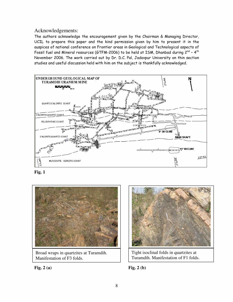
developed) in the extreme north, mark the hangwall limit of mineralisation. Mapping of
different lithological units in underground at 70m depth (1st level) depicts some of the
litho units described above. (Fig.1)
Stratigraphy
Group Formation Member (litho units)
Iron Ore
Feldspathic schist
Banded magnetite quartzite
Quartz chlorite schist
Chlorite quartz schist
Feldspathic schist
Chlorite quartz schist
Muscovite sericite schist
Talcose mica schist
Conglomerate
Unconformity (?)
Singhbhum Granite
Structure
The area around Turamdih has undergone poly-phasal deformations involving tectonism
and related metamorphic activities in recurring cycles, which have left the imprints on
most of the rocks. The quartzite exposures in the northern part of the deposit exhibiting
excellent fold patterns have been described as “monuments for structural geologists” by
some earlier workers. (Fig. 2a and 2b)
The first phase of deformation (F1) is of tight to isoclinal reclined folds with the
development of axial plane schistosity (S1), which at most places, is parallel to the
bedding (S0). The dominant schistosity (S1) in the sector is axial planes of the earliest
deformation (F1). It has a regional arcuate trend following the northern fringe of
Singhbhum Granite and dipping about 35º towards northeast in Turamdih area. F1 folds
are mostly preserved in the outcrops of quartzite (Fig 2b). Extensive mylonitisation in
other litho units have greatly affected the F1 fold patterns (Fig. 3a, 3b and 3c). The
second phase of deformation (F2) has resulted in ESE-WNW trending folds on S1 planes.
These are overturned towards south, asymmetrical type with shorter southern limb and
longer northern limb and plunging about 100 to 15
0 towards ESE-WNW. Axial plane of
these folds is generally seen as crenulation cleavage. The lineations pertaining to this
phase occur in the form of puckers on the S1 surface. Folds of this generation are
abundantly preserved. Third generation of folding (F3) is in the form of broad wraps
plunging towards NNE and manifested by swing of strike at places (Fig 2a). This
indicates minor intensity of deformation during the third phase of folding.
Superimposition of these three deformational phases has an important bearing on the
overall structure and mineralisation pattern in the area. F2 folds are represented as doubly

6
plunging synforms, which are isoclinal asymmetric type. The axis of these synforms
trend WNW-ESE and plunge gently on either side. The feldspathic schist occurring at the
core of the synforms is of disharmonic nature.
Uranium mineralisation:
The most significant uranium mineralisation at Turamdih is confined to chlorite schist
and chlorite-quartz schist and to a lesser extend in feldspathic schists. Uraninite and
pitchblende are the prominent uranium minerals with minor presence of brannerite,
davidite and some secondary uranium minerals. Uraninite is the most predominant seen
as euhedral, grey coloured mineral with internal reflections and sometimes, zoned
intergrowths. The secondary uranium minerals have been formed at the expense of
uraninite along shear fractures Uraninite grains occur within grain interstices of
feldspathic schists and as pore fillings, cleavage plane impregnations and irregular tiny
particles within chlorite and quartz-chlorite schists (Fig. 4a). Uranium ore shoots occur as
sheet like conformable bodies parallel to downdip lineations and F2 fold axis. Width and
dip of these ore lenses vary widely ranging from 1.5 m to 40 m and 70 to 40
0 respectively.
Continuity along strike and dip of the lodes also show wide variation with lodes
appearing and disappearing at different depths. The problem of correlation and
consequent estimation of ore reserve from exploration data was extremely intricate
because of erratic nature of mineralisation and low concentration of uranium values. The
economic grade of uranium mineralisation at Turamdih, in general starts at a depth of 50
m and extends upto 200 m.
Among the sulphide minerals, pyrite and chalcopyrite are most abundant. Magnetite and
ilmenite are the common oxides. Veins of apatite and magnetite are generally found
within mineralized horizons. Pyrite and magnetite grains are seen euhedral occurring as
porphyroblasts in the matrix. Chalcopyrite has patchy occurrence.
Controls of mineralisation
While the mineralisation is confined to chlorite schist (with its quartzitic variation) and
feldspathic schist, appearances of many ore lenses are possibly due to the isoclinal
folding (F1). Closures of these folds vary in dimension resulting in thickening and
thinning of ore lenses within small distances. Manifestation of F2 folds is best seen in
integrating the ore lenses of Turamdih with mineralisation of nearby Nandup and
Banduhurang deposits. F3 folds have least effect on ore lenses.
Genesis
Genesis of uranium deposits in Singhbhum shear zone has remained a matter of
prolonged controversy, though a broad agreement emerges on role of possible
hydrothermal fluid.
The Singhbhum granite, with an average uranium content of about 7 ppm and occurring
in the south of the area as a stable cratonic block is believed to be the main geo-chemical
source of uranium. The weathering of Singhbum granite before (during ?) lower
Proterozoic period (non-availability of oxygen) and the sediments derived from this

7
granitic craton could have led to the syngenetic deposition of detrital uranium (tetravalent
stage) forming a thick pile of sediments towards north. Gradual availability of oxygen in
the atmosphere and on-set of Singhbhum Orogenic cycle (2000 Ma), which is represented
by regional metamorphism, emplacement of basic rocks, widespread metasomatism,
tectonic activities like shearing etc. could have helped in solubilisation of detrital
uranium, transportation of the same in solution through favorable pathways and
precipitation where in contact with reductants (like volcanogenic rocks and ferrous
minerals) in favourable structural and / or stratigraphic locations. During metamorphism,
connate water and structurally trapped water heated with frictional heat have aided in
uranium remobilization. The shearing / deformation in two distinctly different episodes
have provided conduits of high permeability and created structural confines like fractures,
axial plane schistosity etc for redeposition and reconcentration of uranium. Shearing has
also resulted in degradation of early Fe-Mg silicates and formation of chlorites. The
sympathetic ferrous / ferric ratio helped in the fixation of uranium from hexavalent to
tetravalent stage.
Mining
Turamdih uranium deposit was taken up for commercial exploitation by UCIL during
2001-02. Mine entry construction was taken up with the development of a decline (80
gradient), 60 m away from the mineralised zone in the footwall. This provides main
access to the mine. At a depth of 70 m, a crosscut has been developed to access the lodes.
Drives have been developed to establish the configuration of all ore lenses. Ventilation
network has also been established by development of ventilation shafts.
The mine was commissioned in 2003. The development of decline was continued and ore
lenses are now accessed in the lower level at a depth of 105m. Further, levels at a depth
of 140m and 180m have also been planned. Development of decline has not only helped
in early commissioning of the mine, but also facilitated the use of many high-productive,
trackless equipments, viz. mine truck, loaders, drill jumbo, rock-bolting machine etc. A
vertical shaft is now being sunk upto a depth of 260m, which will be utilized for ore
hoisting from deeper levels. Cut-and fill method of stoping has been planned at Turamdih
with ramps as access into the stopes.
Conclusion
The Singhbhum belt in general is perhaps the most intensively studied area of Peninsular
India. Still several aspects on ore genesis, as have been postulated from time to time are
open to methodical discussions.
Uranium mineralisation at Turamdih and adjoining areas like Nandup, Banduhurang and
Keruadungri unveils some interesting observations, specially after opening of this deposit
for mining. A good deal of petrological study on fresh rock samples along with the
stratigraphy and structural study of surface and sub-surface structures may possibly
elucidate further the widely believed general genetic philosophy of polycyclic
mobilization of uranium by a combination of geologic processes, active over a
considerable span of time.
8
Acknowledgements: The authors acknowledge the encouragement given by the Chairman & Managing Director,
UCIL to prepare this paper and the kind permission given by him to present it in the
auspices of national conference on Frontier areas in Geological and Technological aspects of
Fossil fuel and Mineral resources (GTFM-2006) to be held at ISM, Dhanbad during 2nd – 4th
November 2006. The work carried out by Dr. D.C. Pal, Jadavpur University on thin section
studies and useful discussion held with him on the subject is thankfully acknowledged.
Fig. 1
Fig. 2 (a) Fig. 2 (b)
Broad wraps in quartzites at Turamdih.
Manifestation of F3 folds.
Tight isoclinal folds in quartzites at
Turamdih. Manifestation of F1 folds.

9
Fig. 3 (a) Fig. 3 (b)
Fig. 3 (c)
Fig. 4 (a) Fig. 4 (b)
Folding and shearing along axial plane
in feldspathic schist in Turamdih
underground mine (HAND SKETCH)
Folding in quartz-chlorite schist
in Turamdih underground mine
(HAND SKETCH)
Micro-fold defined by folded quartz vein /
lense. Under transmitted plane polarized light
General appearance of quartz-chlorite schists
showing alternate chlorite-rich and quartz-rich
bands. Under transmitted plane polarized light
Folding in quartz-chlorite schist
in Turamdih underground mine

10
References Banerjee, A.K. (1964): On the genesis of copper sulphides, apatite-magnetite and
uraniferous mineral veins along part of Singhbhum Shear Zone, Bihar, India. Report
International Geol. Cong, New Delhi, India. Pp. 278-282.
Bhola, K.L. (1968): Uranium deposits in Singhbhum and their development for use in the
nuclear power programme in India. Symposium Geol. Mineral. At. Minerals
Deposits, New Delhi, India. Pp.277-296.
Dahlkamp, Franz J., (1993) : Uranium ore deposits. Springer- Verlag Berlin Heidelberg
Dar, K.K. (1972): Geological environment of uranium and thorium deposits in India. 24th
International Geological Congress, Pp.167-171.
Dunn, J.A. and Dey, A.K. (1942): The geology and petrology of Eastern Singhbhum and
surrounding areas. Mem. Geol. Survey, India, Calcutta, v. 69, Part-2, pp. 281-456.
Mahadevan, T.M. (1988): Characterization and genesis of the Singhbhum uranium
provinces, Internatl. At. Energy Agency, Vienna. Pp.337-369.
Rao, N.K., and Rao, G.V.U. (1983a, b, c, d): Uranium mineralisation in Singhbhum
Shear Zone, Bihar.1. Ore mineralogy and petrology. J. Geol. Soc. India, v.24.
Saha, A.K, Ray, S.L., and Sarkar, S.N. (1988): Early history of the earth: eveidence from
the eastern Indian shield. J. Geol. Soc. India. Mem.8. Pp.13-88.
Sarangi, A.K. and Singh, A. S. (2006): Vein type uranium mineralisation in Jaduguda
uranium deposit, Singhbhum, India. Proceedings: 12th Quadrennial IAGOD
symposium, Moscow
Sarangi, A.K., et al (2005): Nature of uranium mineralisation and development of deposit
at Turamdih, East Singhbhum District, Jharkhand. Proceedings: Underground metal
mining: Status and Prospects, Pp. 3-8
Sarkar, S.C. (1985): Geology and ore mineralisation of the Singhbhum copper-uranium
belt, Eastern India. INA Press, Kolkata.
Venkataraman, S, Shastry, S, Srinivasan, N, M (1970) Certain observation regarding
uranium and base metal mineralisation. Proceedings: Indian National Science
Academy v. 371, No. 2 Pp. 131-144.
Virnave, S.N (1999): Nuclear Geology and Atomic Mineral Resources. Bharati Bhavan
************************