Observations of the spatial distribution of integrated ... · 10.8 ° in the elevation angle....
1
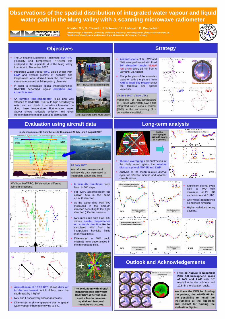
: Observations of the spatial distribution of integrated water vapour and liquid water path in the Murg valley with a scanning microwave radiometer Kneifel, S. 1 , S. Crewell 2 , J. Schween 2 , U. Löhnert 2 , B. Pospichal 2 1 Meteorological Institute, University of Munich, Germany, [email protected] 2 Institute of Geophysics and Meteorology, University of Cologne, Germany Objectives The 14-channel Microwave Radiometer HATPRO (Humidity And Temperature PROfiler) was deployed at the supersite M in the Murg valley from April to December 2007. Integrated Water Vapour IWV, Liquid Water Path LWP and vertical profiles of humidity and temperature were derived from the microwave emission observed at 14 frequency channels. In order to investigate spatial inhomogeneities HATPRO performed regular elevation and azimuth scans. Strategy An infrared (IR)-Radiometer (8-12 μm) was attached to HATPRO. Due to its high sensitivity to water and ice clouds it provides information on cloud base temperature. Furthermore, water vapour shows noticable emission and gives independent information about its distribution. Azimuthscans of IR, LWP and IWV were performed with fixed 30° elevation angle (dotted red circle) every 15 min from 6 July until 28 August. The polar plots of the anomlies together with the picture from AMF’s Total Sky Imager show the temporal and spatial variability. IR LWP IWV AMF-supersite in the Murg valley HATPRO & IR-Radiometer(left) 30 July 2007, 12:00 UTC: Variations of sky-temperature (IR), liquid water path (LWP) and integrated water vapour content (IWV) in the surrounding of a convective cloud field. Outlook and Acknowledgements We thank the DFG for funding the project, the ARM/AMF for the possibility to install the instruments at the supersite and EUFAR for funding the evaluation flights. 31.40 GHz channel sensitive to liquid water: Long-term analysis North South West East IR-Radiometer Evaluation using aircraft data 6 azimuth directions were flown in 30° steps. For every ascent/descent the aircraft flew in the same azimuth direction. At the same time HATPRO measured in the azimuth direction according to the flight direction (different colours). In situ measurements from the MetAir Dimona on 26 July and 1 August 2007 26 July 2007: Aircraft measurements and radiosonde data were used to interpolate a humidity field. IWV from HATPRO, 30°elevation, different azimuth directions: IWV measured with HATPRO shows similar dependence on azimuth direction like the calculated IWV from the interpolated humidity fields (horizontal lines). Differences in IWV could originate from uncertainties in the interpolated field. Azimuthscan at 13:36 UTC shows drier air in the north-west which differs from the south-east by 4 kg/m². IWV and IR show very similar anomalies! Differences in sky-temperature due to spatial water vapour inhomogeneity up to 6 K. The evaluation with aircraft measurements show that HATPRO’s different scan- modi allow to measure spatial and temporal humidity structures. MetAir - DIMONA NNE SSW 1h-time averaging and subtraction of the daily mean gives the relative diurnal cycle of IWV, IR and LWP. Analysis of the mean relative diurnal cycle for different months and weather classifications. Spatial averaging of azimuth scans in 4 sectors From 28 August to December 2007 full hemispheric scans of IWV and LWP with 10° resolution in the azimuth and 10.8° in the elevation angle. Diurnal Cycle on 31 July IWV IR LWP Mean relative diurnal cycle from all days in July/August IWV Standard deviation: 3-6 kg/m² IR Standard deviation: 8-15 K LWP Standard deviation: 100-500 g/m² Significant diurnal cycle only in IWV with maximum at 22 UTC and minimum at 6 UTC. Only weak dependence on azimuth direction. Higher variations during daytime. IWV IR Standard deviation: 2-5 kg/m² Standard deviation: 3-9 K Mean relative diurnal cycle from cloudfree days
Transcript of Observations of the spatial distribution of integrated ... · 10.8 ° in the elevation angle....
:
Observations of the spatial distribution of integra ted water vapour and liquid water path in the Murg valley with a scanning micro wave radiometer
Kneifel, S. 1, S. Crewell 2, J. Schween 2, U. Löhnert 2, B. Pospichal 2
1 Meteorological Institute, University of Munich, Ger many, [email protected] Institute of Geophysics and Meteorology, University of Cologne, Germany
Objectives
� The 14-channel Microwave Radiometer HATPRO(Humidity And Temperature PROfiler) wasdeployed at the supersite M in the Murg valley from April to December 2007.
� Integrated Water Vapour IWV, Liquid Water PathLWP and vertical profiles of humidity and temperature were derived from the microwave emission observed at 14 frequency channels.
� In order to investigate spatial inhomogeneitiesHATPRO performed regular elevation and azimuth scans .
Strategy
� An infrared (IR)-Radiometer (8-12 µm) was attached to HATPRO. Due to its high sensitivity to water and ice clouds it provides information on cloud base temperature. Furthermore, water vapour shows noticable emission and gives independent information about its distribution.
� Azimuthscans of IR, LWP and IWV were performed with fixed 30° elevation angle (dotted red circle) every 15 min from 6 July until 28 August.
� The polar plots of the anomliestogether with the picture from AMF’s Total Sky Imager show the temporal and spatial variability.
IR
LWP IWV
AMF-supersite in the Murg valley
HATPRO & IR-Radiometer(left)
30 July 2007, 12:00 UTC :
Variations of sky-temperature (IR), liquid water path (LWP) and integrated water vapour content (IWV) in the surrounding of a convective cloud field.
Outlook and Acknowledgements
We thank the DFG for funding the project, the ARM/AMF for the possibility to install the instruments at the supersite and EUFAR for funding the evaluation flights.
31.40 GHz channel sensitive to liquid water:
Long-term analysis
North
South
West East
IR-Radiometer
Evaluation using aircraft data
� 6 azimuth directions were flown in 30° steps.
� For every ascent/descent the aircraft flew in the same azimuth direction.
� At the same time HATPRO measured in the azimuth direction according to the flight direction (different colours).
In situ measurements from the MetAir Dimona on 26 July an d 1 August 2007
26 July 2007 :
Aircraft measurements and radiosonde data were used to interpolate a humidity field.
IWV from HATPRO, 30°elevation, different azimuth directions:
� IWV measured with HATPRO shows similar dependence on azimuth direction like the calculated IWV from the interpolated humidity fields (horizontal lines).
� Differences in IWV could originate from uncertainties in the interpolated field.
� Azimuthscan at 13:36 UTC shows drier air in the north-west which differs from the south-east by 4 kg/m².
� IWV and IR show very similar anomalies!
� Differences in sky-temperature due to spatial water vapour inhomogeneity up to 6 K.
The evaluation with aircraft measurements show that HATPRO’s different scan-
modi allow to measure spatial and temporal humidity structures.
MetAir - DIMONANNESSW
� 1h-time averaging and subtraction of the daily mean gives the relative diurnal cycle of IWV, IR and LWP .
� Analysis of the mean relative diurnal cycle for different months and weather classifications.
Spatialaveraging of
azimuth scansin 4 sectors
� From 28 August to December 2007 full hemispheric scansof IWV and LWP with 10°resolution in the azimuth and 10.8° in the elevation angle.
Diurnal Cycle on 31 July
IWV
IR
LWP
Mean relative diurnal cycle from all days in July/August
IWV Standard deviation: 3-6 kg/m² IR
Standard deviation: 8-15 K LWP Standard deviation:
100-500 g/m²
� Significant diurnal cycle only in IWV with maximum at 22 UTC and minimum at 6 UTC.
� Only weak dependence on azimuth direction.
� Higher variations during daytime.IWV IR
Standard deviation: 2-5 kg/m²
Standard deviation: 3-9 K
Mean relative diurnal cycle from cloudfree days