Object calculus and the object-oriented analysis and ... · PDF fileObject calculus and the...
31
Object calculus and the object-oriented analysis and design of an error-sensitive GIS MATT DUCKHAM [email protected] Department of Computer Science, University of Keele Keywords: Object-oriented analysis, object-oriented design, object calculus, formal methods, data quality Correspondence address Matt Duckham Department of Computer Science University of Keele Staffordshire ST7 8AA, UK Email: [email protected] Tel: +44 1782 584270 Fax: +44 1782 713082 Acknowledgements This research was funded as part of a Natural Environmental Research Council CASE studentship at the University of Glasgow, sponsored by Survey and Devel- opment Services (SDS). Supervision for the studentship was from Dr Jane Drum- mond and Dr David Forrest of Glasgow University Geography and Topographic Science Department and from John McCreadie at SDS. Gothic software was kindly supplied under a development license by LaserScan, UK. The help, interest and advice of Dr Tom Melham of Glasgow University Computing Science Department is gratefully acknowledged. Finally, the extensive and constructive comments of the three anonymous reviewers were extremely influential in shaping this paper.
Transcript of Object calculus and the object-oriented analysis and ... · PDF fileObject calculus and the...
Object calculus and the object-oriented analysisand design of an error-sensitive GIS
MATT DUCKHAM [email protected]
Department of Computer Science, University of Keele
Keywords: Object-oriented analysis, object-oriented design, object calculus, formal methods,data quality
Correspondence address
Matt DuckhamDepartment of Computer ScienceUniversity of KeeleStaffordshireST7 8AA, UKEmail: [email protected]: +44 1782 584270Fax: +44 1782 713082
Acknowledgements
This research was funded as part of a Natural Environmental Research CouncilCASE studentship at the University of Glasgow, sponsored by Survey and Devel-opment Services (SDS). Supervision for the studentship was from Dr Jane Drum-mond and Dr David Forrest of Glasgow University Geography and TopographicScience Department and from John McCreadie at SDS. Gothic software was kindlysupplied under a development license by LaserScan, UK. The help, interest andadvice of Dr Tom Melham of Glasgow University Computing Science Departmentis gratefully acknowledged. Finally, the extensive and constructive comments ofthe three anonymous reviewers were extremely influential in shaping this paper.
2
Object calculus and the object-oriented analysisand design of an error-sensitive GIS
Abstract. The use of object-oriented analysis and design (OOAD) in GIS research, developmentand application is now well established. However, the tendency towards informality in OOADtechniques means many of the potential benefits of object-orientation (OO) are being discounted.Recent advances in the formal representation of OO systems may help realise these benefits withrespect to some of the key contemporary issues in GIS. This paper examines the application ofone particular OO formalism, the ς (sigma) calculus of Abadi and Cardelli, to a long-standingunresolved research problem in GIS: the development of an error-sensitive GIS. The work indicatesthat significant enhancements in the exploration, verification and understanding of OO systemscan be achieved through the use of ς-calculus in support of conventional OOAD techniques.
1. Introduction
Object-orientation (OO) is increasingly the dominant information systems (IS) de-velopment paradigm. Notwithstanding this success, the term object-orientationremains highly nebulous and there exists no single, concise definition of the term[61]. The fundamental features of OO are often taken to be classification, encapsu-lation and inheritance. Classification deals with the complexity of a problem fromthe top down and focuses on the essential features of an object in the problemdomain which distinguish it from other objects. Complementary to classification,encapsulation approaches complexity from the opposite direction and aims to con-ceal the detailed mechanisms and features of an object. Finally, inheritance allowsclassified, encapsulated objects to be structured in a hierarchy. The hierarchy al-lows blueprint features to be described just once, and inheriting classes can thenincrementally specialise these blueprint features.
Unfortunately, while the core concepts of classification, encapsulation and inher-itance are likely be mentioned in any discussion of OO, the term evades an ex-haustive definition. A range of related concepts, such as polymorphism, persistenceand identity, may be arrayed alongside the core concepts. Further, the individualconcepts themselves may be subject to a variety of interpretations depending onthe context. This paper aims to look at some of the reasons for, and practical con-sequences of this ambiguity. Using the example development of an OO geographicinformation system (GIS), recent advances in object theory are applied to the OOdevelopment process to resolve this indeterminacy.
1.1. OOA, OOD and OOP
Object-orientation has had a substantial impact upon GIS specifically, as it has onIS generally. Most new GIS make significant, if not exclusive use of OO and OOhas been used widely in research for a variety of GIS architectures [8, 24, 32, 34,44, 50, 52, 54].
, , 3–27 ()c© Kluwer Academic Publishers, Boston. Manufactured in The Netherlands.
Candidate reasons for the enormous success of OO are many fold. For the pro-grammer, object-oriented programming (OOP) offers highly efficient code organi-sation that is able to boost productivity and promote code reuse beyond anythingachievable with even the best possible modular programming [42]. For the designer,object-oriented design (OOD) translates into efficiency of concept, allowing largerand more complex software projects to be implemented and maintained. For theanalyst, object-oriented analysis (OOA) promises an implementation independentmechanism for resolving the complexity of the problem domain into abstracted,comprehensible systems which are arguably closer to our intuitive understandingof the world around us [49]. However, when taken together, it is the use of the OOparadigm as a single, consistent heuristic throughout the entire process of OO anal-ysis, design and programming, which is arguably central to the success of the OOrevolution [33]. Object-orientation promises, for the first time, a one-stop solutionfor IS development: the same paradigm can be used from problem definition rightthrough to a working software solution.
1.2. Shortfalls of OO development
Despite this allure, the OO development process does suffer some shortfalls. Theenormous success of OO is correlated with a proliferation of OO technology, but thisproliferation has not always been complemented by a growth in OO theory. Thesurfeit of object-oriented analysis, design and programming techniques which existare, therefore, necessarily highly subjective. Experience, personal preferences andchoice of object-oriented analysis and design (OOAD) technique and programminglanguage will all play an important role in the shape of the software engineered.
A clear line is often drawn between the purpose of analysis, which aims to de-scribe what a system is supposed to do, and design, which aims to describe howa system performs this function [53]. In principle, the results of an OOA are im-plementation independent whilst OOD is dependent on a target implementation.However, the distinction is much less clearly defined in the practical application ofOOA and OOD. Most authors acknowledge the existence of a “continuum of rep-resentation” [19] where the implementation independent OOA process blurs withthe implementation dependent OOD process [21, 46, 48].
The existence of theory-deficient software engineering techniques may not be ofconcern in many applications. However, even within the highly results led commer-cial sector, the use of more formal methods to guide and document OO softwaredevelopment is gathering acceptance [11]. Rather than focus entirely on the produc-tion of software, academic research very often aims to make more general statementsabout the problem domain being studied using OO. It should come as no surprise,then, that a variety of attempts have been made to provide formal methods tosupport OO technology and to formulate a comprehensive theory of objects.
4
1.3. A theory of objects
The development of the ς (sigma) calculus by Martın Abadi and Luca Cardelli,resulting in the publication of A theory of objects in 1996 [4], represents the one ofthe most comprehensive attempts to date to provide a formal algebraic descriptionof object systems. A number of other attempts have been made; λ (lambda) calcu-lus, the foundation of functional programming, has been used with limited success,for example, in [15, 25]. However, since λ-calculus uses the function as a primitiveconstruct, object calculi based on λ-calculus quickly tend towards high levels ofcomplexity [4]. Generally, the reuse in an OO context of existing formalisms, suchas λ-calculus, first order logic [24] and co-algebras [38], does result in efficiency ofconcept, but can quickly become prohibitively complex. The ς-calculus of Abadiand Cardelli makes use of objects as a primitive construct and is arguably able toexpress more fully the features of object systems as a consequence.
The existence of a fundamental theory of objects presents the possibility of ad-dressing some of the shortfalls of OO technology. Object-oriented theory has, ineffect, caught up with object-oriented technology. The application of ς-calculuswithin the OOAD process is currently largely unexplored. This paper details theuse of ς-calculus to support the development of a GIS able to manage uncertainspatial information, and uses this example to illustrate how the ς-calculus may beof wider use in OO GIS development.
2. Towards an OO error-sensitive GIS
Despite two decades of research, progress toward the production of a GIS able tohandle uncertain spatial information, often termed an error-sensitive GIS [55], hasbeen slow. A number of authors have noted that commercial GIS have little orno data quality management capabilities [7, 12]. While increasing emphasis ondata warehousing for geographic information (GI) is beginning to result in greateravailability of meta-data management tools for GIS [29], generic error-sensitive GISfunctionality remains elusive. This section provides a review of existing approachesto the development of error-sensitive GIS, and introduces an OO conceptual modelof error in GI that aims to overcome some of the difficulties encountered in previouswork.
2.1. Uncertainty management in GIS
The usual mechanism for reporting the uncertainty associated with GI is throughthe medium of data quality. The use of data quality within GIS hopes to allow datausers to assess how suitable a given data set is for a particular purpose, termed fit-ness for use [17]. A variety of data quality standards have grown up under thisbanner. The United States’ National Committee for Digital Cartographic DataStandards (NCDCDS) has been hugely influential in the development of data qual-ity standards. Most subsequent standards have, at their core, made use of thefive data quality elements defined by the NCDCDS: lineage, attribute accuracy,
5
positional accuracy, logical consistency and completeness [47]. A survey of the 22national data standards included in [45], for example, reveals that most have in-herited their approach to data quality from the NCDCDS standard. Despite thisbroad agreement, the exact composition of data quality standards and definitionof the individual elements within different standards can exhibit wide variation. Ithas been noted that no single data quality standard can claim to be either exhaus-tive representations of data quality nor exclusive of other standards and approaches[22]. Standards are subject to continual revision and improvement. Though scarce,many previous attempts to implement uncertainty management within GIS havetended to be data quality standard led (eg [32, 57]). In the light of the volatilenature of data quality standards, the standards-led approach, where standards areeffectively “hard-wired” into software design, is open to criticism.
Where standards have tended to dominate research into data quality concepts,research into the architectural aspects of error-sensitive in GIS has tended to bedominated by the “quality sub-system” approach, typified by [41, 51, 59]. Theapproach is important as it aims to maximise software reuse through the additionof a separate quality sub-system, offering error handling routines and modules, toexisting GIS. However, the development of a quality sub-system does have draw-backs. First uncertainty is usually thought of as a “fundamental” feature of GI[18, 28]. Consequently, the artificial dichotomy between error and GI introducedby a quality sub-system can be correlated with additional conceptual and compu-tational complexity in the system. Second, separate quality sub-systems tend toresult in global or generalised quality information being applied to blocks of GI,for example on a per-layer basis [41]. The inadequacies of such global, generaliseddata quality information are well documented, for example with reference to DEMs[26]. Consequently, a more general approach to uncertainty able to support the in-tegration of data quality and GI without being tied to any particular data qualitystandard is sought here.
2.2. Conceptual OO model of data quality
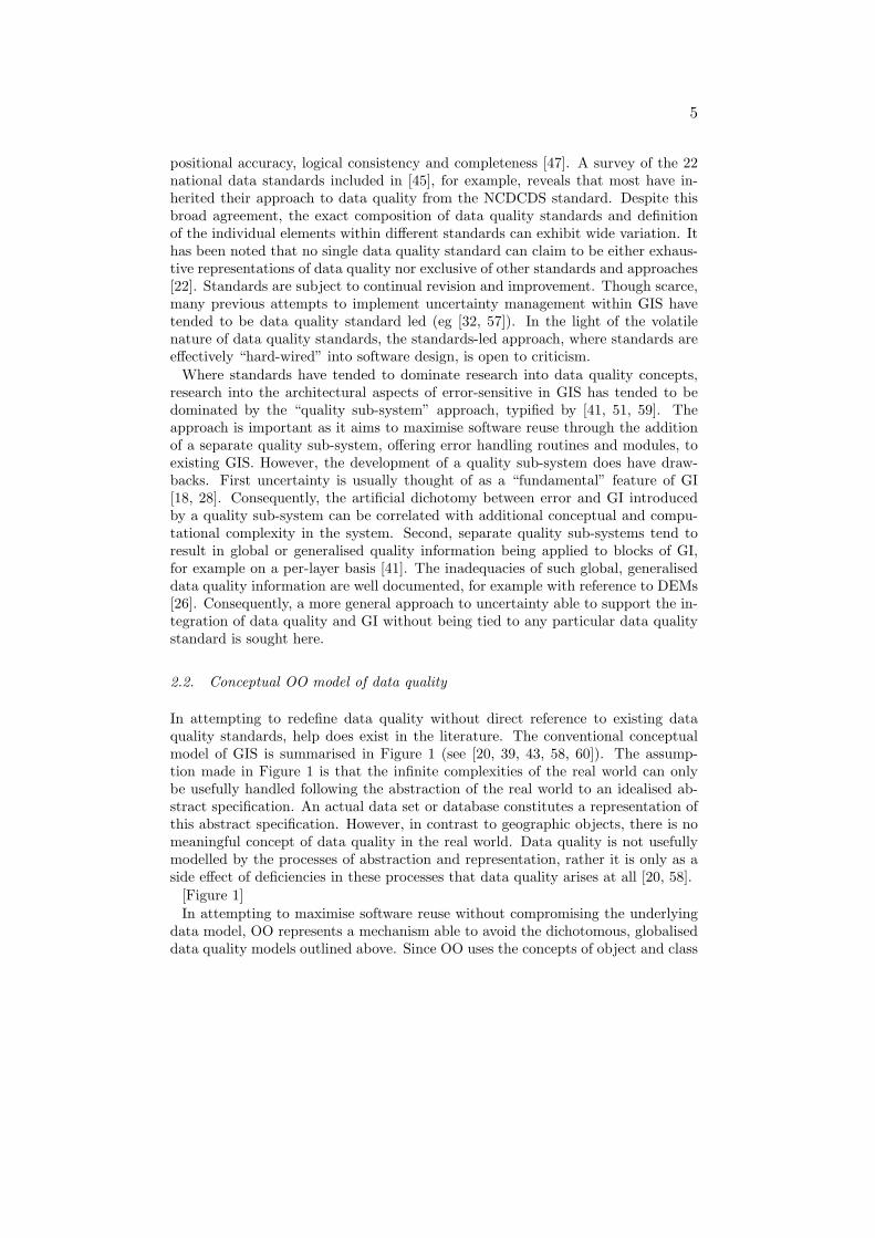
In attempting to redefine data quality without direct reference to existing dataquality standards, help does exist in the literature. The conventional conceptualmodel of GIS is summarised in Figure 1 (see [20, 39, 43, 58, 60]). The assump-tion made in Figure 1 is that the infinite complexities of the real world can onlybe usefully handled following the abstraction of the real world to an idealised ab-stract specification. An actual data set or database constitutes a representation ofthis abstract specification. However, in contrast to geographic objects, there is nomeaningful concept of data quality in the real world. Data quality is not usefullymodelled by the processes of abstraction and representation, rather it is only as aside effect of deficiencies in these processes that data quality arises at all [20, 58].
[Figure 1]In attempting to maximise software reuse without compromising the underlying
data model, OO represents a mechanism able to avoid the dichotomous, globaliseddata quality models outlined above. Since OO uses the concepts of object and class
6
as primitive notions, OO should be able to address uncertainty at every level ofthe database, rather than just for blocks of GI. It is important to note that the useof objects in an object-oriented sense in no way implies the use of objects in thesense of the object versus fields debate in GIS (see [27]). OOA offers a techniquefor modelling concepts, and can equally well be used to model continuous spatialfields as discrete spatial objects. At some level discretisation is a necessary com-ponent of any computational system: even continuous fields or functions can onlybe represented in a computer following some discretisation, for example into thediscrete parameters of a polynomial function. However, conceptual discretisationcannot generally be inferred from computational discretisation.
The combination of the conceptual model in Figure 1 and OO software develop-ment techniques seem well suited to developing error-sensitive GIS able to addressthe problems evident in existing approaches to data quality. Further, the use ofOOAD promises a direct route from the conceptual model to OO software whichembodies the properties of this model. Details of the OOA process can be foundin a wealth of literature on the subject (eg [10, 19, 53]). Software based on thisanalysis should be flexible enough to support not simply existing data quality stan-dards, but potentially any quality standard or elements which might reasonablybe proposed and at any level of the database. Severing the close link betweensoftware and standards, posited in §2.1, should result in increased flexibility andgreater ability to address the real issue underlying most standards, that of fitnessfor use. Such software should assist in restoring the balance of emphasis toward theawareness, understanding and use of data quality information rather than enforcingcompliance with any one particular standard upon which the software happens tobe based.
2.3. OOA of data quality
An OOA of the conceptual model in Figure 1 was conducted as the first stage in thedevelopment of an error-sensitive GIS. The analysis process highlighted a generaldistinction that can be made between what is termed here abstractive quality andrepresentative quality. Abstractive quality results from the process of abstraction inFigure 1. From an OO perspective, abstractive quality operates solely at the classlevel, because it refers to the inconsistent and incomplete classification of objects.In contrast, representative quality results from the process of representation inFigure 1. From an OO perspective, representative quality operates solely at theobject level, because it results from the gap between particular instances of classeswhen compared with the idealised abstract specification. For example, topologicalconsistency is used in vector GIS to enforce topological relations between differentclasses of geographic objects. In a database of road and river features, all bridgesmay be topologically consistent, say, if they fall on the intersection of two roads orof a river and a road. This type of topological consistency can be thought of asan abstractive quality element, as its behaviour will be identical for every objectof a particular class, in this case bridges. In contrast, the accuracy of location ofa bridge in this hypothetical database may be unique to that bridge. Different

7
survey methods, data collection and data provenance will mean that positionalaccuracy may vary for different objects in the same class. It follows that this typeof positional accuracy is an example of a representative quality element. In fact,spatial data quality assessment often demands more complex, aggregated qualityelements than those in the simplified example above. The strength of using theconcepts of abstractive and representative quality is that they can be instructive indecomposing more complex quality elements into their simpler constituents.
Such general results are helpful starting points in the construction of an error-sensitive GIS. The following section looks in more detail at the development ofan OO error-sensitive GIS. In particular, the role of ς-calculus in extending andsupporting the conventional OO development process is introduced and explored.
3. Object calculus
The discussion above indicates some of the potential advantages of conventionalOO development techniques for error-sensitive GIS. On the basis of the frameworkof ideas sketched out in §2 it would be possible to develop an OO GIS with errorhandling capabilities using conventional OO development techniques. However, assuggested in §1.2, the partially subjective nature of conventional OO developmenttechniques provides companies and researchers with only limited control over themovement from concepts to software. This section introduces the use of ς-calculus asa supplement to conventional OO development techniques. Focusing on three areasof error-sensitive GIS development in turn, the following sections explore the use ofς-calculus with respect to conflict resolution, system properties and expressive andnotational power. Finally, §3.4 proposes a general typology of the uses of ς-calculus.
While enough of the ς-calculus is presented below to support the examples used, afull exploration of the formalism would be impossible here and the reader is directedto the literature for a more substantial treatment of the ς-calculus [2, 3, 4, 5]. Asfar a possible, the notation used in the following examples is consistent with thisliterature to facilitate the reference.
3.1. Schema development
An important feature of any formal method in software development is the abilityto capture the results of an analysis in a precise, unambiguous manner [40]. Aclass diagram representing a simplified core of results from the conventional OOAprocess is shown in Figure 2. While often supported with text, class diagrams suchas Figure 2 are central to the communication of conventional OOA results [11]. Thegraphical notation used in Figure 2 is based on object modeling technique (OMT)[53]. A class diagram defines important classes of objects and their behaviours. Ad-ditionally, inheritance relations between classes are given, showing where one classis a specialisation (sub-class) or generalisation (super-class) of another. In Figure 2the classes uncertain objects and abstraction are used to model the general error-sensitive properties induced by representative and abstractive quality respectively.The get rep method enables uncertain objects to be interrogated about their rep-
8
resentative quality. In a similar manner, the class abstraction provides a templatefor abstractive quality elements. In Figure 2, the abstraction class contains anis consistent method which allows instances of the class to be interrogated abouttheir logical consistency. The ellipsis in abstraction highlights that is consistentis just one of many possible abstractive quality methods. The class geographicobjects is meant to represent the super-class of a conventional OO schema for GI,and itself inherits from uncertain objects and abstraction. In this way, OO can beused to transmit the general error-sensitive behaviours encapsulated within uncer-tain objects and abstraction throughout a conventional OO spatial database: anOO approach is still able to maximise software reuse without the need for separatequality sub-systems. A fourth class, representative quality both inherits from andis associated with uncertain objects. The class representative quality is intendedas the generic super-class of all representative quality elements.
[Figure 2]
3.1.1. Untyped ς-calculus Even for results in this simplified form the ς-calculuscan be useful for supporting the OOAD process. A formal representation of theclasses in Figure 2 requires the reformulation of the class diagram as ς-calculusterms. Objects within the ς-calculus are represented as collections of methods lieach with bodies bi. The symbol ς is used to bind the postfixed ‘self’ parameter(conventionally s or z) with occurrences of that parameter in the body of themethod. Each object is enclosed in square brackets and associated with a labelusing the symbol , as in Equation 1.
o , [li = ς(s)bi i∈1..n] (1)
Informally, Equation 1 defines a new object o which is a collection of n methods,each with distinct labels li and bodies bi in which references to the object itselfmay occur, using the bound variable s. A method l of an object o can be invokedusing the dot operator, written o.l. A class C can be represented as an object witha new method, as in Equation 2.
C , [new = ς(z)[li = ς(s)z.li(s) i∈1..n],
li = λ(s)bi i∈1..n](2)
Invocation of the new method on C produces a new object where each of thetemplate or pre-methods, li = λ(s)bi i∈1..n, in the class C are bound to methodsin the object being created. The term l = λ(s)b is in fact shorthand for l =ς(z)λ(s)b where z is unused. The use of λ (lambda) in the pre-methods betraysthe development of ς-calculus from λ-calculus and the λ performs an analogousbinding function to ς. In this way it is possible to obtain a direct mapping fromthe classes in Figure 2 to an ς-calculus object system. The ς-calculus terms forUnc (Definition 1) and Abs (Definition 2) are formal representations of the classesuncertain objects and abstraction respectively.
9
Definition 1
Unc , [new = ς(z)[get rep = ς(s)z.unc1(s)],unc1 = λ(s)b1]
Definition 2
Abs , [new = ς(z)[is cons = ς(s)z.abs1(s)],abs1 = λ(s)b2]
Inheritance is needed to allow the object system to be extended to include a Geoterm, corresponding to the class geographic objects in Figure 2. Inheritance canbe represented by re-using pre-methods, as illustrated by the ς-calculus term forGeo in Definition 3. A similar term for the representative quality class Rep can beconstructed as in Definition 4.
Definition 3
Geo , [new = ς(z)[is cons = ς(s)z.geo1(s),get rep = ς(s)z.geo2(s)],
geo1 = Abs.abs1,
geo2 = Unc.unc1]
Definition 4
Rep , [new = ς(z)[get rep = ς(s)z.rep1(s)],rep1 = Unc.unc1]
3.1.2. Conflict resolution During the OOAD process conflicts inevitably occur.For example, the error-sensitive GIS described here was implemented within twoseparate environments, Java and Laser-Scan Gothic OO GIS. While both Java andGothic are object-oriented environments, they support very different object seman-tics. In particular, Gothic allows the inheritance of one sub-class from more thanone super-class, termed multiple inheritance, while Java does not. Multiple inheri-tance is often very useful during OOA and generally OOA does not proscribe its use[10, 19]. Since the simplified class diagram in Figure 2 uses multiple inheritance,the Java implementation of the analysis results required a slight modification to theclass diagram to remove all multiple inheritance, as shown in Figure 3. However,other modifications are possible: a different schema is obtained if uncertain ob-jects is allowed to inherit from abstraction rather than abstraction inheriting fromuncertain object. Given that representative quality and geographic objects rep-resent generic super-classes for potentially very large sub-schema, the effect of such
10
changes will be felt by a significant number of sub-classes. It is useful, therefore, tohave some formal way to exercise control over such conflicts.
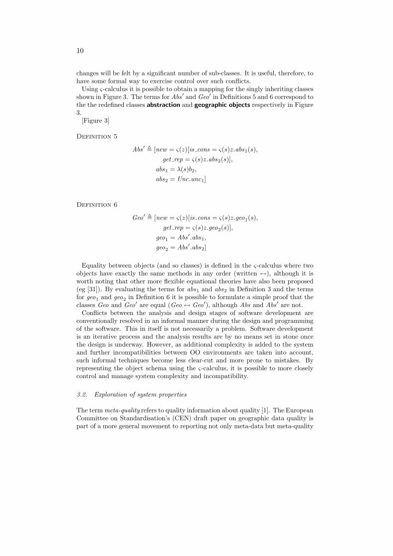
Using ς-calculus it is possible to obtain a mapping for the singly inheriting classesshown in Figure 3. The terms for Abs ′ and Geo′ in Definitions 5 and 6 correspond tothe the redefined classes abstraction and geographic objects respectively in Figure3.
[Figure 3]
Definition 5
Abs ′ , [new = ς(z)[is cons = ς(s)z.abs1(s),get rep = ς(s)z.abs2(s)],
abs1 = λ(s)b2,abs2 = Unc.unc1]
Definition 6
Geo′ , [new = ς(z)[is cons = ς(s)z.geo1(s),get rep = ς(s)z.geo2(s)],
geo1 = Abs ′.abs1,
geo2 = Abs ′.abs2]
Equality between objects (and so classes) is defined in the ς-calculus where twoobjects have exactly the same methods in any order (written ↔), although it isworth noting that other more flexible equational theories have also been proposed(eg [31]). By evaluating the terms for abs1 and abs2 in Definition 3 and the termsfor geo1 and geo2 in Definition 6 it is possible to formulate a simple proof that theclasses Geo and Geo′ are equal (Geo ↔ Geo′), although Abs and Abs ′ are not.
Conflicts between the analysis and design stages of software development areconventionally resolved in an informal manner during the design and programmingof the software. This in itself is not necessarily a problem. Software developmentis an iterative process and the analysis results are by no means set in stone oncethe design is underway. However, as additional complexity is added to the systemand further incompatibilities between OO environments are taken into account,such informal techniques become less clear-cut and more prone to mistakes. Byrepresenting the object schema using the ς-calculus, it is possible to more closelycontrol and manage system complexity and incompatibility.
3.2. Exploration of system properties
The term meta-quality refers to quality information about quality [1]. The EuropeanCommittee on Standardisation’s (CEN) draft paper on geographic data quality ispart of a more general movement to reporting not only meta-data but meta-quality

11
information [16]. Even the original NCDCDS standard made some allowances formeta-quality in terms of reporting the methods used to derive data quality informa-tion [47]. Once the concept of meta-quality is acknowledged as important, however,there is no particular reason to impose these restrict meta-quality to just one levelof self-reference. Preferable to the arbitrary prescription of meta-quality elementsand structure would be an error-sensitive GIS design able to support recurse levelsof meta-quality assignment.
The ς-calculus can be used to explore the recursive properties of the systemin Figure 2. The class representative quality itself inherits from uncertain ob-jects, consequently inheriting the association with representative quality objects.It follows that meta-quality information can be assigned recursively if desired; anyrepresentative quality object can itself have representative quality information as-sociated with it. Recursion within object schema has been recognised not only asimportant tool in the development of OO systems, but also as a potential source ofunexpected and undesirable object behaviour particularly when used in conjunc-tion with multiple inheritance [9]. By using the ς-calculus to represent the objectsinvolved, developers can explore the properties of a system and communicate thoseproperties in a formal way to avoid the pitfalls presented by the use of recursion.
3.2.1. Using typing rules within ς-calculus The previous example made use ofuntyped ς-calculus. However, the introduction of types as a method for categorisingobject terms can increase the expressive power of the ς-calculus. In the ς-calculus,type annotations are used to convey information about the type of methods andobjects. For example,Equation 3 states that type A is composed of methods li eachof type Bi.
A ::= [li : Bi∈1..ni ] (3)
It is possible to give a type for an object of class Unc as in Definition 7. This termdefines an uncertain objects type, UncType, with one method: a get rep methodwhich returns a representative quality object of type RepType.
Definition 7
UncType ::= [get rep : RepType]
It would be desirable to be able to write RepType ::= [get rep : RepType, ...] as asimilar definition for representative quality objects. Unfortunately, this definitionof RepType contains a circular reference to RepType itself. To deal with recursion inthe ς-calculus it is necessary to define a recursive type µ(X)[get rep : X, ...] shownin Definition 8, where µ (mu) binds the type variable X to occurrences of X in thebody of the type. A second type, URepType is obtained by substituting RepTypefor the type variable X, shown in Definition 9. The two types in Definitions 8and 9 are isomorphic and the constructs fold and unfold are used to move betweenthese two types. For some object o : RepType we can write unfold(o) : URepType
12
and fold(RepType, unfold(o)) : RepType. Despite this additional complexity, theeffect Definitions 8 and 9 is informally analogous to writing RepType ::= [get rep :RepType, ...].
Definition 8
RepType ::= µ(X)[get rep : X, ...]
Definition 9
URepType ::= [get rep : RepType, ...]
Armed with the recursive type RepType and the unfolding of this type URepTypeit is possible to explore the properties of this system. For an uncertain objecto : Unc the typing rules in ς-calculus enable us to deduce the result of accessingthe get rep method on o as below.
o : UncTypeo.get rep : RepType
It is possible to illustrate the property of meta-quality by attempting to accessthe representative quality not simply of an uncertain object o : UncType but of theresulting representative quality object itself, shown below.
o : UncTypeo.get rep : RepTypeunfold(o.get rep).get rep : RepTypeunfold(unfold(o.get rep).get rep).get rep : RepType
...
Such terms can be used as the basis of a simple inductive proof that the objectsystem supports recursive meta-quality. In practice, the ability to use meta-qualitybeyond a certain point may be of limited use and the extreme flexibility of thesystem is achieved at the cost of some redundancy. However, this simple exampleboth introduces the use of type systems and illustrates how such type systems canbe used to explore the properties of an object system.
3.3. Expressiveness and notation
Object oriented analysis and design have already been defined as the what and howof OO system development respectively. Issues such as memory requirements anddata volumes are usually considered entirely the preserve of the design stage of
13
development [21]. However, the storage of data quality elements associated withspatial information presents situations where even these relatively clear cut issuescan become enmeshed in the continuum of representation.
Even within the NCDCDS data quality standard, a single datum may be asso-ciated with up to four different items of quality information (lineage, consistency,completeness and either positional or thematic accuracy). Subsequent standardssuch as the 1996 CEN draft standard contain as many as 13 different types of dataquality elements, most of which can meaningfully refer simultaneously to the sameGI. If the existence of meta-quality information is also taken into account, it isclear that any spatial database, if saturated with data quality information, mightincrease in size by an order of magnitude or more. The cost of digital data storageis continually tumbling and so the the storage of huge volumes of data quality in-formation may be an option in some situations: in the near future terabyte storagemedia are likely supersede the megabyte and gigabyte storage media in commonusage today. However, intuitively the value of data quality information is in someway constrained by the value of the information to which it refers: data quality‘adds value’ to GI. Arguably, an organisation which stores gigabytes of GI is un-likely to ever want to store terabytes of associated quality information, irrespectiveof how economical data storage becomes. The effort involved in storing thousandsof times more data quality information that GI will always be difficult to justify aslong as data quality information is not thousands of times more valuable than GI.In short, the design of an error-sensitive GIS has the question of data storage as awhat as well as a how.
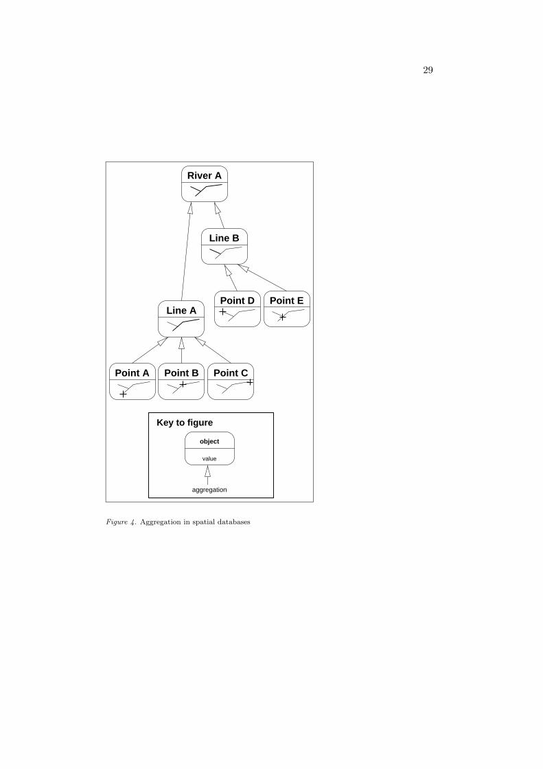
3.3.1. Efficient data storage Given that data volume is an analysis issue in thecontext of developing an error-sensitive GIS, it is possible to develop strategiesto minimise data volume. One such strategy takes advantage of the generallyhierarchical nature of aggregated objects in an OO spatial database. A highlysimplified example of the aggregation relationships which might exist in a vectorOO GIS are shown in Figure 4. Here the representation of a river is actually theaggregation of a number of lines, which in turn are aggregates of a number of points.Because each class of spatial objects in the database inherits from the geographicobjects class in Figure 2, the model used here allows individual representativequality objects to refer to any one of these spatial objects. A first step in minimisingdata quality volumes is to allow spatial objects in the database to infer quality fromthe objects of which they are a part. Assuming, say, Line A in Figure 4 has a qualityobject associated with it, the point objects which make up Line A (Points A, Band C) should be able to infer their quality from the aggregate line.
[Figure 4]An example of where such precedence rules already enjoy practical application
is in US vector product format (VPF) military standard [56]. The ς-calculus canbe used to formulate an algebraic representation of the VPF precedence rules, asillustrated by the untyped term for the class Unc′ in Definition 10. The notationo.x ⇐ ς(s)b is used to replace the body of the method x on object o with ς(s)b.The ς(s) is usually omitted where s is unused in b.
14
Definition 10
Unc′ , [new = ς(z)[parent = [get rep = [ ]], get rep = ς(s)z.unc1(s),set rep = ς(s)z.unc2(s), add parent = ς(s)z.unc3(s)],
unc1 = λ(s)s.parent .get rep,unc2 = λ(s)λ(q)s.get rep ⇐ q,
unc3 = λ(s)λ(p)s.parent ⇐ p]
Given the definition of Unc′ it is possible for objects to infer quality informationin the manner suggested by VPF. In Equation 4 reduction of ς-calculus terms isused to show that a child Unc′ object is able to infer representative quality from itsparent object. The reduction of invoked methods in ς-calculus is indicated usingthe symbol �, for example [l = [ ]].l � [ ]. A detailed exposition of reduction inς-calculus terms is beyond the scope of this paper, but the informal semantics ofreduction should be fairly intuitive to anyone familiar with OOP.
rep , Rep.new
parent , (Unc′.new).set rep(rep)
child , (Unc′.new).add parent(parent)child .get rep � rep
(4)
By using the revised definition of Unc′ above in place of the definition of Unc inDefinition 1, VPF-like precedence rules can be transmitted to all objects through-out the database. In fact, VPF embodies one example of a wide variety of possibleprecedence rules. For example, more sophisticated precedence rules are neededwhere aggregation in geographic objects is not strictly hierarchical, and where oneobject form part of more than on aggregate object. Similarly, quality inferencein Definition 10 goes in only one direction: components infer from aggregates.Equally, it is possible to compose precedence rules where quality in an aggregateobject is inferred through some (error propagation) function of its component ob-jects. In practice, the details of such systems quickly become difficult to explainusing the traditional OO analysis tools of diagrams and text alone. The provision ofa mechanism that allows the detailed workings of a proposed system to be exploredalgorithmically is therefore of great benefit to the error-sensitive GIS analyst. In-deed, using the ς-calculus proved very useful in this research and led directly tonew efficient quality storage algorithms being developed and implemented in thesoftware resulting from this work. The exploration of some of these possibilities isone of the themes of §4. First, §3.4 attempts to solidify some of the ideas introducedin this section.
3.4. Uses of ς-calculus
The example application of ς-calculus in this section illustrates a cross-section ofdifficulties that may be encountered by the system developer during the transition
15
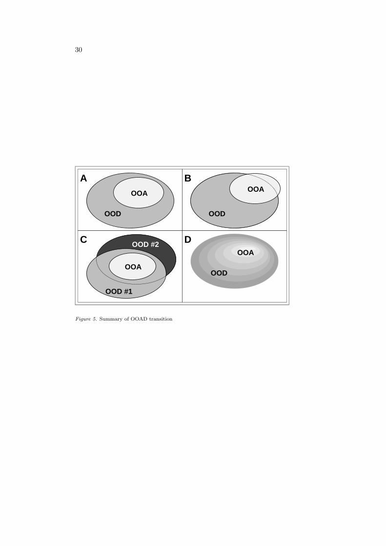
from OO analysis to design. Whilst the literature acknowledges the indeterminacyof the boundary between OOA and OOD, underlying much of the OO developmentprocess is the assumption that the movement of information and distinction be-tween OOA and OOD is reasonably smooth. This situation is illustrated in Figure5A, after [46]. Here, information about the problem domain is captured initiallywith OOA and further information is subsequently captured with OOD. Crucially,the OOD process encompasses all of the OOA results and the boundary betweenOOA and OOD is distinct. This model of the development process is, however,incomplete. Taking each of the three examples above in turn, a characterisationof the use of object calculus within the OOAD process is proposed based on thedeficiencies in the model of the OOAD process shown in Figure 5A.
[Figure 5]The first of the three example uses of the ς-calculus deals with the representation
of multiple inheritance in both OOA and OOD. Information captured about theproblem domain in the form of a multiply inheriting object, could not be used in thedesign without reformulating the multiple inheritance as single inheritance. Thegeneral situation where, despite information being captured by the OOA, the designcannot incorporate those features, is shown in Figure 5B. Information can leak outof the development process at the boundary between analysis and design. The ς-calculus can be used to resolve any conflicts resulting from this information leakage,providing a route to reconcile the analysis with the design. Inheritance strategiesare only one possible area where such information leakage can occur. As alreadynoted the term object-orientation is nebulous and as a consequence some mismatchbetween the concepts used in OOA and in OO programming environments is to beexpected.
The second example looks at the need for a capacity to explore the properties ofthe results of an OOA. Within the commercial world, it may be enough to verify thatthe OO software produced fulfills all the client’s requirements, to be satisfied thatthe development process used to produce that software has been a success. However,it may be unreasonable to infer the properties of an OOA from a software productproduced from that analysis. In Figure 5C, despite the OOA being captured inits entirety by more than one design it is not possible to make any assumptionsabout the general properties of the analysis from those designs. Different designswill extend the analysis results in different ways. Simply because one design andimplementation possesses certain properties does not imply that another necessarilywill. By using the ς-calculus to formalise and explore the analysis, it is possible tomake statements about the core properties of the analysis which, in turn, shouldbe fundamental to any design based on that analysis.
Finally, the ς-calculus was used to provide an expressive, implementation inde-pendent platform to communicate specific OOA results. The detailed working ofan object system is usually excluded from the OOA process and is often regardedas the how of system design rather than the what of problem definition. Thisdoes encourage the analyst to focus on general rather than implementation issues.However, equally it is the lack of an implementation independent language ableto communicate the detailed working which has led to the proscription of detailed
16
working within OOA. The example of the volume of data quality required to de-scribe the uncertainty associated with spatial information shows that, in some cases,the detailed working of an object system can become a central part of the problemdefinition. The general situation is illustrated in Figure 5D, where there is no dis-tinct boundary between OOA and OOD. Consequently, no part of the developmentprocess is guaranteed to be exclusively the preserve of analysis or of design.
4. Application of ς-calculus
The previous section introduced the ς-calculus and indicated a number of pointsin the conventional OO development process that can benefit from the support offormal algebraic object calculus. As already mentioned, the combination of con-ventional and formal approaches was successfully used to develop a prototype im-plementation within Java and a full implementation within LaserScan Gothic OOGIS. The full implementation exhibited the desired high levels of flexibility, withability to support recursive meta-quality, efficient quality storage, and was success-fully integrated with a range of different data quality standards, namely SpatialData Transfer Standard (SDTS), Spatial Archive and Interchange Format (SAIF)and CEN/TC287. However, as indicated in §3.4 simply describing the resultingimplementation may not provide a clear picture of the efficacy of underlying con-cepts and techniques used in the analysis and design process. Consequently, ratherthan offer a detailed, implementation dependent account of the LaserScan Gothicerror-sensitive GIS, this section uses the ς-calculus to construct a very simple im-plementation independent application that illustrates the potential flexibility andutility of the underlying concepts used in the error-sensitive GIS. The object systemexplored in this section represents the core formal specification of an error-sensitiveGIS and is used to provide a ‘walk-through’ of the different stages of error-sensitiveGIS use. The importance of ς-calculus in this process is that it offers a powerful, im-plementation independent mechanism for algorithmic manipulation of objects andclasses which are avatars of those that would exist in a real database application.
4.1. Preliminary assumptions
For notational convenience, the object system discussed below assumes the ex-istence of a number of objects not formally defined here, namely Boolean trueand false objects, real numbers x ∈ R and ordered alphanumeric string objects.To highlight the fact that Booleans, reals and strings are still objects, they arewritten in enclosing square brackets, eg [true], [1.0] and [“string”]. A number ofstandard operators are assumed for these objects. An equivalence binary operator(≡) is assumed for Booleans, reals and strings (eg [“abc”] ≡ [“abc”] reduces to[false]); arithmetic operators are assumed for real numbers (eg [1.0] + [2.0] reducesto [3.0]); a simple if-then-else construct is assumed for Booleans (eg if [2.0] ≡[3.0] then [“Equivalent”] else [“Not equivalent”] reduces to [“Not equivalent”]).While these primitive objects and constructs are not part of the ς-calculus, it isworth noting that pointers on how to build such objects and constructs using pure
17
ς-calculus can be found in the literature, eg [4]. For simplicity the example uses un-typed ς-calculus terms, although the translation of these terms into a typed universeis also possible.
4.2. Database design
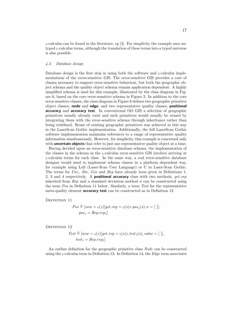
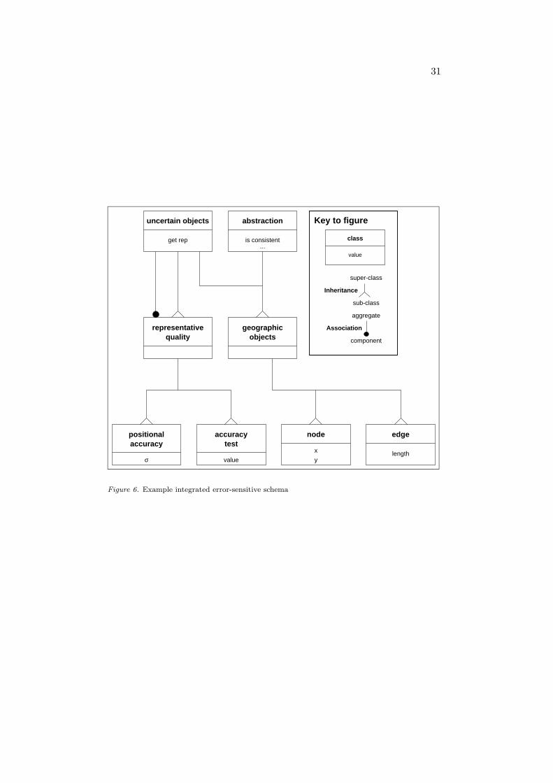
Database design is the first step in using both the software and ς-calculus imple-mentations of the error-sensitive GIS. The error-sensitive GIS provides a core ofclasses necessary to support error-sensitive behaviour, but both the geographic ob-ject schema and the quality object schema remain application dependent. A highlysimplified schema is used for this example, illustrated by the class diagram in Fig-ure 6, based on the core error-sensitive schema in Figure 2. In addition to the coreerror-sensitive classes, the class diagram in Figure 6 defines two geographic primitiveobject classes, node and edge, and two representative quality classes, positionalaccuracy and accuracy test. In conventional OO GIS a selection of geographicprimitives usually already exist and such primitives would usually be reused byintegrating them with the error-sensitive schema through inheritance rather thanbeing redefined. Reuse of existing geographic primitives was achieved in this wayin the LaserScan Gothic implementation. Additionally, the full LaserScan Gothicsoftware implementation maintains references to a range of representative qualityinformation simultaneously. However, for simplicity, this example is concerned onlywith uncertain objects that refer to just one representative quality object at a time.
Having decided upon an error-sensitive database schema, the implementation ofthe classes in the schema in the ς-calculus error-sensitive GIS involves arriving atς-calculus terms for each class. In the same way, a real error-sensitive databasedesigner would need to implement schema classes in a platform dependent way,for example using Lull (Laser-Scan User Language) or C in Laser-Scan Gothic.The terms for Unc, Abs, Geo and Rep have already been given in Definitions 1,2, 3 and 4 respectively. A positional accuracy class with two methods, get repinherited from Rep and a standard deviation method σ can be constructed usingthe term Pos in Definition 11 below. Similarly, a term Test for the representativemeta-quality element accuracy test can be constructed as in Definition 12.
Definition 11
Pos , [new = ς(z)[get rep = ς(s)z.pos1(s), σ = [ ]],pos1 = Rep.rep1]
Definition 12
Test , [new = ς(z)[get rep = ς(s)z.test1(s), value = [ ]],test1 = Rep.rep1]
An outline definition for the geographic primitive class Node can be constructedusing the ς-calculus term in Definition 13. In Definition 14, the Edge term associates
18
and edge with two nodes, in addition to providing a length method which calculatesthe distance between the two nodes that comprise an edge.
Definition 13
Node , [new = ς(z)[is cons = ς(s)z.node1(s),get rep = ς(s)z.node2(s),x = [ ], y = [ ]],
node1 = Abs.abs1,
node2 = Geo.geo2]
Definition 14
Edge , [new = ς(z)[is cons = ς(s)z.edge1(s),get rep = ς(s)z.edge2(s),length = ς(s)z.edge3(s),n1 = Node.new ,n2 = Node.new ],
edge1 = Abs.abs1,
edge2 = Geo.geo2,
edge3 = λ(s)((s.n1.x− s.n2.x)2 + (s.n1.y − s.n2.y)2)12 ]
The definition of these ς-calculus terms mirrors the database design process thatprecedes the use of any error-sensitive GIS. The error-sensitive GIS provides onlyenough class definitions to support the core error-sensitive functionality. In thesame way as conventional OO GIS allow application specific geographic objectschema to be defined, so the error-sensitive GIS allows application specific qualityschema to be defined.
4.3. Abstractive quality
Abstractive quality operates solely at the class level. However, abstractive qualitybehaviours will usually be redefined for each new sub-class of abstraction. In orderto obtain sophisticated consistency behaviour, the body of the is cons methodmust be overridden in sub-classes of Abs. For example, new Node objects initiallydo not have valid coordinates (Node.new .x � [ ]). The Node ′ term in Definition15 updates the body of the is cons method with a new method body that checksits coordinates are not empty objects, [ ].
Definition 15
Node ′ , Node.node1 ⇐ λ(s)if s.x ≡ [ ] then [false] else(if s.y ≡ [ ] then [false] else [true])

19
It is now possible for a Node ′ object to report upon its own consistency. InEquation 5, a new node object is created, which by default has empty x and ycoordinates. As a result, invocation of the is cons method upon this node reducesto [false] and leads to the conclusion that the object is not logically consistent. Incontrast, the new node in Equation 6 is first updated with the coordinates of (5.0,6.0) before the is cons method is invoked, then reducing to [true].
(Node ′.new).is cons � [false] (5)
(((Node ′.new).x⇐ ς(s)[5.0]).y ⇐ ς(s)[6.0]).is cons � [true] (6)
A slightly more sophisticated use of this approach, illustrated in Definition 16,redefines the Edge class in Definition 14 to check whether the edge’s two nodes, n1
and n2 are logically consistent before reporting on its own consistency.
Definition 16
Edge ′ , Edge.edge1 ⇐ λ(s)if s.n1.is cons then(if s.n2.is cons then [true] else [false])
else [false]
This in turn allows the consistency of new Edge ′ objects to be checked as inEquation 7 below.
node1 , (Node ′.new .x⇐ [5.0]).y ⇐ [6.0]
node2 , (Node ′.new .x⇐ [10.0]).y ⇐ [10.0]
edge , (Edge ′.new .n1 ⇐ node1).n2 ⇐ node2
edge.is cons � [true]
(7)
4.4. Representative quality
Classes that inherit from Unc inherit the ability to be interrogated about theirown representative quality through the get rep method. However, the details ofhow this representative quality information is organised and managed are highlyflexible. The simplest approach is to associate a representative quality object withits referring object directly using the get rep method. In Equation 8 below, a nodeis associated directly with a positional accuracy object with a standard deviationmethod σ of 0.5.
node = Node ′.new .get rep ⇐ (Pos.new .σ ⇐ [0.5])node.get rep.σ� [0.5]
(8)
20
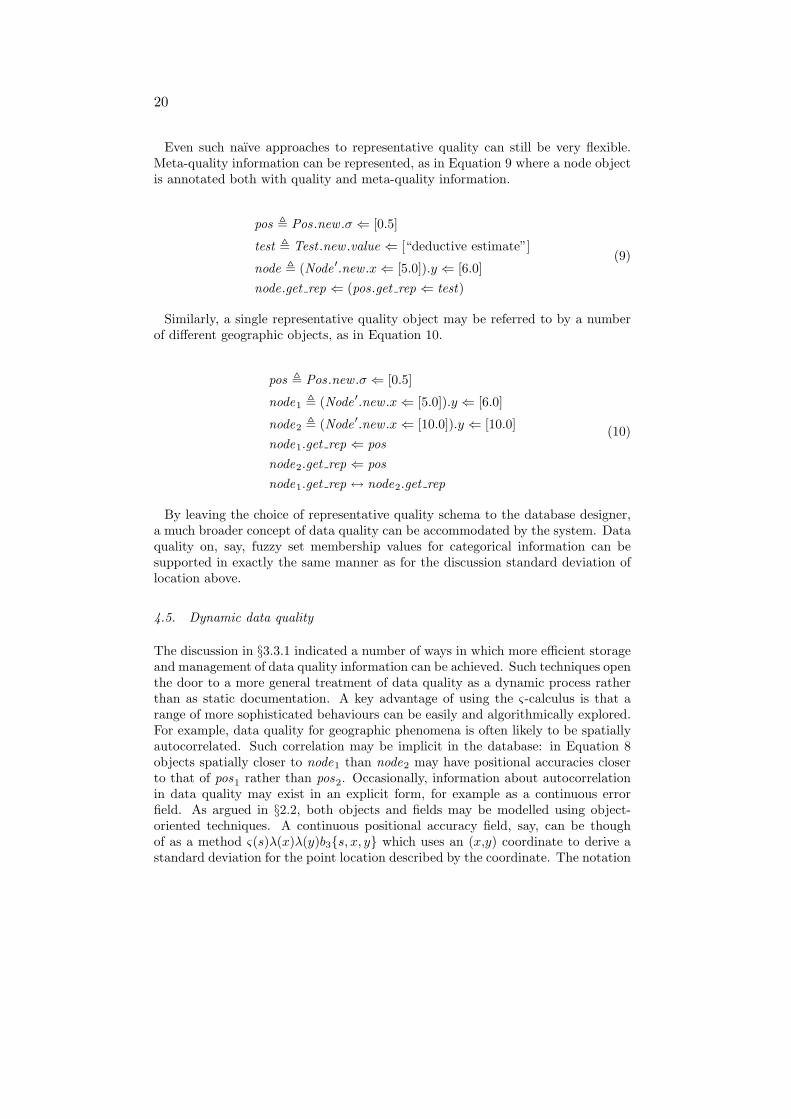
Even such naıve approaches to representative quality can still be very flexible.Meta-quality information can be represented, as in Equation 9 where a node objectis annotated both with quality and meta-quality information.
pos , Pos.new .σ ⇐ [0.5]
test , Test .new .value ⇐ [“deductive estimate”]
node , (Node ′.new .x⇐ [5.0]).y ⇐ [6.0]node.get rep ⇐ (pos.get rep ⇐ test)
(9)
Similarly, a single representative quality object may be referred to by a numberof different geographic objects, as in Equation 10.
pos , Pos.new .σ ⇐ [0.5]
node1 , (Node ′.new .x⇐ [5.0]).y ⇐ [6.0]
node2 , (Node ′.new .x⇐ [10.0]).y ⇐ [10.0]node1.get rep ⇐ posnode2.get rep ⇐ posnode1.get rep ↔ node2.get rep
(10)
By leaving the choice of representative quality schema to the database designer,a much broader concept of data quality can be accommodated by the system. Dataquality on, say, fuzzy set membership values for categorical information can besupported in exactly the same manner as for the discussion standard deviation oflocation above.
4.5. Dynamic data quality
The discussion in §3.3.1 indicated a number of ways in which more efficient storageand management of data quality information can be achieved. Such techniques openthe door to a more general treatment of data quality as a dynamic process ratherthan as static documentation. A key advantage of using the ς-calculus is that arange of more sophisticated behaviours can be easily and algorithmically explored.For example, data quality for geographic phenomena is often likely to be spatiallyautocorrelated. Such correlation may be implicit in the database: in Equation 8objects spatially closer to node1 than node2 may have positional accuracies closerto that of pos1 rather than pos2. Occasionally, information about autocorrelationin data quality may exist in an explicit form, for example as a continuous errorfield. As argued in §2.2, both objects and fields may be modelled using object-oriented techniques. A continuous positional accuracy field, say, can be thoughof as a method ς(s)λ(x)λ(y)b3{s, x, y} which uses an (x,y) coordinate to derive astandard deviation for the point location described by the coordinate. The notation
21
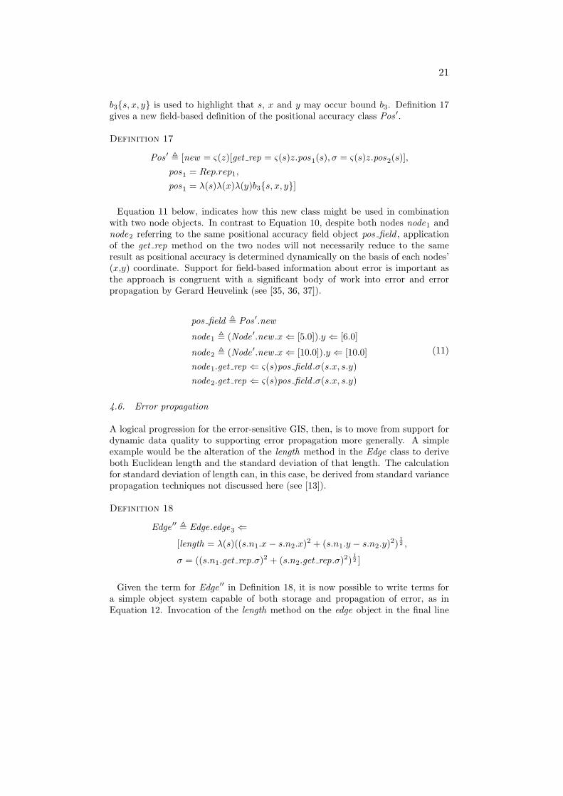
b3{s, x, y} is used to highlight that s, x and y may occur bound b3. Definition 17gives a new field-based definition of the positional accuracy class Pos ′.
Definition 17
Pos ′ , [new = ς(z)[get rep = ς(s)z.pos1(s), σ = ς(s)z.pos2(s)],pos1 = Rep.rep1,
pos1 = λ(s)λ(x)λ(y)b3{s, x, y}]
Equation 11 below, indicates how this new class might be used in combinationwith two node objects. In contrast to Equation 10, despite both nodes node1 andnode2 referring to the same positional accuracy field object pos field , applicationof the get rep method on the two nodes will not necessarily reduce to the sameresult as positional accuracy is determined dynamically on the basis of each nodes’(x,y) coordinate. Support for field-based information about error is important asthe approach is congruent with a significant body of work into error and errorpropagation by Gerard Heuvelink (see [35, 36, 37]).
pos field , Pos ′.new
node1 , (Node ′.new .x⇐ [5.0]).y ⇐ [6.0]
node2 , (Node ′.new .x⇐ [10.0]).y ⇐ [10.0]node1.get rep ⇐ ς(s)pos field .σ(s.x, s.y)node2.get rep ⇐ ς(s)pos field .σ(s.x, s.y)
(11)
4.6. Error propagation
A logical progression for the error-sensitive GIS, then, is to move from support fordynamic data quality to supporting error propagation more generally. A simpleexample would be the alteration of the length method in the Edge class to deriveboth Euclidean length and the standard deviation of that length. The calculationfor standard deviation of length can, in this case, be derived from standard variancepropagation techniques not discussed here (see [13]).
Definition 18
Edge ′′ , Edge.edge3 ⇐
[length = λ(s)((s.n1.x− s.n2.x)2 + (s.n1.y − s.n2.y)2)12 ,
σ = ((s.n1.get rep.σ)2 + (s.n2.get rep.σ)2)12 ]
Given the term for Edge ′′ in Definition 18, it is now possible to write terms fora simple object system capable of both storage and propagation of error, as inEquation 12. Invocation of the length method on the edge object in the final line
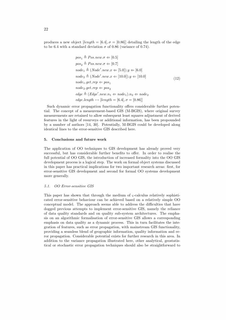
22
produces a new object [length = [6.4], σ = [0.86]] detailing the length of the edgeto be 6.4 with a standard deviation σ of 0.86 (variance of 0.74).
pos1 , Pos.new .σ ⇐ [0.5]
pos2 , Pos.new .σ ⇐ [0.7]
node1 , (Node ′.new .x⇐ [5.0]).y ⇐ [6.0]
node2 , (Node ′.new .x⇐ [10.0]).y ⇐ [10.0]node1.get rep ⇐ pos1
node2.get rep ⇐ pos2
edge , (Edge ′.new .n1 ⇐ node1).n2 ⇐ node2
edge.length � [length = [6.4], σ = [0.86]]
(12)
Such dynamic error propagation functionality offers considerable further poten-tial. The concept of a measurement-based GIS (M-BGIS), where original surveymeasurements are retained to allow subsequent least squares adjustment of derivedfeatures in the light of resurveys or additional information, has been propoundedby a number of authors [14, 30]. Potentially, M-BGIS could be developed alongidentical lines to the error-sensitive GIS described here.
5. Conclusions and future work
The application of OO techniques to GIS development has already proved verysuccessful, but has considerable further benefits to offer. In order to realise thefull potential of OO GIS, the introduction of increased formality into the OO GISdevelopment process is a logical step. The work on formal object systems discussedin this paper has practical implications for two important research areas: first, forerror-sensitive GIS development and second for formal OO systems developmentmore generally.
5.1. OO Error-sensitive GIS
This paper has shown that through the medium of ς-calculus relatively sophisti-cated error-sensitive behaviour can be achieved based on a relatively simple OOconceptual model. The approach seems able to address the difficulties that havedogged previous attempts to implement error-sensitive GIS, namely the relianceof data quality standards and on quality sub-system architectures. The empha-sis on an algorithmic formalisation of error-sensitive GIS allows a correspondingemphasis on data quality as a dynamic process. This in turn facilitates the inte-gration of features, such as error propagation, with mainstream GIS functionality,providing a seamless blend of geographic information, quality information and er-ror propagation. Considerable potential exists for further research in this area. Inaddition to the variance propagation illustrated here, other analytical, geostatis-tical or stochastic error propagation techniques should also be straightforward to
23
integrate. One logical way to approach this would be to provide generic super-classes, such as uncertain objects, with generic error propagation techniques, suchas Monte-Carlo simulation. Using inheritance, these generic techniques could beoverridden by more efficient focussed analytical techniques, such as those describedin [36], by sub-classes where appropriate. As suggested in §4.6, M-BGIS representa logical conclusion of this progression, although much more work remains beforethe system described here could be called an M-BGIS.
It is important to note that the system presented in this paper can only hope toprovide a flexible framework for the handling of uncertain spatial information. Theactual application of the information by human users to real problems is likely torequire a variety of higher level techniques and software (eg [6, 23]).
5.2. OO system development
The ς-calculus of Abadi and Cardelli [4] is more than capable of fulfilling the re-quirements for a rigorous tool able to support the conventional OO developmentprocess. The idea of a language fundamental to all object systems, able to ex-press the entire scope of OO concepts, promises the re-unification and solidificationof often fragmented and nebulous OO concepts. By allowing analysts to explorethe properties of an object system before design and implementation begin shouldprovide for greater code and concept reuse and for earlier detection of mistakes.Specifically, this work highlights a three distinct situations where formality may beuseful in the progression from OOA to OOD: a design may not capture the analysisupon which it is based in its entirety; different designs may implement differentfeatures not covered by an analysis; the boundary between analysis and design isnot always crisp.
Undoubtedly, the foremost drawback with the ς-calculus as presented here isits complexity especially when compared with the relatively intuitive traditionalOOAD techniques. It is likely that for many applications, the simplicity of conven-tional development techniques outweighs the disadvantages of informality. However,the ς-calculus is arguably no more complex than the OOP languages which manyGIS researchers and practitioners use. Further research might productively focuson the derivation of simpler formal development tools from ς-calculus. Abadi andCardelli [4] present the roots of a programming language based on the ς-calculus,and developments in this direction may lead to an object calculus which is more in-tuitive. Nevertheless, even in its present form, the ς-calculus has shown itself to beof significant benefit to the process of OOA in the context of engineering an error-sensitive GIS. The informality of OOAD techniques is already being questionedwidely. Formality is no guarantee correctness, and conventional OOAD techniquesmust remain at the core of any OO system development. However, the future ofresearch and development into OO GIS would be well served by integrating therigorous support mechanisms offered by the ς-calculus.

24
References
1. H.J.G.L. Aalders. Quality metrics for GIS. In M.J. Kraak and M. Molenaar, editors, Advancesin GIS research II; Proceedings Seventh International Symposium on Spatial Data Handling,volume 1, pages 5B1–10, 1996.
2. M. Abadi and L. Cardelli. An imperative object calculus. Theory and Practice of ObjectSystems, 1(3):151–166, 1995.
3. M. Abadi and L. Cardelli. A theory of primitive objects: Second-order systems. Science ofComputer Programming, 25(2-3):81–116, 1995.
4. M. Abadi and L. Cardelli. A theory of objects. Springer-Verlag: New York, 1996.
5. M. Abadi and L. Cardelli. A theory of primitive objects: Untyped and first-order systems.Information and Computation, 125(2):78–102, 1996.
6. A. Agumya and G.J. Hunter. Determining fitness for use of geographic information. ITCJournal, (2):109–113, 1997.
7. R.J. Aspinall. Measurement of area in GIS: A rapid method for assessing the accuracy ofarea measurement. In Proceedings of the GIS Research UK 1996 conference, pages 135–142,1996.
8. L. Becker, A. Voigtmann, and K.H. Hinrichs. Developing applications with the object-oriented GIS-kernel Goodac. In M.J. Kraak and M. Molenaar, editors, Advances in GISresearch II; Proceedings Seventh International Symposium on Spatial Data Handling, vol-ume 1, pages 5A1–18, 1996.
9. G. Blaschek and J.H. Frolich. Recursion in object-oriented programming. Journal of Object-Oriented Programming, 11(7):29–35, 1998.
10. G. Booch. Object oriented analysis and design with applications. Benjamin–Cummings:California, second edition, 1994.
11. J. Bowen. Formal specification and documentation using Z: A case study approach. Inter-national Thomson Computer Press: London, 1996.
12. C. Brunsdon and S. Openshaw. Simulating the effects of error in GIS. In P.M. Mather, editor,Geographical information handling: Research and applications. Wiley: New York, 1993.
13. P.A. Burrough and R.A. McDonnell. Principles of geographical information systems. Claren-don: Oxford, second edition, 1998.
14. G. Campbell, L. Carker, and P. Egesborg. A GIS-based multipurpose digital cadastre forCanada lands. In FIG Congress XX, 1994.
15. L. Cardelli. A semantics of multiple inheritance. In G. Goos and J. Hartmanis, editors,Semantics of data types, number 173 in Lecture notes in computer science, pages 51–67.Springer-Verlag: New York, 1984.
16. CEN/TC287. Draft european standard; geographic information — quality. Technical ReportprEN 287008, European Committee for Standardisation, 1996.
17. N.R. Chrisman. The role of quality information in the long term functioning of a geographicinformation system. In Proceedings Auto-Carto 6, volume 1, pages 303–312, 1983.
18. N.R. Chrisman. The error component in spatial data. In D.J. Maguire, M.F. Goodchild,and D.W. Rhind, editors, Geographical information systems, volume 1, chapter 12, pages165–174. Longman: Essex, 1991.
19. P. Coad and E. Yourdon. Object-oriented analysis. Yourdon Press: New Jersey, 1991.
20. B. David, M. van den Herrewegen, and F. Salge. Conceptual models for geometry and qualityof geographic information. In P.A. Burrough and A.U. Frank, editors, Geographic objectswith indeterminate boundaries, GIS Data 2. Taylor and Francis: London, 1996.
21. D. de Champeaux and P. Faure. A comparative study of object-oriented analysis methods.Journal of Object-Oriented Programming, 5(1):21–33, 1992.
22. M. Duckham and J. Drummond. Implementing and object-oriented approach to data quality.In B. Gittings, editor, Integrating Information Infrastructures with GI Technology, pages 53–64. Taylor and Francis, London, 1999.
23. M. Duckham and J. McCreadie. An intelligent, distributed, error-aware object-orientedGIS. In W. Shi, M.F. Goodchild, and P.F. Fisher, editors, Proceedings 1st InternationalSymposium on Spatial Data Quality, pages 596–505, 1999.

25
24. M.J. Egenhofer and A.U. Frank. Object-oriented modeling: Inheritance and propagation. InProceedings Auto-Carto 9, pages 588–598, 1989.
25. J. Fiadeiro and T. Maibaum. Describing, structuring and implementing objects. In G. Goosand J. Hartmanis, editors, Foundations of Object-Oriented Languages, number 489 in Lecturenotes in computer science, pages 274–310. Springer-Verlag: New York, 1991.
26. P.F. Fisher. Is GIS hidebound by the legacy of cartography? Cartographic Journal, 35(1):5–9,1998.
27. M. Goodchild. Integrating GIS and spatial data analysis: Problems and possibilities. Inter-national Journal of Geographical Information Systems, 6(5):407–423, 1992.
28. M.F. Goodchild. Sharing imperfect data. In H.J. Onsrud and G. Rushton, editors, Sharinggeographic information, pages 413–425. Rutgers: Jersey, 1995.
29. M.F. Goodchild. Directions in GIS. In Proceedings Third InternationalConference/Workshop on Integrating GIS and Environmental Modeling, 1996.http://www.ncgia.ucsb.edu/conf/SANTA FE CD-ROM/main.html.
30. M.F. Goodchild. Measurement-based GIS. In W. Shi, M.F. Goodchild, and P.F. Fisher,editors, Proceedings of the International Symposium on Spatial Data Quality, pages 1–9,1999.
31. A.D. Gordon and G.D. Rees. Bisimilarity for a first-order calculus of objects with subtyping.In Proceedings 23rd Annual ACM Symposium on Principles of Programming Languages,pages 386–395, 1996.
32. S.C. Guptill. Inclusion of accuracy data in a feature based object oriented data model. InM.F. Goodchild and S. Gopal, editors, Accuracy of spatial databases, chapter 8, pages 91–98.Taylor and Francis: London, 1989.
33. W. Haythorn. What is object-oriented design? Journal of Object-Oriented Programming,7(1):67–78, 1994.
34. J.R. Herring. TIGRIS: a data model for an object-oriented geographic information system.Computers and Geosciences, 18(4):443–452, 1992.
35. G.B.M. Heuvelink. Error propagation in quantitative spatial modelling: Applications in Ge-ographical Information Systems. University of Utrecht, 1993.
36. G.B.M. Heuvelink. Error propagation in environmental modelling with GIS. Research mono-graphs in GIS. Taylor and Francis: London, 1998.
37. G.B.M. Heuvelink, P.A. Burrough, and A. Stein. Propagation of errors in spatial modelingin GIS. International Journal of Geographical Information Systems, 3(4):303–322, 1989.
38. B. Jacobs. Objects and classes, co-algebraically. In B. Freitag, C.B. Jones, C. Lengauer,and H-J. Schek, editors, Object-Orientation with Parallelism and Persistence, pages 83–103.Kluwer, Massachusetts, 1996.
39. W. Kainz. Logical consistency. In S.C. Guptil and J.L. Morrison, editors, Elements of spatialdata quality, chapter 6, pages 109–137. Elsevier Science: Oxford, 1995.
40. K. Lano. Formal object-oriented development. Springer-Verlag, Berlin, 1995.
41. D.P. Lanter and H. Veregin. A research paradigm for propagating error in layer-based GIS.Photogrammetric Engineering and Remote Sensing, 58(6):825–833, 1992.
42. J.A. Lewis, S.M. Henry, D.G. Kafura, and R.S. Schulman. On the relationship betweenthe object-oriented paradigm and software reuse: An empirical investigation. Journal ofObject-Oriented Programming, 5(4):35–41, 1992.
43. D.J. Maguire and J. Dangermond. The functionality of GIS. In D.J. Maguire, M.F. Good-child, and D.W. Rhind, editors, Geographical information systems, volume 1, chapter 21,pages 319–335. Longman: Essex, 1991.
44. P. Milne, S. Milton, and J.L. Smith. Geographical object-oriented databases: A case study.International Journal of Geographical Information Systems, 7(1):39–55, 1993.
45. H. Moellering, editor. Spatial database transfer standards 2: Characteristics for assessingstandards and full descriptions of the national and international standards in the world.Elsevier Science: Oxford, 1997.
46. D.E. Monarchi and G.I. Puhr. A research typology for object-oriented analysis and design.Communications of the ACM, 35(9):35–47, 1992.
47. National Committee for Digital Cartographic Data Standards. The proposed standard fordigital catographic data. American Cartographer, 15(1):11–142, 1988.
26
48. J.M. Nerson. Applying object-oriented anlysis and design. Communications of the ACM,35(9):63–74, 1992.
49. C. Partridge. Modelling the real world: Are classes abstractions or objects? Journal ofObject-Oriented Programming, 7(7):39–45, 1994.
50. B.A. Ralston. Object oriented spatial analysis. In S. Fotheringham and P. Rogerson, editors,Spatial analysis and GIS, pages 165–186. Taylor and Francis: London, 1994.
51. B. Ramlal and J.E. Drummond. A GIS uncertainty subsystem. In Archives ISPRS CongressXVII, volume 29.B3, pages 356–362, 1992.
52. J. Raper and D. Livingston. Development of a geomorphological spatial model using objectoriented design. International Journal of Geographical Information Systems, 9(4):359–384,1995.
53. J. Rumbaugh, M. Blaha, W. Premerlani, F. Eddy, and W. Lorensen. Object-oriented modelingand design. Prentice Hall: New Jersey, 1991.
54. A.Y. Tang, T.M. Adams, and E.L. Usery. A spatial data model design for feature-based geo-graphical information systems. International Journal of Geographical Information Systems,10(5):643–659, 1996.
55. D.J. Unwin. Geographical information systems and the problem of error and uncertainty.Progress in Human Geography, 19(4):549–558, 1995.
56. US Department of Defense. Interface standard for vector product format, 1996. MIL-STD-2407.
57. F.J.M. van der Wel, R.M. Hootsmans, and F. Ormeling. Visualization of data quality. InA.M. MacEachren and D.R.F. Taylor, editors, Visualization in modern cartography, pages313–331. Pergamon: Oxford, 1994.
58. H. Veregin. Data quality parameters. In P.A. Longley, M.F. Goodchild, D.J. Maguire, andD.W. Rhind, editors, Geographical information systems, volume 1, chapter 12, pages 177–189. Longman: Essex, second edition, 1999.
59. C.G. Wesseling and G.B.M. Heuvelink. Manipulating qualitative attribute accuracy in vectorGIS. In Proceedings Fourth European Conference on Geographical Information Systems,volume 1, pages 675–684, 1993.
60. M.F. Worboys. A generic model for planar geographical objects. International Journal ofGeographical Information Systems, 6(5):353–372, 1992.
61. M.F. Worboys. Object-oriented approaches to geo-referenced information. InternationalJournal of Geographical Information Systems, 8(4):385–399, 1994.

27
Real world
Data set
Abstraction
Representation
Abstractspecification
Figure 1. Conceptual model of IS
uncertain objects
geographicobjects
...
representativequality
abstraction
...is consistent class
value
aggregate
component
Association
super-class
sub-class
Inheritance
Key to figure
get rep
Figure 2. Simplified OOA results

28
uncertain objects
geographicobjects
...
representativequality
class
value
aggregate
component
Association
super-class
sub-class
Inheritance
Key to figure
abstraction
...is consistent
get rep
Figure 3. Single inheritance analysis results
29
River A
Point A Point B Point C
Line APoint D Point E
Line B
Key to figure
object
value
aggregation
Figure 4. Aggregation in spatial databases
30
OOD
OOA
A
OOD
OOAB
OOD #2
OOD #1
OOA
COOA
OOD
D
Figure 5. Summary of OOAD transition
31
positionalaccuracy
accuracytest
class
value
aggregate
component
Association
super-class
sub-class
Inheritance
Key to figureuncertain objects
geographicobjects
representativequality
abstraction
...is consistent
node edge
σ value
get rep
x
ylength
Figure 6. Example integrated error-sensitive schema