O-Mopsi: Location-based Orienteering Mobile Game Location-based Orienteering Mobile Game ... GSM...
71
University of Eastern Finland School of Computing Master’s Thesis O-Mopsi: Location-based Orienteering Mobile Game Zhentian Wan 28.8.2014
Transcript of O-Mopsi: Location-based Orienteering Mobile Game Location-based Orienteering Mobile Game ... GSM...

University of Eastern Finland
School of Computing
Master’s Thesis
O-Mopsi: Location-based Orienteering Mobile Game
Zhentian Wan
28.8.2014

1
CONTENT
1. Introduction ................................................................................................................... 3
2. Location-based Applications ........................................................................................ 9
2.1 Location-based Services ....................................................................................................... 9
2.2 Location-based Games ........................................................................................................ 18
3. O-Mopsi Game ............................................................................................................ 26
3.1 Game Rules ......................................................................................................................... 26
3.2 O-Mopsi Game Playing ...................................................................................................... 27
3.3 Workshop in SciFest festival .............................................................................................. 32
4. O-Mopsi Web ............................................................................................................... 33
4.1 Game Hall ........................................................................................................................... 33
4.2 Creating a game .................................................................................................................. 36
4.3 How to Create Good Game ................................................................................................. 39
4.4 Game Simulation ................................................................................................................ 41
4.5 Facebook Publishing and Game Events .............................................................................. 43
5. Further Improvements on Game Design ................................................................... 45
5.1 New Game Patterns............................................................................................................. 45
5.2 Badges ................................................................................................................................. 46
6. Calculating Reference Route ..................................................................................... 48
7. Experimental Results .................................................................................................. 50
8. Usability Feedback ...................................................................................................... 57
9. Conclusions ................................................................................................................... 58
Reference .......................................................................................................................... 60
Appendix A: User feedback in SciFest 2014 ................................................................. 63
Appendix B: User feedback in SciFest 2013.................................................................. 66
Appendix C: User feedback in SciFest 2012 ................................................................. 68

1
Abstract
Location-based (mobile) game combines gaming and player's physical location. We have
developed a game O-Mopsi (cs.uef.fi/o-mopsi), which is based on the concept of classical
orienteering. O-Mopsi can be played on mobile phones with GPS receiver and Internet
connection. It requires players to move around in the real world. An O-Mopsi game consists of
targets, which are geo-tagged photos. In order to finish the game, player must visit the set of
targets in free order. The player with shortest time is the winner. Game creation, game
management, game result, online player tracking and social networking functionalities can be
found on the O-Mopsi web site. Games can be played at any time using O-Mopsi application,
which currently exist for Symbian, Windows phone and Android platforms. The game has also
been arranged as continuous workshop three time (2012, 2013 and 2014) at an annual
international festival (SciFest). SciFest is aimed at introducing science and technology to school
children. The overall feedback received from the players has been positive.
In this thesis, we describe the O-Mopsi game in detailed. We study how it has been technically
built and study the algorithms used in the game creation. We present the targets on the Google
map, and analyze game results. Specific attention is paid to the calculation of reference route,
which is NP hard optimization problem, a variant of travelling salesman problem. We compare
three algorithms: Tabu search, ant colony optimization and greedy algorithm with the O-Mopsi
game data and with larger scale data taken form Mopsi (cs.uef.fi/mopsi).
Keyword: Location-based aware, mobile gaming, orienteering, GPS, social network.

2
ACKNOWLEGEMENTS
I am grateful to University of Eastern Finland, Joensuu Campus for giving me the chance to
study here as one of IMPIT 2011 student. I want to express my thanks to all the teachers who
helped me to gain the experience of computer science area. And also thank to the organizers of
IMPIT Program.
I wish to thank my supervisor, Professor Pasi Fränti, for his guidance on my study and work. I
believe, thought those two years work and study under his guide, I have improved my problem
solving skills, programming and research skills. Also I would like to thanks every member of the
Mopsi group for letting me fell as part of team and giving me supports when I need.
I want to express my gratitude to my family for their moral and financial supports which helped
me finishing those two years study in Finland. They have always been my side, supporting me,
encouraging me, no matter the circumstances. Due to them ask for nothing in return but giving
me everything, I will keep moving and achieving a higher level in my life to answer their love. I
appreciate all your love very much.
I would also express my deepest gratitude to my high school supervisor, Professor Mantao Xu,
who changed my whole life and lead to a new level of the life. I know that words "Thank you" is
already not enough to show my gratitude to him. The things he has taught me is what I can learn
from nowhere and they are the most precious things in my life.

3
1. Introduction
Mobile devices that are aware of their location have become increasingly ubiquitous over last
few years. Nowadays, there are at least ten different systems in use or being developed that a
phone could use to identify its location. In most cases, several are used in combination, with one
stepping in when another one becomes less effective1.
Here we briefly introduce four most common ways which Smartphone use to detect the location:
GPS;
Cell ID;
Network;
Wi-Fi.
Global Positioning System (GPS) was developed by the U.S Department of Defense and was
first included in cell-phones in the late 1990s. It is the best-known way to identify the user
location outdoors. A constellation of satellites is used to send location and timing data from
space directly to the user phone. If the phone can pick up signals from three satellites, it can
detect where you are on a flat map, and with four it can also detect your elevation.
There are two other GPS-based technologies which could help to improve the accuracy. They are
Assisted GPS (A-GPS) and Synthetic GPS (S-GPS). GPS works well if phone finds three or four
satellites, but it may take a long time or even no signal at all if you are indoor or in an "urban
canyon" of buildings which reflect satellite signals. A-GPS describes a collection of tools that
help to solve the problem. For example, in indoor situation, phone may use Wi-Fi or network to
get data until full GPS service starts. But this still requires an available data network and the time
to transmit the satellite information. S-GPS uses computing power to forecast satellites' locations
days or weeks in advance in order to help phone to identify its location in two seconds or less.
GSM Cell ID (CID) is a generally unique number used to identify each base transceiver station
or sector (BTS) within a location area code (LAC) if not within a GSM network2. This system
tends to be more aware in urban areas with more smaller cells than in rural areas, where cell may
cover an area of several kilometers in diameter.
Network and Wi-Fi do much the same thing as Cell ID, but with greater precision because their
access points cover a smaller area. The most common way how Wi-Fi determines location is
called received signal strength indication (RSSI). It takes the signals your phone detects from
nearby access points and refers to a database of known Wi-Fi networks. Using signal strength to
1 http://www.pcworld.com/article/253354/ten_ways_your_smartphone_knows_where_you_are.html 2 http://en.wikipedia.org/wiki/Cell_ID

4
determine distance, RSSI determines the location in relation to those known access points (see
Figure 1, 2).
Figure 1: GPS positioning & Network / Wi-Fi positioning
Figure 2: Communication and positioning as location-based service components
Location-based game (LBG) is a type of pervasive game in which the game-play evolves and
progresses via a player's location3. In most cases, a location-based game uses GPS to determine
the location. We have developed a location-based game called O-Mopsi4. It is based on the
classical concept of orienteering and exploits the data available in a geo-tagged user generated
photo collection5. A game is created by defining a set of targets so that players must visit all the
targets in order to complete the game [1]. So far, we have developed O-Mopsi on three different
3 http://en.wikipedia.org/wiki/Location-based_game 4 http://cs.uef.fi/o-mopsi/ 5 http://cs.uef.fi/mopsi/photos/
5
mobile platforms, Nokia Symbian, Windows phone and Android platforms. The mobile client
has functionalities such as plotting targets on the map, displaying compass data and giving audio
clue with varying pitch and sound frequency about the distance to a target. Photos are used as an
additional aid for identifying a target. The web interface allows game management, real-time
players tracking, post-game trail analysis and suggesting tours calculated by Tabu search
algorithm [1]. Calculating reference routes as a study topic, we also developed a TSP page6 for
testing different algorithms and allowing access to more data from Mopsi7 user collections. O-
Mopsi was designed for the annual SciFest Festival8 which brings together thousands of school
kids, high school students, and teachers to learn about science and technology. O-Mopsi was
presented during 2012, 2013 and 2014.
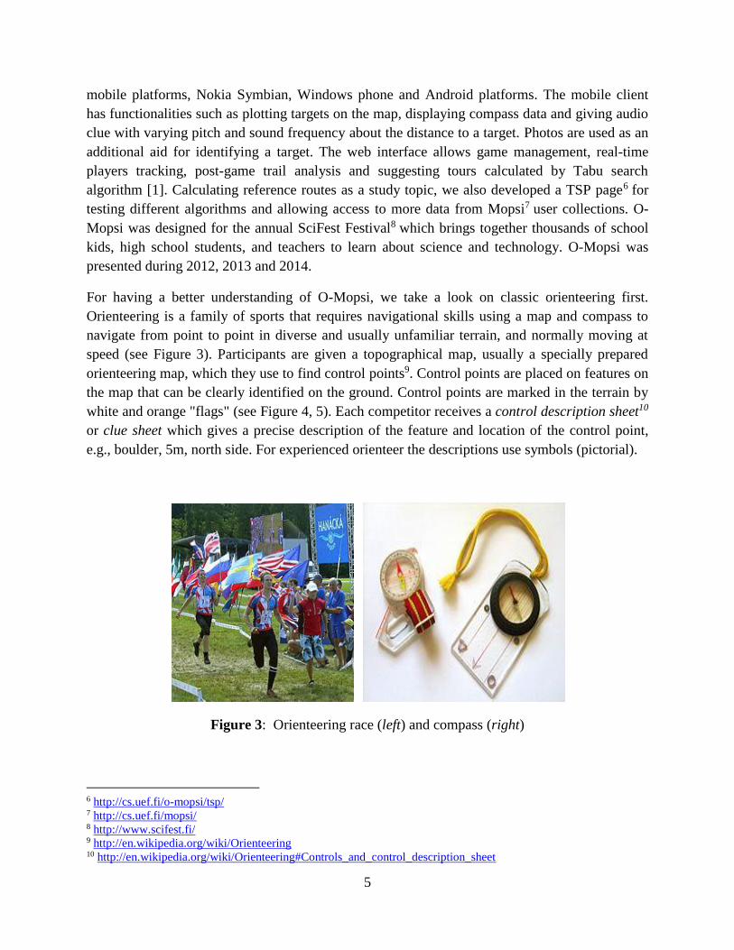
For having a better understanding of O-Mopsi, we take a look on classic orienteering first.
Orienteering is a family of sports that requires navigational skills using a map and compass to
navigate from point to point in diverse and usually unfamiliar terrain, and normally moving at
speed (see Figure 3). Participants are given a topographical map, usually a specially prepared
orienteering map, which they use to find control points9. Control points are placed on features on
the map that can be clearly identified on the ground. Control points are marked in the terrain by
white and orange "flags" (see Figure 4, 5). Each competitor receives a control description sheet10
or clue sheet which gives a precise description of the feature and location of the control point,
e.g., boulder, 5m, north side. For experienced orienteer the descriptions use symbols (pictorial).
Figure 3: Orienteering race (left) and compass (right)
6 http://cs.uef.fi/o-mopsi/tsp/ 7 http://cs.uef.fi/mopsi/ 8 http://www.scifest.fi/ 9 http://en.wikipedia.org/wiki/Orienteering 10 http://en.wikipedia.org/wiki/Orienteering#Controls_and_control_description_sheet

6
Figure 4: Control points11
Figure 5: Example of control points marked on the map & control description sheet
Orienteering has many variations. Foot Orienteering (foot-O) is one of the oldest and most
popular one. Usually, a foot-O is a timed race in which participants start at staggered intervals,
are individually timed, and are expected to perform all navigation on their own. The control
11 http://en.wikipedia.org/wiki/Orienteering#Competition_and_results

7
points are shown on the orienteering map and must be visited in specified order. Standings are
determined first by successful completion of the course, then by shortest time on course12.
Orienteering has been included in the programs of world sporting events including the World
Games13. The rules and guidelines14 of orienteering are defined by the International Orienteering
Federation (IOF)15.
Classic orienteering16 is a race between controls in a preset order. The winner is the person who
completes the course in the shortest time. This is usually cross-country. Courses are normally
designed so that the fastest route is not straightforward to find on the map, and not easy to follow
on the ground. The classic orienteering has a typical winning time of 75 - 90 minutes. Classic
orienteering are usually held in forest to increase difficulty level (see Figure 6).
Another type of orienteering is called sprint orienteering17. It is described by much shorter races,
with winning times in the region of 12 - 15 minutes, often held in city parks and other more
urban settings (see Figure 6). Control sites can include benches, litterbins, sculptures, and other
objects common to urban parks. Usually one needs to visit all targets but there are variations
where the aim is to visit as many as possible within a given time.
Figure 6: Example of classic (left) and sprint orienteering (right) map.
12 http://en.wikipedia.org/wiki/Foot_orienteering 13 http://www.theworldgames.org/ 14 http://orienteering.org/foot-orienteering/rules/ 15 http://orienteering.org/about-the-iof/the-iof/ 16 http://en.wikipedia.org/wiki/Orienteering#Classic 17 http://en.wikipedia.org/wiki/Orienteering#Sprint

8
For example, in 2013, there was Cycling Joensuu18 orienteering races held by University of
Eastern Finland Students Unit. The rules19 state that there are two people in a team and each
team will get a map (see Figure 7) with legend describing tasks. The aim is to find the control
points and fulfill every task correctly. Each task is worth different amount of points. The team
with the biggest total amount of points wins the race. In case of equal points, shortest time wins.
The inspiration of O-Mopsi game is classic orienteering but there are differences. In O-Mopsi,
there is no fixed visiting order, but the player can freely choose the order to visit the targets. All
player uses GPS and mobile phones instead of a map and compass.
Besides orienteering aspect, O-Mopsi can combine educational and travelling aspects. For
example, selecting tourist attractions as targets would create a sight-seeing tour, instead of a
racing game, and users might just tour the targets without competing who is the fastest. For
educational purposes, each target should have some educational motive depending on the subject.
The remainder of the thesis is structured as follows. In Section 2, we give an overview of
location-based services and location-based games. In Section 3 we show how one plays O-Mopsi
games. In Section 4, we study what O-Mopsi application consists of. In Section 5, we study the
algorithms in O-Mopsi. User feedback from SciFest 2012 and 2013 are given in Section 6, and
conclusions drawn in Section 7.
Figure 7: Example of Cycling Joensuu map - Bike
18 http://isyy.fi/en/events/cycling-joensuu/ 19 http://vladt89.com/files/runcity/Cycling_Joensuu_rules.pdf

9
2. Location-based Applications
2.1 Location-based Services
A Location-based Service (LBS) is defined by the CTIA20 as "any wireless service or application
that uses the geographical position of a wireless device"21. According to a GSMA22 study, the
most commonly used location-based services are practical services, such as weather information
or maps, and users of these services value them highly. For example, Figure 8 shows Joensuu
city on OpenStreetMap and Figure 9 shows the weather of different cities in Finland23.
Currently, many location-based applications are available in the market, and one can use these
applications with a smart phone with GPS inside. Foursquare24 is one of the most well-know
location-based social networking service for mobile devices. By using Foursquare (see Figure
10), people can share and save the places they visit. Users "check-in" at real-world venues, and
with each check-in, they are awarded points and sometime "badges" or "venue mayor ships".
Foursquare had over 40 million users worldwide as of September 2013 [2].
Figure 8: Example of a location-based map service called OpenStreetMap
20 http://www.ctia.org/ 21 http://www.fosigrid.org/family-online-safety/content/location-based-services 22 http://www.fosigrid.org/companies/gsma 23 http://en.ilmatieteenlaitos.fi/weather/Joensuu%20 24 https://foursquare.com/activity

10
Figure 9: Example of location-based weather services.
Figure 10: Searching for food in Joensuu city with Foursquare

11
The "check-in" functionality is quite popular nowadays. On Foursquare, there is over 4.5 billion
check-ins in total, and millions more coming every day (see Figure 11).
Figure 11: Foursquare, mobile client, check-in
In China, there is a very popular LBS application called Jiepang25 (Chinese: 街旁), with almost
the same functionalities as Foursquare. Users can use Jiepang application to track and share life
moments with friends. It is one of the leading location based services for "check-in" in china.
Currently, it has more than 5 million registered users.
2.1.1 Mopsi Application
Mopsi26 is a location-based service [3]. It is a locator assistant that helps individuals to know
where the other users are and what is around them. It supports photo sharing, tracking and
chatting. It has applications integrated both on web and in mobile phones. Mopsi contains service,
photo and route databases. The latter two are collected by users via mobile applications. User
profile database is used for giving personalized recommendation containing data about activities
of Mopsi users within the area [4]. Figure 12 shows the web interface of Mopsi.
Mopsi data collection
In Mopsi, there are two kinds of user generated data that can be uploaded and saved on the
Mopsi server: geo-tagged photos and routes. Mopsi users can review their data collections, and
also view other Mopsi users' collections. Photo may have an associated description which user
can type when the photo was taken. Once photo is uploaded to server, the location (latitude and
longitude) and Unix timestamps is also sent and stored in the database. A route is a sequence of
points recorded at a fixed interval. The system distinguishes the following mode of transportation:
walk, run, bicycle and car [5].
25 http://jiepang.com/ 26 http://cs.uef.fi/mopsi/

12
Figure 13 shows both photo and route results for a selected user, Pasi. He has over 1000 routes
consisting of over 2 million points in total until 5.7.2014. To display such a massive amount of
data the system uses polygonal approximation and bounding box solutions as described in [6].
There are 2341 photos took by Pasi in a year. They are placed on the map at the locations they
were taken. For displaying the large photo data on the map and avoid overlapping elements, a
grid-based clustering algorithm27 is applied. Photos appear also in the timeline view, on the top
of the web page, clustered by time28.
Figure 12: Example of Mopsi web interface
Figure 13: Example of photos and routes collections from Mopsi user
27 http://cs.uef.fi/o-mopsi/Document/ClusteringMopsi_logic.pptx 28 http://cs.joensuu.fi/~radum/master_thesis/Detecting%20user%20actions%20in%20MOPSI.pdf

13
A route is analyzed by automatic segmentation, and detection of the movement type is done for
each segment [5]. Figure 14 shows a route belonging to user Pasi. The route is segmented and
classified mostly as running activity with one stop.
Figure 14: Analyzed route containing mostly running activity
On the mobile client, a user can view other users' collections. Linear access by time is
implemented, and the most recent photo or route is being shown first. Figure 15 shows how a
photo and route from Pasi's collection appear on Mopsi for Windows Phone.
Figure 15: Mopsi on mobile (Windows Phone) showing a photo (left) and a route (right)

14
Location-based Search
Normal search engine like Google, Bing and Yahoo provide fast and relevant information.
However, they don't utilize one important aspect of relevance: the location of the user. One
reason for this is that location was not as widely available in the past as nowadays when GPS
technology is integrated in most smart phones. Another reason is that web pages are rarely
attached with location information [7].
Location-based search according to location information and keywords can provide relevant
results in the user’s area. Some famous applications like TripAdvisor29 and Booking30 provide
tourist information, hotel information and reservation system. For example, a user wants to spend
holidays in Hallstatt, Austria and needs to find a hotel on Booking. Given location and time
information, Booking will provides the results (see Figure 16).
Figure 16: Booking search hotels in HallSatt from 30.12.2013 - 1.1.2014
Mopsi search combines traditional location-based service and search engine. It retrieves data
from a local database, then queries relevant data from the user collections and finally performs
location-based search from web as originally proposed in [8], and later implemented as
summarized in [9]. The key idea is to use ad-hoc geo-referencing of the web page based on
address detection within the body text [10], rather than relying on geo-tags or address tags which
rarely exist.
29 http://www.tripadvisor.com/ 30 http://www.booking.com/

15
A user may access Mopsi search from the web31 as illustrated in Figure 17. Location can be
selected by dragging the marker to the desired place on map or by typing an address in the
appropriate field. Keyword must also be specified. The Mopsi mobile solutions32 also provide
access to the search. Figure 18 shows this feature on Windows Phone. Here location information
is automatically detected by the phone. The only needed input by the user is the keyword [11].
Mopsi search engine allows the user to find nearby services and photos from user collection.
Services represent a variety of categories such as restaurants, bars, cafeterias, grocery stores,
museums, pharmacies and ATM machines. They are verified by administrators and are
illustrated with green color coding. The information associated with them contains a title,
location, photo, description, web link, keywords and user ratings. Photos are part of user
collections and are marked with yellow coding [11].
Figure 17: MOPSI web - searching for basketball in Joensuu
Location-based Recommendation
A common scenario for modern recommendation systems is a Web application with which a user
interacts. Typically, a system presents a summary list of items to a user, and the user selects
among the items to receive more details on an item or to interact with the item in some way [12].
For example, YouTube33 is one of the largest video-sharing website in the world. YouTube can
recommend users videos according to what they watched in the past.
Location-based Recommendation (LBR) is almost the same as other recommendation system, the
main difference is that LBR system take location as input, and give the relevant result based on
31 http://cs.uef.fi/mopsi 32 http://cs.uef.fi/mopsi/mobile.php 33 http://www.youtube.com/

16
this input. For example, Tripadvisor34, if a user wants to spend holidays in Wien (Austria), then
giving Wien as search input, the results are shown in Figure 19. These are recommended based
on the ranking by all users, your Facebook35 friends, and other relevant information such as
hotels.
Figure 18: Searching for pizza in Joensuu using MOPSI for Windows Phone [11]
Figure 19: Attractions and hotels recommended by Tripadvisor
34 http://www.tripadvisor.com/Attractions-g190454-Activities-Vienna.html 35 https://www.facebook.com/

17
Four aspects of relevance are [3]: content, time, location and user social network. The system
recommends trusted services, geo-tagged photos and routes. The goal is to offer personalized
recommendations [4] by combining the three different data sources as described in the last two
subsection. Binary search is used by doubling or halving the radius depending if too few or too
many results are found. The process continues until enough results are found. A minimum of 10
results is the threshold for stopping the search (see Figure 20).
A user may ask for recommendations using the Mopsi web page (see Figure 21). In addition to
time and location, the results also depend on the user profile and automatically obtained
preferences. If the user is not logged in, user interests are excluded from the search criteria.
Recommendation does not require additional user input, as opposed to the keyword required by
the Mopsi search [11].
Recommendation can be used on the mobile trough a single tap of a button (see Figure 22).
Location is automatically detected from the GPS sensor. Time and user identity are directly
available in the application [11].
Figure 20: Changing radius to find results when nothing is close [11]

18
Figure 21: Mopsi web showing recommendations in Joensuu
Figure 22: Mopsi for Windows Phone showing recommendations in Joensuu [11]
2.2 Location-based Games What can be called a game? “The game is one of the innate expressions of the human being. It is
born with our abilities to move our bodies, and since then, has evolved through connections with
dance, music, mimiryc and the exploration of the senses. It is one of the first manifestations of
sociability, because even though it can be played alone, the game's full achievement is in the

19
interaction with others” [13]. From the given definition, we know that a game can mix different
physical realities, entrainment and communication.
2.2.1 Location-based mobile games overview
Location-based game experiences extend digital media out into the physical world – be it across
a campus, the city streets or into remote wilderness. User with mobile displays move through the
world. Sensors capture information about their current context, including their location, and this
is used to deliver them an experience that changes according to where they are, what they are
doing, and maybe even how they are feeling. As a result, the user becomes unchained form their
PC and experiences digital media that is associated with the everyday world, and that is
potentially available in any place at any time [14]. Location-based experiences aim to provide
the user with a richer experience that extends across a series of locations. Perhaps the most
compelling - and commercially promising – example is location-based games.
One good example for a location-based experiences game which catching most people eyes is a
TV show called The Amazing Race36. It pits 11 teams, each comprised of two members, against
each other on a trek around the world for approximately 25 days. At every destination, each team
must compete in a series of challenges, some mental and some physical, and only when the tasks
are completed they will learn of their next location (see Figure 23). Teams who are the farthest
behind will gradually be eliminated as the contest progresses, with the first team to arrive at the
final destination winning $1 million. Most of participants expressed their deep appreciation for
this game, no matter whether they won the price or not, but because the experiences they got
from this kind of game touched them much and gave them a different experience from other kind
of games.
Figure 23: one team (left) was on the way & one team (right) was trying to complete their task
36 http://www.cbs.com/shows/amazing_race/

20
2.2.2 Motivations for Location-based game
Physical reality
According to Maged and Stephen’s article [2], there are large numbers of children and
adolescents who are not getting their recommended daily dose of moderate to vigorous physical
activity, and are thus more prone to obesity and its ill health effects. Therefore, more physical
realities are needed in people daily life. Exergames are video games that require physical activity
to play or moving one’s body. For example, Kinect 37 is a full body gaming, no controller, no
remotes, developed by Microsoft, see Figure 24. It has already attracted lots of users, but it
requires to have Kinect device.
Location-based games can be considered as physical reality when this game is played outdoor
and combine physical activity. However, some location-based games, for example shadow city,
can be played even at home, and therefore, lacking the physical activity.
Education
Games are traditionally not associated with learning, but can arouse the intrinsic motivation of
the learner [15]. Computer games in particular have been shown to raise students’ intrinsic
motivation to learn [16]. However, games on a desktop computer in the classroom mostly present
the learning material in an artificial context and, more often than not, provide a very passive,
repetition-based experience for the user, failing to appropriately raise motivation [17]. This is
where mobile games in general, and pervasive games in particular, offer advantages. For
example, Savannah [18], is a game for children in which one can learn how lions live and hunt in
the African savannah. In the first part of the game the children play outside and move their
character, a lion, on the virtual game field, by moving themselves in the real world. After the
hunt, they return to the classroom to discuss the events of the game.
37 http://www.xbox.com/en-US/KINECT

21
Figure 24: Two persons are playing volleyball game on Kinect
Tourist & Culture
Location-based game can also be used for learning culture and get tourist information about one
city. Learning culture [19] is a game in which a story is given and a player should find the object
(building, landscape and museum) according to the clues provided in the city of Matera. When
the player gets close to this object, its historic story and culture information will be shown on the
mobile device and next clue will be given. In this way, players can tour around the city and learn
its culture. The information about the artistic and cultural heritage of the city Matera is provided
by city tourist center. Another example is GUIDE project [20], which provides city visitors with
a hand-held context-aware tourist guide.
Data Acquisition
Location-based games can also be used for real world data acquisition. With the help of the users,
data can be collected about the real world to create more accurate or more detailed maps. For
example, a building can be marked as a church or as tourist attraction. This data can be
integrated in a map to allow better navigation.
2.2.3 Location-based game patterns
A location-based game (LBG) is here defined as a form of play that is designed to be played on a
device in motion and changes the game experience based on the location [21]. There are four
common game patterns which are analyzed [21] (see Figure 25).
1. Search and find
2. Follow the path
3. Chase and catch
4. Change of distance
Search-and-Find
In Search-and-Find, the basic concept is that player has to reach a destination. This location of
destination is fixed. The most famous LBG game using this pattern is geo-caching38. In this type
of games the player has to find an object which is hidden at certain location with only its GPS
coordinates are given. The object is usually a real world box containing various items. The aim
of the game is to find this box using the GPS coordinates, choose one of the items stored in the
box, and in turn put a new item into the box (see Figure 26).
O-Mopsi belong to this category also. Different from geo-caching, O-Mopsi requires players to
visit many places to find certain objects (building, signpost, land marker and so on) in order to
finish the game.
38 http://www.geocaching.com/guide/

22
Figure 25: Graphical overview over the analyzed game patterns
Figure 26: Main components of Geo-caching, treasure box (left) and GPS device (right)
Chase-and-Catch

23
In Chase-and-Catch [22], players hunt a moving object, which can be another player or a virtual
target existing only in the game world. The basic concept here is that the destination changes
frequently. This pattern can be used in a single player environment with one player chasing one
object, such as a hunter chasing a fox [22], or in a more complex multiplayer environment. For
example, in Shadow Cities (no longer available) where two groups of players try to catch each
other with every player chasing and being chased at the same time (see Figure 27).
Figure 27: Example of Shadow cities
In Botfighter [23], the player takes control of a robot with the mission of destroying other robots,
controlled by other players. The players wander around the streets in order to find and destroy
their enemies, while being on their toes as the other players might have them on their sights.
Each kill provides the executioner with credits that can be spent at the game's website to improve
the robot's capabilities further.
Follow-the-Path
Follow-the-path pattern is similar to search-and-find because the main goals in both of them are
reach a destination, but follow-the-path asks a player to follow a given route. This is like classic
orienteering, where all players must visit each targets in order. Besides a given route, it is also
possible not to give any path to follow, but to track the other players movement [21]. For
example, CityExplorer [24] is a game that aims to produce geospatial data to be used for non-
gaming applications like a location-based service. In the game, players explore a city and take

24
photos by their smart phone about objects in different categories (see Figure 28). Another
example of this kind of game is called Tourality39, which has following game modes:
1. Race: Reach all targets faster than your competitors by reaching the targets in the given
order (A-B-C-D).
2. Chase: All targets are active when the game starts. Reach more active targets and dye
them in your color before the others.
3. Rush: Reach all targets in the game faster than your competitors. The sequence of
reaching them is up to your strategy.
4. Act: At the beginning all targets except one are deactivated. As the only active spot is
reached it gets deactivated, and another Spot is activated randomly. Reach more active
targets than anyone else.
Race belongs to the class of follow-the-path, Act and Rush belongs to Search-and-find, and
Chase belongs to the class of chase-and-catch.
Change-of-Distance
In change-of-distance, the main goal is to get closer to a geo-location or further away. The
location itself is not important; it is just the movement that matters. Another distinction is that
the direction is not important either. One example game in this pattern is The Journey40, an
adventure game where the player can read the next part of the story only after having moved a
certain distance.
Figure 28: Example of user collection of CityExplorer
In Table 1, we list some games and show in which game category it belongs to, with its
motivations listed as well.
39 http://www.tourality.com/ 40 http://journey.mopius.com/

25
Table 1: Summary of LBGs
Game Game Patterns Motivations
Search
&
Find
Follow
Path
Chase &
Catch
Chang
Distance
Physical
Activity
Education Tourist &
culture
Data
Acquisition
O-Mopsi41 X - - - X - X -
Geocaching42 X - - - X - - -
Tourality43 X X X - X - - -
FoxHunt [22] - - X - X - - -
Shadow Cities - - X - X - - -
Botfighters [23] - - X - X - - -
Savannah [18] - - - X X X - -
CityExporer [24] X - - - X - - X
Business
education [17]
X
-
-
-
X
X
-
-
AnswerTree [25] X - - - X X - X
GUIDE [20] X - - - X - X -
Learn culture [19] X - - - X - X -
The Journey44 - - - X X - X -
Foursquare45 X -
-
-
X -
X
X
RunAway46 - - X - X - - -
Ingress 47 - - X - X - - -
41 http://cs.uef.fi/o-mopsi/ 42 http://www.geocaching.com/ 43 http://www.tourality.com/ 44 http://journey.mopius.com/ 45 https://foursquare.com/ 46 http://runawayapp.com/ 47 http://www.ingress.com/

26
3. O-Mopsi Game
O-Mopsi is a side-project of Mopsi. It is a game based on the classical concept of orienteering. A
game is created by defining a set of targets. The player needs to visit all the targets in order to
complete the game. The player spends shortest time is the winner. The game is played with a
smart phone equipped with GPS and internet connection. Currently, there are three O-Mopsi
versions available: one is for Nokia Symbian phone, Android and Windows Phone platforms (see
Figure 29).
Figure 29: O-Mopsi version in three platforms
3.1 Game Rules A game starts when player opens the game if GPS signal is available. Player needs to press the
start button as well. The visiting order of targets is free and it gives extra challenge to the player
to find the best order. To visit a target, a player must be closer than 20 meters to its location. This
threshold was chosen considering GPS inaccuracies that occurs in the mobile device. For a good
game, the creator should make sure that all targets have accurate location. A game ends when all
targets have been visited.
Game results and players' progresses can be monitored real time using O-Mopsi web page, which
also includes tools for game analysis including calculation of the shortest tour for reference.
Players are ranked by time of completion. A player can also pause the game and continue it later,
27
but the time keeps running and added to the player's total time of the game playing. The player's
route is recorded and stored on server.
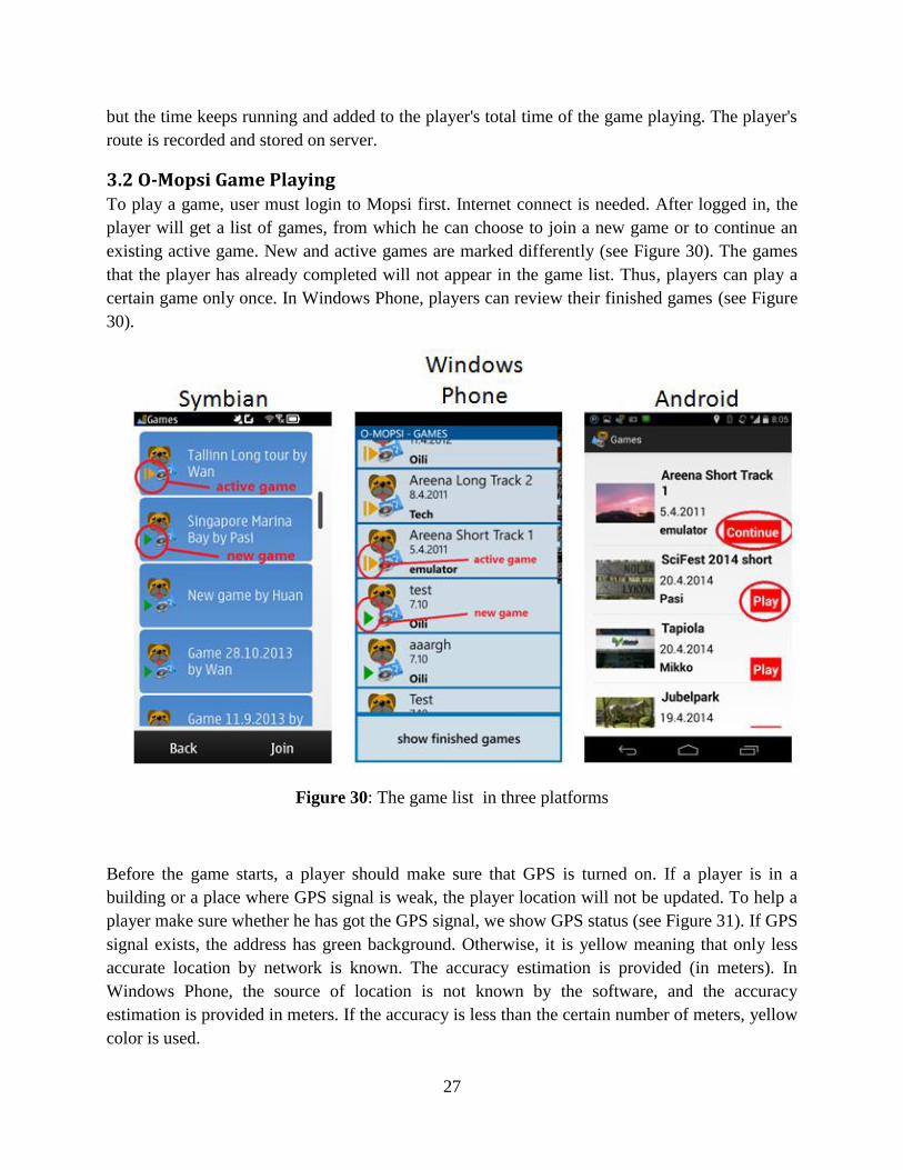
3.2 O-Mopsi Game Playing To play a game, user must login to Mopsi first. Internet connect is needed. After logged in, the
player will get a list of games, from which he can choose to join a new game or to continue an
existing active game. New and active games are marked differently (see Figure 30). The games
that the player has already completed will not appear in the game list. Thus, players can play a
certain game only once. In Windows Phone, players can review their finished games (see Figure
30).
Figure 30: The game list in three platforms
Before the game starts, a player should make sure that GPS is turned on. If a player is in a
building or a place where GPS signal is weak, the player location will not be updated. To help a
player make sure whether he has got the GPS signal, we show GPS status (see Figure 31). If GPS
signal exists, the address has green background. Otherwise, it is yellow meaning that only less
accurate location by network is known. The accuracy estimation is provided (in meters). In
Windows Phone, the source of location is not known by the software, and the accuracy
estimation is provided in meters. If the accuracy is less than the certain number of meters, yellow
color is used.

28
Figure 31: Check GPS signal (O-Mopsi Symbian)
Once game starts, player will access the game screen. The interface of the Symbian and
Windows Phone versions is slightly different, however, they both has the following six
components (see Figure 32):
Current Location
Game statistic
Goal details
Closest goal
Game results
Exit
Figure 32: Game screen in three platforms

29
First component displays current location with the accuracy estimation in meters, and GPS status
by the background color. The second component displays game statistic including the total time
spent, the moved distance and the current speed. The third component shows the visited and total
number of targets. By clicking this button, user will access the targets list screen (see Figure 33).
It displays targets with photo thumbnails and the distance to the target location with direction.
The photo which is surrounded by green border or background means this target has already
been visited, whereas the red border or background means it is unvisited. When player clicks any
target in the list he will navigate to the target detail screen in Symbian version. In Windows
Phone version, it will open the map. There are four main components in target detail screen (see
Figure 34):
Distance & direction
Photo
Target description
Back & Map buttons
The number like 1.6 km, NE shown in Figure 34 tells the distance and direction between the
player's location and the target's location. A player can see a larger photo to help to identify the
target and the description is given below. Here player can click map button to see the target on
the map or return back to the target list screen.
Figure 33: Target list screen in three platform

30
In O-Mopsi, both OpenStreetMap and Nokia map are available in Symbian version. For
Windows Phone version, Bing map is used. On the map, it shows all targets and the location of
player is updated in real time. If a target has been visited, the border of this target is marked by
green color, otherwise by red. The route of the player is also drawn on the map. The closest
target to player position is demonstrated by blinking until player visits it or another target is
clicked on the map (see Figure 35). Blinking is helpful especially when there are lots of targets
on a map close to each other. The distance to this target is also shown.
Figure 34: Goal details screen in Symbian version
Figure 35: Map view in three platforms

31
For approaching a target, player is guided by sound. When distance is closer than 500 m, a
beeping sound is played at fixed intervals. The interval between sounds is inversely proportional
to the distance, starting from 2 seconds (500 m) and decreasing by 0.5 second every 100 m. The
sound frequency increases or decrease depending whether the player becomes closer or further
away from the target (see Table 2). After visiting a target, the approaching sound is stopped and
a different sound is played to tell the player that he has reached the target. This sound would be
played no matter on which screen is open in the game.
Player finishes the game immediately after he has reached the last goal. He can then check the
results by clicking the game result button and see his rank and total time spent. The results of the
other players (see Figure 36) are shown also.
Table 2 : The distance sound interval for different distance levels
Distance Sound
interval
> 500 m no sound
400-500 m 2 s
300-400 m 1.5 s
200-300 m 1 s
100-200 m 0.5 s
60-100 m 0.3 s
20-60 m 0.2 s
< 20 m "found" sound
Figure 36: Game result screen in three platforms

32
3.3 Workshop in SciFest festival
O-Mopsi has been presented in SciFest festival 2012, 2013 and 2014 (see Figure 37 and 38). The
overall feedback is positive, we attach the questionnaire in the appendix A. There are more than
20 players played O-Mopsi each year.
Figure 37: Our staff helping children to set up O-Mopsi Game in SciFest2012.
Figure 38: Our staff presenting O-Mopsi to children in SciFest2013.

33
4. O-Mopsi Web
O-Mopsi web interface can be used for viewing the games, displaying the proposed shortest tour
of a game, displaying game results and viewing players progress real-time. After logged in, user
can also create new games or manage the games he has created earlier. User can publish his
game result and his created games to the Facebook if he has connected his Mopsi and Facebook
accounts. Figure 39 shows the use cases of web client.
Figure 39: O-Mopsi web use cases
4.1 Game Hall
Figure 40: Game Hall

34
Game Hall (see Figure 40) in O-Mopsi acts as a welcome interface. It shows all games published
with information such as the description, thumbnail, creator, creation time, player statistics,
game location and game level. Game description and thumbnail can give a clear indication
whether the game is sight-seeing tour or normal game. Game thumbnail is generated
automatically using the photo of the first target, or it can be uploaded by the game creator.
Thumbnail are shown on the map as well.
Player statistics contains information such as the number of players who have started the game
and who have finished the game. Other O-Mopsi players can use this information to decide
whether to join this game or not. For example, if a game has many players joined but only a few
finished it, this can indicate that this game may be quite challenging or the targets were not well
selected by the creator. Similarly, many players joined and finished the game may indicate that is
a good game, or too easy. Game location is calculated by the average coordinates (latitude and
longitude) of the targets (see Figure 41).
Figure 41: Average location of the game (Around Science)
On the map, there are seven targets marked in red and one as game thumbnail in yellow. The first
target is chosen as game thumbnail by default. Creator can also change game thumbnail by
uploading photo from desktop. We parse the coordinate by using Google maps API to get the
city and country information. Other players can have a rough idea where those targets are located.
The game level including reference tour length and number of targets. Reference tour length is

35
measured by Euclidean length of the shortest available tour in kilo meters for reference (see
Figure 42). According to this information players can consider his / her physical ability to decide
which game to play.
Game Hall provides the following functionalities:
Showing targets on the map
Online player tracking
Analysis and simulation
Game results
Figure 42: Game location, tour length, thumbnail and number of targets
These functionalities will be introduced in detail in the following sections. Online player
tracking shows players real-time while they are playing. Users can also simulate the progress of
all players who has finished the game. In the result list (see Figure 43), user can click each player
to see his route.
Figure 43: Game results of SciFest2013 Easy

36
4.2 Creating a game
Game creation is one of the challenges which exists with many location-based games. By
creation, we mean the construction and placement of game content [26]. If it is done poorly,
players may not enjoy the game or may be at risk. In O-Mopsi, user can create new games and
manage all the games that he has created. There are four main steps for creating a game:
1. Click Create New Game button
2. Give a name to the game
3. Add targets
4. Publish the game to game hall
If a game has been played by others, it will be locked so that the creator cannot add or delete
targets from the game anymore. Therefore, the creator needs to make sure the game is ready
before it is published to game hall. If creator does not choose to publish the game, other players
cannot see this game in the game hall. An empty game cannot be published to the game hall. A
playable game should have at least three targets not to be too trivial. Currently, O-Mopsi does
not set upper bounding for the number of targets, and creator can add as many targets as he
wants to. System shows the number of targets and reference distance for the game (see Figure
44). The reference distance is updated when creator adds or deletes a target. Tabu search
algorithm is used for calculating the distance of the reference route. Those information are given
and it is up to players to decide whether to join the game or not (see Figure 44).
Figure 44: Single game view in My Game mode and its target list with a lock
There are three ways creator adds targets (see Figure 45):
1. Using Mopsi photos collection
2. Using Mopsi services
3. Uploading photos

37
Figure 45: Tools for creating a game
Easiest way is to take targets from Mopsi, because they have location included, and usually
description is already given as well. When using this tool first time, O-Mopsi detects user
location by IP address thought HTML 5 or PHP, and shows a Mopsi marker on the map. Creator
can then drag the icon or type the address in the search box to navigate to the place he wants.
Mopsi photos are shown around the desired area. Creator can select the Mopsi users whose
photos are searched by changing the user name on the top left of the map (see Figure 46).
Selection of all users is also possible.
Targets are added by right clicking the mouse on a single target, or on a photo cluster. The
border of selected photos will change color. Another way is to left click the photo (or photo
cluster) and the press the "Add Goal" button. If the right click is repeated, the selected photo is
unselected and removed from the target list. This tool is useful when a user collects photos by
himself and choose them as targets. He can simply access his own photo collections at the
selected location. It is also convenient to view friend's photos in the desired area, or even any
other Mopsi users' photos.
Figure 46: Tool to show friends photos around the desired area
38
Using Mopsi services is similar to using Mopsi photos, but the targets are limited to the objects
in the service collection. This avoids selecting people or animal which are not suitable as a target.
There is also a location marker on the map and a location search box on the top. Creator can
switch city by those tools. Mopsi services includes photos such as landmark, cafes, restaurants,
museums and shops which are suitable as O-Mopsi targets.
Uploading own photos allows creator to add any target not existing in Mopsi. However, creator
should then also give description and location. Creator can type location in the search box or
drag the marker on the map (see Figure 47). This tool is useful when creator wants to make a
tour game in a city where his friends have not yet been. After user clicks the "Save" button, the
photo will be added on the map. User can still update the photo location or edit the description
later.
Figure 47: upload user own photo
Publishing game to the game hall allows creator to share his / her games with other O-Mopsi
players. Creator can publish a game by clicking the "Publish Game" button on the map (see
Figure 47). A game when first created is not listed in the game hall, they are still in editing
model until this button is pressed (see Figure 48). Therefore, other players cannot yet join the
game. Once the game is published, other players can see and join this game. Creator can also
close this game later from the game hall, after which other players cannot see it.

39
Figure 48: Game Science Park - Utra is not published
4.3 How to Create Good Game
For a playable game, the quality of targets is important. Therefore, we list some rules for creators
to follow.
1. Outdoor targets only
2. Reachable and clear target
3. Accuracy of location
4. Permanent targets
5. Distance between the targets
6. Number of targets
7. Short but descriptive name for a target
8. Descriptive name for the game
9. Language
Outdoor targets only. Targets can be small, like logo on door, small detail on building or big like
Riosk, shop or other easy to find place. Selecting people, animals and indoor objects as targets is
not good.
Reachable and clear target. Figure 49 (a) shows an example, both photos were taken in forest,
but left one has an control point. It is good when players have a certain object to look for.
Targets permanent. Figure 49 (a) shows a control point in the forest, it is good during the SciFest
(we set up control point for each target during the SciFest 2014), but it is not good after the
SciFest because we took those control points back. Also, if you choose flowers as targets, they
may not be found in winter.

40
Accuracy of location. Bigger target only if location can be identified reasonably well (see Figure
49 b). Right one is taken far away from the object, the location is not accurate. Choose close
distance picture is better.
Figure 49: Example for choosing a target
Consider the distance between each targets. If two targets are far from each other, it will lose the
interests for finding it. According to the feedback we got from SciFest, most of the players give
comments that finding targets is the most interesting thing during the game. Players enjoy the
feeling of achievement.
Number and length of targets. A game should have at least three targets. It is up to creator to
decide how many targets he wants to add into the game, there is not up bounding limit. Creator
can use TSP tool to check the reference route length. Sight-seeing tour can be more trivial to
solve, like clear circular tour (see Figure 50).
Figure 50: Sight-seeing tour game in Singapore

41
Short but descriptive name for a target. Target name should be short because mobile screen
cannot fit long names. It should give a hint for players to locate the target. Try to avoid using
names like "Target 1", "No.1" or even empty name.
Give a depictive name for your game. A suitable game name can attract more players come to
play your game. For example, game name can be: Postbox maniac, Joensuu Cafes or Niinivaara
sightseeing. Players might be aware they need to find yellow box in a given area; all cafes in
downtown; includes worth to see places in Niinivaara area.
Last but not least, it is about language. Using local language or English preferred is easier for
people to adopt it.
4.4 Game Simulation
User can select a single or multiple players in the players list, and show their playing route on the
map. Animation tool uses an icon of mopsi with different transportations which is determined by
the player moving speed. When the simulation starts, the icon will move according to the route.
When a target is visited, it's border will turn from red to green (see Figure 51). We also show
speed and elevation charts to show detail movement information.
Figure 51: Game simulation

42
If multiple players are selected, then all selected players will move synchronously according to
their routes. This simulates their playing supposing that they started at the same time. A score
box is shown to display the progress of finding targets. After completing the game, numbers will
be shown to indicate the rank of the players (see Figure 52).
Figure 52: Multiple players simulation
Player tracking can also be monitored in real-time. When users enter the ‘Online player tracking’,
player list (see Figure 53) is shown, including online players. The page is refreshed every 8
seconds. The players' routes are also drawn on the map.
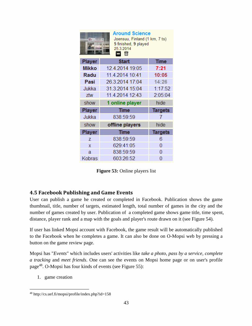
43
Figure 53: Online players list
4.5 Facebook Publishing and Game Events User can publish a game he created or completed in Facebook. Publication shows the game
thumbnail, title, number of targets, estimated length, total number of games in the city and the
number of games created by user. Publication of a completed game shows game title, time spent,
distance, player rank and a map with the goals and player's route drawn on it (see Figure 54).
If user has linked Mopsi account with Facebook, the game result will be automatically published
to the Facebook when he completes a game. It can also be done on O-Mopsi web by pressing a
button on the game review page.
Mopsi has "Events" which includes users' activities like take a photo, pass by a service, complete
a tracking and meet friends. One can see the events on Mopsi home page or on user's profile
page48. O-Mopsi has four kinds of events (see Figure 55):
1. game creation
48 http://cs.uef.fi/mopsi/profile/index.php?id=158

44
2. game participation
3. game completion
4. record breaking
A user can create an O-Mopsi game by selecting a set of targets from the Mopsi photo
collections , the trusted services or uploading his photos. The game creation action will be
triggered when he publishes the game to the Game hall. A player can choose to play any games
from the database, once he joins the game, the game participation action will be triggered. Game
completion action will be triggered when a player completed the game, if he broke the record at
the same time, record breaking action will be trigged also.
Figure 54: Publishing a created or completed game to Facebook
Figure 55: O-Mopsi game events

45
5. Further Improvements on Game Design
O-Mopsi has been presented in SciFest 2012, 2013 and 2014. We received 68 players feedback
in total, of which 59 players (87%) gave a positive feedback. In 2014, positive feedback was
27/30 (90%) which indicates that O-Mopsi is an enjoyable location-based game. In this chapter,
we will introduce further ideas of possible new game patterns for O-Mopsi. We study two
location-based application, of which one is Geocaching and the other one is Foursquare. We try
to learn from well-established applications how to further improve O-Mopsi.
5.1 New Game Patterns
Many of the alternative game patterns requires more users playing at the same time for a single
game. Players can form teams to play against each other, which would increase the enjoyment of
the playing. However, we also consider other single player game patterns.
Monopoly
When I was a child, I liked playing board game. One of my favorite board game is called
Monopoly. Players move around the game board buying or trading properties, developing their
properties with houses and hotels, and collecting rent from their opponents, the ultimate goal
being to drive them into bankruptcy 49. It would be fun if monopoly game can be played in the
real world. The idea of applying Monopoly for O-Mopsi is that each players should visit as many
targets as possible before other players visit them, and once a player visits a target, this target
belongs to him. In the end, the player with the largest number of targets in shortest time is the
winner (see Figure 55). This game pattern can be multi-players individually or played by teams.
Classic distance order
O-Mopsi ranks each player according to the shortest time currently. Alternative ranking could be
used on shortest distance travelled. In this patterns, player should not only be fast but also smart
as winner should visit all targets optimizing the total distance.
Sprint
Players are required to visit as many targets as possible in a given time. The player who visited
most targets is the winner (see Figure 56). If two players come up with the same number of
targets, then the player who spent shortest time is the winner.
Sprint with check point
49 http://en.wikipedia.org/wiki/Monopoly_(game)

46
There are a series of targets in a game, each with different points. When a player visits this target
he will get the amount of points accordingly. Players are required to get points as much as
possible in a given time.
Figure 55: Monopoly game pattern
Figure 56: Sprint game pattern
5.2 Badges The study of Foursquare [27] show that Badges is one of the reasons why users like Foursquare.
People enjoy the feeling of achievement. Badges give people a reason to continue using the
application. Tripadvisor also uses badges (see Figure 57). Inspired by those two applications, we
design Badges for O-Mopsi for three achievements as well: number of games created, completed
and won -- creator, orienteer and winner. Player can earn those badges by creating and playing
games (see Figure 58).

47
Figure 57: Badges from TripAdvisor
Figure 58: O-Mopsi badges

48
6. Calculating Reference Route
We provides reference route for each game. This reference route indicate the potential minimum
distance for completing the game. We use Euclidean distance when calculate the distance among
targets to targets, therefore, real playing distance is often longer than the reference route.
Calculating reference route belongs to Travelling salesman problem (TSP), which was first
formulated as a mathematical problem in 1930 and is one of the most intensively studied
problems in optimization50. The goal of TSP is that a salesman must travel through N cities. All
the cities must be visited once and return to the starting city. TSP is a NP-complete problem51.
In O-Mopsi, the goal of a player is to finish the game in a shortest time. This implies finding the
shortest route, which usually reduces the travel time. The problem in O-Mopsi is slightly
different because player does not need to return to the starting point. Otherwise, the problem is
the same as TSP. In this thesis, we study Tabu search algorithm (TS) to solve TSP. The
algorithm was programmed as a student project on Design and Analysis of Algorithms course 52
organized by University of Eastern Finland. O-Mopsi web page uses the algorithm to give a
reference route for a game. TS algorithm does not guarantee an optimal solution.
The input of the algorithm is from a text file that contains the distance matrix of all possible
routes between every target. The algorithm is based on the idea of swapping every path node that
is not in the tabu list, and then keeping the best solution. The process is then repeated for the new
solution by generating all possible swaps. The tabu list is updated by adding the pair of nodes of
the best swap, and by removing the two oldest nodes form the list. The pseudo code for the
algorithm below:
Algorithm tabu seach
bestSolution: = initialSolution;
for trials = 0 TO MAX_TRIALS DO
for gap = 0 TO sizeOfTargets DO
for q =1 TO sizeOfTargets -gap DO
trialSolution = bestSolution;
swapSolutionNodes(q, q+gap);
if validateSwap() && Distance(trialSolution) < Distance
(bestSolution)
then bestSolution =tempSolution;
updateTabuList(q, q+gap); //the pair which have been
swapped
50 http://www.princeton.edu/~achaney/tmve/wiki100k/docs/Travelling_salesman_problem.html 51 https://gcu.googlecode.com/files/Exploring%20Algorithms.doc 52 http://cs.joensuu.fi/pages/franti/asa/

49
We first initialize the solution by greedy algorithm. The greedy algorithm starts from the first
target and selects next target as the closest to it. This is repeated until all targets are visited. We
store the order and the total distance generated by the greedy algorithm. Then we use this result
as the starting solution for the swapping stage (see Figure 59).
The idea is to swap though all possible solutions by increasing the gap. In this way, all pairs of
nodes will be tried. Before swapping, we check if the pair is not recorded in tabu list and if not
then we do the swap. After each swap, we check if the new solution gives a better result, and if
yes, we accept the new best result and update the tabu list. Tabu list keeps track of the swaps that
has caused improvement in the solution. The idea is to prevent falling back into old patterns and
getting stuck into a local maximum. The algorithm end when a preset number of trials
(MAX_TRIALS equals 100) have been used.
Figure 59: Swap mechanism53
53 http://tonis.comli.com/index.php?page=tsp

50
7. Experimental Results
For testing purpose, we have developed a website MOPSI TSP 54 . We consider two main
characteristics of the algorithms: processing time and tour length. Currently, four algorithms
implemented:
1. Tabu search (TS), by Toni Sanio based on Design & analysis algorithm55
2. Ant colony optimization (ACO), by Hamid Behravan based on Ant Colony Optimization,
The MIT Press Cambridge56
3. Dynamic programming with brute force (DYN), by Emmanuel Kolog based on Design
& analysis algorithm57
4. Greedy Heuristics (GRE), by the author of this thesis based on Design & analysis
algorithm58
In this thesis, we will focus on TS and ACO. Algorithm DYN can guarantee optimal result but it
takes too long time, normally, it is suitable for less than 10 targets and algorithm GRE cannot
give good result every time. We evaluate those two characteristics within O-Mopsi.
We selected O-Mopsi games to test the processing time of TS and ACO. In these games, the
number of targets varies from 6 to 25. As we can see from the results in Table 3 and Figure 60,
TS works well for smaller number of targets but it does not guarantee optimal solution. Starting
from Noljakka game (N = 15), TS works worse than ACO. For Barcelona Grand Tour game, the
difference between those two algorithms is up to 1 km. On the other hand, ACO consumes about
4 seconds or more for calculating reference route when the number of targets is greater than 15.
For Luxembourg Ville Haute game (N = 25), it takes 10 seconds which is not user friendly in
real-time application. TS only takes always less than 1 second (see Figure 61). In summary, TS
cannot guarantee as good result as ACO if number of targets getting larger but it is fast and the
difference is smaller than 10% or less. The corresponding results are plotted in Figure 62.
54 http://cs.uef.fi/o-mopsi/tsp 55 http://tonis.comli.com/index.php?page=readArticle&aId=9 56 http://mitpress.mit.edu/books/ant-colony-optimization 57 http://cs.uef.fi/o-mopsi/Document/DynProramming.pdf 58 http://cs.uef.fi/pages/franti/asa/

51
Table 3: Result of the points number from 6 to 21
No Game name Number of
targets
Time Length
TS ACO TS ACO
1
2
3
4
5
6
7
8
9
10
11
12
13
SciFest Easy
SciFest2013 Easy
SciFest Medium
Mekrijarvi Easy
Manneken Pis
Kowloon Park
Jokiasema
Noljakka
Rantakylä Tour
Barcelona Grand Tour
SciFest2013 Hard
SciFest 2014 long
Luxembourg Ville Haute
6
7
8
10
11
12
14
15
16
18
19
21
25
0.3 s
0.3 s
0.4 s
0.4 s
0.3 s
0.5 s
0.5 s
0.5 s
0.4 s
0.5 s
0.5 s
0.7 s
0.7 s
1 s
1 s
1 s
2 s
2 s
3 s
3 s
4 s
3 s
4 s
4 s
6 s
10 s
922 m
484 m
516 m
5.2 km
1.3 km
844 m
2.2 km
6.5 km
5.2 km
15 km
2.1 km
3.1 km
2.2 km
922 m
484 m
505 m
5.2 km
1.3 km
815 m
2.2 km
6.3 km
5.0 km
14.0 km
2.1 km
3.0 km
2.0 km
Figure 60: Distance comparison between TS and ACO for O-Mopsi games
0%0% 1%
0%
0%3%
0%
3%
4%
7%
0%3%
9%
0
2000
4000
6000
8000
10000
12000
14000
16000
1 2 3 4 5 6 7 8 9 10 11 12 13
Dis
tan
ce (
m)
Game Number
TS ACO

52
Figure 61: Time comparison between TS and ACO for O-Mopsi games
SicFest Easy:
0
1
2
3
4
5
6
7
8
9
10
11
6 7 8 10 11 12 14 15 16 18 19 21 25
Seco
nd
s
Number of targets
TS
ACO

53
SciFest2013 Easy:
SciFest Medium:
Mekrijarvi Easy:

54
Manneken Pis:
Kowloon Park:
Jokiasema:

55
Noljakka:
Rantakylä Tour:

56
Barcelona Grand Tour:
SciFest2013 Hard:
Luxembourg Ville Haute:

57
SciFest 2014 long:
Figure 62 : TSP results for O-Mopsi games
8. Usability Feedback
O-Mopsi was originally developed for the SciFest festival (www.scifest.fi), which is an annual
international science festival which brings together thousands of school kids, high school
students, and teachers to discover new experiences and learn about science, technology and the
environment 59. SciFest is organized in the city of Joensuu, Finland in April.
O-Mopsi workshop was organized during the 2012, 2013 and 2014 editions of the festival. O-
Mopsi Symbian Java version was used in SciFest 2012, Symbian Qt version for 2013 and
Symbian Qt, Android and Windows phone version for 2014. Because of limited availability of
mobile phones with GPS and data connection, the players were organized into teams. After the
game, a short feedback survey was filled by the playing teams (see Table 4). Feedback shows
that the players rated the game mostly as being good or very good. According to the players,
game rules were easy to understand and playing the game was enjoyable. Negative feedback was
59 http://www.uef.fi/en/edtech/past-projects/scifest

58
caused by software problems, or problems finding GPS signal in some case. We list detailed
comments and user feedback in Appendix.
Table 4: Players' ratings of the game in SciFest
Year Rating
Software
Very
good Good Adequate Bad Total
2012 Java (V 0.10) 3 6 0 0 9
2013 Qt (V 0.6) 3 7 0 2 12
2014 Android (V 0.04)
Windows phone (V 0.13)
Qt (V 0.10)
Not specified
4
4
0
0
8
4
2
5
1
0
2
0
0
0
0
0
13
8
4
5
2014
Total
8 19 3 0 30
9. Conclusions
In this thesis we present a location-based mobile game. O-Mopsi, which is based on the classical
concept of orienteering. O-Mopsi game can be played by mobile application available for
Symbian, Android and Windows phone platforms. It offers functionalities such as plotting the
photos on map, displaying compass to indicate the direction and navigate to the selecting target
by sound. In SciFest 2012, 2013 and 2014, we presented O-Mopsi game to the public. The
overall feedback was positive. In 2012, there were 9 players, of which 33% of them gave best
feedbacks and 66% rated it as good. In 2013, 29 players, of which 79% rated it as good. In 2014,
30 players, of which 90% players rated it good or very good.
We also developed a web server for O-Mopsi, in which users can create new games, view game
results, see reference route and watch game simulation. Player can share the game and results
with his Facebook friends. The O-Mopsi web page was developed mostly by the author of this
thesis funded by MOPSI project during the years 2012-2014.

59
Calculating reference route was one of our study topics, for which we built a web page for
testing different TSP algorithms. Currently, we have got 4 algorithms: dynamic programming
with brute force (DYN), ant colony optimization (ACO), Tabu search (TS) and greedy heuristic
(GRE). DYN grantees optimal result but with extremely high time complexity, which means it
only works for ten targets or less. We compared ACO with TS, and found out that ACO gives
slightly better results in general but it is significantly slower than TS. With 20 targets, ACO takes
5-6 seconds which is not user-friendly. As GRE did not give accurate results, we chose to use TS
as a default algorithm in O-Mopsi to calculate the reference route.

60
Reference
[1] A. Tabarcea, Z. T. Wan, K. Waga and P. Fränti, "O-Mopsi: Mobile Orienteering Game
using Geotagged Photos," in International Conference on Web Inoformation Systems &
Technologies (WEBIST' 13), Aachen, 2013, pp. 300-303.
[2] M. N. K. Boulos and S. P. Yang, "Exergames for health and fitness: the roles of GPS and
deosocial apps," Boulos and Yang International Journal of Health Geographics, vol. 12, no.
18, Apr. 2013.
[3] P. Fränti, J. Chen and A. Tabarcea, "Four aspects of relevance in sharing location-based
media: content, time, location and network," in International Conference on Web
Information Systems and Technologies (WEBIST' 11), Noordwijkerhout, May 2011.
[4] K. Waga, A. Tabarcea and P. Fränti, "Recommendation of Points of Interest from User
Generated Data Collection," in Collaborative Computing, Pittsburgh, 2012, pp. 550-555.
[5] K. Waga, A.Tabarcea, M. Chen and P. Fränti, "Detecting movement type by route
segmentation and classification," in Collaborative Computing, Pittsburgh, 2012, pp. 508-
513.
[6] K. Waga, A. Tabarcea, R. Mariescu-Istodor and P. Fränti, "Real Time Access to Multiple
GPS Tracks," in International Conference on Web Information Systems and Technologies
(WEBIST'13), Aachen, 2013.
[7] P. Fränti, J. Kuittinen, A. Tabarcea and L. Sakala, "MOPSI Location-based search engine:
cencept, architecture and prototype," in ACM Symposium on Applied Computing (SAC'10),
Sierre, 2010, pp. 872-873.
[8] G. Hariharan, P. Fränti and S. Mehta, "Data Mining for Personal Navigation," in SPIE
Conference on Data Mining and Knowledge Discovery: Theory, Tools, and Technology IV,
Orlando, 2002, pp. 355-365.
[9] P. Fränti, A. Tabarcea, J. Kuittinen and V. Hautamäki, "Location-based search engine for
multimedia phones," in IEEE International Conference on Multimedia & Expo (ICME'10),
Singapore, 2012, pp. 558-563.
[10] A. Tabarcea, V. Hautamäki and P. Fränti, "Ad-hoc georeferencing of web-pages using
street-name prefix trees," in International Conference on Web Information Systems and
Technologies (WEBIST'10), Valencia, 2010, pp. 237-244.

61
[11] R. Mariescu-Istodor. (2013, Aug.) Detecting user actions in MOPSI. Master Thesis, School
of Computing, University of Eastern Finland. [Online].
http://epublications.uef.fi/pub/urn_nbn_fi_uef-20130926/urn_nbn_fi_uef-20130926.pdf
[12] M. J. Pazzani and D. Billsu, "Content-Based Recommendation Systems," in The AdaptiveE
Web: Methods and Strategies of Web Personalization, 2007, pp. 325-341.
[13] C. Sedano and C. Kampf, "Designing games as a vehicle for passing on cultural knowledge:
A case study of Finnish seniors in the digital age," in Cultural Attitudes Towards
Technology and Communication, Nimes, 2008.
[14] S. Benford. (2005, Jan.) JISC Technology and Standards Watch. [Online].
http://www.jisc.ac.uk/uploaded_documents/jisctsw_05_01.pdf
[15] T. W. Malonem and M. R. Lepper, "Making learning fun: A taxnomoy of intrinsic
motivations for learning," in Conative and Affective Process Analyses, Hillsdale, 1987, pp.
223-253.
[16] M. R. Lepper and D. I. Cordova, "A desire to be taught: Instructional consequences of
intrinsic motivation," in Motivation and Emotion, 1992, pp. 187-208.
[17] J. C. Puja, D. Parsons, "A location-based mobile game for business education," in Advanced
Learning Technologies (ICALT), 2011 11th IEEE International Conference, Athens, 2011,
pp. 42 - 44.
[18] S. Benford, R. Hull, J. Morrison and B. Clayton. (2004, Jan.) “Savannah”: Designing a
Location-Based Game Simulating Lion Behaviour. [Online].
http://140.115.126.240/mediawiki/images/4/43/Savannah.pdf
[19] D. L. Guardia, M. Marrigo and O. D. Giuseppe, "A location-based serious game to learn
about the culture," in International Conference The Future of Education, Florence, 2012.
[20] K. Cheverst, N. Davies, K. Mitchell and A. Friday, "Experiences of Developing and
Deploying a Context-Aware Tourist Guide: The GUID Project," in Proceedings of the 6th
annual international conference on Mobile computing and networking, Boston, USA, 2000,
pp. 20-31.
[21] L. A. Lehmann. (2012) Location-based Mobile Games. [Online]. http://www.snet.tu-
berlin.de/fileadmin/fg220/courses/WS1112/snet-project/location-based-mobile-
games_lehmann.pdf
[22] J. Karlsen, H. Tolsby, G. Misund, H. Holone, "Chase and Catch - simple as that?: old-

62
fashioned fun of traditional playground games revitalized with location-aware mobile
phones," in Proceedings of the International Conference on Advances in Computer
Enterntainment Technology, Athens, Greece, Oct 2009, pp. 73-80.
[23] O. Sotamaa, "All The World’s A Botfi ghter Stage: Notes on Location-based Multi-User
Gaming," in Proceedings of Computer Games and Digital Cultures Conference, 2002, pp.
35-44.
[24] S. Matyas, C. Matyas, C. Schlider and P. Kiefer, "Designing Location-based Mobile Games
with a Purpose - Collecting Geospatial Data with CityExplorer," in Proceedings of the 2008
International Conference on Advances in Computer Entertainment Technology, Yokohama,
Japan, 2008, pp. 244-247.
[25] A. Moore, J. Goulding, E. Brown and J. Swan, "AnswerTree – a hyperplace-based game for
collaborative mobile learning," in Proceedings of the mLearn 2009 Conference, Orlando,
Florida, USA, 2009, pp. 26-30.
[26] C. Neustaedter, A. Tang and T. K. Judge, "Creating scalable location-based games: lessons
from Geocaching," Personal and Ubiquitous Computing, Springer, vol. 2, no. 1617-4909,
pp. 335-349, Feb. 2013.
[27] J. Lindqvist, J. Cranshaw, J. Wiese, J. Hong and J. Zimmerman, "I'm the mayor of my
house: examining why people use foursquare - a social-driven location sharing application,"
in The 29th ACM Conference on Human Factors in Computing, Vancouver, BC, Canada,
2011, pp. 2409-2418.

63
Appendix A: User feedback in SciFest 2014
Q1: In general, how do you like the software O-MOPSI?
Rating
Software
Outstanding Good Some chronic
issues
Poor
Android
Windows phone
Nokia Qt
Not specified
4
4
0
0
8
4
2
5
1
0
2
0
0
0
0
0
Total 8 19 3 0
Q2: Do you think the training beforehand is useful?
Rating
Software
Yes No
Android
Windows phone
Nokia Qt
Not specified
11
6
4
5
0
1
1
0
Total 26 2
Q3: Do you have difficulties on understanding the game rules?
Rating
Software
Yes No
Android
Windows phone
Nokia Qt
Not specified
1
0
0
1
11
8
3
5
Total 2 27
Q4: Do you think the software is easily started?
Rating
Software
very
easy
Level 2 Level 3 Level 4 Level 5 Level 6 very
difficult
Android
Windows phone
Nokia Qt
Not specified
4
1
0
0
4
4
2
4
2
1
0
1
2
2
0
0
0
0
1
0
1
0
0
0
0
0
0
0
Total 5 14 4 4 1 1 0

64
Q5: How do you think of the interface?
Rating
Software
Outstanding Good Adequate Needs
improvement
Poor N/A
Android
Windows phone
Nokia Qt
Not specified
1
1
0
0
6
2
1
2
4
4
1
3
2
0
0
0
0
0
1
0
0
1
1
0
Total 2 11 12 2 1 2
Q6: Do you enjoy the game?
Rating
Software
Outstanding Good Adequate Needs
improvement
Poor N/A
Android
Windows phone
Nokia Qt
Not specified
3
4
0
2
6
2
3
1
4
2
1
2
0
0
0
0
0
0
0
0
0
0
0
0
Total 9 12 9 0 0 0
Q7: Would you recommend this software to your friends?
Rating
Software
Yes No N/A
Android
Windows phone
Nokia Qt
Not specified
11
5
2
4
0
0
0
0
2
3
2
1
Total 22 0 8
Q8: Which part(s) of the software did you like the best?
Item
Software
Login
automatically
Interface Game
rules
Map Find a
goal
Tracking
Android
Windows phone
Nokia Qt
Not specified
1
1
0
1
0
0
1
0
2
2
0
0
5
2
2
1
8
5
3
4
3
2
1
2
Total 3 1 4 10 20 8
Text comments from Android users:
1. Quite good game.

65
2. It would work better and would find the place better. Did not work in the beginning.
(Samsung S3 Mini).
3. It would work in iPhone too. So that it would not quit working when route has gone
through. (Samsung Gal S3 4G)
4. Goal icons have the property that they shutter own position. (Nexus)
5. Some goals were found from really far away (distance even 50m), once I did not see the
goal behind the corner before fanfares. Quite nice game for a person who has ordinary
orienteering as a hobby. (Zte)
6. The program did not work Samsung Galaxy X2 GT-19100 Android 4.2.2 kernel. Outlook
could be also improved.
7. A possibility to cancel game or at least stop time, instructions ( time starts when game
started), Finnish language. Norm thing! Android leaves program on. (Huawei)
8. The route length could be even shorter. Real time route display would have been helpful
(bad net in own phone). Beep sound good, nearness information good. Goal finding
sound good. Aplodes were a nice surprise. (Samsung XCover)
9. In mobile, in results list, the traversed length should read 1 km 500 m, not 1 km 500.
Windows phone users:
1. No need for image page. Just map! (Lumia 620)
2. Accuracy! Some time the connection broke, and all the goals were not seen.(Lumia 720)
3. Panning of map was not working properly, but that could be phone’s problem. Good
exercise.
4. It would be good to have a game for iPhone too. Good game. Worked well. It was nice
that I could go outside.
5. The program was falling at some times. Could repair. Thanks.
6. Faster.
7. Officer’s comment: Niko made short track. Web shows end time 1h33min. Real end time
approximately 40min.
Nokia Symbian users:
1. Better phones! Did not work. Lags! Otherwise nice workshop, especially in the beginning
.
2. In the beginning could tell that orienteering goal’s mark is not the same as the goal. Even
if the mobile was inside the mark it did not give label. (for example Vesikko’s entrance is
better place to find)
iPhone users:
1. No need for ingame page. Just map!

66
Appendix B: User feedback in SciFest 2013
Using Nokia Qt O-Mopsi version only this year.
Q1: How would you rate o-mopsi program?
Rating
Excellent Good Something to improve
Bad
Total 2 21 6 0
Q2: Did you find the guidance given useful?
Rating
Yes No
Total 27 2
Q3: Was it hard to understand the rules of the games?
Rating
Yes No
Total 3 26
Q4: How would you describe opening of the program?
Rating
Very easy
Easy Ok Hard Very
hard
Total 4 16 7 2 0
Q5: How was the user interface?
Rating
Excellent Good Ok Improvements needed
Bad
Total 3 16 3 7 0
Q6: what is your general opinion of the game?
Rating
Excellent Good Ok Improvements needed
Bad
Total 3 19 5 2 0
Q7: Would you recommend this game to your friends?

67
Rating
Yes No Maybe
Total 13 3 2
Q8: What was your favorite part of the game?
Item
Login
automatically
Interface Game
rules
Map Find a
goal
Tracking
Total 1 1 2 4 13 2
Q9: Was it useful to see the recommended route?
Rating
Yes No
Total 13 5
Q10: How was the animation of the route? (Web)
Rating
Excellent Good Ok Improvements needed
Bad Did not
see
Total 2 7 6 2 0 1
Written comments:
1. Pictures could be easier to see.
2. Saving the route should be improved - nothing was saved.
3. Bigger images.
4. Keep it simple that kids can play as well.
5. I was afraid many times that I will be thrown away from the program. However, that did
not happen, program worked nicely.
6. Get better navigators in order to avoid bugs.
7. Time should start immediately - There should be a marker and when we go close it
should convert into a photograph. Possibility of getting bigger photograph would be good.
8. There should be an arrow which would tell into which direction I am moving.
9. Confirmation should be asked before really closing the program.
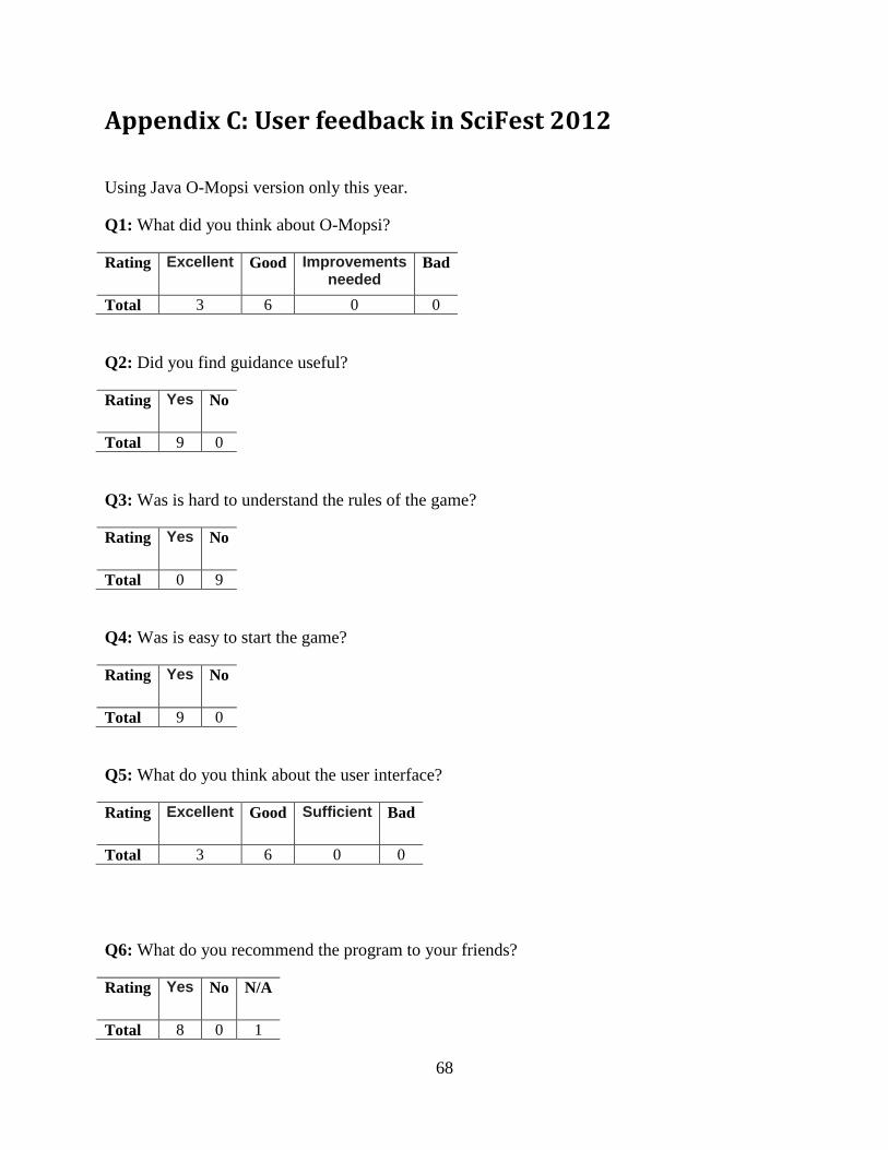
68
Appendix C: User feedback in SciFest 2012
Using Java O-Mopsi version only this year.
Q1: What did you think about O-Mopsi?
Rating
Excellent Good Improvements needed
Bad
Total 3 6 0 0
Q2: Did you find guidance useful?
Rating
Yes No
Total 9 0
Q3: Was is hard to understand the rules of the game?
Rating
Yes No
Total 0 9
Q4: Was is easy to start the game?
Rating
Yes No
Total 9 0
Q5: What do you think about the user interface?
Rating
Excellent Good Sufficient Bad
Total 3 6 0 0
Q6: What do you recommend the program to your friends?
Rating
Yes No N/A
Total 8 0 1

69
Q7: What do you think about the game?
Rating
Excellent Good Sufficient Bad
Total 4 5 0 0
Q8: What part of the program did you like the most?
Item
Login
automatically
Interface Game
rules
Map Find a
goal
Tracking
Total 0 0 0 4 5 0
Written comments:
1. Route could be longer
2. Different sound would be nice.