NR-19 NR-15NR-14NR-13 NR-6NR-7NR-8 NR-9NR-10NR-11NR … · nr-5 nr-6nr-7nr-8 nr-9nr-10nr-11nr-12...
20
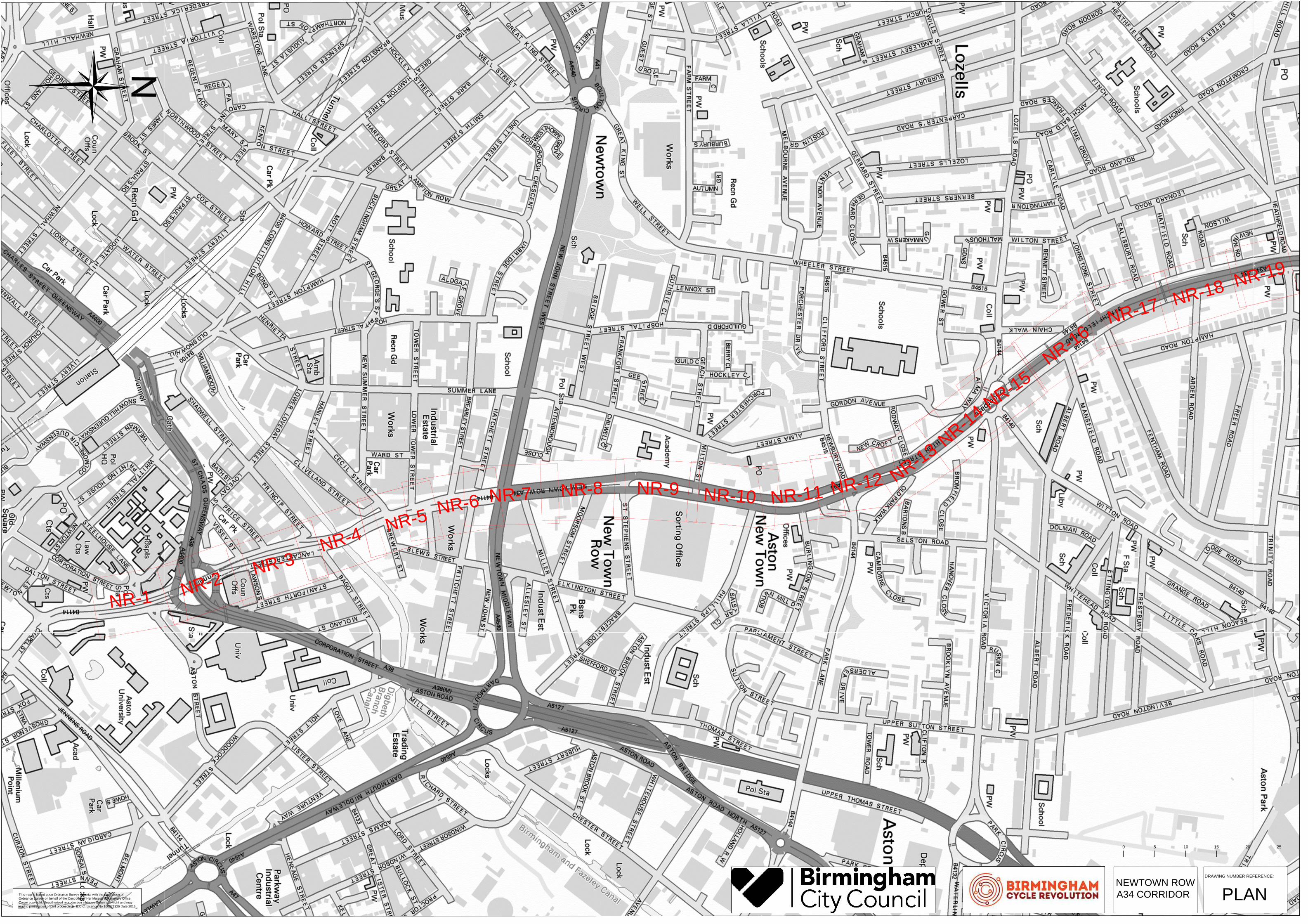
NR-1 NR-2 NR-3 NR-4 NR-5 NR-6 NR-7 NR-8 NR-9 NR-10 NR-11 NR-12 NR-13 NR-14 NR-15 NR-16 NR-17 NR-18 NR-19 This map is based upon Ordnance Survey material with the permission of Ordnance Survey on behalf of the Controller of Her Majesty's Stationery Office Crown copyright. Unauthorised reproduction infringes Crown copyright and may lead to prosecution or civil proceedings. B.C.C. Licence No 100021326 Date 2016 DRAWING NUMBER REFERENCE: PLAN 0 25 5 10 15 20 NEWTOWN ROW A34 CORRIDOR
Transcript of NR-19 NR-15NR-14NR-13 NR-6NR-7NR-8 NR-9NR-10NR-11NR … · nr-5 nr-6nr-7nr-8 nr-9nr-10nr-11nr-12...
N
R
-1
N
R
-
2
N
R
-3
N
R
-
4
N
R
-
5
N
R
-6
NR
-7
NR
-8NR-9
NR
-10N
R-11
N
R
-1
2
N
R
-
1
3
N
R
-
1
4
N
R
-
1
5
N
R
-
1
6
N
R
-
1
7
N
R
-
1
8
N
R
-
1
9
This map is based upon Ordnance Survey material with the permission of
Ordnance Survey on behalf of the Controller of Her Majesty's Stationery Office
Crown copyright. Unauthorised reproduction infringes Crown copyright and may
lead to prosecution or civil proceedings. B.C.C. Licence No 100021326 Date 2016
DRAWING NUMBER REFERENCE:
PLAN
0 255 10 15 20
NEWTOWN ROW
A34 CORRIDOR
S
T
N
S
S
2
1
T
L
T
L
T
L
T
L
T
L
P
a
v
e
d
T
T
B
P
P
a
v
e
d
W
a
te
r fe
a
tu
re
P
a
v
e
d
P
a
v
e
d
B
P
T
T
T
T
B
P
P
a
v
e
d
T
T
P
a
v
e
d
JAMES WATT QUEENSWAY
S
T
E
E
L
H
O
U
S
E
L
A
N
E
C
O
R
P
O
R
A
T
I
O
N
S
T
R
E
E
T
L
A
N
C
A
S
T
E
R
C
I
R
C
U
S
S
U
B
W
A
Y
S
T
N
S
S
2
1
T
L
T
L
T
L
T
L
T
L
P
a
v
e
d
T
T
B
P
P
a
v
e
d
W
a
te
r fe
a
tu
re
P
a
v
e
d
P
a
v
e
d
B
P
T
T
T
T
B
P
P
a
v
e
d
T
T
P
a
v
e
d
11
22
CU
TL
IN
EC
UT
LIN
E
Key :
Footway
Carriageway
Proposed cycleway
Shared use (pedestrians &
cyclists
Landscaping
Tree to be removed. Additional
trees to be replanted along the
scheme
Proposed bus shelter
H
G
F
E
D
C
B
A
J
K
L
M
13 14 15 162 3 4 51 6 7 8 9 10 11 12
H
G
F
E
D
C
B
A
J
K
L
M
13 14 15 162 3 4 51 6 7 8 9 10 11 12
0mm
20mm
10mm
30mm
40mm
50mm
100mm
FIL
E P
AT
H - X
:\C
om
missio
ns\C
A-0
27
52
B
CR
3\0
4 N
orth
W
est B
ha
m B
CR
3\4
.0
D
ra
win
gs\0
2. W
orkin
g D
ra
win
gs\T
_C
A-0
27
52
_0
4-0
1_
10
0 C
on
su
lta
tio
n P
la
n.d
wg
A1
This map is based upon Ordnance Survey material with the permission of
Ordnance Survey on behalf of the Controller of Her Majesty's Stationery Office
Crown copyright. Unauthorised reproduction infringes Crown copyright and may
lead to prosecution or civil proceedings. B.C.C. Licence No 100021326 Date 2016
NEWTOWN ROW
A34 CORRIDOR
DRAWING NUMBER REFERENCE:
SCALE 1:500
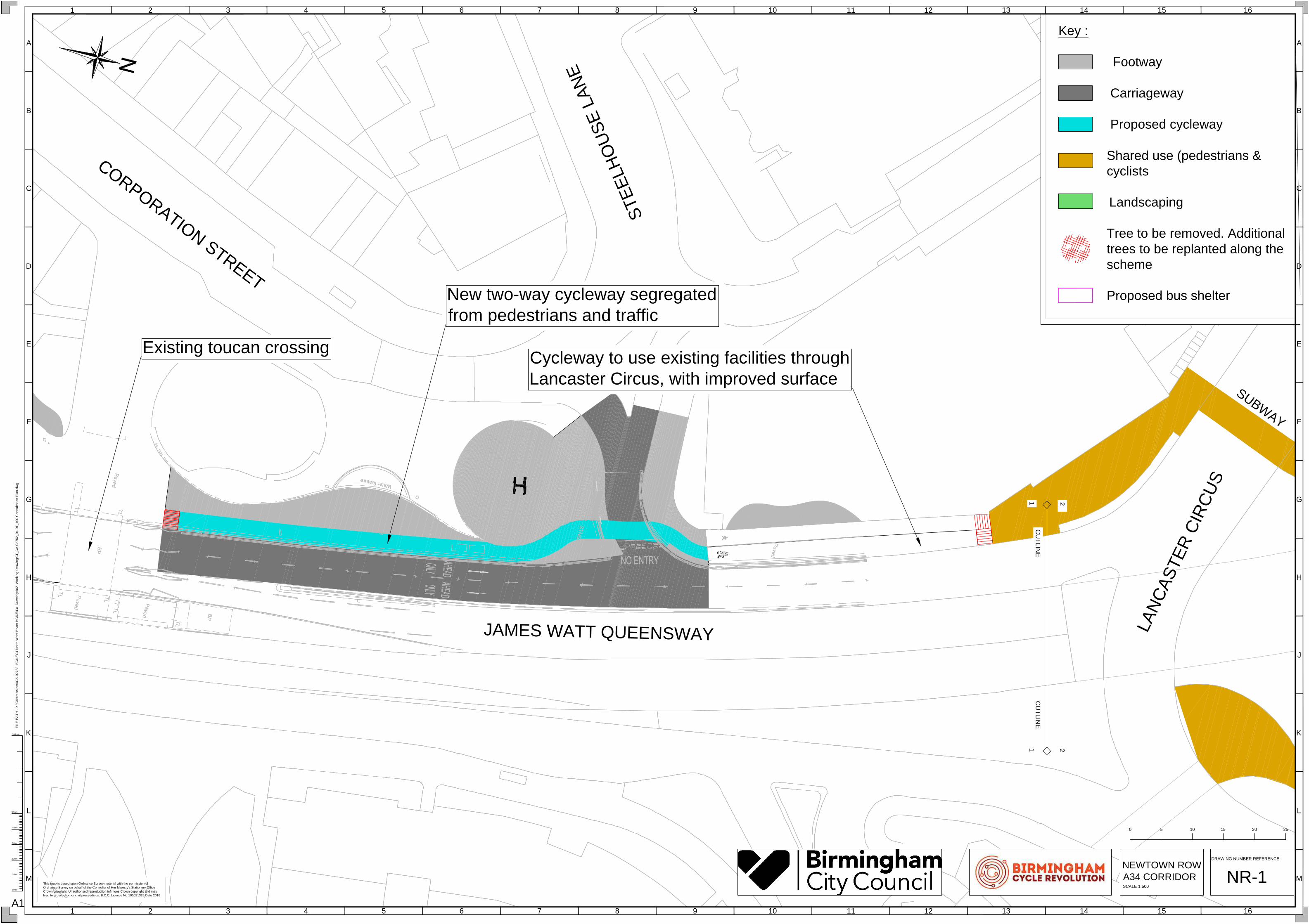
NR-1
0 255 10 15 20
Existing toucan crossing
New two-way cycleway segregated
from pedestrians and traffic
Cycleway to use existing facilities through
Lancaster Circus, with improved surface

L
A
N
C
A
S
T
E
R
C
I
R
C
U
S
VE
SE
Y S
TR
EE
T
L
A
N
C
A
S
T
E
R
C
I
R
C
U
S
S
U
B
W
A
Y
S
U
B
W
A
Y
1
1
2
2
C
U
T
L
I
N
E
C
U
T
L
I
N
E
2
2
3
3
CU
TLIN
E
CU
TLIN
E
Key :
Footway
Carriageway
Proposed cycleway
Shared use (pedestrians &
cyclists
Landscaping
Tree to be removed. Additional
trees to be replanted along the
scheme
Proposed bus shelter
H
G
F
E
D
C
B
A
J
K
L
M
13 14 15 162 3 4 51 6 7 8 9 10 11 12
H
G
F
E
D
C
B
A
J
K
L
M
13 14 15 162 3 4 51 6 7 8 9 10 11 12
0mm
20mm
10mm
30mm
40mm
50mm
100mm
FIL
E P
AT
H - X
:\C
om
missio
ns\C
A-0
27
52
B
CR
3\0
4 N
orth
W
est B
ha
m B
CR
3\4
.0
D
ra
win
gs\0
2. W
orkin
g D
ra
win
gs\T
_C
A-0
27
52
_0
4-0
1_
10
0 C
on
su
lta
tio
n P
la
n.d
wg
A1
This map is based upon Ordnance Survey material with the permission of
Ordnance Survey on behalf of the Controller of Her Majesty's Stationery Office
Crown copyright. Unauthorised reproduction infringes Crown copyright and may
lead to prosecution or civil proceedings. B.C.C. Licence No 100021326 Date 2016
NEWTOWN ROW
A34 CORRIDOR
DRAWING NUMBER REFERENCE:
SCALE 1:500
NR-2
0 255 10 15 20
Cycle route to use existing
facilities through Lancaster Circus.
Surface to be improved in areas.
P
R
I
N
C
I
P
S
T
R
E
E
T
NEW TOWN ROW
V
E
S
E
Y
S
T
R
E
E
T
P
R
I
C
E
S
T
R
E
E
T
2
2
3
3
C
U
T
L
IN
E
C
U
T
L
IN
E
3
3
4
4
CU
TLIN
E
CU
TLIN
E
Key :
Footway
Carriageway
Proposed cycleway
Shared use (pedestrians &
cyclists
Landscaping
Tree to be removed. Additional
trees to be replanted along the
scheme
Proposed bus shelter
H
G
F
E
D
C
B
A
J
K
L
M
13 14 15 162 3 4 51 6 7 8 9 10 11 12
H
G
F
E
D
C
B
A
J
K
L
M
13 14 15 162 3 4 51 6 7 8 9 10 11 12
0mm
20mm
10mm
30mm
40mm
50mm
100mm
FIL
E P
AT
H - X
:\C
om
missio
ns\C
A-0
27
52
B
CR
3\0
4 N
orth
W
est B
ha
m B
CR
3\4
.0
D
ra
win
gs\0
2. W
orkin
g D
ra
win
gs\T
_C
A-0
27
52
_0
4-0
1_
10
0 C
on
su
lta
tio
n P
la
n.d
wg
A1
This map is based upon Ordnance Survey material with the permission of
Ordnance Survey on behalf of the Controller of Her Majesty's Stationery Office
Crown copyright. Unauthorised reproduction infringes Crown copyright and may
lead to prosecution or civil proceedings. B.C.C. Licence No 100021326 Date 2016
DRAWING NUMBER REFERENCE:
NEWTOWN ROW
A34 CORRIDOR
SCALE 1:500
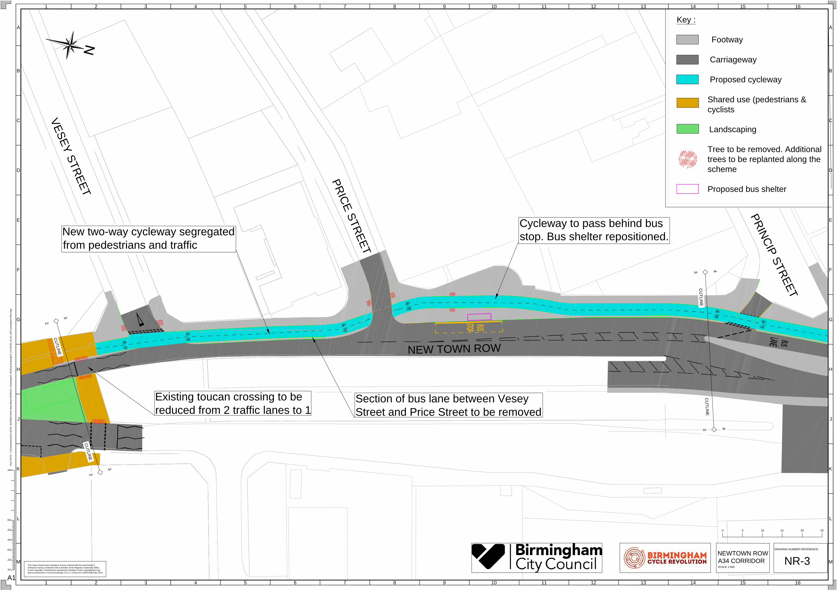
NR-3
0 255 10 15 20
New two-way cycleway segregated
from pedestrians and traffic
Existing toucan crossing to be
reduced from 2 traffic lanes to 1
Section of bus lane between Vesey
Street and Price Street to be removed
Cycleway to pass behind bus
stop. Bus shelter repositioned.

P
R
I
N
C
I
P
S
T
R
E
E
T
B
A
G
O
T
S
T
R
E
E
T
C
L
IV
E
L
A
N
D
S
T
R
E
E
T
NEW TOWN ROW
3
3
4
4
CU
TLIN
E
CU
TLIN
E
44
55
CU
TL
IN
EC
UT
LIN
E
Key :
Footway
Carriageway
Proposed cycleway
Shared use (pedestrians &
cyclists
Landscaping
Tree to be removed. Additional
trees to be replanted along the
scheme
Proposed bus shelter
H
G
F
E
D
C
B
A
J
K
L
M
13 14 15 162 3 4 51 6 7 8 9 10 11 12
H
G
F
E
D
C
B
A
J
K
L
M
13 14 15 162 3 4 51 6 7 8 9 10 11 12
0mm
20mm
10mm
30mm
40mm
50mm
100mm
FIL
E P
AT
H - X
:\C
om
missio
ns\C
A-0
27
52
B
CR
3\0
4 N
orth
W
est B
ha
m B
CR
3\4
.0
D
ra
win
gs\0
2. W
orkin
g D
ra
win
gs\T
_C
A-0
27
52
_0
4-0
1_
10
0 C
on
su
lta
tio
n P
la
n.d
wg
A1
This map is based upon Ordnance Survey material with the permission of
Ordnance Survey on behalf of the Controller of Her Majesty's Stationery Office
Crown copyright. Unauthorised reproduction infringes Crown copyright and may
lead to prosecution or civil proceedings. B.C.C. Licence No 100021326 Date 2016
DRAWING NUMBER REFERENCE:
NR-4
0 255 10 15 20
NEWTOWN ROW
A34 CORRIDOR
SCALE 1:500
Bus gate to be narrowed and
revised to be more efficient for
buses and general traffic
Traffic lane to be narrowed over bridge
New two-way cycleway segregated
from pedestrians and traffic
Cycleway to switch to back and
footway to the front

C
E
C
I
L
S
T
R
E
E
T
L
O
W
E
R
T
O
W
E
R
S
T
R
E
E
T
M
A
N
C
H
E
S
T
E
R
S
T
R
E
E
T
C
L
IV
E
L
A
N
D
S
T
R
E
E
T
BR
EW
ER
Y S
TR
EE
T
NEW TOWN ROW
5
5
6
6
CU
TLIN
E
CU
TLIN
E
44
55
CU
TL
IN
EC
UT
LIN
E
Key :
Footway
Carriageway
Proposed cycleway
Shared use (pedestrians &
cyclists
Landscaping
Tree to be removed. Additional
trees to be replanted along the
scheme
Proposed bus shelter
H
G
F
E
D
C
B
A
J
K
L
M
13 14 15 162 3 4 51 6 7 8 9 10 11 12
H
G
F
E
D
C
B
A
J
K
L
M
13 14 15 162 3 4 51 6 7 8 9 10 11 12
0mm
20mm
10mm
30mm
40mm
50mm
100mm
FIL
E P
AT
H - X
:\C
om
missio
ns\C
A-0
27
52
B
CR
3\0
4 N
orth
W
est B
ha
m B
CR
3\4
.0
D
ra
win
gs\0
2. W
orkin
g D
ra
win
gs\T
_C
A-0
27
52
_0
4-0
1_
10
0 C
on
su
lta
tio
n P
la
n.d
wg
A1
This map is based upon Ordnance Survey material with the permission of
Ordnance Survey on behalf of the Controller of Her Majesty's Stationery Office
Crown copyright. Unauthorised reproduction infringes Crown copyright and may
lead to prosecution or civil proceedings. B.C.C. Licence No 100021326 Date 2016
DRAWING NUMBER REFERENCE:
NR-5
0 255 10 15 20
NEWTOWN ROW
A34 CORRIDOR
SCALE 1:500
Cycleway to switch to back and
footway to the front
New two-way cycleway
segregated from pedestrians
and traffic
Lower Tower Street traffic to
give way to cycleway
New side-by-side pedestrian
and cycle zebra crossing.
Junction to be narrowed.
NE
W
TO
W
N R
O
W
P
R
I
T
C
H
E
T
T
S
T
R
E
E
T
L
O
W
E
R
T
O
W
E
R
S
T
R
E
E
T
B
R
E
A
R
L
E
Y
S
T
R
E
E
T
M
A
N
C
H
E
S
T
E
R
S
T
R
E
E
T
P
R
I
T
C
H
E
T
T
S
T
R
E
E
T
NEW TOWN ROW
NE
W
TO
W
N R
O
W
5
5
6
6
CU
TLIN
E
CU
TLIN
E
6
6
7
7
CU
TLIN
E
CU
TLIN
E
Key :
Footway
Carriageway
Proposed cycleway
Shared use (pedestrians &
cyclists
Landscaping
Tree to be removed. Additional
trees to be replanted along the
scheme
Proposed bus shelter
H
G
F
E
D
C
B
A
J
K
L
M
13 14 15 162 3 4 51 6 7 8 9 10 11 12
H
G
F
E
D
C
B
A
J
K
L
M
13 14 15 162 3 4 51 6 7 8 9 10 11 12
0mm
20mm
10mm
30mm
40mm
50mm
100mm
FIL
E P
AT
H - X
:\C
om
missio
ns\C
A-0
27
52
B
CR
3\0
4 N
orth
W
est B
ha
m B
CR
3\4
.0
D
ra
win
gs\0
2. W
orkin
g D
ra
win
gs\T
_C
A-0
27
52
_0
4-0
1_
10
0 C
on
su
lta
tio
n P
la
n.d
wg
A1
This map is based upon Ordnance Survey material with the permission of
Ordnance Survey on behalf of the Controller of Her Majesty's Stationery Office
Crown copyright. Unauthorised reproduction infringes Crown copyright and may
lead to prosecution or civil proceedings. B.C.C. Licence No 100021326 Date 2016
DRAWING NUMBER REFERENCE:
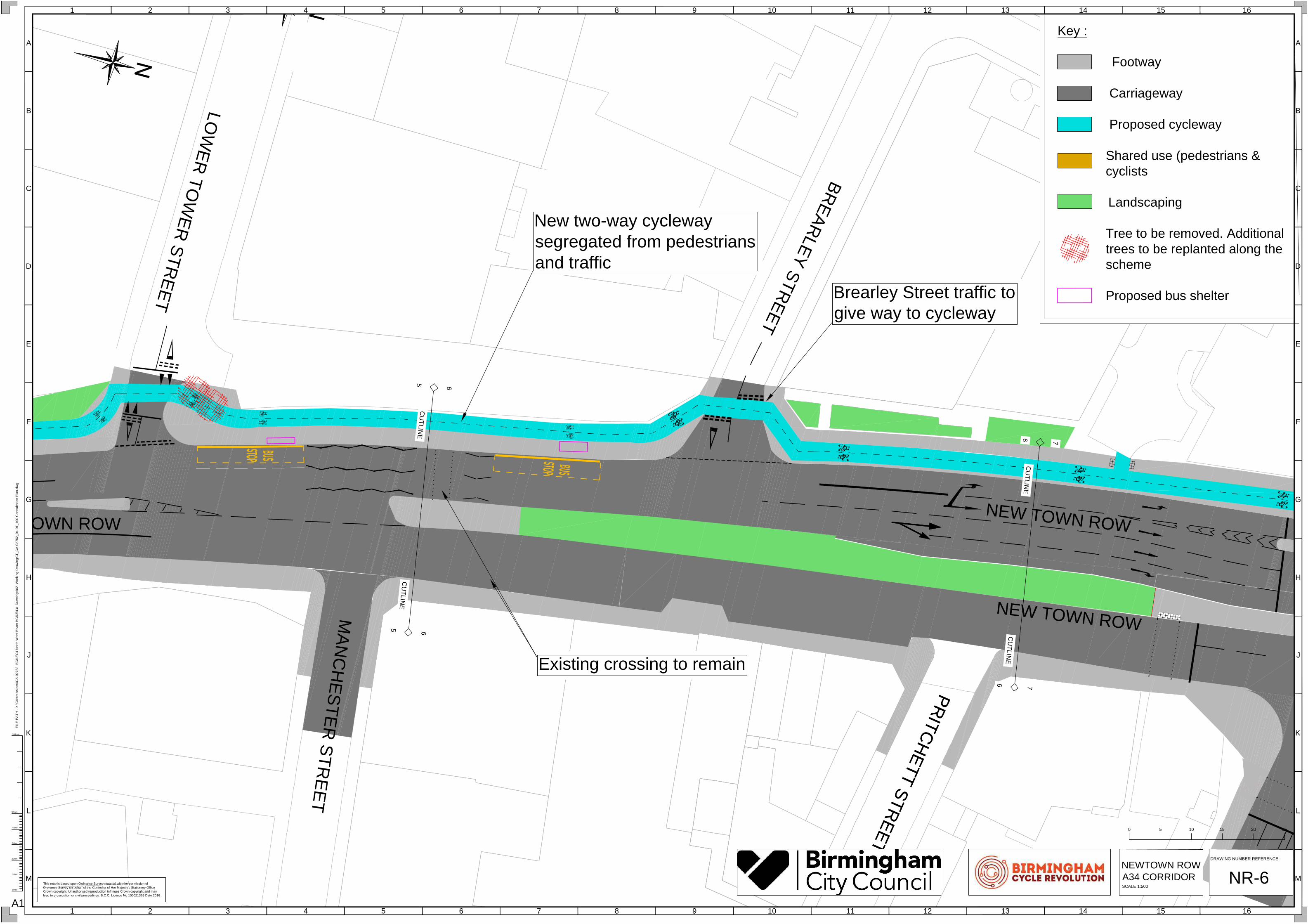
NR-6
0 255 10 15 20
NEWTOWN ROW
A34 CORRIDOR
SCALE 1:500
New two-way cycleway
segregated from pedestrians
and traffic
Brearley Street traffic to
give way to cycleway
Existing crossing to remain
NEW TOWN ROW
N
E
W
T
O
W
N
M
ID
D
L
E
W
A
Y
P
R
IT
C
H
E
T
T
S
T
R
E
E
T
M
IL
L
E
R
S
T
R
E
E
T
N
E
W
J
O
H
N
S
T
R
E
E
T
W
E
S
T
N
E
W
T
O
W
N
M
ID
D
L
E
W
A
Y
P
R
IT
C
H
E
T
T
S
T
R
E
E
T
NEW TOWN ROW
NEW TOWN ROW
NEW TOWN ROW
7
7
8
8
CU
TL
IN
E
CU
TL
IN
E
6
6
7
7
CU
TLIN
E
CU
TLIN
E
Key :
Footway
Carriageway
Proposed cycleway
Shared use (pedestrians &
cyclists
Landscaping
Tree to be removed. Additional
trees to be replanted along the
scheme
Proposed bus shelter
Cycle traffic signal
H
G
F
E
D
C
B
A
J
K
L
M
13 14 15 162 3 4 51 6 7 8 9 10 11 12
H
G
F
E
D
C
B
A
J
K
L
M
13 14 15 162 3 4 51 6 7 8 9 10 11 12
0mm
20mm
10mm
30mm
40mm
50mm
100mm
FIL
E P
AT
H - X
:\C
om
missio
ns\C
A-0
27
52
B
CR
3\0
4 N
orth
W
est B
ha
m B
CR
3\4
.0
D
ra
win
gs\0
2. W
orkin
g D
ra
win
gs\T
_C
A-0
27
52
_0
4-0
1_
10
0 C
on
su
lta
tio
n P
la
n.d
wg
A1
This map is based upon Ordnance Survey material with the permission of
Ordnance Survey on behalf of the Controller of Her Majesty's Stationery Office
Crown copyright. Unauthorised reproduction infringes Crown copyright and may
lead to prosecution or civil proceedings. B.C.C. Licence No 100021326 Date 2016
DRAWING NUMBER REFERENCE:
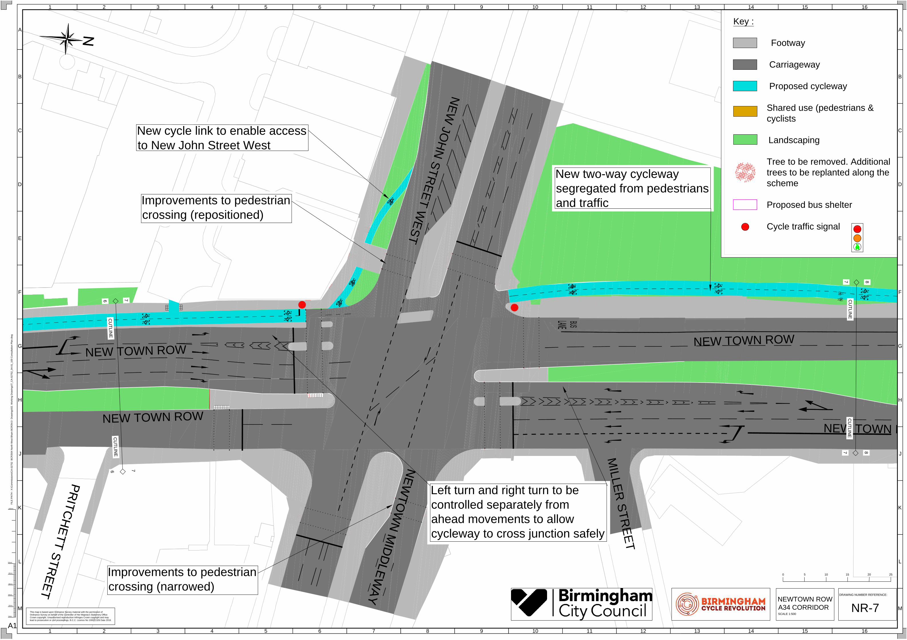
NR-7
0 255 10 15 20
NEWTOWN ROW
A34 CORRIDOR
SCALE 1:500
New two-way cycleway
segregated from pedestrians
and traffic
Left turn and right turn to be
controlled separately from
ahead movements to allow
cycleway to cross junction safely
Improvements to pedestrian
crossing (narrowed)
Improvements to pedestrian
crossing (repositioned)
New cycle link to enable access
to New John Street West
ST
S
TE
PH
EN
S
ST
RE
ET
M
O
O
R
S
O
M
S
T
R
E
E
T
NEW TOW
N ROW
NEW TOWN ROW
NEW TOWN ROW
77
88
CU
TL
IN
EC
UT
LIN
E
88
99
CU
TL
IN
EC
UT
LIN
E
Key :
Footway
Carriageway
Proposed cycleway
Shared use (pedestrians &
cyclists
Landscaping
Tree to be removed. Additional
trees to be replanted along the
scheme
Proposed bus shelter
H
G
F
E
D
C
B
A
J
K
L
M
13 14 15 162 3 4 51 6 7 8 9 10 11 12
H
G
F
E
D
C
B
A
J
K
L
M
13 14 15 162 3 4 51 6 7 8 9 10 11 12
0mm
20mm
10mm
30mm
40mm
50mm
100mm
FIL
E P
AT
H - X
:\C
om
missio
ns\C
A-0
27
52
B
CR
3\0
4 N
orth
W
est B
ha
m B
CR
3\4
.0
D
ra
win
gs\0
2. W
orkin
g D
ra
win
gs\T
_C
A-0
27
52
_0
4-0
1_
10
0 C
on
su
lta
tio
n P
la
n.d
wg
A1
This map is based upon Ordnance Survey material with the permission of
Ordnance Survey on behalf of the Controller of Her Majesty's Stationery Office
Crown copyright. Unauthorised reproduction infringes Crown copyright and may
lead to prosecution or civil proceedings. B.C.C. Licence No 100021326 Date 2016
DRAWING NUMBER REFERENCE:
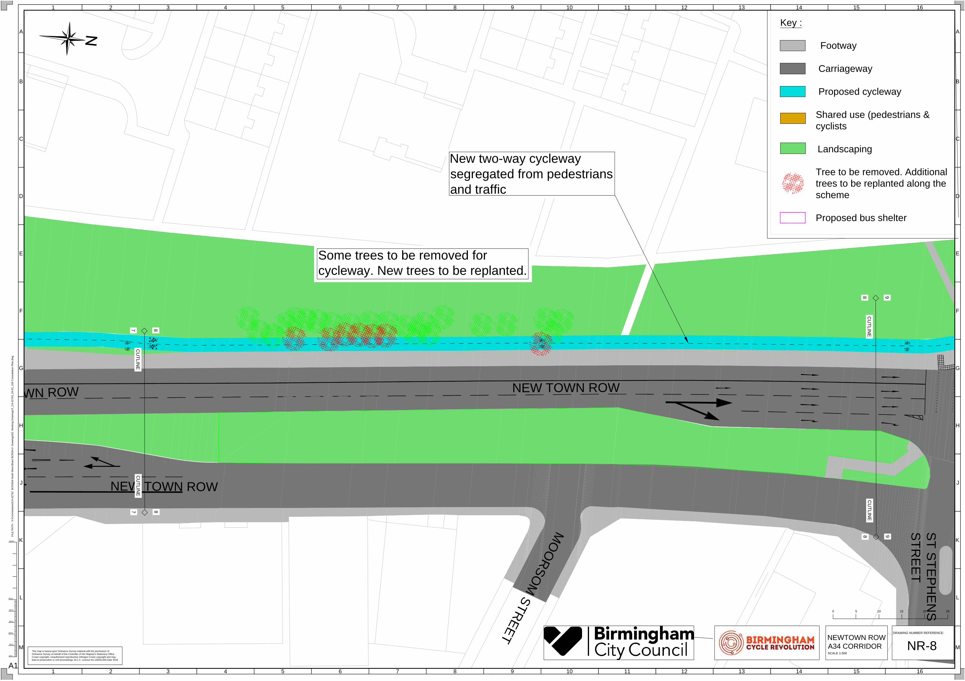
NR-8
0 255 10 15 20
NEWTOWN ROW
A34 CORRIDOR
SCALE 1:500
Some trees to be removed for
cycleway. New trees to be replanted.
New two-way cycleway
segregated from pedestrians
and traffic
S
T S
TE
P
H
E
N
S
S
TR
E
E
T
M
IL
T
O
N
S
T
R
E
E
T
N
E
W
T
O
W
N
R
O
W
NE
W
TO
W
N R
O
W
9
9
10
10
C
U
TLIN
E
C
U
TLIN
E
8
8
9
9
C
U
TLIN
E
C
U
TLIN
E
Key :
Footway
Carriageway
Proposed cycleway
Shared use (pedestrians &
cyclists
Landscaping
Tree to be removed. Additional
trees to be replanted along the
scheme
Proposed bus shelter
H
G
F
E
D
C
B
A
J
K
L
M
13 14 15 162 3 4 51 6 7 8 9 10 11 12
H
G
F
E
D
C
B
A
J
K
L
M
13 14 15 162 3 4 51 6 7 8 9 10 11 12
0mm
20mm
10mm
30mm
40mm
50mm
100mm
FIL
E P
AT
H - X
:\C
om
missio
ns\C
A-0
27
52
B
CR
3\0
4 N
orth
W
est B
ha
m B
CR
3\4
.0
D
ra
win
gs\0
2. W
orkin
g D
ra
win
gs\T
_C
A-0
27
52
_0
4-0
1_
10
0 C
on
su
lta
tio
n P
la
n.d
wg
A1
DRAWING NUMBER REFERENCE:
NR-9
0 255 10 15 20
NEWTOWN ROW
A34 CORRIDOR
SCALE 1:500
This map is based upon Ordnance Survey material with the permission of
Ordnance Survey on behalf of the Controller of Her Majesty's Stationery Office
Crown copyright. Unauthorised reproduction infringes Crown copyright and may
lead to prosecution or civil proceedings. B.C.C. Licence No 100021326 Date 2016
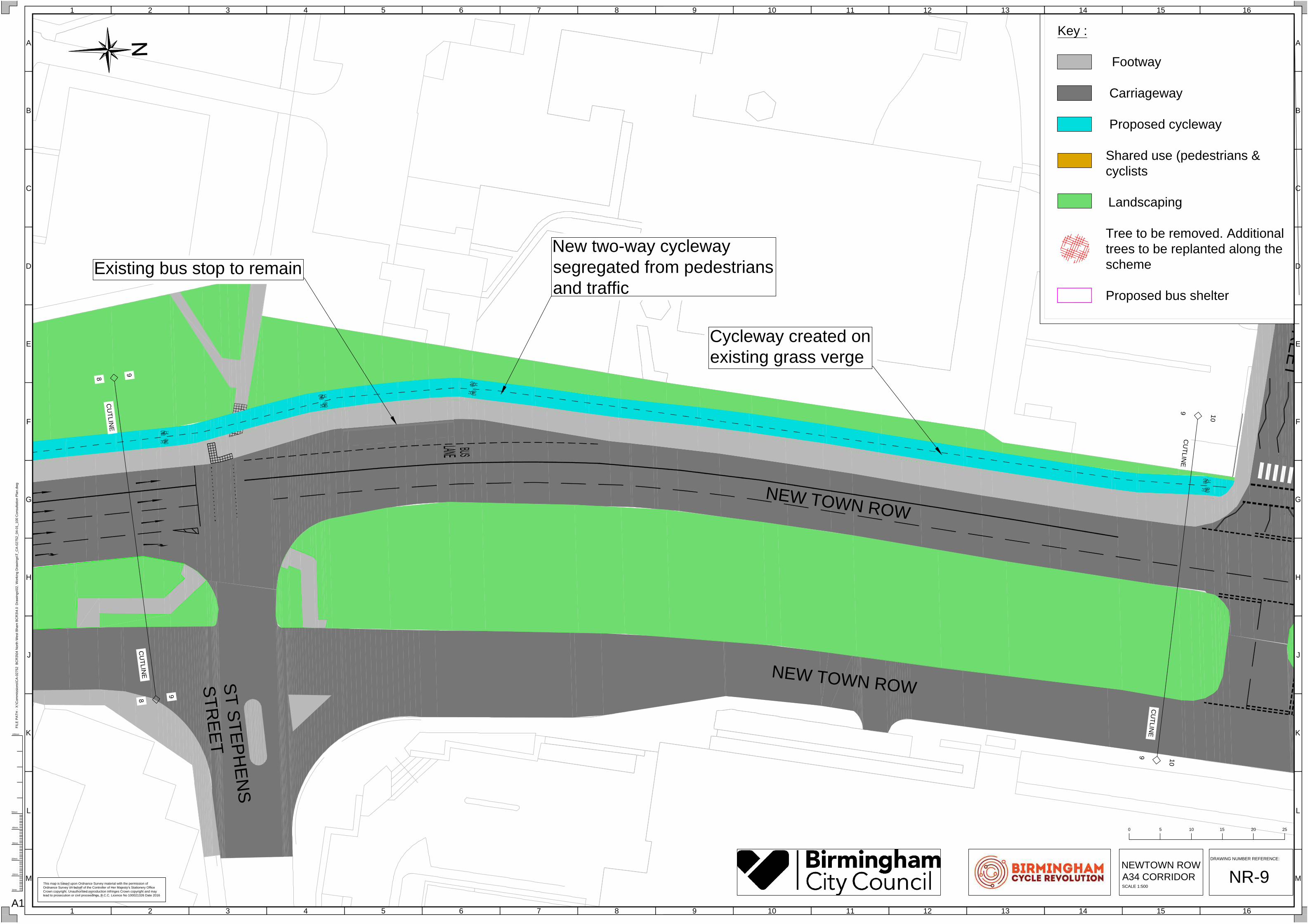
New two-way cycleway
segregated from pedestrians
and traffic
Cycleway created on
existing grass verge
Existing bus stop to remain
MILT
ON
S
TR
EE
T
PH
ILLIP
S S
TR
EE
T
HIGH STREET
HIGH STREET
9
9
10
10
CU
TLIN
E
CU
TLIN
E
10
10
11
11
CU
TLIN
E
CU
TL
IN
E
Key :
Footway
Carriageway
Proposed cycleway
Shared use (pedestrians &
cyclists
Landscaping
Tree to be removed. Additional
trees to be replanted along the
scheme
Proposed bus shelter
H
G
F
E
D
C
B
A
J
K
L
M
13 14 15 162 3 4 51 6 7 8 9 10 11 12
H
G
F
E
D
C
B
A
J
K
L
M
13 14 15 162 3 4 51 6 7 8 9 10 11 12
0mm
20mm
10mm
30mm
40mm
50mm
100mm
FIL
E P
AT
H - X
:\C
om
missio
ns\C
A-0
27
52
B
CR
3\0
4 N
orth
W
est B
ha
m B
CR
3\4
.0
D
ra
win
gs\0
2. W
orkin
g D
ra
win
gs\T
_C
A-0
27
52
_0
4-0
1_
10
0 C
on
su
lta
tio
n P
la
n.d
wg
A1
This map is based upon Ordnance Survey material with the permission of
Ordnance Survey on behalf of the Controller of Her Majesty's Stationery Office
Crown copyright. Unauthorised reproduction infringes Crown copyright and may
lead to prosecution or civil proceedings. B.C.C. Licence No 100021326 Date 2016
DRAWING NUMBER REFERENCE:
NR-10
0 255 10 15 20
NEWTOWN ROW
A34 CORRIDOR
SCALE 1:500
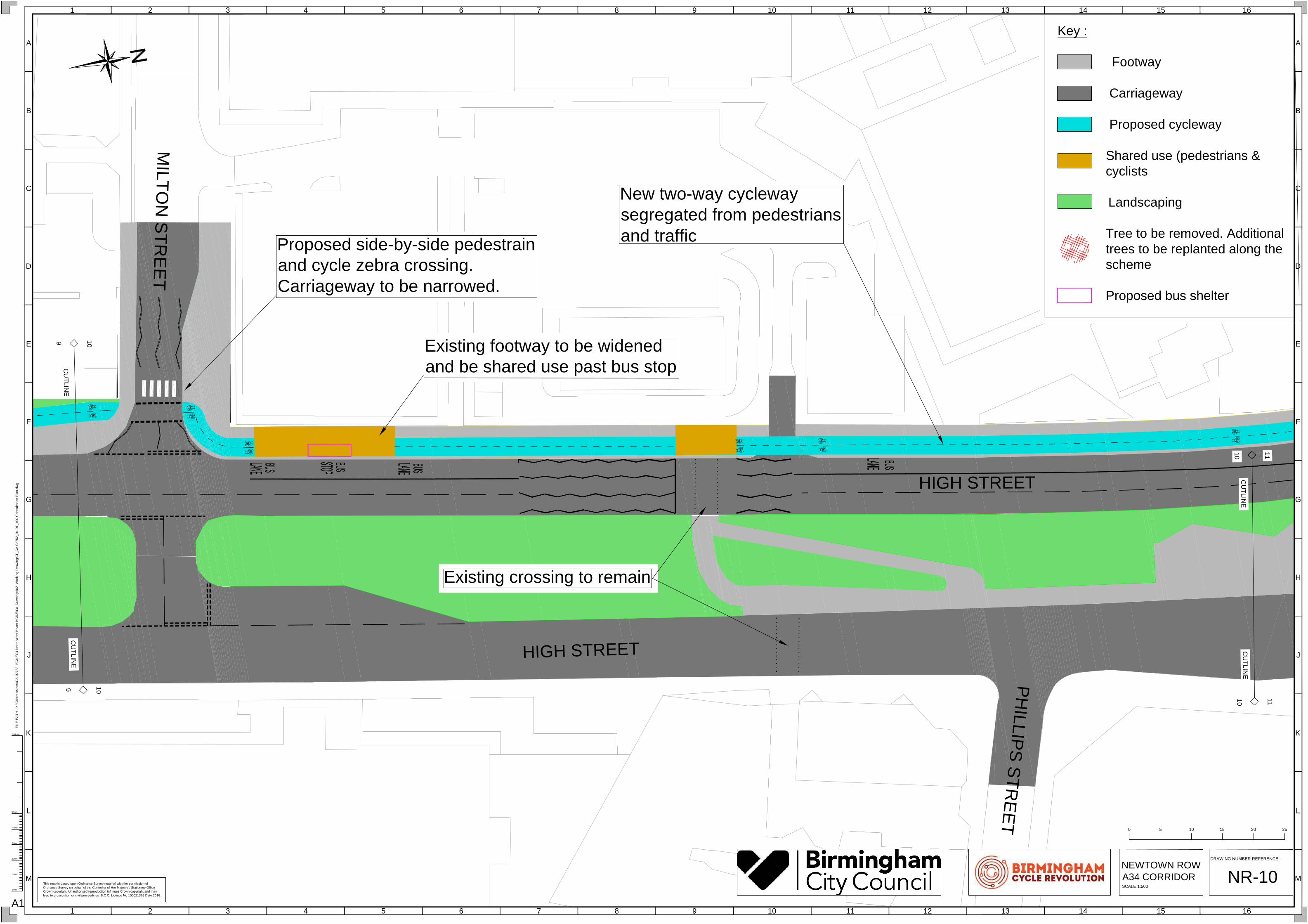
New two-way cycleway
segregated from pedestrians
and traffic
Existing crossing to remain
Proposed side-by-side pedestrain
and cycle zebra crossing.
Carriageway to be narrowed.
Existing footway to be widened
and be shared use past bus stop
P
O
T
T
E
R
S
L
A
N
E
NE
W
BU
RY
R
OA
D
P
A
R
K
L
A
N
E
H
I
G
H
S
T
R
E
E
T
H
I
G
H
S
T
R
E
E
T
H
I
G
H
S
T
R
E
E
T
B
U
R
L
IN
G
T
O
N
S
T
R
E
E
T
1
0
1
0
1
1
1
1
C
U
T
L
I
N
E
C
U
T
L
I
N
E
11
11
12
12
CU
TLIN
E
CU
TLIN
E
Key :
Footway
Carriageway
Proposed cycleway
Shared use (pedestrians &
cyclists
Landscaping
Tree to be removed. Additional
trees to be replanted along the
scheme
Proposed bus shelter
H
G
F
E
D
C
B
A
J
K
L
M
13 14 15 162 3 4 51 6 7 8 9 10 11 12
H
G
F
E
D
C
B
A
J
K
L
M
13 14 15 162 3 4 51 6 7 8 9 10 11 12
0mm
20mm
10mm
30mm
40mm
50mm
100mm
FIL
E P
AT
H - X
:\C
om
missio
ns\C
A-0
27
52
B
CR
3\0
4 N
orth
W
est B
ha
m B
CR
3\4
.0
D
ra
win
gs\0
2. W
orkin
g D
ra
win
gs\T
_C
A-0
27
52
_0
4-0
1_
10
0 C
on
su
lta
tio
n P
la
n.d
wg
A1
This map is based upon Ordnance Survey material with the permission of
Ordnance Survey on behalf of the Controller of Her Majesty's Stationery Office
Crown copyright. Unauthorised reproduction infringes Crown copyright and may
lead to prosecution or civil proceedings. B.C.C. Licence No 100021326 Date 2016
DRAWING NUMBER REFERENCE:
NR-11
0 255 10 15 20
NEWTOWN ROW
A34 CORRIDOR
SCALE 1:500
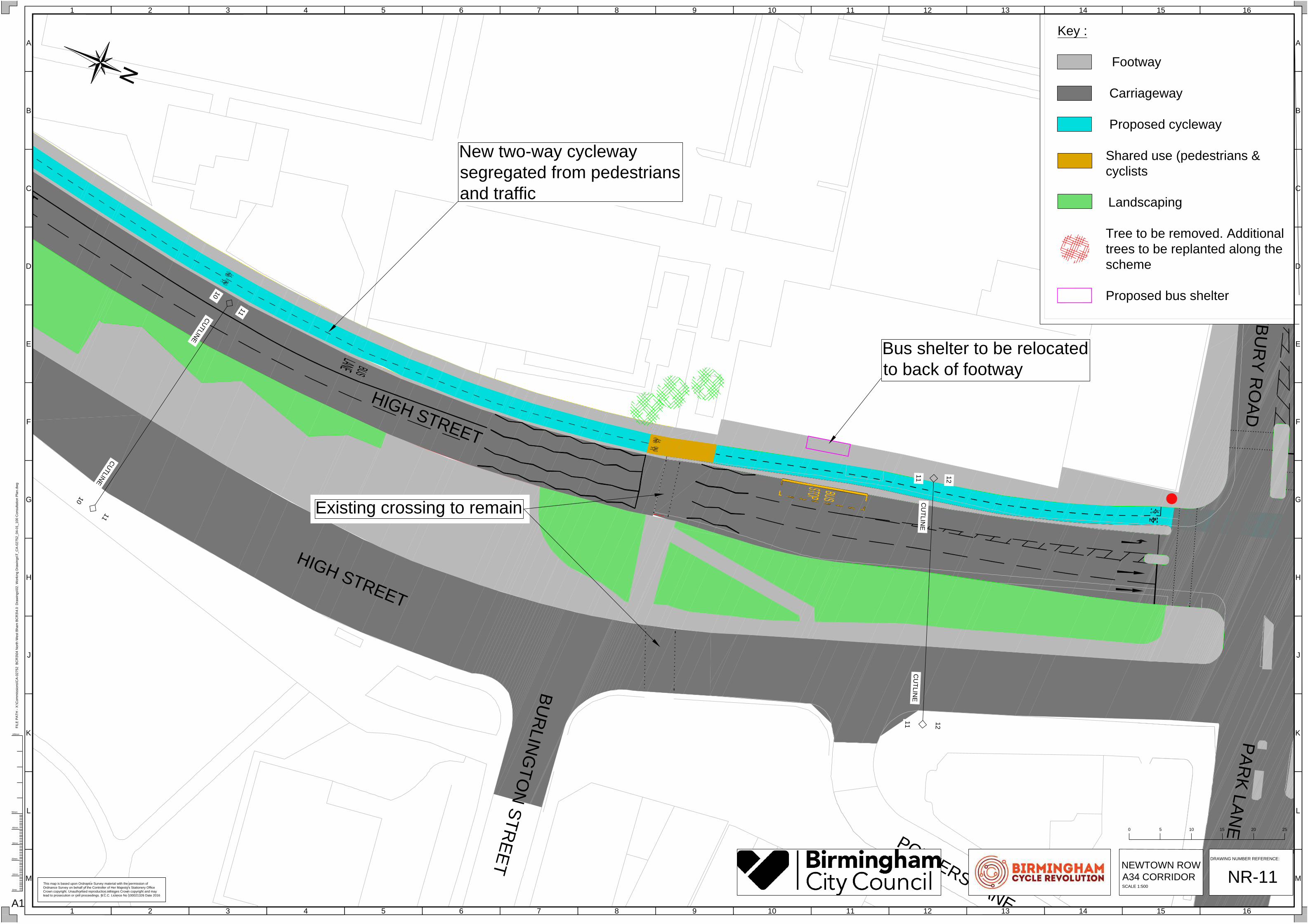
New two-way cycleway
segregated from pedestrians
and traffic
Existing crossing to remain
Bus shelter to be relocated
to back of footway

P
O
T
T
E
R
S
L
A
N
E
NE
WB
UR
Y R
OA
D
PA
RK
LA
NE
11
11
12
12
CU
TLIN
E
CU
TLIN
E
12
12
13
13
CU
TLIN
E
CU
TLIN
E
Key :
Footway
Carriageway
Proposed cycleway
Shared use (pedestrians &
cyclists
Landscaping
Tree to be removed. Additional
trees to be replanted along the
scheme
Proposed bus shelter
Cycle traffic signal
H
G
F
E
D
C
B
A
J
K
L
M
13 14 15 162 3 4 51 6 7 8 9 10 11 12
H
G
F
E
D
C
B
A
J
K
L
M
13 14 15 162 3 4 51 6 7 8 9 10 11 12
0mm
20mm
10mm
30mm
40mm
50mm
100mm
FIL
E P
AT
H - X
:\C
om
missio
ns\C
A-0
27
52
B
CR
3\0
4 N
orth
W
est B
ha
m B
CR
3\4
.0
D
ra
win
gs\0
2. W
orkin
g D
ra
win
gs\T
_C
A-0
27
52
_0
4-0
1_
10
0 C
on
su
lta
tio
n P
la
n.d
wg
A1
This map is based upon Ordnance Survey material with the permission of
Ordnance Survey on behalf of the Controller of Her Majesty's Stationery Office
Crown copyright. Unauthorised reproduction infringes Crown copyright and may
lead to prosecution or civil proceedings. B.C.C. Licence No 100021326 Date 2016
DRAWING NUMBER REFERENCE:
NR-12
0 255 10 15 20
NEWTOWN ROW
A34 CORRIDOR
SCALE 1:500
Amendments to junction layout to include a
two-way cycleway across junction controlled by
traffic signals. Left turn into Newbury Road for
general traffic is on its own signal. New pedestrian
crossing introduced across Newbury Road. Left
turn lanes from Newbury Road reduced from 2 to 1.
New two-way cycleway
segregated from pedestrians
and traffic
Existing pelican crossing to remain

H
IG
H
S
T
R
E
E
T
O
LD
P
AR
K W
ALK
R
O
D
W
A
Y
C
L
O
S
E
1
2
1
2
1
3
1
3
C
U
T
L
I
N
E
C
U
T
L
I
N
E
13
14
CU
TLIN
E
CU
TLIN
E
13
14
Key :
Footway
Carriageway
Proposed cycleway
Shared use (pedestrians &
cyclists
Landscaping
Tree to be removed. Additional
trees to be replanted along the
scheme
Proposed bus shelter
H
G
F
E
D
C
B
A
J
K
L
M
13 14 15 162 3 4 51 6 7 8 9 10 11 12
H
G
F
E
D
C
B
A
J
K
L
M
13 14 15 162 3 4 51 6 7 8 9 10 11 12
0mm
20mm
10mm
30mm
40mm
50mm
100mm
FIL
E P
AT
H - X
:\C
om
missio
ns\C
A-0
27
52
B
CR
3\0
4 N
orth
W
est B
ha
m B
CR
3\4
.0
D
ra
win
gs\0
2. W
orkin
g D
ra
win
gs\T
_C
A-0
27
52
_0
4-0
1_
10
0 C
on
su
lta
tio
n P
la
n.d
wg
A1
This map is based upon Ordnance Survey material with the permission of
Ordnance Survey on behalf of the Controller of Her Majesty's Stationery Office
Crown copyright. Unauthorised reproduction infringes Crown copyright and may
lead to prosecution or civil proceedings. B.C.C. Licence No 100021326 Date 2016
DRAWING NUMBER REFERENCE:
NR-13
0 255 10 15 20
NEWTOWN ROW
A34 CORRIDOR
SCALE 1:500
Location of artist's impression
image
New two-way cycleway
segregated from pedestrians
and traffic
Bus shelter to be relocated
to back of footway
W
IT
TO
N
R
O
AD
V
I
C
T
O
R
I
A
R
O
A
D
HIGH STREET
HIGH STREET
14
14
15
15
CU
TLIN
E
CU
TL
IN
E
13
14
CU
TLIN
E
CU
TL
IN
E
13
14
S
U
B
W
A
Y
Key :
Footway
Carriageway
Proposed cycleway
Shared use (pedestrians &
cyclists
Landscaping
Tree to be removed. Additional
trees to be replanted along the
scheme
Proposed bus shelter
H
G
F
E
D
C
B
A
J
K
L
M
13 14 15 162 3 4 51 6 7 8 9 10 11 12
H
G
F
E
D
C
B
A
J
K
L
M
13 14 15 162 3 4 51 6 7 8 9 10 11 12
0mm
20mm
10mm
30mm
40mm
50mm
100mm
FIL
E P
AT
H - X
:\C
om
missio
ns\C
A-0
27
52
B
CR
3\0
4 N
orth
W
est B
ha
m B
CR
3\4
.0
D
ra
win
gs\0
2. W
orkin
g D
ra
win
gs\T
_C
A-0
27
52
_0
4-0
1_
10
0 C
on
su
lta
tio
n P
la
n.d
wg
A1
This map is based upon Ordnance Survey material with the permission of
Ordnance Survey on behalf of the Controller of Her Majesty's Stationery Office
Crown copyright. Unauthorised reproduction infringes Crown copyright and may
lead to prosecution or civil proceedings. B.C.C. Licence No 100021326 Date 2016
DRAWING NUMBER REFERENCE:
NR-14
0 255 10 15 20
NEWTOWN ROW
A34 CORRIDOR
SCALE 1:500
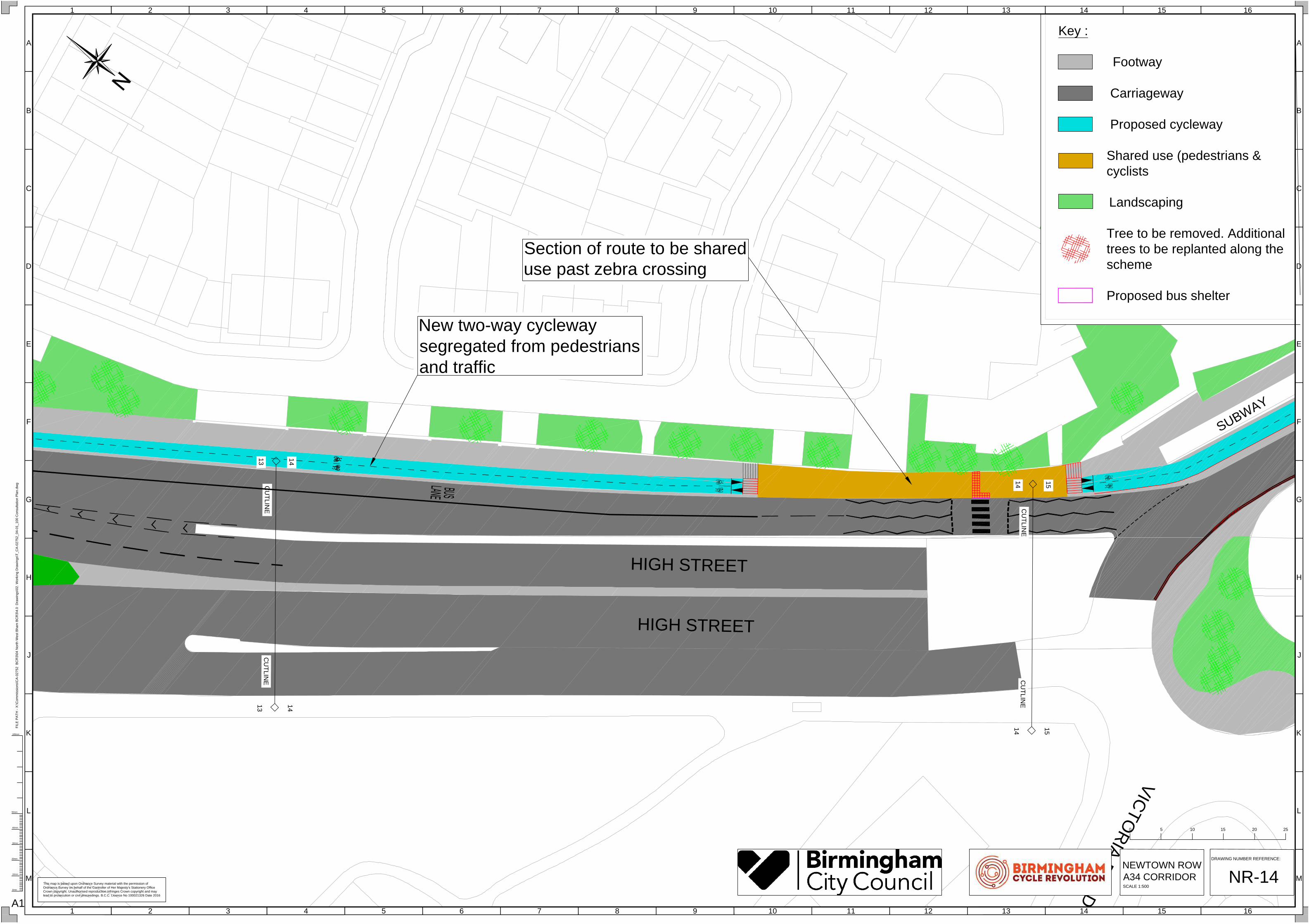
Section of route to be shared
use past zebra crossing
New two-way cycleway
segregated from pedestrians
and traffic

L
O
Z
E
L
L
S
R
O
A
D
W
IT
TO
N
R
O
AD
V
I
C
T
O
R
I
A
R
O
A
D
HIGH STREET
HIG
H S
TR
EE
T
14
14
15
15
CU
TLIN
E
CU
TLIN
E
15
15
16
16
CU
TLIN
E
CU
TLIN
E
S
U
B
W
A
Y
Key :
Footway
Carriageway
Proposed cycleway
Shared use (pedestrians &
cyclists
Landscaping
Tree to be removed. Additional
trees to be replanted along the
scheme
Proposed bus shelter
Cycle traffic signal
H
G
F
E
D
C
B
A
J
K
L
M
13 14 15 162 3 4 51 6 7 8 9 10 11 12
H
G
F
E
D
C
B
A
J
K
L
M
13 14 15 162 3 4 51 6 7 8 9 10 11 12
0mm
20mm
10mm
30mm
40mm
50mm
100mm
FIL
E P
AT
H - X
:\C
om
missio
ns\C
A-0
27
52
B
CR
3\0
4 N
orth
W
est B
ha
m B
CR
3\4
.0
D
ra
win
gs\0
2. W
orkin
g D
ra
win
gs\T
_C
A-0
27
52
_0
4-0
1_
10
0 C
on
su
lta
tio
n P
la
n.d
wg
A1
This map is based upon Ordnance Survey material with the permission of
Ordnance Survey on behalf of the Controller of Her Majesty's Stationery Office
Crown copyright. Unauthorised reproduction infringes Crown copyright and may
lead to prosecution or civil proceedings. B.C.C. Licence No 100021326 Date 2016
DRAWING NUMBER REFERENCE:
NR-15
0 255 10 15 20
NEWTOWN ROW
A34 CORRIDOR
SCALE 1:500
New two-way cycleway
segregated from pedestrians
and traffic
Location of artist's impression
image
Roundabout width to be reduced. No
loss of lanes or capacity for traffic.
New signal controlled cycleway running
side-by-side with pedestrian crossing.
F
E
N
T
H
A
M
R
O
A
D
HIGH STREET
HIGH STREET
HIGH STREET
C
H
A
I
N
W
A
L
K
M
A
N
S
F
IE
L
D
R
O
A
D
15
15
16
16
CU
TLIN
E
CU
TLIN
E
16
16
17
17
CU
TLIN
E
CU
TLIN
E
SU
BW
AY
Key :
Footway
Carriageway
Proposed cycleway
Shared use (pedestrians &
cyclists
Landscaping
Tree to be removed. Additional
trees to be replanted along the
scheme
Proposed bus shelter
H
G
F
E
D
C
B
A
J
K
L
M
13 14 15 162 3 4 51 6 7 8 9 10 11 12
H
G
F
E
D
C
B
A
J
K
L
M
13 14 15 162 3 4 51 6 7 8 9 10 11 12
0mm
20mm
10mm
30mm
40mm
50mm
100mm
FIL
E P
AT
H - X
:\C
om
missio
ns\C
A-0
27
52
B
CR
3\0
4 N
orth
W
est B
ha
m B
CR
3\4
.0
D
ra
win
gs\0
2. W
orkin
g D
ra
win
gs\T
_C
A-0
27
52
_0
4-0
1_
10
0 C
on
su
lta
tio
n P
la
n.d
wg
A1
This map is based upon Ordnance Survey material with the permission of
Ordnance Survey on behalf of the Controller of Her Majesty's Stationery Office
Crown copyright. Unauthorised reproduction infringes Crown copyright and may
lead to prosecution or civil proceedings. B.C.C. Licence No 100021326 Date 2016
DRAWING NUMBER REFERENCE:
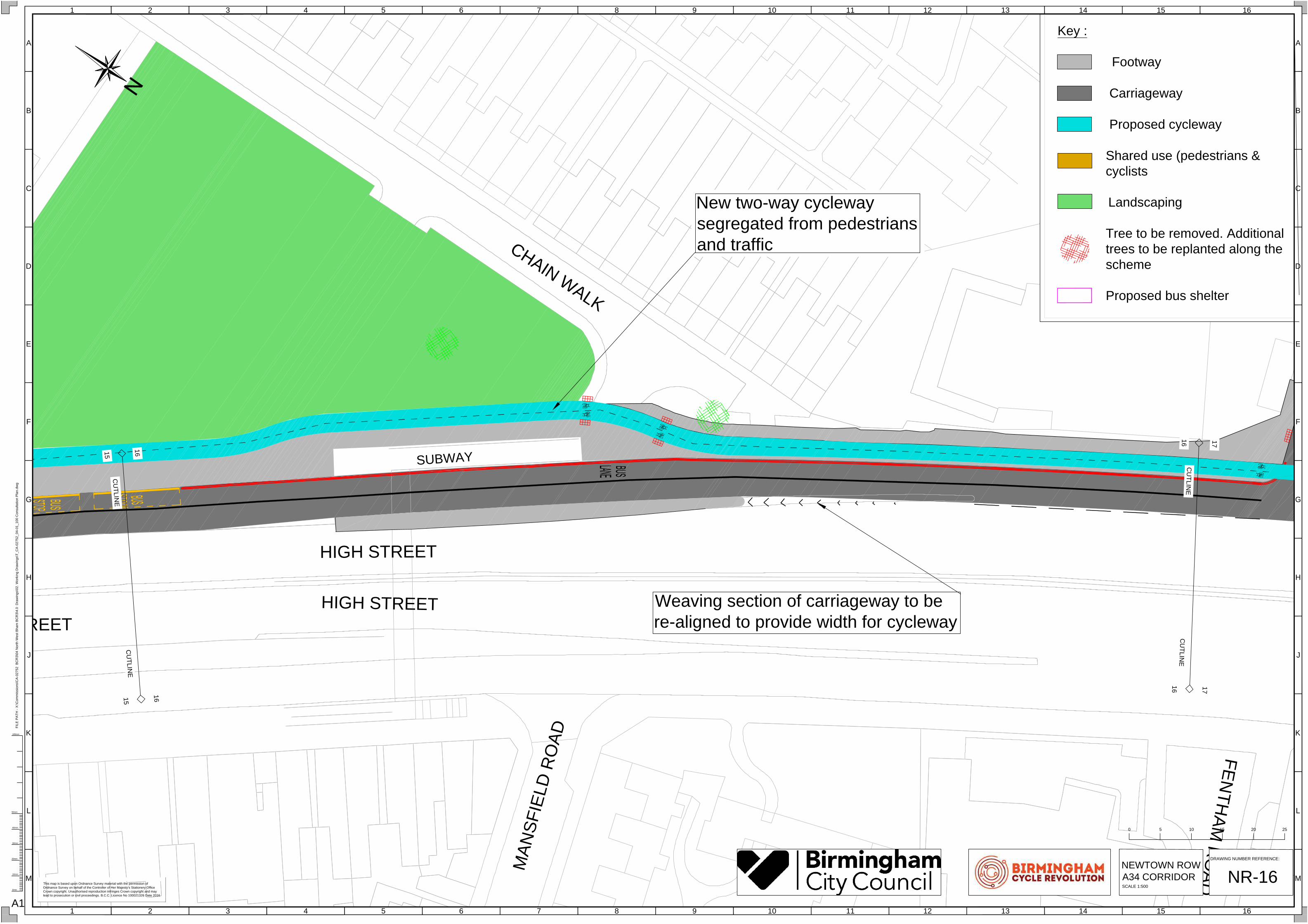
NR-16
0 255 10 15 20
NEWTOWN ROW
A34 CORRIDOR
SCALE 1:500
New two-way cycleway
segregated from pedestrians
and traffic
Weaving section of carriageway to be
re-aligned to provide width for cycleway
JO
HN
ST
ON
E S
TR
EE
T
F
E
N
T
H
A
M
R
O
A
D
SA
LIS
BU
RY
R
OA
D
BIR
CH
FIE
LD
RO
AD
BIR
CH
FIE
LD
RO
AD
1
6
1
6
1
7
1
7
C
U
T
L
IN
E
C
U
T
L
IN
E
17
17
18
18
CU
TLIN
E
CU
TLIN
E
SUBWAY
Key :
Footway
Carriageway
Proposed cycleway
Shared use (pedestrians &
cyclists
Landscaping
Tree to be removed. Additional
trees to be replanted along the
scheme
Proposed bus shelter
H
G
F
E
D
C
B
A
J
K
L
M
13 14 15 162 3 4 51 6 7 8 9 10 11 12
H
G
F
E
D
C
B
A
J
K
L
M
13 14 15 162 3 4 51 6 7 8 9 10 11 12
0mm
20mm
10mm
30mm
40mm
50mm
100mm
FIL
E P
AT
H - X
:\C
om
missio
ns\C
A-0
27
52
B
CR
3\0
4 N
orth
W
est B
ha
m B
CR
3\4
.0
D
ra
win
gs\0
2. W
orkin
g D
ra
win
gs\T
_C
A-0
27
52
_0
4-0
1_
10
0 C
on
su
lta
tio
n P
la
n.d
wg
A1
This map is based upon Ordnance Survey material with the permission of
Ordnance Survey on behalf of the Controller of Her Majesty's Stationery Office
Crown copyright. Unauthorised reproduction infringes Crown copyright and may
lead to prosecution or civil proceedings. B.C.C. Licence No 100021326 Date 2016
DRAWING NUMBER REFERENCE:
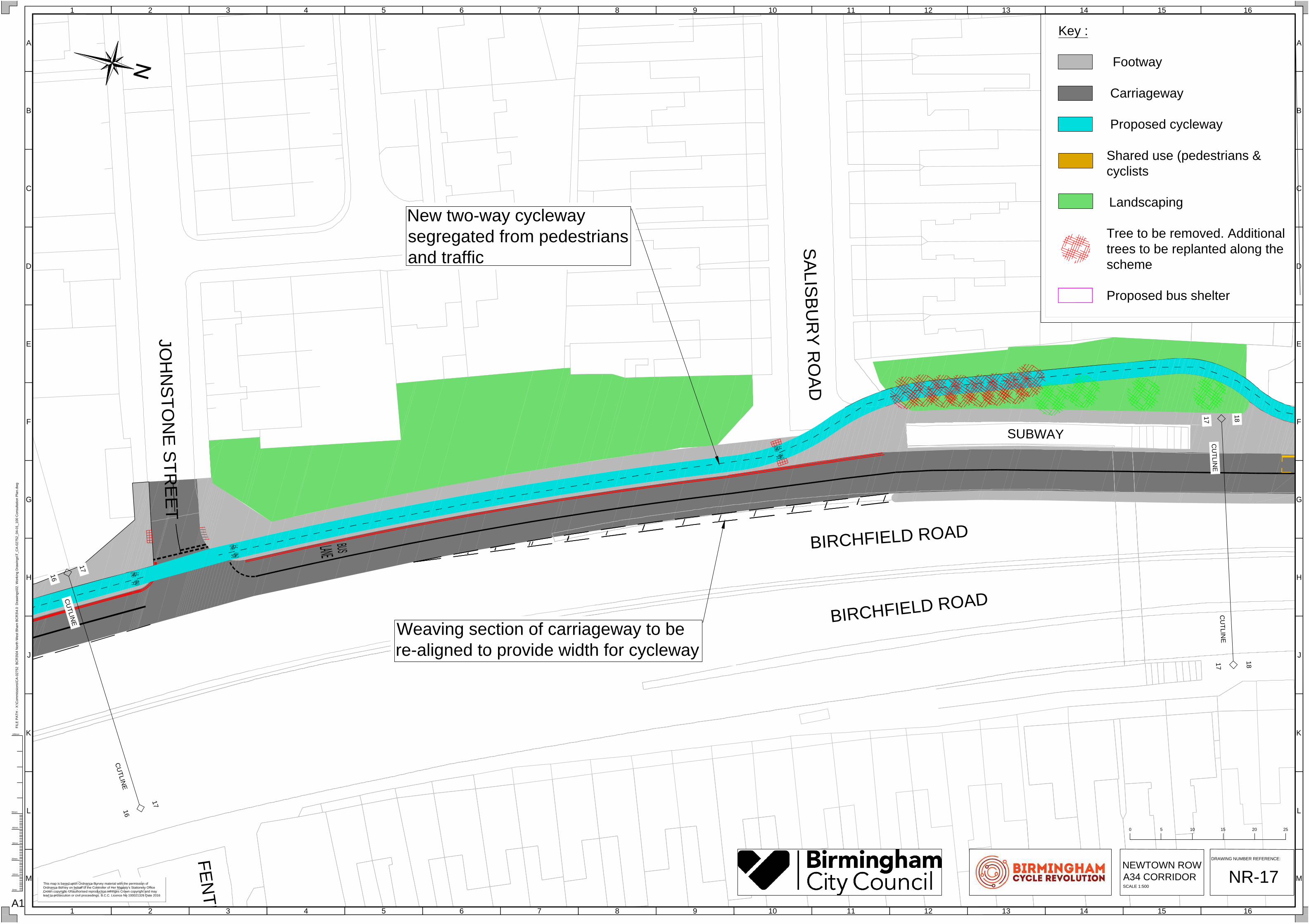
NR-17
0 255 10 15 20
NEWTOWN ROW
A34 CORRIDOR
SCALE 1:500
New two-way cycleway
segregated from pedestrians
and traffic
Weaving section of carriageway to be
re-aligned to provide width for cycleway
HA
TF
IE
LD
R
OA
D
A
R
D
E
N
R
O
A
D
WILS
ON
R
OA
D
NE
W IN
N R
OA
D
BIRCHFIELD ROAD
BIRCHFIELD ROAD
BIRCHFIELD ROAD
17
17
18
18
CU
TLIN
E
CU
TLIN
E
18
18
19
19
CU
TLIN
E
CU
TLIN
E
Key :
Footway
Carriageway
Proposed cycleway
Shared use (pedestrians &
cyclists
Landscaping
Tree to be removed. Additional
trees to be replanted along the
scheme
Proposed bus shelter
H
G
F
E
D
C
B
A
J
K
L
M
13 14 15 162 3 4 51 6 7 8 9 10 11 12
H
G
F
E
D
C
B
A
J
K
L
M
13 14 15 162 3 4 51 6 7 8 9 10 11 12
0mm
20mm
10mm
30mm
40mm
50mm
100mm
FIL
E P
AT
H - X
:\C
om
missio
ns\C
A-0
27
52
B
CR
3\0
4 N
orth
W
est B
ha
m B
CR
3\4
.0
D
ra
win
gs\0
2. W
orkin
g D
ra
win
gs\T
_C
A-0
27
52
_0
4-0
1_
10
0 C
on
su
lta
tio
n P
la
n.d
wg
A1
This map is based upon Ordnance Survey material with the permission of
Ordnance Survey on behalf of the Controller of Her Majesty's Stationery Office
Crown copyright. Unauthorised reproduction infringes Crown copyright and may
lead to prosecution or civil proceedings. B.C.C. Licence No 100021326 Date 2016
DRAWING NUMBER REFERENCE:
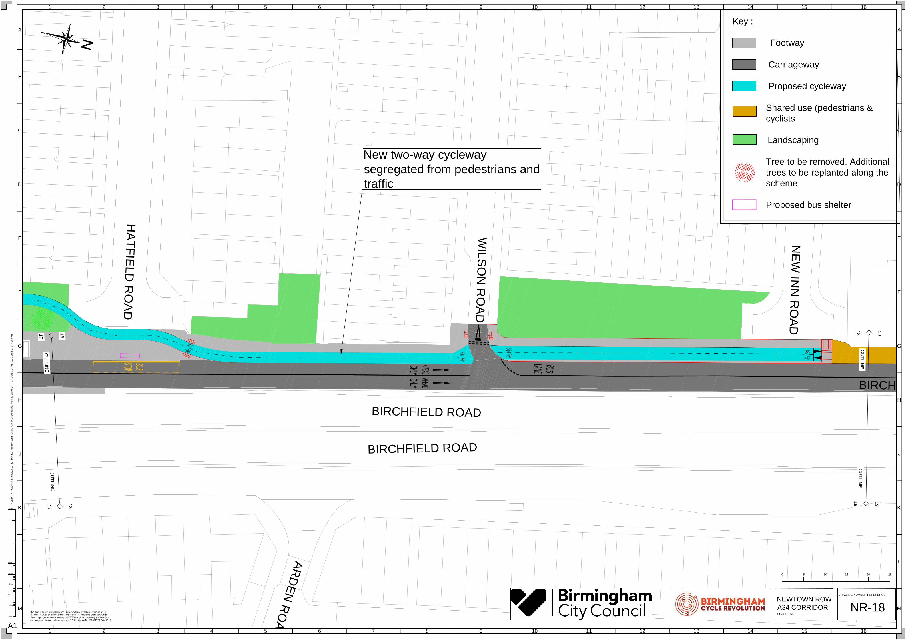
NR-18
0 255 10 15 20
NEWTOWN ROW
A34 CORRIDOR
SCALE 1:500
New two-way cycleway
segregated from pedestrians and
traffic
NE
W IN
N R
OA
D
HE
AT
HF
IE
LD
R
OA
D
T
R
IN
IT
Y
R
O
A
D
BIRCHFIELD ROAD
18
18
19
19
CU
TLIN
E
CU
TLIN
E
Key :
Footway
Carriageway
Proposed cycleway
Shared use (pedestrians &
cyclists
Landscaping
Tree to be removed. Additional
trees to be replanted along the
scheme
Proposed bus shelter
H
G
F
E
D
C
B
A
J
K
L
M
13 14 15 162 3 4 51 6 7 8 9 10 11 12
H
G
F
E
D
C
B
A
J
K
L
M
13 14 15 162 3 4 51 6 7 8 9 10 11 12
0mm
20mm
10mm
30mm
40mm
50mm
100mm
FIL
E P
AT
H - X
:\C
om
missio
ns\C
A-0
27
52
B
CR
3\0
4 N
orth
W
est B
ha
m B
CR
3\4
.0
D
ra
win
gs\0
2. W
orkin
g D
ra
win
gs\T
_C
A-0
27
52
_0
4-0
1_
10
0 C
on
su
lta
tio
n P
la
n.d
wg
A1
This map is based upon Ordnance Survey material with the permission of
Ordnance Survey on behalf of the Controller of Her Majesty's Stationery Office
Crown copyright. Unauthorised reproduction infringes Crown copyright and may
lead to prosecution or civil proceedings. B.C.C. Licence No 100021326 Date 2016
DRAWING NUMBER REFERENCE:
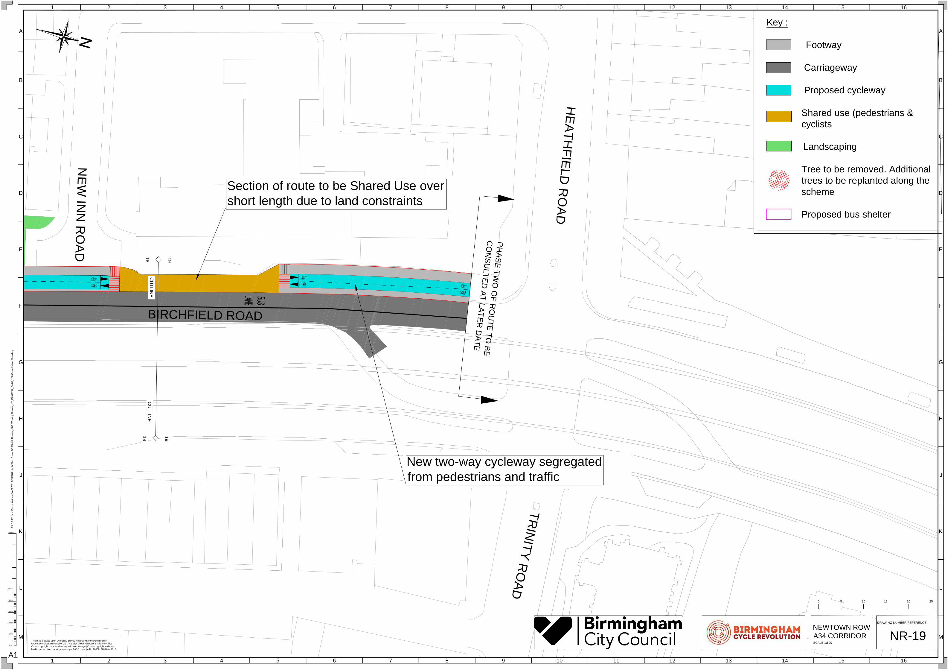
NR-19
0 255 10 15 20
NEWTOWN ROW
A34 CORRIDOR
SCALE 1:500
Section of route to be Shared Use over
short length due to land constraints
New two-way cycleway segregated
from pedestrians and traffic
PH
AS
E T
W
O
O
F R
O
U
TE
T
O
B
E
C
O
N
SU
LT
ED
A
T LA
TE
R
D
AT
E