Construction NOI Storm Water Olentangy Permit List - Ohio.gov

NPDES PHASE II
GENERAL PERMIT APPLICATION STORM WATER QUALITY MANAGEMENT PLAN
PART C: PROGRAM IMPLEMENTATION
CEDAR LAKE, INDIANA
PERMIT # INR040075
MARCH 1, 2005

NPDES PHASE II STORM WATER QUALITY MANAGEMENT PLAN (SWQMP)
PART C: PROGRAM IMPLEMENTATION
Prepared for:
Town of Cedar Lake, Indiana
Prepared by:
Christopher B. Burke Engineering, Ltd. National Town Center, Suite 1368-South
115 W. Washington Street Indianapolis, Indiana 46204
CBBEL Project Number 04-019

Cedar Lake, Indiana NPDES Phase II Part C Implementation Plan
Christopher B. Burke Engineering, Ltd.
DISCLAIMER: Exhibits and any GIS data used within this report are not intended to be used as legal documents or references. They are intended to serve as an aid in graphic representation only. Information shown on exhibits is not warranted for accuracy or merchantability.

Cedar Lake, Indiana NPDES Phase II Part C Implementation Plan
iChristopher B. Burke Engineering, Ltd.
TABLE OF CONTENTS
Page # LIST OF TABLES iii LIST OF EXHIBITS iii LIST OF APPENDICES iii SUPPLEMENTAL MATERIAL iv
1.0 INTRODUCTION 1
2.0 DETAILED DESCRIPTION OF MS4 AREA 3
2.1 NARRATIVE DESCRIPTION OF MS4 AREA 3
2.2 DESCRIPTION OF MS4 CONVEYANCE SYSTEMS 3
2.3 PRIORITY WATERSHED RANKING AND CONCERNS 4
2.4 UTILIZATION OF PRIORITY WATERSHED INFORMATION 5
3.0 PUBLIC EDUCATION AND OUTREACH 6
3.1 EXISTING PUBLIC EDUCATION AND OUTREACH BMPs 6
3.2 PROPOSED PUBLIC EDUCATION AND OUTREACH BMPs 7
4.0 PUBLIC PARTICIPATION AND INVOLVEMENT 13
4.1 EXISTING PUBLIC PARTICIPATION AND INVOLVEMENT BMPs 13
4.2 PROPOSED PUBLIC PARTICIPATION AND INVOLVEMENT BMPs 14 5.0 ILLICIT DISCHARGE DETECTION AND ELIMINATION 20 5.1 EXISTING ILLICIT DISCHARGE DETECTION AND ELIMINATION 20
BMPs
5.2 PROPOSED ILLICIT DISCHARGE DETECTION AND ELIMINATION 21 BMPs

Cedar Lake, Indiana NPDES Phase II Part C Implementation Plan
iiChristopher B. Burke Engineering, Ltd.
6.0 CONSTRUCTION SITE RUNOFF CONTROL 26
6.1 EXISTING CONSTRUCTION SITE RUNOFF CONTROL BMPs 26
6.2 PROPOSED CONSTRUCTION SITE RUNOFF CONTROL BMPs 27 7.0 POST-CONSTRUCTION RUNOFF CONTROL 32
7.1 EXISTING POST-CONSTRUCTION RUNOFF CONTROL BMPs 32
7.2 PROPOSED POST-CONSTRUCTION RUNOFF CONTROL BMPs 33
8.0 POLLUTION PREVENTION AND GOOD HOUSEKEEPING 40 8.1 EXISTING POLLUTION PREVENTION AND GOOD HOUSEKEEPING
BMPs 40
8.2 PROPOSED POLLUTION PREVENTION AND GOOD HOUSEKEEPING BMPs 41
9.0 MS4 PROGRAM COSTS 49
9.1 SWQMP DEVELOPMENT COSTS 49 9.2 DETAILED PART C IMPLEMENTATION COSTS BY MCM OVER
2004-2008 50
9.3 OTHER COMPLIANCE COSTS 2005 – 2008 51
9.4 TOTAL SWQMP PROGRAM COSTS 2004 – 2008 52
9.5 BUGETARY NEEDS 53 10.0 SUMMARY 54
10.1 PROGRAMMATIC INDICATORS 54 10.2 MASTER TIMELINE 59 10.3 NEXT STEPS 63

Cedar Lake, Indiana NPDES Phase II Part C Implementation Plan
iiiChristopher B. Burke Engineering, Ltd.
LIST OF TABLES
2-1 Conveyance Systems for Cedar Lake’s MS4 Area 3 2-2 Priority Watershed Ranking and Concerns 5 2-3 Use of Priority Watershed Information 5 3-1 Public Education and Outreach BMPs 10 4-1 Public Participation and Involvement BMPs 17 5-1 Illicit Discharge Detection and Elimination BMPs 24 6-1 Construction Site Storm Water Runoff Control BMPs 30 7-1 Pre-approved Post-construction BMPs 34 7-2 Post-construction Storm Water Runoff Control BMPs 38 8-1 Storm Sewer System Maintenance Schedule Activities 42 8-2 Good Housekeeping and Pollution Prevention BMPs 46 9-1 Total Program Costs 53 10-1 Programmatic Indicators 55 10-2 Master Timeline 59
LIST OF EXHIBITS
1. MS4 Area Map 2. Priority Watersheds
LIST OF APPENDICES
A. References B. Glossary of Terms C. SWQMP Part C: Program Implementation Certification Checklist D. Certification of the Informational Program for the Public Education and Outreach
MCM E. Certification of the Public Participation and Involvement Program for the Public
Participation and Involvement MCM F. Certification of the Plan to Detect, Address and Eliminate Illicit Discharges for the
Illicit Detection and Elimination MCM G. Certification of the Development, Implementation, Management and Enforcement
of an Erosion and Sediment Control Program for the Construction Site Storm Water Run-Off Control MCM
H. Certification of the Development, Implementation, Management and Enforcement of a Postconstruction Storm Water Run-Off Control Program for the Postconstruction Storm Water Run-Off Control MCM
I. Certification of the Development and Implementation, of a Program to Reduce Pollutant Run-Off from Municipal Operations for the Municipal Operations Pollution Prevention and Good Housekeeping MCM
J. Active Industrial Facilities in the MS4 Area K. Memorandum of Understanding

Cedar Lake, Indiana NPDES Phase II Part C Implementation Plan
ivChristopher B. Burke Engineering, Ltd.
SUPPLEMENTAL MATERIALS
(Bound Separately but Available to Agency Upon Request)
A. Stormwater Management Ordinance B. Illicit Discharge Detection and Elimination (IDDE) Plan

Cedar Lake, Indiana NPDES Phase II Part C Implementation Plan
1 Christopher B. Burke Engineering, Ltd.
1.0 INTRODUCTION As part of the 1987 amendments to the federal Clean Water Act (CWA), the United States Congress added Chapter 402(p) to the CWA to address the water quality impacts of stormwater discharges from industrial facilities and large to medium municipal separate storm sewer systems (MS4s). Large to medium MS4s were defined as communities serving populations of 100,000 or more and are regulated by the Environmental Protection Agency (EPA) under the National Pollutant Discharge Elimination System’s (NPDES) Storm Water Phase I Program. In addition to these amendments, Congress directed the Environmental Protection Agency (EPA) to issue further regulations to identify and regulate additional stormwater discharges that were considered to be contributing to national water quality impairments. On December 8, 1999, the EPA issued regulations that expanded the existing NPDES Storm Water Program to include discharges from small MS4s in “urbanized areas” serving populations of less than 100,000 and stormwater discharges from construction activities that disturb more than one acre of land. These regulations are referred to as the NPDES Phase II Storm Water Program. The urbanized area portion of Town of Cedar Lake met these criteria and was consequently designated as an MS4 entity. In the State of Indiana, the Indiana Department of Environmental Management (IDEM) is responsible for the development and oversight of the NPDES Phase II Program. The IDEM initiated adoption of the Phase II Rules that were ultimately codified as 327 IAC 15-13 (Rule 13). Rule 13 became effective on August 6, 2003 and requires designated MS4 entities to apply for permit coverage by submitting a Notice of Intent (NOI) and developing Storm Water Quality Management Plans (SWQMPs) through a phased submittal process. The IDEM’s phased submittal requirements for the SWQMP include the following three components:
• Part A: Initial Application • Part B: Baseline Characterization Report • Part C: Program Implementation Plan
All MS4s were required to submit NOI and SWQMP Part A documents to the IDEM by November 5, 2003. SWQMP Part B and Part C documents are required to be submitted by May 3, 2004 and November 5, 2004, respectively. Cedar Lake’s NOI and SWQMP Part A documents were submitted to IDEM on November 5, 2003, and the SWQMP Part B document was submitted to IDEM on May 5, 2004. An extension letter to request an extension for the SWQMP Part C submittal and to submit annual reports in March 2006, March 2007, March 2008, and March 2009 was sent to IDEM and subsequently the request was granted by IDEM. The extended Part C submittal date is March 1, 2005. This report has been prepared to address Rule 13 requirements for completing the SWQMP Part C: Program Implementation Report, its corresponding certification form,

Cedar Lake, Indiana NPDES Phase II Part C Implementation Plan
2 Christopher B. Burke Engineering, Ltd.
and certification forms for each of the six Minimum Control Measures (MCMs) for Town of Cedar Lake, Indiana. This report includes the following information:
• An initial evaluation of the storm water program for the Town of Cedar Lake MS4
area, including information on all known structural and nonstructural storm water BMPs utilized,
• A detailed program description for each of the six MCMs, including Measurable goals with results that are related to an environmental benefit and programmatic indicators,
• A timetable for program implementation milestone, which includes milestones for each of the six MCMs,
• SWQMP-Part B: Baseline Characterization Report conclusions (BMP recommendations, additional protective measures for sensitive areas, and correcting identified water quality problems),
• A narrative and mapped description of the MS4 area boundaries that indicate responsible MS4 entity areas for each MCM, including specific jurisdictional boundaries of the MS4 area,
• An estimate of the linear feet of MS4 conveyances within the MS4 area, segregated by MS4 type, including open ditch and pipe,
• A summary of which structural BMP types will be allowed in new development and redevelopment for the MS4 area,
• A summary of the storm water structural BMP selection criteria and, where appropriate, associated performance standards that must be met after installation to indicate BMP effectiveness, and
• A summary of the current storm water budget, (expected or actual) funding source, and a projection of the budget for each year within the five (5) year permit term.
In addition, the IDEM’s SWQMP Part C: Program Implementation Report Certification Checklist and certification forms for each of the six MCMs are included in Appendices C through I of this report.

Cedar Lake, Indiana NPDES Phase II Part C Implementation Plan
3 Christopher B. Burke Engineering, Ltd.
2.0 MS4 AREA DESCRIPTION Rule 13 requires a narrative and mapped description of the MS4 area boundaries and an estimate of the linear feet of MS4 conveyances within the MS4 area. The following discussion provides an evaluation the municipal stormwater conveyance system within Town of Cedar Lake’s MS4 area. The map of the MS4 area boundaries is Exhibit 1 of this report. 2.1 NARRATIVE DESCRIPTION OF MS4 AREA The Town of Cedar Lake is located in Lake Town, Indiana, 40 miles southeast of Chicago, Illinois, and is comprised of approximately 8.1 square miles that surrounds an 805-acre lake. The Town’s MS4 boundary mirrors its jurisdictional boundary, and is located in Center and Hanover Townships. Exhibit 1 identifies Cedar Lake’s MS4 area. 2.2 DESCRIPTION OF MS4 CONVEYANCE SYSTEMS Conveyance is defined by IDEM as any structural process for transferring stormwater between at least two (2) points. The term includes piping, ditches, swales, curbs, gutters, catch basins, channels, storm drains, and roadway. IDEM further defines MS4 conveyance systems as outfall conveyance systems with a pipe diameter of twelve (12) inches or larger and open ditches with a two (2) foot or larger bottom width. Although this definition includes only the main trunks of pipes or open ditches that lead to each regulated outfall, mapping of the total conveyance system (that would also include the tributaries to the main trunks) as budgets allow will aid in illicit discharge detection and elimination efforts. Table 2-1 lists the estimated linear feet of total conveyance systems within Cedar Lake’s MS4 area broken down by type. This estimate will be used to determine the amount of MS4 conveyances to be mapped each year for compliance. Rule 13 requires that 25% of the outfall conveyance system be mapped each year, in years 2 through 5.
Table 2-1 Conveyance Systems for Town of Cedar Lake’s MS4 Area
Conveyance Type Estimated Feet of Conveyance % of Total
Conveyance System Open Storm Drain 5,280 20
Enclosed Pipe 21,120 80 Total 26,400 100

Cedar Lake, Indiana NPDES Phase II Part C Implementation Plan
4 Christopher B. Burke Engineering, Ltd.
2.3 PRIORITY WATERSHED RANKING AND CONCERNS The Rule 13 SWQMP-Part B required the identification of areas having reasonable potential for or actually causing stormwater quality problems based upon relevant land use data and identified sensitive areas, as well as, existing and available water quality data. These areas are required to be given the highest priority for the selection of BMPs and the prohibition of new or significantly increased MS4 discharges. The Town of Cedar Lake’s Part B Report concluded that certain 14-digit subwatersheds in their MS4 area are to be given the highest priority for implementation of their stormwater program. Since the submittal of Part B, IDEM 2004 data has become available and is incorporated into these report findings. The Town of Cedar Lake has ranked the following priority watersheds identified in Part B in an effort to further investigate water quality issues associated with stormwater runoff over the five year permit term and as a means to further direct and target Rule 13 program activities. Watersheds were ranked based on water quality concerns, such as, waterbody impairments, sensitive areas, and percentage of the subwatershed’s land area that is located within the Town’s MS4 area. The priority subwatershed ranking protocol is as follows: • highest priority is given to those watersheds that contain any waterbodies in need of
protective measures to ensure that existing conditions do not deteriorate; • if a subwatershed contains an IDEM 2004 303(d) listed waterbody, then it is given a
higher priority based on its listed number; • IDEM 2004 305(b) report findings that were correlated in the Town’s Part B to
stormwater quality (SWQ) issues are given a higher priority since the Rule 13 program implementation can have an impact on improving subwatershed water quality;
• percentage of the MS4 area located within the subwatershed is a consideration because the Town will implement the majority of its Rule 13 program in their delineated MS4 area; and
• proximity of the identified subwatersheds to one another, their drainage patterns, and land uses were considered.
Table 2-2 ranks the previously identified watersheds based on concerns related to the quality of stormwater runoff for the priority watersheds.

Cedar Lake, Indiana NPDES Phase II Part C Implementation Plan
5 Christopher B. Burke Engineering, Ltd.
Table 2-2
Priority Watershed Ranking and Concerns Priority Ranking
Watershed Name (14-digit HUC)
Watershed Concerns
1 Lake Dalecarlia-Cedar Lake (07120001130060)
• 305(b) related to SWQ • 303(d) ranked 51st for impaired biotic communities • Cedar Lake is a contact recreational water • MS4 area is 35% of the watershed
2 West Creek – Bull Run (07120001140010)
• 305(b) related to SWQ • Small amount of MS4 area is located in watershed
2.4 UTILIZATION OF PRIORITY WATERSHED INFORMATION Town of Cedar Lake will use the information it obtains during further investigation of water quality issues associated with stormwater runoff in the priority watersheds over the five year permit term to direct and further target Rule 13 program activities. Program elements will be prioritized to coincide with priority watershed rankings. Implementation activities will start with priority watershed #1 and will continue sequentially through ranked priority watersheds.
Table 2-3 Use of Priority Watershed Information
MCM Use of Priority Watershed Information
1 • Distribute stormwater educational brochures related to the effects on stormwater quality on Cedar Lake. • Add priority watershed information to web site.
2 • Seek volunteers in Priority Watershed areas. • Identify and work with established Watershed groups in 14-digit subwatersheds.
3 • Prioritize Mapping and Screening activities. • Prioritize Storm Drain marking areas.
4 • Prioritize Construction plan review and inspection activities. 5 • Prioritize Plan review and inspection. 6 • Prioritize areas for street sweeping program.
• Locate sensitive water bodies to minimize salt and sand application.
Cedar Lake, Indiana NPDES Phase II Part C Implementation Plan
6 Christopher B. Burke Engineering, Ltd.
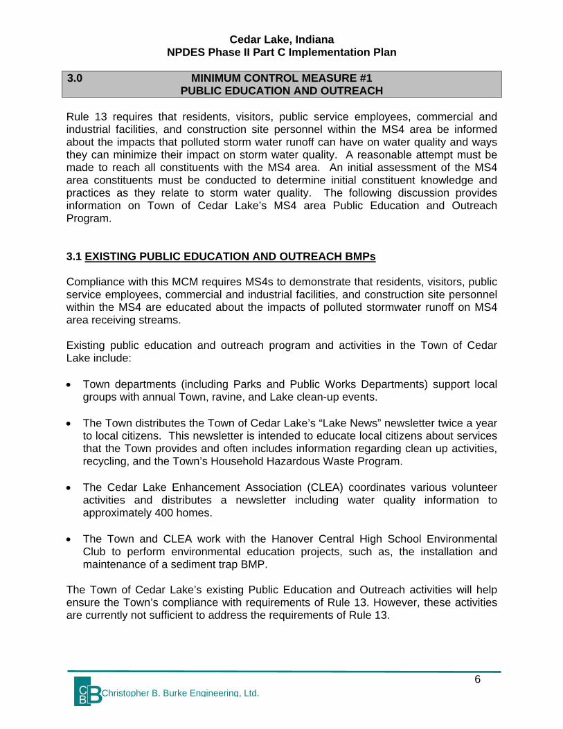
3.0 MINIMUM CONTROL MEASURE #1 PUBLIC EDUCATION AND OUTREACH
Rule 13 requires that residents, visitors, public service employees, commercial and industrial facilities, and construction site personnel within the MS4 area be informed about the impacts that polluted storm water runoff can have on water quality and ways they can minimize their impact on storm water quality. A reasonable attempt must be made to reach all constituents with the MS4 area. An initial assessment of the MS4 area constituents must be conducted to determine initial constituent knowledge and practices as they relate to storm water quality. The following discussion provides information on Town of Cedar Lake’s MS4 area Public Education and Outreach Program. 3.1 EXISTING PUBLIC EDUCATION AND OUTREACH BMPs Compliance with this MCM requires MS4s to demonstrate that residents, visitors, public service employees, commercial and industrial facilities, and construction site personnel within the MS4 are educated about the impacts of polluted stormwater runoff on MS4 area receiving streams. Existing public education and outreach program and activities in the Town of Cedar Lake include: • Town departments (including Parks and Public Works Departments) support local
groups with annual Town, ravine, and Lake clean-up events. • The Town distributes the Town of Cedar Lake’s “Lake News” newsletter twice a year
to local citizens. This newsletter is intended to educate local citizens about services that the Town provides and often includes information regarding clean up activities, recycling, and the Town’s Household Hazardous Waste Program.
• The Cedar Lake Enhancement Association (CLEA) coordinates various volunteer
activities and distributes a newsletter including water quality information to approximately 400 homes.
• The Town and CLEA work with the Hanover Central High School Environmental
Club to perform environmental education projects, such as, the installation and maintenance of a sediment trap BMP.
The Town of Cedar Lake’s existing Public Education and Outreach activities will help ensure the Town’s compliance with requirements of Rule 13. However, these activities are currently not sufficient to address the requirements of Rule 13.

Cedar Lake, Indiana NPDES Phase II Part C Implementation Plan
7 Christopher B. Burke Engineering, Ltd.
3.2 PROPOSED PUBLIC EDUCATION AND OUTREACH BMPs The Town of Cedar Lake has a Memorandum of Understanding (MOU) with the Northwestern Indiana Regional Planning Commission (NIRPC) to cover MCMs #1 and #2. The Northwestern Indiana Regional Planning Commission (NIRPC) will be responsible for the development and implementation of a five-year (5) Joint Storm Water Quality Phase II Public Education and Involvement Program as set forth in their MOU. NIRPC will be responsible for meeting all state and federal requirements as they pertain to the two MCMs of the Rule 13 permit program: Public Education/Outreach and Public Involvement/Participation. The following Education and Outreach BMPs will be developed and implemented by NIRPC on behalf of the Town of Cedar Lake in order to comply with the minimum requirements of this MCM. Existing BMPs identified in subsection 3.1 with any needed enhancements, as well as, any new BMPs are included in this section. The Town’s MS4 area, as discussed in Part B, is comprised of both urban and agricultural lands. The Town’s Education and Outreach Program is therefore designed to minimize stormwater impacts originating from both land uses by informing citizens about the impacts of stormwater discharges on water bodies and the steps that they can take to reduce pollutants in stormwater runoff. As of March 2005, Town of Cedar Lake has initiated implementation of a Storm Water Public Education and Outreach Program as part of this Part C Plan, which outlines the overall strategy for gradually implementing the program and its corresponding BMPs over the next four years. Table 3-1 provides a summary of the Education and Outreach BMPs to be implemented and identifies the associated measurable goals, programmatic indicator number, timeline, priority areas, and responsible parties associated with each BMP. A detailed description of each BMP is provided below. Clean-Up Events The Town will continue to support local clean-up events, which will increase citizen awareness of the Town’s stormwater program through public education and outreach. Town departments (including Parks and Public Works Departments) will participate in annual Town, ravine, and Lake clean-up events. The Town will document the number of volunteers that participate, as well as, the waste collected as a result of these events. This information will be included in the Town’s Rule 13 Annual Reports submitted to IDEM. Training for Construction Professionals NIRPC will administer a regional construction and development community education program, which will increase the construction and development community’s awareness of changing erosion and sediment control standards. This program will require all construction professionals to attend NIPRC trainings in order to perform construction activities in the Town. The Training will require attending a workshop and passing an

Cedar Lake, Indiana NPDES Phase II Part C Implementation Plan
8 Christopher B. Burke Engineering, Ltd.
exam, which focus on the Town’s erosion and sediment control program, construction and Post-construction stormwater BMPs, special protective measures needed within the Town’s identified priority watersheds and sensitive areas, and dealing with highly erodible soils. Continuing education requirements will be required as part of the Training and may include attending annual erosion and sediment control BMP Training Workshops. IDEM and IDNR will be consulted on program content. Newsletter Articles NIRPC will develop a series of articles that discuss topics such as the Rule 13 stormwater program, erosion and sediment control measures, agricultural issues related to stormwater quality, and other relevant stormwater information designed to enhance the urban and rural community’s understanding of the Town’s stormwater issues. Staff from NIRPC will be responsible for drafting the articles. The Town will be responsible for disseminating the information. The Town will document the total number of articles published, the topics of each article, and the total number of newsletters disseminated. This information will be included in the Town’s first Rule 13 Annual Report to be submitted in March of 2006. NIRPC also has future plans for a regional stormwater program newsletter. Web Site NIRPC will create a web site that will be linked to the Town’s web site and include information pertaining to the Town’s Stormwater Program. The web site will be designed to educate residents, visitors, public service employees, commercial and industrial facilities, and construction site personnel about the impacts polluted storm water runoff can have on water quality and the ways they can minimize their impacts on storm water quality. The web site will provide dates, times, and sponsors of stormwater related events such as workshops, clean-up events and public meetings. The web site will include copies of the Town’s SWQMP, stormwater related ordinances, and other relevant information. The web site will include a counter to identify the number of “hits” the site receives. In addition, the web site will have an e-mail function by which an individual could ask a question regarding the Town’s Stormwater Program or stormwater in general. Information will be added to make the public aware of the priority watershed ranking and concerns identified in subsection 2.3. The total number of hits the site receives along with any questions and answers provided will be submitted with the Town’s Rule 13 Annual Reports submitted to IDEM. Stormwater Survey NIRPC will develop and conduct a baseline Stormwater Survey in 2005 to assess the public’s initial knowledge and understanding of stormwater issues and to establish a baseline for MCM #1. NIRPC will also compile the Survey results in 2005. The NIRPC will evaluate the survey results in order to better target their education and outreach activities. The results of the survey as well as the conclusions drawn by NIRPC will be included with the Town’s first Rule 13 Annual Report to be submitted in February of 2006. Constituents will be surveyed in two years and at the end of the permit cycle to determine program effectiveness.

Cedar Lake, Indiana NPDES Phase II Part C Implementation Plan
9 Christopher B. Burke Engineering, Ltd.
Stormwater Brochures NIRPC will develop different stormwater brochures designed to educate residents, visitors, public service employees, commercial and industrial facilities, and construction site personnel about the impacts polluted storm water runoff can have on water quality and the ways they can minimize their impacts on stormwater quality. The brochures will include targeted outreach information on stormwater quality impacts on drinking water, failing septic tank issues related to stormwater quality, and information on the Town’s the Illicit Discharge Detection and Elimination Ordinance, such as, no dumping. Additional brochures will be developed as topics and targeted activities necessitate them. Brochures will be disseminated via mass mailings within MS4 areas, at local places of business, at Town offices, and at Town events. Staff from the NIRPC will be responsible for both production and dissemination of the brochures. Copies of the brochures along with the total number of brochures distributed will be documented and included in the Town’s Rule 13 Annual Reports submitted to IDEM. Solid Waste Management District (SWMD) Promotions In order to educate community members on the importance of pollution prevention and recycling programs, the Town and NIRPC will frequently advertise and promote the activities of the Lake County Solid Waste Management District (SWMD). This will also help with eliminating illegal dumping activities and help to satisfy requirements of MCM #3. The SWMD develops a newsletter and sponsors hazardous waste disposal events, recycling sites, composting sites, and educational programs for local schools and civic groups. Advertisements and promotions will occur on NIRPC’s web-site and through the various stormwater brochures to be developed as part of the Town’s Stormwater Program. The Town will coordinate with the SWMD to estimate the total waste collected at their different facilities and in order to target activities in priority watersheds. In addition, all stormwater related educational activities that occur within the Town’s MS4 area will be documented. All of this information will be included in the Town’s Rule 13 Annual Reports submitted to IDEM. Mass Media Opportunities Mass media has been shown to be a means to gain a higher level of exposure of stormwater education information and to create a higher level of impressions, which will educate a greater number of individuals. Local radio, TV stations, and newspapers will be contacted by NIRPC by November 2005 about possible stormwater quality Public Service Announcements (PSAs). NIRPC will also look at the feasibility of utilizing a roving billboard with a stormwater quality message. NIRPC will track number of PSAs produced and number of airings. As this activity progresses, information will be included with the Town’s Rule 13 Annual Reports submitted to IDEM.

Cedar Lake, Indiana NPDES Phase II Part C Implementation Plan
10 Christopher B. Burke Engineering, Ltd.
Table 3-1
Public Education and Outreach BMPs
Best Management Practice (BMP)
Measurable Goals, Tracking, and
Programmatic Indicators Timeline Priority Areas Responsible Party
Clean-up Events
• Advertise and conduct events annually. • Track using Programmatic Indicators #2 and #3.
Begin in 2005, then held annually.
NIRPC contracted regional MS4 entity areas.
NIRPC.
Training for Construction Professionals
• Administer a local construction and development community education program. • Conduct first workshop in 2005, then annually. • Promote other activities, such as regional IDNR trainings. • Track using Programmatic Indicators #2 and #3.
• Offer first workshop in 2005, then annually. • On-going, promote other applicable training opportunities.
• NIRPC contracted regional MS4 entity areas. • Include training on erosion and sediment control, Post-construction BMPs, priority watersheds, and sensitive areas.
NIRPC.
Newsletter Articles • Publish four articles for each year. • Track number of articles published and subject matter.
Articles published every quarter.
NIRPC contracted regional MS4 entity areas.
NIRPC.

Cedar Lake, Indiana NPDES Phase II Part C Implementation Plan
11 Christopher B. Burke Engineering, Ltd.
Best Management Practice (BMP)
Measurable Goals, Tracking, and
Programmatic Indicators Timeline Priority Areas Responsible Party
Web Site
• Create a new, extensive, water quality website with detailed stormwater information in 2005. • Update with new information, continually. • Answer questions generated by web site on an on-going basis. • Track total number of hits site receives and public questions asked and answers to them.
• In 2005, create web site. • On-going, update information and respond to public questions.
NIRPC contracted regional MS4 entity areas.
NIRPC.
Stormwater Survey
• Develop and conduct survey by December 2005. • Evaluate survey results to assess the public’s initial knowledge and understanding of stormwater issues. • Use survey results to target outreach efforts. • Track using Programmatic Indicator #1.
Survey conducted and compiled by December 2005.
NIRPC contracted regional MS4 entity areas.
NIRPC.
Stormwater Educational Brochures
• Create 3 different stormwater quality brochures by November 2005. • Create additional brochures as needed.
Begin brochure distribution March 2006.
NIRPC contracted regional MS4 entity areas.
NIRPC.

Cedar Lake, Indiana NPDES Phase II Part C Implementation Plan
12 Christopher B. Burke Engineering, Ltd.
Best Management Practice (BMP)
Measurable Goals, Tracking, and
Programmatic Indicators Timeline Priority Areas Responsible Party
Solid Waste Management District
Promotions
• Conduct promotions beginning 2005 and on-going as SWMD performs activities. • Track using Programmatic Indicators #10, #11, and #12.
Begin 2005 and on-going.
NIRPC contracted regional MS4 entity areas.
SWMD and NIRPC.
Mass Media Opportunities
• Contact local radio, TV stations, and newspapers by November 2005 about possible Public Service Announcements (PSAs). • Document progress in Rule 13 Annual Reports.
During 2005. NIRPC contracted regional MS4 entity areas.
NIRPC.

Cedar Lake, Indiana NPDES Phase II Part C Implementation Plan
13 Christopher B. Burke Engineering, Ltd.
4.0 MINIMUM CONTROL MEASURE #2 PUBLIC PARTICIPATION & INVOLVEMENT
Rule 13 requires that documented opportunities are given to constituents within the MS4 area to participate in the storm water management program development and implementation. The MS4 entity must comply with public notice requirements to allow public comment. An initial assessment of MS4 area constituents must be conducted to identify interested individuals for participation in the MS4 area stormwater program. 4.1 EXISTING PUBLIC PARTICIPATION AND INVOLVEMENT BMPs Compliance with this MCM requires MS4s to demonstrate that opportunities were provided for stakeholders to participate in the development and implementation of the MS4’s SWQMP. Existing Public Participation and Involvement activities in the Town of Cedar Lake include: • Stormwater Board meetings and work sessions are open to the public. Every
Thursday afternoon Town officials work with the public to investigate complaints. • The Cedar Lake Enhancement Association (CLEA) has existed since 1994 and has
been involved in various LARE grant projects. They are currently working with the Army Corps to slow down sediment and phosphorous loadings to the lake and ultimately obtain permitting necessary for dredging Cedar Lake. The CLEA provides a “Lake Monitor” to obtain samples twice during the summer from Cedar Lake for analysis of water clarity and phosphorous by Indiana University – Bloomington.
• The Cedar Lake Enhancement Association (CLEA) coordinates various volunteer
activities and distributes a newsletter including water quality information to approximately 400 homes.
• Numerous Town Departments participate in and support local Town cleanup events. • Cedar Lake officials recently approved the construction of a privately owned and
operated dog park. The Town will promote the use of the park and proper disposal of pet waste.
The Town of Cedar Lake’s existing Public Participation and Involvement activities will help ensure the Town’s compliance with requirements of Rule 13. However, these activities are currently not sufficient to address the requirements of Rule 13.

Cedar Lake, Indiana NPDES Phase II Part C Implementation Plan
14 Christopher B. Burke Engineering, Ltd.
4.2 PROPOSED PUBLIC PARTICIPATION AND INVOLVEMENT BMPs The Town of Cedar Lake has a Memorandum of Understanding (MOU) with the Northwestern Indiana Regional Planning Commission (NIRPC) to cover MCMs #1 and #2. The Northwestern Indiana Regional Planning Commission (NIRPC) will be responsible for the development and implementation of a five-year (5) Joint Storm Water Quality Phase II Public Education and Involvement Program as set forth in their MOU. NIRPC will be responsible for meeting all state and federal requirements as they pertain to the two MCMs of the Rule 13 permit program: Public Education/Outreach and Public Involvement/Participation. The following Public Participation and Involvement BMPs will be developed and implemented by NIRPC on behalf of the Town of Cedar Lake in order to comply with the minimum requirements of this MCM. Existing BMPs identified in subsection 4.1 with any needed enhancements, as well as, any new BMPs are included in this section. As of March 2005, NIRPC has initiated the implementation of a Storm Water Public Participation and Involvement Program as part of this Part C Plan, which outlines the overall strategy for gradually implementing the program and its corresponding BMPs over the next four years. The program is designed to engage citizens, form partnerships, and gain greater support and compliance for the program. The presumptive approach of implementing this program assumes that overall stormwater quality will improve each year by better educating the public to reduce the amount of pollutants entering the conveyance system. Table 4-1 provides a summary of the Public Participation and Involvement BMPs to be implemented and identifies the associated measurable goals, programmatic indicators, tracking, timeline, priority areas, and responsible parties associated with each BMP. A detailed description of each BMP is provided below. NIRPC Joint Stormwater MS4 Program Meetings During 2004, NIRPC conducted meetings to bring together all regional MS4 entities that have signed an MOU with NIRPC to provide all of the requirements for MCMs #1 and #2. Cedar Lake has attended all of the NIRPC meetings held in 2004. The purpose of the meetings is for the MS4 entities to provide input and give direction to NIRPC’s program. The entities have given suggestions on the types of BMPs utilized and how NIPRC implements them. Since NIRPC’s program is still under development, the meetings will continue into 2005. NIRPC is considering implementing stormwater quality educational programs focusing on classroom, teacher, business, and community programs. They are also looking at the feasibility of sponsoring stream clean-up, stream monitoring, and reforestation programs. Community Involvement Meetings To ensure adequate citizen involvement in the development and implementation of Town of Cedar Lake’s SWQMP and stormwater program, NIRPC will conduct meetings with the public in order to solicit public input and volunteers. This information will be

Cedar Lake, Indiana NPDES Phase II Part C Implementation Plan
15 Christopher B. Burke Engineering, Ltd.
included in the Town’s Rule 13 Annual Reports submitted to IDEM as this BMP is developed. Clean-Up Events The Town will continue to support local clean-up events, which will increase citizen awareness of the Town’s stormwater program through public education and outreach. Town departments (including Parks and Public Works Departments) will participate in annual Town, ravine, and Lake clean-up events. The Town will document the number of volunteers that participate, as well as, the waste collected as a result of these events. This information will be included in the Town’s Rule 13 Annual Reports submitted to IDEM. Rule 13 Public Participation Lists During 2005, NIRPC will identify those groups and individuals that would be most likely to have an interest in the Town’s Stormwater Program. They will also develop a list of volunteer activities, such as, monitoring water quality, storm drain marking, etc., that identified groups and individuals would most likely participate in. These lists will be used to document that sufficient opportunities were allotted to involve all constituents interesting in participating in the program. The lists, number of and information on contacts made to individuals and groups, and volunteer hours donated will be included with the Town’s Rule 13 Annual Reports submitted to IDEM. Public Meetings NIRPC will conduct Public meetings in order to inform citizens about stormwater impacts and gain support for the program. Key issues such as citizen responsibility, costs, & program benefits, as well as, any other issues related to the stormwater program will be addressed. The Town will track the number of meetings, notices, and attendees, as well as, any public comment opportunities and report this in their Rule 13 Annual Reports submitted to IDEM. Training for Construction Professionals NIRPC will administer a regional construction and development community education program, which will increase the construction and development community’s awareness of changing erosion and sediment control standards. This program will require all construction professionals to attend NIPRC trainings in order to perform construction activities in the Town. The training will consist of attending a workshop and passing an exam, which focus on the Town’s erosion and sediment control program, construction and post-construction stormwater BMPs, special protective measures needed within the Town’s identified priority watersheds and sensitive areas, and dealing with highly erodible soils. Continuing education requirements will be required as part of the training and may include attending annual erosion and sediment control BMP training workshops. IDEM and IDNR will be consulted on program content. Storm Drain Marking To increase citizen awareness of the Town’s stormwater program through public participation, NIRPC will organize and conduct storm drain marking activities throughout

Cedar Lake, Indiana NPDES Phase II Part C Implementation Plan
16 Christopher B. Burke Engineering, Ltd.
the Town’s MS4 area. The Stormwater Management Steering Committee will identify locations such as subdivisions, commercial parks, and other areas that warrant storm drain marking. Storm drain marking activities will be targeted and first occur within priority watersheds listed in Section 2.3. The Steering Committee will be tasked with coordinating and advertising these events and programs as well as identifying local volunteers and sponsors. The Town will document the number of volunteers that participate as well as number and location of storm drains marked or cast. This information will be included in the Town’s Rule 13 Annual Reports submitted to IDEM. “Report-A-Polluter” Program NIRPC will implement a “Report-A-Polluter” program to field complaints from the public on illegal dumping, illicit discharges, poor erosion control, and other activities that negatively impact stormwater quality. Citizens will have the opportunity to submit such complaints through both e-mail and a telephone “hot-line”. Advertising the hotline will improve public involvement and will serve as an education tool to inform the public about hazards of illicit discharges and illegal dumping. After NIRPC receives a complaint and talks to that person, then NIRPC will forward complaints that warrant further investigation to the appropriate MS4 entity. The associated e-mail address and “hot-line” number will be advertised on NIRPC’s web site, on refrigerator magnets, and through the various stormwater brochures to be developed as part of the Town’s Stormwater Program. NIRPC will document the number of magnets distributed, use a web counter to track the number of times the web page is viewed, the number of complaints received, and document the complaints that were forwarded on to the Town. The Town will document their follow up on citizen reports and corrections taken. The Town will use its ASIST (or equivalent) software to track citizen’s complaints that will identify the details of each complaint and the subsequent actions taken by the Town as a result. All of this information will be compiled and included in Town’s Rule 13 Annual Reports submitted to IDEM. Solid Waste Management District (SWMD) Promotions In order to educate community members on the importance of pollution prevention and recycling programs, the Town and NIRPC will frequently advertise and promote the activities of the Lake County Solid Waste Management District (SWMD). This will also help with eliminating illegal dumping activities and help to satisfy requirements of MCM #3. The SWMD develops a newsletter and sponsors hazardous waste disposal events, recycling sites, composting sites, and educational programs for local schools and civic groups. Advertisements and promotions will occur on NIRPC’s web-site and through the various stormwater brochures to be developed as part of the Town’s Stormwater Program. The Town will coordinate with the SWMD to estimate the total waste collected at their different facilities and in order to target activities in priority watersheds. In addition, all stormwater related educational activities that occur within the Town’s MS4 area will be documented. All of this information will be included in the Town’s Rule 13 Annual Reports submitted to IDEM.

Cedar Lake, Indiana NPDES Phase II Part C Implementation Plan
17 Christopher B. Burke Engineering, Ltd.
Table 4-1 Public Participation and Involvement BMPs
Best Management Practice (BMP)
Measurable Goals, Tracking, and
Programmatic IndicatorsTimeline Priority Areas Responsible Party
NIRPC Joint Stormwater MS4
Program Meetings
• Conduct meetings in 2005.• Give input into program implementation issues. • Identify ways to target and prioritize program activities. • Track using Programmatic Indicators #2 and #3.
Meetings during 2005.
NIRPC contracted regional MS4 entity areas.
NIRPC.
Community Involvement
Meetings
• Organize and conduct meetings in 2005. • Track using Programmatic Indicator #2 and #3.
Quarterly meetings during 2005.
NIRPC contracted regional MS4 entity areas.
NIRPC.
Clean-up Events
• Advertise and conduct events annually. • Track using Programmatic Indicators #2 and #3.
On-going. NIRPC contracted regional MS4 entity areas.
NIRPC.
Rule 13 Public Participation List
• Identify those groups and individuals that would be most likely to have an interest in the Town’s Stormwater Program, by March 2006. • Develop a list of volunteer activities, such as, monitoring water quality, storm drain marking, etc. • Track using Programmatic Indicators #2 and #3.
March 2006. NIRPC contracted regional MS4 entity areas.
NIRPC.

Cedar Lake, Indiana NPDES Phase II Part C Implementation Plan
18 Christopher B. Burke Engineering, Ltd.
Best Management Practice (BMP)
Measurable Goals, Tracking, and
Programmatic IndicatorsTimeline Priority Areas Responsible Party
Public Meetings
• Hold public meetings on the Town’s program. • Hold two public hearings on the Stormwater Management Ordinance. • Track using Programmatic Indicators #2 and #3.
Complete by Spring 2005.
NIRPC contracted regional MS4 entity areas.
NIRPC.
Training for Construction Professionals
• Administer a local construction and development community education program. • Conduct first workshop in 2005, then annually. • Promote other activities, such as regional IDNR trainings. • Track using Programmatic Indicators #2 and #3.
• Offer first workshop in 2005, then annually. • On-going, promote other applicable training opportunities.
• NIRPC contracted regional MS4 entity areas. • Include training on erosion and sediment control, Post-Construction BMPs, priority watersheds, and sensitive areas.
NIRPC.
Storm Drain Marking
• Develop and implement program by January 2006. • Track using Programmatic Indicators #2, #3, and #4.
Begin 2006, then on-going.
NIRPC contracted regional MS4 entity areas.
NIRPC.

Cedar Lake, Indiana NPDES Phase II Part C Implementation Plan
19 Christopher B. Burke Engineering, Ltd.
Best Management Practice (BMP)
Measurable Goals, Tracking, and
Programmatic IndicatorsTimeline Priority Areas Responsible Party
“Report-A-Polluter” Program
• Create “Report-a-Polluter” e-mail address by November 2006. • Add information on the stormwater quality web page. • Establish procedures for follow-up on citizen reports. • Create a database for citizen reports to track calls and responses or utilize ASIST (or equivalent) software. • Track using Programmatic Indicators #2 and #3.
Implement November 2006.
NIRPC contracted regional MS4 entity areas.
NIRPC.
Solid Waste Management
District Promotions
• Conduct promotions beginning 2005 and on-going as SWMD performs activities. • Track using Programmatic Indicators #10, #11, and #12.
Begin 2005 and on-going.
NIRPC contracted regional MS4 entity areas.
SWMD and NIRPC.

Cedar Lake, Indiana NPDES Phase II Part C Implementation Plan
20 Christopher B. Burke Engineering, Ltd.
5.0 MINIMUM CONTROL MEASURE #3 ILLICIT DISCHARGE DETECTION AND ELIMINATION
Rule 13 requires the development and implementation of a strategy to detect and eliminate illicit discharges to the MS4 conveyance. A storm sewer system map showing the location of all outfalls and MS4 conveyances under the MS4 operator’s control and the names and locations of all waters that receive discharges from those outfalls must be developed. Through an ordinance or other regulatory mechanism, illicit discharges must be prohibited from entering the MS4 conveyances and appropriate enforcement procedures and actions are required. A plan must be developed to detect, address, and eliminate illicit discharges, including illegal dumping into the MS4 conveyance. This plan must locate problem areas via dry weather screening or other means, determine the source, remove or otherwise correct illicit connections, and document actions taken. The plan must also identify all active industrial facilities within the MS4 area that discharge into the MS4 conveyance. All public employees, businesses, and the general public must be educated about the hazards associated with illicit discharges and the improper disposal of waste. The educational effort must include informational brochures and guidances for specific audiences and school curricula and the public reporting of illicit discharges and spills. In order to give the public alternatives to improper disposal of wastes, the MS4 entities must initiate or help coordinate existing recycling programs in the MS4 area for commonly dumped wastes, such as motor oil, antifreeze, and pesticides. 5.1 EXISTING ILLICIT DISCHARGE IDENTIFICATION AND ELIMINATION BMPs Compliance with this MCM requires MS4s to develop and implement a strategy to detect and eliminate illicit discharges to the MS4 conveyance system. To this end, the Town will need to develop a storm sewer system map that identifies specified conveyances and outfalls. In addition, to maximize effectiveness, it will be important for all field staff to receive training and education regarding illicit discharges to ensure that staff identify and respond to illicit discharges appropriately. Existing Illicit Discharge Detection and Elimination activities in the Town of Cedar Lake include: • The Town of Cedar Lake has identified and documented some stormwater inlets to
the lake on hard copy maps. • The Building Department inspects new stormwater conveyance systems for
compliance with Town construction standards. • The Public Works Department is currently responsible for inspection and repair of
Town stormwater inlets.

Cedar Lake, Indiana NPDES Phase II Part C Implementation Plan
21 Christopher B. Burke Engineering, Ltd.
• The Public Works Department works to eliminate flooding and sewage
contamination of the lake by utilizing a video camera for screening and performing maintenance activities.
The Town of Cedar Lake’s existing Illicit Discharge Detection and Elimination activities will help ensure the Town’s compliance with requirements of Rule 13. However, these activities are currently not sufficient to address the requirements of Rule 13. 5.2 PROPOSED ILLICIT DISCHARGE DETECTION AND ELIMINATION BMPs The following Storm Water Illicit Discharge Detection and Elimination (IDDE) BMPs will be developed and implemented by Town of Cedar Lake in order to comply with the minimum requirements of this MCM. Existing BMPs identified in subsection 5.1 with any needed enhancements, as well as, any new BMPs are included in this section. As of March 2005, Town of Cedar Lake has initiated the implementation of a Storm Water Illicit Discharge Detection and Elimination Program as part of this Part C Plan, which outlines the overall strategy for gradually implementing the program and its corresponding BMPs over the next four years. The Town’s program is designed to gain a thorough awareness of the Town’s separate storm conveyance system and thereby allowing the identification and elimination of illicit discharges entering the system. The program also establishes the legal, technical, and educational means needed to eliminate illicit discharges. The Town’s reduction goal is to remove 25% of cross connections and illicit discharges from their total conveyance system each year for permit years two through five. Table 5-1 provides a summary of the IDDE BMPs listed below and identifies the associated measurable goals, programmatic indicators, timeline, priority areas and responsible parties associated with each BMP. Detailed description of each BMP is provided below. Stormwater System Map As required by Rule 13, the Town will develop a storm sewer system map that identifies the locations of all outfalls and conveyances under the MS4 operator’s control. Having this map will increase effectiveness of Town responses to illicit discharges entering the storm sewer system. Conveyance is defined by IDEM as any structural process for transferring stormwater between at least two (2) points. The term includes piping, ditches, swales, curbs, gutters, catch basins, channels, storm drains, and roadway. IDEM further defines MS4 conveyance systems as outfall conveyance systems with a pipe diameter of twelve (12) inches or larger and open ditches with a two (2) foot or larger bottom width. Although this definition includes only the main trunks of pipes or open ditches that lead to each regulated outfall, mapping of the total conveyance system (that would also include the tributaries to the main trunks) as budgets allow will aid in illicit discharge detection and elimination efforts.

Cedar Lake, Indiana NPDES Phase II Part C Implementation Plan
22 Christopher B. Burke Engineering, Ltd.
Existing as-builts identifying storm sewer systems in newly developed county areas will be utilized when possible. Only conveyance systems with a pipe diameter of twelve inches or larger and open ditches with a two foot or larger bottom width will be mapped. The map will also identify all waters that receive discharges from those outfalls. As required by Rule 13, 25% of the conveyance system will be mapped in the second year of the permit. An additional 25% of the system will be mapped in each of the consecutive years of the permit resulting in 100% of the system being mapped at the end of the five-year permit term. The Town will begin mapping the stormwater conveyance systems within the priority watersheds as identified within Section 2.3. Mapping activities will be documented and included in the Town’s Rule 13 Annual Reports submitted to IDEM. Illicit Discharge Detection and Elimination Ordinance As required by Rule 13, the Town will develop, implement and enforce an Illicit Discharge Detection and Elimination (IDDE) ordinance, which provides legal authority to keep illicit discharges out of the stormwater conveyance system. The IDDE ordinance is included in a comprehensive Stormwater Management Ordinance that addresses illicit discharges, construction runoff, and post-construction runoff. The ordinance is anticipated to be adopted by spring of 2005. The Town will be responsible for enforcing the requirements of the IDDE ordinance. The Town’s Stormwater Management Ordinance is a supplemental document that is bound separately from this report. Any activities towards revising the ordinance will be documented in the Town’s Rule 13 Annual Reports submitted to IDEM. Illicit Discharge Detection and Elimination Plan The Town has developed an IDDE Plan, which is a supplemental document that is bound separately from this report, to ensure effective detection and elimination of illicit discharges to and in Cedar Lake’s separate storm sewer system. The Town’s IDDE Plan identifies the methods for detecting, addressing and eliminating illicit discharges, including illegal dumping, into the Town’s MS4 conveyance system. The plan includes specifics on dry weather screening, methods for determining the source of illicit discharges, removing or correcting illicit connections and documenting actions taken. E. coli monitoring, dye testing, and filming portions of the system will be incorporated into the IDDE plan. Only conveyance systems with a pipe diameter of twenty-four inches or larger and open ditches with a two foot or larger bottom width will be screened. The Town has identified all active industrial facilities within the MS4 area that discharge into the Town’s storm sewer system. A table listing these industrial facilities is included in Appendix J. The Town’s presumptive approach and reduction goal is to remove 25% of cross connections and illicit discharges from their total conveyance system each year for permit years two through five. The IDDE Plan will target activities within the priority watersheds as identified within Section 2.3. Program adjustments will be documented in the Town’s Rule 13 Annual Reports submitted to IDEM.

Cedar Lake, Indiana NPDES Phase II Part C Implementation Plan
23 Christopher B. Burke Engineering, Ltd.
Storm Drain Castings The Town’s Stormwater Management Ordinance will require that all new installations or replacements of cast iron catch basins, grates, and inlet covers for Town-owned and Town-regulated projects be permanently cast with a customized message, such as, a trout emblem and “DUMP NO WASTE, DRAINS TO WATERWAYS” message. The Town will track number of and location of units installed. Cast iron provides an effective, low cost means to discourage illicit dumping in conjunction with the Town’s storm drain marking program. Cast designs serve as an enduring directive against dumping and build public awareness of the dangers of water pollution and its impact on local waterways. Annual IDDE, Good Housekeeping, and Pollution Prevention Staff Training The Town will conduct training for staff on the hazards associated with illicit discharges and improper disposal of waste and pollution prevention, including ways to manage activities to prevent substantial quantities of chemicals and water from entering the conveyance system. Appropriate MS4 entity staff with be trained beginning in 2005 and periodic refresher sessions will be conducted at least annually. The Town will document training opportunities provided and attendees. Trainings will emphasize how substantial quantities of chemicals and water can lead to elevated levels of nutrients and toxins in receiving waters. Information will be presented on priority watersheds and sensitive areas. Additional topics will include proper storage and disposal of hazardous wastes, vegetative waste handling, fertilizer and pesticide application, and the function of implemented BMPs. The number of trainings, number of staff attending trainings, and information presented will be tracked and reported in the Town’s Rule 13 Annual Reports submitted to IDEM. Solid Waste Management District (SWMD) Promotions In order to educate community members on the importance of pollution prevention and recycling programs, the Town and NIRPC will frequently advertise and promote the activities of the Lake County Solid Waste Management District (SWMD). This will also help with eliminating illegal dumping activities and help to satisfy requirements of MCM #3. The SWMD develops a newsletter and sponsors hazardous waste disposal events, recycling sites, composting sites, and educational programs for local schools and civic groups. Advertisements and promotions will occur on NIRPC’s web-site and through the various stormwater brochures to be developed as part of the Town’s Stormwater Program. The Town will coordinate with the SWMD to estimate the total waste collected at their different facilities and in order to target activities in priority watersheds. In addition, all stormwater related educational activities that occur within the Town’s MS4 area will be documented. All of this information will be included in the Town’s Rule 13 Annual Reports submitted to IDEM.

Cedar Lake, Indiana NPDES Phase II Part C Implementation Plan
24 Christopher B. Burke Engineering, Ltd.
Table 5-1 Illicit Discharge Detection and Elimination BMPs
Best Management
Practice (BMP)
Measurable Goals, Tracking, and
Programmatic Indicators Timeline Priority Areas Responsible Party
Stormwater System Map
• Map and screen 25% of the conveyance system between 2005 and 2008. • Track using Programmatic Indicators #5 and #6.
• Begin January 2005, then on-going. • 25% complete end of 2005 • 50% complete end of 2006 • 75% complete end of 2007 • 100% complete end of 2008.
Map all main trunk lines of conveyances with 12” and larger diameter and open conveyances with a 2’ and larger bottom width.
Town of Cedar Lake.
Illicit Discharge Detection and
Elimination (IDDE) Ordinance.
Adopt Stormwater Management Ordinance by March 2005.
Implementation beginning March 2005.
Entire Town MS4 area. Town of Cedar Lake.
IDDE Plan
• Update program priorities annually. • Identify and eliminate illicit storm sewer connections. • Screen 25% of the conveyance system for years 2-5 of the permit in conjunction with mapping efforts. • Track using Programmatic Indicators #7, #8, and #9.
Implementation beginning January 2005, then updated annually.
Prioritize outfalls checked for further, detailed follow up investigations.
Town of Cedar Lake.
Storm Drain Castings
• Require that all new installations or replacements of cast iron catch basins, grates, and inlet covers have permanently cast message as part of ordinance. • Track using Programmatic Indicator #4.
Implementation beginning March 2005.
New installations of MS4 conveyance components.
Town of Cedar Lake.

Cedar Lake, Indiana NPDES Phase II Part C Implementation Plan
25 Christopher B. Burke Engineering, Ltd.
Best Management
Practice (BMP)
Measurable Goals, Tracking, and
Programmatic Indicators Timeline Priority Areas Responsible Party
Annual IDDE, Good
Housekeeping, & Pollution
Prevention Staff Training
• Develop training program by March 2006. • Train on stormwater proper including topics such as: improper disposal of waste, pollution prevention, and priority watersheds and sensitive areas. • Conduct first training course in 2006. • Conduct annual refresher training. • Track using Programmatic Indicators #2 and #3.
Training held in 2006, then annual updates.
Focus on MS4 conveyance system, MS4 operational areas, and Highway Department Facilities.
Town of Cedar Lake and outsourced.
Solid Waste Management
District Promotions
• Conduct promotions beginning 2005 and on-going as SWMD performs activities. • Track using Programmatic Indicators #10, #11, and #12.
Begin 2005 and on-going. NIRPC contracted regional MS4 entity areas.
SWMD and NIRPC.

Cedar Lake, Indiana NPDES Phase II Part C Implementation Plan
26 Christopher B. Burke Engineering, Ltd.
6.0 MINIMUM CONTROL MEASURE #4 CONSTRUCTION SITE STORM WATER RUNOFF CONTROL
Rule 13 requires the development of an ordinance or other regulatory mechanism and establishment of a construction program that controls polluted runoff from construction activities that disturb one or more acres of land in the MS4 area. This construction program must include a permitting process, erosion control plan review process, site inspections, and enforcement. The permitting process must include a requirement for the construction project site owner to submit a copy of the permit application directly to IDEM. MS4 entities must provide an opportunity to the local SWCD to provide comments and recommendations to the MS4 operator on individual projects. The construction program must include requirements for the implementation of appropriate BMPs on construction sites to control sediment, erosion, and other waste. MS4 entities must review and approve construction plans submitted by the construction site operator before construction activity commences. Procedures must be developed for site inspection and enforcement to ensure that BMPs are properly installed. These procedures must include a means to identify priority sites for inspection and enforcement, as well as, a means to receive and consider public inquiries, concerns, and information submitted regarding local construction activities. A tracking process must be implemented in which submitted public information is documented and then give to appropriate staff for follow up. MS4 area personnel responsible for plan review, inspection, and enforcement of construction activities shall receive annual training. 6.1 EXISTING CONSTRUCTION SITE STORMWATER RUNOFF CONTROL BMPs Compliance with this MCM requires MS4s to develop, implement, manage, and enforce an erosion and sediment control program for construction activities that disturb one or more acres of land within the MS4 area. Currently, the Town of Cedar Lake relies on the Lake Town SWCD and the IDNR Division of Soil Conservation for implementation of Indiana’s Rule 5 program for minimizing stormwater runoff from construction activities. Currently, there are no existing Construction Site Stormwater Runoff Control activities in the Town of Cedar Lake related specifically to stormwater quality. However the Town is very active in water quantity control, including: • The Zoning Administrator reviews all building permits and inspects construction sites
in accordance with local ordinance requirements. Inspections are conducted before, during, and after the construction process.
• Chapter 155 and 156 of the Town’s ordinances address floodplain and stormwater
quantity controls with some mention of sediment and erosion control when constructing certain BMPs.

Cedar Lake, Indiana NPDES Phase II Part C Implementation Plan
27 Christopher B. Burke Engineering, Ltd.
The Town of Cedar Lake’s existing Construction Site Runoff Control activities will help ensure the Town’s compliance with requirements of Rule 13. However, these activities are currently not sufficient to address the requirements of Rule 13. 6.2 PROPOSED CONSTRUCTION SITE STORMWATER RUNOFF CONTROL BMPs The following Construction Site Stormwater Runoff Control BMPs will be developed and implemented by Town of Cedar Lake in order to comply with the minimum requirements of this MCM. Existing BMPs identified in subsection 6.1 with any needed enhancements, as well as, any new BMPs are included in this section. The Town’s ordinance will be implemented on a Town-wide basis. As of March 2005, Town of Cedar Lake has initiated the implementation of a Construction Site Stormwater Runoff Control Program as part of this Part C Plan, which outlines the overall strategy for gradually implementing the program and its corresponding BMPs over the next four years. The Town’s program is designed to minimize the amount of sediment and other pollutants from being discharged from construction sites. The presumptive approach of implementing this program assumes that these pollutants will be reduced each year. Table 6-1 provides a summary of the Construction Site BMPs to be implemented and identifies the associated measurable goals, programmatic indicators, timeline, priority areas and responsible parties associated with each BMP. Detailed description of each BMP is provided below. Erosion and Sediment Control Ordinance To minimize water quality impacts of development occurring within Town of Cedar Lake and ensure that new and redevelopment within the Town’s MS4 area is managed as efficiently as possible, the Town is in the process of adopting a comprehensive Stormwater Management Ordinance to meet the minimum requirements of 327 IAC 15-5 (Rule 5). This ordinance will be administered and enforced by the Town. This ordinance addresses illicit discharges, construction runoff, and post-construction runoff. It is anticipated that the ordinance will be adopted by spring of 2005. The Town will review the Stormwater Management Ordinance annually to ensure it meets the minimum requirements of Rule 5. The Town’s comprehensive Stormwater Management Ordinance is a supplemental document that is bound separately from this report. Any activities towards revising the ordinance will be documented in the Town’s Rule 13 Annual Reports submitted to IDEM. Plan Review, Site Inspection, and Enforcement The Town will hire new staff or outsource services to conduct erosion and sediment control plan reviews, constructions site inspections, and if necessary to refer sites for enforcement actions. A copy of each development plan will be sent to the Lake County SWCD for review as well. In addition to conducting plan reviews, the Town will perform

Cedar Lake, Indiana NPDES Phase II Part C Implementation Plan
28 Christopher B. Burke Engineering, Ltd.
construction site inspections and, if necessary, refer sites for enforcement actions. This will ensure that construction plans are being implemented properly and that sites are in compliance with the Town’s ordinance. Activities will be prioritized in accordance with the Town’s “Procedure for Prioritizing Construction Activities” (described on the next page). Beginning March 2005, the Town will review 100% of construction plans and inspect 100% of sites once and 50% of sites twice. Construction site operator compliance improvement will be documented via requested plan revisions made, corrections made in response to inspection reports and forms requests, and enforcement action required corrections. Enforcement actions include requiring corrective actions, fines, and/or stop work orders. Activities will be documented as part of the Monthly Construction Site Project Summary submitted to IDEM as described in Section 10.3. Staff Training The Town will hire new staff or outsource services and conduct annual staff trainings for new and existing staff. The Town will ensure that an adequate amount and skill level of staffing is in place or services can be outsourced to account for increased workloads associated with performing erosion and sediment control plan review, inspection, and enforcement as mandated by Rule 13. All Town staff or hired consultants involved in plan review and site inspection activities will be trained. Training program content will include information on construction and post-construction BMPs and priority watershed concerns. Current staff and/or new staff, or hired consultants, responsible for construction site plan review and construction site inspections will receive, at a minimum, annual erosion and sediment control training. All training activities including the specific curriculum, as well as the number of staff trained, will be included in the Town’s Rule 13 Annual Reports. Staff will be in place and trained by spring of 2005 and/or outsourced services contracts will be finalized. Erosion and Sediment Control and Post-construction BMP Tracking Database The Town will use its ASIST (or equivalent) software database to track the status of construction projects, erosion and sediment control activities, and post-construction BMPs. The database will ensure efficient management and accurate reporting on the status of development within the Town of Cedar Lake. The database will be utilized to track and document Erosion and Sediment Control violations, community complaints, public informational requests, and location of sites. The database will therefore serve as an aid to inspection staff for follow-up inspections and, if necessary, enforcement actions. The database will be implemented by March of 2005. The Town will submit the database to the IDEM monthly. All activities associated with the database will be summarized and included in the Town’s Rule 13 Annual Reports submitted to IDEM. Training for Construction Professionals NIRPC will administer a regional construction and development community education program, which will increase the construction and development community’s awareness of changing erosion and sediment control standards. This program will require all construction professionals to attend NIPRC trainings in order to perform construction activities in the Town. The training will consist of attending a workshop and passing an

Cedar Lake, Indiana NPDES Phase II Part C Implementation Plan
29 Christopher B. Burke Engineering, Ltd.
exam, which focus on the Town’s erosion and sediment control program, construction and post-construction stormwater BMPs, special protective measures needed within the Town’s identified priority watersheds and sensitive areas, and dealing with highly erodible soils. Continuing education requirements will be required as part of the training and may include attending annual erosion and sediment control BMP training workshops. IDEM and IDNR will be consulted on program content. Procedure for Prioritizing Construction Activities The Town will prioritize construction activities for the inspection and enforcement process to ensure that construction and development site inspections are as effective as possible. For each project site, Town staff will evaluate the nature and extent of the construction activity, topography, highly erodible soils, soil suitability for septic systems, and priority watersheds (as well as their receiving waters) as described in Part B to determine how frequently these sites need to be inspected. Sites great than or equal to 5 acres in size, located near a receiving water, as well as sites containing slopes greater than or equal to 4%, wetlands, and/or endangered, threatened, or rare species will likely be prioritized for more frequent inspections. As the Town’s construction program develops, the Town will periodically evaluate their priorities for construction activities. Updates to Town procedures will be submitted in the Town’s Rule 13 Annual Reports. Inspection and Enforcement Documentation The Town will use IDNR’s existing inspection and enforcement form for their Erosion and Sediment Control inspectors to complete following each site inspection to ensure that Town procedures are consistent with State’s Rule 5 program. Town inspectors will be required to document Erosion and sediment control BMP adequacies and inadequacies identified during each visit. All construction site managers will be given a copy of the form following each inspection and be required to sign suggesting their understanding and willingness to address any BMP inadequacies identified. If follow-up inspections prove that the identified BMP inadequacies were not addressed, the form will identify enforcement measures to be taken by the Town. Information from completed forms will be entered into the Town’s ASIST database. Quality Assurance/Quality Control (QA/QC) of overall program In order to ensure consistency with the State’s Rule 5 program and maintain overall program quality, the Town will comply with Rule 5 on Town owned and operated projects, work with IDEM & IDNR in spring of 2005 to seek approval for program and to review Town owned and operated projects, and review the Town’s program with agencies at least annually. The Town will track the number of Town projects subject to Rule 5, the number of IDNR and IDEM meetings, and information discussed in meetings. This action will correct program deficiencies or make updates based on new information or technology.

Cedar Lake, Indiana NPDES Phase II Part C Implementation Plan
30 Christopher B. Burke Engineering, Ltd.
Table 6-1 Construction Site Stormwater Runoff Control BMPs
Best Management Practice (BMP)
Measurable Goals, Tracking, and
Programmatic Indicators Timeline Priority Areas Responsible Party
Erosion and Sediment Control
Ordinance
Adopt ordinance and implement program by spring of 2005.
Spring of 2005, then review and update annually.
Use written Procedure for Prioritizing Construction Program Activities countywide and in MS4 area.
Town of Cedar Lake and outsourced.
Plan Review, Site Inspection, and
Enforcement
Review 100% of construction plans and inspect 100% of sites once and 50% of sites twice, beginning spring of 2005.
Beginning spring of 2005, then on-going.
Use written Procedure for Prioritizing Construction Program Activities countywide and in MS4 area.
Town of Cedar Lake and outsourced.
Staff Training
• Hire and train new and existing staff by spring of 2005. • Conduct annual staff trainings. • Track using Programmatic Indicators #2 and #3.
First training of all staff by spring of 2005, then annually.
Train on priority watershed and sensitive areas.
Town of Cedar Lake and outsourced.
Erosion and Sediment Control and
Post-construction BMP Tracking
Database
• Use ASIST software. • Send reports to IDEM monthly. • Track using Programmatic Indicators #13, #14, #15, #16, #17, #18, #20, and #21.
Spring of 2005.
Use written Procedure for Prioritizing Construction Program Activities countywide and in MS4 area.
Town of Cedar Lake.

Cedar Lake, Indiana NPDES Phase II Part C Implementation Plan
31 Christopher B. Burke Engineering, Ltd.
Best Management Practice (BMP)
Measurable Goals, Tracking, and
Programmatic Indicators Timeline Priority Areas Responsible Party
Training for Construction Professionals
• Administer a local construction and development community education program. • Conduct first workshop in 2005, then annually. • Promote other activities, such as regional IDNR trainings. • Track using Programmatic Indicators #2 and #3.
• Offer first workshop in 2005, then annually. • On-going, promote other applicable training opportunities.
• NIRPC contracted regional MS4 entity areas. • Include training on erosion and sediment control, post-construction BMPs, priority watersheds, and sensitive areas.
NIRPC.
Procedure for Prioritizing
Construction Program Activities
• Completed. • Track using Programmatic Indicator #15.
Completed. Use written Procedure for Prioritizing Construction Program Activities.
Town of Cedar Lake and outsourced.
Inspection and Enforcement
Documentation
• Complete IDNR forms as part of on-going program. • Enter information into ASIST.
Start in 2005, then on-going.
Use written Procedure for Prioritizing Construction Program Activities.
Town of Cedar Lake and outsourced.
QA/QC of Overall Program
• Comply with Rule 5 on County owned and operated projects. • Seek approval for program and review of County owned and operated projects by IDEM & IDNR. • Review with agencies at least annually.
First in spring of 2005, then annually.
Ensure that projects are meeting goals for sensitive areas.
Town of Cedar Lake and outsourced.

Cedar Lake, Indiana NPDES Phase II Part C Implementation Plan
32 Christopher B. Burke Engineering, Ltd.
7.0 MINIMUM CONTROL MEASURE #5 POSTCONSTRUCTION STORM WATER RUNOFF CONTROL
Rule 13 requires the development of an ordinance or other regulatory mechanism and establishment of a postconstruction program that addresses runoff from new development and redevelopment areas that disturb one or more acres of land in the MS4 area. This program must include a permitting process, plan review process, site inspections, and enforcement. MS4 area personnel responsible for plan review, inspection, and enforcement of postconstruction BMPs shall receive annual training. Where appropriate, MS4 entities must use a combination of storage, infiltration, filtering, or vegetative practices to reduce the impact of pollutants in storm water runoff on receiving waters in areas that are the responsibility of the MS4 entity. A written Operational and Maintenance (O&M) Plan must be developed and implemented for all existing storm water structural BMPs, which are under the control of the MS4 entity. As new postconstruction BMPs are added to areas under the control of the MS4 entity, the O&M Plan must be updated accordingly. 7.1 EXISTING POST-CONSTRUCTION SITE STORMWATER RUNOFF CONTROL BMPs Compliance with this MCM requires MS4s to develop a program for managing post-construction Best Management Practices (BMPs) that will ensure adequate, long-term stormwater quality benefits in new development and redevelopment activities. Once construction is complete, post-construction practices specified by the MS4 must be implemented to ensure adequate stormwater quality is maintained from the developed site. Existing Post-Construction Stormwater Runoff Control activities in the Town of Cedar Lake include: • The Town of Cedar Lake currently operates and maintains numerous retention and
detention ponds originally constructed for flood control purposes. Despite the original intent of these structures, they do provide water quality benefits such as sediment removal.
• Chapter 155 and 156 of the Town’s ordinances address floodplain and stormwater
control issues and specifications for some BMPs, such as, swales, detention, and retention ponds.
The Town of Cedar Lake’s existing Post-Construction Runoff Control activities will help ensure the Town’s compliance with requirements of Rule 13. However, these activities are currently not sufficient to address the requirements of Rule 13.

Cedar Lake, Indiana NPDES Phase II Part C Implementation Plan
33 Christopher B. Burke Engineering, Ltd.
7.2 PROPOSED POST-CONSTRUCTION SITE STORMWATER RUNOFF CONTROL BMPs The following Post-construction Site Stormwater Runoff Control BMPs will be developed and implemented by Town of Cedar Lake in order to comply with the minimum requirements of this MCM. Existing BMPs identified in subsection 7.1 with any needed enhancements, as well as, any new BMPs are included in this section. The Town’s ordinance will be implemented on a Town-wide basis. As of March 2005, Town of Cedar Lake has initiated the implementation of a post-construction Site Stormwater Runoff Control Program as part of this Part C Plan, which outlines the overall strategy for gradually implementing the program and its corresponding BMPs over the next four years. The Town’s program is designed to ensure adequate stormwater quality is maintained from developed sites. The presumptive approach of implementing this program assumes that overall stormwater quality will improve each year. The technological standards required as part of the Town’s ordinance contains specific reduction goal percentages for each BMP. Table 7-2 provides a summary of the Post-Construction Site Runoff BMPs to be implemented and identifies the associated measurable goals, programmatic indicators, timeline, priority areas and responsible parties associated with each BMP. Detailed description of each BMP is provided below. Post-Construction Control Ordinance The Town is in the process of adopting a comprehensive Stormwater Management Ordinance that meets the minimum requirements of 327 IAC 15-13 (Rule 13) by including Post-construction site runoff control measures. The Post-construction provisions are part of a comprehensive ordinance that addresses illicit discharges, construction runoff, and Post-construction runoff. The Post-construction provisions will minimize the water quality impacts from new development within Town of Cedar Lake and ensure that new/redevelopment within the Town’s MS4 area is managed as efficiently as possible. It is anticipated that the ordinance will be adopted by spring of 2005. The ordinance will be administered and enforced by the Town. The Town will review the ordinance annually to ensure it meets the minimum requirements of Rule 5. The Town’s comprehensive Stormwater Management Ordinance is a supplemental document that is bound separately from this report. Post-construction BMPs continue to treat stormwater after construction has been completed and the site has been stabilized. Installing certain BMPs, such as bioretention areas and sand filters, prior to stabilization can cause failure of the measure due to clogging from sediment. If such BMPs are installed prior to site stabilization, Cedar Lake will require that they will be protected by traditional erosion control measures. Conversely, detention ponds and other BMPs can be installed during construction and used as sediment control measures. In those instances, Cedar Lake will require that the

Cedar Lake, Indiana NPDES Phase II Part C Implementation Plan
34 Christopher B. Burke Engineering, Ltd.
construction sequence ensures the pond is cleaned out with pertinent elevations and storage and treatment capacities reestablished as noted in the accepted stormwater management plan. Cedar Lake has adopted a policy that the control of stormwater runoff quality will be based on the management of Total Suspended Solids (TSS). This requirement is being adopted as the basis of Cedar Lake’s stormwater quality management program for all areas of jurisdiction. Cedar Lake has designated 12 pre-approved BMP methods to be used alone or in combination to achieve the 80% TSS removal stormwater quality goals for a given project. These BMP measures are listed along with their anticipated average TSS removal rates in Table 7-1. Pre-approved BMPs have been proven/are assumed to achieve the average TSS removal rates indicated in Table 7-1. Anyone applying for a Town permit desiring to use a different TSS removal rate for these BMPs must follow the requirements discussed in the Town’s Technical Standards Document for Innovative BMPs. Details regarding the applicability and design of these pre-approved BMPs are contained within fact sheets presented in Appendix D of the Town’s Technical Standards Document. Note that a single BMP measure may not be adequate to achieve the water quality goals for a project. It is for this reason that a “treatment train”, a number of BMPs in series, is often required for a project.
TABLE 7-1 Pre-approved Post-construction BMPs
BMP Description Anticipated
Average % TSS
Removal RateE
BioretentionA 75 Constructed Wetland 65 Underground detention 70 Extended Dry DetentionB 72 Infiltration BasinA 87 Infiltration TrenchA 87 Media Filtration – Underground Sand 80 Media Filtration – Surface Sand 83 Storm Drain InsertD NAC Filter Strip 48 Vegetated Swale 60 Wet Detention 80

Cedar Lake, Indiana NPDES Phase II Part C Implementation Plan
35 Christopher B. Burke Engineering, Ltd.
Notes: A. Based on capture of 0.5-inch of runoff volume as best available data.
Effectiveness directly related to captured runoff volume, increasing with larger capture volumes.
B. Test results are for three types of ponds: extended wet detention, wet pond and extended dry detention
C. NA may indicate that the BMP is not applicable for the pollutant, but may also indicate that the information is simply Not Available. Independent testing should be provided, rather than the manufacturer’s testing data.
D. Must provide vendor data for removal rates. E. Removal rates shown are based on typical results. These rates are also
dependent on proper installation and maintenance. The ultimate responsibility for determining whether additional measures must be taken to meet the Ordinance requirements for site-specific conditions rests with the applicant.
Cedar Lake has established minimum standards for the selection and design of construction water quality BMPs in their Technical Standards document. The information provided establishes performance criteria for stormwater quality management and procedures to be followed when preparing a BMP plan for compliance. Post-Construction BMPs must be sized to treat the water quality volume, WQv, for detention-based BMPs or the water quality discharge, Qwq, for flow-through BMPs. The Technical Standards Document provides the methodology for calculating the WQv and Qwq values. BMPs not previously accepted by Cedar Lake must be certified by a professional engineer licensed in State of Indiana and accepted through Cedar Lake. ASTM standard methods must be followed when verifying performance of new measures. New BMPs, individually or in combination, must meet the 80% TSS removal rate at 50-125 micron range (silt/fine sand) without reintrainment and must have a low to medium maintenance requirement to be considered by Cedar Lake. Testing to establish the TSS removal rate must be conducted by an independent testing facility, not the BMP manufacturer. Plan Review, Site Inspection, and Enforcement The Town will hire new staff or outsource services to conduct post-construction BMP plan reviews in conjunction with Erosion and Sediment Control plan reviews, post-construction BMP inspections in conjunction with construction site inspections, and if necessary to refer sites for enforcement actions .A copy of each development plan will be sent to the Lake County SWCD for review as well. In addition to conducting plan reviews, the Town will perform post-construction site inspections and, if necessary, refer sites for enforcement actions. This will ensure that construction plans are being implemented properly and that sites are in compliance with the Town’s ordinance. Activities will be prioritized in accordance with the Town’s “Procedure for Prioritizing Construction Activities” (described on the next page). Beginning March 2005, the Town will review 100% of construction plans and inspect 100% of sites once and 50% of sites twice. Construction site operator compliance improvement will be documented via

Cedar Lake, Indiana NPDES Phase II Part C Implementation Plan
36 Christopher B. Burke Engineering, Ltd.
requested plan revisions made, corrections made in response to inspection reports and forms requests, and enforcement action required corrections. Enforcement actions include requiring corrective actions, fines, and/or stop work orders. Activities will be documented as part of the Monthly Construction Site Project Summary submitted to IDEM as described in Section 10.3. Staff Training The Town will hire new staff or outsource services and conduct annual staff trainings for new and existing staff. The Town will ensure that an adequate amount and skill level of staffing is in place or services can be outsourced to account for increased workloads associated with performing erosion and sediment control plan review, inspection, and enforcement as mandated by Rule 13. All Town staff or hired consultants involved in plan review and site inspection activities will be trained. Training program content will include information on construction and post-construction BMPs and priority watershed concerns. Current staff and/or new staff, or hired consultants, responsible for construction site plan review and construction site inspections will receive, at a minimum, annual erosion and sediment control training. All training activities including the specific curriculum, as well as the number of staff trained, will be included in the Town’s Rule 13 Annual Reports. Staff will be in place and trained by spring of 2005 and/or outsourced services contracts will be finalized. Inspection and Enforcement Documentation The Town will use the inspection and enforcement forms from their Technical Standards Manual in conjunction with the exiting IDNR form for Erosion and Sediment Control and Post-construction BMP inspectors to complete following each site inspection. Town inspectors will be required to document Erosion and Sediment Control and Post-construction BMP adequacies and inadequacies identified during each visit. All construction site managers will be given a copy of the form(s) following each inspection and be required to sign suggesting their understanding and willingness to address any BMP inadequacies identified. If follow-up inspections prove that the identified BMP inadequacies were not addressed, the form will identify enforcement measures to be taken by the County. Information from completed forms will be entered into the Town’s ASIST database. Post-Construction BMP Operation and Maintenance Plan The Town has developed and implemented Operation and Maintenance (O&M) Plans for Town owned post-construction BMPs to ensure long-term effectiveness and adequacy of newly installed BMPs. The O&M Manuals are bound separately from this document. Maintenance activities will be performed by the Town DPW and will be tracked by using the Town’s ASIST Database. Erosion and Sediment Control and Post-construction BMP Tracking Database The Town will use its ASIST (or equivalent) software database to track the status of construction projects, erosion and sediment control activities, and post-construction BMPs. The database will ensure efficient management and accurate reporting on the status of development within the Town of Cedar Lake. The database will be utilized to

Cedar Lake, Indiana NPDES Phase II Part C Implementation Plan
37 Christopher B. Burke Engineering, Ltd.
track and document Erosion and Sediment Control violations, community complaints, public informational requests, and location of sites. The database will therefore serve as an aid to inspection staff for follow-up inspections and, if necessary, enforcement actions. The database will be implemented by March of 2005. The Town will submit the database to the IDEM monthly. All activities associated with the database will be summarized and included in the Town’s Rule 13 Annual Reports submitted to IDEM. Training for Construction Professionals NIRPC will administer a regional construction and development community education program, which will increase the construction and development community’s awareness of changing erosion and sediment control standards. This program will require all construction professionals to attend NIPRC trainings in order to perform construction activities in the Town. The training will consist of attending a workshop and passing an exam, which focus on the Town’s erosion and sediment control program, construction and post-construction stormwater BMPs, special protective measures needed within the Town’s identified priority watersheds and sensitive areas, and dealing with highly erodible soils. Continuing education requirements will be required as part of the training and may include attending annual erosion and sediment control BMP training workshops. IDEM and IDNR will be consulted on program content.

Cedar Lake, Indiana NPDES Phase II Part C Implementation Plan
38 Christopher B. Burke Engineering, Ltd.
Table 7-2
Post-construction Site Stormwater Runoff Control BMPs
Best Management
Practice (BMP) Measurable Goals, Tracking, and Programmatic Indicators Timeline Priority Areas Responsible Party
Post-construction Control Ordinance
• Adopt and implement Post-construction ordinance by spring of 2005. • Review construction and Post-construction plans as part of MCM #4.
Spring of 2005 Use written Procedure for Prioritizing Construction Program Activities countywide and in MS4 area.
Town of Cedar Lake and outsourced.
Plan Review, Site Inspection, and
Enforcement
Review 100% of construction plans and inspect 100% of sites once and 50% of sites twice, beginning spring of 2005.
Beginning spring of 2005, then on-going.
Use written Procedure for Prioritizing Construction Program Activities countywide and in MS4 area.
Town of Cedar Lake and outsourced.
Staff Training
• Hire and train new and existing staff by spring of 2005. • Conduct annual staff trainings. • Track using Programmatic Indicators #2 and #3.
First training of all staff by spring of 2005, then annually.
Train on priority watershed and sensitive areas.
Town of Cedar Lake and outsourced.
Inspection and Enforcement
Documentation
• Complete forms as part of on-going program. • Enter information into ASIST database.
Start in 2005, then on-going.
Use written Procedure for Prioritizing Construction Program Activities.
Town of Cedar Lake and outsourced.
Post-construction BMP Operation
and Maintenance (O&M) Plan
• If necessary, develop additional Post-construction BMP O&M Plans.• Track BMP maintenance using Programmatic Indicator #19.
Start in 2005, then on-going.
Town owned & operated structural stormwater quality BMPs.
Town of Cedar Lake, DPW.

Cedar Lake, Indiana NPDES Phase II Part C Implementation Plan
39 Christopher B. Burke Engineering, Ltd.
Best Management
Practice (BMP) Measurable Goals, Tracking, and Programmatic Indicators Timeline Priority Areas Responsible Party
Erosion and Sediment Control
and Post-construction BMP Tracking Database
• Use ASIST software. • Send reports to IDEM monthly. • Track using Programmatic Indicators #13, #14, #15, #16, #17, #18, #20, and #21.
Spring of 2005.
Use written Procedure for Prioritizing Construction Program Activities countywide and in MS4 area.
Town of Cedar Lake and outsourced.
Training for Construction Professionals
• Administer a local construction and development community education program. • Conduct first workshop in 2005, then annually. • Promote other activities, such as regional IDNR trainings. • Track using Programmatic Indicators #2 and #3.
• Offer first workshop in 2005, then annually. • On-going, promote other applicable training opportunities.
• NIRPC contracted regional MS4 entity areas. • Include training on erosion and sediment control, post-construction BMPs, priority watersheds, and sensitive areas.
NIRPC.

Cedar Lake, Indiana NPDES Phase II Part C Implementation Plan
40 Christopher B. Burke Engineering, Ltd.
8.0 MINIMUM CONTROL MEASURE #6 POLLUTION PREVENTION AND GOOD HOUSEKEEPING
Rule 13 requires the development and implementation of a program to prevent or reduce polluted runoff from municipal operations within the MS4 area. The program must include written documentation of maintenance activities, maintenance schedules, and long term inspection procedures for BMPs to reduce floatables and other pollutants discharged from the separate storm sewers. Controls must be implemented for reducing or eliminating the discharge of pollutants from operational areas, including roads, parking lots, maintenance and storage yards, and waste transfer stations. Written procedures must be developed and implemented for the proper disposal of waste or materials removed from separate storm sewer systems and operational areas. New flood management projects must be assessed via written documentation for their impacts on water quality and existing flood management projects must be examined for incorporation of additional water quality protection devices or practices. MS4 entity employees must be properly trained on various topics, such as, fertilizer and pesticide application, and the function of BMPs. Such training must be documented in writing. 8.1 EXISTING POLLUTION PREVENTION AND GOOD HOUSEKEEPING BMPs Compliance with this MCM requires MS4s to develop and implement a program to prevent or reduce pollutant runoff from municipal operations within the MS4 Area. The Town of Cedar Lake is currently implementing a number of recommended Stormwater Pollution Prevention BMPs. Existing Pollution Prevention and Good Housekeeping activities in the Town of Cedar Lake include: • The Public Works Department's vehicle maintenance facility has an arrangement
with the Lake Town Solid Waste department for collection and disposal of used tires and other solid wastes.
• The Public Works Department's vehicle maintenance facility has storage for used
oil/fluids from vehicle maintenance activities. They have a contract with a waste hauling company to dispose of stored fluids.
• The Town maintains a salt and sand storage facility with containment walls;
however, these materials are not covered.
The Town of Cedar Lake’s existing Good Housekeeping Activities will help ensure the Town’s compliance with requirements of Rule 13. However, these activities are currently not sufficient to address the requirements of Rule 13.

Cedar Lake, Indiana NPDES Phase II Part C Implementation Plan
41 Christopher B. Burke Engineering, Ltd.
8.2 PROPOSED POLLUTION PREVENTION AND GOOD HOUSEKEEPING BMPs The following Pollution Prevention and Good Housekeeping BMPs will be developed and implemented by the Town of Cedar Lake in order to comply with the minimum requirements of this MCM. Existing BMPs identified in subsection 8.1 with any needed enhancements, as well as, any new BMPs are included in this section. As of March 2005, Town of Cedar Lake has initiated the implementation of a Pollution Prevention and Good Housekeeping Program as part of this Part C Plan, which outlines the overall strategy for gradually implementing the program and its corresponding BMPs over the next four years. The Town’s program is designed to address the quality of stormwater discharges from Town activities to their MS4 conveyance system. The presumptive approach of implementing this program assumes that overall stormwater quality will improve each year by reducing the amounts of pollutants entering the conveyance system. Reduction goal percentages will be correlated to amounts of BMPs installed, amounts of material collected from BMPs, and plans implemented. For example, when a certain amount of street sweeping material is collected, it is assumed that the unknown total amount of material entering the conveyance system is reduced by the amount collected. Table 8-1 provides a summary of the Pollution Prevention and Good Housekeeping BMPs to be implemented and identifies the associated measurable goals, programmatic indicators, timeline, priority areas and responsible parties associated with each BMP. Detailed description of each BMP is provided below. MS4 Conveyance System Maintenance Beginning in 2005, the Town will begin a program designed to inspect and maintain the Town’s MS4 conveyance system. Regular maintenance allows the conveyance system to work efficiently and removes pollutants. The Town will focus on those portions of the conveyance system with twelve-inch pipes or ditches with two-foot bottom widths. MS4 conveyance system maintenance activities and schedules will be documented in the Town’s ASIST (or equivalent) database. Scheduling and tracking of activities will increase overall program effectiveness. The program will include periodic litter pickup and street sweeping. Periodic BMP structure cleaning is performed by the Town’s DPW, as well as, stabilizing unvegetated portions of the conveyance system (ditches, swales and road side shoulders) and remediation of outfall scouring conditions since unvegetated areas can produce erosion and sediment pollution. The Town will repair and clean catch basins, trash racks and other structural components of the Town’s conveyance system that it owns and operates. Inspection and maintenance activities will be performed by staff from DPW. The Town intends to inspect the entire system within the Town’s MS4 area in the first permit term. Maintenance needs will be prioritized and improvement needs will be conducted as funding allows.

Cedar Lake, Indiana NPDES Phase II Part C Implementation Plan
42 Christopher B. Burke Engineering, Ltd.
All inspection staff will receive annual training on proper inspection and maintenance techniques. The Town will document, in their ASIST (or equivalent) database, the estimated or actual linear feet of the Town’s conveyance system that is cleaned and or repaired as well as the specific locations at which these activities are conducted. In addition, the Town will estimate the amount of material collected from catch basins and trash racks. Town staff will also be trained on the Town’s SWQMP tracking requirements to ensure all activities associated with conveyance system inspections and maintenance are documented. This information will be included in the Town’s Rule 13 Annual Reports submitted to IDEM. Table 8-1 outlines the Town’s MS4 conveyance system maintenance activities.
Table 8-1 Storm Sewer System Maintenance Scheduled Activities
Activity Schedule for Performing Activity
A. Periodic Litter Pickup Town staff will annually conduct litter pickup events along major thoroughfares, at stormwater outfalls, and other areas to be prioritized during the first permit term.
B. Periodic BMP Structure Cleaning The Town maintains its stormwater quality BMPs, including their constructed wetlands.
C. Periodic Pavement Sweeping All streets and MS4 owned parking lots will be swept two times per year.
D. Roadside Shoulder and Ditch Stabilization
DPW performs this activity.
E. Planting and Proper Care of Roadside Vegetation
DPW performs this activity.
F. Remediation of Outfall Scouring DPW performs this activity. Street Sweeping Program Street sweeping is performed by DPW twice a year to remove debris accumulated over the winter and to keep potential pollutants from entering the storm drains. The Town will use their ASIST (or equivalent) database for tracking street sweeping activities. In addition, the Town has contracted with a waste disposal company to collect and dispose of all materials collected. To ensure accurate reporting and documentation of the Town’s pollution prevention programs, the Town will track the estimated or actual amount of material by weight collected from street sweeping, as well as, the street miles swept. This information will be consolidated and included in the Town’s Rule 13 Annual Reports submitted to IDEM.

Cedar Lake, Indiana NPDES Phase II Part C Implementation Plan
43 Christopher B. Burke Engineering, Ltd.
Salt and Sand Management The DPW will manage their salt and sand storage and application in an effort to maintain public safety while minimizing the potential for salt and sand runoff. Beginning in 2005, the DPW will annually document the total weight/cubic yards of salt and sand applied. Also, DPW personnel will be instructed to contain salt and sand spilled during loading by utilizing machinery and hand tools to maintain cleanliness and minimize the risks of stormwater runoff. Also, once the snow and/or ice has melted, DPW personnel will sweep, as necessary, those areas of the facility that have accumulated sand and other debris as a result of day-to-day operations. Town staff will be trained annually on the importance of containing salt and sand and reducing the potential for salt and sand to contaminate stormwater runoff. Town staff will also be trained on the Town’s SWQMP tracking requirements to ensure all activities associated with salt and sand management are documented. All activities associated with salt and sand management will be included in the Town’s Rule 13 Annual Reports submitted to IDEM, including documenting the number and location of storage areas covered or otherwise improved to minimize stormwater exposure and the estimated or actual amount, in tons, of salt and sand used for snow and ice control. Snow Disposal Areas The Town does not normally have any large accumulations of snow from street clearing activities due to the relatively light amount of snow fall in the Town. Snow is simply pushed off to the side of streets. However, beginning in 2005, snow that is cleared and pushed into large piles from Town operational areas, such as, the DPW Facility and the Town Hall will be located away from stormwater inlets and conveyances to ensure that there is minimal potential for pollutant runoff impact on MS4 area receiving waters. Spill Prevention and Clean Up Beginning in 2006, the Town will begin implementing spill prevention and clean up procedures at Town owned and operated facilities. The DPW will be the primary facility for which these measures will be implemented in order to reduce the impact of accidental spills of concentrated solutions, acids, alkalis, salts, oils, or other polluting materials that could contaminate stormwater runoff from areas like the maintenance facility. Measures will include using products like leak and spill wipers, mats, absorbents, and drain covers. The Town does not have any refueling areas. If the Town ever replaces an existing tank system or adds a new tank system, the project will be evaluated for the feasibility of installing storm water quality BMPs. If this situation occurs, the Town will report on the project in the Town’s Rule 13 Annual Reports submitted to IDEM. Town staff will also be trained on the Town’s SWQMP tracking requirements to ensure all activities associated with chemical spill response are documented. The Town will document all activities associated with chemical spill response. This information will be included in the Town’s Rule 13 Annual Reports submitted to IDEM.

Cedar Lake, Indiana NPDES Phase II Part C Implementation Plan
44 Christopher B. Burke Engineering, Ltd.
Vehicle Maintenance Areas Vehicle maintenance areas can be significant sources of stormwater pollutants. To minimize the impacts vehicle maintenance areas have on stormwater runoff, the Town has sealed off all drains and liquids drain to a basin that is suctioned out and the material is disposed of properly. The Town will document training activities, maintenance activities, and estimate the amount of waste collected via the vac truck. The Town will also document the methods by which all materials collected were disposed of. This information will be included in the Town’s Rule 13 Annual Reports submitted to IDEM. All stockpiled materials are located away from storm inlets and other stormwater conveyances. The DPW Facility yard will be keep in an orderly manner and clear of debris or other materials that may be mobilized in stormwater runoff. Wash Water Management All wash waters and wastewaters are currently prohibited from entering waters of the state without a valid NPDES Wastewater Permit. Pollutants from washing activities, such as, detergents and solids can enter into separate storm water conveyances unless they are properly controlled. As identified in Part B, the all vehicle washing is outsourced to commercial facilities. Fertilizer and Pesticide Management The Town has two staff members that apply fertilizers or pesticides and are certified by the Office of the Indiana State Chemist (OISC). Town staff will receive annual training on the Town’s SWQMP tracking requirements to ensure all activities associated with fertilizers and pesticides are documented. All information specific to fertilizer and pesticide management will be included in the Town’s Rule 13 Annual Reports submitted to IDEM. Canine Park Location Pet waste has been shown to be a major contributor of stormwater pollution. If applicable and necessary, the Town will require that all canine parks must be sited at least one hundred fifty (150) feet away from a surface waterbody. The Town will track the number or percentage and location of canine parks sited at least one hundred fifty (150) feet away from a surface waterbody. Special attention will be paid to any potential canine parks being located in priority watershed areas. The Town will review sites in conjunction with construction plan reviews and report results in the Town’s Rule 13 Annual Reports submitted to IDEM. Waste Disposal Removal of accumulated materials (wastes) is part of routine maintenance of the conveyance system. Wastes are also generated from the Town’s operational areas. The Town will ensure that wastes collected are disposed of in a manner that prevents them from contaminating stormwater runoff. Beginning in 2005, the Town will document the disposal of all waste generated from operational areas and from maintaining the

Cedar Lake, Indiana NPDES Phase II Part C Implementation Plan
45 Christopher B. Burke Engineering, Ltd.
Town’s stormwater conveyance system. Such wastes include, but are not limited to, dredge spoil, accumulated sediments, floatables and debris. Town staff will determine if the waste generated can be reused, recycled or requires disposal in a sanitary landfill. The Town has contracted with a private firm for those wastes that require disposal in a landfill. Relevant Town staff will receive training on the Town’s SWQMP tracking requirements to ensure all activities associated with waste disposal are documented. The Town will document all activities associated with waste disposal including the types of waste generated, the amount of waste generated and the method by which the waste was disposed. This information will be included in the Town’s Rule 13 Annual Reports submitted to IDEM. Flood Management Projects The Town will document that new Town owned flood management projects are assessed for their impacts on water quality on an on-going basis if the situation arises. The Town does not own or operate any existing flood management. During the pre-construction phase for new projects, a determination will be made to see if a practice can be modified to address the reduction of pollutants associated with stormwater runoff or if additional BMPs can be designed into the watershed of the project to improve the water quality. This preliminary review will better use limited resources to plan for water quality BMPs before a project is constructed since water quality and water quantity issues are interrelated. Annual IDDE, Good Housekeeping, and Pollution Prevention Staff Training The Town will conduct training for staff on the hazards associated with illicit discharges and improper disposal of waste and pollution prevention, including ways to manage activities to prevent substantial quantities of chemicals and water from entering the conveyance system. Appropriate MS4 entity staff with be trained beginning in 2005 and periodic refresher sessions will be conducted at least annually. The Town will document training opportunities provided and attendees. Trainings will emphasize how substantial quantities of chemicals and water can lead to elevated levels of nutrients and toxins in receiving waters. Information will be presented on priority watersheds and sensitive areas. Additional topics will include proper storage and disposal of hazardous wastes, vegetative waste handling, fertilizer and pesticide application, and the function of implemented BMPs. The number of trainings, number of staff attending trainings, and information presented will be tracked and reported in the Town’s Rule 13 Annual Reports submitted to IDEM.

Cedar Lake, Indiana NPDES Phase II Part C Implementation Plan
46 Christopher B. Burke Engineering, Ltd.
Table 8-2 Pollution Prevention and Good Housekeeping BMPs
Best Management
Practice (BMP) Measurable Goals, Tracking, and Programmatic Indicators Timeline Priority Areas Responsible
Party
MS4 Conveyance
System Maintenance
• Begin inspection and maintenance program, in 2005. • Prioritize maintenance needs based on inspections and make conveyance systems improvements as funding allows. • In 2005, begin annual training. • Track using Programmatic Indicators #26, #27, #28, #29, and #32.
Begin in 2005, then on-going.
Unstable, unvegetated, scoured, or eroded roadside shoulders and/or ditches.
Outsourced and Town’s DPW.
Street Sweeping Program
• Implement tracking system by March 2005. • Track using Programmatic Indicator #33.
March 2005 Remove salt, sand, and debris from winter activities.
Outsourced and Town’s DPW.
Salt and Sand Management
• Implement salt and sand management BMPs as part of on-going permit activities and as budgets allow. • Track using Programmatic Indicators #30 & #31.
• Begin in 2005, then on-going. • In 2007, construct sand containment.
Application on Town streets and DPW Facilities.
Town’s DPW.
Snow Disposal Areas
Identify and use designated snow disposal areas beginning in Winter 2005, then on-going each winter.
Begin in 2005, then on-going each winter.
DPW Facilities and Town Hall. Town’s DPW.
Spill Prevention and Clean Up
• This will be part of on-going permit activities. • Track using Programmatic Indicator #24.
Begin in 2006, then on-going.
DPW Facilities. Town’s DPW.
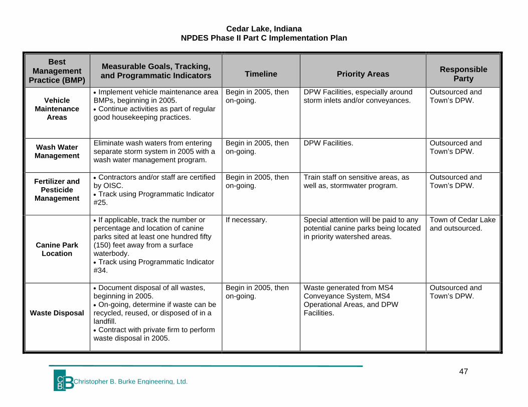
Cedar Lake, Indiana NPDES Phase II Part C Implementation Plan
47 Christopher B. Burke Engineering, Ltd.
Best Management
Practice (BMP) Measurable Goals, Tracking, and Programmatic Indicators Timeline Priority Areas Responsible
Party
Vehicle Maintenance
Areas
• Implement vehicle maintenance area BMPs, beginning in 2005. • Continue activities as part of regular good housekeeping practices.
Begin in 2005, then on-going.
DPW Facilities, especially around storm inlets and/or conveyances.
Outsourced and Town’s DPW.
Wash Water Management
Eliminate wash waters from entering separate storm system in 2005 with a wash water management program.
Begin in 2005, then on-going.
DPW Facilities. Outsourced and Town’s DPW.
Fertilizer and Pesticide
Management
• Contractors and/or staff are certified by OISC. • Track using Programmatic Indicator #25.
Begin in 2005, then on-going.
Train staff on sensitive areas, as well as, stormwater program.
Outsourced and Town’s DPW.
Canine Park Location
• If applicable, track the number or percentage and location of canine parks sited at least one hundred fifty (150) feet away from a surface waterbody. • Track using Programmatic Indicator #34.
If necessary. Special attention will be paid to any potential canine parks being located in priority watershed areas.
Town of Cedar Lake and outsourced.
Waste Disposal
• Document disposal of all wastes, beginning in 2005. • On-going, determine if waste can be recycled, reused, or disposed of in a landfill. • Contract with private firm to perform waste disposal in 2005.
Begin in 2005, then on-going.
Waste generated from MS4 Conveyance System, MS4 Operational Areas, and DPW Facilities.
Outsourced and Town’s DPW.

Cedar Lake, Indiana NPDES Phase II Part C Implementation Plan
48 Christopher B. Burke Engineering, Ltd.
Best Management
Practice (BMP) Measurable Goals, Tracking, and Programmatic Indicators Timeline Priority Areas Responsible
Party
Flood Management
Projects
• Document that all new and existing flood management projects are assessed for incorporation of additional water quality devices or practices. • Review of existing projects completed by 2007.
On-going documentation and review in 2007.
When situation arises. Town of Cedar Lake.
Annual IDDE, Good
Housekeeping, & Pollution
Prevention Staff Training
• Develop training program by March 2006. • Train on stormwater proper including topics such as: improper disposal of waste, pollution prevention, and priority watersheds and sensitive areas. • Conduct first training course in 2006. • Conduct annual refresher training. • Track using Programmatic Indicators #2 and #3.
Training held in 2006, then annual updates.
Focus on MS4 conveyance system, MS4 operational areas, and Highway Department Facilities.
Town of Cedar Lake and outsourced.

Cedar Lake, Indiana NPDES Phase II Part C Implementation Plan
49 Christopher B. Burke Engineering, Ltd.
9.0 MS4 PROGRAM COSTS Rule 13 requires a summary of the current storm water budget, expected or actual funding sources, and a projection of the budget for each year within the five (5) year permit term. Resources used for developing and implementing the storm water program should be documents in order to demonstrate that monies, equipment, and staff are being and will be utilized for the program. The overall fiscal impact of the requirement of Rule 13 may be grouped under three categories: SWQMP Development costs, Part C Implementation costs, and “other” compliance costs. This chapter details the cost of plan implementation (Part C) and it includes the additional expense for developing the SWQMP, continuous characterization, and data reporting. In the numbers detailed below, no monetary value is placed on volunteer hours. 9.1 SWQMP DEVELOPMENT COSTS The development of the SWQMP must be completed by the end of the first year of the permit term. Tasks include completion of a Notice of Intent (NOI), and completion of Part A, Part B, and Part C (this document) of the SWQMP. NOI and Part A: The costs associated with completion of the NOI and Part A are mainly organizational and administrative. An initial list of known receiving waters was compiled. Public Notice was published in the local newspaper. Preliminary estimates of existing and expected budgets had to be included, and an Operator was identified. The estimated cost to compile the information needed for the NOI and Part A submittal was $4,000. The cost of the Public Notice and public meetings is not included in this cost as it is absorbed by Minimum Control Measure 2. Part B Baseline Characterization: Part B involved collection and assessment of existing data for the receiving waters identified in Part A. This data was then used to characterize the baseline water quality conditions in the MS4 area, identify sensitive areas, and guide the development of Part C. Existing BMPs had to be identified and their effectiveness evaluated. The tasks associated with Part B were research, analysis, and report writing. The estimated cost to complete Part B was $14,000. Development of the Part C Implementation Plan: The development of a written plan of action for achieving compliance with Rule 13 was completed by the Town of Cedar Lake. Legally binding agreements were developed between the any cooperating groups or organizations (i.e. NIRPC). Beyond that, the estimated cost for developing an Implementation Plan is $27,000 and includes fees for engineering and time and materials contributed by the Town of Cedar Lake.

Cedar Lake, Indiana NPDES Phase II Part C Implementation Plan
50 Christopher B. Burke Engineering, Ltd.
9.2 DETAILED PART C IMPLEMENTATION COSTS BY MCM OVER 2005-2008 This section details the cost of implementing the program described in this document. There are 6 MCMs within the implementation plan. Costs for each individual MCM are summarized below. Since different plan elements have different start-up timelines, costs are also broken down by permit year, January - December. All estimated costs represent the combined cost to Town of Cedar Lake. MCM #1 Public Education and Outreach: The cost to implement this MCM throughout the first 5-year permit term is estimated to be $24,000. Most of the implementation deadlines for this MCM are in the second permit year with some start-up costs incurred during the first permit year. Estimated annual costs for this MCM are $4,000 for the first year and $5,000 for the second, third, fourth, and fifth years. These costs will cover NIRPC’s fees and include tasks such as reproduction and distribution of educational brochures, web site development and maintenance, and announcements of public events. The costs include educational materials, computer hardware and software upgrades, and man-hours. MCM #2 Public Participation and Involvement: The cost to implement this MCM throughout the first 5-year permit term is included with the MCM #1 costs and NIRPC fees. These costs will cover tasks such as public involvement in plan development, promotion of Clean-Up Events, the “Report-A-Polluter” Program, and Storm Drain Marking. The costs include presentation materials for public meetings and hearings, mailings to volunteer groups and homeowner associations, production and distribution of a refrigerator magnet, dedicated phone lines and computer hardware and software upgrades for public complaints, storm drain signage materials and equipment, and man-hours. MCM #3 Illicit Discharge Detection and Elimination: The cost to implement this MCM throughout the first 5-year permit term is estimated to be $193,000. The implementation deadlines for this MCM are mainly in the second permit year, with some start-up costs beginning in the first permit year. Estimated annual costs for this MCM are $13,000 for the first year, $48,000 for the second year, $44,000 for the third, fourth, and fifth years. These costs will cover such tasks as mapping the storm sewer system and screening for pollutants, development of an illicit discharge ordinance, and collection of household hazardous wastes and lawn wastes. The costs include training for system inspectors, field equipment for system inspectors, computer hardware and software upgrades for GIS mapping, and staff hours. MCM #4 Construction Site Runoff Control: The cost to implement this MCM throughout the first 5-year permit term is estimated to be $169,000. The implementation deadlines for this MCM are mainly in the second permit year, with some preparation work beginning in the first permit year. Estimated annual costs for this MCM are $13,000 for the first year and $39,000 for the second, third, fourth, and fifth years. These costs will cover such tasks as development of an ordinance for controlling construction site runoff and an accompanying technical manual, establishment of a local stormwater permit

Cedar Lake, Indiana NPDES Phase II Part C Implementation Plan
51 Christopher B. Burke Engineering, Ltd.
procedure, and an inspection and enforcement program. The costs include training for developers, builders, contractors, plan reviewers, and site inspectors; and staff hours. MCM #5 Post-construction Stormwater Management: The cost to implement this MCM throughout the permit life is estimated to be $114,000. The implementation deadlines for this MCM are mainly in the second permit year, with some preparation work beginning in the first permit year. Estimated annual costs for this MCM are $22,000 for the first year, $23,000 for the second, third, fourth, and fifth years. These costs will cover such tasks as development of an ordinance for Post-construction stormwater quality management and an accompanying technical manual, establishment of a local stormwater permit procedure, and an inspection and enforcement program. The costs include training for developers, builders, contractors, plan reviewers, and site inspectors; and staff hours. MCM #6 Pollution Prevention and Good Housekeeping: The cost to implement this MCM throughout the first 5-year permit term is estimated to be $271,000. The implementation deadlines for this MCM are mainly in the second and third permit year. Estimated annual costs for this MCM are $15,000 for the first year, $64,000 for the second, third, fourth, and fifth years. These costs will cover such tasks as the implementation of additional MS4 Conveyance System Maintenance, Salt and Sand Management BMPs, operational BMPs, and staff training. The costs include training materials, and staff hours. 9.3 OTHER COMPLIANCE COSTS 2005 – 2008 Beyond development and implementation of the SWQMP, Rule 13 requires ongoing MS4 area characterization, monthly and annual status reports, and renewal of permit application at the end of the 5 year permit term. On-going Characterization: Rule 13 requires regulated communities to continue collecting and evaluating data on water quality throughout the permit life. The cost for this on-going characterization assumes that the Town will review any additional water quality data that becomes available from another entity. Based on the review of this data, the Town will make any appropriate adjustments to their stormwater program as necessary. The cost for this is estimated at $10,000 for each year. On-going mapping and screening are included in the cost for MCM 3 implementation. Status Reporting: Much of the data collection and data management cost of this task is absorbed by the implementation of the MCMs. The estimated cost to compile and organize the volume of data that will be generated is $5,000 for the second year, third year, fourth year, and fifth years. IDEM has provided a template for monthly and annual reports. For each annual report, some additional time and effort will be needed to evaluate the effectiveness of the plan and to determine if adjustments are needed to the BMPs and/or measurable goals. This cost is included in the estimates above.

Cedar Lake, Indiana NPDES Phase II Part C Implementation Plan
52 Christopher B. Burke Engineering, Ltd.
Permit Application Renewal: At the end of this five-year permit term, the Town will need to take a close look at what is and is not working with their plan. Additional BMPs can be added and ineffective BMPs can be dropped. It is expected that the level of effort needed to complete the evaluation of the existing program, make changes, and submit a permit renewal application to IDEM will be similar to the effort required for the original. Therefore, the estimated cost to prepare the permit renewal application is $10,000 (includes 5 years of inflation). On-going As Needed Technical Assistance: Throughout the term of the permit, the Town may require assistance in the form of professional engineering services in order to address tasks associated with NPDES Phase II compliance issues. These tasks may include, but are not limited to, BMP evaluation, MS4 conveyance mapping, plan reviews, inspections, training modules, ordinances, and coordination with IDEM. The cost for on-going technical assistance is estimated to be $10,000 for each year. 9.4 TOTAL SWQMP PROGRAM COSTS 2004 – 2008 Table 9-1 summarizes total program costs, which includes the costs for all tasks described above in Sections 9.1, 9.2, and 9.3. The total estimated cost of compliance with Rule 13 is $926,000 for the first 5-year permit term.

Cedar Lake, Indiana NPDES Phase II Part C Implementation Plan
53 Christopher B. Burke Engineering, Ltd.
Table 9-1 Total Program Costs
November
2003-Mar. 2005
Mar. 2005-Mar. 2006
Mar. 2006-Mar. 2007
Mar. 2007-Mar. 2008
Mar. 2008-Nov. 2008
Total
NOI and SWQMP Part A $4,000 N/A N/A N/A N/A $4,000SWQMP Part B $14,000 N/A N/A N/A N/A $14,000SWQMP Part C (development) $27,000 N/A N/A N/A N/A $27,000Implement MCM1 and MCM 2 $4,000 $5,000 $5,000 $5,000 $5,000 $24,000Implement MCM3 $13,000 $48,000 $44,000 $44,000 $44,000 $193,000Implement MCM4 $13,000 $39,000 $39,000 $39,000 $39,000 $169,000Implement MCM5 $22,000 $23,000 $23,000 $23,000 $23,000 $114,000Implement MCM6 $15,000 $64,000 $64,000 $64,000 $64,000 $271,000On-going Characterization N/A $10,000 $10,000 $10,000 $10,000 $40,000Annual Report N/A $5,000 $5,000 $5,000 $5,000 $20,000Permit Renewal N/A N/A N/A N/A $10,000 $10,000On-going Technical Assistance N/A $10,000 $10,000 $10,000 $10,000 $40,000Total $112,000 $204,000 $200,000 $200,000 $210,000 $926,000 9.5 BUDGETARY NEEDS The total estimated costs provided above are gross costs. Some of the costs are already covered by existing budgets or passed on to the permit applicants/development communities. If these costs/resources are taken into account, the additional amount needed to achieve compliance with Rule 13 would reduce to approximately $275,000. The estimated net annual costs breakdown is $13,000 for the first year (2004), $69,000 for the second year (2005), $61,000 for the third year (2006), $61,000 for the fourth year (2007), and $71,000 for the fifth year (2008). In order to begin implementing the requirements of Rule 13, the Town will rely on a combination of permit fees and general fund dollars.

Cedar Lake, Indiana NPDES Phase II Part C Implementation Plan
54 Christopher B. Burke Engineering, Ltd.
10.0 SUMMARY Implementation of Town of Cedar Lake’s Rule 13 required stormwater quality program will improve the overall quality of stormwater discharges entering into the Town’s separate storm sewer system. In order to successfully implement the Rule 13 program, the Town must pay attention to reporting requirements contained in the programmatic indicators, adhere to mandated time lines, and be aware of next steps beyond the Part C document. 10.1 PROGRAMMATIC INDICATORS As a visual aid to Town of Cedar Lake and to help evaluate Rule 13 permit compliance, Table 10-1 lists the programmatic indicators that are required in Rule 13. The table further identifies those required and chosen BMPs that will fulfill these required programmatic indicators.

Cedar Lake, Indiana NPDES Phase II Part C Implementation Plan
55 Christopher B. Burke Engineering, Ltd.
Table 10-1 Programmatic Indicators
Programmatic
Indicator Description BMP addressing Programmatic
Indicator
1 Number or percentage of citizens, segregated by type of constituent that have an awareness of storm water quality issues.
Stormwater Survey
2
Number and description of meetings, training sessions, and events conducted to involve citizen constituents in the storm water program.
• NIRPC Joint Stormwater MS4 Program Meetings • Community Involvement Meetings • Clean Up Events • Rule 13 Public Participation Lists • Public Meetings • Training for Construction Professionals • Staff Training (for construction and post-construction) • Storm Drain Marking • Annual IDDE, Good Housekeeping, & Pollution Prevention Staff Training • “Report-A-Polluter” Program
3
Number or percentage of citizen constituents that participate in storm water quality improvement programs.
• NIRPC Joint Stormwater MS4 Program Meetings • Clean Up Events • Rule 13 Public Participation Lists • Public Meetings • Training for Construction Professionals • Staff Training (for construction and post-construction) • Storm Drain Marking • Annual IDDE, Good Housekeeping, & Pollution Prevention Staff Training • “Report-A-Polluter” Program
4 Number and location of storm drains marked or cast, segregated by marking method.
• Storm Drain Marking • Storm Drain Castings
5 Estimated or actual linear feet or percentage of MS4 mapped and indicated on an MS4 area map.
Stormwater System Map
6 Number and location of MS4 area outfalls mapped.
Stormwater System Map
7 Number and location of MS4 area outfalls screened for illicit discharges.
Illicit Discharge Detection and Elimination Plan

Cedar Lake, Indiana NPDES Phase II Part C Implementation Plan
56 Christopher B. Burke Engineering, Ltd.
Programmatic Indicator
Description BMP addressing Programmatic Indicator
8 Number and location of illicit discharges detected.
Illicit Discharge Detection and Elimination Plan
9 Number and location of illicit discharges eliminated.
Illicit Discharge Detection and Elimination Plan
10 Number of and estimated or actual amount of material, segregated by type, collected from HHW collections in the MS4 area.
Solid Waste Management District Promotions
11 Number and location of constituent drop-off centers for automotive fluid recycling.
Solid Waste Management District Promotions
12 Number or percentage of constituents that participate in the HHW collections.
Solid Waste Management District Promotions
13
Number of construction sites obtaining an MS4 entity-issued storm water run-off permit in the MS4 area.
• Erosion and Sediment Control and Post-construction BMP Tracking Database • Erosion and Sediment Control Ordinance • Post-construction Control Ordinance
14 Number of construction sites inspected. Erosion and Sediment Control and
Post-construction BMP Tracking Database
15
Number and type of enforcement actions taken against construction site operators.
• Erosion and Sediment Control and Post-construction BMP Tracking Database • Procedures for Prioritizing Construction Program Activities
16 Number of, and associated construction site name and location for, public informational requests received.
Erosion and Sediment Control and Post-construction BMP Tracking Database
17 Number, type, and location of structural BMPs installed.
Erosion and Sediment Control and Post-construction BMP Tracking Database
18 Number, type, and location of structural BMPs inspected.
Erosion and Sediment Control and Post-construction BMP Tracking Database
19 Number, type, and location of structural BMPs maintained or improved to function properly.
Post-construction BMP Operation and Maintenance Plan
20 Type and location of nonstructural BMPs utilized.
Erosion and Sediment Control and Post-construction BMP Tracking Database
21 Estimated or actual acreage or square footage of open space preserved and mapped
Erosion and Sediment Control and Post-construction BMP Tracking

Cedar Lake, Indiana NPDES Phase II Part C Implementation Plan
57 Christopher B. Burke Engineering, Ltd.
Programmatic Indicator
Description BMP addressing Programmatic Indicator
in the MS4 area, if applicable. Database
22 Estimated or actual acreage or square footage of pervious and impervious surfaces mapped in the MS4 area, if applicable.
Not Applicable; Town not set up to track
23
Number and location of new retail gasoline outlets or municipal, state, federal, or institutional refueling areas, or outlets or refueling areas that replaced existing tank systems that have installed storm water BMPs.
Not Applicable; Town not set up to track
24 Number and location of MS4 entity facilities that have containment for accidental releases of stored polluting materials.
Spill Prevention and Clean Up
25
Estimated or actual acreage or square footage, amount, and location where pesticides and fertilizers are applied by a regulated MS4 entity to places where storm water can be exposed within the MS4 area.
Fertilizer and Pesticide Management
26
Estimated or actual linear feet or percentage and location of unvegetated swales and ditches that have an appropriately-sized vegetated filter strip.
MS4 Conveyance System Maintenance
27 Estimated or actual linear feet or percentage and location of MS4 conveyances cleaned or repaired.
MS4 Conveyance System Maintenance
28 Estimated or actual linear feet or percentage and location of roadside shoulders and ditches stabilized, if applicable.
MS4 Conveyance System Maintenance
29 Number and location of storm water outfall areas remediated from scouring conditions, if applicable.
MS4 Conveyance System Maintenance
30 Number and location of deicing salt and sand storage areas covered or otherwise improved to minimize storm water exposure.
Sand and Sand Management
31 Estimated or actual amount, in tons, of salt and sand used for snow and ice control.
Salt and Sand Management
32 Estimated or actual amount of material by weight collected from catch basin, trash rack, or other structural BMP cleaning.
• MS4 Conveyance System Maintenance • Waste Disposal
33
Estimated or actual amount of material by weight collected from street sweeping, if utilized.
Street Sweeping Program

Cedar Lake, Indiana NPDES Phase II Part C Implementation Plan
58 Christopher B. Burke Engineering, Ltd.
Programmatic Indicator
Description BMP addressing Programmatic Indicator
34
If applicable, number or percentage and location of canine parks sited at least one hundred fifty (150) feet away from a surface waterbody.
Canine Park Location

Cedar Lake, Indiana NPDES Phase II Part C Implementation Plan
59Christopher B. Burke Engineering, Ltd.
10.2 Master Timeline The following Master Time outlines all BMPs that have been and will be completed by Town of Cedar Lake during their first five year permit term. Permit Year MCM BMP
2004
1 N/A
2 NIRPC Joint Stormwater MS4 Program Meetings
3 Illicit Discharge Detection & Elimination (IDDE) Ordinance Development
4 Erosion & Sediment Control Ordinance Development
5 • Post-construction Control Ordinance Development • Post-construction BMP Operation and Maintenance Plan
2005
1
• Training for Construction Professionals • Newsletter Articles (4) • Web site • Stormwater Survey • Distribute Stormwater Educational Brochures • Solid Waste Management District Promotions • Soil & Water Conservation District Activities • Mass Media Opportunities
2
• NIRPC Joint Stormwater MS4 Program Meetings • Community Involvement Meetings • Develop Rule 13 Public Participation List • Storm Drain Marking
3
• Stormwater System Map • IDDE Plan • IDDE and Good Housekeeping & Pollution Prevention Staff
Training
4
• Plan Review, Site Inspection, and Enforcement • Staff Training • Use Erosion & Sediment Control and Post-construction BMP
Tracking Database • Develop and Implement Procedure for Prioritizing Construction
Activities • Inspection and Enforcement Documentation • QA/QC of Overall Program
5 Included with MCM #4

Cedar Lake, Indiana NPDES Phase II Part C Implementation Plan
60Christopher B. Burke Engineering, Ltd.
Permit Year MCM BMP
6
• MS4 Conveyance System Maintenance • Street Sweeping Program • Salt and Sand Management • Snow Disposal Areas • Spill Prevention and Clean Up • Vehicle Maintenance Areas • Wash Water Management • Fertilizer and Pesticide Management • Canine Park Location, if applicable • Waste Disposal • Flood Management Projects
2006
1
• Training for Construction Professionals • Newsletter Articles (4) • Web Site • Distribute Stormwater Educational Brochures • Solid Waste Management District Promotions • Soil & Water Conservation District Activities
2 • Update Rule 13 Public Participation List • Storm Drain Marking • “Report-A-Polluter” Program
3
• Stormwater System Map • IDDE Plan • IDDE and Good Housekeeping & Pollution Prevention Staff
Training
4
• Plan Review, Site Inspection, and Enforcement • Staff Training • Use Erosion & Sediment Control and Post-construction BMP
Tracking Database • Implement Procedure for Prioritizing Construction Activities • Inspection and Enforcement Documentation • QA/QC of Overall Program
5 Included with MCM #4

Cedar Lake, Indiana NPDES Phase II Part C Implementation Plan
61Christopher B. Burke Engineering, Ltd.
Permit Year MCM BMP
6
• MS4 Conveyance System Maintenance • Street Sweeping Program • Salt and Sand Management • Snow Disposal Areas • Spill Prevention and Clean Up • Vehicle Maintenance Areas • Wash Water Management • Fertilizer and Pesticide Management • Canine Park Location, if applicable • Waste Disposal • Flood Management Projects
2007
1
• Training for Construction Professionals • Newsletter Articles (4) • Web Site • Distribute Stormwater Educational Brochures • Solid Waste Management District Promotions • Soil & Water Conservation District Activities
2 • Update Rule 13 Public Participation List • Storm Drain Marking • “Report-A-Polluter” Program
3
• Stormwater System Map • IDDE Plan • IDDE and Good Housekeeping & Pollution Prevention Staff
Training
4
• Plan Review, Site Inspection, and Enforcement • Staff Training • Use Erosion & Sediment Control and Post-construction BMP
Tracking Database • Implement Procedure for Prioritizing Construction Activities • Inspection and Enforcement Documentation • QA/QC of Overall Program
5 Included with MCM #4

Cedar Lake, Indiana NPDES Phase II Part C Implementation Plan
62Christopher B. Burke Engineering, Ltd.
Permit Year MCM BMP
6
• MS4 Conveyance System Maintenance • Street Sweeping Program • Salt and Sand Management • Snow Disposal Areas • Spill Prevention and Clean Up • Vehicle Maintenance Areas • Wash Water Management • Fertilizer and Pesticide Management • Canine Park Location, if applicable • Waste Disposal • Flood Management Projects
2008
1
• Training for Construction Professionals • Newsletter Articles (4) • Web Site • Stormwater Survey • Distribute Stormwater Educational Brochures • Solid Waste Management District Promotions • Soil & Water Conservation District Activities
2 • Update Rule 13 Public Participation List • Storm Drain Marking • “Report-A-Polluter” Program
3
• Stormwater System Map • IDDE Plan • IDDE and Good Housekeeping & Pollution Prevention Staff
Training
4
• Plan Review, Site Inspection, and Enforcement • Staff Training • Use Erosion & Sediment Control and Post-construction BMP
Tracking Database • Implement Procedure for Prioritizing Construction Activities • Inspection and Enforcement Documentation • QA/QC of Overall Program
5 Included with MCM #4

Cedar Lake, Indiana NPDES Phase II Part C Implementation Plan
63Christopher B. Burke Engineering, Ltd.
Permit Year MCM BMP
6
• MS4 Conveyance System Maintenance • Street Sweeping Program • Salt and Sand Management • Snow Disposal Areas • Spill Prevention and Clean Up • Vehicle Maintenance Areas • Wash Water Management • Fertilizer and Pesticide Management • Canine Park Location, if applicable • Waste Disposal • Flood Management Projects
10.3 Next Steps As progress is made in implementing the Town of Cedar Lake’s Storm Water Quality Management Plan, elements contained in required annual program reports, monthly construction reports, and on-going water quality characterizations will need to be tracked. Rule 13 does provide program flexibility in that if a BMP proves to be ineffective or infeasible, then the Town of Cedar Lake may change their program and incorporate a different BMP. Annual Reports Starting in March 2006, the Town of Cedar Lake must submit annual reports to IDEM on their Rule 13 permit program. In subsequent permit terms, reports must be submitted only in years two and four. Annual Reports must include: • Progress towards development, implementation, and enforcement of all MCMs,
including updated programmatic indicator data; • A summary of complaints received and follow-up investigation results related to
storm water quality issues; • Updated measurable goals; • Storm water BMPs installed or initiated; • Follow-up or additional water quality characterization information; • An updated active industrial facilities list; • Implementation problems encountered, including BMP changes due to
ineffectiveness or infeasibility; • Funding sources and expenditures; • Changes to MS4 area boundaries, including land areas added to the MS4 area via
annexation or other similar means; • Identified storm water quality improvement projects; and • Updated receiving water information.

Cedar Lake, Indiana NPDES Phase II Part C Implementation Plan
64Christopher B. Burke Engineering, Ltd.
Monthly Construction Site Activity Reports Town of Cedar Lake must submit monthly construction site project summary reports no later than the last day of the following month to IDEM. If no projects occur within a given month, a report does not need to be submitted. Reports must include those projects for which there has been a new permit application or termination notice and must contain: • A list of all construction and post-construction project site names; • Project site addresses; • Project site construction duration timeframes; and • An indication of enforcement actions undertaken. Agency Inspections To evaluate Rule 13 permit compliance, IDEM and/or IDNR staff may periodically inspect the Town of Cedar Lake and review its stormwater program. The MS4 Operator for the Town of Cedar Lake should be prepared to answer questions and provide documentation of program elements. The point of contact for such inspections will be the Town Manager’s Office. The Town Manager’s Office may call upon responsible entities identified in the BMP tables for assistance in such inspections. IDEM may request data to facilitate the identification or qualification of pollutants that may be released to the environment from an MS4 conveyance or to determine effectiveness of the MCMs. On-going Water Quality Characterization As new water quality information becomes available and updates are made to data sources that were reviewed as part of the County’s SWQMP – Part B: Baseline Water Quality Report, Cedar Lake will review that information and adjust their Rule 13 program accordingly. As water quality reports become available, the Town can review this information and compare it to their list of ranked priority watersheds. If different areas are identified as needing additional measures, then the Town will adjust its priorities for program implementation or adjust or add program elements to address newly identified concerns. Priority Watershed Activities In an effort to further investigate ranked priority watersheds identified in subsection 2.3, the Town of Cedar Lake should explore implementing Watershed Management Plans for these watersheds. The Town of Cedar Lake should first investigate whether any organized Watersheds groups exist in the priority watersheds and whether they have developed and/or have begun implementing a Watershed Management Plan. If a group does exist and has a plan developed, then the Town of Cedar Lake should be an active participant in watershed activities that overlap with the Rule 13 program goals. If no group exists, then the Town of Cedar Lake should try to develop their own Watershed Management Plan for each of the priority watersheds. IDEM 319 and 205(j) grant programs could provide funds to develop and implement Watershed Management Plans. As specific goals and pollutants of concern are specifically identified within

Cedar Lake, Indiana NPDES Phase II Part C Implementation Plan
65Christopher B. Burke Engineering, Ltd.
priority watersheds related to stormwater runoff, the Town should incorporate measures into their Rule 13 program to address these issues. Rule 13 Permit Renewal Permit renewal applications are due at least sixty days prior to the expiration date for the Rule 13 permit. The Town of Cedar Lake’s renewal will be due on November 5, 2008. Permit coverage under the renewal NOI will begin on the date of expiration from the previous five year permit term. IDEM may reissue permits on a watershed basis, which may change these dates. Subsequent permits will require the Town of Cedar Lake to maintain and, where possible, improve their performance in implementing the six MCMs.

Cedar Lake, Indiana NPDES Phase II Part C Implementation Plan
66Christopher B. Burke Engineering, Ltd.
Appendix A REFERENCES Christopher B. Burke Engineering, Ltd. NPDES Phase II General Permit Application,
Storm Water Quality Management Plan, Part B: Baseline Characterization Report, Town of Cedar Lake, Indiana. May 2004.
Indiana Department of Environmental Management. 327 IAC 15-13 Final Rule. August
2003. Indiana Department of Environmental Management. Rule 13 Guidance Document.
May 2003. U.S. EPA – Office of Water. Storm Water Phase II Compliance Assistance Guide.
March 2000. U.S. EPA – Office of Water, Storm Water Phase II Final Rule. January 2000. .

Cedar Lake, Indiana NPDES Phase II Part C Implementation Plan
67Christopher B. Burke Engineering, Ltd.
Appendix B GLOSSARY OF TERMS Although all of the acronyms and definitions listed below may have not been used in this document, the additional terminology is provided to assist the user of the document in understanding technical terminology associated with IDEM Rule 13 and NPDES Phase II regulations. ACRONYMS Ag Agriculture ASTM American Society for Testing and Materials BMPs Best Management Practices CBBEL Christopher B. Burke Engineering, Ltd. CLEA Cedar Lake Enhancement Association COE United States Army Corps of Engineers CSMP Comprehensive Stormwater Management Program CSO Combined Sewer Overflow CWA Clean Water Act DPW Department of Public Works EPA Environmental Protection Agency FCA Fish Consumption Advisory FEMA Federal Emergency Management Agency GIS Geographical Information System GPS Global Positioning System HHW Household Hazardous Waste HUC Hydrologic Unit Code IDDE Illicit Discharge Detection and Elimination IDEM Indiana Department of Environmental Management

Cedar Lake, Indiana NPDES Phase II Part C Implementation Plan
68Christopher B. Burke Engineering, Ltd.
IDNR Indiana Department of Natural Resources INDOT Indiana Department of Transportation. MCMs Minimum Control Measures MOU Memorandum of Understanding MS4 Municipal Separate Storm Sewers NIRPC Northwestern Indiana Regional Planning Commission NOD Notice of Deficiency NOI Notice of Intent NPDES National Pollution Discharge Elimination System NPS Non-point source NRCS USDA-Natural Resources Conservation Service OISC Office of the Indiana State Chemist O&M Operational and Maintenance PCB(s) Polychlorinated Biphenyls POTW Publicly Owned Treatment Works PSAs Public Service Announcements QA/QC Quality Assurance/Quality Control Qwq Water Quality Discharge SRCER Stream Reach Characterization Evaluation Report SWCD Soil and Water Conservation District SWMD Solid Waste Management District SWQ Stormwater Quality SWQMP Storm Water Quality Management Plan

Cedar Lake, Indiana NPDES Phase II Part C Implementation Plan
69Christopher B. Burke Engineering, Ltd.
TMDL Total Maximum Daily Load TSS Total Suspended Solids WQv Water Quality Volume DEFINITIONS Backwater. The rise in water surface elevation caused by some obstruction such as a narrow bridge opening, buildings or fill material that limits the area through which the water shall flow. Base Flood. See "Regulatory Flood". Base Flood Elevation (BFE). The water surface elevation corresponding to a flood having a one percent probability of being equaled or exceeded in a given year. Base Flow. Stream discharge derived from groundwater sources as differentiated from surface runoff. Sometimes considered to include flows from regulated lakes or reservoirs. Benchmark. A marked point of known elevation from which other elevations may be established. Best Management Practices. Design, construction, and maintenance practices and criteria for stormwater facilities that minimize the impact of stormwater runoff rates and volumes, prevent erosion, and capture pollutants. Buffer Strip. An existing, variable width strip of vegetated land intended to protect water quality and habitat. Capatown of a Storm Drainage Facility. The maximum flow that can be conveyed or stored by a storm drainage facility without causing damage to public or private property. Catch Basin. A chamber usually built at the curb line of a street for the admission of surface water to a storm sewer or subdrain, having at its base a sediment sump designed to retain grit and detritus below the point of overflow. Channel. A portion of a natural or artificial watercourse which periodically or continuously contains moving water, or which forms a connecting link between two bodies of water. It has a defined bed and banks which serve to confine the water. Channel Improvement. Alteration, maintenance, or reconstruction of the channel area for the purpose of improving the channel capatown or overall drainage efficiency. The

Cedar Lake, Indiana NPDES Phase II Part C Implementation Plan
70Christopher B. Burke Engineering, Ltd.
noted "improvement" does not necessarily imply water quality or habitat improvement within the channel or its adjacent area. Channel Stabilization. Protecting the sides and bed of a channel from erosion by controlling flow velocities and flow directions using jetties, drops, or other structures and/or by fining the channel with vegetation, riprap, concrete, or other suitable lining material. Combined Sewer Overflow. A system designed so that during dry periods the wastewater is carried to a treatment facility. During storm events, the excess water is discharged directly into a river, stream, or lake without treatment. Compost. Organic residue (or a mixture of organic residue and soil) that has undergone biological decomposition until it has become relatively stable humus. Comprehensive Stormwater Management Program. A comprehensive stormwater program for effective management of stormwater quantity and quality throughout the community. Constructed Wetland. A manmade shallow pool that creates growing conditions suitable for wetland vegetation and is designed to maximize pollutant removal. Contour. An imaginary line on the surface of the earth connecting points of the same elevation. Contour Line. Line on a map which represents a contour or points of equal elevation. Control Structure. A structure designed to control the rate of flow that passes through the structure, given a specific upstream and downstream water surface elevation. Conveyance. Any structural method for transferring stormwater between at least two points. Cross-Section. A graph or plot of ground elevation across a stream valley or a portion of it, usually along a line perpendicular to the stream or direction of flow. Culvert. A closed conduit used for the conveyance of surface drainage water under a roadway, railroad, canal or other impediment. Dam. A barrier to confine or impound water for storage or diversion, to prevent gully erosion, or to retain soil, sediment, or other debris. Design Storm. A selected storm event, described in terms of the probability of occurring once within a given number of years, for which drainage or flood control improvements are designed and built.

Cedar Lake, Indiana NPDES Phase II Part C Implementation Plan
71Christopher B. Burke Engineering, Ltd.
Detention. Managing stormwater runoff by temporary holding and controlled release. Detention Storage. The temporary detaining of storage of stormwater in storage facilities, on rooftops, in streets, parking lots, school yards, parks, open spaces or other areas under predetermined and controlled conditions, with the rate of release regulated by appropriately installed devices. Detention Time. The theoretical time required to displace the contents of a tank or unit at a given rate of discharge (volume divided by rate of discharge). Discharge. Usually the rate of water flow. A volume of fluid passing a point per unit time commonly expressed as cubic feet per second, cubic meters per second, gallons per minute, or millions of gallons per day. Ditch. A man-made, open drainageway in or into which excess surface water or groundwater drained from land, stormwater runoff, or floodwaters flow either continuously or intermittently. Drain. A buried slotted or perforated pipe or other conduit (subsurface drain) or a ditch (open drain) for carrying off surplus groundwater or surface water. Drainage. The removal of excess surface water or groundwater from land by means of ditches or subsurface drains. Also see Natural drainage. Drainage (soil). As a natural condition of the soil, drainage refers to both the frequency and duration of periods when the soil is free of saturation. Soil drainage conditions are defined as:
• Well-drained--Excess water drains away rapidly, and no mottling occurs within 36 in. of the surface.
• Moderately well drained--Water is removed from the soil somewhat slowly
resulting in small but significant periods of wetness, and mottling occurs between 18 and 36 in.
• Somewhat poorly drained--Water is removed from the soil slowly enough to
keep it wet for significant periods but not all of the time, and mottling occurs between 8 to 18 in.
• Poorly drained--Water is removed so slowly that it is wet for a large part of the
time, and mottling occurs between 0 and 8 in.
• Very poorly drained--Water is removed so slowly that the water table remains at or near the surface for the greater part of the time; there may also be periods of surface ponding; the soil has a black to gray surface layer with mottles up to the surface.

Cedar Lake, Indiana NPDES Phase II Part C Implementation Plan
72Christopher B. Burke Engineering, Ltd.
Drainage Area. The area draining into a stream at a given point. It may be of different sizes for surface runoff, subsurface flow and base flow, but generally the surface runoff area is considered as the drainage area. Dry Well. A type of infiltration practice that allows stormwater runoff to flow directly into the ground via a bored or other excavated opening in the ground surface. Duration. The time period of a rainfall event. Earth Embankment. A man-made deposit of soil, rock, or other material often used to form an impoundment. Emergency Spillway. Usually a vegetated earth channel used to safely convey flood discharges around an impoundment structure. Environment. The sum total of all the external conditions that may act upon a living organism or community to influence its development or existence. Erosion. The wearing away of the land surface by water, wind, ice, gravity, or other geological agents. The following terms are used to describe different types of water erosion:
• Accelerated erosion--Erosion much more rapid than normal or geologic erosion, primarily as a result of the activities of man.
• Channel erosion --An erosion process whereby the volume and velotown of
flow wears away the bed and/or banks of a well-defined channel.
• Gully erosion --An erosion process whereby runoff water accumulates in narrow channels and, over relatively short periods, removes the soil to considerable depths, ranging from 1-2 ft. to as much as 75-100 ft.
• Rill erosion--An erosion process in which numerous small channels only
several inches deep are formed; occurs mainly on recently disturbed and exposed soils (see Rill).
• Splash erosion--The spattering of small soil particles caused by the impact of
raindrops on wet soils; the loosened and spattered particles may or may not be subsequently removed by surface runoff.
• Sheet erosion--The gradual removal of a fairly uniform layer of soil from the
land surface by runoff water. Filter Strip. Usually a long, relatively narrow area (usually, 20-75 feet wide) of undisturbed or planted vegetation used to retard or collect sediment for the protection of watercourses, reservoirs, or adjacent properties. See also Classified Filter Strip.

Cedar Lake, Indiana NPDES Phase II Part C Implementation Plan
73Christopher B. Burke Engineering, Ltd.
Floatable. Any solid waste that will float on the surface of the water. Flood or Flood Waters. A general and temporary condition of partial or complete inundation of normally dry land areas from the overflow, the unusual and rapid accumulation, or the runoff of surface waters from any source. Flood Frequency. A statistical expression of the average time period between floods equaling or exceeding a given magnitude. For example, a 100-year flood has a magnitude expected to be equaled or exceeded on the average of once every hundred years; such a flood has a one-percent chance of being equaled or exceeded in any given year. Often used interchangeably with "recurrence interval". Floodplain. The channel proper and the areas adjoining the channel which have been or hereafter may be covered by the regulatory or 100-year flood. Any normally dry land area that is susceptible to being inundated by water from any natural source. The floodplain includes both the floodway and the floodway fringe districts. Floodway. The channel of a river or stream and those portions of the flood plains adjoining the channel which are reasonably required to efficiently carry and discharge the peak flow of the regulatory flood of any river or stream. French Drain. A drainage trench backfilled with a coarse, water-transmitting material; may contain a perforated pipe. Geographical Information System. A computer system capable of assembling, storing, manipulation, and displaying geographically referenced information. This technology can be used for resource management and development planning. Geotextile Fabric. A woven or non-woven, water-permeable synthetic material used to trap sediment particles, prevent the clogging of aggregates with fine grained soil particles, or as a separator under road aggregate.. Geotextile Liner. A synthetic, impermeable fabric used to seal impoundments against leaks. Global Positioning System. A system that provides specially coded satellite signals that is processed by a receiver, which determines position, velotown, and time. The system is funded and controlled by the U.S. Department of Defense. Grade. (1) The slope of a road, a channel, or natural ground. (2) The finished surface of a canal bed, roadbed, top of embankment, or bottom of excavation; any surface prepared to a design elevation for the support of construction, such as paving or the laying of a conduit. (3) To finish the surface of a canal bed, roadbed, top of embankment, or bottom of excavation, or other land area to a smooth, even condition.

Cedar Lake, Indiana NPDES Phase II Part C Implementation Plan
74Christopher B. Burke Engineering, Ltd.
Grass. A member of the botanical family Graminae, characterized by blade-like leaves that originate as a sheath wrapped around the stem. Grassed Waterway. A natural or constructed waterway, usually broad and shallow, covered with erosion-resistant grasses and used to safely conduct surface water from an area. Ground Cover (horticulture). Low-growing, spreading plants useful for low-maintenance landscape areas. Ground Water. Accumulation of underground water, natural or artificial. Habitat. The environment in which ,he life needs of a plant or animal are supplied. Household Hazardous Waste. Solid waste generated by households that is ignitable, toxic, reactive, corrosive, or otherwise poses a threat to human health or the environment. Hydrologic Unit Code. A numeric United States Geologic Survey code that corresponds to a watershed area. Hydrology. The science of the behavior of water in the atmosphere, on the surface of the earth, and underground. A typical hydrologic study is undertaken to compute flowrates associated with specified flood events. Illicit Discharge. Any discharge to an MS4 conveyance that is not composed entirely of stormwater. Impervious. Not allowing infiltration. INDOT. Indiana Department of Transportation. Generally used here to refer to specifications contained in the publication "INDOT Standard Specifications." Infiltration. Passage or movement of water into the soil. Invert. The inside bottom of a culvert or other conduit. Land Surveyor. A person licensed under the laws of the State of Indiana to practice land surveying. Minimum Control Measure (MCM). Minimum measures required by the NPDES Phase II program. The six (6) MCMs are: Public education and outreach, Public participation and involvement, Illicit discharge detection and elimination, Construction site runoff control, Post-construction runoff control, and Pollution prevention and good housekeeping.

Cedar Lake, Indiana NPDES Phase II Part C Implementation Plan
75Christopher B. Burke Engineering, Ltd.
Mulch. A natural or artificial layer of plant residue or other materials covering the land surface which conserves moisture, holds soil in place, aids in establishing plant cover, and minimizes temperature fluctuations. MS4 Operator. The person responsible for development, implementation, or enforcement of the MCMs for a designated MS4 area. Municipal Separate Storm Sewers. An MS4: (1) is a conveyance or system of conveyances owned by the state, Town, town, town, or other public entity; (2) discharges to waters of the U.S.; (3) is designed or used for collecting or conveying stormwater; (4) is not a combined sewer; and, (5) is not part of a Publicly Owned Treatment Works (POTW’s). Mutual Drain. A drain that: (1) Is located on two or more tracts of land that are under different ownership; (2) Was established by the mutual consent of all the owners; and (3) Was not established under or made subject to any drainage statute. National Geodetic Vertical Datum of 1929 (NGVD 1929). The nationwide, Federal Elevation datum used to reference topographic elevations to a known value. National Pollution Discharge Elimination System. A permit developed by the U.S. EPA through the Clean Water Act. In Indiana, the permitting process has been delegated to IDEM. This permit covers aspects of municipal stormwater quality. Natural Drainage. The flow patterns of stormwater run-off over the land in its pre-development state. Nonpoint Source Pollution. Pollution that enters a water body from diffuse origins on the watershed and does not result from discernable, confined, or discrete conveyances. Normal Depth. Depth of flow in an open conduit during uniform flow for the given conditions. Nutrient(s). (1) A substance necessary for the growth and reproduction of organisms. (2) In water, those substances (chiefly nitrates and phosphates) that promote growth of algae and bacteria. Open Drain. A natural watercourse or constructed open channel that conveys drainage water. Open Space. Any land area devoid of any disturbed or impervious surfaces created by industrial, commercial, residential, agricultural, or other manmade activities. Outfall. The point, location, or structure where wastewater or drainage discharges from a pipe or open drain to a receiving body of water.

Cedar Lake, Indiana NPDES Phase II Part C Implementation Plan
76Christopher B. Burke Engineering, Ltd.
Outlet. The point of water disposal from a stream, river, lake, tidewater, or artificial drain. Peak Discharge. The maximum instantaneous flow from a given storm condition at a specific location. Percolation. The movement of water through soil. Perennial Stream. A stream that maintains water in its channel throughout the year. Permeability (soil). The quality of a soil that enables water or air to move through it. Usually expressed in 'inches per hour or inches per day. Pervious. Allowing movement of water. Pesticides. Chemical compounds used for the control of undesirable plants, animals, or insects. The term includes insecticides, herbicides, algicides, rodenticides, nematicides, fungicides, and growth regulators. pH. A numerical measure of hydrogen ion activity, the neutral point being 7.0. All pH values below 7.0 are acid, and all above 7.0 are alkaline. Phosphorus (available). Inorganic phosphorus that is readily available for plant growth. Piping. The formation of "pipes" by underground erosion. Water in the soil carries the fine soil particles away, and a series of eroded tubes or tunnels develop. These openings will grow progressively larger and can cause a dam failure. Point Source. Any discernible, confined, and discrete conveyance including but not limited to any pipe, ditch, channel, tunnel, conduit, well, discrete fissure, container, rolling stock, concentrated animal feeding operation, or vessel or other floating craft, from which pollutants are or maybe discharged (P.L. 92-500, Section 502[14]). Porosity. The volume of pore space in soil or rock. Private Drain. A drain that: (1) Is located on land owned by one person or by two or more persons jointly; and (2) was not established under or made subject to any drainage statute. Professional Engineer. A person licensed under the laws of the State of Indiana to practice professional engineering. Programmatic Indicator. Any data collected by an MS4 entity that is used to indicate implementation of one (1) or more minimum control measures.

Cedar Lake, Indiana NPDES Phase II Part C Implementation Plan
77Christopher B. Burke Engineering, Ltd.
Publically Owned Treatment Works. A municiple operation that breaks down and removes contaminants in the wastewater prior to discharging to a stream through primary and/or secondary treatment systems. Rainfall Intensity. The rate at which rain is falling at any given instant, usually expressed in inches per hour. Receiving Stream. The body of water into which runoff or effluent is discharged. Recharge. Replenishment of groundwater reservoirs by infiltration and transmission from the outcrop of an aquifer or from permeable soils. Recurrence Interval. A statistical expression of the average time between floods equaling or exceeding a given magnitude. Redevelopment. Alterations of a property that change a site or building in such a way that there is disturbances of one (1) acre or more of land. Regulated Drain. A drain, either open channel or closed tile/sewer, subject to the provisions of the Indiana Drainage Code, I.C.-36-9-27. Regulatory Flood. The discharge or elevation associated with the 100-year flood as calculated by a method and procedure which is acceptable to and approved by the Indiana Department of Natural Resources and the Federal Emergency Management Agency. The "regulatory flood" is also known as the "base flood". Reservoir. A natural or artificially created pond, lake or other space used for storage, regulation or control of water. May be either permanent or temporary. The term is also used in the hydrologic modeling of storage facilities. Retention. The storage of stormwater to prevent it from leaving the development site. May be temporary or permanent. Revetment. Facing of stone or other material, either permanent or temporary, placed along the edge of a stream to stabilize the bank and protect it from the erosive action of the stream. Also see Revetment riprap. Riparian. Of, on, or pertaining to the banks of a stream, river, or pond. Riprap. Broken rock, cobble, or boulders placed on earth surfaces, such as the face of a dam or the bank of a stream, for protection against the action of water (waves). Revetment riprap is material graded such that: (1) no individual piece weighs more than 120 lbs. and (2) 90-100% will pass through a 12-inch sieve, 20-60% through a 6-inch sieve, and not more than 10% through a 12-inch sieve. Riverine. Relating to, formed by, or resembling a stream (including creeks and rivers).

Cedar Lake, Indiana NPDES Phase II Part C Implementation Plan
78Christopher B. Burke Engineering, Ltd.
River Restoration. Restoring the channel of a stream or ditch to its perceived original, non-obstructed capatown by means of clearing & snagging, obstruction removal, and inexpensive streambank protection measures. The term "restoration", as noted, does not necessarily imply restoration or improvement of water quality or habitat within the channel or its adjacent area. Runoff. That portion of precipitation that flows from a drainage area on the land surface, in open channels, or in stormwater conveyance systems. Sand. (1) Soil particles between 0.05 and 2.0 mm in diameter. (2) A soil textural class inclusive of all soils that are at least 70% sand and 15% or less clay. Sediment. Solid material (both mineral and organic) that is in suspension, is being transported, or has been moved from its site of origin by air, water, gravity, or ice and has come to rest on the earth's surface. Sedimentation. The process that deposits soils, debris and other materials either on the ground surfaces or in bodies of water or watercourses. Sensitive Water. A water body in need of protection or remediation base on its: providing habitat for threatened or endangered species, usage as a public water supply intake, relevant community value, or exception use classification Settling Basin. An enlargement in the channel of a stream to permit the settling of debris carried in suspension. Silt. (1) Soil fraction consisting of particles between 0.002 and 0.05 mm in diameter. (2) A soil textural class indicating more than 80% silt. Silt Fence. A fence constructed of wood or steel supports and either natural (e.g. burlap) or synthetic fabric stretched across area of non-concentrated flow during site development to trap and retain on-site sediment due to rainfall runoff. Single Family Rate. A user fee that is a revenue source generated from people who use or benefit from stormwater management services. Slope. Degree of deviation of a surface from the horizontal, measured as a numerical ratio or percent. Expressed as a ratio, the first number is commonly the horizontal distance (run) and the second is the vertical distance (rise)--e.g., 2:1. However, the preferred method for designation of slopes is to clearly identify the horizontal (H) and vertical (V) components (length (L) and Width (W) components for horizontal angles). Also note that according to international standards (Metric), the slopes are presented as the vertical or width component shown on the numerator--e.g., 1V:2H. Slope expressions in this handbook follow the common presentation of slopes--e.g., 2:1 with the metric presentation shown in parenthesis--e.g., (1V:2H). Slopes can also be

Cedar Lake, Indiana NPDES Phase II Part C Implementation Plan
79Christopher B. Burke Engineering, Ltd.
expressed in "percents". Slopes given in percents are always expressed as (100*V/H) --e.g., a 2:1 (1V:2H) slope is a 50% slope. Soil. The unconsolidated mineral and organic material on the immediate surface of the earth that serves as a natural medium for the growth of land plants. Also see alluvial soil, Clay, Cohesive soil, Loam, Permeability (soil), Sand, Silt, Soil horizon, Soil profile, Subsoil, Surface soil, Topsoil. Soil and Water Conservation District (SWCD). A public organization created under state law as a special-purpose district to develop and carry out a program of soil, water, and related resource conservation, use, and development within its boundaries. A subdivision of state government with a local governing body. Solid Waste. Any garbage, refuse, debris, or other discarded material. Special Flood Hazard Area. An area that is inundated during the 100-Year flood. Storm Duration. The length of time that water may be stored in any stormwater control facility, computed from the time water first begins to be stored. Storm Event. An estimate of the expected amount of precipitation within a given period of time. For example, a 10-yr. frequency, 24-hr. duration storm event is a storm that has a 10% probability of occurring in any one year. Precipitation is measured over a 24-hr. period. Storm Frequency. The time interval between major storms of predetermined intensity and volumes of runoff--e.g., a 5-yr., 10-yr. or 20-yr. storm. Stormwater. Water resulting from rain, melting or melted snow, hail, or sleet. Stormwater Runoff. The water derived from rains falling within a tributary basin, flowing over the surface of the ground or collected in channels or conduits. Stormwater Quality Management Plan (SWQMP). A comprehensive written document that addresses stormwater runoff quality within an MS4 area. The SWQMP is divided into three (3) submittal parts: Part A – Initial Application, Part B – Baseline Characterization and On-going Monitoring Plan, and Part C – Program Implementation. Storm Sewer. A sewer that carries stormwater, surface drainage, street wash, and other wash waters but excludes sewage and industrial wastes. Also called a storm drain. Stream. See lntermittent stream, Perennial stream, Receiving stream. Streambanks. The usual boundaries (not the flood boundaries) of a stream channel. Right and left banks are named facing downstream.

Cedar Lake, Indiana NPDES Phase II Part C Implementation Plan
80Christopher B. Burke Engineering, Ltd.
Stream Gauging. The quantitative determination of stream flow using gauges, current meters, weirs, or other measuring instruments at selected locations (see Gauging station'). Stream Length. The length of a stream or ditch, expressed in miles, from the confluence of the stream or ditch with the receiving stream to the upstream extremity of the stream or ditch, as indicated by the solid or dashed, blue or purple line depicting the stream or ditch on the most current edition of the seven and one-half (72) minute topographic quadrangle map published by the United States Geological Survey, measured along the meanders of the stream or ditch as depicted on the map. Subarea/Subbasin. Portion of a watershed divided into homogenous drainage units which can be modeled for purposes of determining runoff rates. The subareas/subbasins have distinct boundaries, as defined by the topography of the area. Subsoil. The B horizons of soils with distinct profiles. In soils with weak profile development, the subsoil can be defined as the soil below which roots do not normally grow. Subsurface Drain. A pervious backfield trench, usually containing stone and perforated pipe, for intercepting groundwater or seepage. Subwatershed. A watershed subdivision of unspecified size that forms a convenient natural unit. See also Subarea. Surface Runoff. Precipitation that flows onto the surfaces of roofs, streets, the ground, etc., and is not absorbed or retained by that surface but collects and runs off. Suspended Solids. Solids either floating or suspended in water. Swale. An elongated depression in the land surface that is at least seasonally wet, is usually heavily vegetated, and is normally without flowing water. Swales conduct stormwater into primary drainage channels and may provide some groundwater recharge. Tile Drain. Pipe made of perforated plastic, burned clay, concrete, or similar material, laid to a designed grade and depth, to collect and carry excess water from the soil. Tile Drainage. Land drainage by means of a series of tile lines laid at a specified depth, grade, and spacing. Topographic Map. Graphical portrayal of the topographic features of a land area, showing both the horizontal distances between the features and their elevations above a given datum.

Cedar Lake, Indiana NPDES Phase II Part C Implementation Plan
81Christopher B. Burke Engineering, Ltd.
Topography. The representation of a portion of the earth's surface showing natural and man-made features of a give locality such as rivers, streams, ditches, lakes, roads, buildings and most importantly, variations in ground elevations for the terrain of the area. Topsoil. (1) The dark-colored surface layer, or a horizon, of a soil; when present it ranges in depth from a fraction of an inch to 2-3 ft. (2) Equivalent to the plow layer of cultivated soils. (3) Commonly used to refer to the surface layer(s), enriched in organic matter and having textural and structural characteristics favorable for plant growth. Total Maximum Daily Load. Method used to establish allowable loadings for specified pollutants in a surface water resource to meet established water quality standards. Toxitown. The characteristic of being poisonous or harmful to plant or animal life. The relative degree or severity of this characteristic. Tributary. Based on the size of the contributing drainage area, a smaller watercourse which flows into a larger watercourse. Turbidity. (1) Cloudiness of a liquid, caused by suspended solids. (2) A measure of the suspended solids in a liquid. Underdrain. A small diameter perforated pipe that allows the bottom of a detention basin, channel or swale to drain. Unified Soil Classification System (USCS). A system of classifying soils that is based on their identification according to particle size, gradation, plastitown index, and liquid limit. Uniform Flow. A state of steady flow when the mean velotown and cross-sectional area remain constant in all sections of a reach. Urbanized Area. A land area comprising one (1) or more places that together have a residential population of at least fifty thousand (50,000) and an overall population density of at least five hundred (500) people per square mile. Vegetative Stabilization. Protection of erodible or sediment producing areas with: permanent seeding (producing long-term vegetative cover), short-term seeding (producing temporary vegetative cover), or sodding (producing areas covered with a turf of perennial sod-forming grass) . Water Body. Any accumulation of water, surface, or underground, natural or artificial. Water Quality. A term used to describe the chemical, physical, and biological characteristics of water, usually in respect to its suitability for a particular purpose.

Cedar Lake, Indiana NPDES Phase II Part C Implementation Plan
82Christopher B. Burke Engineering, Ltd.
Water Resources. The supply of groundwater and surface water in a given area. Water Table. (1) The free surface of the groundwater. (2) That surface subject to atmospheric pressure under the ground, generally rising and failing with the season or from other conditions such as water withdrawal. Watercourse. Any river, stream, creek, brook, branch, natural or man-made drainageway in or into which stormwater runoff or floodwaters flow either continuously or intermittently. Watershed. The region drained by or contributing water to a specific point that could be along a stream, lake or other stormwater facilities. Watersheds are often broken down into subareas for the purpose of hydrologic modeling. Watershed Area. All land and water within the confines of a drainage divide. See also Watershed. Weir. A channel-spanning structure for measuring or regulating the flow of water. Wetlands. Areas that are inundated or saturated by surface water or groundwater at a frequency and duration sufficient to support, and that under normal circumstances do support, a prevalence of vegetation typically adapted for life in saturated soil conditions and/or those wetland areas that are under the COE jurisdiction.

Cedar Lake, Indiana NPDES Phase II Part C Implementation Plan
83Christopher B. Burke Engineering, Ltd.
Appendix C SWQMP PART C: PROGRAM IMPLEMENTATION CERTIFICATION CHECKLIST

Cedar Lake, Indiana NPDES Phase II Part C Implementation Plan
84Christopher B. Burke Engineering, Ltd.
Appendix D CERTIFICATION OF THE INFORMATIONAL PROGRAM FOR THE PUBLIC EDUCATION AND OUTREACH MCM

Cedar Lake, Indiana NPDES Phase II Part C Implementation Plan
85Christopher B. Burke Engineering, Ltd.
Appendix E CERTIFICATION OF THE PUBLIC PARTICIPATION AND INVOLVEMENT PROGRAM FOR THE PUBLIC PARTICIPATION AND INVOLVEMENT MCM

Cedar Lake, Indiana NPDES Phase II Part C Implementation Plan
86Christopher B. Burke Engineering, Ltd.
Appendix F CERTIFICATION OF THE PLAN TO DETECT, ADDRESS AND ELIMINATE ILLICIT DISCHARGES FOR THE ILLICIT
DETECTION AND ELIMINATION MCM

Cedar Lake, Indiana NPDES Phase II Part C Implementation Plan
87Christopher B. Burke Engineering, Ltd.
Appendix G CERTIFICATION OF THE DEVELOPMENT, IMPLEMENTATION, MANAGEMENT AND ENFORCEMENT OF AN EROSION AND SEDIMENT CONTROL PROGRAM FOR THE
CONSTRUCTION SITE STORMWATER RUNOFF CONTROL MCM

Cedar Lake, Indiana NPDES Phase II Part C Implementation Plan
88Christopher B. Burke Engineering, Ltd.
Appendix H CERTIFICATION OF THE DEVELOPMENT, IMPLEMENTATION, MANAGEMENT AND ENFORCEMENT OF A POST-CONSTRUCTION STORMWATER RUNOFF CONTROL
PROGRAM FOR THE POST-CONSTRUCTION SITE STORMWATER RUNOFF CONTROL MCM

Cedar Lake, Indiana NPDES Phase II Part C Implementation Plan
89Christopher B. Burke Engineering, Ltd.
Appendix I CERTIFICATION OF THE DEVELOPMENT AND
IMPLEMENTATION OF A PROGRAM TO REDUCE POLLUTANT RUNOFF FROM MUNICIPAL OPERATIONS FOR THE MUNICIPAL
OPERATIONS POLLUTION PREVENTION AND GOOD HOUSEKEEPING MCM

Cedar Lake, Indiana NPDES Phase II Part C Implementation Plan
90Christopher B. Burke Engineering, Ltd.
Appendix J LISTING OF ACTIVE INDUSTRIAL FACILITIES

Cedar Lake, Indiana NPDES Phase II Part C Implementation Plan
91Christopher B. Burke Engineering, Ltd.
Appendix K MEMORANDUM OF UNDERSTANDING