NOTES AND CORRESPONDENCE Turbidity Currents, Submarine ...€¦ · In this study, we report that...
6
NOTES AND CORRESPONDENCE Turbidity Currents, Submarine Landslides and the 2006 Pingtung Earthquake off SW Taiwan Shu-Kun Hsu 1, * , Jackie Kuo 2 , Chung-Liang Lo 1 , Ching-Hui Tsai 1 , Wen-Bin Doo 1 , Chia-Yen Ku 1 , and Jean-Claude Sibuet 3 1 Institute of Geophysics, National Central University, Chung-Li 32001, Taiwan, ROC 2 Chung Hwa Telcom Co. Ltd., Toucheng, Yilan 261, Taiwan, ROC 3 Institute of Applied Geosciences, National Taiwan Ocean University, Keelung 202, Taiwan, ROC Received 24 July 2008, accepted 26 September 2008 ABSTRACT Submarine landslides or slumps may generate turbidity currents consisting of mixture of sediment and water. Large and fast-moving turbidity currents can incise and erode continental margins and cause damage to artificial structures such as telecommunication cables on the seafloor. In this study, we report that eleven submarine cables across the Kaoping canyon and Manila trench were broken in sequence from 1500 to 4000 m deep, as a consequence of submarine landslides and turbidity currents associated with the 2006 Pingtung earthquakes offshore SW Taiwan. We have established a full-scale scenario and calculation of the turbidity currents along the Kaoping canyon channel from the middle continental slope to the adjacent deep ocean. Our results show that turbidity current velocities vary downstream ranging from 20 to 3.7 and 5.7 m s -1 , which demonstrates a positive relationship between turbidity current velocity and bathymetric slope. The violent cable failures happened in this case evidenced the destructive power of the turbidity current to seafloor or underwater facilities that should not be underestimated. Key words: Submarine landslide, Turbidity current, Pingtung earthquake, SW Taiwan, Cable break Citation: Hsu, S. K., J. Kuo, C. L. Lo, C. H. Tsai, W. B. Doo, C. Y. Ku, and J. C. Sibuet, 2008: Turbidity currents, submarine landslides and the 2006 Pingtung earthquake off SW Taiwan. Terr. Atmos. Ocean. Sci., 19, 767-772, doi: 10.3319/TAO.2008.19.6.767(PT) 1. INTRODUCTION At least sixteen modern submarine cables used for tele- phone, internet and data transmissions in Southeast and East Asia pass through south of Taiwan within a 150-km wide E-W stripe (Fig. 1). On 26 December 2006, at 20:26 and 20:34 (local time), two almost simultaneous double-event earthquakes of the same magnitude 7.0, only kilometers apart in distance and 8 minutes apart in time, occurred off southwest Taiwan (Pingtung earthquakes marked by EQ1 and EQ2 in Fig. 1) (Liao et al. 2008). Shortly after the Pingtung earthquakes, local fishermen working in that area reported disturbed waters. Within the following 14 hours most of the cables broke at least once (stars in Fig. 1), caus- ing major failures in international telecommunication affect- ing not only Taiwan but all the Southeast and East Asia countries alike. Alternative transmission systems were im- mediately overloaded and failed to transfer data smoothly through the world. The condition of cable break points de- monstrate the violence of the mass flow carrying sediment particles and pebbles (e.g., Fig. 2). The aim of this paper is to show possible submarine landslides associated with the 2006 Pingtung earthquake; we use the telecommunication cable failure information to provide a full-scale scenario and calculation of the velocities of the turbidity currents (Kuenen and Migliorini 1950) under the assumption that those submarine telecommunication cables were broken due to the abrupt tension induced by the turbidity currents. Terr. Atmos. Ocean. Sci., Vol. 19, No. 6, 767-772, December 2008 doi: 10.3319/TAO.2008.19.6.767(PT) * Corresponding author E-mail: [email protected]
Transcript of NOTES AND CORRESPONDENCE Turbidity Currents, Submarine ...€¦ · In this study, we report that...
NOTES AND CORRESPONDENCE
Turbidity Currents, Submarine Landslides and the 2006 PingtungEarthquake off SW Taiwan
Shu-Kun Hsu1, *, Jackie Kuo 2, Chung-Liang Lo1, Ching-Hui Tsai1, Wen-Bin Doo1,
Chia-Yen Ku1, and Jean-Claude Sibuet 3
1 Institute of Geophysics, National Central University, Chung-Li 32001, Taiwan, ROC2 Chung Hwa Telcom Co. Ltd., Toucheng, Yilan 261, Taiwan, ROC
3 Institute of Applied Geosciences, National Taiwan Ocean University, Keelung 202, Taiwan, ROC
Received 24 July 2008, accepted 26 September 2008
ABSTRACT
Submarine landslides or slumps may generate turbidity currents consisting of mixture of sediment and water. Large and
fast-moving turbidity currents can incise and erode continental margins and cause damage to artificial structures such as
telecommunication cables on the seafloor. In this study, we report that eleven submarine cables across the Kaoping canyon and
Manila trench were broken in sequence from 1500 to 4000 m deep, as a consequence of submarine landslides and turbidity
currents associated with the 2006 Pingtung earthquakes offshore SW Taiwan. We have established a full-scale scenario and
calculation of the turbidity currents along the Kaoping canyon channel from the middle continental slope to the adjacent deep
ocean. Our results show that turbidity current velocities vary downstream ranging from 20 to 3.7 and 5.7 m s-1, which
demonstrates a positive relationship between turbidity current velocity and bathymetric slope. The violent cable failures
happened in this case evidenced the destructive power of the turbidity current to seafloor or underwater facilities that should
not be underestimated.
Key words: Submarine landslide, Turbidity current, Pingtung earthquake, SW Taiwan, Cable break
Citation: Hsu, S. K., J. Kuo, C. L. Lo, C. H. Tsai, W. B. Doo, C. Y. Ku, and J. C. Sibuet, 2008: Turbidity currents, submarine landslides and the 2006Pingtung earthquake off SW Taiwan. Terr. Atmos. Ocean. Sci., 19, 767-772, doi: 10.3319/TAO.2008.19.6.767(PT)
1. INTRODUCTION
At least sixteen modern submarine cables used for tele-
phone, internet and data transmissions in Southeast and East
Asia pass through south of Taiwan within a 150-km wide
E-W stripe (Fig. 1). On 26 December 2006, at 20:26 and
20:34 (local time), two almost simultaneous double-event
earthquakes of the same magnitude 7.0, only kilometers
apart in distance and 8 minutes apart in time, occurred off
southwest Taiwan (Pingtung earthquakes marked by EQ1
and EQ2 in Fig. 1) (Liao et al. 2008). Shortly after the
Pingtung earthquakes, local fishermen working in that area
reported disturbed waters. Within the following 14 hours
most of the cables broke at least once (stars in Fig. 1), caus-
ing major failures in international telecommunication affect-
ing not only Taiwan but all the Southeast and East Asia
countries alike. Alternative transmission systems were im-
mediately overloaded and failed to transfer data smoothly
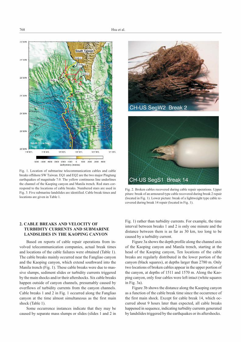
through the world. The condition of cable break points de-
monstrate the violence of the mass flow carrying sediment
particles and pebbles (e.g., Fig. 2). The aim of this paper is
to show possible submarine landslides associated with the
2006 Pingtung earthquake; we use the telecommunication
cable failure information to provide a full-scale scenario
and calculation of the velocities of the turbidity currents
(Kuenen and Migliorini 1950) under the assumption that
those submarine telecommunication cables were broken
due to the abrupt tension induced by the turbidity currents.
Terr. Atmos. Ocean. Sci., Vol. 19, No. 6, 767-772, December 2008 doi: 10.3319/TAO.2008.19.6.767(PT)
* Corresponding author
E-mail: [email protected]
2. CABLE BREAKS AND VELOCITY OF
TURBIDITY CURRENTS AND SUBMARINE
LANDSLIDES IN THE KAOPING CANYON
Based on reports of cable repair operations from in-
volved telecommunication companies, actual break times
and locations of the cable failures were obtained (Table 1).
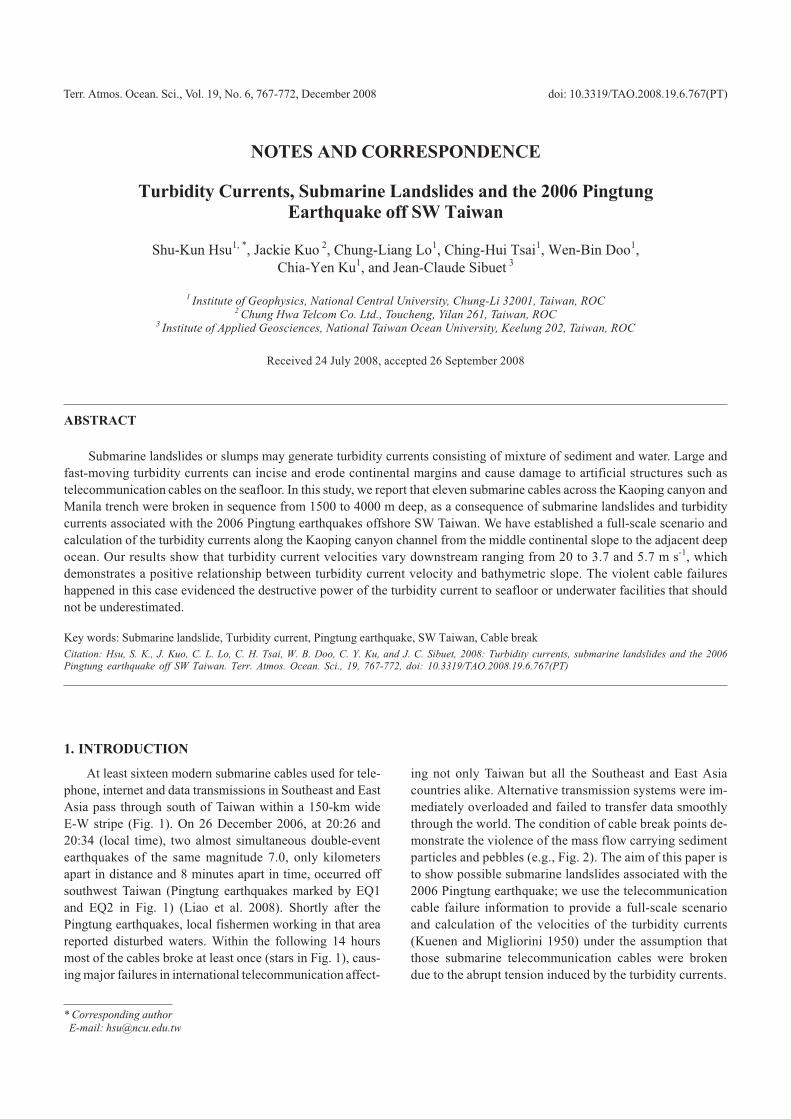
The cable breaks mainly occurred near the Fangliao canyon
and the Kaoping canyon, which extend southward into the
Manila trench (Fig. 1). These cable breaks were due to mas-
sive slumps, sediment slides or turbidity currents triggered
by the main shocks and/or their aftershocks. Six cable breaks
happen outside of canyon channels, presumably caused by
overflows of turbidity currents from the canyon channels.
Cable breaks 1 and 2 in Fig. 1 occurred along the Fangliao
canyon at the time almost simultaneous as the first main
shock (Table 1).
Some occurrence instances indicate that they may be
caused by separate mass slumps or slides (slides 1 and 2 in
Fig. 1) rather than turbidity currents. For example, the time
interval between breaks 1 and 2 is only one minute and the
distance between them is as far as 30 km, too long to be
caused by a turbidity current.
Figure 3a shows the depth profile along the channel axis
of the Kaoping canyon and Manila trench, starting at the
head of the Kaoping canyon, Ten locations of the cable
breaks are regularly distributed in the lower portion of the
canyon (black squares), at depths larger than 2780 m. Only
two locations of broken cables appear in the upper portion of
the canyon, at depths of 1511 and 1570 m. Along the Kao-
ping canyon, only four cables were left intact (white squares
in Fig. 3a).
Figure 3b shows the distance along the Kaoping canyon
as a function of the cable break time since the occurrence of
the first main shock. Except for cable break 14, which oc-
curred about 9 hours later than expected, all cable breaks
happened in sequence, indicating turbidity currents generated
by landslides triggered by the earthquakes or its aftershocks.
768 Hsu et al.
Fig. 1. Location of submarine telecommunication cables and cable
breaks offshore SW Taiwan. EQ1 and EQ2 are the two major Pingtung
earthquakes of magnitude 7.0. The yellow continuous line underlines
the channel of the Kaoping canyon and Manila trench. Red stars cor-
respond to the locations of cable breaks. Numbered stars are used in
Fig. 3. Five submarine landslides are identified. Cable break times and
locations are given in Table 1.
Fig. 2. Broken cables recovered during cable repair operations. Upper
piture: break of an armoured type cable recovered during break 2 repair
(located in Fig. 1). Lower picture: break of a lightweight type cable re-
covered during break 14 repair (located in Fig. 1).
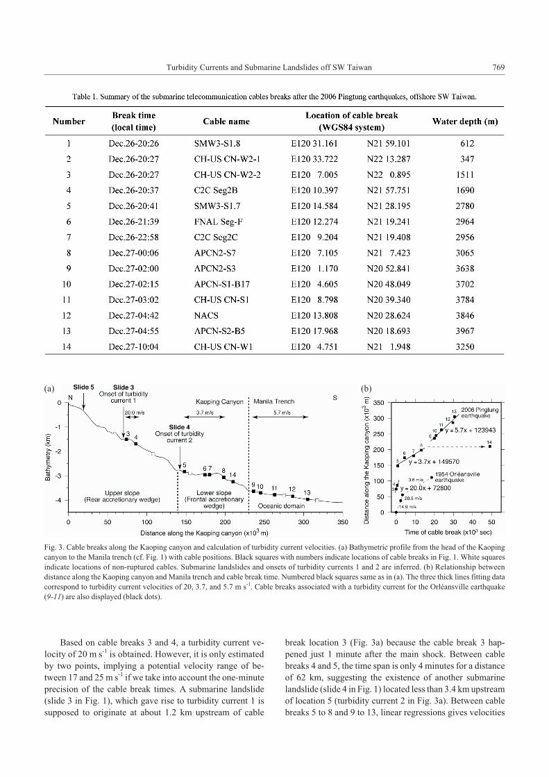
Based on cable breaks 3 and 4, a turbidity current ve-
locity of 20 m s-1 is obtained. However, it is only estimated
by two points, implying a potential velocity range of be-
tween 17 and 25 m s-1 if we take into account the one-minute
precision of the cable break times. A submarine landslide
(slide 3 in Fig. 1), which gave rise to turbidity current 1 is
supposed to originate at about 1.2 km upstream of cable
break location 3 (Fig. 3a) because the cable break 3 hap-
pened just 1 minute after the main shock. Between cable
breaks 4 and 5, the time span is only 4 minutes for a distance
of 62 km, suggesting the existence of another submarine
landslide (slide 4 in Fig. 1) located less than 3.4 km upstream
of location 5 (turbidity current 2 in Fig. 3a). Between cable
breaks 5 to 8 and 9 to 13, linear regressions gives velocities
Turbidity Currents and Submarine Landslides off SW Taiwan 769
Fig. 3. Cable breaks along the Kaoping canyon and calculation of turbidity current velocities. (a) Bathymetric profile from the head of the Kaoping
canyon to the Manila trench (cf. Fig. 1) with cable positions. Black squares with numbers indicate locations of cable breaks in Fig. 1. White squares
indicate locations of non-ruptured cables. Submarine landslides and onsets of turbidity currents 1 and 2 are inferred. (b) Relationship between
distance along the Kaoping canyon and Manila trench and cable break time. Numbered black squares same as in (a). The three thick lines fitting data
correspond to turbidity current velocities of 20, 3.7, and 5.7 m s-1. Cable breaks associated with a turbidity current for the Orléansville earthquake
(9-11) are also displayed (black dots).
(a) (b)
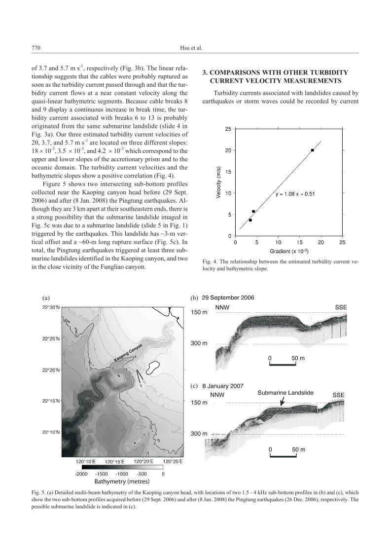
of 3.7 and 5.7 m s-1, respectively (Fig. 3b). The linear rela-
tionship suggests that the cables were probably ruptured as
soon as the turbidity current passed through and that the tur-
bidity current flows at a near constant velocity along the
quasi-linear bathymetric segments. Because cable breaks 8
and 9 display a continuous increase in break time, the tur-
bidity current associated with breaks 6 to 13 is probably
originated from the same submarine landslide (slide 4 in
Fig. 3a). Our three estimated turbidity current velocities of
20, 3.7, and 5.7 m s-1 are located on three different slopes:
18 � 10-3, 3.5 � 10-3, and 4.2 � 10-3 which correspond to the
upper and lower slopes of the accretionary prism and to the
oceanic domain. The turbidity current velocities and the
bathymetric slopes show a positive correlation (Fig. 4).
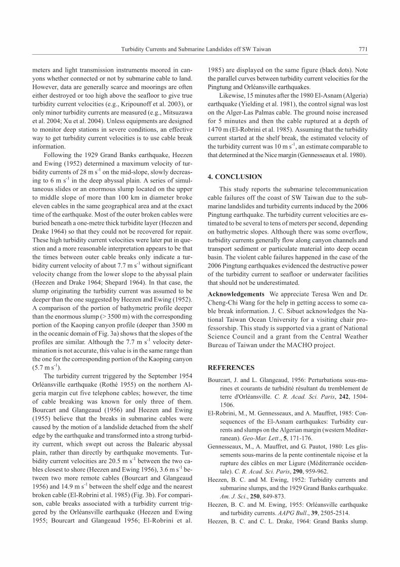
Figure 5 shows two intersecting sub-bottom profiles
collected near the Kaoping canyon head before (29 Sept.
2006) and after (8 Jan. 2008) the Pingtung earthquakes. Al-
though they are 3 km apart at their southeastern ends, there is
a strong possibility that the submarine landslide imaged in
Fig. 5c was due to a submarine landslide (slide 5 in Fig. 1)
triggered by the earthquakes. This landslide has ~3-m ver-
tical offset and a ~60-m long rupture surface (Fig. 5c). In
total, the Pingtung earthquakes triggered at least three sub-
marine landslides identified in the Kaoping canyon, and two
in the close vicinity of the Fungliao canyon.
3. COMPARISONS WITH OTHER TURBIDITY
CURRENT VELOCITY MEASUREMENTS
Turbidity currents associated with landslides caused by
earthquakes or storm waves could be recorded by current
770 Hsu et al.
Fig. 5. (a) Detailed multi-beam bathymetry of the Kaoping canyon head, with locations of two 1.5 - 4 kHz sub-bottom profiles in (b) and (c), which
show the two sub-bottom profiles acquired before (29 Sept. 2006) and after (8 Jan. 2008) the Pingtung earthquakes (26 Dec. 2006), respectively. The
possible submarine landslide is indicated in (c).
(a) (b)
(c)
Fig. 4. The relationship between the estimated turbidity current ve-
locity and bathymetric slope.
meters and light transmission instruments moored in can-
yons whether connected or not by submarine cable to land.
However, data are generally scarce and moorings are often
either destroyed or too high above the seafloor to give true
turbidity current velocities (e.g., Kripounoff et al. 2003), or
only minor turbidity currents are measured (e.g., Mitsuzawa
et al. 2004; Xu et al. 2004). Unless equipments are designed
to monitor deep stations in severe conditions, an effective
way to get turbidity current velocities is to use cable break
information.
Following the 1929 Grand Banks earthquake, Heezen
and Ewing (1952) determined a maximum velocity of tur-
bidity currents of 28 m s-1 on the mid-slope, slowly decreas-
ing to 6 m s-1 in the deep abyssal plain. A series of simul-
taneous slides or an enormous slump located on the upper
to middle slope of more than 100 km in diameter broke
eleven cables in the same geographical area and at the exact
time of the earthquake. Most of the outer broken cables were
buried beneath a one-metre thick turbidite layer (Heezen and
Drake 1964) so that they could not be recovered for repair.
These high turbidity current velocities were later put in que-
stion and a more reasonable interpretation appears to be that
the times between outer cable breaks only indicate a tur-
bidity current velocity of about 7.7 m s-1 without significant
velocity change from the lower slope to the abyssal plain
(Heezen and Drake 1964; Shepard 1964). In that case, the
slump originating the turbidity current was assumed to be
deeper than the one suggested by Heezen and Ewing (1952).
A comparison of the portion of bathymetric profile deeper
than the enormous slump (> 3500 m) with the corresponding
portion of the Kaoping canyon profile (deeper than 3500 m
in the oceanic domain of Fig. 3a) shows that the slopes of the
profiles are similar. Although the 7.7 m s-1 velocity deter-
mination is not accurate, this value is in the same range than
the one for the corresponding portion of the Kaoping canyon
(5.7 m s-1).
The turbidity current triggered by the September 1954
Orléansville earthquake (Rothé 1955) on the northern Al-
geria margin cut five telephone cables; however, the time
of cable breaking was known for only three of them.
Bourcart and Glangeaud (1956) and Heezen and Ewing
(1955) believe that the breaks in submarine cables were
caused by the motion of a landslide detached from the shelf
edge by the earthquake and transformed into a strong turbid-
ity current, which swept out across the Balearic abyssal
plain, rather than directly by earthquake movements. Tur-
bidity current velocities are 20.5 m s-1 between the two ca-
bles closest to shore (Heezen and Ewing 1956), 3.6 m s-1 be-
tween two more remote cables (Bourcart and Glangeaud
1956) and 14.9 m s-1 between the shelf edge and the nearest
broken cable (El-Robrini et al. 1985) (Fig. 3b). For compari-
son, cable breaks associated with a turbidity current trig-
gered by the Orléansville earthquake (Heezen and Ewing
1955; Bourcart and Glangeaud 1956; El-Robrini et al.
1985) are displayed on the same figure (black dots). Note
the parallel curves between turbidity current velocities for the
Pingtung and Orléansville earthquakes.
Likewise, 15 minutes after the 1980 El-Asnam (Algeria)
earthquake (Yielding et al. 1981), the control signal was lost
on the Alger-Las Palmas cable. The ground noise increased
for 5 minutes and then the cable ruptured at a depth of
1470 m (El-Robrini et al. 1985). Assuming that the turbidity
current started at the shelf break, the estimated velocity of
the turbidity current was 10 m s-1, an estimate comparable to
that determined at the Nice margin (Gennesseaux et al. 1980).
4. CONCLUSION
This study reports the submarine telecommunication
cable failures off the coast of SW Taiwan due to the sub-
marine landslides and turbidity currents induced by the 2006
Pingtung earthquake. The turbidity current velocities are es-
timated to be several to tens of meters per second, depending
on bathymetric slopes. Although there was some overflow,
turbidity currents generally flow along canyon channels and
transport sediment or particulate material into deep ocean
basin. The violent cable failures happened in the case of the
2006 Pingtung earthquakes evidenced the destructive power
of the turbidity current to seafloor or underwater facilities
that should not be underestimated.
Acknowledgements We appreciate Teresa Wen and Dr.
Cheng-Chi Wang for the help in getting access to some ca-
ble break information. J. C. Sibuet acknowledges the Na-
tional Taiwan Ocean University for a visiting chair pro-
fessorship. This study is supported via a grant of National
Science Council and a grant from the Central Weather
Bureau of Taiwan under the MACHO project.
REFERENCES
Bourcart, J. and L. Glangeaud, 1956: Perturbations sous-ma-
rines et courants de turbidité résultant du tremblement de
terre d'Orléansville. C. R. Acad. Sci. Paris, 242, 1504-
1506.
El-Robrini, M., M. Gennesseaux, and A. Mauffret, 1985: Con-
sequences of the El-Asnam earthquakes: Turbidity cur-
rents and slumps on the Algerian margin (western Mediter-
ranean). Geo-Mar. Lett., 5, 171-176.
Gennesseaux, M., A. Mauffret, and G. Pautot, 1980: Les glis-
sements sous-marins de la pente continentale niçoise et la
rupture des câbles en mer Ligure (Méditerranée occiden-
tale). C. R. Acad. Sci. Paris, 290, 959-962.
Heezen, B. C. and M. Ewing, 1952: Turbidity currents and
submarine slumps, and the 1929 Grand Banks earthquake.
Am. J. Sci., 250, 849-873.
Heezen, B. C. and M. Ewing, 1955: Orléansville earthquake
and turbidity currents. AAPG Bull., 39, 2505-2514.
Heezen, B. C. and C. L. Drake, 1964: Grand Banks slump.
Turbidity Currents and Submarine Landslides off SW Taiwan 771
AAPG Bull., 48, 221-225.
Kripounoff, A., A. Vangriesheim, N. Babonneau, P. Crassous,
B. Dennielou, and B. Savoye, 2003: Direct observation of
intense turbidity current activity in the Zaire submarine
valley at 4000 m water depth, Mar. Geol., 194, 151-158,
doi: 10.1016/S0025-3227(02)00677-1.
Kuenen, P. H. and C. I. Migliorini, 1950: Turbidity currents as a
cause of graded bedding. J. Geol., 58, 91-127.
Liao, Y. C., S. K. Hsu, C. H. Chang, W. B. Doo, M. Y. Ho, C. L.
Lo, and C. S. Lee, 2008: Seismic tomography off SW
Taiwan: A joint inversion from OBS and onshore data of
2006 Pingtung aftershocks. Terr. Atmos. Ocean. Sci ., 19,
729-741, doi: 10.3319/TAO.2008.19.6.729(PT).
Mitsuzawa, K., R. Iwase, R. Otsuka, K. Hirata, and H. Mikada,
2004: Long-term deep current measurements by JAMSTEC
cabled observatories. IEEE J. Ocean. Eng., 4, 2206-2210,
doi: 10.1109/OCEANS.2004.1406490.
Rothé, J. P., 1955: Le tremblement de terre d'Orléansville et la
séismicité de l'Algérie. Nature, 3237, 1-9.
Shepard, F. P., 1954: High-velocity turbidity currents, a di-
cussion, Proc. Royal Soc. London. Series A, Math. Phys.
Sci., 222, 323-326.
Xu, J. P., M. A. Noble, and L. K. Rosenfeld, 2004: In-situ mea-
surements of velocity structure within turbidity currents.
Geophys. Res. Lett., 31, L09311, doi: 10:1029/2004GL
019718.
Yielding, G., J. A. Jackson, and G. P. King, 1981: Relations be-
tween surface deformation, fault geometry, seismicity and
rupture characteristics during the El-Asnam earthquake of
1980. Earth Planet. Sci. Lett., 56, 287-304.
772 Hsu et al.