
Note: This paper was first published in TURK DUNYASI ... · Web viewBy POLAT KAYA Note: This paper...
110
"AK TENGIZ" THE DISAPPEARED ICE AGE SEA-SIZE LAKE OF SIBERIA By POLAT KAYA Note: This paper was first published in TURK DUNYASI ARASTIRMALARI, No. 121, Agustos, 1999, p. 97-148,
Transcript of Note: This paper was first published in TURK DUNYASI ... · Web viewBy POLAT KAYA Note: This paper...

"AK TENGIZ" THE DISAPPEARED ICE AGE SEA-SIZE LAKE OF SIBERIA
By
POLAT KAYA
Note: This paper was first published in TURK DUNYASI
ARASTIRMALARI, No. 121, Agustos, 1999, p. 97-148, Istanbul, Turkiye.

1. INTRODUCTION..................................................................................................................62. THE GEOGRAPHY.............................................................................................................8
2.1 The West Siberian Lowland..........................................................................................82.1.1 Geography..............................................................................................................82.1.2 Modern Climate of the Area................................................................................10
2.2 Central Asia..................................................................................................................103. THE PLEISTOCENE PERIOD.........................................................................................104. THE LAST ICE AGE.........................................................................................................11
4.1 The Seeding Grounds for the Ice Age Ice Build up..................................................124.2 Start of the Ice Age.....................................................................................................124.3 Distribution of the Ice Age Glacials............................................................................13
4.3.1 Ice shield between 40,000 and 35,000 years BP............................................134.3.2 Ice Shield Between 28,000 and 26,000 years BP..........................................134.3.3 Ice Shield Between 26,000 and 20,000 years UP................................................154.3.4 Ice Shield Between 20,000 and 12,000 Years BP.................................................16
4.4 Ice Build up and Its Effects in Siberia and Central Asia...........................................175. THE FORMATION OF A SEA OF MELT WATERS IN WEST SIBERIA........18
5.1 Formation of a Sea of Melt Waters between 20,000 and 12,000 BP.........................185.2 Naming the Sea Formed by the Ice Age Melt Waters...............................................19
6. FORMATION OF OTHER LAKES BY MELT WATERS.............................................216.1 A Probable Melt Waters Lake in the Tarira Basin....................................................216.2 Probable Enlargement of the Caspian Sea.................................................................23
7. DISCUSSION......................................................................................................................247.1 A summary Look into the Conditions in Europe........................................................247.2 Eventual Loss of "Ak Tengiz".....................................................................................257.3 Ak Tengiz Area as Seen From Above.........................................................................277.4 Was AH Of Siberia a Lake At One Time in the Near Past?.....................................287.5 Glaciers of the Central Asian Mountains..................................................................287.6 The Desertification of Tarim Basin...........................................................................297.7 The Gobi Desert..........................................................................................................297.8 Implications of the Presence and Absence of Ak Tengiz.........................................297.9 Likely Re-appearance of Ak Tengiz After Another Ice Age.....................................32
8. SOME FLOOD STORIES.................................................................................................328.1 Sumerian Flood Story: Probable Reference to Forming of Ak Tengiz...................328.2 Flood References in Religion and Myth......................................................................338.3 Central Asiatic Yer-Sub/Suv/Su Cult........................................................................368.4 "KIEN-GF The Name That The Sumerians Called Themselves............................368.5 "Kien-kucn" Is Also the Name of the Ancestors of Kirgiz Turks.........................378. 6 Some Turkic Mythological Stories............................................................................388.7 Creation Stories of Some Native Americans With a Lake Motif.............................418.8 Beliefs of Maya People Regarding Cosmos................................................................428.9 Yoruba Creation and Flood Story..............................................................................438.10 Norse Creation Story..................................................................................................45
9. LIFE STYLES OF PEOPLES IN CENTRAL ASIA..........................................................479.1 Pastoral Lifestyle...........................................................................................................479.2 Sedentary Life In Central Asia....................................................................................51
10. SUMMARY AND CONCLUSIONS................................................................................55

Note: The following pictures will become much more meaningful after reading sections 5 and 6 of my paper.
Picture A. OB Gulf Area from Google Earth.
Picture B. Area south of Ob Gulf from Google Earth showing lakes from the “AKTENGIZ”. Siberian Low Lands appear as if floating on a sea of water.

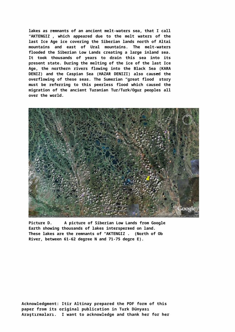
Picture C. Siberian Low Lands dotted with thousands of lakes as remnants of an ancient melt-waters sea, that I call “AKTENGIZ”, which appeared due to the melt waters of the last Ice Age ice covering the Siberian lands north of Altai mountains and east of Ural mountains. The melt-waters flooded the Siberian Low Lands creating a large inland sea. It took thousands of years to drain this sea into its present state. During the melting of the ice of the last Ice Age, the northern rivers flowing into the Black Sea (KARA DENIZ) and the Caspian Sea (HAZAR DENIZI) also caused the overflowing of these seas. The Sumerian “great flood” story must be referring to this peerless flood which caused the migration of the ancient Turanian Tur/Turk/Oguz peoples all over the world.

Picture D. A picture of Siberian Low Lands from Google Earth showing thousands of lakes interspersed on land. These lakes are the remnants of “AKTENGIZ”. (North of Ob River, between 61-62 degree N and 71-75 degre E).
Acknowledgment: Itir Altinay prepared the PDF form of this paper from its original publication in Turk Dünyası Araştırmaları. I want to acknowledge and thank her for her fine work. Itir, your contribution is much appreciated.
Polat Kaya
Oct. 29, 2007
Turk Dünyası Araştırmaları ______________________________Agustos 1999
HERITAGE CENTRAL ASIA(Project year 2000)
"AK TENGIZ"THE DISAPPEARED ICE AGE SEA-SIZE LAKE
OF SIBERIA
Polat KAYA*
1. INTRODUCTION
Upon hearing the names of Central Asia and Siberia, one often imagines cold, harsh and remote places where people were once banished,-a rather negative image created by the politics of the past. During the oppressive years of the Soviet Union, these areas were closed to outsiders, and whatever little was learned about the peoples and lands of Central Asia was negatively colored.
Yet in the ancient past, these lands were the cradle of a hardy and dynamic people who, over the ages, spread throughout the world. The nature of their environment was the reason for their hardiness and the natural events taking place in that area were the cause of their dispersion. With their migrations to new homelands, they took with them not only their culture, beliefs and knowledge, but they also developed and flowered new cultures. Presently, the descendants of these peoples are probably living a low points in their long, ancient and brilliant history.
Emekli elektrik yüksek mühendisi; uzak geçmişte, Türk dünyasının dünyada büyük bir alana yayılmış olduğuna inanan ve zamanla üstü örtülmüş bu uzak geçmişi kamu görüşüne getirmeye ugraşan araştırmacı yazar.
97
2 ________________________________________ TÜRK DÜNYASI ARAŞTIRMALARI
For much of the last century, while many other parts of the world received vast amounts of archeological and scientific attention, scientists generally ignored the Central Asian peoples and their impact on the prehistory of other places. During the last few decades, scientists have shown some interest in this area but I firmly believe that a thorough and unbiased investigation into the past of Central Asia would shed new light on the formations of ancient civilizations.
In this paper, I have used the term Central Asia to cover the area extending from the Ural Mountains and Caspian Sea at the west, to the Greater Khingan Mountains at the eastern borders of Mongolia at the east, and from the coasts of the Arctic Ocean at the north to the Himalayan Mountains at the south. Thus the term Central Asia also includes the area referred to as Siberia (see Map 1). Also, the terms Turkic and Turkish are used interchangeably throughout this paper.
What could be the source of the vigorous dynamism of the Central Asians? Perhaps the answer lies in the unique environment that Central Asia provided in the past. When we examine the geography and distribution of glacials in the northern hemisphere during the last Ice Age, we find that Central Asia received some special treatment from mother nature. While North America and Europe were being treated to crushing loads of ice coverage, a very important segment of Central Asia was without ice coverage for thousands of years. And during this' time, most of Europe and North America were inhospitable to life, while large areas of Central Asia were the homelands for a variety of plants and animals, and humans that were thriving. The environmental conditions of Central Asia, in those ancient times, played a very important role in the shaping and development of ancient civilizations.
Within the geography of Central Asia, there are depression areas where water would have accumulated and formed great lakes that would have influenced their environment and people for thousands of years before the water diminished and disappeared. This paper examines two such areas, namely the West Siberian Lowland and the Tarim Basin. As these likely Ice Age-induced Central Asian lakes were forming, and disappearing thousands of years later, they would have influenced the lives of people dramatically and forced the dispersion of Central Asians to other parts of the world -on both occasions. Additionally, the movement of Central Asians into the rest of Asia, Europe and North America would have followed the spread and withdrawal of Ice Age ice. As new lands were gained from retreating ice, hardy Central Asians would have filled in the newly reconditioned lands thousands of years earlier than the people from the warm-climate areas of the world.
In view of the above given scenario, this paper proposes that a sea-like water body was formed about 20,000 years before present (BP) by the Ice Age melt waters in the West Siberian Lowland and its presence lasted for thousands of years. This major event occurred with such suddenness and continuity that it was remembered in the creation mythologies of people all over the world as "flood" stories.
98

P.KAYA/AK TENGIZ _______________________________________________________________ 3_
Map 1. Central Asia as defined in this paper
2. THE GEOGRAPHY
2.1 The West Siberian Lowland
2.1.1 Geography
The West Siberia Lowlands (Map 2) is an area that is enclosed by the Arctic circle at the north and extending to about the latitude of 55° N at the south, the Ural mountains at the west and the Yenisei River (about 90° longitude) at the East. This area must have lived very dramatic events during the last 25,000 years, i.e. during the later years of the last Ice Age and also after its termination. Events that affected not only the immediate geography of the West Siberian Lowland's but also the rest of Asia.
Presently the geography of the land consists mainly of vast swampy flatlands surrounded by the high Ural Mountains in the west, and a gradually rising land, varying in elevation from 0 to 1000 feet above sea level, as one goes toward the Yenisei River in the East. The area in question is roughly a basin of about 2500 km in diameter. It mainly consists of the so called "West Siberian Lowland" through which two major rivers flow into the Arctic Ocean. These rivers are the Yenisei (Kern in Turkish) River on the east side and the Ob River in the west. The Yenisei River flows on relatively higher grounds into the Arctic Ocean.
The Ob River system constitutes one of the major river systems of the world. It has, as its tributaries, the rivers Katun, Irtish, him, Tobal and many other smaller
99
4 ________________________________________ TÜRK DÜNYASI ARAŞTIRMALARI
rivers that eventually meet with the Ob River and flow altogether into the Gulf of Ob and then into the Kara Sea in the Arctic Ocean. The rivers Yenisei, Ob and Irtish and many smaller tributaries have their sources in the Altai mountains. The Ural Mountains also provide part of the water systems that contribute to the water level of the area. In addition to these two major river systems, there are also the Taz and the Pur Rivers that flow into the Gulf of Ob in the north.
Map 2. The West Siberian Lowland
The World Atlas of the Encyclopedia Britannica' describes the area "as a flat land all around where more than 90% of slopes are very gentle; local relief being less than 100 ft. Only in the central area, the land is undulating with rolling small hills where between 50 to 90% of the slopes are very gentle with local reliefs ranging from 100 to 300 ft. The West Siberian Lowland is essentially a huge
Encyclopedia Britannica World Atlas, 1963, Plates 17 and 18.
100

P.KAYA/AK TENGIZ ________________________________________________________________ 5_
swampy marshland that continues from the eastern slopes of the Ural Mountains to the Central Siherign Upland lying on the east of the Yenisei River."
We should also note here that the drainage of the total Siberian plateau is into the Arctic Ocean. Starting from the Ural Mountains eastward, all rivers, such as the Ob, Yenisei, Lena and Kolima , flow into the Arctic Ocean.
2.1.2 Modern Climate of the Area
In modern times, the average annual temperature of the West Siberian Lowland is 20 degree F and the seasonal variation is in the range of 55° to 75° F. The coldest month is January in which the temperature is about -10° F. The warmest month is July where the temperature varies between 50° to 70° F as one goes south rom the Arctic Ocean towards the Khazakistan lands. It is a subarctic land mass here summers are cool and short, while the winters are long, cold and windy. The precipitation is little in all seasons with an average annual precipitation between 10 and 15 inches.2 As given in the magazine named "Passport to the New World", the climate of the area is described as: continental with long cold winters, average January temperature is -18° to -23° C, in July it ranges 16° to 19° C, annual rainfall 400 to 550 mm.3
2.2 Central Asia
Although presently, the Central Asian lands include major desert systems, such as the Kipchak Colii (Dashty Kypchak), Kara Kum, Kizil Kum, Muyun Kum Tarim Basin, Taklamakan and the Gobi deserts, that range between the Caspian Sea at the west and the borders of China at the east, these lands were not necessarily deserts in the past. Presently, these land masses are very cold during long winters and very warm during short summers. Additionally, there are major mountain systems such as the Altai, Tengri (Tien Shan in Chinese), Sayan, Altun, Pamirs, Karakurum, Kunluns, Himalayan and the Greater Khingan mountains which altogether cover a considerable size of Central Asia. The remaining land mass consists mainly of Central Asian steppes with rolling low hills and large lakes such as Baikal Lake, Balkash Lake, Issik Gol and other smaller lakes. One of the most important water bodies in the area was the Aral Sea which is not a sea anymore. This deterioration of the Aral Sea was due to the selfish and exploitative Soviet attitude towards the local natural resources and their mismanagement of the local water systems that feed the Aral Sea. They killed not only the Aral Sea by diverting waters that fed the Aral Sea but also most of the surrounding land with it - in a time span as short as about 50 years. The lives of the local people in the area surrounding the Aral Sea have been negatively affected by its reduced size. Presently, the Aral Sea is a diminished lake which has lost probably more than 50% of its basin to the deserts of Central Asia.
3. THE PLEISTOCENE PERIOD
During the period between 1.8 million to about 12,000 years BP, which is called the Pleistocene period, the Earth went through a number of major ice ages with many smaller ones in between. Scientists have gathered voluminous information regarding
2 Encyclopedia Britannica World Atlas, 1963, Plates 17 and 18.' Journal named "Passport to the New World" special Issue dated January-February 1995, Publishedby Passport International Ltd., Moscow, Russia, p. 156.
101

6 ________________________________________ TÜRK DÜNYASI ARAŞTIRMALARI
such overwhelming natural events that affected the whole world for long periods of time. During this period, the world's temperate zones were alternately covered by huge ice shields during the cool periods and uncovered during the warmer interglacial periods. Figure 1 gives, diagramatically, the amount of ice volume on the Earth during the last 750,000 years.4 In this diagram, the fluctuation Planktonic Foram oxygen (O-18) is used as a measure of the amount of ice accumulated on earth during different periods of the last 750,000 years. It is evident that there have been major variations in the ice volume during this period.
As seen from the diagram of Figure 1, there must have probably been at least four major ice ages during this period. The most prominent ones of these could have taken place during the periods between about 650,000 to 620,000, 470,000 to 420,000, 175,000 to 130,000, and finally 75,000 to 12,000 years BP. Each of these ice ages, lasting about 25,000 to 80,000 years, are interspaced with other relatively less cold and even warm periods. Remnants of the last Ice Age still exist today and influence the earth's weather system.
Graph of Ice Volume on the Earth


Figure 1. Graph of the ice volume on the Earth during the last 750,000 years. (From Illinois State Museum website on internet called "Ice Ages") http://www.museum.state.il.us/exhibits/ice_ages/
4. THE LAST ICE AGE
The objective of this paper is not to explain why ice ages happen or happened, but rather to focus on a special area on the Earth that the last Ice Age had dramatic
Illinois State Museum, "Ice Ages", an internet Web site, http://vww.museuin.state.il.us/exhibits/ice ages/
102

P.KAYA/AK TENGIZ ________________________________________________________________ 7_
effects upon - effects that are not so obvious at present. Before going into further detail, however, we should take a look at the distribution of ice age glaciers for certain times of the Ice Age as determined by scientists.
4.1 The Seeding Grounds for the Ice Age Ice Build up
It seems that the last Ice Age took place during the period between 75,000 to 12,000 years BP. With the onset of a world wide cooling in climate, among the elements that contributed to the ice building process in the northern hemisphere, it seems that Greenland, the Atlantic Ocean with its warm and cold water currents, the Scandinavian Mountains, the Ural mountains, the Pacific Ocean and the Arctic Ocean were the most influential ones in helping to form the ice shield in the northern hemisphere, i.e., North America, Greenland, Scandinavia and the Arctic Ocean. These areas must have been the seeding grounds for the ice build up.
When the last Ice Age was beginning, as the weather systems moved from west to east in the northern hemisphere, the clouds forming over, say, the north Pacific Ocean first dumped most of their water contents on Canada and Greenland in the form of heavy snow precipitation. As the air currents moved eastward, they picked up more water from the north Atlantic Ocean and dumped most of their water content as snow on northern Europe and on the Ural Mountains before reaching the Siberian lowlands and other parts of Central Asian. When the air system reached the low lands of Siberia, not much water was left in the air, and therefore, very little precipitation took place in these parts of Asia as compared to what was happening in North America, Greenland, the Arctic Ocean and Europe. Consequently most of the time, a very dry, cold, and windy high pressure air system reigned over these lands.
The geography of the land-locked Central Asian steppes and Siberian tundras consist of endless lowlands. Normally the precipitation in this part of the world is bare minimum throughout the year. It was the same but even more so during the Ice Age. When the weather system reached eastern Siberia and Alaska, it once again became under the influence of the environmental conditions of the north Pacific Ocean.
Thus from the start of the Ice Age onwards, while even the lowlands of Europe were being slowly invaded by a south-bound ice shield, there was no such ice build up in the low lands of Central Asia. As the ice shield built up in Europe, animal and human inhabitants of Europe were being displaced by the ice. On the other hand, the native life in the low lands of Central Asia (plants, animals and humans in the area) were maintaining their positions in their homelands up until about 25,000 years BP when the global weather system started to get even colder.
4.2 Start of the Ice Age
The last Ice Age may be said to have started about 120,000 years ago, when the temperature gradually became cooler than normal, and lasted until about 10,000 to 11,000 years BP.5 Based on the scientific data gathered so far, [see
' William H. Calvin, "The Ascent of Mind, Ice Age Climates and the Evolution of Intelligence, Chapter 5," 1990, p. 7, (an article in his website on internet).
103

8 ________________________________________ TÜRK DÜNYASI ARAŞTIRMALARI
Figure 1, ISM ice volume chart], what seems to have happened during this Ice Age was that while Europe and North America were covered with an ice shield as thick as three km, the low lands of Central Asia, i.e., east of Ural Mountains, received a relatively thin ice shield and even that was only during the maximum spread of the Ice Age glacials. Throughout most of the Ice Age, it seems that the West Siberian Lowlands and the Central Siberian Uplands were ice free for thousands of years. This situation is clearly seen in the following Ice Age ice-distribution maps.
4.3 Distribution of the Ice Age Glacials
Distribution of the Ice Age ice coverage is illustrated in many source documents. My references, used as a basis for this paper, are listed below in footnotes. 15
Particularly in the maps by Joseph Campbell, where the distribution of glacials is shown at certain times over the period between 40,000 and 12,000 years BP, we have the picture described below:
4.3.1 Ice shield between 40,000 and 35,000 years BP
Between 40,000 to 35,000 BP, see Map 3 below7, the parts of Siberia that are covered with ice are: the Yamal Peninsula, which is at the north west of the Gulf of Ob, the Gulf of Ob at the north of the Siberian Lowland, and the peninsula of Gory and Tamyr at the north of Central Siberia. While these areas are blocked with land based ice shields (the glaciated areas are shown as cross-hatched) plus the sea ice, the West Siberian Lowlands and Central Siberian Uplands are without ice cover.
We also note that the outlet of the Yenisei river into the Arctic Ocean is free of glaciers. During this time period, a major portion of Europe down to central Europe and central Russia, along with the northern half of England and Ireland are covered with massive glaciers. Similarly in North America, we have most of Canada down to theGreat Lakes and also Greenland all covered with a continuous thick ice shield.
With so much ice accumulated in the northern hemisphere, the level of the seas would have fallen by about 200 feet by this time, that is, over a period of about 85,000 years stretching from 120,000 to 35,000 BP. With so much drop in the sea level, a land bridge would have appeared between Asia and North America through the Bering Sea (or Bering Land Bridge). During the last part of this period, say between 50,000 to 35,000 years BP, it is very likely that there were movements of animals and perhaps even peoples from Asia to North America over the opened up Bering Sea land bridge.
4.3.2 Ice Shield Between 28,000 and 26,000 years BP
Between 28,000 to 26,000 BP, we have the Yamal Peninsula and the Gulf of Ob free of glaciers, while the outlet of the Yenisei River into the Arctic Ocean is
6 1) Samuel W. Matthews, "Ice On the World", National Geographic. Vol. 171, No. 1, January 1987, Map on p. 89 showing ice distribution on northern hemisphere 18.000 years ago.
2) Rick Gore, Kenneth Garrett (Photographs) and Greg Harlin (Art), "The Most Ancient Americans", National Geographic. Vol. 192, No. 4, October 1997, Map on page 95 showing ice distribution at 21,000 and 12,000 years ago on northern hemisphere.3) Joseph Campbell. "Historical Atlas of World Mythology". Vol I. "The Way of the Animal Powers"; Part I. "Mythologies of the Primitive Hunters and Gatherers", Harper & Row, Publishers, New York, 1988, p. 34-35. Joseph Campbell, p. 34 Map 9.
104

P.KAYA/AK TENGIZ ________________________________________________________________ 9_
blocked by glaciers, as shown in Map 4 below.8 Yet during the same time, the West Siberian Lowlands and Central Siberian Uplands are still without ice cover. The ice shields in Europe and North America, as we see them in Maps 3 and 4, however, have advanced even further south from what they were previously, (compare Maps 3 and 4).
Map 3. Ice buildup in northern hemisphere from the beginning of the last Ice Age up to about 35,000 years BP. Cross-hatched areas indicate the glaciers. (From Campbell, Map 9)
' Joseph Campbell, p. 34, Map 10.
105


10 ________________________________________ TÜRK DÜNYASI ARAŞTIRMALARI
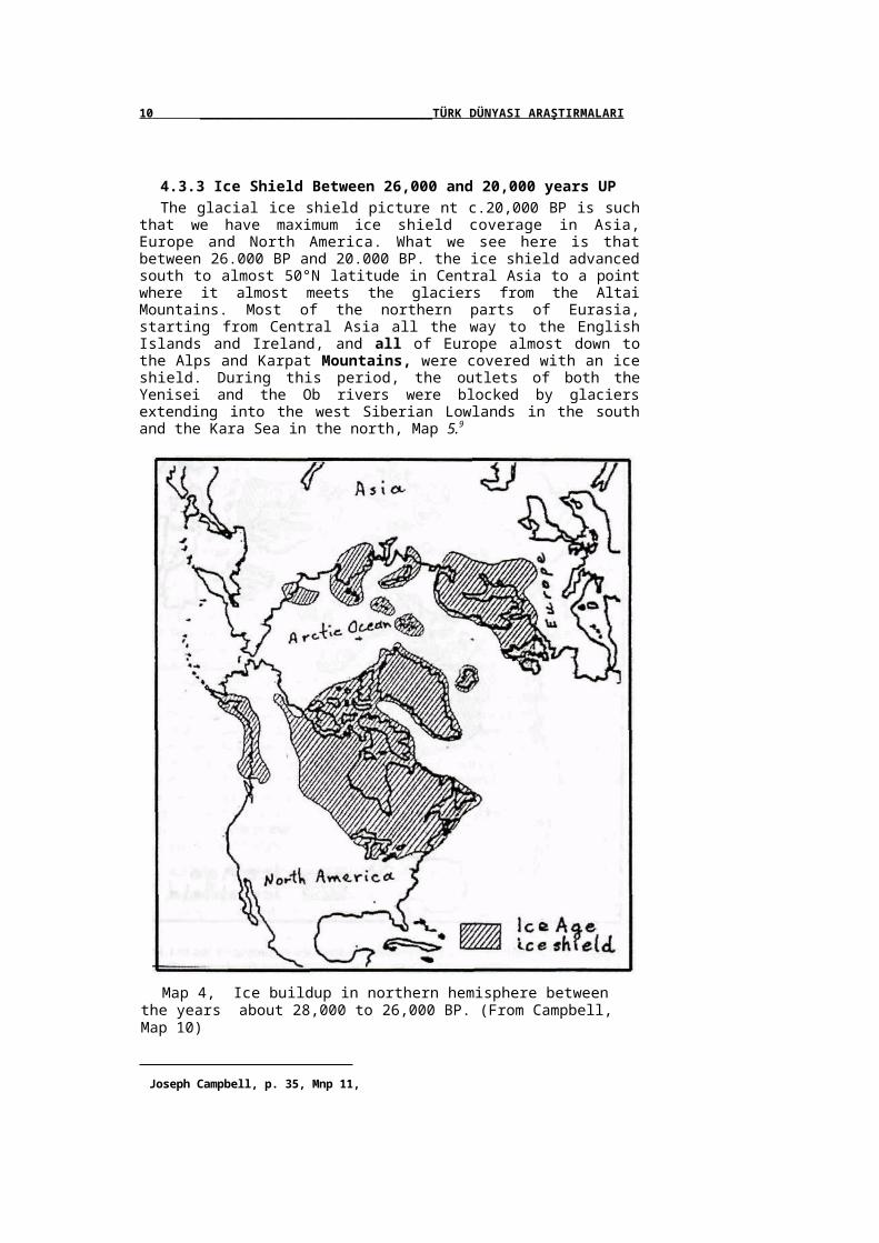
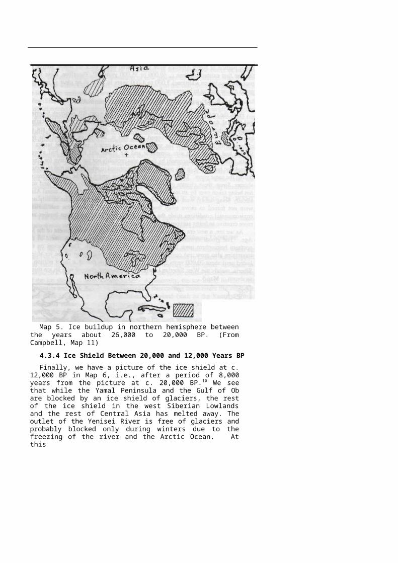
4.3.3 Ice Shield Between 26,000 and 20,000 years UPThe glacial ice shield picture nt c.20,000 BP is such that we have maximum ice
shield coverage in Asia, Europe and North America. What we see here is that between 26.000 BP and 20.000 BP. the ice shield advanced south to almost 50°N latitude in Central Asia to a point where it almost meets the glaciers from the Altai Mountains. Most of the northern parts of Eurasia, starting from Central Asia all the way to the English Islands and Ireland, and all of Europe almost down to the Alps and Karpat Mountains, were covered with an ice shield. During this period, the outlets of both the Yenisei and the Ob rivers were blocked by glaciers extending into the west Siberian Lowlands in the south and the Kara Sea in the north, Map 5.9
Map 4, Ice buildup in northern hemisphere between the years about 28,000 to 26,000 BP. (From Campbell, Map 10)
Joseph Campbell, p. 35, Mnp 11,

P.KAYA/AKTENGIZ11

Map 5. Ice buildup in northern hemisphere between the years about 26,000 to 20,000 BP. (From Campbell, Map 11)
4.3.4 Ice Shield Between 20,000 and 12,000 Years BP
Finally, we have a picture of the ice shield at c. 12,000 BP in Map 6, i.e., after a period of 8,000 years from the picture at c. 20,000 BP. 10 We see that while the Yamal Peninsula and the Gulf of Ob are blocked by an ice shield of glaciers, the rest of the ice shield in the west Siberian Lowlands and the rest of Central Asia has melted away. The outlet of the Yenisei River is free of glaciers and probably blocked only during winters due to the freezing of the river and the Arctic Ocean. At this

10 Joseph Campbell, p. 35, Map 12.

107

12 ________________________________________ TÜRK DÜNYASI ARAŞTIRMALARI
time, the eastern and central European lands up to the Arctic Ocean and similarly, a major portion of North America were still covered with a thick ice shield, similar to the one that existed between c. 40,000 to 35,000 years BP. Therefore, these lands probably needed an additional 3,000 to 4,000 years in order to be clear of ice, i.e., get to a state similar to its present day conditions.
4.4 Ice Build up and Its Effects in Siberia and Central Asia
From the onset of the Ice Age up until about 26,000 years BP, although Siberian and Central Asian plant, animal and human life were affected by the cold weather conditions that came with the Ice Age, the adverse effects were probably not so extreme that they could not be coped with, that is, as long as the land was not covered with ice throughout the year. During this period, probably the tundra in Siberia had increased in size somewhat and the plants and tree lines had moved south, however the displacement by tundra was probably not too restrictive for plant, animal and human life in this part of Asia as compared to what Europe had to endure during the same years. The winter seasons were now longer and the summer seasons shorter. Since, these climate changes were taking place gradually, and the land was not being taken over by an ice shield, the native peoples of Siberia and Central Asia, already being hardy, were able to adapt to these new conditions quite readily and were not forced to move away from their native lands. These new and harsher environmental conditions made the native peoples of these lands even hardier and more creative to better survive the colder climate.
As we see, a new era started after about 26,000 BP in the development of the Ice Age. The global climate became even colder and the existing ice shield in the northern hemisphere grew larger and advanced further south. The glaciers on the mountains also grew and covered larger areas. This enlargement of the ice shield lasted until about 20,000 years BP (see Figure 1). In this period, a major portion of Siberia, mainly the West Siberian Lowlands, also became covered with an ice shield as shown in Map 5..
Map 6. Ice buildup in northern hemisphere between the years from about 20,000 to 12,000 BP.(From Campbell, Map 12)
108

P.KAYA/AK TENGIZ _______________________________________________________________ 13_
From 28,000 to 20,000 years BP, as the climate of the earth continued to cool further (see Figure 1), the outlet of the Yenisei, in addition to the outlet of the Ob River, was also closed by the formation of new glaciers in combination with the sea ice. As the winters lengthened, any precipitation that fell onto the area stayed mostly as ice, while melt-waters during the shorter summers stayed within the basin of the West Siberian Lowland. Since the outlets of the water ways (Ob, Taz, Pur and Yenisei rivers) were blocked by ice, there was no place for the water to go, therefore it accumulated in the lowland basin. This slow ice building process continued for about 8,000 years, i.e., from about 28,000 BP to 20,000 BP, by the end of which the existing ice shield had built up to its maximum size. By 20,000 BP, the extent of the ice shield in Central Asia had reached about 55°N.
As land was replaced by ice, plants and animals had to move to other more hospitable areas. For the first time since the beginning of the Ice Age, because of the ice build up, the people of the West Siberian Lowlands were forced to move to other areas in Asia, Eurasia and probably to North America. The adjacent lands of Central Asia were quite likely the first migration area to move into. After some time, the population crowding must have forced people to migrate even more in all directions
5. THE FORMATION OF A SEA OF MELT WATERS IN WEST SIBERIA
The following developments can be deduced from events that must have taken place during the last 20,000 years or so in the West Siberian Lowlands:
5.1 Formation of a Sea of Melt Waters between 20,000 and 12,000 BP
By the beginning of 20,000 BP, the climate of the earth had started to warm up (see Figure 1). As a result of this, the ice building process in Central Asia stopped and melting started. The climate being much warmer at the lower latitudes, as compared to the area around the Arctic circle in the north, caused the southern skirts of the ice sheath to start melting earlier. Additionally, the ice shield on the Altai Mountains and other ranges were also melting thus causing those rivers that originate from them and flow into the West Siberian Lowland (such as the Yenisey, Irtish, Katun, and others), to overflow their banks. The natural drainage in Siberia is towards the Arctic Ocean and in the West Siberian Lowland, the drainage outlets were closed by the massive ice buildup. As the melt waters were coming from all directions into the West Siberian Lowland, a deluge sea (a huge melt water lake) would start to form. By about 20,000 BP, the water level of oceans had dropped about 300 feet and the ice on the shores of the Arctic Ocean was sitting solidly on the floor of the ocean. Because of this, the outlets of the Ob, Taz, Pur and Yenisei Rivers running into the Arctic Ocean were completely blocked by ice. Thus during the warming climate, the melt waters from the melting southern skirts of the Ice Age ice shield plus the melt waters from the mountains had no place to go but to accumulate into a large flood lake covering not only the West Siberian Lowland basin but also some additional land from the surrounding highlands.
This melt water of the glaciers plus the additional annual rain and snow precipitation during the global warming period, continued for another 8,000 years until about 12,000 BP. From Map 6, which shows the distribution of the Ice Age glaciers around 12,000 BP, we see that although the outlet of the Yenisei River into the Arctic Ocean had opened, the Gulf of Ob (i.e., the outlet of the Ob River into the
109
14 ________________________________________ TÜRK DÜNYASI ARAŞTIRMALARI
Kara Sea) was still blocked. The implication of this is that the melt waters were still not being drained out fully at this time. As a result of this, we would still have a flood lake in the West Siberian Lowland covering an area of probably the size of a circle 2,500 km in diameter. Such a lake would not only swallow the Ob River, but its southern shores could also have included the present day rivers of Irtish, Ishim, Tobol in the south and south-west, and the Yenisei River in the east. The melt waters lake could have been a shallow one being as deep as 30-40 meters.
It is probably the sudden formation of this "sea of flood waters" that most likely left unforgettable memories of "flood" in the minds of ancient peoples, as observed in the mythologies of native Central Asian peoples and also those peoples who migrated into the Americas and other places from Central Asia. Later these memories were transformed into a universal flood image that is imprinted in the mythologies of the peoples of the world. Melt waters rushing in from all directions into the West Siberian Lowland would have been an awesome sight for those who witnessed the event - particularly during the spring and summer seasons. The ancient Central Asians must have told endless stories about this event to their children from generation to generation. Eventually, these stories about the deluge, which had started around 20,000 BP, turned into mythological flood stories that we hear from different sources today.
Of course, as the flood waters formed a huge lake (probably as large as three times the size of the Caspian Sea), a huge area of land was engulfed by the glacial melt waters for thousands of years until the gradually receding waters released the land to its present state - which is now called "the West Siberian Lowland". By this time, the original event was completely forgotten and the flood stories had turned into mythology.
This sea of melt waters quite likely swallowed and obliterated the remnants of any civilization that was likely to have existed in the area at that time. Physical remnants of such an ancient civilization may still surface from time to time. Could it be that the lost continent of 'Atlantis' is the present day so-called West Siberian Lowland, i.e., a land that was covered by melt water for thousands of years before it gradually re-emerged?
5.2 Naming the Sea Formed by the Ice Age Melt Waters
It is worth mentioning here that the sea between the island of Novaya Zemlya and the Yamal Peninsula at the north of the West Siberian Lowlands is presently called the Kara Sea (Kara Tengiz in Turkish).
In ancient Turkish culture, the names of the four cardinal directions are indicated by the colors "red" for east, "blue" for west, "white or yellow" for south and "black" for north, (in Turkish "kırmızı", "gök", "ak" or "san" and "kara" respectively).11
Hence, the Turkic word "kara" means not only "black" but also the cardinal direction "north". Similarly, the word "Ak" means "white" as well as the direction "South". These two Turkish words, 'kara' and 'ak', have been used as descriptive toponyms for many geographical landmarks in areas where Turkish peoples lived throughout history. Two such names in Turkish are particularly worth noting, namely we have: the "Kara Deniz" which is the Turkish name for the "Black Sea" north of the
Emel Esin Büke (The Cosmic Significance of the Dragon in Early Turkish Iconography) Cultura Turcica by Türk Kültürünü Araştırma Enstitüsü, Ankara, 1968-1970, p. 79.
110

P.KAYA/AK TENGIZ ___________________________________________________________________________________15_
Anatolian peninsula; and the "Ak Deniz" the Turkish name for the Mediterranean Sea which is at the south of the Anatolian peninsula. Evidently it was customary for the Turkish peoples to name the water bodies at the north and south of a peninsula in this manner. Accordingly, these two names would also have meant "North Sea" and "South Sea" respectively to the ancient Turkish peoples. These ancient names coined by Turkic peoples for two water bodies in their Anatolian environment are still being used at present.
In the same way, we have the toponym "Kara Tengiz" or the Kara Sea as part of the Arctic Ocean, i.e., at the north of the Yamal Peninsula in the West Siberian Lowland. The native people of the area probably named this sea as the Kara Sea (Kara Tengiz) because it was the most northern sea in the area. If there was in the past another water body at the south of the Yamal Peninsula, it is very likely that it could have been named "Ak Tengiz" (South Sea) by the native Turkic peoples. In fact, there is reference to a name "Ak Tengiz" in the mythologies of Tatar Turks' in the Minusinsk area,12 however it is not known what sea this name refers to.
From the above analysis, it is seen that we indeed have a huge lake of melt waters, a sea that probably had three times the size of the Caspian Sea and a sea that was formed in the West Siberian Lowland by the melt waters of the Ice Age glacials and the glaciers of the Central Asian and Ural mountains. It probably started to form around 20,000 BP, and probably lasted in its watery basin for another 12,000 to 13,000 years before it diminished to its current state. Presently there is so much water in this land basin in the form of huge rivers, thousands of small lakes, swamps and marshes making the water table so high that the local people describe it by saying "it is neither dry land nor water".13
This well camouflaged and presently missing sea, which was formed by the melt waters of the last Ice Age glacials, is still visible not only in the creation stories and flood stories of the local native peoples and also of all those peoples whose ancestors migrated from Central Asia to the rest of the world, but also in the watery basin of the West Siberian Lowland. All around the world, mythologies of peoples are full of references to a deluge which probably refers to the sudden formation of this sea by the melt waters of the Ice Age glacials. In my view, the watery basin of the West Siberian Lowland is nothing but the remnants of this sea. Probably the formation of this sea was one of the main reasons that caused the Turkic peoples to believe in a 'Earth-Water' cult (Yer-Suv/Sub/Su cult in Turkish) where they considered the earth and its waters sacred and accordingly respected them.
With this deduction of the existence of an ancient sea that occupied the West Siberian Lowland in the past, and remaining true to this ancient Turkish tradition, I have named this huge sea "Ak Tengiz" meaning (the South Sea) with respect to the "Kara Tengiz" (the North Sea) at the north of the Yamal Peninsula. "Ak Tengiz" must have been a fresh water sea that was formed in the West Siberian Lowland during the period between 20,000 and 12,000 years BP, is not there now, and will most likely be there again after another ice age similar to the last ice age. Map 7
12 Doçent Eşref Buharalı, "Islam Kaynaklarındaki Türklerin Nesebi ile Alakalı Bilgilerin İlk Türk Türeyiş Efsaneleri ile irtibatlandırılması", Türk Kültürünü Araştırma Enstitüsü, Türk Kültürü,Sayı 357, Ocak 1993, p. 31.
Viladimir Bogdanov, "Passport to the New World", Special issue dated January-February 1995, Passport International Ltd., Moscow, p. 166.
lll


16 ________________________________________ TÜRK DÜNYASI ARAŞTIRMALARI
shows (cross-hatched areas) the approximate extent of the area occupied by this lost sea of melt waters.
It would be useful to remember that a similar but short lived situation also took place in North America. About 13,000 years ago, the rapid melting of glacials made a large lake in eastern Washington state in the USA. Prof. William H. Calvin writes about it by saying14:
"A large lake of melt water formed east of the Idaho-Montana border, but was held in place only by a dam of ice. When that dam broke, the lake emptied suddenly, a great flood sweeping westward. It carved a broad swath across the state until channeled down the Columbia River along the Washington-Oregon border. It sculpted deep valleys in a matter of days. Similar events must have happened as the eastern Canadian and Greenland ice sheets melted, so the North Atlantic was episodically flooded with fresh water, disrupting the formation of the deep salty current that had attracted the warm North Atlantic Current northward (and promoting winter ice that "capped" the evaporation needed for resumption of the salt cycle)".
In the case of Ak Tengiz the ice dam was huge and wide, and it took thousands of years to melt, thus slowly giving way for the drainage of Ak Tengiz.
6. FORMATION OF OTHER LAKES BY MELT WATERS
6.1 A Probable Melt Waters Lake in the Tarira Basin
During the formation of Ak Tengiz, it is highly likely that other inland lakes were similarly forming in other areas. One likely place for such a lake is the Tarim Basin in Central Asia.
OCtAhl
Map 7. Probable flooded areas by the melt waters of ice from the Ice Age in Central Asia. "Ak Tengiz" in the West Siberian Lowland, a "Tarim Lake" in Tarim Basin and the expansion of the Caspian Sea to the lowlands at its eastern shores, between about 20,000 and 8,000 years BP.
William H. Calvin, Chapter 5, "The Ascent of Mind: Ice Age Climates and the Evolution of Intelligence", e-mail address: [email protected].
112
■AFRICA

P.KAYA/AK TENGIZ ___________________________________________________________________________________17_
The "Tarim Basin" is surrounded by the high Jungarian plateau in the northeast, the Tengri mountains in the northwest, the Pamir and Karakorum Ranges in the southwest, the Altun and Kunlun Mountains in the south and by Nan Shan in the east. This area presently consists of the mountain slopes that frame the Tarim basin, some marshes, dried lake beds and the Taklamakan desert in the basin itself, Map 7. At one time in the past, particularly when "Ak Tengiz" in the north was forming, a major portion of the Tarim Basin, namely what is now called the Taklamakan Desert, must also have been a full fledged natural lake fed by rivers coming from the surrounding ice-covered mountains. The appearance of the area, as observed from satellites, suggests that there must have been a lake in this basin. Presently the dried up lake bed of Lop Nor must have been a part of this larger lake. Additionally, this lake probably also included the "Turfan depression" which is 505 feet below sea level.
Presently all of the Tarim Basin area is very hot during summers, and cold and windy during winters. However, this land mass probably had a very different watery picture for thousands of years before it became a desert. To understand the earlier picture of the area, we need to follow the process that the area went through since the time of about 26,000 years BP.
During the period between 26,000 and 20,000 BP, as the world's climate was getting colder, the mountains surrounding the Tarim Basin would have had not only a thick layer of ice, but also glaciers in the valleys. After about 20,000 years BP, as the climate started to get warmer, the ice on the mountains would have started to melt heavily. The Tarim Basin is a natural catch basin for capturing these melt waters. The formation of the Ak Tengiz and the over expansion of the Caspian Sea would have also formed a local rain-generating machine that would increase the waters running into the Tarim basin depression.
During the period after 20,000 years BP, it is expected that most of Central Asia would be receiving considerably more rain than it does annually at present times, thus making the continent a much more hospitable place for plants, animals and humans. The rain waters, in addition to the melt waters from the glaciers, would also have helped to fill the Tarim Basin into a full fledged lake. Let us call this probable ancient lake in the Tarim Basin the "Tarim Lake". As long as the Tarim Lake was being replenished with rain waters, and aided by all the naturally available water bodies in the area plus the melt-waters of ice from the surrounding mountains, it would have lived for a long time.
It is also very likely that the well-protected shores of Tarim Lake, being lush with vegetation and with plenty of wildlife, attracted Central Asian peoples to settle in the area. The environment there would be very conducive for a highly advanced sedentary civilization, thus causing the Central Asian peoples to have a semi-pastoral life style in the lands of steppes and a sedentary lifestyle in the Tarim basin. I firmly believe that some of the most ancient settlements and even pyramid structures will, in the future, be found under the well preserving sands of the Taklamakan Desert.
Due to a continuously increasing world temperature, in time, the water bodies of Central Asia shrank in size. By the time that the bed of Ak Tengiz was forming into the river systems and the marshes that it has presently, the "Tarim Lake" must have also lost a substantial amount of water. Particularly, after a few more thousand years, as the replenishment waters from the melting ice on the nearby mountains
113

18 ________________________________________ TÜRK DÜNYASI ARAŞTIRMALARI
diminished, the Tarim Lake would also dry up, leaving its huge lake bed to the Taklamakan Desert system. This desertification process probably took place during the time that the formation of the Great Sahara Desert in northern Africa was taking place. After the "Tarim Lake" dried up due to global warming, and because of the onset of desertification of area, many of the ancient cities built around the periphery of the Tarim Lake would have had to be abandoned.
Presently, there are the Yarkant, Hotan, Qarqan rivers joining up with the Tarim River that runs along the northern shores of the ancient lake bed and through some marshlands into the dried up lake bed of the Lop Nor at the east of the basin.'5
6.2 Probable Enlargement of the Caspian Sea
During the period between 26,000 and 20,000 years BP, as the climate was getting colder, the Ice Age ice shield that had built up in northern Europe and the Ural mountains, became even thicker and extended further south in Eurasia. When the global weather conditions warmed up after about 20,000 BP, the European ice shield also started to melt. As we notice from the Ice Age ice distribution in Map 6, at about 12,000 years BP, there is still a huge chunk of ice on the top of northern Europe.
While the drainage of Central Asia is towards the Arctic Ocean, the major river systems of Europe run from north to south into the Black Sea and the Caspian Sea. Among these rivers, while the rivers Don, Dynepr, Dynester and Danube (Tuna) flow into the Black Sea. the rivers Ural and Idil (Volga) flow into the Caspian Sea. Thus during the melting stage of the ice shield in Europe and Central Asia, while the Ak Tengiz was forming in the West Siberian Lowland, these European rivers brought into the Black Sea and the Caspian Sea not only waters of the annual precipitation but also the additional melt waters from the melting ice. Of course in time, the water levels of these two seas would have risen beyond their present shores. Particularly the Caspian Sea probably overflowed into the eastern lowlands, which are deserts now, thus making it a much larger sea than it is at present. This likely extension is shown in Map 7 by cross-hatched lines to the east of the Caspian Sea. Although it may have been a fairly shallow water body, it is still likely that the Caspian Sea and the Aral Sea may have joined together sometime during the expansion process. This over extended water body must have maintained its sea state until long after the glacials on the Ural Mountains and northern Europe totally melted away. So we see that there must have been a very watery Central Asian landscape between about 20,000 and probably 8,000 years BP.
Eventually the water level of the over-extended Caspian Sea fell to its present levels and thus, not only the Caspian and the Aral seas separated from each other, but also the Ice Age melt waters left the conquered space to the huge deserts of Turkmenistan. This was part of the desertification process of Central Asia.
5 Thomas B. Allen (TBA) and Photographs by Reza, "Xinjiang", National Geographic, vol. 189, No. 3, March 1996, p. 14-15.
114

P.KAYA/AK TENGIZ ________________________________________________________________ 19_
7. DISCUSSION
7.1 A summary Look into the Conditions in Europe
From the onset of the Ice Age up to about 26,000 years BP, Europe and North America (Canadian land mass) were hit with a healthy dose of ice formation. While north-eastern Canada and north-western Europe were being invaded by as much as a 3 km thick ice shield, there was no ice buildup in Siberia and Central Asia. As a result of this, the native Central Asians were still maintaining their geographic positions in these lands. This situation must have continued up until about 25,000 years ago, when the weather system started to get even colder.
In Europe, even during the receding years of the ice shield, the cold melt-waters of the ice shield was filling the oceans and thus keeping the water temperature of oceans low, which in turn kept the climate of Europe relatively colder for long duration of time. Scientists believe that "as the ice age was ending, some 10,000 years ago, a huge influx of fresh water from the melting glaciers and the ice shield mixed with the Gulf Stream, lowering its density and interrupting the thermohaline flow. As a result, Europe's temperature dropped by about 5° C, delaying the end of the Ice Age there by about 1,000 years."16 From all these facts, it can be deduced that as the climate of the Earth was going through a general warming at the end of the cold cycle of the Ice Age, Central Asia had already rid itself of the ice shield, while Europe was still recovering from the European ice shield. The complete melting of the ice shield in Europe, as compared to the ice shield in Siberia, probably took an additional several thous and years.
As the glaciation of the northern hemisphere stopped and the ice shield started to retreat, the European tundra and tree line moved slowly northwards. The new lands that were gained from the receeding ice became available for plant and animal life. Soon after the retreat of the Ice Age ice shield in Europe, the hardy Central Asians were quick to follow the plants and animals and take positions in the opened up lands before the peoples of, for example, the Mediterranean belt would have. It is reasonable to say that, by the end of the Ice Age, most of central and northern Europe, Eurasia and the Balkans were populated by mostly Central Asians. During this time, the warmer climate peoples would hardly find it suitable for their taste to move into Europe, because it was still too cold for them. The migrations of the warm climate peoples into Europe and some parts of Asia must have taken place only thousands of years after the ending of the Ice Age.
This scenario outlines the peopling of the European continent during the years that the European ice shield was receding and the Ice Age was coming to an end. What it essentially means is that the Continent of Europe was peopled by Central Asians for thousands of years before the warm climate people, such as those in the Mediterranean Belt, could start moving into Europe. The homogeneous peopling of Europe by the native Central Asians, particularly by the Turanians, probably lasted until 5,000 years BP. Only after the European continent warmed up sufficiently, did the Indo-European speaking peoples start to move northwards into Europe. At this point, it is interesting to note a definition of the word Turanian as defined by
16 The Economist, October 19, 1996, p. 85.
115

20 ________________________________________ TÜRK DÜNYASI ARAŞTIRMALARI
Britannica World Language Dictionary (edition of Funk & Wagnalls Standard), 1963, p. 1353, it says:
Turanian, adj. Of or pertaining to a large number of agglutinative languages of Europe and northern Asia, neither Indo-European nor Semitic, specifically known as the Ural-Altaic languages, or any of the people who speak them. -n. 1 One whose mother tongue is a Ural-Altaic language; a person of Ural-Altaic stock. 2 The Ural-Altaic languages collectively. 3 Theoretically, one of an unknown nomadic people who antedated the Aryans in Europe and Asia. [Persian Turan, a country north of the Oxus River]. [Highlighting is mine].
In this definition, it seems that Western writers indeed do know who the Turanians are, but cannot candidly admit that they were Turkic speaking peoples of Central Asia. The term "Theoretically," used in the above definition, is a deception which tries to dilute the last part of the definition which states that it was the Turanians who inhabited Europe and Asia before the Aryans. In this definition it is implied that Aryans and other Indo-European speaking peoples of Europe were not indigenous to Asia and Europe. Evidently, they are late arrivals in Europe. Again, in the definition, the term "unknown nomadic people" is deceptive. The implied claim that western scholars do not know the identity of Turanians is not believable. People who spend their lives studying the past and present peoples of the world, surely know who the Turanians were, in the past and also at present, but for some reasons of their own, cannot name the Turanians as Turks or Turkic speaking peoples. It is a fact that the land defined as Turan and the rest of Central Asia at the north of Oxus River, have always been the original homelands of Turs (Turks). To be evasive about this fact must be due to politics rather than scienc.
Finally, the name "Oxus" is a Hellenized Turkish name that is distorted from its original form. The original form of this Turkish toponym must have been either Oksu or Aksu for that river. Obviously, the sounds ks in the original word have been combined into the Greek sound X to make the name Oxus. Both Ok Su (Arrow River) and Ak su (White River) would have been the proper Turkish name for this river.
7.2 Eventual Loss of "Ak Tengiz"
When we compare the Ice Age ice distribution shown in Maps 5 and 6, it is seen that it took about 8,000 years to melt away most of the glacials that covered the northern lands of Central Asia. Of course the southern skirts of the ice shield melted at a higher rate than the northern parts of the ice shield. This process, shown diagramatically in Figure 2, caused the accumulation of the melt waters in the West Siberian Lowland.
Figure 2 shows schematically the simultaneous flow charts of the temperature changes in the world climate, the changes in the ice shield of Siberia and the likely accumulation of melt waters into the West Siberian Lowland over a time period since 25,000 years BP to the present. The horizontal axis represents time in thousands of years.
Diagram (a) shows the relative state of the climate as colder and warmer versus time; (b) shows the relative level of the ice shield in Siberia due to the Ice Age, with respect to present levels; (c) shows the relative level of the melt waters accumulation; and (d) the likely states of land in Central Asia.
116
P.KAY A/AKTENGiZ 21

Figure 2. Schematical diagrams showing the simultaneous changes in the temperature of the world climate, the ice shield volume of Siberia and the likely accumulation of melt waters into the West Siberian Lowland over a time period between about 25,000 years BP and the present.
"Ak Tengiz," the ancient huge lake of melt waters, probably continued to exist until the ice jam at the Gulf of Ob melted away and/or was pushed away by the force of the flood waters. Initially the water drain from "Ak Tengiz" into the Arctic Ocean must have been quite low. After the removal of this blockage, "Ak Tengiz" would be able to flow into the Arctic Ocean at a higher rate, at the same time
117

22 ________________________________________ TÜRK DÜNYASI ARAŞTIRMALARI
probably changing the channel bed of the Gulf of Ob to its present shape. Following the initial forceful flow, the flow of water into the ocean would slow down in time. This would be aided by the climate of the area, the topography of the land along the northern edge of the West Siberian Lowland which seems to be somewhat higher than the lowland basin itself, thus preventing the water flow into the Arctic Ocean, and the amount of melt waters coming into the basin from the surrounding area. When the ice shield of the Ice Age melted totally, the melt waters would reduce to only the seasonal melt waters from the mountains. However the end of the Ice Age ice shield would not be the end of Ak Tengiz immediately. Since about the time of 12,000 years BP, it must have taken an additional 4 to 5 thousand years more to reduce this body of melt waters to its present remnants. Scientists can calculate in fine detail the exact time duration of the process that reduced "Ak Tengiz" to the mere marshland that it is now in the West Siberian Lowland, particularly between 55°N and 65°N latitudes.
Presently, the West Siberian Lowland is flooded seasonally17 by the Ob and Irtish rivers and others in the area swelled by the spring melt waters from the mountains. The present day swamps of the West Siberian Lowland are the remnants of "Ak Tengiz", although they -give the impression that they are due to present day floods. The geography of the area needs to be reviewed in the light of these new considerations.
Viladimir Bogdanov, in the Special issue of Passport to the New World, writes the following18:
"The landscape of Surgut Region, with its numerous oil and gas fields, is aptly described by the folk saying "neither dry land nor water" ... Swamps, lakes centuries-old taiga and a fragile layer of ground... It is also the habitat of what little is left of the Northern peoples-Khanti and Mansi-and signs and artifacts of the unique ancient civilization of the Ugrian race. At times they are encountered by workers of oil companies. "
One wonders about the age of these ancient artifacts found in the area. How old are they? Are they artifacts that were left by the Ugrian race only, as arbitrarily claimed by some people, or by the Turkic race whose people also used the area as one of their ancient homelands, or both?
7.3 Ak Tengiz Area as Seen From Above
In examining satellite pictures of Central Asia, one observes the remnants of Ak Tengiz as rivers, lakes and marshes in the West Siberian Lowland. Similarly, one also observes some dried up ancient river beds that seem to have fed lakes that could have bridged Ak Tengiz to the Aral Sea in Western Turkistan.'9 It is likely that by 12,000 years BP, when "Ak Tengiz" was at its widest state, the rest of the area in the Central Asian steppes was also full of other smaller lakes - remnants of the Ice Age ice shield that covered the land. Such lakes could have been fed by rivers that
Robert Paul Jordan and Dean Conger (Photographs), "Siberia's Empire Road, The River Ob," National Geographic, Vol. 149, No. 2, February 1976, p. 145-181, Map on p. 151.
Viladimir Bogdanov, "Passport to the New World", Special issue dated January-February 1995, Passport International Ltd., Moscow, p. 166.19
"The Cartographic Satellite Atlas of the World" by Warwick Publishing, Toronto and Los Angelos, 1997, p. 100-101.
118

P.KAYA/AK TENGIZ _______________________________________________________________ 23_
eventually flowed into the Ak Tengiz. For example, in Kazakistan along the present Turgay river, going north to Kushmurun Lake and up to the Tobol River to the city of Kurgan, there is a chain of lakes that would have all been connected to each other making one large lake during the time of "Ak Tengiz". This would be a long but narrow water body, like Lake Balkash in its present state, possibly linking "Ak Tengiz" to the Aral Sea at that time. Similarly, there appears to be dried river beds running from the Ishim River along the tributary called Tersakkan to the west of Kazak Hills, down to the riverbed of the River Sarysu (Sari Su).2l) When "Ak Tengiz" was expanding due to the blockage of its outlets, its shores could have extended to meet these channels all the way down to about 50° N.
7.4 Was AH Of Siberia a Lake At One Time in the Near Past?
Using the ice volume representation chart given in Figure 1, there seemsto be two prominent era during the past 750,000 years, one around 650,000 years BP and another around 150,000 years BP, during which two prolonged ice ages could have taken place. The ice formation period in each one of these cases, similar to the one between the years 26,000 and 20,000 years BP during the last Ice age, probably lasted about 25,000 years before the climate of the Earth started warming up again. During these two events, all the drainage outlets into the Arctic Ocean from Central Asia and Siberia could have been blocked by a vast ice shield for a very long time. The rise of the temperature was fast and the melt waters had no place to go but accumulate in the total Siberian basin all the way from the Ural Mountains at the west to and inclusive of the Lena River at the east. This would eventually form a huge lake probably covering all of Siberia for a long time before the last ice age started. Its formation and retreat would have had dramatic influences not only on the Central Asian landmass but also all over the world. The "Ak Tengiz" that I describe above must be the last of-such events in the area during the last million years.
7.5 Glaciers of the Central Asian Mountains
During the formation years of the Siberian Ice shield, that is, between 26,000 and 20,000 years BP as described above, glaciers were also being formed on the high mountains and plateaus of Central Asia, such as the Altai, Sayan, Tengri and Himalaya Mountains. All of the high mountains surrounding the Tarim Basin and the Gobi Desert were seeding grounds for glaciers.
During the warming period of the earth, i.e. since about 20,000 years BP, while "Ak Tengiz" and Tarim Lake must have formed due to melt waters, in many ways the whole continent of Asia probably benefitted extensively from the new and the other older water bodies in the continent in terms of increased rain. Particularly due to the presence of "Ak Tengiz" at the North and the expanded Caspian Sea and Aral Sea at the west and the "Tarim Lake" at the heart of Central Asia, the annual rain fall would have increased considerably all over the Asian continent. For example, the land formations due to erosion of the land by the run off waters from the hills in Turpan area in Uiguristan (Easter Turkistan),21 indicates how heavy the precipitation must have been on these lands sometime in the past. Under the influence of these
20 Encyclopedia Britannica World Atlas, 1963, p. 29.George Gerster (Photographs) and Larry Kohl (Text), "Above China", National Geographic, Vol. 175,
No. 3, March 1989, p. 298-301.
119

24 ________________________________________ TÜRK DÜNYASI ARAŞTIRMALARI
water bodies in the area, the deserts of Kazakistan, Ozbekistan, Turkmenistan, the Taklamakan and the Gobi Deserts, would all have been lush green lands during the period extending say, between 20,000 and probably 8,000 years BP.
During this period, as the Earth's climate kept warming, seasonal warm periods became relatively longer while the cold winter periods shortened. These changes in the global weather system made the environmental conditions in almost all of Central Asia much more hospitable and habitable for a variety of plants and animals and thus for humans. Many parts of Central Asia, particularly those areas which are desert now, would have been condusive to pastoral and sedentary civilizations, especially around the water bodies. The Tarim basin particularly would have been a haven for sedentary civilization. And it is more than likely that these sedentary civilizations all ceased to exist when the desertification of Central Asia became a reality.
7.6 The Desertification of Tarim Basin
As long as the Tarim Lake was being replenished with rain waters caused by all the water bodies in the area and the melt waters of ice from the surrounding mountains, it would live for a long time. After the disappearance of "Ak Tengiz," the "Tarim Lake" must have continued to live on for some time. However, as the replenishment waters diminished, due mainly to the disappearance of Ak Tengiz and the melting of ice on the mountains, the Tarim Lake also dried up, leaving its huge lake beds to the Taklamakan Desert system. After the "Tarim Lake" dried up, due to warming of the global climate, many of the ancient cities built around the periphery of the lake would also be abandoned to the desert.
Presently, there are the Yarkant, Hotan, Qarqan rivers joining up with the Tarim River that runs along the northern shores of the ancient lake bed and through some marshlands into the dried up lake bed of the Lop Nor at the east of the basin.22
7.7 The Gobi Desert
The Gobi Desert lies at the south of present day Mongolia. It is surrounded by the Altai and Sayan Mountains in the north, the Greater Kingan Mountains at the east, the Inner Mongolian mountains in the south and by the Nan mountains (Nan Shan in Chines) at the south-west. It is a desert that people crossing the ancient Silk Road with their caravans dreaded to go through. It must have seemed to these travellers that this desert would never end. Although the Gobi Desert is now a formidable sand basin, it most likely wasn't so during the time of "Ak Tengiz".
7.8 Implications of the Presence and Absence of Ak Tengiz
The demise of "Ak Tengiz" brings us to the probable time period of about 8,000 to 7,000 BP. But the appearance and the disappearance of "Ak Tengiz" bring with it a whole set of events that influenced the history, not only of Central Asia, but also the rest of the world. Some of the implications of these developments may be summed up as follows:
a) The formation of Ak Tengiz would have forced short and long distance migrations from the lands that it captured.
~ Thomas B. Allen (TBA) and Photographs by Reza, "Xinjiang". National Geographic, vol. 189, No. 3, March 1996, p. 14-15.
120
P.KAYA/AKTENGJZ ___________________________________________________________________________________25_
Although "Ak Tengiz," when it was forming, captured land from Siberian geography, it also provided a new habitat for sea animals and migratory birds of all kinds. Additionally, together with the other water bodies in Central Asia, it became part of a rain generating machinery in the Asian continent. The repurcussions of the formation of Ak Tengiz are almost unlimited for the plant, animal and human life throughout the continent of Asia.
Probably one of the first influences on people was to force them to migrate to other places. For example, the migrations of the ancestors of the Native peoples of the Americas from Central Asia might have been during the formation of Ak Tengiz. Since their lands were being taken over at a fast rate by the melt waters of the Ice Age glacials, people probably felt that they had no choice but to move to other places. North America was one such place via the Bering Sea land bridge that existed at that time.
b) The formation of Ak Tengiz would have forced the creation and development of a seafaring culture for the native peoples of Central Asia. With so many fish and other water animals in it, plus the seasonal migratory birds that came to its shores every spring, Ak Tengiz could have been an area where a variety of its resources were harvested by the local peoples. Seafaring would have been a new lifestyle for the Central Asians in addition to their semi-pastoral animal based culture in the steppes.
This seafaring culture shows itself quite prominently among the cultures of ancient Central Asians who settled in Europe, in the Balkans, the Aegean islands and the Anatolian peninsula before the Indo-European speaking peoples moved into the area. This seafaring culture seems to be a continuation of a similar culture previously developed in their original homelands before Central Asians moved into these areas. For example, the ancient peoples of the Aegean islands, such as the people of ancient Crete, the so-called 'Minoans' who were Pelasgians (ancestors of the Saka Turks), were all Turkic speaking 23 Central Asians and were seafaring people. Additionally the so-called Phoenicians whose real name was Khanoi (Canaanites in Jewish sources) corresponding to the name of Khanlar or Khanoyliiler in Turkish, and the Carthaginians, who were a branch of Phoenicians, were also Turanian speaking Central Asians. 24 The ruling people of ancient Egypt, the Pharaohs and their immediate family members were also Turkic speaking Central Asiatic people.23 The so-called "People of the Sea" who attacked ancient Egypt during the reign of Ramsess III around 1200 B.C. were seafaring Central Asians, contrary to the muteness of the history writers. So it is seen that a lot of ancient seafaring peoples were Central Asian in origin.
It is highly likely that a seafaring culture induced by Ak Tengiz could also have helped ease the migrations of the Central Asiatic peoples into the North and South Americas by way of the seas.
' Polat Kaya, "A Study of the Lcmnos Island Inscription (A preliminary report)", Ottawa, 1997, ISBN 0-9696949-3-8; or on internet
http://www.compinore.net/~tntr/lemstelea.htnil24 Polat Kaya, "Reading of the Pyrgi Tablets", Türk Dünyası Araştırmaları Dergisi. No. 119 Nisan 1999, p. 91-124.
Sir E. A. Wallis Budge, Egyptian Language", London and Henley: Routledge & Kegan Paul, New York: Dover Publications Inc. Fourteenth Impression, 1977, p. 1.
121

26 ________________________________________ TÜRK DÜNYASI ARAŞTIRMALARI
c) The presence of Ak Tengiz would have helped create a rainy change incontinental weather conditions and hence in the ecology of Asia as a whole. With somuch water around, the lands of Central Asia must have been quite lush with plantseverywhere. Additionally the presence of Ak Tengiz would attract millions ofmigratory birds of many kinds to its shores for their annual breeding. So many birdswould bring forth a resource for all kinds of survival needs of the natives in the area.
d) By the demise of Ak Tengiz, the desertification of many parts of Asia wouldbe enhanced. When the melt waters of the glaciers on the mountains and everywhere else were finished, the local wheather conditions would get drier as it is atpresent. The formation of vast deserts throughout Central Asia must be intimatelylinkedto the loss of waters from Ak Tengiz, the Tarim Lake and the Caspian Sea.
e) The loss of waters from Ak Tengiz, the Tarim Lake and the other water bodiesin Central Asia would have forced a second wave of migrations to other places of theworld, such as into east and southeast Asia, the sub-continent of India, Europe,Mesopotamia, the Mediterranean belt, and the continents of the Americas. Forexample, the migration of the Central Asiatic Sumerians to Mesopotamia and theCentral Asiatic ancient Egyptians (the ruling people in ancient Egypt) to the banks ofthe Nile in Egypt in north Africa, and the Pelasaka to Balkans and the Aegean Seaislands probably took place after the onset of desertification in Central Asia.
f) With the disappearance of Ak Tengiz and Tarim Lake, seafaring activity of thelocal people would also terminate. The desire to carry on with seafaring lifestylewould force some groups to move to other places where major seas were readilyaccessible. Those, who insisted on staying in their ancient homelands would stillcarry on their lives with pastoral and semi-pastoral lifestyle, i.e., bee farming, cattle,sheep and horse husbandry, in the steppes of Central Asia, and those who were wayup in the north, probably would deal with reindeer culture.
g) With the desertification in Central Asia, ancient cities where sedentarylifestyle was lived must have been abandoned to the sands. Hence, remnants of suchancient sedentary civilizations are still waiting for excavation under the sands ofCentral Asia.
h) The scenario created by the conditions of the last Ice Age in Central Asia and later by the presence of Ak Tengiz, with the steppes of Central Asia surrounding it, probably helped to create a very vigorous and hardy human species in the area. All of the changing environmental conditions in Central Asia helped to create a very dynamic population that was always ready to move. Finding ancient Central Asians in all other parts of Asia, Europe, the Americas and many other parts of the world, is an indication of this dynamism. With so many difficult conditions to endure in Central Asia, the Central Asians came to respect the forces of nature, mother earth and the waters that came out of it, to the level of sacredness and religion.
i) The migrations from Central Asia also caused the spread of Central Asiatic culture, religious beliefs and ingenuity to other lands where they would flower in many different ways in the newly found environments. The ancient Mesopotamian, Anatolian, Egyptian, Balkan and Mediterranean cultures were totally immersed in the ancient culture of Central Asia. Contrary to the well propagated anti-Central Asiatic beliefs of some groups, there are strong evidences that the ancient world's lingua franca was the Turkic language family of Central Asia. There are many evidences pointing to the fact that Central Asia was the cradle of world civilization. China, India, Mesopotamia, Egypt, the Mediterranean belt and the Americas were
122

P.KAYA/AKTENGJZ ___________________________________________________________________________________27_
the places where Central Asian migrants developed their cultures to new heights. The beliefs that insist on the idea that civilization spread from southern lands into Central Asia is nothing but self serving misrepresentations. In ancient times, the flow of civilization was always from Central Asia towards other lands, inclusive of the warmer southern belt. Unfortunately, Central Asians have always been presented to the world with prejudice and misconceptions.
7.9 Likely Re-appearance of Ak Tengiz After Another Ice Age
Presently there is no lake where the "Ak Tengiz" used to be. In its place there is the swampy marshlands covering almost the total flat floor of the West Siberian Lowlands. After a long and arduous natural process, that is, a process that took about 6,000 years to build up an ice shield in the area, about another 8,000 years to melt it and form a huge lake from its melt waters, and probably another 4,000 years for the disappearance of the lake, "Ak Tengiz" disappeared, but probably not forever. It will most likely reappear in its usual place after another ice age cycle, as it has probably done so many times during the last million years of Earth's life.
8. SOME FLOOD STORIES
8.1 Sumerian Flood Story: Probable Reference to Forming of Ak Tengiz
Since Central Asia has been the homeland for the ancestors of many peoples who somehow migrated out from these lands, we find that similar references are made to major flood events in the creation stories of many peoples all over the world. Sumerians were one such group. Undeniably, the Sumerians were Central Asiatic peoples who migrated to Mesopotamia probably around 4,000 B.C., after the disappearance of Ak Tengiz. The earliest reported flood story in written form is by the Sumerians. The Sumerian writers reported a flood in their king list texts inscribed in cuneiform writing on tablets. They report:26
After kingship had descended from heaven, Eridu became (the seat) of kingship. In Eridu Alulm reigned 28,800 years as king; Alalgar reigned 36,000 years-two kings reigned 64,800 years. Eridu was abandoned, (and) its kingship was carried off to Badtibira.
In Badtibira, Emmenluanna reigned 43,200 years; Emmengalanna reigned 28,800 years; Dumuzi, the shepherd, reigned 36,000 years-three kings reigned 108,000 years. Badtibira was abandoned, (and) its kingship was carried of to Larak.
In Larak, Ensipazianna reigned 28,800 years-one king reigned 28,800 years. Larak was abandoned, (and) its kingship was carried off to Sippar.
In Sippar, Enmeduranna reigned 21,000 years as king-one king reigned 21,000 years. Sippar was abandoned, (and) its kingship was carried off to Shuruppak.
In Shuruppak, Ubartutu reigned 18,600 years-one king reigned 18,600 years. Total five cities, eight kings reigned 241,200 years.
The flood then swept over (the land). After the Flood had swept over (the land)and kingship had descended from heaven (a second time), Kish became the (theseat) of kingship.......".
Samuel Noah Kramer, "The Sumerians", The University of Chicago Press, Chicago & London, 1963, p. 328.

28 ________________________________________ TÜRK DÜNYASI ARAŞTIRMALARI
In this Sumerian story, one may mistakenly get the impression that the flood being referred to took place in Mesopotamia. Of course the occurance of floods in Mesopotamia is a fact and they happen all the time. However, they are due to the local seasonal floods of the Rivers Tigris and Euphrates. Such floods are short lived and much less impressive in magnitude. The flood that the Sumerians are hazily remembering must have taken place many thousands of years ago (note the unnaturally long periods of reigns of the kings given above) when they were in their Central Asiatic homelands and most likely refers to the Ak Tengiz scenario.
The flood stories reported in later Mesopotamian cultures mostly attribute the event to a few days of torrential rain and then link it to a very high mountainous region of eastern Anatolia, particularly to Mount Ararat?1 Understandably, the story is mythological in nature. However, the described flood event, saying that the world was covered with water in such a short time as in one week and that Noah's ark had to land on a mountain, would require an increase in the water level of the oceans to be as high as Mount Ararat itself (5,000 plus meters above sea level). The water needed to do that is more than the water earth has presently. One wonders where did all that water come from and where did it go after the rain was over? So while the described event is a myth and an impossibility, some people still keep looking for the remnants of Noah's Ark on the top or the slopes of Mount Ararat or other parts of eastern Anatolia as if such an event could really have happened in that part of the world.
Yet the Sumerians seem to be referring to an ancient event that sounds similar in nature to the formation of Ak Tengiz referred to in this paper. Such a flood event which could have flooded permanently the lands of people so that people would be forced to move to other places, could have affected people's memories for thousands of years. This is the kind of flood that must have been created by the melt waters of the last Ice Age glacials, and portrayedby many cultures as water gushing out of the mouths of river like-serpents or out of the ground and mountains.28 It is very likely that the formation of "Ak Tengiz" is the kind of flood that the ancient peoples keep referring to in their mythological flood stories and creation stories.
While "Ak Tengiz" was forming, like the flood that the Sumerians refer to as "the flood then swept over the land,"29 it must have invaded a considerable amount of habitable lands, and in doing so, destroyed any ancient sedentary civilization that these lands may have sustained then.
8.2 Flood References in Religion and Myth
Encyclopaedia Britannica gives the following information regarding floods in religion and myth:30
The name Ararat is most likely a distortion of the ancient Turkic name Ar Ar Ata or Er Er Ata as the name of this mountain. The name Ar Ar Ata is like the name Muz Dag Ata which is the Turkish name of one of the famous mountain peaks among the Tengri Mountains of Central Asia. (For an impressive picture of Muztagata, see National Geographic, vol. 189, No. 3, March 1996. p. 42).
John B. Carlson and Bob Sacha (Photographs), "America's Ancient Skywatchers", National Geographic, Vol. 177. No.3, March 1990. p. 81
Samuel Noah Kramer, p. 328.Encyclopaedia Britannica. 1963, Vol. 9, p. 387-388.
124

P.KAYA/AK TENGIZ ________________________________________________________________ 29_
Biblical Accounts.-The story of the flood in Gen. vi-ix is, as biblical criticism , a fusion of two closely interwoven versions, one based on the 8"-century B.C. tradition known as "J" (Yahweh), the other on the 6'1 '-century B.C. priestly tradition called "P," which represents a less primitive and more theological attitude (see Genesis).
The "J" Source.-Yahweh has decided to destroy the human race, which is basically evil, save for one just man, named Noah. Yahweh warns Noah of the coming cataclysm, and commands him to go into the ark with his household and pairs of animals, seven of the clean and one of the unclean, in order to preserve the species. The waters cover the earth, and every living thing is destroyed except for those in the ark. After the rain has ceased, Noah releases a raven, which returns to the ark because it can find nowhere else to rest, and a dove, which does the same. Seven days later the dove is released again, and returns with an olive branch in her beak. After further seven days the dove does not return after her release. Noah then leaves the ark and makes a thank offering to Yahweh, who in his turn is reconciled with mankind, promising never again to smite every living thing."
"The P Source.-Noah is an upright man in the midst of a perverse generation which God has decided to obliterate. He is commanded to make an ark of certain precise measurements which is to shelter him and his, together with two of each species of living things and provisions for them all. Noah is 600 hundred years old when the flood begins: "all the fountains of the great deep burst forth, and the windows of the heavens were opened" (Gen. vii,ll). The ark carries its load while the waters rise for 150 days. Then comes a wind which brings calm, and waters begin to sink. In the seventh month, on the 17th day of the month, the ark comes to rest "upon the mountains of Ararat." A further period of time, carefully measured, has to pass before Noah with his family and animals can leave the ark, God then blesses Noah and his sons, and makes a covenant that he will never send another flood to earth."
"Mesopotamian Accounts:
Assyrian Version in Cuneiform Script.-Gilgamesh,31 king ofErech (Uruk), much distressed by the death of his friend Enkidu, realizes that his own life too must one day end. He remembers that only one human being, Ut-Napishtim ("Uta is my li-fe"),32 has received eternal life, after surviving a flood which he has described in all its episodes. When the gods decided to destroy the city of Shuruppak, Ea advised his protege Ut-Napisthim33 to build a vessel according to a specified plan and to
The name Gilgamesh in the original Sumerian texts is written as "Bilgamesh" which is a Turkish language word, and thus Gilgamesh is a distorted form of Bilgamesh which means 'matured wise man'. This Turkic adjective describes the hero Bilgamesh/Gilgamesh of the story quite well.
The name Bilga/Bilge also appears in "Bilge Kagan" name of Gök Turks (Sky Turks). Obviously, the Bilgamesli/Gilgamesh epic is a Sumerian story, and hence originally a Central Asiatic story; evidently it has been taken over by other Mesopotamians.32 It seems that the name Ut-Napisthim ("Uta is my life") in the story is related to the Sun, for which the Sumerian name is Utu. Its reference to the Sun is also evidenced by its meaning, "Uta is my life", since Sun (Utu) is source of life for all living beings and is also eternal.
The Sumerian name Ut-Napisthim is a composite name made of Turkic root words as follows: a)Ul which is linguistically related to the Turkish word Ot/Od (fire). Probably, the prefix Ut indicates the Sumerian Sun God "Utu" and is an indication that person in question believed in Utu. b) Napu which stands for Nabu, Nebi meaning prophet, farsighted. This word is also in Turkish language. Many
125

30 ________________________________________ TÜRK DÜNYASI ARAŞTIRMALARI
bring into it his family, craftsmen, animals, gold and silver. Flood and storm are then unloosed, to the great dismay of the gods who have commanded them. The earth is submerged, and "mankind is turned into clay." Seven days later there is a lull, and vessel comes to rest on Mt. Nisir. After another seven days a dove, a swallow and a raven are sent out. Only the last finds a place to alight, so does not return. The survivors come out of the ark and make a sacrifice upon which the gods descend. The wrath of Enlil is appeased, and after blessing Ut-Napishtim and his wife he grants them immortality. "34
Encyclopaedia Britannica also records the following:35
"Evidence for the Flood in Historical Sources.-Besides these more or less legendary narratives, there are brief references to the flood as historic fact. For instance, Weld-Blundel's prism (W.B.444) mentiones Ubar-Tutu36, father of Ut-Napisthtim according to the Gilgamesh epic, and then, after enumerating five cities and eight kings, it continues, "the flood came. After flod had come, kingship descended from heaven. The kingship was at "Kish." A tablet (W.B. 63) mentions two kings of Shuruppak (the city of the flood) 37 including Ziusudra (as in the Sumerian version of the story). For ancient historiographers, therefore, the flood marks a distinct break in the train of events."
Additionally, Encyclopaedia Britannica gives the following:38
There is also another cycle, parallel to the epic of Gilgamesh, in which the hero's name is Atrahasis ("the most wise"). The tablets on which it is found were excavated at Nineveh and at Sippar. These documents in Akkadian, like Hebrew a Semitic language, had been preceded by others written in Sumerian, which is not Semitic."
"Sumerian Version From Nippur.-The gods, except for lnanna and Enki, have decided to send a flood "to destroy the seed of the human race. " The king Ziusudra is saved in a giant ship which he has built in accordance with instructions from a god who takes pity on him. He makes a thank offering for his escape and ultimately receives and "eternal inspiration" and goes to live in the country of Dilmun."
Turks have name "Nebi." It is also present in ancient Egyptian language as well as in other anqient Mesopotamian languages, c) Isthim which, I think, is related to and stands for Turkish "As Atam" meaning "my peerless father." Thus, the Sumerian name Ut-Napisthim would mean: "My Peerless Prophet Father who believed Ultt." As seen from the meaning of this composite word, it is not a proper personal name, but rather a desciption of a "father figure".' The saying: "Ut-Napisthim and his wife being granted immortality" is also understandable, in the sense that in ancient Central Asiatic cultures Sun and Moon were considered to be consort of each other. Both of these entities are immortal.
Encyclopaedia Britannica, 1963, Vol. 9, p. 387.' The word Tutu seems to be a version of the Turkish word Tata/Tete/Dada/Dede which means "grandfather." Thus the Sumerian name "Ubar-Tutu" would mean "Ubar Dede" in present day Turkish meaning "Grandfather Ubar." The term Ubar Tutu (Ubar Dede) fits perfectly to Turkish Language. The father of Ut-Napishtim being an "oldman" is therfore referred to as "Grandfather Ubar." ' My analysis of the Sumerian word Shuruppak is as follows: Shu (=Su in Turkish for water) + Uru (=Ur/Uruk in Turkish for city) + pp (=Apaapa/papa/baba in Turkish for grandfather) + Ak(=Aka/Aga in Turkish for Lord). Thus the name stands in Turkish as: "Su Uru Aga Baba" meaning "Lord Father Water City;" it seems that Weld-Biundel is trying to come as close to this meaning as possible by saying 'the city of flood'. 38 Encyclopaedia Britannica, 1963, Vol. 9, p. 387.
126

P.KAYA/AK TENGlZ ___________________________________________________________________________________31_
Here again, the Sumerian flood story given here is similar to the previous ones. However, I like to dwell on the name "Atrahasis" given above. This word is made of two parts, one is "Atrah" and the other is "asi-s". When we consider a probable h/k translation in ancient dialects of Turkic languages, we find that the first part becomes "Atrak" which is the word Semitic people use to identify Turks. The second part "asi" is a version of the Turkish word aasi> agasi meaning "lord" or "king". Thus the word "Atrahasis" is the same as "Atrak aasi/agasi" and "Turk Agasi" in present day Turkish meaning 'Turkish Lord'. Again we see that the story has a Central Asiatic and particularly a Turkic connection.
Finally, The following from Encyclopaedia Britannica is important:39
"Legends of a flood are also found in southern Asia, the Indian archipelago (Sumatra, Borneo, Celebes), New Guinea, Australia, Melanesia, Polynesia and the American continents from Alaska to Cape Horn, as well as in the folklore of certain European countries-Wales, Lithuania and Rumania-and in eastern Rusia. But in Africa, including Egypt, there is scarcely a trace of it. In most of these stories constant features are the saving in a vessel of a remnant (whether a single person, man and wife, brother and sister or a larger group), often with the help of a god, and the subsequent repeopling of the earth by natural or miraculous means."
Among all of these place names, there can be only one common point of origin for the "flood" story to originate, and that place is the "Central Asia."
8.3 Central Asiatic Yer-Sub/Suv/Su Cult
During the forming of "Ak Tengiz", the melt waters from the melting of ice and the underground waters would have been gushing out from almost all directions in the lowlands. For the resident Central Asians, this must have been an awe inspiring sight that would have caused them to fear and respect the earth and waters in the ground and above. For example, Sumerians had a water cult for which they erected temples at their city of Ur. In the language related to this water cult, Sumerians had a word so-called "abzu" meaning "sweet water or water basin". John L. Hayes remarks in his book that: the word 'abzu' is composed of two signs, the zu-sign followed by ab-sign.M) Why this Sumerian word is read as 'abzu' rather than 'zuab' or 'zub' is not clear. However, as noted by John L. Hayes, if it was read the correct way as 'zuab' or 'zub', then it would readily be identified with the Turkish word zub/sub/suv/su meaning 'water' or with the zu/su kab/kabt meaning "water basin". Itis obvious that the Sumerian zuab (mistakenly abzu) cult and the Turkic Yer-Sub/suv/su cult are unquestionably one and the same. Surely, this must have been the continuation of the Central Asiatic Yer-suv cult that probably had some relation to Ak Tengiz originally.
8.4 "KIEN-GF The Name That The Sumerians Called Themselves
At this point I would like to highlight a probable link between the so-called Sumerians and the ancestors of the Kirgiz Turks.
39 Encyclopedia Britannica, 1963, Vol. 9, p. 388.John L. Hayes, "A Manual of Sumerian Grammar and Texts", Undena Publications, Malibu, 1990, p.
157.
127

32 ________________________________________ TÜRK DÜNYASI ARAŞTIRMALARI
John L. Hayes, in defining and discussing some of the Sumerian words in the Sumerian texts presented in his book, dwells on the Sumerian word Ki-en-gi4x He explains that Ki-en-gi is the name by which the Sumerians called themselves. He explains that the English word Sumer is derived from the Akkadian word "Shumeru" which was the equivalent of the Sumerian word Ki-en-gi.
Unfortunately, the word Ki-en-gi is not presently used to identify the Sumerians nor is it known widely in popular writings. This is probably due to the fact that western scholars originated the initial research into the Sumerians and at that time, they arbitrarily gave to this forgotten people a name of their own choice from non-Sumerian sources. The name has been advertised ever since. Therefore, presently these people are not known by their own original name "KI-EN-GI".
Assigning to ancient peoples, names from sources other than their own, adds ambiguity to people's identity. Perhaps whenever the true identity of ancient peoples are recognized, at least out of respect to the ancient peoples, their original name should be re-instituted. Thus the people who are presently known by the name Sumerian should actually be called KI-EN-GI which is what they called themselves.
8.5 "Kien-kucn" Is Also the Name of the Ancestors of Kirgiz Turks
a) It is important to note that in the ancient Chinese records written at about 200B.C., Chinese writers called the ancestors of the Turkic Kirghiz people by thenames"Kien-kuen", "Kie-khu", "Kie-kia-se"42; and "Ki-ku", "Kien-kun",43 Amongthese names, while the names Kie-khu, Ki-ku and Kie-kia-se are close transliterationin Chinese of the present name Kirgiz, the ancient name Kien-kuen or Kien-kun islinguistically the closest one to the name Ki-en-gi that the Sumerians calledthemselves. It seems that the Sumerians and the ancestors of Kirgiz Turks couldhave been the same or related people since having the same name Kien-gi by bothpeoples is a manifestation of this relation. In view of this highly probable nameconnection between the Sumerians and the ancestors of the Kirgiz Turks, scholarsshould investigate further the relation between the names Ki-en-gi and Kien-kuen inorder to clarify the issue.
b) At this point we must also point out that ancient Chinese historians also calledthe ancestors of Uigur Turks Kao-ku44 and the Turkic Huns as Hiung-nu.45 As wecompare these names of the historically known Turkish peoples, i.e., Kien-kuen, Kie-khu, Kie-kia-se, Kao-ku, Hiung-nu with the name Ki-en-gi of the Sumerians, it ishighly likely that all these names are linguistic variations of one very ancient namethat took slightly different formats in Chinese language transliterations over a timeperiod of 5,000 years or more.
41 John L. Hayes, idem, p. 48-49.42 Huseyin Namik Orkun, "Eski Türk Yazıtları", Türk Dil Kurumu Yayınları : 529, Ankara, 1987, p.426-427.43 Türk Kültürünü Araştırma Enstitüsüsü, "Türk Dünyası El Kitabı", TKAE yayınları: 121, Birinci Cilt,Coğrafya-Tarih, Ankara, 1992, p. 150.44 Idem, p. 225.45 Laszlo Rasonyi, "Tarihte Türklük", Türk Kültürünü Araştırma Enstitüsü (TKAE) yayınları : 83.Ankara, 1988, p. 68.
128

P.KAYA/AKTENGIZ ___________________________________________________________________________________33_
c) Additionally, we should note that the last syllable -en in the name Kien-ku-en of Kirgiz Turks is probably indicative of the ancient Turkish plurality suffix -en/-an. When stripped of this suffix, the remaining part Kien-ku of the Kirgiz Turks and the name Kien-gi that the Sumerians called themselves becomes linguistically one and the same name. Of course, in view of the fact that both the Sumerians and the ancestors of Kirgiz Turks were from Central Asia, the linguistic similarity between the name Kien-gi used by the Sumerians and Kien-kuen by Kirgiz Turks cannot be attributed to coincidence. This linguistic relationship suggests the Sumerians as kins of Turkic peoples.
After having noted all these relationships described above, we should also note that the ancestors of Kirgiz Turks spent a lot of their ancient time along the Yenisei River. Yet the Yenisei River would constitute the eastern borders of the ancient melt-waters lake "Ak Tengiz" with elegance. This is another way of saying that Sumerian "flood" story relates quite closely to the floods that would have taken place during the formation of Ak Tengiz.
8. 6 Some Turkic Mythological Stories
Turkish peoples from Siberia and other parts of central Asia have mythological stories that refer to a sea in the area. Prof. Dr. Bahaeddin Ogel in his book entitled "The Turkish Mythology"46 gives many examples of references involving ancient
46 Bahaeddin Ogel, "Türk Mitolojisi", Cilt II, Devlet Kitapları,Milli Eğitim Basımevi, Istanbul, 1971:a) s. 308: "Orta Asya ve Sibirya halklarının çoğu Cennetteki bir göl veya de nizin sütle dolu olduğuna
inanırlardı. Bu sebeple Altay Türkleri bu göle "Süt-Ak-Kol", yani "Süt gibi Ak Göl" demişlerdi."b) s. 308: "Yakut Türklerine gore, "Gok Tanrısının tahtı, şilt gibi ak bir dağ üzerine kurulmuştu. Bu
dağın üzerinde de yine süte benzer bir deniz vardı."c) s. 309: "Altay mitolojisine göre, "hayatın kaynağı Siit Ak-Kol idi. Ruhlar orada kaynaşır ve in-
sanlara ruli veren yaratıcı, yani Yayuci da onun yanında otururdu. Yer yüzünde bir çocuk doğacağızaman, bu gölden bir ruli alınır ve doğacak çocuğa gönderilirdi. Bu göl, Silro adlı bir dağın üzerindebulunurdu." Bu kutsal dağın adı Hint mitolojisinden gelmiştir."
d) s. 306: "Kutsal ırmaklar ve Irmak Tanrıları": Biliyoruz ki Kimek ve Kipcak Türkleri, Altay dağ-larının batısı ile güney Rusya içlerine kadar uzanıyordu. Irtis lrmağı da Türk kavimleri arasında büyüksaygı gorüyor ve adeta ona Tanrı gibi tapınılıyordu."
e) s. 314: "Iran kaynaklannda ise İrtis nehrinin Türklerin bir Tanrısı olduğunu söylerler. Aslındaise bu, Iranlılara tamamı ile yanlış geçmiş bir haberdir. Kutsal lrmakların, tek ve yüce bir Tanrının yerinegeçmiş olmasi pek muhtemel değildir. Irtis nehri, Türk ve Kimek mitolojisindeki kutsal şeylerin birkısmından başka bir şey değildi. Bilindiği üzere Kern ve Yenisey ırmakları, Kirgiz Türklerinin en eskiyurtları idiler. Göktürk yazıları ile yazılmış olan yazıtlara, diğer yerlere nazaran daha çok ve daha sıkrastladığımız bu bölge, Türklüğün meydana geldiği ve geliştiği en önemli bir saha idi. Kern nehri havza-sındaki kültür ve inançlar, en eski ve bozulmamış Türk an'aneleri arasnda önemli bir yer tutarlar. Bubölgedeki Kırgızlara göre, "Kırgız-Han adlı efsanevi ve kutsal bir Han, Kem ve Yenisey ırmaklarınınzengin ve kudretli bir hanı idi."
f) s. 306: Yakutlar ve diğer Türkler yönünden Lena ve Yenisey nehirleri bir kıtayi baştan başa kesipgeçen büyük ırmaklardı. Bu sebeple Yakutlar ve diğer Türkler, "Bu ırmakların kaynağını dünyanınbaşlangıcı ve denize döküldükleri yerleri de sonu olarak kabul ederlerdi. (Sibirya efsanelerine göre), bunehirlerin kaynağı cennete idi. Yani onlara göre, bunlar kaynaklarını cennetten alan, gökten inen ve birsüre yeryüzünde aktıktan sonra, denize dökülerek, yeraltı dünyasında kaybolan, kutsal sulardı." Buinanç Ortaasya mitolojilerine hakim olan, umumi bir prensipti."
g) s. 315: "Su ve Irmak Tanrılarını Altay panteonunda da görebiliyoruz:Altay şamanisminde Talay ve Yayik-Han adlı iki Tanrı vardi ki bu her ikisi de sularla ilgili Tanrılar-
dı. Tabii olarak bu küçük Tanrılar, Büyük Tanrı Bay-Ulgen'in maiyetinde bulunur ve ona yardım eder -lerdi: "Talay-Han, (adından anlaşılacağı üzere), bir deniz ve kabaran suların Tanrısı idi. Onun evi, 17 denizin birleştiği bir yerde bulunurdu. Yer yüzündeki bütün suların hakimi Yayik-Han idi." Bilindiği üzere Türkler Ural ırmağına da Yayik derlerdi"
129

34 ________________________________________ TÜRK DÜNYASI ARAŞTIRMALARI
lakes and/or a sea in the area. I have cited certain entries from Prof. Ogel in Turkish as footnotes to the entries a) to h) given below. Their translations in English are given here with comments:
a) "Many Central Asian and Siberian peoples believed the presence of a lake orsea filled with milk in the heaven. For this reason the Altai Turks called this lakethe "Milky-white Ak (White ) Lake" (Sut-Ak-Kol)."
b) "According to beliefs of Yakut Turks, "the throne of Sky God was seated onthe top of a milky white mountain. There was a milky white sea on this mountain."
In these beliefs, the idea of a "Milky-white Ak Lake" (Süt Ak Göl in Turkish) very much suggests the formation of a lake on top of an ice shield. As pointed out earlier in this paper, the ice in the southern skirts of the Siberian ice shield would melt earlier than the northern parts. Thus all of the melt waters coming from the mountains and the ice shield itself would accumulate on top of un-melted ice shield. This would tend to make the waters probably appear unnaturally white or blue depending on the conditions of the lake. It is not surprising nor un-believable that the local mythologies remember it as "the Milky-white Ak Lake."
c) "According to Altaian mythology, "the source of life was the "Milky-white AkLake" (Sut-Ak-Kol)." The souls would be living at this lake, and 'the life givingcreator god, that is Yayuci, also sat next to this lake. When a child was going to beborn on earth, a soul (spirit) would be taken from this lake and would be sent to thenewly born child. This lake was on a mountain named 'Suro.' The name of thismountain has been taken from Indian mythology."
In ancient beliefs of Central Asians, when people die, their souls would fly out of the body like a 'bird', thus the 'soul' was represented as a bird. Hence birds such as geese and swans, etc. were sacred to people. The souls leaving the body would go to heaven where they would wait for their reassignment to a new born baby by God.
On the other hand, any lake in Siberia would attract seasonally the migratory birds of many kinds from many parts of the world to its shores for annual breeding. Ak Tengiz would be one such lake with countless numbers of migratory birds and indeed would be teeming with fish and other sea animals. Hence, to the native peoples living around this sea-like lake, it could be considered as the 'source of life and souls'. If the birds were being thought of as the 'souls' of people, then Ak Tengiz would be considered as the 'heaven' where the souls gather, and therefore a likely source for 'souls' for newborn children. So the existence of Ak Tengiz seems to fit quite well to this local mythological story or belief.
d) "Sacred Rivers and River Gods": "We know that the Kimek and KipchakTurks were living in an area that extended from the west of Altai mountains tosouthern Rusia. The Irtish River in this area was a most respected sacred river, somuch that they worshipped it as if it was a god to these Turks."
e) "In Iranian sources, they refer to the Irtish River as a god of Turkicpeoples. It is believed that this view is a mistaken one since it has changed itsnature while being transferred to the Iranians. It is not probable that a sacredriver should be instituted in place of a One and Great Sky God of Turkic
h) s. 124: "Güney Sibiryadaki Turk halkları tarafından söylenen efsanelerde gök rengi önemli bir yer tutuyordu. Onlara göre dünya topraklarının bittigi yerde, sonsuz bir 'Mavi Deniz' vardı. Bu denizin adı Kok-Tengiz', yani 'Gokdeniz' idi. Bu efsanelerde geçen hükümdarların adları da 'Kok-Katay', 'Kok-Han' gibi, gok rengi ile sıfatlandırılmış, efsanevi hükümdarlardı."
130
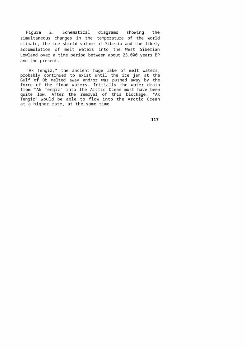
P.KAYA/AK TENGIZ ________________________________________________________________ 35 _
peoples. The Irtish river was a sacred river in the mythologies of Turks and Kimeks. As known, the Kem and Yenisey rivers were the oldest known homelands of Kirgiz Turks. We encounter most of the oldest inscriptions written in Gok Turk runic writings in this area which was the land where the Turks seemed to have acquired their Turkishness and where they developed the most. The culture and beliefs found in the lands about the Kem river are among the oldest and most purely preserved important cultural heritage of Turks. According to those Kirgiz Turks who live in this area, "a mythological and sacred ruler named Kirgiz-Khan was the wealthiest and the most powerful ruler in the lands that the Kem and Yenisey rivers traversed." [Highlighting is mine].
It is interesting that the river Irtish should be considered as 'sacred' by the Kimek, Kipchak and Kirgiz Turks so much so that people almost worshipped it. As we noted in the formation of Ak Tengiz, the rivers Ob and Irtish are the ones that would principally flood the West Siberian Lowland to make it a lake. Such a horrendous activity by the Irtish river would make itself a very respected waterbody in the eyes of the local people.
f) For Yakuts and other Turks, the rivers Lena and Yenisey were great rivers thatcrossed the continent from one end to the other. For this reason, Yakuts and otherTurks thought that the sources of these rivers were the beginning of earth and theplace where they emptied into the sea was the end of the Earth. According toSiberian mythologies, the sources of these rivers were in heaven. In other words,these rivers were sacred rivers whose waters were coming from heaven, and afterflowing for some time on earth were emptying into a sea that disappeared into theneter world." This belief was a motif that was predominant in all Central Asianmythologies."
The Yenisey river would constitute the eastern shores of ancient Ak Tengiz and therefore be part of the Ak Tengiz environment. Thus it is reasonable that the Yenisey river also be considered as 'sacred' by many Turks. In addition to its association with the Ak Tengiz area, the rivers Yenisey and Lena were receiving their headwaters from the lofty peaks of Altai and Sayan mountains. To Central Asians, mountains are sacred places where the earth meets the 'heaven', that is, the sky where the Sky God Tengri dwells. The top of the Turkic 'cosmic mountain' is where Tengri sits on his golden throne which is accessible only by a three-stepped silver stairway.47 Therefore any river that gets its waters from places that are associated with 'sky god Tengri' is bound to be sacred. Hence, the rivers Irtish, Yenisey, Ob and Lena are sacred rivers to probably all Central Asians. That is probably why Central Asians respect and give reverence to all waters and why there was a Yer-Suv (earth-water) cult among Central Asian Turks during ancient times and even now.
g) "We also find Water and River gods in the pantheon of Altaians. In the Altaicshamanism, there are two gods whose names are Talay and Yayik-Khan both ofwhich were waters related gods. Naturally these were minor deities who workedunder the Great God Bay-Vlgen and helped him: "Talay Khan, as it is understoodfrom its name, was the god of a sea and the flood waters. His house was at theintersection of 17 seas. On the other hand, the Yayik-Khan was the ruler of all the
Idem, p. 291, the mythology of Yakut Turks.
36 ________________________________________ TÜRK DÜNYASI ARAŞTIRMALARI
waters on earth." As it is known, Turks used to call the Ural River by the name Yayik." [Highlighting is mine].
Again it is interesting that we should have a deity named Talay Khan who was the god of a sea and the flood waters. Implied in this mythology is the presence of a sea and the flood waters for which the local people had to assign a 'god' who perhaps created the floods and then managed them. One wonders whether the Talay Khan was the "god of Ak Tengiz."
h) "In the mythological stories of Turkish peoples in southern Siberia, the 'blue' (gok in Turkish) color had an important place. According to them, there was an endless blue-sea where the land ended. Its name was Kok-Tengiz (Blue-Sea). Similarly, the names of the mythological rulers, such as 'Kok-Katay, Kok-Han mentioned in these stories, were also described by the word "Kb'k" (blue) in them." [Highlighting is mine].
In this entry from Bahaeddin Ogel, one wonders about 'the endless blue sea Kok-Tengiz' mentioned in the mythological stories of the south Siberian Turks. Was it the "Arctic Ocean" that exists presently to the north of Siberia or the "Ak Tengiz" the presence of which I have deduced from the Ice Age ice conditions in Central Asia?
The reference to the "southern Siberian Turkish peoples" in the above given mythological stories implies people living in the lands extending over the lands of present Kazakistan and the Altai mountains to the east. We should note that the West Siberian Lowland, where the Ak Tengiz would have formed, is immediately north of these lands. Hence, it is highly likely that these mythological stories referred to "Ak Tengiz" rather than the "Arctic Ocean". Ak Tengiz, being a melt-waters lake which included a lot of ice in its waters and also a continuous sheath of Ice Age ice on its floor, would sometimes appear "blue" and some other times "milky white" to people around it. Such an appearance would change depending on the environmental conditions of the lake and its surroundings at any time. Additionally, there would be islands of ice in Ak Tengiz giving the appearance of "Milky White" Mountain or mountains, because there would be no vegetation on them.
In view of so many mythological stories of Central Asiatic Turkish peoples (items a to h above) that make reference to some kind of a large water body in them, one can safely conclude that there indeed was a sea-size lake in the area. It could very well be the Ak Tengiz. The following additional mythological stories from other peoples also point to the existence of such a lake.
8.7 Creation Stories of Some Native Americans With a Lake Motif
Since ancestors of the Native Americans were migrants from Central Asia, and since their mythologies also refer to floods, they are probably referring to the formation of Ak Tengiz - which could have been one of the reasons that caused them to migrate from their original homelands in Central Asia. In this respect, here is one creation story regarding the origins of the Pueblo people of North America. Authors Alfonso Ortis and Felipe Davalos write the following in the National Geographic:48
Alfonso Ortis and Felipe Davalos, "Origins Through TEWA Eyes", National Geographic, vol. 180, No. 4, October 1991, p. 6-13.
132

P.KAYA/AKTENGJZ ________________________________________________________________ 37_
"The distance from Colorado's San Luise Valley to the modern Tewa49 Puebloes along the Rio Grande in New Mexico is but a hundred miles, yet it is also a journey of 12,000 years or more through North America's human history.
This lofty valley is closed in the Great Sand Dunes National Monument. Floored with an ocean of shrubs, sparse grass, barley fields, and small lakes, and ringed by snowcapped peaks, it is a cradle of the Pueblo peoples, particularly the Tewa, whose origin myth refers to a "Sandy Place Lake far to the north". It also was haven to some of the earliest big-game hunters known in the New World.
The story of these hunters begins in an Ice Age America unrecognizable today. Climatic forces in the Pleistocene had buried the northern half of the continent under sheets of ice more than a mile thick. They held so much water that the oceans dropped some 300 feet, exposing the seafloor that links Siberia and Alaska. With little precipitation in this corner of the Arctic, no great buildup of ice blocked the way eastward."
"At the beginning of all beginnings our ancestors came up out of the earth, until they were living beneath Sandy Place Lake to the north. The world under the lake was like this one, but dark. Spirits, people, and animals lived together; death was unknown.
Among the spirits were the first mothers of the Tewa, known as Blue Corn Woman Near to Summer antl White Corn Maiden Near to Ice. These mothers asked one of the men present to go forth and explore the way by which the people might leave the lake.
After many adventures and struggles he returned to the people, announcing his arrival with the call of a fox. He came now as Mountain Lion or Hunt Chief. The people rejoiced, saying, "We have been accepted".
They left the lake and entered the land."That the Tewa see all life as beginning within the earth, like corn plant carefree,
innocent state of early childhood to the status of adult, one of the Dry Food People. For four days the boys are made to carry a load of firewood they have chopped themselves, and girls a basket of cornmeal they have ground themselves, to the homes of their sponsors.
"in the beginning we were one. Then we divided into Summer People and Winter People; in the end we came together again as we are today." (The bold effects in above text are mine).
In this Pueblo story, we notice that they refer to a "Sandy Place Lake far"to the north" from where their ancestors came. Could it be that they are referring to "Ak Tengiz" in this story? It is strikingly important to note that there is a Turkish people called Tuva in the Altai Mountains region of Central Asia to which Ak Tengiz would have been very near. Are the Tewa people and Tuva people the same people or is the similarity of these names due to a coincidence?
8.8 Beliefs of Maya People Regarding Cosmos
The Pre-Columbian Americans believed that the universe encompassed the sky, earth and underworld. Each saw the celestial bodies as living beings that influenced humans and could be affected by them. These beliefs are also the
The name Tewa sounds very much the name Tuva in the Altai region of Central Asia. The culture of Pueblo peoples in North America resemble in many ways to that of Central Asia.
133

38 ________________________________________ TÜRK DÜNYASI ARAŞTIRMALARI
Central Asiatic beliefs that were probably carried to the new world by the immigrant Central Asians.
The Popol-Vuh, the sacred book of Maya, relates creation story in which the first beings are destroyed by a flood. The Feathered Serpent was not happy with his creation, so he cleared the earth from his creation by sending a great flood.50
John B. Carleson and Bob Sacha in their article51 give us an idea regarding the beliefs of Maya people. In one illustration, the Maya universe is shown centered on a tiered pyramid, rested on a crocodilian in a cosmic sea. Each quarter of the earth was associated with a color (red for east, black for west, yellow for south and white for north; in the same way, the Inca and Navajo peoples also used the same colors with the four cardinal directions. Similarly, the Turkic colors are: red for east, blue for west, yellow or white for south and black for north); the center was a fifth direction (similarly, the fifth direction for Turkic peoples was straight up, that is, the direction of an invisible "sky pole" [Temürkazuk or Altunkazuk in Turkish] that holds the sky up). In the Maya world, four divine beings held up the dome of heaven, shown as a two-headed dragon whose body is a sky band of celestial symbols. Water is pouring out of the mouths of the two-headed dragon onto the earth. Could it be that the two-headed dragon represents the Ob and Irtish Rivers combined to make the Ob in northern lands of West Siberian Lowland? As the melting of the Ice Age ice shield started some 20,000 years BP, the ice blocked Ob and Irtish rivers, like two mouths of a dragons, would pour out flood waters that would take over the land.
8.9 Yoruba Creation and Flood Story
The Yoruba people are African people living mostly in the southwestern corner of Nigeria.52 Their creation story, as given by P. J. Criss,53 follows:
In the beginning was only the sky above, water and marshland below. The chief god Olorun [Ulu Er An = Ulu Gok Eri in Turkish] ruled the sky, and the goddess Olokun [Ulu kün = gün, günesh in Turkish] ruled what was below. Obatala [probably originally Ob Ata Ulu], another god, reflected upon this situation, then went to Olorun for permission to create dry land for all kinds of living creatures to inhabit. He was given permission, so he sought advice from Orunmila [probably Er An Bala which would have a meaning in Turkish of: 'Son ofEr An' ], oldest son of Olorun and the god of prophecy. He was told he would need a gold chain long enough to reach below, a snail's shell filled with sand, a white hen, a black cat, and a palm nut, all of which he was to carry in a bag. All the gods contributed what gold they had, and Orunmila supplied the articles for the bag. When all was ready, Obatala hung the chain from a corner of the sky, placed the bag over his shoulder, and started the downward climb. When he reached the end of the chain he saw he still had some distance to go. From above he heard Orunmila instruct him to pour the sand from the snail's shell, and to immediately release the white hen. He did as
"Maya Flood Myth" by P. J. Criss in his Internet home page: http://www.cyhercomm.net/~grandpa/creation.html
John B. Carlson and Bob Sacha (Photographs), "America's Ancient Skywatchers", National Geographic, Vol. 177. No.3, March 1990, p. 81-83. 52 Encyclopaedia Britannica, 1963, Vol. 23, p. 901-902. P. J. Criss's Internet home page.
134

P.KAYA/AK TENGIZ ________________________________________________________________ 3 9_
he was told, whereupon the hen landing on the sand began scratching and scattering it about. Wherever the sand landed it formed dry land, the bigger piles becoming hills and the smaller piles valleys. Obatala jumped to a hill and named the place Ife, The dry land now extended as far as he could see. He dug a hole, planted the palm nut, and saw it grow to maturity in a flash. The mature palm tree dropped more palm nuts on the ground, each of which grew immediately to maturity and repeated the process. Obatala settled down with the cat for company. Many months passed, and he grew bored with his routine. He decided to create beings like himself to keep him company. He dug into the sand and soon found clay with which to mold figures like himself and started on his task, but he soon grew tired and decided to take a break. He made wine from a nearby palm tree, and drank bowl after bowl. Not realizing he was drunk, Obatala returned to his task of fashioning the new beings; because of his condition he fashioned many imperfect figures. Without realizing this, he called out to Olorun to breathe life into his creatures. The next day he realized what he had done and swore never to drink again, and to take care of those who were deformed, thus becoming Protector of the Deformed. The new people built huts as Obatala had done and soon Ife prospered and became a city. All the other gods were happy with what Obatala had done, and visited the land often, except for Olokun, the ruler of all below the sky. She had not been consulted by Obatala and grew angry that he had usurped so much of her kingdom. When Obatala returned to his home in the sky for a visit, Olokun summoned the great waves of her vast oceans and sent them surging across the land. Wave after wave she unleashed, until much of the land was underwater and many of the people were drowned. Those that had fled to the highest land beseeched the god Eshu who had been visiting, to return to the sky and report what was happening to.them. Eshu demanded sacrifice be made to Obatala and himself before he would deliver the message. The people sacrificed some goats, and Eshu returned to the sky. When Orunmila heard the news he climbed down the golden chain to the earth, and cast many spells which caused the flood waters to retreat and the dry land to reappear. So ended the great flood.
[In the above text, comments after names of gods, given within square brackets and highlighting of names and phrases are mine].
In the above story, the names of gods are surprisingly Central Asiatic and in fact Turkic. I have indicated the Turkic version and meaning of the Yoruba god names within brackets. One might question the validity of my remark thinking that when did the Central Asians come here. The connection is not so farfetched when we think that the ancient Saka peoples (Pelasgians) of the Aegean Sea area, the ancient Egyptians, the Etruscans, the Carthaginians and the People of the Sea were all in contact with this part of north Africa. 54 If the Central Asian God names reached this part of the world, the flood story could have done so as well. It is very curious that they have the god name Obatala in
Joseph Campbell, "Historical Atlas of World Mythology, Vol. T: The Way of the Animal Powers, Harper & Row, Publishers, New York, 1988, p. 87: Photo of rock paintings from Wadi Djerat, Tassil (Great Sahara) shows Pelasgian writings written on the rocks. These writings present many common aspects with the Gök Türk Runic writing system. These are unquestionable traces of Central Asians in the deserts of North Africa. Campbell states that this Libyan alphabet derived from the Punic (Carthaginians) cursive script is still used by Tuaregs. The name Tuareg seems to be related to the name Turg/Turk.
135

40 ________________________________________ TÜRK DÜNYASI ARAŞTIRMALARI
the above story. The name Obatala looks suspiciously like Ob Ata Ulu in Turkish meaning Great Ob Father. We should also note that in ancient Turkish beliefs, the Turkic Sky God Tengri is a "Fcither"(Ata) figure for all Central Asians. Obatala (Ob Ata Ulu), as the name indicates, also has a similar "father" figure role in the above story. If these identifications are correct, then we are face to face with a god name that bears the word OB which is the name of the Ob River that was the main contributor to the formation of Ak Tengiz in this essay. The above story particularly says: Olokun [Ulu Kün = Sun God] summoned the great waves of her vast oceans and sent them surging across the land. Wave after wave she unleashed, until much of the land was underwater and many of the people were drowned. This sounds very much like the formation of Ak Tengiz. As explained in this paper, when the global warming started to take place at the tail end of the Ice Age, ice started to melt and waters from many rivers, including the Ob River, rushed, wave after wave, into the West Siberian Lowland, but had nowhere to go except to form a lake. Are all of these affinities coincidence?
8.10 Norse Creation Story
P. J. Criss also gives a Norse creation story which follows:55
At first there was only a great void, Ginnungagap. Eventually a region of mist and ice, Niflheim, was formed in the North and a region of fire, Muspellsheim, was formed in the South. The great world-tree, Yggdrasil, reached through all time and space, but was perpetually under attack from Nidhogg, the evil serpent. The fountain of Mimir, source of hidden wisdom, lay under a root of the tree. Niflheim came into contact with Muspellsheim, and the fires melted the ice, which yielded Ymir, the Frost-Giant with a human form. From Ymir's sweat came a race of Giants, so that a huge cow (Audhumla) [ut/ud in ancient Turkish is Ox and cattle and "diiye" means cow; thus 'udumla' would probably mean 'my cow' or 'with my cow'] was created to feed them. One day the cow licked the ice and hair emerged, on the next day a head, and on the third day Buri [this name reminds us of the ancient Turkic word Bori meaning 'wolf which has prominent position in Turkish creation stories] emerged, fully formed. Buri begot a son, Bur [possibly corresponding to Bir in Turkish], who in turn had three sons: Odin [Odan/Otan = gok Odu/ateshi - kiln in Turkish meaning the Sky fire, that is the Sun], Vili [this name also reminds us of the Turkic Yel, the Sumerian Enlil, the Semitic El, The Greek Aeol as the name of the wind god], and Ve [this name reminds us of the Turkic name ava/hava meaning air]. These three were a new race, not Giants but gods. They banded together and murdered Ymir. Most of the other Giants drowned in Ymir's blood, which created a great sea. From Ymir's body the three gods made solid land, the earth, and from his skull they made the heavens. They then created a race of dwarves from the maggots that fed upon Ymir's body. This was followed by the creation of the first man and the first woman. They shaped the man from an ash tree and the woman from a vine.
a) In this story, we initially have the "mist and ice" in the North and a region of fire in the south. The ice comes into contact with fire which in turn melts the ice. and through some complex processes, a great sea is formed. Most of the Giants
P. J. Criss's Internet home page.
136

P.KAYA/AK TENGIZ ________________________________________________________________ 41_
drowned in this great sea. In Greek mythological stories, we also encounter giants and Cyclopes who are banished into "Tartarus" which was nothing but the lands of Tartars, i.e., the Tatar Turks of Central Asia. The very fact that the Nordic god names Odin, Vili and Ve can be identified with Turkic Odan, Yel/yeli and Hava respectively, suggests that these god names and the related story came from Central Asia. Additionally, in the Norse (Teutonic) mythology,56 Odin had a son named Tyr/Tur who was the war-god.57 Again, we have here the word Tyr/Tur which in fact represents the Turkic speaking Turanian peoples who are known to be the warriors of the past.
b) The very fact that there are thousands of megaliths all throughout theScandinavian countries and the rest of Europe, same as the ones that we find inCentral Asia such as the Altai, Hakaseli and others, again suggests that CentralAsians were every where in Europe before the forefathers of the present dayIndo-European speaking populations moved into Europe. The Turkic presencein Europe is also evidenced by one of the Runic inscriptions found on one suchstones. Namely the one from Klyver farm in Stanga (Gotland), Sweden. Theinscription has been read recently by the Turkish researcher Turgay Kiiriim 58
and the text of the inscription has been found to be in an ancient Turkishlanguage.
c) We should also note that even the name of Europe is a Turkic toponym whichcomes from the Turkic name Huru Apa59 (Huri Apa, Huri Abla in present dayTurkish dialects) meaning Elder sister Hum. The name huru (huri) as a Turkic namefor girls means a nymph-like (girl) or beautiful like a nymph. Even at present,thousands of girls all over the Turkish world use the Turkish name Huru. Accordingto Greek mythologies, Europa (Huru Apa) was a Sidonian princess who wasabducted by Zeus60 from Sidon to the island of Crete.61 The King Agenor of Sidon(Aga Nur in Turkish meaning Lord Light) was her father. Sidon (Sayda in Turkish)was a city of Phoenicians (the name Phoenicia seems to be a Greek, manufacturedname for this seafaring Turanian people whose real name was Khanan (Khanlar) or
The word Teotonic comes from the word Teuton. In Western sources, the word represents one of the ancient German tribes. The Webster's Collegiate Dictionary states that: it is uncertain whether they were Teutonic (meaning the tall, blond Germanic race) or Celtic. It seems that the word Teoton is a variation of the Turkish composite word Ata ata an (Tatan/Titan), i.e., Dedeler or Gok Atalaıi in Turkish meaning "Grandfathers" or "Sky Grandfathers" as I have also explained below under the Greek mythology. 57 Webster's Collegiate Dictionary, 1947, p. 1084.58
Turgay Kurüm, "Mystery of The Futhark Alphabet", see internethomepage: htlp://www.anialyaonline/fulhark
59 "Karsilastirmali Turk Lehceleri Sozlügii", Vol. I, Kültür Bakanligi Kaynak Eserler / 54, Ankara, 1991, P-2.
Even the name Zeus is Turkic in origin. Zeus is the Hellenic version of the the ancient Turkic phrase As Ayas, written by Turanian Saka peoples of Aegean Sea Islands, Western Anatolia and Balkans (Greeks called them Pelasgians) as SAIS (Polat Kaya, "A Study of the Lemnos Island Inscription"). SAIS is 'Eşsiz Işık' in Turkish meaning Peerless Light, referring to the Sun. The Sun, expressed by Turkic sayings: Ak Ayas, As Ayas, Giik Od/Ot, Otan/Odan, Gok ateshi, was another attribute of the Turkic Sky God Tengri (see "Shamanism Archaic Techniques of Ecstasy" by Mircea Eliade, Princeton University Press, 1964, p. 9). Zeus is known to be "Day Light" in Greek mythology. 61 Encyclopaedia Britannica, 1963, Vol. 8, p. 835.
137
42 ________________________________________ TÜRK DÜNYASI ARAŞTIRMALARI
Khano62 (Khan Oyluler). They were also known by the name Tyrians (Turians) because of the name of their city Tyre (Tur ev/oy) meaning the house of Turs or Turanians.
Thus, we have many reasons to believe that the Nordic god names given in the above story were also Turkic in origin.
Finally, we see that there are many so-called mythological stories of peoples distributed far and wide from Central Asia, yet they all seem to remember a sea and/or a flood event that are common to all of them. I believe that sea/flood is what I have called "Ak Tengiz" in this paper.
9. LIFE STYLES OF PEOPLES IN CENTRAL ASIA
9.1 Pastoral Lifestyle
Perhaps one should also dwell on the Central Asian lifestyles which, as expected, would have been influenced dramatically during the tail end of the Ice Age by the ice shield, by Ak Tengiz and by other environmental conditions in Central Asia.
During the ice Age, the human population of Central Asia, which depended on its plant and animal life, must have already conditioned to the harsh climate there. As the environmental conditions improved by the warming climate after about 20,000 years BP, it probably made some southern areas of the land conducive to sedentary as well as pastoral lifestyles. Thus Central Asians could have carried on not only a pastoralistic lifestyle, but also a sedentary one as well, depending on what part of the land they were living in.
Initially people of Central Asia must have been so-called "hunter-gatherers" as was the case everywhere else in the world. As the new steppe lands were gained from the receding ice shield, the land provided more plant and animal varieties. Additionally, since the melt-waters from the receding ice shield also formed large bodies of water in Central Asia, these waters must have become very rich additional food and livelihood sources for the people. Hence, while hunting was done on the land, fishing would have been done in the lakes of old and new formations. Particularly, the Siberian water bodies, such as Ak Tengiz, would have attracted large numbers of migratory birds to the area, thus making them available for hunting as well. For instance, a cache of artifacts found in an area so-called "Malta" near Lake Baikal which are dated 15,000 years old, contain ivory-carved figurines of five geese.63 This is an indication of how much the local people were involved with the migratory water birds such as geese, swans, cranes and others in the area as early as 15,000 years ago.
Probably one of the earliest domesticated animals was the dog which helped humans in hunting and later on in domesticating other animals for further use by the Central Asians. The domesticated dog accompanied the Central Asians in their migrations to North America as their helpers. Sheep, cattle and horses (in that order) must have been domesticated by Central Asians probably by 8,000 years BP. Another domesticated wildlife must have been the "bee". The Central Asian steppes, with plenty of wild flowers and lush green land, must have been an ideal place for
62 Encyclopaedia Britannica, 1963, Vol.17, p. 764.' John J. Putman (text), Sisse Brimberg and Ira Block (Photographs) and Jack Unruh (paintings), "The Search For Modern Humans", National Geographic, Vol. 174, No. 4, October 1988, p. 472.
138

P.KAYA/AK TENGIZ ________________________________________________________________ 43_
"bee" farming - in those ancient times and now. This is evident from the fact that all Turkic peoples have been involved in bee farming and honey and wax production throughout the Eurasian steppes. This must be the reason why they gave the toponym Balkan to eastern European lands. The Turkish word Balkan means "place with honey" or "place where honey is produced".
Probably after the domestication of these animals, most Central Asians were occupied with animal farming in the open fields all over the steppes of Central Asia. The environmental conditions of the steppes necessitated pastoral and semi-pastoral economic lifestyles. In southern zones where the conditions were supportive of a totally sedentary lifestyle, people would adapt themselves into such a lifestyle although still being supported with animal husbandry. The practice of a pastoral lifestyle did not mean that the sedentary lifestyle did not exist in the area. For example, while some people in a community moved their animals to rejuvenated summer pasture lands (yayla in Turkish) for three to four months at the end of which they would return back to the wintering grounds (kishlak in Turkish), others stayed in the village area throughout the year tending activities related to sedentary lifestyles.
Those who went to the higher grounds, the "yayla," enjoyed all the benefits of the land both for themselves and for their animals. The yayla provided fresh grazing grounds for their animals and fresh mountain spring waters and naturally air-conditioned air for the people. Additionally, they manufactured plenty of milk and meat products from their animals during the months they stayed on the higher grounds. Those members of the community who remained in the villages attended agrarian types of activities such as growing and harvesting barley, millet, etc. in the fields and bee keeping as well. During winters, the whole village community would gather back in the winter grounds (kishlak ) where there would be immobile houses as well as mobile 'yurts' and where conditions were more suitable for winter living. This was a life style that harmonized the people with their environment and maximized the man-nature interrelationship into a peaceful co-existence.
Pastoral mobility in those days was a lifestyle and economic adaptation that enabled people to manage and maximize the benefits from the natural resources that the Central Asian steppes provided - such as land, animals, grass and agriculture -without destroying the environment. This life philosophy has been embedded in the beliefs of all Central Asians, irrespective of whether they are still living in Central Asia, the American continents or in other parts of the world. This lifestyle is contrary to the beliefs of those who practice some other economic styles in which the exploitation, destruction and disrespect of nature and everything in it has been the main philosophy.
Unfortunately, western historians, due to their own prejudiced judgments, have very conveniently labeled the Central Asians as "nomad". Although there is nothing wrong with being pastoral, implied in this "nomad" label is the hidden pejorative meaning that Central Asians are "aimlessly wandering people" or "vagabonds" or "eccentric" or "unsettled", etc., as defined in dictionaries, and are not capable of doing anything but herding animals. Such a racist and prejudiced starting point, obviously intended as misleading propaganda against the Central Asians, unfairly prevents Central Asians from being recognized as very important contributors to world civilization.
139
44 ________________________________________ TÜRK DÜNYASI ARAŞTIRMALARI
Intentionally designed terminology, such as "nomad", create superficial comparison environments where people are stereotyped and set against one another, one being 'sedentary' the other 'nomad', one being 'civilized' the other 'barbarian', one being the 'producer of food' in the fields, the other 'hunters and gatherers', one being "creative and skillful" the other "copier and not creative", and so on. As can be seen, such artificial definitions, rather than being scientific, have a lot of ill will and political motivations behind them and are intended to create an artificially cleansed image for the creators of such terms.
The following mythological story, although it is Pelasgian in origin, is attributed to ancient Greeks. This story is from P. J. Criss's internet home page:64
Eurynome,65 the goddess of all creation, arose from Chaos66 and separated the sea from the sky. Then, dancing naked upon the waves, she created the wind and rubbed it in her hands to create the serpent Ophion,61 who made love to her.
64P. J. Criss's Internet home page address is:
http://www.cybercomm.net/-grandpa/creation.htmlEurynome is a composite word made up with Turkish root words. It consists of: a) Eury
(=Huru/Huri in Turkish; this Turkish word is mistakenly attributed to Persian language. Yet it is a Turkic language word that have passed to both Greek and Persian languages. Even the name Hera of the Greek goddess, wife of Zeus, is related to this Turkish word which is a feminized version of the Turkish word ER that appears in the name of Turkish Sky God Tengri (=Ata Eng/An Eri = Ata Gok Eri) meaning Father Sky Man). Thus, Eury (Huru/Huri) means "goddess , goddess like beautiful being." b) N (=ana in Turkish) meaning mother, c) orae (=m/im/im, a Turkish language suffix indicating possessive case, meaning 'mine1. Thus, the so-called Greek word Eurynome is a Hellenic version of the Turkish saying: "Hum Anam" meaning "My beautiful Goddess mother". Thus, the word Eurynome perceived as a Greek word, actually is a composite Turkish phrase.
The so-called Greek word Chaos represents an empty void that had no definite shape at the beginning of universe. The word Chans is made up of Cha + O plus the Greek Hellenizing suffix -s. Cha is the Turkish word Uca (Yiice) meaning 'high1. The second root word O is the ancient form of Turkish Oy meaning house. Thus, the composite word Chao means Uca Oy in Turkish meaning high house. Of course the Uca Oy is nothing but the Sky dome since the word Uca in Turkish also refers to sky because of its height. In the present day Turkish, the word Uzay, meaning the infinite space around us, also comes from the phrase Uca Oy (most likely it was transformed to Ucay and then to Uzay in time). Hence, the word Chaos perceived as a Greek word is also a composite Turkish word. 17 The Greek word Ophion is made up of Ophio and n root words. The root word Ophio means "serpent" or "related to serpent" in Greek (Britannica World Language Dictionary, 1963 edition, p. 885); however, I believe it is the Hellenic version of the Turkish word Afa/Hafa or Hava meaning the air, the atmosphere surrounding (like a serpent) the globe of earth, as indicated in the above story. The word n stands for the Turkish word Ana meaning mother. Thus the composite word Ophion is nothing but the Turkish saying of Hava Ana meaning the "mother air"; however, it has gone through gender and meaning transformations in Greek mind as indicated in this mythologic story, that is, it has become a male seipent making love to Euryomc (Hum Anam).
At this point, we should perhaps remember the creation story involving the Adam (Atom) and Eve (Ava/Hava Ana), perceived to be from the Middle East. In this story, Adam (Atam) has the father role and Eve (Hava Anam) has the mother role. It is clear that both of these words are Turkic. Additionally, in Turkic mythological beliefs, it is also believed that the 'Father" (Ata) of Turks were from "Sky". Thus, the Turkic "ata" and "sky" (ata an/tan as in Tengri) must have some common relation in Turkic mythological beliefs. I noted above in discussing the make up of the word Chaos that it was Uca Oy in Turkish. But Uca Oy also has another form in Turkish which is 0 Dam (0 Oy) meaning "Thai House" referring to the sky dome. It is natural to expect the word "O Dam" (That House) be transformed into "Adam" in time and also be considered as Atam meaning "my father". Thus, it is clear that both the "Greek Creation story" and the "Middle East Creation story" are Turkic in origin. Only in the so-called Greek version, the sky dome is portrayed in \\i&" mother" role and the air around the earth is portrayed as serpent and in the father role. Yet, in the Middle East version. Sky is in the Father role and the air (hava/ava/eve) is in the mother role. These are slight transformations between the two versions.
140

P.KAYA/AK TENGIZ ________________________________________________________________ 45_
Pregnant, Eurynome laid the World Egg, and Ophion coiled around it and hatched it. This egg brought forth the cosmos and everything in it. Eurynome and Ophion settled on Mount Olympus™ and here, soon, Ophion was proclaiming himself creator. Eurynome, angry, banished him to the netherworld. Then she established the seven planets, each with a Titan69 and Titan?ss1{) to rule it. When man appeared, he sprang from the soil, and the first man, Pelasgus,11 taught the others to eat acorns, build huts, and make clothes.
Although the story has some mythological color to it, but it also has factual data in it. The names in it are identifiable Turkish words although they are Hellenized, and the name Pelasaka is a fact. Additionally, the creation part of the story presents the legitimate and ancient beliefs of the people at that time, although the picture presented by them does not exactly fit into the modern man's "Big Bang" universe. Nevertheless, they have tried to answer in their own way some of the mysteries of the world around them. Therefore it is an ancient view of the creation.
As I have explained in the footnotes, the story has a definite Turkish connection which is evidenced by the fact that the names of most of the characters in the story are Turkish except that they have been Hellenized. What seems to have taken place is that, essentially, a number of Turkic words relevant to the subject are put side by side and then read as one Hellenic word. One wonders why the names are Turkish while the story is considered Greek? Could it be that the original stories also belonged to the Central Asians? If the stories belonged to Greek culture and language originally, one would expect the names
The Greek word Olympus is made up of the following root words:Olym + P +us the last one of which is the Hellenizing suffix. The remaining two words are the versions of Turkish words Olüm meaning "dead, death" corresponding to Olym and apa meaning the old fathers', 'the ancestors' represented by P. Thus the Turkic word dlum/dlmus apa (Olymp) means dead fathers. Hence, the Mount Olymp-us would mean "The mountain of Dead Fathers." Actually, that is exactly what the Mount Olympus was in Greek mythological stories. However, the name is a composite word made up Turkish root words. Additionally, there is another similar word in the form of Olympia which again would mean "The house of dead fathers" which derives from Turkic Olüm apa
The Greek word Titan is in reality a composite Turkish word and is made up of the following root words: Titan = Tita + an where the suffix an is the ancient Turkish plurality suffix corresponding to the present day ler/lar suffix. An also means Sky in Turkish. The first root word Tit/Tita is a shorthened and deformed form of Turkish Ataata meaning grandfather. Ataata becomes Tata/Tita./Tete in time, meaning Dede in present day Turkish. Thus The word Titan is nothing but the Turkish Ataatalar or Dedeler. From the ancient mythology, it is quite clear that Titans are nothing but the Turkish Tatan or Dedeler. Thus the Titan is also a composite word made up Turkish root words. The second meaning of Titan in Turkish would be the Sky Fathers, that is, Gök Ataları.
The word Titaness is the femininized version of Titan.The word Pelasgus is the Hellenic name for the ancient Central Asiatic Turkic (Turanic) speaking
peoples who lived not only in Central Asia but all over Europe, Middle East and the Mediterranean belt during ancient times. The Greek word "Pelasgus" stands for "Pcla Saka" which means"Honey Producing Saka" (Bal Üreten Saka" in Turkish). Historical evidences indicate that the so-called Minoans, the Troyans, Trachians, Tuscies, Scythians, Sarmatians, Etruscans, and the People of the Sea were all branches of Central Asians whom ancient Greeks called Pelasagus. Additionally, the so-called Phoenicians (Khanoyluler in Turkish), Chartaginians, i.e., Tyrians, the ruling people of the Hittites, the Ruling people of Egypt, that is, the Pharoahs (Pero in ancient Egyptian hieroglyphs) and Sumerians, Turukkans (another name related to the name of Turk), Hurrians, Urartuans and Kassites were all Turkic speaking Central Asians in origin.
141

46 ________________________________________ TÜRK DÜNYASI ARAŞTIRMALARI
of the characters in the story to also be Greek. Yet they are not. They are pure Turkish. Why would the ancient Greeks use Turkic names in their Greek-culture based stories? I think the answer is that they would not use Turkic names in their Greek stories, unless the stories that they are telling us were originally Turkic stories and the ancient Greeks adopted them without changing the original names of the characters. Evidently in this cultural transaction, the Pelasgians were the givers and the ancient Greeks were the takers.
It is also interesting to note that, the story refers to Pelasgus (the name means Pela Saka - 'Bal Ureten Saka' in Turkish, meaning "Honey Producing Sakas" of Balkans), as the first man sprang from soil, and taught the others to eat acorns, build huts, and make clothes. It is known that Pelasgians were the original inhabitants of the Balkans (the word Balkan is a Turkish toponym given to a vast area in eastern Europe) and the Aegean Sea zone, and they were there probably earlier than the third millennium B.C. When the ancient Greeks came to the Aegean Sea area, they found the Pelasgians already there, as well established, developed and flourishing people. What is suggested by the above given story is that the Pelasgus were the people who were known to the Ancient Greeks as the most ancient people in the area. Hence, they were considered as the first man sprang from the soil. The Pelasgus were Turkic speaking peoples as evidenced from the names of the mythological characters in the story, that is gods, goddesses, Titans, etc., and also from the Pelasgian writing found on the stele from the Lemnos Island.72 Since the Pela Saka (Pelasgus) people were 'hut' (house) builders, 'cloth' makers and 'acorn' eaters and taught this culture to others, evidently, they must have been practicing a sedentary lifestyle that involved all of these activities. For them, the animal husbandry was just another very cleverly organized occupation. We should also note that from their own pottery paintings, the ancient Greeks are not much known for their cloth wearing habits. Implied in this is the meaning that they probably came to the Aegean Sea area from a place where the climate was warm, hence not requiring clothing. On the other hand, it is historically a known fact that Central Asian Turkic peoples were the first inventors of trousers, shirt and other clothing. This is normal and expected of them, because they were the horse riding children of bitterly cold Central Asian climate. Obviously, one cannot ride a fast running horse in that Arctic cold wind (Yel/Cel/el in Turkish) of Central Asia without clothing; neither one can survive that cold in the nude too long even one is not riding a horse.
9.2 Sedentary Life In Central Asia
During the time when "Ak Tengiz" had a very prominent effect on the ecology of Central Asia, many lakes in the region such as Lake Baikal, Issik gol, Lake Balkash, "Tarim Lake" and others attracted sedentary life to their surrounding areas. Archaeological findings in Kirgizistan, Kazakistan, Mogolistan, Tarim Basin and many other places in Central Asia indicate the
72Polat Kaya, "A Study of the Lemnos Island Inscriptions (A preliminary report)", Ottawa, 1997,
also on internet:http://www.compmore.net/~tntr/lemstelea.html
142

P.KAYA/AK TENGIZ ___________________________________________________________________________________47_
presence of many small and large dwellings all along the peripheries of the lakes and along the river beds.
Villages having protection ditches fortified with some kind of walls around them, have been found around the Lake Baikal area.73 The valleys between mountains, such as the Altai Mountains, Tengri Mountains, the Sayan range, the Kunlun range, the Pamirs, etc., were the most attractive zones for both the agricultural and pastoral lifestyles. Of course land masses along many large and small rivers distributed all over Central Asia and Siberia also provided excellent settlement areas. For example the architectural ruins of Cargelan (Cargelan Kalasi), Cungal, Caldivar, Atbash Kalasi, Manakeldi Kalasi and many others that have been lightly termed as "castles" were probably ancient Sky Tengri temples having ziggurat like forms.74 Victor Ivanovieh Sarianidi reports: "After 40 years of fieldwork he has established that Central Asians built cities around oases starting about 2000 B.C. and developed a flourishing civilization with monumental architecture, sophisticated gold and silver crafty &hd irrigation agriculture."15 In reality, the dates of such ancient cities in Central Asia may be much older than the ones cited by Victor Sarianidi. Evidently, such sedentary settlements must have been abandoned by Central Asians only after the desertification of Central Asia started.
All parts of Central Asia have not been fully explored yet. It still waits for extensive investigation in order to find out what went on in this part of the world during the last 20,000 years. All parts of Central Asia are waiting for full study and exposure of their past in an unbiased manner. If done so, these parts of the world will eventually be recognized as one of the most important cradles, if not the foremost, of human civilization. Many parts of the world, particularly the Mediterranean Belt, Europe, the Middle East, China and the American continents were all influenced by the culture developed here thousands of years ago and carried off to far away lands through migrations. A map showing migrations from Central Asia is given by Necati Giiroglu.76
The land along the periphery of the ancient "Tarim Lake", which is a mostly sand filled basin now, was one area where the ancient sedentary life flourished the most. The Tarim Basin and the Gobi Desert areas had their northern and southern peripheries against the slopes of high mountain systems such as the Tengri Mountains, Altun and Kunlun Mountains in the case of Tarim Basin, and the Altai and Sayan Mountain systems in the case of the Gobi Desert. During the Ice Age, these Central Asiatic geographic zones, in addition to being hospitable to plant and animal life, also provided comfortable sheltering areas against the northern winds. Many sedentary settlements seem to have flourished at the slopes of these mountain systems for thousands of years before they were abandoned as a result of the oncoming desertification.
73 Prof. Bahaeddin Ogel, "Türk Kültiir Tarihi", Türk Tarih Kurumu, Ankara, 1991, p. 139.74 Prof. Bahaeddin Ogel, "Türk Kültür Tarihi", p. 173-179.
Victor Ivanovieh Sariandi, inside back cover, "On Assignment" section, National Geographic, Vol. 177, No. 3, March 1990. Also see another article by the same author in the same journal entitled, "The Golden Horde of Bactria", p. 50-75.7 6 Necati Guroglu, "Türk Tarihi ile ilgili Bilinmeyen Yabancı Kaynaklar", Turk Dünyası Tarih Dergisi, Mayrs 1999, Sayi 149 , s. 7.
143

48 ________________________________________ TÜRK DÜNYASI ARAŞTIRMALARI
Such areas of Central Asia must have been, for a long time, the homelands for advanced civilizations by Central Asians. In the Tarim Basin alone, some known but unstudied examples are Kizil, Kumtura, Luntai, Bazaklik (Bezeklik), KTruran (Lulan in Chinese), Miran, Dandan Oluk, Niya, etc.,77 and other ancient places in Turkmenistan, Kirgizistan and other places in Central Asia.
Recent Archaeological findings point to highly developed civilizations in Central Asia. Some researchers looking for possible remnants of Western-culture in Central Asia have brought to surface indications of some ancient sedentary and totally Central Asiatic cultures. For example the three temples found at Ayhanim, northern Afganistan, mentioned by Paul Bernard78 and the Turkish Temples of Heaven described by Emel Esin79 are evidences of such continued sedentary civilization in the area. Of course, we must also mention the pyramids of Eastern Turkistan (Bezeklik in Turpan area in Tarim Basin). These structures are not only very similar to the smaller pyramids found in Egypt and along the pacific coasts of Peru in South America, but also probably are some of the oldest structures in Central Asia. We must note that the pyramidal and kurgan type of burial styles were initially from Central Asia. Figure 3 shows an aerial view of pyramids in the ancient Bezeklik ruins of the Eastern Turkistan (which is presently Xinjiang region of China).80
Figure 3 Pyramids of Turpan Depression (Jiaohe probably Fayonti or Bezeklik in Turkish) as seen from above.
Thomas B. Allen and Photographs by Reza, "Xinjiang", National Geographic, vol. 189, No. 3,March 1996, p. 14-15. 78
Paul Bernard, "An Ancient Greek City in Central Asia', a paper in the Special Issue of ScientificAmerican called "Ancient Cities" 1994, p. 67 and 75.'9 Emel Esin, "Tengrilik, The Turkish Variety of the Temple of Heaven", (or in Turkish: Emel Esin."Tengrilik", Sanat Tarihi Yıllığı, c. XII Istanbul, 1983).an
Geoge Gerster (Photographs) and Larry Kohl (Text), "Above China", National Geographic, Vol. 175. No. 3, March 1989, p. 302-303.
144

P.KAYA/AK TENGIZ ________________________________________________________________ 49_
Almost certainly, some very important remnants of the ancient sedentary civilizations of Central Asia are still buried under the steppes and the sands of the Central Asiatic deserts and are waiting to be discovered. The Turkic peoples, who have been the most prominent original inhabitants of these lands since very ancient times, should carry out their own research and excavations, if necessary, in parallel with the research done by others. After all, what artifacts come out of Central Asia are their own heritage left to them by their ancestors.
At this point, I feel, a word of attention is also in order. It seems that the archaeological activities in the world have been very politicized. What comes out of the ground is used for political promotions of some peoples and for put-down propa-ganda of others. It should not be so. So far, not only have many ancient treasures of the Turkic peoples' ancestral heritage been looted by Europeans and others, but the looters have also attributed the immensely rich and skillfully executed cultural findings to peoples other than Turkic peoples. Some scientific sounding descriptions, yet in actuality subtle misrepresentations, whenever it is applicable, are used in identifying the excavated findings. Thus, public is misled with respect to the ethnicity of the creators of the discovered artworks - even in some respectful publications. There seems to be a lot of euro-centrists at work trying to attach themselves to Turkic peoples' cultural heritage in Central Asia as well as in many other parts of the world. So far, Turks have been extremely silent against such intrusions almost to the degree of naivete. They should collect their self confidence and claim what is rightfully their own ancestral heritage.
There seems to be a racist attitude at work in insinuating that ancient peoples of Central Asia were just "nomads" and not capable of creating such beautifully designed and skillfully created art works unless there was some Indo-European or other non-Central Asian ethnic connection. Of course, nothing can be further from the truth. Such pronouncements must not be considered as serious science, but rather as propaganda. For example, the public descriptions of the ancient Turkic artifacts found in the Pazyryk Kurgans in Altai mountains, the Saka Lady's mummy excavated in the steppes of Altai and the ancient mummies found in the sands of Eastern Turkistan are examples of such verbal maltreatment and misinformation. Trying to attach European hair color and/or Europoid genes to such findings are the result of such euro-centric efforts. Even perpetrating the label of "people of mysterious origin" for the Etruscans, who were actually Turanian people in origin, is also due to euro-centrism. Evidently, such descriptions are aimed at burying the Etruscans even more deeply into the darkness of history than they are at present, just because they were Turanian people. Yet, the Etruscans indicated their Turanian origin by giving the toponym of "Turanian Sea" (known as the Tyrrhenian Sea) to the sea at the west of their country in the hearth of present day Italy. The word Tyrr81 is a variation of Tyr which actually stands for Tur meaning people from Turan. It seems that since ancient times, there has been so much Western "love" towards the Tyrs/Turs of Turan, as there "is" at present, that, for example, many words have been generated in English based on Tyr, including the word Tyrant. Evidently such attitudes have riot changed much during the last several thousand years and should not be expected to change for sometime to come.
81 Webster's Collegiate Dictionary, 1947, p. 1084.
145

50 ________________________________________ TÜRK DÜNYASI ARAŞTIRMALARI
With immense economic advantages available to some groups, not only do they carry out the excavations and take away some of the most valuable objects of the excavated material, but they also frequently attribute the discovered treasures of Central Asian heritage, found in the burial chambers of the ancient Turkic peoples, to some others who are not even related to the kurgan culture. All of these are done with disrespect of the ancient beliefs of Central Asians that tombs of ancestors must not be disturbed. The Central Asians must be attentive to such highly politicized archaeological activities and the related "history" writings afterwards.
10. SUMMARY AND CONCLUSIONS
In this paper, I have presented an essay regarding the last Ice Age and its effects on Central Asia and the Central Asians. I have highlighted the background environmental conditions in the area from about 40,000 years BP to the termination of the last Ice Age and to present times. In summary this paper reports that:
1. The Ice Age treated the continents of Europe and Asia differently. While mostof Europe was invaded by a very thick ice shield all the way down to about 45 °Nlatitude all throughout the duration of the Ice Age, the ice coverage in Central Asiatook place only during the time period between about 26,000 and 20,000 years BP.This influenced the human development in both continents differently during the tailend of the Ice Age.
2. The West Siberian Lowland and the Central Asian steppes provided a specialenvironment such that these lands were not covered with an ice shield during the IceAge up until about 26,000 years BP. From the beginning of the Ice Age to 26,000years BP, the area conditions were minimally changed from what they were at theonset of the Ice Age. Therefore plant and animal life in Central Asia thrived evenduring these cold climate conditions.
3. During the period between 26,000 and 20,000 years BP, the world's climatebecome gradually colder and the northern lands and the high mountains of CentralAsia were covered with glacials, although not as thick as those in Europe and NorthAmerica.
4. By the beginning of 20,000 BP, Earth's climate started to warm up andcontinued warming until present times. This warming of weather melted most of theice shield in the northern hemisphere by about 12,000 years BP.
5. Between 20,000 and 12,000 BP, a huge inland sea-size lake was formed in theWest Siberian Lowland by the melt waters of the melting ice shield in north CentralAsia and the glaciers on the surrounding mountains. This flood water sea, which Icall "Ak Tengiz", formed because the water drainage outlets running into the ArcticOcean were plugged by huge glacial. Ak Tengiz covered an area probably as largeas three times the present size of the Caspian Sea.
6. The flood stories found in Sumerian writings and in the mythologies of manypeoples of the world are most likely referring to a single event like the formation ofthe Ak Tengiz lake in the West Siberian Lowland during the tail end of the last IceAge. Its initial formation would have been a catastrophic event because the floodwaters would have swept over and obliterated any civilization that existed in thelands overtaken by the flood waters.
146
PKAYA/AKTENGiZ _________________________________________________________ 51
7. Mythological flood and creation stories all over the world appear to beCentral Asiatic in origin, hence they seem to corroborate the formation of AkTengiz.
8. It probably took another 3,000 to 4,000 years after the ending of the Ice Agebefore "Ak Tengiz" was reduced to what it is at present. The present remnants ofthis ancient lake in the West Siberian Lowland consist of:
• a network of major rivers such as Ob, Irtish, Katun, and others;• innumerable swampy area; and• many lakes that are distributed throughout the southern outskirts of the land.
This ancient West Siberian Lowland lake, which is not there now, will probably formagain at the end of another ice age. It is quite reasonable to think that this kind of aninland lake formation has taken place in this part of Central Asia during the tail endof many ice ages.
9. During the tail end of the Ice Age, the water levels of the Caspian Sea andBlack Sea must have also swelled up by the ice shield melt waters flowing into themfrom northern Europe and the Ural mountains. It is likely that the Caspian Seaoverflowed its eastern banks to join with the Aral Sea; and possibly the Black Seaand Caspian Sea also joined each other for some time.
10. Because land was taken over by the ice coverage of the northern hemisphereduring the Ice Age, migrations took place. Because plants could not grow in northernEurope during most of the Ice Age, the land animals, and with them the humans,must have been forced out of that area.
11. The human migrations from Central Asia probably did not occur until after26,000 BP when the ice shield was starting to cover Siberia, and the Bering LandBridge was established.
*The first migrations to North America and also to southern Asian lands probably took place between 26,000 and 20,000 BP when the ice shield was taking over land in Siberia.
• Further migrations could have taken place during and after the formation of theAk Tengiz - during the period of about 20,000 to 12,000 years BP. Most of themigrations to North America probably happened during this period before oceanlevels rose sufficiently to cover the Bering Land Bridge. Also during this time, asthe ice shield of Europe started to melt and retreat, plants and animals movedback into the recovered lands of Europe. With them, the Central Asians alsomoved into Europe.12. During the last 20,000 years, plant, animal and human life would have thrived
to new heights in the Central Asiatic land mass between the latitudes of about 35°Nand 55 °N, all the way from the Caspian Sea to the Pacific Ocean, until desertificationstarted.
13. With global warming, Ak Tengiz diminished in size and desertification in thesouthern latitudes of the Central Asian land mass started. Famous deserts of CentralAsia, such as the Gobi, Taklamakan, Kizil Kum, Kara Kum and others were formed,thus forcing new migrations from Central Asia.
During this time, additional migrations from Central Asia into areas such as Europe, China, the Mediterranean belt, Mesopotamia, Iran and India and even into the Indonesian Islands and the Americas must have occurred.
147

52 ________________________________________ TÜRK DÜNYASI ARAŞTIRMALARI
14. The peopling of Europe by the Central Asians probably occurredthousands of years earlier than the peopling of Europe by Indo-Europeanspeaking peoples.
15. The remnants of highly developed, but lost, sedentary civilizations, that musthave existed during ancient times in different parts of Central Asia, are likely to befound under the sands of the Central Asian deserts and possibly under the silts ofmarshy low areas.
16. It is highly likely that the presence of Ak Tengiz, and other lakes in thearea, provided the opportunity for Central Asians to also become seafaringpeoples, in addition to their animal husbandry based lifestyle. The forms ofboats used by the people on the island of Crete (so-called Minoans), the ancientEgyptians and the Central Asiatic peoples as portrayed on bronze vases found innorth-western China82 bear a large resemblance to one another. This is anindication of the continuity of the same culture at three different locations.
17. As the people of Central Asia migrated to other locations, they took withthem their culture, language and religion. All of these were developed into differentbut related forms in their new environment with magnificent results. They sharedtheir culture, religion and language with the native peoples - wherever they foundthem. The One Sky God concept, i.e., Tengriism, was a Central Asian concept thatwas spread everywhere by the ancestors of Turkic peoples. One God (Bir Tengri =Bir Ata An Eri) was the central theme of their religious beliefs since ancient times.Other religions have borrowed much from the features of this Central Asiatic OneTengri concept.
18. Additionally, the culture of ancestor (- Ata Ata An = Tatan = Titan -Atalarin Turkish and Titan as adopted by the ancient Greeks) worshipping was the cultureof Central Asians. Because of this ancestor worshipping culture, Central Asians,wherever they lived in the past, built the most elaborate tomb structures to honortheir ancestors. The pyramid building culture which emulates mountains, i.e., thesacred lofty ceremonial places of Turkic peoples, is essentially a Central Asianculture as indicated by the pyramids of Eastern Turkistan. It originally started asmound (kurgan) building and was developed by the migrant Central Asians intoforms of pyramids as found in ancient Egypt and South America, and in the formsofziggurats in Mesopotamia. Similarly, erecting tall vertical stones for thedead wasalso Central Asian culture that was spread all over Asia and Europe by the CentralAsians.
19. Pastoral animal farming culture, such as sheep, cattle and horse basedhusbandry, and bee farming, were all initially Central Asiatic cultures establishedsince prehistoric times.
82 Polat Kaya, "Qn Bronz Eserlerinde Türklürle ilgili Sahneler", "TÜRK DÜNYASI Tarih Dergisi", sayı 144, Aralık 1998, s. 42-51.
148