Beyond ISE Implementation: Exploring the Way Forward for ...
1
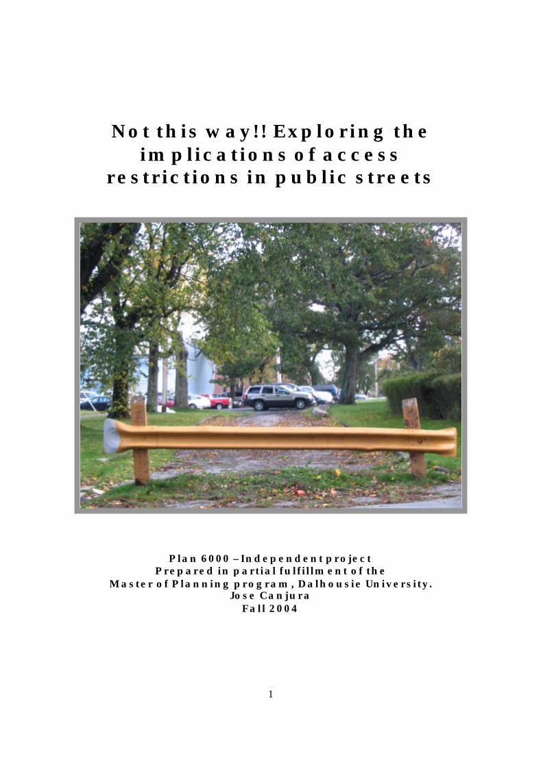
Not this way!! Exploring the
implications of access restrictions in public streets
Plan 6000 – Independent project
Prepared in partial fulfillment of the Master of Planning program, Dalhousie University.
Jose Canjura Fall 2004
2
TABLE OF CONTENTS
Introduction 3 Research question 3 Background 4 Methodology 13 Figure 1: List of street closures provided by the HRM 14 Figure 2: Map showing barricades 15 Findings 16 Figure 3: Inventory findings table 23 Discussion 24 Figure 4: Difference in emergency response route due to barricade 28 Are there alternatives to barricades? 29 Recommendations 34 Conclusion 35 References 38 Appendices 40 List of Appendices:
1. Inventory framework 2. Interview form ‘B’ 3. Interview form ‘A’ 4. Crime statistics

3
INTRODUCTION
Planners across North America recognize that spatial connectivity is an important
consideration in the successful development of urban areas. Well connected, vibrant
cities also encourage the cultural and economic well-being of their inhabitants. Certain
urban forms and planning tools openly challenge ideals of integration; in certain cases
they may even fragment society based on income, class or ethnic background. Gated
communities, for instance, are increasingly fragmenting the urban landscape by offering
seclusion to those in search of privacy and exclusivity.
Access restrictions, however, happen not only on private roads. Certain
neighbourhoods have closed access on public streets, thus preventing outsiders from
entering or shortcutting through. Very little is known about restricted access public
streets in Canada, the permit process and legislative approach to street closures, and the
consequences for traffic patterns and emergency vehicle access.
RESEARCH QUESTION
The purpose of this study is to identify the number and location of public streets
with restricted access in the Halifax Regional Municipality (HRM) of Nova Scotia,
Canada. By exploring the location and the reasons behind the creation of these closures,
I will attempt to answer the following question: why do some neighbourhoods barricade
their streets in Halifax, and what are some of the potential implications of these
closures?
In order to understand the issues behind the closures, I will first look at the
existing literature. I developed a methodology which helped me in the documenting of

4
all the streets identified for the study. Based on the findings, I will discuss some of the
implications of access restrictions, especially for emergency vehicle response, and I will
conclude by making some recommendations that may he lp planners address traffic issues
without jeopardizing safety and the enjoyment of public spaces.
BACKGROUND
The issue of street design has always accompanied the development of urban
spaces. Throughout history, roads and pathways have united people, increasing their
social, economical and political interactions. Many of the street patterns we use in our
cities and neighbourhoods today made their appearance centuries ago in the urban centres
of several different cultures. The grid, for instance, can be traced back to 2500-1500 BC,
and cul-de-sacs are found in the residential districts of great, ancient cities like Eridu, Ur
and Uruk (Grant, 2001). From the Americas to China, the grid has symbolized power
over nature and the ability to establish order in the built environment. Cities in North
America were built under these ideals of order and control, and the grid became the
standard planning tool for urban design. North American planners have long considered
the grid appealing and functional; appealing in terms of its pure form and geometrical
design, and functional for its simplification of surveying, transportation and land
development (Handy et al. 2003). Others however, consider gridiron designs
monotonous and unappealing.
As populations grew, the sanitary conditions of cities and towns often
deteriorated, and health problems spread rap idly. One of the most popular solutions was
the regulation of street width and direction. Commissions were set up in European and

5
North American cities in order to plan and carry out the redevelopment of streets. The
elites developed a different solutio n to the overcrowded conditions and monoto nous
urban patterns of the city: they retreated to the urban edge. The new suburban
developments sought to separate themselves from the dirt and moral degeneration
associated with the city. Suburbs also exercised a segregation of class and land uses,
with a particular focus on the concept of the nuclear family (Southworth and Ben-Joseph,
2003).
The emergence of the suburb also promoted the adoption of different street
patterns and designs. One of the pioneers of suburban street design was John Nash, who
in 1823 designed the plans for Park Village East near London, England. Nash’s design
differed from rectilinear street designs, and adopted winding streets with sidewalks and
houses of different styles, all this within a picturesque setting. In North America, one of
the prototypes for suburban street patterns was the Hampstead Garden Suburb, designed
by Raymond Unwin and Barry Parker in 1904. Here the streets followed the natural
contours of the land; they were also narrower in order to discourage outside traffic, and
cul-de-sacs became widely used to facilitate pedestrian activity (Handy et al. 2003).
As automobile use increased, streets became more and more the realm of the
machine and less a space for pedestrian activity. The influence of the automobile in the
urban environment moved people like Clarence Stein to create a hierarchy of streets.
Residential subdivisions inspired by the ideas of Stein divided street uses according to
width. Residential streets, for instance, became narrower than arterial streets. These
concepts of street hierarchy are still part of the street classification system used to this
day in most of North America. In other words, streets continue to be divided according

6
to the way in which they serve access or movement functions (Handy et al. 2003). This
hierarchy now so prevalent in urban design is very rigid, and also based on very few
types.
The cul-de-sac is still widely used and recognized as an efficient way of
discouraging through traffic. It is then also possible that the limited street designs for
residential neighbourhoods continue to perpetuate street forms like the cul-de-sac even
within urban neighbourhoods. The closure of public streets in urban neighbourhods may
emulate suburban street patterns because of the rigid and unimaginative way in which we
continue to encourage pedestrian activity.
Very little has been written in terms of restricted access public streets in Canada.
Most of the literature that explores this issue refers to examples in the United States and
Britain. Sources are predominantly divided between those which advocate access
restriction, and the ones that argue against it.
One of the most widely recognized advocates of street closures and access
restrictions is Oscar Newman. In 1972 Newman introduced the concept of “defensible
space,” a design- intensive exercise aimed to revitalize run-down inner city areas in
American cities. Defensible space is a model which seeks to inhibit crime by
strengthening social interaction and surveillance within a neighbourhood. Newman
believes that crime and social disintegration tend to concentrate in public areas that
residents do not consider their own. People tend to identify with and protect areas they
consider theirs, regardless of whether they own or rent. Residents will jealously protect
an environment which they feel part of. Street closures thus seek to privatize the public
realm. The results are twofold: outsiders are easily identified when through access is

7
severed and restricted only to local residents; moreover, neighbours exercise greater
maintenance and control over areas clearly demarcated as their own (Newman, 1995).
The effectiveness of defensible space concepts were first observed in three projects in the
United States: two of these were in inner-city neighbourhoods of Dayton, Ohio, and the
south Bronx in New York. The third one integrated public housing residents into a
middle class neighbourhood of Yonkers, New York.
Newman’s defensible space approach has been considered highly successful in
deterring crime and enhancing social interaction among neighbours. This success made
the concept of Crime Prevention through Environmental Design (CPTED) highly popular
(Landman, 2003), and sparked the interest of several politicians and planners across
North America and Europe. London, England, for instance, is now one of the most active
pursuers of safety through street closures and defensible space principles. Peter Knowles,
Bedfordshire’s police architectural liaison officer is a strong advocator of defensible
space. He states that street closures provide residents with a greater degree of control and
ownership of “their” road (Knowles, 2001). These closures, he adds, are necessary not
only on main roads, but also in walk paths and minor roads. This means that not even
pedestrians or cyclists are exempt from access restricting measures. It is interesting to
note how in terms of crime deterrence, good connections and accessibility are a nuisance
rather than a goal, and the rightful enjoyment of open spaces by all becomes a
questionable privilege.
In 2004 the office of the Deputy Prime Minister of Britain released an information
and education book called “Safer Places: the Planning System and Crime Prevention.”
The purpose of this book is to serve both the public and civil servants as a tool for the

8
creation of safer communities; “alley gating” is among the measures considered most
effective by this initiative. It is obvious once again that open access is not a desirable
feature; moreover, the hierarchy of streets according to intensity of use is very rigid.
There are differing views regarding density and safety in public streets, some groups
encourage usage and high volumes of traffic in order to keep all streets safe. Many of the
measures suggested by the book, however, seek to restrict access in poorly used roads
and redirect users towards busy arteries. Measures that would increase use/activities in
unsafe streets are seldom considered and closure, the most drastic solution, becomes the
predominant one.
It is difficult to find literature that supports street closures outside of the context
of defensible space. William Smith-Bowers and Toni Manzi are among the few authors
who defend street closures based on other issues. Both university professors claim that
much like private gated developments, public alley gating suffers from criticism based on
a number of assumptions that lack empirical evidence (2004a and b). For instance, the
privatization of neighbourhoods, rather than promoting alienation and the disintegration
of the social urban fabric, is allowing residents to reclaim areas in decay. Moreover, they
argue, enclosure enables middle class families to remain in inner city areas they would
otherwise leave. Smith-Bowers and Manzi’s arguments in favour of alley gating and
private gated communities are still highly reliant on the issue of safety and crime
deterrence. However, they are right in stating that many claims against these features
lack empirical evidence. With their words in mind, I will attempt to base my conclusions
and recommendations in the empirical foundations of actual evidence, rather than in
“ideological predispositions.”
9
Blakely and Snyder (1997) have become recent authorities in the issue of access
closure. In discussing closures on public streets, they talk about some of the reasons that
may prompt neighbours to exercise this form of territorial control in the public realm.
Public and private street closures, they argue, attempt to simulate suburban street patterns
created to deter outsiders, whether these are casual visitors or criminals (Blakely and
Snyder, 1997). In their typology of gated communities, Blakely and Snyder speak of
Security Zone Communities, areas where the fear of crime and those who may perpetrate
it are the primary motives for seclusion. “Barricaded perches,” according to the authors,
are the fastest growing type of security zones. These perches occur at all income levels
and in all parts of the city, they are responses either to a direct or perceived threat. They
also seek to strengthen social values and enhance the livability and enjoyment of their
environments. This enclosure, however, is a clear example of the “fortress mentality”
that encourages people join together to seclude themselves. Barricades here are directly
associated with fear and the desire to protect family and property values. Blakely and
Snyder also acknowledge the use of barricades as traffic-calming measures, but believe
that in many instances, such claims are only excuses to exercise seclusion.
Many of the examples of barricaded perches offered by Blakely and Snyder
brought about the eventual privatization of open spaces. Mike Davis (1990) has warned
since the 1980s about the criminalization of the poor and the growing restriction on the
rightful access to public spaces in the United States. The barricades that divide the streets
of Miami Shores from the city of Miami, in Florida, separate two neighbourhoods by
income, ethnicity and by the quality of their amenities. The working class, black
residents of Miami were considered a danger to the safety and aesthetics of the more

10
affluent Miami Shores. Blakely and Snyder believe it is unclear whether barricades
actually work in deterring crime. The reduction of certain types of crime cannot be
directly attributed to the role of barricades (Blakely and Snyder, 1997). What is certain is
the desire by residents to take control of their neighbourhood, whether by reasons of
convenience, fear, or desire for exclusivity.
Another voice against the privatization of public neighbourhoods is that of Dell
Champlin (1998). He believes that as neighbourhoods become more insular, individuals
may become less concerned with socio-economic problems present in the wider
metropolitan area. This example of NIMBYism can eventually create less involvement at
the city level. The benefits in terms of increased social capital at the neighbourhood level
can become outweighed by detachment at a greater scale.
Karina Landman is another voice against alley gating and access restrictions on
public roads. She argues that these closures encourage social division, and more
importantly, that they have a cumulative impact at the city-wide level that is often
overlooked. Closures displace traffic to a limited number of access routes, and therefore
increase overall congestion and travel time. Moreover, barricades increase the coarseness
of the urban grain, creating “super blocks” that make urban management and
maintenance increasingly difficult. The consequences of street closures are felt outside
of the neighbourhood in which they occur, and slowly but certainly, the se closures are
also changing the nature and layout of contemporary cities (Land man, 2003).
Beaty Naude (2004) criticizes public street closures because of their limited
success in reducing crime rates. Barricades and alley gating, she argues, can reduce
opportunistic and impulsive crimes, but they have little or no impact on the crime rate at

11
the city, regional or national level. Naude also recognizes the impact that public closures
may have on emergency response timing. She states that the desire for increased safety
may actually cost someone his/her life due to inefficient emerge ncy response access.
Barricades may also have an economic impact on businesses located in areas where the
flow of people is reduced by a closure. Finally, there is also the potential for conflicts
among neighbours. If a homeowner does not support a public road closure, he/she may
be pressured by those who want it implemented.
There is also a relevant body of literature that offers alternative forms of traffic
calming measures. Southworth and Ben-Joseph (2003), for instance, describe a Unified
Street principle which gives priority to pedestrian uses rather than vehicular traffic in
public streets. Michael Poulton (1982) proposes that a simi lar concept, the Dutch
“woonerf,” be introduced in North America. David Engwicht (2003) talks about
reclaiming public streets through a change in pedestrian attitude rather than by the use of
traffic tools or barriers. Susan Handy and colleagues (2003) build a case for increasing
arterial connectivity as a tool to reduce neighbourhood through traffic. I will come back
to these alternatives to street closures, and discuss them in greater detail.
The literature review shows the small number of sources that extensively deal
with access restrictions in public streets. The topic is usually explored as a variation
within the wider research framework of gated communities and access in private roads.
The reality is that public street closures raise some important questions in terms of access
in a realm that, unlike private roads, is not meant to be exclusive.
The fact that the literature has been developed in the specific context of the
United States and Britain may present some problems when used to frame the Canadian
12
example, and more specifically, a mid-size Canadian city like Halifax, instead of a larger
metropolis. For instance, many barricades and alley gating tend to occur as a response to
crime or the fear of crime, especially in cities like New York, Los Angeles, Miami and
London. The creation of the defensible space concept, moreover, was created to allow
residents to take back control of neighbourhoods that had been lost to high crime rates
and other social pathologies (Newman, 1995).
Another issue is the insufficient attention the literature gives to restricted access in
public streets merely as a traffic-calming measure. Authors often neglect to consider
barricades as tools which address particular traffic nuisances such as shortcutting,
speeding and parking. In cities where crime is not a serious cause for alarm, street
closures are most likely related to traffic issues. The fact that street patterns have to be
modified in order to increase safety suggests that there is a design problem that planners
need to address. There is a need for research on current street patterns not
foreseeing/meeting the demands of contemporary living, especially in terms of traffic
safety.
Finally, much of the literature deals with the consequences of privatizing the
public realm, especially in terms of equal access to amenities. Peter Knowles (2001)
states that alley gating creates “selectively public” or semi-private spaces. He considers
the loss of general access and the selective denial of enjoyment of public spaces
necessary measures for safety. But when fear of crime is not an important consideration,
is the restriction justified? This suggests that in cases when street closures obstruct the
enjoyment of public spaces, they can only be justified by a serious threat to public safety.

13
Given the lack of Canadian literature on this issue of public street closures, I will
attempt to appraise the local usefulness of some of the key issues highlighted by the
previous authors.
METHODOLOGY
I have set out to identify and document all the barricades in the Halifax Regional
Municipality (HRM). My goal is to discover any patterns or issues that may help me
understand why certain neighbourhoods barricade public streets, and identify some of the
consequences of these closures. With the word barricade I refer to physical barriers that
restrict total or partial access through a public street. The HRM planning offices do not
possess a comprehensive list or inventory of public streets with restricted access.
However, I was able to obtain a list of most of these streets, thanks to the efforts of the
planners and engineers with whom I have been in contact.
Figure 1 shows the list of barricades and their location, as received from the
planners. The following step was to map the location of these streets; figure 2 thus shows
where the barricades are situated, as well as the location of schools and emergency
response institutions. A more complete map with legend is provided in the appendix
section. Given the extensive number of elementary, junior and senior high schools, I
only show those in relative proximity to the streets in question. As far as emergency
response institutions (hospitals, fire and police stations), I have shown them all, to the
best of my knowledge. I included these features because schools may play a significant
role in decid ing if a barricade is necessary. I mapped emergency response institutions in
order to understand issues of timing and alternative routes.

14
L i s t o f B a r r i c a d e s R e a s o n W h e n1 . W i l l i a m H u n t a t E d w a r d A r a b ( A ) Cu t t o s top s ign i f i can t sho r t cu t t i ng D o n e a b o u t 2 0 y e a r s a g o
2 . Y u k o n a t M o n s t e r y (A ) Cu t due t o an t i c i pa ted t r a f f i c f r om the ma l l w h e n i t w a s f i r s t p r o p o s e d
3 . Ya le a t Monas te ry (A ) Cu t due t o an t i c i pa ted t r a f f i c f r om the ma l l w h e n i t w a s f i r s t p r o p o s e d
4 . B r i a r w o o d a t B a y v i e w ( B ) C u t w h e n s i g n a l s w e r e t o b e i n s t a l l e d a tB a y v i e w / L a c e w o o d
5 . A r m a d a b e t w e e n B e d f o r d H i g h w a y a n d S k y l a r k ( B ) B e c a u s e t h e r o a d w a s c o l l a p s i n g .I t i s a l so ve ry na r row. Has been s tab i l i zed b u t n o t r e - o p e n e d .
6 . D a r t m o u t h R d a t D e v o n s h i r e / R o o m e ( A ) W h e n D e v o n s h i r e a r e n a w a s b u i l t
7 . I d a a t H e r r i n g C o v e ( B ) G r a d i n g p r o b l e m V e r y o l d
8 . M a y o r a t O l d S a m b r o (B ) D u e t o s h o r t c u t t i n g f r o m a T i m H o r t o n ' s w h i c h i s n o w c l o s e d
9 . G e r r i s h a t B r u n s w i c k ( A ) C l o s e d t o r e d u c e t r a f i c v o l u m e s o n M a i t l a n d Ear ly 80 'sa f te r the dea th o f a f i ve year o ld ch i ld , k i l l edw h i l e o n h i s w a y t o s c h o o l
10 . Ger r i sh a t Ba r r i ng ton (A ) D o n e f o r s a f e t y w h e n B a r r i n g t o n w a s w i d e n e d
1 1 . C a r v e r a t P o r t l a n d ( B ) P a r t i a l c l o s u r e w h e n n e w S u p e r s t o r e o p e n e d
1 2 . L a k e c r e s t / H e l e n e / M a i n ( B ) D r i v e r s w e r e u s i n g L a k e c r e s t a t h i g h s p e e d sto avo id t ra f f i c s igna ls on Ma in a t Har t l en
1 3 . F a r q u h a r s o n a t M a i n (B ) W h e n C a l e d o n i a a t M a i n w a s w i d e n e d
1 4 . O l d S a c k v i l l e R d b e t w e e n M e l h a m a n d R i d g e (B ) D u e t o l a n d e x c h a n g e f r o m t h e a l i g n m e n to f w h a t i s n o w H i g h w a y 1 0 1 . T h i s w a s d o n eb y t h e p r o v i n c i a l g o v e r n m e n t
15 . A lp ine a t Po r t l and (B ) U p g r a d e d f r o m c u l - d e - s a c t o r i g h t t u r n s o n l ybecause o f t he nea rby t ra f f i c s i gna l i ns ta l l ed a t R e g a l / P o r t l a n d a n d t h e n e w c o n n e c t i o n a tt h e o t h e r e n d o f A l p i n e
1 6 . P e n h o r n S t . a t S t a p l e C e n t r e d r i v e w a y (B ) Pa r t i a l c l osu re due t o f ea r s t ha t t he p roposedC h r y s l e r d e a l e r s h i p w o u l d s e n d m u c h t r a f f i c t h r o u g h P e n h o r n
1 7 . I s l a n d v i e w b e t w e e n B e d f o r d H i g h w a y a n d S h o r e (B ) D e e m e d d a n g e r o u s d u e t o t h e r a i l w a y g r a d ec r o s s i n g . I t i s s u p p o s e d t o b e a c c e s s i b l e b yf i r e t r ucks
Figure 1: List of street closures provided by the HRM
I was able to visit all the streets on my list, with the exception of number 16:
Penhorn Street in Dartmouth. After several failed attempts to locate it, and given the
limited time available, I was forced to abandon my efforts. I successfully found and
documented all other streets; appendix 2 shows the form I created to record materials,
design and other important descriptive elements. Finally, I compiled all the gathered
information into a spreadsheet (appendix 3).

15
Figure 2: Map showing barricades, schools and emergency response institutions
At the same time I was conducting the site visits, I approached emergency
response institutions. My idea was to obtain additional information about the possible
implications of barricades on emergency response access and timing. I used ‘interview
form B’ (appendix 4) to gather the information obtained during the face-to- face
interviews. Ethical considerations prompted me to only request information based on
professional expertise. I refrained from asking personal questions, even names; I also
explained interviewees that responses would be kept confidential. Fire response

16
personnel were the most cooperative, and therefore most of my data is based on their
responses. I made several attempts to contact police and paramedic personnel, but due to
their busy schedules, I obtained very few responses, especially from paramedics.
The final step in my data gathering process consists of interviews with HRM
planners and engineers. Appendix 5 is an example of the form I sent via email to
professionals in the planning office of the HRM. I did this very early in the process, and
luckily so, because their responses took the longest. Despite all efforts, I only obtained a
total of two responses to “interview form A”.
FINDINGS
All of the barricades visited, with the exception of one, protect residential streets.
These residential streets in turn, all connect to busy roads (arterial, highway or collector)
and to other low traffic residential streets. Eight of the streets where barricades are
located have single unit dwellings as the only type of housing, many others also show it,
but mixed with apartment buildings or townhomes. From these observations, it is easy to
conclude that street closures usually respond to the needs, expectations or demands of
families seeking privacy, comfort and silence.
Yale Street Edward Arab Street

17
Bedford Highway Bayview Street
From the map we can also observe that most of the barricades (10 of them to be
exact) are near schools, within a 500m radius. Schools may not have been the most
important consideration in all of the cases, but could have served as yet another reason to
request a street closure. In some cases, the school is the main reason for this drastic type
of traffic calming measure. Gerrish Street, for instance, was closed at Brunswick Street
after the death of a five year old boy who was killed by a speeding car while on his way
to school. In cases like this, it is hard for authorities to oppose a request for street
closure.
It is important to notice that only six of the barricades are located in peninsular
Halifax; the rest are in suburban areas. Blakely and Snyder (1997) suggest that many
street closures are created in an attempt to emulate suburban street patterns within inner
city areas. In Halifax, most of the closures on public streets happen within the organic
pattern of suburban streets. Moreover, and based on site visits, I found no indication that
suburban barricades divide areas by income or ethnicity. They mainly exist in isolation,
responding to very specific local issues. In places like Miami Shores, where barricades
seek social containment, they occur in close proximity to one another, and along clearly
delineated neighbourhood boundaries (Blakely and Snyder, 1997). However, further
research is necessary to solidify my observations in the Halifax area.

18
While creating the map showing the location of barricades, I thought about
including parks and open spaces located near the street closures. My idea was to do this
in light of what Davis (1990), Blakely and Snyder (1997), and Champlin (1998) suggest:
that some forms of access restriction, and the privatization of certain neighbourhoods
deny some groups from the rightful enjoyment of public spaces. After visiting the
barricades, it became apparent that these are not designed to prevent the use of amenities,
but are mainly created as a response to a traffic hazard or nuisance. In other words, the
reasons for the majority of these closures relate directly to the automobile. Sometimes an
amenity creates high traffic flow in residential streets, and the roads are closed to prevent
the nuisance. This is not the same as denying enjoyment of the amenity, which often is a
shopping mall or recreational centre. I found no indication that any of the barricades
were erected to restrict access to open, public spaces.
The design of barricades is a very interesting issue. Some are ornamental and
follow a common design pattern. They seem designed to blend with the neighbourhood
by using the same materials as the surrounding houses, fences and streets; these materials
are concrete, brick and wrought iron. The barricades cover the entire pavement width,
but still allow pedestrian/bicycle traffic along the sidewalk; some are open in the middle
to become less obstructive for pedestrians.
Briarwood at Bayview Gerrish at Brunswick Yukon at Monastery

19
Other barricades follow a simpler design and use less durable materials such as
wood. They usually consist of short wooden poles joined by an iron divider, the kind we
usually see on the shoulders along highways. A set of barricades on Islandview Drive in
Bedford, consist only of removable concrete
blocks covered in graffiti. Despite their
simplicity, these barricades are as effective
in restricting vehicle access as their more
elaborate counterparts. I originally believed
that the reason for differences in design and
materials is location. I thought that the most attractive barricades were erected near, or in
the intersection with more frequented streets such as Monastery Road, Lacewood Drive
and Brunswick Street. However, the concrete blocks that barricade Islandview are right
on the Bedford Highway. Moreover, both design types are equally distributed between
urban and suburban areas. Time restrictions impede me from further exploring this issue,
but it would be interesting to discover why both types of design are used.
William Hunt Street Dartmouth Road

20
Farquharson Street
Another important observation is that not all the street closures provided in the list
involve barricades. Farquharson Street in Dartmouth was turned into a cul-de-sac, but
access by pedestrians, cyclists and the disabled is still possible through a small
passageway. Some streets have had vehicula r flow reduced to a one-way direction while
others deny left turns to, or entrance from, a busy road. This is accomplished by
widening the shoulder on one side of the street and leaving the street only wide enough
for one vehicle to navigate through. These variations of restricted access in public streets
may seem better at first, especially because they still allow normal access to pedestrians,
cyclists and others. However, wide lips sever a road just like a barricade, especially for
emergency response vehicles, which are left unable to pass through the narrow access,
and thus forced to navigate around.
Lakecrest Dr. Carver St. Alpine St.

21
Even though most closures still allow access to pedestrians and cyclists, there are
others which, either by careless design or intentional restriction make it difficult for non-
vehicular traffic to navigate through. The closure of Ida Street at Herring Cove Road
allows pedestrian access through a stairwell, but bicycles, strollers and wheelchairs are
left with no option but to navigate around using the adjacent streets. Another example of
careless design is the closure on Mayor at Old Sambro.
Ida Street at Herring Cove Mayor Rd. at Old Sambro
There is a closure where total access restriction is emphasized by a set of three
barricades at different levels of the street. These barricades are on Armada Street at
Bedford Highway. I was told that the road was at one point collapsing due to its
steepness and the natural elements ; this street is also too narrow and it has no sidewalks.
In cases where there are visible hazards, it makes perfect sense to close access to all
vehicles and pedestrians. This example raises the question of whether some streets
should exist at all. Are the development guidelines we create for streets too lenient?
This closure is the only case I found in which total access restriction is adequately
justified.

22
Armada Street at Bedford Highway
In terms of reasons for closure, many barricades were erected to deter a particular
nuisance. In most of the cases this nuisance is shortcutting. Some barricades are a direct
response to a perceived danger, such as speeding near an elementary school, grading
problems and unstable roads, and dangerous crossings. Other closures are done for
arbitrary reasons or in response to density increases. One closure done by the Province of
Nova Scotia’s Department of Transportation and Public Works severed a road by
transferring soil from the alignment of nearby highway 101. There is no other reason on
record, and the closure supersedes municipal jurisdiction. HRM planners state that some
neighbours ha ve complained about this closure because it seems unnecessary. There is
also a partial closure on Alpine Drive that is in fact an access upgrade from a cul-de-sac.
Because of neighbours’ request, and new development in the area, the street was opened
for turning into Portland Street, but turns into Alpine from the busy arterial were
restricted in order to avoid shortcutting. These types of upgrades do not happen often,
and are done by request of the residents/developers.
Figure 3 shows the cross tabulation analysis I conducted to confirm some of the
findings. It also shows some significant differences in the characteristics of urban and
suburban closures. For instance, all barricades that unintentionally restrict access to
bicycles, seniors and the mobility disabled are located in suburban areas. Similarly,

23
Location of barricadesUrban* (A) 6Suburban* (B) 1 1* For the purpose of this study "urban" refers to the Halifax peninsula and Dartmouth's waterfrontwhile "suburban" refers to the suburbs identif ied by HRM (Sackvil le, Bedford, etc)
Access restrictionvehicles only (A) (B)bicycles/scooters 1 1 6 5all access 4 0 4
1 1Materials
i ron/wood (simple design)concrete/wrought iron/brick (elaborate design) 5 3 2sidewalk extension 6 3 3concrete boulders 3 3
1 1Types of homes
single unitapartment bld. 1 3 4 9townhomes 6 4 2
3 3Reasons for closure
to avoid/prevent shortcuttingdanger/hazard 8 4 4engineering issue/enforcement of traffic regulation 4 2 2
5 0 5
partial restrictions such as sidewalk extensions only happen in suburban neighbourhoods.
Other differences include the high versus low density of barricaded streets in urban and
suburban neighbourhoods respectively. In terms of reasons for closure, engineering
issues and enforcement of traffic regulations only seem to happen in suburban streets; all
other reasons spread uniformly across both neighbourhood types.
Findings from the questionnaires sent to planners, and from interviews with
emergency response personnel are incorporated in the following discussion.
Figure 3: Inventory findings – cross tabulation analysis
24
DISCUSSION
Nova Scotia and the Halifax Regional Municipality do not have high crime rates
compared to the national average (see appendix 6)1. Nova Scotia has the sixth lowest
crime rate per province/territory, the rate itself is slightly below the national average. In
property crime rates, the Halifax Census Metropolitan Area (CMA) scored slightly above
the median, but experienced a decreased of 6.7% since 1999. The reality is that the fear
of crime in Canada has decreased to the low levels of the 1960s and 1970s, while violent
crime has steadily diminished since 1990 (appendix 6)2. Canadians, especially outside of
the large urban centres like Toronto, Montreal and Vancouver lack the fear of crime that
characterizes residents of countries like the United States and Britain. Barricades in
Halifax are neither a response to the threat of crime, nor an effort to reclaim a
neighbourhood from unwanted social pathologies. Street closures respond to traffic
nuisances, with speeding, shortcutting, high traffic volumes and noise being the most
common ones. This means that defensible space concepts are not a significant
consideration when barricades are erected in the HRM. Barricades do not seek to deter
crime from a neighbourhood, only to limit motorists.
I found no indication that barricades prevent non- local residents from accessing
public and open spaces. If anything, the opposite is most likely: that barricades seek to
prevent traffic related to nearby amenities from shortcutting or speeding through
residential streets. One of the barricades I visited is accompanied by a sign warning
1 This is based on 2000 statistical information provided by the Canadian Centre for Justice Statistics: http://prod.library.utoronto.ca:8090/datalib/codebooks/cstdli/justice/2001/2000_crime_e.pdf Accessed 11/08/04. 2 According to the Department of Justice Canada, indicators show that the country’s fear of crime was 25% in 2002, compared to 34% in 1990 and 37% in 1991. Similarly, violent crime rates have decreased during the same period.

25
outsiders about a neighbourhood watch program. The sign intrigued me, and made me
decide to linger in this neighbourhood longer than in others. I never felt uncomfortable
or unwelcome even though I was obviously an outsider of colour. However, my research
is limited and insufficient at this time to prove whether barricades emphasize certain
forms of social or ethnic discrimination. More research is necessary in order to explore
this issue in depth.
It is also unlikely that restricted access public streets are a symbol of exclusivity
for the neighbourhoods in which they exist. Barricades in the HRM often happen in
isolation from one another and do not surround one neighbourhood, or marginalize
another. Yukon and Yale are streets where barricades are quite near one another, but
both were created to avoid the same nuisance: shortcutting to the near Quinpool mall.
Unfortunately, some street closures unintentionally restrict access to the mobility
disabled. Certain barricades limit access to wheelchairs, motorized senior scooters,
strollers and even bicycles. In some cases a total access restriction is necessary given an
existing danger, such as steep gradient or a collapsing road. In other instances this
reduced access can only be attributed to poor design and to a certain extent, lack of
consideration for the elderly, the mobility disabled, and even advocates of active forms of
transportation.
Some of the literature suggests that the greatest repercussions of barricades are
often felt in terms of emergency vehicle response (Blakely and Snyder, 1997; Landman,
2003). I contacted fire fighters and police officers in order to learn about their
experiences and concerns. My attempts to reach paramedics have been unsuccessful

26
because of their hectic schedules and my limited time. My conclusions, therefore, are
only based on the experiences of the first two groups mentioned above.
At the time the existing barricades in the HRM were erected, emergency response
personnel were often only informed about closures, they were seldom consulted.
Planners are taking measures to ensure that emergency response crews are included in the
evaluation process that leads to street closures. Emergency response institutions are
always informed about all temporary and permanent street closures that happen in the
city. This is usually done via fax, and in some cases a police officer noted, also by email.
I also asked what kind of measures the departments take to deal with access
restrictions. I was told that staff drives around their assigned areas in order to devise
alternative routes. This is particularly important for fire response personnel, because
their assigned areas are more clearly delineated. Moreover, staff often gets transferred or
has to temporarily substitute for crews in other departments. This is always a problem,
because they may not be familiar with street closures in the new area. When a barricade
seriously changes the route from a given station, emergency response teams may contact
other stations located further away. This means that difficulty of access due to a
barricade increases response timing in a significant way, sometimes even justifying
longer travel time for the sake of better routes.
When asked if barricades significantly increase emergency response timing, most
respondents commented that it depends on where the barricade is located. Some of these
obstacles, for instance, are surrounded by narrow residential streets or extremely busy
arterial roads. Navigating around the barricade thus becomes difficult and time-
consuming. Some emergency vehicles have more trouble navigating than others: a police

27
car could have less difficulty with narrow streets than the oversized fire response truck.
One fire fighter commented that some closures may require crews to carry their
equipment over a considerable distance. He compared this situation with a forest fire,
where equipment needs to be carried a significant distance, sometimes also over
obstacles. There is also the issue of exiting the site after the emergency has been
contained. Barricades often create a dead end without offering the roundabout shape of a
cul-de-sac, this turns exiting into a time-consuming exercise on maneuverability.
Moreover, barricades also pose a problem for emergency vehicles like police cars, which
sometimes face a situation that requires them to engage in the pursuit of a suspect.
Partial closures offer the same restrictions and problems in terms of emergency
access. Streets partially severed with wider lips cannot be entered by oversized vehicles.
Even police cars cannot enter these narrow roads because, as one officer points out, the
police have to lead by example, and cannot disobey traffic rules or make maneuvers that
may jeopardize the safety of others.
One of the most important findings I made through the interviews is about the
different consequences of barricades in urban and suburban areas. Fire fighters told me
that emergency response timing in urban areas is not affected too drastically by
barricades. In the urban core, streets are laid out in a tight grid pattern; this makes
navigating around barricades relatively easy and less time-consuming. The case is very
different in suburban areas, where streets are narrower and follow organic layouts.
Figure 4 shows one of the most dramatic differences between real and possible
emergency response timing. The map shows the barricade located on Islandview,
between the Bedford Highway and Shore Drive, and the route that emergency response

28
crews are forced to take in order to respond to an emergency in the most secluded parts of
Shore Drive. The barricade forces a delay which is also enhanced by narrow streets and
sharp turns. Other options could be to transport equipment by hand and over the rail
tracks, or to request the help of another emergency response station; the nearest fire
station after the one shown is in Middle Sackville. All the options above imply a delay of
potentially fatal consequences. Are the factors that planners sought to resolve by erecting
the barricade relevant enough to justify this delay in emergency response?
Figure 4: Difference in emergency response route due to a barricade

29
All respondents agreed that barricades make their job more difficult. Some said
that a lot more care has to be exercised when driving; another fire fighter noted that there
was an obvious convenience addressed by the barricade, such as shortcutting, and the
removal of this option also affects emergency response timing. Only one police officer
disagreed with the rest of the respondents, stating that even though barricades are
sometimes a hindrance, they are planned to have the minimal possible impact, and that
response crews know of these measures well in advance, and can therefore plan
accordingly.
A recent study on housing fire statistics conducted by the Canadian Mortgage and
Housing Corporation (2004) found a correlation between fire death rates and the location
of the fire. The death rate increases as fires occur further away from urban areas. Most
of the streets barricaded in the HRM happen in suburban areas, where emergency
response institutions are dispersed over greater distances and street layouts make it harder
for their vehicles to maneuver. There needs to be a more thorough and comprehensive
evaluation process for barricades in suburban and rural areas, one that considers this
increase in fire death rates. Moreover, all unintentional access restrictions to the mobility
disabled, and all partial closures occur exclusively in suburban areas. Perhaps more in-
depth studies must be conducted for suburban closures. Solutions to traffic problems are
not always universally applicable.
ARE THERE ALTERNATIVES TO BARRICADES?
Considering the overall area of the HRM, there are not too many public streets in
which access has been closed or restricted. This has a great deal to do with current
30
reevaluations and the adoption of new approaches such as the Neighbourhood
Shortcutting policy. This policy was created after a 1994 transportation study predicted
that traffic infiltration in neighbourhood streets would continue to occur, exacerbated by
increases in density and road pressures. Before the adoption of this policy, there was no
written set of guidelines that directly addressed street closures in the Halifax county or
any of its surrounding cities/counties. Traffic problems were solved on an individual
basis, and solutions decided upon without a comprehensive policy.
The Neighbourhood Shortcutting policy considers different traffic calming
measures, and does not necessarily encourage street closures. All of the existing
barricades were erected before the passing of this new document; no closures have been
made since the policy was approved in July 1996. The policy does not encourage street
closures without a careful and lengthy evaluation process. Closures are considered
extreme measures. However, barricades will still be erected when other solutions seem
ineffective.
The Neighbourhood Shortcutting policy may still need other revisions: HRM
planners mentioned that the elements required by the policy, such as data gathering,
assessment, and public participation took as long as five years in the first few cases. It is
likely that in the long time before the implementation of appropriate measures, the
problem itself may change and the measure originally considered could become no longer
effective. Planners believe this long implementation time is the natural result of working
with a new policy. Moreover, they initially addressed some of the most difficult
problems with the policy; they expect to see improvements soon, both in terms of timing
and success.

31
There is a considerable number of measures that could potentially reduce traffic
nuisances in neghbourhood streets. Some are design intensive, while others advocate
more neighbourhood participation. I have researched some of these options, with the
hope that they can be applicable in the HRM.
Southworth and Ben-Joseph (2003) discuss the adoption of a “unified street
principle” in residential streets. The idea is to create an environment that shares
pedestrian activity and vehicular movement without giving particular preference to the
latter. This concept involves design ideas that avoid conventional, paved streets
separated from sidewalk in terms of materials, shape and height. Streets with a
continuous surface that pedestrians are also meant to use will encourage drivers to slow
down. Moreover, the use of speed deterrents such as trees, planters and benches can
easily be incorporated. Streets with more pervasive traffic problems could also
incorpora te features such as narrow pavements and other conventional traffic calming
measures that do not necessar ily close access. However, this requires consideration of
the standards required for efficient emergency response access3. The Unified Street
principle was first introduced in Britain in 1974 with great success, and has since been
adopted in many places, including Japan and Israel. Another benefit offered by unified
streets is the increased opportunity for social interaction among neighbours.
The idea of equal street use by pedestrians and vehicles led to the creation in the
Netherlands of the “woonerf” street pattern (Poulton, 1982). This concept entails street
features designed by and for local residents. In the woonerf, pedestrian uses predominate
over automotive traffic, and street s are redesigned in pleasant and attractive ways that
3 For instance, a study made in Portland, Oregon found that the minimum acceptable street width for efficient emergency response vehicles is 18 feet (Handy et al. 2004).

32
enhance livability. The limitations of the woonerf are that it is neither simple to plan nor
cheap to construct. It also involves extensive neighbourhood participation, something
which could be a lengthy process. However, given the current delays in the
implementation of the Neighbourhood Shortcutting policy, the woonerf would provide
great results in the same amount of time or less, while enhancing the aesthetic value of
neighbourhood streets.
The conventional pattern and hierarchy of North American streets make the
woonerf a suitable addit ion to the Canadian road system (Poulton, 1982). The woonerf
would be most effective in grid street patterns because it provides short street segments
that would be easier to convert. Moreover, the short city blocks within a tight grid
system could become “natural units” for woonerf conversion. The woonerf street pattern
has also been used in curvilinear suburban streets.
Woonerf and principles of unified Street benefit greatly from an efficient arterial
road network. There are in fact many advantages to efficient arterial flow. For instance,
well connected 4 arterial patterns may decrease overall vehicle travel. This decrease is
attributed first to the dispersal of vehicle trips, and second, to a decrease in the amount of
vehicle travel when an adequate network of arterials is provided (Handy et al. 2004). The
advantages of increasing the number of arterials and the links among them will also
benefit emergency response vehicles by providing greater access and reduced travel time.
When developed properly, healthy arterial flow can also reduce shortcutting in
neighbourhood streets simply by reducing the need. Moreover, traffic calming measures
and connectivity must go hand in hand. Access restrictions alone will only displace the
4 A recent study in the Portland, Oregon area defined connectivity as the number of intersections per mile of arterial streets (Handy et al. 2004).

33
problem elsewhere, where it will increase congestion and travel time just the same
(Landman, 2003). By increasing fast, efficient arterial flow and public transit, planners
are addressing the problem in a more general scale, thus benefiting the region as a whole.
This is not to say that traffic calming measures are ineffective, but they only take care of
nuisances in a very localized and NIMBYstic way. Good arterial flow can occur not only
in urban areas, but also in suburban street networks. Advocates believe that hybrid street
patterns of gridiron and curvilinear roads provide the opportunity for increases in
connectivity and thus, efficient traffic travel time and dispersal (Handy et al. 2004).
Other street safety advocates promote more unorthodox approaches to traffic
calming in neighbourhood streets. David Engwicht, for instance, believes that restoring
the human element in residential streets is the most effective traffic calming measure
(2003). He argues that high speeds and shortcutting in residential roads can best be
avoided when people reclaim the streets with elements of intrigue and uncertainty.
Engwicht argues that vehicles often push residents into a psychological retreat that
inhibits them from reclaiming their streets as playgrounds for children and places for
social interaction. Furthermore, signs and other conventional traffic calming methods
turn the streets into predictable environments for motorists. These current methods add a
false sense of security for motorists, and convey the message that streets are
predominantly the realm of the vehicle. Simple symbols of continuous human use such
as toys, on the other hand, would make motorists more alert and cautious, weary of
unexpected situations. In other words, by increasing human activities in residential
streets, and thereby making the environment less predictable for moto rists,
neighbourhoods can decrease non resident traffic. Finally, Engwicht also states that

34
street design should be in the hands of the community rather than city officials. He
believes that the limited tools possessed by planners and other city officials are the main
culprits in the creation of predictable environments that promote traffic problems. If
local residents had more input in the design of, and the elements that characterize their
streets, then roads would have the required elements of intrigue and uncertainty necessary
to increase safety and livability.
RECOMMENDATIONS
Although Engwicht’s ideas are not applicable in every place and context, in some
cases, either alone or in conjunction with other measures, they may yield satisfactory
results. Most traffic calming measures, including street closures, cannot be applied
everywhere in the same manner, or expect the same results. All measures currently
implemented, as well as new design ideas and pledges for greater neighbourhood
participation must be carefully evaluated in the particular context in which they will be
used. No measure is universal or fool proof. Planners need to consider a wider range of
traffic calming measures.
Barricades can be efficient traffic calming devices in some cases, but there are
some considerations that planners need to keep in mind. Since some of the most serious
implications of barricades are felt by emergency response vehicles, these institutions need
to be deeply involved in the evaluation process. Emergency response personnel noted
that they have rarely been consulted in the past, only notified of closures once these have
taken place. However, HRM planners assure that the new measures ensure the
participation of fire fighters, police and ambulance drivers.

35
With already existing street closures, and where these intrude with emergency
response timing, planners should consider options such as replacing solid barricades with
swinging/removable ones that could be easily opened in case of an emergency.
Barcelona and other European cities restrict access in certain public streets with
electrically operated bollards. Once peak traffic hours end, or if an emergency arises,
these bollards sink into the pavement allowing vehicles to navigate through. Swinging or
lifting gates are just as effective and less costly to install.
It is also important to consider the limitations of the elderly and the mobility
challenged. The barricades that unintentionally restrict access to these groups need to be
redesigned. Moreover, new standards must be introduced in the Neighbourhood
Shortcutting policy to avoid mistakes of this kind from happening again.
Most of the street closures on the list provided by the HRM were created a long
time ago. Some of the reasons that prompted the adoption of the access restrictions may
not exist anymore; others could now be addressed with less severe traffic calming
measures. An evaluation of all existing barricades is therefore necessary in order to
remove those no longer needed, especially when these significantly obstruct emergency
response routes or access by the mobility disabled.
CONCLUSION
Public street closures in the HRM are reactions to local traffic nuisances such as
high speeds, high traffic volumes and shortcutting. Barricades do not seem to interfere
with access to open spaces and do not seem to attempt the exclusion of certain people
from enjoying amenities and public spaces. The principles of defensible space which

36
have encouraged many public street closures in the United States and Britain do not seem
to play a significant role in the erection of barricades in the Halifax area. This is perhaps
due to a lower fear of crime in Canada, especially outside of large cities like Vancouver,
Montreal and Toronto.
Most of the street closures in Halifax are located in suburban areas. It is also
exclusively in suburbs where barricades unintentionally restrict access to pedestrians,
cyclists and the mobility challenged. Moreover, the organic patterns of suburban streets
combined with barricades are creating the most dangerous implications in terms of
emergency response access. I am not advocating for the complete abandonment of these
measures, but I hope to convey that it is important to understand the consequences that
barricades and other closures may create. The use of barricades is starting to be
reevaluated in the HRM. Perhaps they will be combined with other solutions, or saved
for those pervasive situations where other measures have been ineffective. It is also
important to remember that no traffic calming measure is universally applicable or
universally successful. One must therefore consider local elements to devise appropriate
solutions .
Planners also need to be aware that just like trends and values change, so do the
reasons that call for certain measures and the consequences they create. If barricades are
not currently dividing neighbourhoods by income or ethnic background in Halifax, it is
important to know that they are too ls of segregation in other places. As planners, we
have to be aware of these implications in order to recognize their possible appearance in
our areas.

37
In the search for pedestrian safety, for peace and comfort in neighbourhood
streets, planners have the duty to continually reevaluate their tools and experiment with
new alternatives that may improve the livability of our cities and neighbourhoods without
jeopardizing efficient emergency response or equal access opportunities.

38
REFERENCES Anonymous. 2002. “Crime trends, demographics, and public perceptions of the criminal
justice system.” PowerPoint presentation prepared by the Canadian Department of Justice. Available online: http://canada.justice.gc.ca/en/cons/roundtable/nov102/presentation.pdf accessed 11/08/04.
Anonymous. 2001. Canadian crime statistics 2000. Canadian Centre for Crime
Statistics. Available online: http://prod.library.utoronto.ca:8090/datalib/codebooks/cstdli/justice/2001/2000_crime_e.pdf accessed 11/08/04.
Blakely, Edward J. and Mary Gail Snyder. 1997. Fortress America: Gated Communities
in the United States. Washington: Brookings Institution Press. Champlin, Dell. 1998. “The Privatization of Community: Implications for Urban
Policy.” Journal of Economic Issues vol. 32(2), p. 595-304. Davis, Mike. 1990. City of Quartz: Excavating the Future in Los Angeles. New York:
Verso. Grant, Jill. 2001. “The dark side of the grid: power and urban design.” Planning
Perspectives 16, 219-241. Halifax Fire and Emergency website: http://www.halifax.ca/fire/stations_core.html
Accessed 10/12/04. Halifax Regional Municipality. “Neighbourhood Shortcutting Policy.” Available online:
http://www.halifax.ca/traffic/calming/Shortcut_Policy.html Accessed 07/02/04. Halifax Regional Schoolboard website: http://www.hrsb.ns.ca/schoolboard/districts/
Accessed 10/12/04. Handy, Susan; Robert G. Paterson and Kent Butler. 2004. Planning for street
connectivity: getting from here to there. Michigan: American Planning Association.
Knowles, Peter. 2001. “Designing out crime: defensible space and the distribution of
crime and disorder in residential areas.” Available online: http://www.operationscorpion.org.uk/design_out_crime/defensible_space.htm accessed: 08/21/04.
Landman, Karina. 2003. “Alley gating and neighbourhood gating: are they two sides of
the same face?” Paper presented at the conference Gated Communities: Building Social Division or Safer Communities? Glasgow, September 18-19, 2003.

39
Available online: http://www.gatedcomsa.co.za/docs/Glasgow_paper_v5.pdf Accessed 11/28/04.
Manzi, Tony and Bill Smith-Bowers. 2004a. “Partitioning urban space: exclusivity or
social integration? Gated communities in the United Kingdom.” Paper presented to the International Sociological Association conference ‘Adequate and Affordable Housing for all Research, Policy, Practice.’ University of Toronto, June 24-27, 2004.
Manzi, Tony and Bill Smith Bowers. 2004b. “Havens gate.” Planning in London,
September 2004. Naude, Beaty. 2004. “Can public road closures reduce traffic effectively?” Paper
presented at the seminar on gated communities at the Institute of Security Studies (ISS). South Africa, March 2004.
Newman, Oscar. 1995. “Defensible Space – A New Physical Planning tool for Urban
Revitalization.” Journal of the American Planning Association vol. 61(2), p. 149-156.
_____________. 1972. Defensible Space. New York: Macmillan. Davies, Llewelyn. 2004. Safer Places: the planning system and crime prevention.
London: Office of the Deputy Prime Minister. Poulton, Michael. 1982. “Replanning the residential street system: adapting the Dutch
Revolution to the Canadian context.” Paper written for the Canadian Institute of Planners’ annual conference. Summer 1982.
Southworth, Michael and Eran Ben-Joseph. 2003. Streets and the shaping of towns and
cities. Washington: Island Press. Thompson, John. 2004. “Gated communities: citadels in the city.” Planning in London,
July 2004 issue.

40
APPENDIX 1: Inventory framework
Inventory Framework – restricted access streets
Street address: Barricade [ ] permanent [ ] removable Materials [ ] concrete [ ] wrought iron [ ] wood [ ] other: Design description: Access restricted by barricade [ ] vehicles only [ ] all access (sidewalk) Type of road barricaded [ ] residential [ ] arterial [ ] collector [ ] highway Type of connecting roads [ ] residential [ ] arterial [ ] collector [ ] highway Nearby amenities [ ] park [ ] school [ ] church [ ] community centre [ ] shopping centre [ ] waterway [ ] other: proximity to barricaded street (in blocks): distance of nearest emergency response institution: type of institution: Type of homes along street [ ] single unit [ ] duplex [ ] townhome [ ] apartment building [ ] mobile [ ] other: Reason for closure:

41
APPENDIX 2: Interview form ‘B’
Interview form ‘B’ (emergency response personnel) Restricted access streets in the Halifax Regional Municipality
1) Could you tell me where the streets with restricted access in your area are located? 2) What measures does your department take to deal with streets where access has been
restricted? 3) Can you estimate how much longer it may take you to enter X street (barricaded)
rather than Y street (open) from your station? 4) What could be the consequences of access restriction in case of a serious emergency? 5) In your experience, do you think that restricted access streets make your job more
difficult?

42
APPENDIX 3: Interview form ‘A’
Interview form ‘A’ (planners/engineers) Restricted access streets in the Halifax Regional Municipality
1) In your experience, what are the most common issues that neighbourhoods seek to resolve by
restricting street access? 2) How many applications do you receive per year? How many are usually approved? 3) Section 6.1 of the Neighbourhood Shortcutting Policy states that volume, speed and collision data will
be collected to determine if a problem exists. How long does this process take? What happens if the City decides there is no significant problem?
4) In the evaluation process, is attention given to emergency response time and access? 5) The Neighbourhood Shortcutting Policy describes several steps, including extensive public
participation, before a street can be closed. How long would you estimate it takes, in average, for an application of this type to be approved?
6) If a project is approved as permanent, can the barricade be removed by the City at a later time? Has
this been done in the past? 7) Are neighbours charged for the expenses incurred by any of the steps listed in the policy? If so, how? 8) Does the HRM decide on the closure of a public street more often than a neighbourhood? Is the
process different than when neighbours petition for this to happen (i.e. Are public meetings still held)?

43
APPENDIX 4: Canadian crime statistics
Source: Canadian Crime Statistics by the Canadian Centre for Justice Statistics http://prod.library.utoronto.ca:8090/datalib/codebooks/cstdli/justice/2001/2000_crime_e.pdf 11/08/04

44
APPENDIX 4 Cont…
Source: Crime trends, demographics, and public perceptions of the criminal justice system. Presentation prepared by the Canadian Department of Justice in 2002. http://canada.justice.gc.ca/en/cons/roundtable/nov102/presentation.pdf 11/08/04.

45