Northern Bayshore Dredged Material Management Plan ... · Bayshore Dredged Material Management...
74
Bayshore Dredged Material Management Plan, Raritan & Sandy Hook Bays, Monmouth County, NJ June 2009 Page 1 of 74 Northern Bayshore Dredged Material Management Plan “Identifying Beneficial Uses for Dredged Material” Raritan and Sandy Hook Bays Monmouth County, New Jersey Funding provided by:
-
Upload
duongkhanh -
Category
Documents
-
view
217 -
download
0
Transcript of Northern Bayshore Dredged Material Management Plan ... · Bayshore Dredged Material Management...

Bayshore Dredged Material Management Plan, Raritan & Sandy Hook Bays, Monmouth County, NJ June 2009
Page 1 of 74
Northern Bayshore Dredged Material Management Plan “Identifying Beneficial Uses for Dredged Material”
Raritan and Sandy Hook Bays
Monmouth County, New Jersey
Funding provided by:

Bayshore Dredged Material Management Plan, Raritan & Sandy Hook Bays, Monmouth County, NJ June 2009
Page 2 of 74
Blank Page

Bayshore Dredged Material Management Plan, Raritan & Sandy Hook Bays, Monmouth County, NJ June 2009
Page 3 of 74
TABLE OF CONTENTS
ACKNOWLEDGEMENTS ............................................................................................. 5
EXECUTIVE SUMMARY .............................................................................................. 7
SECTION I. INTRODUCTION................................................................................... 11 A. Goals and Objectives of the DMMP.................................................................... 11 B. Participants and Partners..................................................................................... 12 C. Planning Process ................................................................................................... 13
SECTION II. REGULATORY REQUIREMENTS............... .................................... 13 A. Dredging Practices & Regulatory Requirements............................................... 14 B. Testing Requirements ........................................................................................... 15 C. Disposal/Management of Dredged Material....................................................... 16 D. Fees ......................................................................................................................... 17 E. Beneficial Uses of Dredged Material ................................................................... 17
SECTION III. EXISTING CONDITIONS .................. ............................................... 18 A. Characterization of Bayshore .............................................................................. 18 B. Historic Dredging Activities ................................................................................. 20 C. Examples of Beneficial Uses in the Bayshore ..................................................... 22
SECTION IV. SEDIMENTATION RATE REDUCTION .......... .............................. 23 A. Sediment Transport, Impacts and Minimization................................................ 23 B. Navigation Channel Sedimentation Reduction .................................................. 25
SECTION V. ECONOMIC FACTORS....................................................................... 26 A. Cost of Dredging..................................................................................................... 26 B. Cost of Moving Material from CDFs.................................................................... 31 C. Economic Impact of Not Dredging....................................................................... 33
SECTION VI. CONFINED DISPOSAL FACILITIES........... .................................... 34 A. Keyport Marine Basin CDF................................................................................. 35 B. Pedersen’s Boat Yard CDF .................................................................................. 36 C. Monmouth County Park System CDF................................................................ 37 D. Shoal Harbor (N61) CDF ..................................................................................... 38 E. Atlantic Highlands CDF ....................................................................................... 39
SECTION VII. BENEFICIAL USES SUITABLE FOR BAYSHORE .................... 40 A. Habitat Creation & Restoration .......................................................................... 40 B. Beach Replenishment............................................................................................ 40 C. Construction Site Uses.......................................................................................... 41 D. Topsoil Creation.................................................................................................... 42 E. Open Water Capping............................................................................................ 42 F. Flood Control Projects (Geotextile Uses) ............................................................ 43

Bayshore Dredged Material Management Plan, Raritan & Sandy Hook Bays, Monmouth County, NJ June 2009
Page 4 of 74
G. Quarry Rehabilitation ........................................................................................... 43 H. Industry Dredged-related Products ..................................................................... 43
SECTION VIII. FINDINGS & RECOMMENDATIONS .......... ............................... 43 A. Identification of Most Economically Viable Option .......................................... 44 B. Decision-making Continuum................................................................................. 45 C. Opportunities for Beneficial Uses in Bayshore.................................................... 45
1. Sandy Hook National Park Bayside Beach Replenishment ............................ 47 2. Highlands Beach Replenishment ....................................................................... 48 3. Leonardo State Marina Beach Replenishment ................................................ 49 4. Belford Landfill Blending & Staging Area....................................................... 50 5. Raritan and Sandy Hook Bay Flood Control Project...................................... 51 6. Keansburg Beach Replenishment & Storage ................................................... 52 7. Aeromarine Facility Remediation & Development ......................................... 53 8. Aberdeen Blending & Staging Area.................................................................. 54 9. Matawan Creek Wetlands Restoration............................................................. 55 10. Bayshore Recycling Corporation..................................................................... 56 11. Other Opportunities ......................................................................................... 57
SECTION IX. CONCLUSION..................................................................................... 58 Tables Table 1. Bayshore Historic Dredging (1984 to 2008) Table 2. Planned Dredging Projects Table 3. Deepwater Marine Facilities Table 4. Dredging Costs per Cubic Yard Table 5. Bayshore Total Project Costs (1984 to 2008) Table 6. Transport Cost Estimates Table 7. Material Extraction & Movement Costs from Bayshore CDFs Figures Figure 1. Mechanical Bucket Dredge Figure 2. Hydraulic River-type Dredge Figure 3. Hydraulic Ocean-going Hopper Dredge Appendices Appendix A - Dredged Material Data Form –DMDF-997 Appendix B - Federal Navigation Channels Appendix C - Proposed Dredging Cycles Appendix D - Beneficial Use Material Needs Survey Appendix E - Dredging Project Needs Survey Appendix F - References Appendix G - Contacts

Bayshore Dredged Material Management Plan, Raritan & Sandy Hook Bays, Monmouth County, NJ June 2009
Page 5 of 74
ACKNOWLEDGEMENTS A team of interested groups and individuals came together to develop the Bayshore Dredged Material Management Plan (DMMP) intending to establish a predictable and economical process for dredging and to promote the beneficial use of the material in northern Monmouth County. The team’s principal project partners include the Bayshore Regional Watershed Council, the Hazlet Area Quality of Life Alliance, Clean Ocean Action, New Jersey Department of Environmental Protection, Mr. John Tiedemann, Associate Dean of the Monmouth University School of Science, Technology and Engineering; and Mr. Steven Taylor, Adjunct Professor in the Monmouth University Department of Political Science Policy Program and an environmental consultant specializing in environmental planning. The “team” presented progressive versions of the DMMP at several community meetings to obtain input during the development phase of the plan. The public meetings provided an opportunity to share draft versions of the DMMP with the community and to collect ideas or concerns about the plan. A greater awareness of local issues, historic dredged material placement sites and barriers to dredging was gained. Consequently, these ideas and issues have been incorporated into the plan for consideration and action. Local participation to the effort is greatly appreciated. Community involvement promotes ownership and ensures implementation of the DMMP since those involved are now committed to the concepts and goals contained in the plan. There is a shared agreement that comprehensive planning will lead to improved management and economic savings associated with dredging activities.

Bayshore Dredged Material Management Plan, Raritan & Sandy Hook Bays, Monmouth County, NJ June 2009
Page 6 of 74
Blank Page
Bayshore Dredged Material Management Plan, Raritan & Sandy Hook Bays, Monmouth County, NJ June 2009
Page 7 of 74
EXECUTIVE SUMMARY The Bayshore region of Monmouth County, New Jersey is rich in maritime history. The towns of Aberdeen, Keyport, Union Beach, Keansburg, Middletown, Atlantic Highlands and Highlands have a unique and long marine history because of their proximity to coastal waters. Today, perhaps more than ever, our coastal environment requires constant attention to protect natural resources and to sustain our nautical heritage. Marine boating activities in the Bayshore region are dependent upon maintenance dredging. Raritan Bay and Sandy Hook Bay are naturally shallow near the shoreline and require periodic dredging of navigation channels and marinas to maintain suitable depths for recreational and commercial boating activities. Naturally occurring sediment transport within the marine ecosystem creates continuous shoaling in navigation channels and impedes marine boating activities. Upland stream channel erosion compounds problems by contributing heavy sediment loads to marine basins and ultimately the larger Bay system resulting in increased demands for dredging. Consequently, a pending crisis is in our midst as existing dredged material storage facilities are filling to capacity and options for beneficial use of the material has not been fully explored. In the Bayshore region there are 20 marinas and 5 federal navigation channels dependent upon regular dredging, but yet there are only 5 dredged material storage facilities. Since 1984, approximately 1,102,218 cubic yards of dredged material have been removed from local marinas and navigation channels. The five dredged material storage facilities, technically referred to as Confined Disposal Facilities or “CDFs”, have a total storage capacity of 204,700 cubic yards of dredged material. Currently, the Bayshore CDFs are storing 79,300 cubic yards, so the remaining storage capacity is 125,400 cubic yards. The Port of Belford is currently planning for the removal of 100,000 cubic yards of dredged material as part of the port’s revitalization plan. Throw in the backlog of dredging projects delayed by project costs and federal channel maintenance, and we are faced with another 1,000,000 cubic yards of dredged material needing our attention. (These numbers exclude Naval Weapons Station Earle and Amboy Aggregates which would add several million more cubic yards, but these two facilities have been excluded from this study because of special use and placement provisions associated with their dredging practices.) It should be noted that CDFs are actually temporary holding facilities for dredged material. During the hydraulic dredging process, the water-sand slurry is pumped into the CDF and the sand-silt-clay mixture is allowed to settle to the bottom. After the material has settled and the remaining water reaches proper clarity levels, water is then discharged through a weir box into the receiving water body. Dredging can then resume. Once the CDF reaches its storage capacity, dredged material can no longer be placed in the CDF until the sediment is removed. Finding beneficial uses for this material is the purpose of this plan.

Bayshore Dredged Material Management Plan, Raritan & Sandy Hook Bays, Monmouth County, NJ June 2009
Page 8 of 74
Not all dredged material is the same and cannot be treated equally. Some dredged material is contaminated and must be disposed of according to strict regulatory standards. However, most dredged material from the Bayshore is not contaminated and meets regulatory standards for beneficial use of the material. Additionally, dredged material consists of various soil types. A diverse sample of dredged material will include gravel, sand, silt and clay. Finding beneficial uses for these different materials is dependent upon its ultimate use. For example, sand is appropriate for bayside beach replenishment, a sand-gravel mixture is suitable for construction site use, clay is suitable for stabilization projects such as flood control berms, and silt is suitable for soil amendment such as topsoil creation. Bay bottom sediment strata are constantly changing and are difficult to predict. Early dredging projects mined larger amounts of sand than they do today. Changes in landuse and Bay hydrodynamics are depositing larger amounts of silt near the shoreline. Even though larger amounts of silt are being observed near the shoreline, this study finds that roughly 60% of the dredged material placed in the Bayshore CDFs consists of a sand/gravel mixture and 40% consists of a silt/clay mixture. Finding beneficial uses for sand and gravel is much easier and cheaper than finding uses for silt and clay. Many bayside beaches are in need of sand replenishment for shoreline protection and habitat enhancement. Sandy beaches provide unique habitat for many aquatic and avian species. They also provide the first line of defense from rising waters and coastal storms. Bayside beaches in need of replenishment highlighted by this study include Gateway National Recreation Area at Sandy Hook, Borough of Highlands, Leonardo and Belford sections of Middletown, and Keansburg. Replenishing bayside beaches is the least expensive beneficial use option when managing dredged material since suitable material can be pumped directly to the beach during hydraulic dredging. This “direct deposit” method requires less mechanical handling and is therefore less costly. Construction site use of sandy dredged material is also a cost-effective use of the material. Towns that host marinas need to assist them in finding uses for material contained in the CDF. Municipalities can help do this by passing resolutions that require developers to utilize dredged material as a first option for construction site fill material. If dredged material meets construction specifications, then it should be used as a first option and importing fill material should be prohibited. A “dredged-material-used-first” option will likely be less expensive than importing mined material from far away and will ultimately benefit local developers. During the development of this plan, Bayshore Recycling Corporation located in Keasbey, New Jersey received a permit from New Jersey Department of Environmental Protection authorizing them to receive dredged material. Under the permit, Bayshore Recycling may blend dredged material with construction material such as concrete, asphalt, brick, block and slag to create a marketable product such as roadway aggregate. This waterfront facility presents a tremendous opportunity to receive large volumes of
Bayshore Dredged Material Management Plan, Raritan & Sandy Hook Bays, Monmouth County, NJ June 2009
Page 9 of 74
dredged material by barge and thus serve as an economical option for the beneficial use of dredged material. Dredged material consisting of silt requires more creative solutions and is typically more expensive to manage. Silt is not suitable for beaches due in part to its erosive qualities, but it can be an acceptable amendment to compost to create topsoil products. Both Middletown and Aberdeen Townships operate compost processing facilities utilizing leaf and woody material collected within their communities. Coincidentally, these facilities are historic dredged material disposal locations. Local operation of these facilities presents opportunities for blending silty dredged material with compost material to create a marketable landscaping product. Of course, extensive handling of the material is costly, but exploring revenue generating ventures for the towns would help recover costs. Silt is also an ideal substrate for wetland creation and enhancement. Bayshore communities have lost hundreds of acres of tidal marsh from development activities over the years and continue to lose marsh lands from erosion. Aerial photography reveals large pockets of tidal marsh losses in Matawan Creek which conveniently hosts a federal navigation channel. Digital photography measurements suggest that nearly 250,000 cubic yards of dredged material could be used to restore Matawan Creek wetlands. Placement of silt rich dredged material coupled with marsh plantings would restore this declining but valuable habitat. Bayshore communities host flood control projects managed by the State and supported by the Army Corps of Engineers’ flood control plans. These flood control projects present opportunities for the use of dredged material consisting primarily of silt and clay. Containment technologies such as geotextile tubes are often used for stabilization projects. These plastic containment tubes could be a viable option for reinforcing existing floodwalls and berms. At the moment, the waterfront communities and marinas in the Bayshore region do not have a sustainable systematic method to manage dredging activities or a course of action to utilize dredged material. Each municipality or marina deals with the management of dredging and disposal on an individual basis, resulting in costly, onerous, and competitive processes. For the most part, municipalities and small marinas discharge and store their dredged material into individual, privately owned CDFs. Coordinating dredging among the municipalities creates an economy of scale and minimizes the ultimate expense of dredging. Mobilizing equipment necessary for dredging is an expensive endeavor. By coordinating dredging needs among the towns, dredging activities can become predictable and enable the mobilization of heavy equipment at the same time, thus saving money. Likewise, the infrastructure necessary for the movement of the material on land can capture similar savings. Boaters, marina owners and local officials often find dredging requirements, restrictions, and management issues confusing. Proper regional planning simplifies and creates predictability in permitting requirements associated with dredging and storing dredged

Bayshore Dredged Material Management Plan, Raritan & Sandy Hook Bays, Monmouth County, NJ June 2009
Page 10 of 74
material. Creating this sustainable dredged material management plan endorsed by regulatory authorities and towns and supported by citizens will enable a self-driven process capable of managing dredged material into the future. Our current dredging strategy must change. We must work harder to prevent sediment from reaching the bay. Stormwater management and streamside erosion controls must be strengthened by local ordinance and enforcement to prevent tons of sediment from reaching the bay. Dredged material must be considered a resource for use and can no longer simply be placed in CDFs without consideration for its ultimate use. Construction activities in our towns must incorporate the use of dredged material whenever and wherever appropriate. This dredging plan evaluates uses based on Bayshore needs and capabilities, dredging costs and regulatory standards. Creative solutions are needed for the use of dredged material because storage and disposal of the material is becoming less viable. Our current unsustainable long-term storage strategy will soon end. Boating is an important industry for the State of New Jersey and a way of life for Bayshore residents. We must work together to find acceptable solutions for the preservation of Bayshore culture and our nautical heritage.

Bayshore Dredged Material Management Plan, Raritan & Sandy Hook Bays, Monmouth County, NJ June 2009
Page 11 of 74
SECTION I. INTRODUCTION A. Goals and Objectives of the DMMP The goal of the project is to produce a long-term regional dredged material management plan (DMMP) for the Bayshore region of Monmouth County by engaging user groups and stakeholders in the process. The Bayshore region and project study area include the towns of Aberdeen, Keyport, Union Beach, Keansburg, Middletown, Atlantic Highlands and Highlands. The DMMP covers the entire material cycle from reducing sources, to accumulation of bottom sediments, and to the ultimate management and end uses of dredged material. The Bayshore dredging planning project is the first comprehensive region-wide look at the issue. A long-term dredged material management plan can help waterfront communities and local marinas in the Bayshore region by improving recreational and commercial boating opportunities, while still protecting and maintaining the value of coastal ecosystems. The DMMP will protect the environment by providing sustainable dredging solutions, reducing stormwater pollution, promoting best management practices for marina operations, and improving education about dredging, pertinent regulations, and dredged material end uses. The Bayshore DMMP serves as a model for other areas interested in developing a regional DMMP. Coastal communities throughout New Jersey are struggling with dredged material management issues. The high cost associated with individualized dredging projects and limited disposal options prohibits many marinas and communities from dredging. The beneficial use options identified in the DMMP demonstrates cost saving options viable for many communities. Project partners have developed a regional plan that involves municipal cooperation to:
• determine the current volume of maintenance dredging, • discover storage capacity and operational/management issues, • identify environmentally sound options for beneficial uses of dredged material, • evaluate potential costs associated with different types of dredging as well as
different methods for material management, and • summarize pertinent regulatory information (local, state, and federal) related to
dredged material management for public, municipal, and marina owner use. Completing the DMMP involved the following tasks: Task 1: Determine extent of dredging needs along the Bayshore
• Objective A: Collect information about historic Bayshore dredging activities. • Objective B: Determine the scope of maintenance dredging needs, dredging cycle
needs, historical storage and release timelines, capacity determination of existing confined disposal facilities, material management options available and appropriate for each facility, and the identification of any operational or management issues associated with dredged material management.

Bayshore Dredged Material Management Plan, Raritan & Sandy Hook Bays, Monmouth County, NJ June 2009
Page 12 of 74
Task 2: Identify environmentally sound dredged material management options in the Bayshore region.
• Objective A: Create a menu of environmentally sound dredging practices, beneficial use options, costs associated with dredging techniques and management methods compatible with confined disposal facilities in the Bayshore region. Associate a most viable option from the menu list with each disposal facility in the region.
• Objective B: Provide recommendations based on cost, technology and geographical capabilities. Incorporate results of analysis into the dredged material management plan.
Task 3: Educate marina managers, municipal officials and the general public on dredged material and management.
• Objective A: Develop a user-friendly reference guide to summarize pertinent regulatory information related to dredging and material management.
• Objective B: Distribute the reference guide to Bayshore towns, marinas and the interested public.
Task 4: Engage user-groups and the community in developing the Dredged Material Management Plan.
• Objective A: Solicit input from the community using various data gathering tools such as Clean Ocean Action’s Dredging Needs and Beneficial Material Use Needs surveys.
• Objective B: Hold community meetings to discuss dredging options appropriate for the Bayshore community.
Task 5: Develop a Dredged Material Management Plan for the Monmouth County Bayshore Region.
• Objective A: Assemble and organize information collected in Tasks 1-4 to create a DMMP.
• Objective B: Present the final DMMP to the region through community meetings, and appropriate agencies.
B. Participants and Partners Principal project partners include the Bayshore Regional Watershed Council, the Hazlet Area Quality of Life Alliance, New Jersey Department of Environmental Protection – Office of Dredging and Sediment Technology, Clean Ocean Action, Mr. John Tiedemann, Associate Dean of the Monmouth University School of Science, Technology and Engineering; and Mr. Steven Taylor, Adjunct Professor in the Monmouth University Department of Political Science Policy Program and an environmental consultant specializing in environmental planning. The municipalities and county agencies in the Bayshore region fully support the development of a regional DMMP, having determined the plan to be necessary for the

Bayshore Dredged Material Management Plan, Raritan & Sandy Hook Bays, Monmouth County, NJ June 2009
Page 13 of 74
maintenance and enhancement of water recreation activities critical to their communities. The Borough of Keyport, the Aberdeen Environmental and Shade Tree Council, Middletown Township, and the Borough of Atlantic Highlands, as well as both the Monmouth County Park System and Planning Board, have already provided statements of support for the DMMP. A number of organizations have participated in the development of the DMMP by attending community planning meetings. Attendees have included representatives from the Atlantic Highlands Harbor Commission, Keyport Yacht Club, Pedersen’s Marina, NJDEP – Coastal Engineering & Dredging and Sediment Technology, Naval Weapons Station Earle, Monmouth County Park System, Monmouth County Planning Board, Atlantic Highlands Environmental Commission, Middletown Environmental Commission, Keyport Council and Commission Members, NJ Marine Sciences Consortium, Monmouth County Mosquito Extermination Commission, and the National Park Service (Gateway National Recreational Area, Sandy Hook). C. Planning Process The planning process consisted of a planning advisory team, project management services and public forums. The planning advisory team, comprised primarily of the project partners, consisted of members from Bayshore Regional Watershed Council, Hazlet Area Quality of Life Alliance, Clean Ocean Action, NJ Department of Environmental Protection, Monmouth University and Steve Taylor who serves as the project manager. The project manager began by collecting information as outlined in the project scope of work. Drafts of the DMMP were developed for planning advisory team consultation as well as public review and input. Public forums alternated between Keyport and Middletown and were held on June 14, 2007, December 13, 2007, July 10, 2008 and May 14, 2009 to discuss the development of the DMMP, the feasibility of beneficial use options for dredged material, potential locations for dredged material, and to review the final draft of the plan. After each public forum, a revised draft was issued for continued discussion and input. Funding for the project is from the NJ Department of Transportation Maritime Resources Division through the I Boat NJ program. SECTION II. REGULATORY REQUIREMENTS The U.S. Environmental Protection Agency and the U.S. Army Corps of Engineers share authority for dredge and fill activities. The U.S. Army Corps of Engineers (USACE) has authority to control the discharge of fill into lakes, ponds, rivers and streams and their associated wetlands. The USACE regulates waters which are used to transport interstate or foreign commerce shoreward of the ordinary high water mark. The U.S. Environmental Protection Agency (USEPA) delegates their dredge and fill regulatory authority to the States. Consequently, the New Jersey Department of Environmental Protection (NJDEP) is authorized to regulate these activities on behalf of the USEPA. A Waterfront Development (WFD) Permit from NJDEP is required for all

Bayshore Dredged Material Management Plan, Raritan & Sandy Hook Bays, Monmouth County, NJ June 2009
Page 14 of 74
dredging projects in tidally influenced waterbodies such as in the Bayshore region. All applicants for a WFD permit must demonstrate compliance with the Coastal Zone Management Rules, N.J.A.C. 7:7E. Information related to the permit application process can be found on the NJDEP’s website at http://www.state.nj.us/dep/landuse/forms/index.html#coastal. NJDEP has established a policy and procedures technical manual entitled, “The Management and Regulation of Dredging Activities and Dredged Material in New Jersey’s Tidal Waters, October 1997.” This document can be found on the Internet at http://www.njstatelib.org/digit/r588/r5881997.html The technical manual provides NJDEP staff and dredging applicants with general guidance and criteria for the required sampling, testing, and permitting of dredged material for various identified management alternatives, including potential beneficial use options. A. Dredging Practices & Regulatory Requirements The NJDEP’s technical manual also contains a list of Best Management Practices (BMPs) intended to reduce environmental impacts associated with dredging activities. Concerns about potential impacts to benthic habitats and aquatic organisms led to the development of BMPs to control and limit the dispersal of sediments away from the dredging area. Preventing aquatic degradation is the keystone for these practices, so areas of ecological importance such as shellfish beds and finfish migratory pathways are avoided. The following BMPs are used to minimize the potential for environmental impacts from dredging operations and will be incorporated as permit conditions based on applicability and relative effectiveness:
• Hydraulic Dredging – requires a nearby Confined Disposal Facility (CDF)
capable of handling large volumes of pumped slurry-like material with high water content.
• Closed Clamshell – use of a closed, watertight clamshell reduces the suspension
of solids in the water column and is often used when contamination levels warrant concern. The method is required by NJDEP when a no-barge-overflow permit condition is in effect. Dredging Practices – practical procedures that minimize the dispersal of suspended solids when using a clamshell dredge:
o Maximize “bite” size taken by the clamshell to reduce total number of bites taken to extract material.
o Withdraw clamshell through the water column slowly. o Prohibit hosing or rinsing sediments off barge.
• No-Barge-Overflow – restricts loss of material from the barge to reduce
suspension of solids in the water column. Required by NJDEP when material contains contaminants at levels warranting concern.

Bayshore Dredged Material Management Plan, Raritan & Sandy Hook Bays, Monmouth County, NJ June 2009
Page 15 of 74
• Decanting Conditions – requires a 24 hour settlement period prior to decanting to reduce total suspended sediments discharged to the water column.
• Shunting – involves pumping free water within a barge to the bottom of the water
column to reduce turbidity in the upper water column. The discharge end of the shunting system must include a diffuser to minimize disruption of bottom sediments.
• Dredging Windows and Seasonal/Migratory Periods – prohibition of dredging
activities during times of the year when aquatic and near-shore terrestrial wildlife may be impacted. The most common timing restriction is from January 1 through May 31 for winter flounder.
• Semi-enclosed water bodies – dredging on incoming tides will limit dispersal of
suspended sediments into areas outside of the semi-enclosed water body.
• Dredging inspectors – third party, independent inspectors are hired to ensure permit conditions are upheld and adverse environmental impacts are avoided or minimized.
• Silt curtains – used in low velocity areas, curtains are effective at controlling
dispersal of sediments in the upper water column.
• Split Hull Barges – only used for open water disposal methods or subaqueous disposal pits.
• Dredged Material Pumping Systems – some pumping systems such as the positive
displacement pump (similar to concrete pumps) and vortex type pumps in combination with directional control systems can significantly reduce resuspension of sediments and transfer material with reduced water content to CDFs thus reducing impacts to surface water quality.
B. Testing Requirements (Note: The testing requirements summarized below are for discussion purposes and are not intended to serve as guidance for NJDEP permit requirements.) Testing of dredged material for contaminants is required in the Bayshore region unless the material to be dredged is:
1. greater than 90% sand (grain size of >0.0625 mm), and 2. background information does not lead the NJDEP to believe the material may be
contaminated (i.e., there is no knowledge of historical spills or discharges of pollutants in the project area).
Since contaminants tend to adhere to fine sediments and less to sand and gravel, grain size can be indicative of contaminant level risk.

Bayshore Dredged Material Management Plan, Raritan & Sandy Hook Bays, Monmouth County, NJ June 2009
Page 16 of 74
If testing is required, bulk sediment chemistry analysis as well as modified elutriate (wash extraction) testing will be required when disposal is intended for a containment area or upland CDF. It must be demonstrated that the placement of the dredged material in a CDF will not result in significant adverse impacts to terrestrial or aquatic ecosystems or pose a risk to public health. Sampling results must be submitted with the Waterfront Development Permit application. Prior to sampling, the applicant shall obtain a dredged material sampling and testing plan from the Office of Dredging and Sediment Technology (ODST). Appendix A (Dredged Material Data Form –DMDF-997) of this document outlines the information that must be submitted to OST so that they may prepare the dredged material sampling and testing plan. Please note that if the material is to be amended (i.e. with Portland cement), additional testing of the amended material will be required. C. Disposal/Management of Dredged Material In addition to BMPs and dredging windows, the NJDEP also regulates the disposal/ management of dredged material as part of the Waterfront Development Permit. This portion of the permit is known as an Acceptable Use Determination (AUD). Applicants must demonstrate that the dredged material is compatible with the chosen disposal/management option. Approval from any off-site disposal site is also required. One of the more common disposal/management options is placing the material in a privately-owned CDF. A confined disposal facility (CDF) is a structure planned and designed to receive and safely contain dredged sediments from navigation channels and harbors. The size, shape, and design of CDFs are selected based on the dredging needs of the local harbors and channels served, the physical and chemical characteristics of the dredged material and local site conditions. The principle goal of the CDF is to receive and confine the dredged material and return excess water with minimal suspended sediments to the waterway. A CDF may not be required if the dredged material has an immediate use such as with beach replenishment. Some common requirements contained in AUDs are as follows: • Owners/operators of CDFs are required to maintain a minimum of one foot of
freeboard from the top of the berms during dredging operations. • A minimum of 24 hours of retention is required prior to discharge of effluent. • Owners/operators may be required to sample the effluent and report results to the
Office of Sediment and Technology (OST) for those pollutants that were detected

Bayshore Dredged Material Management Plan, Raritan & Sandy Hook Bays, Monmouth County, NJ June 2009
Page 17 of 74
above the NJ Surface Water Quality Standards in their modified elutriate tests. These tests predict the quality of dewatering effluent discharged from a CDF.
• No dredged material shall be removed from the CDF without prior written approval
from the OST in the form of a modification to the Acceptable Use Determination. • Owners/Operators shall inspect berms for structural integrity during dredging
operations. Material may be removed from a CDF, but before dredged material is removed, the owner/operator must obtain an AUD from the NJDEP. Essentially, the AUD ensures that the dredged material and any supplemented material (admixture) will be protective of human health and the environment. Application for an AUD requires the submission of data required to determine the safety of the dredged material and any admixture. A contaminant profile and an evaluation of the general quality of all dredged material, admixtures, and all products produced from the blending process are required. Basic monitoring will include grain size characteristics, total organic carbon (TOC), and total petroleum hydrocarbon (TPH). Additional evaluations may be assigned on a case-by-case basis. The AUD also requires detailed recordkeeping of all materials and processes. Additional information will include, but may not be limited to, processing descriptions, material tracking, material classifications, storage and processing capacities, regulatory activities, authorizations, mapping, geographical assessments, operational timetables, and photographs. Dredged material placement options depend on contamination levels in the material. Material that meets residential standards is suitable for beneficial uses and is considered “clean material”. Material that does not meet residential standards must be disposed of properly by meeting State regulatory controls. Most dredged material, whether it meets residential or non-residential standards, is used for landfill cover. Some landfills however do not accept non-residential dredged material. Beneficial uses in the Bayshore have included beach replenishment, landfill cover and construction site use. D. Fees Regulatory costs include the permit application fee, sampling and analyzing costs, consultant costs, and the Tidelands Council Use Fee ($0.30/CY). The NJDEP is currently exploring a Tidelands Council fee waiver when dredged material is used beneficially. Permittees may petition the council to have their fees reduced or waived when proposing beneficial use of the dredged material. E. Beneficial Uses of Dredged Material

Bayshore Dredged Material Management Plan, Raritan & Sandy Hook Bays, Monmouth County, NJ June 2009
Page 18 of 74
Dredged material can and should be considered a resource as opposed to a waste for disposal. The NJDEP supports its use as a beneficial product versus exclusively relying on its disposal. Due to the never-ending supply of dredged material, strategies are needed to ensure a long-term sustainable program for the use of dredged material. The Army Corps of Engineers and the NJDEP have identified a number of alternative uses for dredged material. The NJDEP has determined that not all are appropriate or acceptable uses for the Bayshore such as Open Water Capping. The following list is not all inclusive and the NJDEP encourages creative and multi-faceted uses of the material: • Beach Nourishment • Habitat Development (wetland & upland habitats) • Structural & Non-structural Fill • Landfill Cover • Agricultural Uses • Capping Open Water Disposal Sites SECTION III. EXISTING CONDITIONS A. Characterization of Bayshore The Raritan Bay-Sandy Hook Bay complex is a large embayment measuring nine by twelve miles (109 square miles) with a surface area of about 28,000 hectares (69,188 acres). The inshore portion of the bays within this habitat complex has a total area of 13,500 hectares (33,500 acres). Raritan and Sandy Hook Bays are divided between the states of New Jersey and New York, and receive direct inflow from the Raritan River, the Shrewsbury and Navesink Rivers, and numerous smaller tributaries along the shorelines of Staten Island and New Jersey. The bays also receive indirect inflow from the Hudson through lower New York Bay and the Passaic and Hackensack Rivers via Newark Bay and the Arthur Kill. Raritan Bay and Sandy Hook Bay drain a watershed of approximately 3,630 square kilometers (1,400 square miles), not including the Hudson, Hackensack, or Passaic Rivers. Dredged channels in Raritan and Sandy Hook Bays range in width from 24 to 427 meters (80 to 1400 feet) and are 3 to 11 meters (10 to 35 feet) in depth. Except for the channels, the bay is relatively shallow, usually less than 6 meters (20 feet) in depth. The tidal range averages 1.7 meters (5.5 feet), entering and leaving the bay in a counter-clockwise gyre. High-salinity ocean water enters at the flood tide from the Ambrose Channel, mixes with the fresh and brackish water, and exits at ebb tide through the Sandy Hook Channel. Compared with other parts of the New York - New Jersey Harbor Estuary, the shorelines of Raritan and Sandy Hook Bays have more remaining natural shoreline and open space. The area is subject to a wide variety of fluctuations in temperature, salinity, and dissolved

Bayshore Dredged Material Management Plan, Raritan & Sandy Hook Bays, Monmouth County, NJ June 2009
Page 19 of 74
oxygen, both from natural and anthropogenic activity, especially industrial and sewage effluent and storm-water runoff. The bottom sediments of Raritan Bay and Sandy Hook Bay are predominantly sand, with some areas of gravelly sand overlaid with coarse to fine silt and fine to very fine sand, respectively. The majority of the Raritan River watershed drains from the Piedmont physiographic province, but the Raritan and Sandy Hook Bays and their shorelines are located on the gravels, sands, and clays of the Coastal Plain physiographic province. Recent shoreline sediment testing indicates a transition from a sandy substrate to more silt. This could be due to streamside erosion, stormwater conveyance of erosive soils and resuspension of bay sediment from boating activities. Historic dredging sediment testing indicates that most material meets residential standards and is not contaminated. Of course, there are locations that do not meet these standards and the material must be managed to meet regulatory requirements. The significance of this complex relates to its geographic location and to the variety and quality of habitat types found here; these include shallow estuarine open waters, sandy beach, maritime forest, salt marsh, mudflats, and riparian forest. These habitats support a large number of regionally rare and important species. Over 90 species of fish have been reported in various fisheries investigations of the bays. The bay complex supports recreational fisheries for weakfish, bluefish, winter flounder, summer flounder, striped bass, sea bass, tautog, scup, and spot. Commercial pound net, fyke net, and staked shad net fisheries exist for American shad; American eel and American lobster are landed in pot fisheries, and blue crab and horseshoe crab are taken in a dredge fishery. Although the bays are closed to direct market harvest of shellfish due to pollution, there are commercial quantities of northern quahog and soft clam, which are harvested for depuration or relay. Spawning habitat in the shoal waters for horseshoe crab provides an important food source in the spring for migrating shorebirds. The migratory and mid-winter concentrations of waterfowl in this complex are especially significant, with 20-year midwinter averages of over 60,000 birds. The combination of geographic location and configuration coupled with productive bay wetlands, flats, and waters in Raritan Bay make it an important migratory staging area for many species of waterfowl on the Atlantic Flyway, with peak migration occurring in late October. November aerial counts in New Jersey waters average nearly 45,000 birds. Shorebird surveys done in the early 1980s have indicated the importance of the greater Raritan Bay for spring and fall shorebird migration with seasonal totals of over 20,000 birds based on weekly surveys. The peak months are June and August, and the primary concentration areas are Great Kills on Staten Island, the flats inside Sandy Hook, and the south shore between Chingora Creek and Conaskonk Point; three species, sanderling, ruddy turnstone, and semipalmated sandpiper, make up about 85% of the total of migratory shorebirds using this area.

Bayshore Dredged Material Management Plan, Raritan & Sandy Hook Bays, Monmouth County, NJ June 2009
Page 20 of 74
Many of these species and habitats are vulnerable to dredging activities that can impact water quality, benthic habitats, shorelines, wetlands and terrestrial habitats. In fact, dredging activities have seasonal limitations to reduce impacts to many of these species. B. Historic Dredging Activities Historically, dredging has occurred in a piecemeal fashion. Marina owners and public officials dredged in a reactionary manner with little to no planning or coordination amongst themselves. Unfortunately, opportunities for economy of scale savings were lost as well as a vision for future use of the collected dredged material. Table 1 displays the location of dredging activities and the volume of dredged material removed from Bayshore waters between November 1984 and July 2008. Volumes are based on removal levels authorized by the NJDEP. Actual material removed may be somewhat less than authorized but will not exceed approved levels. Most of the dredged material has been placed in privately owned CDF’s or used in a beneficial manner. It should be noted that Amboy Aggregates, a sand-mining company located in South Amboy, dredges the Ambrose Channel in Raritan Bay on a regular basis. Since this material is used for land-based construction, it does not create a dredged material management need and, therefore, has been excluded from this plan. Similarly, dredging conducted by Naval Weapons Station Earle is either taken out of state or to the Historic Area Remediation Site (HARS) for disposal and has thus been excluded from this plan. The HARS is an ocean disposal site for dredged material collected from the NY/NJ Harbor. It is a 15-square nautical mile area on the seafloor contaminated by disposal of dredged material. It is located approximately 7 miles offshore southeast of Sandy Hook. HARS surrounds the original Mud Dump Site, where contaminated dredged sediments from NY/NJ Harbor were dumped for decades. In 1997, HARS was designated under the Marine Protection, Research, and Sanctuaries Act as an ocean remediation site. The HARS is now being capped with dredged sediments from New York/New Jersey Harbor with material approved by EPA as suitable for remediation.

Bayshore Dredged Material Management Plan, Raritan & Sandy Hook Bays, Monmouth County, NJ June 2009
Page 21 of 74
Table 1: Bayshore Historic Dredging (1984 to 2008)
Facility Locale Completed Quantity Cost (CY) Method Destination Aero Marine Terminal Keyport 9/4/2002 6,000 NR Blk 22 Lot 20
Atlantic Highlands Harbor Atl. Highlands 2/15/2000 11,800 NR Hydraulic onsite CDF Atl. Highlands 12/16/2004 4,000 $18.00 Hydraulic onsite CDF Atl. Highlands 12/22/2005 20,000 $18.00 Hydraulic onsite CDF Atl. Highlands 12/31/2007 18,200 $30.00 Hydraulic onsite CDF
Atl. Highlands Harbor - Fed Channel Atl. Highlands 10/21/1986 508,184 $2.24 Hopper NR
Captain's Cove Highlands 2/17/1999 350 $40.00 Mechanical Bayview Condo
Highlands 3/1/2001 350 $45.00 Mechanical Onsite
Captain's Cove Marina (Waackaak Crk) W. Keansburg 12/17/2002 2,540 NR Hydraulic NJDEP CDF
Compton Creek/Shoal Harbor-Fed Channel Belford 7/23/1999 81,710 $9.20 Hydraulic N61
Compton Creek-Ferry Terminal Belford 1/14/1999 12,658 $10.00 Hydraulic N61 Compton Creek (maintenance) Belford 1/1/2006 43,930 $32.50 Hydraulic N61
Eugene Shute Highlands 6/27/2000 332 NR Mechanical Onsite
Hans Pedersen and Sons Keyport 9/4/2002 6,000 NR Hydraulic CDF
Keyport 8/1/2007 6,000 $6.00 Hydraulic CDF
Keansburg Keansburg Since ‘03* 30,000 $18.00 Mechanical Pt. Comfort Beach
Keansburg - Waackaak/Thorns Keansburg 12/18/2001 29,100 NR Hydraulic upland CDF
Keansburg Jetty Reconstruction Keansburg 12/23/2003 15,145 $16.85 Hydraulic Pt. Comfort Beach
Keyport Harbor-Fed. Channel Keyport 11/8/1990 55,644 $7.62 Clamshell mud dump site
Keport Marine Basin Keyport 10/21/2003 15,000 NR Hydraulic onsite CDF
Lentze Marina, Inc. W. Keansburg 12/12/2002 4,000 NR Hydraulic NJDEP CDF
Leonardo Marina - Fed Channel Leonardo 10/26/1991 58,756 $7.74 Pipeline beach east of jetty
Leonardo State Marina Leonardo 7/3/2003 2,500 NR Belford Land.
Leonardo Since ‘03* 3,250 $6.67 Mechanical onsite
Matawan Creek Keyport 5/29/2002 180 NR NR science
Matawan Creek-Fed Channel Keyport 11/7/1984 135,294 $4.53 Hydraulic adjacent site
Monmouth Cove Marina Port Monmouth 4/1999 9,190 $15.66 Hydraulic onsite CDF-Belford
Port Monmouth 2001 2,865 $24.21 Hydraulic onsite CDF-Belford
Port Monmouth 2/24/2004 7,742 $14.07 Hydraulic Onsite CDF-Belford
Port Monmouth 10/2006 5,563 $33.87 Hydraulic onsite CDF-Belford
Union Beach Union Beach open 4,000 road construction
USCG Sandy Hook Highlands 5/20/2002 1,900 NR NR beach
Wagners Twin Towers Marina Keyport 4/26/2001 35 NR Mechanical Onsite
Total Cubic Yards Dredged 1,102,218 NR = no record * = Keansburg permitted to dredge 6,000 cy annually; Leonardo permitted to dredge 650 cy annually.

Bayshore Dredged Material Management Plan, Raritan & Sandy Hook Bays, Monmouth County, NJ June 2009
Page 22 of 74
Table 2 displays dredging projects currently in the planning stage or have identified an immediate need for dredging. These pending projects may occur in the coming months or could be years away from actual dredging activities.
Table 2: Planned Dredging Projects Facility City Quantity
Brown's Point Marina Keyport 1,700 Compton Creek (widening & deepening) Belford 100,000 Sandy Hook Bay Marina Highlands 40,000 Windansea Dock & Dine Highlands 20 Total Cubic Yards 141,720
Table 3 identifies marinas that do not require dredging because they are located in swift currents that prevent sediments from accumulating or they are located in deep waters.
Table 3: Deepwater Marine Facilities Facility City Dredging Not Needed Bahrs Landing Highlands Branin's Wharf Highlands The Clam Hut Highlands Gateway Marina Highlands Harborside Marine Highlands Highlands Marina, Inc. Highlands Jack's Landing Highlands Keyport Yacht Club Keyport Marina on the Bay Yacht Club Highlands Olsen Boat Works Keyport Schupp's Pier 5 Highlands Skippers Landing Highlands Twin Lights Marina Highlands
C. Examples of Beneficial Uses in the Bayshore Past and current beneficial uses of dredged material in the Bayshore include landfill capping, beach replenishment and septic system soil amendment. Dredged material stored in the Shoal Harbor CDF (a.k.a. N61 in Belford) has been and continues to be used to cap the historic Belford landfill. The dredged material is blended with leaf compost to create topsoil suitable for capping the Belford landfill. In 2007, Shoal Harbor was permitted to blend 16,000 CY of dredged material, which was then placed on the landfill for capping purposes. At this point, most of the landfill has been capped with the minimum two feet of capping material. A study is planned to determine which areas should now be closed due to sufficient cap and which areas can accept additional material. Currently, landfill elevations range from eleven to twenty-four feet.

Bayshore Dredged Material Management Plan, Raritan & Sandy Hook Bays, Monmouth County, NJ June 2009
Page 23 of 74
Dredged material from the Shoal Harbor CDF has also been utilized for beach replenishment. The beach nourishment plan focuses on protection of the landfill and ensuring the integrity of the CDF berms. Sand is placed on the beach near the ferry terminal so that it may naturally migrate east toward the landfill and CDF location. Suitable material must consist of at least 90% sand grain. Approximately 9,000 cubic yards of sand have been placed on the Belford beach. Additional material is needed for beach nourishment and it is evaluated for suitability on a case-by-case basis. The beach nourishment project has a 60-year life expectancy. The Borough of Keansburg utilized dredged material for its beach replenishment project. In 2003, a permit was issued to the NJDEP Coastal Engineering Program to dredge 36,000 CY from the mouth of Waackaack Creek and a channel leading into Raritan Bay. The permit allotted 30,000 CY for beach replenishment and 6,000 CY to be stockpiled for future beach nourishment and berm maintenance. Holmdel Township permitted the use of dredged material as a soil amendment for septic system leach fields. A residential housing development constructed on top of clay soils utilized dredged material to ensure proper drainage of newly installed septic systems. The dredged material, consisting primarily of sand, was trucked-in and blended with existing soils to meet State Septic Fill Criteria. Approximately 2000 truckloads of material were brought into the development with about 200 loads devoted to each septic system. The cost per load ranged from $150-200, so the cost of each septic system ranged between $30,000 and $40,000. SECTION IV. SEDIMENTATION RATE REDUCTION A. Sediment Transport, Impacts and Minimization Preventing sediment transport is the most effective and least expensive method for reducing the need for dredging. Sediment transport through aquatic systems is a natural process. When it rains, soil and debris from the landscape are eroded and washed into streams providing a nutrient source and habitat for aquatic organisms. Unfortunately for marinas, these sediments tend to accumulated at stream and storm drain outlets, some of which discharge directly into marine basins. Development accelerates this natural process. Sediment is delivered to the aquatic environment by land disturbance at construction sites. As the land is excavated and graded to accommodate new roadways and buildings, freshly exposed soil no longer protected by vegetation, is washed into local streams during rain events. The proliferation of impervious surfaces such as roofs, roadways, and parking lots also causes stream erosion. Rainwater that once percolated into the soil is now channeled into stormwater conveyance systems that discharge into local streams. The increase in flow from the channeled stormwater discharge increases the stream’s flow velocity resulting in greater streambed scour, stream bank erosion and sediment transport. From there,

Bayshore Dredged Material Management Plan, Raritan & Sandy Hook Bays, Monmouth County, NJ June 2009
Page 24 of 74
sediment particles wash downstream towards the bay. Overtime, sediments accumulate in areas with low physical hydrodynamics such as marine basins and near shore navigational channels. Eroded sediment can cause many problems in coastal areas, including adverse impacts on water quality, critical habitats, and submerged aquatic vegetation beds, recreational activities, and navigation. While sediment carries nutrients vital to aquatic life, all too often, the sediment load is excessive and actually impairs aquatic organisms. Excessive sediment transport increases turbidity and nitrogen and phosphorus concentrations that can lead to extensive and harmful algal blooms. Sediment accumulation also reduces water depths creating navigation problems, which then become the responsibility of marina owners to maintain by dredging. To control soil loss from development activities, the Freehold Soil Conservation District is charged with managing soil containment at construction sites in Monmouth County. Soil containment strategies include silt fences, sediment deposition areas, construction site ingress and egress controls and stormwater filtration devices. Soil management requirements are controlled under the Soil Erosion and Sediment Control Act. The goal of this Act is to retard sediment-related nonpoint source pollution to protect the land, water, and other natural resources. It is more practical, time efficient, and cost-effective to prevent sediment from getting into our waterways rather than deal with impacts resulting from human-induced erosion. Consequently, construction sites are routinely inspected, and soil management plans are required to be on site at all times. Despite these control efforts, sediment continues to gather in streams and eventually marine basins. Local governments also have responsibility for managing stormwater. By utilizing strict control of land use and development within their municipalities, they can reduce incidents of erosion and sedimentation. Municipalities have the option to make their laws more stringent than the federal or state laws. By requiring the use of specific “Best Management Practices” (BMPs), municipalities can effectively manage comprehensive erosion controls on development projects. BMPs are structural and nonstructural stormwater management control measures taken to mitigate changes to both quantity and quality of runoff caused by changes to the landscape. Generally, BMPs focus on addressing problems resulting from increased impervious surfaces, such as, roadways and rooftops, associated with development. BMPs are designed to reduce volume, peak flows, and/ or nonpoint source pollution through evapotranspiration, infiltration, detention, and filtration or biological and chemical actions. Traditional BMPs include detention and retention stormwater basins, vegetated buffers and silt fencing. More recently, innovative BMPs are gaining traction such as rain gardens, rain barrels, and green roofs. A rain garden is a strategically located low area planted with native vegetation to intercept rainwater runoff. These vegetated depressions

Bayshore Dredged Material Management Plan, Raritan & Sandy Hook Bays, Monmouth County, NJ June 2009
Page 25 of 74
slow the water down in order to prevent erosion and allow it to percolate into the ground. In many cases the plants are chosen for their ability to maintain soil porosity and to remove pollutants. Rain barrels are used to collect rainwater from a traditional roof-top and can then be used for watering vegetation or a yard between rain events. A green roof is a flat rooftop that is partially or completely covered with plants. It may be a tended roof garden or a self-maintaining ecology like a living wall. Earthen structures often have such a roof, as plants simply grow naturally over it, making a hill that is from some angles indistinguishable from a natural one. Engineered green roofs are typically placed on buildings with flat roofs such as a municipal building. Plant and soil material on the roof absorb and cleanse rainwater before it is released into downspouts and storm drains. These rainwater infiltration systems mimic natural systems by allowing rainwater to more easily penetrate the soil and prevent erosive surface runoff. Additionally, infiltration promotes the replenishment of groundwater systems and drinking water aquifers. Municipalities must do more to incorporate these innovative, low-cost technologies. In 2004 municipalities were required by NJDEP to implement Municipal Stormwater Management Plans to address pollution associated with rainwater runoff. Since that time more than 83,000 tons of soil and trash has been swept-up from New Jersey’s streets with an additional 290,000 tons of material removed from storm drain catch basins. Fortunately, all of this material was prevented from reaching coastal waterways. Implementation and enforcement of Stormwater Best Management Practices are essential to reducing sediment and pollution from reaching waterways. More information about this program can be obtained by visiting the NJDEP website at the following link: http://www.nj.gov/dep/dwq/pdf/2006_2007%20Annual_report%20_summaryNEW.pdf B. Navigation Channel Sedimentation Reduction In addition to minimizing sources of sediments, channel sediment reduction techniques can be used to reduce the amount of sediment settling within specific navigation channels. These techniques can reduce the cost of dredging operations. Sediment reduction can be classified into two types: Channel Design Optimization and Structural Modification. Channel Design Optimization reduces sedimentation within the channel by straightening the channel. Commonly referred to as channel realignment, this method increases water velocity within the channel moving suspended sediment through the water column more rapidly. The rapid movement of water reduces the amount of material settling out of the water column and accumulating in the channel. This technique is used in the Federal navigation channels located in the Bayshore. Structural Modifications are physical constructions designed to keep sediment moving through the channel or prevent sediment from entering the channel. Typical structures
Bayshore Dredged Material Management Plan, Raritan & Sandy Hook Bays, Monmouth County, NJ June 2009
Page 26 of 74
include flow training dikes and sills, scour and propeller jets, gates and curtains, pneumatic barriers and sedimentation basins. Hydrodynamic numeric models can be used to determine the feasibility of specific structural modification plans and the best option for a particular location. Examples of flow training dikes can be found throughout the Bayshore such as the rock wall at Compton Creek–Belford Harbor and the bulkhead at Leonardo State Marina. SECTION V. ECONOMIC FACTORS As discussed in the previous section, preventing soil from reaching harbors and navigation channels is the most cost effective strategy because it can significantly reduce the need for dredging. Implementing a stormwater management program that prevents local stream erosion and regular cleaning of storm drain catch basins can prevent tons of material from reaching local waters. Dredging is an expensive endeavor and moving dredged material from one point to another can substantially increase the cost of managing dredged material. Minimizing the movement of dredged material is inevitably the least costly option. Identifying nearby locations for the beneficial use of dredged material is an important component of minimizing costs. A. Cost of Dredging Costing dredging projects is a complicated process because there are so many variables associated with each project. Some projects utilize mechanical dredges or excavators capable of reaching into the water from the land. Excavators are sometimes used to reach into nearshore areas such as the mouth of a harbor or perhaps a boat launch area. Other projects utilize mechanical dredges mounted on barges to reach more difficult areas such as boat slips. Typically mechanical dredging projects are less expensive because they ultimately move less material than hydraulic dredges. A commonly used mechanical dredge is the bucket dredge (Figure 1). It is capable of using different types of buckets for various types of dredging. Buckets include the clamshell, orangepeel, and dragline types and can be quickly changed to suit the operational needs. To minimize the turbidity generated by a clamshell operation, watertight buckets, called closed clamshell buckets, are designed to seal at its edges when closed to prevent material loss. These buckets are best applied for maintenance dredging of fine-grained material. This type of vessel can work in small areas and can be positioned with onboard anchors and spuds. The material excavated is placed in scows or hopper barges that are towed to the disposal or placement areas.
Bayshore Dredged Material Management Plan, Raritan & Sandy Hook Bays, Monmouth County, NJ June 2009
Page 27 of 74
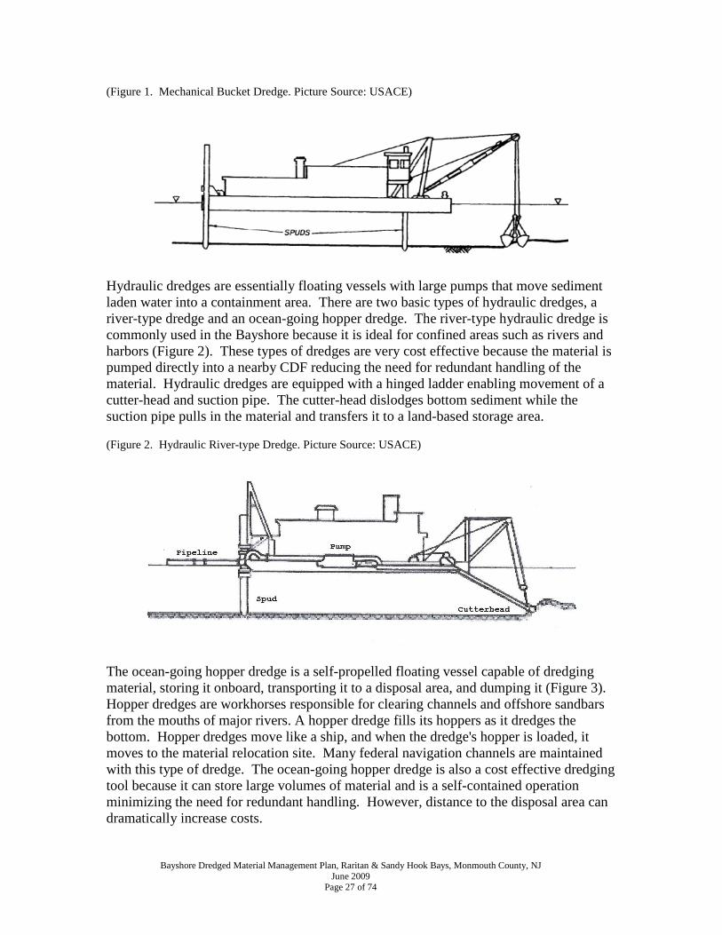
(Figure 1. Mechanical Bucket Dredge. Picture Source: USACE)
Hydraulic dredges are essentially floating vessels with large pumps that move sediment laden water into a containment area. There are two basic types of hydraulic dredges, a river-type dredge and an ocean-going hopper dredge. The river-type hydraulic dredge is commonly used in the Bayshore because it is ideal for confined areas such as rivers and harbors (Figure 2). These types of dredges are very cost effective because the material is pumped directly into a nearby CDF reducing the need for redundant handling of the material. Hydraulic dredges are equipped with a hinged ladder enabling movement of a cutter-head and suction pipe. The cutter-head dislodges bottom sediment while the suction pipe pulls in the material and transfers it to a land-based storage area. (Figure 2. Hydraulic River-type Dredge. Picture Source: USACE)
The ocean-going hopper dredge is a self-propelled floating vessel capable of dredging material, storing it onboard, transporting it to a disposal area, and dumping it (Figure 3). Hopper dredges are workhorses responsible for clearing channels and offshore sandbars from the mouths of major rivers. A hopper dredge fills its hoppers as it dredges the bottom. Hopper dredges move like a ship, and when the dredge's hopper is loaded, it moves to the material relocation site. Many federal navigation channels are maintained with this type of dredge. The ocean-going hopper dredge is also a cost effective dredging tool because it can store large volumes of material and is a self-contained operation minimizing the need for redundant handling. However, distance to the disposal area can dramatically increase costs.

Bayshore Dredged Material Management Plan, Raritan & Sandy Hook Bays, Monmouth County, NJ June 2009
Page 28 of 74
(Figure 3. Hydraulic Ocean-going Hopper Dredge. Picture Source: USACE)
Table 4 provides available cost information for local dredging projects. The table identifies hydraulic dredging versus mechanical dredging projects, cost per cubic yard and material destination. In every instance but one, the material was placed in a nearby CDF or used beneficially at a nearby location. Most of the material used beneficially went to nearby beaches for replenishment or to the Belford Landfill for capping purposes. Examining costs in the table is somewhat enlightening. First, we see that dredging is not getting any cheaper. The going rate appears to be about $30 per cubic yard for hydraulic dredging and mechanical dredging ranges between $7.00 and $45.00 depending upon the amount of material to be removed and access complexity. Second, prices seem to vary wildly. Price variability results from external economic factors and on-site CDF conditions. CDFs that are nearly full have limited capacity to receive dredge slurry. Water is not permitted to overflow the CDF berm, so pumping must stop when the water slurry reaches within one foot of the top. A required 24 hour waiting period allows sediment in the water column to settle out and the water to clear. Once the sediment has settled and the water column is clear, water may be pumped out of the CDF into the bay and dredging may resume. This stop-start process delays dredging and thus adds to the cost of dredging projects. Third, dredging larger volumes of material is cheaper, per unit, than smaller volumes as costs seem to be impacted more by logistics than volume. More difficult access or site physical conditions increase project cost. When working on federal projects, the U.S. Army Corps of Engineers (USACE) attempts to minimize logistical difficulties by placing material near the dredging site (i.e., beach replenishment) or by using dredging equipment capable of storing material onboard until the placement area is reached, i.e., hopper dredge.

Bayshore Dredged Material Management Plan, Raritan & Sandy Hook Bays, Monmouth County, NJ June 2009
Page 29 of 74
Table 4: Bayshore Dredging Costs per CY Facility Quantity Completed Cost/CY Destination
Hydraulic Dredging Projects
Matawan Creek-Fed Channel 135,294 11/7/1984 $4.53 adjacent site Atl. Highlands Harbor - Fed Channel 508,184 10/21/1986 $2.24 no record Keyport Harbor-Fed. Channel 55,644 11/8/1990 $7.62 mud dump site
Leonardo Marina - Fed Channel 58,756 10/26/1991 $7.74 beach east of jetty
Compton Creek-Ferry Terminal 12,658 1/14/1999 $10.00 N61 CDF
Monmouth Cove Marina 9,190 4/1/1999 $15.66 onsite CDF-Belford
Compton Creek/S. Harbor-Fed Channel 81,710 7/23/1999 $9.20 N61 CDF
Monmouth Cove Marina 2,865 10/1/2001 $24.21 onsite CDF-Belford Keansburg Jetty Reconstruction 15,145 12/23/2003 $16.85 Pt. Comfort Beach Monmouth Cove Marina 7,742 2/24/2004 $14.07 onsite CDF-Belford Atl. Highlands Harbor 4,000 12/16/2004 $18.00 onsite CDF
Atl. Highlands Harbor 20,000 12/22/2005 $18.00 onsite CDF
Compton Creek (maintenance) 43,930 1/1/2006 $32.50 N61 CDF
Monmouth Cove Marina 5,563 10/1/2006 $33.87 onsite CDF-Belford
Hans Pedersen 6,000 8/1/2007 $6.00 nearby CDF Atl. Highlands Harbor 18,200 12/31/2007 $30.00 onsite CDF
Mechanical Dredging Projects Captain's Cove 350 2/17/1999 $40.00 Bayview Condo Captain's Cove 350 3/1/2001 $45.00 onsite use Keansburg 6,000 12/23/2008 $18.00 Pt. Comfort Beach
Leonardo Marina 650 12/23/2008 $6.67 onsite use By reviewing historic dredging activities and trends, the cost of managing dredged material can be discerned. Data in Table 5 identify costs associated with dredging in the Bayshore region. Since 1984, nearly $8.5 million has been spent on managing more than 1 million cubic yards of dredged material. Of the 1 million cubic yards of material, approximately 300,000 cubic yards have been used beneficially as either landfill cover at the Belford Landfill or bayside beach replenishment. A little more than half of this material went to the Belford Landfill with the remaining going to bay beaches. Nearly 300,000 cubic yards has been sent to Bayshore CDFs. Today those CDFs store approximately 80,000 cubic yards. The remaining material has been disposed of locally or placed in the ocean at the Historic Area Remediation Site. It is important to note that the Belford Landfill is developing a landfill closure plan, so in the near future this facility will no longer accept dredged material. Landfill elevations are considered optimum and cover material reaches or exceeds minimum depth requirements.

Bayshore Dredged Material Management Plan, Raritan & Sandy Hook Bays, Monmouth County, NJ June 2009
Page 30 of 74
Table 5: Bayshore Total Project Costs (1984-2008) Facility City Quantity Cost/CY Project Cost Aero Marine Terminal Keyport 6,000 $10.00 $60,000.00
Atlantic Highlands Harbor Atl. Highlands 11,800 $10.00 $118,000.00 Atl. Highlands 4,000 $18.00 $72,000.00 Atl. Highlands 20,000 $18.00 $360,000.00
Atl. Highlands 18,200 $30.00 $546,000.00
Atl. Highlands Harbor Federal Channel Atl. Highlands 508,184 $2.24 $1,138,332.16
Captain's Cove Highlands 350 $40.00 $14,000.00
Highlands 350 $45.00 $15,750.00
Captain's Cove Marina (Waackaak Creek) W. Keansburg 2,540 $10.00 $25,400.00
Compton Creek/S.Harbor Federal Channel Belford 81,710 $9.20 $751,732.00 Compton Creek-Ferry Terminal Belford 12,658 $10.00 $126,580.00 Compton Creek (maintenance) Belford 43,930 $32.50 $1,427,725.00
Eugene Shute Highlands 332 $40.00 $13,280.00
Hans Pedersen and Sons Keyport 6,000 $10.00 $60,000.00 Keyport 6,000 $6.00 $36,000.00
Keansburg Keansburg 30,000 $18.00 $540,000.00 Keansburg - Waackaak/Thorns Keansburg 29,100 $10.00 $291,000.00 Keansburg Jetty Reconstruction Keansburg 15,145 $16.85 $255,193.25 Keyport Harbor-Fed. Channel Keyport 55,644 $7.62 $424,007.28 Keport Marine Basin Keyport 15,000 $16.00 $240,000.00 Lentze Marina, Inc. W. Keansburg 4,000 $10.00 $40,000.00
Leonardo Marina - Fed Channel Leonardo 58,756 $7.74 $454,771.44
Leonardo State Marina Leonardo 2,500 $18.00 $45,000.00 Leonardo 3,250 $6.67 $21,677.50
Matawan Creek Keyport 180 $18.00 $3,240.00
Matawan Creek-Fed Channel Keyport 135,294 $4.53 $612,881.82
Monmouth Cove Marina Port Monmouth 9,190 $15.66 $143,915.40 Port Monmouth 2,865 $24.21 $69,361.65 Port Monmouth 7,742 $14.07 $108,929.94 Port Monmouth 5,563 $33.87 $188,418.81
Union Beach Union Beach 4,000 $18.00 $72,000.00 USCG Sandy Hook Highlands 1,900 $40.00 $76,000.00 Wagner’s Twin Towers Marina Keyport 35 $40.00 $1,400.00
Total 1,102,218 $8,352,596.25 Italicized items are estimates based on similar projects and year of activity.
Bayshore Dredged Material Management Plan, Raritan & Sandy Hook Bays, Monmouth County, NJ June 2009
Page 31 of 74
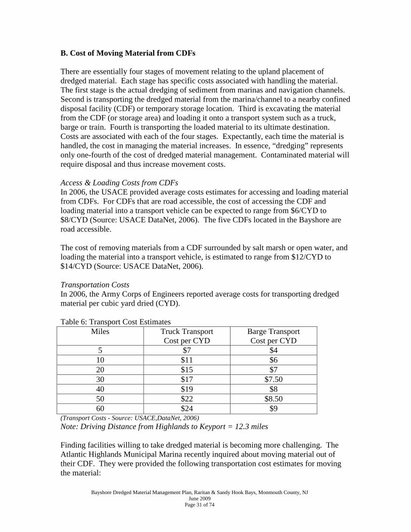
B. Cost of Moving Material from CDFs There are essentially four stages of movement relating to the upland placement of dredged material. Each stage has specific costs associated with handling the material. The first stage is the actual dredging of sediment from marinas and navigation channels. Second is transporting the dredged material from the marina/channel to a nearby confined disposal facility (CDF) or temporary storage location. Third is excavating the material from the CDF (or storage area) and loading it onto a transport system such as a truck, barge or train. Fourth is transporting the loaded material to its ultimate destination. Costs are associated with each of the four stages. Expectantly, each time the material is handled, the cost in managing the material increases. In essence, “dredging” represents only one-fourth of the cost of dredged material management. Contaminated material will require disposal and thus increase movement costs. Access & Loading Costs from CDFs In 2006, the USACE provided average costs estimates for accessing and loading material from CDFs. For CDFs that are road accessible, the cost of accessing the CDF and loading material into a transport vehicle can be expected to range from $6/CYD to $8/CYD (Source: USACE DataNet, 2006). The five CDFs located in the Bayshore are road accessible. The cost of removing materials from a CDF surrounded by salt marsh or open water, and loading the material into a transport vehicle, is estimated to range from $12/CYD to $14/CYD (Source: USACE DataNet, 2006). Transportation Costs In 2006, the Army Corps of Engineers reported average costs for transporting dredged material per cubic yard dried (CYD). Table 6: Transport Cost Estimates
Miles Truck Transport Cost per CYD
Barge Transport Cost per CYD
5 $7 $4 10 $11 $6 20 $15 $7 30 $17 $7.50 40 $19 $8 50 $22 $8.50 60 $24 $9
(Transport Costs - Source: USACE,DataNet, 2006) Note: Driving Distance from Highlands to Keyport = 12.3 miles Finding facilities willing to take dredged material is becoming more challenging. The Atlantic Highlands Municipal Marina recently inquired about moving material out of their CDF. They were provided the following transportation cost estimates for moving the material:

Bayshore Dredged Material Management Plan, Raritan & Sandy Hook Bays, Monmouth County, NJ June 2009
Page 32 of 74
• The Harbor Master was quoted a price of $95/18 CY to take material to the Belford Landfill. The price was based on the use of a large transport truck capable of hauling 18 CY per trip. It was estimated that the hauler would make 12-14 trips per day covering the 11 mile round trip circuit. The transportation cost is $8.64 per mile. ($95/18cy=$5.30/cy or $95/11=$8.64/mile)
• A quarry manager in Somerset County operating under a closure and development plan agreed to accept the material from the CDF. Proposed transportation costs were $65/CY. It was estimated that one truck capable of hauling 16 cubic yards could make 3 trips per day traveling the 80 mile round trip journey or a total of 240 miles per day. The estimated transportation cost is $13.00 per mile. (16cy/truck*3trips=48cy/day*$65=$3120/240mi.=$13/mi.)
• A landfill in Ocean County agreed to accept material from the CDF for $10-$25/CY. This price is merely an acceptance fee and does not include transportation costs. It was estimated that one truck could make 3 trips per day traveling the 90 mile round trip or a total of 270 miles per day. Based on similar pricing and quantities for the Somerset County quarry, the transportation cost would be approximately $13.33 per mile. 48cy/day*65=$3120+$480acceptance fee=$3600/270mi.= $13.33/mile)
Based on the loading cost estimates provided by the USACE, a $7.00 CY loading fee has been assumed. A $13.00 CY transportation fee has been assumed based on recent quotes provided to local facilities. Table 7 reflects material movement costs if material were to be removed from existing CDFs. Non-CDF placement options have not been factored into the table because it is assumed that material was used beneficially and does not present a material movement issue. In essence, preparing the CDFs for the next round of dredging will require an estimated $1.5 million dollar investment or a $4 million dollar investment if the CDFs reach their storage capacity. Table 7: Material Extraction and Movement Costs from Bayshore CDFs (CY)
CDF
Capacity Current Storage Loading $7 Transport $13
Keyport Marine Basin CDF 20,000 15,000 $105,000 $195,000
Pedersen’s Boat Yard CDF 22,000 12,000 $84,000 $156,000
Monmouth County Park System CDF 10,000 0 $0 $0
Shoal Harbor (N61) CDF 130,000 43,000 $301,000 $559,000
Atlantic Highlands CDF 22,700 9,300 $65,100 $120,900
Totals 204,700 79,300 $555,100 $1,030,900
Total Loading & Truck Transportation $1,586,000

Bayshore Dredged Material Management Plan, Raritan & Sandy Hook Bays, Monmouth County, NJ June 2009
Page 33 of 74
C. Economic Impact of Not Dredging New Jersey's recreational boaters spend $2.1 billion a year and support some 18,000 jobs according to a first-ever economic impact study commissioned by the Marine Trades Association of New Jersey. The study reported 176,631 registered boats in New Jersey in the year 2006. That same year New Jersey boaters used their vessels an average of 28 times. Ocean and Monmouth counties support the largest percentage of boaters with 28 percent of registered owners in Ocean County and 12 percent in Monmouth County. Boaters spend an average of $273 on a typical trip, counting fuel, groceries and bait. In 2006, trip-related expenditures exceeded $1.1 billion, and non-trip expenditures for items like maintenance, dock fees and other costs were around $938 million. New Jersey residents' purchases of new boats and accessories exceed $400 million a year, and boaters on average spend $6,340 a year between their original purchase cost and miscellaneous expenses such as dock fees, fuel, insurance and maintenance. In 2006 commercial fishery landings exceeded 152 million pounds with an estimated value of $136 million (NMFS, 2006). Local ports also support a large commercial sector catering to the fishing and boating industry, including ship chandlers, boat builders, repair yards and boat sales offices. New Jersey’s small ports see intensive recreational and commercial fishing and boating activity. New Jersey has supported some of the busiest commercial fishing ports beginning in the 1940’s. In fact, the surf clam fishery was pioneered in Point Pleasant and one of the first processing plants using steam shucking was built there (FishNet, 1999). There are 5 major commercial fishing ports in New Jersey: Belford, Point Pleasant, Barnegat Light, Atlantic City and Cape May. With the exception of Atlantic City, all of these ports support a number of both inshore and offshore fisheries. Clearly recreational and commercial boating is an important industry for New Jersey, and supporting the maritime industry will require maintaining the necessary infrastructure. Infrastructure, of course, includes dredging projects that maintain adequate depths for various marine uses. Loss of marine use would have an economic impact in hundreds of millions of dollars. It would also have a devastating impact on communities dependent upon marine activities and established from a maritime heritage.

Bayshore Dredged Material Management Plan, Raritan & Sandy Hook Bays, Monmouth County, NJ June 2009
Page 34 of 74
SECTION VI. CONFINED DISPOSAL FACILITIES The Bayshore hosts five Confined Disposal Facilities (CDFs). These privately-owned CDFs have a total storage capacity of 204,700 cubic yards of dredged material. At this time, the CDFs are storing 79,300 CY, so the remaining storage capacity is 125,400 CY. If beneficial uses are found for the dredged material within the existing CDFs, then more capacity is available for future dredging. Of the five CDFs, two are deed restricted (Shoal Harbor and Atlantic Highlands) meaning that the material does not meet residential standards for development and thus limits options for beneficial use of the material. The Bayshore CDFs are used for the storage of dredged material from marinas and navigation channels. Consequently, the CDFs are in close proximity to dredging activities associated with each marina. The removal of bottom sediments ensures the functionality and use of each marine facility.
Note: Balloons lettered A through E identify the locations of CDFs in the Bayshore and correspond with descriptions on the following pages.

Bayshore Dredged Material Management Plan, Raritan & Sandy Hook Bays, Monmouth County, NJ June 2009
Page 35 of 74
A. Keyport Marine Basin CDF The Keyport Marine Basin CDF is located adjacent to Matawan Creek at the end of Chandler Avenue in Keyport. It serves as a storage area for dredged material from Keyport Marine Basin. The storage capacity is approximately 20,000 cubic yards (CY). In 2003, the NJDEP permitted the placement of 15,000 CY in the CDF. Material is required to stay there until the acceptable use determination is modified for a final disposal site. The CDF is not deed restricted meaning that the material meets residential standards for development and thus can be utilized for beneficial use options. Quick Facts Municipality: Keyport Adjacent Waterway: Matawan Creek CDF Storage Capacity: ~20,000 CY Material in CDF: 15,000 CY Deed Restricted: No Beneficial Use Potential: Yes, no restrictions.

Bayshore Dredged Material Management Plan, Raritan & Sandy Hook Bays, Monmouth County, NJ June 2009
Page 36 of 74
B. Pedersen’s Boat Yard CDF Pedersen’s Boat Yard CDF is located adjacent to Luppatatong Creek south of West Front Street in Keyport. It serves as storage area for dredged material from Pedersen’s Boat Yard marina. The storage capacity is approximately 22,000 cubic yards. In 2002, the NJDEP permitted the placement of 6,000 CY in the CDF. On August 3, 2007, a permit modification was issued by NJDEP to place an additional 6,000 CY in the CDF. Pedersen’s CDF currently holds 12,000 CY. The CDF is not deed restricted meaning that the material meets residential standards for development and thus can be utilized for beneficial use options. Quick Facts Municipality: Keyport Adjacent Waterway: Luppatatong Creek CDF Storage Capacity: ~22,000 CY Material in CDF: 12,000 CY Deed Restricted: No Beneficial Use Potential: Yes, no restrictions.

Bayshore Dredged Material Management Plan, Raritan & Sandy Hook Bays, Monmouth County, NJ June 2009
Page 37 of 74
C. Monmouth County Park System CDF The Monmouth County Park System’s Monmouth Cove Marina CDF is located adjacent to Pews Creek north of Port Monmouth Road in the Port Monmouth section of Middletown. It serves as storage area for dredged material from Monmouth Cove Marina. The storage capacity is approximately 10,000 cubic yards. On February 24, 2004, NJDEP permitted the placement of 9,050 CY of dredged material in the CDF from Monmouth Cove Marina. The dredged material was removed from the CDF, blended with compost material, and used as landfill cover at the Belford Landfill. The CDF is not deed restricted, so any material placed in it must meet residential standards for development and thus can be utilized for beneficial use options. Quick Facts Municipality: Middletown Adjacent Waterway: Pews Creek CDF Storage Capacity: ~10,000 CY Material in CDF: 0 CY Deed Restricted: No Beneficial Use Potential: Yes, no restrictions.

Bayshore Dredged Material Management Plan, Raritan & Sandy Hook Bays, Monmouth County, NJ June 2009
Page 38 of 74
D. Shoal Harbor (N61) CDF Shoal Harbor also referred to as site N61 is located near Compton Creek southeast of the ferry terminal parking area in the Belford section of Middletown. The CDF serves as storage area for dredged material from Compton Creek to support the operation of the Belford commercial harbor. The storage capacity is approximately 130,000 cubic yards. In 2006, NJDEP permitted the placement of approximately 43,000 cubic yards of material dredged from Compton Creek in site N61. In 2009, the USACE is planning to place approximately 100,000 CY of dredged material from Compton Creek in N61. The CDF is deed restricted since the material does not meet residential standards for development, thus use of the material is limited. The facility, situated near an old airport and historic landfill, also receives dredged material from other areas by truck. The dredged material is placed on the old tarmac and blended with leaf material from nearby towns to create topsoil. The topsoil is then used to cover the historic Belford Landfill adjacent to the CDF. A landfill closure plan is currently under development. Quick Facts Municipality: Middletown Adjacent Waterway: Compton Creek CDF Storage Capacity: ~130,000 CY Material in CDF: 43,000 CY Deed Restricted: Yes Beneficial Use Potential: Yes, but options are limited due to contamination.

Bayshore Dredged Material Management Plan, Raritan & Sandy Hook Bays, Monmouth County, NJ June 2009
Page 39 of 74
E. Atlantic Highlands CDF The Atlantic Highlands CDF is located adjacent to Sandy Hook Bay and is north of Ocean Boulevard in Atlantic Highlands. It serves as storage area for dredged material from the Atlantic Highlands municipal harbor. The storage capacity is 22,700 cubic yards. In 2007, NJDEP permitted the placement of 18,000 CY of dredged material in the CDF. A permit modification was issued November 7, 2007 to allow an additional 6,300 CY to be placed in the CDF, while also allowing 15,000 CY to be removed from the CDF and used as cover at Belford landfill. The CDF is deed restricted since the material does not meet residential standards for development, thus use of the material is limited. Quick Facts Municipality: Atlantic Highlands Adjacent Waterway: Sandy Hook Bay CDF Storage Capacity: 22,700 CY Material in CDF: 9,300 CY Deed Restricted: Yes Beneficial Use Potential: Yes, but options are limited due to contamination.

Bayshore Dredged Material Management Plan, Raritan & Sandy Hook Bays, Monmouth County, NJ June 2009
Page 40 of 74
SECTION VII. BENEFICIAL USES SUITABLE FOR BAYSHORE Dredged material can and should be considered a resource as opposed to a waste destined for disposal. It is increasingly important to explore emerging beneficial use options to ensure an integrated long-term program for the management of dredged material. Depending on its characteristics, particularly grain size and contaminant level, dredged material may be suitable for habitat development projects, beach replenishment, construction site fill for non-structural and structural applications, topsoil creation and many other creative applications. The following describes potential beneficial end uses. Section VIII. C. details known opportunities for beneficial use in the Bayshore. A. Habitat Creation & Restoration Silt is also an ideal substrate for wetland creation and enhancement. Bayshore communities have lost hundreds of acres of tidal marsh from development activities and the rise of sea level over the years and continue to lose marshlands from erosion. Aerial photography reveals large pockets of tidal marsh losses in Matawan Creek which conveniently hosts a federal navigation channel. Digital photography measurements suggest that nearly 250,000 cubic yards of dredged material could be used to restore Matawan Creek wetlands. Placement of silt rich dredged material coupled with marsh plantings would restore this declining but valuable habitat. The majority of habitat creation and restoration projects (e.g., wetland creation, mud flat creation, etc.) recommended by the USACE and NJDEP require the placement of dredged material in open waters. Concerns about potential impacts to aquatic organisms have not permitted these types of projects in New Jersey. Hence, NJDEP is not pursuing open water habitat creation or restoration options at this time. Given the rate of sea level rise (1foot in the last 100 years in NJ) and coastal inundation, habitat creation may be useful to provide a buffer to flooding-prone regions. However, a list of project types is included below should the State decide to pursue habitat creation and restoration projects in the future.
o Wetland creation o Mud flat creation o Submerged Aquatic Vegetation (SAV) creation o Oyster reef creation o Shellfish bed creation o Fish reef creation o Bird upland habitat creation
B. Beach Replenishment NJDEP encourages the replenishment of eroding beaches for both flood protection and public use/access to waterways. Beach replenishment must involve the placement of clean sand of acceptable grain size and composition to ensure beach stability. Suitable material must be comprised of 75% or greater sand, with a grain size compatible with that

Bayshore Dredged Material Management Plan, Raritan & Sandy Hook Bays, Monmouth County, NJ June 2009
Page 41 of 74
of the receiving beach, and known not to be contaminated based on information provided by background documentation (see Section II. B. for Testing Requirements). Material with a grain size smaller than the “compatible grain size” for the beach, but still greater than 75% sand, could be utilized in dune construction, provided that the effective erosion controls remain in place until vegetative cover is established. Potential adverse environmental impacts can result from the placement of dredged material on beaches if the material contains excessive levels of organic material or contaminants. NJDEP regulations are designed to prevent any adverse impacts that threaten public health, benthic and open water ecological communities, or are of aesthetic concern to the community. Beach replenishment projects in the Bayshore include Keansburg and Middletown. The Keansburg site has received 30,000 cubic yards of material with an additional 6,000 CY stockpiled for future beach nourishment from Waackaack Creek and is being managed by the NJDEP. The Middletown site is located in front of the Belford Landfill and the Shoal Harbor (N61) CDF. Approximately 9,000 cubic yards has been placed on the beach. Placement material must have grains of at least 75% sand to ensure beach stability and to minimize sand migration. The Belford facility is owned and managed by Monmouth County. C. Construction Site Uses Some dredged material can be used as construction material. In many cases, dredged material consists of a mixture of sand and clay fractions, which may require some type of separation process. Dewatering may also be required because of high water content. Depending on the sediment type and processing requirements, dredged material may be used as: concrete aggregate (sand and gravel); backfill material or in the production of bituminous mixtures and mortar (sand); raw material for brick manufacturing (clay with less than 30 percent sand); ceramics, such as tile (clay) pellets for insulation or lightweight backfill or aggregate (clay); raw material for the production of riprap or blocks for the protection of dikes and slopes against erosion (rock, mixture); and raw material for the production of compressed blocks for security walls at military installations and for gated communities and home subdivisions. (USACE & USEPA, 2006) Construction site uses include:
• Structural • Nonstructural (e.g., fill material) • Roadway Aggregate • Soil Amendment • Septic System Leach Field Soil Amendment
Bayshore Recycling Corporation located in Keasbey, New Jersey is NJDEP Class B recycling operation permitted to accept dredged material, concrete, asphalt, brick, block,
Bayshore Dredged Material Management Plan, Raritan & Sandy Hook Bays, Monmouth County, NJ June 2009
Page 42 of 74
ID-27 and slag. These materials are processed and transformed into marketable products for a variety of applications such as roadbed material. This waterfront facility is capable of receiving large volumes of dredged material by barge making it an economical option for the beneficial use of dredged material. D. Topsoil Creation Maintenance dredging in harbors, access channels, and rivers produces mixtures of sand, silt, clay and organic matter that can be excellent ingredients for topsoil. However, dredged material from coastal or tidal areas requires special attention to salinity, since most vegetation cannot tolerate and grow in salty soil. Salinity may be reduced naturally by rain or by a dewatering process. Other uses of topsoil might include using dredged material to cap poor soils or to cover and fill coarse material (e.g., urban or industrial waste sites). Other dredged material may require blending with other residual materials such as organic matter (yardwaste, wastepaper, storm debris, etc.) and biosolids (human sewage sludge or animal manure) to manufacture enhanced fertile topsoil. At the Belford Landfill, dredged material is blended with leaf litter to create a topsoil to cover the landfill. The blended topsoil can be used for athletic fields, home landscaping, golf courses, parks, and Brownfield redevelopment. Required topsoil specifications for a specific use can be met through blending appropriate materials together in specific amounts. Dredged material may be used to improve soil structure for agricultural purposes. For the production of food, uncontaminated material must be used. For other uses, the allowed contaminant level will depend on the use of the topsoil. In some cases, suitable material may be placed in a thin layer directly by pumping. After dewatering, the material is suitable topsoil for seeding and planting. Dewatering may require several years, depending on the granular texture of the dredged material and is influenced by additional substances or by the type of dewatering process. E. Open Water Capping Open water capping involves the placement of clean dredged material over a deposit of contaminated dredged material in open water. It is used as a means of remediation by isolating contaminated sediment from the surrounding environment. Open-water caps provide a wave-and current-resistant layer on top of previously deposited contaminated materials. Sand or mixed materials with minimal contaminant levels may be used for open-water capping. Clean dredged material is determined if it meets the EPA Region II/ NYD Category I criteria, with test results showing no unacceptable toxicity or bioaccumulation. Open water capping is used at the Historic Area Remediation Site (HARS) off the coast of Sandy Hook, New Jersey. Clean material dredged from the New York and New Jersey Harbor is used to cover existing contaminated sediments at the designated Historic Area

Bayshore Dredged Material Management Plan, Raritan & Sandy Hook Bays, Monmouth County, NJ June 2009
Page 43 of 74
Remediation Site. Since 1997, approximately 4.3 million cubic yards of dredged material has been used to remediate the HARS and more remediation material is needed. The NJDEP has expressed concern about impacts to aquatic organisms from open water capping. Consequently, open water capping is only considered a beneficial use when remediation is required. F. Flood Control Projects (Geotextile Uses) The planned Raritan Bay-Sandy Hook Bay Hurricane and Storm Damage Reduction Plan presents an opportunity to use dredged material for flood prevention and control. Beach nourishment plans for Old Bridge and Keansburg will require substantial volumes of sand. Levee protection in Keansburg may present opportunities for geotextile use. Geotextile tubes can be filled with dredged material and used as foundation material for levee walls. While beach nourishment will require the use of sand, geotextile tubes can utilize fine grain materials such as silt and clay. The Storm Damage Reduction Plan includes the study of flood prevention in Leonardo, Port Monmouth, Keyport and the Highlands. The project is stalled due to inadequate funding but is slated to be completed by 2010-2015. G. Quarry Rehabilitation Quarries in the region present opportunities for beneficial use of dredged material. Once all mining material has been extracted from a quarry, closing plans may seek rehabilitation of the land. Some rehabilitation plans call for redevelopment of the property by filling and re-grading the landscape. In some cases, dredged material may be used as fill. When this occurs, substantial volumes of material can be brought in to improve property topography. Bernards, New Jersey has undertaken this type of rehabilitation with the Millington Quarry. Officials estimate that more than 2 million cubic yards of material will be needed to rehabilitate the quarry for development. H. Industry Dredged-related Products Dredged material can be blended with recycled residual materials, such as glass, gypsum, plastic bottles, and automobile interiors to manufacture statues, figures, garden benches, stepping patio pavers, plant vases, artificial rocks and water fountains. These products can be used to landscape gardens, backyards, swimming pool environments, monument stones, miniature golf courses, highway rest areas, tourist welcoming centers, zoos, and theme parks. Suitable dredged material may contain sand, silt, clay and mixtures. SECTION VIII. FINDINGS & RECOMMENDATIONS Boating in New Jersey is an incredible resource from both an economic and intrinsic value perspective. Recreational boaters spend $2.1 billion annually on boating related

Bayshore Dredged Material Management Plan, Raritan & Sandy Hook Bays, Monmouth County, NJ June 2009
Page 44 of 74
activities and the industry supports roughly 18,000 jobs (MTANJ, 2006). Commercial fishery landings pumped $136 million into the state economy in 2006 (NMFS, 2006), and local ports support ship chandlers, boat builders, repair yards, boat sales & other support services. These facilities often attract tourists that may not actually be boaters themselves but enjoy being close to the marine environment. These facilities cannot continue to operate without proper support and maintenance such as dredging. Bayshore dredging activities over the past 25 years have resulted in the removal of more than 1,000,000 cubic yards of dredged material at a cost of $28 million. Roughly $20 million of this amount was used to load and transport dredged material after it was placed on land. A little more than half of this material has been used beneficially with most used for landfill cover and beach replenishment. The remaining amount of material has been placed in five privately owned Confined Disposal Facilities (CDF) located in the Bayshore. The five CDFs are approaching nearly half their capacity with large dredging projects looming in the future. Preparing the CDFs for the next 25 years by removing the material within them will cost roughly $4,000,000 once they reach storage capacity. Finding beneficial uses for material currently contained in the CDFs and material yet to be dredged will substantially reduce the cost managing dredged material and supporting marine infrastructure. Coordinating dredging projects among marinas and federal navigation channel maintenance can achieve savings through economies of scale. Mobilizing dredging equipment prior to dredging is a costly process. Improved planning and coordination can established processes that allow shared mobilization costs. Marinas that work together with a single dredging contractor can improve his set-up and equipment transport logistics saving time and money that can be passed on to the marinas. Appendix C provides historic dredging cycles and forecasts dredging needs for Bayshore Marinas and federal navigation channels. Marina owners should review these cycles and partner with nearby marinas with similar cycles to save money. A. Identification of Most Economically Viable Option Substantial savings can be achieved by finding beneficial uses before dredging projects begin. In some cases material movement and processing costs can be eliminated. Loading and transporting dredged material is a tremendous burden logistically and economically. As this report points out, removing material from existing CDFs filled to capacity can cost as much as $4,000,000. Finding a home for the material is even more challenging as evidenced by the reliance of storing material in CDFs and the struggle that marina operators have in finding facilities willing to take the material. Thus, eliminating loading and transportation elements will result in a more economical option. Clearly, beach replenishment along Sandy Hook and Raritan Bays are the most economical option for the Bayshore Region. The list below identifies options in order of

Bayshore Dredged Material Management Plan, Raritan & Sandy Hook Bays, Monmouth County, NJ June 2009
Page 45 of 74
Least Difficult Most Difficult
least difficult to most difficult based on the feasibility of management options, costs and state policy.
• Beach Replenishment • Landfill Cover • Construction Site Use • Flood Control Projects • Topsoil Creation • Agricultural Use • Structural Products (e.g., bricks, pavers, etc.) • Open Water Capping • Habitat Creation and Restoration
B. Decision-making Continuum A decision-making continuum has been developed based on the viable options for the Bayshore community. Considering a priority continuum marina managers, township officials and state regulators should seek opportunities for:
1. beach replenishment and flood control 2. construction site use, and; 3. material processing for landfill cover, topsoil creation, agricultural soil
amendments, and structural products. The Bayshore municipalities should remain diligent in seeking opportunities for the beneficial use of dredged material. This could be facilitated by establishing a dredging committee responsible for coordinating municipal dredging projects, tracking new dredging and recycling technologies and seeking opportunities for the beneficial use of dredged material. The DMMP should serve as a living document so that when new technologies or opportunities are found they are incorporated into the plan. Municipalities should also explore regulatory mechanisms capable of supporting dredging infrastructure needs. For example, towns could pass ordinances that require development projects seeking fill material to explore the use of dredged material as a first option for fill. Only after all options have been explored, may construction firms bring fill material to the construction site. Similarly, roadbed material, landscaping soil and topsoil needs must first utilize dredged material before any other material may be used. C. Opportunities for Beneficial Uses in Bayshore Dredging needs in the Bayshore consist solely of maintenance dredging in existing channels and harbors. Since dredging for new channels and harbors is not an issue, maintenance dredging provides predictability in dredging needs. Dredging locations are fixed and material placement locations are limited. Dredged material will require varying degrees of processing depending upon its ultimate use. For example, dredged material suitable for beach replenishment will not require
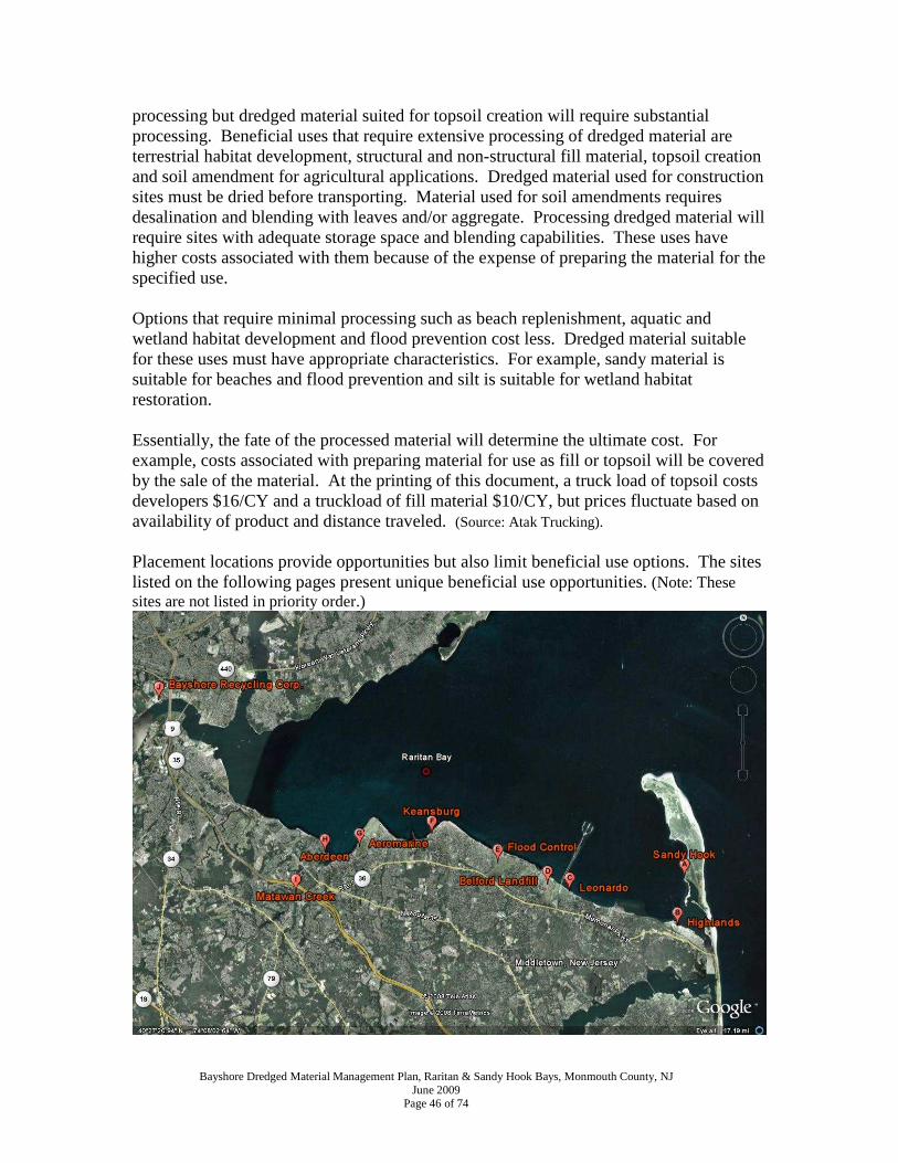
Bayshore Dredged Material Management Plan, Raritan & Sandy Hook Bays, Monmouth County, NJ June 2009
Page 46 of 74
processing but dredged material suited for topsoil creation will require substantial processing. Beneficial uses that require extensive processing of dredged material are terrestrial habitat development, structural and non-structural fill material, topsoil creation and soil amendment for agricultural applications. Dredged material used for construction sites must be dried before transporting. Material used for soil amendments requires desalination and blending with leaves and/or aggregate. Processing dredged material will require sites with adequate storage space and blending capabilities. These uses have higher costs associated with them because of the expense of preparing the material for the specified use. Options that require minimal processing such as beach replenishment, aquatic and wetland habitat development and flood prevention cost less. Dredged material suitable for these uses must have appropriate characteristics. For example, sandy material is suitable for beaches and flood prevention and silt is suitable for wetland habitat restoration. Essentially, the fate of the processed material will determine the ultimate cost. For example, costs associated with preparing material for use as fill or topsoil will be covered by the sale of the material. At the printing of this document, a truck load of topsoil costs developers $16/CY and a truckload of fill material $10/CY, but prices fluctuate based on availability of product and distance traveled. (Source: Atak Trucking). Placement locations provide opportunities but also limit beneficial use options. The sites listed on the following pages present unique beneficial use opportunities. (Note: These sites are not listed in priority order.)

Bayshore Dredged Material Management Plan, Raritan & Sandy Hook Bays, Monmouth County, NJ June 2009
Page 47 of 74
1. (A) Sandy Hook National Park Bayside Beach Replenishment The National Park Service has identified an area along Sandy Hook Bay where beach replenishment is necessary. Approximately 80,000 cubic yards of sandy material is needed to adequately restore and protect the beach. The land area around the site to be filled contains two large historic gun batteries that are in danger of being undermined. Two historic powder magazines have already been lost by erosion and collapsed into the bay. At one time, a long wooden bulkhead protected the shoreline, but it deteriorated over time. Rip rap structures placed to the north to protect historic Fort Hancock and park roadways are causing sediment migration loss. Without beach replenishment, the area is at severe risk of loss. Native vegetation in the area supports a variety of wildlife including diamondback terrapins, raccoons, red fox, osprey and several species of shorebirds.

Bayshore Dredged Material Management Plan, Raritan & Sandy Hook Bays, Monmouth County, NJ June 2009
Page 48 of 74
2. (B) Highlands Beach Replenishment The Bayview Condominiums Association has identified the need for approximately 5,000 CY of dredged material for beach replenishment. The Bayview Condominiums are located next to Sandy Hook Bay in Highlands at 330 Shore Drive. Long-term erosion trends are causing sand deficits adjacent to the building complex. In 1999, Captain’s Cove Marina provided approximately 350 CY of dredged material to supplement the protective beach. The Association is also seeking permission from NJDEP to place sand fencing on the beach to help accumulate sand during the winter months.

Bayshore Dredged Material Management Plan, Raritan & Sandy Hook Bays, Monmouth County, NJ June 2009
Page 49 of 74
3. (C) Leonardo State Marina Beach Replenishment Shoaling at the mouth of the marina canal is common and dredging occurs annually with a long-reach excavator. Dredged material is placed within reach of the excavator for a natural dewatering process. This facility already serves as a temporary storage area for dredged material and may serve as a practical staging point for beach replenishment efforts on nearby beaches in Middletown Township. Residents in the Leonardo section of Middletown have expressed concern about beach erosion for years. The federal channel leading to the Leonardo Marina was last dredged in 1991 with approximately 58,756 CY removed at a cost of $454,536. The material was found to be 92% sand and was placed along the beach on the southeast side of the channel. In May 2006, a survey of the federal channel revealed that the grain size is approximately 50% sand and 50% silt indicating that beach nourishment opportunities will be limited. Leonardo State Marina is located adjacent to Sandy Hook Bay and is a popular jumping off destination for boaters due to its close proximity to popular fishing grounds. Leonardo State marina has a public launch ramp, bait shop and fuel.

Bayshore Dredged Material Management Plan, Raritan & Sandy Hook Bays, Monmouth County, NJ June 2009
Page 50 of 74
4. (D) Belford Landfill Blending & Staging Area The Belford Landfill is an active facility capable of blending dredged material with leaf compost to create marketable topsoil for residential and commercial use. Dedicating one-third of the facility to dredged material-leaf litter blending could account for processing and marketing 115,267 cubic yards of dredged material per year. The facility is owned by Monmouth County and is leased to Middletown Township for leaf compost storage and processing. The site has heavy equipment on-site with material blending capabilities. Facility operations include beach replenishment efforts to protect CDF berms from bayside erosion. The Belford landfill currently accepts appropriate material for landfill cover. A landfill closure plan is under development to determine its remaining capacity, so it will not likely provide any long-term solutions for the placement of dredged material. The Belford landfill is located at the eastern terminus of Centre Avenue just east of the Belford community in Middletown and is adjacent to Sandy Hook Bay. This abandoned airfield belonged to the J. Howard Smith Fish Factory in Port Monmouth and was used by aircraft to spot schools of menhaden for the fishing fleet.
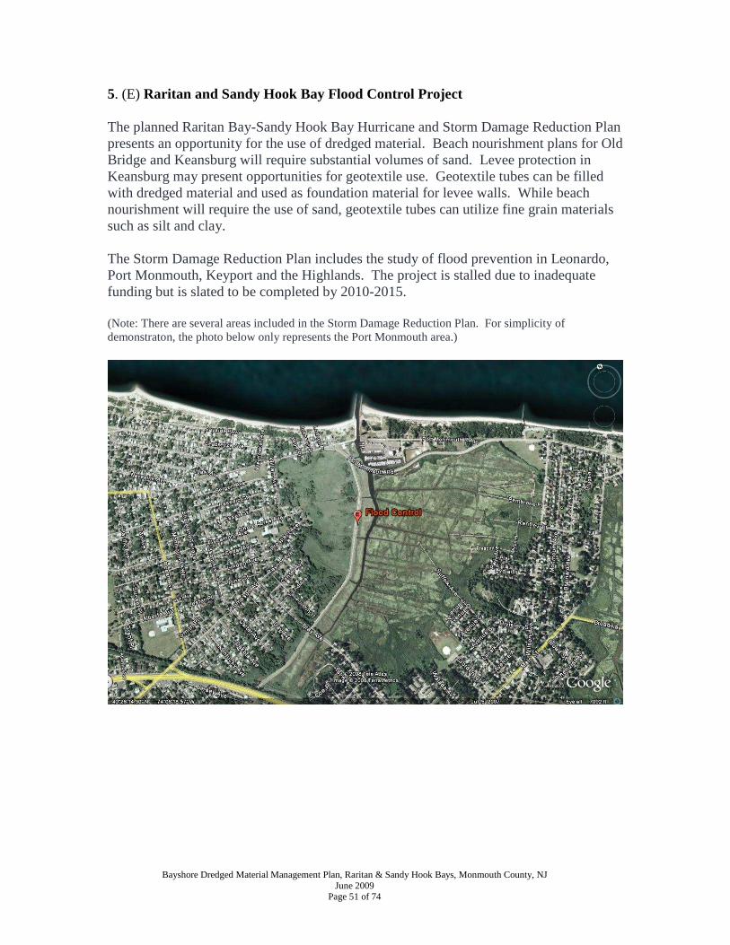
Bayshore Dredged Material Management Plan, Raritan & Sandy Hook Bays, Monmouth County, NJ June 2009
Page 51 of 74
5. (E) Raritan and Sandy Hook Bay Flood Control Project
The planned Raritan Bay-Sandy Hook Bay Hurricane and Storm Damage Reduction Plan presents an opportunity for the use of dredged material. Beach nourishment plans for Old Bridge and Keansburg will require substantial volumes of sand. Levee protection in Keansburg may present opportunities for geotextile use. Geotextile tubes can be filled with dredged material and used as foundation material for levee walls. While beach nourishment will require the use of sand, geotextile tubes can utilize fine grain materials such as silt and clay.
The Storm Damage Reduction Plan includes the study of flood prevention in Leonardo, Port Monmouth, Keyport and the Highlands. The project is stalled due to inadequate funding but is slated to be completed by 2010-2015. (Note: There are several areas included in the Storm Damage Reduction Plan. For simplicity of demonstraton, the photo below only represents the Port Monmouth area.)

Bayshore Dredged Material Management Plan, Raritan & Sandy Hook Bays, Monmouth County, NJ June 2009
Page 52 of 74
6. (F) Keansburg Beach Replenishment & Storage The Keansburg Beach site is currently used as a beach replenishment and storage location. It is located off Laurel Avenue and Charles Avenue in Keansburg and because of its close location to the harbor and the navigational channel, beach replenishment opportunities are utilized. In 2003, 36,000 CY of sediments were permitted by NJDEP to be dredged from the mouth of Waackaack Creek and the navigation channel into Raritan Bay. Of that, 30,000 CY of material were permitted for beach replenishment, and 6,000 CY were stockpiled for future beach replenishment and berm maintenance.

Bayshore Dredged Material Management Plan, Raritan & Sandy Hook Bays, Monmouth County, NJ June 2009
Page 53 of 74
7. (G) Aeromarine Facility Remediation & Development The Aeromarine facility provides water access from Raritan Bay and is a historic landfill and dredged material placement site. Remediation and development of the site may present opportunities for utilizing dredged material. Removal of landfill material may result in the need for clean fill and topsoil for capping that dredged material may provide. As of the date of this document, the NJDEP has not made a final determination regarding remediation/redevelopment of the site. The Aeromarine site once manufactured planes, engines, propellers, and sea planes. Sometime around 1940, the manufacturing plant closed and the site became an industrial park and a garbage landfill. The site is privately owned and future use of site unknown. There has been some official talk about using the Brownfields Program to improve conditions on the site for development opportunities; however, no official decision has been made regarding the fate of this facility. At this point and time, this site does not offer predictability regarding use.

Bayshore Dredged Material Management Plan, Raritan & Sandy Hook Bays, Monmouth County, NJ June 2009
Page 54 of 74
8. (H) Aberdeen Blending & Staging Area The Aberdeen site is located in the Cliffwood Beach section of Aberdeen. The site is a historic dredged material disposal site that the township currently uses as a leaf compost facility. The site offers an opportunity to blend dredged material with leaf compost to create more robust topsoil marketable for residential and commercial use. Dedicating one-third of the facility to dredged material-leaf litter blending could account for processing and marketing 12,600 cubic yards of dredged material per year. The property is adjacent to Matawan Creek and Raritan Bay and water access provides opportunities for barge transport which is more economical than trucking. Each year leaves collected by Aberdeen public works are placed on the site in windrows and turned periodically for composting. After blending and proper decomposition, the material is available for compost in the municipality. The township has some capability for blending material and already supports movement of the material on and off the site. The community is familiar with heavy equipment operating on the site.
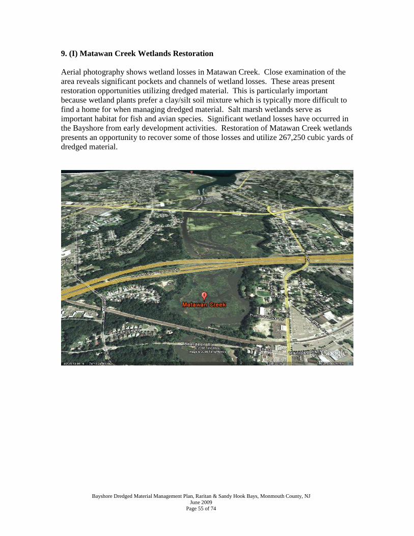
Bayshore Dredged Material Management Plan, Raritan & Sandy Hook Bays, Monmouth County, NJ June 2009
Page 55 of 74
9. (I) Matawan Creek Wetlands Restoration Aerial photography shows wetland losses in Matawan Creek. Close examination of the area reveals significant pockets and channels of wetland losses. These areas present restoration opportunities utilizing dredged material. This is particularly important because wetland plants prefer a clay/silt soil mixture which is typically more difficult to find a home for when managing dredged material. Salt marsh wetlands serve as important habitat for fish and avian species. Significant wetland losses have occurred in the Bayshore from early development activities. Restoration of Matawan Creek wetlands presents an opportunity to recover some of those losses and utilize 267,250 cubic yards of dredged material.

Bayshore Dredged Material Management Plan, Raritan & Sandy Hook Bays, Monmouth County, NJ June 2009
Page 56 of 74
10. (J) Bayshore Recycling Corporation Bayshore Recycling Corporation is a construction debris recycling operation that accepts concrete, asphalt, brick, block, ID-27, slag and dredged material. The facility is located adjacent to the Raritan River where barges of material have easy access to the facility. Transporting large volumes of dredged material by barge is less costly than moving material by truck. During the development of this Dredged Material Management Plan, Bayshore Recycling received authorization from the NJDEP to accept dredged material for product blending. They are currently developing a business model with cost scenarios to accept dredged material. The facility is located in the Keasbey section of Woodbridge and is classified as a Class B recycling center by the NJDEP. Materials are processed and transformed into marketable products for various applications such as clean stone, DGA road stone, sand and other special blends.

Bayshore Dredged Material Management Plan, Raritan & Sandy Hook Bays, Monmouth County, NJ June 2009
Page 57 of 74
11. (K) Other Opportunities Construction Site Uses – Some dredged material can be used as construction material. In many cases, dredged material consists of a mixture of sand and clay fractions, which requires some type of separation process. Dewatering may also be required because of high water content. Quarry Rehabilitation – Mined quarries in the region present opportunities for the beneficial use of dredged material. Once a quarry has finished extracting mining material, closing plans may seek rehabilitation of the land. Some rehabilitation plans call for redevelopment of the property by filling and re-grading the landscape. In some cases, dredged material may be used as fill. When this occurs, substantial volumes of material can be brought in to improve property topography. Bernards, New Jersey has undertaken this type of rehabilitation with the Millington Quarry. Officials estimate that more than 2 million cubic yards of material will be needed to rehabilitate the quarry before development may begin.

Bayshore Dredged Material Management Plan, Raritan & Sandy Hook Bays, Monmouth County, NJ June 2009
Page 58 of 74
SECTION IX. CONCLUSION Over the last 25 years, more than 1,000,000 cubic yards of dredged material has been removed from Bayshore marinas and navigation channels. Most of this material has been used for beach replenishment and landfill cover. The 5 Confined Disposal Facilities (CDFs) located in the Bayshore can store a total of 204,700 cubic yards of material. They are currently storing 79,300 cubic yards. CDFs are a required component of hydraulic dredging when storing dredged material. It is imperative that beneficial uses for dredged material be found so that the CDFs can remain active temporary storage areas for future hydraulic dredging activities. This plan recommends that suitable grain sized dredged material be used to fulfill the 182,500 cubic yards needed for beach replenishment in Highlands, Leonardo, Keansburg and on Sandy Hook. The plan also recommends the placement of 267,250 cubic yards of silt-rich dredged material for the restoration of wetlands in Matawan Creek. Furthermore, substantial quantities should be dedicated to Bayshore flood control projects currently being planned by the Army Corps of Engineers. Opportunities for the use of dredged material on construction sites should be mandated by local ordinance. Projects in both Holmdel and Middletown have utilized dredged material for septic and stormwater management projects that should be coming from local marinas versus bay-bottom sand mining efforts. Aberdeen Township could utilize 12,600 cubic yard of dredged material annually to create a marketable topsoil product by blending with their ongoing leaf composting program. Monmouth County could do the same utilizing 115,267cy annually at the Belford Landfill facility. Dredged material sediment testing indicates that approximately 62% of the material consists of sand and 38% consists of silt/clay. Incorporating this information into 1 million cubic yards dredged to date suggests that 683,375 cubic yards of sand and 418,843 cubic yards of silt/clay have been dredged from marinas and navigation channels. Projected into sand and silt/clay placement opportunities identified in this plan over a 25 year dredging period, the Bayshore can support the placement of 1,780,838 cubic yards of sand and 1,865,588 cubic yards of silt/clay. These numbers suggest that with creative and comprehensive planning, the Bayshore is easily capable of utilizing all of the material dredged from local waters. The challenge will be establishing commitments from local, state and federal officials that dredged material will be considered the resource of preference for beach replenishment, flood control, construction site use, landscaping and habitat restoration. To facilitate implementation of this plan the follow steps should be taken by local, county, state and federal governments: Municipalities
• Pass ordinance to require use of dredged material on construction sites as preference to non-dredged material.

Bayshore Dredged Material Management Plan, Raritan & Sandy Hook Bays, Monmouth County, NJ June 2009
Page 59 of 74
• Expand and implement stormwater management programs to prevent sediment from entering stormwater management systems and prevent streamside erosion. Innovative stormwater management should include sediment traps, rain gardens and greenways to reduce stream flow rates and erosion and to prevent soil from reaching waterways.
• Aberdeen & Middletown support use of existing facilities for blending leaf litter with dredged material to create marketable topsoil product.
Monmouth County
• Support use of Belford Landfill facility for blending leaf litter with dredged material to create marketable topsoil product.
State Support
• NJDEP commitment to provide technical and policy support for wetland habitat restoration and creation.
• NJDEP should implement policy identifying CDFs containing clean material as “temporary storage facilities” and seek plans for the beneficial use of material placed in them.
• NJDEP should waive Tidelands Council Use Fees when dredged material is moved off-site to be used beneficially.
• NJDOT commitment to living document concept and support for implementation of Bayshore Dredged Material Management Plan.
Federal Support
• U.S. Army Corps of Engineers support for use of dredged material for Bayshore Flood Control Projects.

Appendix A
Bayshore Dredged Material Management Plan, Raritan & Sandy Hook Bays, Monmouth County, NJ June 2009
Page 60 of 74
State of New Jersey Department of Environmental Protection Dredge Material Data Form (DMDF-997) DREDGING ACTIVITY 1. Project Applicant _________________________________________________________ 2. Permit Application Number or other pending permits ___________________________ 3. Dredging Location: Water body ___________________________________________ State Plane Coordinates of Dredging Site: X ____________________ Y ____________________ - attach USGS quadrangle or county map with project location highlighted 4. Water Environment, Fresh__, Saline ___, and salinity if known _________ ppt Depth of water within project area at Mean Low Water Existing _______________ Proposed ______________ Maintenance _____ or New Dredging _____ 5. Volume of Material to be removed ___________________________ cubic yards 6. Method of Dredging: - hydraulic_____ - clamshell_____ - closed clamshell_____ - hopper_____ - bucket_____ - other (specify) MANAGEMENT/DISPOSAL OF DREDGED MATERIAL 7. What is proposed method of disposal or long term use of the dredged material?
Appendix A
Bayshore Dredged Material Management Plan, Raritan & Sandy Hook Bays, Monmouth County, NJ June 2009
Page 61 of 74
8. Method of Transport to Management/Disposal Site: - truck_____ - barge_____ - pipeline_____ - other (specify) ______________________________________ 9. State Plane Coordinates of Disposal/Management Site Location: Specify all interim and final locations X___________________ Y___________________ -attach USGS or county map with disposal/management location highlighted Municipality _____________________________, County ________________________ Lot __________________, Block ______________________________ Disposal/Management site owner ________________________________________________________________________ If disposal/management site is not owned by applicant, attach proof that property owner has authorized the placement of dredge material on the property. SAMPLING AND TESTING REQUIREMENTS THE FOLLOWING TESTING EXCLUSIONS ARE AVAILABLE AS SPECIFIED IN CHAPTER III, SECTION C OF THE TECHNICAL MANUAL, PROVIDED THE DATA IS COLLECTED IN ACCORDANCE WITH A DEPARTMENT APPROVED SAMPLING PLAN. 10. Testing Exclusions
- Does the project meet any of the Testing Exclusion Cases as specified in Chapter III, Section C of the Department's Technical Manual? yes ___, no___
If yes, specify and attach proofs of which exclusions are met. Provide the following as appropriate:
CASE 1 (Sand) - Grain size analysis demonstrating that the material to be dredged is greater than 90% sand
CASE 2 (Subaqueous Disposal Pit) - less than 1000 cubic yards - permission to use subaqueous disposal pit

Appendix A
Bayshore Dredged Material Management Plan, Raritan & Sandy Hook Bays, Monmouth County, NJ June 2009
Page 62 of 74
CASE 3 (Residential Property in Region 2) -project is located between Sandy Hook and Cape May -less than 500 cubic yards -disposal site is a residential upland area adjacent to the dredging site -the dredging site contains 4 or less boat slips -the disposal /management area is owned by the same person as the area to be dredged -the dredged material is proposed to be capped with 6 inches of clean fill
CASE 4 (Small Projects in Region 2) -less than 1000 cubic yards -project is located between Sandy Hook and Cape May -demonstration that the disposal area is not located in a residential/recreational area
CASE 5 ( Small marinas, channels and other projects in Region 2) -less than 5000 cubic yards -project is between Sandy Hook and Cape May -site has not been occupied with a marina of 25 or more boats and does not have a current or historic industrial use on the adjacent upland -demonstration that the disposal site is not located in a residential/recreational area
11. If no, proceed with the remainder of this form ALL SAMPLING PLANS MUST BE REVIEWED AND APPROVED BY THE LAND USE REGULATION PROGRAM PRIOR TO THE COLLECTION OF SAMPL ES.
Sampling plan approved? Yes___, no___. Date of approval_______________________
Location and number of sampling points. Attach copy of approved sampling plan.
Depth cores taken to:_____ ft at Mean Low Water
List and describe any cores greater than 6 feet in length. - attach appropriate narrative.
Describe and attach narrative of similarities and differences between sediment cores - Enclose core logs with dredging application
Was stratification present within any cores greater than 6 feet in length? Yes___, No___
If yes, provide depth and description of stratification _____________________________
________________________________________________________________________
Describe how each core was homogenized. ____________________________________
_______________________________________________________________________
Detail what homogenized cores and/or strata were combined to form composite samples.

Appendix A
Bayshore Dredged Material Management Plan, Raritan & Sandy Hook Bays, Monmouth County, NJ June 2009
Page 63 of 74
TESTING REQUIREMENTS 12. Check those tests for which data is being submitted Physical, grain size_____, Total Organic Carbon_____, % moisture_____ Bulk Sediment Chemistry___________ Elutriate___________ Modified Elutriate_____________ Leaching Test - Sequential Batch Leaching Test___ - Column Leach Test___ - Other_________________________ Bioaccumulation________ Bioassay________

Appendix B
Bayshore Dredged Material Management Plan, Raritan & Sandy Hook Bays, Monmouth County, NJ June 2009
Page 64 of 74
Bayshore Federal Navigation Channels
Appendix C
Bayshore Dredged Material Management Plan, Raritan & Sandy Hook Bays, Monmouth County, NJ June 2009
Page 65 of 74

Appendix C
Bayshore Dredged Material Management Plan, Raritan & Sandy Hook Bays, Monmouth County, NJ June 2009
Page 66 of 74

Appendix C
Bayshore Dredged Material Management Plan, Raritan & Sandy Hook Bays, Monmouth County, NJ June 2009
Page 67 of 74

Appendix C
Bayshore Dredged Material Management Plan, Raritan & Sandy Hook Bays, Monmouth County, NJ June 2009
Page 68 of 74

Appendix C
Bayshore Dredged Material Management Plan, Raritan & Sandy Hook Bays, Monmouth County, NJ June 2009
Page 69 of 74

Appendix D
Bayshore Dredged Material Management Plan, Raritan & Sandy Hook Bays, Monmouth County, NJ June 2009
Page 70 of 74
Beneficial Use Material Needs Survey for a Regional Dredged Material Management Plan in the Northern Bayshore Region
The purpose of this survey is to gather essential information to determine areas in the Bayshore Region (from Aberdeen to Highlands, NJ) that need material for various projects. Projects might include beach replenishment, dune stabilization, landfill capping, fill or construction material, among others. Please PRINT. If necessary, please use the back of this form or additional paper for responses. Name:
Address: Phone number: Cell: Email: Potential site location, including cross streets and/or GPS coordinates:
Purpose of fill:
Type of fill needed (i.e. sand, silt, clay): Approximate amount of fill needed: Current property owner: Describe site, including surrounding area, vegetation, and wildlife:
Nearest water body (creek, river, bay): Possible problems/issues with site, if any: Additional information or comments:
PLEASE RETURN TO: CLEAN OCEAN ACTION, P.O. BOX 505, 18 HARTSHORNE DRIVE, HIGHLANDS, NJ 07732
(732) 872-0111 OR (732) 872-8041 (FAX)
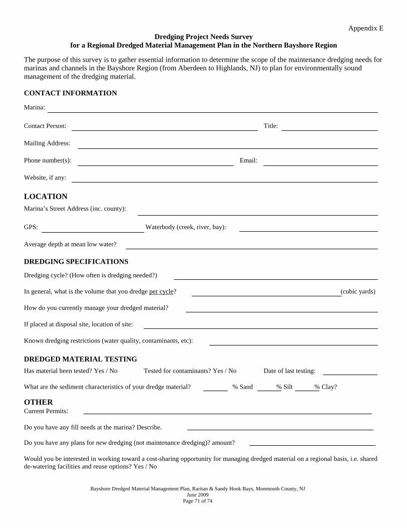
Appendix E
Bayshore Dredged Material Management Plan, Raritan & Sandy Hook Bays, Monmouth County, NJ June 2009
Page 71 of 74
Dredging Project Needs Survey for a Regional Dredged Material Management Plan in the Northern Bayshore Region
The purpose of this survey is to gather essential information to determine the scope of the maintenance dredging needs for marinas and channels in the Bayshore Region (from Aberdeen to Highlands, NJ) to plan for environmentally sound management of the dredging material.
CONTACT INFORMATION
Marina: Contact Person: Title:
Mailing Address:
Phone number(s): Email:
Website, if any:
LOCATION
Marina’s Street Address (inc. county):
GPS: Waterbody (creek, river, bay):
Average depth at mean low water?
DREDGING SPECIFICATIONS
Dredging cycle? (How often is dredging needed?) In general, what is the volume that you dredge per cycle? (cubic yards) How do you currently manage your dredged material? If placed at disposal site, location of site: Known dredging restrictions (water quality, contaminants, etc):
DREDGED MATERIAL TESTING
Has material been tested? Yes / No Tested for contaminants? Yes / No Date of last testing: What are the sediment characteristics of your dredge material? % Sand % Silt % Clay?
OTHER Current Permits: Do you have any fill needs at the marina? Describe. Do you have any plans for new dredging (not maintenance dredging)? amount? Would you be interested in working toward a cost-sharing opportunity for managing dredged material on a regional basis, i.e. shared de-watering facilities and reuse options? Yes / No
Appendix F
Bayshore Dredged Material Management Plan, Raritan & Sandy Hook Bays, Monmouth County, NJ June 2009
Page 72 of 74
References: Birdsall Services Group. 2009. Waterfront Development Individual Permit Application for Leonardo State Marina. CCSP. 2009. Coastal Sensitivity to Sea-Level Rise: A Focus on the Mid-Atlantic Region. A report by the U.S. Climate Change Science Program and the Subcommittee on Global Change Research. U.S. Environmental Protection Agency, Washington D.C., USA. http://www.epa.gov/climatechange/effects/coastal/sap4-1.html Dredged Materials Management Team: Final Report. 1994. Dredging – What is the Best Approach for New Jersey? Marine Trades Association of New Jersey. 2006. Recreational Boating Economic Impact Study for New Jersey. Monmouth County Park System. 2009. Internal Memo: Monmouth Cove Marina NJDEP Permit Renewal Application. New Jersey Department of Environmental Protection. 1997. The Management and Regulation of Dredging Activities and Dredged Material in New Jersey’s Tidal Waters. Personal Communications with Marina Owners/Operators. 2007-2009. Jay Cosgrove Sam Sneider, Fred Rosiak, Rich Ketchow, John Urbanski, John Andrews, Wayne O'neil, Don Shields, Bill Bate, Mike Wagner, John Koenig, John Olsen, Patricia Lentz, Diane Iapicco, Kevin Ganson, and Heng Chin. U.S. Army Corps of Engineers. 1997 & 2008 Update. Dredged Material Management Plan for the Port of NY and NJ. U.S. Army Corps of Engineers. 2005-08. Federal Channel Maintenance Reports for Atlantic Highlands Anchorage, Keyport Harbor, Leonardo Channel, Matawan-Keyport Channel, Shoal Harbor-Compton Creek, and Shrewsbury-Highlands. U.S. Army Corps of Engineers. 2009. Raritan Bay and Sandy Hook Bay Hurricane and Storm Damage Reduction Study Port Monmouth, New Jersey Modification to the Feasibility Report’s Recommended Plan for the Bay Shoreline Protection Reach. http://www.nan.usace.army.mil/front/nepa.pdf U.S. Army Corps of Engineers. 2008. Hurricane and Storm Damage Reduction Plans for Highlands, Keyport, Keansburg, Leonardo, Port Monmouth, and Union Beach. U.S. Army Corps of Engineers. Undated. The Beneficial Uses of Dredged Material. (DVD Format)

Appendix F
Bayshore Dredged Material Management Plan, Raritan & Sandy Hook Bays, Monmouth County, NJ June 2009
Page 73 of 74
U.S. Army Corps of Engineers. 1998. Dredged Material Management Plan for the Port of NY & NJ: Technical Appendix. U.S. Army Corps of Engineers. 1983. Chapter 3 Dredging Equipment and Techniques www.usace.army.mil/publications/eng-manuals/em1110-2-5025/c-3.pdf U.S. Fish and Wildlife Service. 1997. Significant Habitats And Habitat Complexes Of The New York Bight Watershed. Waterways Committee of the Waterway, Port, Coastal and Ocean Division of the American Society of Civil Engineers. 1994. Proceedings of the Second International Conference on Dredging and Dredged Material Placement.

Appendix G
Bayshore Dredged Material Management Plan, Raritan & Sandy Hook Bays, Monmouth County, NJ June 2009
Page 74 of 74
Contacts:
New Jersey Department of Environmental Protection Site Remediation Program Office of Dredging & Sediment Technology 401 East State Street P.O. Box 028 Trenton, NJ 08625 Telephone: 609-292-1251 http://www.state.nj.us/dep/srp/about/wholist.htm New Jersey Department of Transportation Office of Maritime Resources 1035 Parkway Avenue 3rd Floor Main Office Bldg. PO Box 837 Trenton, NJ 08625 Telephone: 609-530-4770 http://www.nj.gov/transportation/airwater/maritime/ U.S. Army Corps of Engineers 26 Federal Plaza, Attn. CENAN-OP-ST New York, NY 10278-0090 212-264-0223 http://www.nad.usace.army.mil/ Bayshore Regional Watershed Council [email protected] http://www.bayshorewatershed.org/bw/
Steve Taylor Bayshore Dredged Material Management Plan Project Manager 732-291-4084 [email protected] Hazlet Area Quality of Life Alliance John M. Curran III PO Box 94 Hazlet, NJ 07730 [email protected] Clean Ocean Action 18 Hartshorne Drive, Suite 2 Highlands, NJ 07732 Telephone: 732-872-0111 http://www.cleanoceanaction.org/ [email protected] Bayshore Recycling Corporation 75 Crows Mill Road Keasbey, NJ 08832 Telephone: 732-738-6000 http://www.bayshorerecycling.com