NORTHERN HYDROLOGY · 11. Hydrology and Northern Changes Grossary Bibliography Biographical Sketch...
9
UNESCO-EOLSS SAMPLE CHAPTERS COLD REGIONS SCIENCE AND MARINE TECHNOLOGY - Northern Hydrology - Ming-ko Woo ©Encyclopedia of Life Support Systems (EOLSS) NORTHERN HYDROLOGY Ming-ko Woo McMaster University, Hamilton, Ontario, Canada Keywords: Snow, ice, glacier, permafrost, ground ice, snowmelt, active layer, infiltration, evaporation, groundwater, overland flow, runoff, streamflow, lakes, wetlands, reservoir, floods, fill-and-spill, Arctic, Subarctic Contents 1. Introduction 2. Physical Setting 3. Snow Conditions 4. Glaciers 5. Active Layer Processes 6. Groundwater 7. Runoff Generation 8. Lakes and Reservoirs 9. Rivers 10. Large Basins 11. Hydrology and Northern Changes Grossary Bibliography Biographical Sketch Summary The Arctic and the Subarctic constitute the North. In this cold region, water commonly occurs in solid and liquid forms, and northern hydrology treats the distribution, movement and storage of freshwater in its different states. The North is subject to increased human activities notably for resource development, and to changes associated with climate warming. Fundamental understanding of northern hydrology better prepares us to cope with these changes and in protecting the environment. Special to the northern cold region is the prevalence of snow and ice, and the presence of permafrost. Snow accumulation and melt processes dominate northern hydrology in the long winter and the short spring seasons. Glaciers also have a wide occurrence in the Arctic, and their summer melt is a major local water source. With exceedingly low capability to conduct water, frozen soil including permafrost presents a hindrance to water flow. Infiltration is limited in favor of lateral runoff through surface and subsurface flow routes. Perennially thawed zones in the permafrost called taliks provide conduits for the circulation of deep groundwater, which discharges as springs or through lake bottoms and river beds. The seasonal flow pattern of most northern rivers follows a nival regime in which snowmelt is the principal contributor to total flow, but flows may be supplemented by glacier melt, summer rain, discharge of deep groundwater and outflows from large lakes and reservoirs.
Transcript of NORTHERN HYDROLOGY · 11. Hydrology and Northern Changes Grossary Bibliography Biographical Sketch...

UNESCO-EOLS
S
SAMPLE C
HAPTERS
COLD REGIONS SCIENCE AND MARINE TECHNOLOGY - Northern Hydrology - Ming-ko Woo
©Encyclopedia of Life Support Systems (EOLSS)
NORTHERN HYDROLOGY
Ming-ko Woo
McMaster University, Hamilton, Ontario, Canada
Keywords: Snow, ice, glacier, permafrost, ground ice, snowmelt, active layer,
infiltration, evaporation, groundwater, overland flow, runoff, streamflow, lakes,
wetlands, reservoir, floods, fill-and-spill, Arctic, Subarctic
Contents
1. Introduction
2. Physical Setting
3. Snow Conditions
4. Glaciers
5. Active Layer Processes
6. Groundwater
7. Runoff Generation
8. Lakes and Reservoirs
9. Rivers
10. Large Basins
11. Hydrology and Northern Changes
Grossary
Bibliography
Biographical Sketch
Summary
The Arctic and the Subarctic constitute the North. In this cold region, water commonly
occurs in solid and liquid forms, and northern hydrology treats the distribution,
movement and storage of freshwater in its different states. The North is subject to
increased human activities notably for resource development, and to changes associated
with climate warming. Fundamental understanding of northern hydrology better
prepares us to cope with these changes and in protecting the environment.
Special to the northern cold region is the prevalence of snow and ice, and the presence
of permafrost. Snow accumulation and melt processes dominate northern hydrology in
the long winter and the short spring seasons. Glaciers also have a wide occurrence in the
Arctic, and their summer melt is a major local water source.
With exceedingly low capability to conduct water, frozen soil including permafrost
presents a hindrance to water flow. Infiltration is limited in favor of lateral runoff
through surface and subsurface flow routes. Perennially thawed zones in the permafrost
called taliks provide conduits for the circulation of deep groundwater, which discharges
as springs or through lake bottoms and river beds. The seasonal flow pattern of most
northern rivers follows a nival regime in which snowmelt is the principal contributor to
total flow, but flows may be supplemented by glacier melt, summer rain, discharge of
deep groundwater and outflows from large lakes and reservoirs.

UNESCO-EOLS
S
SAMPLE C
HAPTERS
COLD REGIONS SCIENCE AND MARINE TECHNOLOGY - Northern Hydrology - Ming-ko Woo
©Encyclopedia of Life Support Systems (EOLSS)
Mega-basins with drainage areas >0.5x10⁶ km
2 integrate the flow of their tributary
basins, which contribute varying amounts depending on their hydroclimate and
physiography. Human-modified river flow, such as for hydropower production, greatly
alters the flow regime of the regulated tributary and can even affect the high and low
flows of the mega-basin. Good hydrological knowledge enables sound management of
northern water resources.
1. Introduction
North, like the word South, is a geographical connotation of locations beyond the mid-
latitudes of the planet. Rather than applying locational criteria such as the Arctic Circle
to delineate the North, intense coldness is generally considered as a distinguishing
feature of the North. Yet coldness is also a foremost characteristic of the far South, such
as Antarctica, and high elevation regions in low latitudes, like the Tibetan Plateau.
There are differences, however. Unlike Polar Regions, extreme seasonal contrast of
extended winter darkness and prolonged summer days do not exist at the temperate and
tropical heights; and the South is a continent surrounded by oceans while the North
consists of continental and insular areas that enclose an ocean.
Hydrology studies the distribution, storage and movement of freshwater underground, at
the surface and in the lower atmosphere. It is an applied as well as a scientific
discipline, seeking to understand the processes that govern the occurrence of water and
applying the acquired knowledge to manage water resources to address human,
ecological and environmental concerns. Northern hydrology is strongly affected by the
state in which water occurs (in solid, liquid and gaseous forms). Much of the water in
the North is locked in its solid form for various lengths of time, from days to years and
decades, even centuries or millennia. Thus, snow, glaciers, lake and river ice are an
important parts of the terrestrial landscape. The formation and decay of snow and ice,
and the seasonal or long term changes in these forms of storage exert strong influence
on the hydrologic cycle. Furthermore, the transformation of water from one state to
another involves energy, the gains and losses of which play an essential role in northern
hydrology.
The North is sparsely populated but its water resource is considerable and notably
pristine. Hydrologic information permits evaluation of flood and drought hazards to the
residents and enables assessment of vulnerability of the northern environment. At
present, the temperate and tropical regions are more developed relative to the far North,
but there is increasing exploitation of resources in the North, including oil and gas
extraction, and mining of metals and precious stones, accompanied by the of creation of
settlements and transportation routes. These activities and the maintenance of their
associated infra-structures necessarily involve the withdrawal and contamination of
water, and alteration of the landscape that entails changes in flow and storage (in the
forms of water, ice and snow).
It is generally acknowledged that as global warming intensifies, the northern climate is
particularly prone to change. Furthermore, environmental disturbances in high latitudes
produce feedbacks that can have global implications. A sound assessment of the
hydrological consequences requires appropriate understanding of northern hydrological

UNESCO-EOLS
S
SAMPLE C
HAPTERS
COLD REGIONS SCIENCE AND MARINE TECHNOLOGY - Northern Hydrology - Ming-ko Woo
©Encyclopedia of Life Support Systems (EOLSS)
processes. While it is beyond the scope of this chapter to discuss the impacts of climate
change, the materials presented provides a survey of basic principles essential for the
appraisal of hydrological responses to external forcing, both natural and human induced.
continuous permafrost
discontinuous permafrost
southern limits:
High Arctic
Low Arctic
Subarctic
glacier, in north of 50 N
Figure 1. Location of Arctic and Subarctic and distribution of permafrost in Northern
Hemisphere. In the map, areas with sporadic presence of permafrost are included under
the discontinuous permafrost category.
2. Physical Setting
The land area of the northern circumpolar region consists of the Arctic and the
Subarctic, which together represents the far North (Figure 1). Northern seas and oceans
are excluded from the present consideration as our focus is on terrestrial hydrology. The
Arctic is a treeless region. In the extreme north is the High Arctic (Figure 2a) where the
ground is largely barren and the surface has 10% or less of tundra vegetation, which
includes lichens and mosses, herbaceous plants and prostrate arctic willow. The Low
Arctic has a dense cover of tundra vegetation, together with varying percentages of erect
shrubs that include willow, birch and alder. The Arctic is separated from the Subarctic
by the tree-line which is a narrow belt with a mixture of shrubs and stands of trees
(Figure 2b). Tree growth in the Subarctic ranges from open woodland at the northern
fringes, to dense covers of boreal forest further south. Spruce and larch are common, as
are aspen and birch.

UNESCO-EOLS
S
SAMPLE C
HAPTERS
COLD REGIONS SCIENCE AND MARINE TECHNOLOGY - Northern Hydrology - Ming-ko Woo
©Encyclopedia of Life Support Systems (EOLSS)
Figure 2, (a) High Arctic polar desert landscape with predominantly barren ground
interspersed with moist patches that support tundra vegetation growth, Resolute,
Cornwallis Island, Canada. (b) Forest margin with tundra-shrub at Salekhard in Siberia,
Russia. The forest consists of spruce, larch and birch, and undergrowth of shrubs.
The North includes large land masses of northern Eurasia and North America, as well as
islands of various sizes juxtaposed with ocean straits and sea inlets, most of which
acquire an ice cover in part or most of the year. All major rock types are represented in
the North, from strongly metamorphosed Precambrian rocks of 0.6 to >2.5 billion years
in age, to volcanic and sedimentary beds that continue to form. Topography is highly
varied, encompassing large plains that rise from the Arctic coast to considerable

UNESCO-EOLS
S
SAMPLE C
HAPTERS
COLD REGIONS SCIENCE AND MARINE TECHNOLOGY - Northern Hydrology - Ming-ko Woo
©Encyclopedia of Life Support Systems (EOLSS)
elevations inland, rolling terrain with rounded hills, intermontane plateaus, high
mountains and ridges of strong relief, often soaring to heights of over 3000 m.
Northern areas share the common trait of experiencing at least half a year with sub-
freezing air temperatures. There are, however, zones that are anomalously warm for
their high latitudes, including coastal location where intense coldness is ameliorated by
mild maritime influences, such as the southern coast of Alaska and the northern coast of
Norway. Overall, seasonal change in air temperature is largely driven by the solar
radiation regime. Owing to polar positions, the annual supply of radiation energy is
more limited than at the lower latitudes. Available energy is concentrated in the summer
with its long hours of daylight while winter is a period of prolonged darkness,
accompanied by heat loss and continuous cooling at the land, water, snow and ice
surfaces. Precipitation varies greatly within the vast northern region. Areas of very low
annual precipitation (<100-300 mm per year), known as polar deserts, are found in the
Arctic Islands. On the other extreme are coastal belts where moisture-bearing onshore
winds encounter topographic barriers to deposit heavy orographic precipitation.
Persistent and intense coldness leads to the occurrence of permafrost, defined as earth
materials with temperature at or below 0°C for at least two consecutive years. Note that
permafrost is defined on the basis of temperature and not on the freeze-thaw state of
water. The ground can be labeled as permafrost with temperature being perennially
below 0°C but freezing may be prevented by freezing-point depression (due to large
pressure imposed by an overburden such as a thick glacier, or an abundance of
impurities in the water) that maintains the soil water in a liquid state. Permafrost may be
rich in ground ice or the ice content can be negligible. Above the permafrost lies the
active layer, a layer that is subject to freezing in winter and thawing in summer. There
are also zones located above, within or below the permafrost, known as taliks, that are
kept unfrozen year-round by geothermal heat or by groundwater circulation. In some
cases, taliks stay unfrozen because they are relicts left from a past period with above-
freezing conditions. Figure 3 provides a simplified representation of permafrost, talik
and active layer in a cold region setting.
Permafrost is continuous and underlies all land in the Arctic, but it becomes
discontinuous and sporadic in the Subarctic (Figure 1). Permafrost thickness reaches
400 m in Svalbard (at about 80°N, north of the Scandinavia mainland), 600 m in the
Canadian Arctic Islands and >1000 m in eastern Siberia, whereas the thickness drops to
only tens of meters in the discontinuous permafrost zones, and permafrost becomes only
sporadic in occurrence in the transition to non-permafrost terrain. A southward decrease
in permafrost thickness is accompanied by an increase in active layer thickness from
about 0.3-1.0 m in the Arctic, to > 2 m in the Subarctic. Locally, the active layer is
thinner on north-facing than on south-facing slopes, under peat and vegetation mats, and
in fine-grained materials.
Myriad lakes of different dimensions are scattered in the North, ranging in size from
tundra ponds that measure several meters across to some of the largest lakes in the
world, including Great Bear Lake, Great Slave Lake, Lake Athabasca and Lake Baikal.
Immense stretches of wetlands and peatlands spread across the northern plains of
Siberia and western Canada, together with less sizable ones on Arctic coastal plains,

UNESCO-EOLS
S
SAMPLE C
HAPTERS
COLD REGIONS SCIENCE AND MARINE TECHNOLOGY - Northern Hydrology - Ming-ko Woo
©Encyclopedia of Life Support Systems (EOLSS)
river deltas and flood plains, and mere patches clustered in the semi-arid High Arctic.
Five mighty rivers and their tributaries dominate surface drainage: Ob, Yenisei, Lena,
Mackenzie and Yukon, but there are also many rivers of medium and smaller sizes that
empty directly or indirectly (e.g. via Hudson Bay) to the Arctic Ocean.
Figure 3. Definition of permafrost, talik and active layer, and groundwater occurrence in
permafrost terrain.
3. Snow Conditions
3.1. Accumulation and Distribution
In the Arctic, snow accumulates over many winter months without melt interruption, but
the Subarctic experiences occasional mid-winter melt events. The snowpack is typically
stratified, partly because of differences in the snow deposited by individual events, and
also due to the presence of ice layers produced by refreezing of water from mid-winter
melt and from rain-on-snow. Drifting and re-deposition of snow produces hard wind-
packed layers, while compaction of the snow under its own weight increases the snow
density. Vapor flux through sublimation and condensation within the snowpack yields
depth hoar which has low density and lacks cohesion.
The Arctic is frequently windswept to cause scouring of the snow on exposed sites.
Blowing snow is prone to sublimation, which converts the snow from solid to vapor
state and is then lost to the atmosphere. The snow that blows and drifts is eventually
deposited in sheltered areas. Re-distribution of snow through scouring and deposition
produces a highly uneven snow cover at the end of winter, leaving thin snow on
exposed hill-tops and completely or partially filling topographic hollows, valleys and
gullies with deep drifts (Figure 4a), superimposed with surface patterns such as vortices,

UNESCO-EOLS
S
SAMPLE C
HAPTERS
COLD REGIONS SCIENCE AND MARINE TECHNOLOGY - Northern Hydrology - Ming-ko Woo
©Encyclopedia of Life Support Systems (EOLSS)
dunes and sastrugis. Tundra vegetation and shrubs in the Low Arctic are often partly or
wholly buried by the snow.
Figure 4. (a) Arctic snow re-distributed by wind to form an uneven cover, with some
areas swept free and other areas producing large cornices. (b) Snow intercepted by
Subarctic tree canopy. Intercepted snow may subsequently fall off the trees but it is also
subject to sublimation loss.
UNESCO-EOLS
S
SAMPLE C
HAPTERS
COLD REGIONS SCIENCE AND MARINE TECHNOLOGY - Northern Hydrology - Ming-ko Woo
©Encyclopedia of Life Support Systems (EOLSS)
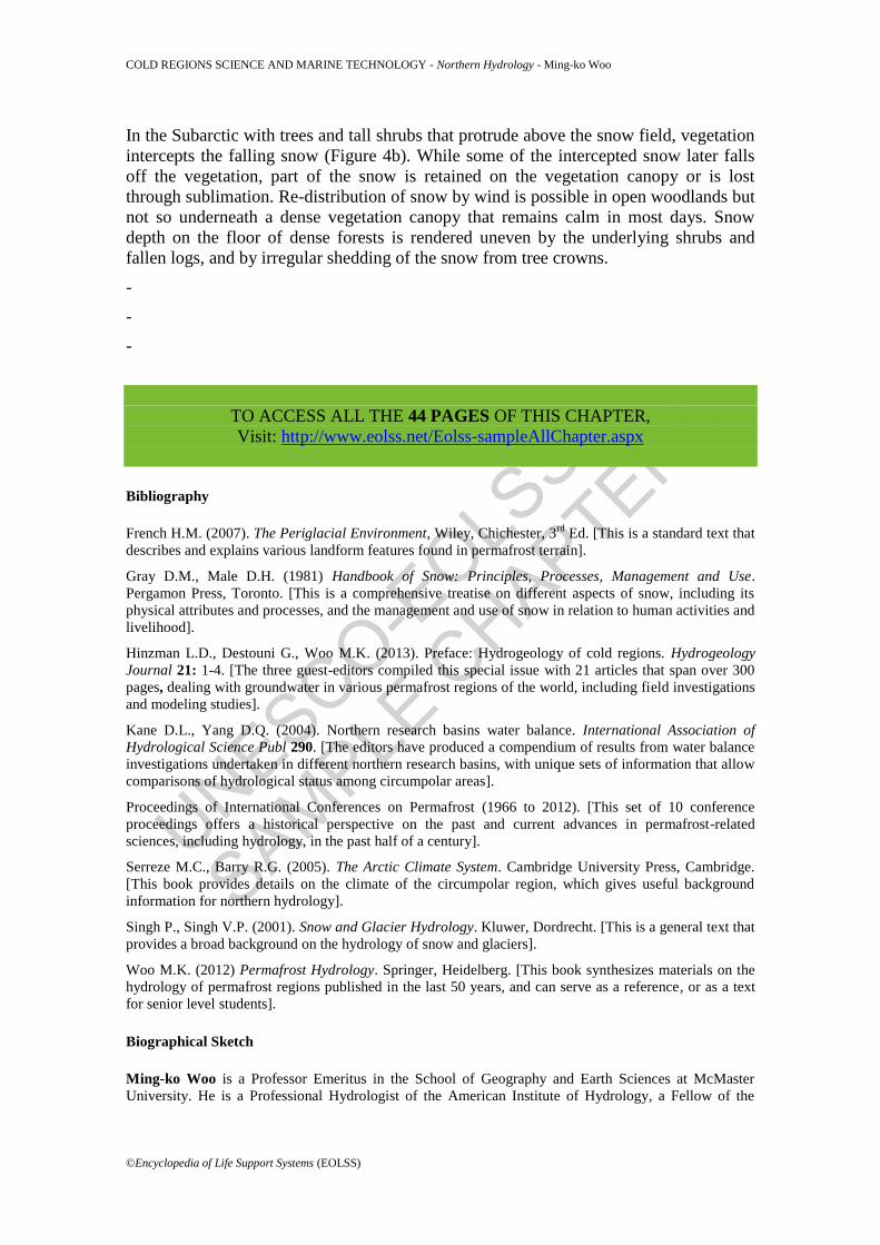
In the Subarctic with trees and tall shrubs that protrude above the snow field, vegetation
intercepts the falling snow (Figure 4b). While some of the intercepted snow later falls
off the vegetation, part of the snow is retained on the vegetation canopy or is lost
through sublimation. Re-distribution of snow by wind is possible in open woodlands but
not so underneath a dense vegetation canopy that remains calm in most days. Snow
depth on the floor of dense forests is rendered uneven by the underlying shrubs and
fallen logs, and by irregular shedding of the snow from tree crowns.
-
-
-
TO ACCESS ALL THE 44 PAGES OF THIS CHAPTER,
Visit: http://www.eolss.net/Eolss-sampleAllChapter.aspx
Bibliography
French H.M. (2007). The Periglacial Environment, Wiley, Chichester, 3
rd Ed. [This is a standard text that
describes and explains various landform features found in permafrost terrain].
Gray D.M., Male D.H. (1981) Handbook of Snow: Principles, Processes, Management and Use.
Pergamon Press, Toronto. [This is a comprehensive treatise on different aspects of snow, including its
physical attributes and processes, and the management and use of snow in relation to human activities and
livelihood].
Hinzman L.D., Destouni G., Woo M.K. (2013). Preface: Hydrogeology of cold regions. Hydrogeology
Journal 21: 1-4. [The three guest-editors compiled this special issue with 21 articles that span over 300
pages, dealing with groundwater in various permafrost regions of the world, including field investigations
and modeling studies].
Kane D.L., Yang D.Q. (2004). Northern research basins water balance. International Association of
Hydrological Science Publ 290. [The editors have produced a compendium of results from water balance
investigations undertaken in different northern research basins, with unique sets of information that allow
comparisons of hydrological status among circumpolar areas].
Proceedings of International Conferences on Permafrost (1966 to 2012). [This set of 10 conference
proceedings offers a historical perspective on the past and current advances in permafrost-related
sciences, including hydrology, in the past half of a century].
Serreze M.C., Barry R.G. (2005). The Arctic Climate System. Cambridge University Press, Cambridge.
[This book provides details on the climate of the circumpolar region, which gives useful background
information for northern hydrology].
Singh P., Singh V.P. (2001). Snow and Glacier Hydrology. Kluwer, Dordrecht. [This is a general text that
provides a broad background on the hydrology of snow and glaciers].
Woo M.K. (2012) Permafrost Hydrology. Springer, Heidelberg. [This book synthesizes materials on the
hydrology of permafrost regions published in the last 50 years, and can serve as a reference, or as a text
for senior level students].
Biographical Sketch
Ming-ko Woo is a Professor Emeritus in the School of Geography and Earth Sciences at McMaster
University. He is a Professional Hydrologist of the American Institute of Hydrology, a Fellow of the

UNESCO-EOLS
S
SAMPLE C
HAPTERS
COLD REGIONS SCIENCE AND MARINE TECHNOLOGY - Northern Hydrology - Ming-ko Woo
©Encyclopedia of Life Support Systems (EOLSS)
Arctic Institute of North America and of the Royal Canadian Geographical Society. After studying
Geography and Geology at the University of Hong Kong, he specialized in snow hydrology for his
doctoral work at the University of British Columbia. His primary research relates to the hydrology of
permafrost, snow and wetlands, as well as to climate variability. For over three decades, he carried out
field investigations in a range of cold environments, from the Arctic, Subarctic, subalpine to extensive
wetlands in Canada, to alpine area in Tianshan. In addition, he has worked on soil erosion in South China
and drought problems in Sahelian Nigeria. He received the Award for Scholarly Distinction from the
Canadian Association of Geographers in 1992, and the President’s Service Award from the American
Society of Wetland Scientists in 1996. In 2008, he was bestowed the Tuzo Wilson Medal, the highest
honor conferred by the Canadian Geophysical Union, which also established the M.K. Woo Hydrology
Lecture Series in recognition of his contribution to Canadian hydrology. Over the years, he has produced
four generations of graduate students, with most of his first-generation students now being established as
academics and senior scientists and successful administrators.


![[Hydrology] groundwater hydrology david k. todd (2005)](https://static.fdocuments.in/doc/165x107/55a8e6001a28ab6c2f8b4687/hydrology-groundwater-hydrology-david-k-todd-2005-55b0d9a792c06.jpg)


![[hydrology] groundwater hydrology - david k. todd (2005).pdf](https://static.fdocuments.in/doc/165x107/577c77961a28abe0548cb0b1/hydrology-groundwater-hydrology-david-k-todd-2005pdf.jpg)