North Somerset Councilapps.n-somerset.gov.uk/cairo/docs/doc28420.pdf · North Somerset Council...
67
1 North Somerset Council REPORT TO THE EXECUTIVE DATE OF MEETING: 14 NOVEMBER 2017 SUBJECT OF REPORT: JOINT SPATIAL PLAN PUBLICATION VERSION TOWN OR PARISH: ALL OFFICER/MEMBER PRESENTING: COUNCILLOR AP REES KEY DECISION: YES RECOMMENDATIONS It is recommended: a. That the draft Joint Spatial Plan (JSP) attached at Appendix A is published for consultation under regulations 19, 20 and 35 of the Town and Country Planning Regulations 2012; b. That if the JSP is ready for independent examination, it is submitted to the Secretary of State before the end of March 2018 under regulation 22 of 2012 Regulations along with the other documents required by that Regulations, and; c. That the Director of Development and Environment is delegated the authority, in consultation with the Council Leader and in co-ordination with Bristol City, Bath and North East Somerset and South Gloucestershire Councils to: i. make minor modifications to the JSP if needed, either prior to publication or prior to submission, and ii. respond to issues raised during the examination, including making minor modifications to the JSP. 1. SUMMARY OF REPORT 1.1 The Joint Spatial Plan is a strategic planning document being prepared jointly by the four West of England authorities. Once adopted it will provide the context for the delivery of the individual Local Plans for each area. As it is a joint development plan document, each local planning authority must approve the Publication version for consultation in accordance with the regulations and for subsequent submission to the Secretary of State for examination. 2. POLICY
-
Upload
vuongthuan -
Category
Documents
-
view
227 -
download
2
Transcript of North Somerset Councilapps.n-somerset.gov.uk/cairo/docs/doc28420.pdf · North Somerset Council...

1
North Somerset Council
REPORT TO THE EXECUTIVE
DATE OF MEETING: 14 NOVEMBER 2017
SUBJECT OF REPORT: JOINT SPATIAL PLAN PUBLICATION VERSION
TOWN OR PARISH: ALL
OFFICER/MEMBER PRESENTING: COUNCILLOR AP REES
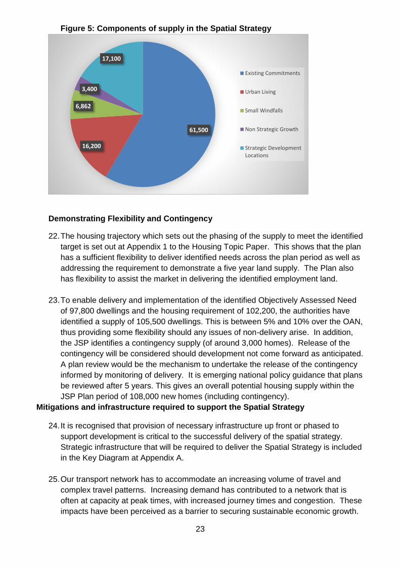
KEY DECISION: YES
RECOMMENDATIONS
It is recommended:
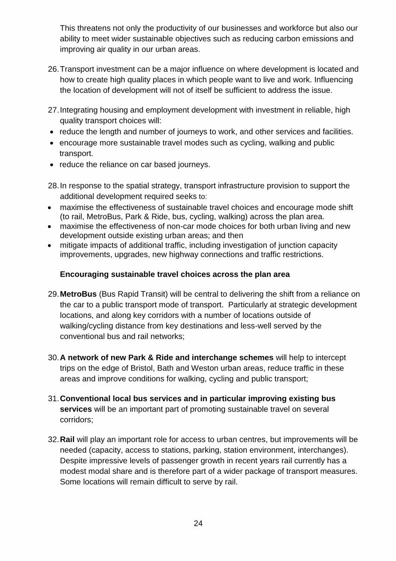
a. That the draft Joint Spatial Plan (JSP) attached at Appendix A is published for consultation under regulations 19, 20 and 35 of the Town and Country Planning Regulations 2012;
b. That if the JSP is ready for independent examination, it is submitted to the Secretary
of State before the end of March 2018 under regulation 22 of 2012 Regulations along with the other documents required by that Regulations, and;
c. That the Director of Development and Environment is delegated the authority, in consultation with the Council Leader and in co-ordination with Bristol City, Bath and North East Somerset and South Gloucestershire Councils to:
i. make minor modifications to the JSP if needed, either prior to publication or prior to submission, and ii. respond to issues raised during the examination, including making minor modifications to the JSP.
1. SUMMARY OF REPORT
1.1 The Joint Spatial Plan is a strategic planning document being prepared jointly by the four West of England authorities. Once adopted it will provide the context for the delivery of the individual Local Plans for each area. As it is a joint development plan document, each local planning authority must approve the Publication version for consultation in accordance with the regulations and for subsequent submission to the Secretary of State for examination.
2. POLICY

2
2.1 The Joint Spatial Plan will provide the framework for the delivery of the three key outcomes of the Corporate Plan. Prosperity and opportunity will be enhanced through the identification of future economic needs and a locational strategy to maximise the potential. Health and wellbeing will be served through identifying future housing needs, including affordable housing, and its delivery at sustainable locations. Quality places will be supported by setting out the sustainability and place making principles.
3. DETAILS
3.1 The West of England authorities are preparing the Joint Spatial Plan. This is a joint strategic planning document covering the period 2016-2036. The scope is limited to:
Identifying the number of new market and affordable homes and the amount of employment land that is needed across the West of England.
Identifying the most appropriate spatial strategy and strategic locations for this growth.
Outlining the strategic transport and other infrastructure that needs to be provided in the right place and at the right time to support sustainable growth and to provide certainty for communities and those who want to invest.
3.2 The JSP is being prepared in parallel with the Joint Transport Study. The JTS has complemented the JSP by outlining future strategic transport proposals for delivery up to 2036 that address current challenges on the network and informed future development proposals in the plan. 3.3 The plan has been through two stages of consultation; Issues and Options (November 2015) and Towards the Emerging Spatial Strategy Document (November 2016). This Publication version attached at Appendix A is the final stage of the plan-making process. This is the plan which, taking account of the evidence base, responses to consultation and other material considerations, is the version with the West of England authorities intend to submit for examination. The consultation at this point is in relation to the soundness of the plan, and all responses received will be submitted to the Secretary of State for consideration through the examination process. 3.4 The JSP is intended to be submitted for examination in March 2018. It is anticipated that any hearings will be held later on in the year with adoption late 2018. 3.5 Previous stages of the Plan’s preparation included public consultation on the key issues and challenges that should be addressed. The comments received have been considered and used to inform the draft Plan’s critical issues and strategic priorities. Key issues of which the JSP has needed to address include: • Identifying housing and employment need. • Affordable housing delivery. • Quality of homes and place and communities. • Infrastructure to support growth. 3.6 The JSP contains seven policies and also policies for each of the proposed Strategic Development Locations (of which there are four in North Somerset). Policy 1: The housing requirement 3.7 The JSP housing requirement is 102,200 new dwellings. To deliver this over the plan period the plan proposes to identify a supply of 105,500 homes to provide flexibility

3
and choice. The four authorities currently make provision for around 61,500 new dwellings through existing Core Strategies/Local Plans. This is predominantly on previously developed land (60.23%). That leaves the 44,000 dwellings to be identified through the JSP spatial strategy. 3.8 Based on the spatial strategy, the district distribution of the proposed housing supply is:
Bath & NE Somerset 14,500 dwellings
Bristol 33,500 dwellings
North Somerset 25,000 dwellings
South Gloucestershire 32,500 dwellings
Total 105,500 dwellings 3.9 The detailed breakdown of the figures for North Somerset is summarised in the following table. The components of supply are explained in the context of Policy 2:
North Somerset
Existing commitments 13,932
Small windfalls 1,300
Urban living 1,000
Non-strategic growth 1,000
Strategic Development Locations 7,850
Total 25,082
3.10 The consequence of this is that the North Somerset housing delivery rises significantly from about 21,000 (1,050pa) in the Core Strategy 2006-2026 to about 25,000 (1,250pa) dwellings over the JSP 20 year period. Policy 2: The spatial strategy 3.11 The principal emphasis of the spatial strategy is to optimise development opportunities within the urban area, which securing a high quality environment for existing and future residents. This helps to ensure that new development is well related to services and facilities and can benefit from existing infrastructure. This is referred to in the plan as the urban living component and is focussed on Bristol. This is expected to deliver some 16,200 homes across the plan area, including 1,000 from the Weston urban area. 3.12 The existing commitments make an assumption about small windfall sites (less than 10 dwellings) coming forward during the Core Strategy periods. The delivery of a further 6,860 dwellings from this source are assumed over the remainder of the JSP plan period. 3.13 Strategic sites in the JSP are defined as being 500 dwellings plus. The JSP includes a requirement that non-strategic growth (sites of 10-499 dwellings) will be brought forward through each UA Local Plan. This comprises 3,400 dwellings including 1,000 in North Somerset. 3.14 The remaining JSP growth is proposed at twelve strategic development locations:
Strategic Development Location
Dwellings anticipated during plan period to 2036
Dwellings expected beyond plan
Total capacity

4
period ie post-2036
Bath & NE Somerset
North Keynsham 1,400 100 1,500
Whitchurch 1,600 900 2,500
Bristol Land at Bath Road, Brislington
750 0 750
North Somerset Backwell 700 0 700
Banwell Garden Village
1,900 0 1,900
Churchill Garden Village
2,675 125 2,800
Nailsea 2,575 725 3,300
South Gloucestershire
Buckover Garden Village
1,500 1,500 3,000
Charfield 1,200 0 1,200
Coalpit Heath 1,800 0 1,800
Thornbury 500 0 500
Yate 1,000 1,000 1,900
Total 17,600 4,350 21,950
Together these Strategic Development Locations comprise 17,600 dwellings during the plan period, 7850 of which are in North Somerset. The total capacity of these locations is anticipated to be 21,950 dwellings, 8700 in North Somerset. The spatial strategy includes some potential Green Belt releases in B&NES and South Gloucestershire where these are considered by those authorities essential to deliver the housing requirement. In accordance with national advice on Green Belt policy, no Green Belt sites are proposed within North Somerset. 3.15 The plan will be reviewed every 5 years. Should this process identify the need for additional housing supply to be brought forward, then contingency sites will be considered for potential future release. The contingency sites identified in the plan comprise land south of Chipping Sodbury in South Gloucestershire and land east of Clevedon, both for about 1,500 dwellings. Land east of Clevedon is outside the Green Belt, but located within a flood risk area and has potential to deliver transport infrastructure to support the strategic development location at Nailsea/Backwell. East of Clevedon will need to be assessed in detail as a potential development location should additional sites be required in the future and, if progressed, an appropriate flood risk mitigation strategy identified. Policy 3: The affordable housing target 3.16 There is a substantial need for affordable housing in the West of England, particularly in Bristol due to the high cost of development land in the City, and the plan sets out a target is 24,500 new affordable dwellings 2016-2036. The plan proposes to include a minimum target of 35% affordable housing deliverable on sites of 5 or more dwellings. This differs from the NSC Core Strategy approach which has a 30% threshold on sites over 10 units. Given the lack of capacity within Bristol city, the JSP seeks to link new development elsewhere in the plan area (Bristol and Bath Housing Market Areas) to delivering a proportion of the affordable housing need for Bristol. In the policy this is delivered firstly through maximising delivery within Bristol, then requiring that ‘the provision of affordable housing on the strategic development locations within or well-related to Bristol urban area must contribute to the affordable housing need of Bristol through on-site provision, with the option for off-site contributions in locations less well related to Bristol’ (Policy 3 paragraph 4).

5
Policy 4: The employment requirement 3.17 The target is for the creation of 82,500 jobs 2016-2036. The plan identifies the strategic employment locations where this growth will be concentred. This includes the city and town centres of Bristol, Bath and Weston-super-Mare, the Enterprise Zones and Enterprise areas, Bristol Airport, Bristol Port and Oldbury Power Station. In addition, new employment opportunities will be delivered at the strategic development locations. Policy 5: Place shaping principles 3.18 Policy 5 sets out the broad place-making principles which will ensure that the new development will deliver attractive and sustainable places in relation to, for example, accessibility, heathy lifestyles, design, energy, infrastructure and creating new communities. Policy 6: Strategic infrastructure requirements 3.19 It is essential that new infrastructure is delivered in step with new development. This is primarily in relation to transport, but will include other elements such as flooding and drainage, energy utilities and green infrastructure. Policy 7: Strategic development locations site requirements 3.20 There are twelve new strategic development locations proposed including four in North Somerset. The policies in the plan set out the broad principles relating to the delivery of these sites. The JSP does not make allocations. The new Local Plans will set out the detailed policy framework and make the specific allocations. More detailed strategic development location templates for each site have been published as part of the supporting evidence (see background papers). Policy 7.4: Backwell 3.21 Land to the west of Backwell is identified for a village extension of around 700 dwellings. New transport infrastructure will be required delivered in association with the Nailsea development, including rail station improvements, metrobus, new multi-modal link from A370 to Nailsea including a new rail crossing, as well as local junction improvements. A new primary school will be required. The development must be sensitively designed given its village location and taking account of historic, ecological (particularly bat habitat) and drainage constraints in particular. Policy 7.5: Banwell garden village 3.22 A new garden village is proposed to the NW of Banwell for about 1,900 dwellings and about 5ha of employment land. It will include two primary schools, a new secondary school to serve both the Banwell and Churchill locations, and a local centre to complement existing facilities in Banwell. Development will be in step with the construction of the Banwell Bypass as part of the M5 to A38 highway improvements, and must not prejudice future M5 improvements, including the construction of a new M5 junction. Removal of through traffic from the centre of Banwell will provide the opportunity for environmental improvement and regeneration of the historic core. The new development must respect historic, ecological (particularly bat habitat), landscape (impacts on AONB) and drainage issues in particular.

6
Policy 7.6: Churchill garden village 3.23 The Churchill garden village location is less well defined than the other NSC locations. At present is it is area of search which will need to be further refined. The proposal is for around 2,675 dwellings to come forward during the plan period and an additional 125 post-2036, and 7.4ha of employment land well-related to the new highway link. The proposal is to create a new community to the NW of Langford, physically separate from existing settlements, but part of a local network in terms of services and facilities. It will provide three primary schools. The new highway link will bypass Sandford and Churchill providing the potential for environmental improvements in these communities and improved accessibility. Development will need to be of a sensitive design, taking account of drainage, heritage, ecological (particularly bat habitat) and landscape (impacts on AONB) constraints. Policy 7.7: Nailsea 3.24 Around 2,575 dwellings are proposed to the south west of Nailsea with a potential for a further 725 post-2036, and around 10.5ha of employment. New multi-modal links are proposed from the A370 Long Ashton Bypass to the station and a link to A370 at Backwell (requiring two new rail crossings), the proposed new development area and a new/improved connection to M5 at Clevedon, as well as improvements to the rail station to create a multi-modal interchange and enhanced parking, and local junction improvements. New metrobus links will connect Nailsea to Bristol and Clevedon. A new local centre is proposed to provide an appropriate range of services and facilities, but complementary to Nailsea town centre. Four primary schools and a secondary school will be needed. The detailed design will need to take account of ecological issues (particularly bat habitat), heritage assets and drainage issues, especially in relation to the Tickenham Moors SSSI.
4. CONSULTATION
4.1 Public consultation on the Issues and Options document took place between November 2015 and January 2016 and on the Towards the Emerging Spatial Strategy Document between November 2016 and January 2017. These are summarised in the respective consultation reports and the outcomes taken into account in the plan making process. 4.2 Following agreement by the four authorities, the Publication version will be made available for public inspection 22 November 2017 to 10 January 2018. All representations received at this stage will be submitted to the Secretary of State to be considered through the examination process. 4.3 No local consultation events will be held in relation to the JSP Publication version. However, given the potential implications of the proposed Strategic Development Locations, four drop-in events will be held at Nailsea, Backwell, Banwell and Churchill as part of the new Local Plan process. This will assist with our understanding of local issues, opportunities and concerns should these locations be taken forward as detailed allocations.
5. FINANCIAL IMPLICATIONS
5.1 The costs of the preparation of the Joint Spatial Plan are being shared equally across the four authorities. The North Somerset costs are identified within existing planning

7
policy and strategic project budgets. There will be additional financial support required for a number of associated studies that are being actioned alongside the Joint Spatial Plan.
6. RISK MANAGEMENT
6.1 There are significant advantages in the sharing of resources across the West of England to establish the strategic planning principles which will then form the framework for the delivery of the development needed. Without a JSP, North Somerset would be responsible for establishing the overall quantum of development required and negotiating with neighbouring authorities through the duty to co-operate. 6.2 The government is currently consulting on a proposed standard methodology for calculating the housing requirement. Under the proposed transitionary arrangements, if plans are submitted before the end of March 2018, then plans will be examined in relation to the current arrangements. The JSP programme includes submission in March thereby ensuring that the plan is assessed in relation to the housing requirement derived through the Strategic Housing Market Assessment process, as opposed to a higher number likely to be derived from using the new methodology. 6.3 The Council has submitted a Housing Infrastructure Fund bid expression of interest to secure infrastructure funding for around £80m and is developing the Housing Deal in association with West of England partners in order to secure funding and additional powers to support housing delivery. Joint working across the West of England on the Joint Spatial Plan is a significant element supporting these bids. Failure to secure the HIF for example could make Banwell very difficult to deliver.
7. EQUALITY IMPLICATIONS
7.1 An Equalities Impact Assessment has been prepared in respect of the JSP Publication version.
8. CORPORATE IMPLICATIONS
8.1 The JSP will identify the overall scale and distribution of development across North Somerset to 2036 and therefore has significant corporate implications across a wide range of service areas.
9. OPTIONS CONSIDERED
9.1 The Council has been working jointly with the West of England authorities as part of the duty to co-operate through the JSP plan-making process. Not proceeding with the project at this stage would entail significant risks in relation to the need to address strategic issues through the new Local Plan and managing development pressures.
AUTHOR
Michael Reep, Planning Policy Manager 01934 426775
BACKGROUND PAPERS
8
West of England Joint Spatial Plan Towards the Emerging Spatial Strategy Document (November 2016). West of England Joint Spatial Plan Issues and Options (November 2015). West of England Joint Transport Study. Report to West of England Joint Committee 30 October 2017 https://s3-eu-west-1.amazonaws.com/so-welep-uploads2/Item%209%20-%20Joint%20Spatial%20Plan%20COMBINED%20DOCs.pdf. JSP Strategic Development Location Templates
Item 9.2 - Appendix
B Strategic Development Location Templates.pdf
JSP draft Sustainability Appraisal summary report
Item 9.3 - Appendix
C Draft JSP SA summary report.pdf
JSP HRA update paper
Item 9.4 - Appendix
D HRA update paper.pdf
JSP report on engagement and main issues
Item 9.5 - Appendix
E JSP report on Engagement and main issues raised.pdf
JSP Housing Topic paper
Item 9.6 - Appendix
F Housing Topic Paper 1.pdf

9
Appendix A
WEST OF ENGLAND JOINT SPATIAL PLAN - October 2017
Foreword
The West of England (WoE) currently faces a key challenge; how to accommodate and deliver much needed new homes, jobs and infrastructure alongside protecting and enhancing our unique and high quality built and natural environment. It is this combination that will create viable, healthy and attractive places. This is key to the ongoing success of the West of England which contributes to its appeal and its high quality of life. Many people feel passionately about where they live and the impact new growth might have on their local communities. They value their local environment, landscape and biodiversity in terms of how it enhances the character and identity of places, and the well-being of residents. This plan, aims to build a common understanding of the need for new housing and the benefits that new development will bring including transport improvements, and the opportunity to improve the links for all our communities with homes and jobs.
This is not just a local issue. The UK is struggling to meet growing demand for new homes. The national economic prosperity relies on areas of growth such as the West of England to increase productivity. It is important that the housing market enables a flexible labour market to support a productive economy. A range of suitable housing options is needed to meet the needs of our ageing population, increase community involvement and improve wellbeing.
We have to address key economic and social imbalances within our city region and support inclusive growth. In the WoE, we need to take steps to ensure more homes are built of the right type and mix, and in locations that people and businesses need. Businesses should be able to locate where they can be most efficient and create jobs, enabling people to live, rent and own homes in places which are accessible to where they work. Transport and infrastructure provision needs to be in place up front or to keep pace with development to support sustainable growth.
The challenges involved and the scale of the issues to be addressed requires a strategic approach and a new strategic direction. We have joined forces to prepare a different type of plan to tackle this challenge. The Joint Spatial Plan (JSP) is a strategic Development Plan Document that will provide the strategic overarching development framework to guide housing, employment and infrastructure requirements to 2036. We are committed to this plan led approach to provide certainty to our communities and investors, in order to secure high quality, sustainable growth for the West of England.
INSERT SIGNATURES

10
CHAPTER 1: INTRODUCTION
A plan for sustainable growth 1. The West of England (WoE) currently faces a key challenge: how to accommodate
and deliver much needed new homes and jobs properly supported by infrastructure to create attractive places, while maintaining the environmental assets and quality of life unique to our area. The scale of the issue to be addressed requires an ambitious strategic response.
2. The local authorities of Bath and North East Somerset Council, Bristol City Council, North Somerset Council and South Gloucestershire Council have joined forces to prepare the Joint Spatial Plan (JSP). The JSP is a statutory Development Plan Document that will provide the strategic overarching development framework for the West of England to 2036. Joint working on this plan is part of the authorities ongoing commitment to meeting the duty to cooperate.
3. In tandem with the JSP, a Joint Transport Study (JTS) has been prepared. The JTS has identified potential future strategic transport proposals for delivery up to 2036 that address current challenges on the network and to inform future development proposals in this plan. The JTS sets out the following Transport Vision:
“Transport in the West of England will be transformed over the next 20 years through a programme of complementary measures designed to address underlying challenges and to enable the sustainable delivery of new housing and employment growth.”
4. The JTS has informed, and has been informed by, the JSP. This joint approach to planning and transport will ensure that future growth decisions are made with an understanding of the necessary transport investment needed to achieve sustainable communities.
Purpose of the Joint Spatial Plan 5. The four authorities are committed to a positive plan-led approach to steer the nature
and location of future development and secure funding for essential infrastructure.
This is consistent with the Government’s core planning principles and the Duty to
Cooperate. The JSP will form the strategic policy for individual Local Plans prepared
by the four authorities. The scope of the JSP, with its supporting evidence base, is
focused on addressing the following critical issues:
identifying the number of new market and affordable homes and amount of employment land that is needed across the West of England 2016-2036.
identifying the most appropriate spatial strategy and strategic locations for this growth.
outlining the strategic transport and other infrastructure that needs to be provided in the right place and at the right time to support sustainable growth and to provide certainty for our communities and those that want to invest in our area.
Relationship of the Joint Spatial Plan to Local Plans

11
6. The JSP is a strategic statutory development plan document (DPD) for the West of England. It is being prepared jointly by and will cover the 4 Unitary Authorities of Bristol, Bath and North East Somerset, North Somerset and South Gloucestershire.
7. On adoption as a Development Plan document it will carry full weight in the planning
system and provide the higher level strategic planning policy framework for each authority’s new Local Plan for the period 2016 to 2036. Whilst the JSP will not allocate new sites, it does identify new strategic development locations (SDL’s), which are shown on the Key diagram. These will be brought forward as allocations through each authority’s new Local Plan New site specific allocations and policy designations in Local Plans will need to be in conformity with the JSP.
8. The JSP is not a qualifying document for establishing planning permission in principle
under the Housing and Planning Act 2016.
9. In March 2017 the West of England Combined Authority (WECA) was established.
The Combined Authority comprises Bath and North East Somerset, Bristol and South
Gloucestershire Councils. The Combined Authority has a Mayor who has devolved
powers including strategic planning, and a duty to prepare a Mayoral Spatial Strategy.
This duty takes effect from May 2018. The Mayoral Spatial Strategy will relate to the
areas covered by the Combined Authority. The Joint Spatial Plan which is being
prepared by the 4 West of England authorities will provide a firm foundation to inform
its preparation.
Sustainability Appraisal and Evidence Base. 10. The Joint Spatial Plan has been subject to a Sustainability Appraisal as an integral
part of its production to help formulate the strategy. A scoping report was published alongside the Issues and Options document in November 2015. An appraisal of the Emerging Spatial Strategy draft plan was published in September 2016. A Sustainability Appraisal for this final draft Joint Spatial Plan has been published alongside the plan.
11. A substantial evidence base has been prepared to support and inform the preparation
for this plan. Full details are available at: www.jointplanningwofe.org.uk
12. The Plan has been prepared working closely with key stakeholders including;
Government agencies: Homes and Communities Agency, Environment Agency, Natural England, Historic England, Highways England, Network Rail
Neighbouring Authorities
Public Health
Infrastructure Providers, and in
consultation with delivery partners.

12
CHAPTER 2: VISION, CRITICAL ISSUES & STRATEGIC PRIORITIES
The Plan area
1. The West of England (WoE) covers the four Unitary Authorities (UAs) of Bath and North East Somerset (B&NES), Bristol, North Somerset and South Gloucestershire. This is the Plan area for the JSP as shown in Figure 1.
Figure 1: West of England Plan area.
Housing Market Areas 2. The National Planning Policy Framework (NPPF) requires local plans to be informed by a
Strategic Housing Market Assessment (SHMA) in order that there is a clear understanding of the needs of their area. The first required step is to establish the Housing Market Area (HMA).
3. The SHMA identifies two separate Housing Market Areas that operate across the West
of England. One focussed on the wider Bristol HMA, which includes Weston-super-Mare as a sub housing market area, and the other focussed on Bath.
4. The JSP sets out the housing target across the whole plan area (encompassing all four
Unitary Authorities) based upon meeting the needs of both the wider Bristol HMA and the Bath HMA. Further information on housing need is set out in Chapter 4 alongside Policy 2.

13
5. The diagrams below show both the technical HMAs and the functional HMAs in the West of England.
Figure 2: Technical and functional Housing Market Areas.
Functional Economic Market Areas 6. The Economic Development Needs Assessment (EDNA) has defined the West of
England (encompassing all four Unitary Authorities) as a Functional Economic Market

14
Area (FEMA). This is because there is a high level of people, almost 90%, who live in the area and also work in the area.
7. The JSP sets out the current and future strategic employment locations 2016-2036 that
are needed to support the job forecasts which underpin the West of England’s economic aspirations. Furthermore detailed work will be undertaken in local plans to ensure local needs are met in the context of local market conditions. This will include identification of economic priorities and options for the distribution of employment land supply. Both the HMA and FEMA evidence show a high level of functional containment within the WoE geographical area. The WoE therefore performs strongly as a geographical unit and this provides an effective basis to plan for a sustainable spatial strategy for the Bristol City Region.
8. The WoE is a generally prosperous area with an excellent quality of life and a growing national and international profile.

15
West of England Key facts and figures
The WoE covers an area of 1,343 km2. It has a growing population which currently
stands at 1.1 million people, around 90% of which live in urban areas. The three
principal urban areas are Bristol (617,280 pop), Bath (94,782 pop) and Weston-super-
Mare (84,452 pop)1.
Its economy is worth £31bn a year and makes a net contribution to the UK Treasury.
22% of employment is within the high-tech economy above the national average.
44% of the population has higher level skills Level 4 or above. There are skill gaps in
the workforce at entry level and Level 2 qualifications.
There is good connectivity including accessibility to London, South Wales the
Midlands and the South West, a major airport and port, rail and strategic road network,
all of which enables access to global mass markets.
The WoE has an outstanding physical environment with two Areas of Outstanding
Natural Beauty, the only UK ‘whole city’ World Heritage Site, coast, areas of
international ecological importance and a diverse countryside with attractive market
towns and villages.
Between 2006/7 and 2015/6 26% of new homes built, were Affordable Homes in the
WoE.
Affordability ratios (average earnings to average house prices vary across the sub
region), UA averages are: B&NES 10.5, Bristol 9.2, N.Som 8.0, and S.Glos 8.4.
Compared to the National average of 7.92.
The WoE has a number of areas which fall within the 10% most deprived nationally
equating to some 83,916 people or 7.8% of the WoE population. These areas are
focused primarily in Bristol and Weston-super-Mare.
The 2011 census shows that across the West of England around 14 % of commuters
walk to work and 5% cycle, which are above the national average of 11%and 3%
respectively.
Bus patronage has increased by 17% since 2008/09, which is against the national
trend of decline, although the number of bus journeys per head of population are still
below other core English cities.
Approximately 2% of commuting journeys are by train.
Car based travel still accounts for around two-thirds of commuting journeys in the
West of England.
1 Source 2011 Census, based on the usual residents by built up area 2 Source: Land Registry; Annual Survey of Hours and Earnings, Office for National Statistics.

16
Critical issues 9. Previous stages of the plan’s preparation included public consultation on the key issues
and challenges that should be addressed. The comments received have been taken into account and used to inform the Plan’s critical issues and strategic priorities. The table below demonstrates what we consider are the critical issues facing the West of England and how these relate to the Plan’s spatial objectives and overarching strategic priorities.
Figure 3 Critical issues and strategic priorities.
Critical Issue Strategic Priority Policy framework
Outcome
There is a critical need to substantially boost the housing supply, particularly affordable housing of which the need is acute across the Plan area.
1. To meet the sub-region’s identified housing needs, in a sustainable way. In particular to make a substantial step change in the supply of affordable housing across the plan area.
1, 2, 3, 7 Delivery of the Plan’s housing requirement and affordable housing target (as set out at Policy 1 and Policy 3 in accordance with the Plan’s spatial strategy at Policy 2).
Economic prosperity has brought substantial benefits to residents, communities & the environment. However, prosperity has not been shared equally by all communities as there are pockets of deprivation within the sub region.
2. To pursue inclusive economic growth by accommodating the economic growth objectives of the LEP Strategic Economic Plan. Particularly to:
promote the growth of existing employment centres such as the Enterprise Zones and Enterprise Areas
ensure more inclusive growth and life chances for all, across the West of England, and improve accessibility to jobs.
4 Delivery of the Plan’s employment land requirement (as set out at Policy 4 in accordance with the Plan’s spatial strategy at Policy 2).
The form and function of development in some parts of the West of England has resulted in significant pressure on infrastructure and settlement patterns which are over-reliant on the private car. This inhibits wealth creation and productivity and contributes to climate
3. To deliver a spatial strategy which;
focuses on three primary centres of Bristol, Bath and Weston-super-Mare and recognises the complementary role of market towns to achieve sustainable growth.
ensures that new development is properly aligned with infrastructure and maximises opportunities for
2,5,6,7 Sustainable growth of homes and jobs, supported by necessary infrastructure. Reduction in car dependency and improved public transport access to opportunity, jobs and services.

17
change and poor health.
sustainable and active travel.
through a place making approach promotes places of density and scale with a range of facilities and which encourages healthy lifestyles and cultural wellbeing.
integrates high quality, multi-functional green infrastructure. Reduces greenhouse gas emissions and ensure resilience to the impacts of climate change.
Contribution to mitigating impacts of climate change. Delivery of Communities in which people want to live and work and; Improved health and well being outcomes.
The sub-region benefits from a world class environment. This brings substantial economic and community benefits and contributes significantly to the quality of life of residents, visitors and businesses.
4. To protect and enhance the sub-region’s diverse and high quality natural, built and historic environment and secure a net gain in biodiversity. To prioritise development on brown field locations, optimise densities and retain the overall function of the Bristol and Bath Green Belt.
Enhanced quality of the natural, built and historic environment. Biodiversity gains.

18
Vision and Strategic Priorities 10. The West of England Joint Spatial Plan vision is consistent with national policy, and
stems from the critical issues identified in the Issues and Options document, and the
WoE LEP Strategic Economic Plan (SEP) economic vision for the sub-region to 2036.
The economic vision has been augmented to reflect social and environmental
aspirations. The proposed vision for the JSP has public support as demonstrated by
71% of respondents to the public consultation at the end of 2015.
Proposed Vision for the West of England Joint Spatial Plan
By 2036 the WoE will be one of Europe’s fastest growing and most prosperous city
regions with the gap between disadvantaged and other communities closed and a rising
quality of life for all. The rich and diverse environmental character will be integral to
health and economic prosperity. Patterns of development and transport will facilitate
healthy and sustainable lifestyles. Provision of a range of housing types, will be of high
quality and more affordable. Existing and new communities will be well integrated,
attractive and desirable places and supported by the necessary infrastructure. New
development will be designed to be resilient to, and reduce the impacts of climate
change.

19
CHAPTER 3: FORMULATING THE SPATIAL STRATEGY
1. The role of the JSP is to provide the broad spatial strategy that will:
deliver the Plan Vision and strategic priorities in order to address the critical issues
identified in chapter 2, and
secure the delivery of the identified needs of development.
2. The Spatial Strategy has been formulated to deliver the Objectively Assessed Need of
97,800 new homes and the Housing Requirement of 102,200 new homes. It identifies an
overall supply of 105,500 new homes to enable flexibility.
3. The Spatial Strategy supports the delivery of 82,500 jobs. The employment aspects of
the strategy are described under Policy 4.
4. It is the role of the individual UAs, to provide the more detailed local policies, including
how the different components of housing need are met such as the needs of the
travelling community, students, older people and the range of dwelling types and size
needed.
Building the spatial strategy:
5. Topic Paper x sets out how the spatial strategy was formulated and this is outlined in the
reasoned justification to Policy 2.
6. In summary, when formulating the spatial strategy, the potential supply from a variety of
sources and the reasonable alternatives have been assessed, primarily:
reviewing existing commitments,
maximising urban capacity & optimising density,
allowing for small windfalls beyond that included in Local Plans,
allowing for ‘non-strategic’ growth,
assessing potential strategic locations, and
assessing other sources e.g. empty homes, specialised housing such as Students & C2.
Existing commitments 7. The four authorities’ existing Local Plans make provision for around 61,500 new
dwellings at April 2016. This is predominantly on previously developed land (60.23%).
There is supporting growth at towns, and villages and also several greenfield strategic
locations in existing local plans. When compared to the housing supply figure identified
(105,500) there are up to 44,000 additional dwellings to 2036, that need to be
planned for through the JSP spatial strategy.
Figure 4: Housing Supply against existing commitments at April 2016.

20
Urban Living -optimising the potential of urban areas 8. Urban Living is a central plank of the Spatial Strategy which commands a high degree of
public support and is a highly sustainable element of the strategy. The four UAs have
assessed the potential of existing urban areas to deliver land to meet development
needs. In recent years a high proportion of new homes have been delivered on
brownfield land in urban areas. Bristol has delivered 45% of the new housing provision
across the JSP plan area since 2006, much of it on previously developed land. This
process has been aided by new approaches to urban density to optimise quality urban
living. This has developed new thinking about the nature of liveable cities and towns and
the trends in the type of accommodation we seek. It is recognised that the success will
rely on the ability to plan effectively the use of all public services as part of this concept.
9. Evidence has identified that through optimising opportunities for development in urban
areas, there is the potential for a further 16,200 new homes to be delivered across the
plan area. Opportunities for maximising the potential of existing land in urban areas will
result from:
The change of use of non-residential brown field land to residential – where the previous use is no longer required or residential use would result in the more efficient use for the land.
Identifying land which is currently underused and has potential for residential development or mixed use development.
Identification of mechanisms to ensure more certainty over the delivery of large windfall sites.
61,500
44,000
0
20,000
40,000
60,000
80,000
100,000
120,000
Housing Supply
Total: 105,500
JSP Strategy
Existing Commitments

21
Increasing the density of development on allocated or existing sites by reappraising and increasing their development potential in line with new thinking on urban living.
Small windfalls
10. The existing commitments make an allowance for small windfall sites (ie 9 dwellings or
below). The JSP also makes an allowance for this component of growth to continue to
the end of the Plan period. This contributes around 6,860 dwellings to the JSP
strategy.
Non-Strategic Growth
11. An allowance is proposed to be made for ‘non-strategic growth’ in sustainable locations to accommodate smaller scale development in villages and towns which is needed to enable local communities to thrive. Detailed proposals will be brought forward through each Authority’s local plan. This contributes 3,400 new dwellings to the JSP strategy.
Strategic Development Locations
12. Against the supply described above, there is the need to identify land for another 17,600 dwellings in order to meet the housing requirement with sufficient flexibility.
13. Locations which are currently, and are anticipated to be, significant generators of trips
include central Bristol, parts of the Bristol North Fringe, central Bath/Bath Enterprise Zone and Weston-super-Mare. However, an approach which focusses on increasing existing urban development opportunities and expansion will not be sufficient to meet the homes and job needs of the Region over the next 20 years. Additional new sustainable locations will be needed which may include new innovative solutions such as garden villages or extensions.
14. The Strategic Development Locations are identified which are capable of delivering large scale development (500 dwellings+) over the plan period in locations which support the spatial strategy. This approach recognises all aspects of sustainability including growth well related to the central areas and other parts of urban areas where people seek to travel for work, shopping and recreational needs.
15. Sustainability is closely related to proximity and accessibility to services and facilities, particularly in Bristol, Bath and Weston super-Mare and the potential to use existing and new transport corridor opportunities. Other sustainability factors to meet the priorities of the Plan have also been considered including rebalancing economic growth, maintaining and enhancing the environment and retaining the overall function of the Green Belt.
16. There is the need to avoid the unsustainable expansion of the north and east fringes of the Bristol urban area beyond the substantial existing commitments that are identified to be delivered in adopted Local Plans. Evidence also shows that due to significant environmental constraints there is no scope to further expand Bath outwards.
17. Alongside this, it is also recognised that existing towns and larger villages have a
role to play in supporting sustainable economic growth. Strategic opportunities have

22
been identified where investment in high profile public transport will assist in
delivering sustainable growth.
18. A sizeable proportion (48%) of the West of England area is within the Bristol-Bath
Green Belt. This has significant implications for the Spatial Strategy, particularly
reflecting the strategic priority to retain the overall function of the Green Belt. The
advice in NPPF para 83 is “Once established, Green Belt boundaries should only be
altered in exceptional circumstances, through the preparation or review of the Local
Plan. At that time, authorities should consider the Green Belt boundaries having
regard to their intended permanence in the long term, so that they should be capable
of enduring beyond the plan period.”
19. Technical work and transport modelling have shown that it is not possible to
sustainably accommodate all the identified growth needs entirely outside the Green
Belt. The transport impacts cannot be fully mitigated even with substantial
investment. Such a strategy would be dependent on some highly unsustainable
locations that are very difficult and expensive to mitigate with only sub-optimal
solutions. It would also put pressure to locate development in the flood risk areas.
These issues would impact on delivery of such a strategy.
20. In response to concerns express through public consultation, the spatial strategy
aims to minimise the impact on the Bristol and Bath Green Belt. However, due to the
scale of provision required and the extensive nature of the Green Belt, the Plan does
include some Strategic Development Locations currently with Green Belt designation
as explained in the Spatial Strategy Topic paper. Finally, the opportunity for new
free standing garden village settlements forms part of the strategy.
21. A summary of the components of supply in the Spatial Strategy is set out at figure 5.
23
Figure 5: Components of supply in the Spatial Strategy
Demonstrating Flexibility and Contingency
22. The housing trajectory which sets out the phasing of the supply to meet the identified
target is set out at Appendix 1 to the Housing Topic Paper. This shows that the plan
has a sufficient flexibility to deliver identified needs across the plan period as well as
addressing the requirement to demonstrate a five year land supply. The Plan also
has flexibility to assist the market in delivering the identified employment land.
23. To enable delivery and implementation of the identified Objectively Assessed Need
of 97,800 dwellings and the housing requirement of 102,200, the authorities have
identified a supply of 105,500 dwellings. This is between 5% and 10% over the OAN,
thus providing some flexibility should any issues of non-delivery arise. In addition,
the JSP identifies a contingency supply (of around 3,000 homes). Release of the
contingency will be considered should development not come forward as anticipated.
A plan review would be the mechanism to undertake the release of the contingency
informed by monitoring of delivery. It is emerging national policy guidance that plans
be reviewed after 5 years. This gives an overall potential housing supply within the
JSP Plan period of 108,000 new homes (including contingency).
Mitigations and infrastructure required to support the Spatial Strategy
24. It is recognised that provision of necessary infrastructure up front or phased to
support development is critical to the successful delivery of the spatial strategy.
Strategic infrastructure that will be required to deliver the Spatial Strategy is included
in the Key Diagram at Appendix A.
25. Our transport network has to accommodate an increasing volume of travel and
complex travel patterns. Increasing demand has contributed to a network that is
often at capacity at peak times, with increased journey times and congestion. These
impacts have been perceived as a barrier to securing sustainable economic growth.
61,500
16,200
6,862
3,400
17,100
Existing Commitments
Urban Living
Small Windfalls
Non Strategic Growth
Strategic DevelopmentLocations
24
This threatens not only the productivity of our businesses and workforce but also our
ability to meet wider sustainable objectives such as reducing carbon emissions and
improving air quality in our urban areas.
26. Transport investment can be a major influence on where development is located and
how to create high quality places in which people want to live and work. Influencing
the location of development will not of itself be sufficient to address the issue.
27. Integrating housing and employment development with investment in reliable, high
quality transport choices will:
reduce the length and number of journeys to work, and other services and facilities.
encourage more sustainable travel modes such as cycling, walking and public
transport.
reduce the reliance on car based journeys.
28. In response to the spatial strategy, transport infrastructure provision to support the
additional development required seeks to:
maximise the effectiveness of sustainable travel choices and encourage mode shift (to rail, MetroBus, Park & Ride, bus, cycling, walking) across the plan area.
maximise the effectiveness of non-car mode choices for both urban living and new development outside existing urban areas; and then
mitigate impacts of additional traffic, including investigation of junction capacity improvements, upgrades, new highway connections and traffic restrictions.
Encouraging sustainable travel choices across the plan area
29. MetroBus (Bus Rapid Transit) will be central to delivering the shift from a reliance on
the car to a public transport mode of transport. Particularly at strategic development
locations, and along key corridors with a number of locations outside of
walking/cycling distance from key destinations and less-well served by the
conventional bus and rail networks;
30. A network of new Park & Ride and interchange schemes will help to intercept
trips on the edge of Bristol, Bath and Weston urban areas, reduce traffic in these
areas and improve conditions for walking, cycling and public transport;
31. Conventional local bus services and in particular improving existing bus
services will be an important part of promoting sustainable travel on several
corridors;
32. Rail will play an important role for access to urban centres, but improvements will be
needed (capacity, access to stations, parking, station environment, interchanges).
Despite impressive levels of passenger growth in recent years rail currently has a
modest modal share and is therefore part of a wider package of transport measures.
Some locations will remain difficult to serve by rail.

25
33. Walking and cycling must take a central role for shorter trips –creating
environments where active travel choices are the first choice, with better links to
surrounding walking and cycling networks.

26
CHAPTER 4: POLICY FRAMEWORK
POLICY 1 – THE HOUSING REQUIREMENT
In order to deliver the housing requirement for the West of England of 102,200 homes between 2016 and 2036, the Joint Spatial Plan (JSP) makes provision for the supply of at least 105,500 new homes. Based on the spatial strategy in Policy 2, the supply will be distributed between the unitary authorities as follows:
Bath and North East Somerset 14,500 dwellings
Bristol City 33,500 dwellings
North Somerset 25,000 dwellings
South Gloucestershire 32,500 dwellings The Plan also makes provision for contingency supply which, if required would take the total housing supply available over the Plan period to 108,000 as set out in Policy 2. The 5 year Housing Land Supply assessment will be based on the Housing Requirement of 102,200 and will be set out in the UAs Local Plans.
Reasoned Justification for Policy 1. 1. Housing Requirement: The Strategic Housing Market Assessments (SHMA) prepared
for the West of England evidenced an Objectively Assessed Need (OAN) for housing of 97,800 dwellings (dwellings) for the plan period 2016-2036. This comprises 85,000 dwellings for Wider Bristol Housing Market Area (HMA) and 12,800 dwellings for the Bath HMA).
2. This takes account of changes to net migration, the need to align future jobs and workers, in response to market signals, and to support the delivery of affordable housing. To take account of the needs of older people, the Housing Requirement is 102,200 dwellings for the Plan period as set out in the SHMA update. To allow some flexibility, the JSP makes provision for 105,500 dwellings by 2036.
3. District distribution: Policy 1 sets out the broad distribution of the Housing
Requirement between the four districts. This is derived from the JSP spatial strategy and the location of committed and proposed housing growth over the plan period. Detailed delivery of the district distribution will be through local plans.
4. In the event that development does not come forward as anticipated, an additional
contingency supply of around 3,000 dwellings has been identified as set out in Policy 2.
5. The 5 year Housing Land Supply assessment is based on the Housing Requirement of 102,200 dwellings and this will be established for each District through the respective UA Local Plans.
POLICY 2 – THE SPATIAL STRATEGY

27
The Joint Spatial Plan housing and job requirements will be achieved through:
1. The delivery of existing Local Plan commitments,
2. Maximising the sustainable development of previously developed land and other appropriate opportunities within existing urban areas,
3. Enabling non-strategic sustainable development at locations identified and brought forward through local plans to meet the UA housing and employment requirements.
4. The allocation in Local Plans of the following Strategic Development Locations:
Bath & North East Somerset: North Keynsham, Whitchurch.
Bristol: Land at Bath Road Brislington
North Somerset: Backwell, Banwell, Churchill, Nailsea.
South Gloucestershire: Buckover, Charfield, Coalpit Heath, Thornbury, Yate.
The strategic policy requirements for each of the strategic development locations are set out in Policy 7.
The spatial strategy is illustrated on the Key Diagram.
The general extent of the Green Belt is maintained except where it is required to be amended through local plans to enable the delivery of the strategic development locations at Coalpit Heath, North Keynsham, Yate, Bath Road, Brislington and Whitchurch.
Contingency/Review:
The Plan will be reviewed every 5 years following adoption. If monitoring demonstrates that the planned housing provision, is not being delivered at the levels being planned for and there would be no reasonable prospect of the planned delivery being met, the identified contingency will be considered for release through plan review.
Reasoned Justification for Policy 2
6. Policy 2 sets out the Plan’s spatial strategy. The Plan promotes a pattern of
development across both Housing Market Areas which most appropriately delivers
the Plan’s Vision and Strategic Priorities. In particular, it seeks to meet the need for
new homes and economic growth supported by the necessary infrastructure.
Chapter 3 and Topic Paper x sets out in more detail how the spatial strategy was
developed.
7. Development of the strategy has been informed by the Sustainability Appraisal and a
broad evidence base.
8. Provision is made to deliver 105,500 new dwellings and 82,500 jobs by 2036. Of
this, a significant proportion, around 61,500 new homes are already identified in
existing adopted plans. A principal element of the strategy is to maximise
development opportunities in urban areas, whilst securing a high quality environment
for existing and future residents. This approach helps to ensure new development is

28
well related to facilities and benefits from existing infrastructure and yields about an
additional 16,200 dgs. In recognising the role of the network of smaller towns and
settlements provision is also made for ‘non-strategic’ growth (3,400 dwellings), and
small site windfall development (6,800) with locations to be identified in UA Local
Plans.
9. The above provision leaves nearly 17,600 dwellings to be accommodated. Whilst all brownfield options have been considered the identification of strategic, greenfield locations (500 or more dwellings for the purposes of the JSP) is warranted. Topic Paper x describes in more detail how the potential Strategic Development Locations (SDLs) have been identified.
10. A number of spatial scenarios were tested in order to establish the most appropriate
strategy and help select the strategic locations which would effectively deliver the
Plan’s priorities. The preferred approach is to achieve a balanced portfolio, which in
combination focusses development at locations: well related to existing urban areas;
which are served by existing sustainable transport routes; or those with the potential
to be sustainable, as a result of the type and form of development proposed. This
reduces the need for travel to facilities and employment and where travel is needed,
to do it more sustainably. In particular it facilitates the priority of economic
rebalancing, thereby helping to address the pockets of deprivation within the sub-
region. The preferred locations have also take account of the need for the spatial
rebalancing of the Bristol city region in response to the extensive past growth and
build out of the existing commitments which remain (of some 13,000 homes) at the
north and east fringes of Bristol over the next 10 to 15 years.
11. A substantial part of the sub-region (around 48%) lies with the Bristol- Bath Green
Belt. This creates a tension as some of the most sustainable (or potentially
sustainable) locations in terms of their proximity to the Bristol urban area are within
the Green Belt. The UAs assessed the scope to meet the need for development by
avoiding Green Belt locations, including options in adjoining Authorities. However,
the avoidance of the Green Belt resulted in a strategy which would entail highly
unsustainable patterns of development, would have significant delivery issues and
would severely compromise the Plan’s objectives.
12. Having examined the other reasonable options for meeting the identified
development requirements, the UAs have concluded that there are exceptional
circumstances to justify the release of certain locations from the Green Belt. In doing
so, the UAs have sought to minimize the impact on the Green Belt and its general
extent remains unchanged, with 0.65% proposed to be removed.
13. The JSP provides the basis for the UAs to formally allocate the SDLs in their
individual Local Plans. Local Plans will set out the detailed site requirements,
delivery arrangements and facilitate mitigation and/or enhancements both on site
and off site. Local Plan preparation will provide the mechanism to amend local Green
Belt boundaries. In the meantime, these locations will remain as part of the Green
Belt. Opportunities to extend Green belt will be explored through local plans such as

29
at Thornbury/ Buckover and Nailsea/Backwell.
14. The strategy provides a robust supply of deliverable land for housing for the Plan
period with a choice of locations and flexibility to respond to changing circumstances.
The strategy provides a firm basis for the UAs to demonstrate a 5 year housing land
supply in each UA Local Plan, based on the identified Housing Requirement.
15. The plan will be reviewed at 5 year intervals to ensure that the strategy is being
delivered and to take into account new evidence. In the event that housing was not
being delivered at the levels being planned for and if there would be no reasonable
prospect of the planned delivery being recovered, the Plan identifies some
contingency locations to be considered for release through Plan review. This
contingency comprises;
Land south of Chipping Sodbury, (around 1,500 dwellings with up to 775
deliverable within the Plan period) and an additional 225 dwellings at North
West Yate, South Gloucestershire.
Land at east Clevedon, North Somerset (around 1,500 dwellings)
Increased non-strategic growth in South Gloucestershire (around 500
dwellings) and in B&NES (100 dwellings)
16. The spatial strategy, as shown in the Key Diagram below, enables the identified
growth needs of the West of England to be met in a sustainable and deliverable way,
properly aligned with new infrastructure and with flexibility. It enables the retention
and enhancement of the sub-region’s high quality environment, provides benefits to
existing communities and it facilitates the development of exemplar, sustainable new
places. This is the most appropriate strategy for the West of England as evidenced
through Sustainability Appraisal (SA) testing and in effectively delivering the Plan’s
spatial priorities.
POLICY 3 – THE AFFORDABLE HOUSING TARGET
1. The Affordable Housing Target for the West of England for 2016-2036 is
24,500 net new affordable dwellings. Delivery of Affordable Housing, in a
range of tenure and unit types, is a significant priority in all residential
development.
2. Affordable Housing is defined as social rented, affordable rented and
intermediate housing provided to households whose needs are not met

30
by the market with regard to local incomes, house prices and rents.
3. On residential developments delivering 5 or more dwellings or sites
larger than 0.2ha, whichever is the lower, a minimum target of 35%
Affordable Housing to be delivered on site is required. This applies to
both C3 and self-contained C2 residential developments, including older
persons and student accommodation.
4. Every opportunity will be taken to maximise the delivery of affordable
housing within Bristol. The provision of Affordable Housing on the
SDLs, and other strategic locations within or well related to the Bristol
urban area, must contribute to the Affordable Housing need of Bristol
through on site provision, with the option for off-site contributions in
locations less well related to Bristol. Offsite contributions will be
retained for the delivery of Affordable Housing for Bristol for a maximum
of ten years or to the end of the JSP period whichever is the later.
5. Where it is demonstrated that viability prevents the delivery of
Affordable Housing policy requirement without public subsidy, the
agreed quantum of Affordable Homes to be delivered without subsidy
will be stipulated in the planning agreement. In these circumstances any
reduced provision of Affordable Housing must still contribute to the
affordable housing need of Bristol as set out in paragraph 4. Further
mechanisms will be used to require the applicant to engage actively with
the local authority to identify alternative forms of investment or public
subsidy to deliver Affordable Homes above this base provision up to
policy compliant, target levels.
6. All Affordable Housing tenures should include provision to remain at an
affordable price in perpetuity for future eligible households (based on
local incomes and house prices) or for the subsidy to be recycled for
alternative affordable provision.
Reasoned Justification for Policy 3
17. The Wider Bristol and Bath SHMAs identified an Affordable Housing need of 32,200 net new dwellings. Based on the Affordable Housing supply, available funding and other interventions an additional 24,500 (76%) Affordable Homes is set as the strategic target of this plan.
18. Affordable Housing is given a significant priority in the plan because of the scale of the
need and historic low delivery rates. The target reflects the commitment by the Unitary Authorities to maximise Affordable Housing delivery across the West of England.

31
19. It will achieve this by:
Requiring a minimum of 35% Affordable Housing on all sites delivering 5 or more
dwellings or sites larger than 0.2ha, whichever is the lower. This is justified by the
high level of need and the shortfall in past delivery, and the consequent need to
maximise delivery from all possible routes.
Maximising delivery via planning policy on site at nil public subsidy.
Maximising delivery via planning policy at nil public subsidy on the Strategic
Development Locations (see Policy 7) as a specific priority.
Requiring policy compliance with the expectation that where it is unviable to provide
the full policy requirement at nil public subsidy, public subsidy or other forms of
investment will be sought and secured to make up the shortfall in order to
demonstrate that every effort has been made to deliver full policy compliance.
Maximising use of HCA funding, other public subsidy and other forms of investment.
Requiring AH to be provided that meets the needs as evidenced by the Wider Bristol
and B&NES Strategic Housing Market Assessments 2016 update or further updated
evidence, in the full range of AH tenure types and unit mixes.
Maximising delivery through higher densities in urban locations.
Maximising delivery by reviewing and where appropriate, bringing forward sites for
affordable housing that are currently allocated for other uses.
Requiring AH to be provided on self-contained C2 residential accommodation,
including older persons housing and student accommodation, justified by the high
level of need and the shortfall in past delivery, and the consequent need to maximise
delivery from all possible routes.
Requiring on-site delivery of Affordable Housing. In exceptional circumstances,
where it can be robustly justified, off-site provision or an equivalent financial
contribution in lieu of on-site provision may be acceptable, for the provision of
affordable housing.
20. In light of the particularly substantial need for Affordable Housing in Bristol, the
provision of AH on the SDLs and other strategic locations within or well-related to the Bristol urban area must contribute to the affordable housing needs of Bristol via on-site provision with the option of off-site contributions in locations less-well related to Bristol. Delivery mechanisms will be determined through a Joint Supplementary Planning Document options to be explored will include:
nomination rights.
financial contribution to be held in a West of England Housing central fund and which
can be retained for a maximum of ten years or to the end of the JSP period,
whichever is the later, in order to maximise the opportunity to spend.
21. The 4 UAs have sought to maximise the provision of AH as far as possible, making it
a priority in the formulation of the spatial strategy and increasing the overall supply of housing in order to increase AH supply. Whilst the identified needs for AH will not be fully met, this strategy will entail a substantial boost in the supply of Affordable Housing for the sub-region and will result in a step change in provision.
32
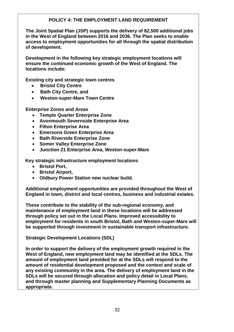
POLICY 4: THE EMPLOYMENT LAND REQUIREMENT The Joint Spatial Plan (JSP) supports the delivery of 82,500 additional jobs in the West of England between 2016 and 2036. The Plan seeks to enable access to employment opportunities for all through the spatial distribution of development. Development in the following key strategic employment locations will ensure the continued economic growth of the West of England. The locations include: Existing city and strategic town centres
Bristol City Centre
Bath City Centre, and
Weston-super-Mare Town Centre
Enterprise Zones and Areas
Temple Quarter Enterprise Zone
Avonmouth Severnside Enterprise Area
Filton Enterprise Area
Emersons Green Enterprise Area
Bath Riverside Enterprise Zone
Somer Valley Enterprise Zone
Junction 21 Enterprise Area, Weston-super-Mare
Key strategic infrastructure employment locations
Bristol Port,
Bristol Airport,
Oldbury Power Station new nuclear build. Additional employment opportunities are provided throughout the West of England in town, district and local centres, business and industrial estates. These contribute to the stability of the sub-regional economy, and maintenance of employment land in these locations will be addressed through policy set out in the Local Plans. Improved accessibility to employment for residents in south Bristol, Bath and Weston-super-Mare will be supported through investment in sustainable transport infrastructure. Strategic Development Locations (SDL) In order to support the delivery of the employment growth required in the West of England, new employment land may be identified at the SDLs. The amount of employment land provided for at the SDLs will respond to the amount of residential development proposed and the context and scale of any existing community in the area. The delivery of employment land in the SDLs will be secured through allocation and policy detail in Local Plans, and through master planning and Supplementary Planning Documents as appropriate.

33
Reasoned Justification for Policy 4 22. In order to support the continued economic growth of the West of England, the area
will need to be able to accommodate an additional 82,500 jobs (c.69,400 Full Time Equivalents) between 2016 and 2036 (all use classes not just B Class use). This figure has been derived from the 2015 Medium High growth forecasts from Oxford Economics with a small uplift of 1.1%.
23. The growth in jobs will be supported by the portfolio of employment opportunities available across the West of England. The continued changes in the employment market mean that flexibility is required within the employment land portfolio, in order to respond to changes in market demand during the plan period and beyond.
24. The employment land requirement to support the delivery of employment growth has been assessed, and the Economic Development Needs Assessment (EDNA) has identified that existing employment land is sufficient to deliver strategic employment needs, and the anticipated jobs growth over the period to 2036. Whilst the EDNA identified some localised mismatches between supply and demand for example in some parts of the WoE such as the Avonmouth / Severnside area, within the single functional economic market of the West of England, the opportunities to satisfy economic and employment land needs exceed the requirements of the highest employment job forecasts. Although additional jobs will be delivered from the full range of employment types, the EDNA deals only with provision for office, industrial and warehouse uses (‘B’ class uses. This is consistent with the requirements of the NPPF and national PPG).
25. The employment potential of the strategic employment locations will continue to be
reviewed to inform detailed policy formulation through each authority’s Local Plan. The strategic focus for the increase in employment opportunity will primarily be within the Enterprise Zones and Enterprise Areas.
26. The overall strategy is to focus growth in City Centres and EZs which are sustainable locations and are successful business locations.
27. Whilst major growth in employment is targeted at these areas, additional growth opportunities for Port, airport and power station related activities, are recognised at 3 key strategic infrastructure employment locations, Bristol Airport in North Somerset and Bristol Port in North Somerset/Bristol, and Oldbury Power Station in South Gloucestershire. This is in response to the evidenced employment growth potential at these locations. Growth at Bristol Airport has the potential to create a range of new employment opportunities. However, significant growth in this location will require the delivery of improved public transport access from Bristol and Weston-super-Mare. In addition, the construction of Hinkley Point C in Somerset, though outside the plan area, will have a significant impact on business supply chains and labour markets across the West of England (e.g. as demonstrated by location of EDF headquarters at Bridgwater House, Bristol).
28. The Strategic Development Locations where appropriate provide for employment land,
proportionate to the scale of development proposed and the proximity of the development to other employment provision, and local employment need. The detailed capacity of the SDLs may be further tested in the preparation of the Local Plans. Although there will continue to be growth opportunities throughout the West of England as a result of intensification of activity within existing local business and

34
industrial estates, there are constrained opportunities for new employment land in south Bristol.
29. The clear priority for the development of brownfield land in the urban areas of the
West of England will provide the opportunity for increased homes and employment using vacant or underused land. Key sites available for an increase in employment activity or for the release to housing land from employment use within Bristol City, the urban edge of Bristol within South Gloucestershire, and within Weston–super-Mare and Bath will be identified through the new the Local Plans.
30. Additional employment opportunities are provided throughout the West of England in town, district and local centres, business and industrial estates. These contribute to the stability of the sub-regional economy, and maintenance of employment land in these locations will be addressed through policy set out in the Local Plans.

35
POLICY 5: PLACE SHAPING PRINCIPLES:
All new development must contribute towards the delivery of high quality and
sustainable places. The following key principles should be used to inform the
development and delivery of high quality and sustainable places to:
1. Create character, distinctiveness and sense of place which
diversifies the residential offer, improves accessibility, affordability
and enhances identity.
2. Improve health and wellbeing and enable independence, reduce
health inequalities, and facilitate social interaction where people can
meet to create healthy, inclusive and safe communities.
3. Enable inclusive and sustainable economic growth.
4. Ensure the protection and enhancement of the natural, built and
historic environment.
5. Mitigate and adapt to climate change and use a catchment based
approach to water management.
6. Minimise energy demand and maximise the use of renewable energy,
where viable meeting all demands for heat and power without
increasing carbon emissions.
7. Provide and ensure access to infrastructure including public
transport, which reduces reliance on use of cars.
8. Maintain and enhance the Green Infrastructure network to deliver
multiple benefits for people, place and the environment.
These Key Principles should be used to prepare the Strategic Development
Locations (identified in Policy 2 and 7) concept frameworks and future master
planning to be identified in local plans or other documents to secure a co-
ordinated and comprehensively planned approach. They should also be used
to support existing communities to ensure the delivery of sustainable urban
living and regeneration led development.
The West of England local authorities through their local plans will build good
working relationships with developers, infrastructure providers other agencies
and local communities to achieve these key principles.
Reasoned Justification for Policy 5.
31. Place making is at the heart of achieving our ambition for the West of England for places that are environmentally, socially and economically sustainable. To support this, the Plan’s vision and spatial strategy recognises the importance of working on key issues across boundaries whilst seeking to respect the character and identity of our individual communities and to make places more innovative, competitive, connected, diverse and healthy.
32. To achieve these key objectives requires the leadership, ambition and co-operation of
public, private and voluntary sectors. This is critical in order to shift expectations, perceptions and devise new delivery models. To support this, key principles have been developed that ensure the JSP incorporates strategic priorities for economic,

36
environmental and social sustainability. These accord with the 3 pillars of sustainable development and are intended to articulate the West of England’s ambition and focus for creating high quality places that fulfil and realise these objectives.
Social
Policy Principle1: Create character, distinctiveness and sense of place
33. The design, diversity and nature of housing in new developments is critical to their
attractiveness as places to live and in establishing successful new communities. New development will demonstrate a high standard of design appropriate to their location. This should be inclusive enabling accessibility and independence helping to reduce health inequalities. A mix of housing typologies and tenures have a role to play in diversifying the residential offer, improving accessibility and affordability and enhancing identity and sense of place. This can link to new models of housing delivery provided by new small and medium sized enterprises (SMEs), such as self and custom build and build to rent. Projects at higher density and scale provide the potential for generating community energy and can help to alter perceptions about an area.
34. Having a sense of place requires that new development provides a clear sense of scale, density, and legibility, has strong landscape and multi-functional green and blue infrastructure features and the provision of a range of amenities and services. Connection to sustainable transport networks are important so that locations are accessible by means other than car travel. New development should provide places of interaction with, diverse local economies and a good standard of service provision such as education. In order to take this work forward, the WoE authorities will prepare an Urban living Supplementary Planning Document (SPD) to set out these principles.
Policy Principle 2: Improve health and wellbeing, reduce health inequalities, and facilitate
social interaction where people can meet to create healthy, inclusive and safe communities.
35. The planning, design and management of places and homes has an impact on the health of both current and future generations. New development and infrastructure provide opportunities to improve public health and access to healthcare services. Such improvements can be direct, for example the installation of smart technology for independent living; or indirect by impacting on behaviour, for example provision of active travel options, improving safety and creating accessible spaces to encourage physical activity. The reduction of obesity by raising levels of physical activity has been shown to lessen the risk of physical and mental health issues and costs to health service providers.
36. Health inequalities, social opportunity and quality of life are differences between people or groups due to social, geographical, biological or other factors. These differences can have a huge impact, resulting in some people and groups experiencing poorer health and shorter lives. Development proposals must be informed by a holistic and evidence-based approach which considers how the current and future health needs of the population can inform the design and planning of new places.
37. Development proposals should:
be planned to integrate transport and land use and recognise the opportunity to offer
a variety of services and facilities including access to green space and nature. This
includes places for leisure, social activity and business space and places, both inside
and out, where people can interact.

37
be fit for the future, incorporate alternative sources and resilience to a more variable
climate.
Support strong, vibrant and healthy communities, by creating clear urban design with
a diversity of housing, flexibility of building uses and sufficient space for cycle paths
and walkways, to the community’s needs and support its health, social and cultural
well-being.
Economic
Policy Principle 3: Enable inclusive and sustainable economic growth
38. The availability of land for business activity is important to the long-term sustainability
of both our existing and new communities, as well as the performance of the local
economy. Where development potential is identified, there is a risk that employment
uses will be pushed out by the need for new homes and the values generated by
residential development. However, whilst land should not be protected for employment
use where there is little prospect of such use occurring, it is important that adequate
provision for future change is made. This does not simply require the right quantum of
floorspace but the provision of premises that can support a strong and productive
economy.
39. To achieve this requires diversity of economic activity, enable business interaction and
the retention and attraction of staff, provide for a range of flexible building types,
including working from home. Development proposals should enable flourishing and
successful economies by allowing for ideas to be generated, tested, developed and
turned into services and products.
40. Where appropriate new employment opportunities should be provided at the strategic
development locations with the form and type of development to be determined
through local plans and SPD as appropriate.
Environment
Policy Principle 4: Ensure the protection and enhancement of the natural, built and historic
environment
41. The West of England is bounded by natural features of international and national
importance – the two limestone landscapes designated for their outstanding natural
beauty - the Cotswolds AONB lies to the east and the Mendip Hills AONB to the south,
the Severn Estuary is an international wetland habitat. A plethora of international and
national sites of ecological importance also exist throughout the WoE, that are not
confined to these landscapes. Topic Paper x sets out these assets. The West of
England’s numerous historic sites and features contribute significantly to the
distinctiveness and sense of place of many communities.
42. These natural, built and historic environments provide a wide range of services that
benefit our economy, and encourage visitors to the region whilst also providing health
related benefits to our residents. Therefore it is crucial that new development works
with natural systems, and is responsive to the distinctive historic and landscape
setting of the sub region.
43. By working closely with our key environmental partners we have sought to establish a
strong evidence base against which to recognise the wider benefits of ecosystem

38
services, providing net gains to biodiversity, ensure areas of high landscape and
visual sensitivity are respected, and the historical environment is conserved and
enhanced. This will be used to ensure new development will:
Conform with planning legislation to ensure protection of Local to International
designated sites (AONB, SNCI, SSSI, SAC, SPA, Ramsar sites) and should ensure
enhanced protection through complimentary habitat creation to extend and/or buffer
the site, implemented through the delivery of green infrastructure corridors.
Be expected to contribute towards a net gain of the sub-regions diverse and high
quality natural environment and biodiversity ensuring that new development creates
high quality sustainable places that deliver the integration, enhancement and
protection of the sub-regions environmental assets.
Encourage opportunities to take a landscape-scale approach to improve the natural
environments resilience and optimise the services they provide as demonstrated
through the Severnside Wetlands Nature Improvement Area (NIA) and Bristol Avon
Catchment.
In delivering Strategic Development Locations, policy requirements will incorporate
provision for multi-functional green infrastructure as mapped in the Strategic
Development Locations framework diagrams.
44. The vehicle to deliver an assessment of the West of England’s key environmental
assets will be delivered through a Green Infrastructure Plan for the West of England,
supported by the 4 Unitary Authorities. The scope is set out in Topic Paper x.
Policy Principle 5 – Mitigate and adapt to climate change and use a catchment based
approach to water management.
45. All development proposals will be required to demonstrate how long term climate
resilience has been taken into account in the location and design of new development.
46. To increase resilience of the water environment to tidal, fluvial and surface water
flooding the West of England authorities are committed to work in partnership on a
catchment wide basis to achieve more holistic outcomes focused on multi-benefit
projects across our administrative boundaries. A clear strategic priority is to increase
investment opportunities for delivering improvements and adaption measures for water-
based issues across the whole of the water catchment that falls within the Plan area,
identifying new funding and delivery mechanisms to deliver positive change. These
include reduced sedimentation of watercourses and associated maintenance costs,
reduced risk of flooding and enhancement of the wider environment to improve the
public realm through soft engineering solutions.
47. There is a need to work with wider partners including the EA and water companies to
address adaption measures to respond to impacts such as drought and water
shortages though schemes to manage water consumption. In working with wider
partners development should positively contribute to managing the water environment
by implementing a sustainable drainage strategy that adopts a catchment based
approach to water management and which is integrated with the green infrastructure
objectives to provide resilience against flooding.

39
48. To meet these objectives, the four West of England authorities will support the
catchment wide action plan and its implementation.
Policy Principle 6: Minimise energy demand and maximise the use of renewable energy,
where viable meeting all demands for heat and power without increasing carbon emissions:
49. The West of England Unitary Authorities are committed to improving energy security,
address fuel poverty and to achieve an efficient low carbon economy. In addressing
these challenges it is important for the West of England Authorities to contribute to and
support the increased use and supply of renewable and low carbon energy in line with
objectives and provisions of the Climate Change Act 2008, 2050 Carbon neutral
targets. As such, the combined West of England CO2 reduction target is to reduce
absolute CO2 emissions by 50% by 2035 from a 2014 baseline.
50. The scale of proposed development to be delivered through the JSP could generate
significant additional CO2 emissions, making it harder to reach this target. To mitigate
this, it will be necessary to maximise the energy efficiency of new development and
integrate renewable energy technologies to supply the energy needs of new
development in order to minimise energy demand. Technology continues to advance
whilst costs fall and it is more cost effective to deliver efficient new buildings with
renewable energy integrated from the outset than to retrofit them once they are built.
51. Through the production of the new Local Plans and supporting SPD, the potential for
development to be built to a zero carbon standard, that is net zero emissions from
regulated and unregulated heat and power, will be investigated using a consistent
methodology across all four Unitary Authorities. Where viable, policies requiring zero
carbon development or development that produces more renewable energy than it uses
through opportunities including heat networks and other measures to support the
delivery of environmentally sustainable development will be considered for inclusion in
Local Plans.
Infrastructure:
Policy Principle 7 Provide and ensure access to infrastructure including public transport,
that reduces reliance on use of cars
52. Strategic development should be in locations which maximise the potential to reduce
the need to travel or, where travel is necessary, maximise opportunities to travel by
sustainable, non-car modes, especially walking and cycling or be in places accessible
to existing or new high quality public transport links. The focus of new transport
infrastructure should address both existing challenges and create capacity for
sustainable growth. New developments should also ensure that safe vehicle access is
secured and appropriate local highway mitigations are identified and delivered.
53. Development should make provision of community infrastructure necessary to support
the new development including provision of retail, education, health and sport and
leisure. New services and facilities should be integrated with existing provision where
appropriate.

40
Policy Principle 8 Maintain and enhance the West of England’s Green Infrastructure
network to deliver multiple benefits for people, place and the environment
54. Strategically planned and designed new green infrastructure and enhancing the existing
green and blue infrastructure can provide a broad range of economic and social
benefits that underpins the JSP’s vision for sustainable growth.
55. In assessing the JSP Strategic Development Locations the four Unitary Authorities
have taken account of the eight cross cutting Green Infrastructure objectives. Through
the assessment of Green Infrastructure for the JSP strategic development locations, a
framework for assessment has been created. This is intended to provide for a well-
integrated, multifunctional public open space and green infrastructure network to
provide a full range of formal and informal recreation opportunities (including
allotments) and to help ensure the setting of local heritage and ecological assets are
protected and enhanced.
56. This framework will help inform local plans to enable consistency within the design of all
new development (urban living and non strategic as well as the SDLs), ensuring multi-
functional green infrastructure objectives are incorporated and delivered.
57. Taking this work forward, the 4 West of England Unitary Authorities will devise and
deliver a Green Infrastructure Plan (as referred to in principle 4) which will identify the
West of England’s key natural assets and the mechanisms for investment in those
assets. It is envisaged that the Green Infrastrcuture plan will be the basis for identifying
opportunities for enhancing and delivering Green Infrastructure and ecosystem
services, both on and offsite, and prioritisation for large scale conservation
management.
58. Through the delivery of a West of England Green Infrastructure Plan and Local Plans,
issues will be addressed on a coordinated and strategic level, including any potential
significant effects on Natura 2000 sites.

41
POLICY 6 STRATEGIC INFRASTRUCTURE REQUIREMENTS
Strategic infrastructure will be required to support the effective
implementation of the Joint Spatial Plan Spatial Strategy.
Transport infrastructure: Working with delivery partners, the strategic transport infrastructure
identified on the Key Diagram and in the West of England Joint
Infrastructure Delivery Programme will be provided within the period 2016-
2036.
Priority will be given to schemes which support the delivery of the spatial
strategy as set out in Policy 2.
Provision will be made in the Local Transport Plan and local plans for an
integrated corridor-based approach to transport improvements which
supports sustainable and active travel choices and maximises the
effectiveness of non-car modes.
Other strategic infrastructure: New development must be properly aligned with the provision of the
necessary strategic infrastructure. Additional strategic infrastructure
identified to support the delivery of the spatial strategy is future investment
in strategic flood management infrastructure at Avonmouth / Severnside,
and on the River Avon in relation to Bristol City Centre. This is indicated on
the Key Diagram. Other infrastructure will be identified where appropriate in
the WoE Joint Infrastructure Delivery Programme and will be identified
through local plans and local infrastructure delivery programs.
Reasoned Justification for Policy 6
59. The policy identifies the strategic development infrastructure requirements which are
identified as being required during the plan period to deliver the spatial strategy. These
are identified on the Key Diagram and set out in the Infrastructure Delivery Programme.
These are the critical transport requirements, flooding and drainage improvements and
mitigations. Energy infrastructure to support low carbon development and resilience to
climate change such as the Avonmouth / Severnside Heat Network, with cross-border
network requirements, will also come forward.
60. The requirement for an effective network of green infrastructure will be set out in local
plans and other policy guidance and delivered through an integrated approach to new
development. Other more localised infrastructure will also be required and this will be
identified through local plans.
61. A WoE GI plan will identify and help to secure any GI required to support the delivery of
the JSP and local plans. This would include addressing any potential significant effects
on Natura 2000 sites, and other designated sites.

42
62. Delivery of the strategic infrastructure in the Infrastructure Delivery Program will be
ensured through joint working with delivery partners including Natural England,
Environment Agency, Highways England, Network Rail, utilities companies and
developers. The local authorities will explore a range of delivery mechanisms including
the use of compulsory purchase powers (CPO) to make sure that essential
infrastructure is delivered in step with new development.
63. Priority will be given to infrastructure delivery which is most effective in delivering the
overall spatial strategy and, for example, tackling existing transport challenges, not just
in respect of the new strategic development locations, but within the urban areas and at
non-strategic locations across the plan area. Where infrastructure provision has cross-
border or wider implications, the Unitary Authorities will work together to deliver the
most effective solution through, for example, shared use of resources.
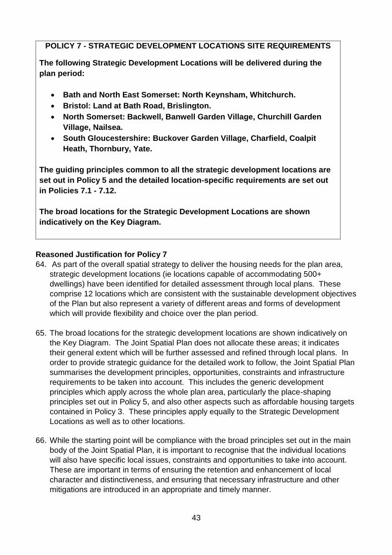
43
POLICY 7 - STRATEGIC DEVELOPMENT LOCATIONS SITE REQUIREMENTS
The following Strategic Development Locations will be delivered during the
plan period:
Bath and North East Somerset: North Keynsham, Whitchurch.
Bristol: Land at Bath Road, Brislington.
North Somerset: Backwell, Banwell Garden Village, Churchill Garden
Village, Nailsea.
South Gloucestershire: Buckover Garden Village, Charfield, Coalpit
Heath, Thornbury, Yate.
The guiding principles common to all the strategic development locations are
set out in Policy 5 and the detailed location-specific requirements are set out
in Policies 7.1 - 7.12.
The broad locations for the Strategic Development Locations are shown
indicatively on the Key Diagram.
Reasoned Justification for Policy 7
64. As part of the overall spatial strategy to deliver the housing needs for the plan area,
strategic development locations (ie locations capable of accommodating 500+
dwellings) have been identified for detailed assessment through local plans. These
comprise 12 locations which are consistent with the sustainable development objectives
of the Plan but also represent a variety of different areas and forms of development
which will provide flexibility and choice over the plan period.
65. The broad locations for the strategic development locations are shown indicatively on
the Key Diagram. The Joint Spatial Plan does not allocate these areas; it indicates
their general extent which will be further assessed and refined through local plans. In
order to provide strategic guidance for the detailed work to follow, the Joint Spatial Plan
summarises the development principles, opportunities, constraints and infrastructure
requirements to be taken into account. This includes the generic development
principles which apply across the whole plan area, particularly the place-shaping
principles set out in Policy 5, and also other aspects such as affordable housing targets
contained in Policy 3. These principles apply equally to the Strategic Development
Locations as well as to other locations.
66. While the starting point will be compliance with the broad principles set out in the main
body of the Joint Spatial Plan, it is important to recognise that the individual locations
will also have specific local issues, constraints and opportunities to take into account.
These are important in terms of ensuring the retention and enhancement of local
character and distinctiveness, and ensuring that necessary infrastructure and other
mitigations are introduced in an appropriate and timely manner.

44
67. Policies 7.1 – 7.12 set out the bespoke requirements for each location which will form
the starting point for their detailed assessment through the local plans. These are
derived from the evidence prepared as part of the plan-making process and
summarised in the supporting documents, particularly the Strategic Development
Location templates. The requirements identified in the Joint Spatial Plan policies are
not exhaustive and will evolve as detailed assessment and masterplanning takes place
at these locations.
68. While the trajectories need to be further refined as the proposals are developed in more
detail, the 12 Strategic Development Locations are currently anticipated to deliver
approximate 17,377 dwellings by 2036, with the capacity for a further 4,350 beyond the
plan period. In many locations delivery is linked to the delivery of essential
infrastructure, particularly highways and transport. This means that in several of the
identified locations development is not anticipated to commence until later in the plan
period.
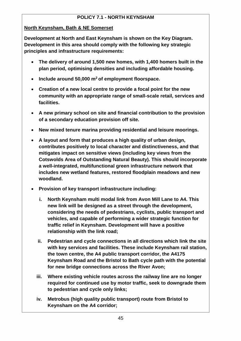
45
POLICY 7.1 - NORTH KEYNSHAM
North Keynsham, Bath & NE Somerset
Development at North and East Keynsham is shown on the Key Diagram.
Development in this area should comply with the following key strategic
principles and infrastructure requirements:
The delivery of around 1,500 new homes, with 1,400 homers built in the
plan period, optimising densities and including affordable housing.
Include around 50,000 m2 of employment floorspace.
Creation of a new local centre to provide a focal point for the new
community with an appropriate range of small-scale retail, services and
facilities.
A new primary school on site and financial contribution to the provision
of a secondary education provision off site.
New mixed tenure marina providing residential and leisure moorings.
A layout and form that produces a high quality of urban design,
contributes positively to local character and distinctiveness, and that
mitigates impact on sensitive views (including key views from the
Cotswolds Area of Outstanding Natural Beauty). This should incorporate
a well-integrated, multifunctional green infrastructure network that
includes new wetland features, restored floodplain meadows and new
woodland.
Provision of key transport infrastructure including:
i. North Keynsham multi modal link from Avon Mill Lane to A4. This
new link will be designed as a street through the development,
considering the needs of pedestrians, cyclists, public transport and
vehicles, and capable of performing a wider strategic function for
traffic relief in Keynsham. Development will have a positive
relationship with the link road;
ii. Pedestrian and cycle connections in all directions which link the site
with key services and facilities. These include Keynsham rail station,
the town centre, the A4 public transport corridor, the A4175
Keynsham Road and the Bristol to Bath cycle path with the potential
for new bridge connections across the River Avon;
iii. Where existing vehicle routes across the railway line are no longer
required for continued use by motor traffic, seek to downgrade them
to pedestrian and cycle only links;
iv. Metrobus (high quality public transport) route from Bristol to
Keynsham on the A4 corridor;

46
v. High frequency local bus service following an orbital route
connecting the site to the town centre, Metrobus, rail and other local
bus services;
vi. Improved passenger facilities at Keynsham rail station;
vii. Off-site junction improvements including at Hicks Gate; and
viii. Expanded or relocated A4 Bristol Park & Ride.
No housing will be completed at the North Keynsham SDL ahead of the Avon
Mill Lane to A4 link, Keynsham rail station improvements and Metrobus (high
quality public transport) route from Bristol to Keynsham on the A4 corridor
being completed. This should not prejudice a full Transportation Assessment
which will be required for each location.

47
POLICY 7.2 – WHITCHURCH
Whitchurch, Bath & North East Somerset
The development of land at Whitchurch is shown on the Key Diagram.
Development in this area should comply with the following key strategic
principles and infrastructure requirements:
Around 2,500 new homes, optimising densities with 1,600 homes built in the plan period, including affordable housing.
Provide retail, healthcare and community facilities, two new primary schools and a secondary school.
Deliver environmental enhancements to Whitchurch village and its local centre.
Retain the open gap between Whitchurch village and the Bristol urban area.
Include employment spaces at a quantum and of a type to be determined though the Local Plan.
Preserve and/or enhance the Queen Charlton Conservation Area, and the Maes Knoll and Wansdyke Scheduled Monuments and their settings.
Provision of key transport infrastructure including; i. Multi-modal link connecting A4, A37 and the south Bristol link road;
ii. Park and ride provision;
iii. Metrobus (high quality public transport) route from Bristol on the A4-
A37 link;
iv. Pedestrian and cycle connections in all directions which link the site
with key services and facilities. These include extending and improving
walking and cycling routes to Bristol, Keynsham and to the countryside
to the south; and
v. Off-site junction improvements including at Hicks Gate.
No dwelling will be completed at the Whitchurch SDL ahead of:
i. Park and Ride, and
ii. the multi-modal link A4-A37-south Bristol link including as a pre-
requisite, the Callington Road scheme being completed.

48
The strategic infrastructure listed above should not prejudice a full
Transportation Assessment which will be required for each location.

49
POLICY 7.3 – LAND AT BATH ROAD, BRISLINGTON
Bath Road, Brislington, Bristol
The relocation of Brislington Park & Ride to land near Hicks Gate Roundabout within Bath and North East Somerset will enable the creation of a new neighbourhood within Bristol. Development in this area should comply with the following strategic principles and infrastructure requirements:
Provision of at least 750 new homes;
Mix of uses to be provided in accordance with masterplanning process;
Retention and incorporation of hedgerows into development, including the hedgerows along Scotland Lane;
The Sustainable Drainage Systems (SuDS) strategy will include surface water runoff management measures to remediate existing issues on the Scotland Bottom watercourse and Scotland Lane;
Provision of a linear recreational park incorporating Scotland Bottom watercourse to allow for maintenance of the watercourse and the protection and enhancement of nature conservation. The park should include walking and cycling routes;
Avoidance of unnecessary sterilisation of coal resources within the Minerals Safeguarding Area;
Financial contributions to the provision of primary school places off site;
The provision of key transport infrastructure in advance of development including;
i. Relocation of Brislington Park & Ride to land near Hicks Gate Roundabout
within Bath and North East Somerset;
ii. Callington Road Link / A4 Rapid Transit Scheme;
iii. Widening of the A4 strategic road network corridor to provide public
transport infrastructure inbound and outbound, and an adjacent strategic
greenway providing walking and cycling paths with links across Bath Road,
and a landscape frontage alongside the A4;
Other transport improvements: iv. A4 – A37 link, which may incorporate a MetroBus route;
v. Review the use of Scotland Lane, in light of delivering the A4-A37- south Bristol link, to reduce through traffic and provide walking and cycling facilities
vi. Extending and improving cycle routes to Bristol, Keynsham, and to the
countryside to the south.

50
POLICY 7.4 - BACKWELL
Backwell, North Somerset
Land to the west of Backwell is shown indicatively on the Key Diagram as
the broad location to accommodate an extension to the village. The key
strategic principles and infrastructure requirements are as follows:
Delivery of an extension to Backwell village to create a sympathetic
and well-designed development appropriate to its rural setting of
around 700 dwellings including affordable housing.
Lower densities will be expected on more sensitive parts of the site,
including to safeguard heritage and ecological assets.
Creation of new footpath and cycleways linking the site to the rail
station, proposed MetroBus connections and local services and
facilities.
Improvements to the rail station to create a multimodal interchange
including enhanced parking, facilitating increased frequency and
capacity, accessibility and accommodating a MetroBus interchange.
Local junction improvements will be required including at Station
Road, and theA370 Backwell signalised junction.
Provision of a primary school of at least 2.4ha to be located to
maximise safe access from surrounding communities by walking and
cycling.
Protection of the settings of historic Chelvey and West Town
Conservation Area and the need for sensitive treatment in respect of
the setting of Grove Farm.
Strategic approach to the assessment, safeguarding and
enhancement of greater and lesser horseshoe bat habitat (particularly
the Juvenile Sustenance Zone between the A370 and Chelvey Road),
and Tickenham; Nailsea and Kenn Moor SSSI interests.
Development should avoid the flood plain and demonstrate reduced
run-off rates including through the use of attenuation ponds and other
features as appropriate. Additional land may be required off-site to
facilitate long term water storage as part of the sustainable drainage
strategy.
Development to be mitigated with the delivery of:
i. New multi-modal link from A370 Long Ashton Bypass to station
interchange (including rail crossing), Nailsea SDL and Nailsea

51
town centre, with connection to A370 west of Backwell (including
rail crossing) and a new or improved connection to M5.
ii. New MetroBus route linking Bristol to Nailsea from Long Ashton
Bypass to the station interchange (including rail crossing), Nailsea
SDL and Nailsea town centre, and potential onward link to
Clevedon.
iii. Opportunities to phase delivery of the highway improvements in
step with parts of the development may be explored.

52
POLICY 7.5 - BANWELL GARDEN VILLAGE
NW of Banwell, North Somerset
Land to the north west of Banwell is shown indicatively on the Key Diagram
as the broad location to accommodate a new Garden Village. The key
strategic principles and infrastructure requirements are as follows:
Delivery of a new garden village to the north west of Banwell with its
own character and sense of identity, whilst demonstrating sensitivity
to the existing context for around 1900 dwellings including affordable
housing.
Creation of a new local centre to provide a focal point for the new
community with an appropriate range of small-scale retail, services
and facilities to complement existing facilities in Banwell.
Potential for higher density at the local centre and other accessible
locations.
Creation of new footpath and cycleways connecting the garden village
to Banwell, Weston-super-Mare and the nearby Weston Villages.
Delivery of bus service improvements to Weston-super-Mare and
Bristol including potential for MetroBus.
Development will not commence until the construction of the Banwell
Bypass is delivered as part of the M5 to A38 highway improvements
with connection to a new M5 Junction 21a at a location to be
confirmed, and onward connection to the Sandford/Churchill Bypass.
Opportunities to phase delivery of the highway improvements in step
with parts of the development may be explored particularly where
delivery of infrastructure is directly within the land controlled by the
developer. Development must not prejudice the delivery of future
improvements to M5, including the construction of the new M5
junction.
Local network and junction improvements including widening of
Wolvershill Road.
Provision of two primary schools one of at least 2.4ha and the other
3.4ha to be located to maximise safe accessibility from surrounding
communities by walking and cycling. Provision for a new secondary
school to serve the Banwell and Churchill SDL should be made with
location to be confirmed through the local plan.
Strategic approach to the assessment, safeguarding and
enhancement of greater and lesser horseshoe bat habitat including

53
investigation of the potential to create a ‘dark corridor’ link through
the development from open countryside around Stonebridge towards
the Grumplepill Rhyne corridor.
Development should avoid the flood plain and demonstrate reduced
run-off rates including through the use of attenuation ponds and other
features as appropriate. Additional land may be required off-site to
facilitate long term water storage as part of a sustainable drainage
strategy.
Identification of around 5 ha of employment land primarily for B8 use
class with good access to the M5 and new strategic transport
infrastructure.
As part of the approach to securing a multi-functional and
interconnected green infrastructure, investigate the opportunity for an
open setting along the northern edge of the existing village including
potential for a nature reserve or other uses, with links out to open
countryside to the east.
Implementation of environmental improvements to the centre of
Banwell following construction of the Bypass.
Safeguarding of the setting of Banwell Conservation Area and
protection and enhancement of the settings of listed heritage assets
located both within and outside the historic core.
Recognition that there are areas of high potential for archaeology
which may require appropriate mitigation, particularly around
Stonebridge and Wolvershill, and also between East Street and
Riverside.
Development form, and layout to respect the sensitivity of the location
close to the Mendip Hills AONB.

54
POLICY 7.6 – CHURCHILL GARDEN VILLAGE
NW of Langford and Churchill, North Somerset
The area of search for development to the north west of Churchill and
Langford is shown indicatively on the Key Diagram as the broad location to
accommodate a new Garden Village. The key strategic principles and
infrastructure requirements are as follows:
Delivery of a new garden village to the north west of Langford with its
own character and sense of identity for around 2675 dwellings including
affordable housing. An additional 125 dwellings are estimated beyond
2036.
An interconnected and multi-functional network of green infrastructure
will be established, including the provision of an appropriate strategic
(open space) gap between Churchill Garden Village and existing
settlements.
Development should avoid the flood plain and demonstrate reduced run-
off rates including through the use of attenuation ponds and other
features as appropriate. Additional land may be required off-site to
facilitate long-term water storage as part of a sustainable drainage
strategy.
Protection and enhancement of local heritage assets and their settings,
including Churchill Court unregistered park and garden and listed
buildings at Churchill Green and Front Street.
Creation of a new local centre to provide the heart of the new
community with a range of retail, employment, services and facilities.
Potential for higher densities at the local centre and other accessible
locations, and reduced densities on the fringes of the development to
provide a soft edge and setting for the new community.
Creation of new footpath and cycleways linking the new community with
existing settlements and facilities including access to the Strawberry
Line.
Package of highway schemes including a new M5 junction, Banwell
Bypass, Sandford/Churchill Bypass and capacity improvements to
A38/A368 junction. Bus service improvements to Bristol and Weston-
super-Mare, including the potential for Metrobus.

55
Provision of three primary schools of at least 2.4ha each to be located to
maximise safe access from surrounding communities by walking and
cycling.
Strategic approach to the assessment, safeguarding and enhancement
of greater and lesser horseshoe bat habitat. Investigation and
implementation of a green corridor through development linking from
open countryside to the west to Windmill Hill to areas south of Langford
and beyond to the Langford Brook.
Identification of around 7.4 ha of employment land. Employment land to
be located in close proximity to new highway link and will provide
business opportunities in the B Use Class.
Development form, and layout to respect the sensitivity of the location
close to the Mendip Hills AONB.
Windmill Hill to be retained as a focal green feature for ecological,
recreational and landscape value. It also has archaeological significance
as a location for the remains of Iron Age settlement.

56
POLICY 7.7 – NAILSEA
SW Nailsea, North Somerset
Land to the south west of Nailsea is shown indicatively on the Key Diagram as
the broad location to accommodate a new extension to the town. The key
strategic principles and infrastructure requirements are as follows:
Delivery of an extension to the south west of Nailsea with its own
character and sense of identity for around 2575 dwellings including
affordable housing. An additional 725 dwellings are estimated beyond
2036.
Creation of a new local centre to form the heart of the new community
with a range of retail, employment, services and facilities, but of a scale
and type which is complementary to Nailsea town centre which will
remain the main centre.
Higher densities at the local centre and at accessible locations,
particularly along the proposed MetroBus route and lower densities
towards the western edge of the development.
Creation of new footpath and cycleways linking the new local centre
with residential areas, locations within Nailsea and the rail station and
public transport services.
Development to be mitigated with the delivery of:
i. New multi-modal link from A370 Long Ashton Bypass to station
interchange (including rail crossing), new development area and
Nailsea town centre, with connection to A370 west of Backwell
(including rail crossing) and a new or improved connection to the
M5.
ii. New MetroBus route linking Bristol to Nailsea from Long Ashton
Bypass to the station interchange (including rail crossing), new
development area and Nailsea town centre, and onward link to
Clevedon via M5 J20 link.
iii. Opportunities to phase delivery of the highway improvements in
step with parts of the development may be explored.
Local junction improvements including Station Road, and A370
Backwell signalised junction.
Provision of a secondary school of 8 ha and four primary schools of at
least 2.4ha each, located to maximise safe access by walking and
cycling.
Strategic approach to the assessment, safeguarding and enhancement of greater and lesser horseshoe bat habitat, and Tickenham; Nailsea and Kenn Moor SSSI interests. This includes investigating the potential for a

57
dark corridor through the new development linking habitats at Backwell through to open countryside to the north and at Batch Farm Meadow wildlife site.
Protection of heritage assets and their settings particularly listed farm
buildings in the area whose settings should be addressed through a
sensitive green infrastructure strategy.
Long-term water storage and other measures are likely to be required as
part of a sustainable drainage strategy, as well as reduced run-off rates
to surrounding area. Measures to ensure water quality and levels are
not adversely impacted on the nearby Tickenham Moors SSSI must be in
place.
The separate identity and character of Nailsea and Backwell will be
retained through the provision of an appropriate Strategic Gap.
Improvements to the rail station to create a multimodal interchange
including enhanced parking, facilitating increased frequency and
capacity, accessibility and accommodating a MetroBus interchange.
Consideration of relocation/undergrounding of existing pylons.
Identification of around 10.5 ha of employment land well-connected to
the railway station, local centre and Metrobus route. Investigate the
potential for a new office park close to the railway with optimum travel
links.

58
POLICY 7.8 -BUCKOVER GARDEN VILLAGE
Buckover, South Gloucestershire
A Garden Village will be developed on land either side of the A38 at Buckover (east of Thornbury) as shown indicatively on the Key Diagram. An appropriate delivery body, including the land value capture, ownership and management of assets, long-term stewardship and governance arrangements (for the benefit of the community), land uses, master planning and detailed design principles will accord with Garden City principles and shall be agreed with the Council following consultation with the local community, Parish and Town Councils and other relevant stakeholders. These principles will be set out in a new Local Plan policy and other planning policy documentation and delivery agreements as appropriate. The Garden Village should also comply with the following key strategic objectives and infrastructure requirements:
Provision of around 3,000 dwellings (including affordable homes), to be delivered by a full range of providers and of a wide range of types and tenures, complementing existing predominant house types in the local area. At least 1,500 will be delivered within the plan period. The homes will be innovative, of high quality design, spacious and well-planned, meeting Nationally Described Space Standards as a minimum.
A new Local Plan policy will establish an appropriate policy designation to ensure a permanent strategic gap between the new Garden Village and Thornbury.
A Green Infrastructure network will also be established to ensure a permanent and robust landscape edge to the western boundary of Buckover Garden Village, Ridgewood and the setting of local heritage and ecological assets are protected and local food production is given emphasis within the new settlement.
Provision of and support for a range of retail, community & cultural facilities in the Garden Village and potentially other nearby communities to complement existing local provision.
Provision of a primary school and 3-16 all through school and nursery(s).
Provision of around 11 ha of employment land to provide a range of local employment opportunities, including provision for start-up, SMEs and larger businesses.
Embedding of zero-carbon and energy positive solutions throughout the planning, design and delivery process across the whole settlement.
Provision of a strategic transport package including as appropriate delivery of or contributions towards: Metrobus Extension to

59
Thornbury & Buckover GV, A38(N) Park & Ride, M5 J14 improvements, Charfield rail station re-opening, local bus service improvements (including new local shuttlebus to Thornbury), strategic and local cycle and pedestrian connections to Thornbury and other local highway network improvements as necessary.
Consideration will also be required to ensure the A38 can continue to act as an effective relief road to the M5 without detriment to the new resident’s health & wellbeing.

60
POLICY 7.9 - CHARFIELD
Charfield, South Gloucestershire
Land at Charfield will comprise a number of major interdependent development areas around the village. Development of these separate land parcels should be undertaken in a co-ordinated manner to ensure Charfield becomes a more sustainable settlement.
New development should also comply with and or contribute towards the following strategic principles and infrastructure requirements:
Provide around 1200 dwellings, including affordable housing, to be developed within the plan period. New housing should expand the range of types and tenures available in the village.
The future role and function of existing retail and community assets and remaining greenfield land parcels within the centre of the village adjoining the Wotton Road will firstly be reviewed in consultation with the local community to ensure future needs are assessed, new and existing facilities make the most efficient use of land and they assist to maximise the sustainability of the expanded village.
Replacement of the existing primary school with a new 3FE school in a central village location and contributions to delivery of an expanded secondary school in the locality, and or the delivery of a new all through 3-16 school at Buckover Garden Village.
New and/or improved retail and community facilities.
A minimum of 5 ha of new employment land (traditional B-use classes) distributed within the development areas at appropriate locations.
The new development will provide or contribute to a strategic transport package including: M5 J14 improvements, Charfield rail station re-opening, local bus services, a comprehensive Wotton Road environmental enhancement scheme, new and improved foot and cycle connections through the village and to key local destinations such as Renishaws, KLB school and Wotton-under-Edge, and including a new Charfield circular public right of way route.
A Green Infrastructure network will enhance and protect the Little Avon River and its flood zone, the setting to Elbury Hill and St James’ Church, local SSSI, SNCIs and other Listed Buildings, as well as soften views from the AoNB.
Reinforcement of the sewerage network and treatment works.

61
POLICY 7.10 - COALPIT HEATH
Coalpit Heath, South Gloucestershire
Land to the east of Coalpit Heath will deliver a new neighbourhood that responds positively to the locality’s rich mining heritage and visually prominent aspect. The new neighbourhood should also comply with the following key strategic principles and infrastructure requirements:
Provide around 1800 dwellings, including affordable housing, to be developed within the plan period.
Provide a new local centre incorporating a new primary school, local retail outlet, & community facility/hub, and a second primary school (subject to further testing) plus contributions to a new or expanded secondary school in the wider locality.
Incorporate up to 5ha of employment land (B-use classes)
Provide or contribute to a strategic transport package including: Metrobus extension to Yate and Chipping Sodbury, A432 Park and Ride, Yate Rail Station enhancement, the Winterbourne and Frampton Cotterell Bypass, strategic cycle route and local bus services. Vehicular access will be off Badminton Road/Frog Lane, Roundways and Woodside Road.
Establish a Green Infrastructure network that will reinforce a new Green Belt boundary along the rail cutting, provide attractive routes through the site to the nearby countryside (including along the historic Dramway), break up development impact along the ridgeline and protect the setting of nearby Listed Buildings.

62
POLICY 7.11 – THORNBURY
Thornbury, South Gloucestershire
Land at Thornbury around the town’s north and eastern edge off Butt Lane & Morton Way should comply with the following key strategic principles and infrastructure requirements:
A maximum of 500 dwellings, including affordable housing, to be developed within the plan period.
The new Local Plan will establish an appropriate policy designation to ensure a permanent strategic gap between Buckover Garden Village and Thornbury.
Around 5ha of additional employment land on land at Crossways east of Morton Way, sensitively designed to respect the rural nature of the locality.
Incorporate a new convenience store/retail or community opportunity and new and enhanced public open space.
Establish a Green Infrastructure network that will protect Crossways & Cleve Wood, the setting of Hacket Farm, rural nature of Hacket Lane, Clay Lane & Crossways Lane, include SUDs features at Crossways to manage potential flooding at Crossways, and extend the Picked Brook Rhine streamside walk.
Development will also make financial contributions towards local and strategic transportation schemes, including potentially: Metrobus Extension to Thornbury (& Buckover GV), A38(N) Park & Ride, M5 J14 improvements, Charfield rail station re-opening, local bus service improvements, local highway, foot and cycle improvements.

63
POLICY 7.12 – YATE
Yate, South Gloucestershire
Land at Yate comprising two broad locations to the northwest and west of
Yate will deliver a new residential neighbourhood and employment area which
should comply with the following key strategic principles and infrastructure
requirements:
A minimum of 2,000 dwellings, including affordable housing, of which at
least 1,000 will be delivered within the plan period.
Provide a new high quality, high density, mixed-use residential
neighbourhood at NW Yate that improves connections through a
regenerated Beeches Industrial Estate and to the rail station.
The residential neighbourhood will contain a new local centre including a
primary school(s) and/or all through 3-16 school, local retail and
community facility/hub.
A significant new employment land allocation totalling approx. 30ha will
also be allocated at West Yate, of which, approximately:
11ha of land south of Badminton Road will be allocated for B1
and B2 office/light industrial and research use; and
19ha of land between the railway tracks off the Westerleigh Road
will be allocated for B2/B8 and similar uses.
The new development areas will provide or contribute to a strategic
transport package including: Metrobus extension to Yate and Chipping
Sodbury, strategic cycle route, A432 Park and Ride, Yate Rail Station
enhancement, Winterbourne and Frampton Cotterell Bypass and local
bus services. An on-site rail crossing and a new rail bridge is also likely
to be required across the Nibley Lane.
A Green Infrastructure network will reinforce a new Green Belt boundary,
protect the river valley, linear settlement of Engine Common and Nibley
Village, provide an attractive segregated route along the Frome Valley
Walkway, and enhance North Road and the Frome river corridor through
the Beeches Estate.
The historic parliamentary enclosures, which comprise small to medium
sized fields, reinforced by a strong mature hedgerow network and large
number of trees, north of Mission Road and east and west of North Road
will also be protected by a new landscape and or Green Belt designation
which will be confirmed through the new local plan.
Plus, early consideration of appropriate powers devolved to the West of
England to enhance the prospect of land assembly, infrastructure
delivery and the regeneration of existing industrial areas so also

64
assisting bring forward a well planned and connected new residential
development.

65
CHAPTER 5 DELIVERY AND IMPLEMENTATION
1. The authorities recognise that the policies in this Plan are applied consistently across
the plan area and used to inform local plan reviews. Whilst most of the actions
required are the responsibility of or within the control of the authorities it is
acknowledged that some rely on action from statutory agencies and delivery
partners. These include: the Homes and Communities Agency, Highways England,
Network Rail, Environment Agency, the Local Nature Partnership, infrastructure
providers and the development industry. The West of England authorities through
the Duty to Cooperate will continue to work with these organisations.
2. The West of England has a Strategic Solutions Panel comprising the key delivery
agencies and has worked closely with neighbouring authorities in the production of
the JSP. The JSP is supported by an evidence base on infrastructure delivery as set
out in Topic Paper x.
3. The governance structure, within which joint working in the West of England
operates, facilitates meeting the duty to co-operate. The four local authorities have a
history of close joint working. Previously this was under the Planning Homes and
Communities Board. There is now a formally constituted Joint Committee
(Leaders/Mayor) and an Infrastructure Advisory Board (constituted of Cabinet
Members and a business representative), to take a coordinated approach to
Transport and Planning. These meetings are held in public as required to ensure
transparency and accountability. The nature of the ongoing work to meet the duty to
cooperate is set out in the duty to cooperate schedule which is reported to the
Infrastructure Advisory Board.
Funding
4. The scale of the challenge means that delivering the JSP will require a multi-agency
approach. The West of England Authorities recognise that our potential can only be
achieved through collaborative working, and finding new ways and models of
delivery such as compulsory purchase powers, in which we can secure the
investment required to stimulate growth.
5. The JSP sets out our delivery priorities and seeks to influence decision making on
investment (securing funding and directing that funding obtained) by internal and
external decision makers.
6. In the West of England working closely with the Local Enterprise Partnership the four
authorities operate a joined up approach to funding. This is a single pot which
includes the revolving infrastructure fund, city deal funding and growth deal funding.
In 2016, the three Authorities of Bath and North East Somerset, Bristol and South
Gloucestershire agreed a devolution deal with Government and the West of England
Combined Authority was established in 2017. As part of devolution, Government
devolved funds of some £900m investment (£30m per annum over 30 years) to the
Combined Authority to assist in supporting priority infrastructure schemes. This
includes schemes coming forward to support the JSP development locations.

66
7. Infrastructure delivery will be enabled through the most appropriate blend of funding
and a range of funding mechanisms from the West of England and our partners. The
principle of funding development is an equitable share of costs between the public
and private sector.
8. Different sources of funding will be proactively sought and brought together. This
enables a co-ordinated, targeted approach to investment, often with investment in
infrastructure up front, to assist in ‘unlocking’ locations/sites in a timely and co-
ordinated manner to achieve the most development potential. Where appropriate
and necessary we will actively look to use Compulsory Purchase Powers (CPO) to
undertake land assembly and to resolve barriers to the delivery of new homes, jobs
and supporting infrastructure.
9. Positive planning in this way will support opportunities to accelerate sustainable
growth. The JSP aims to direct investment to our shared strategic development
locations, to seek alignment with other agencies capital investment programmes and
to collaborate with the development industry, to assist in implementing the Plan.
Monitoring
10. The preparation of the JSP has been informed by a supporting evidence base. The
JSP will steer local plan reviews. Once adopted local plans will continue to be
informed, monitored and reviewed so that they may respond to changing needs and
circumstances.
11. Information on monitoring of the JSP is expected to be reported through joint or
individual Council’s Authority’s Monitoring Reports.
12. Each authority will: -
undertake a consistent and jointly agreed process of monitoring which will identify changes in stock, the contributions of different sources of supply, changes in housing requirements, and the provision of necessary infrastructure and services; and
in considering the release of sites for housing through local plans, take account of progress in implementing the Plan’s proposals across the Joint Spatial Plan area as a whole, including its neighbouring authorities.
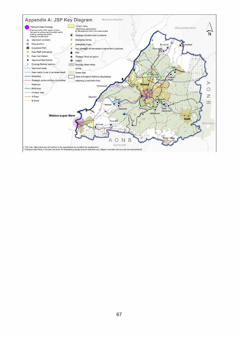
67