North Branch and Kingsbury Branch Class Three and...
90
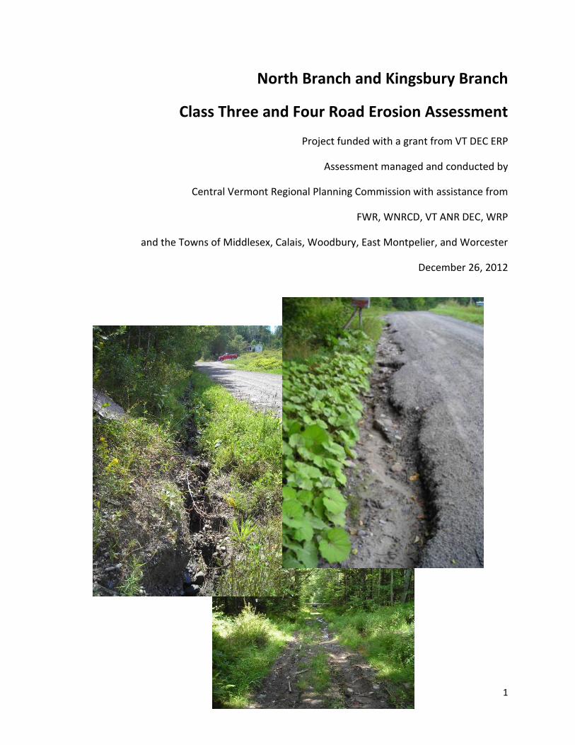
1 North Branch and Kingsbury Branch Class Three and Four Road Erosion Assessment Project funded with a grant from VT DEC ERP Assessment managed and conducted by Central Vermont Regional Planning Commission with assistance from FWR, WNRCD, VT ANR DEC, WRP and the Towns of Middlesex, Calais, Woodbury, East Montpelier, and Worcester December 26, 2012
Transcript of North Branch and Kingsbury Branch Class Three and...
1
North Branch and Kingsbury Branch
Class Three and Four Road Erosion Assessment
Project funded with a grant from VT DEC ERP
Assessment managed and conducted by
Central Vermont Regional Planning Commission with assistance from
FWR, WNRCD, VT ANR DEC, WRP
and the Towns of Middlesex, Calais, Woodbury, East Montpelier, and Worcester
December 26, 2012
2
Table of Contents Introduction .................................................................................................................................................. 3
Methodology ................................................................................................................................................. 3
Geographic Information Systems (GIS) Desktop Analysis ......................................................................... 3
Field Priority Indicators ............................................................................................................................. 4
Data Collection and Reduction ................................................................................................................. 5
Results ....................................................................................................................................................... 5
Summary of Town Erosion Results ............................................................................................................... 6
Calais ......................................................................................................................................................... 6
East Montpelier ....................................................................................................................................... 22
Middlesex ................................................................................................................................................ 35
Woodbury ............................................................................................................................................... 44
Worcester ............................................................................................................................................... 50
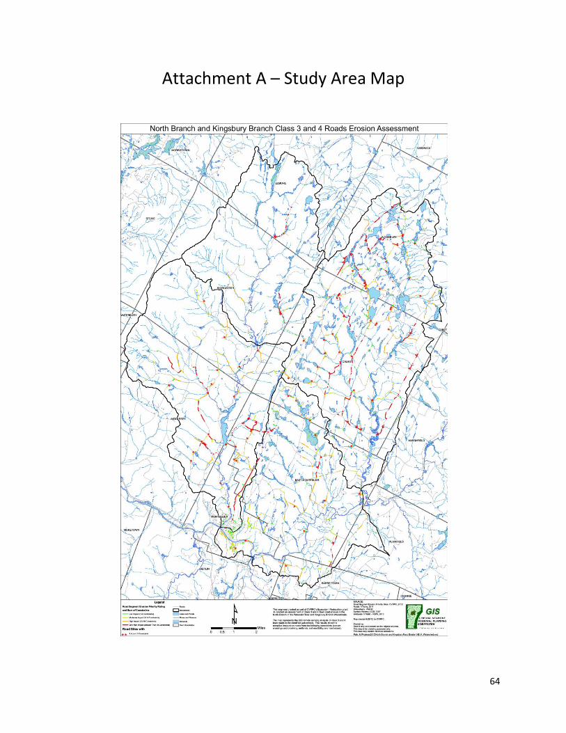
Attachment A – Study Area Map ................................................................................................................ 64
Attachment B – Scoring Matrix ................................................................................................................... 65
Attachment C – Summary of all Data by Town ........................................................................................... 69
Attachment D – Town Erosion Site Maps ................................................................................................... 80
Calais ....................................................................................................................................................... 80
East Montpelier ....................................................................................................................................... 81
Middlesex ................................................................................................................................................ 82
Woodbury ............................................................................................................................................... 83
Worcester ............................................................................................................................................... 84
Attachment E – Town Commitment Documents ........................................................................................ 85
Calais ....................................................................................................................................................... 85
East Montpelier ....................................................................................................................................... 86
Middlesex ................................................................................................................................................ 87
Woodbury ............................................................................................................................................... 88
Worcester ............................................................................................................................................... 89
Attachment F – GIS Shapefiles and Photos ................................................................................................. 90
GIS Shapefiles .......................................................................................................................................... 90
Photos ..................................................................................................................................................... 90
3
Introduction
In 2012 Central Vermont Regional Planning Commission along with the Friends of the Winooski River and Winooski Natural Resource Conservation District conducted an analysis to map, inventory, prioritize, and prepare site maps for Class 3 and 4 road erosion sites within the North Branch and Kingsburg Branch Watersheds which included the following towns (East Montpelier, Calais, Middlesex, Woodbury, and Worcester). The purpose of the project was to 1) better understand the scope of the erosion problems along the Class 3 and 4 roads, 2) to provide an inventory of erosion sites, 3) prioritize the erosion sites for impact to water quality by sedimentation, 4) provide a simple site map and erosion treatment techniques for the highest priority erosion sites, and 5) present the results of the study to the towns and discuss the erosion treatment techniques. The project was funded through a Grant provided by the State of Vermont Ecosystem Restoration Program (ERP).
Methodology
Geographic Information Systems (GIS) Desktop Analysis
A constraints analysis was conducted by the Central Vermont Regional Planning Commission (CVRPC) using ArcView GIS. The purpose of the constraints analysis was to use desktop GIS to identify areas of the road network that were likely susceptible to erosion and sedimentation resulting in water quality impact, in order to focus the scope of the field investigation. The constraints analysis considered a total of five parameters, which included stream crossings, width of buffers to streams, width of buffers to mapped State-regulated Class II wetlands, soil erodibility, and road slope. The road network within the five Towns was divided into 100-foot segments, and for each segment the presence or absence of the five constraints was analyzed. Then, for each road, the number of constraints was totaled. The segments of each road with the relative constraints scoring were displayed on a GIS map. In addition to the line segments a point location was also developed by CVRPC to specify locations where three, four, or five of the constraints existed at the same location. This data was then used on the field maps to help locate general and specific road areas to visit. The GIS maps are included in Attachment A. Field crews visited all point locations with 3 and greater constraints and all line segments with a total constraints score of 37 and greater. Table 1 below provides a summary of the constraint values considered in the GIS analysis.
Constraint Criteria Data Source
Stream Crossings
Road / Stream intersection
Vermont Hydrography Dataset (VHDCARTO, 2010)
Stream Buffer Width 50 feet Vermont Hydrography Dataset (VHDCARTO, 2010)
Class II Wetland
Buffer 50 feet Vermont Significant Wetlands Inventory (VSWI, 2010)
Soil Erodibility Kw > 0.36 Natural Resource Conservation Service (NRCS) Soil

4
Survey (Geologic_SO, 2011)
Slope rise/run > 15% Vermont Hydrography Dataset DEM (ElevationDEM_VTHYDRODEM, 2005)
Table 1. GIS Analysis parameters.
Field Priority Indicators
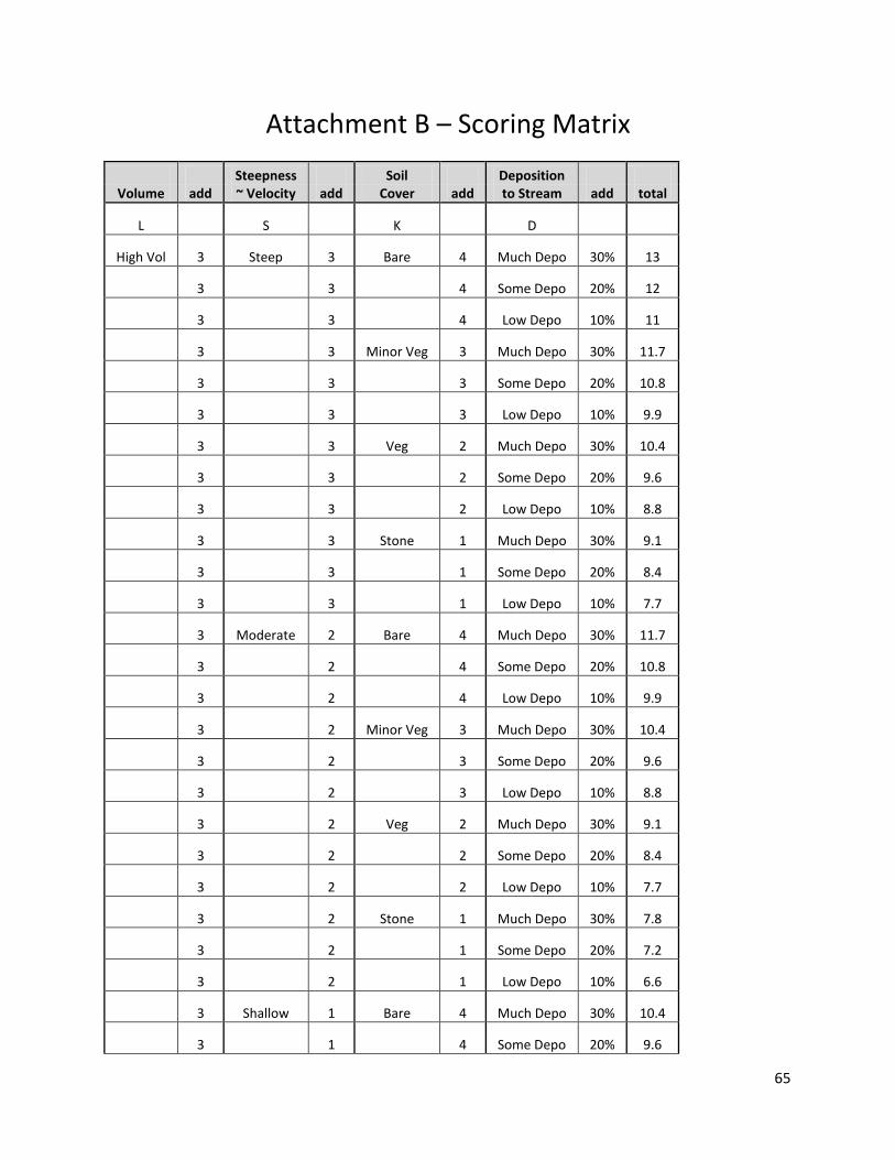
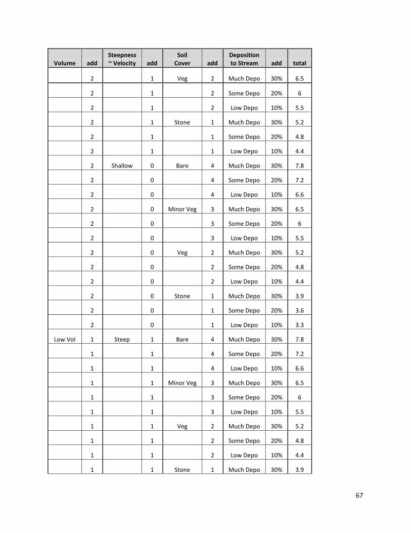
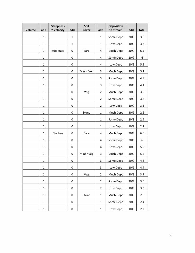
After the completion of the GIS desktop analysis, a series of field priority indicators were developed along with a scoring matrix, which were used by field crews to rank each erosion area impact to water quality during the field mapping effort. These priority indicators included volume of runoff expected through the erosion area, the steepness of the area, the condition of the ground cover, and finally the opportunity for sediment deposition to surface waters. Individual erosion areas were scored in the field as high, medium, and low, for each of these indicators. Following the field data collection, scoring for each of the field indicators was imported into an excel spreadsheet to calculate total scores for each area. Each high, medium, and low score was assigned a value of 3, 2, or 1, respectively. In the case of the opportunity for deposition indicator, percentages of 30%, 20%, or 10% were assigned to a high, medium or low score, given that depositional areas were assumed to have a weighted importance. A summary table of the field priority indicators is provided in Table 2 below. The complete scoring matrix is provided in Attachment B.
Priority Indicators Description Score Notes
Volume
small channel, headwater area Low Volume indicator refers to the condition at and upstream of the erosion area
medium channel, middle of watershed
Medium
large channel, close to receiving water
High
Velocity/Steepness low slope, <5% Low Velocity/Steepness indicator refers to the condition at and downstream of the erosion area
moderate slope, >5% and < 15% Medium
steep slope, > 15% High
Soil Cover stone Low Soil Cover indicator refers to the condition downstream of the erosion area
vegetation Medium
minor vegetation Medium/High
bare High
Deposition to Stream
sheet flow over well vegetated terrain/ channel with turnouts to vegetated terrain
Low Deposition indicator refers to the condition downstream of the erosion area channel flow with defined break
in slope with some deposition before stream
Medium
5
channel flow with no slope breaks, obvious in stream deposition
High
Table 2. Priority indicators for water quality scoring.
Data Collection and Reduction
Field crews walked/drove each priority road segment during the 2012 field season. Field crews carried a Trimble GeoXM GPS unit capable of sub meter accuracy with post processing correction and a digital camera. The roadway surface, shoulders, and ditches where scanned for areas of erosion. Field data was entered directly into the GPS units using a data dictionary which allowed for customized drop down menus to be used to log the data. The digital camera was used to take photos of the erosion and those photos where loaded and linked directly to each site being recorded in the GPS units through a wireless network join. These two data collection techniques significantly increased data collection efficiency. The descriptor data is summarized in Table 3.
Descriptors Type Notes General Erosion Category Rill small channel that could be graded
Incision medium channel that could be graded Gully larger channel that could not be repaired by
grading Slump failure of road edge or surface In stream / in ditch scour carving of stream bank / ditch side slopes
Erosion Location Roadway Roadway Shoulder Ditch Ditched Stream Culvert Headwall Culvert Endwall
Culvert Data (Culvert Sites Only)
Diameter inches Material metal/plastic/concrete Condition poor/fair/good Ownership Town/Private Drop from outlet to stream inches - live stream crossings only Bankfull width at outlet inches - live stream crossing only
Table 3. Erosion area descriptors.
Results
A total of 237 erosion sites were mapped across the five towns. Sites having the highest priority scores in each Town were selected and a site plan with erosion treatment developed. A total of 29 sites were selected for site plan with erosion treatment development. CVRPC utilizes the Better Back Roads manual in the development of all road erosion treatments.
6
The list of erosion sites by town follows this section of the report.
Summary of Town Erosion Results
Calais
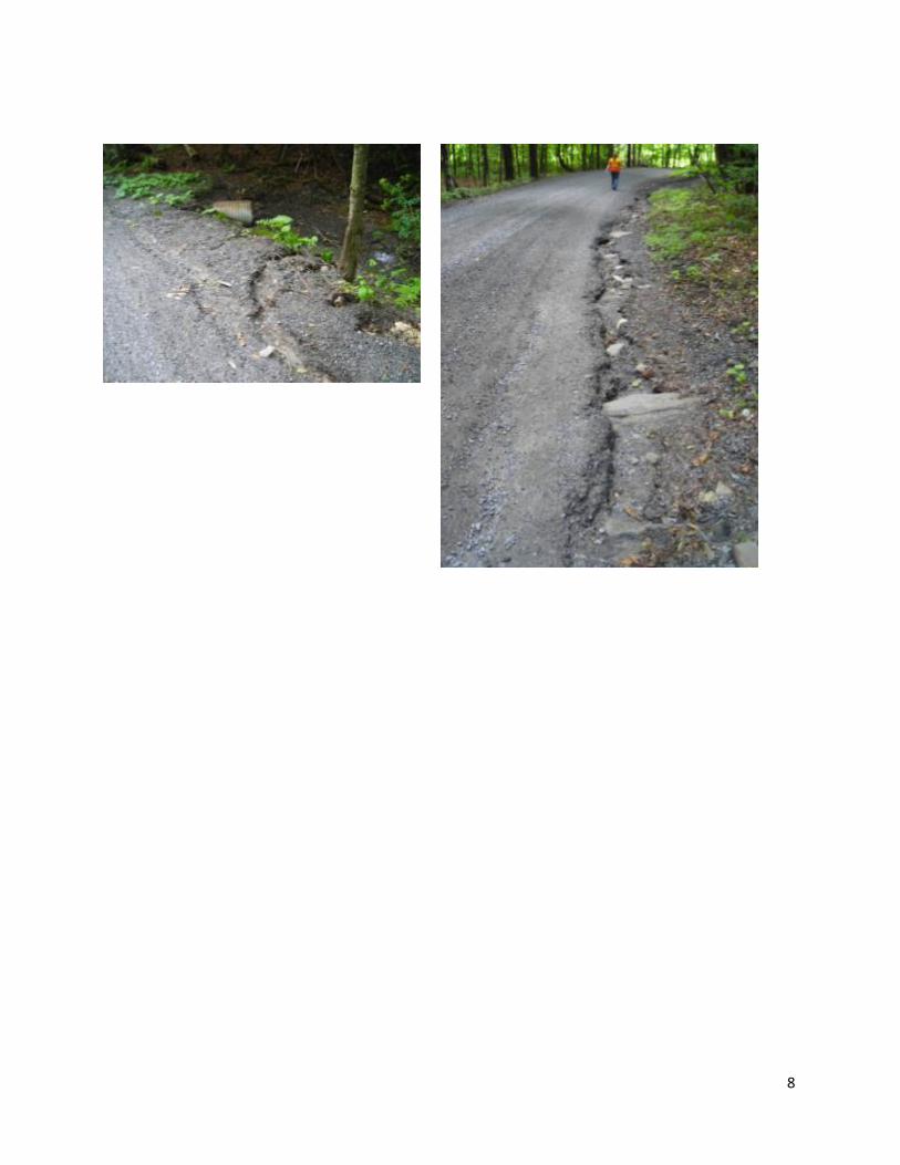
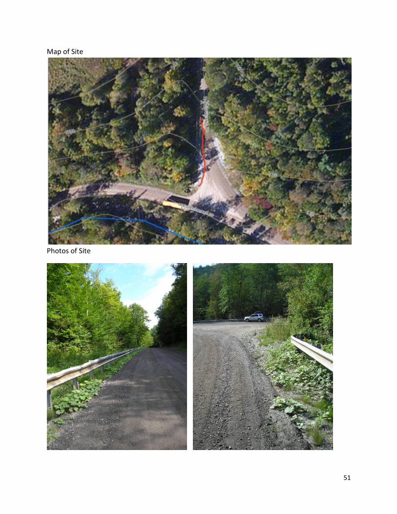
Erosion site 1 –
Location –500 feet of road shoulder erosion along Long Meadow Rd 0.44 miles west of County
Rd in Calais, VT.
Field Collection Data –
Site Slope Calculation – 12%
Suggested Erosion Treatment –
Add 2-3 new cross culverts below existing culvert
Add stone aprons at outlets of new culverts and existing culvert
Install headers and footers on all new culverts and existing culvert
Armor shoulder above existing culvert
Improve ditch and stone line for length of erosion about 500 ft
Replace existing culvert if undersized for location.
Needed Information from Site –
Existing culvert dimensions and condition
Existing culvert alignment to stream
Existing culvert header and footer information
Stream channel bankfull width
Calculate stone needed for ditch and armor – estimate about 100 Yards
Calculate stone needed for stone aprons at culvert outlets - estimate about 6 Yards
Price of new and replacement culverts
Location of Erosion
Water Volume
Steepness of Site
Soil Cover Deposition to
Stream Type of Erosion Total Score
ROADWAY SHOULDER
HIGH STEEP >15 BARE HIGH GULLY/INCISION 13.0

7
Map of Site
Photos of Sites
8

9
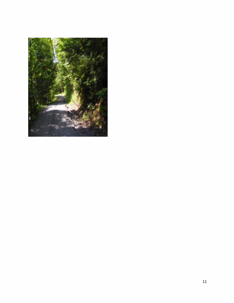
Erosion site 2 – Good site for Better Back Roads Grant
Location – 820 feet of road shoulder erosion along Mirror Lake Rd 0.16 miles west of Number
10 Pond Rd in Calais, VT.
Field Collection Data –
Site Slope Calculation – 12%
Suggested Erosion Treatment –
Add 1-2 new cross culverts above existing culverts
Realign existing cross culverts
Add stone aprons at outlets of new culverts and existing culverts
Install headers and footers on all new culverts and existing culvert
Improve ditch and stone line for length of erosion about 820 ft
Replace existing culvert if undersized for location.
Needed Information from Site –
Existing culvert dimensions and condition
Existing culvert alignment
Existing culvert header and footer information
Calculate stone needed for ditch – estimate about 150 Yards
Calculate stone needed for stone aprons at culvert outlets - estimate about 8 Yards
Price of new and replacement culverts
Location of Erosion
Water Volume
Steepness of Site
Soil Cover
Deposition to Stream
Type of Erosion Total Score
ROADWAY SHOULDER HIGH STEEP >15 BARE HIGH GULLY/INCISION 13.0

10
Map of Site –
Photos of Site
11

12
Erosion site 3
Location – 320 feet of road shoulder erosion along Dugar Brook Rd 220 feet east of West
County Rd in Calais, VT.
Field Collection Data –
Site Slope Calculation – 13%
Suggested Erosion Treatment –
Add 1-2 new cross culverts above existing culvert
Add stone aprons at outlets of new culverts and existing culvert
Install headers and footers on all new culverts and existing culvert
Improve ditch and stone line for length of erosion about 320 ft
Replace existing culvert if undersized for location.
Needed Information from Site –
Existing culvert dimensions and condition
Existing culvert alignment
Existing culvert header and footer information
Calculate stone needed for ditch – estimate about 75 Yards
Calculate stone needed for stone aprons at culvert outlets - estimate about 3 Yards
Price of new and replacement culverts
Location of Erosion
Water Volume
Steepness of Site
Soil Cover
Deposition to Stream
Type of Erosion Total Score
ROADWAY SHOULDER HIGH STEEP >15 BARE HIGH GULLY/INCISION 13.0
13
Map of Site
14
Photos of Site

15
Erosion site 4 - Good site for Better Back Roads Grant
Location – 320 feet of road shoulder erosion along Apple Hill 350 feet south of Dugar Brook Rd
in Calais, VT.
Field Collection Data –
Site Slope Calculation – 13%
Suggested Erosion Treatment –
Improve ditch and stone line for length of erosion about 320 ft
Improve turnout above bridge
Stone line apron at turnout
Install settling pond below turnout.
Needed Information from Site –
Calculate stone needed for ditch, turnout, settling pond – estimate about 80 Yards
Map of Site
Location of Erosion
Water Volume
Steepness of Site
Soil Cover
Deposition to Stream
Type of Erosion Total Score
ROADWAY SHOULDER HIGH STEEP >15 BARE HIGH GULLY/INCISION 13.0
16
Photos of Site

17
Erosion site 5
Location – 700 feet of road shoulder erosion along Jack Hill Rd 0.37 miles north of Pekin Brook
Rd in Calais, VT.
Field Collection Data –
Site Slope Calculation – 7%
Suggested Erosion Treatment –
Add 1-2 new cross culverts below existing culvert
Add stone aprons at outlets of new culverts and existing culvert
Install headers and footers on all new culverts and existing culvert
Improve ditch by moving it closer to road
Improve ditch by stone line for length of erosion about 700 ft
Cut down soil berm along both sides of road
Replace existing culvert if undersized for location.
Needed Information from Site –
Existing culvert dimensions and condition
Existing culvert alignment
Existing culvert header and footer information
Calculate stone needed for ditch – estimate about 120 Yards
Calculate stone needed for stone aprons at culvert outlets - estimate about 5 Yards
Price of new and replacement culverts
Location of Erosion
Water Volume
Steepness of Site
Soil Cover
Deposition to Stream
Type of Erosion Total Score
ROADWAY SHOULDER HIGH STEEP >15 BARE MEDIUM GULLY/INCISION 12.0

18
Map of Site
Photos of Site

19

20
Erosion site 6 –
Location – 760 feet of road shoulder erosion along Singleton Rd 0.3 miles west of Pekin Brook
Rd in Calais, VT
Field Collection Data –
Site Slope Calculation – 10%
Suggested Erosion Treatment –
Add 1-2 new cross culverts above existing culvert
Add stone aprons at outlets of new culverts and existing culvert
Install headers and footers on all new culverts and existing culvert
Improve ditch and stone line for length of erosion about 760 ft
Improve turnouts and stone line
Replace existing culvert if undersized for location.
Needed Information from Site –
Existing culvert dimensions and condition
Existing culvert alignment
Existing culvert header and footer information
Calculate stone needed for ditch – estimate about 90 Yards
Calculate stone needed for turnouts and aprons at culvert outlets - estimate about 8
Yards
Price of new and replacement culverts
Location of Erosion
Water Volume
Steepness of Site
Soil Cover
Deposition to Stream
Type of Erosion Total Score
ROADWAY SHOULDER HIGH STEEP >15 BARE MEDIUM GULLY/INCISION 12.0

21
Map of Site
Photos of Site
22
East Montpelier
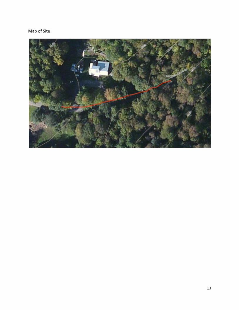
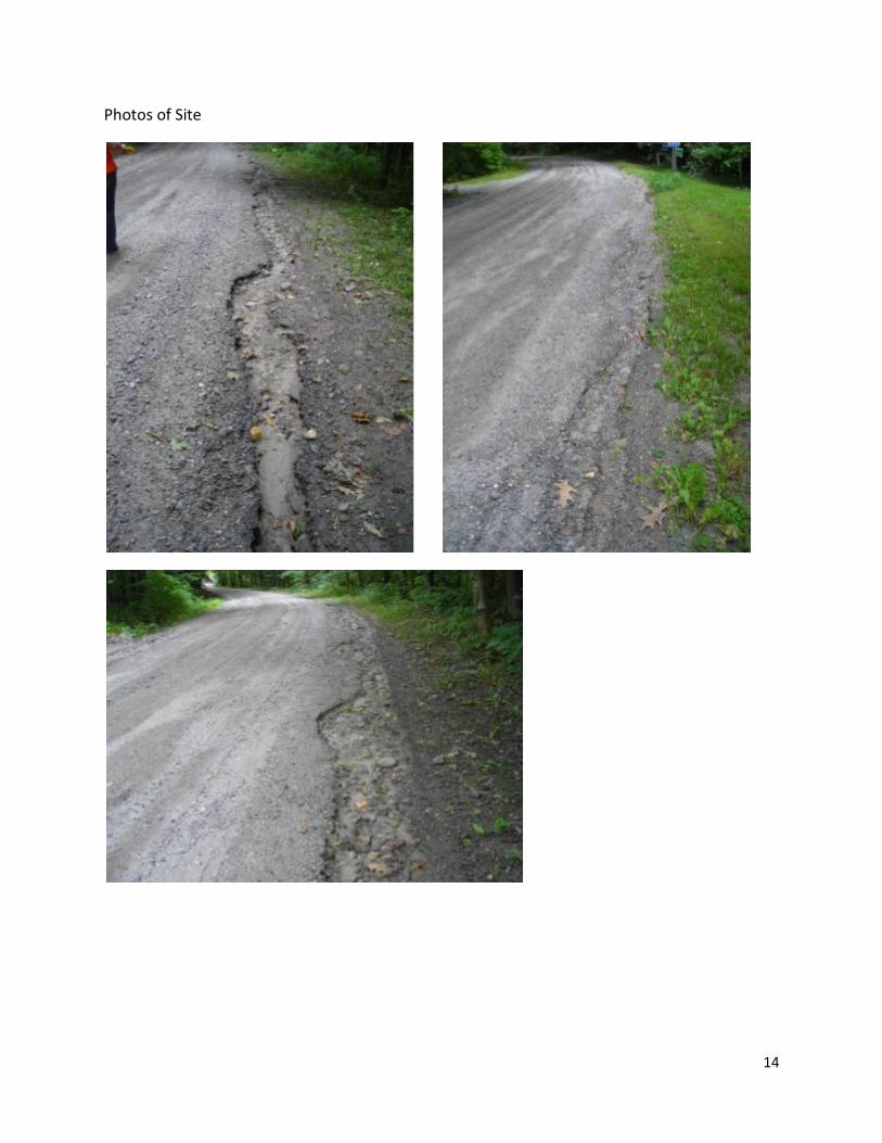
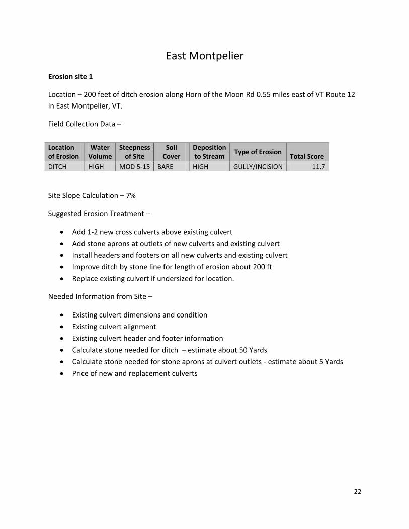
Erosion site 1
Location – 200 feet of ditch erosion along Horn of the Moon Rd 0.55 miles east of VT Route 12
in East Montpelier, VT.
Field Collection Data –
Site Slope Calculation – 7%
Suggested Erosion Treatment –
Add 1-2 new cross culverts above existing culvert
Add stone aprons at outlets of new culverts and existing culvert
Install headers and footers on all new culverts and existing culvert
Improve ditch by stone line for length of erosion about 200 ft
Replace existing culvert if undersized for location.
Needed Information from Site –
Existing culvert dimensions and condition
Existing culvert alignment
Existing culvert header and footer information
Calculate stone needed for ditch – estimate about 50 Yards
Calculate stone needed for stone aprons at culvert outlets - estimate about 5 Yards
Price of new and replacement culverts
Location of Erosion
Water Volume
Steepness of Site
Soil Cover
Deposition to Stream
Type of Erosion Total Score
DITCH HIGH MOD 5-15 BARE HIGH GULLY/INCISION 11.7
23
Map of Site
Photos of Site

24
25
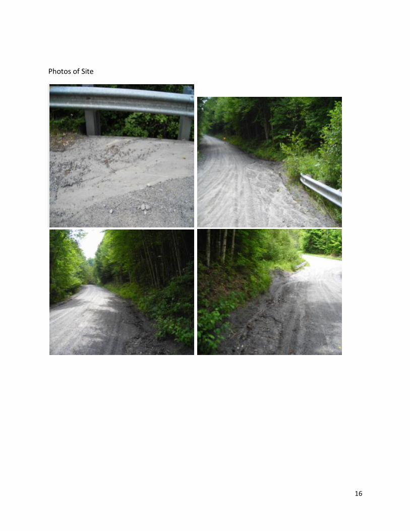
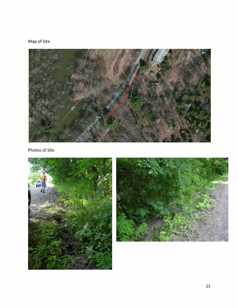
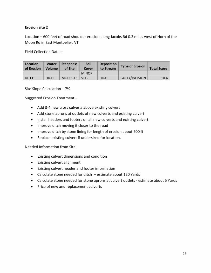
Erosion site 2
Location – 600 feet of road shoulder erosion along Jacobs Rd 0.2 miles west of Horn of the
Moon Rd in East Montpelier, VT
Field Collection Data –
Site Slope Calculation – 7%
Suggested Erosion Treatment –
Add 3-4 new cross culverts above existing culvert
Add stone aprons at outlets of new culverts and existing culvert
Install headers and footers on all new culverts and existing culvert
Improve ditch moving it closer to the road
Improve ditch by stone lining for length of erosion about 600 ft
Replace existing culvert if undersized for location.
Needed Information from Site –
Existing culvert dimensions and condition
Existing culvert alignment
Existing culvert header and footer information
Calculate stone needed for ditch – estimate about 120 Yards
Calculate stone needed for stone aprons at culvert outlets - estimate about 5 Yards
Price of new and replacement culverts
Location of Erosion
Water Volume
Steepness of Site
Soil Cover
Deposition to Stream
Type of Erosion Total Score
DITCH HIGH MOD 5-15 MINOR VEG HIGH GULLY/INCISION 10.4

26
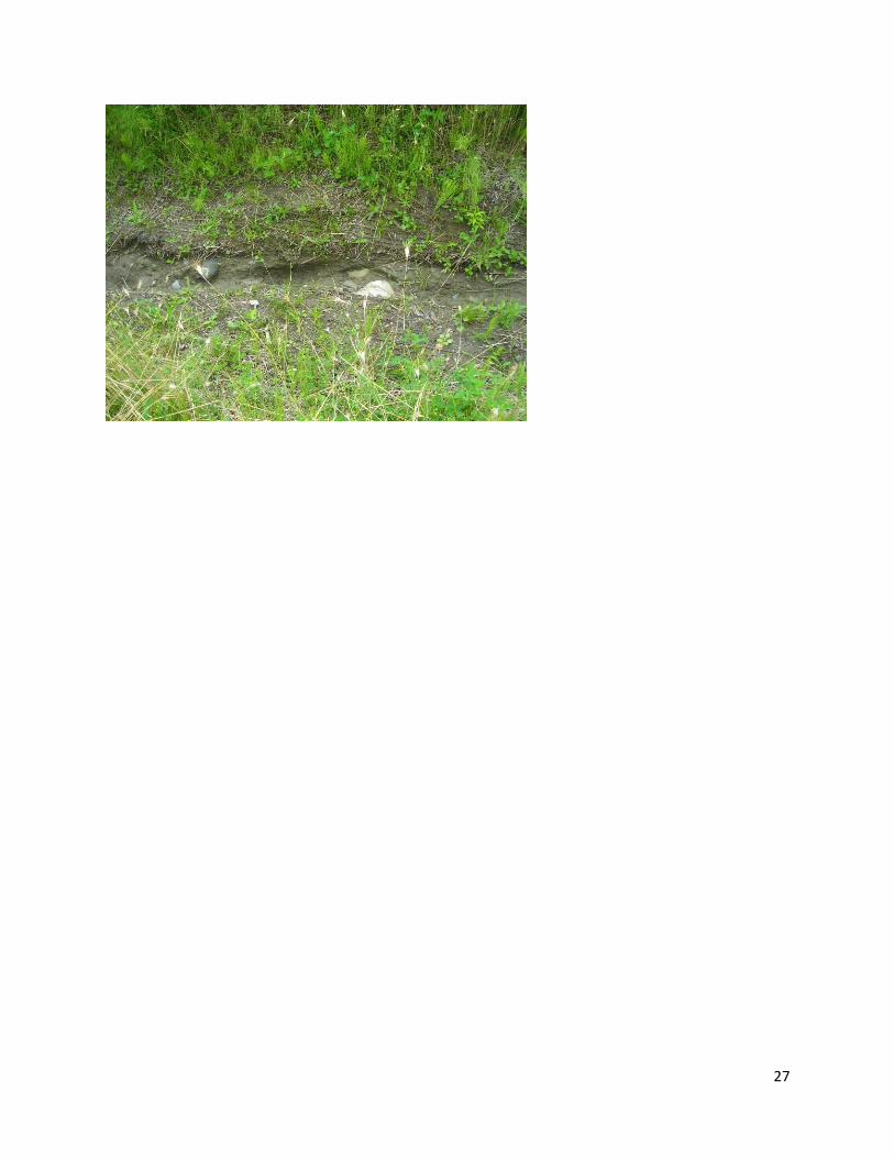
Map of Site
Pictures of Site
27
28
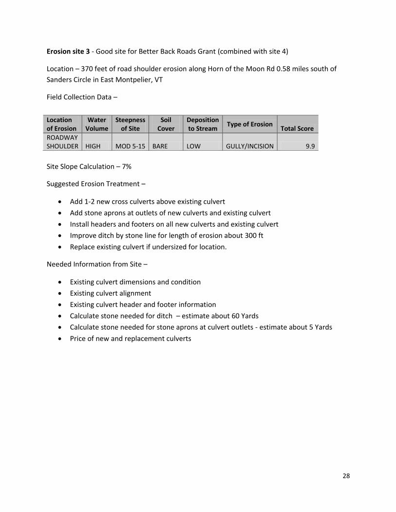
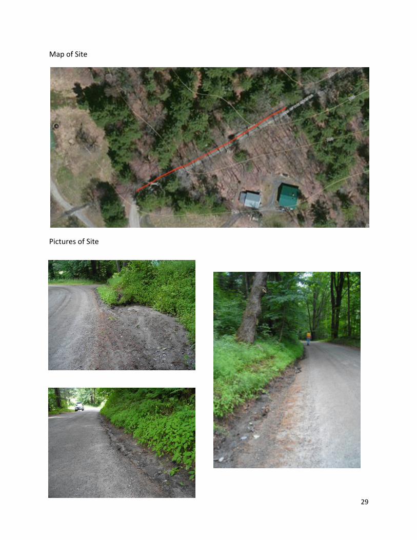
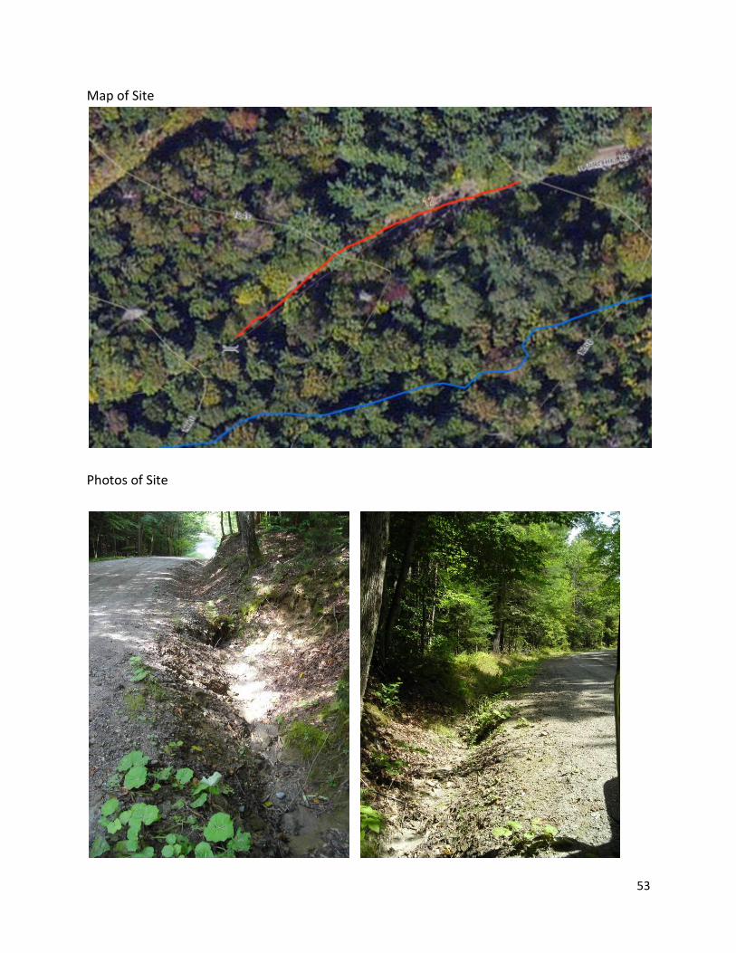
Erosion site 3 - Good site for Better Back Roads Grant (combined with site 4)
Location – 370 feet of road shoulder erosion along Horn of the Moon Rd 0.58 miles south of
Sanders Circle in East Montpelier, VT
Field Collection Data –
Site Slope Calculation – 7%
Suggested Erosion Treatment –
Add 1-2 new cross culverts above existing culvert
Add stone aprons at outlets of new culverts and existing culvert
Install headers and footers on all new culverts and existing culvert
Improve ditch by stone line for length of erosion about 300 ft
Replace existing culvert if undersized for location.
Needed Information from Site –
Existing culvert dimensions and condition
Existing culvert alignment
Existing culvert header and footer information
Calculate stone needed for ditch – estimate about 60 Yards
Calculate stone needed for stone aprons at culvert outlets - estimate about 5 Yards
Price of new and replacement culverts
Location of Erosion
Water Volume
Steepness of Site
Soil Cover
Deposition to Stream
Type of Erosion Total Score
ROADWAY SHOULDER HIGH MOD 5-15 BARE LOW GULLY/INCISION 9.9
29
Map of Site
Pictures of Site
30
31
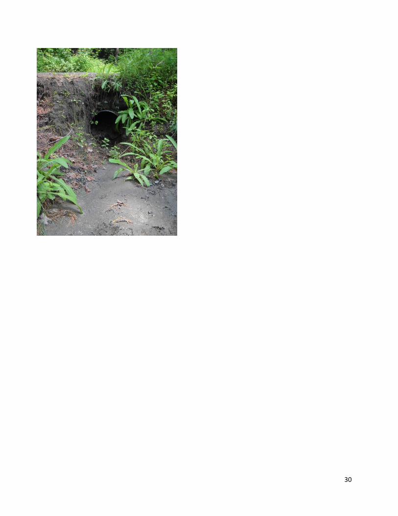
Erosion site 4 - Good site for Better Back Roads Grant (combined with site 3)
Location – 230 feet of road shoulder and ditch erosion along Horn of the Moon Rd 0.5 miles
south of Sanders Circle in East Montpelier, VT
Field Collection Data –
Site Slope Calculation – 8%
Suggested Erosion Treatment –
Add 1-2 new cross culverts above existing culvert
Add stone aprons at outlets of new culverts and existing culvert
Install headers and footers on all new culverts and existing culvert
Improve ditch by stone line for length of erosion about 230 ft
Replace existing culvert if undersized for location.
Needed Information from Site –
Existing culvert dimensions and condition
Existing culvert alignment
Existing culvert header and footer information
Calculate stone needed for ditch – estimate about 50 Yards
Calculate stone needed for stone aprons at culvert outlets - estimate about 3 Yards
Price of new and replacement culverts
Location of Erosion
Water Volume
Steepness of Site
Soil Cover
Deposition to Stream
Type of Erosion Total Score
DITCH HIGH MOD 5-15 BARE LOW GULLY/INCISION 9.9

32
Map of Site
Photos of Site

33
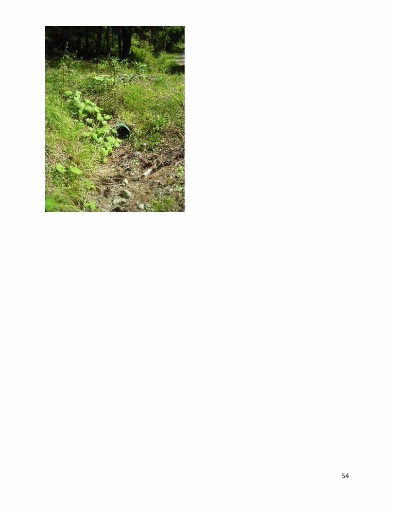
Erosion site 5
Location – 130 feet of ditch erosion along Lyle Young Rd 0.22 miles east of Center Rd (just
below Rock Rd) in East Montpelier, VT.
Field Collection Data –
Site Slope Calculation – 6%
Suggested Erosion Treatment –
Improve driveway culvert above ditch
Improve ditch by stone line for length of erosion about 130 ft
Replace existing culvert if undersized for location.
Needed Information from Site –
Existing culvert dimensions and condition
Existing culvert alignment
Existing culvert header and footer information
Calculate stone needed for ditch – estimate about 40 Yards
Price of replacement culvert
Map of Site
Location of Erosion
Water Volume
Steepness of Site
Soil Cover
Deposition to Stream
Type of Erosion Total Score
DITCH HIGH MOD 5-15 MINOR VEG LOW GULLY/INCISION 8.8

34
Photos of Site
35
Middlesex
Erosion site 1 and 2- Good site for Better Back Roads Grant (combined together)
Location – 320 feet of road shoulder erosion and head cut at end of ditch where it enters
stream on Macey Rd 0.72 miles south of West Hill Rd in Middlesex, VT.
Field Collection Data Site 1 Point –
Comment - Head cut starting at end of ditch.
Field Collection Data Site 2 Line –
Comment - Water stays on road and does not access ditch.
Site Slope Calculation – Unknown
Suggested Erosion Treatment –
Add 1-2 new cross culverts above existing culvert
Add stone aprons at outlets of new culverts and existing culvert
Install headers and footers on all new culverts and existing culvert
Improve ditch by stone line for length of erosion about 320 ft
Stabilize head cut at end of ditch with rock
Replace existing culvert if undersized for location.
Needed Information from Site –
Existing culvert dimensions and condition
Existing culvert alignment
Determine bankfull width for existing culvert
Existing culvert header and footer information
Calculate stone needed for ditch – estimate about 100 Yards
Calculate stone needed for stone aprons at culvert outlets - estimate about 3 Yards
Calculate stone needed for head cut stabilization
Location of Erosion
Water Volume
Steepness of Site
Soil Cover
Deposition to Stream
Type of Erosion Total Score
DITCH HIGH STEEP >15 BARE HIGH GULLY/INCISION 13
Location of Erosion
Water Volume
Steepness of Site
Soil Cover
Deposition to Stream
Type of Erosion Total Score
ROADWAY SHOULDER HIGH STEEP >15
MINOR VEG HIGH GULLY/INCISION 11.7

36
Price of new and replacement culverts
Map of Site
Photos of Site
37
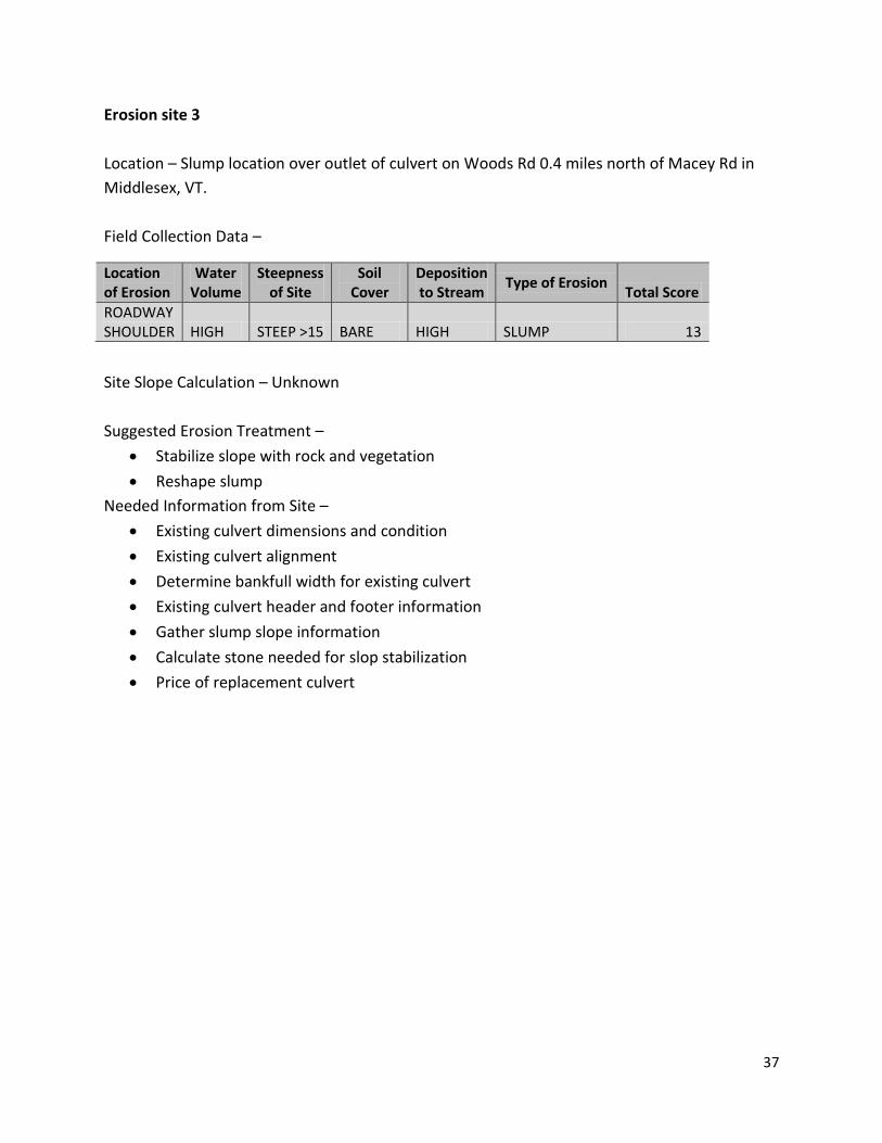
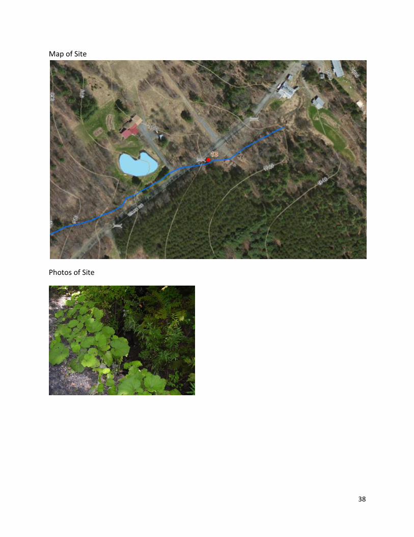
Erosion site 3
Location – Slump location over outlet of culvert on Woods Rd 0.4 miles north of Macey Rd in
Middlesex, VT.
Field Collection Data –
Site Slope Calculation – Unknown
Suggested Erosion Treatment –
Stabilize slope with rock and vegetation
Reshape slump
Needed Information from Site –
Existing culvert dimensions and condition
Existing culvert alignment
Determine bankfull width for existing culvert
Existing culvert header and footer information
Gather slump slope information
Calculate stone needed for slop stabilization
Price of replacement culvert
Location of Erosion
Water Volume
Steepness of Site
Soil Cover
Deposition to Stream
Type of Erosion Total Score
ROADWAY SHOULDER HIGH STEEP >15 BARE HIGH SLUMP 13
38
Map of Site
Photos of Site
39
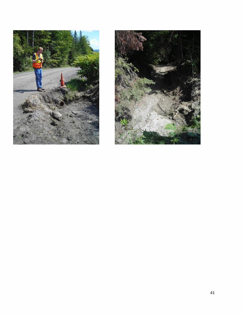
Erosion site 4-
Location – 700 feet of ditch erosion on Bolduc Rd 0.12 miles south of Dolan Rd and Tangletown
Rd intersection in Middlesex, VT.
Field Collection Data –
Site Slope Calculation – 11%
Suggested Erosion Treatment –
Add 3-4 new cross culverts above existing culvert
Add stone aprons at outlets of new culverts and existing culvert
Install headers and footers on all new culverts and existing culvert
Improve ditch by stone line for length of erosion about 700 ft
Replace existing culvert at location.
Needed Information from Site –
Existing culvert dimensions and condition
Existing culvert alignment
Existing culvert header and footer information
Calculate stone needed for ditch – estimate about 150 Yards
Calculate stone needed for stone aprons at culvert outlets - estimate about 8 Yards
Price of new and replacement culverts
Location of Erosion
Water Volume
Steepness of Site
Soil Cover
Deposition to Stream
Type of Erosion Total Score
DITCH HIGH STEEP >15 BARE MEDIUM GULLY/INCISION 12

40
Map of Site
Photos of Site
41

42
Erosion site 5 and 6
Location – 200 feet of roadway shoulder erosion on Bolduc Rd 290 feet north of Dolan Rd in
Middlesex, VT.
Field Collection Data Site 1 Line –
Comment - Water from driveway
Field Collection Data Site 2 Point–
Site Slope Calculation –5%
Suggested Erosion Treatment –
Add turn outs above driveway
Add turnout on driveway before entering road
Improve ditch by bringing it closer to road edge
Replace existing culvert at location.
Needed Information from Site –
Existing culvert dimensions and condition
Existing culvert alignment
Existing culvert header and footer information
Calculate stone needed for ditch – estimate about 50 Yards
Price of replacement culvert
Location of Erosion
Water Volume
Steepness of Site
Soil Cover
Deposition to Stream
Type of Erosion Total Score
ROADWAY SHOULDER HIGH MOD 5-15 BARE HIGH GULLY/INCISION 11.7
Location of Erosion
Water Volume
Steepness of Site
Soil Cover
Deposition to Stream
Type of Erosion Total Score
ROADWAY SHOULDER HIGH MOD 5-15 BARE HIGH GULLY/INCISION 11.7

43
Map of Site
Photos of Sites
44
Woodbury
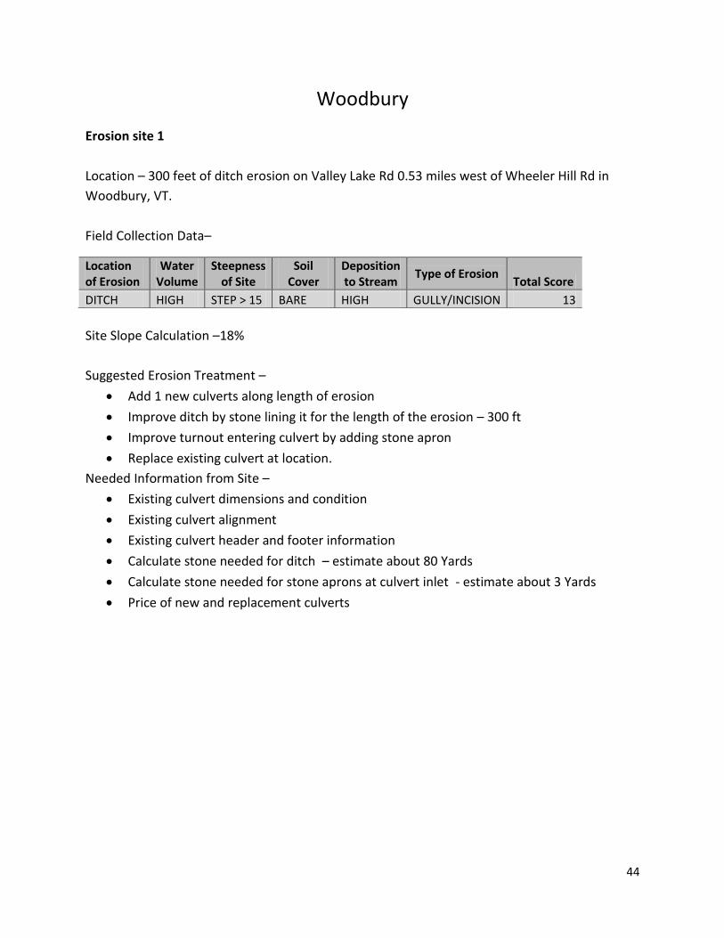
Erosion site 1
Location – 300 feet of ditch erosion on Valley Lake Rd 0.53 miles west of Wheeler Hill Rd in
Woodbury, VT.
Field Collection Data–
Site Slope Calculation –18%
Suggested Erosion Treatment –
Add 1 new culverts along length of erosion
Improve ditch by stone lining it for the length of the erosion – 300 ft
Improve turnout entering culvert by adding stone apron
Replace existing culvert at location.
Needed Information from Site –
Existing culvert dimensions and condition
Existing culvert alignment
Existing culvert header and footer information
Calculate stone needed for ditch – estimate about 80 Yards
Calculate stone needed for stone aprons at culvert inlet - estimate about 3 Yards
Price of new and replacement culverts
Location of Erosion
Water Volume
Steepness of Site
Soil Cover
Deposition to Stream
Type of Erosion Total Score
DITCH HIGH STEP > 15 BARE HIGH GULLY/INCISION 13

45
Map of Site
Photos of Site

46
47
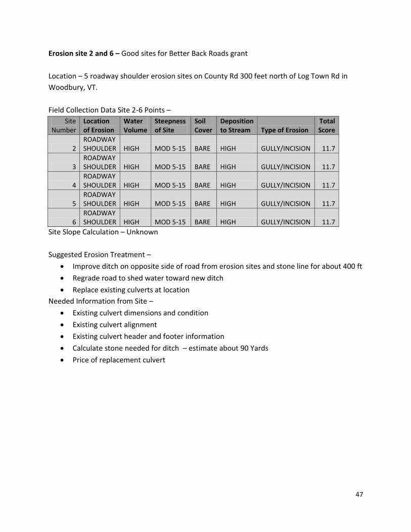
Erosion site 2 and 6 – Good sites for Better Back Roads grant
Location – 5 roadway shoulder erosion sites on County Rd 300 feet north of Log Town Rd in
Woodbury, VT.
Field Collection Data Site 2-6 Points –
Site Number
Location of Erosion
Water Volume
Steepness of Site
Soil Cover
Deposition to Stream Type of Erosion
Total Score
2 ROADWAY SHOULDER HIGH MOD 5-15 BARE HIGH GULLY/INCISION 11.7
3 ROADWAY SHOULDER HIGH MOD 5-15 BARE HIGH GULLY/INCISION 11.7
4 ROADWAY SHOULDER HIGH MOD 5-15 BARE HIGH GULLY/INCISION 11.7
5 ROADWAY SHOULDER HIGH MOD 5-15 BARE HIGH GULLY/INCISION 11.7
6 ROADWAY SHOULDER HIGH MOD 5-15 BARE HIGH GULLY/INCISION 11.7
Site Slope Calculation – Unknown
Suggested Erosion Treatment –
Improve ditch on opposite side of road from erosion sites and stone line for about 400 ft
Regrade road to shed water toward new ditch
Replace existing culverts at location
Needed Information from Site –
Existing culvert dimensions and condition
Existing culvert alignment
Existing culvert header and footer information
Calculate stone needed for ditch – estimate about 90 Yards
Price of replacement culvert

48
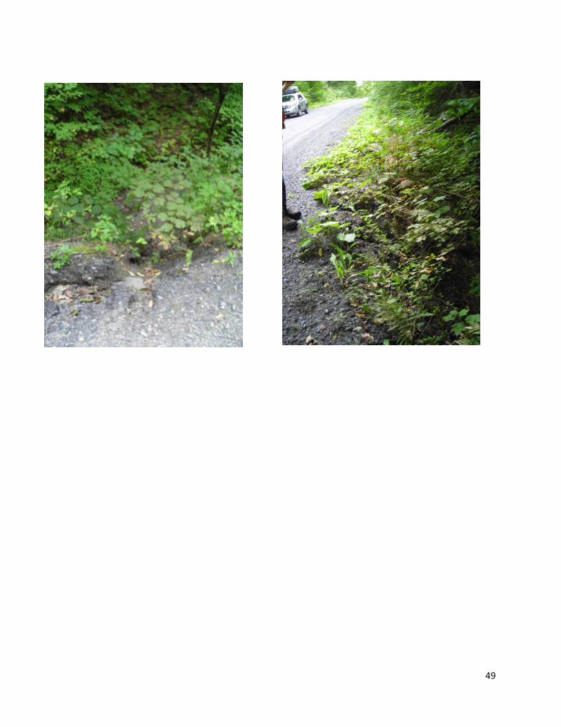
Map of Sites
Photos of Site
49
50
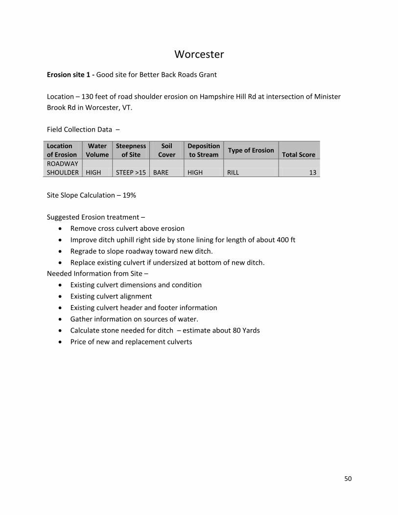
Worcester
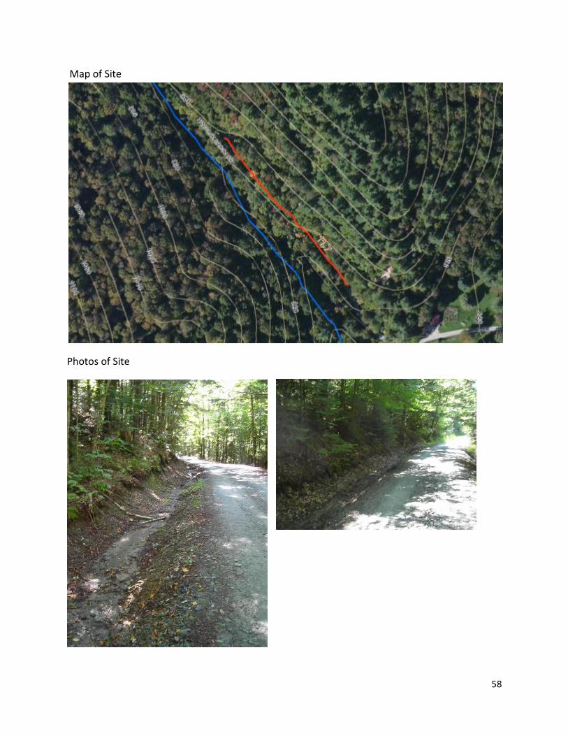
Erosion site 1 - Good site for Better Back Roads Grant
Location – 130 feet of road shoulder erosion on Hampshire Hill Rd at intersection of Minister
Brook Rd in Worcester, VT.
Field Collection Data –
Site Slope Calculation – 19%
Suggested Erosion treatment –
Remove cross culvert above erosion
Improve ditch uphill right side by stone lining for length of about 400 ft
Regrade to slope roadway toward new ditch.
Replace existing culvert if undersized at bottom of new ditch.
Needed Information from Site –
Existing culvert dimensions and condition
Existing culvert alignment
Existing culvert header and footer information
Gather information on sources of water.
Calculate stone needed for ditch – estimate about 80 Yards
Price of new and replacement culverts
Location of Erosion
Water Volume
Steepness of Site
Soil Cover
Deposition to Stream
Type of Erosion Total Score
ROADWAY SHOULDER HIGH STEEP >15 BARE HIGH RILL 13
51
Map of Site
Photos of Site

52
Erosion site 2-
Location – 325 feet of ditch erosion on Harris Hill Rd 0.33 miles north of Eagle Ledge Rd in
Worcester, VT.
Field Collection Data –
Site Slope Calculation – 11%
Suggested Erosion Treatment –
Add 1-2 new cross culverts above existing culvert
Add stone aprons at outlets of new culverts and existing culvert
Install headers and footers on all new culverts and existing culvert
Improve ditch by stone lining for length of erosion about 325 ft
Replace existing culvert if undersized for location.
Needed Information from Site –
Existing culvert dimensions and condition
Existing culvert alignment
Existing culvert header and footer information
Calculate stone needed for ditch – estimate about 80 Yards
Calculate stone needed for stone aprons at culvert outlets - estimate about 3 Yards
Price of new and replacement culverts
Location of Erosion
Water Volume
Steepness of Site
Soil Cover
Deposition to Stream
Type of Erosion Total Score
DITCH HIGH STEEP >15 BARE MEDIUM GULLY/INCISION 12
53
Map of Site
Photos of Site
54

55
Erosion site 3-
Location – 600 feet of ditch erosion on Hancock Brook Rd (Class 4) 0.63 miles west of Elmore Rd
(Route 12) in Worcester, VT.
Field Collection Data –
Site Slope Calculation – 5%
Suggested Erosion Treatment –
Add 2-3 new cross culverts above existing culvert
Add stone aprons at outlets of new culverts and existing culvert
Install headers and footers on all new culverts and existing culvert
Improve ditch by stone lining for length of erosion about 600 ft
Replace existing culvert if undersized for location.
Needed Information from Site –
Existing culvert dimensions and condition
Existing culvert alignment
Existing culvert header and footer information
Calculate stone needed for ditch – estimate about 110 Yards
Calculate stone needed for stone aprons at culvert outlets - estimate about 6 Yards
Price of new and replacement culverts
Location of Erosion
Water Volume
Steepness of Site
Soil Cover
Deposition to Stream
Type of Erosion Total Score
DITCH HIGH MOD 5-15 BARE HIGH GULLY/INCISION 11.7

56
Map of Site
Photos of Site

57
Erosion site 4
Location – 520 feet of ditch erosion on Hancock Brook Rd (Class 4) 0.38 miles west of Elmore Rd
(Route 12) in Worcester, VT.
Field Collection Data –
Site Slope Calculation – 8%
Suggested Erosion Treatment –
Add 2-3 new cross culverts above existing culvert
Add stone aprons at outlets of new culverts and existing culvert
Install headers and footers on all new culverts and existing culvert
Improve ditch by stone lining for length of erosion about 520 ft
Replace existing culvert if undersized for location.
Needed Information from Site –
Existing culvert dimensions and condition
Existing culvert alignment
Existing culvert header and footer information
Calculate stone needed for ditch – estimate about 100 Yards
Calculate stone needed for stone aprons at culvert outlets - estimate about 6 Yards
Price of new and replacement culverts
Location of Erosion
Water Volume
Steepness of Site
Soil Cover
Deposition to Stream
Type of Erosion Total Score
DITCH HIGH MOD 5-15 BARE HIGH GULLY/INCISION 11.7
58
Map of Site
Photos of Site
59
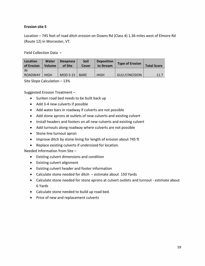
Erosion site 5
Location – 745 feet of road ditch erosion on Downs Rd (Class 4) 1.36 miles west of Elmore Rd
(Route 12) in Worcester, VT.
Field Collection Data –
Site Slope Calculation – 13%
Suggested Erosion Treatment –
Sunken road bed needs to be built back up
Add 3-4 new culverts if possible
Add water bars in roadway if culverts are not possible
Add stone aprons at outlets of new culverts and existing culvert
Install headers and footers on all new culverts and existing culvert
Add turnouts along roadway where culverts are not possible
Stone line turnout apron
Improve ditch by stone lining for length of erosion about 745 ft
Replace existing culverts if undersized for location.
Needed Information from Site –
Existing culvert dimensions and condition
Existing culvert alignment
Existing culvert header and footer information
Calculate stone needed for ditch – estimate about 150 Yards
Calculate stone needed for stone aprons at culvert outlets and turnout - estimate about
6 Yards
Calculate stone needed to build up road bed.
Price of new and replacement culverts
Location of Erosion
Water Volume
Steepness of Site
Soil Cover
Deposition to Stream
Type of Erosion Total Score
IN ROADWAY HIGH MOD 5-15 BARE HIGH GULLY/INCISION 11.7

60
Map of Site
Photos of Site
61
62
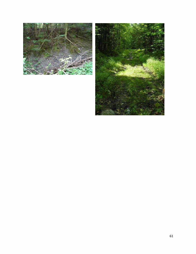
Erosion site 6
Location – Erosion along road edge over outlet of culvert on Harris Hill Rd 0.26 miles north of
Eagle Ledge Rd in Worcester, VT.
Field Collection Data –
Site Slope Calculation – Unknown
Suggested Erosion Treatment –
Armor road shoulder above culvert
Replace existing culvert if undersized for location.
Needed Information from Site –
Existing culvert dimensions and condition
Existing culvert alignment
Determine stream bankful width at culvert
Existing culvert header and footer information
Calculate stone needed for stone apron at culvert outlet - estimate about 2 Yards
Price of replacement culvert
Location of Erosion
Water Volume
Steepness of Site
Soil Cover
Deposition to Stream
Type of Erosion Total Score
ROADWAY SHOULDER HIGH MOD 5-15 BARE HIGH GULLY/INCISION 11.7

63
Map of Site
Photo of Site
64
Attachment A – Study Area Map
65
Attachment B – Scoring Matrix
Steepness Soil Deposition Volume add ~ Velocity add Cover add to Stream add total
L S K D
High Vol 3 Steep 3 Bare 4 Much Depo 30% 13
3 3 4 Some Depo 20% 12
3 3 4 Low Depo 10% 11
3 3 Minor Veg 3 Much Depo 30% 11.7
3 3 3 Some Depo 20% 10.8
3 3 3 Low Depo 10% 9.9
3 3 Veg 2 Much Depo 30% 10.4
3 3 2 Some Depo 20% 9.6
3 3 2 Low Depo 10% 8.8
3 3 Stone 1 Much Depo 30% 9.1
3 3 1 Some Depo 20% 8.4
3 3 1 Low Depo 10% 7.7
3 Moderate 2 Bare 4 Much Depo 30% 11.7
3 2 4 Some Depo 20% 10.8
3 2 4 Low Depo 10% 9.9
3 2 Minor Veg 3 Much Depo 30% 10.4
3 2 3 Some Depo 20% 9.6
3 2 3 Low Depo 10% 8.8
3 2 Veg 2 Much Depo 30% 9.1
3 2 2 Some Depo 20% 8.4
3 2 2 Low Depo 10% 7.7
3 2 Stone 1 Much Depo 30% 7.8
3 2 1 Some Depo 20% 7.2
3 2 1 Low Depo 10% 6.6
3 Shallow 1 Bare 4 Much Depo 30% 10.4
3 1 4 Some Depo 20% 9.6

66
Steepness Soil Deposition Volume add ~ Velocity add Cover add to Stream add total
3 1 4 Low Depo 10% 8.8
3 1 Minor Veg 3 Much Depo 30% 9.1
3 1 3 Some Depo 20% 8.4
3 1 3 Low Depo 10% 7.7
3 1 Veg 2 Much Depo 30% 7.8
3 1 2 Some Depo 20% 7.2
3 1 2 Low Depo 10% 6.6
3 1 Stone 1 Much Depo 30% 6.5
3 1 1 Some Depo 20% 6
3 1 1 Low Depo 10% 5.5
Med Vol 2 Steep 2 Bare 4 Much Depo 30% 10.4
2 2 4 Some Depo 20% 9.6
2 2 4 Low Depo 10% 8.8
2 2 Minor Veg 3 Much Depo 30% 9.1
2 2 3 Some Depo 20% 8.4
2 2 3 Low Depo 10% 7.7
2 2 Veg 2 Much Depo 30% 7.8
2 2 2 Some Depo 20% 7.2
2 2 2 Low Depo 10% 6.6
2 2 Stone 1 Much Depo 30% 6.5
2 2 1 Some Depo 20% 6
2 2 1 Low Depo 10% 5.5
2 Moderate 1 Bare 4 Much Depo 30% 9.1
2 1 4 Some Depo 20% 8.4
2 1 4 Low Depo 10% 7.7
2 1 Minor Veg 3 Much Depo 30% 7.8
2 1 3 Some Depo 20% 7.2
2 1 3 Low Depo 10% 6.6
67
Steepness Soil Deposition Volume add ~ Velocity add Cover add to Stream add total
2 1 Veg 2 Much Depo 30% 6.5
2 1 2 Some Depo 20% 6
2 1 2 Low Depo 10% 5.5
2 1 Stone 1 Much Depo 30% 5.2
2 1 1 Some Depo 20% 4.8
2 1 1 Low Depo 10% 4.4
2 Shallow 0 Bare 4 Much Depo 30% 7.8
2 0 4 Some Depo 20% 7.2
2 0 4 Low Depo 10% 6.6
2 0 Minor Veg 3 Much Depo 30% 6.5
2 0 3 Some Depo 20% 6
2 0 3 Low Depo 10% 5.5
2 0 Veg 2 Much Depo 30% 5.2
2 0 2 Some Depo 20% 4.8
2 0 2 Low Depo 10% 4.4
2 0 Stone 1 Much Depo 30% 3.9
2 0 1 Some Depo 20% 3.6
2 0 1 Low Depo 10% 3.3
Low Vol 1 Steep 1 Bare 4 Much Depo 30% 7.8
1 1 4 Some Depo 20% 7.2
1 1 4 Low Depo 10% 6.6
1 1 Minor Veg 3 Much Depo 30% 6.5
1 1 3 Some Depo 20% 6
1 1 3 Low Depo 10% 5.5
1 1 Veg 2 Much Depo 30% 5.2
1 1 2 Some Depo 20% 4.8
1 1 2 Low Depo 10% 4.4
1 1 Stone 1 Much Depo 30% 3.9
68
Steepness Soil Deposition Volume add ~ Velocity add Cover add to Stream add total
1 1 1 Some Depo 20% 3.6
1 1 1 Low Depo 10% 3.3
1 Moderate 0 Bare 4 Much Depo 30% 6.5
1 0 4 Some Depo 20% 6
1 0 4 Low Depo 10% 5.5
1 0 Minor Veg 3 Much Depo 30% 5.2
1 0 3 Some Depo 20% 4.8
1 0 3 Low Depo 10% 4.4
1 0 Veg 2 Much Depo 30% 3.9
1 0 2 Some Depo 20% 3.6
1 0 2 Low Depo 10% 3.3
1 0 Stone 1 Much Depo 30% 2.6
1 0 1 Some Depo 20% 2.4
1 0 1 Low Depo 10% 2.2
1 Shallow 0 Bare 4 Much Depo 30% 6.5
1 0 4 Some Depo 20% 6
1 0 4 Low Depo 10% 5.5
1 0 Minor Veg 3 Much Depo 30% 5.2
1 0 3 Some Depo 20% 4.8
1 0 3 Low Depo 10% 4.4
1 0 Veg 2 Much Depo 30% 3.9
1 0 2 Some Depo 20% 3.6
1 0 2 Low Depo 10% 3.3
1 0 Stone 1 Much Depo 30% 2.6
1 0 1 Some Depo 20% 2.4
1 0 1 Low Depo 10% 2.2

69
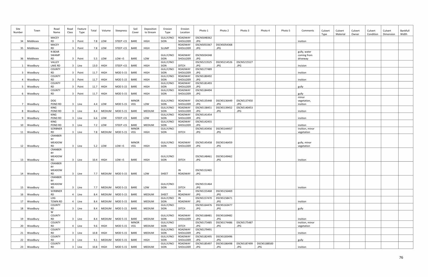
Attachment C – Summary of all Data by Town
Page Left Blank
70
Site Number
Town Road Name
Road Class
Feature Type
Total Volume Steepness Soil
Cover Deposition to Stream
Erosion Type
Erosion Location
Photo 1 Photo 2 Photo 3 Photo 4 Photo 5 Comments Culvert Type
Culvert Material
Culvert Owner
Culvert Condition
Culvert Dimension
Bankfull Width
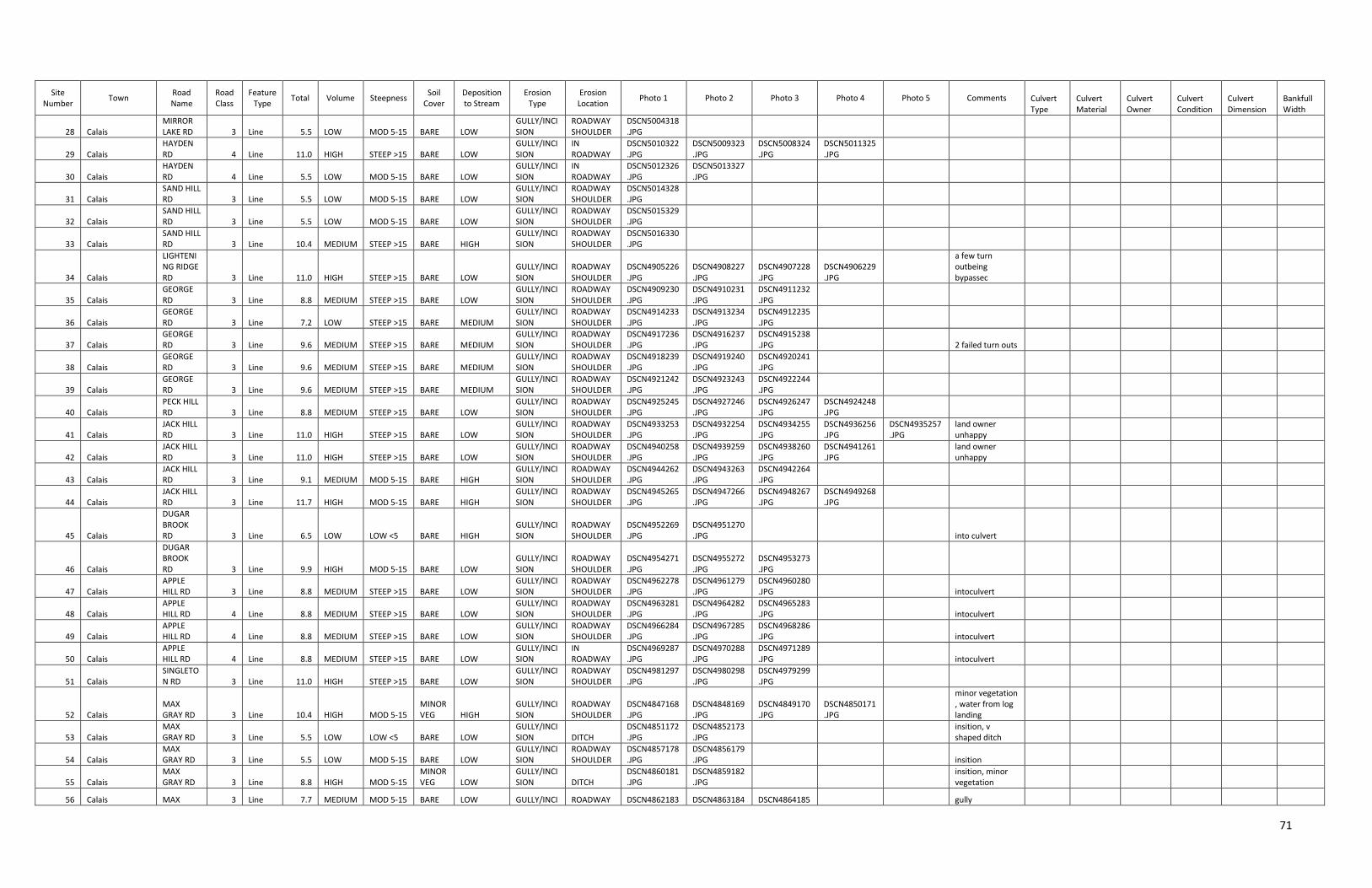
1 Calais
LONG MEADOW HILL RD 3 Line 13.0 HIGH STEEP >15 BARE HIGH
GULLY/INCISION
ROADWAY SHOULDER
DSCN4996310.JPG
DSCN4997311.JPG
DSCN4998312.JPG
DSCN4999313.JPG
2 Calais MIROR LAKE RD 3 Line 13.0 HIGH STEEP >15 BARE HIGH
GULLY/INCISION
ROADWAY SHOULDER
DSCN5006319.JPG
DSCN5005320.JPG
DSCN5007321.JPG
3 Calais
DUGAR BROOK RD 3 Line 13.0 HIGH STEEP >15 BARE HIGH
GULLY/INCISION
ROADWAY SHOULDER
DSCN4958274.JPG
DSCN4957275.JPG
DSCN4956276.JPG
intoculvert
4 Calais APPLE HILL RD 3 Line 13.0 HIGH STEEP >15 BARE HIGH
GULLY/INCISION
ROADWAY SHOULDER
DSCN4972290.JPG
DSCN4973291.JPG
DSCN4974292.JPG
DSCN4975293.JPG
intoculvert
5 Calais JACK HILL RD 3 Line 12.0 HIGH STEEP >15 BARE MEDIUM
GULLY/INCISION
ROADWAY SHOULDER
DSCN4931249.JPG
DSCN4930250.JPG
DSCN4929251.JPG
DSCN4928252.JPG
ditch there but not flowing in
6 Calais SINGLETON RD 3 Line 12.0 HIGH STEEP >15 BARE MEDIUM
GULLY/INCISION
ROADWAY SHOULDER
DSCN4978294.JPG
DSCN4976295.JPG
DSCN4977296.JPG
intoculvert
7 Calais MAX GRAY RD 3 Line 6.0 LOW LOW <5 BARE MEDIUM RILL DITCH
DSCN4780106.JPG
DSCN4779107.JPG
plugged culvert
8 Calais MAX GRAY RD 3 Line 4.8 LOW LOW <5
MINOR VEG MEDIUM RILL DITCH
DSCN4783108.JPG
DSCN4782109.JPG
DSCN4781110.JPG
minor vegetation
9 Calais MAX GRAY RD 3 Line 7.8 MEDIUM MOD 5-15
MINOR VEG HIGH
GULLY/INCISION DITCH
DSCN4789111.JPG
DSCN4790112.JPG
DSCN4788113.JPG
DSCN4784114.JPG
DSCN4785115.JPG
minor vegetation poor cul/stream alignment
10 Calais BLACHLY RD 3 Line 5.5 LOW LOW <5 BARE LOW RILL DITCH
DSCN4796118.JPG
DSCN4794119.JPG
DSCN4797120.JPG
11 Calais BLACHLY RD 3 Line 7.8 MEDIUM LOW <5 BARE HIGH RILL
ROADWAY SHOULDER
DSCN4800121.JPG
DSCN4798122.JPG
DSCN4799123.JPG
12 Calais BLACHLY RD 3 Line 9.1 MEDIUM MOD 5-15 BARE HIGH
GULLY/INCISION DITCH
DSCN4801124.JPG
DSCN4803125.JPG
DSCN4802126.JPG
13 Calais E HILL RD 3 Line 8.4 MEDIUM MOD 5-15 BARE MEDIUM GULLY/INCISION DITCH
DSCN4807129.JPG
DSCN4806130.JPG
DSCN4808131.JPG
14 Calais BLACHLY RD 3 Line 10.8 HIGH MOD 5-15 BARE MEDIUM
GULLY/INCISION
DITCHED STREAM
DSCN4809132.JPG
DSCN4810133.JPG
DSCN4813134.JPG
DSCN4811135.JPG
DSCN4812136.JPG
15 Calais E HILL RD 3 Line 8.8 HIGH LOW <5 BARE LOW GULLY/INCISION DITCH
DSCN4814137.JPG
DSCN4815138.JPG
DSCN4816139.JPG
DSCN4817140.JPG
DSCN4818141.JPG
16 Calais E HILL RD 3 Line 5.5 LOW LOW <5 BARE LOW GULLY/INCISION
ROADWAY SHOULDER
DSCN4821142.JPG
DSCN4819143.JPG
DSCN4820144.JPG
incision
17 Calais E HILL RD 3 Line 7.7 MEDIUM MOD 5-15 BARE LOW RILL ROADWAY SHOULDER
DSCN4822145.JPG
DSCN4824146.JPG
DSCN4823147.JPG
run off from roof down driveway
18 Calais E HILL RD 3 Line 7.7 MEDIUM MOD 5-15 BARE LOW RILL ROADWAY SHOULDER
DSCN4825148.JPG
DSCN4826149.JPG
19 Calais E HILL RD 3 Line 9.9 HIGH MOD 5-15 BARE LOW RILL ROADWAY SHOULDER
DSCN4832152.JPG
DSCN4830153.JPG
DSCN4831154.JPG
DSCN4829155.JPG
20 Calais E HILL RD 3 Line 8.4 MEDIUM MOD 5-15 BARE MEDIUM RILL ROADWAY SHOULDER
DSCN4835156.JPG
DSCN4834157.JPG
DSCN4833158.JPG
21 Calais E HILL RD 3 Line 6.6 MEDIUM LOW <5 BARE LOW RILL ROADWAY SHOULDER
DSCN4836159.JPG
DSCN4837160.JPG
DSCN4838161.JPG
plugged culvert
22 Calais E HILL RD 3 Line 7.7 HIGH MOD 5-15 VEGETATION LOW
GULLY/INCISION DITCH
DSCN4841162.JPG
DSCN4840163.JPG
DSCN4842164.JPG
plugged culvert
23 Calais E HILL RD 3 Line 3.3 LOW LOW <5 VEGETATION LOW
GULLY/INCISION DITCH
DSCN4843165.JPG
DSCN4844166.JPG
DSCN4845167.JPG
incision
24 Calais
LONG MEADOW HILL RD 3 Line 8.8 MEDIUM STEEP >15 BARE LOW
GULLY/INCISION
ROADWAY SHOULDER
DSCN4986300.JPG
DSCN4987301.JPG
DSCN4988302.JPG
25 Calais
LONG MEADOW HILL RD 3 Line 9.1 MEDIUM MOD 5-15 BARE HIGH
GULLY/INCISION
ROADWAY SHOULDER
DSCN4990303.JPG
DSCN4989304.JPG
26 Calais
LONG MEADOW HILL RD 3 Line 6.0 LOW MOD 5-15 BARE MEDIUM
GULLY/INCISION
ROADWAY SHOULDER
DSCN4992305.JPG
DSCN4991306.JPG
left side of rd going down to county rd
27 Calais
LONG MEADOW HILL RD 3 Line 7.8 LOW STEEP >15 BARE HIGH
GULLY/INCISION
ROADWAY SHOULDER
DSCN4993307.JPG
DSCN4994308.JPG
DSCN4995309.JPG
71
Site Number
Town Road Name
Road Class
Feature Type
Total Volume Steepness Soil
Cover Deposition to Stream
Erosion Type
Erosion Location
Photo 1 Photo 2 Photo 3 Photo 4 Photo 5 Comments Culvert Type
Culvert Material
Culvert Owner
Culvert Condition
Culvert Dimension
Bankfull Width
28 Calais MIRROR LAKE RD 3 Line 5.5 LOW MOD 5-15 BARE LOW
GULLY/INCISION
ROADWAY SHOULDER
DSCN5004318.JPG
29 Calais HAYDEN RD 4 Line 11.0 HIGH STEEP >15 BARE LOW
GULLY/INCISION
IN ROADWAY
DSCN5010322.JPG
DSCN5009323.JPG
DSCN5008324.JPG
DSCN5011325.JPG
30 Calais HAYDEN RD 4 Line 5.5 LOW MOD 5-15 BARE LOW
GULLY/INCISION
IN ROADWAY
DSCN5012326.JPG
DSCN5013327.JPG
31 Calais SAND HILL RD 3 Line 5.5 LOW MOD 5-15 BARE LOW
GULLY/INCISION
ROADWAY SHOULDER
DSCN5014328.JPG
32 Calais SAND HILL RD 3 Line 5.5 LOW MOD 5-15 BARE LOW
GULLY/INCISION
ROADWAY SHOULDER
DSCN5015329.JPG
33 Calais SAND HILL RD 3 Line 10.4 MEDIUM STEEP >15 BARE HIGH
GULLY/INCISION
ROADWAY SHOULDER
DSCN5016330.JPG
34 Calais
LIGHTENING RIDGE RD 3 Line 11.0 HIGH STEEP >15 BARE LOW
GULLY/INCISION
ROADWAY SHOULDER
DSCN4905226.JPG
DSCN4908227.JPG
DSCN4907228.JPG
DSCN4906229.JPG
a few turn outbeing bypassec
35 Calais GEORGE RD 3 Line 8.8 MEDIUM STEEP >15 BARE LOW
GULLY/INCISION
ROADWAY SHOULDER
DSCN4909230.JPG
DSCN4910231.JPG
DSCN4911232.JPG
36 Calais GEORGE RD 3 Line 7.2 LOW STEEP >15 BARE MEDIUM
GULLY/INCISION
ROADWAY SHOULDER
DSCN4914233.JPG
DSCN4913234.JPG
DSCN4912235.JPG
37 Calais GEORGE RD 3 Line 9.6 MEDIUM STEEP >15 BARE MEDIUM
GULLY/INCISION
ROADWAY SHOULDER
DSCN4917236.JPG
DSCN4916237.JPG
DSCN4915238.JPG
2 failed turn outs
38 Calais GEORGE RD 3 Line 9.6 MEDIUM STEEP >15 BARE MEDIUM
GULLY/INCISION
ROADWAY SHOULDER
DSCN4918239.JPG
DSCN4919240.JPG
DSCN4920241.JPG
39 Calais GEORGE RD 3 Line 9.6 MEDIUM STEEP >15 BARE MEDIUM
GULLY/INCISION
ROADWAY SHOULDER
DSCN4921242.JPG
DSCN4923243.JPG
DSCN4922244.JPG
40 Calais PECK HILL RD 3 Line 8.8 MEDIUM STEEP >15 BARE LOW
GULLY/INCISION
ROADWAY SHOULDER
DSCN4925245.JPG
DSCN4927246.JPG
DSCN4926247.JPG
DSCN4924248.JPG
41 Calais JACK HILL RD 3 Line 11.0 HIGH STEEP >15 BARE LOW
GULLY/INCISION
ROADWAY SHOULDER
DSCN4933253.JPG
DSCN4932254.JPG
DSCN4934255.JPG
DSCN4936256.JPG
DSCN4935257.JPG
land owner unhappy
42 Calais JACK HILL RD 3 Line 11.0 HIGH STEEP >15 BARE LOW
GULLY/INCISION
ROADWAY SHOULDER
DSCN4940258.JPG
DSCN4939259.JPG
DSCN4938260.JPG
DSCN4941261.JPG
land owner unhappy
43 Calais JACK HILL RD 3 Line 9.1 MEDIUM MOD 5-15 BARE HIGH
GULLY/INCISION
ROADWAY SHOULDER
DSCN4944262.JPG
DSCN4943263.JPG
DSCN4942264.JPG
44 Calais JACK HILL RD 3 Line 11.7 HIGH MOD 5-15 BARE HIGH
GULLY/INCISION
ROADWAY SHOULDER
DSCN4945265.JPG
DSCN4947266.JPG
DSCN4948267.JPG
DSCN4949268.JPG
45 Calais
DUGAR BROOK RD 3 Line 6.5 LOW LOW <5 BARE HIGH
GULLY/INCISION
ROADWAY SHOULDER
DSCN4952269.JPG
DSCN4951270.JPG
into culvert
46 Calais
DUGAR BROOK RD 3 Line 9.9 HIGH MOD 5-15 BARE LOW
GULLY/INCISION
ROADWAY SHOULDER
DSCN4954271.JPG
DSCN4955272.JPG
DSCN4953273.JPG
47 Calais APPLE HILL RD 3 Line 8.8 MEDIUM STEEP >15 BARE LOW
GULLY/INCISION
ROADWAY SHOULDER
DSCN4962278.JPG
DSCN4961279.JPG
DSCN4960280.JPG
intoculvert
48 Calais APPLE HILL RD 4 Line 8.8 MEDIUM STEEP >15 BARE LOW
GULLY/INCISION
ROADWAY SHOULDER
DSCN4963281.JPG
DSCN4964282.JPG
DSCN4965283.JPG
intoculvert
49 Calais APPLE HILL RD 4 Line 8.8 MEDIUM STEEP >15 BARE LOW
GULLY/INCISION
ROADWAY SHOULDER
DSCN4966284.JPG
DSCN4967285.JPG
DSCN4968286.JPG
intoculvert
50 Calais APPLE HILL RD 4 Line 8.8 MEDIUM STEEP >15 BARE LOW
GULLY/INCISION
IN ROADWAY
DSCN4969287.JPG
DSCN4970288.JPG
DSCN4971289.JPG
intoculvert
51 Calais SINGLETON RD 3 Line 11.0 HIGH STEEP >15 BARE LOW
GULLY/INCISION
ROADWAY SHOULDER
DSCN4981297.JPG
DSCN4980298.JPG
DSCN4979299.JPG
52 Calais MAX GRAY RD 3 Line 10.4 HIGH MOD 5-15
MINOR VEG HIGH
GULLY/INCISION
ROADWAY SHOULDER
DSCN4847168.JPG
DSCN4848169.JPG
DSCN4849170.JPG
DSCN4850171.JPG
minor vegetation , water from log landing
53 Calais MAX GRAY RD 3 Line 5.5 LOW LOW <5 BARE LOW
GULLY/INCISION DITCH
DSCN4851172.JPG
DSCN4852173.JPG
insition, v shaped ditch
54 Calais MAX GRAY RD 3 Line 5.5 LOW MOD 5-15 BARE LOW
GULLY/INCISION
ROADWAY SHOULDER
DSCN4857178.JPG
DSCN4856179.JPG
insition
55 Calais MAX GRAY RD 3 Line 8.8 HIGH MOD 5-15
MINOR VEG LOW
GULLY/INCISION DITCH
DSCN4860181.JPG
DSCN4859182.JPG
insition, minor vegetation
56 Calais MAX 3 Line 7.7 MEDIUM MOD 5-15 BARE LOW GULLY/INCI ROADWAY DSCN4862183 DSCN4863184 DSCN4864185
gully
72
Site Number
Town Road Name
Road Class
Feature Type
Total Volume Steepness Soil
Cover Deposition to Stream
Erosion Type
Erosion Location
Photo 1 Photo 2 Photo 3 Photo 4 Photo 5 Comments Culvert Type
Culvert Material
Culvert Owner
Culvert Condition
Culvert Dimension
Bankfull Width
GRAY RD SION SHOULDER .JPG .JPG .JPG
57 Calais MAX GRAY RD 3 Line 7.8 MEDIUM LOW <5 BARE HIGH
GULLY/INCISION DITCH
DSCN4865187.JPG
DSCN4867188.JPG
DSCN4868189.JPG
insition, pirched culvert with down stream erosion
58 Calais MAX GRAY RD 3 Line 10.4 HIGH LOW <5 BARE HIGH
GULLY/INCISION DITCH
DSCN4869190.JPG
DSCN4870191.JPG
DSCN4871192.JPG
DSCN4872193.JPG
DSCN4873194.JPG
insition, water from logging rd
59 Calais MAX GRAY RD 3 Line 4.4 LOW MOD 5-15
MINOR VEG LOW RILL DITCH
DSCN4877198.JPG
DSCN4878199.JPG
minor vegetation
60 Calais MAX GRAY RD 3 Line 5.5 LOW MOD 5-15 BARE LOW
GULLY/INCISION DITCH
DSCN4881202.JPG
DSCN4882203.JPG
insition
61 Calais MAX GRAY RD 3 Line 5.5 LOW MOD 5-15 BARE LOW
GULLY/INCISION DITCH
DSCN4883204.JPG
DSCN4884205.JPG
insition
62 Calais MAX GRAY RD 3 Line 6.6 MEDIUM LOW <5 BARE LOW RILL
ROADWAY SHOULDER
DSCN4885206.JPG
DSCN4886207.JPG
minor insition above culvert
63 Calais E HILL RD 3 Line 6.0 LOW MOD 5-15 BARE MEDIUM GULLY/INCISION
ROADWAY SHOULDER
DSCN4887208.JPG
DSCN4888209.JPG
DSCN4889210.JPG
insition
64 Calais E HILL RD 3 Line 5.5 LOW LOW <5 BARE LOW GULLY/INCISION
ROADWAY SHOULDER
DSCN4890211.JPG
insition
65 Calais
LIGHTENING RIDGE RD 3 Line 8.8 HIGH LOW <5 BARE LOW
GULLY/INCISION
ROADWAY SHOULDER
DSCN4891212.JPG
DSCN4892213.JPG
insition
66 Calais
LIGHTENING RIDGE RD 3 Line 7.7 MEDIUM MOD 5-15 BARE LOW
GULLY/INCISION
ROADWAY SHOULDER
DSCN4893214.JPG
DSCN4894215.JPG
DSCN4895216.JPG
insition, erosion into ditch
67 Calais
LIGHTENING RIDGE RD 3 Line 8.8 HIGH LOW <5 BARE LOW
GULLY/INCISION
ROADWAY SHOULDER
DSCN4896217.JPG
DSCN4897218.JPG
DSCN4898219.JPG
erosion from roads into turn out
68 Calais
LIGHTENING RIDGE RD 3 Line 9.9 HIGH MOD 5-15 BARE LOW
GULLY/INCISION
ROADWAY SHOULDER
DSCN4899220.JPG
DSCN4900221.JPG
DSCN4901222.JPG
insition ,water from drive way
69 Calais
LIGHTENING RIDGE RD 3 Line 8.8 HIGH MOD 5-15
MINOR VEG LOW
GULLY/INCISION DITCH
DSCN4902223.JPG
DSCN4903224.JPG
DSCN4904225.JPG
gully, minor vegetation
70 Calais
W COUNTY RD 3 Line 8.4 MEDIUM MOD 5-15 BARE MEDIUM RILL
ROADWAY SHOULDER
DSCN5167478.JPG
DSCN5166479.JPG
71 Calais E HILL RD 3 Point 4.8 LOW STEEP >15 VEGETATION MEDIUM SLUMP
ROADWAY SHOULDER
DSCN4827150.JPG
DSCN4828151.JPG
72 Calais SAND HILL RD 3 Point 10.4 MEDIUM STEEP >15 BARE HIGH SLUMP
CULVERT ENDWALL
DSCN5018331.JPG
DSCN5017332.JPG
ROUND STEEL TOWN FAIR 6 0
73 Calais
ROBINSON CEMETERY RD 3 Point 7.8 LOW STEEP >15 BARE HIGH SLUMP
CULVERT HEADWALL
DSCN5003316.JPG
DSCN5002317.JPG
ROUND STEEL TOWN FAIR 5 15
74 Calais BLACHLY RD 3 Point 7.2 MEDIUM LOW <5 BARE MEDIUM RILL
CULVERT HEADWALL
DSCN4805127.JPG
DSCN4804128.JPG
ROUND STEEL TOWN POOR
75 Calais
DUGAR BROOK RD 3 Point 10.4 MEDIUM STEEP >15 BARE HIGH SLUMP
CULVERT ENDWALL
DSCN4959277.JPG
ROUND STEEL TOWN FAIR 10 26
76 Calais BLISS POND RD 3 Point 9.1 MEDIUM MOD 5-15 BARE HIGH SLUMP
CULVERT ENDWALL
DSCN5001314.JPG
DSCN5000315.JPG
existing damn ROUND STEEL TOWN FAIR 4 11
77 Calais MAX GRAY RD 3 Point 6.5 LOW STEEP >15 BARE HIGH SLUMP
CULVERT HEADWALL
DSCN4791116.JPG
DSCN4792117.JPG
BOX STONE TOWN GOOD 24 7
78 Calais MAX GRAY RD 3 Point 4.4 LOW STEEP >15
VEGETATION LOW
GULLY/INCISION
ROADWAY SHOULDER
DSCN4853(1)174.JPG
DSCN4854175.JPG
gully , culvert short for rd
79 Calais MAX GRAY RD 3 Point 8.8 MEDIUM STEEP >15 BARE LOW
GULLY/INCISION
ROADWAY SHOULDER
DSCN4855176.JPG
gully
80 Calais MAX GRAY RD 3 Point 5.5 LOW STEEP >15
MINOR VEG LOW
GULLY/INCISION
ROADWAY SHOULDER
DSCN4858177.JPG
insition , minor vegetation , multiple slump
73
Site Number
Town Road Name
Road Class
Feature Type
Total Volume Steepness Soil
Cover Deposition to Stream
Erosion Type
Erosion Location
Photo 1 Photo 2 Photo 3 Photo 4 Photo 5 Comments Culvert Type
Culvert Material
Culvert Owner
Culvert Condition
Culvert Dimension
Bankfull Width
locations
81 Calais MAX GRAY RD 3 Point 9.9 HIGH MOD 5-15 BARE LOW SLUMP
ROADWAY SHOULDER
DSCN4861180.JPG
82 Calais MAX GRAY RD 3 Point 8.4 MEDIUM MOD 5-15 BARE MEDIUM SLUMP
ROADWAY SHOULDER
DSCN4866186.JPG
83 Calais MAX GRAY RD 3 Point 9.1 MEDIUM STEEP >15
MINOR VEG HIGH SLUMP
ROADWAY SHOULDER
DSCN4874195.JPG
minor vegetation
84 Calais MAX GRAY RD 3 Point 7.7 MEDIUM MOD 5-15 BARE LOW
GULLY/INCISION
ROADWAY SHOULDER
DSCN4875196.JPG
DSCN4876197.JPG
multiple gullis along rd edge
85 Calais MAX GRAY RD 3 Point 7.7 MEDIUM MOD 5-15 BARE LOW
GULLY/INCISION
ROADWAY SHOULDER
DSCN4879200.JPG
gully
86 Calais MAX GRAY RD 3 Point 6.6 LOW STEEP >15 BARE LOW
GULLY/INCISION
ROADWAY SHOULDER
DSCN4880201.JPG
insition
1 East Montpelier
HORN OF THE MOON RD 3 Line 11.7 HIGH MOD 5-15 BARE HIGH
GULLY/INCISION DITCH
\DSCN473064.JPG
\DSCN473165.JPG
\DSCN473266.JPG
\DSCN473467.JPG
2 East Montpelier JACOBS RD 3 Line 10.4 HIGH MOD 5-15
MINOR VEG HIGH
GULLY/INCISION DITCH
\DSCN469333.JPG
\DSCN469434.JPG
\DSCN469535.JPG
bare w/ minor veg, gully
3 East Montpelier
HORN OF THE MOON RD 3 Line 9.9 HIGH MOD 5-15 BARE LOW
GULLY/INCISION
ROADWAY SHOULDER
\DSCN473870.JPG
\DSCN473971.JPG
\DSCN473772.JPG
\DSCN474073.JPG
culvert pluged forcing water out of ditch into rd way
4 East Montpelier
HORN OF THE MOON RD 3 Line 9.9 HIGH MOD 5-15 BARE LOW
GULLY/INCISION DITCH
\DSCN474174.JPG
\DSCN474275.JPG
\DSCN474376.JPG
5 East Montpelier
LYLE YOUNG RD 3 Line 8.8 HIGH MOD 5-15
MINOR VEG LOW
GULLY/INCISION DITCH
\DSCN472660.JPG
\DSCN472761.JPG
minor vegetation, gully
6 East Montpelier COUNTY RD 2 Line 6.6 MEDIUM LOW <5 BARE LOW
GULLY/INCISION
ROADWAY SHOULDER
\DSCN467011.JPG
\DSCN467112.JPG
\DSCN467213.JPG
insition
7 East Montpelier
HORN OF THE MOON RD 3 Line 5.5 LOW MOD 5-15 BARE LOW
GULLY/INCISION
ROADWAY SHOULDER
\DSCN467314.JPG
\DSCN467415.JPG
\DSCN467516.JPG
insition road ditch run out
8 East Montpelier
HORN OF THE MOON RD 3 Line 6.6 MEDIUM LOW <5 BARE LOW
GULLY/INCISION
ROADWAY SHOULDER
\DSCN467617.JPG
\DSCN467718.JPG
\DSCN467819.JPG
insition road ditch run out
9 East Montpelier
HORN OF THE MOON RD 3 Line 6.0 LOW MOD 5-15 BARE MEDIUM
GULLY/INCISION
ROADWAY SHOULDER
\DSCN467920.JPG
\DSCN468021.JPG
\DSCN468222.JPG
\DSCN468323.JPG
\DSCN468124.JPG
insition/bare w/ minor veg
10 East Montpelier
HORN OF THE MOON RD 3 Line 4.8 LOW LOW <5
MINOR VEG MEDIUM RILL
IN ROADWAY
\DSCN468525.JPG
\DSCN468726.JPG
\DSCN468632.JPG
\DSCN468827.JPG
bare w/ minor veg
11 East Montpelier JACOBS RD 3 Line 7.8 MEDIUM MOD 5-15
MINOR VEG HIGH RILL DITCH
\DSCN469028.JPG
\DSCN468929.JPG
\DSCN469130.JPG
\DSCN469231.JPG
bare w/ minor veg
12 East Montpelier SANDERS CIR 3 Line 4.4 LOW LOW <5
MINOR VEG LOW
GULLY/INCISION DITCH
\DSCN469636.JPG
\DSCN469737.JPG
bare w/ minor veg, gully
13 East Montpelier NORTH ST 3 Line 5.5 MEDIUM LOW <5 MINOR VEG LOW
GULLY/INCISION DITCH
\DSCN470241.JPG
\DSCN470142.JPG
\DSCN470343.JPG
\DSCN470444.JPG
bare w/ minor veg, insition , water input from woods
14 East Montpelier NORTH ST 3 Line 5.5 MEDIUM LOW <5 MINOR VEG LOW
GULLY/INCISION DITCH
\DSCN470646.JPG
\DSCN470747.JPG
\DSCN470848.JPG
bare w/ minor veg, insition
15 East Montpelier
LYLE YOUNG RD 3 Line 6.6 MEDIUM MOD 5-15
MINOR VEG LOW
GULLY/INCISION DITCH
\DSCN471549.JPG
\DSCN471650.JPG
\DSCN471751.JPG
\DSCN471852.JPG
\DSCN471953.JPG minor vegetation
16 East Montpelier
LYLE YOUNG RD 3 Line 7.8 MEDIUM MOD 5-15
MINOR VEG HIGH RILL DITCH
\DSCN472054.JPG
\DSCN472155.JPG
\DSCN472256.JPG
minor vegetation
17 East Montpelier
LYLE YOUNG RD 3 Line 5.5 MEDIUM LOW <5
MINOR VEG LOW
GULLY/INCISION DITCH
\DSCN472357.JPG
\DSCN472458.JPG
\DSCN472559.JPG
minor vegetation, insition
74
Site Number
Town Road Name
Road Class
Feature Type
Total Volume Steepness Soil
Cover Deposition to Stream
Erosion Type
Erosion Location
Photo 1 Photo 2 Photo 3 Photo 4 Photo 5 Comments Culvert Type
Culvert Material
Culvert Owner
Culvert Condition
Culvert Dimension
Bankfull Width
18 East Montpelier TEMPLETON RD 3 Line 6.6 MEDIUM LOW <5 BARE LOW
GULLY/INCISION
ROADWAY SHOULDER
\DSCN472862.JPG
\DSCN472963.JPG
water from town garage
19 East Montpelier
HORN OF THE MOON RD 3 Line 6.6 MEDIUM MOD 5-15
MINOR VEG LOW
GULLY/INCISION DITCH
\DSCN474477.JPG
\DSCN474578.JPG
\DSCN474779.JPG
\DSCN474880.JPG
minor vegetation , culvert full and crush at outlet
20 East Montpelier CLARK RD 3 Line 5.5 MEDIUM LOW <5 MINOR VEG LOW
GULLY/INCISION DITCH
\DSCN475688.JPG
\DSCN475789.JPG
minor vegetation
21 East Montpelier CLARK RD 3 Line 6.6 MEDIUM MOD 5-15 MINOR VEG LOW
GULLY/INCISION DITCH
\DSCN475990.JPG
\DSCN475891.JPG
minor vegetation
22 East Montpelier CLARK RD 3 Line 6.6 MEDIUM MOD 5-15 MINOR VEG LOW
GULLY/INCISION DITCH
\DSCN476092.JPG
\DSCN476193.JPG
minor vegetation
23 East Montpelier CLARK RD 3 Line 6.5 LOW LOW <5 BARE HIGH GULLY/INCISION
ROADWAY SHOULDER
\DSCN476294.JPG
\DSCN476395.JPG
insition
24 East Montpelier E HILL RD 3 Line 5.5 LOW LOW <5 BARE LOW GULLY/INCISION DITCH
\DSCN476496.JPG
\DSCN476597.JPG
\DSCN476698.JPG
gully,
25 East Montpelier E HILL RD 3 Line 5.5 LOW MOD 5-15 BARE LOW GULLY/INCISION DITCH
\DSCN476899.JPG
DSCN4769102.JPG
gully,
26 East Montpelier E HILL RD 3 Line 7.7 MEDIUM MOD 5-15 BARE LOW GULLY/INCISION DITCH
DSCN4770100.JPG
DSCN4771101.JPG
gully,
27 East Montpelier E HILL RD 3 Line 8.4 MEDIUM MOD 5-15 BARE MEDIUM GULLY/INCISION DITCH
DSCN4772103.JPG
DSCN4773104.JPG
DSCN4774105.JPG
gully,
28 East Montpelier SANDERS CIR 3 Point 5.5 LOW MOD 5-15 BARE LOW
GULLY/INCISION
ROADWAY SHOULDER
DSCN469838.JPG
DSCN469939.JPG
29 East Montpelier FOSTER RD 3 Point 6.5 LOW STEEP >15
MINOR VEG HIGH
GULLY/INCISION
ROADWAY SHOULDER
DSCN474981.JPG
DSCN475082.JPG
minor vegetation , gully
30 East Montpelier
HORN OF THE MOON RD 3 Point 5.2 LOW STEEP >15
VEGETATION HIGH SLUMP
ROADWAY SHOULDER
DSCN470040.JPG
gullies in vegetation
31 East Montpelier COBURN RD 3 Point 6.5 LOW STEEP >15
MINOR VEG HIGH
GULLY/INCISION
ROADWAY SHOULDER
DSCN475183.JPG
DSCN475284.JPG
DSCN475385.JPG
minor vegetation , gully, 48 x 48 box BOX
CONCRETE TOWN FAIR 6 10
32 East Montpelier
HORN OF THE MOON RD 3 Point 7.8 LOW STEEP >15 BARE HIGH SLUMP
ROADWAY SHOULDER
DSCN473568.JPG
DSCN473669.JPG
culvert short for rd way
33 East Montpelier NORTH ST 3 Point 5.5 MEDIUM LOW <5 MINOR VEG LOW
GULLY/INCISION
CULVERT ENDWALL
DSCN470545.JPG
minimal vegetation ROUND STEEL TOWN FAIR 6 0
34 East Montpelier COBURN RD 3 Point 7.2 LOW STEEP >15 BARE MEDIUM
GULLY/INCISION
ROADWAY SHOULDER
DSCN475486.JPG
DSCN475587.JPG
mass failure 22 ft king by 30 ft high
1 Middlesex MACEY RD 3 Point 13.0 HIGH STEEP >15 BARE HIGH
GULLY/INCISION DITCH
DSCN5047361.JPG
gully, with head cut
2 Middlesex MACEY RD 3 Line 11.7 HIGH STEEP >15
MINOR VEG HIGH
GULLY/INCISION
ROADWAY SHOULDER
DSCN5046360.JPG
minor vegetation, insition, water stays in rd and does not access ditch
3 Middlesex WOOD RD 3 Point 13.0 HIGH STEEP >15 BARE HIGH SLUMP ROADWAY SHOULDER
DSCN5055369.JPG
4 Middlesex BOLDUC RD 3 Line 12.0 HIGH STEEP >15 BARE MEDIUM
GULLY/INCISION DITCH
DSCN5128441.JPG
DSCN5129442.JPG
DSCN5130443.JPG
DSCN5131444.JPG
gully
5 Middlesex CULVER HILL RD 3 Line 11.7 HIGH MOD 5-15 BARE HIGH
GULLY/INCISION
ROADWAY SHOULDER
DSCN5063378.JPG
insition, water from driveway
6 Middlesex CULVER HILL RD 3 Point 11.7 HIGH MOD 5-15 BARE HIGH
GULLY/INCISION
ROADWAY SHOULDER
DSCN5064377.JPG
gully
7 Middlesex
E BEAR SWAMP RD 3 Line 7.7 MEDIUM MOD 5-15 BARE LOW
GULLY/INCISION
ROADWAY SHOULDER
DSCN5019333.JPG
DSCN5020334.JPG
insition
8 Middlesex
E BEAR SWAMP RD 3 Line 9.9 HIGH MOD 5-15 BARE LOW RILL
ROADWAY SHOULDER
DSCN5025339.JPG
DSCN5027340.JPG
DSCN5026341.JPG
water from driveway
9 Middlesex E BEAR 3 Line 7.7 MEDIUM MOD 5-15 BARE LOW RILL IN DSCN5030343 DSCN5029344

75
Site Number
Town Road Name
Road Class
Feature Type
Total Volume Steepness Soil
Cover Deposition to Stream
Erosion Type
Erosion Location
Photo 1 Photo 2 Photo 3 Photo 4 Photo 5 Comments Culvert Type
Culvert Material
Culvert Owner
Culvert Condition
Culvert Dimension
Bankfull Width
SWAMP RD
ROADWAY .JPG .JPG
10 Middlesex
E BEAR SWAMP RD 3 Line 10.8 HIGH MOD 5-15 BARE MEDIUM RILL
IN ROADWAY
DSCN5033345.JPG
DSCN5031346.JPG
DSCN5032347.JPG
sheet and insition aslo pressent on rd
11 Middlesex
N BEAR SWAMP RD 3 Line 8.8 MEDIUM STEEP >15 BARE LOW
GULLY/INCISION DITCH
DSCN5035349.JPG
DSCN5036350.JPG
bed rock present in ditch, gully and slump along rd edge
12 Middlesex
N BEAR SWAMP RD 3 Line 11.0 HIGH STEEP >15 BARE LOW
GULLY/INCISION DITCH
DSCN5037351.JPG
DSCN5038352.JPG
13 Middlesex MACEY RD 3 Line 9.9 HIGH MOD 5-15 BARE LOW
GULLY/INCISION
ROADWAY SHOULDER
DSCN5039353.JPG
DSCN5040354.JPG
DSCN5042355.JPG
DSCN5041356.JPG
insition, water crosses rd
14 Middlesex MACEY RD 3 Line 11.0 HIGH STEEP >15 BARE LOW
GULLY/INCISION
ROADWAY SHOULDER
DSCN5043357.JPG
DSCN5045358.JPG
DSCN5044359.JPG
insition, water stays in rd and does not access ditch
15 Middlesex MACEY RD 3 Line 7.2 MEDIUM MOD 5-15
MINOR VEG MEDIUM SLUMP
ROADWAY SHOULDER
DSCN5050363.JPG
DSCN5049364.JPG
minor vegetation, bed rock present in ditch
16 Middlesex MACEY RD 3 Line 7.7 MEDIUM MOD 5-15 BARE LOW
GULLY/INCISION
ROADWAY SHOULDER
DSCN5051365.JPG
DSCN5052366.JPG
insition, water from driveway
17 Middlesex MACEY RD 3 Line 6.5 LOW MOD 5-15 BARE HIGH
GULLY/INCISION
ROADWAY SHOULDER
DSCN5056370.JPG
DSCN5057371.JPG
insition
18 Middlesex CULVER HILL RD 3 Line 6.6 MEDIUM LOW <5 BARE LOW
GULLY/INCISION
ROADWAY SHOULDER
DSCN5059373.JPG
DSCN5060374.JPG
insition, water from driveway
19 Middlesex DOLAN RD 3 Line 9.9 HIGH MOD 5-15 BARE LOW
GULLY/INCISION
ROADWAY SHOULDER
DSCN5065379.JPG
DSCN5066380.JPG
DSCN5067381.JPG
insition, water from driveway
20 Middlesex CULVER HILL RD 3 Line 7.7 MEDIUM MOD 5-15 BARE LOW
GULLY/INCISION
ROADWAY SHOULDER
DSCN5068382.JPG
insition, water from driveway
21 Middlesex CULVER HILL RD 3 Line 7.8 MEDIUM LOW <5 BARE HIGH
GULLY/INCISION DITCH
DSCN5069383.JPG
DSCN5070384.JPG
insition, water from driveway
22 Middlesex CULVER HILL RD 3 Line 8.4 MEDIUM MOD 5-15 BARE MEDIUM
GULLY/INCISION
ROADWAY SHOULDER
DSCN5121434.JPG
DSCN5122435.JPG
insition
23 Middlesex BOLDUC RD 3 Line 8.4 MEDIUM MOD 5-15 BARE MEDIUM
GULLY/INCISION
ROADWAY SHOULDER
DSCN5124437.JPG
DSCN5126439.JPG
insition
24 Middlesex MACEY RD 3 Point 10.4 MEDIUM STEEP >15 BARE HIGH SLUMP
ROADWAY SHOULDER
DSCN5058372.JPG
25 Middlesex CULVER HILL RD 3 Point 5.5 LOW LOW <5 BARE LOW
GULLY/INCISION
ROADWAY SHOULDER
DSCN5061375.JPG
gully
26 Middlesex CULVER HILL RD 3 Point 5.5 LOW LOW <5 BARE LOW
GULLY/INCISION
CULVERT ENDWALL
DSCN5062376.JPG
gully ROUND STEEL TOWN FAIR
27 Middlesex
E BEAR SWAMP RD 3 Point 8.8 HIGH MOD 5-15
MINOR VEG LOW SLUMP
ROADWAY SHOULDER
DSCN5023336.JPG
DSCN5022337.JPG
bare with minor vegetation ROUND
28 Middlesex
E BEAR SWAMP RD 3 Point 5.5 MEDIUM MOD 5-15
VEGETATION LOW SLUMP
ROADWAY SHOULDER
DSCN5024338.JPG
ROUND
ALUMINUM TOWN POOR
29 Middlesex
E BEAR SWAMP RD 3 Point 6.6 MEDIUM LOW <5 BARE LOW SLUMP
ROADWAY SHOULDER
DSCN5028342.JPG
culvert to short for rd, inlet slump ROUND STEEL TOWN POOR
30 Middlesex CULVER HILL RD 3 Point 6.0 LOW LOW <5 BARE MEDIUM
GULLY/INCISION
ROADWAY SHOULDER
DSCN5123436.JPG
insition
31 Middlesex PORTAL RD 3 Point 5.5 LOW LOW <5 BARE LOW
GULLY/INCISION
ROADWAY SHOULDER
DSCN5132445.JPG
gully
32 Middlesex BOLDUC RD 3 Point 6.0 LOW LOW <5 BARE MEDIUM SLUMP
ROADWAY SHOULDER
DSCN5125438.JPG
33 Middlesex BOLDUC RD 3 Point 10.4 HIGH LOW <5 BARE HIGH SLUMP
ROADWAY SHOULDER
DSCN5127440.JPG
76
Site Number
Town Road Name
Road Class
Feature Type
Total Volume Steepness Soil
Cover Deposition to Stream
Erosion Type
Erosion Location
Photo 1 Photo 2 Photo 3 Photo 4 Photo 5 Comments Culvert Type
Culvert Material
Culvert Owner
Culvert Condition
Culvert Dimension
Bankfull Width
34 Middlesex MACEY RD 3 Point 7.8 LOW STEEP >15 BARE HIGH
GULLY/INCISION
ROADWAY SHOULDER
DSCN5048362.JPG
insition
35 Middlesex MACEY RD 3 Point 7.8 LOW STEEP >15 BARE HIGH SLUMP
ROADWAY SHOULDER
DSCN5053367.JPG
DSCN5054368.JPG
36 Middlesex
N BEAR SWAMP RD 3 Point 5.5 LOW LOW <5 BARE LOW
GULLY/INCISION
ROADWAY SHOULDER
DSCN5034348.JPG
gully, water coming from driveway
1 Woodbury VALLEY LAKE RD 3 Line 13.0 HIGH STEEP >15 BARE HIGH
GULLY/INCISION DITCH
DSCN5213525.JPG
DSCN5214526.JPG
DSCN5215527.JPG
incision
3 Woodbury COUNTY RD 3 Point 11.7 HIGH MOD 5-15 BARE HIGH
GULLY/INCISION
ROADWAY SHOULDER
DSCN5177489.JPG
insition
4 Woodbury COUNTY RD 3 Point 11.7 HIGH MOD 5-15 BARE HIGH
GULLY/INCISION
ROADWAY SHOULDER
DSCN5180492.JPG
insition
5 Woodbury COUNTY RD 3 Point 11.7 HIGH MOD 5-15 BARE HIGH
GULLY/INCISION
ROADWAY SHOULDER
DSCN5181493.JPG
gully
6 Woodbury COUNTY RD 3 Point 11.7 HIGH MOD 5-15 BARE HIGH
GULLY/INCISION
ROADWAY SHOULDER
DSCN5184494.JPG
gully
7 Woodbury DOG POND RD 3 Line 4.4 LOW MOD 5-15
MINOR VEG LOW
GULLY/INCISION
ROADWAY SHOULDER
DSCN5135448.JPG
DSCN5136449.JPG
DSCN5137450.JPG
minor vegetation, insition
8 Woodbury KING POND RD 3 Line 8.4 MEDIUM MOD 5-15 BARE MEDIUM
GULLY/INCISION
ROADWAY SHOULDER
DSCN5138451.JPG
DSCN5139452.JPG
DSCN5140453.JPG
insition
9 Woodbury KING POND RD 3 Line 6.6 LOW STEEP >15 BARE LOW
GULLY/INCISION
ROADWAY SHOULDER
DSCN5141454.JPG
insition
10 Woodbury KING POND RD 3 Line 7.2 LOW STEEP >15 BARE MEDIUM
GULLY/INCISION
ROADWAY SHOULDER
DSCN5142455.JPG
insition
11 Woodbury SCRIBNER RD 3 Line 7.8 MEDIUM MOD 5-15
MINOR VEG HIGH
GULLY/INCISION DITCH
DSCN5143456.JPG
DSCN5144457.JPG
insition, minor vegetation
12 Woodbury
CRANBERRY MEADOW RD 3 Line 5.2 LOW LOW <5
MINOR VEG HIGH
GULLY/INCISION
ROADWAY SHOULDER
DSCN5145458.JPG
DSCN5146459.JPG
gully, minor vegetation
13 Woodbury
CRANBERRY MEADOW RD 3 Line 10.4 HIGH LOW <5 BARE HIGH
GULLY/INCISION DITCH
DSCN5148461.JPG
DSCN5149462.JPG
insition
14 Woodbury
CRANBERRY MEADOW RD 3 Line 7.7 MEDIUM MOD 5-15 BARE LOW SHEET
IN ROADWAY
DSCN5152465.JPG
15 Woodbury
CRANBERRY MEADOW RD 3 Line 7.7 MEDIUM MOD 5-15 BARE LOW
GULLY/INCISION DITCH
DSCN5151464.JPG
insition
16 Woodbury SCRIBNER RD 4 Line 8.4 MEDIUM MOD 5-15 BARE MEDIUM SHEET
IN ROADWAY
DSCN5155468.JPG
DSCN5156469.JPG
17 Woodbury LOG TOWN RD 4 Line 8.4 MEDIUM MOD 5-15 BARE MEDIUM
GULLY/INCISION
IN ROADWAY
DSCN5157470.JPG
DSCN5158471.JPG
insition
18 Woodbury COUNTY RD 3 Line 8.4 MEDIUM MOD 5-15 BARE MEDIUM
GULLY/INCISION DITCH
DSCN5164476.JPG
DSCN5163477.JPG
gully
19 Woodbury
W COUNTY RD 3 Line 8.4 MEDIUM MOD 5-15 BARE MEDIUM
GULLY/INCISION
ROADWAY SHOULDER
DSCN5168481.JPG
DSCN5169482.JPG
insition
20 Woodbury COUNTY RD 4 Line 9.6 HIGH MOD 5-15
MINOR VEG MEDIUM
GULLY/INCISION DITCH
DSCN5173485.JPG
DSCN5174486.JPG
DSCN5175487.JPG
insition, minor vegetation
21 Woodbury COUNTY RD 3 Line 10.8 HIGH MOD 5-15 BARE MEDIUM
GULLY/INCISION
ROADWAY SHOULDER
DSCN5179491.JPG
insition
22 Woodbury COUNTY RD 3 Line 9.1 MEDIUM MOD 5-15 BARE HIGH
GULLY/INCISION
ROADWAY SHOULDER
DSCN5182495.JPG
DSCN5183496.JPG
gully
23 Woodbury COUNTY RD 3 Line 10.8 HIGH MOD 5-15 BARE MEDIUM
GULLY/INCISION
ROADWAY SHOULDER
DSCN5185497.JPG
DSCN5186498.JPG
DSCN5187499.JPG
DSCN5188500.JPG
insition

77
Site Number
Town Road Name
Road Class
Feature Type
Total Volume Steepness Soil
Cover Deposition to Stream
Erosion Type
Erosion Location
Photo 1 Photo 2 Photo 3 Photo 4 Photo 5 Comments Culvert Type
Culvert Material
Culvert Owner
Culvert Condition
Culvert Dimension
Bankfull Width
24 Woodbury COUNTY RD 3 Line 11.7 HIGH MOD 5-15 BARE HIGH
GULLY/INCISION
ROADWAY SHOULDER
DSCN5189501.JPG
DSCN5190502.JPG
DSCN5191503.JPG
gully, three gully sites
25 Woodbury COUNTY RD 3 Line 9.9 HIGH MOD 5-15 BARE LOW
GULLY/INCISION
ROADWAY SHOULDER
DSCN5194506.JPG
DSCN5195507.JPG
insition
26 Woodbury COUNTY RD 3 Line 7.7 MEDIUM MOD 5-15 BARE LOW RILL
ROADWAY SHOULDER
DSCN5196508.JPG
27 Woodbury COUNTY RD 3 Line 8.4 MEDIUM MOD 5-15 BARE MEDIUM RILL
ROADWAY SHOULDER
DSCN5197509.JPG
DSCN5198510.JPG
28 Woodbury COUNTY RD 3 Line 8.4 MEDIUM MOD 5-15 BARE MEDIUM
GULLY/INCISION
ROADWAY SHOULDER
DSCN5199511.JPG
DSCN5200512.JPG
insition
29 Woodbury VALLEY LAKE RD 3 Line 7.7 MEDIUM MOD 5-15 BARE LOW
GULLY/INCISION
ROADWAY SHOULDER
DSCN5205517.JPG
DSCN5206518.JPG
insition, ledge under rdway
30 Woodbury VALLEY LAKE RD 3 Line 8.8 MEDIUM STEEP >15 BARE LOW
GULLY/INCISION DITCH
DSCN5207519.JPG
DSCN5208520.JPG
incision
31 Woodbury VALLEY LAKE RD 3 Line 6.6 LOW STEEP >15 BARE LOW
GULLY/INCISION DITCH
DSCN5209521.JPG
incision
32 Woodbury VALLEY LAKE RD 3 Line 6.5 LOW MOD 5-15 BARE HIGH
GULLY/INCISION DITCH
DSCN5210522.JPG
incision
33 Woodbury VALLEY LAKE RD 3 Line 8.8 MEDIUM STEEP >15 BARE LOW
GULLY/INCISION DITCH
DSCN5218528.JPG
DSCN5216529.JPG
DSCN5219530.JPG
incision
34 Woodbury DOG POND RD 3 Line 8.8 MEDIUM STEEP >15 BARE LOW
GULLY/INCISION DITCH
incision
35 Woodbury WHEELER HILL RD 3 Line 7.7 MEDIUM MOD 5-15 BARE LOW
GULLY/INCISION DITCH
DSCN5300537.JPG
DSCN5299538.JPG
DSCN5298539.JPG
incision
36 Woodbury WHEELER HILL RD 3 Line 5.5 LOW MOD 5-15 BARE LOW
GULLY/INCISION DITCH
DSCN5301540.JPG
DSCN5302541.JPG
incision
37 Woodbury WHEELER HILL RD 3 Line 6.0 LOW MOD 5-15 BARE MEDIUM
GULLY/INCISION
ROADWAY SHOULDER
DSCN5222536.JPG
DSCN5293542.JPG
DSCN5296543.JPG
DSCN5292544.JPG
DSCN5294545.JPG
incision bedrock in ditch
38 Woodbury DOG POND RD 3 Point 5.5 LOW MOD 5-15 BARE LOW RILL
ROADWAY SHOULDER
DSCN5222(1)533.JPG
DSCN5223534.JPG
DSCN5224535.JPG
ROUND STEEL TOWN FAIR
39 Woodbury SCRIBNER RD 4 Point 9.1 MEDIUM MOD 5-15 BARE HIGH SHEET
IN ROADWAY
DSCN5154466.JPG
DSCN5153467.JPG
40 Woodbury COUNTY RD 3 Point 8.4 MEDIUM MOD 5-15 BARE MEDIUM
GULLY/INCISION
ROADWAY SHOULDER
DSCN5201513.JPG
gully at culvert inlet ROUND PLASTIC TOWN GOOD
41 Woodbury VALLEY LAKE RD 3 Point 9.1 MEDIUM MOD 5-15 BARE HIGH
GULLY/INCISION
ROADWAY SHOULDER
DSCN5211523.JPG
incision
42 Woodbury VALLEY LAKE RD 3 Point 9.1 MEDIUM MOD 5-15 BARE HIGH SLUMP
ROADWAY SHOULDER
DSCN5212524.JPG
43 Woodbury VALLEY LAKE RD 3 Point 9.6 MEDIUM STEEP >15 BARE MEDIUM
GULLY/INCISION
ROADWAY SHOULDER
DSCN5220531.JPG
incision
44 Woodbury LOG TOWN RD 3 Point 7.8 MEDIUM LOW <5 BARE HIGH SHEET
IN ROADWAY
DSCN5159472.JPG
DSCN5160473.JPG
flowing from rd off bridge edges
45 Woodbury DOG POND RD 3 Point 3.3 LOW LOW <5
VEGETATION LOW
GULLY/INCISION DITCH
DSCN5133446.JPG
gully at end of turn out
46 Woodbury DOG POND RD 3 Point 6.5 LOW LOW <5 BARE HIGH
GULLY/INCISION
ROADWAY SHOULDER
DSCN5134447.JPG
insition
47 Woodbury COUNTY RD 3 Point 5.5 LOW LOW <5 BARE LOW RILL
ROADWAY SHOULDER
DSCN5161474.JPG
DSCN5162475.JPG
48 Woodbury COUNTY RD 3 Point 11.7 HIGH MOD 5-15 BARE HIGH
GULLY/INCISION
ROADWAY SHOULDER
DSCN5176488.JPG
gully
49 Woodbury COUNTY RD 3 Point 9.1 MEDIUM MOD 5-15 BARE HIGH
GULLY/INCISION
ROADWAY SHOULDER
DSCN5178490.JPG
insition
50 Woodbury VALLEY LAKE RD 3 Point 7.8 MEDIUM LOW <5 BARE HIGH RILL
ROADWAY SHOULDER
DSCN5204516.JPG
water from fire dpt roof
51 Woodbury COUNTY RD 3 Point 10.4 HIGH LOW <5 BARE HIGH SLUMP
CULVERT HEADWALL
DSCN5202514.JPG
large sediment source up stream of culvert ROUND STEEL TOWN FAIR
52 Woodbury COUNTY RD 3 Point 6.5 LOW LOW <5 BARE HIGH RILL
ROADWAY SHOULDER
DSCN5203515.JPG
ROUND
53 Woodbury VALLEY LAKE RD 3 Point 6.0 LOW LOW <5 BARE MEDIUM RILL
ROADWAY SHOULDER
DSCN5221532.JPG
ROUND STEEL TOWN FAIR
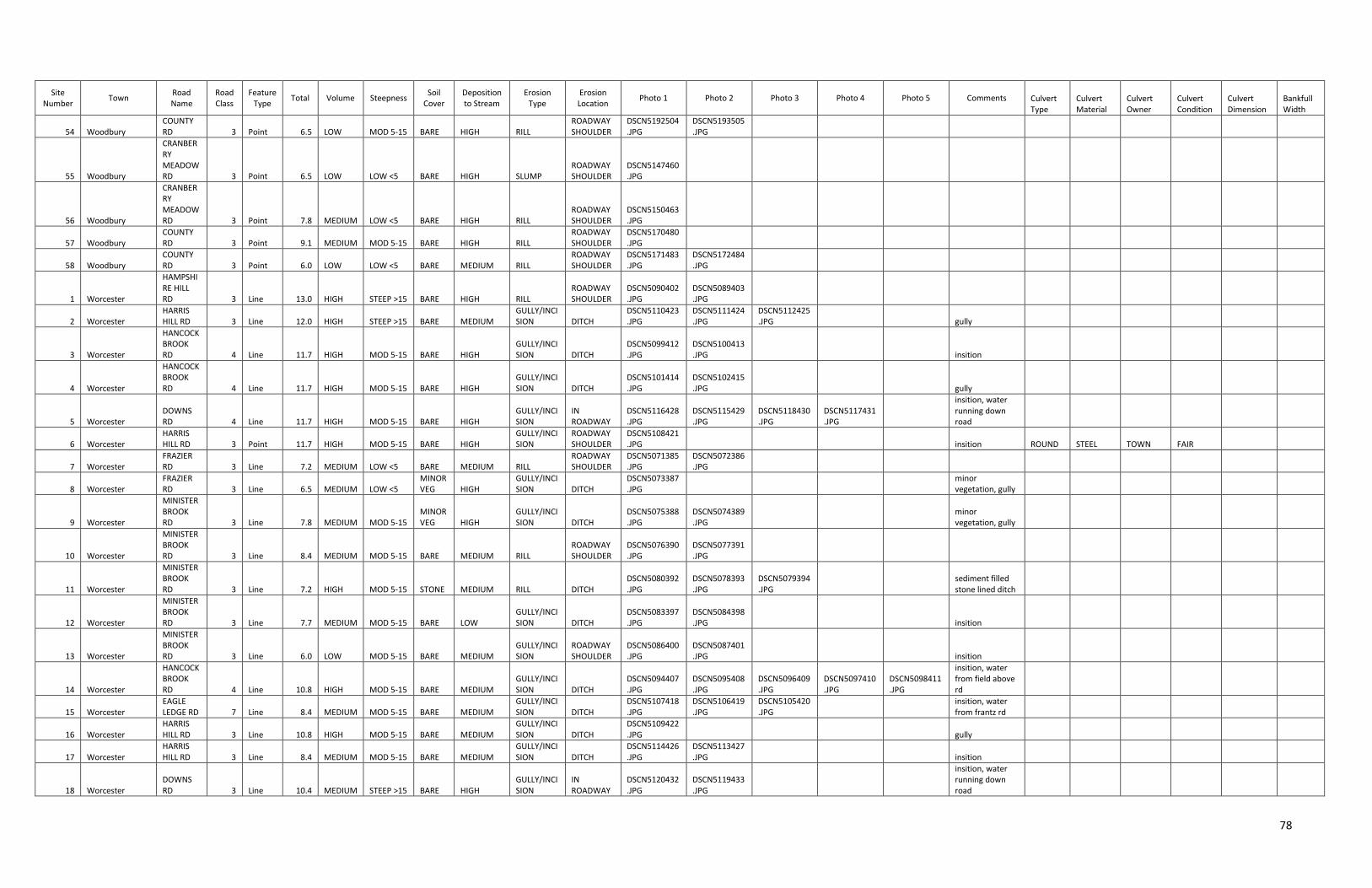
78
Site Number
Town Road Name
Road Class
Feature Type
Total Volume Steepness Soil
Cover Deposition to Stream
Erosion Type
Erosion Location
Photo 1 Photo 2 Photo 3 Photo 4 Photo 5 Comments Culvert Type
Culvert Material
Culvert Owner
Culvert Condition
Culvert Dimension
Bankfull Width
54 Woodbury COUNTY RD 3 Point 6.5 LOW MOD 5-15 BARE HIGH RILL
ROADWAY SHOULDER
DSCN5192504.JPG
DSCN5193505.JPG
55 Woodbury
CRANBERRY MEADOW RD 3 Point 6.5 LOW LOW <5 BARE HIGH SLUMP
ROADWAY SHOULDER
DSCN5147460.JPG
56 Woodbury
CRANBERRY MEADOW RD 3 Point 7.8 MEDIUM LOW <5 BARE HIGH RILL
ROADWAY SHOULDER
DSCN5150463.JPG
57 Woodbury COUNTY RD 3 Point 9.1 MEDIUM MOD 5-15 BARE HIGH RILL
ROADWAY SHOULDER
DSCN5170480.JPG
58 Woodbury COUNTY RD 3 Point 6.0 LOW LOW <5 BARE MEDIUM RILL
ROADWAY SHOULDER
DSCN5171483.JPG
DSCN5172484.JPG
1 Worcester
HAMPSHIRE HILL RD 3 Line 13.0 HIGH STEEP >15 BARE HIGH RILL
ROADWAY SHOULDER
DSCN5090402.JPG
DSCN5089403.JPG
2 Worcester HARRIS HILL RD 3 Line 12.0 HIGH STEEP >15 BARE MEDIUM
GULLY/INCISION DITCH
DSCN5110423.JPG
DSCN5111424.JPG
DSCN5112425.JPG
gully
3 Worcester
HANCOCK BROOK RD 4 Line 11.7 HIGH MOD 5-15 BARE HIGH
GULLY/INCISION DITCH
DSCN5099412.JPG
DSCN5100413.JPG
insition
4 Worcester
HANCOCK BROOK RD 4 Line 11.7 HIGH MOD 5-15 BARE HIGH
GULLY/INCISION DITCH
DSCN5101414.JPG
DSCN5102415.JPG
gully
5 Worcester DOWNS RD 4 Line 11.7 HIGH MOD 5-15 BARE HIGH
GULLY/INCISION
IN ROADWAY
DSCN5116428.JPG
DSCN5115429.JPG
DSCN5118430.JPG
DSCN5117431.JPG
insition, water running down road
6 Worcester HARRIS HILL RD 3 Point 11.7 HIGH MOD 5-15 BARE HIGH
GULLY/INCISION
ROADWAY SHOULDER
DSCN5108421.JPG
insition ROUND STEEL TOWN FAIR
7 Worcester FRAZIER RD 3 Line 7.2 MEDIUM LOW <5 BARE MEDIUM RILL
ROADWAY SHOULDER
DSCN5071385.JPG
DSCN5072386.JPG
8 Worcester FRAZIER RD 3 Line 6.5 MEDIUM LOW <5
MINOR VEG HIGH
GULLY/INCISION DITCH
DSCN5073387.JPG
minor vegetation, gully
9 Worcester
MINISTER BROOK RD 3 Line 7.8 MEDIUM MOD 5-15
MINOR VEG HIGH
GULLY/INCISION DITCH
DSCN5075388.JPG
DSCN5074389.JPG
minor vegetation, gully
10 Worcester
MINISTER BROOK RD 3 Line 8.4 MEDIUM MOD 5-15 BARE MEDIUM RILL
ROADWAY SHOULDER
DSCN5076390.JPG
DSCN5077391.JPG
11 Worcester
MINISTER BROOK RD 3 Line 7.2 HIGH MOD 5-15 STONE MEDIUM RILL DITCH
DSCN5080392.JPG
DSCN5078393.JPG
DSCN5079394.JPG
sediment filled stone lined ditch
12 Worcester
MINISTER BROOK RD 3 Line 7.7 MEDIUM MOD 5-15 BARE LOW
GULLY/INCISION DITCH
DSCN5083397.JPG
DSCN5084398.JPG
insition
13 Worcester
MINISTER BROOK RD 3 Line 6.0 LOW MOD 5-15 BARE MEDIUM
GULLY/INCISION
ROADWAY SHOULDER
DSCN5086400.JPG
DSCN5087401.JPG
insition
14 Worcester
HANCOCK BROOK RD 4 Line 10.8 HIGH MOD 5-15 BARE MEDIUM
GULLY/INCISION DITCH
DSCN5094407.JPG
DSCN5095408.JPG
DSCN5096409.JPG
DSCN5097410.JPG
DSCN5098411.JPG
insition, water from field above rd
15 Worcester EAGLE LEDGE RD 7 Line 8.4 MEDIUM MOD 5-15 BARE MEDIUM
GULLY/INCISION DITCH
DSCN5107418.JPG
DSCN5106419.JPG
DSCN5105420.JPG
insition, water from frantz rd
16 Worcester HARRIS HILL RD 3 Line 10.8 HIGH MOD 5-15 BARE MEDIUM
GULLY/INCISION DITCH
DSCN5109422.JPG
gully
17 Worcester HARRIS HILL RD 3 Line 8.4 MEDIUM MOD 5-15 BARE MEDIUM
GULLY/INCISION DITCH
DSCN5114426.JPG
DSCN5113427.JPG
insition
18 Worcester DOWNS RD 3 Line 10.4 MEDIUM STEEP >15 BARE HIGH
GULLY/INCISION
IN ROADWAY
DSCN5120432.JPG
DSCN5119433.JPG
insition, water running down road
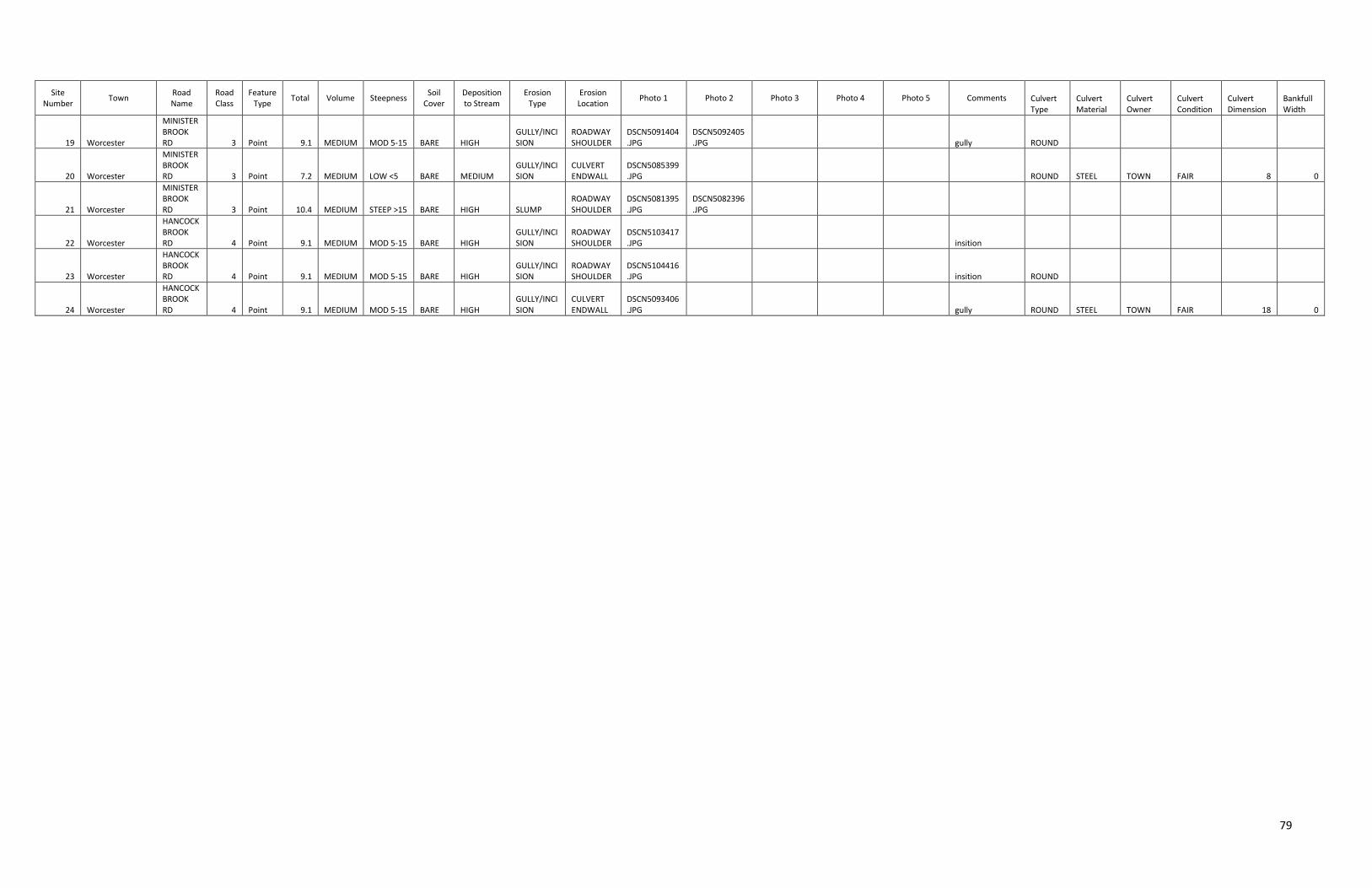
79
Site Number
Town Road Name
Road Class
Feature Type
Total Volume Steepness Soil
Cover Deposition to Stream
Erosion Type
Erosion Location
Photo 1 Photo 2 Photo 3 Photo 4 Photo 5 Comments Culvert Type
Culvert Material
Culvert Owner
Culvert Condition
Culvert Dimension
Bankfull Width
19 Worcester
MINISTER BROOK RD 3 Point 9.1 MEDIUM MOD 5-15 BARE HIGH
GULLY/INCISION
ROADWAY SHOULDER
DSCN5091404.JPG
DSCN5092405.JPG
gully ROUND
20 Worcester
MINISTER BROOK RD 3 Point 7.2 MEDIUM LOW <5 BARE MEDIUM
GULLY/INCISION
CULVERT ENDWALL
DSCN5085399.JPG
ROUND STEEL TOWN FAIR 8 0
21 Worcester
MINISTER BROOK RD 3 Point 10.4 MEDIUM STEEP >15 BARE HIGH SLUMP
ROADWAY SHOULDER
DSCN5081395.JPG
DSCN5082396.JPG
22 Worcester
HANCOCK BROOK RD 4 Point 9.1 MEDIUM MOD 5-15 BARE HIGH
GULLY/INCISION
ROADWAY SHOULDER
DSCN5103417.JPG
insition
23 Worcester
HANCOCK BROOK RD 4 Point 9.1 MEDIUM MOD 5-15 BARE HIGH
GULLY/INCISION
ROADWAY SHOULDER
DSCN5104416.JPG
insition ROUND
24 Worcester
HANCOCK BROOK RD 4 Point 9.1 MEDIUM MOD 5-15 BARE HIGH
GULLY/INCISION
CULVERT ENDWALL
DSCN5093406.JPG
gully ROUND STEEL TOWN FAIR 18 0
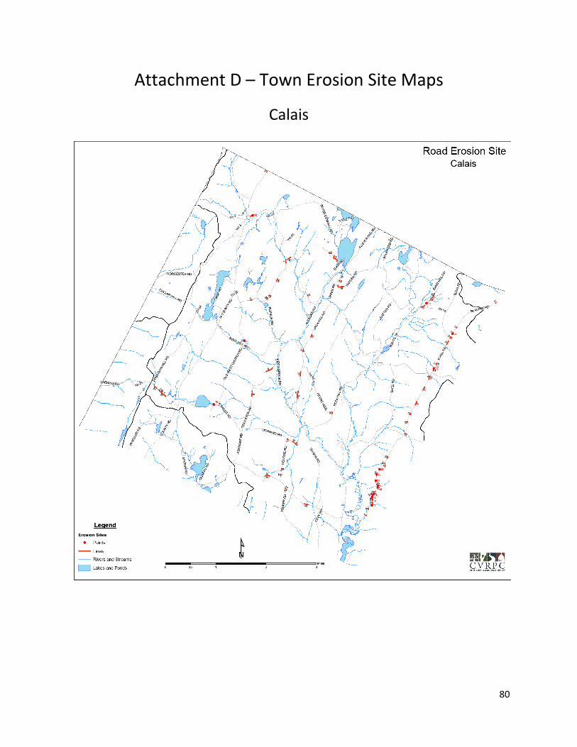
80
Attachment D – Town Erosion Site Maps
Calais
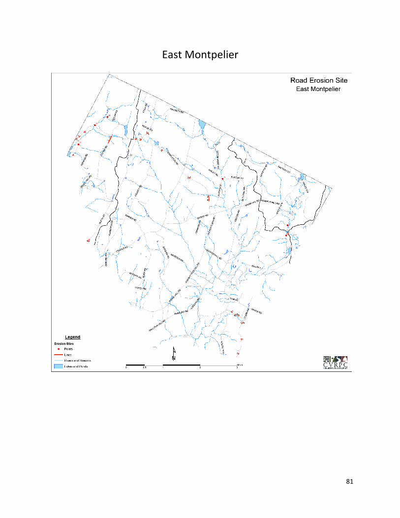
81
East Montpelier
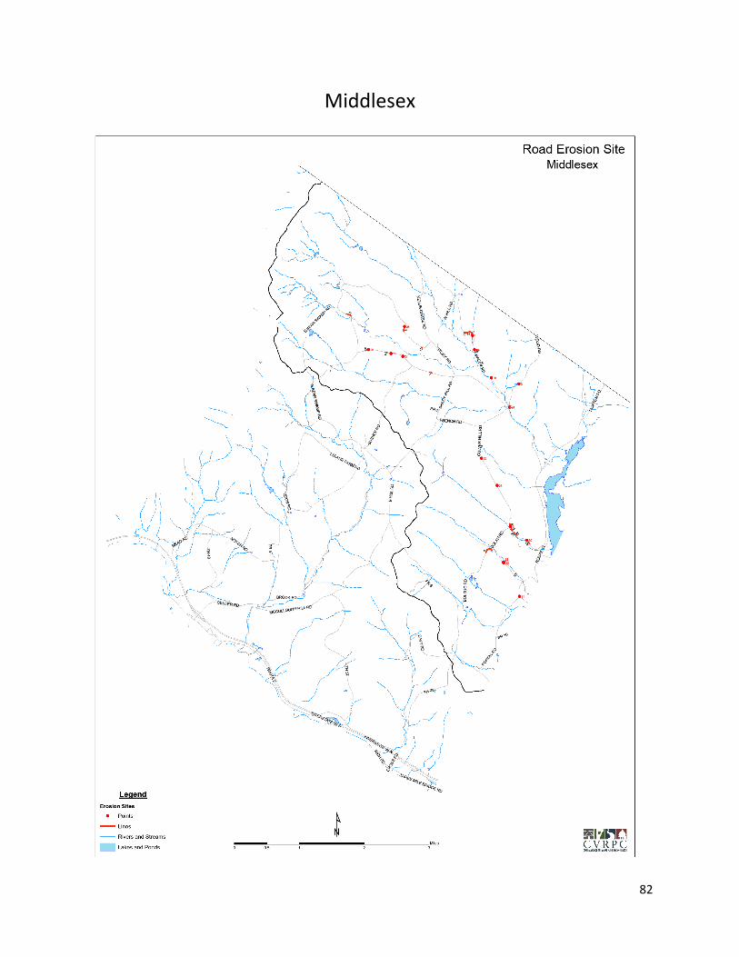
82
Middlesex
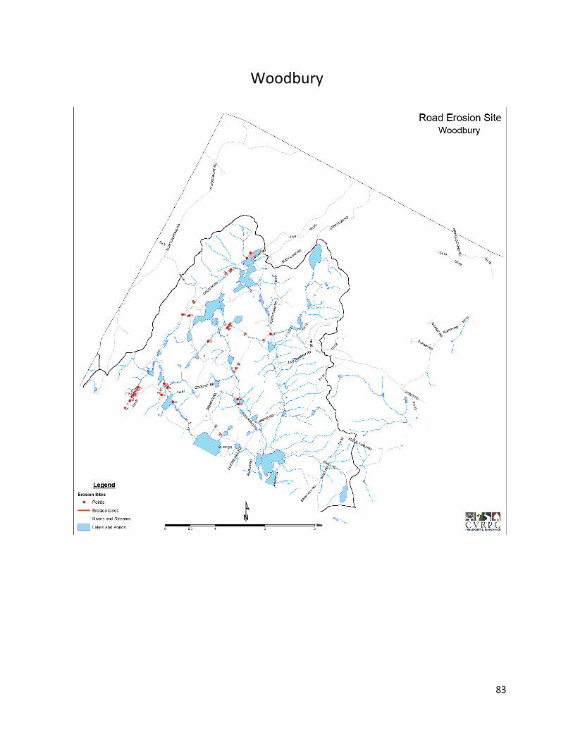
83
Woodbury

84
Worcester

85
Attachment E – Town Commitment Documents
Calais

86
East Montpelier
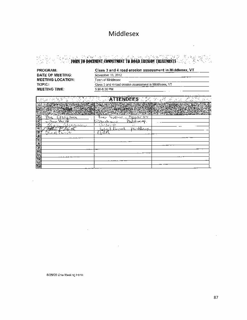
87
Middlesex

88
Woodbury
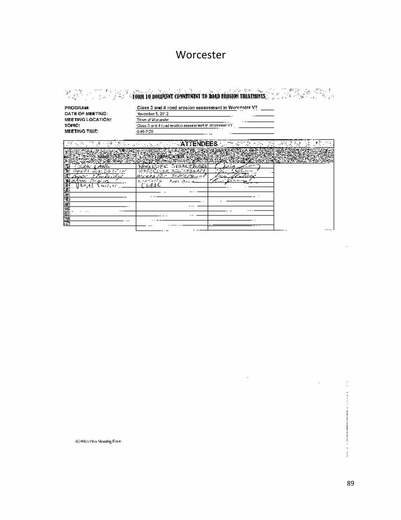
89
Worcester

90
Attachment F – GIS Shapefiles and Photos
GIS Shapefiles
To view the erosion line and point data collected during this project please refer to the digital folder
titled GIS Shapefiles and Photos and then sub folder titled GIS Shapefiles which contains two shapefiles
titled:
1. Erosion_Lines_Roads.shp
2. Erosion_Points_Roads.shp
Photos
To view the erosion site photos taken during this project please refer to the digital folder titled GIS
Shapefiles and Photos and then sub folder titled Photos which contains the photo folders titled:
1. CALAIS72312~files
2. CALAIS072512~files
3. EMONT071812~files
4. EMONTPELIER071612~files
5. MIDDLESEX082212~files
6. R080109A~files
7. R080809A~files
8. R091410B~files
9. WOODBURY082912~files
10. WOODBURY083112~files
11. WOODBURY091412~files
12. WORCESTER082312~files