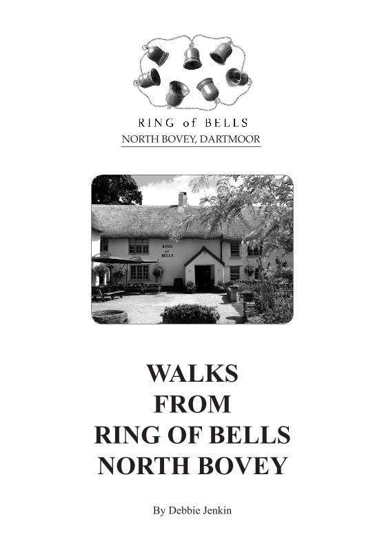
NORTH BOVEY, DARTMOOR - The Ring of Bells, a 13th...
17
WALKS FROM RING OF BELLS NORTH BOVEY By Debbie Jenkin NORTH BOVEY, DARTMOOR
-
Upload
nguyendang -
Category
Documents
-
view
215 -
download
0
Transcript of NORTH BOVEY, DARTMOOR - The Ring of Bells, a 13th...
WALKS FROM
RING OF BELLSNORTH BOVEY
By Debbie Jenkin
NORTH BOVEY, DARTMOOR
Welcome to the Ring of Bells Inn, North BoveyThe Ring of Bells is an idyllic pub in an idyllic setting. But we’re not just a pretty facade
– we have earned an enviable reputation for our food, beers and hospitality.
We serve coffee from 10am and food is available at lunch and dinner time and our chef, Tony Carr, uses fresh, seasonal, locally-grown produce in his daily-changing menu,
available in the bar and dining room. We also have a range of well-kept ales and an extensive wine list.
Our Stable Bar is an excellent room for formal dinners or relaxed parties. For a sit down meal, it can accommodate up to 50 people. For a more casual buffet-style event, 80 people can be catered for. Situated just off the bar, it’s also a great venue for informal meetings.
And finally – expecting visitors? We have five elegantly furnished ensuite bedrooms, all with flat screen digital TVs and tea and coffee making facilities.
If you’d like to view a room, please just ask.
Open 10.00am – 11.00pm daily
To find out about all the latest news and developments, or to take advantage of our special offers, check out our website on: www.ringofbells.net and sign up to our e-newsletter.
You can also follow us on Facebook.
We look forward to seeing you soon!
NORTH BOVEY, DARTMOOR, DEVON TQ13 8RBTel: 01647 440375 www.ringofbells.net [email protected]
NORTH BOVEY, DARTMOOR

CONTENTS
1
Page
Introduction
Walk 1 Ring of Bells - 3/4 of a mile 3 & 4
Walk 2 Ring of Bells - 3.5 miles 5 & 6
Walk 3 Ring of Bells - 5 miles 7 & 8
Walk 4 Ring of Bells - 3 miles 9 & 10
Walk 5 Ring of Bells - 5 miles 11 & 12
Walk 6 Ring of Bells - 7 miles 13 to 16
© D. JenkinFirst published 2014
Printed and published by Moor Print, Manaton, Devon
All rights reserved.No reproduction permitted without prior
permission of the publishers

INTRODUCTION
I hope this booklet of walks will add to the enjoyment of your visit to this small Dartmoor village. North Bovey is listed in the Domesday Survey of 1086 when it included 11 villagers, 6 small holders and 5 slaves! Today the population is
considerably greater but there remains much of its medieval past. The Ring of Bells and the church date back to the 13th Century, when this ancient ale-house provided lodgings for the medieval stonemasons working on the church construction.
Dartmoor covers a huge area, (368 square miles), and can display a variety of moods, not all of them friendly. It is therefore important to respect its isolated quality and to be aware of changing weather patterns and forecasts and of the onset of nightfall.
Please always observe the Country Code on paths and through farmland and you will be welcomed back next time. Close gates, don’t leave litter and, if you have a dog, please keep it under close control, particularly where there are animals.
Waterproof clothing is important to have with you, also do wear comfortable walking shoes or boots. Wellington boots are fine for shorter walks although these may cause rubbing on longer ones.
Every care has been taken in the preparation of these walks for your enjoyment. However, sometimes things can change; for example a hedge can be taken out or a path diverted. The author, the publisher nor the Ring of Bells can be held responsible for any inaccuracies, changes or alterations.
The following 6 walks are all circular, starting and finishing from the Ring of Bells. Approximate distances and timings are given. Enjoy this beautiful and peaceful corner of Dartmoor.
Happy walking!
2

WALK1
A short stroll of about 3/4 mile. Easy-going, one hill.
Time allowed - about half an hour.
1) Leave the pub courtyard and turn left down the hill on the tarmac lane. Some charming cottages border this lane which is known as Lower Hill.
The slope flattens out and the track continues through a gate, (often open), and then opens out by the River Bovey.
2) This beautiful spot is enjoyed by children, families, riders and walkers at all times of the year. There are three ways to cross the river here: 1) Paddle through, (wellies or bare feet recommended!), 2) Use the stepping stones, 3) Cross by way of the footbridge.
Having arrived on the right bank of the river, you will see a stony lane leading away from the river. Take this lane and within a few hundred metres you will come to a gate on to the road, where you turn right and cross the river again, this time on an 18th Century stone bridge.
3
NNORTHBOVEY
RiverBovey
1
23
4
RINGOFBELLS
Church

3) Over the bridge, turn sharp left along ‘Two Waters Lane’, a quiet road parallel to the river where you might be lucky enough to see a dipper. This little bird is dark brown with a white bib and tends to fly up the course of the river just above the water. Alternatively, it will stand on a rock, bobbing and curtseying. It is only found on the western side of the British Isles.
4) After about 300 metres you will come to a T junction with a beautiful and much older stone bridge, on the left. Look over this bridge for another chance of seeing a dipper. The long white house you can see here used to be a mill in former days. Turn right and, as the road bends to the left, you will see a narrow path leading uphill and between high banks of overhanging trees. Take this church path, at the end of which, is a gate into the churchyard of the lovely old church of St. John’s. It is beautiful inside and well worth a look, usually being unlocked during daylight hours. It boasts some medieval glass in one window and a 15th Century oak screen. Continue through the churchyard to the lich gate, with its war memorial boards. Once through here you will be facing the village green and now it is just a short walk along the bottom of the green to get back into the pub courtyard. Time for a drink?!
4

WALK2
This walk is along quiet lanes and through farmland. In Winter it can be muddy.
A number of stiles to climb. Flattish ground. No steep hills.
About 3.5 miles
Time allowed - 2 to 3 hours.
1) From the Ring of Bells courtyard, turn right and walk up past the green, passing the long, low, thatched village hall on the right. Keep on past a row of cottages and take the road uphill and round some bends. At the junction at the top, you may notice a large rock, ‘Pound Rock’. Several hundred years ago, this area was used for impounding stray animals; hence its name.
2) As the main (!) road bears right, keep to the left, smaller lane and carry on. After the road drops downhill, look out for a stile tucked away in the hedge on the right with its tell-tale yellow dot, a footpath symbol. There will be others today!
3) Climb over here and head towards the left boundary of this large field. The next stile is about halfway up this left side and once over this one you need to head to the top left hand corner of the next large field where there is a gate.
5
N
1
2
3
4
5
6
7
8
9
10
RiverBovey
ChurchRINGOFBELLS
RiverBovey
FursdonFarm
NarramoreFarm
BoveyCastle
NORTHBOVEY
HospitX

4) This is a good place to pause and look back the way you have come. The south-west horizon will now be dominated by Easdon Hill, the highest place in the immediate vicinity. Coniferous woodlands flank the hill on your side; another good place to walk! Returning to your gate, this will direct you through a sorting pen - which can be very muddy - to another gate. Now go hard left through another gate and into a large field. You need to aim slightly right across this field to another stile which will appear in the bank.
5) Climb over here, turn right and you will be in the county road. You now have about a mile to walk on tarmac. Keep on this road until you arrive at a cross-roads, Hospit Cross, also called Bovey Cross or Stumpy Cross, after the chunky, low-set ancient stone cross which you can see on the left. Go straight across and proceed past a yellow house, a farm and a house with a long straight driveway until, just beyond this, you need to turn left at the junction of Brinning Cross.
6) Just before turning, you may be interested to find an old guide-stone in the left-hand hedge, with letters M and L, (written backwards!), on two faces. These stand for Moretonhampstead and Lustleigh.
7) About 400 metres down this lane look out for a footpath sign and stile on the right, for it is over here that your way now goes.
Follow the footpath signs across several fields and stiles - these are mostly situated at the bottom of sloping fields and following your left-hand boundary. You will eventually emerge on to the driveway of Narramore Farm, and bearing right you come to the road.
8) Go straight across the road and through a gate into a grassy lane. This was the old drive to the next farm, close by which you will pass. At the point where the buildings come into view at the end of the lane, the footpath directs you right, before the farm and takes you across a paddock, rich in wild flowers in May and June. Cross the concrete drive and go straight into the gate opposite where you turn left to another stile, across another field and through a gate. Having got here you must now bear slightly right and head for about halfway across the bottom boundary to negotiate another stile and stream.
9) This stream marks the boundary between North Bovey and Lustleigh parishes, so having crossed here you are now back on North Bovey land. Keep straight across this field to where you can see a metal gate, keep to the left-hand boundary of the following field which will lead you over a hidden stile into a tiny leafy lane, bordered on both sides by trees and bushes. Walk to the bottom of this lane and over a stile into a stony track where you turn right.
10) Two hundred metres along this track you will come to the River Bovey with its pretty bridge and stepping stones. This charming spot is a popular resting place for locals and visitors alike and even the most hardened heart cannot fail to be melted by this scene. When you have had your fill and, without crossing the river, head uphill, now on tarmac, past or through the gate. A few hundred metres will bring you back into North Bovey with the Ring of Bells on the right.
6

WALK3
Through leafy lanes, bridlepaths and quiet roads. Some lovely views with an ‘away from it all’ feeling.
About 5 miles.
Allow 3 hours.
1) Leave the Ring of Bells courtyard and turn left going downhill and past some pretty cottages. After the gate and when the road turns into a stony track, you will come to a ford. This delightful spot is worth pausing for. Stepping stones and a wooden footbridge provide dry ways of crossing here although for this walk, nei-ther is necessary.
2) Continue along this lane passing a stone barn on the left. Various fields lead off and in places you will be walking through a tunnel of trees overhanging the lane from the banks on both sides. After about a mile the track becomes tarmac under your feet and a short while later, and after passing drives to a couple of farms, you will come to a T junction where you turn right.
7
2
RiverBovey
RINGOFBELLS
Foxworthy
NORTHBOVEY
PeckFarm
N
1
4
3
65
7
Neadon
8
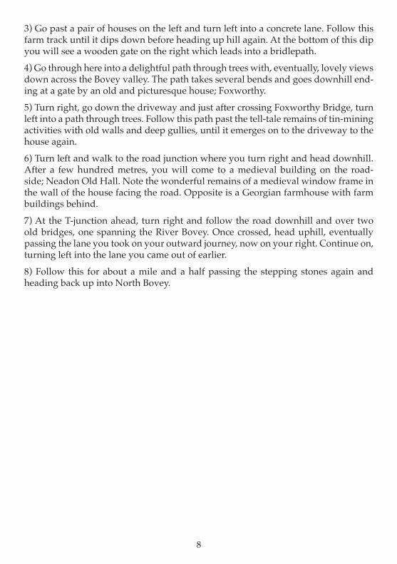
3) Go past a pair of houses on the left and turn left into a concrete lane. Follow this farm track until it dips down before heading up hill again. At the bottom of this dip you will see a wooden gate on the right which leads into a bridlepath.
4) Go through here into a delightful path through trees with, eventually, lovely views down across the Bovey valley. The path takes several bends and goes downhill end-ing at a gate by an old and picturesque house; Foxworthy.
5) Turn right, go down the driveway and just after crossing Foxworthy Bridge, turn left into a path through trees. Follow this path past the tell-tale remains of tin-mining activities with old walls and deep gullies, until it emerges on to the driveway to the house again.
6) Turn left and walk to the road junction where you turn right and head downhill. After a few hundred metres, you will come to a medieval building on the road-side; Neadon Old Hall. Note the wonderful remains of a medieval window frame in the wall of the house facing the road. Opposite is a Georgian farmhouse with farm buildings behind.
7) At the T-junction ahead, turn right and follow the road downhill and over two old bridges, one spanning the River Bovey. Once crossed, head uphill, eventually passing the lane you took on your outward journey, now on your right. Continue on, turning left into the lane you came out of earlier.
8) Follow this for about a mile and a half passing the stepping stones again and heading back up into North Bovey.
8

WALK4
Halfway through this walk there is the opportunity to stop for afternoon tea at the renouned Bovey Castle. This beautiful hotel was built in 1906 as a country house for the original W.H.Smith, Viscount Hambledon. For many years it bore the name of the Manor House Hotel until after much refurbishment and with an extra wing added, it became Bovey Castle in 2003.
Distance - about 3 miles
Allow 2 hours, more if having tea at the castle
Quiet lanes and paths
1) From the Ring of Bells come out of the courtyard and head straight across the lower end of the green to the church lich gate. Go through the churchyard, perhaps diverting inside the ancient church which is usually open during the day and is mainly Early English in style.
2) Come out of the churchyard at the far end and into the church path, a delightful and narrow footpath between walls and hedgebanks with overhanging trees.
9
2
RiverBovey RINGOFBELLS
YARDE
NORTHBOVEY
1
43
5
7 N
6
BOVEYCASTLE8
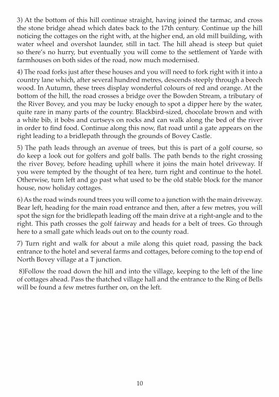
3) At the bottom of this hill continue straight, having joined the tarmac, and cross the stone bridge ahead which dates back to the 17th century. Continue up the hill noticing the cottages on the right with, at the higher end, an old mill building, with water wheel and overshot launder, still in tact. The hill ahead is steep but quiet so there’s no hurry, but eventually you will come to the settlement of Yarde with farmhouses on both sides of the road, now much modernised.
4) The road forks just after these houses and you will need to fork right with it into a country lane which, after several hundred metres, descends steeply through a beech wood. In Autumn, these trees display wonderful colours of red and orange. At the bottom of the hill, the road crosses a bridge over the Bowden Stream, a tributary of the River Bovey, and you may be lucky enough to spot a dipper here by the water, quite rare in many parts of the country. Blackbird-sized, chocolate brown and with a white bib, it bobs and curtseys on rocks and can walk along the bed of the river in order to find food. Continue along this now, flat road until a gate appears on the right leading to a bridlepath through the grounds of Bovey Castle.
5) The path leads through an avenue of trees, but this is part of a golf course, so do keep a look out for golfers and golf balls. The path bends to the right crossing the river Bovey, before heading uphill where it joins the main hotel driveway. If you were tempted by the thought of tea here, turn right and continue to the hotel. Otherwise, turn left and go past what used to be the old stable block for the manor house, now holiday cottages.
6) As the road winds round trees you will come to a junction with the main driveway. Bear left, heading for the main road entrance and then, after a few metres, you will spot the sign for the bridlepath leading off the main drive at a right-angle and to the right. This path crosses the golf fairway and heads for a belt of trees. Go through here to a small gate which leads out on to the county road.
7) Turn right and walk for about a mile along this quiet road, passing the back entrance to the hotel and several farms and cottages, before coming to the top end of North Bovey village at a T junction.
8)Follow the road down the hill and into the village, keeping to the left of the line of cottages ahead. Pass the thatched village hall and the entrance to the Ring of Bells will be found a few metres further on, on the left.
10

WALK5
This walk is about 5 miles and is along quiet lanes and over moorland. Some steep hills.
Allow about 3 hours
1) Leave the Ring of Bells and head across the bottom of the green, entering the churchyard by way of the lich gate. You may be interested to read the names on the war memorials here; those who served, on the board on the right; those who fell, on stone on the left.2) Go through the gate at the far end of the churchyard into the church path which leads down a narrow lane to the road. Walk over the lovely stone bridge ahead and keep on going up the steep hill and on, to the hamlet of Yarde where two former farmhouses sit, one on either side of the road.3) There is a turning to the right here but don’t take it, rather keep on going as the road climbs with fields on either side of the road and eventually the road flattens out.4) On the left you will find a narrow track with a wooden sign showing it as a right-of-way. It is up this narrow track with its high banks and bushes that you now must pass. This is called Langdon Lane and amazingly, it used to be the driveway to two ancient farms! Those farms now have a more modern driveway on the other side of the hill.
11
2
R.Bovey
EASDONTOR
YARDE
NORTHBOVEY
1
43
5
7
6
HELE
8
9
10
11
N
RINGOFBELLS

5) After just over half a mile, the main track continues but there is a little turning to the left and it is along here that you need to go, where there is a gate on to open moorland.
You are now on Easdon Hill and if you look from the gate, to the highest point, you will be able to see a clump of rocks - Easdon Tor - and possibly, the straight concrete post of the triangulation point on top. You need to aim for this. There are many little paths through the gorse, heather and bracken but if you keep the tor in view as far as possible, you will eventually arrive on top.
6) The views from here are magnificent. To the west is Shapley Common and King Tor. Due south is a ridge, with Honeybag and Chinkwell Tors; slightly east of that, the craggy outline of Hound Tor comes into view, well known for its association with Sir Arthur Conan Doyle’s, Hound of the Baskervilles. When you have drunk your fill of these views, you will need to head down the other side of Easdon, until a long, straight, drystone wall comes into sight in front and to the left of you, heading down the slope. It is to the bottom corner that you now need to aim and as you get closer, you will see a gate there with a lane either side.
7) Having reached the gate, don’t go through it but turn right along the grassy track bordered by gorse bushes, which leads away from it. Several hundred metres later will bring you to another gate. Go through here and along the stony track the other side, passing a farm and a cottage close by the lane. You will then emerge at a T junc-tion on the road.
8) Turn right here. This is Long Lane, made famous by the song of Widecombe Fair, in which it features as Long Lea; lea being the old Devon word for lane. For of course, it was along this lane, going in the opposite direction to you, that Tom Cobley and his motley crew, rode the unfortunate grey mare to the fair. After about a mile you will come to a cross- roads but continue along this road, passing a driveway to a house called Everley, on the right and then over a bridge. You will now see a turning to the right, opposite Barramoor Farm.
9) Take this right turn, into a quiet lane, passing some white cottages on the left and then, a bit later, a farm on the roadside. This is Hele Farm, - ‘hele’ meaning valley.
10) Turn right at this farm and on the left you may notice Hele Cross, an ornate and ancient waymarker. Further on down this road, Bowden Mill is on your right and a bit further, a delightful wooded area with a bridge over the river, where you may see a dipper by the water. Keep on the road, up a steep hill through beech trees. This road comes, after a few hundred metres, to a T junction which brings you back to the hamlet of Yarde again.
11) Turn left and retrace your steps downhill, crossing the River Bovey on the 17th century bridge and heading up the church path, through the churchyard and back over the green to the Ring of Bells.
12

WALK6
A walk of about 7 miles. Ideal for a day’s outing, perhaps with a picnic.
Allow about 5 hours
Quiet roads, footpaths, forest rides, open moorland.
13
EasdonHill
Bowerman’sNose
10
11
RINGOFBELLS
N
4
3
5
76
8
9
1
2
12
13
14
15
16
N
Manaton
Barracott

1) Leave the Ring of Bells and turn sharp left downhill, past some pretty cottages. Go through or past the gate until the area opens up to reveal some stepping stones over the River Bovey. There is also a wooden footbridge for the less adventurous.
2) Having crossed the river, continue along a stony, (and sometimes muddy), lane between trees. After a few hundred metres you will emerge through a gate on to a tarmac road where you turn left.
3) After almost a mile, a tiny road joins the one you are on from the left and at a sloping junction, but keep right and going up the road you are on until, about a hundred metres beyond the little junction you will find a field gate on the left with a wooden sign showing a path across this field.
4) Having closed the gate behind you, head diagonally across this field, contouring the slope and aiming for the far and lower corner. Here, after crossing a small wall, a stream and a stile, you will be in a mixed woodland. Follow the path, which can be quite wet in places as it winds towards the top of the wood and a wooden gate. Go through and continue this line, parallel to a boundary on your left and to a stile in a fence ahead. Cross here. Within about 50 metres, the wooded path now splits and you need to take the path to the right.
5) This path steadily climbs up through the scrub and in Summer the bracken here is high. At the top and underneath the granite outcrop of Manaton Rocks, there is another stile into an enclosed path with a fence on one side and rocks on the other. There is a place where these rocks can be scaled to the top if you want a cracking view of the Bovey valley.
Head downhill now, over stiles and through bushes, across the edge of fields and, on approaching the church, turn hard left through a gate into the churchyard of St. Winifred’s church noting the ancient and headless cross just through the gate, and around which, many moons ago, a curate here used to encourage his flock to process, with curious chanting, at certain times of year! This church is usually open daily and is well worth a look. It has a fine old screen on which the faces of the saints have been gouged out during the Reformation in the 1500s.
6) Leave by way of the main gate at the far side and cross the green, noting the beautiful thatched house on the left at the top, once the Half Moon Inn. When you reach the other side of the green, turn left along the road for a short distance. The Manaton Parish Hall appears on the left and just past this, on the right, is the start of a lane with a gate at right angles. Go through here.
7) You are now in Slinkers’ Lane, frequented several hundred years ago, by highwaymen and cut-throats. There shouldn’t be a problem now but just keep hold of your wallet ...
This delightful narrow lane leads down through trees and bushes, through a gate
14

and, at the bottom of a slight slope, you need to turn right towards Manaton and Water. Keep on this lane following the wooden bridlepath signs to Manaton, until a right turn leads you on to tarmac, and then takes you to a cross roads in Manaton village with the Kestor Inn on the right.
8) Go straight across the cross roads into a quiet lane which, bordered by odd farms and houses, winds through farmland to another cross roads, Hayne Cross, where you need to go straight across towards Hayne Down.
This road reaches a house and then peters out into a path which rises through trees until reaching a gate on to the moor. From here your way is to the right and up, up over the saddle of a ridge known as Hayne Down.
9) Pause here for some good views to the west. On descending the other side, look right and you will see a huge granite pillar resembling a man wearing a cap. This is Bowerman’s Nose and has a legend to it: Bowerman the hunter was turned to stone after having disturbed three witches in the valley as he and his horse, thundered up through. You can make a detour to study him more closely if you wish and if you dare, put your hands flat on his granite body. Some say you can feel a heartbeat .....
Having returned to the path, head downhill and on reaching the tarmac lane, turn right going downhill.
10) Along this road and in this area of scrubby trees, you can often hear a cuckoo calling in April or May.
On reaching the gate at the bottom, go through and continue until reaching a bigger raod at a T junction where you turn left.
11) Walk along this road until after a hundred metres or so, you find a stile on the left in the hedge. Climb over here and follow the footpath across stiles through two fields, which nicely cut off a corner in the bend in the road. Emerging on to the road, turn left again for several hundred metres until a tarmac lane on the right leads away from this road and up hill. A sign points up here to Barracott.
12) Continue past a couple of houses and a farm as the road turns into a cart track and eventually to a gate on to the moor. Once through this gate, turn hard right and, keeping next to the wall which rises up the slope, follow it to a right-angled corner. Go right with the wall and continue following it until the wall takes another right turn. There are some lovely beech trees on this corner.
13) From here you can see a conifer plantation ahead. You need to aim for the left side of it. The path ahead bears left anyway. Where it splits into two, keep to the left path and very soon you will see the left end of this bit of the forest with its enclosing dry-stone wall. Head for this corner.
14) The wall makes a right turn downhill and you need to follow it for 20 or 30
15

metres before the path you are on, bears to the left and needs to take you with it. After a few hundred metres it is joined by another path coming downhill from the left at a short, green-topped post and now drops down more steeply through an area of young oak trees. You will notice that you are going down towards another part of the forest and, as the hill becomes more gradual, a forest wall boundary will appear on your left. You need to stay on the line of your path and parallel to this descending wall. Wind down along a wet and sometimes muddy, path as the scrub vegetation gets thicker around you. At the bottom is a small gate.
15) Go through here , follow the path and cross over a forest ride into a bridlepath - wooden signs direct you. After about a hundred metres, bear off to the left into trees and down to another gate. Go through, along a rocky track, until through another gate, you will emerge on to the tarmac road.
16) Your way is now left and downhill and you need to retrace your steps from your outward journey. At the bottom of this road, go over the bridge, (Fairbrook Bridge; 18th Century), and back up into North Bovey. The Ring of Bells is on the right. Time for a cup of tea or perhaps something stronger ...
16