NOISE MAPPING PROCESS Dr Bernadette McKell Hamilton & McGregor.
25
NOISE MAPPING PROCESS Dr Bernadette McKell Hamilton & McGregor
-
Upload
izaiah-stacey -
Category
Documents
-
view
219 -
download
1
Transcript of NOISE MAPPING PROCESS Dr Bernadette McKell Hamilton & McGregor.

NOISE MAPPING PROCESS
Dr Bernadette McKell
Hamilton & McGregor

What We Have Mapped?
•Agglomerations over 250,000 inhabitants (including industry and ports)
•All major roads carrying more than 6 million vehicles a year;
•Major railways with over 60,000 rail passengers a year
•Major airports with over 50,000 movements per year.

What Have Mapped Within Agglomerations?
•Industry and ports
•All roads within agglomerations with flows of 1000 vehicles or more per day (the lower limit is equivalent to 0.35 million passages per annum).
•Every railway which is likely to produce noise levels of greater than 55 dB Lden or 50 dB Lnight at 4m above ground level (therefore all railways).
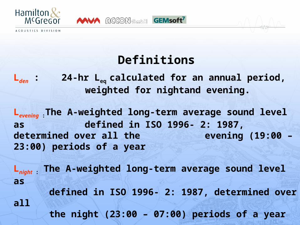
DefinitionsLden : 24-hr Leq calculated for an annual period, weighted for nightand evening.
Levening :The A-weighted long-term average sound level as defined in ISO 1996- 2: 1987, determined over all the evening (19:00 – 23:00) periods of a year
Lnight : The A-weighted long-term average sound level as defined in ISO 1996- 2: 1987, determined over all the night (23:00 – 07:00) periods of a year

dBLnighteveningday LLL
den
10
10
10
5
1010 10*810*410*1224
1log*10
The logarithmic of Lday Levening and Lnight including penalties for the night and evening periods

Noise Source
Methodology
Road CRTN+TRL backend LA18(hr) to Lden correction
Railways CRN + correction to take account of rail/wheel roughness
Airport .csv files (CAA for Glasgow, Edinburgh and Aberdeen and Bickerdike Allen for Prestwick)
Industrial & Ports
European Commission Working Group Assessment of Exposure to Noise (WG-AEN) GPG for Strategic Noise Mapping and the Production of Associated Data on Noise Exposure


Qualifying Road Study Areas
Copyright © Hamilton & McGregor 2007. Permission is granted for this material to be shared for non-commercial, educational purposes, provided that this copyright statement appears on the reproduced materials and notice is given that the copying is by permission of the author. To disseminate otherwise or to republish requires written permission from the author.

Overall Area
Total Study Area (incl buffer = 4494 sq km)
Inliers and Outliers
Total area outside Agglomerations =3659 sq kmTotal road length outside Agglomeration = 1635 km
Edinburgh AgglomerationTotal area of Edinburgh Agglomeration: = 274 sq kmTotal length of road within Edinburgh Agglomeration =496 km
Glasgow Agglomeration
Total area of Glasgow Agglomeration =766 sq kmTotal length of road within Glasgow Agglomeration =1483 km
Copyright © Hamilton & McGregor 2007. Permission is granted for this material to be shared for non-commercial, educational purposes, provided that this copyright statement appears on the reproduced materials and notice is given that the copying is by permission of the author. To disseminate otherwise or to republish requires written permission from the author.

Qualifying Railways Study Areas
Copyright © Hamilton & McGregor 2007. Permission is granted for this material to be shared for non-commercial, educational purposes, provided that this copyright statement appears on the reproduced materials and notice is given that the copying is by permission of the author. To disseminate otherwise or to republish requires written permission from the author.

Edinburgh AgglomerationTotal area of Edinburgh agglomeration = 274 sq km Total Length of Railway tracks within Agglomeration =163 km
Glasgow AgglomerationTotal area of Agglomeration = 766 sq km Total length of railway tracks within Agglomeration = 652 km
Outliers and InliersTotal area of outside Agglomeration =: 422 sq km
Total length of railway tracks outside Agglomeration = 205 km
Copyright © Hamilton & McGregor 2007. Permission is granted for this material to be shared for non-commercial, educational purposes, provided that this copyright statement appears on the reproduced materials and notice is given that the copying is by permission of the author. To disseminate otherwise or to republish requires written permission from the author.
Due to OS licence conditions, you/your agent may only use this map for official business dealings with the Scottish Government. If you wish to use the map for other uses, you must first obtain a separate licence from OS.© Crown copyright. All rights reserved Scottish Government 100020540 2007.

Ground modelling
Primary Data Sources :
•OS Master Map•Nextmap DTM, DSM•LiDAR Data •ITN Road Network
Data, Process and Optimisation
Copyright © Hamilton & McGregor 2007. Permission is granted for this material to be shared for non-commercial, educational purposes, provided that this copyright statement appears on the reproduced materials and notice is given that the copying is by permission of the author. To disseminate otherwise or to republish requires written permission from the author.
Due to OS licence conditions, you/your agent may only use this map for official business dealings with the Scottish Government. If you wish to use the map for other uses, you must first obtain a separate licence from OS.© Crown copyright. All rights reserved Scottish Government 100020540 2007.

Main primary data source for the ground objects
Copyright © Hamilton & McGregor 2007. Permission is granted for this material to be shared for non-commercial, educational purposes, provided that this copyright statement appears on the reproduced materials and notice is given that the copying is by permission of the author. To disseminate otherwise or to republish requires written permission from the author.
Due to OS licence conditions, you/your agent may only use this map for official business dealings with the Scottish Government. If you wish to use the map for other uses, you must first obtain a separate licence from OS.© Crown copyright. All rights reserved Scottish Government 100020540 2007.

OS Data represents the real world accuracy
Copyright © Hamilton & McGregor 2007. Permission is granted for this material to be shared for non-commercial, educational purposes, provided that this copyright statement appears on the reproduced materials and notice is given that the copying is by permission of the author. To disseminate otherwise or to republish requires written permission from the author.
Due to OS licence conditions, you/your agent may only use this map for official business dealings with the Scottish Government. If you wish to use the map for other uses, you must first obtain a separate licence from OS.© Crown copyright. All rights reserved Scottish Government 100020540 2007.

2D Buildings are extracted from OS Master Map data
Copyright © Hamilton & McGregor 2007. Permission is granted for this material to be shared for non-commercial, educational purposes, provided that this copyright statement appears on the reproduced materials and notice is given that the copying is by permission of the author. To disseminate otherwise or to republish requires written permission from the author.
Due to OS licence conditions, you/your agent may only use this map for official business dealings with the Scottish Government. If you wish to use the map for other uses, you must first obtain a separate licence from OS.© Crown copyright. All rights reserved Scottish Government 100020540 2007.

Master Map with 2D Buildings ( Glasgow City Centre Area)
Copyright © Hamilton & McGregor 2007. Permission is granted for this material to be shared for non-commercial, educational purposes, provided that this copyright statement appears on the reproduced materials and notice is given that the copying is by permission of the author. To disseminate otherwise or to republish requires written permission from the author.
Due to OS licence conditions, you/your agent may only use this map for official business dealings with the Scottish Government. If you wish to use the map for other uses, you must first obtain a separate licence from OS.© Crown copyright. All rights reserved Scottish Government 100020540 2007.

3D Glasgow Urban Model
Building height assigned from LiDAR data
1m LiDAR data source: Geoinformation group, UK
Copyright © Hamilton & McGregor 2007. Permission is granted for this material to be shared for non-commercial, educational purposes, provided that this copyright statement appears on the reproduced materials and notice is given that the copying is by permission of the author. To disseminate otherwise or to republish requires written permission from the author.
Due to OS licence conditions, you/your agent may only use this map for official business dealings with the Scottish Government. If you wish to use the map for other uses, you must first obtain a separate licence from OS.© Crown copyright. All rights reserved Scottish Government 100020540 2007.

Width Model
Railway tracks are modelledaccording to constant width
Road are modelled according to actual width
Copyright © Hamilton & McGregor 2007. Permission is granted for this material to be shared for non-commercial, educational purposes, provided that this copyright statement appears on the reproduced materials and notice is given that the copying is by permission of the author. To disseminate otherwise or to republish requires written permission from the author.
Due to OS licence conditions, you/your agent may only use this map for official business dealings with the Scottish Government. If you wish to use the map for other uses, you must first obtain a separate licence from OS.© Crown copyright. All rights reserved Scottish Government 100020540 2007.

NextMap DTM
Advantages for Noise Mapping
•Better accuracy then contours •Compatible with noise modelling software
Problems•Contains too many points•Create problem in noise calculation in Larger area• Heavy file size
Data Required optimization
Total number of points (pixels) in the City Centre Area: 145994
Copyright © Hamilton & McGregor 2007. Permission is granted for this material to be shared for non-commercial, educational purposes, provided that this copyright statement appears on the reproduced materials and notice is given that the copying is by permission of the author. To disseminate otherwise or to republish requires written permission from the author.

•Total number of points are reduced from 145994 to 11682 ( 12 times reduction)•File size reduced to 10MB to 2.5MB
Total number of points (pixels) in the City Centre Area: 11682
Copyright © Hamilton & McGregor 2007. Permission is granted for this material to be shared for non-commercial, educational purposes, provided that this copyright statement appears on the reproduced materials and notice is given that the copying is by permission of the author. To disseminate otherwise or to republish requires written permission from the author.

Model Comparison
3D Ground model from original points
3D Ground model from optimised points
Insignificant difference between models M2 is compatible, fast and accurate for noise modelling
M1
M2
Copyright © Hamilton & McGregor 2007. Permission is granted for this material to be shared for non-commercial, educational purposes, provided that this copyright statement appears on the reproduced materials and notice is given that the copying is by permission of the author. To disseminate otherwise or to republish requires written permission from the author.

3D buildings ground model
•Building heights from 1m Lidar•Ground Model from 5m NextMap
Copyright © Hamilton & McGregor 2007. Permission is granted for this material to be shared for non-commercial, educational purposes, provided that this copyright statement appears on the reproduced materials and notice is given that the copying is by permission of the author. To disseminate otherwise or to republish requires written permission from the author.
Due to OS licence conditions, you/your agent may only use this map for official business dealings with the Scottish Government. If you wish to use the map for other uses, you must first obtain a separate licence from OS.© Crown copyright. All rights reserved Scottish Government 100020540 2007.

3D Noise Map Lden Glasgow City Centre Area
Copyright © Hamilton & McGregor 2007. Permission is granted for this material to be shared for non-commercial, educational purposes, provided that this copyright statement appears on the reproduced materials and notice is given that the copying is by permission of the author. To disseminate otherwise or to republish requires written permission from the author.
Due to OS licence conditions, you/your agent may only use this map for official business dealings with the Scottish Government. If you wish to use the map for other uses, you must first obtain a separate licence from OS.© Crown copyright. All rights reserved Scottish Government 100020540 2007.

Final Noise Map
Copyright © Hamilton & McGregor 2007. Permission is granted for this material to be shared for non-commercial, educational purposes, provided that this copyright statement appears on the reproduced materials and notice is given that the copying is by permission of the author. To disseminate otherwise or to republish requires written permission from the author.
Due to OS licence conditions, you/your agent may only use this map for official business dealings with the Scottish Government. If you wish to use the map for other uses, you must first obtain a separate licence from OS.© Crown copyright. All rights reserved Scottish Government 100020540 2007.

http://www.scotland.gov.uk/Publications/2007/08/24141743/0