Nobis Project No. 80034 1 Congress Street, Suite 1100 Five ...
95
Nobis Engineering, Inc. 18ChenelI Drive Concord, NH 03301 Tel (603)224-4182 Fax (603) 224-2507 www.nobisengineering.com EPA Region 1 RAC 2 Contract No. EP-S1-06-03 September 30, 2008 Nobis Project No. 80034 NH-1647-2008-F Via Electronic Submittal U.S. Environmental Protection Agency, Region 1 Attention: Mr. Derrick Golden, Task Order Project Officer 1 Congress Street, Suite 1100 Boston, Massachusetts 02114-2023 Subject: Transmittal of Fourth Five-Year Review Plymouth Harbor/Cannon Engineering Corporation Superfund Site Plymouth, Massachusetts Five-Year Review Task Order No. 0034-FR-FE-0128 Dear Mr. Golden: Enclosed for EPA's use is the fourth Five-Year Review for the Plymouth Harbor/Cannon Engineering Corporation Superfund Site located in Plymouth, Massachusetts. Should you have any questions or comments, please contact me at (603) 724-6235, or [email protected]. Sincerely, NOBIS ENGINEERING, INC. Scott W. Harding, P. E. Project Manager Attachments c: File 80034/NH (w/enc.) ENGINEERING & CONSTRUCTION SOLUTIONS
Transcript of Nobis Project No. 80034 1 Congress Street, Suite 1100 Five ...
Nobis Engineering, Inc. 18ChenelI Drive Concord, NH 03301 Tel (603)224-4182 Fax (603) 224-2507 www.nobisengineering.com
EPA Region 1 RAC 2 Contract No. EP-S1-06-03
September 30, 2008 Nobis Project No. 80034 NH-1647-2008-F
Via Electronic Submittal
U.S. Environmental Protection Agency, Region 1 Attention: Mr. Derrick Golden, Task Order Project Officer 1 Congress Street, Suite 1100 Boston, Massachusetts 02114-2023
Subject: Transmittal of Fourth Five-Year Review Plymouth Harbor/Cannon Engineering Corporation Superfund Site Plymouth, Massachusetts Five-Year Review Task Order No. 0034-FR-FE-0128
Dear Mr. Golden:
Enclosed for EPA's use is the fourth Five-Year Review for the Plymouth Harbor/Cannon Engineering Corporation Superfund Site located in Plymouth, Massachusetts.
Should you have any questions or comments, please contact me at (603) 724-6235, or [email protected].
Sincerely,
NOBIS ENGINEERING, INC.
Scott W. Harding, P. E. Project Manager
Attachments
c: File 80034/NH (w/enc.)
ENGINEERING & CONSTRUCTION SOLUTIONS
Five-Year Review Report
Fourth Five-Year Review for
Plymouth Harbor – Cannon Engineering Corporation Superfund Site Plymouth, Massachusetts
September 2008
Prepared by:
The United States Environmental Protection Agency Region 1, New England Boston, Massachusetts

Snperfund Records Qjaier SITE: ( V v / v ^ ' S PUfh60 TH BREAK: ^ 3 OTHER:
Five-Year Review Report
Fourth Five-Year Review for
Plymouth Harbor- Cannon EngineeringCorporation Superfund Site Plymouth, Massachusetts
September 2008
Prepared by:
The United States Environmental Protection Agency Region 1, New England Boston, Massachusetts
6EFft New England
C ifaL ames T. Owens, III Director
Office of Site Remediation and RestorationU.S. EPA, New England
07
TABLE OF CONTENTS FOURTH FIVE-YEAR REVIEW
PLYMOUTH HARBOR - CANNON ENGINEERING CORPORATION SITE PLYMOUTH, MASSACHUSETTS
SECTION PAGE
ACRONYMS ......................................................................................................... AC-1
EXECUTIVE SUMMARY ....................................................................................... ES-1
1.0 INTRODUCTION .......................................................................................................... 1
2.0 SITE CHRONOLOGY .................................................................................................. 2
3.0 BACKGROUND ........................................................................................................... 3 3.1 Physical Characteristics ..................................................................................... 3 3.2 Land and Resource Use .................................................................................... 7 3.3 History of Contamination .................................................................................... 7 3.4 Initial Response ................................................................................................. 8 3.5 Basis for Taking Action ...................................................................................... 9
4.0 REMEDIAL ACTION .................................................................................................... 9 4.1 Remedy Selection .............................................................................................. 9 4.2 Remedy Implementation .................................................................................. 10
4.2.1 Floodplains Assessment ..................................................................... 10 4.2.2 Tank Dismantling and Disposal ........................................................... 11 4.2.3 Supplemental Sampling ...................................................................... 11 4.2.4 Consent Decree .................................................................................. 12 4.2.5 Soil Removal ....................................................................................... 12 4.2.6 Endangerment Assessment ................................................................ 12 4.2.7 Institutional Controls ............................................................................ 13
4.3 Operations and Maintenance ........................................................................... 13
5.0 PROGRESS SINCE LAST FIVE-YEAR REVIEW ..................................................... 14
6.0 FIVE-YEAR REVIEW PROCESS .............................................................................. 15 6.1 Administrative Components ............................................................................. 15 6.2 Community Notification and Involvement ......................................................... 15 6.3 Document Review ............................................................................................ 15 6.4 Data Review ..................................................................................................... 15
6.4.1 Soil ...................................................................................................... 16 6.4.2 Groundwater ........................................................................................ 17 6.4.3 Surface Water ..................................................................................... 17 6.4.4 Sediment ............................................................................................. 17
6.5 Site Inspection ................................................................................................. 18 6.6 Interviews ......................................................................................................... 18
7.0 TECHNICAL ASSESSMENT ..................................................................................... 19 7.1 Question A: Is the Remedy Functioning as Intended by the Decision
Documents? ..................................................................................................... 20
i

TABLE OF CONTENTS (cont.) FOURTH FIVE-YEAR REVIEW
PLYMOUTH HARBOR - CANNON ENGINEERING CORPORATION SITE PLYMOUTH, MASSACHUSETTS
SECTION PAGE
ii
7.2 Question B: Are the Exposure Assumptions, Toxicity Data, Cleanup Levels, and Remedial Action Objectives (RAOs) Used at the Time of the Remedy Selection Still Valid? ........................................................................................ 21
7.3 Question C: Has Any Other Information Come To Light That Could Call Into Question the Protectiveness of the Remedy? ................................................. 25
7.4 Technical Assessment Summary ..................................................................... 25
8.0 ISSUES ..................................................................................................................... 26
9.0 RECOMMENDATIONS AND FOLLOW-UP ACTIONS ............................................ 28
10.0 PROTECTIVENESS STATEMENTS ......................................................................... 28
11.0 NEXT REVIEW ........................................................................................................... 29
TABLES
NUMBER PAGE
2-1 Chronology of Site Events ......................................................................................... 2 8-1 Issues ...................................................................................................................... 27 9-1 Recommendations and Follow-Up Actions .............................................................. 28
FIGURES
NUMBER PAGE
1 Site Locus .................................................................................................................. 4 2 Site Layout Plan ......................................................................................................... 5
APPENDICES A Document Review List/References B Site Inspection Report C Interview List D Risk Assessment Memorandum E Declaration of Restrictions F Public Notice Press Release G Risk Calculations for Soil Outside of Bermed Areas

ACRONYMS
ARAR Applicable or Relevant and Appropriate Requirement
ATSDR Agency for Toxic Substances and Disease Registry
CEC Cannon Engineering Corporation
COC Contaminant of Concern
CERCLA Comprehensive Environmental Response, Compensation, and Liability Act
CFR Code of Federal Regulations
cPAH Carcinogenic polynuclear aromatic hydrocarbons
CSF Cancer Slope Factor
DL Detection Limit
EA Endangerment Assessment
FEMA Federal Emergency Management Agency
FOP Field Operations Plan
FS Feasibility Study
MassDEP Massachusetts Department of Environmental Protection
MADEQE Massachusetts Department of Environmental Quality Engineering
MCL Maximum Contaminant Level
ND non detect
NMV New Millenium Ventures
Nobis Nobis Engineering, Inc.
NPL National Priorities List
NUS NUS Corporation
O&M Operations and Maintenance
PAH Polynuclear aromatic hydrocarbons
ppb parts per billion
AC-1

AC-2
ACRONYMS (cont.)
ppm parts per million
RAO Remedial Action Objective
RfDs USEPA Risk Reference Doses
RI Remedial Investigation
ROD Record of Decision
RP Responsible Parties
Site Plymouth Harbor, Cannon Engineering Superfund Site
TBC To be considered
TtNUS Tetra Tech NUS, Inc.
Trust Salt Water Trust
µg/L micrograms per liter
USEPA United States Environmental Protection Agency
VOC volatile organic compound
EXECUTIVE SUMMARY
This is the fourth five-year review for the Plymouth Harbor, Cannon Engineering Corporation (CEC)
Superfund Site (Site). The triggering action for this policy review was the completion of the third
Five-year review dated September 2003. The five-year review is required since hazardous
contamination remains at the Site above levels that allow for unlimited use and unrestricted
exposure.
Three above-ground storage tanks were constructed on the property in the 1920s. Until 1974, the
tanks were used for storage of No. 6 Marine Fuel and Bunker C Oil. Tank Nos. 1 and 2 had a
capacity of 250,000 gallons each; Tank No. 3 had a capacity of 300,000 gallons. From 1976 until
1980, CEC used Tank Nos. 1 and 2 for storage of motor oils, solvents, lacquers, organic and
inorganic chemicals, cyanide and plating waste, clay and filter media containing chemicals, plating
sludge, oil solids, and pesticides. In response to a 1980 Order of Revocation, CEC closed the Site.
Although CEC ceased operations, approximately 500,000 gallons of liquid hazardous wastes in
Tank Nos. 1 and 2 were abandoned at the facility. Tank No. 3 was not used by CEC.
Tank No. 1 was drained in 1983 and its contents disposed of offsite. In January 1984, Tank No. 2
was drained, cleaned, and its contents disposed of offsite. By 1985, the three tanks were empty,
the connecting piping was cleaned, and the waste was removed. On September 30, 1985, the
United States Environmental Protection Agency (EPA) issued a Record of Decision (ROD). The
goal of the ROD was to obtain a more complete understanding of the risks associated with the Site
and to assess the need for an amended ROD and a final remedy that would be protective of human
health and the environment. The ROD required the completion of the following three tasks before
selecting and implementing a final remedy:
1. Dismantling and off-site disposal of the three tanks and associated piping.
2. Supplemental sampling of all media to confirm the pattern of contamination identified in the
Remedial Investigation (RI) and characterization of the areas beneath the three tanks.
3. Preparation of a site-specific floodplains assessment.
The three tanks were inspected, decontaminated, demolished, and disposed of offsite in the fall of
1987. Also in the fall of 1987, supplemental samples were collected from the soils under the
dismantled tanks and surface and subsurface soil locations outside the tank berms; five on-site
ES-1
groundwater monitoring wells were installed; and sediments located offsite in the tidal seep were
sampled. In September 1988, approximately 200 tons of stained soil contaminated with oily and
hazardous materials were excavated and disposed of at a Subtitle C hazardous waste facility. An
additional 50 tons of contaminated soils excavated from the top 6 to 12 inches inside each of the
three bermed areas were disposed of along with the other stained soils.
EPA completed a supplemental Endangerment Assessment (EA) in April 1989 using Site data
collected during the remedial and response actions. Based on the findings of the EA coupled with
the characterization of the response action as a removal action, EPA, in consultation with the
Massachusetts Department of Environmental Protection (MassDEP), concluded that no additional
remedial action or a ROD amendment were necessary for the Site.
In 1992, a deed restriction was recorded to restrict the use of the property and limit future property
use to commercial or industrial development. The deed restriction also specified that a risk
assessment must be performed prior to redevelopment of the Site for any of the listed restricted
uses. Based on the results of the risk assessment, EPA and MassDEP could either concur on the
proposed use or could require that an additional response action be performed before allowing the
proposed use.
Subsequent to the 1989 EA, changes in risk assessment guidelines and recommendations resulted
in the need to reassess the protectiveness of the remedy for the allowed commercial or industrial
property use and for older child/trespassers in accordance with the new risk assessment guidelines
and recommendations. Computations of updated risks to commercial or industrial workers and to
older child/trespassers using Site data collected during post excavation soil sampling were provided
in the 2003 five-year review and Section 7.2 of this fourth five-year review, respectively. As
discussed in Section 7.2, EPA has expressed concerns with the age, adequacy, and
appropriateness of the available data for the purposes of performing an updated risk assessment.
Although the updated risk calculations show the combined risks (ingestion and dermal) for older
child/trespasser (Appendix D) and adult commercial worker (from the 2003 five-year review)
exposures to carcinogenic polynuclear aromatic hydrocarbons (cPAHs) are both slightly above
1x10⁻⁴, it is likely that the risks are 1x10⁻⁴ or less (at the high end of the protective range) as further
explained in Section 7.2. Because these risks are at the high end of the protective range and the
data on which they are based are questionable, further sampling and re-evaluation of risks must be
performed if the Site is to be developed.
ES-2

Although there has not been any redevelopment of the Site since the last five-year review, the Site
owner indicated that he has considered Site redevelopment for use as a boat storage facility. As
provided in the 2003 five-year review, and in this fourth five-year review, prior to commencement of
any Site development activities, a detailed redevelopment plan must be submitted to and approved
by both EPA and MassDEP. Additional soil sampling and completion of an updated risk
assessment is required prior to any redevelopment of the Site.
Five-Year Review Protectiveness Statement:
The remedy is protective in the short-term because clean fill covers the remaining subsurface
contamination; however, in order for the remedy to be protective in the long-term, follow-up actions
need to be taken:
• The northern and northeastern shoreline perimeter Site fence must be reconstructed and
maintained to provide complete access controls around the property.
• If the Site is to be developed, additional soil data must be collected in accordance with an
EPA-approved soil sampling and management program designed for risk assessment
purposes. A new risk assessment must be completed using the new data, updated
methods, and updated exposure assumptions based on any of the proposed Site uses to
confirm that the exposures remain within the protective range.
• Prior to commencement of any Site redevelopment activities, a detailed redevelopment plan
must be submitted to EPA and MassDEP. This plan should include a statement of the
proposed work, Site activities, and information pertaining to environmental monitoring
procedures, health and safety measures, and soil management activities to ensure worker
and public safety during construction.
ES-3

Five-Year Review Summary Form
SITE IDENTIFICATION
Site name (from WasteLAN): Plymouth Harbor/Cannon Engineering Corp. EPA ID (from WasteLAN): MAD980525232 Region: 1 State: MA City/County: Plymouth/Plymouth
SITE STATUS
NPL status: Final Deleted Other (specify) Remediation status (choose all that apply): Under Construction Operating Complete Multiple OUs?* YES NO Construction completion date: 1987 Has site been put into reuse? YES NO
REVIEW STATUS
Lead agency: EPA State Tribe Other Federal Agency____________________Author name: Derrick Golden Author title: Task Order Project Officer Author affiliation: U.S. EPA Region I Review period:** 7/24/08 to 9/30/08 Date(s) of site inspection: 7/24/08 Type of review:
Post-SARA Pre-SARA NPL-Removal only Non-NPL Remedial Action Site NPL State/Tribe-lead Regional Discretion
Review number: 1 (first) 2 (second) 3 (third) Other (specify) Fourth_____ Triggering action:
Actual RA Onsite Construction at OU #____ Actual RA Start at OU#____ Construction Completion Previous Five-Year Review Report Other (specify)
Triggering action date (from WasteLAN): September 2003 Due date (five years after triggering action date): September 2008 * “OU” refers to operable unit.
** Five-Year Reviews were completed in 1992, 1998, and 2003
ES-4

ES-5
1.0 INTRODUCTION
The purpose of this fourth Five-year review is to determine if the remedy selected for the Plymouth
Harbor, Cannon Engineering Corporation (CEC) Superfund Site (Site) in Plymouth, Massachusetts
is protective of human health and the environment. This report summarizes the five-year review
process,emedial actions undertaken at the Site; evaluates the monitoring data collected; reviews,
as appropriate, the Applicable or Relevant and Appropriate Requirements (ARARs) specified in the
Record of Decision (ROD) for changes; discusses any issues identified during the review; and
presents recommendations to address those issues.
The United States Environmental Protection Agency, Region 1 (EPA) prepared this five-year review
pursuant to the Comprehensive Environmental Response Compensation and Liability Act
(CERCLA) §121 and the National Contingency Plan. CERCLA §121 states:
“If the President selects a remedial action that results in any hazardous substances, pollutants, or contaminants remaining at the site, the President shall review such remedial action no less often than each five years after the initiation of such remedial action to assure that human health and the environment are being protected by the remedial action being implemented. In addition, if upon such review it is the judgment of the President that action is appropriate at such site in accordance with section [104] or [106], the President shall take or require such action. The President shall report to the Congress a list of facilities for which such review is required, the results of all such reviews, and any actions taken as a result of such reviews.”
EPA further interpreted this requirement in the National Contingency Plan under 40 CFR
§300.430(f)(4)(ii):
“If a remedial action is selected that results in hazardous substances, pollutants, or contaminants remaining at the site above levels that allow for unlimited use and unrestricted exposure, the lead agency shall review such action no less often than every five years after the initiation of the selected remedial action.”
EPA conducted this fourth Five-year review of the remedial actions implemented at the Site. Nobis
Engineering, Inc. (Nobis) supported EPA in completion of this review under EPA Contract No. EP-
S1-06-03. Work on this review was undertaken between July and September 2008. This review
was completed in accordance with EPA Guidance OSWER No. 9355.7-03B-P. The Task Order
Project Officer is Derrick Golden. The Massachusetts Department of Environmental Protection
(MADEP) representative is Jay Naparstek.
Issues:
• Site redevelopment.
• New calculations show a risk for adult workers in the commercial/industrial allowed use as well as the older child/trespasser scenario are at the high end of the protective range. The soil data used are of questionable quality.
• Access controls are inadequate; the northern perimeter Site fence is in disrepair.
Recommendations and Follow-up Actions: If Site redevelopment is anticipated:
- Complete a new risk assessment once new soil data are available.
- Complete a new risk assessment with new data to confirm the industrial/commercial use exposures remain within the protective range.
- Perform soil sampling and management following a plan approved by EPA.
Regardless of redevelopment status:
- Replace and maintain the northern perimeter site fence. Protectiveness Statement(s): The remedy is protective in the short-term because clean fill covers the remaining subsurface
contamination; however, in order for the remedy to be protective in the long-term, follow-up actions need to
be taken:
• The northern and northeastern shoreline perimeter Site fence must be reconstructed and maintained to provide complete access controls around the property.
• If the Site is to be developed for any use (including industrial/commercial use), additional soil data must be collected in accordance with an EPA-approved soil sampling and management program designed for risk assessment purposes. A new risk assessment must be completed using the new data, updated methods, and updated exposure assumptions based on any of the proposed Site uses to confirm that the exposures remain within the protective range.
• Prior to commencement of any Site redevelopment activities, regardless of the type of reuse, a detailed redevelopment plan must be submitted to EPA and MassDEP. This plan should include a statement of the proposed work, Site activities, and information pertaining to environmental monitoring procedures, health and safety measures, and soil management activities to ensure worker and public safety during construction.

1.0 INTRODUCTION The purpose of this five-year review is to determine if the remedy selected for Plymouth Harbor,
Cannons Engineering Corporation Superfund Site (Site) in Plymouth, Massachusetts is protective of
human health and the environment. This report summarizes the five-year review processes,
investigations, and remedial actions undertaken at the Site; evaluates the monitoring data collected;
reviews, as appropriate, the Applicable or Relevant and Appropriate Requirement (ARARs)
specified in the Record of Decision (ROD) for changes; discusses any issues identified during the
review; and presents recommendations to address those issues.
The United States Environmental Protection Agency, Region 1 (EPA) prepared this five-year review
pursuant to Agency policy and consistent with the Comprehensive Environmental Response
Compensation and Liability Act (CERCLA) §121 and the National Contingency Plan. CERCLA
§121 states:
“If the President selects a remedial action that results in any hazardous substances, pollutants, or contaminants remaining at the Site, the President shall review such remedial action no less often than each five years after the initiation of such remedial action to assure that human health and the environment are being protected by the remedial action being implemented. In addition, if upon such review it is the judgment of the President that action is appropriate at such Site in accordance with section [104] or [106], the President shall take or require such action. The President shall report to the Congress a list of facilities for which such review is required, the results of all such reviews, and any actions taken as a result of such reviews.”
The EPA interpreted this requirement further in the National Contingency Plan; 40 Code of Federal
Regulations (CFR) §300.430(f)(4)(ii) states:
“If a remedial action is selected that results in hazardous substances, pollutants, or
contaminants remaining at the Site above levels that allow for unlimited use and
unrestricted exposure, the lead agency shall review such action no less often than
every five years after the initiation of the selected remedial action.”
USEPA conducted this five-year review of the remedial actions implemented at the Plymouth
Harbor Site in Plymouth, Massachusetts. Nobis Engineering, Inc. (Nobis) supported USEPA in
completion of the review under EPA Contract No. EP-S1-06-03. Work on this review was
undertaken between July and September 2008. The review was completed in accordance with
USEPA Guidance OSWER No. 9355.7-03B-P.
1
This is the fourth five-year review for the Site. The three prior five-year reviews were completed in
1992, 1998, and 2003. The triggering action for this policy review was the completion of the third
five-year review in 2003. The five-year review is required since hazardous contamination remains
at the Site above levels that allow for unlimited use and unrestricted exposure.
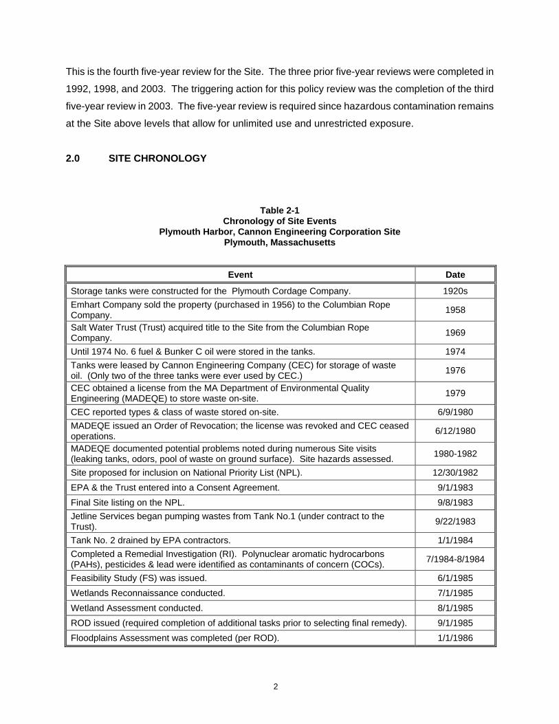
2.0 SITE CHRONOLOGY
Table 2-1
Chronology of Site Events Plymouth Harbor, Cannon Engineering Corporation Site
Plymouth, Massachusetts
Event Date
Storage tanks were constructed for the Plymouth Cordage Company. 1920s Emhart Company sold the property (purchased in 1956) to the Columbian Rope Company. 1958
Salt Water Trust (Trust) acquired title to the Site from the Columbian Rope Company. 1969
Until 1974 No. 6 fuel & Bunker C oil were stored in the tanks. 1974 Tanks were leased by Cannon Engineering Company (CEC) for storage of waste oil. (Only two of the three tanks were ever used by CEC.) 1976
CEC obtained a license from the MA Department of Environmental Quality Engineering (MADEQE) to store waste on-site. 1979
CEC reported types & class of waste stored on-site. 6/9/1980 MADEQE issued an Order of Revocation; the license was revoked and CEC ceased operations. 6/12/1980
MADEQE documented potential problems noted during numerous Site visits (leaking tanks, odors, pool of waste on ground surface). Site hazards assessed. 1980-1982
Site proposed for inclusion on National Priority List (NPL). 12/30/1982 EPA & the Trust entered into a Consent Agreement. 9/1/1983 Final Site listing on the NPL. 9/8/1983 Jetline Services began pumping wastes from Tank No.1 (under contract to the Trust). 9/22/1983
Tank No. 2 drained by EPA contractors. 1/1/1984 Completed a Remedial Investigation (RI). Polynuclear aromatic hydrocarbons (PAHs), pesticides & lead were identified as contaminants of concern (COCs). 7/1984-8/1984
Feasibility Study (FS) was issued. 6/1/1985 Wetlands Reconnaissance conducted. 7/1/1985 Wetland Assessment conducted. 8/1/1985 ROD issued (required completion of additional tasks prior to selecting final remedy). 9/1/1985 Floodplains Assessment was completed (per ROD). 1/1/1986
2

Event Date Work Plan & Field Operations Plan issued by the Responsible Parties (RPs) for tank demolition and disposal and a Supplemental Sampling Program. 4/1/1987
Remedial Action (fencing, tank demolition, drum, debris, waste and stained soil removal) completed by the RPs. 6/87 – 11/87
Supplemental sampling conducted (per ROD) by the RPs. Fall/1987 Revised Draft Supplemental Report completed by the RPs. 2/1/1988 Partial Consent Decree was entered into between EPA & CEC Settling Parties. 9/1/1988 ATSDR issued a Health Assessment. 10/1/1988 EPA completed an Endangerment Assessment. 4/1/1989 Deed restriction filed at Plymouth County Registry of Deeds. 4/1/1992 EPA issued a Site Close Out report. 5/29/1992 First Five-Year Review completed. 12/1/1992 Site deleted from NPL. 11/19/1993 Second Five-Year Review completed. 7/1/1998 Human health risk assessment submitted by Risk Management, Inc. (RMI) on behalf of New Millennium Ventures (NMV) to support lifting of deed restriction to allow residential development.
11/1/2000
EPA found the RMI risk assessment to be inadequate and requested additional sampling & that a soil management plan be prepared. 2/1/2001
Additional soil sampling and proposed soil management plan submitted by NMV’s consultant. 8/7/2001
EPA approved NMV’s sampling & soil management plans, but NMV never performed further sampling. 9/20/2001
Third Five-Year Review completed. 9/1/2003 Fourth Five-Year Review completed. 9/30/08
3.0 BACKGROUND This section contains information pertaining to the Site’s physical characteristics, current and prior
land use at the property, as well as, waste identification and characterization information. This
information has been obtained through a review of historical information, previous investigations,
zoning and flood maps, and a site visit.
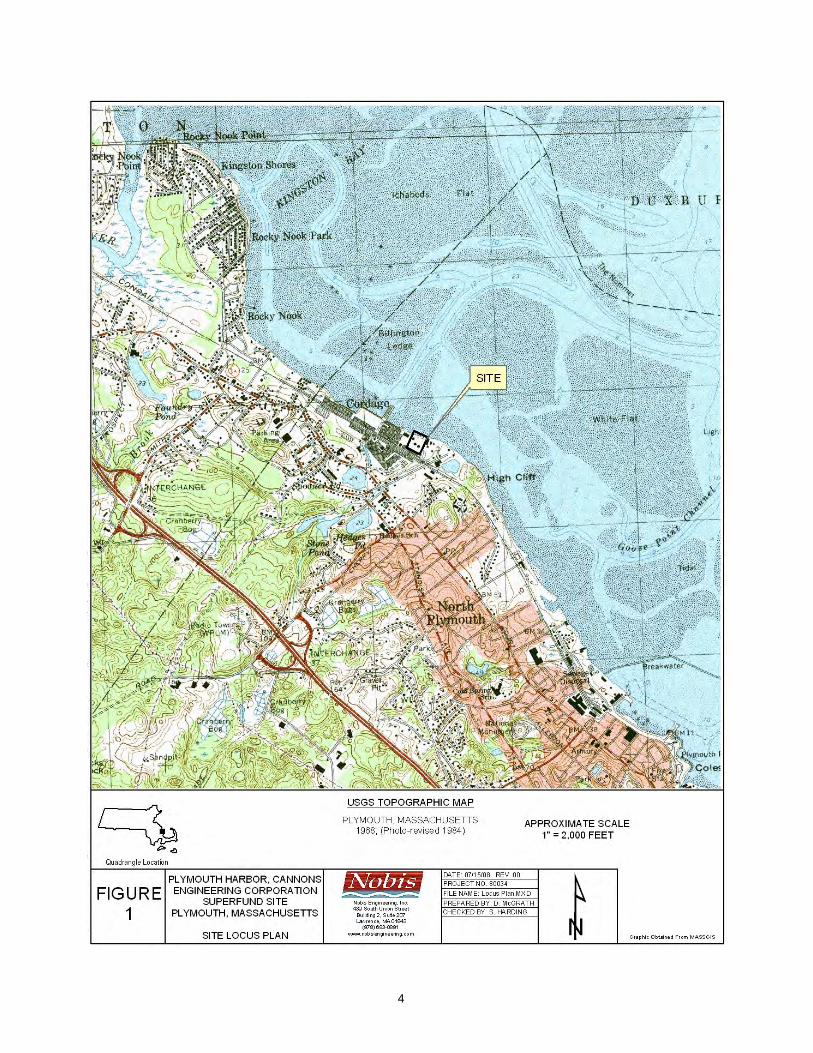
3.1 Physical Characteristics The Site is located in Cordage Park, a business and industrial park, adjacent to Plymouth Harbor,
Plymouth, Massachusetts (Figure 1). The Site consists of approximately 2.5 acres and is bordered
by a tidal stream to the southeast, a warehouse to the southwest, a former fish processing plant to
the northwest, and Plymouth Harbor to the northeast (Figure 2).
3
4
5
Three aboveground storage tanks were located in 6 to 8 foot deep earthen berms on the property
between the 1920s and 1987. Tank Nos. 1 and 2 each had a storage capacity of 250,000 gallons;
Tank No. 3 had a capacity of 500,000 gallons. The tanks were constructed in the 1920s and were
used until 1974 for storage of No. 6 marine fuel and Bunker C oil that was off-loaded from ocean
barges. In 1976, the CEC began using Tank Nos. 1 and 2 to store motor oils, plating sludge,
solvents, oily solids, pesticides, and other industrial substances. Tank No. 3 was not used by CEC
and remained empty. In response to an order of revocation, CEC ceased operations at the Site in
1980. Approximately 500,000 gallons of liquid hazardous substances stored in Tank Nos. 1 and 2
were left on the site. Tank No. 1 was drained by the Site owners in 1983. Tank No. 2 was drained
by EPA in 1984. The three tanks and connecting piping were dismantled and removed from the
Site in 1985. A perimeter fence was constructed to prevent access to the Site in 1987. Figure 2
shows the major features of the Site, including the locations of the three former tanks and the
remaining tank berms.
The topography of the property is relatively flat with a slight easterly slope towards Plymouth
Harbor. The highest points on the Site were the three berms surrounding the former tanks,
approximately 6 to 8 feet higher than the natural Site elevation. The Site is heavily vegetated with
grasses, large trees (up to eight-inch-diameter), and 4- to 5-foot high shrubs. Due to the
vegetation, there is limited potential for erosion.
The Site is comprised primarily of fill material containing silty sands, rock, brick, and/or slag. This
fill varies in thickness across the property, from one to nine feet and overlies a peat deposit in the
northern and northeastern portions of the property. These materials are underlain primarily by
unstratified sand and gravel, approximately twenty-two feet thick. Beneath that layer, fine grained
sand overlies a layer of silty clay that has created two surficial aquifers underlying the Site. The
generalized surficial geology map for Plymouth County shows surficial glacial outwash or fluvial
deposits in the vicinity of the Site. Groundwater is tidally influenced and flows in an easterly
direction towards Plymouth Harbor and the tidal stream along the southeast side of the Site.
Based on information from the Federal Emergency Management Agency (FEMA), most of the Site
lies within a 100-year coastal floodplain (FEMA, 2006). If the berms around the tank areas were not
present, the area would possibly become inundated during a major storm event (USEPA, 1985).
Although part of the coastal floodplain, the Site is not a protected open space, endangered species
habitat, or Area of Critical Environmental Concern. A number of surface water bodies are located
6

within 0.5 miles of the Site including: Hedges Pond to the southwest; Spooner Pond to the west;
unnamed water bodies to the west and southeast; and Plymouth Harbor to the north.
3.2 Land and Resource Use A review of the current Town of Plymouth zoning map located in the Plymouth Town Offices
indicated that the Site lies within an area zoned LI/WF (Light Industrial/Waterfront). This land use
description allows for “a mix of uses including commercial uses of light intensity, clean operational
nature, residential uses and compatible industrial uses” (Plymouth, 2008). In the past, the Site and
surrounding areas were used for industrial/commercial purposes; the areas near the Site presently
remain in industrial/commercial use.
A multi-story, multi-building commercial complex is located near the Site; however light industrial
uses predominate near the waterfront and directly adjacent to the Site. The Site is in close
proximity to a boat yard/marina located approximately 150 feet to the southeast; a glass bottle
crusher and warehouse located approximately 150 feet to the southwest; a former fish processing
plant and a large vacant brick structure formerly occupied by the Plymouth Cordage Co. is located
to the northwest. A number of beaches and tourist areas are nearby. For example, Duxbury beach
is approximately 4.0 miles northeast of the Site and Plymouth (Long) Beach is approximately 2.0
miles southeast of the Site. In addition, Plymouth Harbor, abutting the Site to the northeast, is used
for boating and other recreational activities. The Plymouth Rock historic area is located
approximately 1.0 mile southeast of the Site. These landmarks are not identified on Figure 1.
The Site is located in a medium yield non-potential drinking water source area. A high yield non-
potential drinking water source area is located within 0.5 miles of the Site. The Kingston municipal
water well supply is located 2.5 miles upgradient and inland from the Site. The aquifer below the
Site is not potable due to saline intrusion; therefore it is unlikely that it has been, or will be, utilized
as a source of drinking water (USEPA, 1989). There are no known private wells located within a
0.5-mile radius. All residents in the area are supplied with public water.
3.3 History of Contamination In the 1920’s, the three tanks were constructed for the Plymouth Cordage Company. Tank Nos. 1
and 2 had capacities of approximately 250,000 gallons each; Tank No. 3 had a capacity of
approximately 500,000 gallons. All were surrounded by 6- to 8-foot high berms (see Figure 2). The
tanks were used for storage of No. 6 fuel oil and Bunker C oil until 1974. CEC leased the tanks in
7
1976 and used Tank Nos. 1 and 2 for storage of motor oils, solvents, lacquers, organic and
inorganic chemicals, cyanide and plating waste, clay and filter media containing chemicals, plating
sludge, oil solids, and pesticides. Only two of the three tanks on-site were used by CEC, since
facility operations were terminated prior to the third tank becoming operational (USEPA, 1985). The
facility was licensed by the Commonwealth of Massachusetts for waste storage in 1979.
The Massachusetts Department of Environmental Quality Engineering (MADEQE) issued an Order
of Revocation in 1980, which forced CEC to close the Ste. When CEC ceased operations,
approximately 500,000 gallons of liquid hazardous wastes were left at the Site in Tank Nos. 1 and
No. 2. Between 1980 and 1983, MADEQE performed numerous Site inspections and noticed leaks
from seams in Tank Nos. 1 and 2 and a small pool of waste material on the ground surface
approximately 20 yards from Plymouth Harbor. Both EPA and MADEQE were concerned about a
possible catastrophic tank failure. The local fire marshal certified that the tanks posed a fire and
explosion hazard. Complaints of bad odors from the leaking tanks were also made by adjacent
property owners.
3.4 Initial Response Following the closing of the Site in 1980 and the identification of potential Site hazards, the
MADEQE contracted with Jetline Services, Inc. (Jetline) to remove hazardous materials and
contaminated soils from the Site and drain and clean the tanks. Tank No. 1 contained
approximately 221,000 gallons of product, 73,000 gallons of water, and no sludge or PCBs. Tank
No. 2 contained approximately 204,000 gallons of product with an estimated 82 parts per million
(ppm) of PCBs, 71,000 gallons of water with 71 ppm PCBs, and 6,000 gallons of sludge with 77
ppm PCBs (ATSDR, 1988). The Site was ranked according to the Hazard Ranking System and
proposed for inclusion on the National Priority List (NPL) in December 1982. The Site was listed on
the NPL in September 1983.
In 1983, pursuant to a Consent Agreement between EPA and the site owner, Jetline was contracted
by the site owner to drain Tank No. 1 and dispose of the waste. In January 1984, an EPA
contractor drained and cleaned Tank No. 2. By 1985, the three tanks were empty, the connecting
piping was cleaned, and the waste was removed. In total, approximately 425,000 gallons of
product, 144,000 gallons of water, and 6,000 gallons of sludge from the two tanks were transported
off-site for proper disposal (ATSDR, 1988). USEPA initiated an RI in early 1984.
8

3.5 Basis for Taking Action By 1985, EPA had completed an RI, a Wetlands Reconnaissance, and a Wetlands Assessment on
the Site. A qualitative human health risk assessment was conducted as part of the RI that identified
the primary contaminants of concern (COCs) as polynuclear aromatic hydrocarbons (PAHs),
pesticides, and lead. The risk assessment found the greatest potential risk to be from direct contact
or incidental ingestion of contaminated soils and concluded that the shallow soils presented the
greatest risk (USEPA, 1992a). The highest concentrations of COCs were found within the bermed
areas to a depth of 6 feet below ground surface. Pesticides and lead, but no PAHs, were found in
subsurface soils. The contaminants were distributed within the on-site soils in a random pattern
both laterally and vertically; no areas characteristic of a source area were identified. Off-site
sediments from the tidal stream contained a number of pesticides. It was concluded, however, that
the pesticides in the sediments were not Site related (USEPA, 1992a).
The primary COCs identified in the groundwater and surface water included low levels of metals, in
particular lead. Air samples showed no contaminants detected above ambient air background
concentrations.
4.0 REMEDIAL ACTION This section describes the remedial actions selected for and implemented at the Site.
4.1 Remedy Selection Ten remedial alternatives for the contaminated soils were evaluated in the 1985 FS. The 10
remedial alternatives, with the exception of the no action alternative, were variations of excavation,
capping, off-site land disposal, and off-site incineration. On September 30, 1985, EPA issued a
ROD based on the conclusions of the RI and FS. The goal of the ROD was to obtain a more
complete understanding of the risks associated with the Site to assess the need for an amended
ROD with a final remedy that would be protective of human health and the environment. The ROD
identified the following remedial action objectives (RAOs) based on the information in the RI:
• Minimize the potential for direct contact with surface soil; and
• Minimize the potential for off-site migration of hazardous chemicals” (USEPA, 1985).
Capping or excavation with off-site disposal were determined to be most applicable alternatives
based on the RAOs listed above. Because the Site is located in a 100-year floodplain, EPA
9

determined that the capping alternative required further study and that a floodplains assessment
should be performed to be consistent with Executive Order 11988 and EPA’s policy concerning
floodplains and wetlands. EPA felt that it would be advantageous to identify possible sources of
contamination beneath the tanks (after their removal) and confirm the pattern of contamination
identified in the RI prior to selection of the capping alternative. Therefore, prior to any soil
excavation and offsite disposal activities, EPA determined that additional sampling was necessary
to address the uncertainty about the extent of on-site contamination both below the tanks and
elsewhere on the Site.
Rather than selecting a final remedy, the USEPA required the completion of the following three
tasks before selecting and implementing a final remedy.
• Dismantling and off-site disposal of the three tanks and associated piping.
• Supplemental sampling of all media to confirm the pattern of contamination identified in the
RI and characterize the areas beneath the three tanks.
• Preparing a site-specific floodplains assessment.
EPA concluded that supplemental sampling and preparation of a floodplain assessment were
necessary to verify the RI data and conclusions, and that the selection of the final alternative should
be deferred until the supplemental sampling and evaluation was completed. EPA intended to
amend the ROD following an evaluation of the supplemental data and the selection of a final
remedial alternative. However, it was determined that the ROD did not require an amendment
based upon the supplemental sampling and floodplains assessment.
4.2 Remedy Implementation This section describes the completion of the tasks required by the ROD, the results of which were
intended to support the selection of a final remedy.
4.2.1 Floodplains Assessment As required under the ROD, a site-specific floodplains assessment was completed in January 1986.
The report examined the potential for the remedial alternatives identified in the FS to adversely
impact the floodplain, since the Site lies within the 100-year floodplain. A number of measures to
mitigate potential impacts to the floodplain were identified in the report. The recommendations
10
presented in the report were implemented during the response actions described below (USEPA,
1992a).
4.2.2 Tank Dismantling and Disposal In April 1987, EPA developed a Work Plan and Field Operations Plan (FOP) for the tank
dismantling and disposal and also the performance of the supplemental sampling program. The
Site was fenced in June 1987, prior to dismantling the tanks. The three tanks were inspected,
decontaminated, demolished, and disposed of offsite in the fall of 1987 in accordance with the
FOP.
Non-hazardous wastes, including miscellaneous demolition debris (e.g. concrete shed rubble,
overhead piping, and piping support materials) were disposed of at the James G. Grant Co. facility
in Hyde Park, Massachusetts. Manifested hazardous wastes, including drums (steel and plastic,
empty and with liquids or solids) were transported for processing at the Clean Harbors facility in
Braintree, Massachusetts. Clean Harbors packaged and shipped the liquid and solid wastes to
appropriate disposal facilities (USEPA, 1992a).
During the dismantling process an area of stained soil was found adjacent to the former location of
Tank No. 1. Approximately 3 cubic yards of soil from the area were excavated and drummed. The
drummed soil was transferred to Clean Harbors and disposed of off-site along with the other
hazardous wastes. However, an estimated additional 180 cubic yards of soil contaminated with
hazardous substances and oils remained within the Tank No. 1 bermed area (USEPA, 1992a) (this
soil was removed in 1988). Ambient air samples collected at the site perimeter after the tanks were
dismantled did not indicate any significant contamination.
4.2.3 Supplemental Sampling The supplemental sampling program specified in the ROD was necessary to confirm the pattern of
contamination that was reported in the 1984 RI and to characterize the distribution of contaminants
located beneath the storage tanks following their removal. Supplemental samples were collected in
the fall of 1987 from the contaminated soils located under the former tanks, and surface and
subsurface soil locations outside the tank berms; five on-site groundwater monitoring wells were
installed; and sediments located offsite in the tidal seep were sampled (ATSDR, 1988). The results
of the sampling events are discussed in Section 6.4.
11

4.2.4 Consent Decree In September 1988, the EPA and a group of potentially responsible parties (“PRPs”), including the
owner of the Site, entered into a Consent Decree, which set forth a response action of soil
excavation, confirmatory sampling, and backfilling with clean soil. EPA and the MassDEP
concluded that an amended ROD was not necessary. The Consent Decree set forth the following
activities:
• Excavate and dispose of soil contaminated with oily materials from inside the Tank No. 1
berm;
• Collect confirmatory soil samples from the excavated area; and
• Backfill the tank bermed areas with clean fill.
4.2.5 Soil Removal Pursuant to the September 1988 Consent Decree, the PRPs conducted a removal of the remaining
stained soil found near the former location of Tank No. 1 during the tank dismantling activities.
Approximately 200 tons of soil contaminated with oily and hazardous materials were excavated and
disposed of at a Subtitle C hazardous waste facility (USEPA, 1992c). An additional 50 tons of
contaminated soils excavated from the top 6 to 12 inches inside each of the three bermed areas
were disposed of along with the other stained soils (USEPA, 1992a).
Post-excavation soil grab samples were collected from the base and perimeter of the excavated
area, from the interior of the bermed areas, and from outside the bermed areas and composited.
The post-excavation soil sample results are discussed in Section 6.4.1. After the post-excavation
sampling, the excavated areas inside the three bermed areas were backfilled with 6 to 12 inches of
clean fill and re-graded to the grade of the area prior to the removal action. Perimeter air
monitoring for VOCs was conducted during the removal action. No ambient air readings above
background concentrations were detected.
4.2.6 Endangerment Assessment EPA completed an EA in April 1989 using Site data collected during the remedial and response
actions. Local demographics, land use, and zoning were used to develop current and future use
exposure scenarios. Data from grab soil samples collected and composited following excavation
and removal of the stained soils (Section 4.2.5), were used in the EA risk calculations. EPA
concluded that use of the Site for commercial or industrial purposes (the likely future use) would not
12
present any current or future exposure risk to human health or the environment; provided a deed
restriction was issued for the Site. EPA, in consultation with the MassDEP concluded that no
additional remedial action or a ROD amendment were necessary for the Site. This determination
was based on the findings of the EA, and the characterization of the response action as a removal
action.
4.2.7 Institutional Controls As recommended in the EA, a deed restriction was the main institutional control required for the
Site. A copy of the deed restriction is included in Appendix E of this report. The deed restriction,
recorded in the Plymouth County Registry of Deeds on April 21, 1992, limited future property use to
commercial or industrial development and also listed a number of restricted uses. The deed
restriction specifies that a human-health risk assessment must be performed prior to redevelopment
of the Site for any of the listed restricted uses. EPA and the MassDEP would use the risk
assessment results to determine if the proposed restricted use would pose an unacceptable risk of
exposure to contaminated Site soils. If the risk is acceptable, EPA, in consultation with MassDEP,
would certify the change in use and record the certification in the deed. However, if the proposed
use poses an unacceptable risk, the change in use would only be allowed by EPA and MassDEP
after a response action was performed to reduce the risk to an acceptable level.
The deed restriction also requires the property owner to inspect, maintain and repair the fence
around the perimeter of the Site. This requirement will remain in place until EPA and MassDEP
certify that it is no longer required.
4.3 Operations and Maintenance The remedy selected and implemented did not include any operations and maintenance activities.
According to the Site Close-Out report, “no groundwater extraction and treatment systems were
required and no source control measures, such as capping, were implemented which would
necessitate a long term operation and maintenance program” (USEPA, 1992a). As mentioned in
Section 4.2.7, pursuant to the deed restriction the Site owners are required to inspect, maintain and
repair a Site boundary fence until the EPA, in consultation with the MassDEP, determines that such
maintenance and repair of the fence is no longer necessary.
13

5.0 PROGRESS SINCE LAST FIVE-YEAR REVIEW This is the fourth five-year review for the Site. The third five-year review (USEPA, 2003) concluded
that the remedial action selected for the Site was protective of human health and the environment in
the short term because the remaining subsurface contamination was covered with clean fill.
However, the third five-year review required that several actions be taken to ensure that the remedy
remains protective in the long-term. The summary below outlines the recommendations included in
the third five year review and the outcome/resolution of recommendations.
• Replace and maintain the northern perimeter site fence
o The northern shoreline perimeter wooden-slat-type snow fence was repaired in
response to the recommendation provided in the third five-Year Review. However,
during the site inspection for the fourth five-year review, the fence was again found
to be in disrepair with several gaps noted. It is recommended that this recurring
problem be rectified with a more-permanent solution such as a chain-linked fence or
equivalent, or a more-rigorous maintenance schedule.
• Perform soil sampling and management following a plan approved by USEPA
o Since 2003, no additional soil sampling has been performed as there has been no
development proposed for the parcel.
• Complete a new risk assessment with new data to confirm the industrial/commercial use
exposures remain within the protective range
o New data has not been collected; therefore a new risk assessment has not been
performed.
• Complete a new risk assessment once new soil data are available
o New data has not been collected. Therefore, a new risk assessment has not been
performed.
A review conducted at the Plymouth County Registry of Deeds established that the current deed
restriction remains in place.
Although the owner of the Site is contemplating using the Site as a boat storage facility, they have
no immediate plans to move forward with any redevelopment at this time.
14
6.0 FIVE-YEAR REVIEW PROCESS This section provides a summary of the five-year review process and the actions taken by EPA to
complete the review.
6.1 Administrative Components EPA, the lead agency for this five-year review, notified MassDEP and the property owner in the
summer of 2008 that the five-year review would be completed. The MassDEP Site representative is
Jay Naparstek. A draft copy of this review has been provided to MassDEP for their review and
comment.
6.2 Community Notification and Involvement A press release was published in the Old Colony Memorial newspaper on July 2, 2008. The press
release summarized the Site activities, and stated that the results of this Five-Year Review would
be available. A copy of the press release is included in Appendix F.
According to previous investigations there has been limited public interest in the Site.
6.3 Document Review This five-year review consisted of a review of relevant documents including decision documents
and monitoring reports (see Appendix A).
6.4 Data Review A summary of relevant data regarding the components of the Site remedy is presented below. The
data reviewed were collected from 1987 to 1988, as part of the 1987 supplemental sampling
required by the ROD and the 1988 soil excavation response action required by the Consent Decree.
The results of these sampling events are summarized below by media. (A Massachusetts
Contingency Plan based human health risk assessment was completed by Risk Management, Inc.
(RMI) on behalf of the property owner in 2000. However, EPA did not consider the assessment to
be adequate as it did not meet the requirements set forth under CERCLA, and therefore it is not
presented here.)
15

6.4.1 Soil PCBs were not detected above reporting limits in any soil sample collected during the RI, and
therefore, follow-up sample collection completed at the Site did not include PCBs as an analyte.
Soil samples collected during the 1987 supplemental sampling event were free of VOC
contamination, but low levels of PAHs, pesticides, and lead were detected. The distribution of
contaminants was random, both vertically and laterally, as was concluded or found in the RI. The
highest concentrations were detected in shallow soils (ATSDR, 1988).
Following excavation of contaminated soils during the removal action in 1988, soil samples were
collected to characterize the excavated areas and general Site soils. Post-excavation soil samples
were collected from the base and perimeter walls of the excavated areas, from around the exterior
of the three bermed areas, from inside each of the three berms, and from soil excavated from the
Tank No. 1 area. Grab samples from each of these four areas were composited to form
representative samples, which were analyzed for PAHs, inorganics, and pesticides. The results of
these 1988 composite samples are discussed below.
No pesticides were detected in any of the samples; however, PAHs were detected in all of the
samples. The average PAH concentration was 111 ppm (total PAH) inside the bermed areas and 6
ppm (total PAH) outside the bermed areas (USEPA, 1992a). Inorganic compounds were detected
in samples at concentrations that were generally within the range of naturally occurring inorganic
compounds. The average lead concentration was 192 ppm inside the bermed areas and 78 ppm
outside the bermed areas (USEPA, 1992a). The lowest concentrations of both PAHs and lead were
found in the composited samples from outside the berms. The clean soil fill material was also
sampled prior to backfilling on the Site. The fill material contained lead at 2.7 ppm, but no PAHs
(USEPA, 1992).
The cPAH data from the 1988 post-excavation composite soil samples were used in the EA , as
well as, in the risk computations included in both the Second Five-Year Review Report (USEPA,
1998), the Third Five-Year Review (USEPA, 2003), and this fourth Five-Year Review (see
Appendix D).
The current use scenario in the 1989 EA assumed unlimited access to the entire site and not just
the areas inside the former berms. Therefore the EA assumes that the likelihood of contact with
16
any portion of the site (inside or outside of the bermed area) is equal. A site wide average
concentration was used to calculate exposure doses. The site wide average is an area weighted
value calculated assuming the bermed areas comprise approximately 1/3 of the total site area. The
contaminant concentrations for the areas inside the berms and outside the berms were obtained
from analysis of the fill material covering the berms and the composite samples of the area outside
the berms. The area concentrations were weighted to obtain the area weighted site average.
6.4.2 Groundwater Groundwater sampling was conducted as part of the 1987 supplemental sampling event at both low
and high tide to determine if the distribution of contamination was tidally influenced. In both the RI
and the supplemental sampling, groundwater samples were free of organic contamination, but
contained low levels of lead (below the federal maximum contaminant level (MCL) of 50 parts per
billion (ppb)). The distribution of lead contamination was random and no tidal influence was found
(ATSDR, 1988).
6.4.3 Surface Water Surface water samples were collected from the tidal stream during the 1987 supplemental sampling
event. During both the RI and the supplemental sampling investigation, organic compounds were
not detected and lead was the only inorganic compound detected. Lead concentrations were
significantly higher in the RI samples than they were in the supplemental samples; in fact, only two
of the eight samples collected as part of the supplemental investigation contained low-level
detectable concentrations. Silver and selenium were detected during the RI investigation, but not
during the supplemental sampling round (USEPA, 1989). No COCs associated with surface water
were identified.
6.4.4 Sediment The collection of sediment samples during both the RI and the 1987 supplemental sampling was
limited to the tidal stream (Figure 2). Similar contaminants (PAHs and lead) and levels of
contamination were detected in both sets of samples. The only difference noted was that pesticides
were not detected in the 1987 supplemental samples as they had been in the 1984 RI (ATSDR,
1988). In addition, no COCs associated with sediment were identified.
17

6.5 Site Inspection On July 24, 2008, EPA’s contractor conducted a Site inspection, accompanied by representatives
from Cordage Commerce Center property management. The inspection included a Site walkover
and an inspection of the berms and other topographic features. A Site inspection report, including
Site photographs, is included in Appendix B.
The northwestern, southern, southeastern, and eastern sides of the Site were secured by a chain
link fence with a padlocked gate. Along the northern and northeastern property boundary, the
wooden-slat snow-fence was observed, but several breaches in the fence were also noted,
therefore the Site was not fully secured. However, there did not appear to be any evidence of
trespassing or vandalism at the Site.
Debris including metal scraps, brick, plastic tubing, and broken sea shells were noted throughout
the property, in the high vegetation and on top of a razed building foundation. Several areas of
“coal ash” type material were observed around the Site outside the berms. Four of the five
monitoring wells, used during previous investigations, were observed. Although the wells appeared
to be intact, their metal casings may have rusted-shut.
The boat yard located east of the Site and glass bottle crushing facility located southwest of the
property appear to be fully operational, unlike the former fish processing facility and a multi-story
brick structure, located northwest, both of which appear to be completely vacant.
6.6 Interviews General discussions and observations were documented during the Site inspection on July 24, 2008.
Telephone interviews and e-mail correspondence were completed as a follow-up to the Site
inspection. The list of individuals interviewed regarding this fourth five-year review is shown in
Appendix C.
Joseph Jannetty of Janco Development stated that the Master Plan for the properties adjacent to
the Site is to raze the existing vacant structures and construct condominiums complete with a multi-
slip marina. Though not specifically part of the Master Plan, Mr. Jannetty indicated interest in
grading the Site for use as a storage area for boats. Mr. Jannetty stated that he was aware of EPA
and MassDEP requests to review any Site redevelopment plans. Redevelopment of the Site is not
imminent.
18

William Rudolph, the Cordage Commerce Center property manager, stated that trespassing was
not a problem on the Site itself but was a problem in adjacent vacant structures. His company
manages properties contiguous to the Site and provides security and monitoring for all the
properties. Mr. Rudolph was not aware of any fires or floods occurring at the Site.
During the course of the project, Mr. Derrick Golden of EPA provided Site-related information
regarding the Site history, setting, and project stakeholders. A formal interview of Mr. Golden was
not conducted as the interview-information had been obtained previously.
Mr. Jay Naparstek of MassDEP stated that there has not been any public interest in the Site, that
he is aware of, during the previous five years. Mr. Naparstek stated that MassDEP is sufficiently
informed about the status of the Site. As there has been little activity on the Site since the 1990s,
there has not been opportunity to discuss the Site. However, MassDEP is certain that they would
be informed of any future redevelopment of the Site.
Interviews conducted with Town of Plymouth Officials from the Economic Development/Planning
Department, Building Department, and Zoning Board of Appeals stated that there are no current
plans on-file at the town regarding development of the Site.
The Site repository remained located in the Government References section of the Town of
Plymouth Public Library.
7.0 TECHNICAL ASSESSMENT This section provides a technical assessment of the remedy implemented at the Site, as outlined in
the Comprehensive Five-Year Review Guidance (USEPA, 2001b). The remedy has been
evaluated based on its function in accordance with decision documents, its adherence to valid risk
data and scenarios, as well as any other information that could have affected the remedy’s
protectiveness. There were no ARARs and/or “to be considered” (TBCs) identified in the 1985 ROD
since it was a pre-SARA ROD.
19
7.1 Question A: Is the Remedy Functioning as Intended by the Decision
Documents? Yes, the remedy is functioning as intended. Clean fill covers the remaining subsurface
contamination. However, in the long-term, before any reuse of the property, new sampling is
needed and a current risk assessment should be performed. Requirements are in-place which
would require such action on the part of the property owner if the Site is to be redeveloped for any
of the restricted uses; however these requirements do not extend to all uses of the site property. In
addition, the fence along Plymouth Harbor is in disrepair and requires replacement or a more-
rigorous maintenance routine. It should be noted however, that no evidence of trespassing or
disturbance of the soil cover was noted during the July 24, 2008 site inspection.
Remedial action performance and monitoring results. The dismantling and disposal of the three
tanks, a floodplains assessment, and the collection of supplemental soil, groundwater, surface
water, and sediment samples were required by the 1985 ROD. Soil excavation and off-site
disposal, the collection of confirmatory samples, and backfilling with clean fill were additional
response activities required by the 1988 Consent Decree. All response activities were completed
by 1988. Since the ROD and subsequent decision documents did not establish any clean-up
criteria, there were no specific performance standards that had to be achieved. The Site was
deleted from the NPL in 1993.
Operations and Maintenance Costs. There were no O&M activities specified in the ROD, however
in the recorded deed restrictions, the property owner agreed to maintain and repair the fence
surrounding the Site until EPA, in consultation with the MassDEP, determines that it is no longer
necessary.
Indicators of Remedy Problems. Based on the Site inspection and a review of Site documents,
there do not appear to be any indications of problems with the remedy, with the exception of risk
assessment factors and access controls as discussed below.
Implementation of Institutional Controls. As required by the EA, a deed restriction on the property
was recorded in the Plymouth County Registry of Deeds on April 12, 1992. The deed restriction
limited future property use to commercial, industrial and/or other use as permitted under the Town
of Plymouth Zoning Bylaws. In addition, the deed restriction included the following restricted uses:
single-family or multiple-family residences, school facilities, hotel, motel, or recreational or
20

community facilities (Declaration of Restrictions, 1992, see Appendix E). Redevelopment for any
listed restricted use can only be considered after performance of a human health risk assessment
and the concurrence of EPA and MassDEP. The deed restriction continues to be in effect. The
deed restriction also requires access controls; and the property owner is required to inspect,
maintain and repair the fence around the perimeter of the Site. The wooden slat snow-fence along
the northern and northeastern perimeter of the Site is in poor condition with several breaches noted,
leaving open access to the Site and potentially placing the remedy’s protectiveness at risk in the
long term. In addition, the deed restriction does not include the more comprehensive re-
development requirements that were recommended at the time of the third five-year review (e.g.,
performance of sampling and a risk assessment prior to any reuse of the property, including
industrial/commercial uses).
7.2 Question B: Are the Exposure Assumptions, Toxicity Data, Cleanup
Levels, and Remedial Action Objectives (RAOs) Used at the Time of
the Remedy Selection Still Valid? No, the exposure assumptions and toxicity data used at the time of the remedy selection are no
longer valid. However, recalculations of risk to trespassers and industrial/commercial workers
based on composite soil data collected more than 20 years ago indicate that the remedy is still
protective of human health for current use and potential future redevelopment of the Site for
industrial or commercial use. Because estimated adult commercial worker and adolescent
trespasser risks are at the high end of the protectiveness range, and because the soil data is of
questionable value for current risk assessment purposes, it is important to collect new data and
reevaluate risks to confirm protectiveness prior to any redevelopment. The ROD and subsequent
decision documents did not establish any performance standards. The RAOs used at the time of
the remedy selection are still valid.
Changes in Land Use of the Site and Physical Site Conditions
No changes in land use or the physical conditions of the property have occurred since the third five-
year review. The Site remains vacant; however, the snow-fence located along the northeastern
property boundary was noted to be down in several areas. Refer to Photographs 9, 10, and 11 in
Appendix B.
New Contaminants and/or Contaminant Sources
No new contaminants or contaminant sources have been identified since the remedy.
21

Changes in Standards or TBCs
Since the ROD and subsequent decision documents did not specify any ARARs or TBCs there
were no standards to review, except for the human health risk assessment guidance described
below. Site soils were identified as the only potential threat, and PAHs and lead as the only COCs,
in the EA. The soil removal action and subsequent Site delisting were based on risk calculations
determined to be within EPA acceptable risk ranges.
Changes in Exposure Pathways and Exposure Assumptions
There have been no changes in land use in the vicinity of the Site since the third Five-Year Review.
The 1989 EA identified older child trespassers and adult workers as those most likely to be
exposed to soil contamination and dermal contact and incidental ingestion as the only two exposure
pathways. These two exposure scenarios remain the most likely current or future exposures. The
adult worker exposure scenario assumes full-time workers at the Site after redevelopment for
industrial/commercial use. Currently, the Site remains vacant. With proper maintenance of the
perimeter fence, all current exposures are eliminated. The older child trespasser and adult worker
scenarios identified in the EA reflect potential future scenarios should the Site be redeveloped for
industrial/commercial use or the fence be removed, allowing access to trespassers.
Since the development of these scenarios in the EA, EPA has established recommended default
exposure frequency and exposure duration assumptions for industrial/commercial workers. These
default assumptions reflect greater exposures than those estimated in the EA. No default
assumptions regarding exposure frequency and exposure duration have been established for
trespassers. The Risk Assessment Guidance for Superfund Volume 1: Human Health Evaluation
Manual (Part E, Supplemental Guidance for Dermal Risk Assessment), Interim Guidance (USEPA,
2004) was used to establish dermal exposure parameters during the previous five-year review.
This document was updated in 2004, but none of the exposure assumptions utilized in the Third
Five-Year Review have changed.
Changes in Toxicity and Other Contaminant Characteristics
The contaminants with the greatest cancer risk potential at the Site were carcinogenic PAHs
(cPAHs). As noted in the third Five-Year Review, the cancer slope factor (CSF) (formerly called
cancer potency factor) for the most toxic PAH, benzo(a)pyrene, decreased from 11.5 (mg/kg-day)-1
to 7.3 (mg/kg-day)-1
and estimated potencies for six cPAHs were established. There have been no
22
changes in CSFs since 1998. A decrease in a CSF indicates that potential risk from exposure to
contaminants is lower than previously calculated. However, the historical data does not
consistently report specific PAH constituents; subsequent risk assessment calculations have thus
assumed that the reported total PAH concentrations represent cPAHs of equivalent potency to
benzo(a)pyrene. This approach likely overestimates risk.
Changes in Risk Assessment Methods
The EA identified lead as a COC. As noted in the previous five-year reviews, EPA now uses
several models to predict blood lead levels that would result due to exposure to lead-contaminated
soil. This change in the risk assessment method for evaluation of lead exposures has remained the
same since the third Five-Year Review. Since lead concentrations were below the residential
screening level currently used, they do not pose a significant public health hazard.
In March 2005, EPA published an updated version of the Guidelines for Carcinogen Risk
Assessment and a new supplement, Supplemental Guidance for Assessing Susceptibility from
Early-Life Exposures to Carcinogens. These documents provide a revised method of evaluating
risk to children and adolescents from carcinogens with a mutagenic mode of action, including
PAHs. This guidance impacts the risk calculations for the trespasser scenario. They do not impact
the calculations for the industrial/commercial worker. For children ages 2 through 16, cancer slope
factors for carcinogens with a mutagenic mode of action should be adjusted by a factor of 3. Risks
to trespassers from PAHs (the only contaminants evaluated in the previous five-year reviews at this
Site) increase 3-fold. Appendix D presents revised cancer risks based on consideration of the
mutagenic mode of action for cPAHs for older child trespassers of 1.6x10⁻⁴ (similar to the cancer
risk estimates for industrial workers of 1.7x10⁻⁴ calculated during the third five-year review).
Although the quantitative risk estimates of 1.6x10⁻⁴ and 1.7x10⁻⁴ round to 2x10⁻⁴, it is likely that
the risks are 1x10⁻⁴ or less (at the high end of the acceptable range) because the calculations used
the maximum concentration of total PAH, and assumed that all the PAHs were carcinogenic and as
carcinogenic as the most carcinogenic PAH (benzo(a)pyrene). These assumptions are
conservative because some of the PAHs are non-carcinogenic or carcinogenic but less toxic than
benzo(a)pyrene, and a realistic exposure scenario would be to a lower concentration than the
maximum.
23
Changes in Risk Assessment Conclusions
As part of this five-year review, cancer risks for older child trespassers exposed to cPAHs through
soil ingestion and dermal contact were re-calculated, using current risk assessment methods and
assumptions. The calculations (see Appendix D) follow the Supplemental Guidance for Assessing
Susceptibility from Early-Life Exposures to Carcinogens. The calculated potential risks are:
Combined risk for older child trespasser exposure to cPAHs = 1.6 x 10⁻⁴
Appendix D presents revised cancer risks based on consideration of the mutagenic mode of action
for cPAHs for older child trespassers of 1.6x10⁻⁴, which is at the high end of acceptable (similar to
the cancer risk estimates for industrial workers calculated during the third five-year review.
Appendix D presents revised cancer risks based on consideration of the mutagenic mode of action
for cPAHs for older child trespassers of 1.6x10⁻⁴, (similar to the cancer risk estimates for industrial
workers of 1.7x10⁻⁴, calculated during the third five-year review). Although the quantitative risk
estimates of 1.6x10⁻⁴, and 1.7x10⁻⁴, round to 2x10⁻⁴,, it is likely that the risks are 1x10⁻⁴, or less (at
the high end of the acceptable range) because the calculations used the maximum concentration of
total PAH, and assumed that all the PAHs were carcinogenic and as carcinogenic as the most
carcinogenic PAH (benzo(a)pyrene). These assumptions are conservative because some of the
PAHs are non-carcinogenic or carcinogenic but less toxic than benzo(a)pyrene, and a realistic
exposure scenario would be to a lower concentration than the maximum. Because estimated adult
commercial worker (calculated in the third five-year review) and adolescent trespasser (calculated
in this five-year review) risks are likely to be at the high end of the protectiveness range, and are
based on data collected years ago not using current data collection methods for purposes of risk
assessment evaluation, it is particularly important to collect new data and reevaluate risks to
confirm protectiveness prior to any redevelopment.
Soil Outside the Bermed Areas
As part of this five-year review, potential risks associated with soil outside the bermed area were
recalculated using current risk assessment methods and assumptions. A site wide average of 2
mg/kg carcinogenic PAHs was used for the current use scenario and results in total trespasser
cancer risk of 2.3 x 10⁻⁶
which is within EPA’s acceptable risk range. See section 6.4.1 for further
discussion of how the site wide average of 2 mg/kg PAHs was determined and see Appendix G for
the risk calculations.
24
Expected Progress Towards Meeting RAOs
The following is a summary of the RAOs for the remedy that were established in the 1985 ROD with
a brief assessment of the progress that has been made towards meeting these objectives.
The ROD identified the following RAOs based on the information in the RI:
• Minimize the potential for direct contact with surface soil; and
• Minimize the potential for off-site migration of hazardous chemicals.
Minimize the potential for direct contact with surface soil: The tank removal and disposal,
excavation and removal of contaminated soils, and backfilling of tank bermed areas with clean fill
have reduced potential for direct contact with contaminated surface soil.
Minimize the potential for off-site migration of hazardous chemicals: The tank removal and disposal,
excavation and removal of contaminated soils, and backfilling of tank bermed areas with clean fill
have reduced off-site migration of hazardous chemicals.
7.3 Question C: Has Any Other Information Come To Light That Could
Call Into Question the Protectiveness of the Remedy? No, aside from the human health risk assessment factors described above and the reinstallation of
the perimeter fence on the northern and northwestern boundaries, there is no additional information
that may call into question the protectiveness of the remedy. The Site is within a 100-year
floodplain, as previously mentioned, but there have been no substantial changes to the Site with
regard to flooding, construction, grading, etc. In addition, there are no species whose habitat is
likely to be at risk.
7.4 Technical Assessment Summary The discussions related to Questions A, B, and C above indicate that in general the remedy for the
Site is protective. However, proper maintenance of access controls, and collection of new soil data
to support and confirm that the exposures are within the protective range, are required to ensure
the protectiveness of the remedy. The basis for this conclusion is summarized below.
Question A: The deed restriction is functioning as intended with the exception of the portion
pertaining to access controls. The perimeter fence has not been maintained to restrict access to
25

trespassers along the shoreline side of the Site. In addition, the deed restrictions do not require the
performance of a risk assessment prior to any site redevelopment (under the deed restriction, this
requirement only applies to redevelopment for restricted uses).
Question B: Exposure assumptions, toxicity data, and risk assessment methods have changed
since the time of the remedy selection. Recalculations of risk to trespassers and
industrial/commercial workers based on composite soil data collected more than 20 years ago
results in risks slightly exceeding 1x10⁻⁴. It is likely that the risks are 1x10⁻⁴ or less (at the high
end of acceptable) because the calculations used the maximum concentration of total PAH, and
assumed that all the PAHs were carcinogenic and as carcinogenic as the most carcinogenic PAH
(benzo(a)pyrene). While the conditions at the Site appear to be protective of current and future
human health based on an older child/trespasser and an industrial/commercial use scenario, the
likely risks for these scenarios are at the high end of the protectiveness range, and the data upon
which the estimates are based is of questionable quality. New data is required to further support
and confirm this conclusion, prior to site redevelopment.
Question C: No changes have occurred at the Site and it remains vacant and undeveloped.
8.0 ISSUES This section provides a summary of the issues identified during this fourth five-year review.
Recommendations and follow-up actions are presented in Section 9.0. A tabular summary of the
issues identified is included at the conclusion of Section 8.0.
• Inadequate Access Controls
As provided in the deed restriction, the site owner is required to maintain and repair the
fence surrounding the Site until EPA, in consultation with the MassDEP, determines that the
fence is no longer necessary. Although the chain link fence surrounding much of the Site is
in good condition and the entranceway was secured with a padlock, the wooden-slat snow-
fence along the northern and northeastern property border had fallen in several places and
has not been replaced. Refer to photographs 9, 10, and 11 in Appendix B.
• Site Redevelopment for a Restricted Use and/or for Commercial/Industrial Uses
26
The deed restriction on the Site requires the completion of a new risk assessment before
redevelopment for any restricted use listed in the deed restriction.
Calculations performed as part of the third five-year review and this report (see Appendix D)
indicated that the cancer risks for adult workers in a commercial/industrial future use
scenario and for older child/trespassers are likely to be at the high end of EPA’s acceptable
range. The risk calculations were made using data from 1988 that were not collected for
risk assessment purposes. Using available data of questionable quality (now over 20 years
old), in conjunction with updated default exposure frequencies and durations, updated
dermal exposure parameters, and updated risk guidance, has resulted in risk estimates
likely to be at the high end of the acceptable range that need to be confirmed with better
quality data (Appendix D).
Based on the current available information and risk estimates provided in the 2003 five-year
review and this five-year review, a new risk assessment, using new data and updated
methods, should be performed to support and confirm the cancer risk estimates prior to any
Site redevelopment (including industrial/commercial redevelopment).
The current deed restriction requires that prior to commencement of Site redevelopment
activities for any of the restricted uses, a detailed redevelopment plan must be submitted to
EPA and MassDEP. Based on the current available data and risk assessments performed
in the 2003 five-year review and this five-year review, a detailed redevelopment plan prior to
commencement of any Site redevelopment activities (including industrial/commercial
activities), must be submitted to EPA and MassDEP for review and approval.
Table 8-1
Issues Plymouth Harbor, Cannon Engineering Corporation Site
Plymouth, Massachusetts
Issues Affects Current Protectiveness
(Y/N)
Affects Future Protectiveness
(Y/N) Inadequate Access Controls – Northern/Northeastern perimeter fence in disrepair N Y
Site Redevelopment for a Restricted Use & Adequate Risk Assessment N Y Site Redevelopment for a Commercial/Industrial Use & Adequate Risk Assessment N Y
27
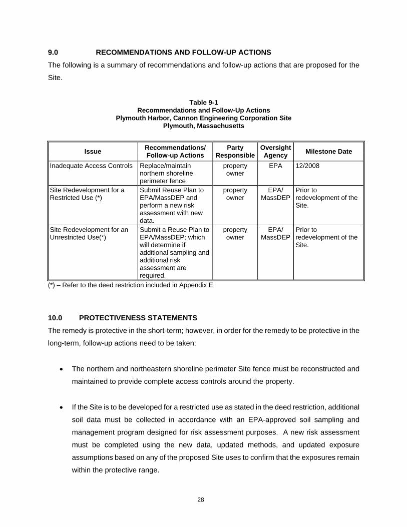
9.0 RECOMMENDATIONS AND FOLLOW-UP ACTIONS The following is a summary of recommendations and follow-up actions that are proposed for the
Site.
Table 9-1
Recommendations and Follow-Up Actions Plymouth Harbor, Cannon Engineering Corporation Site
Plymouth, Massachusetts
Issue Recommendations/ Follow-up Actions
Party Responsible
Oversight Agency Milestone Date
Inadequate Access Controls Replace/maintain northern shoreline perimeter fence
property owner
EPA 12/2008
Site Redevelopment for a Restricted Use (*)
Submit Reuse Plan to EPA/MassDEP and perform a new risk assessment with new data.
property owner
EPA/ MassDEP
Prior to redevelopment of the Site.
Site Redevelopment for an Unrestricted Use(*)
Submit a Reuse Plan to EPA/MassDEP; which will determine if additional sampling and additional risk assessment are required.
property owner
EPA/ MassDEP
Prior to redevelopment of the Site.
(*) – Refer to the deed restriction included in Appendix E
10.0 PROTECTIVENESS STATEMENTS The remedy is protective in the short-term; however, in order for the remedy to be protective in the
long-term, follow-up actions need to be taken:
• The northern and northeastern shoreline perimeter Site fence must be reconstructed and
maintained to provide complete access controls around the property.
• If the Site is to be developed for a restricted use as stated in the deed restriction, additional
soil data must be collected in accordance with an EPA-approved soil sampling and
management program designed for risk assessment purposes. A new risk assessment
must be completed using the new data, updated methods, and updated exposure
assumptions based on any of the proposed Site uses to confirm that the exposures remain
within the protective range.
28
29
• Prior to commencement of any Site redevelopment activities, a detailed redevelopment plan
must be submitted to EPA and MassDEP. This plan should include a statement of the
proposed work, Site activities, and information pertaining to environmental monitoring
procedures, health and safety measures, and soil management activities to ensure worker
and public safety during construction.
• Since exposure scenarios and toxicity values have been modified since the original samples
were collected; soil sample collection and an updated risk assessment must be completed
prior to any redevelopment of the Site (including commercial/industrial development). All
additional soil data must be collected in accordance with an EPA-approved soil sampling
and management program designed for risk assessment purposes and procedures in place
at that time. To ensure that these requirements are met, EPA will initiate further discussions
with the Site owner.
If the site remains undeveloped, no sampling or risk assessment is required.
11.0 NEXT REVIEW A fifth five-year review for the Plymouth Harbor Site will be conducted in 2013.
APPENDIX A
DOCUMENT REVIEW LIST/REFERENCES
DOCUMENTS REVIEWED/REFERENCES CITED
ATSDR (Agency for Toxic Substances and Disease Registry), 1988. Health Assessment, October 26. Declaration of Restrictions, 1992. Recorded at the Plymouth County Registry of Deeds on April 21. Carter, J. 1977. Executive Order 11988, Floodplains Management 42 F.R. 26951. May 24. Carter, J. 1977. Executive Order 11990, Protection of Wetlands 42 F.R. 26961. May 24. Carter, J. 1979. Executive Order 12148, Federal Emergency Management 44 FR 42957. July 20. Fasanella & Wood, LLP, 2001. Letter from Attorney Fasanella to USEPA and MADEP regarding sampling plan and soil management plan approval, September 27. FEMA, 1992. Flood Insurance Rate Map,Town of Plymouth, Massachusetts. Community Panel Number 250278 0006 D. Revised July 2. MADEP, 2001a. Fax from Harish Panchel, MADEP, to Derrick Golden, USEPA, regarding draft letter to RMI, January 30. MADEP, 2001b. Internal Memorandum regarding review of MCP Method 3 Risk Characterization/CERCLA Risk Assessment dated November 22, 2000, April 27. MADEP, 2002. Letter from Harish Panchal, MADEP, to Derrick Golden, USEPA, regarding change in lead of Project Management of the site, March 8. Plymouth Registry of Deeds, 1992. Deed Restriction, April 21. Plymouth, 2002. Town of Plymouth Zoning Bylaw, revised December 23. Plymouth, 2008. Town of Plymouth Tax Assessors Map No. 1, January 1. RMI, 2000. MCP Method 3 Risk Characterization/CERCLA Risk Assessment, November 22. RMI, 2001a. Letter from Peter Woodman, RMI, to Derrick Golden, USEPA, regarding response to USEPA Risk Assessment comments, April 12. RMI, 2001b. Internal Memorandum regarding USEPA additional sampling request, July 11. RMI, 2001c. Internal Memorandum regarding details for USEPA additional soil sampling and management plan request, August 7.
US District Court, 1988. Partial Consent Decree (C.A. No.’s. 88-1786-WF, 88-1797-WF, 88-1788-WF), April 9. USEPA, 1985. EPA Superfund Record of Decision. U.S. Environmental Protection Agency, Region I. September 30. USEPA, 1989. Endangerment Assessment Public Health Post-Remedial/Removal Action. U.S. Environmental Protection Agency, Region I. April 6. USEPA, 1992. Superfund Site Close Out Report. U.S. Environmental Protection Agency, Region I. May 29. USEPA, 1992a. Five-year Review. U.S. Environmental Protection Agency, Region I. December 4. USEPA, 1998. Second Five-year Review. U.S. Environmental Protection Agency, Region I. July 29. USEPA, 2000. Internal Memorandum regarding review of MCP Method 3 Risk Characterization/CERCLA Risk Assessment dated November 22, 2000, December 20. USEPA, 2001a. Letter from Derrick Golden, USEPA, to Peter Woodman, RMI, regarding MCP Method 3 Risk Characterization/CERCLA Risk Assessment report dated November 22, 2000, February 12. USEPA, 2001b. Comprehensive Five-year Review Guidance, OSWER Directive 9355.7-03B-P, June. USEPA, 2001c. Letter from Derrick Golden, USEPA, to Peter Woodman, RMI, regarding additional sampling plan, September 20. USEPA, 2001d. Letter from Derrick Golden, USEPA, to Attorney Fasanella regarding letters dated September 27, 200 & October 17, 2001 as well as conference call on September 17, 2001, October 26. USEPA, 2003. Third Five-Year Review. U.S. Environmental Protection Agency, Region I. September. USEPA, 2004. Risk Assessment Guidance for Superfund Volume 1: Human Health Evaluation Manual (Part E, Supplemental Guidance for Dermal Risk Assessment), Interim Guidance, July. 40 Code of Federal Regulations Part 264 Section 228, Standards for Owners and Operators of Hazardous Waste Treatment, Storage, and Disposal Facilities; Subpart K – Surface Impoundments, Closure and Post-Closure Care Title 42 U.S. Code, Chapter 103; Comprehensive Environmental Response, Compensation, and Liability.

APPENDIX B
SITE INSPECTION REPORT

Site Inspection Checklist
I. SITE INFORMATION
Site name: Plymouth Harbor/Cannon Engineering Date of inspection: July 24, 2008
Location and Region: Plymouth, MA – Region 1 EPA ID: MAD980525232
Agency, office, or company leading the five-year review: EPA
Weather/temperature: Sunny, ~90°F
Remedy Includes: (Check all that apply) Landfill cover/containment Monitored natural attenuation Access controls Groundwater containment Institutional controls Vertical barrier walls Groundwater pump and treatment Surface water collection and treatment Other: Final remedy is deferred until additional supplemental sampling has been completed.
Activities completed on site per the ROD include: tank removal; supplemental sampling and; floodplains assessment. A subsequent Consent Decree was entered into between EPA and the SPs in which additional excavation and clean soil placement was completed. Additionally, an EA was completed by EPA which concluded that access to the property must be controlled and a use restriction was to be placed on the property.
Attachments: Inspection team roster attached Site map attached Site photographs
II. INTERVIEWS (Check all that apply)
1. O&M site manager Joseph Jannetty Principal 7/24/08 Name Title Date Interviewed at site ⌧ at office by phone Phone no. ______________
Problems, suggestions; Report attached 2. O&M Staff William Rudolph Property Manager 7/24/08 Name Title Date Interviewed ⌧ at site at office by phone Phone no. ______________ Problems, suggestions; Report attached
X
3. Local regulatory authorities and response agencies (i.e., State and Tribal offices, emergency response office, police department, office of public health or environmental health, zoning office, recorder of deeds, or other city and county offices, etc.) Fill in all that apply.
Agency: No interviews other than Site personnel conducted at the time of the inspection Contact: Name Title Date Phone no. Problems; suggestions; Report attached
Agency: Contact: Name Title Date Phone no. Problems; suggestions; Report attached Agency: Contact: Name Title Date Phone no. Problems; suggestions; Report attached Agency: Contact:
Name Title Date Phone no. Problems; suggestions; Report attached
4. Other interviews (optional) Report attached.
III. ON-SITE DOCUMENTS & RECORDS VERIFIED (Check all that apply)
1. O&M Documents O&M manual Readily available Up to date N/A As-built drawings Readily available Up to date N/A Maintenance logs Readily available Up to date N/A
Remarks__________________________________________________________________________ ____________________________________________________________________
2. Site-Specific Health and Safety Plan Readily available Up to date N/A Contingency plan/emergency response plan Readily available Up to date N/A
Remarks__________________________________________________________________________ _________________________________________________________________________________
3. O&M and OSHA Training Records Readily available Up to date N/A Remarks__________________________________________________________________________ _________________________________________________________________________________
4. Permits and Service Agreements Air discharge permit Readily available Up to date N/A Effluent discharge Readily available Up to date N/A Waste disposal, POTW Readily available Up to date N/A Other permits_____________________ Readily available Up to date N/A
Remarks__________________________________________________________________________ _________________________________________________________________________________
5. Gas Generation Records Readily available Up to date N/A Remarks__________________________________________________________________________ _________________________________________________________________________________
6. Settlement Monument Records Readily available Up to date N/A Remarks__________________________________________________________________________ _________________________________________________________________________________
7. Groundwater Monitoring Records Readily available Up to date N/A Remarks__________________________________________________________________________ _________________________________________________________________________________
8. Leachate Extraction Records Readily available Up to date N/A Remarks__________________________________________________________________________ _________________________________________________________________________________
9. Discharge Compliance Records Air Readily available Up to date N/A Water (effluent) Readily available Up to date N/A
Remarks__________________________________________________________________________ _________________________________________________________________________________
10. Daily Access/Security Logs Readily available Up to date N/A Remarks__________________________________________________________________________ _________________________________________________________________________________
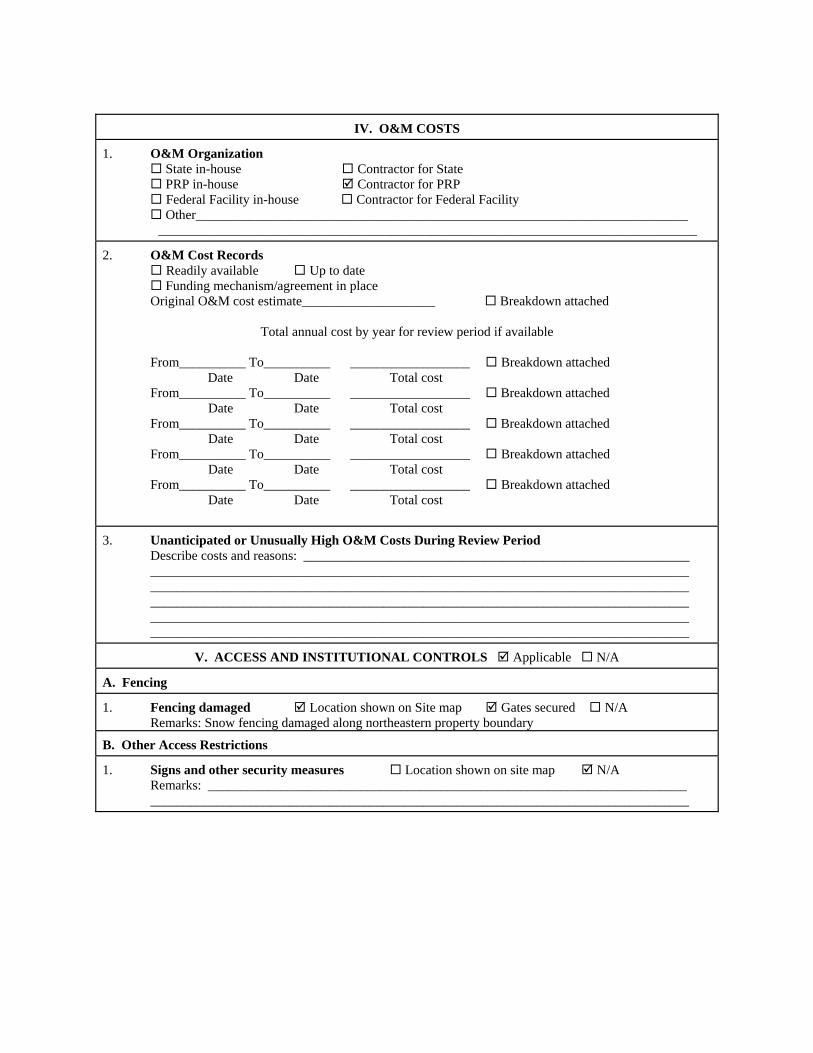
IV. O&M COSTS
1. O&M Organization State in-house Contractor for State PRP in-house Contractor for PRP Federal Facility in-house Contractor for Federal Facility Other__________________________________________________________________________
_________________________________________________________________________________
2. O&M Cost Records Readily available Up to date Funding mechanism/agreement in place
Original O&M cost estimate____________________ Breakdown attached
Total annual cost by year for review period if available
From__________ To__________ __________________ Breakdown attached Date Date Total cost
From__________ To__________ __________________ Breakdown attached Date Date Total cost
From__________ To__________ __________________ Breakdown attached Date Date Total cost
From__________ To__________ __________________ Breakdown attached Date Date Total cost
From__________ To__________ __________________ Breakdown attached Date Date Total cost
3. Unanticipated or Unusually High O&M Costs During Review Period Describe costs and reasons: __________________________________________________________ _________________________________________________________________________________ _________________________________________________________________________________ _________________________________________________________________________________ _________________________________________________________________________________ _________________________________________________________________________________
V. ACCESS AND INSTITUTIONAL CONTROLS Applicable N/A
A. Fencing
1. Fencing damaged Location shown on Site map Gates secured N/A Remarks: Snow fencing damaged along northeastern property boundary
B. Other Access Restrictions
1. Signs and other security measures Location shown on site map N/A Remarks: ________________________________________________________________________ _________________________________________________________________________________

C. Institutional Controls (ICs)
1. Implementation and enforcement Site conditions imply ICs not properly implemented Yes No N/A Site conditions imply ICs not being fully enforced Yes No N/A
Type of monitoring (e.g., self-reporting, drive by) _________________________________________ Frequency ________________________________________________________________________ Responsible party/agency ____________________________________________________________ Contact ____________________________ __________________ ________ ____________
Name Title Date Phone no.
Reporting is up-to-date Yes No N/A Reports are verified by the lead agency Yes No N/A
Specific requirements in deed or decision documents have been met Yes No N/A Violations have been reported Yes No N/A Other problems or suggestions: Report attached Damage to fencing may impact protectiveness of this remedy, repair to the fencing is advised _________________________________________________________________________________
2. Adequacy ICs are adequate ICs are inadequate N/A Remarks__________________________________________________________________________ _________________________________________________________________________________ _________________________________________________________________________________
D. General
1. Vandalism/trespassing Location shown on site map No vandalism evident Remarks__________________________________________________________________________ _________________________________________________________________________________
2. Land use changes on site N/A Remarks__________________________________________________________________________ _________________________________________________________________________________
3. Land use changes off site N/A Remarks__________________________________________________________________________ _________________________________________________________________________________
VI. GENERAL SITE CONDITIONS
A. Roads Applicable N/A
1. Roads damaged Location shown on site map Roads adequate N/A Remarks__________________________________________________________________________ _________________________________________________________________________________

B. Other Site Conditions
Remarks ______________________________________________________________ ____________________________________________________________________ ____________________________________________________________________ ____________________________________________________________________ ____________________________________________________________________ ____________________________________________________________________
VII. LANDFILL COVERS Applicable N/A
A. Landfill Surface
1. Settlement (Low spots) Location shown on site map Settlement not evident Areal extent______________ Depth____________ Remarks____________________________________________________________ __________________________________________________________________
2. Cracks Location shown on site map Cracking not evident Lengths____________ Widths___________ Depths__________ Remarks____________________________________________________________ __________________________________________________________________
3. Erosion Location shown on site map Erosion not evident Areal extent______________ Depth____________ Remarks__________________________________________________________________________ _________________________________________________________________________________
4. Holes Location shown on site map Holes not evident Areal extent______________ Depth____________ Remarks__________________________________________________________________________ _________________________________________________________________________________
5. Vegetative Cover Grass Cover properly established No signs of stress Trees/Shrubs (indicate size and locations on a diagram)
Remarks__________________________________________________________________________ _________________________________________________________________________________
6. Alternative Cover (armored rock, concrete, etc.) N/A Remarks__________________________________________________________________________ _________________________________________________________________________________
7. Bulges Location shown on site map Bulges not evident Areal extent______________ Height____________ Remarks__________________________________________________________________________ _________________________________________________________________________________
8. Wet Areas/Water Damage Wet areas/water damage not evident Wet areas Location shown on site map Areal extent______________ Ponding Location shown on site map Areal extent______________ Seeps Location shown on site map Areal extent______________ Soft subgrade Location shown on site map Areal extent______________
Remarks__________________________________________________________________________ _________________________________________________________________________________
9. Slope Instability Slides Location shown on site map No evidence of slope instability Areal extent______________ Remarks__________________________________________________________________________ _________________________________________________________________________________
B. Benches Applicable N/A (Horizontally constructed mounds of earth placed across a steep landfill side slope to interrupt the slope in order to slow down the velocity of surface runoff and intercept and convey the runoff to a lined channel.)
1. Flows Bypass Bench Location shown on site map N/A or okay Remarks__________________________________________________________________________ _________________________________________________________________________________
2. Bench Breached Location shown on site map N/A or okay Remarks__________________________________________________________________________ _________________________________________________________________________________
3. Bench Overtopped Location shown on site map N/A or okay Remarks__________________________________________________________________________ _________________________________________________________________________________
C. Letdown Channels Applicable N/A (Channel lined with erosion control mats, riprap, grout bags, or gabions that descend down the steep side slope of the cover and will allow the runoff water collected by the benches to move off of the landfill cover without creating erosion gullies.)
1. Settlement Location shown on site map No evidence of settlement Areal extent______________ Depth____________ Remarks__________________________________________________________________________ _________________________________________________________________________________
2. Material Degradation Location shown on site map No evidence of degradation Material type_______________ Areal extent_____________ Remarks__________________________________________________________________________ _________________________________________________________________________________
3. Erosion Location shown on site map No evidence of erosion Areal extent______________ Depth____________ Remarks__________________________________________________________________________ _________________________________________________________________________________
4. Undercutting Location shown on site map No evidence of undercutting Areal extent______________ Depth____________ Remarks__________________________________________________________________________ _________________________________________________________________________________
5. Obstructions Type_____________________ No obstructions Location shown on site map Areal extent______________
Size____________ Remarks__________________________________________________________________________ _________________________________________________________________________________
6. Excessive Vegetative Growth Type____________________ No evidence of excessive growth Vegetation in channels does not obstruct flow Location shown on site map Areal extent______________
Remarks__________________________________________________________________________ _________________________________________________________________________________
D. Cover Penetrations Applicable N/A
1. Gas Vents Active Passive Properly secured/locked Functioning Routinely sampled Good condition Evidence of leakage at penetration Needs Maintenance N/A
Remarks__________________________________________________________________________ _________________________________________________________________________________
2. Gas Monitoring Probes Properly secured/locked Functioning Routinely sampled Good condition Evidence of leakage at penetration Needs Maintenance N/A
Remarks__________________________________________________________________________ _________________________________________________________________________________
3. Monitoring Wells (within surface area of landfill) Properly secured/locked Functioning Routinely sampled Good condition Evidence of leakage at penetration Needs Maintenance N/A
Remarks___________________________________________________________ _________________________________________________________________
4. Leachate Extraction Wells Properly secured/locked Functioning Routinely sampled Good condition Evidence of leakage at penetration Needs Maintenance N/A
Remarks__________________________________________________________________________ _________________________________________________________________________________
5. Settlement Monuments Located Routinely surveyed N/A Remarks__________________________________________________________________________ _________________________________________________________________________________

E. Gas Collection and Treatment Applicable N/A
1. Gas Treatment Facilities Flaring Thermal destruction Collection for reuse Good condition Needs Maintenance
Remarks__________________________________________________________________________ _________________________________________________________________________________
2. Gas Collection Wells, Manifolds and Piping Good condition Needs Maintenance
Remarks__________________________________________________________________________ _________________________________________________________________________________
3. Gas Monitoring Facilities (e.g., gas monitoring of adjacent homes or buildings) Good condition Needs Maintenance N/A
Remarks__________________________________________________________________________ _________________________________________________________________________________
F. Cover Drainage Layer Applicable N/A
1. Outlet Pipes Inspected Functioning N/A Remarks__________________________________________________________________________ _________________________________________________________________________________
2. Outlet Rock Inspected Functioning N/A Remarks__________________________________________________________________________ _________________________________________________________________________________
G. Detention/Sedimentation Ponds Applicable N/A
1. Siltation Areal extent______________ Depth____________ N/A Siltation not evident
Remarks__________________________________________________________________________ _________________________________________________________________________________
2. Erosion Areal extent______________ Depth____________ Erosion not evident
Remarks__________________________________________________________________________ _________________________________________________________________________________
3. Outlet Works Functioning N/A Remarks__________________________________________________________________________ _________________________________________________________________________________
4. Dam Functioning N/A Remarks__________________________________________________________________________ _________________________________________________________________________________

H. Retaining Walls Applicable N/A
1. Deformations Location shown on site map Deformation not evident Horizontal displacement____________ Vertical displacement_______________ Rotational displacement____________ Remarks__________________________________________________________________________
_________________________________________________________________________________
2. Degradation Location shown on site map Degradation not evident Remarks__________________________________________________________________________ _________________________________________________________________________________
I. Perimeter Ditches/Off-Site Discharge Applicable N/A
1. Siltation Location shown on site map Siltation not evident Areal extent______________ Depth____________ Remarks__________________________________________________________________________ _________________________________________________________________________________
2. Vegetative Growth Location shown on site map N/A Vegetation does not impede flow
Areal extent______________ Type____________ Remarks__________________________________________________________________________ _________________________________________________________________________________
3. Erosion Location shown on site map Erosion not evident Areal extent______________ Depth____________ Remarks__________________________________________________________________________ _________________________________________________________________________________
4. Discharge Structure Functioning N/A Remarks__________________________________________________________________________ _________________________________________________________________________________
VIII. VERTICAL BARRIER WALLS Applicable N/A
1. Settlement Location shown on site map Settlement not evident Areal extent______________ Depth____________ Remarks__________________________________________________________________________ _________________________________________________________________________________
2. Performance Monitoring Type of monitoring__________________________ Performance not monitored
Frequency_______________________________ Evidence of breaching Head differential__________________________ Remarks__________________________________________________________________________ _________________________________________________________________________________

C. Treatment System Applicable N/A
1. Treatment Train (Check components that apply) Metals removal Oil/water separation Bioremediation Air stripping Carbon adsorbers Filters_________________________________________________________________________ Additive (e.g., chelation agent, flocculent)_____________________________________________ Others_________________________________________________________________________ Good condition Needs Maintenance Sampling ports properly marked and functional Sampling/maintenance log displayed and up to date Equipment properly identified Quantity of groundwater treated annually________________________ Quantity of surface water treated annually________________________
Remarks__________________________________________________________________________ _________________________________________________________________________________
2. Electrical Enclosures and Panels (properly rated and functional) N/A Good condition Needs Maintenance
Remarks__________________________________________________________________________ _________________________________________________________________________________
3. Tanks, Vaults, Storage Vessels N/A Good condition Proper secondary containment Needs Maintenance
Remarks__________________________________________________________________________ _________________________________________________________________________________
4. Discharge Structure and Appurtenances N/A Good condition Needs Maintenance
Remarks__________________________________________________________________________ _________________________________________________________________________________
5. Treatment Building(s) N/A Good condition (esp. roof and doorways) Needs repair Chemicals and equipment properly stored
Remarks__________________________________________________________________________ _________________________________________________________________________________
6. Monitoring Wells (pump and treatment remedy) Properly secured/locked Functioning Routinely sampled Good condition All required wells located Needs Maintenance N/A
Remarks__________________________________________________________________________ _________________________________________________________________________________
D. Monitoring Data 1. Monitoring Data
Is routinely submitted on time Is of acceptable quality 2. Monitoring data suggests:
Groundwater plume is effectively contained Contaminant concentrations are declining

D. Monitored Natural Attenuation
1. Monitoring Wells (natural attenuation remedy) Properly secured/locked Functioning Routinely sampled Good condition All required wells located Needs Maintenance N/A
Remarks__________________________________________________________________________ _________________________________________________________________________________
X. OTHER REMEDIES
If there are remedies applied at the site which are not covered above, attach an inspection sheet describing the physical nature and condition of any facility associated with the remedy. An example would be soil vapor extraction.
XI. OVERALL OBSERVATIONS
A. Implementation of the Remedy
Describe issues and observations relating to whether the remedy is effective and functioning as designed. Begin with a brief statement of what the remedy is to accomplish (i.e., to contain contaminant plume, minimize infiltration and gas emission, etc.). Other than the damage to the snow fencing along the northeastern property boundary, the overall condition of the Site has not changed since the third five-year review in 2003. The property owner is aware of the requirement to include EPA and MADEP in a review of any proposed site development. Additionally, any development identified in the deed restriction as a “restricted use” will require additional environmental sampling and a risk assessment prior to EPA and MADEP approval.
B. Adequacy of O&M
____________________________________________________________________ ____________________________________________________________________ ____________________________________________________________________ ____________________________________________________________________ ____________________________________________________________________ ____________________________________________________________________ ____________________________________________________________________ ____________________________________________________________________ ____________________________________________________________________

C. Early Indicators of Potential Remedy Problems
Describe issues and observations such as unexpected changes in the cost or scope of O&M or a high frequency of unscheduled repairs, that suggest that the protectiveness of the remedy may be compromised in the future. ____________________________________________________________________ ____________________________________________________________________ ____________________________________________________________________ ____________________________________________________________________
D. Opportunities for Optimization
____________________________________________________________________ ____________________________________________________________________ ____________________________________________________________________ ____________________________________________________________________ ____________________________________________________________________ ____________________________________________________________________ ____________________________________________________________________ ____________________________________________________________________ ____________________________________________________________________

Photo Number: 1 – Facing WNW of main site entrance and glass crushing facility Date: July 24, 2008
Photo Number: 2 – SE corner of property, showing locked gate. Date: July 24, 2008
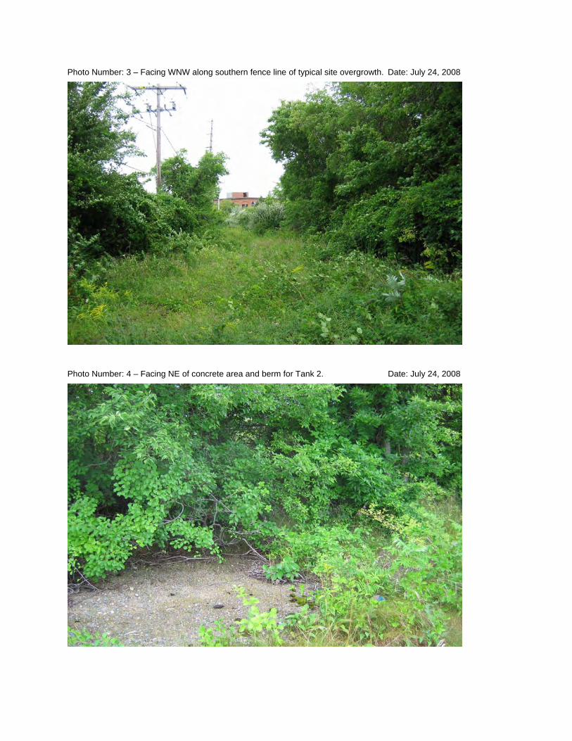
Photo Number: 3 – Facing WNW along southern fence line of typical site overgrowth. Date: July 24, 2008
Photo Number: 4 – Facing NE of concrete area and berm for Tank 2. Date: July 24, 2008
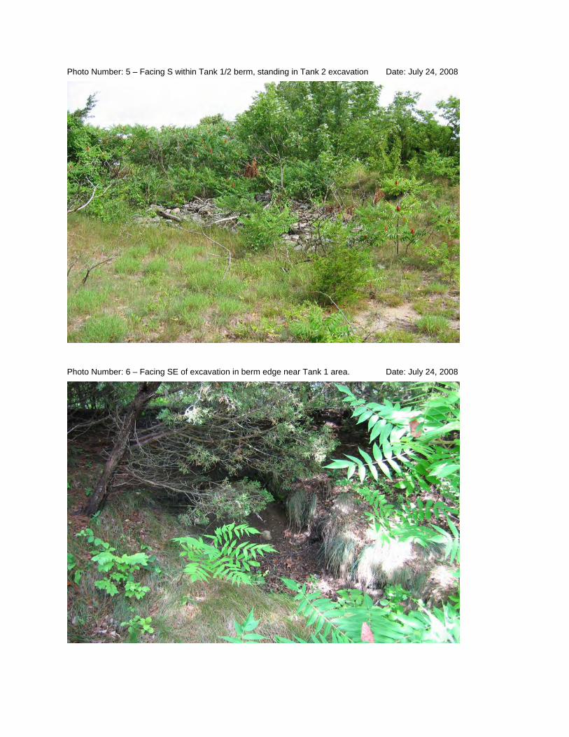
Photo Number: 5 – Facing S within Tank 1/2 berm, standing in Tank 2 excavation Date: July 24, 2008
Photo Number: 6 – Facing SE of excavation in berm edge near Tank 1 area. Date: July 24, 2008
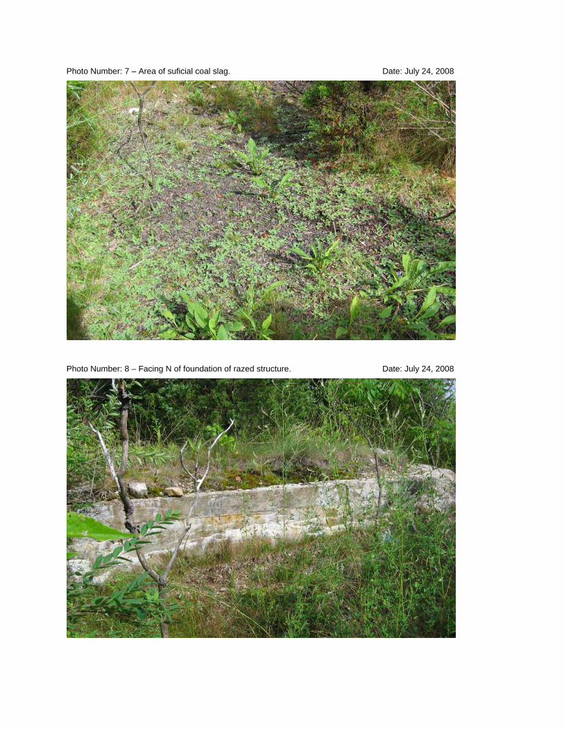
Photo Number: 7 – Area of suficial coal slag. Date: July 24, 2008
Photo Number: 8 – Facing N of foundation of razed structure. Date: July 24, 2008

Photo Number: 9 – Facing N from Tank 3 over downed fence. Date: July 24, 2008
Photo Number: 10 – Facing south; snow fence down in areas. Date: July 24, 2008
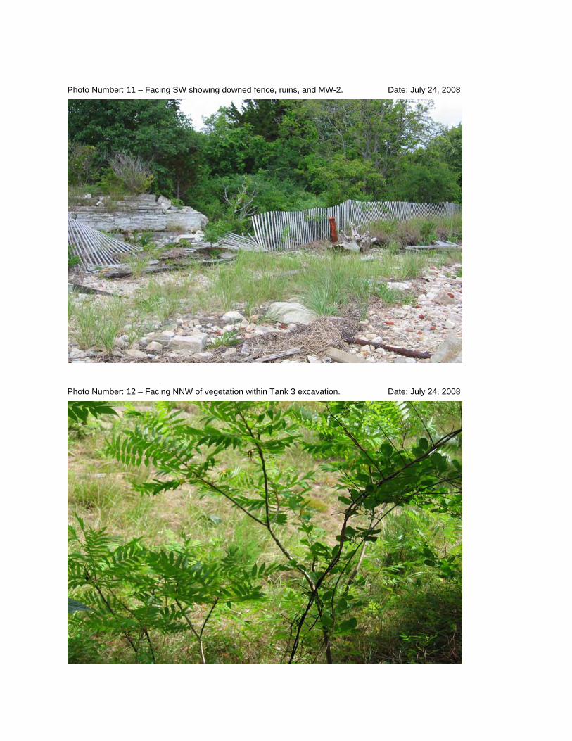
Photo Number: 11 – Facing SW showing downed fence, ruins, and MW-2. Date: July 24, 2008
Photo Number: 12 – Facing NNW of vegetation within Tank 3 excavation. Date: July 24, 2008

Photo Number: 13 – Facing W of existing abutting structures. Date: July 24, 2008

APPENDIX C
INTERVIEW LIST

INTERVIEW DOCUMENTATION FORMThe following is a list of individual interviewed for this five-year review. See the attached contact record(s) for a detailed summary of the interviews.
Joseph Jannetty Principal/Property Owner JANCO Development, LLC 7/24/2008Name Title/Position Organization Date
William Rudolph Property Manger Cordage Commerce Center 7/24/2008Name Title/Position Organization Date
Derrick Golden Task Order Project Manager USEPA 7/28/2008Name Title/Position Organization Date
(Information exchanged throughout the course of the project;date cited was a communication informing Mr. Golden of the Site status.)
Jay Naparstek Chief-Bureau of Wastesite Cleanup MADEP 8/6/2008Name Title/Position Organization Date
Various Individuals --
Town of PlymouthEconomic
Development/PlanningDevelopment/Planning Department, Building
Department, and Zoning Board of Appeals 8/11/2008
Name Title/Position Organization Date

Time: 10:00 am Date: 7/24/08
Name: Denis McGrath
Name: Joseph Jannetty
Location of Visit: Plynouth, MA
Incoming Outgoing
INTERVIEW RECORDSite Name: Cannon Engineering/Plymouth Harbor EPA ID No.: MAD980525232
Subject: Fourth Five-Year Review
Type: Telephone Visit Other
Contact Made By:Title: Project Scientist Organization: Nobis Engineering, Inc.
Individual Contacted:Title: Principal Organization: JANCO Development, LLC
Telephone No: 508-747-8822Fax No:E-Mail Address:
Street Address: 10 Cordage Park Cir. Suite 235City, State, Zip: Plymouth, MA 02360
Summary Of ConversationQ1: Has there been any environmental sampling since the previous five year review?A1: No additional sampling completed.
Q2: What are the redevelopment plans for the Site?A2: At the moment, Mr. Jannetty has entertained the idea of clearing and grading the Site for use as a boat storage yard to expand the Plymouth Boat Yard's storage capacity.
Q3: Has there been any flooding/fires in the previous five years?A3: No.
Q4: What are the redevelopment plans for abutting property?A4: The master plan for the area is to raze the existing vaacant buildings and construct condominiums along the waterfront.

Time: 10:00 am Date: 7/24/08
Name: Denis McGrath
Name: William Rudolph
INTERVIEW RECORDSite Name: Cannon Engineering/Plymouth Harbor EPA ID No.: MAD980525232
Subject: Fourth Five-Year Review
Type: Telephone Visit Other Incoming OutgoingLocation of Visit: Plynouth, MA
Contact Made By:Title: Project Scientist Organization: Nobis Engineering, Inc.
Individual Contacted:Title: Property Manager Organization: Cordage Commerce Center
Telephone No: 508-746-7707 Street Address: 10 Cordage Park Cir.Fax No: City, State, Zip: Plymouth, MA 02360E-Mail Address:
Summary Of ConversationQ1: Has there been any environmental sampling since the previous five year review?A1: No additional sampling completed.
Q2: Has there been any evidence of trespassing at the Site?A2: No, not at the Site, but in surrounding properties, yes.
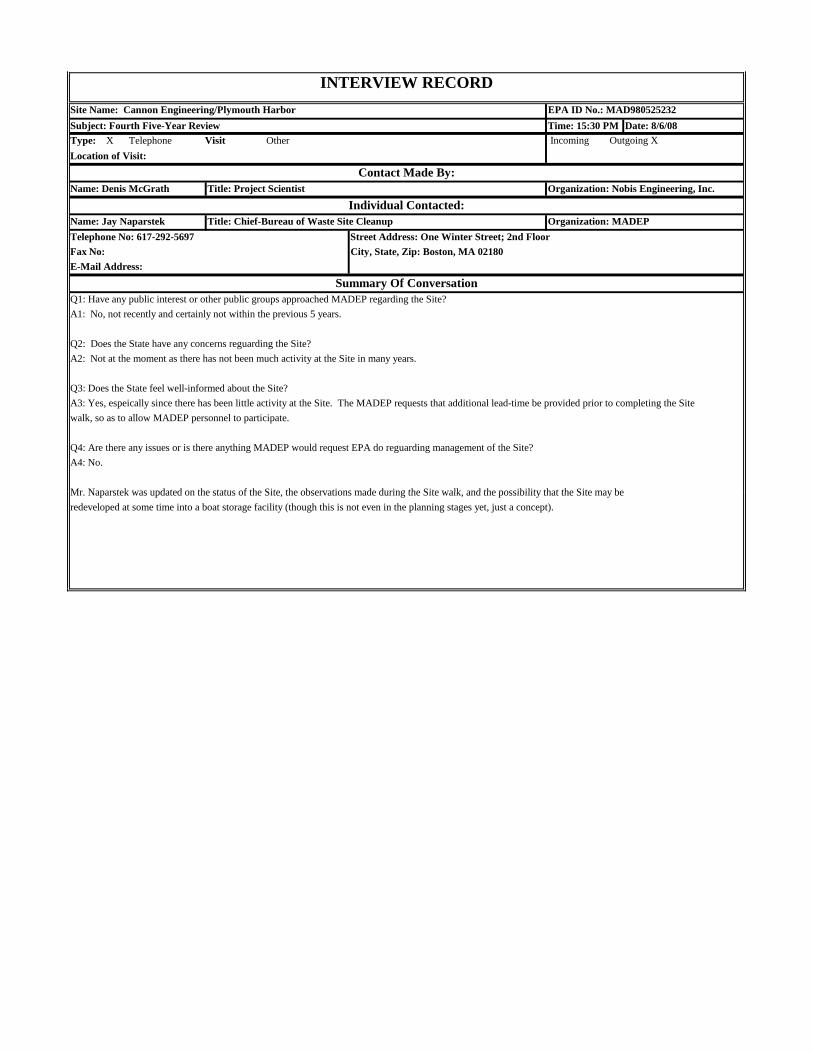
Time: 15:30 PM Date: 8/6/08
Name: Denis McGrath
Name: Jay Naparstek
A4: No.
Mr Naparstek was updated on the status of the Site the observations made during the Site walk and the possibility that the Site may be
Q4: Are there any issues or is there anything MADEP would request EPA do reguarding management of the Site?
Summary Of ConversationQ1: Have any public interest or other public groups approached MADEP regarding the Site?A1: No, not recently and certainly not within the previous 5 years.
Q2: Does the State have any concerns reguarding the Site?A2: Not at the moment as there has not been much activity at the Site in many years.
Q3: Does the State feel well-informed about the Site?A3: Yes, espeically since there has been little activity at the Site. The MADEP requests that additional lead-time be provided prior to completing the Sitewalk, so as to allow MADEP personnel to participate.
Telephone No: 617-292-5697 Street Address: One Winter Street; 2nd FloorFax No: City, State, Zip: Boston, MA 02180E-Mail Address:
Contact Made By:Title: Project Scientist Organization: Nobis Engineering, Inc.
Individual Contacted:Title: Chief-Bureau of Waste Site Cleanup Organization: MADEP
INTERVIEW RECORDSite Name: Cannon Engineering/Plymouth Harbor EPA ID No.: MAD980525232Subject: Fourth Five-Year ReviewType: X Telephone Visit Other Incoming Outgoing XLocation of Visit:
Mr. Naparstek was updated on the status of the Site, the observations made during the Site walk, and the possibility that the Site may beredeveloped at some time into a boat storage facility (though this is not even in the planning stages yet, just a concept).

Time: 14:00 Date: 8/11/08
Name: Denis McGrath
Name: Various Individuals
Summary Of ConversationQ1: Is the Economic Development/Planning Department aware of any proposed development at the Site?A1: No, there are no proposed plans on file with the Department. There also is nothing on file with the Zoning Board of Appeals.
Q2: Is the Building Department aware of any proposed development at the Site?A2: The Building Department stated that there were no proposed plans on-file for the Site.
Individual names of the department representatives were not obtained.
Telephone No: 508-747-1620 Street Address: 11 Lincoln StreetFax No: City, State, Zip: Plymouth, MA 02360E-Mail Address:
Contact Made By:Title: Project Scientist Organization: Nobis Engineering, Inc.
Individual Contacted:Title: -- Organization: Plymouth Economic
Development/Planning Department, Zoning Board of Appeals, and Building Department
INTERVIEW RECORDSite Name: Cannon Engineering/Plymouth Harbor EPA ID No.: MAD980525232
Subject: Fourth Five-Year Review
Type: X Telephone Visit Other Incoming Outgoing XLocation of Visit:
APPENDIX D
RISK ASSESSMENT MEMORANDUM
107 South Church Street, West Chester, PA 19382 Telephone: 610-692-8330 Fax: 610-692-8339
Email: [email protected] Internet: www.avatarenviro.com
To: Scott Harding
Nobis Engineering, Inc.
From: Cynthia Woods
Avatar Environmental, LLC.
Date: July 28, 2008
Subject: Addendum to Plymouth Harbor/Cannon Engineering Corporation Five-
Year Review
I have reviewed the 1998 “Second Five-year Review” and the 2003 “Third Five-
year Review” for Cannons Engineering Corporation, Plymouth Harbor Superfund
Site, Plymouth, Massachusetts, the addendum provided by Sarah Levinson of
EPA Region 1, as Attachment 4 to the Second Five-year Review, and the
addendum provided by myself, formerly of TetraTech NUS, as Appendix D to the
Third Five-year Review.
As Sarah pointed out in 1998 the original data collected at Cannon Engineering
from the mid-1980’s reflecting post-removal composite soil sampling, which has
since been covered by “clean fill”, is likely to have little bearing on current risk to
a trespasser or occupational worker in contact with surface soil at the site. With
that caveat in mind, calculations from that data are likely to overestimate
exposures to workers or trespassers who do not disturb the soil. As part of the
1998 Second Five-year Review, Sarah performed risk computations using the
highest composite concentrations from the mid-1980’s sampling and scenarios
as defined in the 1989 Endangerment Assessment. Similarly, I performed
updated risk calculations for the third year review.
The primary contaminants of concern at this site have been carcinogenic
polyaromatic hydrocarbons (cPAHs) and lead. EPA guidance relative to lead
remains unchanged since the previous two five-year reviews. At this site lead

concentrations are below the residential screening level and therefore do not
pose a significant public health hazard.
Toxicity information and chemical-specific absorption values for PAHs remain
similarly unchanged since the last two five-year reviews. As Sarah noted there
are now relative potency factors available for several cPAHs; however, in the
absence of individual PAH concentration data, cPAH risks at this site were
evaluated assuming the total PAH concentration reflects the most toxic PAH
(benzo(a)pyrene).
The dermal risk assessment guidance (“Risk Assessment Guidance for
Superfund Volume I: Human Health Evaluation Manual Part E, Supplemental
Guidance for Dermal Risk Assessment, Interim”) to which Sarah referred was
most recently updated in July 2004 (EPA, 2004). The chemical-specific
absorption values for cPAHs remain unchanged since the last five-year review.
The default dermal absorption factor for benzo(a)pyrene and other cPAHs
remains at 13%. Recommended soil adherence factors and exposed surface
areas had undergone some revisions between Sarah’s assessment and the 2003
review, but have not changed since. These changes were incorporated in the
2003 review.
The presumed scenarios for this site are an adult commercial worker and an
older child trespasser.
The previous two reviews utilized recommended default exposure frequencies
and exposure durations for evaluations of exposures to industrial/commercial
workers provided by EPA since the 1989 Endangerment Assessment to update
risk calculations for industrial/commercial workers. These default exposure
assumptions have not changed since the last five-year review.
2
Since the previous five-year review, EPA has updated its Guidelines for
Carcinogen Risk Assessment (EPA, 2005a) and issued Supplemental Guidance
for Assessing Susceptibility from Early-Life Exposure to Carcinogens (EPA,
2005b). The later provides new direction on evaluating cancer risks to children
from exposures to carcinogens that act via a mutagenic mode of action.
Carcinogenic PAHs are considered to act via a mutagenic mode of action. As
such an age-dependent adjustment factor of 10 for children less than 2 years of
age or 3 for children between 2 and 16 years of age is applied to cancer risk
calculations. This guidance does not impact calculations of risks to
industrial/commercial workers or calculations of non-cancer hazard indices for
older child trespassers at this site, but does impact calculations of cancer risks to
older child trespassers.
The Endangerment Assessment presented risk calculations based on a site wide
average cPAH concentration of 9 mg/kg and a high composite cPAH
concentration of 49 mg/kg. The post-excavation composited soil samples results
used in the Endangerment Assessment and prior reviews are summarized in
Table 1, attached to this memorandum.
In light of the Supplemental Guidance for Assessing Susceptibility from Early-Life
Exposure to Carcinogens (EPA, 2005b), and to address the stated older child
trespasser scenario, cancer risk computations are provided below for older child
trespassers potentially exposed via dermal contact and ingestion pathways.
These risk computations use the highest composite concentrations from the mid-
1980’s sampling. Note that while Sarah used 53 mg/kg as the highest composite;
based on averages of the duplicate samples shown in Table 1, 49 mg/kg is the
highest composite, and was used in the Endangerment Assessment calculations
and this review. This minor difference has little impact on the calculations
presented below.
3

Table 2, attached to this memorandum, shows a summary of the exposure
assumptions and rates presented below, referenced for the source of the
exposure rates.
Incidental Soil Ingestion Exposure Assumptions:
Older child and adult soil ingestion rate: 100 mg/event
Older child exposure frequency: 50 days/year
Older child exposure duration: 10 years
Older child body weight: 45 kg
Exposed carcinogenic PAH concentration: 49 mg/kg (highest composite)
Older Child Trespasser Soil Ingestion Cancer Risk for cPAHs =
7.3 (mg/kg-day)-1 x 3 x 49 mg cPAHs/kg soil x 100 mg/kg x 10-6 kg soil/mg soil x 50 events/yrs x
10 yr
45kg x 365 days/yr x 70 yr
Older Child Trespasser Soil Ingestion Cancer Risk for cPAHs = 4.7 x 10⁻⁵
Dermal Contact Exposure Assumptions:
Dermal absorption cPAHs: 0.13
Older child exposed surface area: 4,650 cm2/day
Older child soil adherence factor: 0.4 mg/cm2
Older child exposure frequency: 50 days/year
Older child exposure duration: 10 years
Older child body weight: 45 kg
Exposed carcinogenic PAH concentration: 49 mg/kg (highest composite)
4

Older Child Trespasser Soil Dermal Contact Cancer Risk for cPAHs =
7.3 (mg/kg-day)-1 x 3 x 49 mg cPAHs/kg soil x 0.13x 4650 cm2/day x 0.4 mg soil/cm2 x 10-6 kg soil/mg soil x 50 events/yrs
x 10 yr
45kg x 365 days/yr x 70 yr
Older Child Trespasser Soil Dermal Contact Cancer Risk for cPAHs = 1.1 x 10⁻⁴
Combined risk for Trespasser exposure to cPAHs (ingestion + dermal) = 1.6 x10⁻⁴
The combined cancer risk estimate for an older child trespasser is at the high
end of the acceptable range, slightly above EPA’s target cancer risk range of 1 x
10-4 to 10-6. EPA considers the older child trespasser exposure as within the
protective range, based on current exposure assumptions and the use of data
over 20 years old whose validity for risk assessment purposes is questionable.
The calculations use the highest soil composite data, rather than the site wide
data, as also presented in the Endangerment Assessment, which likely
overestimates the exposure risk. New soil data must be collected to further
support and confirm the protectiveness of the remedy.
References:
EPA, 2004. Risk Assessment Guidance for Superfund (RAGS), Volume I: Human
Health Evaluation Manual (Part E, Supplemental Guidance for Dermal Risk
Assessment) U.S. Environmental Protection Agency, Washington, DC,
EPA/540/R/99/005, July 2004.
EPA, 2005a. Guidelines for Carcinogen Risk Assessment, U.S. Environmental
Protection Agency, Risk Assessment Forum, National Center for Environmental
Assessment, Washington, DC. EPA/630/P-03/001F, March 2005.
5
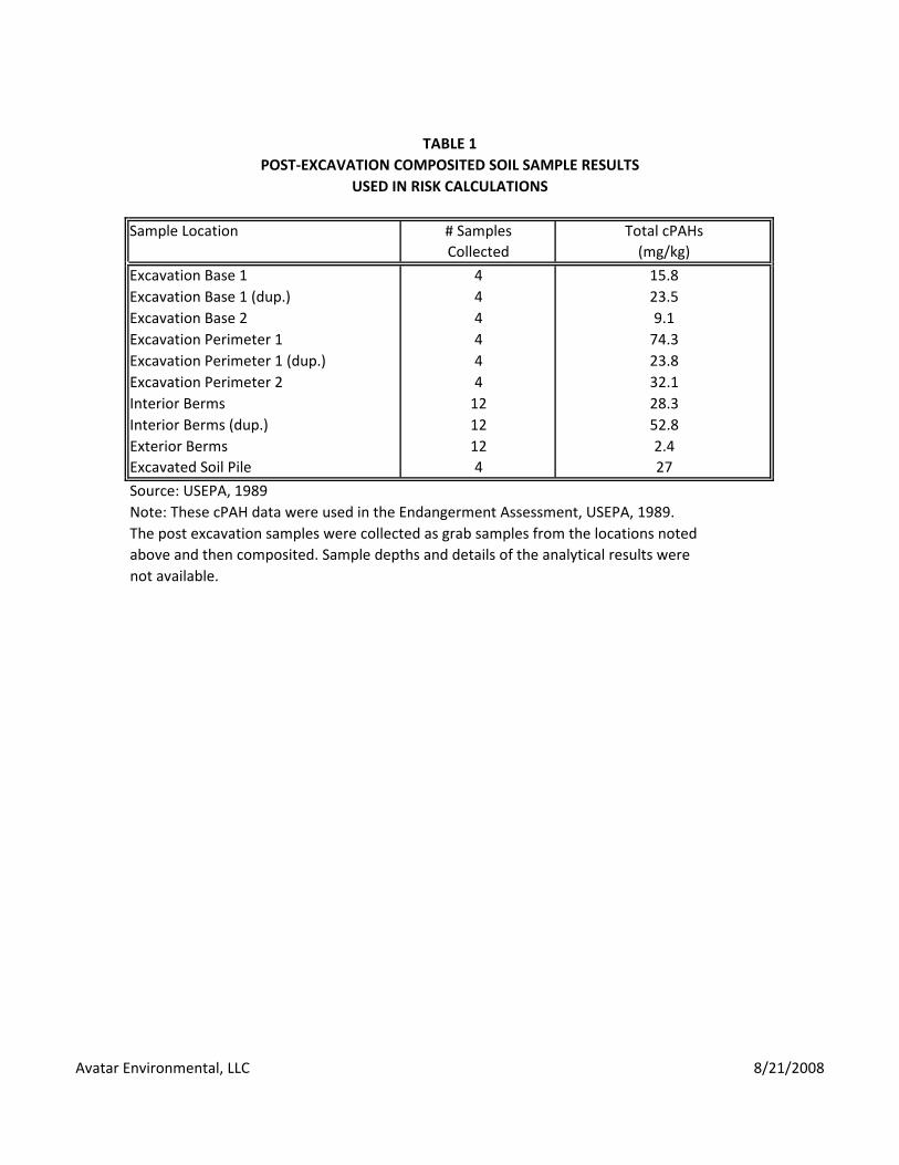
TABLE 1POST‐EXCAVATION COMPOSITED SOIL SAMPLE RESULTS
USED IN RISK CALCULATIONS
Sample Location # Samples Total cPAHsCollected (mg/kg)
Excavation Base 1 4 15.8Excavation Base 1 (dup.) 4 23.5Excavation Base 2 4 9.1Excavation Perimeter 1 4 74.3Excavation Perimeter 1 (dup.) 4 23.8Excavation Perimeter 2 4 32.1Interior Berms 12 28.3Interior Berms (dup.) 12 52.8Exterior Berms 12 2.4Excavated Soil Pile 4 27
Source: USEPA, 1989Note: These cPAH data were used in the Endangerment Assessment, USEPA, 1989.The post excavation samples were collected as grab samples from the locations notedabove and then composited. Sample depths and details of the analytical results werenot available.
Avatar Environmental, LLC 8/21/2008
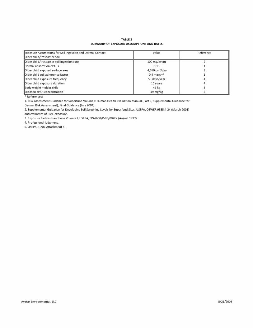
TABLE 2SUMMARY OF EXPOSURE ASSUMPTIONS AND RATES
Exposure Assumptions for Soil Ingestion and Dermal Contact Value ReferenceOlder child/trespasser soil
Older child/trespasser soil ingestion rate 100 mg/event 2Dermal absorption cPAHs 0.13 1Older child exposed surface area 4,650 cm²/day 3Older child soil adherence factor 0.4 mg/cm² 1Older child exposure frequency 50 days/year 4Older child exposure duration 10 years 4Body weight – older child 45 kg 3Exposed cPAH concentration 49 mg/kg 5
* References:1. Risk Assessment Guidance for Superfund Volume I: Human Health Evaluation Manual (Part E, Supplemental Guidance forDermal Risk Assessment), Final Guidance (July 2004).2. Supplemental Guidance for Developing Soil Screening Levels for Superfund Sites, USEPA, OSWER 9355.4‐24 (March 2001)and estimates of RME exposure.3. Exposure Factors Handbook Volume I, USEPA, EPA/600/P‐95/002Fa (August 1997).4. Professional judgment.5. USEPA, 1998, Attachment 4.
Avatar Environmental, LLC 8/21/2008
APPENDIX E
DECLARATION OF RESTRICTIONS
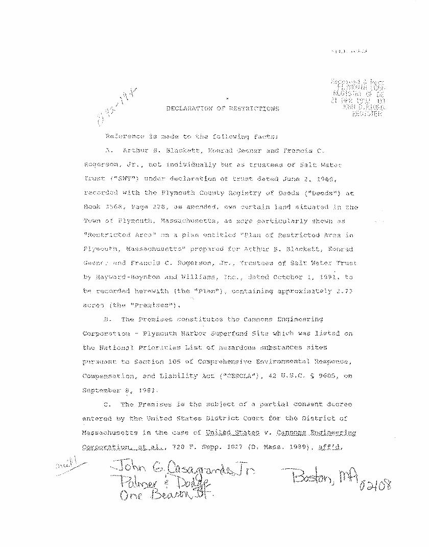
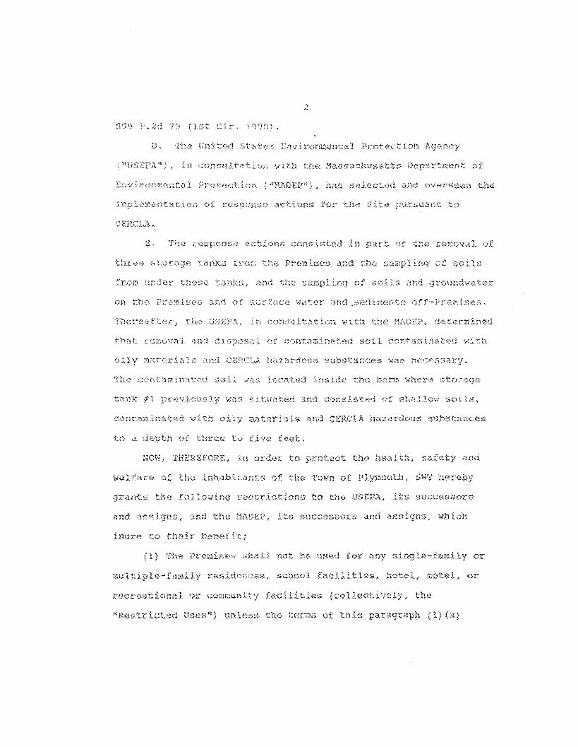


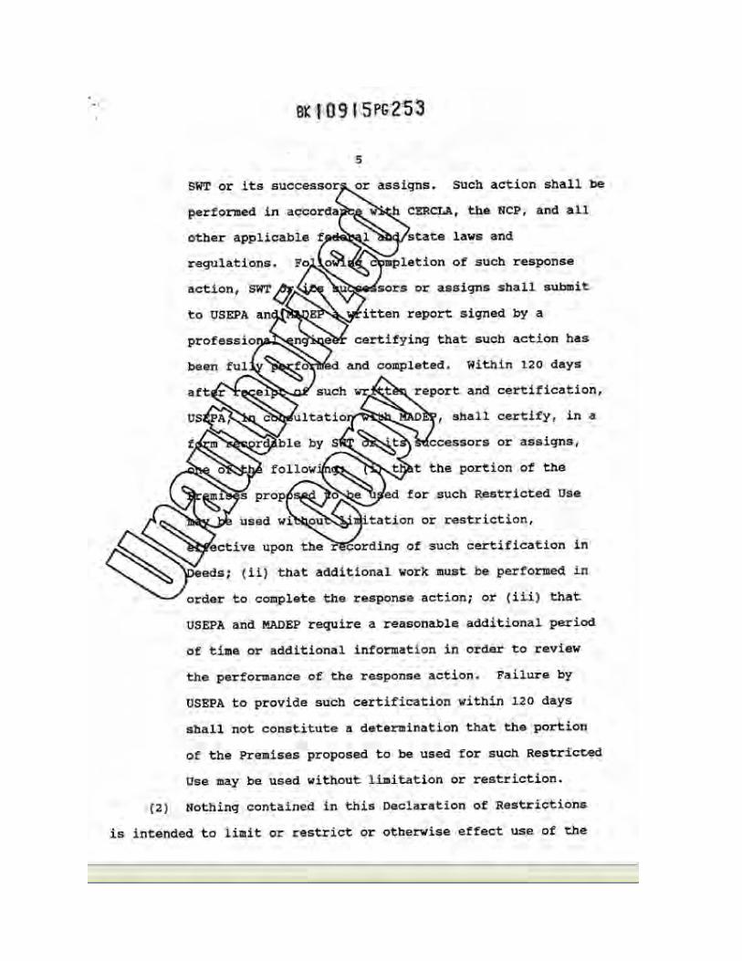
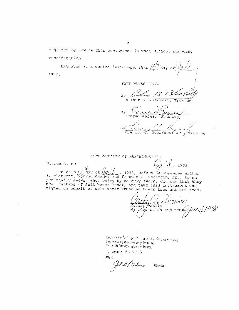
APPENDIX F
PUBLIC NOTIFICATION
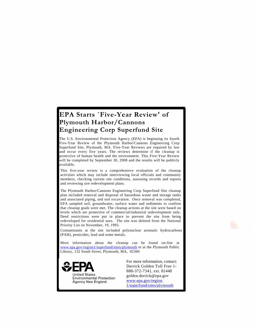
For more information, contact: Derrick Golden Toll Free 1-888-372-7341, ext. 81448 [email protected] www.epa.gov/region 1/superfund/sites/plymouth
More information about the cleanup can be found on-line at www.epa.gov/region1/superfund/sites/plymouth or at the Plymouth Public Library, 132 South Street, Plymouth, MA, 02360
Contaminants at the site included polynuclear aromatic hydrocarbons (PAH), pesticides, lead and some metals.
This five-year review is a comprehensive evaluation of the cleanup activities which may include interviewing local officials and community members, checking current site conditions, assessing records and reports and reviewing sire redevelopment plans.
The Plymouth Harbor/Cannons Engineering Corp Superfund Site cleanup plan included removal and disposal of hazardous waste and storage tanks and associated piping, and soil excavation. Once removal was completed, EPA sampled soil, groundwater, surface water and sediments to confirm that cleanup goals were met. The cleanup actions at the site were based on levels which are protective of commercial/industrial redevelopment only. Deed restrictions were put in place to prevent the site from being redeveloped for residential uses. The site was deleted from the National Priority List on November, 19, 1993.
EPA Starts `Five-Year Review' of Plymouth Harbor/Cannons Engineering Corp Superfund Site The U.S. Environmental Protection Agency (EPA) is beginning its fourth Five-Year Review of the Plymouth Harbor/Cannons Engineering Corp Superfund Site, Plymouth, MA. Five-Year Reviews are required by law and occur every five years. The reviews determine if the cleanup is protective of human health and the environment. This Five-Year Review will be completed by September 30, 2008 and the results will be publicly available.
APPENDIX G
RISK CALCULATIONS FOR SOIL OUTSIDE BERMED AREAS

Email Correspondence: To: [email protected] From: [email protected] RE: Calculation of Risk Outside of Bermed Areas I calculated the ingestion and dermal risks of 2 mg/kg carcinogenic PAH in soil to a child age 6 to 16. The following assumptions were made, based on the assumptions in the original Endangerment Assessment for exposure duration (10 years) and exposure frequency (50 days/yr) and current EPA guidance concerning incidental ingestion and dermal exposure: Exposure Duration = 10 years Exposure Frequency = 50 days/yr Body Weight = 43 kg (average for males and females age 6 to 16) All PAH was benzo(a)pyrene Skin surface area = 12,000 cm2 (50% of total average surface area for males and females age 6‐16) Soil adherence factor = 0.2 mg/cm2‐event Dermal Absorption Fraction = 0.1 Oral slope factor = 7.3 per mg/kg‐day (IRIS value for benzo(a)pyrene The results are that the elevated lifetime cancer risk is 6.6E‐07 for ingestion and 1.6E‐06 for dermal, for a total cancer risk of 2.3E‐06. This is similar to the risks calculated in the Endangerment Assessment. This is conservative because all of the PAHs were assumed to be benzo (a)pyrene, the most carcinogenic PAH. (See attached file: Soil PAH risks.xls)
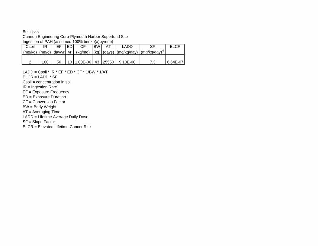
Soil risksCannon Engineering Corp-Plymouth Harbor Superfund SiteIngestion of PAH (assumed 100% benzo(a)pyrene)
Csoil IR EF ED CF BW AT LADD SF ELCR(mg/kg) (mg/d) day/yr yr (kg/mg) (kg) (days) (mg/kg/day) (mg/kg/day)-1
2 100 50 10 1.00E-06 43 25550 9.10E-08 7.3 6.64E-07
LADD = Csoil * IR * EF * ED * CF * 1/BW * 1/ATELCR = LADD * SFCsoil = concentration in soilIR = Ingestion RateEF = Exposure FrequencyED = Exposure DurationCF = Conversion FactorBW = Body WeightAT = Averaging TimeLADD Lif ti A D il DLADD = Lifetime Average Daily DoseSF = Slope FactorELCR = Elevated Lifetime Cancer Risk

Soil risksCannon Engineering Corp-Plymouth Harbor Superfund SiteDermal exposure to soil PAH (assumed 100% benzo(a)pyrene)
Csoil CF AF ABSd DA-event EF ED EV SA BW AT DAD SF ELCR(mg/kg) (mg/kg) (mg/cm2-event) (unitless) (mg/cm2-event) (d/yr) (yr) (event/d) (cm2) (kg) (days) (mg/kg-day) (mg/kg/d)-1 (unitless)
2 1.00E-06 0.2 0.1 4.00E-08 50 10 1 12000 43 25550 2.18E-07 7.3 1.59E-06
DA event = Csoil * CF * AF * ABSdDAD = DA-event * EF * ED * EV * SA *1/BW* 1/ATELCR = DAD * SFCsoil = concentration in soilCF = Conversion FactorAF = Adherence FactorABSd = dermal absorption fractionDA-event = absorbed dose per eventDAD = Dermal Absorbed DoseSA S f ASA = Surface AreaEV = event frequencyED = Exposure DurationBW = Body WeightAT = Averaging TimeELCR = Elevated Lifetime Cancer Risk