NOAA Fleet Update - legislative.noaa.gov · WP-3D (N42RF) – “Hurricane Hunter ... UnderWater...
30
NOAA Fleet Update May 2016 The following update provides the status of NOAA’s fleet of ships and aircraft, which play a critical role in the collection of oceanographic, atmospheric, hydrographic, and fisheries data. NOAA’s current fleet of 16 ships – the largest civilian research and survey fleet in the world – and nine aircraft, are operated, managed, and maintained by NOAA’s Office of Marine and Aviation Operations (OMAO). OMAO includes civilians, mariners, and officers of the United States NOAA Commissioned Officer Corps (NOAA Corps), one of the nation’s seven Uniformed Services. Find us on Facebook for the latest news and activities.
Transcript of NOAA Fleet Update - legislative.noaa.gov · WP-3D (N42RF) – “Hurricane Hunter ... UnderWater...

NOAA Fleet Update
May 2016
The following update provides the status of NOAA’s fleet of ships and aircraft, which play a critical role in the collection of
oceanographic, atmospheric, hydrographic, and fisheries data. NOAA’s current fleet of 16 ships – the largest civilian
research and survey fleet in the world – and nine aircraft, are operated, managed, and maintained by NOAA’s Office of
Marine and Aviation Operations (OMAO). OMAO includes civilians, mariners, and officers of the United States NOAA
Commissioned Officer Corps (NOAA Corps), one of the nation’s seven Uniformed Services.
Find us on Facebook for the latest news and activities.

Page | 2
Table of Contents Please click on the Table of Contents entry below to be taken directly to a specific ship, center, aircraft, asset, program, or
information. The fleet is listed based on the geographical location of their homeport/base starting in the Northeast and
ending in the Pacific.
Office of Marine and Aviation Operations (OMAO) and the NOAA Commissioned Officer Corps
- In the News - .............................................................................................................................................. 4
NOAA Ship Henry B. Bigelow
Homeport Change ....................................................................................................................................... 6
Rear Admiral David Score
- New Presidential Appointment - .............................................................................................................. 7
Dr. Jim McFadden
- Service to America Medal Finalist - ........................................................................................................ 7
NOAA Basic Officer Training Class (BOTC) 127 ..................................................................................... 8
Independent Review Team ......................................................................................................................... 9
OMAO’s Ships and Centers ..................................................................................................................... 10
New Castle, NH .......................................................................................................................................... 10
NOAA Ship Ferdinand R. Hassler ............................................................................................................ 10
Newport, RI ................................................................................................................................................ 10
NOAA Ship Henry B. Bigelow .................................................................................................................. 10
Davisville, RI .............................................................................................................................................. 11
NOAA Ship Okeanos Explorer ................................................................................................................. 11
Norfolk, VA ................................................................................................................................................. 11
NOAA Ship Thomas Jefferson ................................................................................................................. 11
OMAO’S MARINE OPERATIONS CENTER – ATLANTIC (MOC-A) ........................................................ 11
Charleston, SC........................................................................................................................................... 12
NOAA Ship Nancy Foster ......................................................................................................................... 12
NOAA Ship Ronald H. Brown ................................................................................................................... 12
Pascagoula, MS ......................................................................................................................................... 12
NOAA Ship Oregon II ................................................................................................................................ 12
NOAA Ship Pisces .................................................................................................................................... 13
NOAA Ship Gordon Gunter ...................................................................................................................... 13
San Diego, CA............................................................................................................................................ 14
NOAA Ship Reuben Lasker ...................................................................................................................... 14
Newport, OR............................................................................................................................................... 14
NOAA Ship Rainier .................................................................................................................................... 14
NOAA Ship Bell M. Shimada .................................................................................................................... 14
OMAO’S MARINE OPERATIONS.............................................................................................................. 15
OMAO’S MARINE OPERATIONS CENTER – PACIFIC (MOC-P) ............................................................ 15

Page | 3
Ketchikan, AK ............................................................................................................................................ 15
NOAA Ship Fairweather ............................................................................................................................ 15
Kodiak, AK ................................................................................................................................................. 15
NOAA Ship Oscar Dyson .......................................................................................................................... 15
Honolulu, HI ............................................................................................................................................... 16
NOAA Ship Hi’ialakai ................................................................................................................................ 16
NOAA Ship Oscar Elton Sette .................................................................................................................. 17
OMAO’S MARINE OPERATIONS CENTER – PACIFIC ISLANDS (MOC-PI) .......................................... 17
OMAO’s Aircraft ........................................................................................................................................ 18
Tampa, Florida ........................................................................................................................................... 18
WP-3D (N42RF) – “Hurricane Hunter” ..................................................................................................... 18
WP-3D (N43RF) – “Hurricane Hunter” ..................................................................................................... 18
Jet Prop Commander (N45RF) ................................................................................................................. 18
Gulfstream IV (N49RF) .............................................................................................................................. 18
Twin Otter (N46RF) .................................................................................................................................... 19
King Air (N68RF) ....................................................................................................................................... 19
Twin Otter (N48RF) .................................................................................................................................... 19
Twin Otter (N56RF) .................................................................................................................................... 19
Twin Otter (N57RF) .................................................................................................................................... 20
OMAO’S AIRCRAFT OPERATIONS CENTER (AOC) .............................................................................. 20
Unmanned Systems Support ................................................................................................................... 21
NASA Global Hawk ................................................................................................................................... 21
APH-22 Hexacopter ................................................................................................................................... 21
Puma UAS .................................................................................................................................................. 22
OMAO Partnerships .................................................................................................................................. 23
United States Senate Committee on Commerce, Science, and Transportation ................................. 23
National Science Foundation ................................................................................................................... 23
Department of Defense - U.S. Pacific Command (USPACOM) ............................................................. 23
Department of Defense - U.S. Navy ......................................................................................................... 23
Department of Homeland Security - U.S. Coast Guard ......................................................................... 24
Teacher At Sea Program .......................................................................................................................... 25
OMAO - NOAA Dive Program ................................................................................................................... 26
OMAO Small Boat Program ...................................................................................................................... 27
Office of Marine and Aviation Operations .............................................................................................. 28
NOAA Commissioned Officer Corps ....................................................................................................... 30

Page | 4
Office of Marine and Aviation Operations
(OMAO)
and the NOAA Commissioned Officer Corps - In the News -
Aircraft at MacDill helps track Earth’s shrinking ice a world away
-Tampa Tribune
Miss Piggy, famous for flying into hurricanes to gather information about storm tracks, now is being pressed into service
for NASA because of what can only be described as a perfect storm. The mission is part of Operation IceBridge, a $15-
million-a-year NASA program to investigate Earth’s polar ice in the greatest detail ever to better understand processes
that connect the polar regions with the global climate system...To do that, NASA needs a plane. But the agency’s own
Orion P-3, which has been helping bridge the gap, is getting new wings now like Miss Piggy. So is fellow NOAA’s other P-
3, Kermit. And several other NASA aircraft used for this project are busy with other missions. So in November, NASA
officials, mindful of the lull between June-to-November hurricane seasons, reached out to the NOAA Aircraft Operations
Center at MacDill, which has shipped off its P-3s for other science missions in the past...
These researchers don’t just track the weather, they fly right into it
-PBS NewsHour (Video)
When weather events like El Niño impose themselves, everybody on the planet feels it. Scientists are getting better at
predicting El Niño, but there is still a lot they don't know amid an absence of data. Science correspondent Miles O'Brien
follows along as weather scientists gather information in Hawaii by air and by sea.
NOAA ship docks near San Francisco's Exploratorium
-ABC7 San Franciso
It's far out in the ocean most of the time. But this Sunday, one very high-tech ship will be open to the public at the
Exploratorium. Jonathan Bloom got to climb onboard the shiny new vessel that's on a fish-finding mission. Watch the
video player above for his full report and click here to learn more about the NOAA Ship Reuben Lasker...
What’s Happening: Ice-associated Seal Ecology Research Survey 2016
-Alaska Fisheries Science Center blog
The Alaska Fisheries Science Center's Marine Mammal Laboratory is conducting an ice-associated seal research survey
in the central Bering Sea from April 2-29, 2016 aboard the NOAA Ship Oscar Dyson. The species being studied are
ribbon, spotted, bearded and ringed seals.A key objective is to attach satellite-linked tags on ribbon and spotted seals,
which spend time either on or in the proximity of sea-ice during this time of year. Scientists plan to use data collected from
the satellite-linked tags, together with information collected during similar surveys since 2005, to learn more about the
timing of when these seals "haul out," that is come out of the water onto the ice...
UnderWater World now serving as command center for NOAA ship
-Guam Daily Post
UnderWater World is serving as Guam's command center for the Marianas Trench Exploration expedition, launched today
by the National Atmospheric and Ocean Administration Ship research vessel, the Okeanos Explorer, Wednesday, April
20. The aquarium in Tamuning, Guam, hosted a kickoff event on April 18 to unveil the command center...

Page | 5
Operation IceBridge returns to the Arctic
- Cosmos
Operation IceBridge, NASA’s airborne survey of polar ice, has launched its eighth spring Arctic campaign. After a
research flight over Greenland, it will continue surveying Arctic sea and land ice until 21 May. Over the past seven years,
IceBridge data have helped scientists improve forecasts for the summer melt season. This year's flights will be conducted
aboard one of the National Oceanic and Atmospheric Administration’s (NOAA) hurricane hunter planes, a P-3 Orion...
Senate subcommittee approves funding for research vessels
- Workboat
The Senate Commerce-Justice-Science (CJS) Appropriations Subcommittee has approved the fiscal year 2017 CJS
Appropriations Bill, which includes funding for the National Oceanic and Atmospheric Administration (NOAA) and the
National Science Foundation (NSF). The bill provides $5.7 billion for NOAA, a $33.5 million increase above the FY2016
enacted level, and $7.5 billion for NSF, maintaining the FY2016 enacted level. The bill provides $75 million to complete a
new survey vessel for the National Oceanic and Atmospheric Administration (NOAA). NOAA currently has 16 ships in its
aging fleet, but that number will dwindle to eight vessels by 2028. To maintain its current oceanographic capacity, NOAA
needs to build not one but eight additional vessels in the next two to four years, as construction takes eight to 10 years
per ship — 8-10 years is the typical timeline associated with the shipbuilding process, including requirements
development, analysis of alternatives, concept design, preliminary design, and detailed design and construction. These
vessels enable NOAA to map the ocean floor, support weather forecasts, conduct oceanographic and climate research
and improve ecosystem and fisheries management..

Page | 6
NOAA Ship Henry B. Bigelow Homeport Change
NOAA Ship Henry B. Bigelow Homeport Change
Senator Jack Reed (D-RI), in partnership with NOAA, announced that effective April 12, 2016, the NOAA Ship Henry. B
Bigelow will now be officially homeported in Newport, RI, where the vessel has docked for the last several years. The
administrative change of official homeport designation from Woods Hole, MA, to Newport, will allow NOAA to leverage
funding, cooperation, and relationships with federal partners in the Northeast, including the U.S. Navy and U.S. Coast
Guard at Naval Station (NAVSTA) Newport. This administrative change will have no impact on ship operations and will
align the homeport’s historical physical location with the future operational reality. We remain committed to supporting our
NOAA Fisheries and other partners in the New England region with this highly capable platform and her skilled crew.
A copy of the Senator’s press release may be found at http://www.reed.senate.gov/news/releases/reed-announces-noaa-
fisheries-research-vessel-henry-b-bigelow-to-be-permanently-homeported-in-newport
NOAA Ship Henry B. Bigelow alongside at GMD Shipyard in Brooklyn, NY
[Photo Credit: Curtis Cobble/NOAA]

Page | 7
Rear Admiral David Score
- New Presidential Appointment -
President Obama Announces More Key Administration Posts
-White House News Release – April 19
President Barack Obama announced his intent to nominate and appoint officials to several Administration posts, including
Rear Admiral David A. Score to the Board of Visitors of the United States Merchant Marine Academy.
Rear Admiral (RADM) David A. Score (two star) serves as the Director of the National Oceanic and Atmospheric
Administration’s Commissioned Officer Corps (NOAA Corps) and Director of NOAA’s Office of Marine and Aviation
Operations (OMAO), the operational arm of NOAA. As Director of NOAA Corps and OMAO, RADM Score is responsible
for the safe, efficient and effective operation of the agency's fleet of research and survey ships and aircraft, as well as
guiding the 321 commissioned NOAA officers and approximately 1,000 civilian personnel assigned to OMAO.
Dr. Jim McFadden
- Service to America Medal Finalist -
Samuel J. Heyman Service to America Medals 2016 Finalist Career Achievement- Dr. James McFadden
For nearly 50 years, Dr. McFadden has been the bedrock of the nation’s hurricane hunter program, flying airplanes
into hundreds of violent tropical storms to gather information for more accurate weather forecasts. As the
government’s longest-serving hurricane hunter, McFadden is the heart and soul of the National Oceanic and
Atmospheric Administration’s Aircraft Operations Center that sends aircraft into the harshest weather to gather real-
time, life-saving specifics on the formation and progress of earth’s deadliest storms.
Dr. Jim McFadden
[Photo Credit: NOAA]

Page | 8
NOAA Basic Officer Training Class
(BOTC) 127
Excitement is building as the last few weeks of the 127th BOTC draws to a finale. It is the perfect time for the NOAA
Corps' newest members to reflect on the past three and a half months of training; both to appreciate the arduous struggles
they have overcome and the lasting friendships and priceless memories that only shipmates can create. The Officer
Candidates (OCs) voyaged aboard the USCGC Barque Eagle from Little Creek, VA, to Savannah, GA.
Upon returning from their Eagle cruise BOTC members attended the highly emotional reveal, billet night! Along with Coast
Guard shipmates, NOAA OC's received their first sea assignments:
OC Mason Carroll-‐ NOAA Ship Fairweather
OC Nikki Chappelle-‐ NOAA Ship Hi'ialakai
OC Sarah Donohoe-‐ NOAA Ship Reuben Lasker
OC Josh Fredrick-‐ NOAA Ship Oscar Elton Sette
OC Dale Gump-‐ NOAA Ship Thomas Jefferson
OC Michelle Levano-‐ NOAA Ship Rainier
OC Bethany McAcy-‐ NOAA Ship Rainier
OC Alyssa Thompson-‐ NOAA Ship Gordon Gunter
BOTC 127 and Officer Candidate School Class 2-16 aboard the USCG Cutter Barque Eagle.
[Photo: ENS DeCastro/NOAA]

Page | 9
Independent Review Team In January 2016, OMAO convened an Independent Review Team (IRT) to conduct a review of our ship fleet and:
● The IRT will assess the health of the NOAA Fleet of research vessels, requirements for recapitalization, and
analysis of operational, maintenance practices and technology infusion, as well as:
o Utilization of alternatives to the NOAA Fleet (commercial contracting, Academic Research Fleet, other
public-funded vessels) to meet requirements;
o Analysis of current operational systems (crewing, scheduling) and current maintenance practices; and
o Technology readiness and infusion (instrumentation and mechanical).
● The IRT will deliver a final report in September 2016.
● The guidance from the IRT will inform modernization plans of the NOAA fleet in alignment with the Federal
Oceanographic fleet, charter options, as well as operation and maintenance strategies of the current fleet.
● The IRT process & report is independent of any larger Administration planning efforts related to the federal fleet.
● The IRT consists of twelve persons from across Federal government, Academia, and private sector to include
expertise in science, ship-based data collection requirements, vessel operation, vessel design and building, and
ship-based technological advancements
Independent Review Team
Co-Chairs:
Dick West Robert Winokur
RADM, US Navy (ret) Senior Advisor
Michigan Tech Research Institute / Michigan Tech Univ.
Members:
Fred Byus Dr. John Hughes-Clarke
RDML, US Navy (ret) Professor
Vice President & General Manager University of New Hampshire
Battelle Mission and Defense Technologies
John Crowley Bauke (Bob) Houtman
RADM, US Coast Guard (ret) Head, Integrative Programs Section
Executive Director National Science Foundation, Ocean Sciences Division
National Association of Waterfront Employers
Dr. Steve Murawski Blake Powell
Professor President
University of South Florida JMS Naval Architects
Nancy Rabalais, Ph.D. Dr. Steve Ramberg
Executive Director and Professor Distinguished Research Fellow
Louisiana Universities Marine Consortium Center for Technology and National Security Policy,
National Defense University, Penn State University
Robert (Tim) Schnoor Dick Vortmann
Ocean Research Facilities Manager President and CEO (retired)
Office of Naval Research National Steel and Shipbuilding Company (NASSCO)
NOAA Liaisons:
Nancy Hann, CDR/NOAA Richard J. Park, LT/NOAA
Chief of Staff Flag Aide to Director, NOAA Corps and OMAO
NOAA Office of Marine and Aviation Operations NOAA Office of Marine and Aviation Operations

Page | 10
OMAO’s Ships and Centers
OMAO’s Ship Tracker (screen shot below) shows information about the location - present and past - of our fleet of
research and survey ships. Please note: To access Ship Tracker you must create an account with a .gov or .mil email
address. All other access is restricted.
OMAO’s ships and related Marine Centers are listed below based on the geographical location of the vessels’ homeports
starting in the Northeast and ending in the Pacific.
New Castle, NH NOAA Ship Ferdinand R. Hassler
Commanding Officer: LCDR Briana Welton
Primary Mission Category: Hydrographic Surveys
Ship Status: Dry Dock Repair Period, ship will be alongside for scheduled maintenance, repairs, scientific data
processing, crew rest, and training.
Newport, RI NOAA Ship Henry B. Bigelow
Commanding Officer: CDR G. Mark Miller
Primary Mission Category: Fisheries Research
DEPART: Newport, Rhode Island ARRIVE: Boston, Massachusetts
DEPART: Boston, Massachusetts ARRIVE: Newport, Rhode Island
Project 1: Spring Bottom Trawl Survey
Objectives: Determine the spring distribution and relative abundance of fish and invertebrate species found on the
continental shelf and upper slope, including the collection of additional biological information following the pre-established
sampling plan at the direction of the Chief Scientist. Opportunistically evaluate survey gear efficiency, methods, and
survey related equipment that may benefit the trawl survey and fish stock assessments. Collect oceanographic data
including Conductivity, Temperature, Depth (CTD) casts and bongo tows at selected stations; and opportunistically collect
acoustic data along cruise tracks with the EK-60 and ME-70 acoustic systems.

Page | 11
Davisville, RI NOAA Ship Okeanos Explorer
Commanding Officer: CDR Mark Wetzler
Primary Mission Category: Oceanographic Exploration and Research
Depart: Apra Harbor, Guam Arrive: Saipan, Northern Mariana Islands (NMI)
Depart: Saipan, NMI Arrive: Apra Harbor, Guam
Project 1: CAPSTONE
Objectives: CAPSTONE is a three year initiative to collect critical baseline NOAA science and management needs in
largely unknown areas of U.S. waters in the Pacific. Operations conducted during this campaign support NOAA missions
to understand and predict changes in climate, weather, oceans and coasts, and share that knowledge and information
with others. Much of this work associated with CAPSTONE will contribute to and complement Deep Sea Coral Research
and Technology Program’s three-year Pacific Islands Regional Initiative.
Norfolk, VA NOAA Ship Thomas Jefferson
Commanding Officer: CAPT Shepard Smith
Primary Mission Category: Hydrographic Surveys
Ship Status: Alongside US Coast Guard Yard Curtis Bay - Baltimore, Maryland, for scheduled maintenance, winter
repairs, scientific data processing, crew rest, and training.
NOAA Ship Thomas Jefferson’s view of Curtis Creek from U.S. Coast Guard Yard Curtis Bay in Baltimore,
Maryland
[Photo: ENS Seberger/NOAA]
OMAO’S MARINE OPERATIONS CENTER – ATLANTIC (MOC-A)
CAPT Anne Lynch, Commanding Officer MOC-A
MOC-A serves as a homeport for one NOAA ship, and manages the day-to-day operations and provides administrative,
engineering, maintenance, and logistical support for the research and survey ships in NOAA's Atlantic fleet. Each year
these ships conduct dozens of missions to assess fish and marine mammal stocks, conduct coral reef research, collect
seafloor data to update nautical charts, and explore the ocean.

Page | 12
Charleston, SC NOAA Ship Nancy Foster
Commanding Officer: LCDR Jeffrey Shoup
Primary Mission Category: Oceanographic Research, Environmental Assessment
Depart: Miami, Florida Arrive: Havana, Cuba
Depart: Havana, Cuba Arrive: Cozumel, Mexico
Depart: Cozumel, Mexico Arrive: Cienfuegos, Cuba
Project 1: Bluefin Tuna Ecology and Coral Reef Ecosystem Research
Objectives: Southeast Fisheries Science Center and the Atlantic Oceanographic and Meteorological Laboratory will be
collaborating on two joint projects focused on Bluefin Tuna Ecology and Coral Reef Ecosystem research. This project will
allow NOAA to gain a better understanding of the importance of alternative spawning sites and to improve management of
the western Atlantic stock, as well as continue a multi-year, interdisciplinary research project to conduct biological and
physical oceanographic surveys of the Virgin Islands bank ecosystems and surrounding regional waters.
NOAA Ship Ronald H. Brown
Commanding Officer: CAPT Robert Kamphaus
Primary Mission Category: Oceanographic Research, Environmental Assessment
DEPART: San Diego, California ARRIVE: San Francisco, California
DEPART: San Francisco, California ARRIVE: Seattle, Washington
Project 1: West Coast Ocean Acidification
Objectives: Multiple deployments and recoveries of a CTD and 24-position Niskin bottle rosette in support of ocean
acidification research, along transect lines and at moored sensor locations. There will be additional ancillary projects,
including deployment of smaller sensor packages by hand and by winch, continuous underway pCO2 monitoring via the
ship's scientific uncontaminated seawater line, deployment of Argo floats, collection of phytoplankton and zooplankton by
net tows with winch, and onboard incubations of phytoplankton and zooplankton.
Pascagoula, MS NOAA Ship Oregon II
Commanding Officer: Master Dave Nelson
Primary Mission Category: Fisheries Research
DEPART: Pascagoula, Mississippi ARRIVE: Pascagoula, Mississippi
DEPART: Pascagoula, Mississippi ARRIVE: Pascagoula, Mississippi
Project 1: SEAMAP Spring Plankton Survey
Objectives: The SEAMAP Spring Plankton survey is a State/Federal cooperative program to provide fishery-independent
indices (SEAMAP Larval Indices) of spawning stock abundance for select resource species throughout their range in the
Gulf of Mexico based on the abundance and occurrence of their larvae. The SEAMAP program is a line item under the
NMFS Southeast Region's budget that provides support for state/federal cooperative surveys under the auspices of the
Gulf States Marine Fisheries Commission. This survey is an essential component of the NOAA Southeast Fisheries
Science Center's programs in ecosystem observations. This time series (begun in 1977) of biological and physical
observations and fishery-independent data taken over the entire extent of the Gulf of Mexico Large Marine Ecosystem are
the primary basis for assessment and management of the Atlantic Bluefin Tuna (ABFT) by ICCAT (International
Commission for the Conservation of Atlantic Tuna). Now these data along with satellite imagery inform models describing
the ABFT spawning habitat which is believed to be located exclusively to the Gulf of Mexico.

Page | 13
NOAA Ship Pisces
Commanding Officer: CDR William Mowitt
Primary Mission Category: Fisheries Research
DEPART: Pascagoula, Mississippi ARRIVE: Pascagoula, Mississippi
DEPART: Pascagoula, Mississippi ARRIVE: Mayport, Florida
Project 1: SEAMAP Reef Fish Video Survey
Objectives: Conduct a survey of reef fish on the U.S. continental shelf of the GOM using a custom built stereo/video
camera system and bandit reels. The ship’s ME-70 multi-beam system and Simrad EK60 echo-sounder will be used to
map predetermined targeted areas on a nightly basis to improve or increase the reef fish sample universe.
NOAA Ship Gordon Gunter
Commanding Officer: Master Donn Pratt
Primary Mission Category: Fisheries Research
DEPART: Woods Hole, Massachusetts ARRIVE: Newport, Rhode Island
DEPART: Newport, Rhode Island ARRIVE: Newport, Rhode Island
Project 1: Northern Right Whale Biology
Objectives: Collect photo ID and biopsy samples of baleen whales. Primary target species is North Atlantic right whales.
Apply dermal tags to right and sei whales. Conduct oceanographic sampling, zooplankton sampling in proximity to tagged
whales. Collect right and sei whale fecal and blow samples for hormone analysis, and deploy sonobuoys near
aggregations of whales.
Project 2: Spring Ecosystem Monitoring Survey
Objectives: Assess the hydrographic, planktonic and pelagic components of the Northeast U.S. Continental Shelf
Ecosystem. Specifically we will quantify the spatial distribution of the following parameters: water currents, water
properties, phytoplankton, microzooplankton, mesozooplankton, sea turtles and marine mammals. Traditional and novel
techniques and instruments will be used, and a broad array of measurements of the pelagic ecosystem collected.
NOAA Ship Gordon Gunter alongside in Pascagoula, Mississippi
[Photo: NOAA]

Page | 14
San Diego, CA NOAA Ship Reuben Lasker
Commanding Officer: CDR John Crofts
Primary Mission Category: Fisheries Research
DEPART: San Diego, California ARRIVE: San Francisco, California
DEPART: San Francisco, California ARRIVE: San Diego, California
Project 1: Rockfish Recruitment and Ecosystem Assessment
Objectives: This project will sample for pelagic juvenile rockfish (Sebastes spp.) and other epi-pelagic micronekton.
Characterize prevailing ocean conditions and examine prominent hydrographic features as well as harmful algal blooms.
Map the distribution and abundance of krill (Euphausiacea). Observe seabird and marine mammal distribution and
abundance. Finally collect Humboldt squid (Dosidicus gigas), and sample for juvenile salmon (Oncorhynchus spp.).
Newport, OR NOAA Ship Rainier
Commanding Officer: CDR E.J. Van Den Ameele
Primary Mission Category: Hydrographic Surveys
Ship Status: In drydock at Mare Island Drydock, in Vallejo, California, for scheduled maintenance, winter repairs,
scientific data processing, crew rest, and training.
NOAA Ship Bell M. Shimada
Commanding Officer: CDR Paul Kunicki
Primary Mission Category: Fisheries Research
DEPART: San Francisco, California ARRIVE: San Francisco, California
DEPART: San Francisco, California ARRIVE: Newport, Oregon
Project 1: Patterns in Deep Sea Coral and Sponge Communities
Objectives: To-date over 50% of the Channel Islands National Marine Sanctuary remains uncharacterized, yet anecdotal
evidence suggests that these areas are home to large populations of commercially important species including fish and
lobster as well as fragile ecosystem components such as deep sea corals. With a mandate to preserve and maintain this
special place, sanctuary management requires a detailed understanding of the distribution, abundance and condition of
the resources at the site. During this mission Bell M. Shimada will simultaneously acquire fish and seafloor data with the
use of the vessel’s ME-70 and EK-60 sonars together with the Office of Coast Survey’s REMUS-600 mapping
Autonomous Underwater Vehicle. This information will help inform resource protection issues and will provide valuable
input into the next revision of the sanctuary management plan.
Project 2: Sanctuary Ecosystem Assessment-Applied California Current Ecosystems Assessments Surveys
Objectives: This project contributes to a regional characterization and monitoring of the physical and biological
components of the pelagic ecosystems of northern Monterey Bay (MBNMS), Cordell Bank (CBNMS) and Greater
Farallones (GFNMS) National Marine Sanctuaries. Data will be used to relate the spatial patterns of bird and mammal
distribution with oceanographic and prey patterns and to understand seasonal and interannual changes in the pelagic
ecosystem. NOAA and other regulatory agencies to protect resources in the sanctuaries use this information in
management decisions. This assessment and monitoring of the pelagic system specifically meets the sanctuary’s
mandate to conduct long-term monitoring of the resources within the sanctuaries and provides important information for
resource protection, management, and education/outreach.
Page | 15
The NOAA Ship Bell M. Shimada underway preparing to deploy a CTD rosette.
[Photo: CalCOFI/NOAA]
OMAO’S MARINE OPERATIONS
CAPT Todd Bridgeman, Director of Marine Operations
OMAO’s Marine Operations over-sees operations of the three regional Centers, including the Marine Operations Center-
Pacific, Marine Operations Center-Atlantic, and Marine Operations Center-Pacific Islands.
OMAO’S MARINE OPERATIONS CENTER – PACIFIC (MOC-P)
CDR Brian Parker, Commanding Officer MOC-P
MOC-P serves as a homeport for two NOAA ships, and manages the day-to-day operations and provides administrative,
engineering, maintenance, and logistical support for the research and survey ships in NOAA's Pacific fleet. Each year
these ships conduct dozens of missions to assess fish and marine mammal stocks, conduct coral reef research, collect
seafloor data to update nautical charts, and explore the ocean.
Ketchikan, AK NOAA Ship Fairweather
Commanding Officer: CDR David Zezula
Primary Mission Category: Hydrographic Surveys
Depart: Ketchikan, Alaska Arrive: Petersburg, Alaska
Depart: Petersburg, Alaska Arrive: Juneau, Alaska
Project 1: Southeast Alaska Survey
Objective: To support safe navigation through the acquisition and processing of hydrographic survey data for updating
nautical charts and by the identification and dissemination of dangers to navigation, as identified during the course of
survey operations.
Kodiak, AK NOAA Ship Oscar Dyson
Commanding Officer: CDR Arthur “Jesse” Stark
Primary Mission Category: Fisheries Research
Depart: Dutch Harbor, Alaska Arrive: Dutch Harbor, Alaska
Depart: Dutch Harbor, Alaska Arrive: Dutch Harbor, Alaska
Project 1: EcoFOCI Spring Moorings
Objective: Perform hydrographic and zooplankton studies in the Bering Sea; recover 2 subsurface moorings and
redeploy one subsurface and two surface moorings at the same location. An additional project will be to test the operation
of a towed hydrographic instrument.

Page | 16
Project 2: FOCI/EMA Spring Ichthyoplankton
Objective: Conduct an assessment of eggs and larvae of walleye pollock (Gadus chalcogrammus) over the eastern
Bering shelf. Examine the interaction among climate, weather, and ichthyoplankton distribution and abundance. This work
is intended to describe larval fish assemblages and determine how physical and biological factors affect the transport and
survival of fish larvae.
Honolulu, HI NOAA Ship Hi’ialakai
Commanding Officer: CDR Elizabeth Kretovic
Primary Mission Category: Oceanographic Research, Environmental Assessment
Depart: Pearl Harbor, Hawaii Arrive: Pearl Harbor, Hawaii
Depart: Pearl Harbor, Hawaii Arrive: Pearl Harbor, Hawaii
Project 1: Hawaiian Monk Seal Population Assessment
Objective: This project will deploy Hawaiian monk seal camps at French Frigate Shoals, Laysan Island, Lisianski Island,
Pearl and Hermes Reef and Kure Atoll. Conduct monk seal surveys at Ni’ihau, Midway Atoll, and opportunistically at
Nihoa and Necker Islands. Perform opportunistic health assessment and sampling of seals at all sites visited. Translocate
injured Hawaiian monk seals from Northwestern Hawaiian Islands’ populations for rehabilitation at a facility in Kona,
Hawaii. Deliver supplies to Kure Atoll for the Department of Forestry and Wildlife, Department of Land and Natural
Resources, State of Hawaii. Finally, set up a collaborative project with Sustainable Coastlines Hawaii for marine debris
cleanup and monitoring during the field season.
Project 2: Biogeography Northwest Hawaiian Islands
Objective: Support for a Papahānaumokuākea Marine National Monument, National Ocean Service , NOAA project at
Ni‘ihau, French Frigate Shoals, Laysan, Lisianski, Pearl and Hermes Atoll, Midway Atoll, and Kure Atoll. The project will
support open-circuit SCUBA dives, closed-circuit re-breather dives, and snorkeler collections of reef fish, corals, other
invertebrates, and algae for population genetics analysis; surveying and monitoring reefs and associated reef fish, as well
as searching for invasive/alien species of coral and algae. These studies allow federal and state resource managers to
better understand the resources under their jurisdictions.
The NOAA Ship Hi’ialakai as seen from Midway Atoll.
[Photo: NOAA]

Page | 17
NOAA Ship Oscar Elton Sette
Commanding Officer: LCDR Keith Golden
Primary Mission Category: Fisheries Research
DEPART: Pago Pago, American Samoa ARRIVE: Pearl Harbor, Hawaii
Project 1: Samoan Archipelago Fisheries Life History
Objectives: Support deep-slope and shallow-water bottom fish, coastal pelagic fishes, and coral reef fishes bio sampling,
collection of larval and juvenile stage pelagic and bottom fish species, surveys of coral reef ecosystems, and exploration
of seamount benthic species, through collection of adult deep-slope bottom fish, coral reef fish, and coastal pelagic fishes.
Collection of pelagic stage (larvae and juveniles) eteline snappers and tuna, as well as fishes and invertebrates at
offshore seamounts using strings of Fathoms Plus traps. Oceanographic data from routine conductivity, temperature,
depth casts, continuous acoustic doppler current profiler, and thermosalinograph measurements and daylight coral reefs
snorkel surveys.
OMAO’S MARINE OPERATIONS CENTER – PACIFIC ISLANDS (MOC-PI)
CDR Matthew Wingate, Commanding Officer MOC-PI
MOC-PI serves as a homeport for two NOAA ships, and manages the day-to-day operations and provides administrative,
engineering, maintenance, and logistical support for the ships in NOAA's Pacific Islands’ fleet.

Page | 18
OMAO’s Aircraft
Tampa, Florida WP-3D (N42RF) – “Hurricane Hunter”
Aircraft Commander: N/A
Temporary Base: Naval Air Station Jacksonville, FL
Current Mission: Scheduled Maintenance - Until July 2016
The aircraft is at the Naval Air Station Jacksonville, Florida undergoing an extensive refurbishment period which will
include replacing the wings and upgrading various components. This effort will extend the useful life of the aircraft for
another 15-20 years.
WP-3D (N43RF) – “Hurricane Hunter”
Aircraft Commander: CDR Price/ LCDR Kerns
Temporary Base: Alaska and Greenland
Current Mission: NASA Ice Bridge
NASA’s Operation IceBridge images Earth’s polar ice in unprecedented detail to better understand processes that
connect the Polar Regions with the global climate system. Utilizing NOAA’s highly specialized research aircraft, IceBridge
employs the most sophisticated suite of science instruments ever assembled to characterize annual changes in thickness
of sea ice, glaciers, and ice sheets. In addition, IceBridge collects critical data used to predict the response of Earth’s
polar ice to climate change and resulting sea-level rise. IceBridge also helps bridge the gap in polar observations between
NASA’s ICESat satellite missions.
Jet Prop Commander (N45RF)
Aircraft Commander: LT Salling/ LTJG Doremus
Temporary Base: Various locations
Current Mission: Soil Moisture Surveys
NOAA aircraft use specialized detection equipment to make accurate, real-time measurements of snowpack
characteristics and soil moisture across the country. This information is critical for managers and others to make optimal
decisions supporting river, flood, and water supply forecasting, agriculture and forest management, recreation and winter
tourism, and the commerce, industry, and transportation sectors of the Nation’s economy. A single snowmelt flood can
cause billions of dollars in damage and in the western areas of the country spring snowmelt provides over 70% of the
annual water supply. The benefits of accurate snow and soil moisture measurements are immense and NOAA aircraft are
uniquely capable to provide this information.
Gulfstream IV (N49RF)
Aircraft Commander: TBD
Current Mission: 2016 Hurricane Awareness Tour
As part of its efforts to build a weather-ready nation, NOAA and its hurricane experts will tour Gulf Coast cities to raise
awareness about the importance of preparing for the upcoming hurricane season. The public and media are invited to see
the aircraft and meet the team. The aircraft will visit the cities of San Antonio, TX; Galveston, TX; New Orleans, LA;
Mobile, LA; and Naples, FL May 15 – 20.
NOAA’s highly specialized G-IV aircraft will also participate in the Governors’ Hurricane Conference in Orlando, FL on
May 12.

Page | 19
Twin Otter (N46RF)
Aircraft Commander: LT Marino/LTJG Norman
Temporary Base: Various locations
Current Mission: Soil Moisture Surveys
NOAA aircraft use specialized detection equipment to make accurate, real-time measurements of snowpack
characteristics and soil moisture across the country. This information is critical for managers and others to make optimal
decisions supporting river, flood, and water supply forecasting, agriculture and forest management, recreation and winter
tourism, and the commerce, industry, and transportation sectors of the Nation’s economy. A single snowmelt flood can
cause billions of dollars in damage and in the western areas of the country spring snowmelt provides over 70% of the
annual water supply. The benefits of accurate snow and soil moisture measurements are immense and NOAA aircraft are
uniquely capable to provide this information.
King Air (N68RF)
Aircraft Commander: LCDR Waddington
Temporary Base: Various locations
Current Mission: Continuous Coastal Mapping
Coastal Mapping is an on-going mission of NOAA’s National Geodetic Survey (NGS) to survey approximately 95,000
miles of United States coastline providing the Nation with an accurate, up-to-date and seamless database of the national
shoreline. This data is used as the baseline for defining America’s marine territorial limits, including its Exclusive
Economic Zone, and for the geographic reference needed to manage coastal resources and support marine navigation.
Stereo photogrammetry and Light Detection and Ranging (LiDAR) are used to produce a digital database. In addition, the
Coastal Mapping Program supports NOAA’s homeland security and emergency response requirements by rapidly
acquiring and disseminating a variety of datasets to federal, state, and local government agencies as well as the general
public
Twin Otter (N48RF)
Aircraft Commander: CDR Fritzler/LT Cowan
Temporary base: Various locations
Current Mission: North Atlantic Right Whale
North Atlantic right whales are critically endangered and listed under the Marine Mammal Protection Act. Aerial surveys
serve multiple objectives with regard to conservation including providing locations and distribution of right whales to
mariners to avoid collisions with ships, photo identification records on right whales, information on distribution and
abundance of marine mammals and turtles, and provide sightings of dead whales for monitoring mortality.
Twin Otter (N56RF)
Aircraft Commander: TBD
Current Mission: Installation and calibration for Arctic Heat
The complex interaction between the atmosphere, ice, and ocean drives the seasonal cycle of ice melting and freezing in
the Arctic as well as the biological activity related to it. The goal of the Arctic Heat project is to collect data necessary to
better understand these processes while also improving weather and sea-ice hazard forecasts. This project will also
quantify and map the movement of heat through the Arctic surface environment on a variety of scales.

Page | 20
Twin Otter (N57RF)
Aircraft Commander: LT Mitchell/ ENS Blaauboer
Temporary base: Various Locations
Current Mission: TopoBathy LiDAR
The TopoBathy LIDAR mission will collect data in the coastal zone used to produce the most up-to-date- and accurate
marine navigation charts, FEMA flood plain and inundation maps, and other Integrated Ocean and Coastal Mapping
(IOCM) applications. Data gathered will help ensure safe and efficient marine transportation and benefit coastal
communities with accurate resource management and aid emergency response efforts.
BioLIDAR will investigate the prevalence of bioaerosol in the atmosphere and its relation to air chemistry, microbial
ecology, and climate. These particles can act as effective condensation nuclei with significant potential impacts on cloud
formation and global climate. NOAA will employ two new sensors, a wide-band integrated bioaerosol sensor and a micro-
doppler LIDAR, to increase understanding where few reported observations exist.
OMAO’S AIRCRAFT OPERATIONS CENTER (AOC)
CAPT Michael Silah, Commanding Officer AOC
The AOC, located at MacDill Air Force Base in Tampa, Florida, serves as the main base for OMAO’s fleet of nine aircraft
and provides capable, mission-ready aircraft and professional crews to the scientific community. Whether studying global
climate change or acid rain, assessing marine mammal populations, surveying coastal erosion, investigating oil spills,
flight checking aeronautical charts, or improving hurricane prediction models, the AOC flight crews continue to operate in
some of the world's most demanding flight regimes.
Lead Technician, Mike Mascaro, installs upgraded mission system wiring in the leading edge of NOAA P3
recently-installed new wing-set at the Navy's Fleet Readiness Center Southeast depot at Naval Air Station
Jacksonville. This is one of many upgrades AOC personnel are engaged in while the plane is undergoing depot
level work and being prepared for this summer's hurricane season.
[Photo: Terry Lynch/NOAA]

Page | 21
Unmanned Systems Support
NASA Global Hawk Location: Edwards Air Force Base (AFB), California/ NASA Wallops Flight facility
Mission: Maintenance
Project Manager: LCDR Neuhaus
The NASA Global Hawk project is conducting routine maintenance for the month of May 2016. A second Global Hawk
acquired from the USAF is being refurbished and configured for entry into NASA service in 2017. For the 2016 Hurricane
Season, NOAA will fund a hurricane surveillance campaign called SHOUT (Sensing Hazards Operationally using
Unmanned Technology). SHOUT officially begins in early July with payload integration followed by a lengthy deployment
to Virginia in August 2016. Flight operations for SHOUT will base out Wallops, VA, to expand the Global Hawk’s
operational area in the Atlantic, Caribbean, and Gulf of Mexico.
APH-22 Hexacopter Location: Everett, Washington
Mission: Levee Setback Environmental Condition Monitoring
The NOAA Northwest Restoration Center seeks to add another layer of information to the monitoring effort on levees in
the Snohomish River estuary in Puget Sound by utilizing data collected by the APH-22 UAS. The broad goals of the
project are to transform the site into a vegetated, self-sustaining wetland that will maximize the modern, natural ecological
potential of the site; minimize adverse effects on, and add socio-economic value to the surrounding community; and
advance the science and practice of restoration.
Location: Piedras Blancas, California
Mission: Grey Whale Photogrammetry
The Southwest Fisheries Science Center (SWFSC) plans to survey gray whales from Piedras Blancas Lighthouse near
San Simeon, CA, during the period of April to May. The plan is to assess the body condition and nutritional status of
reproductive female gray whales based on measurements of length and width from vertical aerial photographs. Estimates
of length will inform long-term growth trends and minimum size at sexual maturity for this population. Widths will be used
to infer current nutritional status and to establish a baseline of conditions for reproductive females within this population.
These metrics will be compared to samples collected from manned platforms in previous years and data collected during
scientific whaling operations in the late 1950’s and 1960’s. The data will be used to inform us on how changes in the
Arctic are impacting the population of large whales.
Location: Cape Cod, Massachusetts
Mission: Cape Cod Whale Photogrammetry
The Northeast Fisheries Science Center (NEFSC) plans to survey North Atlantic right whales in Cape Cod Bay, MA during
the period of April to May. Photographs will be collected for the purpose of cataloging individuals, obtaining
measurements for body length, documenting entanglements and quantifying wildlife response to UAV’s. The operation will
be conducted utilizing two scientists and will be operating from a NOAA vessel. All surveys will be in coordination with
other agency vessels and a non-NOAA survey plane operated by the Center for Coastal Studies.

Page | 22
Location: Strait of Juan de Fuca, Washington
Mission: Orca Whale Photogrammetry
The Southwest Fisheries Science Center (SWFSC) plans to survey Orca Whales from a small boat in the marine waters
of Washington State. Aerial photographs will be used to assess the body condition and nutritional status of Southern
Resident killer whales. Specifically, measurements of length will inform long-term growth trends and widths will be used to
infer current nutritional status; both will be related to trends in returning Chinook salmon (their principal prey) in past
decades. These metrics will be compared to those existing and planned for the northern resident killer whale population
that aggregates in adjacent Canadian waters off Northern Vancouver Island, to provide a comparative assessment of
nutritional status to guide management of these two protected populations.
Puma UAS Location: Santa Barbara Channel, California Mission: Puma Net Capture
This is a multiple sortie mission for AeroVironment in collaboration with NOAA to validate the improvements to the Puma
Autonomous Net Capture System. Development of an autonomous shipboard recovery system has benefits to the NOAA
and USCG by increasing safety and efficiency while operating Puma aboard ships at sea. Operations will take place in the
Santa Barbara Channel on board the NOAA R/V Shearwater.

Page | 23
OMAO Partnerships
United States Senate Committee on Commerce, Science, and Transportation Location: Washington, DC
Detail: LCDR Wendy Lewis, NOAA Commissioned Officer Corps
LCDR Lewis is currently on detail to the Committee with the staff of the Chair, Senator John Thune (R-SD), where she is
assisting on activities pertaining to oceans, atmosphere, and fisheries policy, as well as other matters within the
Committee's jurisdiction.
National Science Foundation Location: Antarctica
Mission: LTJG Rafael Klein, NOAA Commissioned Officer Corps
Members of the NOAA Commissioned Officer Corps carry out NOAA's mission in remote locations across the globe. LT
Milton is assigned to Antarctica where he serves as the Station Chief for NOAA’s Atmospheric Research Observatory
(ARO) at the Amundsen-Scott South Pole Station. The ARO at the Amundsen-Scott South Pole Station is a National
Science Foundation facility used in support of scientific research related to atmospheric phenomena.
Department of Defense - U.S. Pacific Command (USPACOM) Location: Honolulu, Hawaii
Embedded Liaison: CAPT Barry Choy, NOAA Commissioned Officer Corps
The U.S. Pacific Command (USPACOM) area of responsibility encompasses approximately half the earth's surface and
more than half of its population. The 36 nations that comprise the Asia-Pacific include: two of the three largest economies
and nine of the ten smallest; the most populous nation; the largest democracy; the largest Muslim-majority nation; and the
smallest republic in the world. The region is a vital driver of the global economy and includes the world's busiest
international sea lanes and nine of the ten largest ports. By any meaningful measure, the Asia-Pacific is also the most
militarized region in the world, with seven of the world's ten largest standing militaries and five of the world's declared
nuclear nations. Under these circumstances, the strategic complexity facing the region is unique. CAPT Choy is linked
closely with the activities within the region allowing for identification of opportunities and cooperation between USPACOM
and NOAA, and better overall government function situational awareness in the region.
Department of Defense - U.S. Navy Location: Washington, DC
Embedded Liaison: CDR Christiaan van Westendorp, NOAA Commissioned Officer Corps
CDR van Westendorp serves as NOAA liaison to the Oceanographer of the Navy and is an important interface between
the U.S. Navy and other U.S. federal agencies, including NOAA. As NOAA Liaison, CDR van Westendorp serves as the
Head of the Interagency Policy Branch of the International and Interagency Policy Division, Office of the Oceanographer
of the Navy, located at the U.S. Naval Observatory. The mission of this Division is to coordinate and execute the
Oceanographer of the Navy functions related to policy and programs involving international and/or interagency
oceanography. Oceanography includes meteorology, oceanography, mapping, charting and geodesy, astronomy, and
precise time and time interval.
Location: Stennis Space Center, Mississippi
Embedded Liaison: LTJG Laura Dwyer, NOAA Commissioned Officer Corps
Embedded in the Navy’s Naval Oceanography Mine Warfare Center, LTJG Laura Dwyer works side by side with Navy
officers operating Unmanned Underwater Vehicles worldwide and is currently stationed at Stennis Space Center. This
collaboration will provide knowledge and experience that will keep NOAA on the cutting edge of this emerging technology
as well as strengthen the partnership between NOAA and the Navy.

Page | 24
Department of Homeland Security - U.S. Coast Guard Location: Washington, DC
Embedded Liaison: CAPT Scott Sirois, NOAA Commissioned Officer Corps
As the NOAA liaison to the United States Coast Guard (USCG), CAPT Sirois maintains a current and comprehensive
knowledge of interagency activities and policies related to the USCG and NOAA. He identifies potential conflicts or
benefits issues for analysis and evaluation, conducts appropriate assessments and studies, and serves as the interface
between NOAA and the USCG. CAPT Sirois initiates, designs, and implements strategies through federal agency liaison
and coordination that results in cooperative arrangements for maritime security, oceanographic research, hazardous
materials spill response, and many other activities.

Page | 25
Teacher At Sea Program The mission of the Teacher at Sea (TAS) program is to give teachers a clearer insight into our ocean planet, a greater
understanding of maritime work and studies, and to increase their level of environmental literacy by fostering an
interdisciplinary research experience. The program provides a unique environment for learning and teaching by sending
kindergarten through college-level teachers to sea aboard NOAA research and survey ships to work under the tutelage of
scientists and crew. Then, armed with new understanding and experience, teachers bring this knowledge back to their
classrooms. Since its inception in 1990, the program has enabled more than 600 teachers to gain first-hand experience of
science and life at sea. By participating in this program, teachers enrich their classroom curricula with knowledge that can
only be gained by living and working side-by-side, day and night, with those who contribute to the world's body of oceanic
and atmospheric scientific knowledge. Below is a list of the NOAA Teachers at Sea for the current monthly update for the
2016 Field Season. Once they have embarked on their cruise, you can gain access to their blogs which document their
missions at sea and offer a wealth of information about the research being conducted as well as personal stories.
Teacher at Sea Nichia Huxtable from Fillmore High School, Fillmore, California sailing out of San Francisco,
California on NOAA Ship Bell M. Shimada during the Channel Islands National Marine Sanctuary survey.
Teacher at Sea Denise Harrington from South Prairie Elementary, Tillamook, Oregon sailing out of Pascagoula,
Mississippi on the NOAA Ship Pisces on a reef fish survey
Teacher at Sea Dana Chu from Florin High School, Sacramento, California sailing out of San Francisco,
California on NOAA Ship Bell M. Shimada during the Cordell Bank National Marine Sanctuary survey.
Teacher-At-Sea, Virginia Warren underway aboard NOAA Ship Oscar Dyson.
[Photo: NOAA]

Page | 26
OMAO - NOAA Dive Program
OMAO manages and implements NOAA’s Dive Program (NDP), which trains and certifies scientists, engineers, and
technicians from federal, state, tribal governments, and the private sector to perform the variety of tasks carried out
underwater to support NOAA’s mission. NDP also has cooperative diving agreements with over 100 government agencies
and academic institutions. NOAA has more than 400 divers who perform over 14,000 dives per year. The NDP is
headquartered at the NOAA Diving Center at the NOAA Western Regional Center in Seattle, Washington.
NOAA Divers are trained to deploy and retrieve all types of scientific equipment, some of which is designed in-
house at NOAA. One of these devices are the Autonomous Reef Monitoring Structures.
[Photo: NOAA]

Page | 27
OMAO Small Boat Program
OMAO manages NOAA’s Small Boat Program and sets policy and provides safety inspections for almost 400 small boats
operated by the various Line and program offices throughout NOAA, which support fisheries laboratories, dive support,
nautical charting, ocean and Great Lakes research, and more.
NOAA small boats support many diverse operations across the country.
[Photos: NOAA]

Page | 28
Office of Marine and Aviation Operations
Providing environmental intelligence for a dynamic world
The personnel, ships, and aircraft of NOAA play a critical role in gathering environmental data vital to the nation's
economic security, the safety of its citizens, and the understanding, protection, and management of our natural resources.
The NOAA fleet of ships and aircraft is managed and operated by the Office of Marine and Aviation Operations (OMAO),
an office comprising civilians, mariners, and officers of the NOAA Commissioned Officer Corps, one of the seven
uniformed services of the United States. NOAA's roots trace back to 1807, when President Thomas Jefferson ordered the
first comprehensive coastal surveys. Those early surveys ensured safe passage of ship-borne cargo for a young nation.
As the needs of the nation have grown, so too have OMAO's responsibilities. Today, OMAO civilians and NOAA Corps
officers operate, manage, and maintain NOAA's active fleet of 16 research and survey ships and nine specialized aircraft.
Together, OMAO and the NOAA Corps support nearly all of NOAA's missions.
NOAA has the largest fleet of federal research and survey ships in the nation. The fleet ranges from large oceanographic
ships capable of exploring and charting the world's deepest ocean, to smaller vessels responsible for surveying the
shallow bays and inlets of the United States. The fleet supports a wide range of marine activities including fisheries
surveys, nautical charting, and ocean and climate studies. Based throughout the continental United States, Alaska, and
Hawaii, the ships operate in all regions of the nation and around the world.
NOAA's aircraft provide a wide range of airborne capabilities. Our highly specialized Lockheed WP-3D "Hurricane Hunter"
aircraft are equipped with an unprecedented variety of scientific instrumentation, radars, and recording systems for both in
situ and remote sensing measurements of the atmosphere, the Earth, and its environment. Equipped with both C-band
weather radar and X-band tail Doppler radar systems, the WP-3Ds have the unique ability to conduct tropical cyclone
research in addition to storm reconnaissance. Together with NOAA's Gulfstream IV-SP hurricane surveillance jet, these
aircraft greatly improve our physical understanding of hurricanes and enhance the accuracy of tropical cyclone forecasts.
NOAA's light aircraft also play a vital role in monitoring our environment. Our King Air, Commander and Twin Otter aircraft
support marine mammal population studies, shoreline change assessments, oil spill investigations, and water
resource/snowpack surveys for spring flood forecasts.

Page | 29
The NOAA fleet provides immediate response capabilities for unpredictable events. For example, in November 2014, our
aircraft flew missions over upstate New York after the record snow falls of up to seven feet and conducted airborne Snow
Water Equivalent (SWE) and soil moisture measurements. Airborne SWE measurements are used by NOAA’s National
Weather Service when issuing river and flood forecasts, water supply forecasts, and spring flood outlooks.
After Hurricane Sandy in 2012, NOAA ships Thomas Jefferson and Ferdinand R. Hassler conducted emergency
bathometric surveys to locate possible submerged navigational hazards in the ports of New York and Virginia. These
surveys enabled the ports to reopen quickly. Aerial images of storm-stricken regions, taken by NOAA aircraft, helped
residents and emergency workers to quickly assess the condition of houses, bridges, and vital infrastructure. In 2010, the
NOAA fleet and the NOAA Corps played a major role in the response to the BP Deepwater Horizon oil spill. NOAA's entire
Atlantic fleet and over a quarter of the total strength of the NOAA Corps were deployed to the Gulf following the spill,
developing mission plans and assisting response efforts.
While manned aircraft and sea-going vessels have been, and will continue to be, a primary source of environmental data,
new technology will have a significant role to play in the future NOAA fleet. OMAO, in coordination with other NOAA
offices and federal agencies, is evaluating and deploying remotely piloted underwater and aircraft systems that could
significantly contribute to environmental observations. OMAO's ongoing challenge is to meet the growing demand for in
situ scientific data while providing the highest level of service. To better serve the needs of the nation, NOAA is examining
the composition of the fleet through an exhaustive and critical review of at-sea science and observation requirements. Our
objective is to develop a clear, cost-efficient path forward to ensure that the NOAA fleet can continue to conduct at-sea
surveys and research vital to fisheries management, updating nautical charts, responding to natural and manmade
disasters, and understanding coastal and marine systems more fully. Meeting these requirements is essential to
developing sustainable, science-based management and conservation plans that protect the health and resiliency of
these resources over the long-term.
We continue our efforts to build a civilian and NOAA Corps officer work force that is uniquely qualified to gather critical
environmental intelligence and be adaptive and responsive to a changing world and work to expand our partnerships with
other federal agencies. For example, NOAA Corps officers are currently assigned to work in the Department of Defense,
National Science Foundation, and the U.S. Senate among others where they lend their expertise and service. We also
continue to strengthen our partnership with the U.S. Coast Guard. Our basic NOAA Corps officer training class is held at
the U.S. Coast Guard Academy, where newly commissioned officers train alongside Coast Guard officer candidates,
developing skills and professional relationships that will benefit both services, especially during challenging times. Active
collaboration among the Federal family is critical to ensuring the long-term capability and success of the federal ocean
infrastructure. Our partners' success is our success. The men and women of OMAO and the NOAA Corps provide
environmental intelligence for a dynamic world as they serve our nation every day from the farthest seas to the highest
skies.
Page | 30
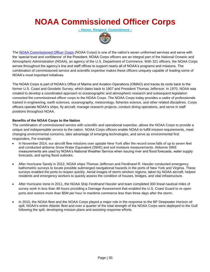
NOAA Commissioned Officer Corps – Honor, Respect, Commitment –
The NOAA Commissioned Officer Corps (NOAA Corps) is one of the nation’s seven uniformed services and serve with
the ‘special trust and confidence’ of the President. NOAA Corps officers are an integral part of the National Oceanic and
Atmospheric Administration (NOAA), an agency of the U.S. Department of Commerce. With 321 officers, the NOAA Corps
serves throughout the agency’s line and staff offices to support nearly all of NOAA’s programs and missions. The
combination of commissioned service and scientific expertise makes these officers uniquely capable of leading some of
NOAA’s most important initiatives.
The NOAA Corps is part of NOAA’s Office of Marine and Aviation Operations (OMAO) and traces its roots back to the
former U.S. Coast and Geodetic Survey, which dates back to 1807 and President Thomas Jefferson. In 1970, NOAA was
created to develop a coordinated approach to oceanographic and atmospheric research and subsequent legislation
converted the commissioned officer corps to the NOAA Corps. The NOAA Corps today provides a cadre of professionals
trained in engineering, earth sciences, oceanography, meteorology, fisheries science, and other related disciplines. Corps
officers operate NOAA’s ships, fly aircraft, manage research projects, conduct diving operations, and serve in staff
positions throughout NOAA.
Benefits of the NOAA Corps to the Nation
The combination of commissioned service with scientific and operational expertise, allows the NOAA Corps to provide a
unique and indispensable service to the nation. NOAA Corps officers enable NOAA to fulfill mission requirements, meet
changing environmental concerns, take advantage of emerging technologies, and serve as environmental first
responders. For example:
In November 2014, our aircraft flew missions over upstate New York after the record snow falls of up to seven feet and conducted airborne Snow Water Equivalent (SWE) and soil moisture measurements. Airborne SWE measurements are used by NOAA’s National Weather Service when issuing river and flood forecasts, water supply forecasts, and spring flood outlooks.
After Hurricane Sandy in 2012, NOAA ships Thomas Jefferson and Ferdinand R. Hassler conducted emergency bathometric surveys to locate possible submerged navigational hazards in the ports of New York and Virginia. These surveys enabled the ports to reopen quickly. Aerial images of storm-stricken regions, taken by NOAA aircraft, helped residents and emergency workers to quickly assess the condition of houses, bridges, and vital infrastructure.
After Hurricane Irene in 2011, the NOAA Ship Ferdinand Hassler and team completed 300 lineal nautical miles of
survey work in less than 48 hours providing a Damage Assessment that enabled the U.S. Coast Guard to re-open
ports and restore more than $5M per hour in maritime commerce less than three days after the storm.
In 2010, the NOAA fleet and the NOAA Corps played a major role in the response to the BP Deepwater Horizon oil spill. NOAA's entire Atlantic fleet and over a quarter of the total strength of the NOAA Corps were deployed to the Gulf following the spill, developing mission plans and assisting response efforts.


![t4JbÃBBQ by [57'Lx;ä] GUAM PLAZA FIESTA RESORT …ƒBBQ by [57'Lx;ä] GUAM PLAZA FIESTA RESORT 45 PACIFIC ISLANDS P.I.C. ROYAL ORCHID GUAM HOTEL HILTON GUAM GUAM REEF & ONWARD SHERATON](https://static.fdocuments.in/doc/165x107/5afde0387f8b9a256b8c45ee/t4jbbbq-by-57lx-guam-plaza-fiesta-resort-by-57lx-guam-plaza-fiesta-resort.jpg)