NO: R152 COUNCIL DATE: July 9, 2012 - Surrey · The purpose of this report is to obtain Council...
24
CORPORATE REPORT NO: R152 COUNCIL DATE: July 9, 2012 REGULAR COUNCIL TO: Mayor & Council DATE: July 4, 2012 FROM: General Manager, Engineering FILE: XC: 5260-07 3150-01 SUBJECT: Amendments to the 10-Year (2012-2021) Servicing Plan and the Development Cost Charge By-law to Provide Engineering Services for Development in the Anniedale/Tynehead NCP Area RECOMMENDATION: The Engineering Department recommends that Council: 1. Approve amendments, as listed in Appendix I attached to this report, to the 10-Year (2012- 2021) Servicing Plan, which projects will service future development in the Anniedale/Tynehead NCP area; 2. Approve amendments, as documented in Appendix II to this report, to Development Cost Charge By-law, 2012, No. 17539, which will put in place area specific DCC rates for development in the Anniedale/Tynehead NCP area; 3. Authorize the City Clerk to bring forward for the required readings the necessary Development Cost Charge By-law Amendment By-law; and 4. Subject to the DCC Amendment By-law being given the required readings, authorize staff to forward the DCC Amendment By-law to the Provincial Ministry of Community, Sport and Cultural Development for approval prior to the By-law being considered for final adoption by Council. INTENT The purpose of this report is to obtain Council approval for amendments to the 10-Year (2012- 2021) Servicing Plan and the Development Cost Charge By-law to support development in the Anniedale-Tynehead Neighbourhood Concept Plan (NCP) area, which NCP was recently adopted by Council. BACKGROUND At its Regular meeting on April 23, 2012 Council considered Corporate Report No. R077;2012, which recommended an engineering servicing strategy and a related financial strategy for the
Transcript of NO: R152 COUNCIL DATE: July 9, 2012 - Surrey · The purpose of this report is to obtain Council...
CORPORATE REPORT
NO: R152 COUNCIL DATE: July 9, 2012
REGULAR COUNCIL TO: Mayor & Council DATE: July 4, 2012 FROM: General Manager, Engineering FILE:
XC: 5260-07 3150-01
SUBJECT: Amendments to the 10-Year (2012-2021) Servicing Plan and the Development
Cost Charge By-law to Provide Engineering Services for Development in the Anniedale/Tynehead NCP Area
RECOMMENDATION: The Engineering Department recommends that Council:
1. Approve amendments, as listed in Appendix I attached to this report, to the 10-Year (2012-2021) Servicing Plan, which projects will service future development in the Anniedale/Tynehead NCP area;
2. Approve amendments, as documented in Appendix II to this report, to Development Cost Charge By-law, 2012, No. 17539, which will put in place area specific DCC rates for development in the Anniedale/Tynehead NCP area;
3. Authorize the City Clerk to bring forward for the required readings the necessary
Development Cost Charge By-law Amendment By-law; and 4. Subject to the DCC Amendment By-law being given the required readings, authorize staff
to forward the DCC Amendment By-law to the Provincial Ministry of Community, Sport and Cultural Development for approval prior to the By-law being considered for final adoption by Council.
INTENT The purpose of this report is to obtain Council approval for amendments to the 10-Year (2012-2021) Servicing Plan and the Development Cost Charge By-law to support development in the Anniedale-Tynehead Neighbourhood Concept Plan (NCP) area, which NCP was recently adopted by Council. BACKGROUND At its Regular meeting on April 23, 2012 Council considered Corporate Report No. R077;2012, which recommended an engineering servicing strategy and a related financial strategy for the
- 2 –
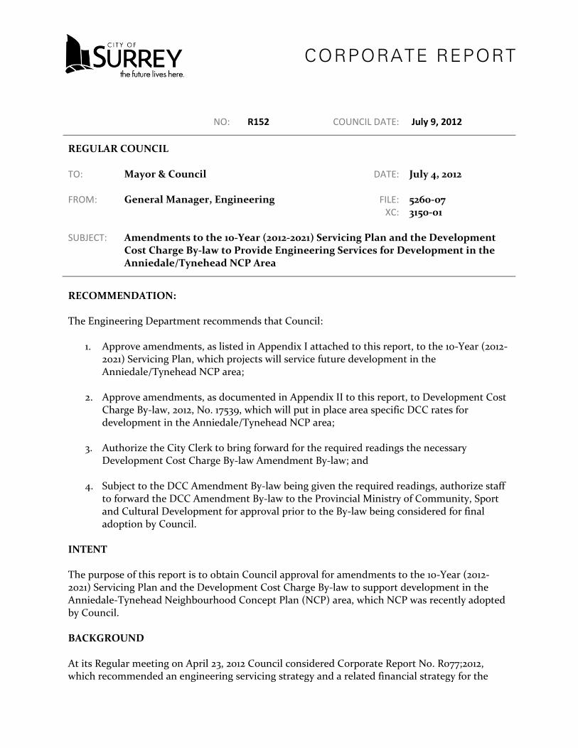
Anniedale-Tynehead NCP as a means of managing the provision of engineering services for development in that NCP area. The costs to provide engineering services to this NCP area are very high due to the limited amount of infrastructure in and around the area, the topography of the area and the location of the area in relation to major highways. As such, Council endorsed that area-specific DCC rates be established as an equitable way to distribute the costs of the needed infrastructure across development that is planned for the area. DISCUSSION Appendix I to this report lists the projects related to each of the sanitary sewer, water, drainage and transportation, respectively that will need to be constructed to support development within the Anniedale/Tynehead NCP area as adopted by Council. These projects now need to be incorporated into the City’s 10 Year Servicing Plan and will become the basis upon which DCC rates will be calculated for the NCP. The estimated total cost by service type of the DCC-funded projects that will need to be constructed to service development in the Anniedale-Tynehead NCP as documented in Appendix I is listed in the following table:
Program
Growth Component
(DCC Eligible)
Non-Growth Component
External Funding Required
Total
Arterial Roads $98,500,000 $0 $107,180,000 $205,680,000 Non-Arterial Roads $25,500,000 $0 $34,655,000 $60,155,000 Drainage $26,637,000 $0 - $26,637,000 Water $20,500,000 $0 - $20,500,000 Sewer $29,293,000 $0 - $29,293,000 TOTAL $200,430,000 $0 $141,835,000 $342,265,000
Except for a small amount (5 to 10%) of City funding assistance, the growth component of the costs as listed in the table is funded from revenues generated through DCC rates. External Funding As indicated in the table referenced above, approximately $142 million, or 53% of the total value of, Arterial and Non-Arterial infrastructure costs are expected to be paid from various sources of external funding. In this regard, the external funding for the Arterial Road program is expected to be secured through contributions from:
• The Ministry of Transportation and Infrastructure, and the Transportation Investment Corporation, primarily for the Highway 1 and 192 Street full movement interchange; and
• TransLink for the Major Road Network (MRN) cost-shared improvements on 88 Avenue. Some external funding is also expected from other orders of government in relation to the Highway 15/Golden Ears Way/96 Avenue interchange.
- 3 –
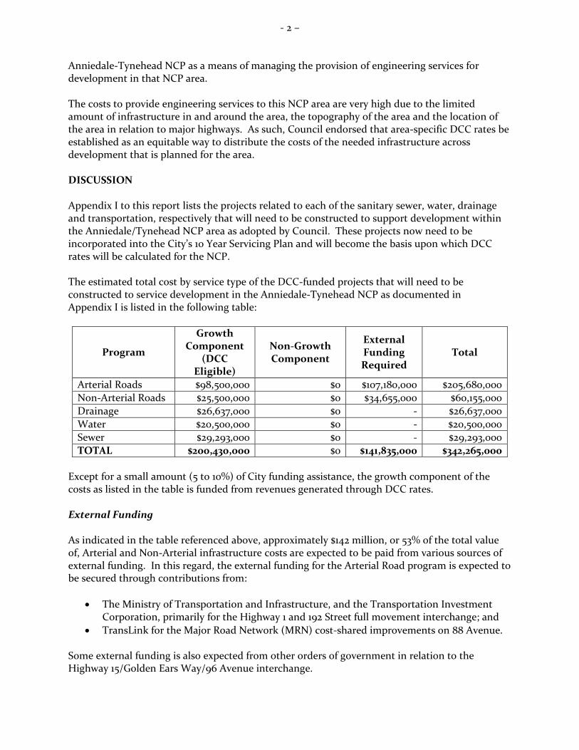
The primary source of external funding for the Non-Arterial Road program will be from developers who develop the property fronting these roads as the majority of these projects relate to road upsizing. This requirement is prescribed in the Subdivision and Development By-law, No. 8830. Area Specific Development Cost Charges To distribute the costs of needed infrastructure in an equitable manner area specific DCC rates are proposed for the NCP area. Similar area-specific DCC rates were adopted for the Campbell Heights Business Area and the Highway 99 Corridor Local Area Plan. The following table documents the proposed DCC rates for each of various zones in the Anniedale/Tynehead NCP. These rates were developed in accordance with the DCC Best Practices Guidelines as published by the Ministry of Community, Sport and Cultural Development.
Land Use Proposed Area-Specific DCC Rate SF (RF, RF-12, RFC) $41,346 / lot SF Small Lot (RF-9, RF-SD) $36,035 / lot RM-10, RM-15 & RM-30 $21.77 / sq. ft. RM-45 and RM-70 $24.67 / sq. ft. Commercial (ground floor) $15.84 / sq. ft. Industrial $140,713 / acre
The proposed amendments to DCC By-law No. 17539 are documented in Appendix II to this report. Implementation The amendments to the 10-Year Servicing Plan to incorporate the Anniedale/Tynehead projects and the adoption of the related DCC rates as proposed in this report are expected to be implemented in accordance with the following schedule:
July 9, 2012 Corporate Report to Council for approval of amendments to the 10-Year
(2012-2021) Servicing Plan and initial readings of the related amendments to the 2012 DCC By-law No. 17539
August, 2012 Approval of the amendments to the 2012 DCC By-law No. 17539 by the
Ministry of Community, Sport and Cultural Development Sept. 10, 2012 Final Adoption of amendments to the 2012 DCC By-law No. 17539 Sept. 14, 2012 New DCC Rates for the Anniedale/Tynehead NCP Area take effect
Impact on the Five Year (2012-2016) Financial Plan The Five Year (2013-2017) Capital and General Operating Financial Plans, which will be considered by the Finance Committee late in 2012 will reflect the amendments to the 10-Year (2012-2021) Servicing Plan as documented in this report.

- 4 –
Legal Services and Finance Review This report and the related By-law amendments have been reviewed by the Finance and Technology Department and the Legal Services Division. There are no concerns from either perspective. SUSTAINABILITY CONSIDERATIONS A properly developed and adequately funded 10-Year Servicing Plan will help to ensure orderly development in the Anniedale-Tynehead NCP area, which will support the Economic Pillar of the City’s Sustainability Charter; more particularly, the following Charter action items:
• EC3: Sustainable Infrastructure Maintenance and Replacement; • EC4: Sustainable Financial Management Practices; and • EC11: Providing infrastructure to support and expand Surrey’s Employment Land Base.
CONCLUSION Based on the above discussion, it is recommended that Council:
• Approve amendments, as listed in Appendix I attached to this report, to the 10-Year (2012-2021) Servicing Plan, which projects will service future development in the Anniedale/Tynehead NCP area;
• Approve amendments, as documented in Appendix II to this report, to Development Cost Charge By-law, 2012, No. 17539, which will put in place area specific DCC rates for development in the Anniedale/Tynehead NCP area;
• Authorize the City Clerk to bring forward for the required readings the necessary
Development Cost Charge By-law Amendment By-law; and • Subject to the DCC Amendment By-law being given the required readings, authorize staff
to forward the DCC Amendment By-law to the Provincial Ministry of Community, Sport and Cultural Development for approval prior to the By-law being considered for final adoption by Council.
Vincent Lalonde, P.Eng. General Manager, Engineering
VL/JA/LW/brb Appendix I - Proposed Amendments to the 10-Year (2012-2021) Servicing Plan Appendix II - Proposed Amendments to Development Cost Charge By-law, 2012, No. 17539 g:\wp-docs\2012\admin\cr\05101041ja (md) ja 2.docx BRB 7/5/12 2:28 PM

www.surrey.ca
ENGINEERING DEPARTMENT
2012 - 2021 TEN YEAR SERVICING PLAN
Amendment 1:Anniedale - Tynehead NCP
APPENDIX I

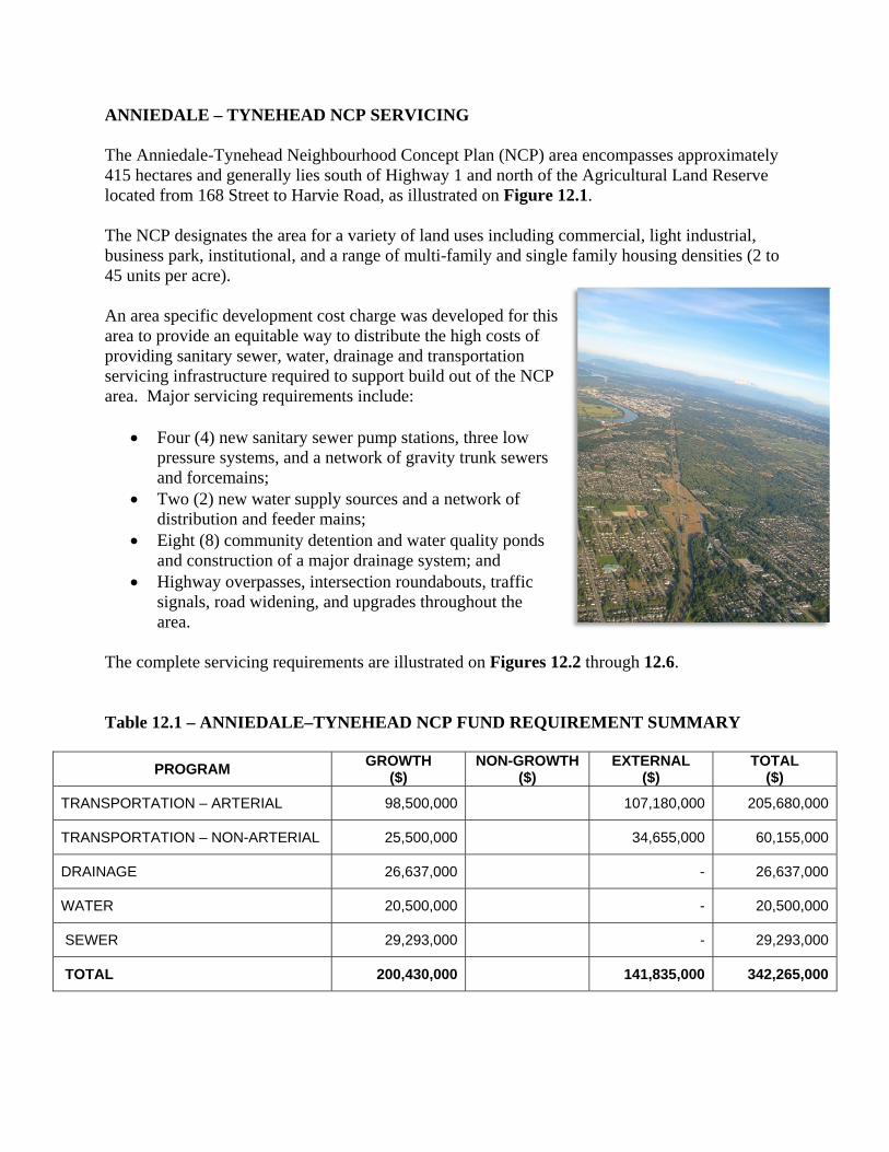
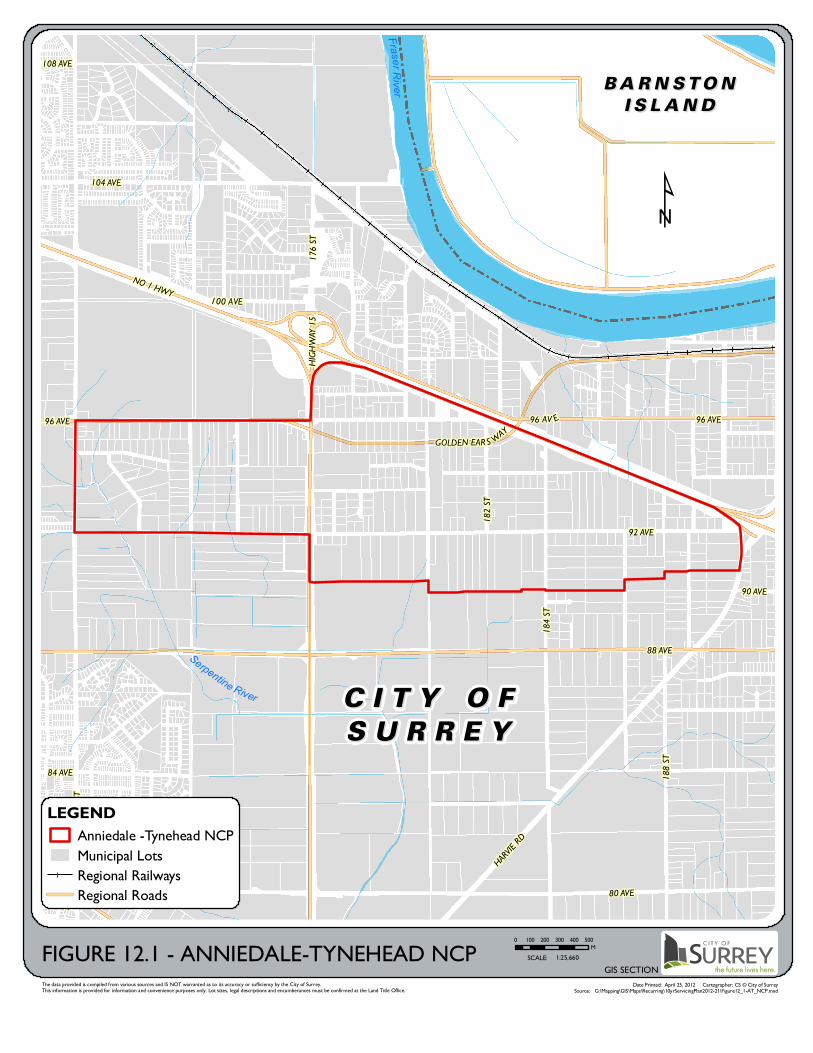
ANNIEDALE – TYNEHEAD NCP SERVICING The Anniedale-Tynehead Neighbourhood Concept Plan (NCP) area encompasses approximately 415 hectares and generally lies south of Highway 1 and north of the Agricultural Land Reserve located from 168 Street to Harvie Road, as illustrated on Figure 12.1. The NCP designates the area for a variety of land uses including commercial, light industrial, business park, institutional, and a range of multi-family and single family housing densities (2 to 45 units per acre). An area specific development cost charge was developed for this area to provide an equitable way to distribute the high costs of providing sanitary sewer, water, drainage and transportation servicing infrastructure required to support build out of the NCP area. Major servicing requirements include:
Four (4) new sanitary sewer pump stations, three low pressure systems, and a network of gravity trunk sewers and forcemains;
Two (2) new water supply sources and a network of distribution and feeder mains;
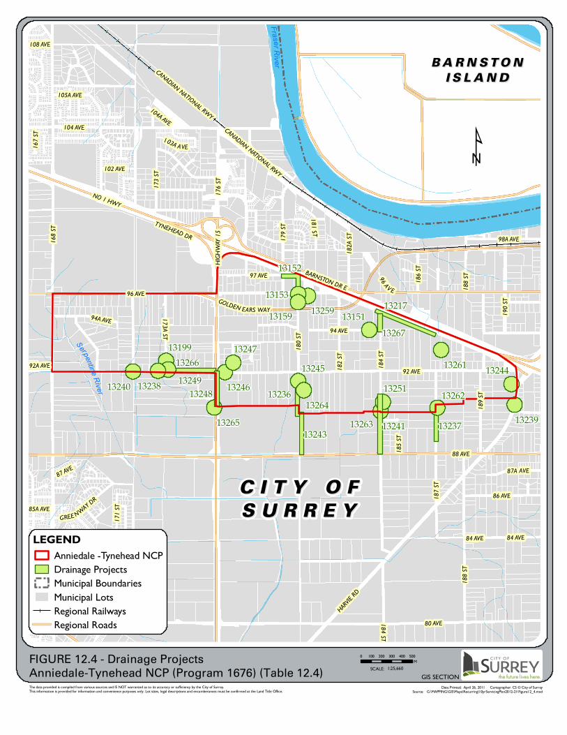
Eight (8) community detention and water quality ponds and construction of a major drainage system; and
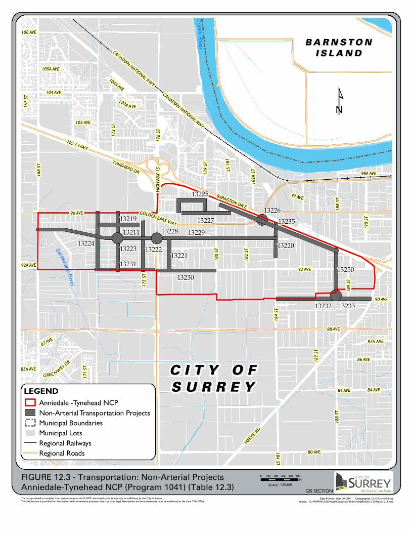
Highway overpasses, intersection roundabouts, traffic signals, road widening, and upgrades throughout the area.
The complete servicing requirements are illustrated on Figures 12.2 through 12.6. Table 12.1 – ANNIEDALE–TYNEHEAD NCP FUND REQUIREMENT SUMMARY
PROGRAM GROWTH ($)
NON-GROWTH ($)
EXTERNAL ($)
TOTAL ($)
TRANSPORTATION – ARTERIAL 98,500,000 107,180,000 205,680,000
TRANSPORTATION – NON-ARTERIAL 25,500,000 34,655,000 60,155,000
DRAINAGE 26,637,000 - 26,637,000
WATER 20,500,000 - 20,500,000
SEWER 29,293,000 - 29,293,000
TOTAL 200,430,000 141,835,000 342,265,000

This page is intentionally blank.
Fras er R iv er
Serpentine River
88 AVE
80 AVE
168 S
T
NO 1 HWY
92 AVE
HIGHW
AY 15
104 AVE
HARVIE R
D
184 S
T
188 S
T
96 AVEGOLDEN EAR S WAY
176 S
T100 AVE
182 S
T
90 AVE
84 AVE
108 AVE
96 AVE
80 AVE
96 AV E
The data provided is compiled from various sources and IS NOT warranted as to its accuracy or sufficiency by the City of Surrey.This information is provided for information and convenience purposes only. Lot sizes, legal descriptions and encumberances must be confirmed at the Land Title Office.
Date Printed: April 25, 2012 Cartographer: CS © City of SurreySource: G:\Mapping\GIS\Maps\Recurring\10yrServicingPlan2012-21\Figure12_1-AT_NCP.mxd
GIS SECTION
LEGENDAnniedale -Tynehead NCPMunicipal LotsRegional RailwaysRegional Roads
0 100 200 300 400 500MFIGURE 12.1 - ANNIEDALE-TYNEHEAD NCP SCALE: 1:25,660
C I T Y O FC I T Y O F
S U R R E YS U R R E Y
B A R N S T O NB A R N S T O N
I S L A N DI S L A N D
¹

13268
1325313254
1325713256 13255 13210
13207
13209
13252
13242
13215
13216
13208
13260
1320413205
13214
13218
13203
13234
13206
1321313212
13258
Fraser River
Serpentine River
168 S
T
88 AVE
80 AVE
NO 1 HWY
92 AVE
72 AVE
192 S
T
HARVIE R
D
HIGHW
AY 15
184 S
T
104 AVE
74 AVE
FRASER HWY
188 S
T
96 AVE
76 AVE
GOLDEN EARS WAY
172 S
T
98A AVE
CANADIAN NATIONAL RWY
187 S
T
170 S
T
176 S
T
196 S
T
189 S
T
190 S
T
194 S
T
78 AVE
83 AVE
86 AVE
180 S
T
82A AVE
173A ST
94 AVE
97 AVE
73 AVE
173 S
T
182 ST
182A
ST
18 1 ST
195 S
T
171 S
T
186 S
T
72A AVE
171A
ST
92A AVE
77 AVE
102 AVE
85A AVE
105A AVE
175 S
T
104A AVE
185 ST
79A AVE
169 S
T
193 S
T
96 AVE
192 S
T
184 S
T
196 S
T
168 S
T
76 AVE
92 AVE 92 AVE
The data provided is compiled from various sources and IS NOT warranted as to its accuracy or sufficiency by the City of Surrey.This information is provided for information and convenience purposes only. Lot sizes, legal descriptions and encumberances must be confirmed at the Land Title Office.
Date Printed: June 29, 2012 Cartographer: CS © City of SurreySource: G:\MAPPING\GIS\Maps\Recurring\10yrServicingPlan2012-21\Figure12_2.mxd
GIS SECTION
LEGENDAnniedale -Tynehead NCPArterial Transportation Projects Municipal BoundariesMunicipal LotsRegional RailwaysRegional Roads
0 100 200 300 400 500M
SCALE: 1:31,156
C I T Y O FC I T Y O F
S U R R E YS U R R E Y
B A R N S TO NB A R N S TO N
I S L A N DI S L A N D¹
FIGURE 12.2 - Transportation: Arterial ProjectsAnniedale-Tynehead NCP (Program 1021) (Table 12.2)

ANNIEDALE-TYNEHEADTable 12.2 - Program 1021 - Transportation Arterial
Project ID Project Name Project Location Priority Total CostGrowth
ComponentNon-Growth Component
External Funding
13203 Traffic Signal 096 Ave / 173A St NCP Driven 180,000 180,000
13204 Traffic Signal 192 St / 80 Ave NCP Driven 180,000 90,000 90,000
13205 Traffic Signal 184 St / 80 Ave NCP Driven 180,000 90,000 90,000
13206 Traffic Signal 184 St / 90 Ave NCP Driven 180,000 90,000 90,000
13207 Traffic Signal 180 St / 96 Ave NCP Driven 180,000 180,000
13208 Traffic Signal 180 St / 93A Ave NCP Driven 180,000 180,000
13209 Traffic Signal 088 Ave / 184 St NCP Driven 180,000 72,000 108,000
13210 Traffic Signal 092 Ave / 188 St NCP Driven 180,000 180,000
13212 Traffic Signal 092 Ave / 184 St NCP Driven 180,000 180,000
13213 Traffic Signal 092 Ave / 180 St NCP Driven 180,000 180,000
13214 Traffic Signal 090 Ave / 192 St NCP Driven 180,000 126,000 54,000
13215 Traffic Signal 090 Ave / Harvie Rd NCP Driven 180,000 126,000 54,000
13216 Traffic Signal 088 Ave / 192 St NCP Driven 180,000 72,000 108,000
13218 Traffic Signal 168 St / 94A Ave NCP Driven 180,000 90,000 90,000
13234 Traffic Signal 088 Ave / 180 St NCP Driven 180,000 72,000 108,000
13242 Traffic Signal 088 Ave / 188 St NCP Driven 180,000 72,000 108,000
13252 Interchange Hwy 15 / GEW NCP Driven 47,500,000 11,870,000 35,630,000
13253 Ultimate Arterial Widening 192 St: 80 ‐ 92 Ave NCP Driven 19,200,000 9,600,000 9,600,000
13254 Ultimate Arterial Widening & New Arterial Widening 184 St: 80 ‐ 93 Ave NCP Driven 21,600,000 10,800,000 10,800,000
13255 Ultimate Arterial Widening (Special Section HH) 180 St: 88 ‐ 96 Ave NCP Driven 12,800,000 12,800,000
13256 Ultimate Arterial Widening 168 St: 88 ‐ 96 Ave NCP Driven 14,400,000 7,200,000 7,200,000
13257 Interim Arterial Upsizing (Special Section II) 092 Ave: 180 St ‐ Harvie Rd; Harvie Rd: 92 ‐ 90 Ave NCP Driven 18,200,000 18,200,000
13258 Ultimate Arterial Widening 090 Ave: Harvie Rd ‐ 192 St NCP Driven 2,700,000 1,890,000 810,000
13260 Interchange Hwy 1 / 192 St NCP Driven 16,000,000 4,000,000 12,000,000
13268 Ultimate Arterial Widening 088 Ave: 168 ‐196 St NCP Driven 50,400,000 20,160,000 30,240,000
205,680,000 98,500,000 ‐ 107,180,000
1322913235
13232
1322313224
13225
13227
1323013231
13222
13219
1325013221
13220
13226
13233
13211 13228
Fras er R iv er
Serpentine River88 AVE
80 AVE
168 S
T
92 AVE
NO 1 HWY
184 S
T
HIGHW
AY 15
HARVIE R
D
104 AVE
188 S
T
96 AVE
172 S
T
187 S
T
CANADIAN NATIONAL RWY
GOLDEN EARS WAY
170 S
T
176 S
T
170A
ST
189 S
T
190 S
T
83 AVE
180 S
T
179 S
T
86 AVE
BARNSTON DR E
97 AVE
98A AVE
173 S
T
182 S
T
TYNEHEAD DR
182A
ST
87A AVE
181 ST
171 S
T
84 AVE
103A A VE
FRASER HWY
171A ST
102 AVE
90 AVE
105A AVE
175 S
T
167 S
T
GREE NWAY DR
87 AVE
104A AVE
108 AVE
92A AVE
85A AVE
184 ST
188 S
T
84 AVE
CANADIAN NATIONAL RWY
The data provided is compiled from various sources and IS NOT warranted as to its accuracy or sufficiency by the City of Surrey.This information is provided for information and convenience purposes only. Lot sizes, legal descriptions and encumberances must be confirmed at the Land Title Office.
Date Printed: April 30, 2011 Cartographer: CS © City of SurreySource: G:\MAPPING\GIS\Maps\Recurring\10yrServicingPlan2012-21\Figure12_3.mxd
GIS SECTION
LEGENDAnniedale -Tynehead NCPNon-Arterial Transportation Projects Municipal BoundariesMunicipal LotsRegional RailwaysRegional Roads
0 100 200 300 400 500M
SCALE: 1:25,660
C I T Y O FC I T Y O F
S U R R E YS U R R E Y
B A R N S T O NB A R N S T O N
I S L A N DI S L A N D
¹
FIGURE 12.3 - Transportation: Non-Arterial ProjectsAnniedale-Tynehead NCP (Program 1041) (Table 12.3)

ANNIEDALE-TYNEHEADTable 12.3 - Program 1041 - Transportation Non-Arterial
Project ID Project Name Project Location Priority Total CostGrowth
ComponentNon-Growth Component
External Funding
13211 Roundabout/Intersection Improvements 094A Ave / 173A St NCP Driven 750,000 750,000
13219 Upsizing (Special Section DD) 095 Ave: 172 ‐ 175 St NCP Driven 1,120,000 168,000 952,000
13220 Upsizing 184 St: 92A Ave ‐ Hwy 1 NCP Driven 1,475,000 310,000 1,165,000
13221 Upsizing 177 St: 92 ‐ 93A Ave NCP Driven 1,005,000 211,000 794,000
13222 Upsizing Special Section EE 175 St: 92 ‐ 95 Ave NCP Driven 1,545,000 351,000 1,194,000
13223 Upsizing 173A St: 92 ‐ 96 Ave NCP Driven 2,870,000 603,000 2,267,000
13224 Upsizing 172 St: 92 ‐ 96 Ave NCP Driven 2,870,000 603,000 2,267,000
13225 Anniedale Triangle Upsizing 097 Ave: 177A ‐ 179 St; 177A St: 96 ‐ 97 Ave; 179 St: 96 ‐ 9 NCP Driven 3,000,000 675,000 2,325,000
13226 Frontage Road Overpass Structure Hwy 1 / Golden Ears Way NCP Driven 5,500,000 5,500,000
13227 Upsizing 096 Ave: 177A ‐ 181A St NCP Driven 2,515,000 527,000 1,988,000
13228 Overpass Structure 094 Ave / Hwy 15 NCP Driven 6,500,000 6,500,000
13229 Upsizing & South Side of 94A Ave (Special Section AA) 094A Ave: 168 ‐ 176 St; 93A Ave: 176 ‐ 184 St NCP Driven 13,200,000 2,973,000 10,227,000
13230 Upsizing 092 Ave: 176 ‐ 180 St NCP Driven 3,112,000 654,000 2,458,000
13231 Upsizing & South Side (Special Section CC) 092 Ave: 172 ‐ 176 St NCP Driven 2,230,000 670,000 1,560,000
13232 Upsizing 090 Ave: 184 St ‐ Harvie Rd NCP Driven 1,810,000 325,000 1,485,000
13233 Roundabout/Intersection Improvements 090 Ave / 188 St NCP Driven 750,000 750,000
13235 Upsizing of Frontage Rd (Special Section GG) Hwy 1: 181 ‐ 188 St NCP Driven 6,370,000 3,188,000 3,182,000
13250 Upsizing 188 St: 90A Ave ‐ Hwy 1 NCP Driven 3,533,000 742,000 2,791,000
TOTAL 60,155,000 25,500,000 ‐ 34,655,000
13267
13241
13249
13243
1324713244
13246
13159
13199
13153
13239
13259
1325113245
13263
13238
13151
13266
13264
13261
1326213240
13265
13248
13152
13237
13236
13217Fras er R iv er
Serpentine River88 AVE
80 AVE
168 S
T
92 AVE
NO 1 HWY
184 S
T
HIGHW
AY 15
HARVIE R
D
104 AVE
188 S
T
96 AVE
172 S
T
187 S
T
CANADIAN NATIONAL RWY
GOLDEN EARS WAY
170 S
T
176 S
T
170A
ST
189 S
T
190 S
T
83 AVE
180 S
T
179 S
T
86 AVE
BARNSTON DR E
173 A ST 94 AVE
97 AVE
98A AVE
173 S
T
182 S
T
TYNEHEAD DR
182A
ST
94A AVE
87A AVE
181 ST
171 S
T
186 S
T
84 AVE
103A A VE
FRASER HWY
171A ST
102 AVE
105A AVE
167 S
T
GREE NWAY DR
87 AVE
104A AVE
108 AVE
92A AVE
185 S
T
85A AVE
188 S
T
184 ST96 A V E
CANADIAN NATIONAL RWY
84 AVE
The data provided is compiled from various sources and IS NOT warranted as to its accuracy or sufficiency by the City of Surrey.This information is provided for information and convenience purposes only. Lot sizes, legal descriptions and encumberances must be confirmed at the Land Title Office.
Date Printed: April 26, 2011 Cartographer: CS © City of SurreySource: G:\MAPPING\GIS\Maps\Recurring\10yrServicingPlan2012-21\Figure12_4.mxd
GIS SECTION
LEGENDAnniedale -Tynehead NCPDrainage Projects Municipal BoundariesMunicipal LotsRegional RailwaysRegional Roads
0 100 200 300 400 500M
SCALE: 1:25,660
C I T Y O FC I T Y O F
S U R R E YS U R R E Y
B A R N S T O NB A R N S T O N
I S L A N DI S L A N D
¹
FIGURE 12.4 - Drainage ProjectsAnniedale-Tynehead NCP (Program 1676) (Table 12.4)
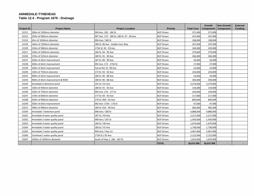
ANNIEDALE-TYNEHEADTable 12.4 - Program 1676 - Drainage
Project ID Project Name Project Location Priority Total CostGrowth
ComponentNon-Growth Component
External Funding
13151 200m of 1050mm diameter 094 Ave: 183 ‐ 184 St NCP Driven 371,000 371,000
13152 250m of 900mm diameter 097 Ave: 179 ‐ 180 St; 180 St: 97 ‐ 96 Ave NCP Driven 347,000 347,000
13153 65m of 1050mm diameter 096 Ave / 180 St NCP Driven 108,000 108,000
13159 160m of 1050mm diameter 180 St: 96 Ave ‐ Golden Ears Way NCP Driven 297,000 297,000
13199 150m of 900mm diameter 173A St: 92 ‐ 93 Ave NCP Driven 249,000 249,000
13217 150m of 1050mm diameter 184 St: 94 ‐ 95 Ave NCP Driven 279,000 279,000
13236 270m of 525mm diameter 180 St: 91 ‐ 90 Ave NCP Driven 266,000 266,000
13237 250m of ditch improvement 187 St: 89 ‐ 90 Ave NCP Driven 34,000 34,000
13238 200m of ditch improvement 092 Ave: 173 ‐ 173A St NCP Driven 27,000 27,000
13239 100m of ditch improvement Harvie Rd: 91 ‐90 Ave NCP Driven 14,000 14,000
13240 150m of 750mm diameter 172 St: 93 ‐ 92 Ave NCP Driven 220,000 220,000
13241 400m of ditch improvement 184 St: 90 ‐ 88 Ave NCP Driven 54,000 54,000
13243 400m of ditch improvement & ROW 180 St: 90 ‐ 88 Ave NCP Driven 509,000 509,000
13244 Anniedale 6 detention pond 191 St / 91 Ave NCP Driven 3,279,000 3,279,000
13245 150m of 450mm diameter 180 St: 91 ‐ 92 Ave NCP Driven 134,000 134,000
13246 150m of 750mm diameter 092 Ave: 176 ‐ 177 St NCP Driven 220,000 220,000
13247 170m of 600mm diameter 177 St: 93 ‐ 92 Ave NCP Driven 217,000 217,000
13248 350m of 900mm diameter 176 St: 90A ‐ 92 Ave NCP Driven 809,000 809,000
13249 350m of ditch improvement 092 Ave: 173A ‐ 176 St NCP Driven 47,000 47,000
13251 290m of 900mm diameter 184 St: 91A ‐ 90 Ave NCP Driven 482,000 482,000
13259 Anniedale 7 detention pond 096 Ave / 180 St NCP Driven 4,888,000 4,888,000
13261 Anniedale 8 water quality pond 187 St / 93 Ave NCP Driven 2,217,000 2,217,000
13262 Anniedale 5 water quality pond 090 Ave / 187 St NCP Driven 1,439,000 1,439,000
13263 Anniedale 4 water quality pond 184 St / 90 Ave NCP Driven 1,679,000 1,679,000
13264 Anniedale 3 water quality pond 180 St / 91 Ave NCP Driven 1,738,000 1,738,000
13265 Anniedale 2 water quality pond 90A Ave / Hwy 15 NCP Driven 2,967,000 2,967,000
13266 Tynehead 1 water quality pond 173A St / 92 Ave NCP Driven 2,122,000 2,122,000
13267 1050m of 1050mm diameter South of Hwy 1: 184 ‐ 187 St NCP Driven 1,624,000 1,624,000
TOTAL 26,637,000 26,637,000 ‐ ‐

Fraser River
13182 13183
13175
13185
13174
13184
13189
13201
131871320213173
13177 13180
13179
13271
1317813176
13181
88 AVE
156 S
T
152 S
T
NO 1 HWY
168 S
T
160 S
T
80 AVE
96 AVE
192 S
T
FRASER HWY
92 AVE
104 AVE
HARVIE R
D
82 AVE
CANADIAN NATIONAL RWY
184 S
T
108 AVE
112 AVE
74 AVE
76 AVE
188 S
T
162 S
T
98 AVE
172 S
T
187 S
T
GO L DEN EA
RS WAY
164 S
T
78 AVE
170 ST
162A
ST
158 S
T
102 AVE
176 S
T
170A ST
189 ST
190 S
T
98A AVE
83 AVE
86 AVE
180 S
T
155 S
T
94 AVE
97 AVE
109 AVE
173 S
T
105 AVE
100 AVE
182A
ST
152A
ST15
3 ST
111 AVE
87A AVE
161 S
T
111A AVE
91 AVE
154 S
T
159A
ST
171 S
T
GLENWOOD CR S
90 AVE
92A AVE
84 A AVE
155A
ST
175 ST
77A AVE
153 S
T
164 S
T
104 AVE
168 S
T
The data provided is compiled from various sources and IS NOT warranted as to its accuracy or sufficiency by the City of Surrey.This information is provided for information and convenience purposes only. Lot sizes, legal descriptions and encumberances must be confirmed at the Land Title Office.
Date Printed: April 26, 2011 Cartographer: CS © City of SurreySource: G:\MAPPING\GIS\Maps\Recurring\10yrServicingPlan2012-21\Figure12_5.mxd
GIS SECTION
LEGENDAnniedale -Tynehead NCPWater Projects Municipal BoundariesMunicipal LotsRegional RailwaysRegional Roads
0 0.25 0.5 0.75 1KM
SCALE: 1:43,639
C I T Y O FC I T Y O F
S U R R E YS U R R E Y
B A R N S T O NB A R N S T O N
I S L A N DI S L A N D
¹
FIGURE 12.5 - Water ProjectsAnniedale-Tynehead NCP (Program 1621) (Table 12.5)
P I T TP I T T
M E A D O W SM E A D O W S
D O U G L A SD O U G L A S
I S L A N DI S L A N D
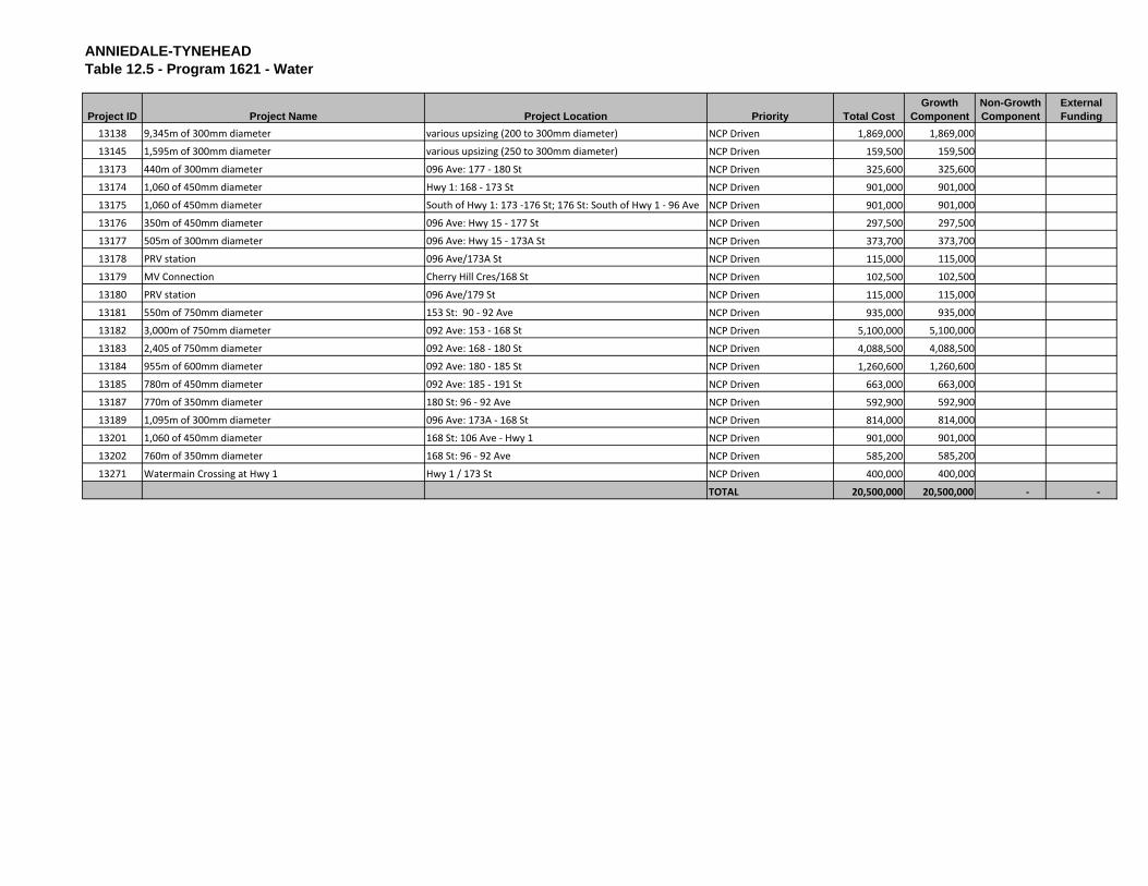
ANNIEDALE-TYNEHEADTable 12.5 - Program 1621 - Water
Project ID Project Name Project Location Priority Total CostGrowth
ComponentNon-Growth Component
External Funding
13138 9,345m of 300mm diameter various upsizing (200 to 300mm diameter) NCP Driven 1,869,000 1,869,000
13145 1,595m of 300mm diameter various upsizing (250 to 300mm diameter) NCP Driven 159,500 159,500
13173 440m of 300mm diameter 096 Ave: 177 ‐ 180 St NCP Driven 325,600 325,600
13174 1,060 of 450mm diameter Hwy 1: 168 ‐ 173 St NCP Driven 901,000 901,000
13175 1,060 of 450mm diameter South of Hwy 1: 173 ‐176 St; 176 St: South of Hwy 1 ‐ 96 Ave NCP Driven 901,000 901,000
13176 350m of 450mm diameter 096 Ave: Hwy 15 ‐ 177 St NCP Driven 297,500 297,500
13177 505m of 300mm diameter 096 Ave: Hwy 15 ‐ 173A St NCP Driven 373,700 373,700
13178 PRV station 096 Ave/173A St NCP Driven 115,000 115,000
13179 MV Connection Cherry Hill Cres/168 St NCP Driven 102,500 102,500
13180 PRV station 096 Ave/179 St NCP Driven 115,000 115,000
13181 550m of 750mm diameter 153 St: 90 ‐ 92 Ave NCP Driven 935,000 935,000
13182 3,000m of 750mm diameter 092 Ave: 153 ‐ 168 St NCP Driven 5,100,000 5,100,000
13183 2,405 of 750mm diameter 092 Ave: 168 ‐ 180 St NCP Driven 4,088,500 4,088,500
13184 955m of 600mm diameter 092 Ave: 180 ‐ 185 St NCP Driven 1,260,600 1,260,600
13185 780m of 450mm diameter 092 Ave: 185 ‐ 191 St NCP Driven 663,000 663,000
13187 770m of 350mm diameter 180 St: 96 ‐ 92 Ave NCP Driven 592,900 592,900
13189 1,095m of 300mm diameter 096 Ave: 173A ‐ 168 St NCP Driven 814,000 814,000
13201 1,060 of 450mm diameter 168 St: 106 Ave ‐ Hwy 1 NCP Driven 901,000 901,000
13202 760m of 350mm diameter 168 St: 96 ‐ 92 Ave NCP Driven 585,200 585,200
13271 Watermain Crossing at Hwy 1 Hwy 1 / 173 St NCP Driven 400,000 400,000
TOTAL 20,500,000 20,500,000 ‐ ‐
13186
13200
13157
13193 13156
13195
13164 1316813191
13169
1319413196
13150
1314913166
13172
13190
13197
1316713165 13163
13188
13192
13171
13198
1316113158
1316213154 13148
13155
1314713160
13170
Fraser R ive r
Serpentine River
88 AVE
80 AVE
168 S
T
92 AVE
NO 1 HWY
184 S
T
104 AVE
HARVIE R
D
96 AVE
188 S
T
172 S
T
187 S
T
CANADIAN NATIONAL RWY
GOLDEN EARS WAY
170 S
T
176 S
T
189 ST
190 S
T
83 AVE
170A
ST
180 S
T17
9 ST
86 AVE
173A
ST
94 AVE
97 AVE
98A AVE
173 S
T
182 ST100 AVE
182A ST
94A AVE
171 S
T
186 S
T
84 AVE
FRASER HWY
171A ST
102 AVE
90 AVE
105A AVE
167 S
T
GREE NWAY DR
87 AVE
108 AVE
92A AVE
84A AVE
185 ST
1 03B AVE
84 AVE
188 S
T96 AV E
CANADIAN NATIONAL RWY
189 S
T
The data provided is compiled from various sources and IS NOT warranted as to its accuracy or sufficiency by the City of Surrey.This information is provided for information and convenience purposes only. Lot sizes, legal descriptions and encumberances must be confirmed at the Land Title Office.
Date Printed: April 26, 2011 Cartographer: CS © City of SurreySource: G:\MAPPING\GIS\Maps\Recurring\10yrServicingPlan2012-21\Figure12_6.mxd
GIS SECTION
LEGENDAnniedale -Tynehead NCPSewer Projects Municipal BoundariesMunicipal LotsRegional RailwaysRegional Roads
0 100 200 300 400 500M
SCALE: 1:25,916
C I T Y O FC I T Y O F
S U R R E YS U R R E Y
B A R N S T O NB A R N S T O N
I S L A N DI S L A N D
¹
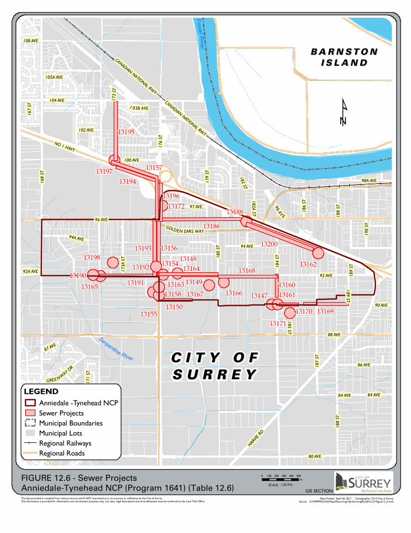
FIGURE 12.6 - Sewer ProjectsAnniedale-Tynehead NCP (Program 1641) (Table 12.6)

ANNIEDALE-TYNEHEADTable 12.6 - Program 1641 - Sewer
Project ID Project Name Project Location Priority Total CostGrowth
ComponentNon-Growth Component
External Funding
13139 435m of 375mm diameter Tynehead 375mm dia upsizing NCP Driven 104,500 104,500
13140 160m of 300mm diameter Tynehead 300mm dia upsizing NCP Driven 22,000 22,000
13141 270m of 250mm diameter Tynehead 250mm dia upsizing NCP Driven 17,500 17,500
13142 1,135m of 250mm diameter Anniedale A1/B1/B4 250mm dia upsizing NCP Driven 72,500 72,500
13143 350m of 300mm diameter Anniedale A1/B1/B4 300mm dia upsizing NCP Driven 47,500 47,500
13144 75m of 375mm diameter Anniedale A1/B1/B4 375mm dia upsizing NCP Driven 18,000 18,000
13146 100m of 300mm diameter Anniedale B3 300mm dia upsizing NCP Driven 13,500 13,500
13147 Anniedale B2 pump station 184 St / 89 Ave NCP Driven 4,400,000 4,400,000
13148 390m of 375mm diameter (upsizing) 092 Ave: 177 ‐ 176 St NCP Driven 93,500 93,500
13149 690m of 300mm diameter (upsizing) 091 Ave: 180 ‐ 178 St NCP Driven 94,000 94,000
13150 135m of 375mm diameter (upsizing) 090A Ave: 178 ‐ 176 St NCP Driven 32,500 32,500
13154 200m of 400mm diameter Hwy 15: 91 ‐ 92 Ave NCP Driven 194,000 194,000
13155 Anniedale B4 odour control Hwy 15 / 91 Ave NCP Driven 60,000 60,000
13156 980m of 500mm diameter Hwy 15: 92 ‐ 96 Ave NCP Driven 1,065,500 1,065,500
13157 1150m of 650mm diameter Hwy 15: 96 Ave ‐ s. of Hwy 1; s. of Hwy 1: Hwy 15 ‐ 173 St NCP Driven 1,396,000 1,396,000
13158 Anniedale B4 Pump Station 176 St / 91 Ave NCP Driven 3,500,000 3,500,000
13160 400m of 250mm diameter 184 St: 90 ‐ 92 Ave NCP Driven 304,000 304,000
13161 Anniedale B2 odour control 090 Ave / 184 St NCP Driven 60,000 60,000
13162 Anniedale Pump Station South of Hwy 1 / 187 St NCP Driven 3,600,000 3,600,000
13163 265m of 375mm diameter (upsizing) 092 Ave: 178 ‐ 177 St NCP Driven 63,500 63,500
13164 850m of 250mm diameter 092 Ave: 180 ‐ 176 St NCP Driven 646,000 646,000
13165 Tynehead Pump Station 092 Ave / 172 St NCP Driven 3,300,000 3,300,000
13166 220m of 300mm diameter (upsizing) 091 Ave: 180 ‐ 181 St NCP Driven 30,000 30,000
13167 Anniedale B3 Trunk ROW 091 Ave / 179 St NCP Driven 225,000 225,000
13168 920m of 250mm diameter 092 Ave: 184 ‐ 180 St NCP Driven 699,000 699,000
13169 890m of 525mm diameter 090A Ave: 189 ‐ 186 St NCP Driven 822,000 822,000
13170 190m of 600 diameter 090 Ave: 186 ‐ 184 St NCP Driven 191,000 191,000
13171 Anniedale B2 Trunk ROW 089 Ave / 185 St; 90A Ave / 188 St; 91 Ave / 188A St NCP Driven 235,000 235,000
13172 Hwy 15 crossing Hwy 15 / 97 Ave NCP Driven 200,000 200,000
13186 2140m of 400mm diameter South of Hwy 1: 182 ‐ 187 St; 96 Ave: 182 St ‐ Hwy 15 NCP Driven 2,078,000 2,078,000
13188 Anniedale A odour control 096 Ave / 182 St NCP Driven 60,000 60,000
13190 355m of 375mm diameter (upsizing) 092 Ave: 171 ‐ 172 St NCP Driven 85,500 85,500
13191 835m of 400mm diameter 092 Ave: 176 ‐ 172 St NCP Driven 811,000 811,000
13192 Tynehead forcemain odour contol Hwy 15 / 92A Ave NCP Driven 60,000 60,000
13193 980m of 400mm diameter Hwy 15: 96 ‐ 92 Ave NCP Driven 952,000 952,000
13194 1150m of 400mm diameter South of Hwy 1: 176 ‐ 173 St; Hwy 15: 96 Ave‐south of Hwy 1 NCP Driven 1,117,000 1,117,000
13195 800m of 600mm diameter 173 St: Hwy 1 ‐ 104 Ave NCP Driven 1,133,000 1,133,000

ANNIEDALE-TYNEHEADTable 12.6 - Program 1641 - Sewer
Project ID Project Name Project Location Priority Total CostGrowth
ComponentNon-Growth Component
External Funding
13196 Tynehead Trunk ROW 097 Ave / 175A St NCP Driven 90,000 90,000
13197 Hwy 1 crossing Hwy 1 / 173 St NCP Driven 500,000 500,000
13198 South Port Kells odour control 173 St / 92A Ave NCP Driven 660,000 660,000
13200 1000m of 375mm diameter (upsizing) South of Hwy 1: 182 ‐ 187 St NCP Driven 240,000 240,000
TOTAL 29,293,000 29,293,000 ‐ ‐
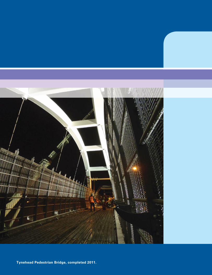
Tynehead Pedestrian Bridge, completed 2011.

APPENDIX II
Proposed Amendments to Development Cost Charge By-law, 2012, No. 17539 It is proposed that the By-law be amended as follows:
1. In section 2, insert a new definition immediately before the definition for “Assisted Living Residence” as follows:
“Anniedale-Tynehead means the area of the City of Surrey shown as Area XXVII in Schedule “F” of the Surrey Zoning By-law.”
2. In section 5, insert immediately after “in Schedule “A”” the following:
“for the entire City of Surrey except Anniedale-Tynehead, and Schedule “A-1” for Anniedale-Tynehead”
3. In section 13, insert at the beginning of the section, immediately before “Surrey Development Cost Charge By-law, 2011, No. 17330”the following:
“Subject to section 14,”
4. Add a new section 14 as follows:
“ 14. For Anniedale-Tynehead, Surrey Development Cost Charge By-law, 2012, No. 17539, Amendment By-law, 2012, No. 17668 is applicable, except in the case of:
(a) applications for subdivision of land that are in-stream on July 27,
2012 and which are completed within one year of July 27, 2012; and
(b) building permits that are in-stream on July 27, 2012 and which are
issuable within one year of July 27, 2012,
in which case Surrey Development Cost Charge By-law, 2011, No. 17330 or
Surrey Development Cost Charge By-law, 2012, No. 17539, prior to this
amendment by-law, shall apply.”
5. Add a new Schedule “A-1” immediately following the existing Schedule “A” as attached as Schedule “A-1” to this By-law.
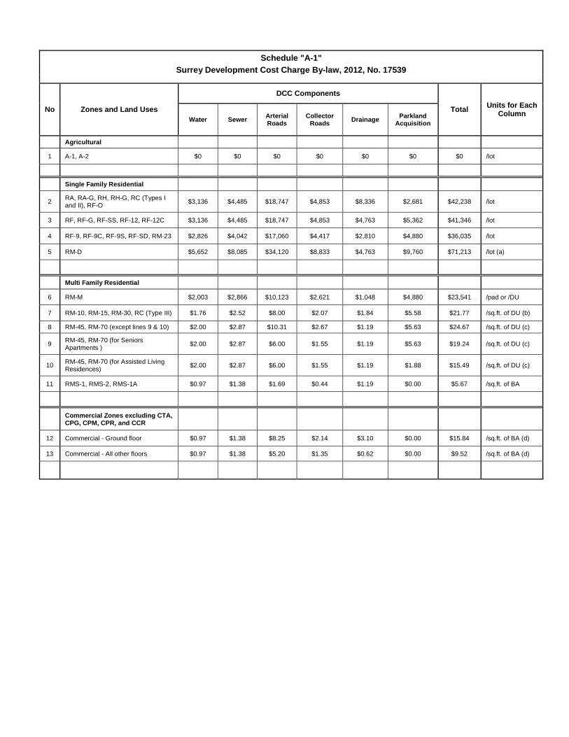
Schedule "A-1" Surrey Development Cost Charge By-law, 2012, No. 17539
No Zones and Land Uses
DCC Components
Total Units for Each Column
Water Sewer Arterial Roads
Collector Roads Drainage Parkland
Acquisition
Agricultural 1 A-1, A-2 $0 $0 $0 $0 $0 $0 $0 /lot
Single Family Residential
2 RA, RA-G, RH, RH-G, RC (Types I and II), RF-O $3,136 $4,485 $18,747 $4,853 $8,336 $2,681 $42,238 /lot
3 RF, RF-G, RF-SS, RF-12, RF-12C $3,136 $4,485 $18,747 $4,853 $4,763 $5,362 $41,346 /lot
4 RF-9, RF-9C, RF-9S, RF-SD, RM-23 $2,826 $4,042 $17,060 $4,417 $2,810 $4,880 $36,035 /lot
5 RM-D $5,652 $8,085 $34,120 $8,833 $4,763 $9,760 $71,213 /lot (a)
Multi Family Residential
6 RM-M $2,003 $2,866 $10,123 $2,621 $1,048 $4,880 $23,541 /pad or /DU
7 RM-10, RM-15, RM-30, RC (Type III) $1.76 $2.52 $8.00 $2.07 $1.84 $5.58 $21.77 /sq.ft. of DU (b)
8 RM-45, RM-70 (except lines 9 & 10) $2.00 $2.87 $10.31 $2.67 $1.19 $5.63 $24.67 /sq.ft. of DU (c)
9 RM-45, RM-70 (for Seniors Apartments ) $2.00 $2.87 $6.00 $1.55 $1.19 $5.63 $19.24 /sq.ft. of DU (c)
10 RM-45, RM-70 (for Assisted Living Residences) $2.00 $2.87 $6.00 $1.55 $1.19 $1.88 $15.49 /sq.ft. of DU (c)
11 RMS-1, RMS-2, RMS-1A $0.97 $1.38 $1.69 $0.44 $1.19 $0.00 $5.67 /sq.ft. of BA
Commercial Zones excluding CTA, CPG, CPM, CPR, and CCR
12 Commercial - Ground floor $0.97 $1.38 $8.25 $2.14 $3.10 $0.00 $15.84 /sq.ft. of BA (d)
13 Commercial - All other floors $0.97 $1.38 $5.20 $1.35 $0.62 $0.00 $9.52 /sq.ft. of BA (d)
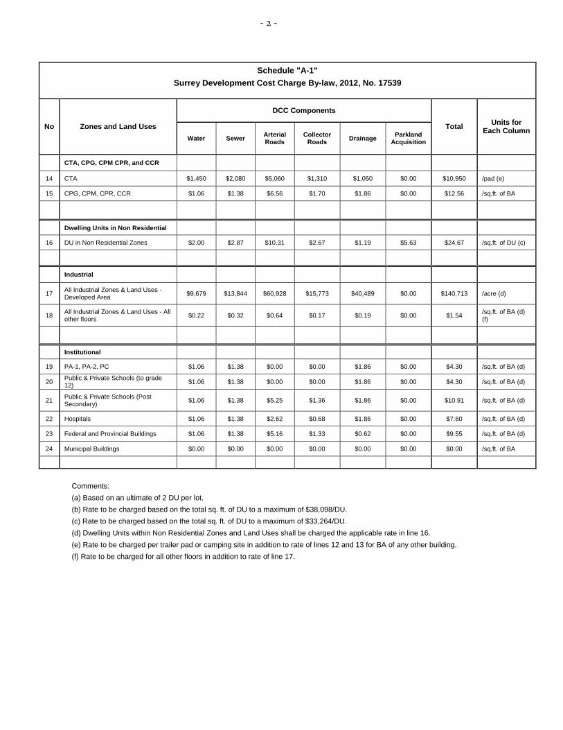
- 2 -
Schedule "A-1"
Surrey Development Cost Charge By-law, 2012, No. 17539
No Zones and Land Uses
DCC Components
Total Units for Each Column
Water Sewer Arterial Roads
Collector Roads Drainage Parkland
Acquisition
CTA, CPG, CPM CPR, and CCR
14 CTA $1,450 $2,080 $5,060 $1,310 $1,050 $0.00 $10,950 /pad (e)
15 CPG, CPM, CPR, CCR $1.06 $1.38 $6.56 $1.70 $1.86 $0.00 $12.56 /sq.ft. of BA
Dwelling Units in Non Residential
16 DU in Non Residential Zones $2.00 $2.87 $10.31 $2.67 $1.19 $5.63 $24.67 /sq.ft. of DU (c)
Industrial
17 All Industrial Zones & Land Uses - Developed Area $9,679 $13,844 $60,928 $15,773 $40,489 $0.00 $140,713 /acre (d)
18 All Industrial Zones & Land Uses - All other floors $0.22 $0.32 $0.64 $0.17 $0.19 $0.00 $1.54 /sq.ft. of BA (d)
(f)
Institutional
19 PA-1, PA-2, PC $1.06 $1.38 $0.00 $0.00 $1.86 $0.00 $4.30 /sq.ft. of BA (d)
20 Public & Private Schools (to grade 12) $1.06 $1.38 $0.00 $0.00 $1.86 $0.00 $4.30 /sq.ft. of BA (d)
21 Public & Private Schools (Post Secondary) $1.06 $1.38 $5.25 $1.36 $1.86 $0.00 $10.91 /sq.ft. of BA (d)
22 Hospitals $1.06 $1.38 $2.62 $0.68 $1.86 $0.00 $7.60 /sq.ft. of BA (d)
23 Federal and Provincial Buildings $1.06 $1.38 $5.16 $1.33 $0.62 $0.00 $9.55 /sq.ft. of BA (d)
24 Municipal Buildings $0.00 $0.00 $0.00 $0.00 $0.00 $0.00 $0.00 /sq.ft. of BA
Comments:
(a) Based on an ultimate of 2 DU per lot.
(b) Rate to be charged based on the total sq. ft. of DU to a maximum of $38,098/DU.
(c) Rate to be charged based on the total sq. ft. of DU to a maximum of $33,264/DU.
(d) Dwelling Units within Non Residential Zones and Land Uses shall be charged the applicable rate in line 16.
(e) Rate to be charged per trailer pad or camping site in addition to rate of lines 12 and 13 for BA of any other building.
(f) Rate to be charged for all other floors in addition to rate of line 17.