No Longer Ice olated - Tufts University · portion happens to be where polar bears make the...
1
Factors 1 Extremely Low Risk 2 Low Risk 3 Average Risk 4 High Risk 5 Extremely High Risk Density of Oil Wells 0 0-0.00014 0.00014- 0.00029 0.00029- 0.00046 0.00046- 00064 Density of Airports 0 0-0.038 0.038-0.25 0.25-1.34 1.34-4.89 Lands Protected Lands Unprotected Shipping Lanes >45 miles 30-45 miles 15-30 miles 5-15 miles 0-5 miles The majority of the wells were identified on the northern coast of Alaska, overlapping with many bear denning locations. Kernel density was used to identify the areas containing the greatest number of wells per area. Oil wells are abundant in the North Slope of Alaska, and recently, legislation passed to allow drilling at these sites, but it is not too late to protect these lands. For drilling to begin, this legislation must pass through environmental scrutiny and pushback by the local community. Identifying denning locations in these areas may add to pushback against drilling and further lead to protecting the land. Polar bears (Ursus maritimus) have been a symbol of strength and resilience in the Arctic for centuries. The species is listed as “vulnerable” on the IUCN Red List and is protected under the Endangered Species Act. Exact numbers of the animal are difficult to determine due to the bears’ extensive habitat range over the entire Arctic Sea. It is known, however, that the United States’ own polar bear subpopulation in Alaska—estimated at only 900 individuals—is decreasing. The most well-known threat facing the species is climate change, as rising global temperatures have steadily decreased the amount of annual Arctic sea ice formation. The bears need ice to hunt seals, their main food source, making the ice essential to the bears’ survival. Although sea ice decline is devastating the bears’ habitat, they also face a number of additional threats that may accelerate their decline. In Alaska in particular, increased transportation, potential for oil and gas drilling, and unprotected coastal lands may impact polar bears and their denning areas. These denning areas were identified in the North Slope of Alaska, and therefore the project was focused on this borough. The primary goal of the project was to identify den locations at the highest risk for human-created disturbance. Such disturbances at denning sites could potentially lead to a decrease in polar bear reproduction and therefore overall population size. A Slippery Slope Shipping traffic in Alaska has increased due to shorter periods of sea ice formation throughout the year. The North Slope holds multiple ports and is surrounded by shipping lanes at sea. Higher imports of goods by shipping traffic increases chances of disturbance to bear dens. Euclidian distance was run on the shipping lanes to identify the lanes closest to the coast. Protected areas are necessary to ensure polar bear survival and prevent future development of the North Slope. By protecting the lands of denning locations, construction of additional airports, shipping ports, and oil drilling may be banned in these areas. This map shows that the majority of the North Slope is protected, with the exception of a portion of the coastline. This portion happens to be where polar bears make the majority of their dens. The most pressing risks to polar bear survival were identified by the International Union for the Conservation of Nature (IUCN) and the World Wildlife Fund (WWF). These hazards were determined to be oil well locations, shipping lanes, airports, and unprotected lands. Spatial analysis tools were used to identify high-risk denning locations and, thus, the areas in the most need of state and federal protection. Each layer was converted to a raster and ranked from 1-5, with 1 being the lowest risk and 5 being the highest. After running the raster cal- culator, kernel density was performed on polar bear den locations within the final map to identify the most at-risk dens. With this information, conservationists can focus their work on these loca- tions to protect fu- ture genera- The lands needing protection were identified as being on the north eastern coast of the North Slope. When polar bears move off the ice and onto land to make their dens every year, it is vital they have places free of disturbance to produce healthy cubs. As pressures to industrialize Alaska increase, this analysis could be used by lawmakers to identify high priority areas for protection. Methods Risk Factors It ’ s Not Too Late Airport Density Shipping Lane Distance to Coastline Oil Well Density Protected vs. Unprotected Lands No Longer Ice-olated: Industrialization of Alaska ’ s North Slope Poses Risks to Polar Bear Denning Habitat Density of At- Risk Dens Airports have potential to disturb polar bear dens by increasing noise levels and human-created traffic. Kernel density was used to identify the areas of the highest airport concentration in the North Slope. As North Slope development increases, these densities may increase as well. Future airports should be built in areas away from bear dens to decrease interference. Tori Rowley MCM 591 GIS for Conservation Medicine December 14 th , 2018 Data Sources: ESRI, USGS, IUCN, WWF Projection: NAD 1983 Alaska Albers Thank you to Carolyn Talmadge for her endless support and knowledge !
Transcript of No Longer Ice olated - Tufts University · portion happens to be where polar bears make the...
Factors
1
Extremely
Low Risk
2
Low
Risk
3
Average
Risk
4
High
Risk
5
Extremely
High Risk
Density of
Oil Wells
0 0-0.00014 0.00014-
0.00029
0.00029-
0.00046
0.00046-
00064
Density of
Airports
0 0-0.038 0.038-0.25 0.25-1.34 1.34-4.89
Lands Protected
Lands
Unprotected
Shipping
Lanes
>45 miles 30-45 miles 15-30 miles 5-15
miles
0-5 miles
The majority of the wells were identified on the northern coast of Alaska, overlapping with many bear denning locations. Kernel density was used to identify the areas containing the greatest number of wells per area. Oil wells are abundant in the North Slope of Alaska, and recently, legislation passed to allow drilling at these sites, but it is not too late to protect these lands. For drilling to begin, this legislation must pass through environmental scrutiny and pushback by the local community. Identifying denning locations in these areas may add to pushback against drilling and further lead to protecting the land.
Polar bears (Ursus maritimus) have been a symbol of strength and resilience in the Arctic for centuries. The species is listed as “vulnerable” on the IUCN Red List and is protected under the Endangered Species Act. Exact numbers of the animal are difficult to determine due to the bears’ extensive habitat range over the entire Arctic Sea. It is known, however, that the United States’ own polar bear subpopulation in Alaska—estimated at only 900 individuals—is decreasing. The most well-known threat facing the species is climate change, as rising global temperatures have steadily decreased the amount of annual Arctic sea ice formation. The bears need ice
to hunt seals, their main food source, making the ice essential to the bears’ survival.
Although sea ice decline is devastating the bears’ habitat, they also face a number of additional threats that may accelerate their decline. In Alaska in particular, increased transportation, potential for oil and gas drilling, and unprotected coastal lands may impact polar bears and their denning areas. These denning areas were identified in the North Slope of Alaska, and therefore the project was focused on this borough. The primary goal of the project was to identify den locations at the highest risk for human-created disturbance. Such disturbances at denning sites could potentially lead to a decrease in polar bear reproduction
and therefore overall population size.
A Slippery Slope
Shipping traffic in Alaska has increased due to shorter periods of sea ice formation throughout the year. The North Slope holds multiple ports and is surrounded by shipping lanes at sea. Higher imports of goods by shipping traffic increases chances of disturbance to bear dens. Euclidian distance was run on the shipping lanes to identify the lanes closest to the coast.
Protected areas are necessary to ensure polar bear survival and prevent future development of the North Slope. By protecting the lands of denning locations, construction of additional airports, shipping ports, and oil drilling may be banned in these areas. This map shows that the majority of the North Slope is protected, with the exception of a portion of the coastline. This portion happens to be where polar bears make the majority of their dens.
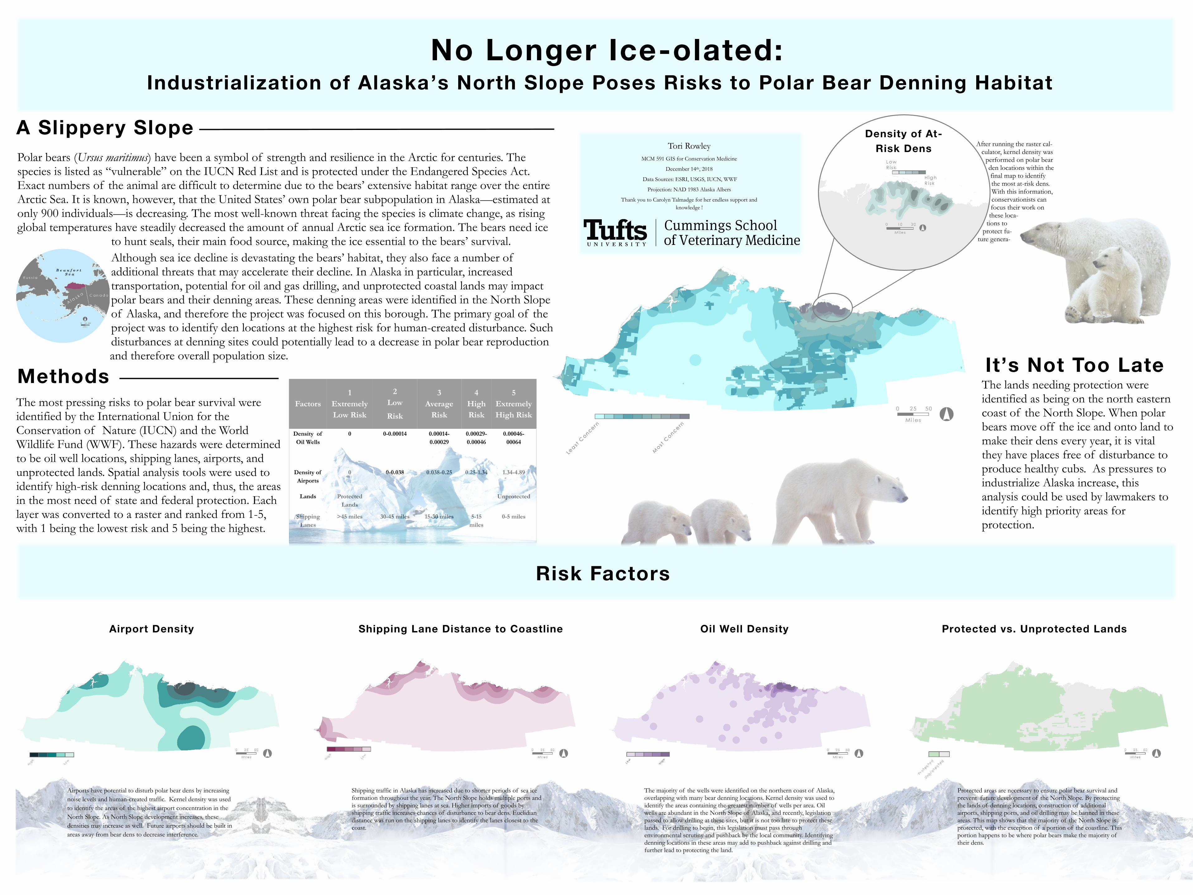
The most pressing risks to polar bear survival were identified by the International Union for the Conservation of Nature (IUCN) and the World Wildlife Fund (WWF). These hazards were determined to be oil well locations, shipping lanes, airports, and unprotected lands. Spatial analysis tools were used to identify high-risk denning locations and, thus, the areas in the most need of state and federal protection. Each layer was converted to a raster and ranked from 1-5, with 1 being the lowest risk and 5 being the highest.
After running the raster cal-culator, kernel density was
performed on polar bear den locations within the final map to identify the most at-risk dens. With this information, conservationists can focus their work on these loca-
tions to protect fu-
ture genera-
The lands needing protection were identified as being on the north eastern coast of the North Slope. When polar bears move off the ice and onto land to make their dens every year, it is vital they have places free of disturbance to produce healthy cubs. As pressures to industrialize Alaska increase, this analysis could be used by lawmakers to identify high priority areas for protection.
Methods
Risk Factors
It’s Not Too Late
Airport Density Shipping Lane Distance to Coastline Oil Well Density Protected vs. Unprotected Lands
No Longer Ice-olated: Industrialization of Alaska ’s North Slope Poses Risks to Polar Bear Denning Habitat
Density of At-
Risk Dens
Airports have potential to disturb polar bear dens by increasing
noise levels and human-created traffic. Kernel density was used
to identify the areas of the highest airport concentration in the
North Slope. As North Slope development increases, these
densities may increase as well. Future airports should be built in
areas away from bear dens to decrease interference.
Tori Rowley
MCM 591 GIS for Conservation Medicine
December 14th, 2018
Data Sources: ESRI, USGS, IUCN, WWF
Projection: NAD 1983 Alaska Albers
Thank you to Carolyn Talmadge for her endless support and
knowledge !