NJSPLS Workshop Shields HeightModNJSPLSHandout · Differential Leveling – NAVD88: Accurate? ......
41
1 National Geodetic Survey’s National Height Modernization Program New Jersey Society of Professional Land Surveyors Annual Conference Atlantic City, New Jersey February 3-5, 2011 Renee Shields Height Modernization Manager • NGS Mission and Height Modernization Background and Overview • Needs and Benefits of Accurate Overview • Needs and Benefits of Accurate Heights –Activities: mapping, charting, construction, models, precision ag –State accomplishments • Accurate Heights with GPS – Ellipsoid vs. Orthometric heights – Geoid model/GRAV-D – The future of the vertical datum Overview – The future of the vertical datum • NGS’ Role – Delivering the NSRS – Management/coordination – Infrastructure/Models/Outreach
Transcript of NJSPLS Workshop Shields HeightModNJSPLSHandout · Differential Leveling – NAVD88: Accurate? ......

1
National Geodetic Survey’s National Height Modernization
Program
New Jersey Society of Professional Land SurveyorsAnnual Conference
Atlantic City, New JerseyFebruary 3-5, 2011
Renee ShieldsHeight Modernization Manager
• NGS Mission and Height Modernization Background and Overview
• Needs and Benefits of Accurate
Overview
• Needs and Benefits of Accurate Heights –Activities: mapping, charting,
construction, models, precision ag–State accomplishments
• Accurate Heights with GPS– Ellipsoid vs. Orthometric heights– Geoid model/GRAV-D– The future of the vertical datum
Overview
– The future of the vertical datum• NGS’ Role
– Delivering the NSRS– Management/coordination– Infrastructure/Models/Outreach

2
1807President Thomas Jefferson signs legislation
establishing the Survey of the Coast
Changes in Mission of the USC&GS
• 1867-1871 - with the acquisition of Alaska, mission expanded to carry geodetic surveys into the interior of the country
• 1997 – “apply state-of-of-the-art methods of precise positioning and advanced geodetic techniques to positioning and advanced geodetic techniques to establish and maintain a consistent national coordinate system and to support mapping, charting, navigation, boundary determination, property delineation, infrastructure development, and resource evaluation surveys, and scientific applications”
The National Geodetic Survey 10 year Plan -- Mission, Vision and Strategy
2008-2018
• To define, maintain and provide access to the National Spatial Reference System to meet our nation’s economic, social, and environmental needse o e ta eeds
• 2018 Targets:– NAD 83 and NAVD 88
replaced– Modernize the Geopotential
(Vertical) Datum
http://www.ngs.noaa.gov/INFO/NGS10yearplan.pdf

3
• The official national coordinate system of the U.S. federal government which includes:– Geodetic latitude, longitude and height– Scale, gravity, and orientation– How these values change with time
Mission – The NSRS is…
• Components include:– National CORS– Network of passive monuments– Official national shoreline – Precise orbits of GNSS satellites used to define NSRS– Models and tools to describe how all of these
quantities change over time.
• Define the NSRS– “The NSRS must be more accurate than all activities which
build upon it, while still being practicably achievable.”
• Maintain the NSRS– “NGS must track all of the temporal changes to the defining
points of the NSRS in such a way as to always maintain the
From the NGS 10-Year Plan
p y yaccuracy in the NSRS definition.”
• Provide Access to the NSRS– “NGS must develop and maintain guidelines for users to
access the NSRS at a variety of accuracies.”– “NGS will publish all coordinates of defining points of the
NSRS with an epoch tag and will furthermore publish velocities relative to that epoch-tagged set of coordinates”
http://geodesy.noaa.gov/INFO/ngs_tenyearplan.pdf
Height Modernization Objective
NSRS
NSRS
Reliable
Cost-effective
Accurate
Standardized
GEODETIC CONTROLNAVD88
Legally Established

4
Height Modernization is …
…the establishment of accurate, reliable heights using GNSS technology in conjunction with traditional leveling gravity and traditional leveling, gravity, and modern remote sensing information….
The Roots of Height Modernization
• In 1994 - First meeting held in
Sacramento, CA
– Some heights in CA in error by more than a meter
– GPS could be immediately used to meet some of California’s requirementssome of California’s requirements
– Necessary for the implementation of NAVD 88
• In 1998, $1.0 M was added to NGS budget to perform Height Modernization Study
• In 2000, $500K added to NGS’ budget for Height Modernization planning
• In 2001, $2.25M added to NGS budget – to implement Height Modernization in NC
The Roots of Height Modernization
– to support the California Spatial Reference Center (CSRC)
– to support NGS related Height Modernization activities
• Also in 2001, NOAA is directed to work with LA and WI to assess their requirements for Height Modernization

5
Height Modernization Program Timeline
• 2002-2006 – Expanded to 11 states through Congressionally directed earmarks
• 2007 – Funded at FY2006 level but without Congressional Direction
• 2008 Appropriations includes HM line • 2008 – Appropriations includes HM line plus earmarks, but total funding is decreased
• 2009-2010 – Appropriations includes HM line plus earmarks (large sums directed at limited number of organizations)
Height Modernization AppropriationsFiscal Year Appropriations States
FY 2001 2.25 M CA, NC
FY 2002 3.75 M CA, NC, LA, WI
FY 2003 3.75 M CA, NC, LA, WI, MS
FY 2004 9.0 M CA, NC, LA, WI, MS, AL, WA, SC
FY 2005 9 6 M CA NC LA WI MS AL WA TX KYFY 2005 9.6 M CA, NC, LA, WI, MS, AL, WA, TX, KY
FY 2006 9.9 M CA, NC, WI, MS, AL, SC, TX, KY, AZ
FY 2007 9.9 M “without direction”
FY 2008 4.995 M + 1.152 M Line* + AL, KY, IL
FY 2009 2.54 M + 9.06 M Line* + AL, MS, LA, IL, WI
FY 2010 2.54 M + 5.27 M Line* + IL, LA, MS, TX, WI
* Competitive grants funded from Line
Height Modernization - Recipients• Academic Institutions
– Scripps Oceanographic Institute – North Carolina A&T University– Louisiana State University– University of Southern Mississippi– Texas A&M Corpus Christi– Morehead State University– University of Illinois
N M i St t U i it– New Mexico State University
• State and Local Governments– North Carolina Geodetic Survey– South Carolina Geodetic Survey– State Departments of Transportation: Wisconsin, Michigan,
Minnesota, Colorado, Montana, New Jersey – Alabama Department of Revenue– Washington State Department of Natural Resources– Arizona State Land Development

6
Participating and Interested States
Current Funded Partners
States engaged in HM without federal funding assistance
Spatial Reference CentersRegional LeadersOther funded partners
Height Matters
Image credit:: AP Photo/Rick Bowmer
• Transportation
• Mapping and Charting
• Construction, Engineering
• Recover decimated control networks

7
Flooding: river overflow, coastal, storm surge, flash flood
• FEMA Map Modernization Program
– Flood Insurance Rate Maps
– Elevation Certificates
– FEMA Cooperative Technical
• Determining High Water Marks
• Evacuation Route Surveys
• Damage Mitigation
FEMA Cooperative Technical States, e.g. NC
Measure, Monitor, Model - Crustal Motion/ Subsidence/Isostatic Rebound /Seasonal changes
1713
129
MONTGOMERY
17 8 2 911
18
3 5619
15
10 1416
4
0021
26
2322
20
272428
NE
LKHU
ADKSTMC
HOUSTON
FORT BEND
GALVESTON
HARRIS
• Dam Safety
• Water resources
• Relating tidal and geodetic datums
– Ship transport:
Water Resource Management
Folsom dam
Ship transport: underwater/overhead clearance
Novi Special WT, MI
Alma, AR

8
DEMs, Geoid modeling
New and Non-traditional Applications:
• Geographic Information Systems (GIS)
• Precision Farming• Fleet Management
• Reduce design and construction costs for engineering projects
• Accurate geospatial foundation for GIS
• Emergency response
• Coastal resilience, habitat restoration
• Water management, delivery – dams, levees
• Water levels – relative sea level change
Benefits
g
• Storm surge, inundation modeling
• Accurate determination of floodplains – maximize insurance cost/benefit
• Improve agricultural yields
• Ensure safe low-visibility aircraft landings
• Ensure safe overhead and under-keel clearance on waterways

9
• Access to accurate, reliable heights nationally
• Standards that are consistentacross the nation
Goal of NHMP
• Data, technology, and tools that yield consistent results regardless of terrain and circumstances
• A system/process that will stand the test of time – “Maintain-able”
NGVD 29 NAVD 88
DATUM DEFINITION LMSL 26 Tide Gauges FATHER’S POINT/Rimouski in the U.S. & Canada; Quebec, Canada;Various tidal epochs common epoch (1960-1978)
Vertical Reference Frame Today
GEOID FITTING Distorted to Fit MSL Gauges Best Continental Model
CORRECTIONS Normal Gravity, Level, Observed Gravity, Level, Rod, Temp. Rod, Temp. Magnetic, Refraction
BENCH MARKS 100,000 450,000
LEVELING (Km) 106,724 (U.S. + Canada) 1,001,500
NAVD 88 Tidal Control Stations
10
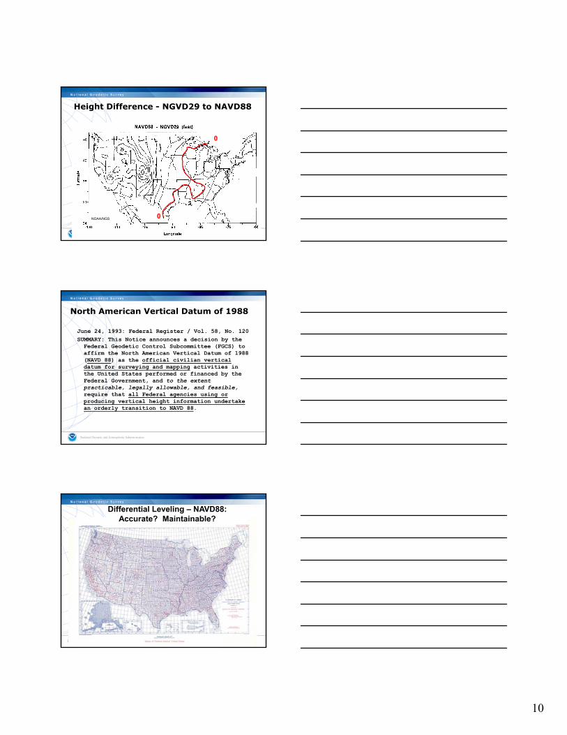
CONUS Range = 0.4 to 5.0 ft (AK ~ 6.5 ft)
0
Height Difference - NGVD29 to NAVD88
0NOAA/NGS
North American Vertical Datum of 1988
June 24, 1993: Federal Register / Vol. 58, No. 120SUMMARY: This Notice announces a decision by the Federal Geodetic Control Subcommittee (FGCS) to affirm the North American Vertical Datum of 1988 (NAVD 88) as the official civilian vertical datum for surveying and mapping activities indatum for surveying and mapping activities in the United States performed or financed by the Federal Government, and to the extent practicable, legally allowable, and feasible,require that all Federal agencies using or producing vertical height information undertake an orderly transition to NAVD 88.
Differential Leveling – NAVD88: Accurate? Maintainable?

11
B h M k B
Conventional Leveling:
• Precise
• Labor Intensive
Bench Mark A
Bench Mark B
1 National Geodetic Survey, Retrieval Date = DECEMBER 10, 2010AH9175 ***********************************************************************AH9175 FBN - This is a Federal Base Network Control Station.AH9175 DESIGNATION - 01410600 AAH9175 PID - AH9175AH9175 STATE/COUNTY- NJ/ATLANTICAH9175 USGS QUAD - OCEANVILLE (1989)AH9175AH9175 *CURRENT SURVEY CONTROLAH9175 ___________________________________________________________________AH9175* NAD 83(2007)- 39 22 46.68223(N) 074 25 28.32298(W) ADJUSTED
NGS Datasheet – Leveling
AH9175* NAVD 88 - 1.568 (meters) 5.14 (feet) ADJUSTED AH9175 ___________________________________________________________________AH9175 EPOCH DATE - 2002.00AH9175 . . . AH9175 ELLIP HEIGHT- -32.802 (meters) (02/10/07) ADJUSTEDAH9175 GEOID HEIGHT- -34.34 (meters) GEOID09AH9175 DYNAMIC HT - 1.567 (meters) 5.14 (feet) COMPAH9175AH9175 ------- Accuracy Estimates (at 95% Confidence Level in cm) --------AH9175 Type PID Designation North East EllipAH9175 -------------------------------------------------------------------AH9175 NETWORK AH9175 01410600 A 0.92 0.73 2.12
AH9175 -------------------------------------------------------------------AH9175 NETWORK AH9175 01410600 A 0.92 0.73 2.12AH9175 -------------------------------------------------------------------AH9175 MODELED GRAV- 980,109.0 (mgal) NAVD 88AH9175AH9175 VERT ORDER - SECOND CLASS IAH9175AH9175. . .AH9175AH9175.The orthometric height was determined by differential leveling andAH9175.adjusted in March 2001.
NGS Datasheet – Leveling
AH9175.No vertical observational check was made to the station.AH9175AH9175.The X, Y, and Z were computed from the position and the ellipsoidal ht.AH9175AH9175.The Laplace correction was computed from DEFLEC09 derived deflections.AH9175AH9175.The ellipsoidal height was determined by GPS observationsAH9175.and is referenced to NAD 83.AH9175AH9175.The geoid height was determined by GEOID09.AH9175

12
AH9175AH9175 . . .AH9175AH9175 SUPERSEDED SURVEY CONTROLAH9175AH9175 NAD 83(1996)- 39 22 46.68190(N) 074 25 28.32294(W) AD( ) AAH9175 ELLIP H (09/24/01) -32.787 (m) GP( ) 4 1AH9175 NAVD 88 (09/24/01) 1.57 (m) 5.2 (f) LEVELING 3 AH9175AH9175.Superseded values are not recommended for survey control.AH9175.NGS no longer adjusts projects to the NAD 27 or NGVD 29 datums.
NGS Datasheet – Leveling
AH9175.See file dsdata.txt to determine how the superseded data were derived.AH9175 . . .AH9175 HISTORY - Date Condition Report ByAH9175 HISTORY - 1997 MONUMENTED NJGSAH9175 HISTORY - 20000714 GOOD NGSAH9175 HISTORY - 20090106 GOOD BANCAH9175AH9175 STATION DESCRIPTIONAH9175AH9175'DESCRIBED BY NEW JERSEY GEODETIC SURVEY 1997 (ECB)AH9175'THE STATION IS LOCATED IN THE CITY OF ATLANTIC CITY ON THE GROUNDS OFAH9175'THE U.S. COAST GUARD STATION. TO REACH THE STATION FROM THEAH9175'INTERSECTION OF U.S. HIGHWAY 30, ABSECON BOULEVARD AND STATE ROUTE
Pros and Cons of Leveling
• Pros – Produces the most accurate relative heights
possible
• Cons– Expensivep– Time consuming– Requires setting and tying to passive control
which falls victim to subsidence, tectonic motion, isostatic adjustment, and … bulldozers
enter GNSS…
Can we get accurate heights with GNSS?

13
• Good ellipsoid heights – Better field procedures– Accurate ellipsoid heights at control
stations
To improve GPS-derived orthometric heights we need:
• An improved geoid model– Accurate ellipsoid heights– More bench marks observed by GPS
• Accurate orthometric heights at bench marks
H = Orthometric Height (leveling) H = h - N
TOPOGRAPHIC SURFACE
h = Ellipsoidal Height (GPS)
N = Geoid Height (model)
h (NAD83)
Accurate:Ellipsoid, Geoid, and Orthometric Heights
(NAVD88) Hh (NAD83)
Ellipsoid
N
GeoidGeoid Height
(GEOID09)
With 2 known heights we can calculate the 3rd
Guidelines to obtain accurate heights through GNSS
NOAA Technical Memorandum NOS NGS-58
GUIDELINES FOR ESTABLISHING GPS-DERIVED ELLIPSOID HEIGHTS(STANDARDS: 2 CM AND 5 CM)VERSION 4.3
David B. ZilkoskiJoseph D. D'OnofrioStephen J. Frakes
Silver Spring, MD
November 1997
• Equipment requirements
• Field Procedures/Data
Collection Parameters
U.S. DEPARTMENT OF National Oceanic and National Ocean National GeodeticCOMMERCE Atmospheric Administration Service Survey
Collection Parameters
• Basic Control Requirements
• Processing/Analysis
Procedures

14
Equipment Requirements
• Dual-frequency, full-wavelength GPS receiver– Required - observations > 10 km– Preferred - ALL observations regardless of length
• Geodetic quality antennas with ground planes– Choke ring antennas; highly recommended– Successfully modeled L1/L2 offsets and phase – Successfully modeled L1/L2 offsets and phase
patterns– Use identical antenna types if possible– Corrections must be utilized by processing software
when mixing antenna types
“Fixed” HeightTripod
Equipment Requirements
Data Collection Parameters
• VDOP < 6 for 90% or longer of 30 minute session
• Session lengths and sampling rate• Track satellites down to 10° elevation angle• Repeat Baselines• Repeat Baselines
– Different days– Different times of day
• Detect, remove, reduce effects due to multipath and similar satellite geometry between sessions

15
Comparison of 30 Minute Solutions - Precise Orbit; Hopfield (0); IONOFREE(30 Minute solutions computed on the hour and the half hour)
MOLA to RV22 10.8 Km
Day 264dh (m)
Hours Diff. Day 265
dh (m)
Day 264 minus
Day 265 (cm)
* diff >2 cm
Mean dh (m)
Mean dh minus "Truth" (cm)
* diff >2 cm
14:00-14:30 -10.281 27hrs 17:00-17:30 -10.279 -0.2 -10.280 -0.514:30-15:00 -10.278 27hrs 17:30-18:00 -10.270 -0.8 -10.274 0.215:00-15:30 -10.281 27hrs 18:00-18:30 -10.278 -0.3 -10.280 -0.4
Two Days/Same Time
Difference = 0.3 cm
“Truth” = -10.276Difference = 2.3 cm
Two Days/Different Times
-10.254-10.251 > -10.253
15:30-16:00 -10.291 27hrs 18:30-19:00 -10.274 -1.7 -10.283 -0.716:00-16:30 -10.274 27hrs 19:00-19:30 -10.274 0.0 -10.274 0.216:30-17:00 -10.287 27hrs 19:30-20:00 -10.276 -1.1 -10.282 -0.617:00-17:30 -10.279 27hrs 20:00-20:30 -10.261 -1.8 -10.270 0.617:30-18:00 -10.270 27hrs 20:30-21:00 -10.251 -1.9 -10.261 1.518:00-18:30 -10.277 21hrs 15:00-15:30 -10.270 -0.7 -10.274 0.218:30-19:00 -10.271 21hrs 15:30-16:00 -10.276 0.5 -10.274 0.219:00-19:30 -10.277 21hrs 16:00-16:30 -10.278 0.1 -10.278 -0.219:30-20:00 -10.271 21hrs 16:30-17:00 -10.286 1.5 -10.279 -0.320:00-20:30 -10.259 18hrs 14:00-14:30 -10.278 1.9 -10.269 0.720:30-21:00 -10.254 18hrs 14:30-15:00 -10.295 4.1 * -10.275 0.1
"Truth"14:00-21:00 -10.275 14:00-21:00 -10.276 0.1 -10.276
-10.254- 10.295 > -10.275
Difference = 4.1 cm
“Truth” = -10.276
Difference = 0.1 cm
REPEAT BASELINE DIFFERENCES BY DISTANCE
2
3
4
5
6
T D
IFFE
REN
CES
(CM
)
0113-H83A3.1
1933-01213.1 0092-1933
3.1
6669-00924.7
6669-6666 4.9
172 BASELINES - 3% Above 3 cm
0
1
2
0 5000 10000 15000 20000 25000 30000 35000 40000
BASELINE LENGTH (M)
REP
EAT
Station pairs with large repeat base line differences also result in large residuals. NGS guidelines for estimating GPS-derived ellipsoid heights require user to re-observe these base lines.
Four Basic Control Requirements
• Occupy stations with known NAVD 88 orthometric heights, evenly distributed throughout project
• Project areas < 20 km on a side, surround project with at least 4 NAVD 88 bench marks
• Project areas > 20 km on a side, keep distances between GPS-occupied NAVD 88 bench marks to less than 20 km
• Projects located in mountainous regions, occupy bench marks at base and summit of mountains, even if distance is less than 20 km

16
• Perform 3-D minimally constrained (free) adjustment
• Analyze adjustment results
• Compute differences between GPS-derived orthometric heights from free adjustment
d bli h d NAVD88 BM
Processing: Five Basic Procedures
and published NAVD88 BMs
• Evaluate differences to determine which BMs have valid NAVD88 height values
• Perform constrained adjustment with results from previous step
HARN/Control Stations(75 km) 5.5 hr 3 days different times
Primary Base(40 km) 5.5 hr
3 days different times
GPS Ellipsoid Height Hierarchy
3 days different times
Secondary Base(15 km) 0.5 hr
2 days different times
Local Network Stations(7 to 10 km) 0.5 hr
2 days different times
Sample Project
• Area: East San Francisco Bay Project– Latitude 37° 50” N to 38° 10” N– Longitude 121° 45” W to 122° 25” W
• Receivers Available: 5
• Standards: 2 cm GPS-Derived Heights

17
East SF Bay Project Primary Base Stations
CORSHARNNAVD’88 BMNew Station
38°20’N
Primary Base Station
10CCD191
121°40’W122°35’W LONGITUDE
MOLA
MARTLAKE
38°16’NCORSHARNNAVD’88 BMNew StationSpacing StationPrimary Base Station
10LC
TIDD D191
MONT X469 Z190DROU
BM20 Q555
East Bay Project Points
121°40’W122°20’W LONGITUDE
04KU
TIDE
ZINCPT14
MART
5144
P371R100
LAKE04HK
CATT
Q
TOLA
CORSHARNNAVD’88 BMNew StationSpacing Station
38°16’N
Primary Base Station
Session DSession ESession F
Session G
Observation Sessions
121°40’W122°20’W LONGITUDE
Session A
Session B Session C

18
CORSHARNNAVD’88 BMNew StationSpacing Station
38°16’N
Primary Base Station
Independent Base Lines
D
DD
E
E
E
E
FF
F
F
G
G
121°40’W122°20’W LONGITUDE
A
A
A
AB
B
B
B
C
C C
C
D
G
GG
Height Modernization ProjectHARN - Average 50km,
max 75kmPrimary – 20-25km,
max 40km
Secondary - Average 12-15km, max 15km
Local – Average 6-8 km, max 10km
= Existing NGS Level line= New HMP Level line
= HARN
= Primary Base Network
= Secondary Base Network
= Local Base Network
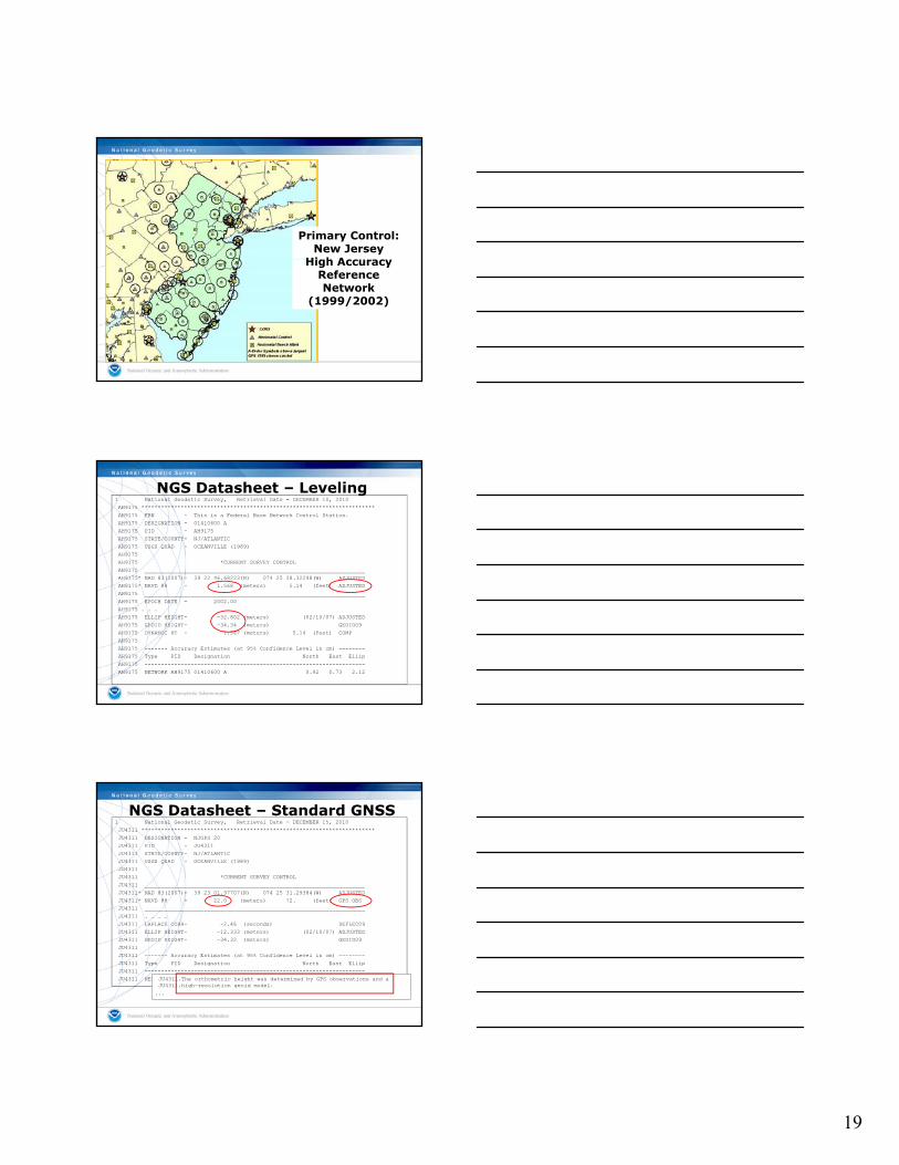
NJOC – Sussex County, NJ
Primary Control, New Jersey – CORS
NJWC – Warren County, NJ
NJGT – R Stockton Coll, NJ
19
Primary Control:New Jersey
High Acc ac High Accuracy Reference Network
(1999/2002)
1 National Geodetic Survey, Retrieval Date = DECEMBER 10, 2010AH9175 ***********************************************************************AH9175 FBN - This is a Federal Base Network Control Station.AH9175 DESIGNATION - 01410600 AAH9175 PID - AH9175AH9175 STATE/COUNTY- NJ/ATLANTICAH9175 USGS QUAD - OCEANVILLE (1989)AH9175AH9175 *CURRENT SURVEY CONTROLAH9175 ___________________________________________________________________AH9175* NAD 83(2007)- 39 22 46.68223(N) 074 25 28.32298(W) ADJUSTED
NGS Datasheet – Leveling
AH9175* NAVD 88 - 1.568 (meters) 5.14 (feet) ADJUSTED AH9175 ___________________________________________________________________AH9175 EPOCH DATE - 2002.00AH9175 . . . AH9175 ELLIP HEIGHT- -32.802 (meters) (02/10/07) ADJUSTEDAH9175 GEOID HEIGHT- -34.34 (meters) GEOID09AH9175 DYNAMIC HT - 1.567 (meters) 5.14 (feet) COMPAH9175AH9175 ------- Accuracy Estimates (at 95% Confidence Level in cm) --------AH9175 Type PID Designation North East EllipAH9175 -------------------------------------------------------------------AH9175 NETWORK AH9175 01410600 A 0.92 0.73 2.12
1 National Geodetic Survey, Retrieval Date = DECEMBER 15, 2010JU4311 ***********************************************************************JU4311 DESIGNATION - NJGPS 20JU4311 PID - JU4311JU4311 STATE/COUNTY- NJ/ATLANTICJU4311 USGS QUAD - OCEANVILLE (1989)JU4311JU4311 *CURRENT SURVEY CONTROLJU4311 ___________________________________________________________________JU4311* NAD 83(2007)- 39 23 01.97707(N) 074 25 31.29384(W) ADJUSTED JU4311* NAVD 88 - 22.0 (meters) 72. (feet) GPS OBS
NGS Datasheet – Standard GNSS
JU4311 ___________________________________________________________________JU4311 . . . .JU4311 LAPLACE CORR- -2.46 (seconds) DEFLEC09JU4311 ELLIP HEIGHT- -12.333 (meters) (02/10/07) ADJUSTEDJU4311 GEOID HEIGHT- -34.32 (meters) GEOID09JU4311JU4311 ------- Accuracy Estimates (at 95% Confidence Level in cm) --------JU4311 Type PID Designation North East EllipJU4311 -------------------------------------------------------------------JU4311 NETWORK JU4311 NJGPS 20 0.67 0.57 1.37JU4311.The orthometric height was determined by GPS observations and a
JU4311.high-resolution geoid model....

20
1 National Geodetic Survey, Retrieval Date = DECEMBER 15, 2010JV6109 ***********************************************************************JV6109 HT_MOD - This is a Height Modernization Survey Station.JV6109 DESIGNATION - FOSTERJV6109 PID - JV6109JV6109 STATE/COUNTY- MD/BALTIMOREJV6109 USGS QUAD - HEREFORD (1974)JV6109JV6109 *CURRENT SURVEY CONTROLJV6109 ___________________________________________________________________JV6109* NAD 83(2007)- 39 34 44.11413(N) 076 42 48.20871(W) ADJUSTED
NGS Datasheet – GNSS NGS58/59
JV6109* NAVD 88 - 214.66 (meters) 704.3 (feet) GPS OBS JV6109 ___________________________________________________________________JV6109 EPOCH DATE - 2002.00JV6109 X - 1,131,361.846 (meters) COMPJV6109 Y - -4,790,998.768 (meters) COMPJV6109 Z - 4,042,177.076 (meters) COMPJV6109 LAPLACE CORR- -2.70 (seconds) DEFLEC09JV6109 ELLIP HEIGHT- 182.459 (meters) (02/10/07) ADJUSTEDJV6109 GEOID HEIGHT- -32.21 (meters) GEOID09JV6109
JV6109.The orthometric height was determined by GPS observations and aJV6109.high-resolution geoid model using precise GPS observation andJV6109.processing techniques.
1 National Geodetic Survey, Retrieval Date = DECEMBER 10, 2010AH9175 ***********************************************************************AH9175 FBN - This is a Federal Base Network Control Station.AH9175 DESIGNATION - 01410600 AAH9175 PID - AH9175AH9175 STATE/COUNTY- NJ/ATLANTICAH9175 USGS QUAD - OCEANVILLE (1989)AH9175AH9175 *CURRENT SURVEY CONTROLAH9175 ___________________________________________________________________AH9175* NAD 83(2007)- 39 22 46.68223(N) 074 25 28.32298(W) ADJUSTED
NGS Datasheet – Leveling
AH9175* NAVD 88 - 1.568 (meters) 5.14 (feet) ADJUSTED AH9175 ___________________________________________________________________AH9175 EPOCH DATE - 2002.00AH9175 . . . AH9175 ELLIP HEIGHT- -32.802 (meters) (02/10/07) ADJUSTEDAH9175 GEOID HEIGHT- -34.34 (meters) GEOID09AH9175 DYNAMIC HT - 1.567 (meters) 5.14 (feet) COMPAH9175AH9175 ------- Accuracy Estimates (at 95% Confidence Level in cm) --------AH9175 Type PID Designation North East EllipAH9175 -------------------------------------------------------------------AH9175 NETWORK AH9175 01410600 A 0.92 0.73 2.12
NAVD88 – Ellipsoid Ht + Geoid Ht = …1.568 + 32.802 - 35.269 = -0.899 USGG20091.568 + 32.802 - 34.340 = +0.030 GEOID091.568 + 32.802 - 34.304 = +0.066 GEOID031.568 + 32.802 - 34.325 = +0.045 GEOID99
How accurate is a GPS-derived Orthometric Height?
• Relative (local) accuracy in ellipsoid heights between adjacent points will be better than 2 cm, at 95% confidence level
• Network accuracy (relative to NSRS) in ellipsoid and orthometric heights will be better ellipsoid and orthometric heights will be better than 5 cm, at 95% confidence level
• Accuracy of orthometric height is dependent on
– accuracy of the NAVD 88 control
– accuracy of the geoid model

21
In Search of the Geoid…
Dr. Dan Roman
Dr. Yan Wang
• Courtesy of Natural Resources Canada www.geod.nrcan.gc.ca/index_e/geodesy_e/geoid03_e.html
Definitions: GEOIDS versus GEOID HEIGHTS
• “The equipotential surface of the Earth’s gravity field which best fits, in the least squares sense, (global) mean sea level.”*
• Can’t see the surface or measure it directly.• Can be modeled from gravity data as they are
mathematically related.• Note that the geoid is a vertical datum surface• Note that the geoid is a vertical datum surface.• A geoid height is the height from an ellipsoidal datum
to a geoid.• Hence, geoid height models are directly tied to the
geoid and ellipsoid that define them (i.e., geoid height models are not interchangeable).
*Definition from the Geodetic Glossary, September 1986
LEVEL SURFACES AND ORTHOMETRIC HEIGHTS
Level Surfaces
PlumbLine
“Geoid”
P
MeanSea
WP
PO
Level Surface = Equipotential Surface (W)H (Orthometric Height) = Distance along plumb line (PO to P)
Ocean
Level WO

22
High Resolution Geoid Models
• Start with gravity measurements
• Add Digital Elevation Data (Continental)
• Add a Global Earth Gravity Model (EGM96,
EGM08)
• Result – A purely Gravitational geoid model –
good for scientific applications

23
NGS’ Two Geoid Models
• Gravitational model:
• is good for scientific applications
• does not provide relationship between GPS heights and NAVD 88between GPS heights and NAVD 88
• “Hybrid” model:
• starts with gravitational model
• uses GPS on bench marks to enable a fit to NAVD 88
GRACE Satellite Gravity
GPSBM1999: 6,169 total 0 Canada STDEV 9.2 cm (2!) GPSBM2003: 14,185 total 579 Canada STDEV 4.8 cm (2!) GPSBM2009: 18,291 total 576 Canada STDEV 2.8 cm (2!)
For 2009 Rejections based on:S: State adviserh: ell ht err (NRA)H: ortho ht errN: geoid err (misfit)D: duplicate
Earth’s Surface
hh
h hh
HH
HEllipsoid
Gravimetric vs. Hybrid Geoid surface
Note use of GPS on BMs
0.994 M in Atlantic City–1999 model
0.987 M in Atlantic City –2003 model
Gravimetric Geoid systematic misfit to BM’s but best fits “true” heightsHybrid Geoid “converted” to fit local BM’s, so best fits NAVD 88 heightsConversion Surface model of systematic misfit derived from BM’s in IDB
HH
H H
NNNNN
Ellipsoid
Hybrid Geoid
Gravimetric GeoidGeoid
N N NN N
0.929 M in Atlantic City –2009 model

24

25
That was then….
• At the start of Height Mod NGS felt the Gravimetric geoid was adequate as the base for the Hybrid geoid . . .
What’s changed?• Better accuracy from GNSS-derived heights – can
use GNSS (CORS) to monitor changes in heightsuse GNSS (CORS) to monitor changes in heights• Better understanding of poor condition of vertical
network – which continues to degrade• Gravity holdings at NGS evaluated
Is NAVD 88 “Maintainable”?
• NAVD88 defined through leveling network
• Not practical to re-leveling the country – Estimate re-leveling NAVD 88 would cost up to $2.25 Billion– Does not include densifying poorly covered areas in Western
CONUS, Alaska– Does not include leveling needed for separate vertical g p
datums on island states and territories
• Leveling yields cross-country error build-up; problems in the mountains
• Leveling requires leaving behind marks – Bulldozers and crustal motion do their worst
Bias in NAVD 88
Approximate level of geoid mismatch known to exist in the NAVD 88 zero surface

26
NGS Gravity Holdings
• Most of the historical NGS data is terrestrial• Multiple observers, multiple processors over the
past 60 years • Numerous corrections and datums over time• Metadata maintained in paper records• Very limited aerogravity• Deficit in near-shore gravity data
Terrestrial gravity 20-100 km gravity gaps along coast
New Orleans
Ship gravity

27
• Official NGS policy as of Nov 14, 2007– $38.5M over 10 years
• Airborne Gravity Snapshot• Absolute Gravity Tracking
Transition to the Future – Gravity for the Redefinition of the American Vertical Datum
• Absolute Gravity Tracking• Re-define the U.S. Vertical
Datum by 2018 (if fully funded)
• Target: 2 cm orthometric heights using GNSS and gravimetric geoid model
http:/www.ngs.noaa.gov/GRAV-D/
Building a Gravity Field
Long Wavelengths:(" 400 km)
GRACE Satellite+
Intermediate Wavelengths(500 km to 20 km)
Airborne Measurement
Surface Measurement
Short Wavelengths(< 200 km)
http://www.dpi.nsw.gov.au/minerals/geological/info/oaklands-basin
+
Airborne Program Development
• Build GRAV-D project team – Field crew for airborne and
terrestrial gravity data collection
– Geodesists for processing gGPS and gravity data
• Instrumentation– New and upgraded
gravimeters

28
Airborne Program Development
• When fully operational, will survey 10 months of the year for 8 years; 100 flight hours/month
• Currently use aircraft available: NOAA and other partners
Airborne Program Development
• Data Processing: Software Development– GPS data processing
– Gravity data processingy p g
• Processing for QC on site
• Re-process with precise ephemerides in office
• Data management and archival
83
Newton 2.0
Airborne Data Flow

29
Current Status
20092010
20112011
Current Status
2009
2008
201020102011
2010
2011
2011
Priorities:
1. Finish Alaska2. Finish Gulf Coast3. Great Lakes4. East Coast5. West Coast6. Hawaii7. Pacific Island
H ldiHoldings8. Interior U.S.

30
Regional Partnerships & Collaborations
• Other Federal Agencies– USACE already funded Gulf of Mexico survey– NGA funded Alaska 2009 survey– USGS
• States– North Carolina, South Carolina
• Industry Partners: Micro-g LaCoste, Fugro• University Researchers
GRAV-D Web Page
• Program events are recorded here
• Survey progress ll b d l dwill be displayed
• Plan to make data and software available here
http://www.ngs.noaa.gov/grav-d
Table Mountain Geophysical Observatory (TMGO)
Before
• Develop long-term plan to measure/monitor gravity – goal to keep geoid accurate over time
• Renovate facility – add Office
After
• Renovate facility – add Office and meeting rooms for visiting scientists
• 11 gravity piers • Arrange international gravimeter
comparisons for calibration: first planned for Fall 2010
• Form international geoid steering committee

31
Geoid/GRAV-D TeamGEOID Team• Daniel R. Roman, Ph.D.• Yan Ming Wang, Ph.D.• Jarir Saleh• Simon Holmes, Ph.D.• Xiaopeng Li Ph D• Xiaopeng Li, Ph.D.
Aerogravity Collection/Processing• Vicki A. Childers, Ph.D.• Theresa Diehl, Ph.D.• Sandra A. Preaux
Programming/IT Support• William Waickman
• Access to accurate, reliable heights nationally
• Standards that are consistentacross the nation
Goal of NHMP
• Data, technology, and tools that yield consistent results regardless of terrain and circumstances
• A system/process that will stand the text of time – “Maintain-able”
Consistency?

32
• Support NGS Mission for NSRS
• Needs don’t stop at state boundaries
• More efficient use of funds, people
• Encourages partnerships
A National ProgramThrough Regional Expansion
• Encourages partnerships
• Commitment by users and larger voice might result in increased Congressional support
• Difficult for state and local agencies to work outside of their mandates
National Height Modernization Program
Height Mod National Height Mod
Funding Source State earmarks Line item
Funding Recipients Grant Recipients NGS + Grant Recipients
Primary Driver 1998 Report to Congress
NGS 10 year plan +GRAV-D project plang GRAV D project plan
Geography 18 states All states and territories
Cost > $70 M $5(?)M / year, 10 years (split internal/external)
Dominant Activities Leveling, GPS, SRC’s, Outreach
Similar, plus airborne and terrestrial gravity, LIDAR, IFSAR

33
• Infrastructure
• Models and Tools
O t id C it B ildi
NGS Business Plan: 3 Areas of Focus
• Outside Capacity Building
• Two datums provided previously through the active (CORS) and passive (marks in the ground) networks will be redefined as “geometric” and “geopotential datums,”
Infrastructure – “Define, maintain, provide access to NSRS”
geometric and geopotential datums, accessed primarily through CORS
• Guidelines and standards will be updated for geodetic field and processing practices, keeping up with advanced surveying technologies
• Quality check data that is incorporated in the NGS database
• OPUS DB and Projects change how NGS
Infrastructure
accepts geodetic control into the NSRS
• Encourage use of active control over passive control, especially in dynamic areas
• Enable access to new datum through precise leveling when sub-cm relative heights needed

34
• Enable positioning consistent with NSRS – e.g. Real Time Networks
• Improve “timeliness” of coordinates on datasheets
R b /R dj t i l j t
Infrastructure
• Re-observe/Readjust – special case projects, gravity
• Model motion, develop tools – monitor with CORS, satellite gravity
• Metadata: Epochs, reliability scale, i.e. “Expiration date” on coordinates
Example: Louisiana
• Louisiana vertical control was out of date –subsidence
• Study of historic leveling data provided a crude model for updating heights
• Leveling/GPS/Gravity survey in 2004 provided up to date data – refine geoid model
• Publish new heights only; other heights ‘suppressed’
• Partnerships: FEMA, LSU/LSRC, NOAA, Parish Surveyors
• Collect new data – multi-faceted approach–Repeat GPS Surveys (2006, 2010)
Measure/Monitor Heights
–Densify CORS network–Observe relative & absolute gravity– Install new tide stations–Test Real Time Network (RTN)

35
Pre-2004
Estimate “subsidence” border
• 1 National Geodetic Survey, Retrieval Date = MARCH 18, 2009• BJ0196 ***********************************************************************• BJ0196 HT_MOD - This is a Height Modernization Survey Station.• BJ0196 FBN - This is a Federal Base Network Control Station.• BJ0196 DESIGNATION - E 284 X• BJ0196 PID - BJ0196• BJ0196 STATE/COUNTY- LA/ST LANDRY• BJ0196 USGS QUAD - BAYOU CURRENT (1994)• BJ0196• BJ0196 *CURRENT SURVEY CONTROL• BJ0196 ___________________________________________________________________• BJ0196* NAD 83(2007)- 30 46 55.32566(N) 091 46 23.63541(W) ADJUSTED
BJ0196* NAVD 88 11 54 ( t ) 37 9 (f t) GPS OBS
NGS Datasheet – GPS Height Mod
• BJ0196* NAVD 88 - 11.54 (meters) 37.9 (feet) GPS OBS • BJ0196 ___________________________________________________________________• BJ0196 EPOCH DATE - 2002.00• BJ0196 X - -169,707.673 (meters) COMP• BJ0196 Y - -5,481,757.847 (meters) COMP• BJ0196 Z - 3,245,148.124 (meters) COMP• BJ0196 LAPLACE CORR- 0.08 (seconds) DEFLEC99• BJ0196 ELLIP HEIGHT- -15.814 (meters) (02/10/07) ADJUSTED• BJ0196 GEOID HEIGHT- -27.25 (meters) GEOID03• BJ0196• BJ0196 ------- Accuracy Estimates (at 95% Confidence Level in cm) --------• BJ0196 Type PID Designation North East Ellip• BJ0196 -------------------------------------------------------------------• BJ0196 NETWORK BJ0196 E 284 X 0.25 0.25 0.76• BJ0196 -------------------------------------------------------------------
H = h - N11.54 = -15.814 - (- 27.25) 11.54 ! 11.436 (0.104 m/0.25 ft)

36
• 1 National Geodetic Survey, Retrieval Date = MARCH 17, 2009• AV0426 ***********************************************************************• AV0426 HT_MOD - This is a Louisiana Height Modernization Survey Station.• AV0426 DESIGNATION - D 215• AV0426 PID - AV0426• AV0426 STATE/COUNTY- LA/CAMERON• AV0426 USGS QUAD - CREOLE (1982)• AV0426• AV0426 *CURRENT SURVEY CONTROL• AV0426 ___________________________________________________________________• AV0426* NAD 83(2007)- 29 51 37.54827(N) 093 05 15.70510(W) ADJUSTED • AV0426* NAVD 88 - 0.65 (meters) 2.1 (feet) GPS OBS(2006.81)
AV0426 **Thi t ti i l t d i t d b id ( b l )
NGS Datasheet – Special 1
• AV0426 **This station is located in a suspected subsidence area (see below).• AV0426 **This station is included in the VTDP model (see below).• AV0426 ___________________________________________________________________• AV0426 EPOCH DATE - 2002.00• AV0426 X - -298,190.692 (meters) COMP• AV0426 Y - -5,527,916.711 (meters) COMP• AV0426 Z - 3,156,952.642 (meters) COMP• AV0426 LAPLACE CORR- 0.40 (seconds) DEFLEC99• AV0426 ELLIP HEIGHT- -26.050 (meters) (03/12/08) ADJUSTED• AV0426 GEOID HEIGHT- -26.76 (meters) GEOID03• AV0426• AV0426 ------- Accuracy Estimates (at 95% Confidence Level in cm) --------• AV0426 Type PID Designation North East Ellip• AV0426 -------------------------------------------------------------------• AV0426 NETWORK AV0426 D 215 0.96 0.82 2.00• AV0426 -------------------------------------------------------------------
• AV0426 ------- Accuracy Estimates (at 95% Confidence Level in cm) --------• AV0426 Type PID Designation North East Ellip• AV0426 -------------------------------------------------------------------• AV0426 NETWORK AV0426 D 215 0.96 0.82 2.00• AV0426 -------------------------------------------------------------------• AV0426 ELLP ORDER - THIRD CLASS I• AV0426• AV0426.The horizontal coordinates were established by GPS observations• AV0426.and adjusted by the National Geodetic Survey in February 2007.• AV0426• AV0426.The datum tag of NAD 83(2007) is equivalent to NAD 83(NSRS2007).• AV0426.See National Readjustment for more information.
AV0426 Th h i t l di t lid t th h d t di l d b
NGS Datasheet – Special 1
• AV0426.The horizontal coordinates are valid at the epoch date displayed above.• AV0426.The epoch date for horizontal control is a decimal equivalence• AV0426.of Year/Month/Day.• AV0426• AV0426.The orthometric height was determined by GPS observations and a• AV0426.high-resolution geoid model.• AV0426 ** Due to the variability of land subsidence, the orthometric, ellipsoid,• AV0426 ** and geoid heights are valid at the date of observation. These heights• AV0426 ** must always be validated when used as control.• AV0426 ** The orthometric height was determined with a Vertical Time-dependent• AV0426 ** Positioning (VTDP) model and has been validated through GPS observations• AV0426 ** for the epoch indicated (see www.ngs.noaa.gov/heightmod/VTDP.shtml).• AV0426 ** The geoid height was determined by a new realization of GEOID03 for the• AV0426 ** epoch indicated which incorporates improved geoid heights for the• AV0426 ** Southern Louisiana Subsidence area• AV0426 ** (see www.ngs.noaa.gov/PC_PROD/GEOID03).
• AV0421 ***********************************************************************• AV0421 HT_MOD - This is a Louisiana Height Modernization Survey Station.• AV0421 DESIGNATION - DRAWBRIDGE RESET• AV0421 PID - AV0421• AV0421 STATE/COUNTY- LA/CAMERON• AV0421 USGS QUAD - BOUDREAUX LAKE (1982)• AV0421• AV0421 *CURRENT SURVEY CONTROL• AV0421 ___________________________________________________________________• AV0421* NAD 83(2007)- 29 55 39.79753(N) 093 04 44.12719(W) ADJUSTED • AV0421* NAVD 88 - 2.31 (meters) 7.6 (feet) GPS OBS(2006.81)• AV0421 **This station is located in a suspected subsidence area (see below).
AV0421
NGS Datasheet – Special 2
• AV0421 ___________________________________________________________________• AV0421 EPOCH DATE - 2002.00• AV0421 X - -297,144.785 (meters) COMP• AV0421 Y - -5,524,251.283 (meters) COMP• AV0421 Z - 3,163,420.198 (meters) COMP• AV0421 LAPLACE CORR- 0.31 (seconds) DEFLEC99• AV0421 ELLIP HEIGHT- -24.540 (meters) (03/12/08) ADJUSTED• AV0421 GEOID HEIGHT- -26.90 (meters) GEOID03• AV0421 HORZ ORDER - A• AV0421 ELLP ORDER - THIRD CLASS I• AV0421• AV0421.The horizontal coordinates were established by GPS observations• AV0421.and adjusted by the National Geodetic Survey in March 2008.• AV0421

37
• BK2416 ***********************************************************************• BK2416 DESIGNATION - 28 A 032• BK2416 PID - BK2416• BK2416 STATE/COUNTY- LA/ST LANDRY• BK2416 USGS QUAD - SUNSET (1983)• BK2416• BK2416 *CURRENT SURVEY CONTROL• BK2416 ___________________________________________________________________• BK2416* NAD 83(1992)- 30 23 01.12137(N) 092 03 15.21777(W) ADJUSTED • BK2416* NAVD 88 - **(meters) **(feet) NOT PUB • BK2416 **This station is located in a suspected subsidence area (see below).• BK2416 ___________________________________________________________________
BK2416 LAPLACE CORR 0 40 ( d ) DEFLEC99
NGS Datasheet – Special 3
• BK2416 LAPLACE CORR- 0.40 (seconds) DEFLEC99• BK2416 GEOID HEIGHT- -27.45 (meters) GEOID03• BK2416 DYNAMIC HT - 14.510 (meters) 47.60 (feet) COMP• BK2416 MODELED GRAV- 979,322.9 (mgal) NAVD 88• BK2416• BK2416 HORZ ORDER - SECOND• BK2416 VERT ORDER - FIRST CLASS II• BK2416• BK2416.The horizontal coordinates were established by classical geodetic methods• BK2416.and adjusted by the National Geodetic Survey in January 1993.• BK2416• BK2416.The orthometric height was determined by differential leveling• BK2416.and adjusted in February 1994.• BK2416 ** Due to the variability of land subsidence, the orthometric, ellipsoid, …
• Assist USACE efforts to update datums on dams and levees
• Coordinate with FEMA during implementation of Map Modernization and Risk Map programs
Infrastructure – Current and planned activities
• Work with federal, state, university partners to target areas where infrastructure is deficient –develop strategy to enhance infrastructure so accurate transformation tools can be created
NOAA uses USGS Stream GagesUS Geological Survey (USGS) stream gages quickly provide
information used for emergency warnings as well as the long-term data needed to understand flood risks.
USGS Stream Gage at Pacific Creek near Moran,
WY
Issues!with!USGS!Stream!Gage!Data!:
Data!are!sometimes!not!referenced!to!the!official!national!vertical!datum
Gages can reference a localH(MLLW)
H (88)
H (29)
MHHW
Height Systems – Local Sea Level Heights and Geodetic
Vertical Datums
Gages!can!reference!a!local!datum!(even!if!decades!old)!ifthe!proper!conversion!is!used,!but a!conversion!may!not!be!readily!available
NAVD 88
NGVD 29
MHW
MTL
MLW
MLLW

38
• Models
• Geoid: 1-cm; GRAV-D; strategy for monitoring
• HTDP: Partner with Scripps, UAF
• VTDP: Repeat surveys in Southern Louisiana, subsidence monitoring in Harris Galveston
Models/Tools – Current and planned
subsidence monitoring in Harris-Galveston Coastal Subsidence District
• Tools
• Online Geodetic tool kit
• LOCUS
• Tools
• Transformations: Vdatum – Use GPS and leveling to connect tidal and geodetic Datums for monitoring relative sea level change
• Field tools
Models/Tools – Current and planned
• PGM – Pocket GPS Manager (Scripps)
• Digital Elevation Tool (TX A&M)
• Develop standards and guidelines: use FGCS’ Vertical Reference System Work Group to reach out to stakeholders to evaluate needs
Leveling Spokane 2006
Outreach and Outside Capacity Building
www.ngs.noaa.gov/corbin/index.shtml
Leveling – Spokane, 2006
• State Geodetic Advisor Program
• Forums, workshops
• Conferences
• Training, capacity building

39
Height Modernization Partners
• Funded Partners– Academic Institutions– State and Local Governments– Spatial Reference Centers
• Offices within NOAA– National Weather Service– National Hurricane Center– Ocean and Atmosphere Research– National Ocean Service
• Other federal agencies– Department of Homeland Security/FEMA– US Army Corps of Engineers – e.g. levees, dams– US Geological Survey – e.g. stream gages
HM in Practice – What are states doing?• Infrastructure – establish, densify, maintain
– CORS – Passive control - leveling– Co-locate CORS and tide stations; level to tide stations– Remote sensing
• Models, tools– Pilot projects, test guidelinesPilot projects, test guidelines– Data collection, distribution - Gravity? – contribute to
models– Build state GIS– Develop software – PGM, “THM level tool”
• Outreach, education– Create Spatial Reference Centers– Workshops, forums, technology transfer– Websites, data access– NGS/State Geodetic Advisor Program
• Program Management
• Congressional briefings
• Budget, grants management
• Coordination – Partners, SRCs
• Project Leadership
• Develop National plan
• Support advance of science
• Support NOAA’s Mission – shoreline, weather, climate change
Prepare for Transition to new datums

40
The NGS 10 year plan (2008-2018)
http://www.ngs.noaa.gov/INFO/NGS10yearplan.pdf
The GRAV-D Project
http://www ngs noaa gov/GRAV D
Additional Information
http://www.ngs.noaa.gov/GRAV-D
Socio-Economic Benefits of CORS and GRAV-D
http://www.ngs.noaa.gov/PUBS_LIB/Socio-EconomicBenefitsofCORSandGRAV-D.pdf
Full Report:http://www nap edu/catalog php?http://www.nap.edu/catalog.php?record_id=12954
From NGS’ 10-Year Plan
NGS Mission: “Modernize the Geopotential (“Vertical”) Datum”
“The gravimetric geoid, long used as the foundation for hybrid geoid models, becomes the most critical model produced by NGS.”

41
Millstone River, Zaraphath, NJ-9/17/99, Post-Hurricane Floyd; photo Flood Mitigation Plan
ftp://ftp-fc.sc.egov.usda.gov/NJ/programs/watersheds/FranklinTwpFloodMitigationPlan.pdf
Winnie, Texas - September 14, 2008, Hurricane Ike (AP Photo/Pool, Smile N. Pool)
Hackensack River, Rivervale, NJ 4/16/07
http://nj.usgs.gov/hazards/flood/flood0407
Questions
Fast is fine, but accuracy is everything. – Wyatt Earp
A witty saying proves nothing. - Voltaire
Renee ShieldsHeight Modernization Manager301-713-3231, [email protected]
http://www.ngs.noaa.gov/heightmod/EventsArchive.shtml