(niapp), viet-nam. project
142
TIL: NATIONS DvELorMLr PROGRf-Jal FOOD & AGR[ULLLRAL ORGANIZATION STRENffi F7 -3F H [;ONA!I.. NSTIT FTE. k_IL1JRALFLfr.b & (NIAPP VIE 1 NAM Project : VIE 86 / 024 1;21 FINAL - A - FSF SOP 3 A TECHNICAL REPORT By I 1: L FAO-UNDP CONSULTANT Oct. 30 - Dec. 5, 1989 HANOI ( VIET-NAM ) November, , 198 9
-
Upload
vuongnguyet -
Category
Documents
-
view
233 -
download
0
Transcript of (niapp), viet-nam. project

TIL: NATIONS DvELorMLr PROGRf-Jal
FOOD & AGR[ULLLRAL ORGANIZATION
STRENffi F7 -3F H [;ONA!I.. NSTIT FTE.
k_IL1JRALFLfr.b &
(NIAPPVIE 1 NAM
Project : VIE 86 / 024
1;21
FINAL
-A - FSF SOP 3
A TECHNICAL REPORT
By
I 1: L
FAO-UNDP CONSULTANTOct. 30 - Dec. 5, 1989
HANOI ( VIET-NAM )November,, 198 9
ICA R
' R J. L. SEHGALDirector
DEar Dr. Brinkman,
Please refer to your letter of June 4, 1990. It is true that you didn'tfind answers to the questions you raised in your earlier letter as I could notreceive the results of most of the analysis undertaken at the laboratories of NIAPPHanoi, Vietnam.
As informed earlier, we used the analysis of some comparable soilsfrom the adjoining countries as given in the FAO/UNESCO World Soil MapPublication. The analysis of one sample (brought by me) suggest that the pHincreases from 3.5 (in soil : water) to 4.2 (in Soil : KC1). The soils have verylow exchange capacity because of very low clay content (exceptional sample whichwas burried). The semi-quantitative analysis of the clay and silt fractions suggestsKaolinite to be the dominant clay mineral comprising 90-95 per cent of the clayfraction. The higher pH in soil : KC1 ratio of 4.2 as one may expect suggestseAtreme weathering stage in these soils.
However, in order to confirm the derived relationships, we need alarge number of soil samples. I have a few more soil samples which we shallrun for clay, CE,C, pH and B.S. and revert back to you.
With regards,. . -
Yours sincerely,
Dr. R. Brinkman,Chief,Soil REsources, Management "AConservation Service,Land and Water DeveloppentVia delle Terme di Carkalla,00100 ROME, ITALY.
i C2
1.1 y
/L,
\P). 31A/Phones
3
(0712)?Direct 3238?Office 34664
34545Res 33913
Grams SOILANDBRUTelex 0715-262
NBSL-IN
D.O. NO. (21PA/89 25 bc,z6'
DateSept,_
6,L
C fîL
0,2L
TTr.frif q'T Trq4i T4'41-4 F9.11-'fq9. Erfit, 2.11:RT4a."1" tU, ffilTgK 440 OW
NATIONAL BUREAU OF SOIL SURVEY & LAND USE PLANNINGAmravati Road , NAGPUR 440 010 , India
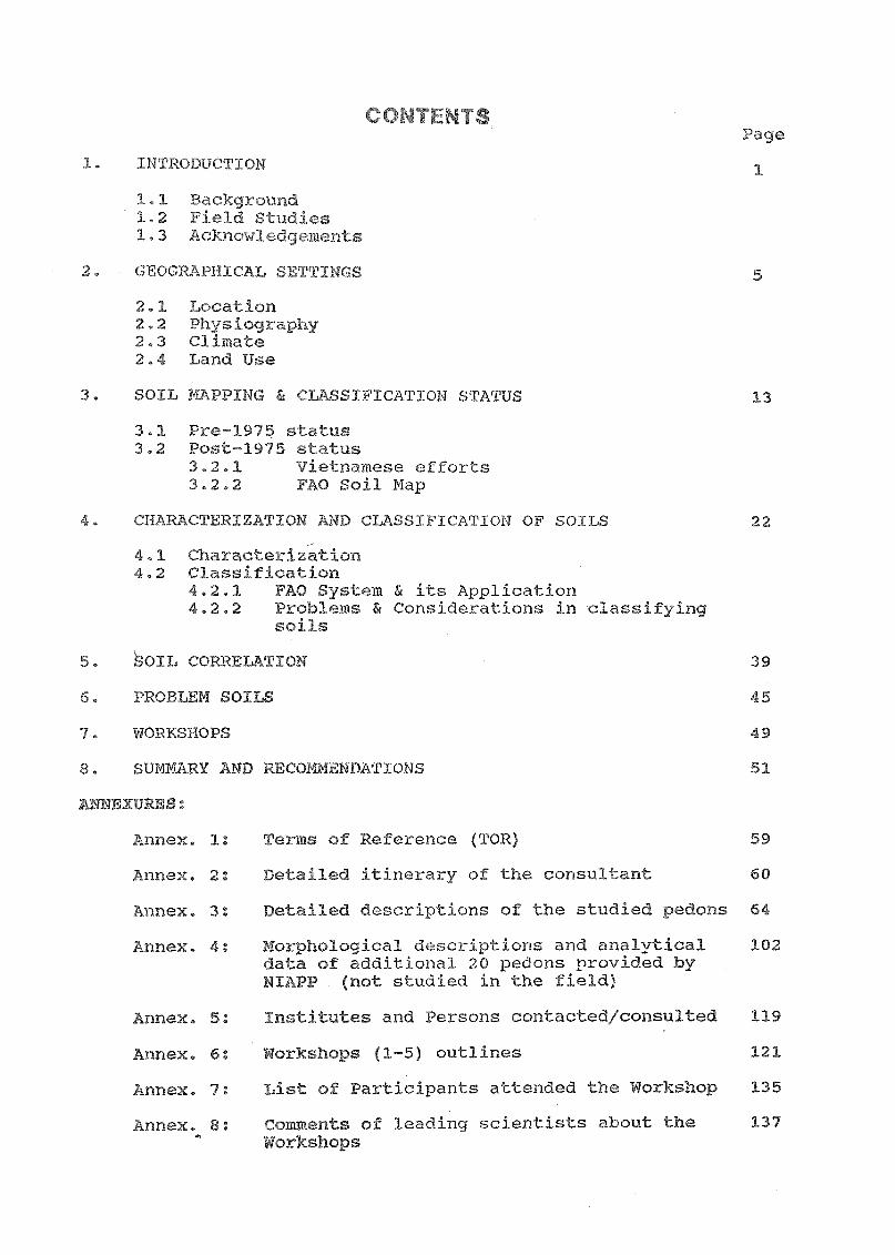
CONTENTSPage
INT1Jsoll,'0,,
1.1 Bock(.iround1.2 Fild StuCics1.3 Acknowle(Ignts
. GEOGRAPHIAL 5
2.1 caj,ion2.2 Physiogrphy2.3 Climate2.4 Land Use
SOI PING c.Y:ASSIFICATION STATUS 13
3.1 Pre1975 sttus3.2 Post-1975 status
3.2.1 Vietoamese efforts3.3.2 FAO Soil Map
CHA CTERIZATION AND CLASSIFICATION OF SOILS 22
4.1 Characterization4.2 Classification
4.2.1 PAO System & its Applic,A7.ion4.2,2 Problems & ConsideratioAs in classifying
soils
bOIL CORELATION 39
T:'RO-f.J,Ekii SOILS 45
WORKSHOPS 49
1.;13,I D :7:COMMENDATIONS 51
ANNEXURES:
. -nnef. 1: Terms of Reference (TOR) 59
Annex. 2: Detailed itinerary of the consultant 60
:).nex. 3: 7-i1ed descriptions of the studied'
»ri-JT:la. 4: Xorphological descriptions and analyticaldata of additional 20 pedons provided byNIAPP . - studied in the field)
Annex. 5: Institus and Persons contacted/consulted 119
knne. 6: Workshops J-5) outlines 121
7: List oi ,articipantsattended thr Work-op 135
knne_ . 8: Comments of leading scientists J»,ol.A-7; :he 137Workshops

LIST OF TABLES
4 !.nerary of the consultant (Dr. J. !-7:r, (jai)
Climatic elemen f some importanVietnam
11 balance data of Important station
Actual lcvad use and growing period onal(777oprl in Vietnam
Soil Groops of Vietnam and the area under major 16soilsComposition and extent of the soil mapping units 21In Vietnam
rlJtical data of some studied pedoo.s 24
Statistical data regarding correlations workeC 25betweem di:Crerent parameters
iteria for se -,rating major soils with Bt horz 31
;h.0 ;oil units -d their criteria 32
Clas Jiciftion of Vietnamese soils (-;ti,died) 37
(.21,Ji.,Jation of the additional pedow: (described) 38
Correlation of Vietnamese soils 42
Con. ...atj.oyi of Vietnamese soils (two maps) with 43the -22).)-0SCO soil mapping units

L ST OF FIGU ES
Fig.
Fig.
1
2
Vielt-nm Location & Meterological Station
Vie Physiography
6
7
Fig. 3 V't , ainfall 9
Fig. 4 Water balence data of some stations in 11Viet,nam
Fig. 5 Vietr BOILS
Fig. 6 Vie se Soils: FAO-UITSCO Map
Fig. 7 tion map of the st-1 ¡et soils 23
Fig. 8 Corelat between Clay and CEC B-hor4of AcriE
26
Fig. 9 Ct.. .telation between Clay and CEC in 26,B-horizons of Ferral ols
Fig. 10 between BS & pH (H20) in A 1 27
Fig. 11 Cci,s.--AatIzon between BS & pH (KC1) in Acrizcls 27
Fig. 12 Cor. .lation between pH (H90) and 33S in 28Fer sols
Fig. 13 Correlation between pH (KC1) anC BS in 28Ferralsols
Fig. 14 Correlation between pH (KC1) and BS in 29Luvisols
Fig. 15 Correlation between pH (KC1) & BS in Luvisols 29
Fig. 16 Correldtion (semi-quantative) of Vietnamesemajo soils with the FAO soil grolaps
44
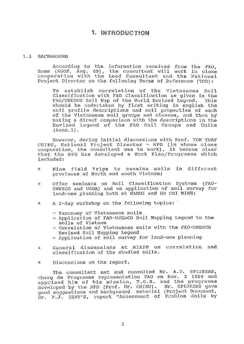
IN ODU TION
1.1 BACK ouND
According to the .)-07t:Hn -;ca from the FAO,Rome (AGOF, Aug. 89), the consultant will work in closecooperation with the Load Consultant and the NationalProject DirceLor on the following To:ems of Rerel:ence (TOR):
To establish correlation of the Vietnemese SoilClassification uith FAO ClassiEication as given in theFAO/UNESCO Soil Map of the World. Revised Legend. Thisshould be nndettaken by ficst writing in english thesoil profile descriptions ond soil properties of eachof the Vietnamese soil J. eups and clasEes, find then bymaking a diceet compar.:-ee with the descriptions in theRevised Legend of the , A0 Soil Crroups and Units(»11.1).However, during initial discussions with Prof. TON THAT
CH1EU, National Project Director - NPD (in whose closecooperation, the rensultant was to work), it became clearthat the NPD has developed a Work Plan/Progremme whichincluded:
Aiee -1.(1 trips te mie soils in differentp_o\rin- of North and (;_. \ m;
Offer eeminars on Soil Classification SysLems (FAO-UNESCO and USDA) and on application oE soil survey forland-use planning both at HANOI and hO :HI MTNH;
A 2-da-
Taxonomy of Vietnamese soilsApplication of FAO-UNESCO Soil Mapping Legend to thesoils of VietnamCorrelation of Vietnamese soils with the FAO-UPSCORevised Soil Mapping LegendApplication of soil survey for land-use planning
Geiieìal discussions at NIAPP on correlation and.ssification of the stndied soils.
Discussions on the r(u
consul.;-.n;: met and consulted Mr. A.D. SPIaRERS,eharg de Programme represenlation FAO on Nov. 2 1989 and,Ipprised him of his mission, T.O.R. and the programmedeveloped bv the 1PD (Prof. Dr. CHTEU). Mr. SPLINERS gavegood suggestions and backgvaund pate:-ial (Project Docnment,Dr. F.J. DENT;S report "Assessment of Pzoblem Soils by

agro-ecological zoning of Vietnam", ctnd Mr. -(ADWAYYs reporton "Soil rli)ssiflootion and Land Evaluation"). /le sutjgosted
follow the To:ogramme do\,c.loped oy the WPD as it seemscloite logical to siudy tbe soils in the field Tor theiroJassification ;,nd oorreJation. 11e howovor felt tbat i_-hemission is of short duration against the prog_cmme doveJopedand the TOR indiodted.
The consultant also mot the UNDP Deputy Representative(Mr. Winston TempJe) on Sat. Nov. 4, 1989 and discussed;q)out bis mission Lo Vietnam in i:he projeot (VIE/861'024 -Agricultural Planning and Projection) and about his firstrieJd Lrips impressions about íoils, /and. -oe and cr,TpingoaLtern. According to Mr. Tomple, the visit is of shortcluition Lo do justicc.1 for the soil clssiJfcation noeds ofthe country0
consultctntrs visit .. 4) to the AgKionituralUniversity No. 1 was useful for interE,ctin(2.; with the staffdnd P.G. students at the Unilietsitv and seeing variety ofviotnamese soils displavcd throu91i soil monoJiths. Theinteraction reveaJed that the studonts are t&uyht USSR andUS systems of soil classification. The .;faoulty memberslooked forward to discuss FAO-UNECO system in the plannedworkshop for comprehension and'applioation to Vietnamese
The visit Lo institute of Soils and Fertilizers (onNov. 25, 1989) belped to understand their soil mapping workand sce the lobordtory facilities. The Consultant also metthe Director of Fatioaal Institute of Agric)Iltural Planningand Projections - WTAPP (Dr. TAN AN PHONG), DeputyDirectors, NIAPP (Yr. BULQUANG TOAN and Dr. VU-NANG PUNG),Chief Soil Sorvey Division (Ms PIRM-THT-DTWH) and otherstaff mombeis of tbe NIAPP.
The project VIE/86/024 "Reinfoucoment de Institute pourla planification et les Projections AgricoJes" is a multi-lcvel planning project supporting NIPP - one of the sixteeninstitutes within the Ministry of Agrculture and FoodIndustries. The Tnstitute for soils and Frtiliers (TSF)js closely related to NIAPP in terms of its mandate.
1.2 FIELD S DIES
in close cooperation with the NPD(Prof. CHIEU) and the NTAPP Soil Su:Ivey Staiff. The soils ofVieLnam were stvied and described through field tripsspread over 16 (-1117s e::amini_ng about 20 dierent soils andsites. The available data on soil properties from Lhe NPDand other sources were collected for o.1sifying soils.Where sooh data were not ;I:ailable, expert estima Les 1:,asedon morphology, climte, vogeLation and disy;issions with theNTAPP staff and using correlation developed on compovnblesoils wc,re mad:e for classiying soils in VAO-UNESCO '-Zevised
2

Soil Mapping Legend (now i-7b,red as system) ond in US SoilTaonomy (as per refucst of NPD). J11 the mean time, thecollected soil samples vere subjected to basic soilanalysis.
An 8-day visit was olso undertaken to NIAPPinstitute at NO-CHI-MINH (south Vietnam) and typical soilsof the South were ;-3tudied, classified and correlatedaccording to PAO-UNESCO and US Soil Classification Systoms.
1.1. er 6, 1' L, 2 DepaLH.re fi cnì -Ia: !O_ for Nagpur (India).
During the course of Cield tril?s and discussions withthe Soil Su-uvey Staff of the NTAPP, the consultant observedthat they are n31 devoted to the cause and are willing toouik and learn. This inspired him to work and share hisc,wperienc.D both in the field and office. The consultantof rc on soil classification systems so that the
A brief programme of the consultant (as proposed by the NPD)is given in TT-:ble 1 (for dotal:1,s soe Tnnex. 2).
Table 1: Brief itinrary of ant (Dr. J.
Oct. 30 to Travel to maned_Nov. 1, 1989
Nov. 2 At Hanoi; brIef 11g with FAO, nPDP andWAPP staff
Nov. 3 - 7 Fiel cl trips Lo di ):.egions
of North Vietnamh
Nov. 8 - 9 c:lussions with NIAPP staff :.e.gardinghkorphology and classification of studiedsoil. profiles
Nov. 10 - 18 Field tripVisit to HO CHI "u a'od
to different ar 'ciSo-oth tnam
Nov. 20 - 25 r«k-oJ for reviewing the field work,finalisation of soil corcelation and classi-f±cation work. Rewriting of soil profiledescriptions and discussions with local staff
Nov. 26 - 28 fering ars
Nov. 29 to Dusk rc Siting ofDec.
Dec.
2,
4
1989
- 5 .'SIctngs with P of. Callan Chan as per FAO'sdirections and finalisation of the missionroport
VieiTnamese scientist can use the system of FA0-10independentiv.
T;q- t;int of not using a y (12:nlish)was ealized hilt was evorcome through an inieepreier anirl/orthrough the use of Feench 3anguage with the NPD. The timespent in slew communication was overcome by spending extraLime during the field trips and in office.
1.3 ACKNoWLEDGEMENTS
The consnitant would like to convey his grateful thanksto the following in accomplishing his mission to Vietnam:
FAO HQs (especially Prof. Brinkman and Dr. M.F.Purnell) for snpplving F.O publications concerning SEASTA.
10A0 and uppp staff (especially FAO and tql-DP - Peps.their DepWcies - Kr. Spijkers and Mr. Temple) and Mr.Le Huu Cat Dien, Programme Officer and Ms. White andPepita for their willing support.
- Di rector (Dr. Phong), NIAPP Sub-InstituteDirector (Dr. TR)EU) and their Vice Directors (DR. YUNANG DUNG) and Dr. Bni Quang Toan, N-IAPP, and theirstaff (listed in ;\nnex 3) for their eooperation andassistance in many ways.
Mr. TR; r'T, Vice Chai-Lman of the SRV, State PlanningCommittee i:'or expressing his satisfaction on theseminars offered.
In particular, Prof. Dr. Ton That Chieu, NationalProject Director - NPD (VIE/86/024) who has always beenenthusiastic and willing to share information anddiscuss classification of the studied soils. Withouthis support, it would have been difficult to achievesuccess in this mission.
The Soil Survey Staff (headed by Dr. (Mrs) Binh atHANOI and Mr. Khanh at HO CHI MINH who have been alwayswilling to assist in aji possible ways. Their eagernessto learn fascinated the consultant Lo share hise-xperience with all.
The interpeeters (Mr.Nam an0 Mrs Loan)assistance in briaying the co)c:flnnir- '4on
sivnultaneous trenslation.
e
4
nc, Lap for his as t in s cal

GRAPHICAL SETTINGS
2.1 LOCATION ( . 1)
Vietna», is a long And norrow-:=haped cc,untry errtendingNorth-South from nearly 90 to 240 laiALude. The country isbounded by sea in the East aud China in the North and Laosand Kampuchea in the West. It has a Lotiql area of 329,600sq,km., with the rosumption of ;:he old borders withlampuchia.
2.2 PRY, PM'
¡QT.. /m t , lan be di: :c1 3 broadzones, viz.
The Na'cional InstiLute of Agricullural Planning andProjections (NDPP) has delineated five ecological zoneswithin c72e )h7.4:ographc zones as:
The lowlands, comprising relatively small area ofVietnam, constitute two mEljor and agriculturally importantoreas, viz the Red River Delta (in the North) and the MekongDelta (in the South) which are connected 1.)y a narrow anddiscontinuous coastal st.rip. The Highlands (Hilly) aremostly located in ne North and forms boundary with Laos.The HighlonJs ae hilly which (xmform to the NIAPP"s zonesof Hills (<200 m elevation) and Low Mount&ins (upto 500 moae-vation)
5
* Lowlands : 0 99 m bove MSL* Hilly land : 100 - 499 m .7-bove MSL* Mountains > 500 m e MSL
Coasta7_ lainsLowlands
Inlan ' lins
HillsHilly land
Low 'idountains
FAc.untains

L A\
PROV I NCE
HA-NOIHAI -PHONG
HoA1IG-LI1F.N -SON
1.121-TNUYEN
BAC -THAIAUANG-NINHHAI-HUNGTIT Al`111-110A
FA-11104-11 i:1,1H
isINHVilTh -1711U
NA. ;011-- BINHEA-PACLAI -CliAUCAO-LANGSUN-LA
CENTRAL REGION
NGI1E-TINHBIN-TRI-TIENQUANG-NAM
Nan A-BIN11PHO-KHANGTAY-NI.N11
GIA-LAI-CONG-TUMDAC-LACSONG-BELAM-DONETHUAN-HAI
SOUT11ERN REGION
HO -THI -NINHIDONE-NAILONG-ANTIF:11-=GI ANC;
IUG-THAPAM -G I ANG
BEN -TR E0111-LONGIl Ali-G T ANG
1'1 El 1 -G I AUG
MINH-11AT
CHI NA
(71,1ALI
"I AM0. 1 ?
11^ _
t
I. MIA pAn
CAM PU CHA
CAO BANG. PHU HO
3. BAC GI ANG4 . HANOI
. 11AI HUNGPHU LIENTIM DIN!!
3. 1111E
. PLEIKU10. DAUTIENG
110-C1lT -MINHNi7 VUNG TAUr-
^.
f IONG nr
)47,Arnn(I n
!CC)"
MET . STN
Fir i VIET \
LOCAT ION OF
MEJEROLOG I cAL STAT I
. _....-s,r
,,
,,,.- m \"\ i, A D
A A
.
r ,4A1
"t.r ,)."7 <'I\ 11.nrtn.n,
42.
t, A, I '`1?,\
tinioA
A111.1

CHINA
T H AIL AND
GU L F
LAOS
7
1 17:11`,I-AM
Il lYS I OrRAP IY
G Lg L F
F
TONKIN
CH /NA
VICTNAM
O F H.:Chsram!, CjIv. P.I1Hucle
\;\ imr,tef si
F-777-1 D 99
THAILAND
SOUT H
CHI N A
SEA
ncCe .tern, S. Field Docuement 9 Fl\O,

2.3 CLIMATE
The as a tropical monsoon climate which iss;vongly influenk..:(.-d by the country 's smpe and Lopography.VThie 2 oiltlincs climttic data in 3Cf:1,,ic.;i: of m,tjorThe data show U.]at the 41inual roinfall ìies ).C)M )c.s ihan1500 to over .)000 mm (Fig. 3). The mean annual ;:eluperaturevaries from 21 to 29° C. Tbe mez,n summer and winter'colveraLure difCer by less than 50 C only up to Northlatitude of 150 snygesting iso climatic condtions; beyond15 N non-iso couclitions prevail.
The detailed monthly- ;, (3.-tta fostations is pyesened f e 3 and Fig 4.
Table 2: Climatic rts Lt iwortunt stations in Vietnam
(mm) (o C)
1. CAO BANG : CAO BANG 9 : 106°141E : 1374 21.4
2. PHU HO : VINH PHU 21°29'N : 104°13'E : 1862 26.3
3. BAC GIANG HA BAC 21°17'N : 106°12'E : 1476 23.3
4. HANOI : HANOI 21°01'N o481E : 1664 23.5 28.7 17.1
5. HAI HUNG : HAI HUNG 20°56'N : 106(7'1-1 : 1611 23.4
6. PHU LIEN : HAI PHONG 20 1,i!stl : 1802 22.8
7. NAM DINH : HA NAM NINH 2 26(11 106°0(»E : 11,25 23.4 28.7 17.1
8. HUE : BINH TRI THIEN 16°24'N : 107°41'E : 3031 25.3 29.4 20.5
9. PLE1KU : GIA LIA 13°59'N : 108°00,E : 2283 21.4 22.0 19.4
10. DAU TIENG SONG BE 11°20'N : 106°20'E : 2102 27.0
11. HO CHI MINH : HO CHI MINH 10°49'N : 106°40'E 1943 27.2 27.6 26.1
12. VUNG TAU VUNG TAU 10°20'N : 107o05,E : 1352 26.3
Station Province 1,A) TI,JA Mean Mean
Latitude Longitude rcni. An.Tem. Sum.Tem.

6
) @D.
V1-131-1dIAJVN 'SOV1 INVN1131A
.-°`" I:" Pilt 10 1
091'.):, of if vrovvl
001
6b)
091
kuwacoc 3.rm 1.1 0 !:
-1-1V:11
-HUN A
I (I 1.111 1 r
T.FP
I1A
VI P+

Table nce
Station : U:nh Vielnm;
Rainfall(mm) 25 28 44 110 155 210 238 334 363 208 74 36 1825
R.N.(%) 89 87 90 89 84 84 82 85 85 79 82 79
Sunshir.. 23 14 13 26 50 45 54 44 50 50 45 37
Pot.Evapo- 63 61 78 99 143 140 157 136 124 112 79 69 105.8
transpiration
(mm)
----- ----- ------ ...----. --------- -----
Station : Ho chi Minh (South Vietnam)
Rainfall(mm) 1.4 1.4 1.1 5.2 21.9 32.2 29.3 27.1 33.0 26.7 11.2 4.8 194
Temperature 25.7 26.7 27.9 29.0 27.2 27.7 27.4 27.8 27.1 26.9 26.5 26.0 27.
(°C)
Pot.Evapo- 107 128 145 148 125 115 105 118 108 103 100 98 108.
transpiration
(mm)
10
month Jan. Feb. flor. Apr. May Jun. Jul. Aug. Sep. Oct. Nov. ec. MeanClim.element annual
month Jan. Feb. Mar. Apr. May Jun. Ju . Aug. Sep. Oct. Nov. Dec. Mea
annu
Average 1). 16.3 16.8 19.7 23.4 27.3 20.5 29.2 28.4 27.3 24.7 21.2 18.3 23.4(°C)

400
lu
200
150
100
350
360
340
320
300
280
260
240
220
200
180
160
140
120
100
50
60
40
20
Rainfall + PET
Country : Vietnam
0.5 PET
JA M J J A 5 0 N
jill + PET 0.5 PET
- Fig. 4, Vi.Ait-c 411zInce da of some stations in(ror loc:,tion, see Fig. 1)
Waterbalance da_a o ChiMinn s,n.
\* dataCount
rn Dinh cz

2.4 LAND USE
The natural vegetaiion in .ict in most of ViL1)k).:(7:1. in the ,aouniriin ond bi3ly perts of the HA PAM NINHpcovince, here everyleen broad-1Q(..ved fort dominates anda -reaction of the area is occ-upied by deciduous winterforest. The destruction of forosts could be clue to increasedhuman population pre:3sure for more '11c:i more need 17ordgricultural laild for cultivation.
me major crops grown in Victnam ,:ra paddy (2 to 3crops per year) followed by in the Cormer case, c- subsidiarycrop of groundtlut, potato, set-p,Aato, maize, etc. Theland use in Lhe North (because of mild win;:er) is dominatedby two paddy crops in summer and spaing ana sandwiched by asubsidiary crop of maize, potato, ..,-:weet-pol-ato or groundnutduring the winter season. In the Soun, in view of thetypical tropical .2nvirol-zmonts, three crops of paddy or twocrops oE paddy aud one subsidiary ;re cultivekted. Thearea under different land uses in the c:-)/,#qtry is Jivn inTable 4.
15/9 - 31/1
B. In the South
Winter-spring
1/10 - 31/3
1/2 - 30/6
12
1/7 - 30/1115/6 - 15/9
Wet nnsoi
1/8
Table 4 Actual land use and growinn oriod ODS in Vietnam
LAND USE Acrosge % pf ur0.00hgA sY2.9r i es
Natural su,erfces 33,036 100
1. Forest 9,642 29
2. Agricul ural area 6,914 21
Perrenial crop 5,527 16.7
Rice 4,242 12.8Vcgetnble 16 0.05Reed 16 0.05Subsidiary cropindurtry crop
1,253 3.8
Perrenial crop 860 2.6
Industrial crops 664 2.0Fruit crops 196 0.6
Grass land 323 0.98
Water surface
t-onal crops
173 0.52
A. In the North
Winter crop

APPLi & C SFiCATON TATUS'
3.1 P 1975 EFFORTS
TLe MSR 3( aclemy of scimoce c.-mpiled a gener-1]isd soil-map of Vielnam (No):th of 17° N) at 1:3,000,000 scale.Although the map, lc.lgend aid r(s,port etre no longer availF,hleat N3APP, t is inCielstood i:hat the leend cot4tained sixmain soil fol.mations as:
1 - FeirsaJitic and acid soils (npland areas)2 - Acid sc,iis with mobile light kumns (with a short
dry period)- Weakly acid and neutral soils (dYir,:dareas along
the coast with a dry . -eason)4 - Saline (and alkalne) soils stal and deltas)5 - Mountain soils6 - Alluvial soils (rive ad deltas)
Viooman (1961)f; compped a soil map of Vietnam soth of 17° Npn 1:1 m scale based on:
reconnaissance soil suivey of majo part of SouthVietnama general interpretation of the photossemi-detailed and detailed soil su:vveys in variousregions, andinterpretation of existing soil, geological nci
yraphical maps.
The soil units/associations are tbe cr-reat Soil Groups,are characterised by the dominant paront rocks, theLopogc.aphy and chEtracteristics of the soils. In all 25-wapping uni:cz were i c.'entifi'.d, which cou'ld be Tcouped in 8major soi3s as under:
13

10
Mor Soilv
Ml1Jvja1 37.21,1s. (u)diffeeutiated, sallne,attid very acid end In-r,eto
nes ,nd old red Sand)
(shallow, on acid rockDY0w1/or old al/uvium)
14
11 - 18 Pod7,olico53s (sandy, t-ed-yellew, gray,hnmid on old alluvium an:1 complex)
19 yietosols (Re6dish brown, :,:ed and Yellow,Eorthy .ved, Reddish brown and Shallow)Peat and Muck soils
3.2 1975 t
The NIAPP and ISF (1978) jointly ;,tought cut a son mapon 1:1 A seele by unifying the two eecieting soil maps withadditional obsetvations (both in field ond laboretoty). Thesame was publised (on 1:500,000 scole) in 1983 (Fig. 5).The NIAPP has alse been producing soil maps of differentprovinces, districts, state fai-ms and villases on scalesrdnging from 1:100,000 to 1:5,000 scales.
The Vietnemese legend is largely tased on the RussianSystem, that 35 Genetic, based on zonality concept, tak,ing,in addition, intc, consideration perent material, andtopoolaphy. It bas two cateoories: Major soil groups andsoil classes; the number of groups and classes varydepending on the scale of mapping. The same groups andclasses eppear at different scales; nowever their numberincreases as the scale is enlarged (from 1:1 m to 1:5,000)as under:
scale For So!,_1 SoilGro-opz;
(1:1,000,000 to 13 31 07.1clu-1:500,000) ding negligible
.17,;aline soils
c(:iqm (1:250,000 to Preee- es 14 751:50,000)
(1:25,000 to Districts; 15 861:5,000) Vi]laoes
An exmple of the small-ecale map legend reduced from1:1 m soil map evident in Fig. 5 and 5s brieed in Table 5.

T.71)
SO-AL OHPS CLA!
and thu area und r soils
M:'\PSYMOL
16
1000 ha
35 0.1
3 4
1.5
991 3.0
2140 6.5
72 0.2
2936 8.9
2813 8.5
Whi Yello snddune soilsRed Sand dune SoilsSaJ- ;.:Tine Soils
I. -rniqDY
II. SET,I'flE
Salinc ,Sal3-1 SoilsAnalIne SAli 0 snils
III. ACID SUL1T1T, (7
Strongly Acid Eulphate Soils SnMedium & Weakly AcidSulphate Soils S
IV. ET-717? SOILS &
Swamp SoilsPeat Soils
V. ALLUVIAT SOILS
Alluvial Soils of Red R. PhAlluvial Soils of MeRong R PCAlluvial Soils of OtherRivero
VI. :.EY DECRADED SOILSx
Grey Degraded Soils on Xold alluviumGluy Degraded Grey Soils Xgon old alluviumGrey Degraded Soils onacid igneous rocks andon sandstones
VII. D-RO c SOILS
17. -grey Soils Xx,(i-arid 'one)
Cc
-Cd

IX.
18. o nails
1,71.1.LC
Purple-brown soils on Fktbasic & neut.cal igneous soilsRed-L)own soils on D.asic Fk& ueui:ral igeuous rocksYellow-bfown soils on hasic& neutral igepous rocksBroWn-red soils on Jjme-stonesYeJ iow-:.:eì su.);is on clLy- Fssi-ones & Petamorphic rocksYellow-red soils on acid Faigneous rocksLight-yellow soils on FqsandstonesBrown-yellow s n olc Fba1. hi
X. RED-LLOW JJATC IN /400;.,1Tk±OS.
15,816 47.9
,257 9.9
2 4
238 0.7
in : Nol:thern »Ionntains - 700/900 to 2000 min : Southern movntains - 1000 to 2000 m
Red-yellow riumic suils Fhin mountainsHumic soi]s in high
xi. pop'7Lic
o
XII. RODED JLT:,TIC SOILS 1.5
.:,(aeC soi s E
T.";n-maDo 7,77.1s 0&ta able &bout 10%)
17

The morphelogical doecriptions and analyticel data(borieon wise) have been given in each of the soil surveyJ.(2,poJ:t proOueed. These provide velueble Oata-base or lend-nse plenning. Tlet the preliminry el)eeLve;--ions suggoet thatHe p)ofiJe (leecriplions and -i he eoel),;i1:el data do needchecking and control as ;he info)metion contained thoreinserve limited pulpose to classify and corre)ate the soils inany internationally accepted systom of soil classification,such as FAO-UNESCO, US Soil Taxoeomy, which demand preciseinformetion (both from field and leborato-ty).
3.2.2 FAO-UNF Soil Map
The FAO end UNESCO (1976) has compiled a soil map ofthe world on 1:5 million eeeJe whevein sheet IX covcis S.E.Asia, including Vietnam. The soil map of Vietnam (as perFAO-UNESCO Legend) is given in Fig. 6. The mapping unitsconsist of a soil unit or an association of soil units. Thetexture nnd slope ace shown as suffixes to the main unit;the former is indiceted for the dominant soil nnit, whilethe latter (slope) reflects the topography in which the soilassociation occurs. The pro.sence of indurated layers, depth,stoniness and salinity are shown by different shades (notshown in Fig. 6). Each soil nnit is composecl of dominant andsub-dominant or assoeieted soil nnits, the latter coveringat least 20 pel.cent of the delineaLed eIea; other soilscovering less than 20 percent of ;he arca are included asinclusions. The Map Units are shown by a eymbol representingthe dominant soil, followed by a figure (GO or 73)correlating with the descriptive legend, follcAded by thetextural and slope class symbol (2a, lb, 1/2 ab). The extentand distribution of various soil units (see Fig. 6)(representing major soil groups) occurring in Vietnam aregiven in Table 6. The data, summarisine, the extent ofdominant and sub-dominaat soils of Vietnam, suggest thatAcrisols (A) occupy the largest area (+ 43%) followed by theGleysols, occupying 13.3%, and the Cambisols (3) andFluvisols (J) eovering 7.8% and 7.6% of the total land drearespectively. The Ferralsols (F) and Luvisols (L) represent4.5 percent and 2.4 percent area, respectively. It alsoshows that the Lithic phase, suggesting a soil depth of lessthan 50 cm and Lithosols (I), which by definition, are veryshallow soils (< 10 cm) taken together, cover almost one-third of Vietue,ae eeLJ.e.
Analysing i-he two soil meps (Figs 5 and 6) and the datagiven in Tables 5 and 6, suggests interesting distributionpattern of majo: soil groups in Vietnam. :iccording to theVietnamese Legend, Ferrallitics soils (occnpying about 50%of the area) ere the dominant soD,s, followed by equallydis-;-ributed Red-Yellow Hu.aic, Grey Degleded and AlluvialSoils (each covering + 10% of he area) and the AcidSulphate SoUs (+ 7%).
18

The FAO srdl stv-T, on ne othe 11nd, ,31/(L:gest.s Acvisolsto he the OolflUnt. sons (covering 71!)ont 50% (Area), .rollowedby (yols (iV), Fliivsols (8%) (76mbiso1s (n),Vc-yral::,01s and Lnw:.sols (2,5?;),
19

01.8801.Z. ,
, I
Eh RI I 1
I !
1
I
1
9I
! 01
36
255,
ro . . 7:.:TE: OF THE SOIL 1PE ti;.,-17:21-...3 117.
169
75
: 302
24
172
16 ,
' lei '
' :119.
21
rit ri (I 000 ha)
155
7251
169
1...... ............574 235 2525
1.6. 0.7 -7.636 155i
330.1 G.5 ( -71341")
cc ; t/eSai4, (956)
'7'J:: -' ''.,;..S ' 'ClIgS 11Eil. . . SOLS
1,
! : *,-,. , [ ...i 1
IQ( ' Saa Po , VI: V( ' 10 Bd Bg Bk BI 1 114 Hd 1 Od 1 no Al Ah Ap Ag Fo Fr
l
,225 I 4
1 '''.; 450 - 1 1F450 900 - . 225
i
I ' 845 - 507 1L5I!I ' 32
I
, 83
6511, 3! 65 2 57
631.,
1
83 124'
j 16323 ' 1189
501 1007! 2014 1007
22 22
I12 161
1 I6e 504 672
44
75
307 f302
10J
,
41 2454
- I iI 146'
r(;11 60;1
! .... I 1 238 119 i 60!
!,
'346 121: 60 407 119 109 ; 32 1169 14 343i1037; 665 118! 2 42461146 la52 2945 1189 535 616 617 6721.0 0.1: 0.2 1.2 0.4; 0.1 1141 3.6 0.1 1.0 3.11 2.0 '0.1*(0.1 ! 3.710.4 ,2.5 8.8 3.6 1.6 1.8 1.5 2.0
: 41 60-1/7ab I.
;I
J: it 1 Si Ed . Ea
I 1
-inab i 169
321
21
30-2i3c lithic-0107-2c.;
, ,
;
io102-5ab 12
Fr 25-54')_9: , ;4). ; 52
44 352
;le 5,;-5a 1274 764
-A1-3c
, saline i 272
i ! 3574, 175 60
534.:9-.2) 74 -
:1C.4-: lithic:4,1 ::-.4 1113
33-1ab ' 61 Si
t'p. i4-3a lithic ' 50
total talent
,
000 hal ;1036 1', j 919 916
3,1 4.51 6.2 2.6 2.7
______-____-__-_-. ______ -----L.........-__. --------,--- ---------__ -..---------------------TUJY1501.3 ! :P.E604.1THO ARII, ,POD) NIPTISOU SOLOH,SOLO OAMB1SOLS LINIS01.5 PLANO iX.2.13:1LS FEZZAL501.5 10IAL EllE141

4.1 CHARACTERISATION
In view of the inherent lipitatjons of availableinformation on soil morphology and analytical data ondiffefsent soils for the purpose of classifying andcohrelating them into FAO-UNESCO Revised Legend, severalfjold excursions were made as per the Work Plan prepared bythe NPD Lo study soils in the North and Sor,th of Vietnam forsetting principles for classifying and correlatingVietnemese sois in the VAO-UNESCO Revised Le(jend (1988)and in US Soil Taxonomy (Soil Survey Staff, 1975).
4.1.1 idied Pedons
In all 20 soil profiles h and south ofVieLnem (see Fig. 7) were studied in the field and i'escribedby following the FAO Guidelines* on the subject. Themorphological features and diagnostic horizons observed inthe field and Lheir application in classifving soils (bothin the FAO-UNESCO and USDA systems) were discussed with theNiAPP Staff for their benefit and with the objective to makethem work independently to describe and classify soils. Thedetailed descriptions of the studied soil profiles ara givenin Annexure 3.
The soil samples colleute -o. iaon-wise were subjected toanalysis in the NIAPP laboratories. While some basicproperties could be determined, others weue derived by usingcorrelation technique of samples with available data. Thecorrelation between pH and base saturation, and clay andexchange capacity, using analytical data on comparable soilsfrom the region,- were worked out (Tabla 7). The correlationsdeveloped and used are shown in Figs. 8 to 15. The datathus derived in conjunction with the laboretory data (givenin Table 8) were used to cic--;LLs:r
4.2 CLASSIFICATION (Please see page
* FAO (1977) Cuidelines for Soil Profile Descriptions.FAO, Roma Publ., p 66.
t:4 r\r". V: r
22

PEDON: 6 GLEY ALL0V14,1. .-07rz "F flUVIUM
Pf 12-23 5.1 -40 -8 -53
23-50 4.0 -40 -8 -14
50-100 3.7 -40 -8 -8
PEDON:8 ALLUVIAL GREY SOILS
24
- around
Ph
X
12-2525-4343-63
PEDON:14
17-:1) 4.64.8
55-7C; 4.6
78-100 4.4
6.66.66.5
GREY SOILS ON OLD ALLUVIUM
3.8 53.5
3.9 52.8
3.9 50.8
3, 52.8
14.0
8.0
12.0
6.0
-45-45
-50
32.539.237.241.2
-6-8-7-8
Saturated
PEDON:15 L[7:o HItS H LT
Ft 0-22 5.9 4.3 28.0 35.0 37.0 14.8 40.0 68 2.9 7.1
22-45 6.1 5.2 12.0 31.0 51.0 16.6 7,2.0 78 2.9 10.1
PEDON:16 F:1ED It: SOILS
Fk 0-13 4.8 4.0 10.0 27.0 63.0 8.7 14.0 19.3 0.84 0.84
iD-35 5.1 4.1 5.0 25.0 72.0 8.3 11.0 19.1 0.84 0.72
..5-57 5.2 4.3 6.0 17.0 77.0 8.2 11.0 35.2 1.2 1.08
:;1-113 5.2 4.3 6.0 16.0 78.0 7.8 i0.0 26.0 1.2 0.2()
113-150 5.6 4.6 6.0 12.0 82.0 7.9 10.0 30.4 0.42 0.6150-200 5.78 4.6 5.0 13.0 82.0 8.1 i0.0 23.6 0.72 1.20
PEDON: 19 RED SRN' LIT1C SOILS OM BASALT
Fk 0-71 5.2 4.2 14.0 16.0 -0.0 7.8 11.1 0.9 0.5 12.4
30-78 5.4 4.3 20.0 12.0 32.0 7.5 11.0 0.7 0.6 17.5
78-120 5.5 4.5 13.0 10.0 C(-.0 7.6 9.0 1.2 0.2 18.6
120-165 5.6 4.5 7.0 15.0 ','2.0 6.0 7.0 1.1 0.2 ?2.0
135-220 5.5 4.6 10.0 12.0 78.0 5.3 6.0 0.9 0.2 22.6
>220 5.0 47 10 12.0 75.0 4.8 6.0 0.5 0.1 17.4
Fs
Fs
Bg
Bp
Pi.r.OI!: 2
15-5153-Y090-120
PEDON:3
20-45
PEDON: 4
15-20
20-2929-32
I.1011: 5
12--c',
28-30
'50-78
-s3-100
IT.D n YELLOW FLn[J.ITIC SOILS
3.8 ,-40,
3.7 -403.8 -40-50
RE[ 1LLi I't SOILS H
5.0 N.D. 58 9 33
GLGY -JE1 r9EY SOILS ON OLD ALLUVIUM
4.94.23.9 '
GIL: Y Hfz,Y)r0 61.EY '.,()ILS (-v! ! WVILM
5.2 -6
6.0 -4
5.2 -40
5.5 -40
-8-8
-8.5
7.3
-6.0-8.5
-8.5
-<3
-<3
-8
22.2
-10-9
-10
16
-45-23-10
-F7,C,
0.4 0.7
Table 7: Anply;.if. of some Po
i4.1)th :I (1:5) ! Orf.,k.nic ',(,;. '';..r,.1..: Sir., LL. Q0-bleUi-, (Ho) _ tc,tter ---------------- -
r (..ationr KC1 % SurV, Sill. Cfty% iw:./1000 foit LL.,1
>0.05 0.05- .002 ----------------um 0.002 ni (soil) ( ) Ca Mg Na
wro

Tub : Statistical data rerjdrding ,ed out1)QttR.en d!ffent pararoeters.
. of P.17ZOL
CLAY 6": CEC
25
----------------BS & pH (KCL) Regreion Output: ES & pH(KCL)
stant 3.603302 Conslnt 4.076460Std Err of Y Est 0.:',372059 Std Err of Y Est 0.247784R Squared 0.427183 R Squared 0,483480No.of Observations 33 lio.of Observations 19Dec: f 31 Fro-fQ 17
X Coefficient(s) 0.025376 CoeZficienL(s) 0.010595Std Err of Coef. 0.0092931 SUd Err of Coaf. 0.008999
Con5tant 9.S24434 Constant. 4,855392Std Err of Y Est 2.370395 Std Err of Y ESt 1,330194JR Squared 0.465061 R Squa'ced 0-249685No. of Ohervati.ons 13 No. of Obsecifvations 11Deciroes of FrccOom 11 of rn 9
X Coefficient(s) 0.1934395 X Coefficiunt(x) -0.02737Std Err of Coef. 0.05715168 Std Err of Coef. 0.070878------------------ _oession : BS & pH (H20) -gres, '-qvi-" BS& ":,-)11 (H20)
Constant 4." ._)894 4.483247Std Err of Y Est 0.3752468 Std Err of Y Est 0.2444831R Squared 0.590698 R Squa::.ed 0.624214No. of Obse:cvations 13 No. of Observations 19Degrees of Freellom 11 Degrees of Fr?.edom 17
X Coeffirde-r(s) 0.0664 X Co(- iient (s) 0.014311td Err 0.00;S-)78 Std Err cf 0.007924

10 20 30
CLAY
a data Est. data
Fig. 9_ Relation Between Clay and CEC IN B HOR.N..r:RALsoL (r-2=-0.249665)
CLAY
Real data + Est. data
D
o
L_ _6050
Fig. 8. Relation Between (-Icy nn CLC IN B OR.Or
Hg. 10. REILATION BETWFLIN ACMOL (r":: .
1.9
4.
4.7
4.6
4.5
4.4
4.
4.
4.1
4
3.9
3.8
3.7
3.6
3.5
Fig. 11. RF_LATION BETWEEN BS cgc pH KCLIN ACRI501_ (r'2=0.427183)
27
EiS (%)
J ,a-ta 4- Est. data
pH H20
o 20 60
55 (%),Iato + Est. data

C)
Fig 12. [RELATION [RF WrEN H20) & BSIN
6.2
6.1
6
5.
5.8
5.7
5.6
5.5
5.4h.3
5.2
5.1
5
4.9
4.8
4.7
4.6
4.5
4.4
4.3
4.2
5.5
5.4
5.3
5.2
5.1
5
4.
_J 4.o
4.7
a 4.6
4.5
1.4
4.
4.2
4.1
Docl
O
0 Real data Est. data
Fig. 13. RELATION BETWEEN pH KCL BSLRRALSOL (r-2=-E1.-11
4
3.9
_1 1
BS (%)
0 Real data -1- Est. data
28
o
_1_ _1 _1._
60 80 100
10020 40 60 80
Fig.15. RELATION BETWEEN pH (KCL)81 BS
(31:
1342
150
-r - -1-70 60 90
LUVISOLS
29
100
100-
Fig.14. RELA 4.13ETWEEN pil 1120 a BS
6,4 -:SO CO
- -r "-I -CO 70 CO
4.2 CLASSIFICATION
stedied eoils (20120) were classified occording toihe systems (1:- FAO-UNRSCO (3988)2 end USDA (Soil SurveyStaff, J975)1. The FPO-Syetem is fludoubteOly moeh eesier touade.stand and opply For clessifyiag soils as compared withtbe US Soil Taolir.,my. Since the objecti're is to (.:lassifysoils in the F0-System, a brief ebout th3 system may helpthose who are not acquainted with it. This is especiallytrne of the Vietnamese scientsts, for whom specialseatina-cs/workshops were oroenised by the N1APP to highliuhtthe pri'aciples of the system.
4.2.1 FAO ' ITS TYON
The ec,i System is largely based on compilationof existing materials combined with systematic fieldidentification and correlation of soils over a period ofmore than two deeodos. The system is basad on observable andmoesnreble soil propeuLies. The use of diagnostic horizonsfor ideatification of soil units has oroved Lo be mostappropriate. The set of quantitatively defined propertiesproduced by soil forming processes, have made it possible tobase the classification on g.7:neral veinciples of soilgenesis. The processes themselves are Dot used as criteria,but the inferences of the Drocesses, as expressed inmoLphology and intrinsic soil properties, form the bases foridentifying soil groups, soil units and subunits. Thecriteria for defining diagnostic horizons and diagnosticproperties have been inherited laruely from Soil Taxonomy(Soil Survey Staff, 1975)1 but modified wherever desired. Forinstance, separating argillic and oxic B horizons has been aproblem, especially in the tropical areas where low activityclay prevails. As such argillic and oxic horizons have beenredefined uader the names of Argic and Ferralic B horizons.In the revised Legend (FAO-UNESCO, 1.988)2 some major soilgroups and units have been deleted whereas others have beenadded in acoexclance with the additional e<perience gained.The important additions or alterations (relevant toVietnamese soils) are highlight d as under:
IntroOlction of the LIXISOLS (conno'cative of strongweathering) for soils having an argic horizon, highbase status 2mt low-activity elay wbich allows theirseparation from LUVISOLS (which ara coils with 3)1gh-
tivity
Soil Socve!y Staff (1975) Soil Taxc my. U;
SCS; Washington DC, USA,
ee ej,RSC (1988). FAO-UNESCO Soil Piap of the WorldRevised Legend. World Soil Peseurces Report EC, FAOPubl., p.110.
30

Tab 9: Criteri
-, - X,' 0- ^ -
CRITPRTA
Argic (Bt) horj7, nCEC (Cmol(-0 kg c 6y,-Kind of clay
Base Saturation
- soils with Bt horizons
LUVT.SoLS LIXISOLS .hcRiSOLS ALISOLS(LV) (LX) (.ZC) (AL)
X X X X> 24 > 24 >24 >24High- Low- Low- High-
activity cictivitv activity activity> 50% > 50 <50 <50
31
hc"PTOLS ;rt.. two soil groups as:
Awisols: with lay
Al: clay
In view of Lhe changos, the criteria fordiffcentiating diff[,:rent soil groups are out]ied iaTable 9.
o Ddivision of poorly-drained sojls into those with aground water table and those with surface water-loggingby introducing STAGNIC units.
o Introducti,,n of PL1NTHOSOLS (tol_m Gr. Plinto, brjck;mottled olay material which hardens on ixposure), i:hus
separating such soils from Fe):ralsols.
Introduction of hUMIC unit for soils wI c- havemollic or umbric A horizon.
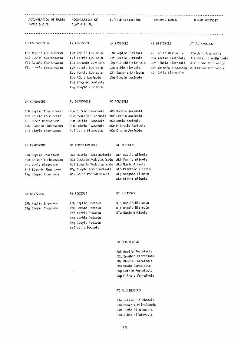
As of today, there are 28 major soil groupings,subdivided at the second level into 153 soil units. Thedetails of soil groups and soil units alongwith the criteriafor their separations are given in Table 10. The discussionabout the US system of Soil Taxonomy is leyond the scope ofthis mission.
While classifying the studied soils in the FAO System,some problems were faced. These are briefly discussed hereunder as these are rlevant to the logical ,:lassifjcation ofVietnamese Soils.
4.2.2 PRou ,pse AND CONSIDERATIONS Ih -:',I2N"ING SOILS
The aprication of FAO-UNESCO System to the itudied
soils sugge:7.ts that the critexia and soil units p-,:ovidedin the systnm may r ': :Iodate all the soils for their
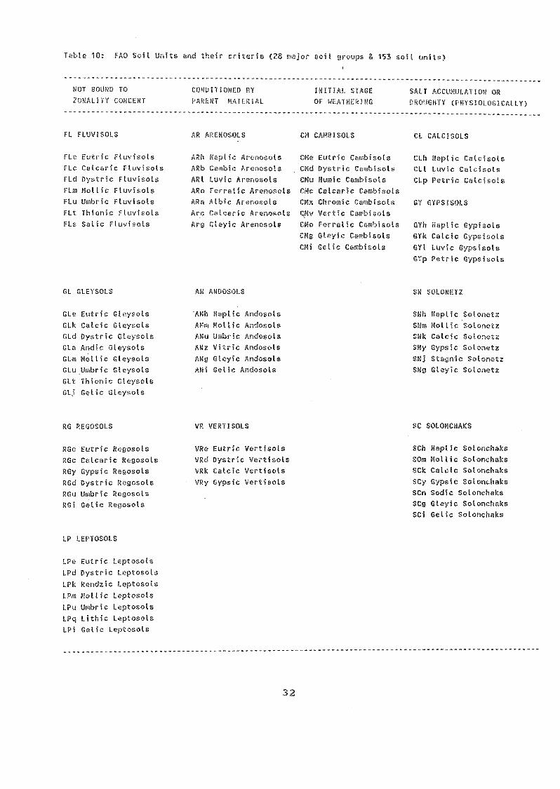
Table 10: FAO Soil Units and their criteria (28 major ¡woups 153 soil units)
1 PeOh, lc.., rl.';,)-.1 :-IHT ,': INITU1 ::.:.,A,.,FL SALT I. ION ORALITY (...ukCENT ; :,H:.!!'r r;,';) HL-ti. 07 "'L'.'4 . Ai ,-.,,!:!(;I:TY (i tro'L' 101 (3G I CAI Ly)
FL FLUV1SOI.S
FLe Eutric Ftuyisots
FLc Catcaric Fluyisots
FLd Dystric Fluvisols
FLm Mot tic Ftuyisots
FLu Umbric Fluyisots
FLt Thionic Fluvisots
FLs Satic Fluyisols
GL GLEYSOLS
GLe Eutric Gleysots
GLk Catcic Gteysols
GLd Dystric Gtc:,,sols
GLa Andic Glc-;sols
GLm Mollic
GLuLimbrc
GLt Thionic
Gelic Gleysols
RG REGOSOLS
RGe Eutr ?gosots
RGc Cctc 7!(:gosols
RGy Gypi ,osols
RGd D'stH rrosotsRGu Umbri
RGi Getic
LP LEPTOSOLS
_utric Lc:pu,:ots
stric
LI :. c:1 )oi
LV. :-ottic I )tosois
LPu Umbric
LPg, Lithis I
LPi Cetio L Dsols
AR :'F'...OSOLS iOf
ARh Cambisots
Dystric C;mbisols
ARL Humic Cmhisots
ARo Ferratic Arenosels CMc Catcaric C,;mbisots
ARa Atbic Ar,.9)usots CMx Chromic 7Lmbisel::
Arc Wcaric ArQr10::.eis ply Vertic ComLkots
Aro (31,:yic CMo 1i.rrntic rmbisots
CM Gt4yic
CIO Colic Ccmbisots
/.1MO:i0LS
'Arh N.THG Andosots
Arh: Andosots
ANu U c nchlsols
Vitric
GLeyic
AMI Getic írt5
VR VERTISOLS
VRe Eutric Vertisots
VRd Dystric Vcrtisots
VRk Catcic Vt.rtisoLs
ic Vertisots
32
CL CALCISOLS
CLh Haptic Catcisots
CLL Luyic Calcisols
CLp Petric Catciscts
GYh i1. c Cypisols
GYk Catcic .s
GYt Luvic
GYp Petric Gypsisols
SN SOLOPET
VPVplic Sotonetz
[:ottic Sotonetz
Ctcic Sotc,net:
Gsic SotonetzSkj Staunic SotDrietz
Skg Gleyic Solonetz
SC SOLOr::.
le SoT 4.7,hrAs
1:7 So7,_ s,hsAs
So. ,.!-, h;T2ks
Ac .2c ,A)Lin.)ks
SCn Sodio -T,ot,:,nch3!zs
SCg Gleic olonchasSCi Static Solonehaks
ULA1Y:! ORGAIc oJL HUMAN ACT/VITTA. OM. & R,
KS KASTANOZFM'' LV LUVISOLS LX LIXISOES HS il.TnIT-41!.!1 AT ArTrrroLs
KSh
HI Luvic' "Jcic
CH CHRNOZEMS
CHh Haptic
CHk Calcic
CHI Luvic Cherr(.74:cms
CHw Gtossic OICIFZQMIS
CHg Gteyic Chen
PHh Haptic fl1H.PHc Catt,L.ric
PHI LuvicPHI Stagnic PkwozemsPHg Gleyic Phuewems
GRh rapticGRg Gleyic Gre;!:16iis
LVh Haplic Lu-1:,otsLVf Fe H.
LHvicolsUc. LIrjsoIs
LVv Ve i:: LuvisolsLVa Albic Luvisot3LVj Stagnic LuvisolsLVg Gteyic
LXti Haptic LixisotsLXf Ferric LixisolsLI/p PtinthicLYcr Atbic LiyisolsLXj LixisulsLX0 Gteyic Lmisots.
.PLe Lutric clts AC .crisoLsPLd Dystric [,L]- 43 AH isotsPLm Motlic Ptrnosols AC(/ T.,:risotsPLu Umbric Pt,pasots ACp LO .Eic AcrisotsPLj Gelic PlavT.:(7,Tn. (LO, H,.crisots
PZh E_ .1c :',.zotsPZb Cawbic PcK:zots
PZf Ferric [-,(ot:;PZc Carbic Pc(zolsPZg Gleyic Por:zolsPZi getic Podzots
PDe Eutric PodzoluvisotsPDd Dystric Prd7oiuvi9olsPOI SUgnic PtdzouvisolsPOg GleyiC izotuvisolsPOi GeN tvisots
Alh ' icAtf 1.1c
ALu
ALp Etiv(thic AtisotsALj H AtisolsAL 6 ':c Atisols
. NTh HoptcNTr Rhodic
NTu Humic
FRh
FRx Z.:othic FerratsolsFRr ic1c Ferratsots
( "(rfl c iolsPo olo
7.,(T(c(01,8
PT PI/NTHOSOLS
(sic Plinthosotstinthosots
FTe
33
HSI Folic HistrIc.otsHSs Terric HistoolsUSE Fihric Fis'ootsHSt Thiolic'HSi Getic
PH PHAEOZEMS AL ALISOLS
GF! GrEYZEI1S NT NnY.L7
ATri A(itrosotsATc AnthrosotsATf Fimic AnthrosotsATu Urbic nthrosols

logical classification and necessitate the introduction ofintergrades or subunits and/or proposing new criteria todepict 'die ill"1.1C u r 11 i'(?. 0)7 -Lb C ,(..)jïS
.1"0013.(,;_0,11 T desVSoc -Vet a
1uvsols Fhow disLinct gleyic elloracteristicswithin 100 (..111 of' the eurface. S'uch characteristics ifoccurring wiLhin 50 cm of the surface will qualify suchsoils (P.8) for Gleysols. Since the ,;y.f;tem provi(les atthe third level to c)assify etch intel:grade soils,therefore P-8 has been classified as Glevi-EutricFluvisols (P-8).
On similar analogy, soils clualifying for Glevsols,but showing flnvic properties (-zecondary) within 1 m ofthe surface may hotter be keyed out as Fluvi-DystricGleysols (P-6) to highlic3ht Ihe fluvial nature of soils(like .11-6), hut showing distinct glcying within 50 cm ofsoils and not keying out as Fluvisols.
Some Cleysols ow in addition SWuNIC properhiesfor a lacge part of a year. To highlight the Ftagnicproperties, a subunit of STAr;NIC within Gleysols oay bedesirable.
eemle
The D:k-Brown soils of Vietnam 1-eaving developed ondecomposed basalt, show strong brown to 1-ed colours withan argic (Bt) horizon and a mollic eoipedon. As per thekey, such soils (P-15) key out as Pbeeozems (rather thanLuvisols). Within Phaeozems, their characteristicproperty, vie-f.. red colours, don't find any place as hasbeen provided in Luvisols. We believe the introductionof CHROMIC soil unit may help to highlight the typicalnature of these soils,i.e reddish colours and logicallyclassify them (P-15) as Chromi-Luvic Phaeozems. Thisappears appropriate as these.soils grade to Luvisols onthe landscape.
Fe7(
':J;le Ferric units have been fecovided withinLuvisols, Lixisols, Alisols and Acrisols to highlighttbeir transition to Ferralsols. Some r_!oils of Vietnam(P hdve characteristic features of Acrisols pluslow (<2) 5102 /R2 03 ratio, small Podules and showcolours redder than 705YR (commonly 5Y12), bu t show nomottles or discrete nodules upto 2 cm in diameter. Suchsoils key out as Haplic Ac..'risols which Coes not depicttheir true nature. We propose to separate suchFerralitic soils (as per Vietnamese legend) bybroadening the criteria of FRRIC properties to include:
34

'Che Acid Sulphate ( occupy a considerablefraction 7% of ibe lend arca in V3.eLw.,)o. Tnese soils arealso observed in other countries. The soils, althoughshow gleying cbaracteri,stics, zet have a diagnostichorizon, vi z. sul;:uric within 75 em of the surfoce (uncedrained) and pose serious lnd(nse problems. We believewhile gleyng properties may be talen care of bysuitoble agJeenomic p:feetices, snch as cultivation onbeds with rUEEOWS, the sulfuric propelties eontinue topose serious problems for cultiwftion of such soils (P-13) and adversely affect crop yields. Since diagnostichorizons-, such as calcic, gypsic, natric, enjoyprecedent over aeidic moisture regime eed are teken careof at Soil Group level, we believe the Acid SulphateSoils also deserve to the enjoying precedent over aquicsoil moisture regime to classify such soils (P-13) asTHIONOSOLS. The soil (.2ronp of ThionoFols may have thefollowing soil units.
Gleyic ThionosolsFluventic ThionosolsHistic ThionosolsStagnic ThionosolsHaplic Thionosols
Using the eriteria of soil units, es given in theFAO-UNESCO Revised Legend, and keeping in view theabove considerations, the studied soils of Vietnam havebeen classified (Table 11).
Although difficult, an attempt has else) been made toclassify the additional 20 pedons based on theirlimited morphology and analytical data. Theirclassification is given in Table 12.
The data (Teble 11 nd 12) ehow thrit the soils ofVietnam Delong to the following 12 (9+3) Soil Groupsand over 20 soil units
35
-)1
-(ier to key out. ils (P1-2) as FERRIC A( oisThe pedon-3 showing red or dusky red colours may
better be classified as RUODIC ACR1SOirS by introducing aSOIL UN1T oC RPODIC within ACR1SOLS. This will be inline with the Rhodic Ferralsols.

)L7!OLS*
36
(rer.yjc, Rhodi-Fer-cic, eyic,Haplic,Uomic)
ARE uvic, Haplic)
CAN (Dystric)
FLUVISOLS (Pystric, Gleyi-dyst c, Gle c, Eutric,DapJic)
GLEYSOLS (Fluvic, Dystyic, D s srutvic:, Fluvi-Dystvic!)-
PLINMOO-(, tOyiLxic)SOLONCHAES Thee Soil Ga:oups are obF,eïved to occurLUVISOLS :;J1 Vie.tDayrt based on 20 alftditional profilesOiERNO2f1'S Psed for (.. ssjfication
, ,- .,,,
* New Propc,sals
Rhodic)
Luvic)
'

TABLE 11 CLASSIFICATION OF THE STUDIED SOILS
Pro- SOIL CLA.1FICATIONfile
VIETNAMESE FAO-..1N:LCO US SOIL TALN'JPV---- o 9 a- -a -
Red & Yellow Ferralitic Soils Ferric Acrisole Paleustulton Gneiss
Red & Yellow Ferralitic Soils Ferric Acrisole Paleustulton Gneiss
3, IIr,r1Ferratillc Soils on Mica Rhodi-Ferric Acrisols PateustultSchist
7rded Grey Soils on Ferri-Gteyic Acrisole Aerie KanhaplaquultOld A l'rium
Grey E:ttoaded Gley Soils on Gleyi-Dystric Thapto AcrrquoxieOld Alluvium Fluvisols rwmentic Ustiflunt
Glay Alluvial Soils on Recent (Fluvi)-Dystric Dystric HaplAlluvium Gleysols
Hydromorphic Gley Soils on Stagni. "Hc StagnicRecent Alluvium Gleysat.. aquept
Ressnt Alluvial Gley Soits Gleyi-Eutric Aquertic Ustifluvent(on alluvium of the Red kiver) Fluvisols
11. Sandy Soils on Dunes Haplic Arenosols Fluventic Tropo;-.,. -,Paent
Perriodic Solonchaks (in-fluenced by underground water)
Acid Sulphate Soils on RecentAlluvium
Grey Soils on Old Alluvium
Dark Brown Soils on DecomposedBasalt (of Volcanic Origin)
Red-Brown Ferralitic Soils on Humic FerralsoicDecomposed Basalt
Brown Yellow Ferralitic Soils Haplic Acrisole
on Old Alluvium
" Srey Soils with Gleyic Acrisols
LaI .tic Concretions on Old
Attu
Stagni-Eutric Gleysols Aeric Tropa.:!u,-..pt
(with salic Phase) (with Saline Phase)
Sulfi-lhionic Gleysols/ Sulfic,Tropaquept(*)Sutfi-Gley's Thionesols(with Stagnic rhase)
. Dystric Cambisols Dystric Ustropept(*)
Chromi-Luvic Phaeozems/ Mollic Ultic Tropustalf(Chromi-Humic Luvieols) Haplustall
37
Ustic Kandihumult
Typic Kandiustult
Aquic Kandiustult
19. Red-Broun Ferralitic Soils Rhodic Ferralsols Rhodic Haplustox
on Sasatt
20. Glcy Degraded Soils with Dystric Plinthosols Plinth's Acrustox
Lateritic Concretions_____
Proposed Classification

Table 12: Classification of tfc c'ionaL f (.!escribed eartier)
450 (Fs)(Fs)
(Fs)
142 (Fv)
(B9)
200 (Ph)
264 (14)
75 (C)
65 (Fq)
SOIL CLASSIFIrH;')1
VIETNAMESE FAO-UrESCO
Ferralitic on mctamor01,-,sed rock
:-Vellow Ferratitic .n-sik on Claystone
.d-Yellow Ferralitic nilo on Claystone
Broun-rcd rerralftic Soils on 1.77".on7.:
Clay Ocicraced Grey Soils on -1 1Luvir
Gtey Alluvial Soils on Red River alluviumSaline SoilsSandy rapine Soils
Light-Yellow Ferratitic Soils on .-ndctone
38
Ferric AcrisoloGleyic Acrisolo
Luvisols,(data)
Acrisolo (Logic)
Luvic Chernozems
Gleyic AlisolsGleyic Acrisolo
Gteyi-Eutric FluvisolsFluvic Solorichrks
Haptic
Acrisolo
493 (Fa) 7.d-1:7:ttof rorralitic Soils on ,.7.',1-nftic rock r.,,:iTc crisols
39 (Fk) P.d-Ci7own Fc,rralitic Soils on Lt;-..lt U,,,: :crisols
6 (S) Acid Sulphate Soits Thicnic GloysoLs/Gleyic
Thionosols (')102 (X) Grey Soils on old alluvium Humic Acrisolo
1805 (M) Saline Soils Gteyic Fluvisols
(aline Phase)
92 (S) Acid Sulphate Soils Thionic GleysolsGleyic Thionosol(*)
45 (Xk) Brown Grey Soils (in semi-arid region) Luvisols
53 (Pc) Alluvial Soils on the Mekong R. alluvium Gleyic Ftuvisols
(*) Proposed Classification

5. SOIL CORRE A ION
The studied soils of Vietnam (20 pedons actuallye,ndied end described in the field by tbe Consultent and a.nother*20 pedens already described in different ).eports by theVietnemese Soil Survey Staff) typifying ,-ome Vietnamese soils,were eorreloted by diretly compering the texonomy of these eoilsin the Vietnamese Soil Map Legend and with tbat of the FAO-UNESCOSystem. The results, as presented in Table 13, el,ows that whilesome of the etudied soils could be correlated without anydifficult *, the others WO.Ye not so easy to eorrelete.
The sandy soils on dunes (as per Vietnemese legeud) (P-11) correlate well with Aeenosols. The hydromorphic G3ey Soils(P-7) qualify for Dystric Gleysols. The Gley Degreded Grey Soilson old a3luvium (P-4), as per Vietnamese Leuend, qualify forGleyic Ac:risols. The other Grey Soils on old allovium (P-14) alsocorrelete with Aerisols or Cambisols depeuding on the presence orabsence of an argic
The Acid Sulphate Soils (P-13) key out as ThienicGeysols in the FAO-UNESCO syetem. These soils, as suggestedearlier, may deserve Lo be abstracted at a higher level in thesystem e.e- Gleyic Thionosols (discussed in Section 4).
The Dark Br'- on decomoosed besalt (P-15)correlate with Phaeozems. Such soils in other areas, notqualifying for a manic epipedon, may qualify for Humi-ChromicLuvieols.
For other soil 'wilts, especially nose claesified asFerrallitic Soils (in the Vietnamese legend), the correlation isnot that easy. From the morphological descriptions and analyticaldata of the etudied soil profiles (given in Section 4), some suchsoils qualify for Acrisols and the others as Ferralsols (as perFAO System). Similar problems are faced in reepect of SoloPohaksand Grey Degraded Soils with lateritic crusts.
A critical look at the morphological descriptions (SeeAhnex. 3 & 4) and analytical data (See Table 7) show that the Red-Brown Ferrallitic Soils (in Vietnamese Legend) have dusky red orled ,:,;leeeez, high elay content (70% or so), diffuse boundaries.They commonly occur in the South of 15° N in typical tropicalc)imate and are used -7or rubber or coffee plantations. The Red-Yellow Ferrallitic Soils, on the other hand, are Yellowieh-red incolour (7.5 YR or redder) with clear/gradual boundaries betweenhorizons, have comparatively low clay content (50-60%) and few tocommon lateritic concretions in their Bs horizorL They eommonlyoccur in the northern sectors (north of 150 N) and are mainlv usedfor tea and lichi p7antations and for growing cassava. Thelaboratory data also show low CEC, low B.S. and high clay contentin the former (Red-Brown Ferrallitic) than the latter (Red-Yellow
39

Ferrallitic) soils. Aceordingly, the Red-WI:own Fecrallitic Soilseorrelated with Perraleols and the Red-Yellow Ferrallitic
Soils with Acrisols of the FAO sysLem. Within the Ferralsols (P-16 and 39), the assertion of the local scientists that the soils,repreeented by pedon 16, are more degreded and weethered may notbe tengible as per ihe uresent investigation. The discuesionsheld in the Workehop (on Nov 27-28, 1989) convineed the localscientists of the proposed elessification and correlation of theirFerrallitic Soils in Ferralsols (P-16, 19) and in Acrisols (P 1,2, 3, 1)). More CiPld 'work may be needed to confirm theseobservetions.
The Gley Degraded Grey Soils qith lateritic concretions(P-20) es per VietAamese legend, correlate with Plinthosols oftbe FAO system. But other comparable soils wi-nout lateriticconcretions (P-4) and developed on old alluvium qualified forAcrisols. Such soils will need more attention in future studiesalthough it became clear thet the former (P-20) has Plinthite andthe latter ferric properties.
An attempt was also mede to classify and ccerelateanother set of twenty pedons (studied and dest.:ribed by theVietnamese scientists). The morphology and analytical data ofthese soils is not adequate/dependable enough to classify thesesoils in the FAO System. Uowever, the tentative classification ofthcese soils collaborate with the above inferences drawn reuardingthe correlation of these soils.
From the
while some iiase legend) could be correlatedwithout any diffictulty, the others, especially Ferralliticand Degraded Grey Soils are not that easy to correlate inthe FAO system. The present study did help to correlateFerrallitic Soils in Ferralsols and Acrisols.
for p:ope;n ocrrelation, fresh descriptions and analyticaldata may be essential as many of the Ferrallitic Soilsqualify for Acrisols, Alisols/Ferralsols or even Luvisols inthe FAO-UNESCO System.
An attempt was also made to correlate sc,ils by placingthe FAO-UNESCO Soil Map over the Vietnamese Soil Map of thesame scale. The results of the overlepping (summarised inTable 14) suggest that no special trend is observed as manysoil cartographic units (of the Vietnamese map) qualify fortwo or more Soil Groups in the FAO map. A critical analysis,however, suggests some Lrend as:
Most of the Ferrallitic Soils of Vietnam commonlyqualify for Acrisols, Ferralsols, and occasionally forGley Soils, and rarely for Lithosols.
The Acid Sulphate Soils qualify for Fluvisols orCleysols
40

vial Soils quaiify for F uv:() s, Gleysols andDr
The DogrF,ded Grey Soils correlate with Acrisols,Gleysols.
corre ith ) o .
on 20:0 also suggestthat while there is no problem to classiy Sandy, AcidSulphate, Alluvial Soils, the pycb)7_ems re fao.ed in respectof Ferrallitic, Degraded Grey and Saline Soils.
Looking to .Jle area cove-ed by each of the majorsoil unit (as given in Figs. 5 and 6, and Tables 5 and 6),one may notice that Ferrallitic soils (AGrisols, senso FAO-System) are the (3ominant Soils covering almost 50 percent ofthe total area. Koeping in view ;'he Soil Correlation, asgiven in Tables 13 and 14, and the Froa covered by each ofthe major Soil Unit, the extent of relatiophip of the majorsoil gioups (in the Vietnomesc Legend) with the soil uni;.s inthe FAO-System has been worked out and given :Al Fig. 16.
In view of the above Flthongh broad-levelTeJationship betwEen different soils do exists, it may becomeobvious that direct transfer of Vietnamese Soil Nap Legendinto the FAO-UNESCO System without maRing field andlaboratory studies may be difficult.
41

42
4
schist)
Gley Degraded Grey FERRI-GLEYIC Aeric KanhapSoils ACRISOLS quult
14 Grey Soils (on oldalluvium)
HAPLIC ACR1±OLS/Dystric Cemb;soLs
Dystric Ustr
15 Dark-Brown Soils (on CHROMI-LUVIC PHAEOZEMS/ Argiustoll/Malluvium) CHROMI-HUM1C LUVISOLS Ultic Haplus
11 Sandy Soils on Dunes HAPLIC ARENOSOLS FluventicTropopsammen
6, Gley Alluvial Soils FLUVI-DYSTRIC Dystric Hapl8 (on recent alluvium) GLEYSOLS & GLEYI- Aquertic Ust
GLEYI-EUTRIC FLUVISOLS
7 Hydromorphic Gley Soils STAGNI-FLUVIC Stagnic Fluv(on recent alluvium) GLaYSOLS
12 Periodic SOLONCHAKS STAGNI-EUTRIC Aeric TropaqGLEYSOLS ( 4i h
SAL1C phase)
13 Acid Sulphate Soils SULFI-THIONIC Sulfic TropaGLEYSOLS
------- ---
Table 13: Correlation of
PEDON VIETNAMESE LEGEND
Vietnamese Soils
FAO-UNESCO SYSTEM USDA(Approx.Equi
20 Grey De r Gley Soilswith L. c crust
DYSTRIC PLINTHOSOLS ACRUSTOX
19 Red & Brown Ferrallitic RHODIC FERRALSOLS Rhodic HapluSoils (on basalt)
16 Red & Brown Ferrallitic HUMIC FERRALSOLS Humic HaplusDegraded Soils(on basalt)
1,2,3 Red & Yellow Ferrallitic FERRIC ACRISOLS PaleustuLt& 17 Soils (on gneiss/mica HAPL1C ACR1SOLS

* Fo7-
14 : :orelation of Vietnamese soils with the FAQ-ïr.soil mapf,lug units
PAO-UHCO FOIL 1jWITS1';^ --^ , n _ - -.. -1 -,
ACRISOLSAf 60 - 1/2 abAf 61 - 1/2 ab2q 16 - 2aAg 17 - 1/2 abAo 13 - 3 bcAo 90 - 2/3 cAo 107 - 2 bc
FF,FTRALSOLSFo 102 - 3 abFr 33 - 3 ab
(41SOLSGd 29 - 3 aGe 55 - 3 aGe 56 - 3 a
LITHOSOLSI-Af-3cI-Lc-Bk-C
LUVISOLSLc 99 - 2 bLc 100 - C
HISTOSOLSOd 21 - a
RIGOSOLSRe 83 - 1 ab
VI-NTTSOTSVp 64 - 3 aVo 66 - 3 a
43
-E SOIL UNITS*
P-X-Xa-R-Fx-Fv-Fs-a-Fq-Pp-FH-EF-X-Xa-Fa-Fp-FHP-X-XgJ-Ph-F-):g-Fs-Fa-FpFs-FHX-Xa-Xx-R-Fk-Fv-Fs-Fa-Fq-FH-MA-EP-Fk-Fv-Fs-Fa-Fq-Fp-VH-E
Fk-Fks-FaFkt-Fk-Fs-Fa-Fp-S-
Cc-C-S-J-P Xa-Fs-Fct-Fq-EM-Sn-S-T
i P-X-Fs-Fa-Fp-E
Fs-Fq-FH-HAP-Fk-Fs-Fq
Xx-FaFk-Fv-Fs-Fq-FH
Cc-Cd-C-M-S-P
P-Xa-R-Fk-FaFs-Fa
o
units please see Figs. 5 :Ind 6.P - Alluvial Soils; X-Degraded Grey Soils; F-Ferranitic Soils;M-Saline Soils; S-Acid Sulphate Soils; C-Sandy Sons
FLUVISOLSJe 72 - 2a Ph-P1Je 73 - 3a Mm-M-SnJt 13 - 3a Mm-M-Sn-S-P-XJt 14 - 3a 11-3-P-Xg-Fp

f'( 48 0/0 )
Fill\IDY
SOILS? °A, )
OF MAJOR. VIETNAMESE SOIS WITH FAO SOIL GROUPS
SOIL GROUPS : VIEnvAil,/ APPROXIMATE ,q)11, UNITS ( FAO-SYSTEM )LEGEN9 ( t17/ 711 AREA aDWkhE) 0/0 CORRELA HON ( 4/1 771 Y. AREA COVERED)
fIAL SOILS( 9.4 )
GREY DEGRI',DED-SOILS ( 9 Ve )
[ACID Sall IATESOILS ( 7 Vo )
SALINE SOILSIC 3 %)
[rT.F,D
YELLOW HUM CSOILS ( 10 V. )
0A/ 15%
0\o'
20°/ci
FIG.16 CORRELATION (SEMIQUANTITATIVE) OF VIETNAMESE MAJOR SOILSWITH THE F A 0 SOIL GROUPS.
44
AGRISOLS C 48
LGLEYSOLL; (
Al.SOLS
SOLONCHAKS
--FLIJVISOLS ( eìo
CA viBISOLS LU PSOLS
[iNTHO 1
[ARENOS0-1-1S
/ LEPTOSOLS (7%

6: PROBLEM SOILS
The mn dls of Vietnam are:
'rown re xr;---;/itic,; dOilS (Ferrr7_3o1s IA FAO'S_y_stem)p-16, 19
::s developed on weether_ng products ofbaalt, are occur3,ing in high vainfa)1 ares. The soi/s showdusky red/red colours, uniform profile with diffuse boundarieswith or without huniferous surfece horizon. They have hicjh claycontent (+ 70%) and blocky structure breaiang easily to cl.nmb.This enabLes water to infilteratc easily. These soils suffer fromthe following problems:
physical deqrc1ation causes degradation of soil structure tocompact blocky and renders such soils susceptible toerosion resulting in rill or ç:ully-erosion pattern on thelandscape
Low Rlant £uIiflts -nd w0;er 't_y_ due torlominance of 1:1 clay alinerals
Chemical depletion of soils as evidenced by low pH (< 4.5),exchange capacity (CEC < 16me/100 g clay) and very low basesaturation (B.S.) (<25%). The low pH also results in excessof soluble manganese which proves toxic to plants groth;
LcA in available olant nutrients, especially phosphrous (P)
and potassium (K). The p-fixation, as Fe-Al-phosphate, iswell known in such soils.
R d-Yellow Ferrallitic Soils (A4 sols) (p-1, 2,
The Soils although resemble Red-Brown Ferrallitic Soilsas for depth, structure and to some extent, colour, but differ inrespect of chemical (and physical) properties. They c.ommonly havelateritic concretions in their B-horizon. The soils arecomparatively less red (bue 7.5 to 5 IR), ánd are observed in lessrainfall , ,one having a pronounced dry period. The major soilprobl,,- -re:
Chemical depletion of soils :cesulting in low pH (around 5)B.S. (<50%) and CEC (<24 me/100 g clay).
Low ayailab e plant nutrients because of fixation znd_
1:1 type of clay minerals.Low w Id nu oldi apacity.
Strong esion
45

Glev Degraded Grey Boils lAcrisols1on o d a luvium (p-
of thc
raeRleJeignme/J00 g clay).
CeoTooact)
argic horion with gleying :,.;elow 50 cmyLoblems concerned with
P)_e_Y11q/EillaerOic concfltious1which esult in inadequate roomfor roots to expl :t the soil for nutrients and ciiuse an,imbalance in soil-air-water relationshiR whicil restricts thesupply of oxygen for root respiration (rice is e),copLionalcrop which no)mally roots in enaerohic eonditions end he.vespecial 16ec1ianism for traw-Ifering oven from the stems andleaves to roots).
tgleysol/Fluvisols)_ on reitalluvium
Such soils, developed. on recentappreciable area end are the most dotentiaproduction. These oils pose problems of:
'imperfect to poor duainagg p..conditions
lye;
(silty clay cA) clay);
SaLine groundweter and the ingress of brackish sea water inthe coastal regions are the najor causes for the spyead ofsaline soils. The amelioration of such soils demand drainagenetwork. At preseat, raumers follow an excellent technique ofraised beds and furrows to raise subsidiary c)-ops of maize,sweet potato, potato, etc;
Spppl_y of inadequate i tion water during dry period(Nov. to Feb./March) is another important question0 z--tp5:esent the farmers use stored water in tanks during the dryperiod. This system needs to be made more effective andefficient.
310 tAfe soils pulfi-Thionic Gleysols) (p-13)
Such =olls oc upying around 2.5 million hectares ofland area, occur in the low back swamps, especially Mekong riverdelta (which alone covers 2.0 m ha). Tbe major -droblems of thesesoils are:
Jarosite material whie on oxi.dation tur o :uric acidresulting insurvive;
46
to low B.S. (<50%\ (<24
uviusoils
occupyor food
reLeuling from highground water (generally within 1 m of the surface);
extremely low pH (+3) roots can
'luv &.Gley S?-6, 7, 8)

High ground for a largepart of ycar
The rea is used planLing pinc-apple F.nd cncfllyptnson raised beds and water s drined through open drains. Theyields are low.
Such soils pose a great challenge as on one side the, te material has to be maintained unde,: hydromorphic
conditions by not letting it oxidise and on the ,)Lher side providesufficient aeration io the 9J:owing planes.
Grey Soils (Acrisols/Dystri, nbisols) on old alluvium (p-14)
soils are deep; Yellowish Brolvn in colour andhave good physical conditions with excellent soil-air-vTaterrelationship; but still the yields are Jou both of rice (FgrounC,nut). Thc,se soils ffe from:
Depletion o_ 13pil fertility with low base saturation (<50%)and low cation 7!.7change capacity (<24 me/100 cf clay).
Such soils can be ameliorated bya green-manuring C1:010 in the crop rotation.
Dark Brown 02MS Td:IV1.C)TS) (p-15)
The soils ara agricultu-s:ally the mot,t fertile soilsThey have dcveloped on decompood 3D, it, have hightt-_(3r and 1c,ase saturation.
The only limiting factor in such soils is:
Limiting Soil depth (<50 Although excellent Zor thegrowth of annual crops, -!AE pose problems for perennialand deep-rooting crops.
To sum up, the most important and se / soil problemsin Vietnam are:
Soil erosion, especially in t e Ferrallitic (Ferrals/Acrisols) Soils.
Chemical_ Degradation/Depletion of Soils resulting in low pH,B.S. and CEC and under extreme sttuation fomation of Kaolin
(1)-5)-The problem is of general nature in most of the studiedsoils and is ala.cming as it adversely affect the yield and'choice of crop.
47
high t brackish ground water

a u.o.as and iess of sea wator in the coast al aveas..r7J.ey_i nq clue t o hi git gyound water tth] e icj ina3 inia;ion , making ava i 1 able Fe and 7-1n in excH ive
amoun isF)T1C1 jori-,(z.trol-i on Co:' i?3 ont
pljj p 1 clep-:h i.n elec-L-.,..,d .reas 1-)eC11:::f?. of cceive(...ros ion F-,nd,,iov the occ,lwrenoc-: of bed Kock a h. low c3(,..pth.
48
7 WORKSHOPS
Worl,shops ere considered an impoyellt aspect ofconsultrnIts ae.tivities in this country. Undoubtodly, it is animpoItent exol_cise for both the culsultent and the partiei?antsto share views and experienc
The experience of one month mostly studying soils in thefield and in the office 7cy going through diD7erent documents fe:omdiffeeLent parts of Vietnam was shared In a lacger ,3at)leringparticipriting from many fields ,Ind institutes (see Altnex. 4)Through two days kNov. 27-28) Workshops were org.anised on thefollowing ;:opics:
soil classification", with special emdhasisand US systems of soil cOessification:
"Application of FAO-UNESCO System for c assif andcorrelating the soils of Vietnam".
"Soil :.atic inventories for land evaluation towardsc1, Tv.2. anning".
ii ,e 'ce mapping using remote sen echnique".
in the first topic, the WHY and HOW of soilclassification, general principles, different approaches withemphasis on FAO-UNESCO and US system of soil 0/ossification werediecussed. The lectures were delivered using viseal aids, such ascolour slides and overhead projections (given I.11 Annex. Sothat the participants can digest the subject matter involving theusa of Latin and Greek words.
The i'lipplf=.eation i)f YA0-13C0 System Zol classiflilng andcol-celet.ingthe soil of Vietnam'u was discussed, using the soilmicromonoliths (collected during field studies). The topicgenerated a lot of di_scussion as some of the names were incontrast to the expectations of some university professors andother pedologists. The mocphology and analytical data were used tosupport our assertions.
The topic "EvIii end clticlzmd cveluation toards Teild use Plau»ivtg" was presented through aset of colour slides to demonstrate the importance of soils andclimate inven;-lories for land evaluation using FAO approach forland use planning. Two case studies were taken as examples forworking out the suitability of soils and site conditions fordifferent crops with the objective to develop o?timum land-useplan.
The topic "soil esovoi:e;a Nepping sìng;:eTitoto oeAsingteehyti(ve" was more of our experience in mapping soils at
49

different scales for land use planning. The topic becameint:eresting because most of the time was nsed to question andonnwer session-
Tt has 1.00nl very satisfying (7, pelience or theconso)tnnt as Lhe pniticipents :zanYoed a grk.-at intorest to learnand share their feelings and doubts. The soil micromonolithscollected during field missions proved very bandy to demonstrateLhe differences and similarities in differont soi)s, theirproblems and potential, and diseTAss their classification as"seeing was believing".
According to ome partieipants, it has acted as a cetalyst tocontinue the soil corre)ation and classification work on tbeselines in Vietnam. Some comwents of the participants attencling theWorkshops are given in Annex.
Consensus Arrived
The Workshop convinced 'die administrators ead technocrats ofthe advantages of using the FAO-UNESCO system forclassifying and conrelating their soils and to initiatepreparing a new soil pap in the units of FAO System. The seedsown by the study of 20 pedons, representing their typicalsoils, proved very effective in convincing the participants.
The availab e Hation on soil profiles, ath.oL f valuefor coilation but mav not be affective in oorrelating soilsand in bringing out a soil map of VieLnam aecording to theunits of the FAO-Lagend. Many profile studies, representingdifferent mapping units, will have to be undertaken toachieve the goal-For soil resource mapping, th use of remote sensingtechnique should be ,Idopted as it will not only help inachieving accuracy in mapping but also in bringing outlandform analysis map which will form the hase for a newsoil resource map of the country.For Jand use planning which is a subsequent step to soilresource mapping, some case studies at re0.onal level basedon the soils and Oimatic resource inventories, be undertakenfor developing optimum cropping system.
50

AY AND AF-"_.":,;1°,:T",,f;';, '! V8'
8.1 Y
The one-monh miss ion of the consollant was aimedto establish eorelation of the Vie;tnamese soilclassifieation with the F.O-Unesco elrssification . -listem bymaking direet eemparison of the available soil profiledescriptions with the 7.A0 Revised Soil 1,Tap Legend.
The preliminary review of the available data onil morphology and analytical data at WTAPP sowed that
these data may v,ot be adequate to serve t3le purpose. TheNational Project Director (NPD), Prof. Ton That Chieu withwhom the Consultant was to work, Cesired to undertake fieldstudies of roe beneNaark sois (as per the Plan of Workalready prepared by him) for initiating work on thisimportant aspect of soil classification and correlation,using the FPOUNSCO and USDA Systcms, so that his staffcould also 1( arn and benefit from the expe)trs experience.The FAO at HaJloi was 1,riefed and work initiat,ed.
Several field missions sproad over 16 days both inthe North and South of Vietnam ' ere undertaken and 20 pedonswere studied, of which 18 pedons have been c7escribod in thereport, using FAO-Guidelines. The morphological features,diagnostic horizons and the classification of the studiedpedons were discNssed with the Soil Survey Staff of NTAPP.The tentative claSsification was later confirmed with limitedanalytical data undertahen on the collected soil samples. Forstimating base saturation and cation excipange capacity,correlations were worked out with pH and clay eontent,respectively. The derived values on 5ase saturation andexchange capacity were used to classify soils,
In addition, 20 more soil profile descriptions andtheir analytical data from the available reports wereselected and reviewed with the help of the Chief, SoilSurvey Division, NIAPP. Their morphological and analyticalcharacteristics were translated in english and soilsclassified in the FAO-UNESCO Revised Legend. Theclassification of these soils is not satis-,factory and beconsidered as tentative because of the inadequate orundependable data
The twenty 6tudied soils (a tuallv studied anddescribed) belong to 3 Soil Groups and 16 Soil Units as perFAO-UNESCO Legend, In the US Soil Taxonomy, these belong to 5Soil Orders and 14 Great Groups. Some of the classified soilscould not find logical places in the above systems. As suchsome intergrades had to be suggested and/or new subgroupsproposed to accommoda e these soils in thesa systems.
51

Correlating the Vietnemese soils in the FAO-UNSCOSystem, it became obvious ihat Sandy, Acid Sulpbate, Gleyend Alluvial (Recen.) soi3s ro.Lrelate without any difgleoltywith the FM-UNESCO System/kritera, The endy Soi3s onOunes correlete vith A)-(.neeols, the 1-Tydrophic Soils withGleysols and the Acid Sulphate Soils qualify for Sulfi-Thionic Gleysols, Uowever,it is felt that Acicl Sulphate Soilsshould be abstracted at a higher level to give preeedent tosulfuric horizon/sulfuric properties. The other soilcartographic units, representdting Ferrallitic, Grey soils(on terrctces end ,-leveloped on old alluvium) Co not correlatewell with the FAO-UNESCO class criteria. Such soils qualifyor more than one soil 9roup. Uence, correlation is not that
eesy in euch
The (lata, however, suggest tbat Red-BrownFerrallitic Soils (_,s per VietnFeaese Legend) correlatebetter with Fervalsols and the Red-Yellow PerrallItic Soilswith Ferric/Nnmic Acrisols, These obsecvations demandfurther confirmation from soils in other ereas. The GleyDegraded Grey Soils with a lateritic 'naterial/coucretionscorre] ate with Plinthosols and those without lateriticmaterial and others developed on old alluvium qualifv forAcrisols. These obselvations are highliyhted Table l4.
The study of the Vietnamese soils also suggestthose are euffering from the following degradation
Chemical Cepletion of soils, that is leaching of Yeethavi0Jahle and reserve plant nutrients-
acidity, resulting from bleaching f soils.
e erosion, resulting in /oss of sur e .ce soils andformation of rills and gullies,
Acid sulphate soils (cat clays) which on drying lead tothe formation of sulphuric acid resulting in extremelyloy IJ nd deete of all plant roots,
Soil salinity - unstable depending on the provision ofstructures against infringement of saline water ortheir destruction.
Gleying/hvdronorphic nature due to high groundwatertable (< 1 m)
The whole work on soil classificationcorrelation and the application of FAO-UNESCO system of soilclassification on the Vietnamese soils was presented anddiscussed in two Cays of Workshops, attended by distinguishedprofessors from tha nniversities, staff of the nationalinstitutions and of the NTAPP from all over Vietnam, on the
52

following cs:
Principles o: i e7 ionand l_TDA)
i!pplicatiou of YAO Sysiem in classifying andcOrreleting soils of Vietnam.
Soil and c.imate inventories fortiontowerds laud use plenni.ng.
Soil sing
The Workshoos genereted great interest emong thepa):ticipents who asked meny queetions about the proposedclassification and correlretion of the Vietnamese soils.Their remarks are given in Annex . To the consultant, this
'een a Yery eetisfying experienee.Based on tha field work, laboratory studies on the
studied pedons ena review of the profile deek:riptions, theirclassification ena eorrelation, etc., the followingrecemmendetions may be made:
8.2 REC EONS
8.2.1 A6ontio)t of AO System for classifying VietnameseOnils
A fairly good soil resource map of Vietnam (on 1:1m scale) is alreaay available. The map units show major soilgroups following a qualitative approach since the soilclassification system used in Vietnam is not based onmeasurable soil 9roperties. Xt becomes difficult (if notimpossible) to transform this map to any of the vecognizedinternational systems, like fAO-UNESCO, which is based onmeasurable and observable soil proparties. The USDA System(as discussed in one of the Workshops) is comparatively morecomplex and may pot be easy to understand and apply. Sincethe FAO System is better understood at intecnational level,it is ,:e0ommend that the FAO-UNESCO system be adopted forclassifying soils of Vietnam.
8.2.2 c transfer of agro-technol jy
-, Vietnamese have genexated limited technology ontheir major soil groups for land-use planning. The adoptionof FAO-System of soil classification will halp to i-ransfertechnology from other parts of the erorld where such soils andteehnology exist, through the soil taxa whicll act as wheelsfor euch a transfer. It is further KE(.:41MIP that a soil
53
.NESCO

map of Viehlam, accceding to the uDIts of PAO Syst4, isimperative for such a traesfer of agso-technology.8.2.3 Pf YIettIcklus
The 1AO-Uvf,se0 mop of SE isle, (en 1:1 m scole)euveving Vietnam has been J:ound to be very useful forrecognising broad soil units eccur)ing in Vietnam. But due toits scale limitetions , it does not celineate all soilpolyons and their c.baracteristics 17or developing rationaluse of :he countrys finite soil resonrees. )4oreover, thesoils of Vietnam nave been suffering from various soildegradation problems. It is therefore im/erative that acomparatively larje-scsie mep (on 1:250,000 or larger) withsoil families as tha mapping units should he prepered formaking land use )er.onmendetions. Accordingly, it is,s-seeve7ed tiDat 1lY7d3P prepares a SO)L 7,)AP on 1:250,000 scaleor leroer, usiog an internationally secepted system of soilclassification (11.0-)NI%Se0).
This can be rea7i e7 by eollating snd correlatingthe existing reliable information pins additi,-)nal efforts interms of:
Tanciform analysis using remote-sensing technique,Detai]ed field work in selected arcas for developingland form-soil 17eistionships and at recusnaissance scaleIn other areasStudying soils at regular interval (say at 5 hm rid)for generating thematic maps.Studying typical soil profiles, represes,ting major oapPnits, for oonereting dependable data °ease.For optimising land use recommendations, the mappingunits should be association of soil families and itsphases.
In view of the available staff at NIAPP, it isreeemktea(led that FAO-UNDP may consider providing NTAPP withneeded expertise. This will also imply that the NIAPPscientists receive training in latest technology in soilmapping, interaet with other institutes for gainingexperience and taking initjaUves to improve their mappingand cartographic techniques0
cesreleting i.he soil of Vietea)11 with the FAO-UNESCO System, it become obvious that while somecartographic units (such as Sandy Soils, Tlecent AlluvialSoils,.cid sniphate Soils, etc0 eould be corselated withoutany difficulty, the other soils (such as Ferrallitic, Grey,Gley, etc.) are not easy to correlate since such soils couldequally well qualify for different soil oroups, such as
54
8.2.4 -:son c ils with FAC--,
AcrIo1s iraisc1s Alisols, FJuvtsols, Gleyools, etc,depending upon their ehemical pruvetics. This is beeanse ofthe legend of Vietwwse soil rp iS 1,aeed on qoalitativeepliteach, that is based lergely on eo3our and polentw;th limited weightege to meEeuiebe soil nrepecties, Thisrigerod in ce of the Workebops where Lbe pevticiants1.ealised that i_he VieLnamese soil a(-1p1 eepecielly the nnitsnelating to Ferralitic Grey, Gley eoils, need revision efLerunderetending the coeeepts of Feyrelstas and Arri:-7ols :heforeproper cell:relation conld be attempted. Moreover, theavaileble information on soil preile (3escriptions andanalytical data are not aCequate enough tn.) e!laesify andeorrelate soils Ui the 1T0-System as it beeelne evident fromthe additional 20 pedonts scanty r'lescriptions and datarecetved ;Ale NILPP (eee 7\nnex. d(). therefore,.7:oomIrenCed that corcletion work on Vienemese soils belargely bc,sed on freshly-described pedens, noe'renenting majorsoil cartogrcphic units. This world imply continuing ;-hepreseet effort of etadying 20 pedons by nndortaking fortberfield work to si-eengtben the c.orretion iqcrk in Vietnem,otherwise the seed sown for initiating soil classificationend correlation work Onring this miseion will die of its owndoath.
8.2.5
The principal so1ls from diJ:Cerent mapped nnits bestudied, described and characterised preoisely as perstandard norns. This effort can form the data base onbenchmark soils of Vietnam for: geneceting agro-teohnology,longterm planning and monitoring the :?oil yosources of thecountry, in view of the fast degradation of soils.
8.2.6 Assessing Regraded Lands andAlternative Crepping Pattern
Vietnam has be en following a very intensivecropping system with (2 to 3) crops in a year (3 paddy crops(rarely) or 2 peddy crops + 1 subsidiary crop (duringwinter) without giving anv rest to its soils. any of thesoils studied during this mission do suggest of theirdeqraded nature or are fast degrading, especially in respectof chemical depletion. The use of finite soil resources onsustainable besis, accoraing to thein: capacity (keeping inview the Gountryrs needs), r7,e'61enc7ts:
that the soil resources of the country, especially ciedegraded and those which are degrading, be assessed onpriority in order to know the degree and thej. xtent of such problematic soils for their amelioration.
r.,ing soil-site suitability of soils for"ve crops for developing iationel land use by
de.;_
alt
55

8.2.7
The 7,-.e1uation towards optimising land use ina subsequent ste? following soil and climatic :i:esourceinv(ntories. The scientists at PITA.PP and 1SF have shownn)eat interest to Oevelop soil-site suitability models fordiffevent erops. It bcnenmes important as the nils ;')re Teingmined for repeted rice culture, Le yield are theKe-Corestanating (2t/ha/crop) or ene:n
It is, theyefore, ..eemncn, oa ihat the c,rk beinitiated by nndert,lking en-,sossment of those soils for soil-site suitability evalnation for different cn-ops using the .wA0System for land evalnation. The work can 3)e undectaken bycomparing soil-site conditions of each mapped unit with thesoil site and climatic requirnments of each crop. This willhelp to make 1Jetter land uso recomAendations,
8.2.8
introducing new crops in the rotntionmonoculture of pnOdy, whenever fensible.intloduction oE a green-manure crop inThis will not onTy provie7e relief to heliolp to improve the Ocyrer3ing nhysiealfertility sinetus of the soils, apart fromyield of subsequeut ccop(s).
56
to evoid
the :cot(ltiofl.Is but also
condition nndncrensing the
orrelat cjassification
The soil correlation and classification i ork inVietnam is at the initial stages. The interaction of theconsultant with the NTAPP scientists during field trips andfree and frank discnssions Ourinef the Worleshops stronglysnggest that scientists of NIATP need strong support in thefield of soil classification (internationally-acceptedsystem) and correlation on a long-term basis. The vcesentmission of the consultant motivated the scientist andadministrators, including the high personalities in thePlanning Committee, to strengthen these wings in order tokeep pace with the recent developments in the world, It is,therefore, l'ecoencled time that UNDP/FAO recognises thegenuine needs of Vietnam and provide needed expertise tostrengthen their soil correlation and classification wings.
8.2.9 ng Young Scient sts
Dua_ing neveral field laissions both in north andsouth of Vietnam, the consultant realised that the FIAPP'sSoil Survey Staff are willing and devoted lorkers both atHanoi and at Sub-FIAPP, Ho-Chi- Wnh. They are veryenthusiatic to learn recent developments in the field of soilresource mapping, soil classification (especially 'FAO andUSDA systems) and soil correlation. The prepa..cation of a new

soil map in the units of FAO Revised Legend largely denendson those worccs. It is therefore :7,((..01.(ie2 Lhat soi/survey staff are prov.ided training in soil suLvey and mappingusing remote scnsing technqiue, soil correlation z:ndclosirication ystm(s) so ihat ihoy could \fork withconfidence hnd plove useful Lo their colinivv. This luay he,posible throogh a SECOND PHASE of the pres:t.n projc,cZ-..
57
Accordng Lo the NPD, Prof. Chieu, tbe presentmission proved to be a turning point in the Vietnztmesehistory of soil correlation and classification for acceptingin p3:inciple the use of FAO System for classifying andcorl.elating soils of the country. The University PcoCessors,after discussion on the recent syst:ems of soilclassification, convinced Lo intr,-Adoee the )eAOUNESCO(hnd USDA) Sw'tem in flleir course-curriculae for teaching atthe undergraduaLe lcvol.
Since the systems of Soil Tdolkomy and of the FAO-ONESL:0 are new to the Vietnamese, it is .xcommavI7(2 thaton-the-job (field training should be provided to learn themthe use of the system for better appraisal of their soilresources. This can be done either through the support ofanoLher institute having bilateral exchange c): by shorttermmission of an exprt to provide them with f:he details of thesoil classification system and its use in the field. Theexperts mission should include studying 100 1)enchmark soils,classifying and correlating these in the FAO-Unesco Systeminvolving the local staff. This will help to transforrn theexisting soil map of Vietnam in the units of l'AO-Systom.
8.2.10 in X, FAO

i,";.777

VIE 86/024 PROJECT
AGR/CULTURAL PLANNING AND n JECTIONS
Duration: One Month Hanoi
Under the supoviion of - and inthe Load Consult,:nt and the NationalConsulLant will:
EXURE 1
-011a1,:on withct -r, the
Have to establiAh c.orrelation of the ViJ-naDcse soilclassifiation with FAO clasification as given in theFAO/Ul\W,SCO Soil Maps of the Norld Revised Legend. Thisshould be undertaken by fiyst writing in English the soilprofile de:scriptions ,,,nd soil pL.opctis of each of theVieimamese soil krn-01,.s and clasr;es, F.nd then by making adirect c;:,mpalison with the clesoviptions in the RevisedLcc_v.nd of the FAO Soil G.coups :and Units.
Upon 4.ompletion of the assignment, Dropace and suhmit to theCPO in Rome, a dc:tailed report in English in five copies,giving findings and recommendaLions for futureimpleTaentation, at3 per the altached
IIS (TOR)
SOIL 'I TION SOIL c"(IP FLATION) COt

N .3
No.
Nov. 5(SUN)
Nov. 6(F10 N)
NoKI.
(TUE°
Oolhi Ba,19.05 hr 00 '
Field Trip-1
HANOI-VINH Study of Pedons 1-3Province
At HANOI. Visited Rgricuitural Univevsity No.1 toreview work done and see soil monolAhs, Meetingwith the UNDP-Deputy Rep. (Nr. Wil/ston TEMPLE)
tt, IP 016.
Field Trip-2
0I-SOC SON Distt
Field Trip-3
HANOI-ChM DONG -C BINH Distt(HAI HUNG PROVINCE)
60
kok
TIriefing loeetjngs and generalexchange with t,DAPP si;aff (Dir. &Proj. Direotor) with FAO nd UNDP:ztaff (Mr. A.O. SPIJXERS), etc.
Study of Pedons 4, 5
Study of Pedons
EXURE 2
Detailed itinerary of Consultant (Dr. J. Sehgal)-------- ,
DATE STAT1lON (TTME-NRS. REMARKSFROM TO
Oct. Wagpur Delhi Travel to Delhi as no flight(YON) 7,55 hr 10.50 hr available on 31,10
Dight stay DelhiVisited FAO 0Cfce for briefing
,xed auger s because stagnatio ..Ta er
NOV. ?f2,9 Bangkok HANOI(V;ED) 11,00 12.50
Nu.,T. 2, At HANOI(THU)

0( . 8 to 9
Nov. 10(UZI)
Nov. 11(S T)
Nov. 12(SUN)
Nov. 13(NON)
Nov. 14(TUE)
Nov. 15(WED)
. 16-
Nov. 17(FRI)
niscussicns at N1APP al)out Lhe cassificc,tionof Soil Profiles (1-7) studied during Lha
1.11-e-: field trips.Tiltductory LeLture on Soil C/:sifieuLf(onSystem of FAO-UNESCO &nd Soil T,(xonomy to soilsurvey staff of NIAPP (at their rLquest).
Field Trip-4
HANOI - Suberb Study of Pedon 8TRAVEL TO SUB INSTITUTENYAPP at HO-CHI-MINH
HANOI - HO-CHI-MINH(6.30)
Neeting with the NI4PP Sub Institute StaffDiscussion on Prograll,mc deyelopccl by theDi/:e(Itor, Sub InsUtItte NIAPP
:ieldHO-CHI-oINH Study 11-12*1 )0,' HAI Area, _ HAI Proviuce
IT3oM 'Prip Study of Acic-1-SuJphateHO-cHI-",111H S ils; Pctdons 13-14*
State Fa
Vield Tx.. -7:HO-CHI-MINH tudy of ìR:ns 15, 16TAN PHU dist.rict area(DONG NAI Province)
ectures to Soil Survey Staff at HO-CHI-MINH onprincipies of:
Soil Classification System (Soil Taxonomy)VAO-UNESCO Soil Mapping Legend
Preparation or discussion on soils of southernVieLnam
Discussion on classification o studieprofiles
7ir-16 57K1p-8:Study of pedon 17
DONG NAI Province
Field TIsip-9:HO-CHI-hINHTIEN GIANG Province
61
Study of ons 18, 19,20
Lecture. on Application of ,_vey for LandUse Planning (19-21 hr.)
Nov. 18(AT)
Nov. 19(;;UN)
1. 20
Nov. 21(TUE)
Nov. 22(w),;D)
Nis,. 23011(J)
Nov. 24(FRI)
Nov. 25
Nov. 27 toNov 28,
1,T & TUE)
NDV. 29(9ED)
-. 30
Dec. 1, 1,0(PRI)
Doc. 2(SAT)
62
Desk work for writing of raportWorking 'c:at relationship of pH Vs BS andCl ay Vs CEC
work for writing
Discoion on claF ication Aied soilsReturn to
- HANOI_ (Afterno
9
Checkiag profile Iscripstudied soils.Writing Ivork
Review of studied peJons for their clssi-ZicationMeetin;;; with the FAO ProgA'amme Oîficer at NYAPP
R3v1cw of soil of 20 pedons withPcof. Chieu.Writing of destr.
Meeting fqith Vi ce Director, N31\PP, andIndian Embasssador along with the NIAPPDirector and NPD (VIE/36/024)
°1-I5 with NIAPP staff regi:o:ds WHY andHOW of 9roposed soil classification of 20studied pedons
for the planned workshop and rewritingofile descriptions
Visit to institute of Soil and Fertilizer (ISF).Brief discussions with Prof. Chieu, NPDreclacding the workshop topics, 'r_imings and contents
Prepariag seminars andwriting the transparent for nrojections
Workshops on differevt 'rK1 byNPD
Desk work for soil correlation and classificationfor (;.6ditiona1 20 pejons
Desk work for writing of

Dyc. 5(TUE)
11c.(1.w0)
Dec. 7(THU)
Dec. 8,1989 Bombay -
ot; ;Tig w;ih Dr. Ga;ELeinoc,n.Contihued Trjting and typi)kgEvening:Discusinq wii-h Dr. f:all,t0her
Discuss: NPD
Dep. for BangkoT elhi
Sin(_.e there was no directflight available for Nagpurbe.ause of In in ;Irlinesreschdu]ing of Mghts and7,nme cation by the stafff IA.
63
Drc. 3 ,0 T'REE(SUN) ked )nio Lyjcìd ).)0fi1e de! £3.

64
NNEXURE 3
...ogical description of studied soils pedons
1 (VIE/86/024)
I. INFO MTnIT ON THE SITE Date of Exam: Nov. 3 1989
e ligh catergoric classi
;lei' se: Yellow Ferrali a.c soils on Gneiss
, FAO : Ferric Ac:ciF 1
USDA : Pal 4-771
2. thor : J. Sehgal d by Chieu, Mrs Binh'71,,
3. TA6. 11.: 5'N, 105°15'E. 100 km North of Hanoi, VinhPhu pl:o\ril
4. Elevation: +20 m above ME-:
5. Land -f :
Sloping landUndulating ( rT1ing
6. Slope on which pedon is sited: y S (n- )
7. Land-use: Cass,:wa cultivated with poor yieid. Other cropsgKown ale: Paddy (2 orops/vear) with yield of 6tonnes/ha (for 2 crops) and maize, sweetpotatoes, soyabeans (on bcoad beds with furrows).
8. Climate: Station PHU THO Vinh Ph' ovince)
Annual rainfall (AR) MST
1862 26.3°C 30.00C 15.0°C
II. GENERAL INFORMATION ON THE SOIL:
Parent :rial: Gneiss
Drainage: Well drained
Moisture conditions in pedon: Dry in th ,per 50 cm
Depth of ground-water table: Deep, not c)b- rved
Evidence of erosion: Slight/moderate

riwRON 07 ME NO:12N: Very :,op, red soils with aconcretionary laler of Fe-Al-o.):ides dEve"ioped on gnoIsseswhich is observed as ,7aprolite at 42 m deplh. The Foils havelow water bolding capacity (c:(0ept for the surface soilshaving madium water lolcling capacity), Thay show eycssiveleaching of silica aJad concentration of R,03 in nodularform. The dominant clay minerals in the aros are kanliniteand yoetbite (as per local ataff).
:D011 )14.-400.-WOTNT: (P-1)
A (0-20 Strong brown (7.5 YR 4/6 D) clay loam;sta:ongly developed angular blocky; dry hard,moist friable; many fine and medium pores;occasional termite activity; common finerots; clear smooth boundary.
-, 1 (20-50 cm) Strong brown (7.5 YR 5/8 D) clay; moderatene(lium angular blocky; Zew E.mall nodules; aryhard, moist friable, wet slightly sticky and
c3ear smooth 7)oundary.
7,(,s1 (50-97 S'crong brown (7.5 YR /8 M) s3ightly gravellyclay, (+45% clay); moderately developed,meclium angular blocky; common (+15%) smalland large, indurated, irregular, blacknodules; dry hard, icloist friable, wetslightly sticky and plastic; clear smoothbonndary.
EA's2 (95-140 fq St,:ong brown (7.5 YR /8 D) gravelly clay;moderately developed, fine medium angularblocky; frequent (+40%) small and largeindurated, irregular, black nodules; dryhad, moist friable, wet slightly sticky andplastic; clear smooth boundaxy,
Bes3 (140-165 cm) Yellowish L (5 YR 5/7 D&M) slightlygravelly clay; moderate fine and mediumangular blocky; few (10%), small indurated,irregular, black noclulF; dry hard, moistfriable; wet slightly sticky and plastic;gradual smooth boundary,
Bcs4 (165-180 cm) Yellowish red (5 YR 5/7 D&M) zlightlygravelly sily c ay leaam; few (5%) smallhard, irregular, black nodules; dry hard,moist friable; clear smooth boundary.
C1 30 c Silty material from th '-hered rock(gneiss)
C2 (230 cm+) Silty saprollitic material from the weatheredgneiss,
65

I. ORMATION
Soi.. me - High c gor1 'assifie
vietanamcse: E. a & Yellow Ferralitic soils on
FAO Ferric Acri;,>
UsDA Paleustults
Author(s): J, S6-bgal accokupanied by Pic.f. hieu and Mrs.Binh.
PEDON 2 (VIE/86/024)
3. Location: 21026u1\T: 10501resoarelh Inst.Phu province)
66
Date o!:
. Industrial pThntation (Tea)km North of anoi (in Vinh
4. E vation: 20 n
5. d orm:
inp;:olvr,,12c TrLa(.e,7-TINI:LovTudug 71 11d T,xm Uudulat.ing
6. Slope on which nedon is s ted: Ger;-.; sloOng (
7. Land-use: lat shcwing very goof growth of tea.
8. Cl St : PHU THO
Annual rainfall (AR) MAT MST MWT
1862 inri 26.3°C 30.0°C 15.0°C
II. GENERAL INFORMATION ON THE SOIL:
Parent material: Mica * * Ind gneiss
Drainage: Well drained
Moisture conditions in pedon Partl below 53 cm.
4, rrth of ground-water table: N.O.
5. Evidence of ei Lion: Slight
III. 3P.X:EF D'ESCRIPION 01 TUE D1WN: Very Jeep, yellowish redcoloured soils with ?_il-richment of clay (Bt) in the sub-surface horizons and of iron-oxihydrates in 'ells B3 horizonbelow lm of the surface. The soils have developed ongneisses which is aeeper than 2m (and could not beobserved).
Nov. 3, 1989

IV. MOT. DEI 'TION: (P-2)
Ap (0-15 cm) Strong brown (7.5 YR 4/6 D) and brown (7.5 YR4/4 M) clay loam; moderate, medium subangularblocky, breaks partly to crumb; dry slightlyhard, moist friable; many fine and mediumpores; many fine and medium roots; clearsmooth boundary.
B1 (15-53 cm) Yellowish red (5 YR 4/5 D); yellowish brown(5 YR 4/4 M); silty clay loam; moderate,medium subangular blocky; dry hard, moistfriable; commml fine and medium tubular andinterstitial pores; common fine roots;gradual smooth boundary.
Bt1 (53-90 cm) Yellowish red (5 YR 5/6 M); silty clay loam;moderate, fine and medium subangular blocky(breaks partly to crumb); dry hard, moistfriable; common fine and medium pores fewfine roots; gradual smooth boundary.
Bt2 (90-120 cm) Yellowish red (5 YR 5/6 M); silty clay (±40-50% silty); moderate, medium angular blocky;moist friable, dry hard; common fina andmedium tubular and interestitial pores; fewfine roots; gradual smooth boundary.
Bcs1 (120-175 cm) Yellowish red (5 YR 5/6 M); slightlygravelly, silty clay; moderate, fine angularand medium subangular blocky; dry hard, moistgritty and friable; few (10-15%), small hard,irregular and angular nodules; commoil, fine(and medium) tubular and vesicular por;; fewvery fine roots; gradual smooth bounc-la-c.
Bcs2 (175-200+ cm) Yellowish red (5 YR 4.5/6); silty clay;moderate medium and coarse angular blocky;dry hard, moist friable; few (5-10%) small,hard, angular nodules; common fine pores.

PEDON 3 (VIE/86/024)
I. INFORMATION ON THE SITE Date of Exam: Nov. 3 1989
1. Soil name - High catergoric classification:
Vietnamese: Red Ferralitic soils on mica schist
FAO - hc,cjc Acrisols
USDA : Faleustults
Author(s): J. Sehgal (accompanied by Prof. Chieu and Mrs.Binh)
Loc:ation: 21027N; 105°15'E. Industrial PlantP4-iResearch Institute, 20 km North of qa.loi (Vinh muprovince); 100 m away from Pedon 2.
4. Elevation:
5. Land-form:
PT:ysiograD7Ac position: TerraceSu::ro-ailtdi::.g land form : Undulating
6. Slope on which pedon is sited: +5%
7. Land-use: Tea plantation (dominant)Litchi plantations growing well
8. Climatc: Station PF:G THO
rainfall (AR) MAT MST
1862 lam 26.3°C 30.0°C
INPUATION THE SOIL:
Parent material: ;iicE. schist (and gneiss)
Dr---ge: Wen
Mo_;, re ,!onditions pedon: Moist .'oughout
Depth of ground-water table: N.O.
Evence of erosion: Slight
68
III. TaIEF DESCRIPTIOU 02 THE PEDON: Deep, red coloured soilwith a B-horizon showing common illuviated clay cutans. Thesoil show prismatic structure which breaks to angularblocky.
MWT
15.0°C

IV. PEDON n 0DTPTION: (P-3)
Ap (0-15 Yellowish red (5 YR 4/6 M) with cc)mmonLuaii:.(js of rrldish tftown (5 yR 4/3 1J);clay; lueak, flne... uban(julac 3)locky, 111,,aks tocFumb; wet nijghtly -,;ticky and plabtic; manyfine ;-4nd mdium tubular Fold interstitialeL.,hef:; many Jf3ne and medium roots; cleac
nooth bouitdary.
Btl 50 cfm Red (2.5 YR 4/' M) with common orgallic andferriacgillan coatings of voddish brown (10YR 4/3 ); clay, prioatjo in place 1,-)rcks toangular 111,:.ky; many fine aud medium pores;ivany, fine and medium oots,2 gxadualTewa,r boundary.
Bt2 (50-90 cm) 'Red (2.5 YR 5/6 M); silty clay/clay;pci,-.10A;Ac ir Oace, 7.)r-!aks to a)tgular blocky;moist firm; common fine tubular andinterstitAal pores; commsn fine hoots; NBhori_on n,mpled for rEc and B.S. Rorizondetecminations; clear :,mooth boundary.
Bt3 (90+ cm) Red (2.5 YR 4/7 M); clay; wea-- fine andmadium subangular blocky, 7- :Hartly toc:fumbs; ITIOLSt. firm.

2. Author(s): J -hqa:i (accBinh)
PEDON 4 (VIE/86/024)
ON ON THE BITE Nov.
70
by Prof. Chieu and Mrs.
Location: 21Q1H; 105°50/E; Lk) 60 km North of Hanoi inUanoi D:covince
Elevation: 12 - 15 m abovE
J. Land-form:
Phy::Aogx:;v1I: ;»»Al-jon: Plain (MidÙmd),f71/1:ng 1::4)Aki )Tform Klmost fiat
Slope on which pedon is sited: Flat (o
Land-use: Paddy/havvested (intensivelypaddy crops per year)
fTlat)
h 2
8. Climate:
Station Annual rainfall (AR) MAT MST MWT
Hanoi 1664 23.5°C 28.7°C 17.1°CBac Giang 1476 3.3°C 28.5°C 17.0°C
TI. GENERAL INFORMATION ON THE SOIL:
Parent material: Alluvium
Drainage: Poo/
Moisture conditions in pedon: Moist but wet below 30 cm
Depth of ground-water table: 1 m
Evidence of erosion:
USDA Aeric KanhE
1. Soi b goric
ey d4 CaCTI 1Ty soils on old alluvium
PAC Ferric- Le i ols

BwIBP )):;b0t.°:tT:9:YON oP 'yoE :DON: Deop,hi-osqnish grey yoottie with r;N-1, poouly droined soils W.fthyjoond ilator iable ayoond 1 m dopth. St)ong oxieationroduotion pcocoss throukpout F)low 30 CA 0(--pthwith hsownith kjvcy moirix nd h noitlos. The soilshiwe massive .:11eface (15 cm) with a iMn (5 cm) ,,rompactsPhs.nrrace soil and clay enriched Bt horion below 20 cm anda/most uniCormly gicyed helow 30 cm depth. Fost of the -.Lootsare confinod to : ni-TF,ce hori%on.
EDON DESCRIPTION: (P-4
Ap (0-15 cm) Gr.:T12h hrown (10 !,!R 5/2 01; 6/2 0) with_o:qmon, fine distinct s:oarp root -,:ustmottlo,s; loam; massive (in place) 1.roaks to3-1ochy; moist Friable, dry hard; many -veryfine, iubular pores; many firie very finehoots; cicar smooth boundary.
A3 (15-20 cm) Grey b.cown (2.5 Y 5/2 M; 6/2 D) with commonfine :71istinet, sharp strong brown (7.5 YR5/6) mottles; silt loam; comact and massive,;Dre.?ks Lo sQbamgular blucky; moist firm, dryhard; a few fine rools; clear smooth buudary.
IIBt1 (20-29 cm) ¡Dark brown (7.5 YR 4 M) with common finedistio,ct, clear Yellowish red (5 (R 4/6)fp,Itles; silty olay; mod.-xately eeveloped,
medium and coarse prismatic; wet slightlysticky and plastic; common patch , thincutFits on ped faces; a fo.w fine ots;diffuse smooth boundary.
IIB21g (29-52 cm) Greyish hrown (10 YR 5/2 M) mottled with manvmedium, coarse, distinct/p,:ominent, sharpcontrasting red (2.5 YR 4/6) mottles; siltyclay; massive in place, breaks to blockypeds; wet slightly sticky and plastic; fewfine roots; diffuse smooth boundary.
IIB22g (52-70 Light brownish grey (10 R 6/2 M) with many,madium, coarse plominent, sharp, red (2.5 YR4/6) mottles; silty clay; ma_ssive in place(oraks to blocky); wet sii9litly sticky andplastic; few fine :i:clots; diffuse smoothhounary.
IIB3g (78-107 Light brownish grey (10 YR 5/ M) with manyEine and medium, coarse, priminent, sharpcontrasting dark red (2.5 YR 3/6) mottles;
'lty clay; massive; wet slightly sticky and_c_stic; no roots.
71
i.
V
FAO
USDA
Location:
4, Elevation:
5. Land ''orm:
T:311io(- 1?Y.c ;,alliost flat pl;Anre,:rm : Undulating to due to
Lills -1:oland
6. Slope on which pedon is ted: Almost flat
7. Land-use: Fallow (pz.,(1dy hay.Asted);axe other crops gIown.
8. Climate:
Annual rainfall (AR) T MST MWT
1476 mm 23. 28.5°C 17.0°C
U. GENERAL INFORMATION ON THE SOIL:
Lrent material: (Younger colluvial over old
Drainage: Imperfect
Moisture conditions in pedon: Moist, but wet belo
Depth of g and-water table: 100 cm
Evidence o- .erosio
N 5 (VIE/86/024)
I. ION ON [TE Nov.
Greyjoncdegr-
: Gleyi-Dysw
Thz.
105 OfE; Village Phu Linh, dissv.11c Hanoi
MSL
72
ir: T ton:
soils on old al
sols
ntic Ustifluvents
3C
Author(s): J. EehrjR1 (acc.12tnifi of. Chieu and Mrs.WA-14)

DRlEP QV a'!Q13 :?)0)(11N: Deep, ;.31uvinm-derivf?dcourse tcurcd groyish Euld pale brown zlo;ls (upto 50 a m)n:Iderlain by fine-LcIxtured moLtled ovc-r oiin -oateriaI.They ore impeJToctiv draid Ema 11%e gror.nd water i-able atlm Oepth. Tlaee l.ir_eqoum is rhow ï.og .-107otionrodnci-ion 1-)rocess b1ow 50 cm with cont-ra-,ting cc.lours ofdark qrey, dark yellowish brQwn ad wbite. These arennderiain by a Yaolin 1Fcaer :;Dolow 78 cm of be skirface. Theyare poor in nutrint and water- holding (pacity. The rootsare 94znerally confih(.d to the 31-1-cface.--------------
PEDON DESCRIPTION (P
Ap (0-1: Greyish browli (10 YR 5/2 g, crwshd) withco;Infton fine, distinct, a Tear xoot-rustmottles of dork yellowish brown (10 YA 3/4);coa3se randy loam; mossiv in place, breaksto eak suhan2ular blocky; moist veryfriable; maly, fine, und modil)m roots; clear
oc)1.-h boundal.y.
A3 (12-28 cm) Grey (10 YR 5/1.5 M); 1oa4ty coarse sad;massive; dry/moist lcose; few roots; clea::,uooth boundary.
C (28-50 cm) Pale brown (10 YR 6.5/2; M) uith common, fineeistinct Feddish louttles in the lower 5 cmsoil mass; very gravelly coarse sand;'structureless; loose; rare roots; clar*mooth boundary.
II Bgb (50-78 c Mottled horizon with three-colour (dark grey- 10 YR 4/1; Dark yellow brown - 10 YR 4/6and white - 10 YR 8/1); strongly oxidised andteduced horizon with common Kaolin material;silty clay loam; massive in place; wet veryslightly sticky and plastic; negligibleroots; clear smooth boundary.
II B3 (78-10e Very light grey (7.5 YR 7.5/0 M); wet soilmaterial dominated by Kaolin; silty clayloam; massive; wet non-sticky and non-plastic.

PEDON 6 (VIE/86/024)
I. -"TFORMATION ON THE SITE E) Nov. 7 1989
loric ssif
e: Gley Al1uvial Soils on recent alluvium (ofhi)in ri.ver)
FAO : Fluvi -
USDA ;tric ague ts
,,thor(s): anied by Mrs. Binh)
Location: 20"SS-m; 106u28IE C7,100NG vJ.1ìe (ANbYNHdistrict, AI HUNG 1-1).ovinc:e; 50 'an east of: ThNOI
Elevation: 3 m above MSL
d form:
1.14yrgKovci 1?,.;,;,tii-,:;,on: Alluvial platn (mid upland)ii) 111CA : Almost flat
Slope on which pedon is sited: < 1%
Land-use: Paddv barvsted; cienerally two crops of paddy andone sol)sidiary ci:op of 3eet tato, loaize orgrounOnut are grown.
74
8. Climate:
Station Annua/ rainfall AR
HAI HUNG 1611 mm
II. GENERAL INFO TION ON THE SOIL:
Parent material: Alluvium (recent
Drainage: Poor
Moisture conditions in pedon:
Depth of ground-water table: 80 cm
Evidence of erosion:
MAT MWT
23.4°C
III. ' 3RIEF Y)MCRIPTXON oF YgE 'RBDON: & very Jeep, hydrolDorphicsoil developed on -cecent alluvium having k,wound water tablewithin 1 m of the surface for most of the year. The soilsare brown at the surface and mottled below.

IV. TON DESCRIPTION
Ap (0-12 7:1A:Lwn (10 V( 6/4 D), brown(30 5/3 M) /;t71 comqton, yellowish 3ed (5
5/7) J:oot rust inottles; silty clay loam(-0; »assiNde; dry ha,:d, YPt. sliyhtly stickyand plastic; cQkmon fine ocr:(?.s; k-ommon fine;oats; ,-)3-n:opt smooi.h Y)olluclfluy.
Bgl (12-23 cm) Brown (10 YR 5/3 1,1) (Ter nd iroyish brown2,5 Y 5/2 A); lower part wi;:h mauy diKtinct
rzJmrp, blown ¡5 YR 4/4) oxidationmottYr-s; silty clay loam (+); moclerate,000rse priatic; moist Cim, wet slightlyN,ticLy c,nd pJJ.,stic; a faw filre ad finecoles; few very fine root...,;; clear QouoothoJncry
Bg2 (23-50 cm) Lic2ht v(-0.lowish brown (10 ,i12 6/4 M, ,.orlished)moitfed wiLh yroy (2.5 Y 6/1 M) End 4:eddishlellow (7.5 Y-R 6/6 M) materials; silty-clayloam; "atassive in place, breaks to weak,..oarse prismatic (;:-441fm,a!ntavy); wet slightlyzzticly F(Dri pl,stic; uradnal srnooth booudary.
Bg3 (50-85 Strrolg brown (7.5 YI M) ,(Atled withlight brownish ;J-rey (2.5 Y 6/2) in 50:50ratio; silty clay loam; massive (in place),%,rzaks to weak, fine bangular blocl,y; wetAjghtly sticky and plastic; ground water at+ 80 cm.
Cr (85-155 cm) Gr?-y (2.5 Y 6/1 M) and light brownish grey2.5 Y 6.5/2 D) with common, medium distinct
Yfottles of strong brown (7.5 YR 5/6); siltyclay loam; massive material (drawn by auger).


IV. 0 E DESCI (P-7)
stlatified ndy lo'.na; loassive
77
(0-22 Gv ( 0 YR 5/1 ; -'i) Ly c3 ay w i:11 fLi. »g ; e; 11(,. c1j :or s
OP, a 1 bounr3a3:y.
Ag (22-45 cm Wive T:ey (5 Y 1/2 - wet ) with +;(4)1wm,fine, di:-AinQt Llcrk1.)5:wn (10 VR 4/4))koti71c,,s; (W;(!cous) siity cJay; ; no):oots, .4):(70.1a1 houndary.
Crl (45-60 Very Jefk (j1._ c.-17 ( 10 YR 1.5ceons clay; 've;
- T\'et)47.10ar
12,00031:y.
Cr2 (60-90 I) Very dark 9Ieyish brown (10 YR 3/2lo:qm (+) ].o.:,ssive; clear boundary.
wet);
( 90+ cm ) Pa.rk i.eyih 1).i:own ( 10 IR 4/2 wet) ;

Slope on which
Land-use: rddy
Climate:
Annual rainfall
1664 mm
?DON 8 (VIE/86/024)
I. J'ION ON THE 'Nov.
flame Hi h C goricVi( se: Recent Alluvial y soils
FAG Gleyi-F ic Fluvisols
USDA AquertA ;tifluvents
Author(s): J. Sgol byProf. Chieu, Mrs. Binhnapg
n: 7,1°04'13; 105°56F4 12 n frogi janoi, and 4 kmf)2om T.;.ec river in wi)lage KOBL, Gia Lamdistrict, 7anoi p:t2c,i/i.nce
78
Elevation: 5 m above MSL
=form:
Phyc,:7_ourphio Alluvial plainuiig ind : Flat or almost
ited: < 1%
'Aps per year)
23.5°C
rece t)ovel Plain
II. GENERAL INFORMATION ON THE SOIL:
Parent material: ::ent alluvium
Drainage: Imperfect (poor)
plois4tviro 0tweii;Plio in profile: Toughout; wet below82 cm
Depth of ground-water able: .5 m
Evidence of erosion: il-slight
MST
28.7°C 17.1°C
TTT. t.,ck 0,0-)CIM: very deep, c701-k br-c,wn, fine$5:cz-Iti)-ied soils, mottled with ',-v;:rong ftrown and greym;-4I-.eri a 1 . Thoy iave typ5 ca 1 s edimc,,n ry st ctu re(p r i. ìE H.Ire k nkj to i ar I.)1o0A-,y) ;Jig poorhorizontion, (,copt the surface ochric (--.piodon. The soilsshow gleying ellafacteritics 1)elow 50 GM and strongreduotion below 82 depth. They i-72:c ued for2 paddy rops a year,. The pedon shows flood (.:oatings on pedfacs Au the ..,.1117,sl1rface horizon and sulperTicjal flood cr'ocksof 1o5 t_;im width 5-10 um de(T at tho v.;Tare...
IV. ,3D( ION:
Ap (0-12 cm) Dark 7:9_own (7.5 YR 3/5 M); silty clay loamft-,e and medinm $cha)Igular b3ocky;
sli(>tly sti<Ay (-Ind p7astic;co4Qmon silt (flood) coatil!ys on some ped-Ccos and root oh.Innels; many fine and mediumt,lbnlar por,;..s; many fine z)nd medium roots;olrz.ar (looth 3:oundary.
A3 (12-25/28 cm) Bown/dark brown (7.5 YR d12 M); a few rootr).1st mottles; f(7,Aq, fine and medium, distinctclear mottles of strong brown (7.5 YR 5/6);silty clay; sedAmentary blocky structure;'moist very firm, Wet sticky and plastic;cc)mmon flood 4::oatings on pod faces; commonane roots; occasional sand pockets: clearTlayy boundary.
Cl (2Li._- cm) Eron/dark 1.).7cwn (7.5 YR d/2 M); a Zaw rootrst mottles; silty clay; redimantaryprismaL'ic like structure, b:,:eaks to coarseangular blocky; moist very Cirm, wet stickyand plastic; frequent Clood coatings of 20YR4/3 common, fine tnbular pores; few finerots; c3ear smooth boundary.
C2 (43-63 CM) 13rown dark brown (7.5 YR 4/2 M); with manycoarse distinct, clear yellowish brown (10 YR5/4), and few fine distinct sharp, $trong1)k:own (7.5 VII 5/6) and dark. brown (7.5 YR3/2) oxidation-reduction mottles; moist veryfirm, wet sticky and plastic; common fine andvery fine tubular and vesicular intra andinped pores; few verv fin- root ; Trdualsvglooth boundary.
79

Cg (63-82 cm) Ti.esoun/do.rk 1-Jvown (7,5 Y.R. 4/7. M); vlith manyfine and mr0ium, distinct, cicar Not.tl.c-ts ofgrey (10 YR 6/1) -,,140
(10 YR 6/4); F.ilty o] ¿y; wr;Aly-O. veloped,cl E e ci3 iliary p:( 3 ticcuiavoon clayey (T3ood) i.:.oaLings on
e.d faces; Noist very f3rm, wet si-icky andcc,vollon finca and ve,:cy fine tubnlar
Do5f,s; fmq, micro, intraed 1:oots; clear:MOO ) lioyirl.y
Cr (82-115 cm) Grey (2.5 Y 6/1 M) (lominallt maL-.7ix colourwin wally Nedinm-cose, Jistinct, c:1;7-ar'»d 'ion motticss of yz.?.11owish Irown (10 YR5/6) ;-tnd Vdih cown (10 YR 4/3); clay
masive,Lreaks ;fp angular blockyeclimenìy) iìo s vely :Cirm; wet sticky
'ind plastic; cc,hnilou, niclo .-)nd Nr,-1.ry finev-esic,nlar pm'es; no vos.Note: a gleyed hor'

FAO
8. climate: 7:ic tropical
Annual rain
1352 mm
H. GENERAL INFO TION ON THE SOIL:
Parent material: Coastal sand
Drainage: Excessively drai
7oiure ,,0.7N(-4¡'-icwo in pedon: Dry up130 cm.
Depth of ground-water table: N.O.
Evidence of erosion: Slight
PEDON 11 (VIE/86/024)
)N ON Nov. 12, 1989
1. Soil Hi gor
Sandy Soils'.
Haplic Arerols
USDA : Fluventic Tropopsam.
2. 1.thor(s): J. S--,11(ja.1 (accGAI?,7)11ied by Chieu andperJoic)gis of..F,t)..17,-PTAPP.
3. Location: 10020N 3ai.itude; 107012'E lonclitncle; 120 km EastHo Chi Vinh city on the Fea
4. Elevation: 2- 3 'ove
5. Land-f :
7?Ily73io.0.0 1:=oron: Cc*:,sal p1 in0»,KnAg :3.0 :q74M : n011i.ng tO billy
6. Slope on which pedon is sited: .'':ost flat ( 0 - 2; )
7. tnd-use: rjsses (Eup - -); p1antec7i; 'ocoa,casnaina; palm
81
MST
26.3°C '4ST and MWT di< 5°C.
1.30 cm; moist below

ITI. ÏEF ON oF 1-nDu:Voly'p4.uoarso :andy
soil (with wory lamllac. of dark coloui-ed maLi-x of<1 cm at 53O (.m 7:elow 75 cm of nc 'w Thesoils hve clovelc,pd on oozstnt Pndoro,n/i)(mAmonts. TU.? 4(.)ils [how oc..hric A pip,Con unOorlain by aburried Al Ilorion (OacK.-r in colour) w;th a C horizonbelow. The show no dic,nostic ho-.1.on 0,-,copt Oorkerc.oloured octbric opjl»::.0ono
---------
IV. PEDON DESCRIPTION: (P-11)
Al (0-22 u Light bcownish grey (10 YR 6/2 D), coarse:and; very veak; fiae sib ngn1r blocky,Ity.caks mostly to single g.cains; klry slightlyh;,-xd, moist very friable, wet nonotioky
throughout with dopth; .7o)rulton
J'iue L'r>ots; cl(,ar smooth boundary.
Alb cu GrLyish brown (10 YR 5/2 D), dark y»..eyish3.rown (10 YR 4/2 M); orlarL.e sand; masisve inpie, breaks lai-gely to single grains; dryslightly ;1. ..!rd; moist \iery friable; highlyporous; common orgair coat).ngs on skeletalgrains; common fine to very fine aud fewoarse roots; clear smooth bkundary.
Cl (45-75 cm) Pale brown (10 _z-s:t 6/3 D) brown(10 YR 5/3 M);c.oarse sand; massfc.re (in place), breaksc'7ominant1y to single yrains and a part tovery weak, fine su;-,argular blocky; dry loose,moist very friable; highly porous; few fineand very fine roots; gradual smooth boundary.
C2 (75-0E cm) Pale brown (10 YR 6/4.5 D) to light yellowishI-,rown (10 YR 5/4 A); few fine (<1 m deep)'iarker coloured (10 YR 4/2 d; 3/2 m) Limellae(wavy) at 7-20 7.-A Cepth interval, theOistance of their occurrence decreases (from20 to 7 cm) as ones moves with depth to C3and C4 horizons; coarse sErad; massive (inplaces), breaks to single grains and veryweak, fine subangular blocky; dry loose; afew fine and occasional coarse roots; gradual:imooth bouno.ary.
C3 (105-130 cm) (iight) y 'lowish brown (1.1 YR 5.5/4 D)yellowish brown (10 YR 5/4 M); sand; massive(in place) breaks to single grains; dry andm,oist loose; few fine and rare coarseroots;gradral smooth lower boundary.
,C4 180 cm) Light yellowish brown (10 IR 6/4 N); sand;single grain; moist loose; common fine andmedium roots.
82

PEDON 12 (VIE/861'
I. ION( Ex . 12,
1. Soi qh cateicíojo classificV Periodic Solonchaks flue
ground-water)
FAO Stagni-Eutric Gley.s» (with salIA Aeric Tropaqu 1, with salinl, rAse)
2. Author(s): J. ,;c1)y,1 (ac, cQupaDied by Prof. Chiek4 and soil3t1Lv,ay zL<iff of Sul:).-14TPP)
3. Lion: 10022'N; 18'E; 20 way tlom the se7village LON(-,) U Ho Chipzot5Dce,
4. Elevation: 1 m above MSL
5. Land-form:
P:tc.f,;-1:.71-1.c Irli;.ion: Alluvial pL-irStie5:ou,,(7.i149 Y. -rel .7.ct%-m : Almost flat -Lnd
6. Slope on which ron is sited: <1%
7. 'Paddy hahvested; goDerf-Ally used for 1 crop ofpaddy Apr/Nav to Oct.. 7. (yield 2.5tonn4?s ha).
8. Climate: zpical trop: enviroe-A
Annual rainfall (AR) MST MWT
1352 mm 26.3°C L.ST and MWT differby <5°C.
II. GENERAL INFORMATION ON THE SOIL:
Parent material: Recent alluvium
DI.FOage: Poor ne fields revai lue to rainwater from June to Nuvember
isture conditions in pedon: Wet throughout t !don
Depth of ground-water table:
Evidence of erosion:
83

1;;IP '0:kiV %nkdy (:l aylo in .lkyclromrl ic Foil (about 20 kla wh(re Logriself ,,c>F; Nater 1-vinys in soil r'.aJinity. The 1»,-,:nt FLlius ofsalLs is < 4 iiohos/eta; but ' 5_:011 riiy to M'ach the 6. eao.yperio:!)c!os problem.
y
Da- P 12)
Dark ,..;:cey (10 'S'.1/ 4/1 M); :-7andy Jay (+);Qet J. lcjhtiysLicl;v; iltany
K.,:of11e f:;)-xe Loot.s; oo;:_h Loonary.
(15-40 cm) Glyh LreJn (A.) YR 4/2 1,1) uith )aany, ,finedld -,116.0iYm thafp, .)ot-rust othe):of .ong ; )roi,n (7.5 R 5/6) ;inm; $1.1-17 bctrd, lkoist fi-rla; wet!oightly stio,lky; aany ìe i.c1 i rJiìu poYes;
fine rooi-.F.
Ap (0-1.
(B)g (40-7C Yi.gh brownish grey (2,5 Y 6/2 X) withcoanon, fine, distinct Taottles of yellowishIr.:oun (10 YR 5/8); sady clay; moist Zirm,u(A: stcky and plastic few fine roots; clear-Alooth boundary.
csg (70-110 cm) G:Leyish 1).cown (2.5 5/2 M) Tit aany,madfum, Drominent, shal:p red (2.5 Ya 4/6,)Illottles; clay; moist fi/m; wet sticky andpla,stic; fveyuent (4- 15P.) small, hardi:re(jular Fe-Mn (-!canc):2;:iops (broken colour;d,rk..ced - 2.5 YR 3/6).

PEDON 13 (VIE/86/024)
I. .1ON ON THE SITE
se: ulphate S )n tnt alluvi
Sulfi-Thinnic GR,ysols ( fi-k1.1Thionosol - oKope.sea)
uSDA Sulfic Tropoquepts
2. r(s): J. Sellgal ',(-:( o)oTaK)ied by Prof. Chieu, Mr.T;IV-11), Nhan
Loc : 1105881N; 1060341E; 30 km from 1:c-Chi-N.iilh city;Ni ian. Acjd Sulphate Soil Al3e1.ioration statJnn(dew.:loiied in (!oopel'otton with F:oagi:-:m Go7,ment)
4. Elevation: 0.5 m above MSL
5. Land-form:
Physiogr ic pos n: Depression :talid (with stagila-tng water)
Surrounding form : Nlmost flat
6. Slope o ich pedon is sited: <1%
7. Land-use: Eleocharis (Nang), DulD in wat);Fougore (on odges); Eucalyptus1anted (2 yearsold; +10 m Ttigh) on beds; pine apple (ana'oas) onbeds,
8. Climate: Hydr,31, 4AL :local)
Annual rainfall MST
2102 mm 27.0°C MST and MWT differby <5°C
II.AL INFORMATION ON THE SOIL:
Parent materia Alluvium (recent)
Drainage: Very poor (despite installing open d,
Moisture conditions in pedon: Wet th-, hout
Dopth oti gxoundwater table: Stagnating water at surface(50-100 cm) which gets drained by March.
"dence of erosion:
85
o
h :goric on

"AT.i THE ',:.Y.)0N;.! Dr.ep, byclromorphichumiferois soil C,cycloped in alluvium vinder vc4ry poordro.N,A.ye oouditions,. The su.ca,ce soils ;-7,:how undoc!omPosed
S 1rith clark 001 01.7ved ;iiibccir-C;ice bori!;on andDIOLtics n th(:. (bolow 75 t of the --13371c-c.e)
;_nld compi etely :cednced soil below lm (3.0.917.11,,
(P-13)
T,e0clic7h brown YR 3/3.5); plantleavcs
Al (0-21 cm) Placa (5 Y 2.5/1 M); 1,7mm (+)/ clav loam withtigh organic matter (+A2); partly andcompletely ilecoaposed plant rcmains; modoratek..rumb and Fuhangular blocky; strongly.zïe3 1g sulp;)udic !Paterial; moist friable;cloar ;,Jmooth 1)oondary.
Ag (21-33 cm) B1,71ck (5 Y 2.5/2 M); clay l,Tham; mo('tc-7-atelyd.?veloped :-Lruciure; wet sliljhtly stioky and
(B)g (dark) groYish brown (2.5 V 3._)/2 A); clayloam; Atoderately developed ,71.1bangular blockystructure; wet slightly sticky and plestic;47.omwon roots; noerately smelling platerial.
(B)g (61-77 Very (lark greyish Twown (2.5 Y 3/2 M); clayloam (+); moder(=ttely developed, snbangular1cchy struc'ture; wat siittly sticky and
flastic; few roots.
B3r (77-100 c Dark olive grey (5 Y 3/2 A) with jarositemottles (in 30-% area) of olive yellow (5 Y/6); very strong smelling clue to sulfudicmaterial); wet sticky and plastic; no 'A:oots;colcmon fine pores; abrupt/clear smoothboundary.
Cr (100+) Grey (5 Y 5/1 X); clay; massive; wet sticky(reOuced layer) nd plastic; no roots.
N 14 (VIE/86/024)
I. )N ON 1 E YtT 13, 1989
Dystric Ustropepts
4. ration: + 30 m above MSL
5. Land-form:
P31y$:;,o(2-03?ic Teri:aceOlvi:Tong 1Qvi : Almost flat
6. Slope on which pedon is sited: 1%
7. H1-use: Fallow aftr paddy; paddy in adjoining field; onecrop of pz,ddy (July- Oct.) and Groundnut (Nov. -TWo.); Yield; Pa0dy - 2.5 tonnes and groundnut0.7 toftes/ha.
8. Climate:
Station Annual rainfall (AR ,MST s MAT
DAU TIENGClose by
21021943 mm
II. ENERAL INFORMATION ON THE SOIL:
Parent material: Old alluvium
Drainage: Well drained
Moisture conditions in pedon: Moist throughout the pedon
Depth of ground-water table: N.O.
Evidence of erosion: Slight
87
Soil High _go t
ViC iese: Grey Soils on old alluv'
FAG Dystri( -ols
USDA
lor(s): J. S-h,Dal )4ii:11 p,of. cliien id Soil veySia)f, SIlb N121PP,Uo Chi Wiinh.
Location: 31:7*00r1i; 106°32'E; Viflage )C VINH AN,di.::,:-/Ac'h k00-1T, no-clbi-Mioh ciLy.
270°C <5°C27.2°C <5°C
ger- eally 1-2°C)

BRIEF Y,"1"..!$.30:1Py:N or YUB Vc-ry tfIccp, a1luviom rivodsc.)i s ;.)n. t-i) , 1,-,ktpc.1(...-.37 well ned-.1:0 S o The ;.oils 1)¡,,ve a da,1:k umlo«,7ed
(.(.1:0-1C pi kplciOn 1.ry ,..".13 -; TAi.M.an few cl
DESCRIP P-14)
Ap1 (0-17 '.Itl) c,5:eyir--..h !Irk-gm (10 YR _ M); t-andy clay loam;weak to mode.i:ate, fi:',:e an(1 medium sol: ,angularhloc3,zy; moist \.7-7cy iyia51, ,:.Jet 51::c;htly
i(':!Ar ,and plastic; wkny --fine and mediumL oy, es; co'mloon ::ae. -',t-td :01(:(---;11,-,in -:(:)Ot FA ; ,2:'(-11:ia1,,:)1c:,c*;:11 1,)oili-tdacy .
Ap2 (17-30 cm) Dvown (10 YR 1/3 kii) loam (+) clay loam;voak, flne nd medinm sibangolar blocky;noist friaL)le, wet sliyhtly sticky; oanycifle,AwAium 72ores; w.,nv fine aid very fine/.ok:ts; Tew 1»4ttotobls
B21 (30-53 l'o_uvn (TO YR :-.andy clay lom/claylopm; moate fine (-4nd modium ;zubangularblocky; few occasional shinning l'ed faces(in-situ wo.athering o1f p/imaryhumus coatings; moist Criable, Fret slightlyt.icky and plastic; many fine and mediuTil
-vores; common fine and very fine roots, few1,cdoio3)ules; clear shtmoth..)oondary.
B22 (53-78 cm) Yellov,ish bl:own (10 g.R 5/4 M); sandy clayloem/olay loam; ocoasion/l'ew clay cutans(clay skins) on ped faces cold root channels;covmon fine and ledium tubular pores; commonyoot; moderate fine and mdium sobangulark'lecky; moist friable, wet slightly stickyand plastic; nlear smooth 7ooundary.
B3 (78-100+ cm) Yellowish bvown (10 YR 5/5 M); sandy clayloam/so; weak fine and medium subangularlocky; moist friable, wet slight sticky and
plr-Istic; few voot channels; k:ommon finos pores.

on:
5,
ice: Dark Brown Hils o
Luvic Phaeozem (Chromi--*
.(s): J. Sehgal with sub-NI? staff
1 1U/ 271E; HOA village TAN PHU; ON(.4NAI province
ve MSL
15
UpTand: Hilly
slope on which pedon is sited: 7 2°C
Prcsen'cly urider 'cotacco crop and banana plantationaround, but ;:he ..c.ea is intensively cultivated for 2-3 chopsper year (2 c!rops ofoyabean from MJ:ch to Sept. and 1 Gropof tobacco fom Oct. to March).
Climate:
14,
GENERP FORMATION O' THE SOIL:
Parent material: Vo: -Inic ash material
Drainage: Well drained
Moisture conditions in pedon:
Depth of grounwater table: + 20 m
Evidence o_ ion: Slight
III. szORYEIP OESCT41PTON OF Tkii3 11!3DOE: Moderately shallow(ruptic), dark fellowish br'.)wn soils developed on 7)asalt(decomposed) under typical conditions. The soils show awell-developed mollic epipedon underlain by - 11 argic horizonwith common thin shnning ped faces and ferriargillans inpores. They show ruptic properties below 50 -'1E1 depth.
89
rougl not irrigated)
Haplustalfs (Troj -(1)USDA
I.1.

IV. ON IPTION: (P-15)
Ap (0-20 Fiz.0k rff!ish Yo..-eYn (5 YR 3-2-5/2 W); clay:,0;',111 ,Tc..11 (5v(,,'J,,po(-3, filJe rnd w-'cv :jinee
-.Inular; moist flible, wot s]ightly :.. ..ticky.11c1 ::lastic; po::olls; mony fine and laedjum3:04ts; 01(:sar : moi.,t11 1-,cundary,
Bt (20-40 cm) Dark yrj1cwi.h briAm (5 YR 3/2.5 T4); (silty)e3.7,.y; Aoc',Vcaie fil4e nd velf yri:alular(00oilant)vd 1bnLjiiar 311ocky
Zviable, w(-A. Tery FtiGkyrl)d !?1?ksLic; common Zinc: dnd wo7ium roots;mar;y ìine lAjum ;u)ar p(wes; soil
ial is intupted by ba*.altic ;z:tonesffine yvFtinedTi71eced pitty appearice.
Note: The soils 31ave boulders in 7)etwcen soil below 50 cm (lepthand conLinuous rock (probably) below 1 m o the snyTace.

I.
1.
Pc-d-RpkJon on d!;7!salt
PAO Humic Ferral ols
DA Ustic Kap ts
3. Lc Ation: 30057rN; 107Q08°E, BAU HAM es TH,.-r:tifiri(.tt; DONG NAT province.
4. Elevation: 100 m
5. Ld-form:
,rhys:o '!:1%;_k-Al: SlopingErm : Rolling
6. Slope on which pedon is sited: 5%
7. Land-use: :assava cultivated, rubber plantation in..Airrounding area.
8. climate: N.O.
II. GENERAL INFORMATION ON THE SOIL:
Parent material: Basalt
Drainage: Moderately well drained
Moisture conditions in pedon: Moist through
Depth of ground-water table: 10-15 m below the surface
Evidence of erosion: Slight
III. :61aF WilCRSIJTXON 07 rsTs ?ETON: Very deep, dark :4:,:,ddish
brow soils developed on decomposed basalt ander moderatelywell drained and tropical climatic conditions. The soilsshow an umbric epipedon and an argic horizon with low CECand base saturation.
N 16 (V ) 024)
91
Nov.
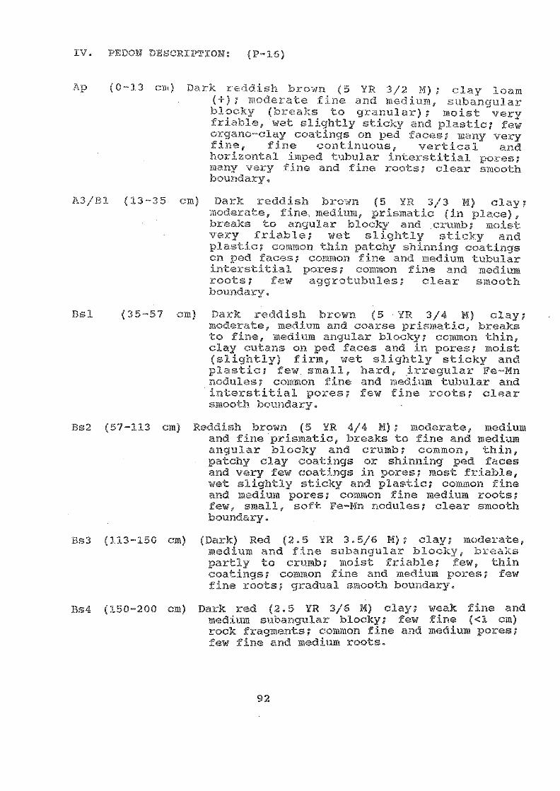
IV. ION DI (P-16)
(0-13 cm) F.$)rk 7, wn (5 VR 3/2.14.); cy loam(+); mocic,:rate Cine ,u3DE:null)ar7locy (3)r1zs to yranular); moist varyfki.,)bje, sticLy and plastic; £e.-.ic-L.3no-o1ay coatings Qn ped frkees; mally veryfine, fine contionous, vertical andboriol)tal ;m1,-,ed irnterstitial pores;)clny a,nd fine roes; clear ;,moothboury.
A3/B1 (13-35 cm) )aJ:k r.:00is71 7-):;-t,:wn (5 Y!-: 3/3 M) clay;One )edirm, prim...1Lic (in ï1' ce)brks to n(31.1)ar blc.wky ;-,nd 01,1,q)b; moist
i-)AF)ble; wet sliqhtly stic7ky andplatic; ,2colon tbin patchy shinnjng (.0atingson oed fr-cc-s; Gommon Tine %Ind medium ;_ubuldr
T.):es; ,20mmon ',11d mediumroots; few agroWxules; clear rmooth
(35-57 cm) rlark redrlish brown (5 Yr. 3/4 M) clay;mp(lor;%tte, ceciiim and coarse irismatic, 1,-,reaksto Eine, med1rm E.ngular blocky; ccmmon thin,clay .utans on ped faces and in pores; moistOliOtly) flrm, wet slightly sticky andplastic; few &mall, 3.:ard, irregular Fe-Mnnodules; ceAmon fine and ,e.Ciflm tublilar andinterstitial pores; -:!ew fine roots; clear
ooth 1)oundary.
(57-113 cm) R(5dish brown (5 YR 1/4 M); moder,'Ite, mediumand fine prIsmatic, breaks to fine and mediumangular blocky and crumb; common, bin,ptchv clay coatings or shinning ped facesa-ld vary few coatings in pores; most friable,wket =;lightly sticky and plastic; common fineand medium 1.)ores; common fire medium roots;few, small, .5.0ft Fe-Mn -JK)dules; clear smoothbAindary.
Bs3 (113-150 cm) (Dzrk) Red (2.5 YR 3.5/6 M); clay; moderate,medium and fine sflb,anclular bloLay,p,Irtly to ;rumb; moist friable; few, thincoatincjs; common fine and medium pores; fewfine _:oots; gradual smooth boundary.
(:ZO .200 cm) Dark red (2.5 YR 3/6 M) clay; weak fine andm.edium subangular blocky; few fine (<1 cm)rock Eragments; common fine and medium pores;fw fine and medium roots.
92

1.
"USDA
- Hi h es ifiBrown Yellow Ferralitic Soils on cid alluvium
Haplic Acrisols
Typic Kandiustults
2. Author(s): j. Shgal (a47!4.7o)u2aYlied by Prof,Chieu and Sub-?4)A1?.?
TAN PHC lage; THU Iistrict; Ho-Chi-Minhcity
4. n: 50 m MSL
5. Lana-torm:
k7T4Q0c H,iil-0)13 Terrace (upp,rF17:011/iel:)1y1g .,744-m 3 ?Jmost flat
6. Slope on which pedon is sited: Slightly s oping (2-4%)
7. Land-use: Local g a ses
8. Clima e:
Annual rainfall (AR)
1943 mm
II. GENERAL INFORMATION ON THE SOIL:
Parent material: (Old) Alluvium
Drainage: Somewhat exec- ely drain
Moisture conditions in pedon: Moist
Depth of ground-water table: N(
Evidence of erosion: (Slight to) moderate, with truncaltedsurface
III. V: Y:EF DV,SCRTWTOE QV P:OIDOM: Very deep, sandy-like soilon gently sloping land developed t:(nder well drained andtropical climatic condiLions. The soils have a dep Bthorizon below an ochric epipedon. The C horizon is observedonly below 150 en.
93
27.2°C
MST
27.6°C
OV.
MWT
26.4°C

IV. PED : (P-17)
Al (0 a reOr;ish 1-,Fc,wn to roOdir,11 ynilow (75 YR6/5 ly cose ;,,od; m(F:sive (in ple.ce)br(-aks Comintly to ngle bli-!achodr- Andy hoxiL,on; porous; many fine nnd mocliumloots; clear , ,,mooth hnui)(3ary,
Btl (12-28 cm) e..Uowjh a_Pd (5 YR 5/7 M) coarse ;:;ondy loz-m;)w,CeLc,..te fine znd medium subankjular 3400ky;poist sliqhtly fiim; (o)omon thin clay._oatinr3s nn pce nd on skeleial yLains;few k,h,licoal ;?ices; 41 6mon, fine and Ra13UM
xiy kr(_cy fine, fino :11k1 medium yoots;pooLh Ll14,71ary.
(28-68 Yraloish ec1 (5 5/6 ii); (7.5 YR 7/6 D)coar:-e :7andy lcwm (finor than above);iode.rate, fine ama medium, sub'klookv; moist fiz'Ible, e.om.aon thin patchyCarriargillF,ns on L;keletal grains and pedfaces; manv fine Lqedium poros; many w,ry fineand fine J:oots; few o halcoal pir-ces; qradualmooth boundary.
Bt3 (68-96 cm) Yellowish red (5 YR 5/6 M); coarse s;andyloam(eoarser than above) ieak, fine andmedium subangular blocky; nois fr.iable; fewclay coatings as above; many fine and mediumpores; few to common very fine roo-.s; fewcharcoal piecLts; clear :,:mooth boundary.
B3 150 cm) Reddish yellow (5 YR 6/8 M); coarse sandyloam; weak, fine and medium, subangularblocky, partly breaks to crumb; moist veryfriable; many fine and medium tubular andinterstitial pores; few very flna roots;clear smooth boundary.
' 50-208 cm) Reddish yellow (7.5 IR 6/8 A); lealay coarsesand; massive, breaks to weak, finesubangular blocky and single gcains; moistvary Triable; many, fine and medium pores;few very fine roots; rara fine (1-2 PM) round
uodules (perhaps ,qeposited withalluvium
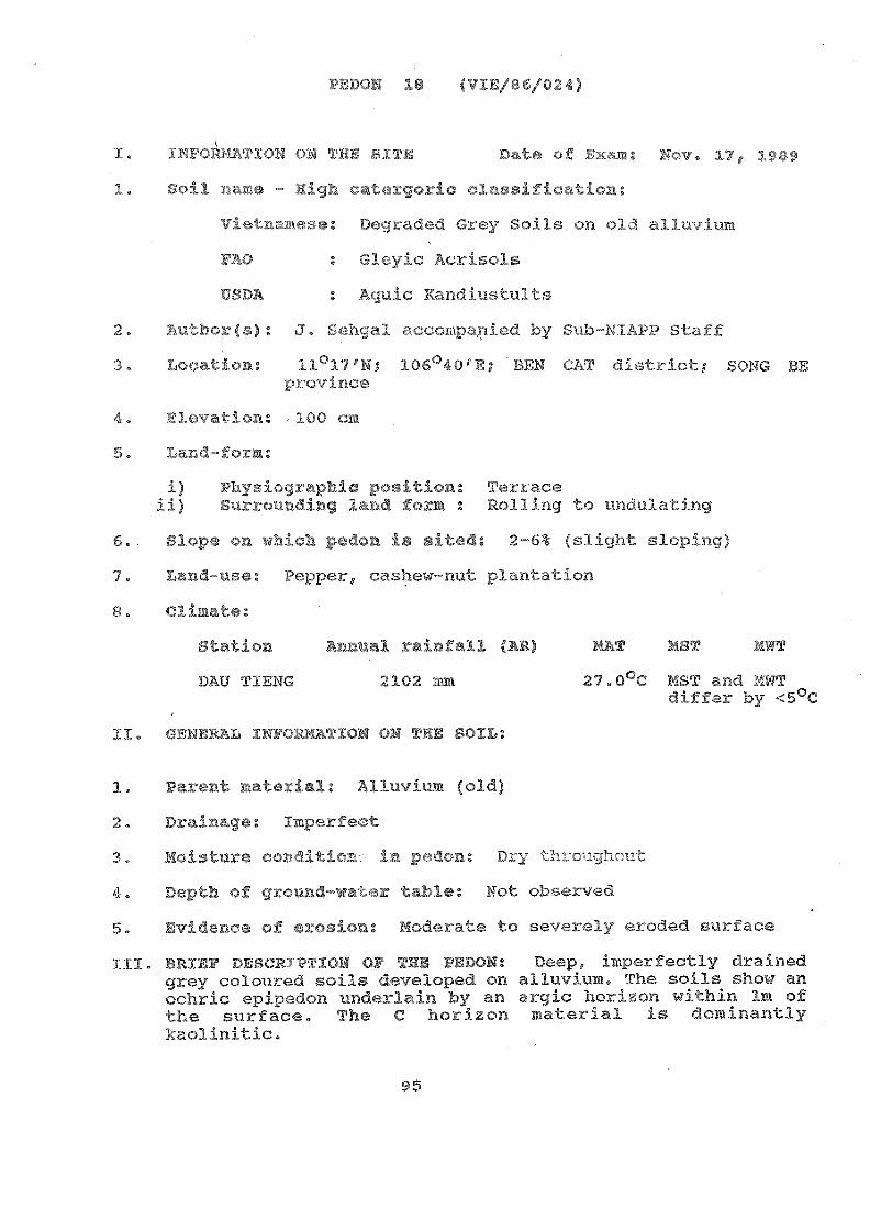
PEDON 18 (VIE/86/024)
Nov. 171
.gh cat gor
r)coded ui.ey oid alluvium
FAO s
USDA : Aquic Kaprqustults
): J. Sehgal accoinied 3taff
11°17'N; 106 40'E; - CAT district;province
,100 cm
95
Te.).J:ace
r. ovo(37i.g 7r.Ak2 aolling lating
6.. S ope on which p'onir ited: 2-6% (F71 slopi
Land-use: Peppe, casw-nut plantat:
3tation rain all (AR) T MST
DAU 9:(A 2102 27.0°C MST and 149T:r by C
II. ENERAL IN 0 TION ON ThE SOIL:
Parent n .erial: Alluvium (old)
Drainage: Imperfect
Moisture condi
Depth of ground-wa r table Not obser c
Evidence of erosion: Moderate t L.y ercc6
III. 13RVBF ».0e1tW;,'TY(711 Cr TAU, PEDON: Doep, jr,parfectly drainedgrey coloured soils developed on alluvium. The soils show anochric epipedon undexlain by an argic ho.A.Fon within lm of'che surface. The C ho-4'iLon material is dominantly
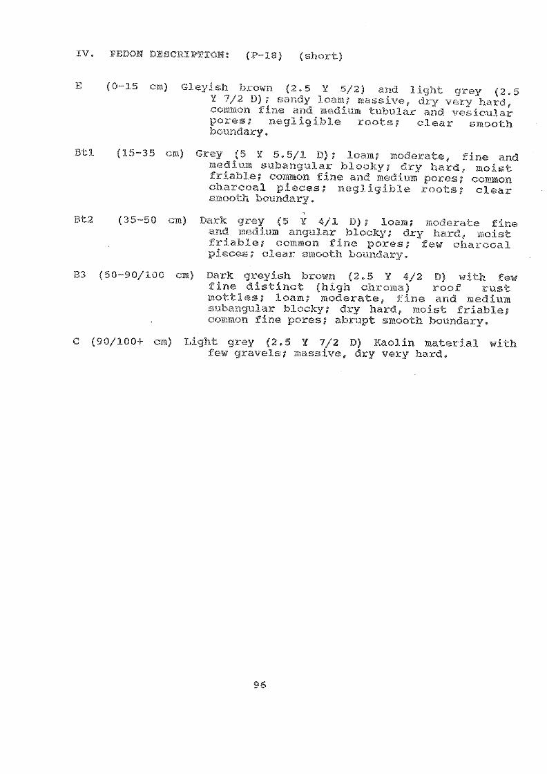
B3 5C
Bt2 (35-50
TioN: (P-18) (short
E GJeysh 1,.:own 2.5 Y 5/2) (JA7vy (2.5'1/2 D); r4oY)cly 3()t1; :it. lssiNrc,, 61:y vc,ry
tubojar flc:1
):(70ts;
(15-35 cm) Grey Y 5.5/1 L)) 1oF-)m; :1,,x1oEate, TiDeit1 ':1r3:,1ocky; 41-ry bard, ioist
:.7viab1e; '..)amon fine i-,nd Wetfai.PM pc-wr!s;ploces; ' )(--c_iligibJ.e roots; citar
!trooth borindry.
Dark JA:GT (5 Y D); A.o'm; mo,7o-r:te fine1mma-IguJar 'olocky rlry hard, it(oistco-mmon fine poces; fci cbacoal
pirc(s; cJe.,Jr iiooih1)011110,tr.
)0 cm) D,='irk ,Jrovish b.1,-(,wn (2.5 Y /2 D)(hioh chn,ma) roof rustpotties; loam; moerater z.nd mcrlium
;-101-.,aDou1ar blockv; cfty hard, moist friable;;viomon fine l'ores; alplupt bonpriary.
C (90/100 fJiyhî: grey (2.5 Y 7/2 D) KaoJin )Iaterial withfew c_savels; massive dry -q%,..,1:y hard.
IV. PEDOB
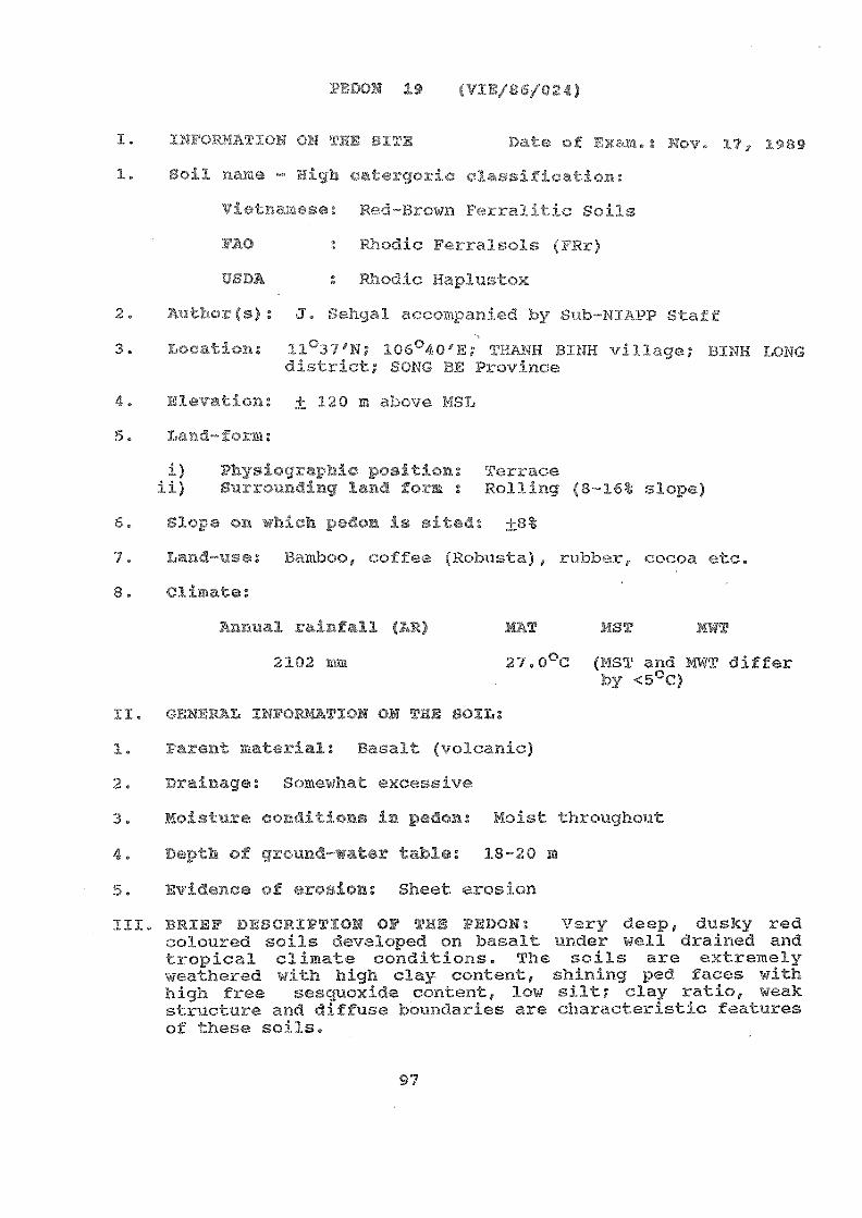
n: "A,1(3.37qIF 106°40fE7 TY3ANH RMH 311.
sorG )11 ?Kov!Lnc!e
19
USDA Rhodic aplu tox
120 ove MSL
i) .P71117;,T;.,Afrl 11raceii)LT Y. fo):111 : Polling (8-16
Sloea on which p don i
Land-use: Bamboo, coffee, obusta), rubber, cocoa etc.
Annual rainfall (AR)
2102
II.PiL INFORMATION ON THE SOIL:
ent material: Basalt (1'I. :.-nic)
Drainage: I lewhat excessivP
Moisture conditions in pedon: Mc - ughout
Depth of ground-water table: 18-20 m
Evidence o --osion: Sh rosion
III. BRIEF DESCRIPTION OF THE 1.0DON: Very deep, dusky redcoloured soils ,3eveloped on basalt under well drained andtropical climate .:onditions. The soils are extremelyweathered with high clay content, shining ped faces withhigh free sescAnoxide content, low silt clay ratio, weakstructura and diffuse boundaries are characteristic featuresof these sois,
97
MST MWT
27.0°C (AST and MWT differby <5oc)
, 17, 1989
,ied by Sub-NIAPPr(s): J. Sehga-

IV. TION: (P-19)
Al (0-30 cm)
13s1 (30
(78
h) c.,)....rt (2.5 :3/3r;3r (f,O. ;
13.3;
'; 4 /, 4:4 / 47:/: t /4/' :7 . 747.7 At,t4 'ta? ;7):; 2::
o , 1/.../, " (101i " Yt(*Li
/',`+ nt .1 "*1:,a :..yr (71' ;31
(1 h :;`c.; :,;t 5 'Y 2,/ ; ::c!; ;-J 7 1.0 p
,,, 1L' UI': ; *J., 1.!: H rg,]?. ,7.7) 7 CO t 110.;
.;.z; n
;-;Jty cw3. 0: 3 C; *;;:t) 7k.
;At? 7 41, 44 t "1/ 27'4(.1
wrk , , 1,7 (';( `,;°
I .....
( 7L7ti / CZ' 7 ;,CY;./, .-, .1(7. 111 í .); E
111'4! )1 )2 ;
(165-220 cm) 7r.7:.-4-y (10..r3: :37,1 ; J3.7r;(: ;'4.7. .2,2. '77
(7, r .1 T r S :17 tr:;
Be , y f; .1.0 3 :IfJie

I.
1 .
8.
e
te:
rinnuz- fall (AR
2102
20 (VI 024)
y 1-r.,,c.,,-0.1(.?_(
fric Plinthosol
DA thic
2. iVif, ,$): J. 5:(:,,b1 a(»..o .(d by Of Chieu,andSoj.1 Sm.vey :'-7;Laff of :7,u17,-NK1,PP
3. 11 °06'N; 106037/E, BEN CAT area
4. E 100 m above MSL
5. m:
: 1',.j:-1;- [,, :.4,,A: Uvper t(-rrafteC-,117:.14(10 7 :,0 To\m : UD(1PlaLilig (2-6%)
6. Slope on which pedon is sited:
7. Land-use: Barr,.n abohdoned); brick ?7i1n is opratingliRrIT. 'he su\rounding area sows ,7,ashewnut/13)1i.ati.on.
99
L;ion:
ith Lateritic concretion
MST
27.0c (MST hd UWT differ)y <5°C)
Nov. 17:
II. GENERAL INFORMATION ON THE SOIL:
Parent material: Alluvium (
Drainage: Moderately well tc erfect
Moisture (7,!;:17- il-i.:%!:s in pedon: ury su-lfr(m, moist below 50 cmdepth
Depth of ground-water table: Not observed
Evidence of erosion: Moderate to strong; g rills andgullies.

' oz)13k' Tv)7, motled 1rtat,,y7ial -pljnthite (irwl aikd Kaolin Kich).-sogttjny o:4j(lation/¡Q°04:.c:tso to lot A 1-iorizon
r_h1e i
IV. PEDON CRIPTION: P 20)
(0-15 cm) White to livhi; (.4,:ey (5 Y 7.5/1 D) 110)1tledwith yellowish 4ed (5 YR 5/8 D) in J;2 :catioplintbite m-6k-rial; tlindy c] ay lor,m;o,a6ipla angular blonky; t:iry , xt-kr-wely hard,u,!t sliyhtly icky and platic; no :,00ts;.21r i.foes; grdual wavyLwproviz.iry.
Bs2 (15-50 White to light J'yey (5 Y 7 5/1 0) ottledvith 1,e3lowish red (5 YR 5/8 D) oateyial in12 Y.atio (plin%hite) ,1,,andy c] ay loam;
(nyvAar blocky; dry ,axtvemelyhard, uet sliJjhtly sticky; 9radua1 :L;T000LhbuT)dary.
Bs3 (50-90 cm) grey (5 Y 7/1 M) mottled with yellowishred (5 YR 4/6 M) in 12 ratio; &andy clay;srong 7 ine and medium angulaAr blocky; moistvery i:cm, dry extremely hard; gradual smoothbos3ndary
Bs4 (90+ As abcve; hut ratio of light gr,ay (5 Y 7/1 M)yellowish red (5 YR 4 5 M) matria/
chanes to 1:3,
100

7. o )':=. ' t C' ) C" ,4 s - i."V C.:r 1-errly ng 13 n 'ï1" 5 1 xn iee i .0 (1
; f'07);) 1z3 g. 7) ; ;tva i i-71-)3 e .)..no-.,--r); I l)t. 3.0,71 1
f}k4,1 ;°,1Fi1yt: i in 1-3»g3.3 shprei.1 .7,1)nr.!):.,1) Fromcvicwof 1-hose t taJ: -1.,A on 91ven
n. 7,-to,x. 4 is 0-3_ sc: ,-.:,ssify;.4.03, 3 s wJ h c. (-7 e Ls v(?-...:e -wade '0.10 rise
soi s 311 the Q SA' z.tk..-011 of F,oilclassì.:F. ion vo.i ex 4-)

ins 20, to
s i cat data of pedon 450 (Source B1APP)
Ift - CI,:_0:JR VOIL .;',-)IL CC!I I.s-,-17',!Cii c041-1 t4 GS C'.7'n 1-. v:ES ir COTS Pr.^.1t!- r rE V \ USH: Eri' . ON ! ' Y.:: F.LitTLES ::r:U IFY,T i,,01:31' trZi CUMIS CRE DARY
C1'll:E' VIE
e-
:fl:)FtLF: o
Uow Ferralitic :-:AT1ON
Acri.
A 0-15 7.5 YR 6/4
'Pr v
SOU Province
many gradual
NIAPP(No
4
'
102
Fs Btl 15-37 7.5 YR 4/8 manyrato Loua f nm
EglaU
lar
Bt2 37-93 7.5 YR 6/8
This iE ely firm horizon (with
......... ------
Map Horizon :y : pH (1:5) anic Soil Particle Size =i: CEC Drbm-igecblo (useUnit (cm) -------------- (ds/m) matter -------------------- m.-:/1000 va/100g c.aLions Satur
Water KCl X sond Silt Clay (soW (clay) C711/k0 tion
> 0.05 0.05- 40.002 ................. %
0.002 Ca Ng Na
r-7FAF: 450 o LOCK( C' !
CI,31FICATI0N: Vietnamese - Red-Yellow FerraL.t4..-
A 0-15 4.5 3.2 35.4 2',.0 0.0 7.4 1.2 1.2 32
Fs BO 15-37 5.0 2.1 26.2 25.0 48.0 6.0 1.6 0.4 33
Bt2 37-93 5.5 0.6 22.8 26.0 50.9 4.0 0.8 0.7 38
Remarks: 5102 / Al20 . 1.79
S102 / N203 1.43
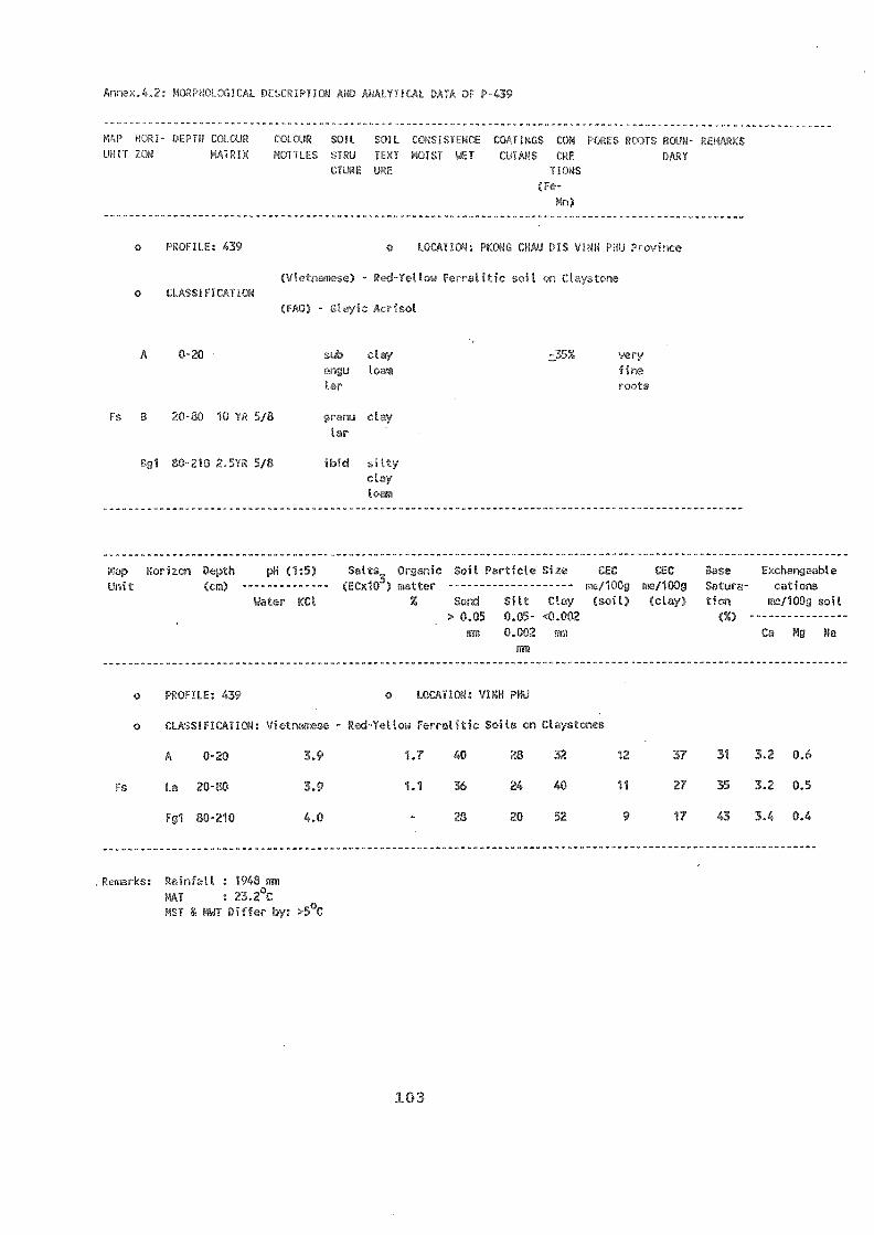
DESCR CAL DATA OF P-439
MAP Hofl.I- DEPTH C,11 0'A cOLCJR ;)IL t!IIL tIE COIIRGS CON PO:L !f DoJN- RER1
UNIT "fuN MLWILS !;RLI 1L;;I uIS ET COIANS (RE DAkY
CIUE ME(Fe-
Mn)
PROFILE: 439 o f.00ATION: PKONP, Fs!.( VINH PU rrroc
3e) - Red-1:-% FiTralitic sklo F!rTIOIN
A 0-20 sub clay z35% veri
rv.ju Lfi.3IQ'S
Fs YR 5/8
13g1 80-210 2.51R 5/8 ibid ciltyeLy
Map Horizu-1Unit
pH (1:5) Salts_ 0r2mic H-;1. Particle Size CEC CPC roce
-------------- (FCfle) iKtter -.------------------ Fe/100g no2/100g Stturo- tic s
Water KCl Z Silt Clay (soil) (clay) tion -10r7 soil
. 0.05 0.05- <0.002mm 0.002 mm Ca Mg Na
Din
PROFILE: 439 T ON: VINH PHU
CJJ,SOIFIc:V .LicwFerralitic Soils on Claystones
A 0-20 1.7 28 32 12 37 31 3.2 0.6
Fs La 20-80 3.9 1.1 24 40 11 27 35 3.2 0.5
F91 80-210 4.0 20 52 9 17 43 3.4 0.4
,rci.1.1fts: Rainfall : 143 mm
MAT : 23.2°C
MST & INT Differ by: >5°C
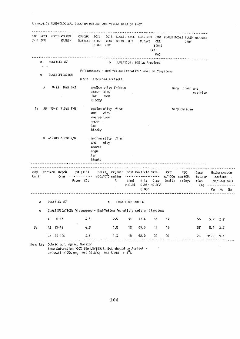
Fa AB 13-41 7.5YR 7/8
ANALYTIcAL DATA OF P-67
iaclay
c-arGc
Elrterky
B 41-100 "i',5'NZ T18 zica silty firmclay
corseangu-larblocky
------- ----------------- ------------------------------------------------------------------------------
Map Horizon Depth pH (1:5) salts_ Oryanic So il PrJ-I-.icici Size CEC fEC Base Exchpnt7eJbleUnit (cm) ------ -------- (ECx1e) matter -------------------- ma/Mg /iCOc Satura- cZiox,
Water KCl X Sand Silt Clay (soil) ,:,.7Jay) ticn me/100g soil> 0.05 0.05- <0.002
0.002 Ca Mg Na
o PROFILE: 67 o LOCATION: SON-LA
o CLASSIFICATION: Vi- lese - Red-Yetlow Ferralitic soil on Claystone
A 0-13 ,.5 2.5 11 73.4 16 17 56 5.7 3.7
Fs V HT1 4.3 1.8 12 69.0 19 16 57 5.9 3.7
Et 41-1CC 4.4 1.3 18 58.0 24 24 70 11.0 5.5----- --------- ----- -------
Ochric ep. HorizonBase Saturation >50% (So LIIVISOLS, Cut should b2 Acrisol -Rainfall :1456 mm, NAT 20.80C; NST a NWT ;. 5°C
,MAP HoRl- DITI 0 COIOUR 1.JmCUR :OIL OIL CT0)UNIT ZON LAIfts S'ICU TTNT
CWHE URE
(re-rn)
o PROFILE: 67 n7' P
o
(F :risols
A 0-7 silty fC clerxclay
tar t,-qin

";AP i.qt;!! i-uL(JR Ceq(YJR $":)11 :,01L Cu'!-I:i1ErcE C,0111ii;S )RES WON.IJHI1,P)P1XI.íï LS '.= 1n:T nrAu 1:T COMS DARY
Cl0E.
(7c-
Vn)
o PROFILE: 142
'!rcATloN
Ap 0-18 5YR 3/2
Fv 81 18-44 5YR 3/4
oti clay
q.ALYT1CAL DATA OF P-142
LOCtT!P"7 TRUNG - CAO BANG Province
soil o
15 -
2a%
Ca Mg Na
Mollic epi.
Case Saturation
Clrissificarim: Luvie;
39 14.5 86 8.6 4.0
51 9.1 92 6.1 2.3
46 10.8 87 5.1 4.4
51 10.2 78 4.7 3.3
82 44-80 5YR 4/4 rnu cicy 15%
Ir loPm
C 80-120 clay 15%
...._____ ______ ................................................................... .................._-_-___________ _____ .......i'(1:5) Soltv. . :.,,.)il r.,...--t.. . cr,.( CEC
-------------- (ECx103) r -------------------- .:V'irg , qz/100g
r.C1 X nd Sitt Clay (cloy) i 7,1i0. IL
0.05 0.05- -0.002 ----------------
nm 0.002 mm
mm
PROFIVE: 142
(7T1014:
AH0-18 6.5
Fv 81 18-44 6.3 6.0 2.0
hs1 Ferralitic Soil
7.2 12 49
T CAO-BANG
1.8 24 30
17 31
82 44-80 6.9 6.6
C 80-120 6.9 6.6
OP

M. I'
.1!
: TH1:1 V! r, ovince
ey seit old :CLASSITIO:!
.t - Aliso A..visol)
A2 0-15 101 8/1 si t ' -toy loose
grt
By AB 15-25 5 Y 7/6 oc,rle iLty vc,ry i'eu clear
nju '(uy firm fina
ar t roots
Bg 25-49 7.51R 5/6
Bg 49-70 '% 51.".
Bg 70-100 10YR 6/2
COAT'rGS ON r po:m-
s;VU tIXT 3 T I Lr CPC.NS (IZE Fcin'L t!!U:
(Fe-
Mn)
leP::TuJi clay firm
pris-mAic
firm
firm
mal
Map Noriz,:,:) :pal pii (1:5) SiAts Otganic Soil Particle Size
Unit -------------- (EC103) matter --------------------Water KCl % Sand Silt Clay
> 0.05 0.05- <0.002 (%)
0.002 Ca Mg Na
1,si
PROFILE: 1 o LO
CLASSIFICATION: - Degrae aley-Grc
A 0-15 4... ,.40
Bg AB 15-25 4.5 0.45
25 49 4.0 0.45
t.9-70 4.0 0.45
70-100 4.0 0.45
ir . Gleyic prop-Ji-jes; Agric -
on: <50%; yic ALIECL
diff-use
diff-
use
BAC
on Old Alluvial
28 58 13 5.1 39 47 1.2 1.2
34 54 12 5.7 47 49 1.6 0.6
50 15 5.3 35 61 2.1 3.0
' 40 33 11.7 35 51 2.5 3.9
',.,
CEC
45
>2
38 14.9 38 47 4.5 5.0
--------
CEO CEC Dace C,sciv,tnjeable
itt:/1000 m2/100g S,..lora- cations(soil) (clay) tion m7.1/100g soil
n ",1= "TTfl 7.ITA oF P-1
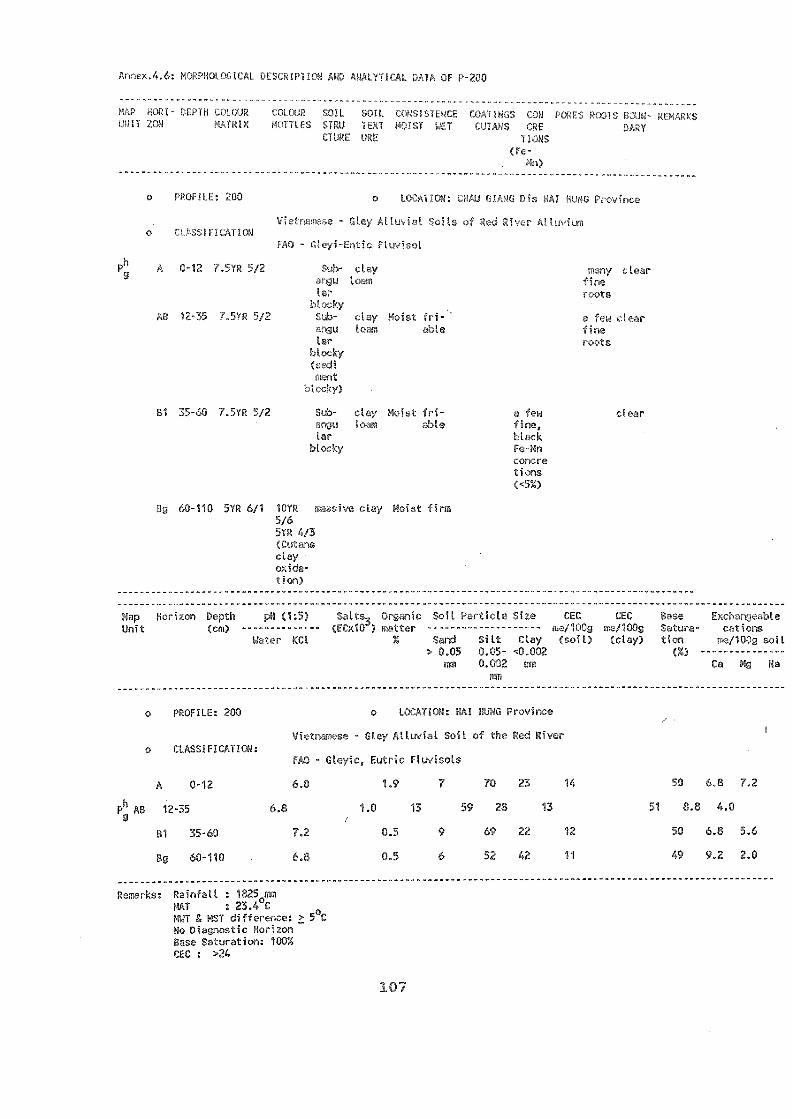
U[iit
fIE s,D)L SOIL iPLE I"I UI,,S I,71:1 , 1'1 I S Iv.VII ¡U TL-4 r PT I JIS CEE
liONS
Bg 60-110 5YR 611 10YR
176r.-Ar. 4,3
^ ___^ ^ S._
7zon Dopth
PRPFTIF: PO
o
A 0-12
Ph AB 12-35
B1 35-60
Bg 60-110
7.5YR 5/2
o
VI. _ -
FAO -
Remarks: Rainfall : 1825 110HAT : 23.4°C
NT E HST differc-rice: 5oC
No Di<inostic HorizonBasc Sluration: 10=CEC : >24
blocky
ri-
y Moist firm
107
P-200
kw
WckMn
con.Ao'jogs
PH ThtZs, Oct,,...nie Soil rPLicl:: qi%e(cm) -------------- (Unle)
Ctay0.05 n.os- -10.002
0.002 1.:11
clear
CEC Ev.cloj, 614e
tica cVinOg soil
Ca Mg Na
LOrATTON: RAI RUNG Prnvince
ey -oil of vr
FAO - Gleyic, Eutric visols
6.0
6.8
7.2
6.8
1.0i
1.9
0.5
0.5
13
7
9
6
59
70
28
69
52
23
22
42
13
14
12
11
51
50
8.8
50
49
.....
6.8
4.0
6.8
9.2
7.2
5.6
2.0
Ph A 0-12 7.5YR 5/2 :tearr, finatar k,Ott.;
14.,kyAr 2 y Moist fr
ab et
tJiA_ot
r
o rATION

Annex.4.7; r,Hn!OGICAL . !!I'T!r"! AND ANALYTICAr 'Y: OF P-264
Salic Horizon
Fluvatile
^nit,
(Fe-
Vn)
PROFILE: 264 o LOCATION: HAI PHONG CITY
Oap Horizon Depth 0F;alts Orgonic Soil Particle Size CEC CEC %se .x:: riJi)le
Unit tECx103) notter -------------------- 10Q/100g or:1100g F:atLira- cations
Water CI, Z San: Mt Clay (soil) (clay) tion 4...1100g ,-.;oil> 0.0.5 0.05- .10002 (X) ---------- ----- -
0.002 n:a Ca Mg Na
pui
PROFILE: 264 T : AN HAI - HAI PHONG
'IsCLASSIFICATION:
Al
B1
132
0-35
35-70
70-100
7
7
7
6.6
6.6
7.0
Ftuvic SolcichAs.
CL
0.6 0.
0.6 0.2
0.2 0.1 -
of Salt % of 0.6
8 47
6 43
3 40
44
50
57
11
14
10
4.2
4.5
4.1
4.0
4.0
4.0
Al 0-35 7.5YR 5/3 Silty
clay
No Vcry urn-
fin:: dual
B1 35-70 2.5YR 614 ;lay No Frw era-
Cunt
B2 70-100 2.5YR 6/4 ;lay No No --
SoIL [(WS P.17r!NCLJIS'O-XT ;.TE DARYURE 1,FONS

o ^ 1- ~ n.^. ---e--e-
MAP Er,n- DI LI (010j11 co:.noRUNIT 7U
o ruF7LF: 75
O
A 0-20 1C. VN 7,5/1 7.5YF
5/6
20-90 10YR 8/4
C 90-120 10YR 8/4
Map Horizon Depth pil (1:5)F.ntts Orgic Soil Particle Size (EC CEC Base -.1 )le
Unit Colour (cm) -- 0 Cx/03) waiter -------------------- m2/00c me/100g Satura- cc:t;ons'7,:l X Smd Silt C.ay ¡soil) (clay) ton me/1009 soil
0.05 0.05- <0,002 (%) ---------- ------
rm 0.002 Ca Mg Na
FM
o PROFILE: 75 LOCATION: CIE 1 !GE AN
ldy Marine Soilso
Fu IA
A10YR 5/1 0-20
C C10YR 8/4 20-90
C10YR 8/4 90-120
7.2
7.0
7.0
:11 cIL1[-!;i1:Prr. UIP,I,US CON nn oCIN rArKS!!liT CYTI,MS CE [WIRY
URE TJONS
(Fe-
Mn)
O LOCATION: NGHE TINH Province
No very clear
30%
Mn
40%
Mn
1.7
1.1
Rainfall : 2033 mm
23.8°C
MST a rAJT differoce:
Ochric Epipadon; A-C Profile; Cnsa Saturated; Sandy
109
..L.SCRIPTION OF P-75
12 5 7
11 9 7
81 13 6 9
6.3 1.1
,P( 6.8 1.1
7.9 1.9

PROFILE: 65
CLASSIFICATION
7*.ap
init
. No Bt. L Tendable data
O TRI THIEV-7. Provi--7
fl So
OF P-65
- ['WM frO.,..112 zulL tCWSI:,.10cE C,"0,11NGS it01L Coi:z P7A1-IT 1:iTRIX ITLES :'IRO MIST !,!..f VUVAS LRE nARY
..111E URE ItODS(Fe-
Mn)
AB 0-14 7.5YR 6/4 moist No y rt)th
..n0U to gra-
tor ifots (-IRA
U'u
Fq 8 14-55 7.5YR 7/6 A!- :-..y vary finm No a few s
qnu Ir.:m roist
. lar
BC 55-70 7.5YR 7/8 firm No No clear
>70 Weathering Rock
-------------
Depth pH (1:5)Sotts Org:nic SC! ,-.7.e Size CEC CEC P,fse Exchanjeable
(EC;;103) wotter ----------- rilV10(k n/100g Sawa- cations
Water KCI 7, Sand Silt Cloy (sol) (clay) lion 11.2/100g soil
> 0.05 0.05-.0.002 (%)
mn 0.002 mm Ca Mg Na
PROFILE: 65
- Light Yellowrrolitic
CLASSIFICATION:FAO-
scio-
AB 0-14 4.5 1.6 15 12.0 7.0 0.8 0.8
Fq B1 14-55 4.3 1.0 20 3.0 8.0 0.8 1.8
Bc 55-70 4.5 1.2 9 6.0 8.0 1.2 1.4
D >70 - - - -

.10
,AP DLHN (IT,wA t(LGAUNIT -4171:1 IV:MX hívrOFTS
Fa
493 o LOCA.'': CIA LA
namese - Red-Yell feiTJAtico r T
FAO - (Humic) Acrisols.
3.9 3.9 53 14 33 10.6 32 19 1.5 0.5
4.1 2.8 49 6 45 8.0 18 20 1.3 0.3
4.1 1.7 47 2 51 6.1 12 15 0.7 0.2
4.3 0.9 49 4 47 4.6 10 21 0.3 0.7
Remarks: Agric. Horizon; Be-,- ' --tion : <2; CEC: <24
111
CRE U.RYOUS
(ro-
Map Horizon Dopth pH (1:5) Orcanic Soil Partii.,1 size cEC CEC
Unit (fCxie) wtter ------- ------- 111.2./i00c, m2/100gClal' (soil)! (clay)
0.002r,fa
Exchblec.ationE,.
me/100g soil
Ca Mg Ca
A 0-10 4.6
B1 10-30 4.9
132 30-70 5.4
133 70-150 5.6
o 'nFTLE: 493 o L yince
se - Red - Yellow ! Rockso
FAO - Burnie
A 0-10 7.5YR 6/1 kery friable Ewa -
WetanguLar
Fa B1 10-30 7.5YR 6/2 same
B2 30-70 7.5YR 6/6 fine elay firm a few ura-inr,u tozm d%!al
iar
B3 70-150 7.5YR 6/6 angu 'TirmLar................... ------ ............................................................. -----
------

Fk
MAP R(1- DEPTH w!.1. JR fXlieURUJJI) 'OA Lc4R1X iru 1H3f km31 1JCaT
URE
Fk 1.Hr0 2.5YR 4/6 clay
cruAb
(FAO)
A 0-20 2.5YR 3/2
B1
c!ay
r
Will/i cl c!ar
fine
112
B2 61 6.0 21 0.8 0.5-----
Rainfell:.1770 mm; NST JATF differen3e <5°C
Mallic Epip323n; Agric. 23so FaZuration: <50; CEC <24
o c
,ralitic soils
4.8 38 16
2.9 28 12
17 27 12
1.5 25 13
CIASSIFICATION:r -
0-20 5.0 4.9
20-50 4.8 4.2
50-70 4.8 4.3
70-110 4.8 4.4
.4.11: ANALYTICAL r L P-39
o 39 LOCATIC f
- Red Ferrali.: :- 3333o
B1 50-70 2.5YR 4/6 fri- mJny ,±iff-
crunb able fin3 roots use
smooth
B2 70-110 2.5YR 4/6 eiva Elist v3ry
climb
Map P3pth (1:5) Salts_ Orcuoic Soil Particle Size CEC CEC Pose FNchLnceableUnit (cm) - (COO') matter m2/100g Fatura- ciJtions
% 3Cl Z Sand Silt Clay (oil) (clay) tion ma/1000 soil
> 9.05 0.05- <0.002 (%)
IWO ,00.c. mm Ca Mg Na
39 O T DAKLAK
45 17.5
59 10.0
60 6.9
18 1.8 1.2
17 1.0 0.6
19 0.8 0.4

Ii 6
CLAL.::"."
Al 0-25 5Y 4/2
S 25-40 5Y 4/2
Bg 40-60 2.5YR 6/2 clay
C 60-80 2.5Y 8/3 clay
Map Horizor pa (1:5) Ail Particle Size ; :1J; CEC . . Exchonjeable
Unit (crd; ma/100g Sz-tnra- cations:Cl , . and Silt Clay (,-oil, (clay) ticn h,:,./100g soil
:, 0.05 0.05- <0.002mm 0.002 mm Ca Mg Na
!TM
N>ist
claylow
: 6 o LOCATION: I f
Vietnamese - Acid Sulp ilsr'
FAO - Thionic Gleysols
Al 0-25 3.2 2.9 0.66 2.1 2.2 213 70 17.9
S Ag 25-40 3.2 3.0 0.58 2.7 3.1 30 66 15.7
Bg 40-60 3.1 2.9 0.85 2.6 2.2 28 69 19.3
C 60-80 3.2 3.0 0.92 3.4 2.7 25 72 20.6
------- ------- ------ ------- ----- -------Rainfall : 1548 mm
29.0°CNST riir difference:oC
1.6 3.0 0.4
1.6 3.0 0.3
3.0 3.0 0.4
1.4 4.0 0.4
Annex.4.12.. DFscRIPTION ANN TiON OF P-6
^ 'Mt _ _ ^ .NoRI-.^7iL *ulL ïI t. (.0N POT:. NNTS prur- -ON fOFU 1EXT CRE
lItI;EURCE rluNS(Fe-
Mn)

YI.E: 102
P-102
)lLs011. 011:1f;,f1-1/GF. t,04111,GS MN fq,:ls Or.1s Pc'Im-I:01ST 1E7 CUI,NS LitE
URE 1I011S
LO'h Pin '
Grc:o
A 74 -in*p v.aylIuiri nUe
st
114
sithgra-
e72at
------- ------- ...... --------I Rainfall : 226 run
MAT 26 CMST 8, &í i,rence: <5°CTexture : :lay contentOchric EpipadonBt possibleBasa Saturation: -:20
CEC 20
A
X Bt
Bt1
Bt2
0-20
20-45
45-80
801110
_ - Grey Soi s on ..71.!,.,
F^U - numic Acrisol
3.4 3.4 64
3.9 1.3 65
4.1 65
4.1 65
2
4
2
1
34
31
33
34
-7.0 21
-20
0.5 1.0
0.6 1.0
0.5 1.0
0.7 0.7
X 131t 20-45 /0YR 5/3 fe0 gra-ne dual
Zion(5-le%)
B2t 45-80 10YR 5/3 10YR 5/6 loarrFine xkrib
133t 80-110 10YR 5/3 fine fineCrUC) con-
cre-tion(50-
70%)
Hap Horizon Dopth pH (1:5) Salts3 Organic Soil Particle Size r1:-.0 CEC Base ExchanjoabloUnit (cm) -------------- (ECOO ) mAlter -------------------- ma/1)0!: ma/100g Satura- cctions
Water KM % Sand Silt Clay (:.oil) (clay) Lion me/1000 soil> 0.05 0.05- TO.002
I'M 0.002 mm Ca Mg Na,3n
o 102 o LOCkfiC:!: :
Annex.4.13:
MAP
UNIT :?,01.1

Annex.4.14: LLIGICP
rtAr V(0 1 - o7 (Alf:
HPlf
B2 70-110 7.5YR 6/1
7 I 7
SOIL 07::IF,1r4E COUIPC,S
)EXf 1;01ST t.'LT COTÌUS (RE
C.7t1,7E HET ItO0S
(Fe-
Mn)
A 0-40 7.5YR 6/2 1,eikra ctny
clay firm
ECe : s/cm; Satic properties
Mn 24.4 10.7 64.8
W,ItY
10% c,tear
(xotion
. (<10X)
Map Horizon riptIt 7,4 P*.1:5) Salts_ 01!4.:nic Soil Particte Size CEC CEC Case Exch,.ngeable
Unit (Cxle) m.tier -------------------- mo/100g me/100g S/tura- cations
,an X Sand Silt :to.! ('oil) (claY) tion ma/100g soil
> 0.05 0.05- -.:(J,00?
mm MO2 1 Ca Mg Na
o '105 o
Stronolv une Soils
o CLASSIFICATION:
stune phase)
28.4 10.7 3.7 12
3.5 13
25.5 10.0 64.4 21 Th 3.2 12
60.8
FAO - Gleyic Fluvi
A 7.5YR6/2 0-40 5.0 3.2 0.2 0 0.9
BI 7.5YR6/2 40-70 6.0 6.7 0.4 0.5
B2 7.5YR6/1 70-110 4 6.4 0.4 0.04 1.1
Mn B1 40-70 clay firm s clear
cre-
tion
5 o LONG AN Province
lso CLASSIFICATICN
Salic Pha:

2.5Y6/8
FAO-
loose
clay firm
clay
clay
vzwy di;f-finz use.:ots
:Lear
vryrwnAhLit- gro-tto dal
No
Map Horizon Depth pH (1:5) ' Organic Soil Particle SizeUni1 N.Itter --------------------
Water KCt % "3,nd Silt Clay
o 92
> 0.05 0.05-ITM 0.002
ITITI
o L0( 'It : AN GIANG
40.002mo
() -----------Ca Mg
-----Na
Vietnamese - Acid 1;ls
FAO - TLionic Clc;rols":; SOL,-
A 2.5Y 4/1 0-10 4.6 4.0 0.12 5.2 25.5 22 52.5 18 1.8 5.5 0.4
S Bg 2.5Y 5/1 10-48 4.1 3.2 2.7 27.5 22 50.5 19 18 3.1 3.9 0.3
Bj 2.5Y 6/2 48-70 3.7 2.9 u.24 2.5 27.5 24 48.5 17 15 3.1 - 0.5
Bj 2.6Y 6/1 70-110 3.4 3.2 0.24 27.5 22 50.5 20 20 4.2 3.6 0.5
0
92
z:P":;.Y10:!
AH 0-10 2.5Y 4/1
S Big 10-48 2.5Y 5/i
2.5Y 6/2
6229 70-110 2.5Y 6/1
CEC CEC z2 e E:Aa,J,.:AbleNe/1001 me/100g t':ai.urri- eat(,,oil) (cloy) tion me/100g soil
Annex.4.1: ANALYTICAL DATA OF P-92
DEA'111 COLC.JR l'OLcAR SOlL 'n/L (Of1/41it!GS. DOM L:AS 5CMHun '11!,1 r, Tr, IX aTIA S SIM ILO E) S1 T cUIaNS CREr.:rY
LIME Ir'L T,
(Fe-

r irl AHD AA 1 7TTR.7t; PAf
-J. IL SOIL CCRSISTERGE CON L, RuOlS CuUN-mnj
1..11tu TEXT 1;:TIST VET Ctlif. cRE DrRYCiUp.E ('RE 'MRS
(le-
Ma)
o ' P - . rovince
- Brown-Grey S.iL gion)o CLIR71
-
Ap 0-24 10YR 4/2 Rrely very hard clear
tcv0m (vost) mopth
Xk E 24-37 5YR 5/6
Lar
blocky
co
",.50iivc;
-76 10YR 6/6 rcrdy hard weak clay ccma
coatings fina
muu- iron
tar con-
(4-0-
lions
Ces 76-120 with lateritic gravel of 2 to 10
Map Horizon Depth pH (1:5) Sarcs Oraanic :',oil Particle Size
Unit (cm) -------------- ,liCx103) fietter --------------------
Water KCl0.00,, Sand Silt Clay
> 0.05 00:5- <0.002
0,002 mm Ca Mg Na
MI
o FU J: 45 ; 1)HAN-THIET
Vietnamese -
o CLASSIFICATION:
FAO - Li
A 0-24 5.9
E 24-37 6.0
Xk Btg 37-76 5.7
C 76-120 6.4
hard *
Remarks: Rainfall : 1110 mm; NAT : 26.6°C; & NWT <5oC;
Bt Horizon; Base Saturation: <40; Jt 24
... ......
(Semi acid ic:))
0.7 13 15 4.1 <40% 3.4 0.5
0.4 69 13 17 4.0 (24 3.1 0.7
0.5 65 15 19 3.8 -<24 83 2.7 0.1
0.3 60 19 21 4.3 -.<24 80 2.5 0.1
CEC CEC Pase Exchangeable
me//00g me/100g Satura- cations
(scil) (clay) tion me/100g soil
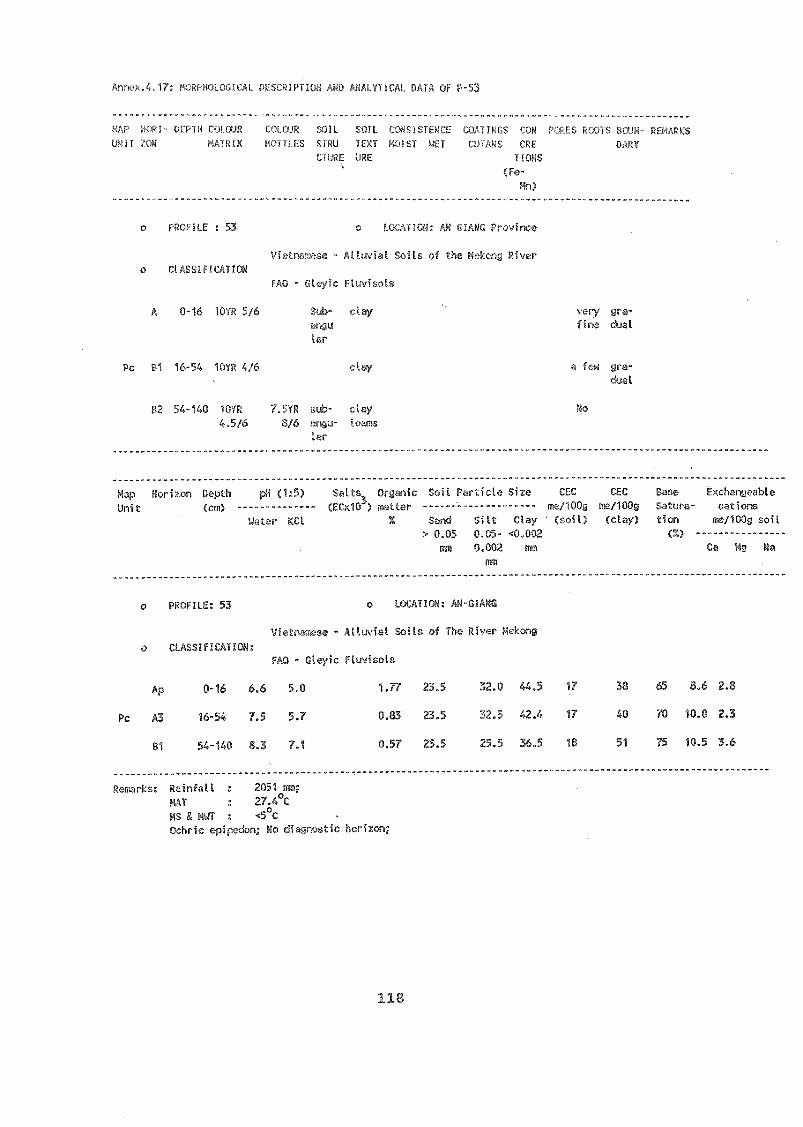
HI--
FAO -
' cihrs: Rainfall : 2051 mm;
MT : 27.A°C
MS & MWT :
Ochric epi[don; Ho dillotio ki
A OF P-53
loPS
rq)
Ap
Pc A3
81
38 65
40 70
51 75
0-16 6.6 5.0 1.77 23.5 32.0 44.5 17
16-54 7.5 5.7 0.83 23.5 32.5 42.4 17
54-140 8.3 7.1 0.57 25.5 25.5 36.5 18
8.6 2.8
10.0 2.3
10.5 3.6
o PROFILE : 53 o
Fl
A 0-16 10YR 5/6 clay %ery
ttloo dual
tar
Pc B1 16-54 10YR 4/6 clay a few ura-
c'Jal
B2 54-140 't''.5YR sub- No
3/6
Lar
Map Horizon Dcpth pil (1:5) SaAts_ Olurilic Soil Particle Size CEC CEC e .I.0
Unit (cm) -------------- (ECKW) rt. 3lAer ------"------------ m/ 100g me/100g ura-
Water KCl % Sand Silt Clay ' (soil) (clay) n V100g soil
:-.. 0.05 0.05- <0.002
wm 0.002 mm Ca Mg Na
In71
E: 53 AN-GIAFIG
Vietnamese - Soils Vhe River ;;:r.

119
RE 5
ted
27-29, PIn Boi Chau, Nano! (Tclx UNDP 4417 VT)1,1r. D,IvA Smith ResidontNr. W:.nL-;Lon Temple, Deputy Rc,sir7c,It Rep,Ns V,,Jerie White Adminisi.xative Serotory tiqie)
Officr
(3 Ngul,:n (jia 'Oieu, Hanoi Teix 4J18 001')hG VT)Office Dr. s. i. .KUNRTEV, Residont F)O, Rep.
Mr. AD Spijirs, ,hatge du ProY,,mme Reorf-IcAta-ion FAO
Mr. 1:.b:axt L. Semple, Regional Coordinator, TAOPeg. 0;ffie 7tpr Asia and 7Eocific, rhra Atit 'Road,Pmcjk()k 70200, Thai]./nd (at. (Telx 82815
TH).
NY' o Jeïi-re'LE:C.0 Barne.kowProfez.,t:sional Officer,
Ms Fitz Gerald, PI:17)ITA Secretary, .
NIAPP (National Intiiut.e for hgricultuval Piamoing and Projection)6 T;yup.n cong Tru, Hanoi (Vietnam) (Tel. 53093)
D]. -an An Phong, Director NIAYPP,:of. Dr. Ton That Chieu, NECcjonal Project Director- NPD V1E/86/024 FAO, Hanoi (Vietnam)
Mr. K)-1 QUANG TOAN - Deputy Director, NIAPPVU 1.4,NG DUNG - Deputy Director, N1APP
Project Staff
Krs. PUAM L:NH - Chief. Soil SurveyNIAPPDr. PHAM 1.,UOlor- LING - Vice Chief. Soil .veyDeptt, NIRPPM. HOANG TRUNG LAP - Computer Unit NIAID,Mr. Do Aiuh, Administrator FAO 13)-oject.VIE/86/024Mr. Clqa Dinh Lam cesponsible for equipmentsp.foject V1E/86/024Mr. Pham Nguyen Diene iespcnsible for tours and*t.rainingMr. Tran My Nam, Interpretor, Project VIE/86/024Ms. DEny Minh Thu, Typist

AGR
rsPr, re03o*tMr. Clio 00c Minh, r,,dolo(J:ist hnd coom,o-pi;47c. ion ChomitMr. InTgyeu V,an Tdfl, Pedologist
1Zc.o 7Tro-Pc.6oloyLi_stDjuycJI Fkj0(-1 Duong, Photocer
Office3a Trung, H.. ' Minh city (Tel 90.007; 90 008)
Pr. Le wiinh Trieu, DirectorMr. Irquyn An Ticm, Vice Dirr,otor Sub-NIAPPMr. 111(7m 17h:anh, Pcdn3ogist
ITTn vcn N11111, PcdologistP .Tqycn 1Thuoug Loan, IntelpJ.eiler
MET DURING FIELD VISITS
Mr. Mom Van My. Agrie. Ecigineer; ChieDisivict of Soc Son People's Committee, Hanoi.Mr. icgo van Chuc, Chief of Cam Dcmg village, Camriinh district, Hai Hung province.Mr. Vu Duong Nhuang
Mr. Nguyen Van Minh Director of Fruit CentreDr. VU MA/YH HAI - Vice Director of Fruit Centre, Phu HoMr. Nguyen Van Bau-Chairman of Cam Dong CooperativeMr. njuyen Van HOANG-Cbai).man of Cam Binh DistrictHai Hung province
for S(
Dr. meI PHIEN Deputy Director ISFMr. DO DINH THOAN Pedologist
ti3
UNT at H OI staff:Prof Dr. Cao Mom fo.mur head of Soil ScienceD,pt,Dr, Ncyn Njnh Thuc, Vice DireCcorSoil Scl(nce, D,Tt.Prof. Dr. Vo Kinh 'Khan, Diiccto- of S(1-3ept.Ms. Noni,ai-hip Chan Paerxav, uate tc1entCram

LEVEL 2
LEVEL 3
00
USSR: TT:chiie BP1t rlorrysvonOs o a charetctc-xiticSOIL JORT1ON (Pkoposed). The TItey:trop. Soils -
(Tyop-St)
LEVEL 10-ORDERS; Ra.ch Groups soils ;liat differ LITTLEin their "idnd dnd re)ative strnyth of processes-tbat,-levelop Horizons.
ORSTOM:Accorlling to mode and intensity of soil evolution(be IlatIle).ing stage, Profile dev., OM, RO, etc)eg.soils pH evolues (Entisols),Solls Halomorpheshydt.ophes, ,ols isohumignes, so3s and oxides
USSR: Facies defined by dayt exceeding 10°C,R/Evop. Ratio (eg. Trop., continental csoon,Eau. ani)
Differentise used are:Chem. and Phy, propertiesthat x7eflct wateclogging or genetic variabilitydue to.
ORSTOM:Based on Pedoclimate conditions (Temp.Humidity)eg. Sols of S201 hrs divided on contentand Maaviour ot RO as: solrouge medittarean;sois P:erKuginous tl:c.p etc sols hydromorphic arebased on G.W., OM, ..tc.
CaL 'orics from this downwards become increasinglysimilar eg. GG/Type/Groups are defined kind of Phy.
123
1 2 4
USR BELT FA,JES(1uf2. i.a) VOR- CYASS - TYPE
3vJA.TTON
USDA SUBORDER GREAT SUB-(Amt-vica) GROUP (1Roup
ORs'WK CLASSE SOUS- 'F' 71-OPE SOUS- T1PE/(Fr,-mce) CY, SE GROUPE PU 1.

0)::01ZS
u
EPI ollic,e
C4_i.otsraGL-k or I- in origin
SOIL
; thru
T.17,r3o0. ou ,c-;.7:u:r1)1e nr:,:ii pTcoptios1' - as :,:,:7 s (1tN.-C:; ned i.11 77.F:4_ JO S 0"57. 0 i 1 1):i700,:. Ci 1 CS7
1-nL. propc).L.ies i.-,,I)ik,;h ,.»cl Lit(a 4.',,o)4,3 Qf soilT`T-(.:w noAencl,F,tureA(.:Ivi c'tr,cy.q...y - SI7bijroup - ,,A-40dOD-1(?r1y :,c:IP,Ille ;:or 11J);ng ,liff. ..7.oi-ol-,plyes
,)RIZONS
orklers - 10Sro.or(,-.Ls - 47
eat Groups-227a)1,,,:uops - 1000Families -
I:?es Type/Phase
Cid words and (nds with 1SOL'Uave a connecting vovelFirst syllable repr ovder name e o
AWMIHOUSE - for all order nameEl, Abstra -" from each order
124
7able
)

Jr-r-,--16.6 or- -Or(lc,ys
V/ERT T ;oT, ERT
/ALF/1 J7(1r.,ce
M/OLLA OLL
/OX/
/ULT/I SOL
/ENT/I SOL
SOL
-131(.Alcmt,7, ;1-1c1 iv;:mr's of Orders - de(!k;i-joyl!spErviv, in OiffuEn
F,r1k(-c.J.unmoi-jve of Fo.cma-
,,.,:-!+11- l0?-
Desert,ID
Forme t.Elementsid,ert olletc.
74.1Dception1)egining
Gx,Ustes,
OX Y,Oxider):cixle
ULT )J,U1;-imns,
OD e
ENT MonsenseP,,aGent
125
- -J. 1.
. . . .
Conetie Syti,1-(10. )77,0 -Unc-sco
C,xumisols,Black(co¡J:G11),Ragi
otnNon-cal(-:lc,BrcwnPloposols
chrsimut,Cheyo-zr,mostBylmi%ome,Prx-12..Inos
Sol Brown acid,Forest,hdnia pby
Bog soils
Lalosols,To.t:eitasoils
Redyellow,Podzoli.cf,aterite
Podsols,BuownPndzolic
Azonal,Lcwgley
evpsii.sols,Cal-(,:c,r(=.o))s,Yoro-;-7,;n1s,
isols
Cberwo:foas,Kz,st.77,J7ozome,Phaso7,-_,ms
Cambisols
sols
_rolsols
Borisols,SJi:=-1(0s
Podsols
Regosols,Arenosol Kiwis
Used as Inentifier of the order nameat al1 the lower categorj_cs suorders)eg. UD IOLLf
mIflCuT:R_S Consists of 2 Syl (I) Suggests, property of class(2) Suggests name of order
ie- TTT, OLL, UST, ALF, UD ULT, UST OX FLUY EM
aa7AT ,TRaUP:

7,47
u' ïoos coits of nalue of apps:opricLte oro.at group:$0o0ified by une ;.,djoutive og. T:y0c ,Tz.4)11.,0011
re of different c.-t-c.
01-JJ T(5LL
Argi UST .......TV rje TJt0.1 1
126
o
It Cep6rts fi:um Cenetic approachgave sts:ung Ceog0 bias towards and n1:d4,2r3 (Enti
gistoc Incep., i.e. Azonol and Tnteronal soiSoils with di.ffcrent 4.aeA30ASe )ut having similar proper-tics go noneNo ]ace (at ol:cler Lwel ) Cc»: Hydro) rofine, Sa3irle/Todicif
c):71.s
APH IATION
74ost elaborateBaoes al.-e soil popertiesNomenclaWre F:nggr,ss sol propertiesBujlt-in, mecbanismPermits class uf oils, not of soil foftning proceses_Permits Uniformity among different scientists
ier said " It is a Greatest contL:i_J-on in recentyears".
HOW TO 7) for classifying soils)
First Step - Identify soil order , Key - Table afteruildel:standing soil genetic sys'
07)..derSuborderGfeat GroupSub Group

i-11-cJ--Wi h ui c hi5-r---with in 2 cm ond l*:ve or: natriecverlyiYlgLhe Ovic: iko7,70
')i7 òI[í L11 1ÜI ör--,74.1.--F.Iirev :Lc, eFine, have c;--] r.ic Gy3.)sic,, ml) lc or.?\rgi3 lid 3)or.
Ïi2k-6(-5T6i-é-c-YaSedepth)Soils of Gssli'Ind Ath Mollie epi.
NO
Low -15ase sat.us s63.1-s -(<3 E3% of vkU,71R -111UMiaReg. MAT>WJC; + have 2,:cgi?.lic hor,
NO
l'il-g-h--base-5-!',T) soil's of Humtalussubhumi0. Reg. witl-x an Ochi:ic epi. 1-
ic Hor.NO
NO
KEY FOR CLASSIFI! !70-E,S
-b-lc Ho rc!xcept Oc ric or
b t-hérs h av e no spoTlc,ArglI 11 c , a-T7:-1- OlcleEVtrocalteic,P1inthitsve Cambie E-hor
lz 1
-Yes-
Yes
Yes
Yes
Yes
Yes> Ei,111:175-SOL
NCEPTISOL
BWi-41-1- :8- 1ink -S.', -63ÏT Tö1: k.Yr mO-Z-e Clay Yes(upto 1m)Qukimun
+ c-q? rco:s ,:.---.7noac,nsi des or ZTISOL

u7\kbe ot soil
10;,itnIJFJ,
o P-_,4L!scTice/.-1,1):7,4-,,nceDiztop,iosti.c FoT:,
DII J C PR S
:y 1icjh (DM.C61-11;,ing (qys or :Tuell
No 0i,=iorC,Aabia 1T r r LTÌIb aepir ¿ì1 i1jh BO
7)hrlior. - Hioh B,S,,-"Tow 8.S,.0.
C.xic
. oil Moisture Reg.: Usti . or
128
0,1,(QAZ
*,taSTOr°L
l,E1.7TTr,OL
o vNT'iSOL."CNCIJTfSOL,MLLIOL'-1,OD02,0LP,LFJSOL
OL0 co 0 C 0 0 C OX.1"011

WORK,--rqt"1" 4 - (1.1e0..teOR
L Og
1)y:Puof. 17. PAO-UNP-.^ ^ -.^ , , .-,-^. ^ ^- 1-
27,1989 .T9f.triloon ,(,ssion)(1,30-5,00 PM)
1960 L`:,SS (at Madi- f World SoilM-o
1961 r7ork ;--,;acc7d; boccc,,;sivejTLi of i-he Soil Nap (.nd3-'c».11c1 p,fon6r4-?d Clon lof(,cm.P :3-vs"(noicSoil rk,)-i-elIPLio-o Oone.
1968 1SSS 7(1,-1F-jde) uppro:(4,,d Leçiend, latureand 0-i75i+jon of soil units.
1971 Sheet of Map 4, ,e1981 The lct 2 shcets of 19-sheel-s Soil Nap of Worldpurlisc,d ;..hru 25 yr. involving 300 scientts
Appraisal of 17.11e Morid Soil Resourr.tesProvide scieutific base for transfer of Tech.EstaYllish genrally accepted soil ,-Tassification andnomenclature
Establish colvaon ramework for detailed investigationsServe as a basic 6ocument for teaching, resoarch anddevelopinntStrengthen inernational cooperation
BUT HOW
Lack of interAationally accepted systemDivergenes in different approachesDissimilaritis in envi:conments
129

1 on 1)(1t 5i1 ftnd j, On Of SO ¡AS
rail: ble to
Soil unlis Ofinedp.T:opet::on
:.erent
Soil propert:s are selected ;Jsed on P)jineipleFoymat-Lon so os to correlate with many othercharacteristics
,,nits are defined using Climate as crietria
3NERAL PRINCIPLES
130
e vable
(7,1d have
Dn
( on TntaaLn. agremol Soils to berepKesented
No comccosus reached on weightage each uniwithin the classjfication system
Concepts of Cljmato, Zonality, Evolution, MorpY%ologv,Ecology or ceology differ most of the soil classiflcationand
The available knowledge make it difficult to manyof the concepLs on general basis.
Degree of profits d.evelopent cannot be used consistentlybecause soils in difficult parts are not members of acontineous sequence of Soil Formation (eg. Podzols andFeramalsols) since they are product of differentEnvironments.
Similarly climate (concept of zonanility) cannot be usedbecause infl. of clim, is secondary to the effect ofAM or Age. eg. Podzols may occur both under Boreal andTropical climates, Planosols are formed due altern. wetdrv cond1tions (Physing after)
The legend usad is based on factual inventories reg.distributioa and characteristics of world soils, and
Can be used for practical and scientific purlposs.
SYSTEM OF LISTING SOILS
Based on geophysi " n and

o-ind Lo 47( )1 01Li iud b37 I(0)a)iLy Put-rva ovi F>t;,..,ge
- -
Fluvisols(FL)Gleysols(GL)Ri,(Jouols(RG)LeptLsols(LP)
ACC:UM.°f- 0.M.
Kastanoms XS)Cne:;:snozons(N)Phaeuz(:.ms(PN)
s Greyze)as(GR)
S
Arc.nool (AR) o Cz...m1:i:-7ols
overtlsols(VR)
Accom, of
MAJOR CHANGES IN SOIL GROUPS
Lithosols, Renoznas, Kankers have been grouped asLEPTOSOLS
Ferosols gn,uped into Arenosols (as sandy soils are )Luvisols sepaiwted into Luvisols and LixasolsActisols s(i-parated into Acrisols and Alisols as under:
Prop. vlsols Lixlsois Acrlsols ArrEarg----hrgie(Bt) x x x xCEC >24me/100gm <24 <24 >24(me/100g clay)BS >50 >50 <50 <50
Ilitense wea- Organic Soilsclay -:R03 thring(Trop.,
Subtrop.Reg.
Tuvisols(LV) o Lixisols ,X) o Hit000ls(HS)PLellosols(PL) o Aerisols ..!)
PoO.:,;oluvisols O Allsols(AL)(PD)
Podzols(PZ) o Nitisols(NT) o Humn infli.Ferralsols(FR)Plinthosols o Anthrosols
(PT) (AT)
Yermosols, Xerosols dropped because they were based onAridic moisture regime
Calcisols, Gypsisols have been introducedPlinthosols being different than Ferralsols hence sepa-
rated at highest levelAnthorosols added
NOMENCLATURE
Latente dropped and new words coinedPhaglam newly coined word soils with Bt occurring inUs traditional names (existing and well known interna-
tionally) ego Soldnst, Chernozims, Podzols, Planosols,Solonosols, Soldnchard, Solonatz, Regosols.me have acquired acceptance (Tertisols, Andosols,Acto Ferrai
131
(cm)
tion or P4p7,10-logica.11v )1.y
Calcisols(CL)Gypsisots(GY)
C) SoiGneti(SN)Sol,,),IeLlilks(SK)
Table. SOIL UNITS AND MAJOR SOIL GROUPING (Level -
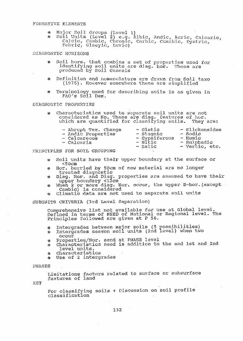
T,Ta-,ior Sojl (YA:ve.t1
Soil ULs (Tyl:vel 2) e. ;Andic, r!aJcr.Jc,calcic, Ch.:omtc, CarlAic, rriìc, Dvstric,
Clay:117, Luvjc):-ORIZONS
Soil hors. '1t combine a set of s ed Uoridentify5ng c)J1 units are diag, hor. avevroc'uced by Soil Gonesis
Dofitition y',4,ci.nclature are OYawn fkom Soil tanxo(1Y75). ITo,;(-,ver somowbore the al-e
Termino]c,gy 1. .z,d for describing soils is as given ins'oll Des.
DIACTic PRO RTIES
charc)ics used to F,Lparate z=.,o,j1 ni0i-s c 3 iotr.onsi(le:_ed as No. These are diag. eaLures oE ;or0
rh a'r'e quantified for classifying -.(Ji) s. They
Soil -units have thaTr pper boundary tt the surl-ace or<50cm
Hora bu'iried by 50cm of ne.w material al:e no longertreated diaunosticDiag. Hor. nd Diag. properties are assumed to have theirupper boundary <12cm
When 2 or more diag. Hor. occur, the upper D-hor. exceptCambic) is considered
Climatic ",a.ta are :lot used to separate soil units
aITERIA (3rd Level Se- <tion)
Comprehensive list not available for use at Global level.Defined in terms of NEED of National or Regional level. ThePrinciples followed are given at P 56.
Intergrades btween major soils (5 possibilities)Intergrades season soil units (2nd level) when twooccur
Prcpertics/Hor. _',end at PHASE levelCharacteristic3 need is addition to the and 1st and 2ndlevel units.CharacteristicsUse of 2 intecrades
PHASES
TAmitations factors related to suface or J')surfacefeatures of 7.and
For classifying soils + D CL.sSIOfl on soil profileclassification
n:(upt Tex. Changeiic Pr()perties(alcareous
-,A)R
132
Slic:kensiraesStagnic - SodicGusiferous HunicNitic SulphedicSalic Vertic, etc.

-3 ".,AO-VC.OLCO PUR(.41
2,B,-.(939
The i..)plic.ation oE F210-N)SCO y;,1-(alit of soil,:/_,:ssifHation for (:-1:71:Aifying anid correlhtog ;Ile 2.(Dis ofViel:uam Tras dic1.1,1 .nd dmoustraLed ,Ising the SOILMTuK(WOiq0LITHS (col.lcd ring fir,Pld suclis). A lot of1112ww-silo11 'îo[D]: 01.-CO ;; :ole oC the namos -,Tc.ce in $.-i.-).st to-he iyidiion of :.(-qnu ullive-rsity pro.Cosors ond otherpodoloclists. The .6oLjto1ogy and analytical data vere used tosuppocf:. our &:,,sertin f-lich 0:(..vntnced i-Jlow all, Some st7ientits
.-0),,m,--,nd
"We way Lave to c3elge ;;ome of our carlier conceptsceyarOilig oil deg.Ladcction of soils-f.'cllow the -o n: linJ.iug to classify and corrc,Jateour soils for 3,a.td planning".
The c..,1,71,3 of ;,r,we Icnowned petlo),)gsts cq,-0,:naedas ;111?(IY,..,It:z1)o,t the house highly appreciai d 'c.he of:Portsolt in by the u U Lo e),plain the hard subject mati:er iamuch smplei- TTays t.l.at all of the persons could rollow. To thec.onsp3tant, it -as a :,%i.is.rying t,:xperionce.
,Jr-4 30)T.43 q-1,114TIC RESOURCE ii\NITOP:(FIS VOiN 71'¡-;-00htJN`j:01V'i4TMS; f.d1ND UST, 3TW1W.4G"
,
Nov. 7,8,389 (2nd Morning Session)
A set of S3A)ES was used to demonstrate the iiaportanceof soils and cliloati.c; inventories for land evaluation using FAOapproach fo-c land planning. Two case studios were i-aken as, xamples for working out the suitability of soils and sitecondltions for different crops with the objective to improve the,.xisi-ing cropping pattern.
133

,'-j07.7-.
Nov. 28,1989 ,,noon -4-)n)
i.-t..)1es of v,Tere3.imeel The o sind o
(...i01 ic.ibtod.
r./.9 ;-,:opic: ;--):oc,'e a ) t of n C-.s. ' st as a 1 ot ofCu1 S The Lill(SL. )11 jA.).)(1 on 'as
;.bis,31:.oke about
:7-,a,:;r1;-..--rst,,,70-L-kf:,...17),)-os ,"<1x1 (111-.cinti i-be (lays i'nf.)131) .
Ct ba,s heavy; lint a \i. .):y satisfying-)>:.¡-.,..ncie i'.be .!onsuli ant. as there /1,---As 1)(,,, n a 1,;:ceat clomandr-rom te iäPD to ogfe,r ìms tO bis and other t.staf.f
in Vietnam.1.111-le oconolc.-Jots and list of i' its are in
Annex.... 0 .
LIST 07 NTS ,,,4.:T11,1,0Y,DON
135
Sr.-1.2,
7c, 5. 70. ir fl.9
e , I , o e
Dv. TRt\N AN P:z.ONGDr. 111-2,\W 1.111\I
cy.1:61 i,J; Y.,
" 17:1-» `rkii C":r
TITLETfj:(r.. TE
D3ryetor, NTAPPVice Chairwan of thc
P)anning CQmmittce3. Dr, Prof. ToN T:fAT C:OIEU NDP-V1E/86/024 - NT»-PP4. Dr. Prof. LE .OUH WOOC - NIAPP5. Dr. 'Prof. C7\0 ?yofussor of the 21(41?cnli-ure
UnivursiLy No. 16. D. J-Ziqi CoNG Hanoi Univevsity7. Dr. VU PGOC TUT,14 Gunoral De'Llartment for
Land ManagumentC. DO DINH TWE',N Podologist. Institute of
Agro-Chotry and Pc-Ocslogy9. Mvs. PHkM TFT v. NH ITrzid of tLe Soil S(1,7_nce
Depe,vment - NIAPP10. Dr. Pham Diong Ung DcTuty Chicf of The Soil
Sc:Te.nce Department - DTAPP11. Kr. Nguyen Qiu alven Soil Scientist - N1APP12. Dr. Nguyen KImg Soil Scientist - NTAPP13. Mr, Pham Qw4ng nanh Chief of the Soil Science
DepLt. - Snb - Institute,(NIAPP)
14. Mr. Nguyen 7)ho Head of the Centre ofPlanning and Soil Science
NIAPP15. Mr. Nguyen Van Vhiem Deputy H(Dad. of the C-Ini:re16. Mr. Nguyen Ngoc Thinh Soil Scientist - NJAPP17. Mr. Chu dac Thinh Soil Scientist NIAPP18. M. Nguyen van Tan Soil Scientist - N3APP19. Mr. Le Thai 73at Head of the Chambre of
Science - VIAPP20. Mr. Dao Can Deputy HcaC. of The Chambre
of Science - NTAPP21. Dr. Rao Chau Thu Soil ScienList - Agriculture
University No, 1 Hanoi22. Mr, Le Van Hieu General Department of Land
Management23. Mr. Do Dinh Dai Soil Scientist - NIAPP24. Mr. TI:an Huy Nghi Soil ScieniAst NIAPP25.26.27,
Mr. Nguyen Thanh ThongMr. Can TrieuMr, Tran Mong Tan
Soil Scientist - NIAPPSoil Scientist - NIAPPF^4/nf ist - NTAPP
28.29,30._A.
Mr. Nguyen Dac DanMr. Nguyen Viet ThanhMr, Chu Dinh LamMr. Hoang Xuan Tin
Soil Scientist - NIAPPSoil Chemist - NIAPPSoil Chemist - NIAPPSoil Sciontist - NIAPP

MY F. VO Cis,r:111Dr, r Tro'cl(j orMr, N(Joyr-A-1 Di oh '1),7c4
Conh P1-p)cigìr Çn. Cf TJ:.11h7.5r. Do 11:Tnh
Ar, Pliam en D'
Mr. Doc,ng7h TnMr. ITTlyn 17,7oa Uicx1
136
Soil - N-J.APPSoil Scientist 3,, A01)oi 1,Scentjst )11APPSoil - 01-3)0?r,.!Auto E;ew:,inci.7\1,Jsit,tilt - Proje(J:
/024AS7,t;111t. acej,:,ct Vf-E/:36/024cl,lobre of - wtAPPSon Sci(77.nist NliWP

_ "".
r
tr10 2a,Jû5
OF LEAD] NG SCI ENT] TS ;Ax)1/1 tho W01.:1(:;HOPSP-,,EM I NAPS No
Prof . Dr . ¡CA PAC, 1 ,TANT
at : NATIONAL INST. ACRIC. PLANNING & PRO.IECTIONS NIAPP
HANOI, Novc,m1 , 1989
a a
TX.6 i.
- 1 -
.ir y i:4a: »
-7 1(/ ,".77 --1,`-77.-,'.: ,:;-)».2,
1 '. ,
6 ,...,:,./.-t..,,,.. - --c-,
....1 /z ,Jr. J1,./ Ì ) 1
,...) .'
,C.4.0f,e,
7:0 O';,<..),<_. 1-17-!-- 4; al-/77;,,,-k).,, I ) . ? ,,
e2P/ -.1, ,t.. ./..;':- Z)r, -t
P:2
771) ":;;
_JS4)47,7 g )/r)
CAP/
i. ....IT?: -... -* _A-, ...:4 ,-3 - .-.........-:?1,-- , ---1.:.' .. 7:4".}."--,.,:*--,-^-/t,- ,.... ,-51:.:,,,--,.., .../.:1:;- L.' ,),1
, -
e.C.,,,,"..2r4-.7". ,,. `Z:CY.,,e- a,'
/a t .1:' Z "/ ----).:/' ..:.. C-'," /4,27....-7,',--, f.1 _.z.2.71-.:,
-
t.".,:-.;14... '"
1
,,' `,.:/ :.:" , ,,,, a)I , , 1
. ,...
-5,, -'.1. ,T::.:
r
, "./' ) 4.- -.1^:)/: ¡)", ,
ikLe-,)6,1 M.
ANNEXURE 8
C.I.:.(117.1L ! 71. i:',147
-
x,Pia-06z,J'41-7
&?m0-7 -

Prof. Dr.Foro


IN1 21
01tr ,r110, tLH li1^sanI iont
Id lirtinttt 5t.tic
It
r nc cctc "Pltn, ,11,on, 1,11,
II alinr ,011,
11_',1111'lll 11 ` 111";
1 nr1) 1,11 tt11141tIc S0110
L tti iitdtttr, ° 1cciii cci tt:11 it tit' 0.11,
'tt 1.1 NI
101111 1\1
'1111\ 1,1 '011' 01 the crti 11f f
It f nu11 171 I 4if 1 Ow 11, I
Iift111d II` f
I 4 I 1,P 1 I '[7:1 t ccc 4 V1141,11 ,olt on 011 1111..,1
17.T.1 1 o,f ti<111,I, 1 .1/<ri 4,1,1 +Alm d
t. ;LI r or, .1,$ rtdr1 «cl' n ;It I i f`11, 1 IV
(176 cni fI1,11,
01, At' i i I toqt 1 .,1 I rhil 111.1 r,rit n
1,1\ I In op ci,»11 ,
i-- -:i iti«i ccci't'citcctic
1. t
1\9 A
s
"
ri trPurl le 1cc r I
ctcttctoi tIncctc cc
,. lc yor I'. 1 'C 111117/1 I
Hi' 1 j t. h r 11474,17 7,71, 1IS It
21 ittctt ird s ila 1, II ctncI fr Pi I StttnN
n1,1.1.01141,, '
/ n tt. t f
7 11/1 11, 71) f wry,
Po rlk n111'iitcctoiI I 11(1, nI I II It I, 4,Ni
Ir 1111 it III 'r - 0111
III '*,11111 -
1,y't ,
' ",ti
4
I '
I
t .1 1 O. 't h,11111 11 in lilt on1 cc cc
1, 4 t i 111f it ;I, 01,11(1,
4
1 r,/ I 11
I I I II
I I -1,,r r or

J
THAIL A 1\1 Ei
VET NAM77,,,V OF STUDIED SOIL.-
M."
iftl \ rut,
tt°1,ttt I
1 .,1' ,. HIM/ 1;
L OC AT IO N
KOONS DONE
11A5 140 1 S I UD1ED YET
ott (1
tot
t ,tct,
titt
N,