NIAGARAFALLS Pt1-Cover--Front.indd
161
Niagara Falls National Heritage Area Commission June 2012 NIAGARA FALLS NATIONAL HERITAGE A REA Part I – Environmental Assessment
Transcript of NIAGARAFALLS Pt1-Cover--Front.indd

Niagara Falls National Heritage Area Commission
June 2012
NIAGARA FALLSNATIONAL HERITAGE AREA
Part I – Environmental Assessment
Niagara Falls NatioNal Heritage area
NIAGARA FALLS NATIONAL HERITAGE AREAPart I – Environmental Assessment
Submitted to:
The Niagara Falls National Heritage Area CommissionU.S. National Park ServiceandKen SalazarU.S. Secretary of the Interior
Consulting team:
John Milner Associates, Inc. Heritage Strategies, LLCNational Trust for Historic Bergmann Associates
June 2012

Part I – Environmental Assessment
ii Niagara Falls NatioNal Heritage area

NIAGARA FALLS NATIONAL HERITAGE AREA v
Table of Contents
PART I ─ ENVIRONMENTAL ASSESSMENT
CHAPTER 1 ─ PURPOSE AND NEED
Introduction 1.1 . . . . . . . . . . . . . . . . . . . . . . . . . . . . . . . . . 1-1Purpose and Need for Action1.2 . . . . . . . . . . . . . . . . . . . . . . . . . 1-1Background and Overview of the National Heritage Area1.3 . . . . . . . . . . 1-3
1.3.1 National Heritage Area Description . . . . . . . . . . . . . . . . . . 1-3 1.3.2 Designation of the Niagara Falls National Heritage Area . . . . . . . 1-4
Foundation for Planning1.4 . . . . . . . . . . . . . . . . . . . . . . . . . . . 1-5 1.4.1 Legislative Requirements . . . . . . . . . . . . . . . . . . . . . . . . 1-5 1.4.2 National Signifi cance of the Heritage Area . . . . . . . . . . . . . . . 1-7 1.4.3 Context, Vision, and Mission . . . . . . . . . . . . . . . . . . . . . . 1-12 1.4.4 Interpretive Themes . . . . . . . . . . . . . . . . . . . . . . . . . . . 1-13
Public Participation and Scoping1.5 . . . . . . . . . . . . . . . . . . . . . . . 1-141.5.1 The Scoping Process . . . . . . . . . . . . . . . . . . . . . . . . . . 1-151.5.2 Issues Identifi ed through Scoping . . . . . . . . . . . . . . . . . . . 1-171.5.3 Goals for the National Heritage Area . . . . . . . . . . . . . . . . . 1-17
1.6 Impact Topics . . . . . . . . . . . . . . . . . . . . . . . . . . . . . . . . . 1-181.6.1 Impact Topics Retained for Analysis . . . . . . . . . . . . . . . . . . 1-181.6.2 Impact Topics Dismissed from Analysis . . . . . . . . . . . . . . . . 1-20
1.7 Relationships to Other Plans and Projects . . . . . . . . . . . . . . . . . . 1-22
CHAPTER 2 ─ ALTERNATIVES
2.1 Development of Alternatives . . . . . . . . . . . . . . . . . . . . . . . . . 2-12.2 Alternative A – Current Conditions Continue (No Action) . . . . . . . . . . 2-32.3 Program Elements Common to All Action Alternatives (B, C, and D) . . . . 2-42.4 Alternative B – Focus on Interpretation . . . . . . . . . . . . . . . . . . . . 2-62.5 Alternative C – Focus on Heritage Product Development . . . . . . . . . . 2-82.6 Alternative D – Focus on Visitor Experience (Preferred Alternative) . . . . 2-102.7 Alternatives Considered But Dismissed . . . . . . . . . . . . . . . . . . . . 2-132.8 Mitigation Measures . . . . . . . . . . . . . . . . . . . . . . . . . . . . . 2-132.9 Comparison of Alternatives . . . . . . . . . . . . . . . . . . . . . . . . . . 2-142.10 Environmentally Preferred Alternative . . . . . . . . . . . . . . . . . . . 2-212.11 Selection of the Preferred Alternative . . . . . . . . . . . . . . . . . . . . 2-21
CHAPTER 3 ─ AFFECTED ENVIRONMENT
3.1 Natural Resources and Landscapes . . . . . . . . . . . . . . . . . . . . . 3-23.1.1 The Niagara Gorge and Escarpment, Unique Ecosystem (EA Impact Topic) . . . . . . . . . . . . . . . . . . . . . . . . . . . 3-33.1.2 Topographic Features . . . . . . . . . . . . . . . . . . . . . . . . . 3-53.1.3 Geology and Geological Features . . . . . . . . . . . . . . . . . . . 3-63.1.4 Prime and Unique Agricultural Land. . . . . . . . . . . . . . . . . . 3-73.1.5 Hydrology . . . . . . . . . . . . . . . . . . . . . . . . . . . . . . . 3-83.1.6 Climate . . . . . . . . . . . . . . . . . . . . . . . . . . . . . . . . . 3-8

NIAGARA FALLS NATIONAL HERITAGE AREA
Part I – Environmental Assessment
vi
3.1.7 Vegetation/ Endangered and Threatened Plant Species (EA Impact Topic) . . . . . . . . . . . . . . . . . . . . . . . . . . . 3-93.1.8 Important Wildlife (EA Impact Topic) . . . . . . . . . . . . . . . . . 3-12
3.2 Niagara’s Historic and Cultural Resources . . . . . . . . . . . . . . . . . . 3-143.2.1 Historic Properties and Districts (EA Impact Topic) . . . . . . . . . . 3-16 3.2.2 Native American Associated Sites (EA Impact Topic) . . . . . . . . . 3-243.2.3 Indian Trust Resources and Sacred Sites . . . . . . . . . . . . . . . . 3-253.2.4 Archeological Resources (EA Impact Topic) . . . . . . . . . . . . . 3-263.2.5 Interpretive Facilities and Collections (EA Impact Topic) . . . . . . . 3-273.2.6 Thematically Related Cultural Resources Outside of the Heritage Area Boundary . . . . . . . . . . . . . . . . . . . . . . . . 3-28
3.3 Socio-economic Context . . . . . . . . . . . . . . . . . . . . . . . . . . . 3-283.3.1 Population . . . . . . . . . . . . . . . . . . . . . . . . . . . . . . . 3-283.3.2 The Local Economy . . . . . . . . . . . . . . . . . . . . . . . . . . 3-363.3.3 Growth Patterns . . . . . . . . . . . . . . . . . . . . . . . . . . . . 3-433.3.4 Race and Ethnicity . . . . . . . . . . . . . . . . . . . . . . . . . . . 3-433.3.5 Foreign Born . . . . . . . . . . . . . . . . . . . . . . . . . . . . . . 3-453.3.6 Income . . . . . . . . . . . . . . . . . . . . . . . . . . . . . . . . . . 463.3.7 Education . . . . . . . . . . . . . . . . . . . . . . . . . . . . . . . 3-483.3.8 The Impact of the Heritage Area on Socio-economic Factors (EA Impact Topic) . . . . . . . . . . . . . . . . . . . . . . . . . . . 3-493.3.9 Sources of Demographic Information . . . . . . . . . . . . . . . . . 3-50
3.4 Regional and Community Planning . . . . . . . . . . . . . . . . . . . . . . 3-513.4.1 Niagara River Greenway Plan, 2007 . . . . . . . . . . . . . . . . . . 3-513.4.2 The Great Lakes Seaway Trail . . . . . . . . . . . . . . . . . . . . . 3-513.4.3 State and National Heritage Areas . . . . . . . . . . . . . . . . . . . 3-513.4.4 Economic Development: Plans and Organizations . . . . . . . . . . . 3-583.4.5 Niagara Power Project, New York Power Authority – Relicensing . . 3-583.4.6 Historical Organizations . . . . . . . . . . . . . . . . . . . . . . . . 3-593.4.7 Environmental Protection: Plans and Organizations . . . . . . . . . . 3-593.4.8 State Agencies . . . . . . . . . . . . . . . . . . . . . . . . . . . . . 3-603.4.9 Regional Planning Initiatives. . . . . . . . . . . . . . . . . . . . . . 3-613.4.10 Tribal Nation Plans . . . . . . . . . . . . . . . . . . . . . . . . . . 3-623.4.11 Planning by Local Governments . . . . . . . . . . . . . . . . . . . 3-633.4.12 Transportation . . . . . . . . . . . . . . . . . . . . . . . . . . . . . 3-663.4.13 Utilities . . . . . . . . . . . . . . . . . . . . . . . . . . . . . . . . 3-66
3.5 Tourism and Visitor Experience (EA Impact Topic) . . . . . . . . . . . . . 3-663.5.1 National Trends in Heritage Tourism . . . . . . . . . . . . . . . . . 3-673.5.2 Tourism in Niagara Falls . . . . . . . . . . . . . . . . . . . . . . . . 3-673.5.3 Profi le of Visitors to Niagara Falls, New York . . . . . . . . . . . . . 3-703.5.4 Visitation at Niagara Falls, New York Attractions . . . . . . . . . . . 3-713.5.5 Closest Markets for Niagara Falls, New York . . . . . . . . . . . . . 3-713.5.6 Tourism Partners in Niagara Falls . . . . . . . . . . . . . . . . . . . 3-723.5.7 Lodging . . . . . . . . . . . . . . . . . . . . . . . . . . . . . . . . . 3-773.5.8 Fully Independent Traveler Market . . . . . . . . . . . . . . . . . . 3-783.5.9 Visitor Transportation . . . . . . . . . . . . . . . . . . . . . . . . . 3-80
NIAGARA FALLS NATIONAL HERITAGE AREA
Table of Contents
vii
CHAPTER 4 ─ ENVIRONMENTAL CONSEQUENCES
4.1 General Methodology for Assessing Impacts . . . . . . . . . . . . . . . . . 4-14.2 Summary of Key Differences among the Alternatives . . . . . . . . . . . . 4-34.3 Natural Resources and Landscapes . . . . . . . . . . . . . . . . . . . . . . 4-4 4.3.1 The Niagara Gorge and Escarpment, Unique Ecosystem . . . . . . . 4-4 4.3.2 Vegetation/Threatened and Endangered Plant Species . . . . . . . . 4-5 4.3.3 Important Wildlife . . . . . . . . . . . . . . . . . . . . . . . . . . . 4-74.4 Historic and Cultural Resources . . . . . . . . . . . . . . . . . . . . . . . 4-7 4.4.1 Historic Properties and Districts . . . . . . . . . . . . . . . . . . . . 4-8 4.4.2 Native American Associated Properties . . . . . . . . . . . . . . . . 4-8 4.4.3 Archeological Resources . . . . . . . . . . . . . . . . . . . . . . . . 4-9 4.4.4 Interpretive Facilities and Collections . . . . . . . . . . . . . . . . . 4-104.5 Socio-economic Environment . . . . . . . . . . . . . . . . . . . . . . . . 4-104.6 Tourism and Visitor Experience . . . . . . . . . . . . . . . . . . . . . . . 4-11 4.6.1 Visitor Experience . . . . . . . . . . . . . . . . . . . . . . . . . . . 4-12 4.6.2 Scenic and Recreational Resources . . . . . . . . . . . . . . . . . . 4-124.7 Tables Summarizing Environmental Impacts . . . . . . . . . . . . . . . . . 4-144.8 Adverse and Cumulative Impacts . . . . . . . . . . . . . . . . . . . . . . . 4-15
CHAPTER 5 ─ CONSULTATION AND COORDINATION
5.1 Public Involvement in the Planning Process: An Overview . . . . . . . . . 5-1 5.1.1 Project Initiation . . . . . . . . . . . . . . . . . . . . . . . . . . . . 5-3 5.1.2 Existing Conditions and Resource Assessment . . . . . . . . . . . . 5-3 5.1.3 Vision, Mission, and Goals . . . . . . . . . . . . . . . . . . . . . . . 5-4 5.1.4 Development and Analysis of Alternatives . . . . . . . . . . . . . . 5-4 5.1.5 Selection of Preferred Alternative . . . . . . . . . . . . . . . . . . . 5-5 5.1.6 Public Review of the Environmental Assessment . . . . . . . . . . . 5-6 5.1.7 Development of the Draft Management Plan . . . . . . . . . . . . . 5-65.2 Agency Consultation . . . . . . . . . . . . . . . . . . . . . . . . . . . . . 5-6
APPENDICES (UNDER SEPARATE COVER)
APPENDIX A: FEDERAL ENABLING LEGISLATION (PUBLIC LAW 110-229) & OFFICIAL MAP
APPENDIX B: THEMATICALLY RELATED SITES IN NIAGARA & ERIE COUNTIES
APPENDIX C: LISTED SPECIES RESPONSE LETTERS
APPENDIX D: CIVIC ENGAGEMENT STRATEGY
APPENDIX E: PROJECT NEWSLETTERS
APPENDIX F: CONSULTATION LETTERS
APPENDIX G: PUBLIC MEETING PRESS RELEASES & NOTICES
APPENDIX H: EXPRESSIONS OF SUPPORT
APPENDIX I: WORK PLAN, FINANCIAL PLAN, & LIST OF POTENTIAL FUNDING SOURCES
ACKNOWLEDGMENTS

NIAGARA FALLS NATIONAL HERITAGE AREA
Part I – Environmental Assessment
viii
1-1NIAGARA FALLS NATIONAL HERITAGE AREA ENVIRONMENTAL ASSESSMENT
Chapter 1 – Purpose and Need
1.1 Introduction
Congress established the Niagara Falls National Heritage Area on May 8, 2008 in Public Law 110-229. The legislation designates the Niagara Falls National Heritage Area Commission as the local coordinating entity for the heritage area and directs the Commission to prepare a management plan that specifi es actions, policies, strategies, and recommendations to meet the heritage area’s goals.
Under the National Environmental Policy Act of 1969 (NEPA), activities undertaken or funded by federal agencies must be assessed for their potential to cause environmental impacts – both positive and negative. An environmental assessment is a NEPA document prepared to analyze the action, evaluate alternatives, identify impacts, and determine an environmentally preferred means of undertaking a federal action. As the Niagara Falls National Heritage Area was established through federal legislation and receives federal funding and assistance, the creation and approval of a management plan for the heritage area is considered a federal action and is subject to review under NEPA. This environmental assessment has therefore been prepared in conjunction with the management plan in accordance with NEPA requirements.
The Niagara Falls National Heritage Area Management Plan and Environmental Assessment have been prepared by the Niagara Falls National Heritage Area Commission with the participation of a wide variety of partners within the region and with support from the National Park Service and its Northeast Regional Offi ce. The environmental assessment evaluates four alternatives for management of the heritage area, describes potential benefi cial and negative impacts that would result as a consequence of implementing each of the alternatives, outlines scoping and public participation processes associated with the planning work, and identifi es a preferred alternative. Following completion of the environmental assessment and selection of a preferred alternative, the management plan was prepared to describe the detailed policies, actions, roles, and responsibilities involved in implementing the preferred alternative.
Chapter 1 of this document describes the purpose and need for the project, the foundation for planning, public participation, issues identifi ed through scoping, and impact topics for consideration in the assessment of alternative for the plan.
1.2 Purpose and Need for Action
The proposed federal action considered in this environmental assessment is the creation and approval of a management plan to accomplish the purposes for which the Niagara Falls National Heritage Area was created. As delineated in Section 421 of the legislation, these purposes are:

1-2 NIAGARA FALLS NATIONAL HERITAGE AREA ENVIRONMENTAL ASSESSMENT
Chapter 1 – Purpose and Need
to recognize the national importance of the natural and cultural legacies (1) of the area, as demonstrated in the NPS study report entitled Niagara National Heritage Area Study and dated 2005 (2005 Study Report);
to preserve, support, conserve, and interpret the natural, scenic, cultural, (2) and historic resources within the National Heritage Area;
to promote heritage, cultural, and recreational tourism and to develop (3) educational and cultural programs for visitors and the general public;
to recognize and interpret important events and geographic locations (4) representing key developments in American history and culture, including Native American, Colonial American, European American, and African American heritage;
to enhance a cooperative management framework to assist State, local, (5) and Tribal governments, the private sector, and citizens residing in the National Heritage Area in conserving, supporting, enhancing, and interpreting the signifi cant historic, cultural, and recreational sites in the National Heritage Area;
to conserve and interpret the history of the development of hydroelectric (6) power in the United States and its role in developing the American economy; and
to provide appropriate linkages among units of the National Park (7) System within and surrounding the National Heritage Area, to protect, enhance, and interpret resources outside of park boundaries. (P.L. 110-229, 2008)
The management plan outlines policies, strategies, and an operational plan for implementation of the Niagara Falls National Heritage Area by heritage area partners. As the local coordinating entity, the Niagara Falls National Heritage Area Commission (Commission) will guide, assist, and lead heritage area partners, with differing roles depending upon the specifi c activity. The Commission has been created for a period of fi ve years from the date of enactment of the legislation. Upon expiration of that fi ve-year period, unless it is extended by additional legislation, a private nonprofi t or governmental organization designated by the Commission will serve as the local coordinating entity.
The management plan for the Niagara Falls National Heritage Area is being prepared in accordance with the requirements of Section 424 of the enabling legislation (P.L. 110-229). This environmental assessment was prepared as an integral part of the planning process to engage organizations and residents, explore alternative futures for the heritage area, and assess potential impacts of possible alternatives on social and environmental resources, conditions, and interests. The management plan and its environmental assessment are being prepared in compliance with requirements of the National Environmental Policy Act of 1969, as amended (NEPA), the Council on Environmental Quality’s (CEQ’s) implementing regulations for NEPA (40 CFR 1500-1508), and NPS Director Order #12, Conservation Planning, Environmental Impact Analysis and Decision-making (DO-12, 2001) and accompanying DO-12 Handbook.

1-3
Chapter 1 – Purpose and Need
NIAGARA FALLS NATIONAL HERITAGE AREA ENVIRONMENTAL ASSESSMENT
1.3 Background and Overview of the National Heritage Area
The City of Niagara Falls, as well as the larger Buffalo-Niagara region, has experienced a signifi cant decline in population and manufacturing jobs over the last several decades. Plants were closed as manufacturing was moved to the southern United States and overseas. The comprehensive plan for the City of Niagara Falls describes the existing challenges:
Today, many urban neighborhoods are in decay, large areas of the city’s industrial corridors are abandoned, and many residents, community and business leaders have lost their sense of pride in their city. In fact, many former residents have chosen to move out of Niagara Falls. Many visitors are disappointed and clearly unimpressed by the quality of the urban environment and the tourism offering that is not what they would expect adjacent to a world-class natural heritage destination such as the Falls. Tourists prefer to visit Niagara Falls, Ontario than remain in Niagara Falls, New York for more than a couple of hours. (City of Niagara Falls [CNF] 2009:1).
The City of Niagara Falls is taking strides to transition to a service economy, with tourism an important growth sector. Efforts over the last decade have focused on tourism, with the opening of the Seneca Niagara Casino in 2004, the new Conference Center Niagara Falls in 2005, and other redevelopment projects bringing new visitor events and services into the downtown. The city’s 2009 comprehensive plan outlines a vision for positive change and strategies for renewal in an important effort to address the challenges it describes in the quote above.
With regard to the Niagara Falls region overall, the 2005 Study Report describes “a widespread belief that there is great potential for upgrading the area’s offerings” and the view that a national heritage area designation could “heighten appreciation of the region, better preserve its natural and historic resources, improve coordination among existing programs and sites, and improve the quality of life and economy of the area” (NPS 2005:5). Specifi c needs for the region, identifi ed in the feasibility study, relate to tourism development, resource management, downtown revitalization in the City of Niagara Falls, protecting the rural/village character of Lewiston and Youngstown, and visitor management (NPS 2005:58). These needs are broadly refl ected in the heritage area’s 2008 enabling legislation.
The heritage area initiative in general and the management plan in particular will address these needs by coordinating a wide range of partners in tourism, community enhancement, preservation, and other planning initiatives within the Niagara Falls region as outlined in the enabling legislation.
1.3.1 National Heritage Area Description
The Niagara Falls National Heritage Area is a 13-mile-long corridor in western New York State along the United States/Canadian border and the Niagara River from the City of Niagara Falls to Lake Ontario. The enabling legislation recognizes the heritage area’s natural and cultural resources, which include the world-renowned Niagara Falls and scenic Niagara River
1-4 NIAGARA FALLS NATIONAL HERITAGE AREA ENVIRONMENTAL ASSESSMENT
Chapter 1 – Purpose and Need
Gorge. The Niagara Falls region has “signifi cant historical associations with Indians, early European exploration, the French and Indian War, the American Revolution, the War of 1812, the Underground Railroad,” and the development of hydroelectric power (NPS 2005:5).
The heritage area is located north of Buffalo and within the Buffalo-Niagara Falls metropolitan area and the western region of New York. New York City is approximately 400 miles to the southeast, and Canada lies to the north and west – with Toronto located north of the heritage area across Lake Ontario. The Niagara River fl ows northward from Lake Erie to Lake Ontario and serves as the international boundary between the United States and Canada. Niagara Falls, Ontario, is the Canadian tourist destination for visitors to the Falls and Gorge and stands within eyesight across the Niagara River from the heritage area’s City of Niagara Falls. The Erie Canalway National Heritage Corridor is located near the Niagara Falls National Heritage Area as it curves southward from Lockport to Tonawanda, the Niagara River, and Buffalo.
With the Niagara River, Falls, and Gorge, the heritage area’s landscape is one of dramatic beauty. More than eight million people visit the United States side of Niagara Falls each year. The Niagara River fl ows 35 miles from Lake Erie to Lake Ontario and falls approximately 326 feet over that distance. At Goat Island, the southern end of the heritage area, the Upper Niagara River fl ows over the American Falls from heights of 70 to 110 feet and over the Canadian Horseshoe Falls from heights of 170 feet. The Lower Niagara River and the Niagara Gorge begin at the base of the Falls, with the river fl owing to Lake Ontario, and the Gorge extending to Lewiston. The Niagara Escarpment, a geological formation that runs from New York State into Ontario and west to Wisconsin, is the landform over which the river – the outfl ow of four of the Great Lakes – plunges to form Niagara Falls (NPS 2005:23).
The Niagara Falls National Heritage Area boundary follows the jurisdictional boundaries of the City of Niagara Falls at the southern end of the heritage area. It extends north along the Robert Moses Parkway to Lake Ontario and west to the Niagara River. It includes Goat Island, all of the City of Niagara Falls and villages of Lewiston and Youngstown, and portions of the towns of Lewiston and Porter. The legislatively delineated boundaries are shown in Figure 1-1. [Insert legislative map] A number of thematically related sites located outside of this boundary in Niagara and Erie Counties are also a part of the National Heritage Area and are identifi ed in the management plan.
1.3.2 Designation of the Niagara Falls National Heritage Area
Local leaders fi rst discussed the idea of a Niagara Falls National Heritage Area with the National Park Service in 2000. Several efforts to revitalize the Niagara Falls region were ongoing or developing during the same time. These included various design, planning, heritage, redevelopment, and promotional initiatives by the University of Buffalo; Bi-National Niagara Tourism Alliance; City of Niagara Falls; New York State Offi ce of Parks, Recreation, and Historic Preservation; the USA Niagara Development Corporation (a subsidiary of the state’s Empire State Development Corporation); and the Niagara Tourism and Convention Corporation (NPS 2005:7).
In 2001, upon the request of Senator Charles E. Schumer and Congressman John J. LaFalce, representatives of the National Park Service visited the Niagara region to

1-5
Chapter 1 – Purpose and Need
NIAGARA FALLS NATIONAL HERITAGE AREA ENVIRONMENTAL ASSESSMENT
explore opportunities for the federal agency to play a role in the region. A formal assessment, completed in July 2001, recommended that further study be undertaken to determine the feasibility of several possible opportunities. These included possible NPS technical assistance and designation of a national heritage area (NPS 2005:11).Congress authorized preparation of a feasibility study to examine these opportunities under Public Law 107-256, the Niagara Falls National Heritage Area Study Act, in October 2002. The study was completed by the National Park Service in 2005. It identifi ed natural and cultural resources, articulated interpretive themes, mapped the region and sites by theme, considered various boundary options, identifi ed potential partners and stakeholders, and assessed three possible management alternatives. The environmental assessment included in the study found that the potential impacts of the three proposed management alternatives were not signifi cant, “although additional visitors staying over longer periods of time would contribute to the tourism economy and specifi c sites might receive more visitation” (NPS 2005:7).
The study determined that the Niagara Falls area met NPS criteria for designation as a national heritage area (NPS 2005:54) and provided supporting documentation for subsequent Congressional consideration of national heritage area designation for the region. In the spring of 2008, Congress established the Niagara Falls National Heritage Area under P.L. 110-229.
1.4 Foundation for Planning
The foundation for planning for the Niagara Falls National Heritage Area provides basic information and guidance for development of the management plan and for decisions to be made in implementing it. It is a reference through which options may be assessed and good decision-making may be informed. All programs undertaken through the heritage area should be grounded in the foundation for planning. From time to time, the foundation should be reexamined and updated. The foundation for planning includes:
An outline of legislative requirements;A statement of signifi cance;Vision, mission, and goals for the heritage area; andA review of interpretive themes that have been developed.
1.4.1 Legislative Requirements
Subtitle B of P.L. 110-229 is the enabling legislation for the Niagara Falls National Heritage Area. A copy of the legislation is provided in the appendices. Key elements of the enabling legislation are outlined below and refl ected in the management plan.
Section 421 states the seven purposes for which the heritage area was established. These purposes are listed in Section 1.2 of this chapter, above.
Section 423 designates the heritage area and defi nes its boundaries. The boundaries are discussed in Section 1.4 of this chapter, above.
Section 424 outlines requirements for the heritage area management plan, which must be submitted to the Secretary of the Interior within three years of funds fi rst being made available to the heritage area. Requirements include:

1-6 NIAGARA FALLS NATIONAL HERITAGE AREA ENVIRONMENTAL ASSESSMENT
Chapter 1 – Purpose and Need
Describe comprehensive policies, goals, strategies, and recommendations for telling the story of the heritage of the area covered by the National Heritage Area and encouraging long-term resource protection, enhancement, interpretation, funding, management, and development of the National Heritage Area;
Include a description of actions and commitments that federal, state, tribal, and local governments, private organizations, and citizens will take to protect, enhance, interpret, fund, manage, and develop the natural, historical, cultural, educational, scenic, and recreational resources of the National Heritage Area;
Specify existing and otential sources of funding or economic development strategies to protect, enhance, interpret, fund, manage, and develop the National Heritage Area;
Include an inventory of the natural, historical, cultural, educational, scenic, and recreational resources of the National Heritage Area that should be protected, enhanced, interpreted, managed, funded, and developed;
Recommend policies and strategies for resource management, including the development of intergovernmental and interagency agreements to protect, enhance, interpret, fund, manage, and develop the natural, historical, cultural, educational, scenic, and recreational resources of the National Heritage Area;
Describe a program for the implementation for the management plan;
Include an analysis of, and recommendations for , means by which federal, state, tribal, or local programs may best be coordinated (including the role of the National Park Service and other federal agencies associated with the National Heritage Area) to further the purposes of this subtitle; and
Include a business plan for the local coordinating entity and its partnerships.
Section 426 outlines the designation and duties of the local coordinating entity. For the fi rst fi ve-year period beginning on the date of enactment, the Niagara Falls Heritage Area Commission is to serve as the local coordinating entity for the heritage area. Section 427 of the legislation establishes and outlines the composition, terms, and authorities of the Commission. After fi ve years, a private nonprofi t or governmental organization designated by the Commission is to serve as the local coordinating entity. To further the purposes of the National Heritage Area, the local coordinating entity is required to:
Prepare a management plan;Submit an annual report to the Secretary of the Interior;Make available for audit information pertaining to the expenditure of the funds and any matching funds;Encourage economic viability and sustainability that is consistent with the purposes of the National Heritage Area; and
1-7
Chapter 1 – Purpose and Need
NIAGARA FALLS NATIONAL HERITAGE AREA ENVIRONMENTAL ASSESSMENT
Coordinate projects, activities, and programs with the Erie Canalway National Heritage Corridor.
Section 472 states that the local coordinating entity may not use federal funds authorized under the legislation to acquire any interest in real property.
Section 428 encourages federal agencies planning to conduct activities that may have an impact upon the heritage area to consult and coordinate with the local coordinating entity, but does not otherwise modify or limit the authorities or responsibilities of federal agencies.
Section 429 clearly states that heritage area designation does not abridge any private property rights, require participation, permit public access to private property, alter any land use regulations, impact water rights, or create liabilities for owners of private property.
Section 430 authorizes the appropriation of not more than $1,000,000 per year for the heritage area and a maximum of $15,000,000. (Note: in practice, the actual yearly allocations to National Heritage Areas are signifi cantly less than the authorized amounts.) The federal share of the cost of any activity assisted shall not be more than 50 percent. Non-federal costs may include in-kind goods and services. Federal funds available under other laws may be used for the purposes for which they were authorized.
Section 432, entitled Sunset for Grants and Other Assistance, states that the authority of the Secretary to provide fi nancial assistance under the legislation terminates 15 years after the date of enactment.
1.4.2 National Signifi cance of the Heritage Area
The Niagara Falls, River and Gorge are rich in beauty and in stories. They are signifi cant to the nation as a natural wonder and as the site of key events in American history. The narrative of Niagara Falls speaks to Native American, Colonial, European, and African American experiences in the region, and to the ascendancy and legacy of hydroelectric power in the United States. Nature, parks, trails, museums, urban neighborhoods, towns, and power plants are the physical components of the region that help people experience and absorb this history (NPS 2005).
The cultural history of the region begins with the indigenous people that have lived in the vicinity of the lower Niagara River (the origin of ‘Niagara’ is said to derive from the Iroquoian word ‘Onguiahara’) since the retreat of glacial ice, rise of the Great Lakes, and growth of deciduous forests along the Niagara escarpment. The changing temperate climate over several millennia allowed small groups of humans who were previously nomadic hunter-gatherers to settle and develop a more sedentary life style. The advent of agricultural practices created a prosperity that accommodated the formation of tribal societies. Although isolated artifact fi nds suggest an earlier presence, the oldest well-documented archeological sites in the region date to the Late Archaic Period (5,000 – 3,000 years B.P.) Since that time it is readily apparent through evidence recovered

1-8 NIAGARA FALLS NATIONAL HERITAGE AREA ENVIRONMENTAL ASSESSMENT
Chapter 1 – Purpose and Need
in the archeological record, that the Niagara region was settled continuously through the Woodland Period (3,000 B.P. to 1650 A.D.) up to the time of European contact.
For many generations the Five Nations had engaged in intertribal warfare with the western Algonquian League led by the Hurons, but events escalated to an unprecedented level when the Iroquois Confederacy formed trading partnerships with British and Dutch interests in the 17th century. Armed with iron weaponry and eventually muskets gained in exchange for fur pelts, the Mohawks led the Iroquois Confederacy into a century-long series of raids and attacks on neighboring tribes commonly referred to as the Beaver Wars. From 1609 until the end of Queen Anne’s War in 1713 the Iroquois greatly expanded their territory and monopolized trade with European markets. Although the French had formed a strategic and trading alliance with the Algonquian Leagues maintaining control of northern Ontario and the coastal provinces, efforts to halt the advance of the Iroquois were ineffective. The battles were often brutal and are said to be one of the bloodiest series of confl icts in North American history. During this period the Iroquois succeeded in annihilating or assimilating entire tribes such as the Erie, Wenro, and the Neutral Nation; pushed back their ancient enemies, the Hurons, far to the north; and substantially expanded their own territory west to the Mississippi River and south into the Carolinas.
Euro-American cultural history in the region started with the exploration and settlement of northern North America by France and Great Britain. In 1534 Jacques Cartier laid claim to ‘New France’ in the name of King Francis I. Both Spain and Britain had laid similar claims to the ‘New World’ with overlapping territories on the continent, so the race was on to defend their respective national interests. Although the French had limited success with establishing permanent colonies, their efforts to explore and map the northeastern coastline and interior waterways were extensive. An example is Samuel de Champlain’s 1608 expedition along the St. Lawrence River which opens the interior of the continent to the French fur trade. Both Cartier and Champlain had heard stories of the great falls of Niagara, but neither ever witnessed them fi rsthand.
It seems likely that other Europeans would have made earlier visits to Niagara Falls, but the expedition lead by René-Robert Cavelier de la Salle is credited with the fi rst documented account of the cascading torrents during a visit in 1678. Father Louis Hennepin, chronicler for the expedition, both wrote of the experience and prepared the fi rst known illustration of the falls. One year later Cavelier de la Salle initiated construction of Fort Conti on the eastern bank of the Niagara River where it empties into Lake Ontario. Although destroyed by fi re the following year, the strategic location was fortifi ed repeatedly during the years to come and became the site of Fort Niagara.
The clash between colonial empires for control of the New World sparked a series of wars that extended to the Niagara frontier. During the eighteenth century French and British forces along with their respective Indian allies fought over control of the region and its access to the Ohio River Valley, the Great Lakes, and the interior of the continent. These alliances reemerged on four occasions as battle lines were drawn between New France and New England during King William’s War (1689-97), Queen Anne’s War (1702-13), King George’s War (1744-48), and the Seven Years War known in North America as the French and Indian War (1754-63). Fort Niagara, originally erected by the French in 1726 replacing earlier

1-9
Chapter 1 – Purpose and Need
NIAGARA FALLS NATIONAL HERITAGE AREA ENVIRONMENTAL ASSESSMENT
fortifi cations, became a British stronghold in 1759 following a nineteen day siege. The British occupied Fort Niagara until 1796, thirteen years after the end of the American Revolution.
In 1722 a sixth tribe, the Tuscarora or ‘Sku-Rah-Reh’ (meaning “Gatherers of Hemp”) joined the Iroquois Confederacy. It is believed that the Tuscaroras came together as a people in the vicinity of the Great Lakes perhaps during the rise of the Five Nations, an idea supported by the fact that their language belongs to the Northern Iroquoian-language family. Before the arrival of Europeans in North America, the Tuscarora had migrated south and settled in what is now eastern North Carolina. At fi rst, relations between the fi rst European settlers and the Tuscarora remained peaceful. However, increasing tensions sparked the Tuscarora War which was fought from 1711 to 1715 resulting in the migration of most of the Tuscarora people who left North Carolina over the next several decades. Migrating north to Pennsylvania and New York because of the ancestral connection, they ultimately found refuge with the Oneida Nation who sponsored their entry into the Iroquois Confederacy.
The Iroquois Confederacy remained relatively intact during the French and Indian War with the Six Nations siding primarily with the British. On the end of the war the British Crown issued the Royal Proclamation of 1763 recognizing the Iroquois Territory west of the Appalachian Mountains and forbidding any British-sponsored settlements in the region. Subsequently, at the 1768 Treaty of Fort Stanwix the Iroquois agreed to sell the British Crown their claim to lands between the Tennessee and Ohio rivers.
The American Revolutionary War created a major rift in the Iroquois Confederacy. The British promise of a large reservation for the Iroquois in the American Mid-west motivated the Mohawk, Seneca, Onondaga and Cayuga to remain loyal to the British Crown while many Tuscarora and Oneida sided with the American Continental Army. Raids were staged by pro-British Iroquois on frontier farms and settlements in the Mohawk Valley forcing General George Washington to plan the Sullivan Campaign, a major offensive against the Iroquois intended to destroy the British-Indian alliance. After the war, a large contingent of Iroquois left New York to settle in Ontario, Canada on a large land grant on the Grand River provided for their service and loyalty to the British Crown. The reservation exists to this day and the tribal nation is recognized as the Six Nations of the Grand River by the Canadian government.
At the end of the American Revolution, the Treaty of Paris (1783) assigned the eastern banks of the Niagara River to the United States and established the existing international boundary between the United States and Canada down the center of the Niagara River. However, British occupation of Fort Niagara was ultimately relinquished to American interests only after the signing of the 1794 Treaty of Amity Commerce and Navigation, also known as Jay’s Treaty.
Also in 1794 a treaty was signed in Canandaigua, New York between representatives of the United States of America and the Six Nations of the Iroquois restoring tribal lands in western New York State that had been ceded to the British by the 1768 Treaty of Fort Stanwix. The Canandaigua Treaty also recognized the sovereignty of the Six Nations to govern and set laws as individual nations.
During the War of 1812, in response to American forces setting fi re to Newark, Ontario (present day Niagara-on-the-Lake) on December 15, 1813, British forces mounted a

1-10 NIAGARA FALLS NATIONAL HERITAGE AREA ENVIRONMENTAL ASSESSMENT
Chapter 1 – Purpose and Need
counter attack capturing Fort Niagara on December 18th and descending on Lewiston, New York the following morning. British troops accompanied by allied Mohawks and American Tories descended upon the village. The small American militia unit in the vicinity was no match for the invading force and as the village was being burned and its inhabitants killed, a band of Tuscarora from a nearby Indian village intervened. Although substantially outnumbered, the Tuscarorans fought with a fi erce tenacity against the British regulars and their Haudenosaunee brethren allowing the remaining villagers to escape harm. Lewiston, the Tuscaroran village, and a few days later Buffalo, were burned to the ground by British forces. The following year in July, American forces invaded British Canada at Fort Erie and advanced to Niagara Falls, Ontario in one of several attempts by American forces to raid Canada. This attempt was repulsed at the Battle of Lundy’s Lane in Niagara Falls, Ontario not far from the falls. It was not long after that negotiation to end the war was initiated and ultimately fi nalized with the American ratifi cation of the Treaty of Ghent in February 1815 thus putting an end to the Colonial era.
The City of Niagara Falls and the City of Buffalo twenty miles to the south have been allies in the growth and development of a substantial industrial legacy during the 19th and early 20th centuries some of which remains in the existing built environment of both communities. The need to transport goods and passengers around the Falls helped inspire construction of the Erie Canal, an engineering success story, from the Great Lakes to the Hudson River and New York City during the early nineteenth century. Buffalo became a boomtown with the opening of the Erie Canal in 1825, the fi rst major investment in transportation infrastructure in the United States. The construction of the railroad to Niagara Falls in 1838 made the largest waterfall in North America dramatically more accessible as a tourist destination.
Already well-positioned as the gateway to navigation along the Great Lakes and points beyond, Buffalo benefi ted further by its proximity to Niagara Falls when the mighty cascades were harnessed for hydroelectric power in 1881 and long-range commercial distribution of electricity was perfected soon thereafter. In 1895 Westinghouse Electric built the world’s fi rst large generating station for alternating current in Niagara Falls. Part of the complex, the Adams Power Plant Transformer House, still stands and has been designated as a National Historic Landmark by the National Park Service. By 1900 Buffalo was the largest and most prosperous city on the Great Lakes with more millionaires residing within its limits than any other city in the nation. Niagara Falls shared in this prosperity with many industrial facilities over the years taking advantage of inexpensive power. Such name brands as Nabisco, International Paper, and Dupont Chemical had plants in Niagara Falls. This hub of industry and technology also played a major role in the development of the nuclear bomb during World War II.
With the advent of tourism in the nineteenth century came hotels, museums, tours, boat rides, souvenirs, and outrageous stunts – tightrope walkers crossing the Niagara River Gorge on wires and daredevils staging death-defying plunges in barrels over the falls. Over time Niagara Falls became one of America’s major travel destinations for families and for couples on their honeymoons. Uninhibited commercialism inspired a group of infl uential individuals led by Frederic Law Olmsted to lobby for preservation and restoration of Niagara Falls. After 15 years of effort, the Niagara Falls State Reservation was created in 1885, the nation’s fi rst state park. The process

1-11
Chapter 1 – Purpose and Need
NIAGARA FALLS NATIONAL HERITAGE AREA ENVIRONMENTAL ASSESSMENT
through which the state park was conserved and made available free of charge to visitors supported a national movement to use public money for the protection of land as public parks, and helped inspire the creation of the National Park Service (NPS 2005).
Prior to the American Civil War, the Underground Railroad routed fugitives to the Buffalo Niagara region because of its proximity to Canada. Individuals and families escaping enslavement crossed the Niagara River to Canada and freedom. The village of Suspension Bridge, now within the City of Niagara Falls, was the site of John Roebling’s phenomenal 1855 bridge that proved the feasibility of suspension bridge technology for both railroad and vehicle traffi c. His bridge became a major crossing point of the Underground Railroad in the years before the war. Others crossed the river by boat from Lewiston and Youngstown and even by swimming.
The nineteenth century brought pioneers of a different kind to Niagara Falls. Innovative entrepreneurs and industrialists began to harness the water power of the Niagara River in the mid-1800s, and water-powered factories and mills were constructed along the river, canals, and gorge. In the 1880s, the emerging technology of hydroelectric generation heralded a transformation in American life. Niagara Falls was the scene of an intense and high-stakes competition in hydroelectric technology involving such names as Edison, Tesla, Westinghouse, and Kelvin. Entrepreneurs constructed the fi rst large-scale hydroelectric power plants with the capability of generating large amounts of electricity. For the fi rst time, electricity was produced in amounts large enough to power cities. Emerging electrothermic and electrochemical industries requiring amounts of power not before possible were drawn to Niagara Falls, which soon became an industrial center and the cutting edge location for industries that transformed twentieth century life.
Large modern factories were constructed along the river and gorge. The city expanded with an infl ux of white collar managers and blue collar workers of diverse ethnic backgrounds. Utopian visions at the dawn of the era of electricity predicted a gleaming future of plenty. Niagara Falls was to be the model city of the twentieth century.
Niagara Falls grew rapidly as an industrial center and a center of technology and innovation. By mid-century, however, new realities set in. Revolutionary developments in product creation by industry from the early 1900s through the 1940s led to intense environmental degradation with the potential for signifi cant harm to human health and the environment. Beginning in the 1960s with changes in technology, widespread availability of electricity from other power sources, and the transfer of manufacturing to overseas locations, plants began to close down, jobs were lost, and the population began to decline as people moved elsewhere for work. The link between hazardous waste and public health became evident at Love Canal in the LaSalle neighborhood of Niagara Falls in the 1970s. After a disturbing expose by the Niagara Gazette documenting an unusually high rate of birth defects and cancer deaths in a 36-block area, public outcry and federal investigations eventually led to the establishment of several Superfund and Brownfi eld remediation sites in the area and the awakening of a national environmental awareness.
Today, the City of Niagara Falls is working hard and successfully towards building a new economy – one based upon service and tourism industries. The National Heritage Area, by protecting and illuminating the many natural, historical, and cultural treasures

1-12 NIAGARA FALLS NATIONAL HERITAGE AREA ENVIRONMENTAL ASSESSMENT
Chapter 1 – Purpose and Need
of the community, is one of several important initiatives in the region focused upon revitalizing the local economy and community.
1.4.3 Context, Vision, and Mission
The Niagara Falls National Heritage Area management plan includes a shared vision for the heritage area along with related context and mission statements and goals for the program. The context, vision, mission, and goals presented below encapsulate the perspective, direction, and consensus of commissioners as recorded during three workshops. These program elements have been directly infl uenced by public input and comments received during the planning process. These elements have guided and informed the preparation of the management plan alternatives and implementation strategies.
Context Statement for the Niagara Falls National Heritage AreaThe fi rst Niagara, or Onghiara, existed for generations as a natural wonder. Those who heard of the ‘thundering waters’ would travel great distances to look in amazement upon the mighty cascades and marvel at the magical ‘moonbow’ in its mist. In wintertime, many would make a special trip to the shimmering fantasyland in the river gorge, scaling the sculpted tumble of ice fl oes and gazing at the landscape encased in frozen spray. The falls, with raging cataracts above and menacing eddies below, was inspiration for myth and legend.
The second Niagara is a product of geography, aesthetic and industrialization. Native peoples and Europeans fought among and against each other for control of this natural wonder. Those wishing to access the continent’s interior via the Niagara River and the Great Lakes, the interstate highways of early America, had to travel around the Falls. Whichever nation controlled the portage held the key to the continent. Major wars eventually established a fi rm border between the United States and Canada along the Niagara River. Canadians and Americans joined forces in harnessing the waters of Niagara to generate technological strength, power economic growth, and advance scientifi c knowledge. During this era repeated efforts to tame the overwhelming torrent and alter its appearance have resulted in a spectacle that now refl ects a human sense of order and beauty.
Now, at this time of global transition, a third Niagara must emerge to face the future. The importance of caring for this intertwined natural and cultural legacy should be recognized and embraced by the world. Responsible stewards of this heritage must join forces to create a larger Niagara community that can adequately address the opportunities and challenges of this inheritance. The Niagara Falls National Heritage Area will serve as part of this community as defi ned below and based on the following vision and mission statements.
Vision for the Niagara Falls National Heritage AreaThe Niagara Falls National Heritage Area is an internationally recognized biosphere, cultural icon, and renowned destination of historical signifi cance. It enables the growth of a sustainable regional economy and the conservation of its natural and cultural resources in ways that benefi t and unite its people and places. Its natural splendor and meaningful heritage are shared with millions of delighted visitors and celebrated by its residents so that its environment and communities are thriving.

1-13
Chapter 1 – Purpose and Need
NIAGARA FALLS NATIONAL HERITAGE AREA ENVIRONMENTAL ASSESSMENT
Mission Statement for the Niagara Falls National Heritage AreaThe work of the Niagara Falls National Heritage Area is to enhance public appreciation for the communities, signifi cant historic and natural resources, and landscapes of the Niagara region. The National Heritage Area works through a network of heritage area partners who seek to make interpretive, environmental, economic, and social improvements that benefi t residents and visitors alike. Where initiative is lacking, the National Heritage Area will take action to fi ll the gap. In pursuing this mission, the Niagara Falls National Heritage Area encourages historic preservation, recreational access, and environmental recovery. We value authenticity, cultural diversity, high-quality design, energy effi ciency, regional and cross-border leadership, open communication, and transparent operations.
1.4.4 Interpretive Themes
The 2005 Study Report developed four key interpretive themes that help convey the overall history and signifi cance of the Niagara Falls region and its peoples. These interpretive themes were derived from a variety of sources with input from local experts and the public. Following an inventory and review of existing natural and cultural resources within the heritage area, themes were identifi ed that were most cohesive, pervasive, and distinctive in relation to those resources. The themes are refl ected in the purposes outlined in the heritage area’s enabling legislation.
Themes are the organizing framework within which interpretation of individual resources and stories may be presented with reference to the context of the whole. The four themes developed for the Niagara Falls National Heritage Area are meant to be broad and comprehensive so that they are able to capture a wide range of pertinent stories and individual sites. The use of themes will help determine how interpretation will be undertaken heritage area-wide, how regional interpretation might be organized, and how linkages between sites and resources might be created.
The interpretive themes presented in the study are fully described in Chapter 6 of the management plan, Niagara’s Interpretive Experience. They are summarized below (NPS 2005:35-44).
Natural Phenomenon: 1. At Niagara Falls we encounter a natural phenomenon that is overwhelming in its magnitude and deeply embedded in popular consciousness. To understand the distinctive characteristics of the region, the primary focus must be on this unparalleled resource and the geological processes that formed it. The Falls, Gorge, and rapids are the focus here. Natural Phenomenon is a descriptive physical theme which presents a geological basis for the dramatic spectacle that visitors come to see and relates it to the Niagara Escarpment and the entire Great Lakes region. The theme accommodates the full range of natural resources including the unusual plant and animal communities that fl ourish due to microclimates in the area. It is different from the remaining three themes, which are cultural and describe how people have perceived and made use of the compelling natural resource.
Tourism and Recreation: 1. This theme explores the development of Niagara Falls as a cultural symbol and tourist attraction. It encompasses a history of tourism that extends from early European and American encounters with the Falls to the growth

1-14 NIAGARA FALLS NATIONAL HERITAGE AREA ENVIRONMENTAL ASSESSMENT
Chapter 1 – Purpose and Need
of mass tourism, the honeymoon phenomenon, and modern efforts to revitalize the City of Niagara Falls. Niagara offers an exceptional opportunity to examine American responses to the natural world. It includes the story of the nineteenth century conservation movement, with the Frederick Law Olmsted-led efforts to protect what has become today’s Niagara Falls State Park and the park’s relationship to the development of the National Park System. The Tourism and Recreation theme also describes the traditions of outrageous behavior at the Falls, including such activities as high-wire acts and going over the Falls in a barrel.
Power and Industry: 2. Niagara Falls was the place where the large-scale generation of electricity was fi rst undertaken, with tremendous implications for changes in the American way of life. The story is rich with personalities, innovation, and high-stakes risk. It includes the fi rst development and installation of large electrical generators, the fi rst long distance transmission of electrical power, and the attraction of cutting edge industries that have shaped human experience in the twentieth century. In highlighting the history of power generation, the Power and Industry theme presents a story of major technological advancements and the binational cooperation necessary to harness hydroelectric power at the Falls. The theme includes the industrial development that arose dependent upon Niagara power, pollution caused by industry, and today’s efforts of environmental remediation.
Borderland/Border Crossing: 3. Niagara’s position on an international boundary has shaped its character in a variety of ways. This theme encompasses (1) the history of military activity in the region from the eighteenth and nineteenth centuries; (2) the importance of the Niagara River as a passage between the Great Lakes and the interior of the continent; (3) the signifi cance of the river as an international boundary – both in terms of the friendly relationship between the United States and Canada and in the development of transportation facilities on either side of the river; (4) the importance of the Niagara Frontier and access to Canada in the operation of the Underground Railroad during the nineteenth century; and (5) the history of Indian tribes in the region, including the Tuscarora Nation. The borderland theme is expansive in both geographical and interpretive scope. It can address an array of economic and social issues that are in some way dependent on the existence of an international boundary.
1.5 Public Participation and Scoping
The Niagara Falls National Heritage Area Environmental Assessment and Management Plan has been prepared with the goal of engaging partners and members of the public in the planning process and implementation. Scoping for the project has included consultations with a wide range of potential partners within the region, fi eld work to document and assess existing conditions, and a series of public meetings and workshops to receive public input.
Toward the beginning of the planning process, the consulting team prepared a civic engagement memorandum to provide a blueprint and guidance for the Niagara Falls National Heritage Area Commission, which has played the lead role in engaging members of the public. Heritage area management planning requires a rich process for reaching out and talking to many groups and leaders who can contribute information, perspectives, leadership, communication

1-15
Chapter 1 – Purpose and Need
NIAGARA FALLS NATIONAL HERITAGE AREA ENVIRONMENTAL ASSESSMENT
to their audiences, and various resources for implementation. At the end of the management planning process, part of the Secretary of the Interior’s judgment as to the soundness of the fi nal management plan will be to assess how thoroughly consultation was done. Moreover, commitments to action are needed from stakeholder-participants for implementation.
The civic engagement memo prepared for the Commission outlined the status of public participation in the project and how the planning process might reach as many interested groups as possible in the best ways possible, so that by the end of the planning process the Commission would have many willing partners. The memo provided an initial list of possible partners and interested organizations under categories of activity. The memo provided a blueprint for civic engagement through the alternatives phase of the planning process. As a working document, it was adapted in its implementation to changing circumstances in order to maximize effectiveness. Documentation of the public participation process was undertaken through notes, meeting minutes, and revisions to planning documents in order to demonstrate the extent of public involvement.
1.5.1 The Scoping Process
A full description of the planning process for the Niagara Falls National Heritage Area Management Plan is included in Chapter 5, Consultation and Coordination. Scoping for the management plan began with a fi eld visit in December of 2009 when the consulting team was contracted. At the time, nominations for members of the Niagara Falls National Heritage Area Commission had been made and submitted to the Department of the Interior for approval. Final approval, however, was not received until October of 2010. In the meantime, the consulting team undertook existing conditions evaluations, researched potential partners, and consulted with a number of key partners in order to appreciate issues and conditions within the region.
Upon being informed that the Commission had been approved and seated, arrangements were made to begin the planning process. The fi rst meeting of the Commission occurred on December 8, 2010, during which organizing activities were undertaken. Since then, the Commission has held regular monthly meetings, progressing through the planning process. Commission meetings are open to the public and public comments and input are encouraged. Consultations with potential partners were undertaken by commissioners and the consulting team around visits for each monthly meeting of the Commission in order to inform and engage various interest groups. Additional consultations and presentations have been conducted by commissioners. The management plan scoping process has included:
Initial fi eld visits in December 2009 and March 2010 by the consulting team to become familiar with existing conditions and to consult with key partners.
Research in January and February 2010 to identify potential partners and organizations within the region that may have an interest in the heritage area.
During the course of the project preparation of a draft Environmental Assessment for the proposed federal action consistent with the National Environmental Policy Act including the provision of chapters addressing Purpose and Need, Alternatives, Affected Environment and Environmental Consequences.

1-16 NIAGARA FALLS NATIONAL HERITAGE AREA ENVIRONMENTAL ASSESSMENT
Chapter 1 – Purpose and Need
Organization of the planning process in October and November of 2010 upon being informed that the Commission had been seated.
Initial public meeting of the Commission on December 8, 2010 to organize, elect offi cers, review bylaws, and begin the planning process.
First regular monthly meeting of the Commission on January 26, 2011 to continue organizing and consider potential early actions; and conduct a planning workshop of the Commission to discuss vision, issues, and opportunities.
News release on February 16, 2011; Commission meeting on February 23 continuing discussion of vision, issues, and opportunities; public information meeting on February 23 and distribution of Planning Newsletter #1 outlining the heritage area concept, introducing the Commission, and describing the planning process.
Commission meeting on March 30, 2011; public meeting on March 30 facilitating discussion of issues and opportunities; Commission workshop on March 31 continuing discussion of vision, goals, opportunities, and strategies.
Commission meeting on April 27, 2011 and consultations with partners focusing upon heritage tourism.
Commission meeting on May 25, 2011, initiating discussion of draft alternatives for the heritage area.
Commission meeting on June 29, 2011 on draft vision and goals, draft alternatives, and the public engagement process for alternatives.
Commission meeting on July 27, 2011 on alternatives; public meetings on July 26 and 27 presenting draft alternatives; distribution of Planning Newsletter #2 on alternatives by email and meeting handouts; posting of draft alternatives online on the heritage area website and NPS Public Education Public Comment (PEPC) website.
Commission meeting on August 31, 2011 to select a preliminary preferred alternative for additional public review and comments.
Upon the selection of a preferred alternative and completion of the environmental assessment process, including public review and comment, the Commission and partners then began development of a detailed management plan outlining policies, strategies, and actions to implement the preferred alternative in accordance with the requirements of the heritage area’s enabling legislation.
Posting of the draft Environmental Assessment on the heritage area website and NPS PEPC website; public notifi cation and invitation for comments and input through email and news release.
April 2012, providing a thirty-day public comment period.
1-17
Chapter 1 – Purpose and Need
NIAGARA FALLS NATIONAL HERITAGE AREA ENVIRONMENTAL ASSESSMENT
After May 1, 2012 review public comments provided and prepare a Finding of No Signifi cant Impact (FONSI) statement to be forwarded to the U.S. Secretary of the Interior for fi nal review and approval.
1.5.2 Issues Identifi ed through Scoping
In January 2011, commissioners met in a workshop to discuss a vision for the heritage area, issues the heritage area should address, and opportunities that were especially suitable to the heritage area initiative. The Commission continued these discussions at its February and March meetings, and public discussion was facilitated on these subjects during public meetings in February and March.Initially, thirteen key subjects were identifi ed encapsulating the issues faced by the Niagara region. Guiding principles and potential strategies the heritage area could undertake related to those issues were outlined and discussed. Through that discussion, the key subjects were consolidated into nine subjects of interest that would address regional issues. These nine areas eventually became the basis for the goals presented in the following section.
1.5.3 Goals for the National Heritage Area
The thirteen key subjects were reorganized and consolidated into the following nine topics and goals that will address the issues that the Niagara region faces:
Heritage Area Management and Regional Positioning1. – Work to extend the communication, coordination, and cooperation among governments, communities, and organizations that are essential to regional success in heritage tourism.
Interpretation and Education2. – Assure the creation of a high-quality educational and interpretive program, providing partners with a framework and opportunities to inform and inspire a wide range of audiences and nurture public appreciation for the diverse communities, cultures, resources, and environments in the Niagara region.
Visitor Experience and Heritage Tourism3. – Offer and promote authentic regional heritage tourism opportunities that communicate a unifi ed message and provide visitors with a transformational experience.
Engaging our Young People4. – Provide interactive and engaging opportunities for children, teenagers, and young adults that motivate them to develop knowledge and understanding of the community’s important stories; learn useful skills and trades; and become the region’s next generation of leaders.
Outdoor Recreation5. – Identify and support outdoor activities and programs, eco-tourism opportunities, and recreational access and facilities that enhance heritage area resources and amenities.
Sense of Place, Sense of Community6. – Maintain and improve sense of place and community by assisting in the recognition and restoration of signifi cant resources and landscapes and supporting their preservation, conservation, and enhancement.
1-18 NIAGARA FALLS NATIONAL HERITAGE AREA ENVIRONMENTAL ASSESSMENT
Chapter 1 – Purpose and Need
Historic Preservation7. – Maximize the heritage area’s signifi cant historic and cultural resources as working community assets.
Nature and the River8. – Support restoration and enhancement of the heritage area’s natural environment that uses a sustainable approach and engages the public in appreciating the river and nature.
Economic Revitalization 9. – Foster economic revitalization through advocating the principles and best practices of heritage tourism.
1.6 Impact Topics
The planning process involves evaluating alternatives for management of the National Heritage Area in order to test ideas and explore varied approaches based upon differing goals, strategies, and interests. Through the exploration of alternatives, we can better understand the potential impacts and consequences of programs and actions that would result.
Based on the issues and concerns identifi ed during scoping, specifi c impact topics were developed to focus the environmental impact analysis. Impact topics cover resources of concern that could be affected, either adversely or benefi cially, by the range of alternatives presented in the heritage area management plan. The use of specifi c impact topics allows comparison of the environmental consequences of each alternative based on the most relevant topics.
The impact topics are based on federal laws, regulations, and executive orders; NPS Management Policies 2001; and information obtained through the scoping process. Following is a list of the impact topics retained for analysis, with a rationale for their selection, as well as a list of impact topics that were dismissed from detailed analysis, with the rationale for dismissal. In identifying these impact topics, the consulting team reviewed the categories listed in association with NPS Director’s Order 12. The impact topics presented below are grouped by broad resource categories.
1.6.1 Impact Topics Retained for Analysis
Natural Resources and LandscapesAmong the purposes identifi ed in the enabling legislation for the Niagara Falls National Heritage Area is to preserve, support, conserve, and interpret the natural and scenic resources of the heritage area. Niagara Falls and the Niagara River Gorge are world-class natural resources. They are home to rare plant communities due to the unique microclimates created here as well as a range of animal and aquatic species.The plant communities and animals of the Gorge have been the subject of studies undertaken for the re-licensing of the Robert Moses Niagara Power Plant and Lewiston Pumped Storage Plant. They continue to be the subject of ongoing studies for their conservation, protection, and restoration. The roles that the heritage area might play in these ongoing issues are of interest. The following impact topics relating to natural resources were retained:
The Niagara Gorge and Escarpment, Unique EcosystemVegetation/Threatened and Endangered Plant Species Important Wildlife

1-19
Chapter 1 – Purpose and Need
NIAGARA FALLS NATIONAL HERITAGE AREA ENVIRONMENTAL ASSESSMENT
Historic and Cultural Resources The Niagara Falls National Heritage Area was created in large part to recognize and interpret the signifi cant role the region played in American history and culture. As with natural resources, the heritage area’s enabling legislation identifi es its purpose to preserve, support, conserve, and interpret the cultural and historic resources of the region. The Niagara region’s historical signifi cance is outlined in Section 1.5.2 of this chapter. Interpretive themes related to that signifi cance have been identifi ed in the 2005 Niagara National Heritage Area Study. The recognition and condition of extant historic resources within the region are discussed in Chapter 3 of this management plan. The role of the heritage area in the interpretation and preservation of historic and cultural resources is of signifi cant interest. The following impact topics were retained for analysis relating to historic and cultural resources:
Historic Properties and DistrictsNative American Associated Sites other than Indian Trust Resources and Sacred SitesArcheological ResourcesInterpretive Facilities and Collections
Socio-economic ContextAmong the issues identifi ed during scoping is the need for economic revitalization in the City of Niagara Falls. Chapter 3 outlines the socio-economic conditions within the region. The city’s comprehensive plan describes how these socio-economic conditions are related to the loss of industry, lack of economic opportunity, a poor and aging population, and other signifi cant challenges.
The city has created a vision for its future that builds upon its assets and opportunities and seeks to improve the local quality of life. It is hoped that the heritage area can play a central coordinating role in implementing this vision. The following impact topics have been retained relating to socio-economic resources:
Socio-economic factors, employment
Tourism and Visitor ExperienceThe enabling legislation states that a purpose of the heritage area is “to promote heritage, cultural, and recreational tourism and to develop educational and cultural programs for visitors and the general public.” The quality of visitor experience is critical to a successful tourism initiative. Niagara Falls is a world-class visitor attraction and hosts approximately eight million visitors a year. Encouraging those visitors to explore the region’s other sites and communities and to stay longer is a core strategy for the region’s economic revitalization.
In the past, the City of Niagara Falls relied upon its industries as the base of its prosperity. Tourism resources were neglected and the quality of visitor experience declined signifi cantly. Niagara Falls, Ontario, became the favored destination for visitors, while Niagara Falls, USA, was bypassed. The goal for revitalization of the city and of increasing visitation regionally is dependent upon reversing this trend and creating a high-quality visitor experienced based upon the region’s assets and character. The following impact topics for visitor experience have been retained:
Visitor experience

1-20 NIAGARA FALLS NATIONAL HERITAGE AREA ENVIRONMENTAL ASSESSMENT
Chapter 1 – Purpose and Need
Scenic and recreation resources
1.6.2 Impact Topics Dismissed from AnalysisSeveral impact topics were considered during the scoping process, but were then dismissed from detailed analysis because the preparation of the management plan had no relationship or impact. These impact topics are described below along with the rationale for their dismissal as it relates to the national heritage area management plan.
Regional and Community Planning Regional and community planning are a means of organizing and implementing actions related to economic and community revitalization. To the extent that the heritage area can be a factor in community revitalization, it must be aware of community issues and conditions and the role it might play as a positive, unifying force. However, the heritage area organization will rely heavily on the actions of other partner agencies and organizations in order to have any effect on planning issues and concerns. For this reason, the following impact topics relating to regional and community planning have been dismissed:
Land useUrban quality, gateway communities.Long-term management of resources Transportation
Natural Resources and LandscapesThe following impact topics relating to natural resources were dismissed:
Topographic FeaturesGeology and Geological FeaturesPrime and Unique Agricultural LandHydrologyClimate
Historic and Cultural ResourcesThe following impact topics relating to cultural resources were dismissed:
Thematically Related Cultural Resources Beyond the Heritage Area BoundaryIndian Trust Resources and Sacred Sites
Secretarial Order 3175 requires that any anticipated impacts to Indian Trust Resources and Assets by a proposed project or action by Department of the Interior agencies be explicitly addressed in environmental documents. The federal Indian Trust responsibility is a legally enforceable obligation on the part of the United States to protect tribal lands, assets, resources, and treaty rights, and it represents a duty to carry out the mandates of federal laws with respect to federally recognized Native American tribes.
The Niagara Falls National Heritage Area involves resources of interest to three federally recognized Native American tribes: the Seneca Nation of Indians, the Tonawanda Band of Seneca Indians, and the Tuscarora Nation. Also representatives from two of these three tribal nations serve on the Commission. Tribal lands that are contained within the primary heritage area boundary include

1-21
Chapter 1 – Purpose and Need
NIAGARA FALLS NATIONAL HERITAGE AREA ENVIRONMENTAL ASSESSMENT
the Niagara Territory held in interest by the Seneca Nation of Indians for their casino and related operations in the City of Niagara Falls.
As outlined in Chapter 5, Consultation and Coordination, the National Park Service has been in communication with Native American tribes believed to have possible interest in the Niagara region about planning for the heritage area and tribal representatives for two nations currently serve on the Commission. There are no known Indian Trust Resources or Assets in the Niagara Fall National Heritage Area, and the lands comprising the NHA are not held in trust by the Secretary of the Interior for the benefi t of Indians due to their status as Indians. Therefore, the impact topic of Indian Trust Resources was dismissed
Energy ResourcesNiagara Falls is signifi cant to the nation’s history in part due to the cutting edge development of hydroelectric generation and transmission during the late nineteenth century and the new industries that came here because of the availability of large amounts of electricity during the early twentieth century. The development of electricity at Niagara Falls changed the American way of life. Today, the Robert Moses Niagara Power Plant is the largest electrical generating facility in New York State. Funding obligated as a part of the plant’s re-licensing supports many community enhancement initiatives that are expected to be associated with the heritage area initiative. Although it has historical and ongoing signifi cance to the heritage area, region and the nation as an interpretive theme, the subject of energy resources has been dismissed as an impact topic with respect to development of the management plan.
Toxic WasteAs a result of the region’s industrial development, toxic wastes were introduced into the local environment over the course of the twentieth century with catastrophic consequences. Dangerous chemicals were dumped or buried without regulation or responsibility, polluting the soils and groundwater to an extent that was unimagined, seriously impacting human and environmental health. This environmental nightmare was a far cry from the utopian vision of the city espoused during the early days of electrical era.
One positive consequence, however, was the awakening of an environmental consciousness across the nation resulting from the publicity related to grassroots movements such as that created around Love Canal. A national program of Brownfi eld responsibility and cleanup was begun and continues today. Many former industrial sites in the Niagara Falls area have been remediated and additional sites are being cleaned today. Although this subject and issue is signifi cant to the City of Niagara Falls and the region, the activities and programs associated with the national heritage area will not directly generate or remove any toxic waste and, therefore, has been dismissed as an impact topic.
Environmental JusticeThe United States Environmental Protection Agency defi nes environmental justice as:
“…fair treatment and meaningful involvement of all people regardless of race, color, national origin, or income with respect to the development, implementation, and enforcement of environmental laws, regulations, and policies. Fair treatment means that no group of people, including a racial, ethnic, or socioeconomic

1-22 NIAGARA FALLS NATIONAL HERITAGE AREA ENVIRONMENTAL ASSESSMENT
Chapter 1 – Purpose and Need
group, should bear a disproportionate share of the negative environmental consequences resulting from industrial, municipal, and commercial operations or the execution of federal, state, local, and tribal programs and policies.”
The goal of ‘fair treatment’ is not to shift risks among populations, but to identify potentially disproportionately high and adverse effects and prepare alternatives that may mitigate these impacts. Both minority and low-income populations are present in the vicinity of the Niagara Falls National Heritage Area; however, environmental justice is dismissed as an impact topic for the following reasons:
The Commission actively solicited public participation as part of the planning process and gave equal consideration to all input from persons regardless of age, race, income status, or other socioeconomic or demographic factors.Implementation of the proposed alternatives would not result in any identifi able adverse human health effects. Therefore, there would be no direct or indirect adverse effects on any minority or low-income population.The impacts associated with implementation of the proposed alternatives would not disproportionately affect any minority or low-income population or community.Any impacts to the socioeconomic environment would not appreciably alter the physical and social structure of the nearby communities.
1.7 Relationships to Other Plans and Projects
Planning is a key element of the Niagara Falls National Heritage Area program and is essential to fulfi lling the mission of making interpretive, environmental, economic and social improvements that benefi t residents and visitors alike. To be effective, the management plan must recognize the planning goals, strategies, and actions being undertaken by its partners. It must tailor heritage area programs to support and complement its partners’ plans and, where appropriate, use those plans to help implement heritage area goals and strategies.
An overview of existing planning efforts and the broad regional goals articulated in pertinent planning documents is provided in Chapter 3, Affected Environment. Broad strategies related to existing plans are articulated in the alternatives in Chapter 2 and detailed for implementation of the preferred alternative in the management plan. A clear understanding of existing planning efforts in the region will enable the Niagara Falls National Heritage Area to implement a management plan that supports partners within the region and avoids duplicating ongoing programs. Plans considered in the development of alternatives and in the creation of the management plan included those listed below.
Community Planning DocumentsA. Comprehensive Plan for the City of Niagara Falls, USA, 2009Niagara Communities Comprehensive Plan 2030 (Niagara County)Village of Lewiston, Local Waterfront Revitalization Program, 1991Village of Youngstown, Local Waterfront Revitalization Program, 1990Town of Porter Comprehensive Plan, 2004Town of Lewiston, Comprehensive Plan, 1981, revised 1998

1-23
Chapter 1 – Purpose and Need
NIAGARA FALLS NATIONAL HERITAGE AREA ENVIRONMENTAL ASSESSMENT
Regional Planning Documents and InitiativesB. Niagara River Greenway Plan, 2007Niagara Power Project relicensing – Environmental Impact Statement, related studies and documents, and funded projects 2007 to present.Erie Canalway National Heritage CorridorNiagara Falls Underground Railroad Heritage AreaUSA Niagara redevelopment programs – Empire State DevelopmentGreat Lakes Seaway Trail National Scenic BywayStrategic Plan, Niagara Tourism and Convention Center, 2010-2014Marketing Plan, Niagara Tourism and Convention Center, 2010-2014Visitor Report, Niagara Falls, NY, Longwoods Travel USA, 2008A Cultural Tourism Strategy: Enriching Culture and Building Tourism in Buffalo Niagara, Buffalo Niagara Cultural Tourism Initiative , January 2005Comprehensive Economic Development Strategy, Niagara County, 2006Revealing Niagara: A Citizen Vision for Heritage and Cultural Tourism in the Bi-National Niagara Region, 2002Niagara River Greenway Facilitation Services, Progress Report, September 2005Comprehensive Economic Development Strategy for Niagara CountyAchieving Niagara Falls’ Future: An Assessment of Niagara Falls’ Waterfront Planning, April 2002Rethinking the Niagara Frontier, A Report on the Continuing Bi-National Forum, April 2001
Other Types of Plans ConsideredC. State Heritage Area management plans including the Niagara Falls Underground Railroad State Heritage Area initiativeScenic byways, tours, and recreational trailsAgency and nonprofi t plans regarding open space conservation and stewardshipResource management and interpretive plans for historic and natural sites and parks

1-24 NIAGARA FALLS NATIONAL HERITAGE AREA ENVIRONMENTAL ASSESSMENT
Chapter 1 – Purpose and Need

1-25
Chapter 1 – Purpose and Need
NIAGARA FALLS NATIONAL HERITAGE AREA ENVIRONMENTAL ASSESSMENT

2-1NIAGARA FALLS NATIONAL HERITAGE AREA ENVIRONMENTAL ASSESSMENT
Chapter 2 – Alternatives
In planning for the Niagara Falls National Heritage Area, a set of contrasting alternatives were considered for implementing the heritage area in accordance with the vision, mission, and goals outlined in Chapter 1. This chapter describes the process through which potential alternatives for heritage area management were developed, the assessment of those alternatives, and selection of a preferred alternative. An analysis of the potential impacts of each alternative, were they to be implemented, is presented in Chapter 4, Environmental Consequences.
2.1 Development of Alternatives
The work on vision and goals in Chapter 1, Purpose and Need, laid the groundwork for developing heritage area alternatives. Following this work, the Commission and consulting team created four alternatives for heritage area implementation and management and reviewed those alternatives at a series of public workshops. The consideration of alternatives enabled the Commission and partners to test ideas and explore alternative approaches based upon differing priorities and interests.
The City of Niagara Falls and each of the Lower Niagara River communities located within the heritage area have different socio-economic makeup and community issues, needs, and objectives. Alternatives for the heritage area were sought and developed that were mindful of competing programmatic priorities.
Draft alternatives for the heritage area were fi rst discussed with the Commission at a public meeting in May 2011. A Commission workshop on alternatives was held the following month. Based upon this workshop, the alternatives were further refi ned and were presented to the Commission, heritage area partners, and the interested public for discussion at the end of July 2011. There were two public workshops about the alternatives on July 25th and 26th, and the Commission met to consider the public input and proposed alternatives on July 27th. The alternatives were emailed to partners for consideration in a July 2011 newsletter and posted on the Niagara Falls National Heritage Area website. These communications were followed with an August 31st Commission meeting. At the meetings and workshops held from May through August, the alternatives were presented and discussed using handouts and PowerPoint presentations. From May through August, the public was invited to and did voice concerns, suggestions, and support regarding the alternatives. The public review process greatly assisted the Commission and consulting team in exploring the depth and implications of the differing decisions that could be made. On August 31st at its meeting, the Commission selected a preferred alternative by voice vote.
The Environmental Assessment was subsequently fi nalized and issued for public review and comment using PEPC – the public comment website (formal name Public

2-2 NIAGARA FALLS NATIONAL HERITAGE AREA ENVIRONMENTAL ASSESSMENT
Chapter 2 – Alternatives
Education Public Comment) operated by the National Park Service, including a 30-day review process. Notifi cations of this review opportunity were sent to the public via press releases and email.
In greatly simplifi ed form, the four alternatives that were developed represented one “no action” option and three different programmatic priorities:
Alternative A: Current Conditions Continue (No Action)This alternative assumes that existing conditions continue as they are, with current initiatives proceeding without the added component of a National Heritage Area. This serves as the baseline for comparison with the other alternatives and serves as the “No Action” alternative as required by National Park Service Director’s Order 12.
Alternative B: Focus on Heritage Interpretation This program alternative envisions a heritage area organization working primarily behind the scenes assisting partners as an organizer, facilitator, and coach. The primary focus would be creating a high-quality interpretive experience with secondary emphasis on other goals and strategies.
Alternative C: Focus on Heritage Product DevelopmentThis alternative envisions an active, leadership role in which the heritage area organization is out front as a primary player within the region, actively engaged in a wide range of potential projects and issues focused upon heritage development. While still working closely with partners, the heritage area might initiate, manage, and develop projects on its own.
Alternative D: Focus on Visitor ExperienceThis program alternative encourages the heritage area organization to focus on a series of specifi c, targeted projects that will provide high-quality interpretation, visitor experience, and community engagement. In most areas of activity, the heritage area organization would facilitate the work of partners in meeting its programmatic goals. In some specifi c areas where needed, however, it would play an active, leadership role.
Each of these alternatives presents a particular point of view, a strong focus on a particular set of objectives, and differing organizational construct. As the Commission and its partners explored the possibilities of each alternative, the following questions were discussed. Given a particular focus, which strategies and actions become most important and which become secondary? Given limited resources and capabilities, how would time and resources be spent under each alternative? What would get done immediately and what would take more time? What are the implications and impacts of these alternative points of view?
Through the exercise of discussing each alternative, strategies and actions were distilled to those that would achieve the desired results envisioned for each alternative. The form and character of the heritage area that each would create were then compared. These were then tested against both the Niagara Falls National Heritage Area’s mission and the purposes outlined in its authorizing legislation. Based upon this exercise, a preferred

2-3
Chapter 2 – Alternatives
NIAGARA FALLS NATIONAL HERITAGE AREA ENVIRONMENTAL ASSESSMENT
alternative was identifi ed for further development and refi nement. The four alternatives are more fully outlined below.
2.2 Alternative A – Current Conditions Continue (No Action)
Under Current Conditions Continue the region would continue to develop without programming offered through the heritage area. Existing programs would continue to evolve as they are presently organized.
Heritage Area Management and Regional Positioning (A)Intergovernmental coordination and heritage tourism efforts continue as currently organized; occasional collaboration across a wide range of community activities.
Interpretation and Education (A)Existing interpretive sites continue to offer interpretive programming with occasional collaboration and coordination.
Historical organizations continue independent programs.
School programs continue under existing constraints of funding and curriculum.
Visitor Experience and Heritage Tourism (A)The City of Niagara Falls programming continues as scheduled.
New York State Parks continues to implement recreation, interpretive and infrastructure programs on state park lands.Local initiatives continue in the villages and at existing heritage attractions and historic sites.
Engaging our Young People (A)Schools and organizations continue to offer environmental and history programs for children and young adults on a limited and independent basis.
Outdoor Recreation (A)Existing recreational trails are maintained and improved over time by individual agencies.
Sense of Place, Sense of Community (A)Communities and municipalities continue individual efforts to develop and strengthen their sense of place.
Historic Preservation (A)Local organizations continue to promote preservation within their respective communities.

2-4 NIAGARA FALLS NATIONAL HERITAGE AREA ENVIRONMENTAL ASSESSMENT
Chapter 2 – Alternatives
Nature and the River (A)Continued implementation of the Niagara River Greenway plan.
Economic Revitalization (A)Local economic development organizations and municipalities continue to implement initiatives independently within their respective communities.
2.3 Program Elements Common to All Action Alternatives (B, C, and D)
Through workshop discussions, it was determined that the program elements outlined below should be common to all of the proposed action alternatives (Alternatives B, C & D), though details of their implementation might be affected by the implications identifi ed under the different alternatives. The following program elements are included in and should be read in tandem with Alternatives B, C, and D.
Heritage Area Management and Regional Positioning (Common)Provide a forum to support heritage tourism collaboration, maintaining the vision and articulating goals.
Engage with organizations and agencies, local to international, to recognize, preserve and promote the region’s heritage resources and landscapes, including hosting activities and events.
Seek offi cial designations for signifi cant cultural and natural resources; create or partner with organizations to preserve, enhance and interpret these resources.
Interpretation and Education (Common)Collaborate with partners in developing an interpretive framework and plan and in networking attractions, to reach a wide range of audiences and nurture public appreciation for the region’s communities, cultures, resources, and environments.
Identify an interpretive hub and linkages for each of the four themes; stimulate coordinated landscape exhibits for each; and support partners’ related interior programming.
Support partners in implementing their sites’ portions of the interpretive plan, beginning with a core program, with other experiences phased in over time.
Assist local partners in establishing and supporting a central database of materials, publications and artifacts related to interpretive subjects and encourage scholarly research.
Establish the Falls to the Fort as a regional interpretive connector to places and programs throughout Niagara and Erie counties and Canada.
Provide interpretive content to visitors through easily accessible social media and other technological formats.
2-5
Chapter 2 – Alternatives
NIAGARA FALLS NATIONAL HERITAGE AREA ENVIRONMENTAL ASSESSMENT
Establish a comprehensive graphic identity, including signage, publications, website, and promotional materials. Materials related to each of the four themes would have identifi ably distinct appearances coordinated within the same format (using elements such as color or icons).
Visitor Experience and Heritage Tourism (Common)Collaborate with partners to develop and implement programs, incentives, and standards for improving the overall visitor experience.
Collaborate with partners in creating satellite orientation centers in Lewiston and Youngstown.
Create an independent website providing a “virtual heritage area” that can be experienced world-wide; providing the social media applications needed to direct traffi c to the website; linking to partner websites; and interfacing with the Niagara USA website.
Brand and promote the National Heritage Area.
Implement a comprehensive wayfi nding system integrated with social media, GPS and digital mapping, and other technologies.
Create maps for walking and driving tours.
Engaging our Young People (Common)Work with partners on interactive and engaging opportunities for children, teenagers, and young adults that use local history and historic sites to meet state curriculum requirements.
Create a Junior Rangers Program encouraging children to visit and engage with sites.
Provide internships for local college students.
Enable youth organizations to use the region’s history and resources for their objectives.
Encourage local youth leadership organizations.
Outdoor Recreation (Common)Ensure eco-tourism opportunities through partnership efforts; support partners in providing eco-tourism opportunities, recreational facilities, and access that sustain and enhance heritage area resources and amenities.
Provide technical assistance, grants, and organizational capabilities to relate recreational programming directly to the heritage area’s interpretive themes.

2-6 NIAGARA FALLS NATIONAL HERITAGE AREA ENVIRONMENTAL ASSESSMENT
Chapter 2 – Alternatives
Sense of Place, Sense of Community (Common)Assist in the recognition, restoration and enhancement of resources and landscapes.
Support communities in using the Niagara River corridor to promote a regional sense of place.
Integrate the Niagara River Greenway plan, City of Niagara Falls comprehensive plan, local plans of Lewiston, Porter, and the Tribal Nations, and other planning initiatives along the Niagara River Corridor with Commission goals.
Historic Preservation (Common)Develop historic context statements and engage researchers in using the region’s historic resources as a living laboratory.
Encourage local advocates in preserving historic resources, neighborhoods, and commercial centers.
Encourage local governments to prepare/update preservation plans and historic inventories; and apply for the federal Certifi ed Local Government (CLG) program with its planning grants and technical assistance.
Nature and the River (Common)Support other organizations in restoring ecosystems along with plant and animal communities within and along the Niagara River, Escarpment, and Gorge.
Encourage interpretation of Native American perspectives on relationships between culture and nature.
Develop an incentive strategy to promote top-priority Niagara River Greenway projects.
Economic Revitalization (Common)Coordinate with and support local organizations in economic development initiatives focused on heritage tourism.
Participate in a “Buy Local” initiative that encourages consumers to purchase locally made goods and services.
Facilitate and promote locally made food products, arts, and crafts as part of the heritage tourism economy.
Train local residents in skills and trades necessary to provide the goods and services associated with a strong heritage tourism economy.
2.4 Alternative B – Focus on Interpretation
Alternative B, Focus on Interpretation, concentrates on enriching the interpretive experience from the ‘Falls to the Fort’ with connections to thematically associated sites

2-7
Chapter 2 – Alternatives
NIAGARA FALLS NATIONAL HERITAGE AREA ENVIRONMENTAL ASSESSMENT
in Niagara and Erie counties. The heritage area would work primarily through existing partnership organizations and sites. This would be a bold, creative approach combining world-class exhibits, living history, media, and programming. Residents would gain added understanding of the landscape and visitors would be encouraged to explore.
Heritage Area Management and Regional Positioning (B)The heritage area organization will play a coordinating, facilitating and supporting role in heritage tourism development and promotion with partner organizations taking the lead roles.
Interpretation and Education (B)Work with State Parks to use the existing park visitor center as the primary hub for the four interpretive themes.
Visitor Experience and Heritage Tourism (B)Focus on assisting attractions, sites, and communities with authentic, accurate, and engaging interpretation and programs and stimulating superior customer service and visitor facilities.
Engaging our Young People (B)Provide an expansive local history program for local school children that instills a sense of appreciation and pride for the community and environment in which they live.
Create seasonal employment opportunities for young adults to implement interpretive programs.
Outdoor Recreation (B)Coordinate and support resource-based recreational programming offered by partnering organizations for residents and visitors,
Encourage partners to maintain and improve existing trails and create new trail connections.
Sense of Place, Sense of Community (B)Promote physical and interpretive connections throughout the river corridor that strengthen the sense of regional identity.
Historic Preservation (B)Provide interpretive and educational programming that directly supports community preservation goals.
Nature and the River (B)Provide educational and interpretive programming that support environmental goals and objectives set forth in the Niagara River Greenway plan. Accord greater consideration to applications for funding that are consistent with the plan’s goals.

2-8 NIAGARA FALLS NATIONAL HERITAGE AREA ENVIRONMENTAL ASSESSMENT
Chapter 2 – Alternatives
Economic Revitalization (B)Promote and encourage interpretive programming in commercial districts serving both visitors and residents.
2.5 Alternative C – Focus on Heritage Product Development
Alternative C, Focus on Heritage Product Development, envisions an active role in a series of initiatives focused on heritage development and community enhancement, especially a new interpretive center, extensive trails system, and network of high-quality interpretive exhibits. Like USA Niagara (the USA Niagara Development Corporation, a subsidiary of the state’s Empire State Development Corporation), the heritage area would have a direct role in developing and implementing its core projects.
Heritage Area Management and Regional Positioning (C)The heritage area organization will become a strong leadership organization capable of raising major funds and implementing heritage tourism projects and programs on the ground. The organization would gain its strength from the interests and capabilities of thoroughly engaged partners. Serves as initiator, facilitator, and partner.
Interpretation and Education (C)Operate a central interpretive center near the park entrance with exhibits introducing the heritage area themes.
Design, construct, and manage a comprehensive system of landscape interpretive exhibits along an extensive sys tem of trails along the gorge and in communities.
Visitor Experience and Heritage Tourism (C)Design and implement a quality assurance program for visitor services and attractions.
Create a program to train and certify guides to assist visitors and tour operators.
Use the Niagara Falls central interpretive center as a transportation facility with multi-modal connections including pedestrian, bicycle, personal vehicle, rental car, and tour buses and visitor shuttles.
Establish a regularly scheduled mobile visitor center shuttle system between the Falls and the Fort with interpretive content offered through guides, living history interpreters, and/or media presentations.
Engaging our Young People (C)Create an Ambassadors Program to engage local young people in presenting their communities to visitors.
Participate with the Student Conservation Association in establishing a program for environmental and outdoor recreation enhancements.

2-9
Chapter 2 – Alternatives
NIAGARA FALLS NATIONAL HERITAGE AREA ENVIRONMENTAL ASSESSMENT
Outdoor Recreation (C)Design, restore, construct, and manage a comprehensive trails system from the Falls to the Fort with connections into adjacent communities.
Develop cooperative leases and/or concession relation ships with State Parks and other partners to facilitate implementation of the comprehensive trails system.
Develop and promote resource-based recreational programming for residents and visitors using the trails system.
Sense of Place, Sense of Community (C) Work with the villages of Youngstown and Lewiston and to implement projects that preserve and enhance village centers and neighborhoods.
Assist the City of Niagara Falls and neighborhood organizations in implementing the vision for the ‘City in the Garden’ as outlined in the city’s comprehensive plan.
Historic Preservation (C)Support local advocacy organizations in preparing a regional preservation plan for the heritage area, building on state and local plans.
Perform the role of a non-profi t historic preservation advocacy organization to lead implementation of the regional preservation plan.
Actively seek oppor tunities to stabilize, rehabili tate and restore historic buildings and structures in the City of Niagara Falls to revitalize neighborhoods and commercial districts.
Nature and the River (C)Take an active role in restor ing ecosystems along with plant and animal com-munities along the river.
Economic Revitalization (C)Working with local partners, implement a small business development program focused on providing high-quality visitor services and the arts. Work closely with business associations in Youngstown and Lewiston and in the Falls Street, Third Street, Pine Avenue, Upper Main, Niagara Street area, and LaSalle districts of Niagara Falls.
Offer fi nancial assistance in the form of grants and micro-loans for tourism related small business startups.
Create a heritage tourism institute for the benefi t of local residents in learning about local history, the natural environment, and heritage tourism.

2-10 NIAGARA FALLS NATIONAL HERITAGE AREA ENVIRONMENTAL ASSESSMENT
Chapter 2 – Alternatives
2.6 Alternative D – Focus on Visitor Experience (Preferred Alternative)
Following the initial discussion of alternatives with the Commission, Alternative D was created to provide a more robust version of Alternative B by incorporating appropriate elements from Alternative C as well as other elements that may be identifi ed through public and partner review and discussion. Under Focus on Visitor Experience, the National Heritage Area would concentrate upon the three topics of interpretation, visitor experience, and community engagement.
As outlined in Alternative B, the heritage area would develop, coordinate, and enrich the interpretive experience from the ‘Falls to the Fort’ as a primary activity with connections to thematically associated sites in Niagara and Erie Counties. In addition, the heritage area would play a leadership role in developing and maintaining a high-quality visitor experience, addressing visitor information, hospitality, transportation, wayfi nding, and services. The heritage area’s role would vary depending upon the specifi c activity. Where existing organizations are able to lead, the heritage area would play a coordinating, facilitating, and supporting role as outlined in Alternative B. Where existing leadership is lacking, the heritage area would be an active leader and developer, as in Alternative C.
Community engagement would be an equally important focus and would be incorporated into as many programming initiatives as possible. The heritage area would engage residents through programming, research, educational initiatives, historic preservation, employment opportunities, and support for local businesses.
The Focus on Visitor Experience alternative would be a bold, creative initiative combining world-class interpretive exhibits, living history, media presentations, and programming set appropriately into the authentic natural and community landscapes of the heritage area. This would be Niagara’s ‘experience center without walls’ providing residents with knowledge and understanding of the environment and landscape in which they live and encouraging exploration by visitors.
Heritage Area Management and Regional Positioning (D)The heritage area organization will play a lead or partnering role, fi lling critical gaps in creating high-quality interpretation and visitor experience in such areas as hospitality pro grams and training, wayfi nding, and visitor information and services. The organization will play a coordinating, facilitating, and supporting role in economic development, community enhancement, and environmental quality.
Interpretation and Education (D)Operate a central interpretive center with exhibits introducing the heritage area themes.
Plan and implement a comprehensive system of landscape interpretive exhibits along an extensive system of trails along the gorge and in communities.

2-11
Chapter 2 – Alternatives
NIAGARA FALLS NATIONAL HERITAGE AREA ENVIRONMENTAL ASSESSMENT
Visitor Experience and Heritage Tourism (D) Play a major role in creating a high-quality visitor experience along the river corridor by assist ing attractions, sites, and communities with authentic, accurate, and engaging interpretive programs.
Collaborate with existing organizations in developing and implementing programs and standards for improving the overall visitor experience.
Establish a certifi ed quality designation and logo that can be displayed by qualifying businesses and attractions.
Create a program to train guides to assist visitors and tour operators.
Coordinate with existing transportation services to assure multi-modal access including pedestrian, bicycle, personal vehicle, rental car, and tour buses and visitor shuttles.
Engaging our Young People (D)Provide an expansive local history program for local school children that instills a sense of appreciation and pride for the community and environment in which they live;
Create an Ambassadors Program to engage local young people in presenting their communities to visitors.
Create seasonal employment opportunities for young adults to work with interpretive programs and businesses.
Maintain an awareness of regional scholastic, research and conservation projects to identify ways for students to address heritage area goals.
Partner with local trades organizations to teach young adults the skills necessary to create a restoration economy in the region.
Participate with the Student Conservation Association in establishing a program for environmental and outdoor recreation enhancements.
Outdoor Recreation (D)Through partnership efforts, map, enhance, rehabilitate, and promote a seamless multi-use trail network from the Falls to the Fort.
Encourage partners to restore and improve existing trails and create new trail connections linking parks, historic sites, attractions, communities, and neighborhoods.
Promote a rich array of outdoor recreation opportunities that facilitate interaction with and learning in the natural world, including such activities as boating, fi shing, birding, camping, and guided educational hiking tours.

2-12 NIAGARA FALLS NATIONAL HERITAGE AREA ENVIRONMENTAL ASSESSMENT
Chapter 2 – Alternatives
Sense of Place, Sense of Community (D)Develop and assist heritage area communities and program partners in developing specifi c projects and events that create an unusual or unique sense of place.
Place interpretive exhibits at regional transportation terminals such as the train station and airport to promote the heritage area.
Historic Preservation (D)Support local advocacy organizations in preparing a regional preservation plan for the heritage area, building on state and local plans.
Assist local partners in establishing and supporting a central database for historical information, documents, and research.
Maintain a clearinghouse of grant opportunities and other fi nancial incentives for funding historic preservation projects and revitalizing local business districts across the Heritage Area.
Collaborate with local partners in establishing and implementing an oral history project coordinated with the central database and research program noted above.
Support comprehensive local efforts to stabilize, rehabili tate and restore historic buildings and structures in the National Heritage Area to revitalize neighborhoods and commercial districts.
Nature and the River (D)Provide educational and interpretive programming that support environmental goals and objectives set forth in the Niagara River Greenway plan. Accord greater consideration to applications for funding that is consistent with the plan’s goals.
Participate in and encourage local initiatives for restoring ecosystems along the river.
Create and promote opportunities for visitors to enjoy local agricultural products, foods and beverages.
Encourage appreciation of the region’s agriculture resulting from the unique microclimate and natural resources, including Native American perspectives.
Economic Revitalization (D)Working with local partners, implement an aggressive small business development program in commercial areas focused on providing high-quality services to visitors and residents, with special attention to arts initiatives.
Integrate interpretive programming into commercial districts serving both visitors and residents.

2-13
Chapter 2 – Alternatives
NIAGARA FALLS NATIONAL HERITAGE AREA ENVIRONMENTAL ASSESSMENT
Create a heritage tourism institute for the benefi t of local residents in learning about local history, the natural environment, and heritage tourism.
2.7 Alternatives Considered But Dismissed
The following alternatives were proposed but dismissed as part of the planning process:
National Park Service FacilityEstablishing a permanent facility operated by the National Park Service within the heritage area boundary was considered, but dismissed as a viable alternative. The Commission concluded that the lack of existing federal land conducive for facility development; constraints in the current funding of federal programs; and the presence of several New York State Park properties and facilities providing public access to the falls, gorge and other signifi cant resources in the heritage area made this alternative diffi cult to implement.
New York State Parks Operating PartnerThe idea that the heritage area organization would partner with New York State Parks in the development and operation of state park facilities within the heritage area boundary was proposed, but dismissed as a viable alternative. The Commission felt it had an obligation to forge productive partnerships among all potential local, regional, and state organizations that have a stake in the national heritage area.
Combine National Heritage AreasThe western terminus of the Erie Canalway National Heritage Corridor is located in Niagara County just east of the Niagara Falls National Heritage Area. Its close proximity would be convenient for the merging of both heritage area initiatives. This alternative was dismissed because the two heritage areas are at different stages of implementation; communicate a different series of interpretive themes; and at 524 miles in length the current size of the Erie Canalway National Heritage Corridor presents management challenges that a merger would only exacerbate.
2.8 Mitigation Measures
The Environmental Assessment and Management Plan for the Niagara Falls National Heritage Area is conceptual and programmatic in scope. As a result of the plan’s broadly defi ned policies and programs, this discussion of environmental impacts focuses on the types of consequences that could be associated with certain strategies, policies, and action items, rather than site-specifi c or project-specifi c impacts. If individual projects within the Niagara Falls National Heritage Area are undertaken in the future, they would need to comply with all applicable state and local requirements including but not limited to zoning statutes, wetlands and/or waterway permits, and fl oodplain regulations. Future projects that receive federal assistance would require additional compliance under such laws as the National Environmental Policy Act and Section 106 of the National Historic Preservation Act at the time they are undertaken.
Through its actions, programming, and support, the Niagara Falls National Heritage Area Commission may directly undertake or have a direct relationship with partners who are

2-14 NIAGARA FALLS NATIONAL HERITAGE AREA ENVIRONMENTAL ASSESSMENT
Chapter 2 – Alternatives
undertaking projects that have a physical impact upon communities, landscapes, and resources. In its programming, the Niagara Falls National Heritage Area Commission will therefore establish criteria and guidelines that will assure that projects and initiatives it pursues and supports meet basic goals and standards for resource and environmental protection, preservation, and stewardship. In addition to other criteria and guidelines outlined in the management plan, these criteria and guidelines will include:
Compliance with federal, state, and local laws and regulations for resource evaluation, protection, and stewardship;The inventory of natural, cultural, and historic resources for any property undergoing physical development or being managed under programming supported by the heritage area;Compliance with the Secretary of the Interior’s Standards for the Treatment of Historic Properties in all projects, programs, and initiatives;Plans for the avoidance of adverse impacts upon natural, cultural, and historic resources or for the mitigation for such impacts;Coordination of projects with other community plans and planning goals and priorities;Where archeological resources may be impacted, survey and testing to identify archeologically sensitive areas, avoidance of archeologically sensitive areas, and data recovery or other appropriate mitigation measures of sensitive areas where avoidance is not possible;Cultural landscape inventory, assessment, and treatment plans for landscapes being preserved or affected by heritage area programming;Programs and initiatives that enhance community character and support community revitalization in accordance with resource protection and adaptive reuse strategies;Minimizing site disturbance and removal of vegetation for landscape construction projects;Maximizing the preservation and support of healthy ecosystems and native plant communities;Avoidance of wetlands, fl oodplains, fl ood zones, and adverse impacts upon waterways, stormwater management systems, and waters;Support for alternative forms of transportation; andSupport for sustainable programs for energy use and consumption.
2.9 Comparison of Alternatives
The table below shows a side-by-side comparison of how each of the alternatives evaluated in this management plan and environmental assessment meets the goals outlined in Chapter 1. Chapter 4, Environmental Consequences, presents an analysis of the potential impacts of the four alternatives evaluated in this Environmental Assessment. Also the identifi cation of the Environmentally Preferred Alternative and selection of the Preferred Alternative are presented in Chapter 4.

2-15
Chapter 2 – Alternatives
NIAGARA FALLS NATIONAL HERITAGE AREA ENVIRONMENTAL ASSESSMENT
Figu
re 2
-1, A
ltern
ativ
es C
ompa
riso
n Ta
ble
NIA
GA
RA
FA
LLS
NA
TIO
NA
L H
ERIT
AG
E A
REA
FIG
UR
E 2-
1,A
LTER
NA
TIV
ESC
OM
PAR
ISO
N T
AB
LE
Alte
rnat
ive
A –
Alte
rnat
ive
B –
Alte
rnat
ive
C –
Alte
rnat
ive
D –
CU
RR
EN
T C
ON
DIT
ION
S C
ON
TIN
UE
(NO
AC
TIO
N)
P RO
GR
AM
EL
EM
EN
TS
CO
MM
ON
TO
AL
L A
CT
ION
A
LT
ER
NA
TIV
ES
FOC
US
ON
INT
ER
PRE
TA
TIO
NH
ER
ITA
GE
PR
OD
UC
T
DE
VE
LO
PME
NT
T
AR
GE
TE
D H
ER
ITA
GE
PR
OJE
CT
S
Introduction
•The
regi
on w
ould
con
tinue
to
deve
lop
with
out p
rogr
amm
ing
offe
red
thro
ugh
the
herit
age
area
. Exi
stin
g pr
ogra
ms
wou
ld c
ontin
ue to
evo
lve
as
they
are
pre
sent
ly o
rgan
ized
.
Cer
tain
pro
gram
ele
men
ts
outli
ned
belo
w a
re c
omm
on to
al
l of t
he p
ropo
sed
actio
n al
tern
ativ
es (A
ltern
ativ
es B
, C
& D
).
Con
cent
rate
son
enri
chin
g th
e in
terp
retiv
e ex
peri
ence
from
th
e ‘F
alls
to th
e Fo
rt’ w
ith
conn
ectio
ns to
them
atic
ally
as
soci
ated
site
s in
Nia
gara
and
Er
ie C
ount
ies.
The
herit
age
area
wou
ld w
ork
prim
arily
th
roug
h ex
istin
g pa
rtne
rshi
p or
gani
zatio
ns a
nd si
tes.
This
w
ould
be
a bo
ld, c
reat
ive
appr
oach
com
bini
ng w
orld
-cl
ass e
xhib
its,l
ivin
g hi
stor
y,m
edia
,and
pro
gram
min
g.R
esid
ents
wou
ld g
ain
adde
d un
ders
tand
ing
of th
e la
ndsc
ape
and
visi
tors
wou
ld b
e en
cour
aged
to e
xplo
re.
Envi
sion
san
activ
e ro
le in
a
serie
s of i
nitia
tives
focu
sed
upon
her
itage
dev
elop
men
t an
d co
mm
unity
enh
ance
-m
ent,
espe
cial
ly a
new
inte
r-pr
etiv
e ce
nter
,ext
ensi
ve
trai
ls sy
stem
,and
net
wor
k of
hi
gh q
ualit
y in
terp
retiv
e ex
-hi
bits
.Lik
e U
SA N
iaga
ra, t
he
herit
age
area
wou
ld h
ave
a di
rect
rol
e in
dev
elop
ing
and
impl
emen
ting
its c
ore
proj
ects
.
Con
cent
rate
son
inte
rpre
ta-
tion,
visi
tor
expe
rien
ce,a
nd
com
mun
ity e
ngag
emen
t. Th
is
is a
mor
e ro
bust
ver
sion
of
Alte
rnat
ive
B b
y w
ith
elem
ents
from
Alte
rnat
ive
C.
Whe
re e
xist
ing
grou
ps c
an
lead
, the
her
itage
are
a w
ould
pl
ay th
e fa
cilit
atin
g ro
le o
f B,
aim
ing
for
a w
orld
-cla
ss
inte
rpre
tive
expe
rien
ce.
Whe
re n
o le
ader
ship
exi
sts,
the
herit
age
area
wou
ld a
lso
be a
n ac
tive
lead
er a
nd
deve
lope
r, a
s in
C, f
ocus
ed o
n de
velo
ping
a h
igh
qual
ity
visi
tor
expe
rien
ce.
Heritage Area Management and RegionalPositioning
•Int
ergo
vern
men
tal
coor
dina
tion
and
heri
tage
to
uris
m e
ffor
ts c
ontin
ue a
s cu
rren
tly o
rgan
ized
.
•Pro
vide
a fo
rum
to su
ppor
t he
rita
ge to
uris
m c
olla
bora
-tio
n,m
aint
aini
ng th
e vi
sion
an
d ar
ticul
atin
g go
als.
•Eng
age
with
org
aniz
atio
ns
and
agen
cies
–lo
cal t
o in
ter-
natio
nal–
to r
ecog
nize
,pre
-se
rve
and
prom
ote
the
regi
on’s
her
itage
res
ourc
esan
d la
ndsc
apes
, inc
ludi
ng
host
ing
activ
ities
and
eve
nts.
•See
k of
ficia
l des
igna
tions
for s
igni
fican
t cul
tura
l and
na
tura
l res
ourc
es; c
reat
e or
pa
rtner
with
org
aniz
atio
ns to
pr
eser
ve, e
nhan
ce a
nd
inte
rpre
t the
se re
sour
ces.
The
herit
age
area
org
aniz
atio
n w
ill p
lay
a co
ordi
natin
g,fa
cilit
atin
g an
d su
ppor
ting
role
in h
erita
ge to
uris
m
prom
otio
nan
d de
velo
pmen
t w
ith p
artn
er o
rgan
izat
ions
ta
king
the
lead
role
s.
The
herit
age
area
org
aniz
atio
n w
ill b
ecom
e a
stro
ng le
ader
-sh
ip o
rgan
izat
ion
capa
ble
of
rais
ing
fund
s and
impl
e-m
entin
g he
rita
ge to
uris
m
proj
ects
and
pro
gram
s on
the
grou
nd.T
he o
rgan
izat
ion
wou
ld g
ain
its st
reng
th fr
om
the
inte
rest
s and
cap
abili
ties o
f th
orou
ghly
eng
aged
pa
rtne
rs.
The
herit
age
area
org
aniz
atio
n w
ill p
lay
a le
ad ro
le a
nd fi
ll cr
itica
l gap
s in
crea
ting
a hi
gh q
ualit
y vi
sito
r ex
pe-
rien
cein
such
are
as a
s vis
itor
info
rmat
ion,
hosp
italit
y pr
o-gr
ams a
nd tr
aini
ng,v
isito
r tr
ansp
orta
tion,
way
findi
ng,
and
visi
tor
serv
ices
. The
or
gani
zatio
n w
ill p
lay
a co
or-
dina
ting,
faci
litat
ing,
and
su
ppor
ting
role
inec
onom
ic
deve
lopm
ent,
com
mun
ity
enha
ncem
ent,
and
envi
ron-
men
tal q
ualit
y.

2-16 NIAGARA FALLS NATIONAL HERITAGE AREA ENVIRONMENTAL ASSESSMENT
Chapter 2 – Alternatives
NIA
GA
RA
FA
LLS
NA
TIO
NA
L H
ERIT
AG
E A
REA
FIG
UR
E 2-
1,A
LTER
NA
TIV
ESC
OM
PAR
ISO
N T
AB
LE
Alte
rnat
ive
A –
Alte
rnat
ive
B –
Alte
rnat
ive
C –
Alte
rnat
ive
D –
CU
RR
EN
T C
ON
DIT
ION
S C
ON
TIN
UE
(NO
AC
TIO
N)
P RO
GR
AM
EL
EM
EN
TS
CO
MM
ON
TO
AL
L A
CT
ION
A
LT
ER
NA
TIV
ES
FOC
US
ON
INT
ER
PRE
TA
TIO
NH
ER
ITA
GE
PR
OD
UC
T
DE
VE
LO
PME
NT
T
AR
GE
TE
D H
ER
ITA
GE
PR
OJE
CT
S
Interpretation and Education
•Exi
stin
g in
terp
retiv
e si
tes
cont
inue
to o
ffer
inte
rpre
tive
prog
ram
min
g w
ith
occa
sion
al c
olla
bora
tion
and
coor
dina
tion.
•H
isto
rica
l org
aniz
atio
ns
cont
inue
inde
pend
ent
prog
ram
s. •S
choo
l pro
gram
s con
tinue
un
der
exis
ting
cons
trai
nts o
f fu
ndin
g an
d cu
rric
ulum
.
A h
igh
qual
ity e
duca
tiona
l and
in
terp
retiv
e pr
ogra
m w
ill:
•Pro
vide
par
tner
s with
a
fram
ewor
k an
d op
port
uni-
ties t
o in
form
and
insp
ire
aw
ide
rang
e of
aud
ienc
es a
nd
nurtu
re p
ublic
app
reci
atio
n fo
r th
e re
gion
’s d
iver
se c
omm
uni-
ties,
cultu
res,
reso
urce
s and
en
viro
nmen
ts.
•Col
labo
rate
with
par
tner
s on
expa
ndin
g or
cre
atin
g in
ter-
pret
ive
cent
ers o
r hu
bs in
L
ewis
ton,
You
ngst
own,
Por-
ter
and
the
Indi
an n
atio
ns.
•Ass
ist l
ocal
par
tner
s in
esta
blis
hing
and
supp
ortin
g a
cent
ral d
atab
ase
of
mat
eria
ls, p
ublic
atio
ns a
nd
artif
acts
rela
ted
to in
terp
retiv
e su
bjec
ts a
nd e
ncou
rage
sc
hola
rly
rese
arch
.•E
stab
lish
the
Falls
to th
e Fo
rtas
a r
egio
nal i
nter
pre-
tive
hub
conn
ectin
g to
pla
ces
and
prog
ram
s thr
ough
out
Nia
gara
and
Erie
cou
ntie
s and
C
anad
a.
•Col
labo
rate
with
par
tner
s in
deve
lopi
ng a
nin
terp
retiv
e pl
an
arou
nd th
e fo
ur th
emes
iden
ti-fie
d in
the
feas
ibili
ty st
udy
and
netw
orki
ng a
ttrac
tions
.•P
rovi
de e
asily
acc
essi
ble
per-
sona
l and
soci
al m
edia
for-
mat
s with
inte
rpre
tive
con-
tent
for v
isito
rs.
•Wor
k w
ith S
tate
Par
ks to
use
th
e ex
istin
g pa
rk v
isito
r ce
n-te
r as
the
prim
ary
hub
for
inte
rpre
tive
expe
rien
cesa
nd
them
esto
be
offe
red
alon
g th
e en
tire
river
cor
ridor
.•I
dent
ify a
n in
terp
retiv
e hu
b an
d lin
kage
s for
eac
h of
the
four
them
es;s
timul
ate
coor
-di
nate
d la
ndsc
ape
exhi
bits
for
each
and
supp
ort i
nter
ior p
ro-
gram
min
g at
par
tner
ing
site
s. •H
elp
part
ners
in im
plem
ent-
ing
thei
rsite
s’ p
ortio
ns o
f the
in
terp
retiv
e ex
perie
nce,
beg
in-
ning
with
a c
ore
prog
ram
with
oth
er e
xper
ienc
es
phas
ed in
over
tim
e.
•Est
ablis
h a
grap
hic
iden
tity
for t
he N
iaga
ra’s
Inte
rpre
tive
Expe
rienc
e, in
clud
ing
sign
age,
publ
icat
ions
,web
site
,and
pr
omot
iona
l mat
eria
ls. M
ate-
rials
rela
ted
to e
ach
of th
e fo
ur th
emes
wou
ld h
ave
iden
tifia
bly
dist
inct
app
ear-
ance
scoo
rdin
ated
with
in th
e sa
me
form
at (u
sing
ele
men
ts
such
as c
olor
or i
cons
).
•Ope
rate
a c
entr
al in
terp
re-
tive
cent
er n
ear
the
park
en
tran
cew
ith e
xhib
its in
tro-
duci
ng th
e he
ritag
e ar
ea
them
es a
nd a
n ex
tens
ive
sys-
tem
of t
rails
and
land
scap
e in
terp
retiv
e ex
hibi
tsal
ong
the
gorg
e an
d in
co
mm
uniti
es.
•Des
ign,
con
stru
ct, a
nd
man
age
a co
mpr
ehen
sive
sys-
tem
of l
ands
cape
inte
rpre
tive
exhi
bits
alon
g th
e tra
ils sy
s-te
m n
oted
abo
ve a
nd w
ithin
co
mm
uniti
es.
•Cre
ate
a pr
ogra
m to
cer
tify
guid
es to
ass
ist v
isito
rs a
nd
tour
ope
rato
rs.
•Ope
rate
a c
entr
al in
terp
re-
tive
cent
er n
ear
the
park
en
tran
cew
ith e
xhib
its in
tro-
duci
ng th
e he
ritag
e ar
ea
them
es a
nd a
n ex
tens
ive
sys-
tem
of t
rails
and
land
scap
e in
terp
retiv
e ex
hibi
ts a
long
th
e go
rge
and
in
com
mun
ities
.•I
dent
ify a
n in
terp
retiv
e hu
b an
d lin
kage
s for
eac
h of
the
four
them
es; s
timul
ate
coor
-di
nate
d la
ndsc
ape
exhi
bits
for
each
and
supp
ort i
nter
ior p
ro-
gram
min
g at
par
tner
ing
site
s. •H
elp
part
ners
in im
plem
ent-
ing
thei
r site
s’ p
ortio
ns o
f the
in
terp
retiv
e ex
perie
nce,
beg
in-
ning
with
a c
ore
prog
ram
w
ith o
ther
exp
erie
nces
ph
ased
inov
er ti
me.
•E
stab
lish
a gr
aphi
c id
entit
yfo
r the
Nia
gara
’s In
terp
retiv
e Ex
perie
nce,
incl
udin
g si
gnag
e,pu
blic
atio
ns,w
ebsi
te,a
nd
prom
otio
nal m
ater
ials
. Mat
e-ria
ls re
late
d to
eac
h of
the
four
them
es w
ould
hav
e id
entif
iabl
y di
stin
ct a
ppea
r-an
cesc
oord
inat
ed w
ithin
the
sam
e fo
rmat
(usi
ng e
lem
ents
su
ch a
s col
or o
r ico
ns).
Figu
re 2
-1, A
ltern
ativ
es C
ompa
riso
n Ta
ble,
con
tinue
d

2-17
Chapter 2 – Alternatives
NIAGARA FALLS NATIONAL HERITAGE AREA ENVIRONMENTAL ASSESSMENT
NIA
GA
RA
FA
LLS
NA
TIO
NA
L H
ERIT
AG
E A
REA
FIG
UR
E 2-
1,A
LTER
NA
TIV
ESC
OM
PAR
ISO
N T
AB
LE
Alte
rnat
ive
A –
Alte
rnat
ive
B –
Alte
rnat
ive
C –
Alte
rnat
ive
D –
CU
RR
EN
T C
ON
DIT
ION
S C
ON
TIN
UE
(NO
AC
TIO
N)
P RO
GR
AM
EL
EM
EN
TS
CO
MM
ON
TO
AL
L A
CT
ION
A
LT
ER
NA
TIV
ES
FOC
US
ON
INT
ER
PRE
TA
TIO
NH
ER
ITA
GE
PR
OD
UC
T
DE
VE
LO
PME
NT
T
AR
GE
TE
D H
ER
ITA
GE
PR
OJE
CT
S
Visitor Experience and Heritage Tourism
•The
City
of N
iaga
ra F
alls
co
ntin
ues t
o en
hanc
e th
e vi
sito
r ex
peri
ence
in th
e Fa
lls S
tree
t dis
tric
t thr
ough
in
fras
truct
ure
initi
ativ
es a
nd
prog
ram
min
g.
•New
Yor
k St
ate
Park
s con
-tin
ues t
o im
plem
ent
recr
eatio
n, in
terp
retiv
e an
d in
fras
truct
ure
prog
ram
s on
stat
e pa
rk la
nds.
•Loc
al in
itiat
ives
con
tinue
in
the
villa
ges a
nd a
t exi
stin
g he
ritag
e at
tract
ions
and
hi
stor
ic si
tes.
The
herit
age
area
org
aniz
atio
nw
ill e
nsur
e an
aut
hent
ic
visi
tor
expe
rien
cean
d pr
o-m
ote
regi
onal
her
itage
to
uris
m o
ppor
tuni
tiesb
y:
•Cre
atin
g a
high
qua
lity
web
-si
tefo
r the
NFN
HA
pro
vidi
nga
“virt
ual h
erita
ge a
rea”
that
can
be e
xper
ienc
ed w
orld
-w
ide;
pro
vidi
ng th
e so
cial
m
edia
app
licat
ions
nee
ded
to
dire
ct tr
affic
to th
e w
ebsi
te;
linki
ngto
par
tner
web
site
s;
inte
rfac
ing
with
the
Nia
gara
U
SA w
ebsi
te.
•Cre
atin
g a
grap
hic
iden
tity
and
bran
dth
e re
gion
. •C
reat
e m
aps f
or w
alki
ng a
nd
driv
ing
tour
s.
•Col
labo
rate
with
exi
stin
g or
-ga
niza
tions
in d
evel
opin
g an
d im
plem
entin
g pr
ogra
ms a
nd
stan
dard
s for
impr
ovin
g th
e ov
eral
l vis
itor
expe
rien
ce.
•Pla
y a
prim
ary
role
in
assi
stin
g at
trac
tions
,site
s,an
d co
mm
uniti
esw
ith
auth
entic
, acc
urat
e,an
d en
gagi
ng in
terp
reta
tion
and
prog
ram
s.
•Pla
y a
maj
or ro
le in
cre
atin
g a
high
qua
lity
visi
tor
expe
-ri
ence
alon
g th
e riv
er c
orrid
or.
•Est
ablis
h gu
idel
ines
and
cr
eate
ince
ntiv
es. E
stab
lish
a ce
rtifie
d qu
ality
des
igna
tion
and
logo
that
can
be
disp
laye
d by
qua
lifyi
ng b
usin
esse
s. •U
se th
e N
iaga
ra F
alls
cen
-tr
alin
terp
retiv
e ce
nter
as a
tr
ansp
orta
tion
hub
with
m
ulti-
mod
al c
onne
ctio
ns in
-cl
udin
g pe
dest
rian,
bic
ycle
, pe
rson
al v
ehic
le, r
enta
l car
, an
d to
ur b
uses
and
vis
itor
shut
tles.
•Est
ablis
h a
regu
larly
sche
-du
led
mob
ile v
isito
r ce
nter
sh
uttle
syst
em b
etw
een
the
Falls
and
the
Fort
with
inte
r-pr
etiv
e co
nten
t off
ered
thro
ugh
guid
es, l
ivin
g hi
stor
y in
ter-
pret
ers,
and/
or m
edia
pre
sen-
tatio
ns.
•Im
plem
ent a
way
findi
ng
sign
age
syst
em.
•Pla
y a
maj
or ro
le in
cre
atin
g a
high
qua
lity
visi
tor
expe
-ri
ence
alon
g th
e riv
er c
orrid
or.
•Est
ablis
h gu
idel
ines
and
cr
eate
ince
ntiv
es. E
stab
lish
a ce
rtifie
d qu
ality
des
igna
tion
and
logo
that
can
be
disp
laye
d by
qua
lifyi
ng b
usin
esse
s. •U
se th
e N
iaga
ra F
alls
cen
-tr
alin
terp
retiv
e ce
nter
as a
tr
ansp
orta
tion
hub
with
m
ulti-
mod
al c
onne
ctio
ns in
-cl
udin
g pe
dest
rian,
bic
ycle
, pe
rson
al v
ehic
le, r
enta
l car
, an
d to
ur b
uses
and
vis
itor
shut
tles.
•Im
plem
ent a
way
findi
ng si
g-na
ge sy
stem
.•W
ork
with
tour
ope
rato
rs to
pr
ovid
e tr
aine
d “s
tep-
on”
guid
esto
tell
the
herit
age
area
st
ory
to to
ur g
roup
s.
Figu
re 2
-1, A
ltern
ativ
es C
ompa
riso
n Ta
ble,
con
tinue
d

2-18 NIAGARA FALLS NATIONAL HERITAGE AREA ENVIRONMENTAL ASSESSMENT
Chapter 2 – Alternatives
NIA
GA
RA
FA
LLS
NA
TIO
NA
L H
ERIT
AG
E A
REA
FIG
UR
E 2-
1,A
LTER
NA
TIV
ESC
OM
PAR
ISO
N T
AB
LE
Alte
rnat
ive
A –
Alte
rnat
ive
B –
Alte
rnat
ive
C –
Alte
rnat
ive
D –
CU
RR
EN
T C
ON
DIT
ION
S C
ON
TIN
UE
(NO
AC
TIO
N)
P RO
GR
AM
EL
EM
EN
TS
CO
MM
ON
TO
AL
L A
CT
ION
A
LT
ER
NA
TIV
ES
FOC
US
ON
INT
ER
PRE
TA
TIO
NH
ER
ITA
GE
PR
OD
UC
T
DE
VE
LO
PME
NT
T
AR
GE
TE
D H
ER
ITA
GE
PR
OJE
CT
S
Engaging our Young People
•Sch
ools
and
org
aniz
atio
ns
cont
inue
to o
ffer
en
viro
nmen
tal a
nd h
isto
ry
prog
ram
s for
chi
ldre
n an
d yo
ung
adul
ts o
n a
limite
d an
d in
depe
nden
t bas
is.
Wor
k w
ith p
artn
erso
n in
ter-
activ
e an
d en
gagi
ng o
ppor
tun-
ities
for c
hild
ren,
teen
ager
s, an
d yo
ung
adul
ts th
at:
•Use
loca
l his
tory
and
his
-to
ric
site
s to
mee
t sta
te
curr
icul
um r
equi
rem
ents
.•C
reat
e a
Juni
or R
ange
rs
Prog
ram
enco
urag
ing
child
-re
n to
vis
it an
d en
gage
with
si
tes.
•Pro
vide
inte
rnsh
ips f
or lo
cal
colle
ge st
uden
ts.
•Ena
ble
yout
h or
gani
zatio
nsto
use
the
regi
on’s
his
tory
and
re
sour
ces f
or th
eir o
bjec
tives
. •E
ncou
rage
loca
l you
th
lead
ersh
ipor
gani
zatio
ns.
•Pro
vide
an
expa
nsiv
elo
cal
hist
ory
prog
ram
for
loca
l sc
hool
chi
ldre
nth
at in
still
sase
nse
of a
ppre
ciat
ion
and
prid
e fo
r the
com
mun
ity a
nd
envi
ronm
ent i
n w
hich
they
liv
e.
•Cre
ate
seas
onal
em
ploy
men
t op
port
uniti
es fo
r yo
ung
adul
tsto
impl
emen
t in
terp
retiv
e pr
ogra
ms.
•Cre
ate
an A
mba
ssad
ors
Prog
ram
to e
ngag
e lo
cal
youn
g pe
ople
in p
rese
ntin
g th
eir c
omm
uniti
es to
vis
itors
. •P
artic
ipat
e w
ith th
e St
uden
t C
onse
rvat
ion
Ass
ocia
tion
in
esta
blis
hing
a p
rogr
am fo
r en
viro
nmen
tal a
nd o
utdo
or
recr
eatio
n en
hanc
emen
ts.
•Cre
ate
an A
mba
ssad
ors
Prog
ram
to e
ngag
e lo
cal
youn
g pe
ople
in p
rese
ntin
g th
eir c
omm
uniti
es to
vis
itors
. •C
reat
e se
ason
al e
mpl
oym
ent
oppo
rtun
ities
for
youn
g ad
ults
to w
ork
with
inte
rpre
-tiv
e pr
ogra
ms a
nd b
usin
esse
s. •M
aint
ain
an a
war
enes
s of
regi
onal
scho
last
ic,r
esea
rch
and
cons
erva
tion
proj
ects
to
iden
tify
way
s for
stud
ents
to
addr
ess h
erita
ge a
rea
goal
s. •P
artn
er w
ith lo
cal t
rade
s or
gani
zatio
nsto
teac
hyo
ung
adul
ts th
e sk
ills n
eces
sary
to
crea
te a
res
tora
tion
econ
omy
in th
e re
gion
.
Outdoor Recreation
•Exi
stin
g re
crea
tiona
l tra
ils
are
mai
ntai
ned
and
impr
oved
ove
r tim
eby
in
divi
dual
age
ncie
s.
The
herit
age
area
org
aniz
atio
nw
ill id
entif
y an
d su
ppor
t ou
tdoo
r act
iviti
es a
nd
prog
ram
s tha
t: •P
rovi
de e
co-t
ouri
sm
oppo
rtun
ities
,rec
reat
iona
l fa
cilit
ies a
nd a
cces
stha
t en
hanc
e he
ritag
e ar
ea
reso
urce
s and
am
eniti
es.
•Coo
rdin
ate
and
supp
ort
reso
urce
-bas
ed r
ecre
atio
nal
prog
ram
min
g of
fere
d by
pa
rtne
ring
org
aniz
atio
nsfo
r re
side
nts a
nd v
isito
rs.
•Enc
oura
ge p
artn
ers t
o re
-st
ore
and
impr
ove
exis
ting
trai
ls a
nd c
reat
e ne
w tr
ail
conn
ectio
ns.
•Pro
vide
tech
nica
l ass
ista
nce,
gr
ants
, and
org
aniz
atio
nal
capa
bilit
ies t
ore
late
re
crea
tiona
l pro
gram
min
g di
rect
ly to
the
heri
tage
ar
ea’s
inte
rpre
tive
them
es.
•Des
ign,
rest
ore,
con
stru
ct,
and
man
age
a co
mpr
ehen
sive
tr
ail s
yste
m fr
om th
e Fa
lls to
th
e Fo
rt w
ith c
onne
ctio
ns
into
adj
acen
t com
mun
ities
.•D
evel
op c
oope
rativ
e le
ases
an
d/or
con
cess
ion
rela
tion-
ship
s with
Sta
te P
arks
and
ot
her
part
ners
to fa
cilit
ate
impl
emen
tatio
nof
the
com
preh
ensi
ve tr
ails
syst
em.
•Dev
elop
and
pro
mot
e re
sour
ce-b
ased
rec
reat
iona
l pr
ogra
mm
ing
for r
esid
ents
an
d vi
sito
rs u
sing
the
trails
sy
stem
.
•Thr
ough
part
ners
hip
effo
rts,
map
,enh
ance
,re
habi
litat
e an
d pr
omot
e a
com
preh
ensi
ve tr
ail n
etw
ork
linki
ng p
arks
, his
toric
site
s, at
tract
ions
, com
mun
ities
, and
ne
ighb
orho
ods.
•Enc
oura
ge p
artn
ers t
o re
-st
ore
and
impr
ove
exis
ting
trai
ls a
nd c
reat
e ne
w tr
ail
conn
ectio
ns.
•Pro
vide
tech
nica
l ass
ista
nce,
gr
ants
, and
org
aniz
atio
nal
capa
bilit
ies t
o re
late
re
crea
tiona
l pro
gram
min
g di
rect
ly to
the
heri
tage
ar
ea’s
inte
rpre
tive
them
es.
Figu
re 2
-1, A
ltern
ativ
es C
ompa
riso
n Ta
ble,
con
tinue
d
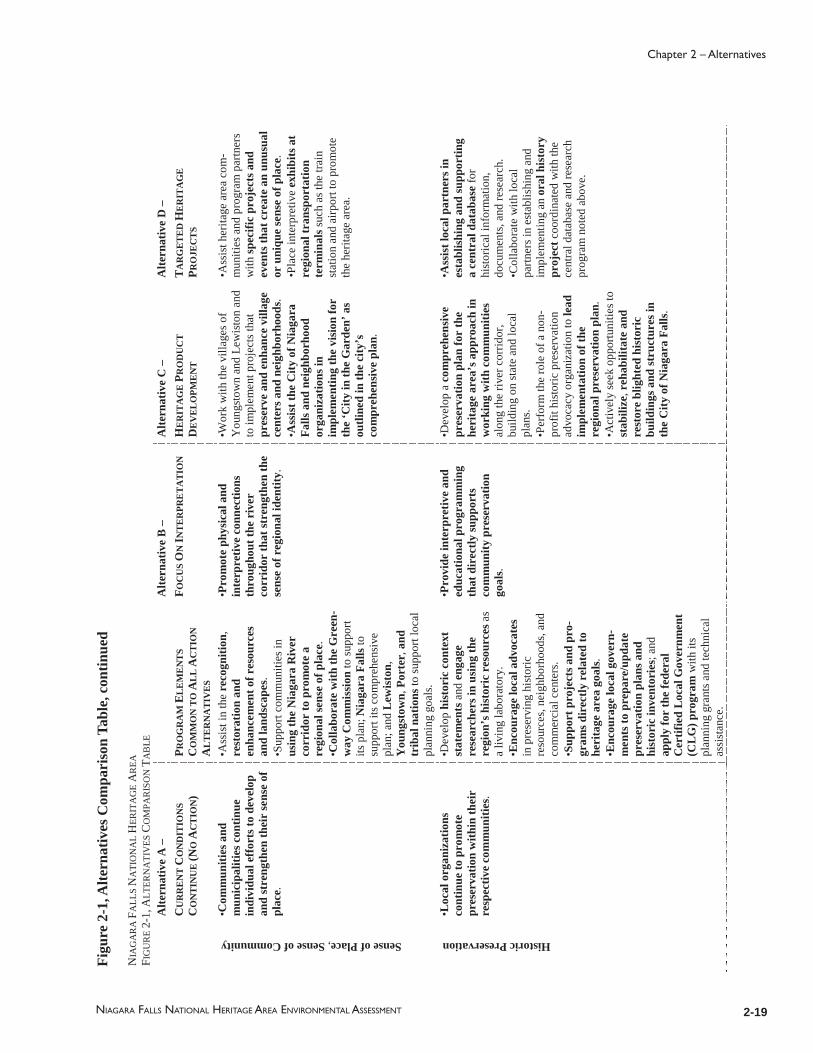
2-19
Chapter 2 – Alternatives
NIAGARA FALLS NATIONAL HERITAGE AREA ENVIRONMENTAL ASSESSMENT
Figu
re 2
-1, A
ltern
ativ
es C
ompa
riso
n Ta
ble,
con
tinue
d
NIA
GA
RA
FA
LLS
NA
TIO
NA
L H
ERIT
AG
E A
REA
FIG
UR
E 2-
1,A
LTER
NA
TIV
ESC
OM
PAR
ISO
N T
AB
LE
Alte
rnat
ive
A –
Alte
rnat
ive
B –
Alte
rnat
ive
C –
Alte
rnat
ive
D –
CU
RR
EN
T C
ON
DIT
ION
S C
ON
TIN
UE
(NO
AC
TIO
N)
P RO
GR
AM
EL
EM
EN
TS
CO
MM
ON
TO
AL
L A
CT
ION
A
LT
ER
NA
TIV
ES
FOC
US
ON
INT
ER
PRE
TA
TIO
NH
ER
ITA
GE
PR
OD
UC
T
DE
VE
LO
PME
NT
T
AR
GE
TE
D H
ER
ITA
GE
PR
OJE
CT
S
Sense of Place,Sense of Community
•Com
mun
ities
and
m
unic
ipal
ities
con
tinue
in
divi
dual
eff
orts
to d
evel
op
and
stre
ngth
en th
eir
sens
e of
pl
ace.
•Ass
ist i
n th
ere
cogn
ition
,re
stor
atio
nan
d en
hanc
emen
tof r
esou
rces
an
d la
ndsc
apes
.•S
uppo
rt co
mm
uniti
es in
us
ing
the
Nia
gara
Riv
er
corr
idor
to p
rom
ote
a re
gion
al se
nse
of p
lace
.•C
olla
bora
te w
ithth
e G
reen
-w
ay C
omm
issi
onto
supp
ort
its p
lan;
Nia
gara
Fal
lsto
su
ppor
t its
com
preh
ensi
ve
plan
; and
Lew
isto
n,Y
oung
stow
n,Po
rter
,and
tr
ibal
nat
ions
to su
ppor
t loc
al
plan
ning
goa
ls.
•Pro
mot
e ph
ysic
al a
nd
inte
rpre
tive
conn
ectio
ns
thro
ugho
ut th
e ri
ver
corr
idor
that
stre
ngth
en th
e se
nse
of r
egio
nal i
dent
ity.
•Wor
k w
ith th
e vi
llage
s of
You
ngst
own
and
Lew
isto
n an
d to
impl
emen
t pro
ject
s tha
t pr
eser
ve a
nd e
nhan
ce v
illag
e ce
nter
s and
nei
ghbo
rhoo
ds.
•Ass
ist t
he C
ity o
f Nia
gara
Fa
lls a
nd n
eigh
borh
ood
orga
niza
tions
inim
plem
entin
g th
e vi
sion
for
the
‘City
in th
e G
arde
n’ a
s ou
tline
d in
the
city
’s
com
preh
ensi
ve p
lan.
•Ass
ist h
erita
ge a
rea
com
-m
uniti
es a
nd p
rogr
am p
artn
ers
with
spec
ific
proj
ects
and
ev
ents
that
cre
ate
an u
nusu
al
or u
niqu
e se
nse
of p
lace
.•P
lace
inte
rpre
tive
exhi
bits
at
regi
onal
tran
spor
tatio
n te
rmin
alss
uch
as th
e tra
in
stat
ion
and
airp
ort t
o pr
omot
e th
e he
ritag
e ar
ea.
Historic Preservation
•Loc
al o
rgan
izat
ions
co
ntin
ue to
pro
mot
e pr
eser
vatio
n w
ithin
thei
r re
spec
tive
com
mun
ities
.
•Dev
elop
his
tori
c co
ntex
t st
atem
ents
and
enga
ge
rese
arch
ers i
n us
ing
the
regi
on’s
his
tori
c re
sour
cesa
s a
livin
g la
bora
tory
. •E
ncou
rage
loca
l adv
ocat
esin
pre
serv
ing
hist
oric
re
sour
ces,
neig
hbor
hood
s, an
d co
mm
erci
al c
ente
rs.
•Sup
port
pro
ject
s and
pro
-gr
ams d
irec
tly r
elat
edto
he
rita
ge a
rea
goal
s.•E
ncou
rage
loca
l gov
ern-
men
ts to
prep
are/
upda
te
pres
erva
tion
plan
sand
hi
stor
ic in
vent
orie
s;an
d ap
ply
for
the
fede
ral
Cer
tifie
d L
ocal
Gov
ernm
ent
(CL
G) p
rogr
amw
ith it
s pl
anni
ng g
rant
s and
tech
nica
l as
sist
ance
.
•Pro
vide
inte
rpre
tive
and
educ
atio
nal p
rogr
amm
ing
that
dir
ectly
supp
orts
co
mm
unity
pre
serv
atio
n go
als.
•Dev
elop
a c
ompr
ehen
sive
pr
eser
vatio
n pl
an fo
r th
e he
rita
ge a
rea’
s app
roac
h in
w
orki
ng w
ith c
omm
uniti
esal
ong
the
river
cor
ridor
, bu
ildin
g on
stat
e an
d lo
cal
plan
s.•P
erfo
rm th
e ro
le o
f a n
on-
prof
it hi
stor
ic p
rese
rvat
ion
advo
cacy
org
aniz
atio
n to
lead
im
plem
enta
tion
of th
e re
gion
al p
rese
rvat
ion
plan
.•A
ctiv
ely
seek
opp
ortu
nitie
s to
stab
ilize
,reh
abili
tate
and
re
stor
e bl
ight
ed h
isto
ric
build
ings
and
stru
ctur
es in
th
e C
ity o
f Nia
gara
Fal
ls.
•Ass
ist l
ocal
par
tner
s in
esta
blis
hing
and
supp
ortin
g a
cent
ral d
atab
ase
for
hist
oric
al in
form
atio
n,
docu
men
ts, a
nd re
sear
ch.
•Col
labo
rate
with
loca
l pa
rtner
s in
esta
blis
hing
and
im
plem
entin
g an
ora
l his
tory
pr
ojec
tcoo
rdin
ated
with
the
cent
ral d
atab
ase
and
rese
arch
pr
ogra
m n
oted
abo
ve.
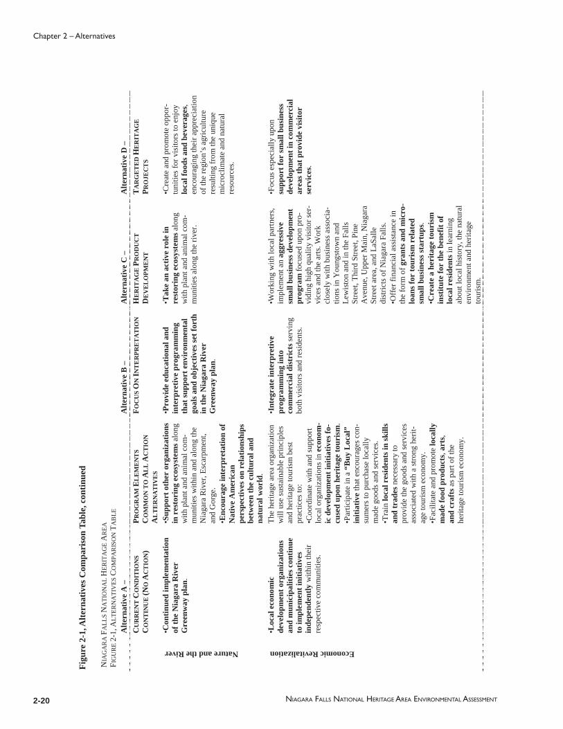
2-20 NIAGARA FALLS NATIONAL HERITAGE AREA ENVIRONMENTAL ASSESSMENT
Chapter 2 – Alternatives
NIA
GA
RA
FA
LLS
NA
TIO
NA
L H
ERIT
AG
E A
REA
FIG
UR
E 2-
1,A
LTER
NA
TIV
ESC
OM
PAR
ISO
N T
AB
LE
Alte
rnat
ive
A –
Alte
rnat
ive
B –
Alte
rnat
ive
C –
Alte
rnat
ive
D –
CU
RR
EN
T C
ON
DIT
ION
S C
ON
TIN
UE
(NO
AC
TIO
N)
P RO
GR
AM
EL
EM
EN
TS
CO
MM
ON
TO
AL
L A
CT
ION
A
LT
ER
NA
TIV
ES
FOC
US
ON
INT
ER
PRE
TA
TIO
NH
ER
ITA
GE
PR
OD
UC
T
DE
VE
LO
PME
NT
T
AR
GE
TE
D H
ER
ITA
GE
PR
OJE
CT
S
Nature and the River
•Con
tinue
d im
plem
enta
tion
of th
e N
iaga
ra R
iver
G
reen
way
pla
n.
•Sup
port
othe
r or
gani
zatio
ns
in r
esto
ring
eco
syst
emsa
long
w
ith p
lant
and
ani
mal
com
-m
uniti
es w
ithin
and
alo
ng th
e N
iaga
ra R
iver
, Esc
arpm
ent,
and
Gor
ge.
•Enc
oura
ge in
terp
reta
tion
ofN
ativ
e A
mer
ican
pe
rspe
ctiv
es o
n re
latio
nshi
ps
betw
een
the
cultu
ral a
nd
natu
ral w
orld
.
•Pro
vide
edu
catio
nal a
nd
inte
rpre
tive
prog
ram
min
g th
at su
ppor
t env
iron
men
tal
goal
s and
obj
ectiv
es se
tfor
th
in th
e N
iaga
ra R
iver
G
reen
way
pla
n.
•Tak
e an
act
ive
role
in
rest
orin
g ec
osys
tem
salo
ng
with
pla
nt a
nd a
nim
al c
om-
mun
ities
alo
ng th
e riv
er.
•Cre
ate
and
prom
ote
oppo
r-tu
nitie
s for
vis
itors
to e
njoy
lo
cal f
oods
and
bev
erag
es,
enco
urag
ing
thei
r app
reci
atio
n of
the
regi
on’s
agr
icul
ture
re
sulti
ng fr
om th
e un
ique
m
icro
clim
ate
and
natu
ral
reso
urce
s.
Economic Revitalization
•Loc
al e
cono
mic
de
velo
pmen
t org
aniz
atio
ns
and
mun
icip
aliti
es c
ontin
ue
to im
plem
ent i
nitia
tives
inde
pend
ently
with
in th
eir
resp
ectiv
e co
mm
uniti
es.
The
herit
age
area
org
aniz
atio
nw
ill u
se su
stai
nabl
e pr
inci
ples
an
d he
ritag
e to
uris
m b
est
prac
tices
to:
•Coo
rdin
ate
with
and
supp
ort
loca
l org
aniz
atio
ns in
eco
nom
-ic
dev
elop
men
t ini
tiativ
es fo
-cu
sed
upon
her
itage
tour
ism
.•P
artic
ipat
e in
a“B
uy L
ocal
” in
itiat
ive
that
enc
oura
ges c
on-
sum
ers t
o pu
rcha
se lo
cally
m
ade
good
s and
serv
ices
. •T
rain
loca
l res
iden
ts in
skill
s an
d tr
ades
nece
ssar
y to
pr
ovid
e th
e go
ods a
nd se
rvic
es
asso
ciat
ed w
ith a
stro
ng h
erit-
age
tour
ism
eco
nom
y.
•Fac
ilita
te a
nd p
rom
ote
loca
lly
mad
e fo
od p
rodu
cts,
arts
,an
d cr
afts
as p
art o
f the
he
ritag
e to
uris
m e
cono
my.
•Int
egra
te in
terp
retiv
e pr
ogra
mm
ing
into
co
mm
erci
al d
istr
icts
serv
ing
both
vis
itors
and
resi
dent
s.
•Wor
king
with
loca
l par
tner
s, im
plem
ent a
n ag
gres
sive
sm
all b
usin
ess d
evel
opm
ent
prog
ram
focu
sed
upon
pro
-vi
ding
hig
h qu
ality
vis
itor s
er-
vice
s and
the
arts
.Wor
k cl
osel
y w
ith b
usin
ess a
ssoc
ia-
tions
in Y
oung
stow
n an
d Le
wis
ton
and
in th
e Fa
lls
Stre
et, T
hird
Stre
et, P
ine
Ave
nue,
Upp
er M
ain,
Nia
gara
St
reet
are
a, a
nd L
aSal
le
dist
ricts
of N
iaga
ra F
alls
. •O
ffer
fina
ncia
l ass
ista
nce
in
the
form
of g
rant
s and
mic
ro-
loan
s for
tour
ism
rel
ated
sm
all b
usin
ess s
tart
ups.
•Cre
ate
a he
rita
ge to
uris
m
inst
itute
for
the
bene
fit o
f lo
cal r
esid
ents
in le
arni
ng
abou
t loc
al h
isto
ry, t
hena
tura
l en
viro
nmen
t and
her
itage
to
uris
m.
•Foc
us e
spec
ially
upo
n su
ppor
t for
smal
l bus
ines
s de
velo
pmen
t in
com
mer
cial
ar
eas t
hat p
rovi
de v
isito
r se
rvic
es.
Figu
re 2
-1, A
ltern
ativ
es C
ompa
riso
n Ta
ble,
con
tinue
d

2-21
Chapter 2 – Alternatives
NIAGARA FALLS NATIONAL HERITAGE AREA ENVIRONMENTAL ASSESSMENT
2.10 Environmentally Preferred Alternative
In accordance with the DO-12 Handbook, the NPS identifi es the environmentally preferable alternative in its NEPA documents for public review and comment [Sect. 4.5 E(9)]. The environmentally preferable alternative is the alternative that causes the least damage to the biological and physical environment and best protects, preserves, and enhances historical, cultural, and natural resources. The environmentally preferable alternative is identifi ed upon consideration and weighing by the Responsible Offi cial of long-term environmental impacts against short-term impacts in evaluating what is the best protection of these resources. In some situations, such as when different alternatives impact different resources to different degrees, there may be more than one environmentally preferable alternative (43 CFR 46.30).
Alternative C, Focus on Heritage Product Development, is the Environmentally Preferred Alternative among those alternatives considered for the Niagara Falls National Heritage Area. Alternative C would include signifi cant, direct efforts for the preservation and conservation of historic, cultural, and natural resources by the heritage area’s local coordinating entity. While the other alternatives considered also thoroughly support environmental goals and are environmentally friendly, Alternative C has the most aggressive and direct actions for implementing its programming, including those related to the preservation, protection, and enhancement of historic, cultural, and natural resources. Based upon this aggressive, direct level of activity in comparison to the other alternatives, Alternative C is the Environmentally Preferred Alternative.
2.11 Selection of the Preferred Alternative
At the meeting of the Commission on August 31, 2011, at Power Vista on the Niagara River Gorge, Alternative D: Focus on Visitor Experience was selected as the Preferred Alternative by a unanimous voice vote of the eleven commissioners present.
Alternative D provides a realistic and energetic approach that blends initiatives and approaches from both Alternatives B and C. In general, Alternative B, which focuses upon interpretation and works primarily through partners, was not thought to be strong enough and did not address some important issues related to the heritage area. Alternative C, on the other hand, was thought to be too ambitious, unrealistic in terms of its scope, and not attuned to the partnership potential within the heritage area.
Alternative D: Focus on Visitor Experience, emphasizes interpretation, visitor experience, and community engagement. Where existing groups can lead, the heritage area will play a facilitating role, aiming for a world-class interpretive experience. Where no leadership exists, the heritage area will be an active leader and deve loper, focused on developing a high-quality visitor experience. Alternative D was felt to be the way to initiate the Niagara Falls National Heritage Area mission and most effectively begin to share the role and signifi cance of Niagara Falls in American history as outlined in the heritage area’s enabling legislation.

2-22 NIAGARA FALLS NATIONAL HERITAGE AREA ENVIRONMENTAL ASSESSMENT
Chapter 2 – Alternatives

3-1NIAGARA FALLS NATIONAL HERITAGE AREA ENVIRONMENTAL ASSESSMENT
Chapter 3 – Affected Environment
Chapter 3 describes the existing conditions found within the Niagara Falls National Heritage Area as a basis for preparation of the heritage area’s management plan. This chapter also includes the affected environment information required under NEPA for the environmental assessment associated with the plan.
The Niagara River corridor is a complex landscape that has seen extensive human use and development over the past 300 years. The purposes and goals of the heritage area are intended to tell the stories of the region’s development and to help address issues related to the region’s future. The purpose of this chapter is to provide a broad overview of conditions that affect the planning and implementation of the heritage area. For this reason, the chapter goes beyond what is required for the environmental assessment. Chapter 3 provides the background which was the basis for development of alternatives for the heritage area, selection of a preferred alternative, and crafting of strategies and programs for implementation.
Chapter 3 is divided into fi ve broad categories that characterize the heritage area and its context:
Natural Resources and Landscapes – an overview of the environmental context of the heritage area including an outline of signifi cant natural resources remaining today;
Historic and Cultural Resources – a broad look at the historic and cultural resources present within the heritage area with a particular focus upon the historic development of the City of Niagara Falls and the river communities of Lewiston and Youngstown as well as relationships with Tribal Nations.
Socio-Economic Context – a description of the socio-economic conditions within the heritage area including demographics related to population, race and ethnicity, income, employment, and education.
Tourism and Visitor Experience– a discussion of regional tourism, and community issues related to the visitor experience in the City of Niagara Falls downtown; a description of the attractions, interpretive programs, visitor services, and wayfi nding systems.
Regional and Community Planning – an overview of the community planning organizations, initiatives, and plans that are in place both regionally and locally relating to the mission and objectives of the heritage area.
Chapter 3 provides an overview of the conditions observed and summarizes issues that have been identifi ed. It has been used to describe the broad range of resources and their signifi cance to the heritage area, understand the issues facing communities today,

3-2 NIAGARA FALLS NATIONAL HERITAGE AREA ENVIRONMENTAL ASSESSMENT
Chapter 3 – Affected Environment
identify organizations and initiatives addressing specifi c areas of interest, and identify sources of information as well as apparent gaps in existing information. In effect, two kinds of contexts are involved – the context that will have a signifi cant effect on the development of the heritage area, and the context that will be affected by the heritage area. These impacts may be positive or negative.
For the purposes of the management plan’s Environmental Assessment, the information outlined below (a) provided the background for the issues identifi ed through scoping and the impact topics identifi ed at the end of Chapter 1, Purpose and Need; (b) supported the development of alternatives outlined in Chapter 2, Alternatives; and (c) is used in the assessment of potential impacts in Chapter 4, Environmental Consequences.
The information summarized below has been gathered from documents, websites, consultations, and fi eld observation. This information has been critical in providing the Niagara Falls Heritage Area Commission, partners, and consultant team with a broad understanding of the issues and opportunities facing the heritage area. Following the selection of a preferred alternative for the heritage area and completion of the Environmental Assessment, the information on existing conditions was used to shape recommendations and actions for implementation of the preferred alternative.
3.1 Natural Resources and Landscapes
Niagara Falls and the Niagara Gorge form a breathtaking natural landscape that is world renown. The Niagara River from the Falls to Lake Ontario were well known by Native American peoples and have been a subject of broad international awareness since European explorers fi rst arrived in the region. Historically, the Falls have been known for their power and awe inspiring beauty, a symbol of the sublime. Over the past two centuries, however, the Falls, river, and surrounding landscape have been vastly altered and overwhelmed by human use. Nonetheless, the river’s landscape today retains vibrant ecosystems that are home to globally signifi cant plant communities, bird populations, fi sh species, and other wildlife.
In Thomas Hart Barton’s mural of Father Hennepin at Niagara Falls the mists rise to the edge of a rugged and heavily forested wilderness. [add photo of mural] This is the landscape known to the Native Americans for centuries and fi rst encountered by Hennepin and the rest of Robert de La Salle’s expedition during the late 1670s. It was a harsh and awe inspiring land traversed by waterways and, when the rapids of Niagara River made passage impossible, by an American Indian portage trail that led the explorers of 1679 over the Niagara escarpment and around the rapids.
The wilderness was tamed over the next two centuries with nations contesting control of the Niagara River and access to the interior of North American continent. Eventually, settlement moved westward, rail and ships moved people and goods, hydroelectric power transformed the nation, and chemical industries arose. Today, the ecosystems of the former wilderness are limited to a few isolated locations and to memory.
The New York Department of Environmental Conservation, the Natural Audubon Society, and others provide detailed information regarding the at-risk or fragile condition

3-3
Chapter 3 – Affected Environment
NIAGARA FALLS NATIONAL HERITAGE AREA ENVIRONMENTAL ASSESSMENT
of natural communities as well as the healthy ecosystems of the heritage area. The re-licensing process leading up to the 2007 approval of the Niagara Power Project produced several studies that summarize the condition of natural resources within the area. Additional studies are being spearheaded by several nonprofi t partners with Greenway funding available as a result of the re-licensing. This information will be useful to the heritage area partners as they work to achieve the natural resource goals of the management plan and the heritage area’s authorizing legislation.
3.1.1 The Niagara Gorge and Escarpment, Unique Ecosystem (EA Impact Topic)
The Niagara Escarpment is an extensive landform visible as a line of steep slopes and long bluffs extending from New York State through Ontario, Michigan, Wisconsin, and Illinois. Niagara Escarpment is the edge of a thick series of dolomite layers of Silurian age. It formed 450 million years ago from layers of sand, silt, and clay that compressed into thick sedimentary rock and reef structures. The caprock or surface layer of sedimentary rock of the escarpment was dolostone and covered layers of softer or more easily eroded shale. Over time the different layers of rock eroded at different rates and created natural cliffs, including Niagara Falls (NPS 2005:24).
The landform of the Niagara Escarpment is known as a cuesta, where a gently-sloping layer of rock forms a ridge. One side of the ridge has a long gentle slope, the dip slope that is essentially the surface of the rock layer. The other side is a steep bluff, the exposed edge of the formation. The Niagara Escarpment owes its prominence to both the resistance of the Silurian dolomite layers and the relative softness of the Ordovician and Devonian rocks on either side. Within the heritage area, the northern edge of the Niagara Escarpment is the steep bluff that overlooks Lewiston toward Lake Ontario. The dip slope is the gently sloping surface south of the bluff on which the City of Niagara Falls is located.
The Niagara Gorge is the channel cut through the escarpment by the Niagara River over time, and Niagara Falls is the present location of that erosive action. The Niagara Falls and Gorge may be the best known landscape features of the Niagara Escarpment. Other prominent features of the escarpment include waterfalls on the Genesee River in Rochester and the spine of several islands in northern Lake Huron.
Over 12,000 years ago, near the end of the Wisconsin glaciation, the last time in which glaciers advanced in North America, warming temperatures released water from Lake Erie that fl owed downstream and over the escarpment. This formed the Niagara River and Falls. Originally, the Falls were located 10 miles north of its current location, plunging water almost directly into Lake Ontario. The face of the Falls has retreated southward as the differential erosion of rock layers continued. Over the course of thousands of years, the swift moving river wore through the underlying rock and formed the 7.1-mile-long Niagara Gorge seen today. From the mouth of the Gorge at the steep edge of the escarpment, the Niagara River fl ows north another six miles before reaching Lake Ontario. The diversion of water from the Niagara River for hydroelectric purposes since the early 1900s has slowed the erosion process (NPS 2005:24).
3-4 NIAGARA FALLS NATIONAL HERITAGE AREA ENVIRONMENTAL ASSESSMENT
Chapter 3 – Affected Environment
The Niagara Gorge has been identifi ed as a particularly signifi cant location retaining specifi c rare and endangered species and plant communities. Comprehensive and detailed studies were made of the vegetation along the Gorge and in the vicinity of the Falls between 1986 and 2004 by Patricia M. Eckel, a research scientist at the Missouri Botanical Gardens who studied at the University at Buffalo. She reviewed over 25,000 plant specimens collected over the last two centuries and conducted fi eld work to document current plant species within the Gorge and adjacent to the Falls, particularly on Goat Island. In addition to Eckel’s work, rare plants within the four state parks of the Niagara Gorge (Niagara Falls, Whirlpool, Devil’s Hole, and Earl W. Brydges Artpark State Parks) were documented and summarized by the Natural Heritage Program in 2000. The Natural Heritage Program continues to update its rare plant records and publish its information annually online (TRC Engineering 2008). (Citation: TRC Engineering. LLC and Riveredge Associates, LLC, Feasibility Study for the Restoration of Native Terrestrial Plants in the Vicinity of the Niagara Gorge, New York Power Authority, 2008)
A series of studies prepared in conjunction with the Niagara Power Project re-licensing summarize available information about plant communities in the vicinity of the Niagara Gorge. The Final Environmental Impact Statement for the project, completed in December 2006, and related studies outline the range of water, aquatic, and terrestrial resources along with anticipated environmental effects and proposed mitigation measures related to the power project.
The Feasibility Study for the Restoration of Native Terrestrial Plants in the Vicinity of the Niagara Gorge, prepared in January 2008 as a mitigation measure, reviewed Eckel’s work in identifying and documenting rare plants. The purpose of the study was to assess the feasibility of large-scale and small-scale restoration of native plant communities. As documented by Eckel and confi rmed through fi eld observation, the native plant communities of the Gorge were found to have been signifi cantly altered with the loss of a number of rare species and the introduction of invasive aliens. Even the woodland at the base of the Gorge is replacement woods, regenerating after having been cleared for construction of the Gorge railway.
Signifi cant threats leading to the loss of rare species include human disturbance and the introduction of alien invasive species. Heavy recreational use over many years has led to trampling, compaction, and loss of the thin soil layers of the Gorge both on and off designated trails. Collecting over many decades by plant enthusiasts has contributed to the loss of species. Stormwater runoff and discharge from combined sewer overfl ows located in the Gorge have changed drainage patterns; introduced chemicals, petroleum products, and salts to the soils; and eroded soil layers. These conditions have resulted in changes in ecological conditions and modifi cations to plants species compositions. The study concluded that, while large-scale restoration of native plant communities is probably not feasible, small-scale restoration is not only feasible but would contribute signifi cantly to our ability to manage and preserve remaining species and communities (TRC Engineering 2008).

3-5
Chapter 3 – Affected Environment
NIAGARA FALLS NATIONAL HERITAGE AREA ENVIRONMENTAL ASSESSMENT
The Feasibility Study also documented and mapped plant communities and land use types in the vicinity of the Gorge using Natural Heritage Program criteria. The range of existing plant communities and land use types identifi ed included:
Calcareous Cliff CommunityCalcareous Talus Slope WoodlandCommercialLimestone WoodlandOak Hickory ForestOutdoor RecreationSuccessional Shrubland
Despite the degradation of its native plant communities, the vicinity of the Gorge and Falls remains exceptionally rich in rare plant species. The New York Natural Heritage Program states that “the combination of misting and wet seepage areas interspersed with dry open rock faces and calcareous bedrock produces one of the greatest assemblages of rare plants within New York State” (NPS 2005:24). The two most ecologically signifi cant natural plant communities identifi ed by the Natural Heritage Program along the Gorge are the Calcareous Cliff Community and Calcareous Talus Slope Woodland Community. A “signifi cant” determination within the Natural Heritage Program system means that these two natural communities have high ecological and conservation values.
The Calcareous Cliff Community consists of “sparsely vegetated limestone cliffs along the east rim of the Niagara Gorge from Niagara Falls downstream roughly 8,000 meters” (NYSDEC 2011). The cliff community lines the Gorge, provides habitat for rare cliff nesting birds and rare plants, and likely harbors some of the oldest trees in the state. Northern white cedar trees (Thuja occidentalis) 500 to 1000 years old have been located in cliff communities of the Niagara Escarpment.
The Calcareous Talus Slope Woodland Community is a steep slope woodland habitat, found below the Calcareous Cliff Community near the base of the gorge, which supports rare and common plant and animal species. It is of moderate size within the Niagara Gorge Whirlpool Woods at Whirlpool State Park. The New York Natural Heritage Program database notes that “as currently documented, the community extends the length of the Niagara Gorge from Niagara Falls downstream roughly 8000 meters to a large dam operated by the New York Power Authority” (NYSDEC 2011).
3.1.2 Topographic Features2
The Niagara Escarpment, running east-west across Niagara County, is the county’s single dramatic natural topographic feature. The escarpment is experienced as a 260-foot ridge crossing the heritage area just south of the Village of Lewiston with dramatic views northward toward Lake Ontario.
To the north and south of the escarpment are two nearly fl at plains separated by elevation but of similar topographic character. To the north is the Ontario Lake Plain, which is
2 Dismissed as an impact topic for the Environmental Assessment; provided as background information.
3-6 NIAGARA FALLS NATIONAL HERITAGE AREA ENVIRONMENTAL ASSESSMENT
Chapter 3 – Affected Environment
characterized by a gently rolling surface extending from the base of the escarpment to the bluffs of the Lake Ontario shoreline, which is 32 feet above sea level. To the south is the Huron Lake Plain, the dip slope, which extends from the high ridge of the escarpment and slopes gently in elevation towards the City of Niagara Falls’ southern shoreline on the Niagara River. This slope varies from 20 to 40 feet in elevation per mile and is barely noticeable. The level of Lake Erie is 326 feet higher than the level of Lake Ontario. Using the International Great Lakes Datum (IGLD), Lake Erie’s high water elevation is 573.4 feet and Lake Ontario’s high water elevation is 247.3 feet. The Niagara River runs for 35 miles between these two Great Lakes. The river fl ows from Lake Erie, divides at Grand Island and then Goat Island where it fl ows over the American Falls and Canadian Horseshoe Falls, and then continues for 13 miles through the Niagara Gorge and across the plain to Lake Ontario (NPS 2005:23).
3.1.3 Geology and Geological Features3
The Niagara Falls region lies upon bedrock, the outward crust of the earth’s surface, that extends several miles deep and is generally not visible at the ground level. The bedrock within the heritage area is primarily composed of sedimentary rock layers known as Queenston shale, DeCew dolostone, Guelph dolostone, and Lockport dolomitic limestone. Although the bedrock is covered in most places by soil, the dramatic landforms of Niagara County expose the rock in several places. Queenston shale forms the rugged exposed rock cliffs along the Niagara Gorge. The Niagara Escarpment has areas of exposed Lockport dolomitic limestone (CHA 2009: III-8).
Niagara County’s Niagara Communities Comprehensive Plan (2009) notes that the character of bedrock within the region can be a major consideration in development projects. “Depending on its stability, hardness and depth from the surface, bedrock could be a signifi cant constraint to development and quite costly to overcome” (CHA 2009:III-8).
The soils, sand, and gravel that cover the region’s bedrock are comparatively shallow. These accumulations are the result of water, ice, and wind eroding exposed bedrock over many centuries, the same forces moving the materials from place to place. The form and location of this layer were largely caused by glacial activity and are collectively known as glacial till. The last ice age in the region ended approximately 12,000 years ago. Receding glaciers radically changed the geography of the region and created a number of glacial till deposits, which occur in four types: (1) ground moraines (gently rolling hills or plains), (2) drumlins (an elongated whale-shaped hill), (3) elongated till ridges, and (4) terminal moraines (ridges) (CHA 2009:III-9). These glacial till deposits are visible on the landscape as gently rolling hills, mainly to the north of the escarpment, or plains, and ridges, located more to the south of the escarpment.
3 Dismissed as an impact topic for the Environmental Assessment; provided as background informa-tion

3-7
Chapter 3 – Affected Environment
NIAGARA FALLS NATIONAL HERITAGE AREA ENVIRONMENTAL ASSESSMENT
The glaciers also left behind three major glacial lakes: Lake Iroquois, Lake Lundy, and Lake Tonawanda. As these lakes shifted and disappeared over time, they left behind layers of silt and clay sediment which combines with glacial till to cover the bedrock and form the basis of local soils. (CHA 2009:III-9).
Soils evolve from the crumbling of the different bedrock types beneath the surface, as well as from the glacial lake sediments deposited during the last ice age. For example, within Niagara County, erosion from the bedrock Queenston shale formation created Lairdsville and Lockport soils, while Brockport soils are the product of the bedrock Rochester shale. The ancient glacial lakes left sediments of varying color and composition (CHA 2009:III-8,9).
The soils within the heritage area’s boundaries primarily include lacustrine silt and clay or glacial till of variable texture (boulders to silt; “lacustrine” means deposited in a lake environment in geologic time). The northern neck of the heritage area from the Village of Lewiston to Fort Niagara as well as the southeast corner of the City of Niagara Falls sit atop silt and clay, which have almost no farming value due to poor the drainage conditions they create.
The remainder of the City of Niagara Falls up to the ridge of the escarpment and southern boundary of the Village of Lewiston have sand-rich glacial till. This till covers 33% of Niagara County and has historically supported dairy farming. There is an area of lacustrine sand just west of the Village of Youngstown and a pocket of lacustrine beach within the Village of Lewiston, which are good soils for growing fruits and vegetables. A stretch of bedrock either exposed or close to the surface lies atop the escarpment just south and west of the Village of Lewiston (CHA 2009:III 9-12).
3.1.4 Prime and Unique Agricultural Land4
Agricultural lands were mapped for all of Niagara County as part of its 2009 comprehensive plan. The results show only a small amount of farmland located within the boundaries of the heritage area, located outside the Village of Youngstown. Good farmland supporting orchards, vineyards, and dairy farms is located to the east of the heritage area in the Towns of Porter and Lewiston and other areas of the county. Niagara County ranks high in the state overall in the total value of agricultural products sold and for fruit production in particular (CHA 2009:III 16-17).
Prime Agricultural Land is one of several designations made by the U.S. Department of Agriculture to identify important farmlands in the United States that contribute to the nation’s short- and long-range needs. This type of farmland has the best physical and chemical characteristics for the production of food, feed, fi ber, forage, or oilseed. Characteristics include an adequate and dependable water supply from precipitation or irrigation, a favorable temperature and growing season, an acceptable level of acidity or alkalinity, an acceptable content of salt or sodium, and few or no rocks. While there are soils designated as prime farmlands in the study area, the actions assessed in this
4 Dismissed as an impact topic for the Environmental Assessment; provided as background information.

3-8 NIAGARA FALLS NATIONAL HERITAGE AREA ENVIRONMENTAL ASSESSMENT
Chapter 3 – Affected Environment
document would not result in an irretrievable loss of these characteristics, therefore, the impact topic of Prime and Unique Agricultural Land was dismissed.
3.1.5 Hydrology5
The Niagara River is 35 miles long and runs north/northwesterly from Lake Erie to Lake Ontario. The river is the primary drainage for the four upper Great Lakes (Superior, Michigan, Huron, and Erie), and forms the boundary between the United States on the east and Canada on the west. The Niagara River fl ows from Lake Erie over the Niagara Escarpment, where centuries of water fl ow have carved out the Niagara Gorge. Rocky banks surround a relatively narrow and volatile riverbed. The upper section of the river, above Niagara Falls, is 22.5 miles long and fl ows through rapids as it approaches the Falls. [photo of the river]
Niagara Falls itself is divided into three sections: the American Falls, the Bridal Veil Falls, and the Horseshoe Falls. These Falls have a vertical drop of 70 to 110 feet, 181 feet, and 174 feet respectively. The American Falls, a wide cascade with an uneven edge, lies between Prospect Point and the tiny Luna Island. The Bridal Veil Falls is a small cascade from the narrow channel between Luna Island and the larger Goat Island. Both Luna Island and Goat Island are in the United States. The semicircular Horseshoe Falls are the largest and most spectacular sector of the falls and lie between Goat Island and the Canadian side of the Niagara River.
Below Niagara Falls, the river fl ows through the narrow, treacherous Niagara Gorge to the edge of the Niagara Escarpment at Lewiston. The Gorge is characterized by steep austere cliff walls above wooded slopes that stand over 200 feet above the river, which cascades through churning whirlpools and rapids. Beyond the escarpment, the river valley widens and the water calms on approach to Lake Ontario. Recreational boating is popular in the navigable lowermost portion of the river.
3.1.6 Climate6
The heritage area has a temperate clime relative to its location in the northeastern United States, which is in part due to its location adjacent Lakes Erie and Ontario and overall within the Great Lakes region. Average temperatures range from 31 degrees in the winter to 82 degrees in the summer. The lakes help moderate seasonal temperatures as water absorbs heat and cools the air in the summer and retains that heat into the fall. Known as “Lake Effect”, the manner in which Lake Ontario moderates weather within Niagara County is conducive to growing fruit and helps create the successful fruit orchards and vineyards found in the central and eastern portions of the county. The Lake Effect also helps produce heavy snowfall during winter months. Western winds pick up the warmer air and moisture of the lake and as they pass over the colder land surface create heavy snows for the region.
5 Dismissed as an impact topic for the Environmental Assessment; provided as background information. 6 Dismissed as an impact topic for the Environmental Assessment; provided as background informa-tion

3-9
Chapter 3 – Affected Environment
NIAGARA FALLS NATIONAL HERITAGE AREA ENVIRONMENTAL ASSESSMENT
3.1.7 Vegetation/ Endangered and Threatened Plant Species (EA Impact Topic)
Broadly speaking, northwestern New York is part of the Eastern Deciduous Forest of the United States, a complex of forest communities that extends from the southern states north into New England. The northernmost of these deciduous forest communities is the Northern Hardwood Forest, which covers much of New England and extends southwest to the Niagara River and eastern tip of Lake Erie. Broad-leaved deciduous trees are the dominant plant species of the Eastern Deciduous Forest, and Yellow Birch, Sugar Maple and American Beech are the dominant species of the Northern Hardwood Forest. Two conifers, Eastern Hemlock and White Pine often grow abundantly among the broad-leaved species, Eastern Hemlock in moist areas and on north-facing slopes and White Pine on exposed and/or disturbed sites (Kricher 1988:49),
In New York, ecologists have divided the state into various ecological zones according to the landscape’s physical characteristics and the habitats they support. The ecological zone encompassing northwestern New York in the vicinity of Lake Erie and Lake Ontario has been identifi ed as the Great Lakes Plain.
Extending from the Niagara River on the west to vicinity of Rome on the east, the Great Lakes Plain is essentially a fl at plain of horizontal rock formations with little local relief. The plain has a simple erosional topography of glacial till, modifi ed by moraines, shoreline deposits, and drumlins. Its natural vegetation is comprised primarily of elm-red maple-northern hardwoods, with beech, white ash, basswood, sugar maple, hickory, hemlock, and tulip tree predominating on better drained sites. Because of its topography, soils, and climate, the region has been largely cleared for farms and orchards. Only about one-fi fth of the land remains forested, mainly in a disrupted pattern related to soil conditions and drainage patterns. As noted above, the climate here is equitable, modifi ed by Lakes Erie and Ontario (Dickinson 1979 and Andrle 1988: 45).
In the late 1600s when European explorers fi rst explored the Niagara region then occupied by the Seneca of the Haudenosaunee, the area appears to have been largely forested. It can be surmised that the forest was largely composed of the natural vegetation ascribed today to the Great Lakes Plain ecoregion.
Human activity has drastically altered the landscape in the vicinity of the Niagara River over the past 250 years and with it the nature and extent of the vegetation that occurs here. Today, only small, isolated remnants of the region’s pre-settlement plant communities remain. Almost all locations within the heritage area where natural vegetation has been allowed to grow are re-emergent secondary plant communities. While these plant communities may retain many of the characteristics of the pre-settlement ecology, the introduction of a variety of alien invasive species over the decades has affected the local species composition of this successional and secondary vegetative growth.
The National Audubon Society, who oversees an initiative to protect the Niagara River habitat for globally signifi cant bird populations, notes that much of the forest and shrub habitat along the river corridor has been removed for “industrial development, power generation, commercial, and residential uses” and that more clearing will negatively impact the availability of habitat for migratory songbirds (NAS 2011). This is particularly

3-10 NIAGARA FALLS NATIONAL HERITAGE AREA ENVIRONMENTAL ASSESSMENT
Chapter 3 – Affected Environment
true within the City of Niagara Falls. Most of the forest habitat that remains within the heritage area south of the Niagara Escarpment is located in the state parks along the edge of the Niagara Gorge. The particular signifi cance of the plant communities found in the vicinity of the Gorge is discussed below. North of the Escarpment, between Lewiston and Fort Niagara, much of the land area along the Niagara River within the heritage area is successional woodland and provides excellent habitat. This area is predominantly residential but is not heavily developed. It has not been cleared for cultivation because of its silt and clay soils and resulting poor drainage.
Bruce S. Kirshner was a forest ecologist, environmentalist, and authority in old growth forests. He lived in Buffalo and authored a number of ecological studies and books, including co-authoring the Sierra Club Guide to Ancient Forests of the Northeast (2004) and National Wildlife Field Guide to Tree of North America (2008). Kirshner studied the vegetation along the Niagara River corridor and produced two hand-drawn maps documenting old-growth forest sites. The fi rst map, titled Bi-National Niagara Corridor of Forest Antiquity, documents the locations of eight old-growth forest sites on the New York side of the river and seventeen sites on the Ontario side. The second map, titled Ancient White Cedars of the Niagara Gorge, documents the locations and numbers of ancient white cedars along the Gorge. Both maps and his writings on the subject provide a basis for further study, documentation, and conservation initiatives.
New York State’s Department of Environmental Conservation in partnership with The Nature Conservancy has developed the New York Natural Heritage Program to facilitate the conservation of rare plants, animal, and natural communities within the state. Initiated in 1985, the Natural Heritage Program maintains the state’s most comprehensive database of rare and endangered species. In 1990, the Natural Heritage Program published the study Ecological Communities of New York State, by Carol Reschke, which is an extensive description of the types of plant communities found within the state. Updated in 2002, this study is used by biologists and plant scientists to identify plant communities in the fi eld. The Natural Heritage Program website includes guides with information on each type of plant community.
Threatened and Endangered Plant SpeciesThere are 14 state-listed threatened and endangered plant species identifi ed for the heritage area. Ten of these are known to exist within the heritage area. Four of these were last documented between 1833 and 1886 and may or may not continue to exist within the heritage area. lists the threatened and endangered plant species for the heritage area.7 Additionally, there are also 14 other rare plant species that no longer occur within the vicinity of the Niagara Gorge. This list can be found in the Feasibility Study for the Restoration of Native Terrestrial Plants in the Vicinity of the Niagara Gorge, 2008
7 Endangered native plants in New York are those species in danger of expiration throughout all or a signifi cant portion of their ranges within the state and requiring remedial action to prevent such extinction. Threatened native plants in New York are those species that are likely to become endangered within the foreseeable future throughout all or a signifi cant portion of their ranges in the state. SX is a state code for species that are apparently extirpated from the state, meaning that they are thought to no longer occur within New York State, and that have a very low probability of rediscovery.

3-11
Chapter 3 – Affected Environment
NIAGARA FALLS NATIONAL HERITAGE AREA ENVIRONMENTAL ASSESSMENT
(TRC 2008:3-4)8. There are no federal listings of threatened or endangered plants for the heritage area.9
The information about state listed threatened and endangered species was obtained from the NY Natural Heritage database in April 2011, which is managed by the NYS Department of Environmental Conservation, and from the 2008 NYPA study entitled Feasibility Study for the Restoration of Native Terrestrial Plants in the Vicinity of the Niagara Gorge. It is important to note that there are a few contradictions between the list of species provided by the state and the list of species established in the 2008 NYPA study and to describe how the fi nal list for the Niagara Falls National Heritage Area was determined.
The list of 14 threatened and endangered species present in the heritage area includes twelve from the NY Natural Heritage database and two additional species from the 2008 NYPA study.
The 2008 NYPA study included the Southern Bluefl ag (scientifi c name: Iris virginica var. shrevei), which is a NYS endangered plant species located just south of the City of Niagara Falls and outside the boundaries of the Niagara Falls National Heritage Area. However, no plants were included in the heritage area list of threatened and endangered species that were located outside its boundaries.
The 2008 NYPA study included the NYS endangered Ninebark (scientifi c name: Physocarpus opulifolius var. intermedius) species but its status has changed and as of 2010 it was no longer considered a threatened and endangered species. It is not included in the heritage area list of threatened and endangered species.
The 2008 NYPA study indicated that Puttyroot, Basil-balm, and Northern Pondweed are of the historical record and do not exist within the vicinity of the Niagara Gorge. The information from the NY Natural Heritage database indicated that these same three plant species are on the historic record, as they have not been documented since the 1800s, but that if appropriate habitat for these plants is present it is possible that they may still exist within the heritage area. They were thus retained in the list of 14 threatened and endangered plant species identifi ed for the heritage area.
The full report from the NYS Department of Environmental Conservation regarding state-listed rare species is provided in Appendix XX of this document in a letter dated April 15, 2011. The 2008 research is provided in the Feasibility Study for the Restoration of Native Terrestrial Plants in the Vicinity of the Niagara Gorge, which is available online at www.niagara.nypa.gov/ documents.htm. The federal listing of species for Niagara County can be accessed at www.fws.gov/northeast/nyfo/es/CountyLists/ NiagaraDec2006.htm.
8 The Feasibility Study for the Restoration of Native Terrestrial Plants in the Vicinity of the Niagara Gorge, 2008 is available online at www.niagara.nypa.gov/documents.htm. 9 The federal list of endangered and threatened species lists the Eastern Prairie Fringed Orchid (scientifi c name: Platanthera leucophea) for Niagara County, however, the NYS DEC NatureExplorer mapping program shows that it is located outside the boundaries of the Niagara Falls National Heritage Area.

3-12 NIAGARA FALLS NATIONAL HERITAGE AREA ENVIRONMENTAL ASSESSMENT
Chapter 3 – Affected Environment
Common Name Scientific Name NYS Status Location Source*
1 Elk Sedge Carex garberi Endangered Niagara Gorge Whirlpool Woods; Goat Island
NY NH Database and NYPA Study
2 Big Shellbark Hickory Carya iaciniosa Threatened Lewiston, Hickory Stick Woods
NY NH Database
3 Lesser Fringed Gentian Gentienoposis virgata
Endangered Niagara Gorge Whirlpool Woods; Goat Island; Lewiston
NY NH Database and NYPA Study
4 Slender Blazing-star Liatris cylindracea Endangered Niagara Gorge Whirlpool Woods
NY NH Database and NYPA Study
5 Four-flowered Loosestrife
Lysimachia quadriflora
Endangered Goat Island NY NH Database and NYPA Study
6 Ohio Goldenrod Oligoneuron ohloense
Threatened Lewiston Riverbank NY NH Database and NYPA Study
7 Smooth Cliff Brake Peliaea giabella ssp. Glabella
Threatened Niagara Gorge Whirlpool Woods
NY NH Database and NYPA Study
8 Sky-blue Aster Symphyotrichum oolentangiense
Endangered Niagara Gorge Whirlpool Woods
NY NH Database and NYPA Study
9 Woodland Bluegrass Poa sylvestris Endangered ------------ NYPA Study 10 Mountain Death
Camas Anticlea elegans ssp. glaucus1
Threatened City of Niagara Falls NYPA Study
11 Lesser Fringed Gentian Gentienoposis virgata
Endangered Lewiston NY NH Database
12 Puttyroot Aplectrum hyemale Endangered Whirlpool Woods NY NH Database 13 Basil-balm Monarda clinopodia Endangered Goat Island NY NH Database 14 Northern Pondweed Potamogeton alpines Threatened Niagara Falls NY NH Database
Table 3-1: List of Endangered or Threatened Species for the Heritage Area
*Source denotes the origin of the information and whether the species was listed in the 2011 New York State Department of Environmental Conservation, NY Natural Heritage Database (NY NH) database and / or the 2008 NYPA Study (Feasibility Study for the Restoration of Native Terrestrial Plants in the Vicinity of the Niagara Gorge, 2008), which was prepared under the relicensing agreement for the Niagara Power Project.
____________________
1 The scientifi c name for Mountain Death Camas changed from Zigadenus elegans ssp. glaucus in 2008 to Anticlea elegans ssp. glaucus in 2010 according to the New York Rare Plant Status Lists, June 2010 (Young 2010).
3.1.8 Important Wildlife (EA Impact Topic)
Wildlife that typically inhabits the heritage area includes many common species of small and large mammals and amphibians, and common and rare reptiles, fi sh, and birds. No wildlife in the heritage area is federally listed as endangered or threatened (www.fws.gov/northeast/nyfo/es/ CountyLists/NiagaraDec2006.htm). One turtle, several bird species, and a number species of fi sh are listed on the New York State list of Endangered, Threatened and Special Concern Fish and Wildlife Species as noted below.
Small mammals found within the heritage area include mice and voles, Eastern cottontail rabbit and grey squirrels, woodchucks, and bats. Larger mammals include the red fox,

3-13
Chapter 3 – Affected Environment
NIAGARA FALLS NATIONAL HERITAGE AREA ENVIRONMENTAL ASSESSMENT
coyote, skunk, muskrat, raccoon, and whitetail deer. Bullfrogs, the American toad, snapping turtle, and garter snake are common reptiles and amphibians found in the heritage area (NPS 2005:25). Blanding’s Turtle is listed by the state as a threatened species, which means that it is a native species likely to become endangered in the not too distant future in New York State (NYSDEC ESU 2011). Endangered and threatened birds and aquatic life are discussed below.
With regard to birds in the heritage area and vicinity, the Peregrine Falcon is a state-listed endangered species and the Least Bittern and Common Tern are state-listed threatened species found within the heritage area. The federal government removed the Bald Eagle, which is present in the heritage area for portions of the year, from the U.S. Department of Interior’s Endangered Species List in August 2007 (www.fws.gov/northeast/nyfo/es/CountyLists/NiagaraDec2006.htm).
The Niagara River corridor is designated as a globally signifi cant Important Bird Area, overseen by Birdlife International and its Canadian and United States partners – the Canadian Nature Federation and the National Audubon Society. The Important Bird Area program works around the world to conserve habitats vital to birds to thereby sustain bird populations and other biodiversity threatened by global warming, habitat fragmentation, and the loss of habitat. The Niagara River corridor extends over 32 miles from Lake Erie to Lake Ontario, the lower portion of which is within the heritage area.
The Niagara River is a migratory stopover and wintering site for a variety of gulls and waterfowl. It supports breeding colonies of herons, egrets, terns and other species, and the river’s edge is a habitat for migrating songbirds during the spring and fall. The Important Bird Area site profi le for the Niagara River corridor reports world-wide signifi cant concentrations of gulls and a “remarkable diversity and abundance of waterfowl” (NAS 2011). One-day counts for Bonaparte’s Gulls and Herring Gulls rise as high as 50,000, and one-day counts for the Ring-billed Gull range from 10,000 to 20,000. Bonaparte’s Gulls landing on the river represent as much as 10% of the bird’s world-wide population. Waterfowl include state-wide signifi cant numbers of Canvasbacks, Greater Scaup, Common Goldeneyes, and Common Mergansers (NAS 2011).
Joseph Davis State Park, one of seven state parks located in the heritage area, is a state designated Bird Conservation Area. The Bird Conservation Area program began in 1997 and is modeled on the Important Bird Area program, which began in 1996. A Bird Conservation Area is intended to protect and enhance bird populations and their habitats on state land and water. Northern Harrier, Horned Lark, and Savannah Sparrow are a few types of birds found at the park. Threatened species at home in these state lands located adjacent to the Niagara River include Pied-billed Grebe, Bald Eagle, Northern Harrier, and Common Tern. Other state listed species include the following species of special concern: Osprey, Sharp-shinned Hawk, Cooper’s Hawk, Common Nighthawk, Whip-Poor-Will, Horned Lark and Yellow-Breasted Chat (NYSDEC BCA 2011).
The varied and nearly year around availability of fi sh in the Niagara River attracts recreational and sport fi shing enthusiasts. Ninety-two fi sh species have been found in the river, including Bass, Perch, Catfi sh, Carp, and Salmon (WD 2007:136).
3-14 NIAGARA FALLS NATIONAL HERITAGE AREA ENVIRONMENTAL ASSESSMENT
Chapter 3 – Affected Environment
Niagara Falls creates a physical barrier to aquatic life moving along the river creating two separate aquatic habitats. Cold water species such as Salmon and Trout are found to be more abundant in the Lower Niagara River, below the Falls, than in the Upper Niagara River. Cool and warm water species such as Walleye and Bass are found in larger quantities in the Upper Niagara River. The cool and warm water species of the Upper Niagara River are self-sustaining, while the cold water species below the Falls are largely supported by a New York State program that stocks a variety of fi sh, including Trout, Salmon, and Steelhead in the Lower Niagara River and adjacent Lake Ontario (WD 2007:136).
There are several fi sh on the state’s list of endangered and threatened species that are found in the Niagara River. The Silver Chub is endangered, the Lake Sturgeon and Mooneye are categorized as threatened, and the Black Redhorse Sucker and Redfi n Shiner are species of special concern. Non-native species of mussels (Zebra and Quagga Mussels) may be responsible for the low number of native mussels, such as Hickorynut and Rainbow Mussels, present in the river (WD 2007:137). Hickorynut Freshwater Mussels existed in small numbers near Buckhorn Island and Goat Island in the Niagara River in the early 1990s before the mid-1990s Zebra Mussel outbreak, and it appears that the Hickorynut were killed by the Zebra Mussels (NYSDEC 2011).
There are two Signifi cant Coastal Fish and Wildlife Habitats (SCFWH) within and adjacent to the heritage area. They are part of the NYS Coastal Management Program, which is administered by the NYS Department of State. The state uses SCFWH designation to protect coastal habitats from harmful uses or development. The Department of State reviews proposed land and water use and developments for compliance with the Coastal Management Program when they may potentially impact habitats with the SCFWH designation. The two SCFWH sites are the Buckhorn Island and Goat Island Rapids immediately above the Falls and the Lower Niagara River Rapids immediately below.[Map 7: Signifi cant Coastal Fish and Wildlife Habitats]
The Buckhorn Island and Goat Island Rapids is an 850-acre fi sh and wildlife habitat located on the Upper Niagara River just south of the City of Niagara Falls between the Goat Island bridge/Three Sisters Islands area and the Buckhorn Island water diversion structures.
The Lower Niagara River Rapids is a 4.5 mile segment of the Niagara River channel below the Falls in the Niagara Gorge. The deep and fast moving waters of the rapids provide habitat for one of the largest concentrations of steelhead in the state as well as for one of the state’s largest winter concentration of gulls. It also supports a variety of other fi sh, including Coho Salmon, Chinook Salmon, and Brown Trout, and commonly occurring wildlife such as Blue Jays, the Downy Woodpecker, a variety of diving ducks, Eastern Cottontail, and raccoons (WD 2007:141).
3.2 Niagara’s Historic and Cultural Resources
In addition to the natural wonders of Niagara Falls and Gorge, the heritage area presents opportunities to visit incredible buildings (18th century Fort Niagara), beautifully designed landscapes (1.5 acre Great Lakes Region fl oral garden at Niagara Falls State

3-15
Chapter 3 – Affected Environment
NIAGARA FALLS NATIONAL HERITAGE AREA ENVIRONMENTAL ASSESSMENT
Park), an ancient Native American burial mound (Lewiston Mound at Artpark State Park) and engineering marvels (power plant structures at the Gorge). The man-made landscape of the City and river communities is also a cultural experience in itself. On a regional scale, the bridges and boat landings of the heritage area are a portal to the lands and waters beyond the United States border – Canada and Lake Ontario – and provide the experience of being in a global, international community.
From another perspective, though suburban development has fi lled in some stretches of open land between the jurisdictions, visitors and residents still experience the space between and historic boundaries of the City and Villages of Lewiston and Youngstown. At the block level, pedestrians absorb the contrasts between the dense urban City center, the bustling Village of Lewiston, and the small and charming Village of Youngstown. The City of Niagara Falls has intact, walkable architecturally interesting urban neighborhoods and the Villages each have their own unique pedestrian-friendly, more modestly scaled, and historic character. Certainly there are challenges to be faced in each community of the heritage area, however historic structures and a varied and intriguing landscape is present, can be experienced today, and will be strengthened over time.
Criteria and CategoriesThe legislation authorizing federal recognition of the Niagara Falls National Heritage Area uses the following criteria to identify cultural resources:
Resources are those related to the “national importance” demonstrated in the Niagara National Heritage Area Study, dated 2005 (USC PL 110-229, Subtitle B, Section 421(1)). The study proposes four themes or stories to encompass and convey the national importance of the heritage area. These themes are briefl y described below and discussed in more detail in the management plan’s Chapter 2, Niagara’s Interpretive Presentation:
Natural Phenomenon – the Niagara Escarpment, Niagara Falls and Niagara - River Gorge and Rapids;
Tourism and Recreation – Niagara Falls as tourist destination and - development of tourism and nature conservation in America;
Power and Industry – Development of hydroelectric power and heavy - industry at Niagara Falls and Buffalo;
Borderland / Border Crossing – Niagara River – an international boundary; - role in: Indian culture, colonial struggle to control North America, the American Revolution, War of 1812, and the Underground Railroad; and as a refl ection of similarities and differences between United States and Canada (NPS 2005:35-44).
Natural, scenic, cultural, and historic resources located within the boundaries set in Map 3.XX;
Resources located beyond the mapped heritage area boundaries that are thematically related to the heritage area, located within Niagara and Erie counties, and identifi ed in the National Heritage Area’s Management Plan (USC PL 100-229:Section 421 & 423).

3-16 NIAGARA FALLS NATIONAL HERITAGE AREA ENVIRONMENTAL ASSESSMENT
Chapter 3 – Affected Environment
The scope of history which the authorizing legislation recognizes is very broad, ranging from the prehistoric origin of the Falls to construction of the Robert Moses Niagara Power Plant in the mid 20th century to the modern day border relationship between the United States and Canada, and this essentially suggests that most if not all of the historic buildings, communities, and landscapes located within the heritage area boundaries are heritage area resources. Indeed, there are many properties, districts, monuments, historic transportation routes, cultural landscapes, and archeological areas that are designated or recognized as historic or culturally signifi cant at the local, state and national level that are located within the heritage area. There are also signifi cant sites that do not hold specifi c historic designations but may be deserving of such recognition. Designated resources and potential resources located within the heritage and thematically related resources located beyond the heritage area fall into the following categories:
Historic Properties and DistrictsState and Municipal ParksState Heritage AreaNative American ResourcesArcheological ResourcesToursEducationInterpretive Facilities and Collections
Below, cultural resources located within the heritage area are generally discussed before those thematically related cultural resources located beyond the heritage area. Interpretive facilities, collections, research, and education are discussed on a regional basis.
3.2.1 Historic Properties and Districts (EA Impact Topic)
The National Register of Historic Places, maintained by the National Park Service, is the offi cial list of historic places for the United States. The National Historic Landmarks program, also managed by the National Park Service, recognizes historic properties that have signifi cance to all Americans. Across the country, there are more than 85,000 National Register listings of historic places and fewer than 2,500 National Historic Landmarks. States also have their own lists of historic places, which generally include the properties listed on the National Register of Historic Places. In the heritage area there are 30 New York State and National Register properties and districts, as shown in Map 3. There are three National Historic Landmarks – the Adams Power Transformer Building, Niagara Falls State Park, and the Colonial Niagara Historic District.
As of September 2011, there were two National Register nominations in the works. Under the Federal Energy Regulatory Commission’s relicensing of the New York Power Authority (NYPA) operation of the Niagara Power Project, NYPA is preparing a National Register nomination for the former Schoellkopf Project, which is now a ruin, and one for the Robert Moses Niagara Project. Other nominations may result from the work being conducted by NYPA under their 2009 Historic Properties Management Plan for the Niagara Power Project.

3-17
Chapter 3 – Affected Environment
NIAGARA FALLS NATIONAL HERITAGE AREA ENVIRONMENTAL ASSESSMENT
Resource Name City Multiple Names
Frontier House Lewiston Lewiston Mound Lewiston Lower Landing Archeological District Lewiston Adams Power Plant Transformer House Niagara Falls Chilton Avenue-Orchard Parkway Historic District Niagara Falls Deveaux School Historic District Niagara Falls First Unitarian Universalist Church of Niagara Niagara Falls Former Niagara Falls High School Niagara Falls Hazard Sheldon House Niagara Falls Holley-Rankine House Niagara Falls Holy Trinity Roman Catholic Church Complex Niagara Falls Jefferson Apartment Building Niagara Falls Marshall, James G., House Niagara Falls
Niagara Falls Armory Niagara Falls Army National Guard Armories in New York State MPS
Niagara Falls City Hall Niagara Falls Niagara Falls Public Library Niagara Falls Niagara Reservation Niagara Falls Niagara Hotel, The Niagara Falls Park Place Historic District Niagara Falls St. Mary's Nurses' Residence Niagara Falls Town of Niagara District School No. 2 Niagara Falls U.S. Customhouse Niagara Falls United Office Building Niagara Falls
US Post Office – Niagara Falls Main Niagara Falls US Post Offices in New York State, 1858-1943, TR
Whitney Mansion Niagara Falls Williams, Johann, Farm Niagara Falls Carter, John, Farmstead Youngstown
Fort Niagara Light Youngstown U.S. Coast Guard Lighthouses and Light Stations on the Great Lakes TR
Old Fort Niagara – Colonial Niagara Historic District Youngstown
St. John's Episcopal Church Youngstown
Table 3-2: National Register Properties and Districts located in the National Heritage Area
Sources: National Register of Historic Places Database, and New York State, State Historic Preservation Offi ce, Geographic Information System for Archeology and National Register, obtained March 23, 2011.
3-18 NIAGARA FALLS NATIONAL HERITAGE AREA ENVIRONMENTAL ASSESSMENT
Chapter 3 – Affected Environment
Inventories of Historic PropertiesThe City of Niagara Falls and Village of Lewiston have inventories of historic resources. The properties included in these inventories are shown in Map 3 and listed in the appendices. The City’s current inventory, updated last in August 2008, includes 174 local, State, and National Register and National Register eligible properties. More properties will likely be added as the City pursues the phased Historic Preservation Resource Survey, which was recommended in its 2009 Comprehensive Plan. Within the Village of Lewiston, there are 89 locally designated historic properties and one National Register property.
The Village of Youngstown and the Town of Porter do not have an adopted inventory of local historic resources, though the Village references properties included on the National Register of Historic Places. The Town of Lewiston’s draft 2011 Comprehensive Plan Update recommends that the Town create an inventory of locally signifi cant buildings that could have a local designation or plaque that highlights their historic character (TL 2011:40). (Town of Lewiston historian, Mark Davis, 984-6157, is going to call me back and tell me if there is a current listing of locally designated historic properties.)
There are properties in the heritage area that are marked as part of the Niagara Historic Trail, though these designations do not necessarily correlate with inclusion on local, state or national registers of historic properties and districts. The trail was originally created in 1975 to celebrate the 1776 Bicentennial, updated in 1991, and in 2009 for the 200th anniversary of Niagara County. The most recent update of the self-guided tour book was prepared by the North Tonawanda History Museum in collaboration with municipal historians and historical organizations throughout the county. (Possibly include map of tour in heritage area in report.) (Get copy from North Tonawanda History Museum, 716-213-0554.)
City of Niagara FallsThe City of Niagara Falls has twenty properties on the State and National Register and three State and National Register historic districts, and these districts encompass the majority of the 174 properties included on the City’s list of local, State, and National Register properties. The City’s list of historic properties was last updated in August 2008. In November 2007, the City and the New York State Offi ce of Parks, Recreation and Historic Preservation completed the Historic Preservation Industrial Reconnaissance Survey, which includes tunnels, canals, offi ces, and manufacturing plants. This industrial survey identifi es the structures that remain from when Niagara Falls was one of the largest industrial centers in the world, and places them in three districts – the High Bank Industrial District, Buffalo Avenue Industrial District, and the Highland Avenue Industrial District. The City published a guide entitled Historic Walking Tour of Downtown Niagara Falls, which shows largely residential, civic, and commercial (not industrial) buildings, and also the Historic Walking Tour of the Niagara Reservation.Historic Development of the City
The City of Niagara Falls was originally known as Schlosser after Fort Schlosser, which was once a French outpost known as Little Niagara that was destroyed in 1759, later rebuilt and occupied by the British until 1796, and used by American forces during the War of 1812. The State of New York fi rst offered lands along the Niagara River for sale

3-19
Chapter 3 – Affected Environment
NIAGARA FALLS NATIONAL HERITAGE AREA ENVIRONMENTAL ASSESSMENT
in 1805, and Augustus Porter was the fi rst to purchase land and settle on the American side of the Falls. He built a saw mill and blacksmith shop in 1805. No buildings existed in the vicinity of the Falls prior to 1805. The area grew into a mill town, known as the Village of Manchester with a population of 550 by 1832. General Parkhurst Whitney was the fi rst president of the village when it was incorporated as the Niagara Falls in 1848. Whitney was the owner of the Cataract House, a well-known hotel whose guests through the years included Abraham Lincoln, Grover Cleveland, and Winston Churchill. In 1892, New York State combined the Village of Niagara Falls with the Suspension Bridge area (Village of Bellevue), a village that had grown on the American side of the fi rst suspension bridge, to form the City of Niagara Falls. The Sanborn-Perris Map Company produced an 1892 map of the newly minted City of Niagara Falls that records a population of 13,000 (Sanborn 1892). In the early 20th century a historian wrote that at the time of consolidation “in the middle distance, between the two villages…there were few houses. The old horse cars were just giving way to trolleys…” (Kowsky 2007:6). The Village of LaSalle was annexed by the City in 1927, which added 13 square miles and roughly 7,000 people.
By 1892, the Village of Niagara Falls had several small industries that relied upon water power from the Niagara River and had for decades been growing in popularity as a tourist destination. The 1892 Sanborn map shows the Cataract House Hotel and the International Hotel located just outside the present-day Niagara Falls State Park with a Cyclorama of the Battle of Gettysburg and Niagara Falls Museum found a block further west on River Road (Sanborn 1892). The Niagara Reservation, now known as the Niagara Falls State Park, replaced a private entertainment park and opened as a publicly owned park in 1885. The Suspension Bridge area grew in response to the rapid pace of trade between America and Canada, as serviced by the railroad bridge that crossed over the gorge (Kowsky 2007:6).
The City grew dramatically between 1892 and 1915 with a population increase of nearly 29,000 people. In 1881, the fi rst hydroelectric power was produced at Niagara Falls and fi fteen years later the fi rst commercial hydroelectric power was transmitted from Niagara Falls to the City of Buffalo (NPS 2005:103). Since “hydroelectric power was cheapest…when consumed close to its source of production,” new and larger industries in need of abundant power moved to Niagara Falls (Kowsky 2007:15). Companies such as the Aluminum Company of America, Union Carbide, and the Carborundum Company, which produced synthetic abrasives, were some of the fi rst large-scale manufacturers to locate in the City after the advancements in the production of hydroelectric power. The peak of Niagara Falls industry was reached in the mid 20th century (Kowsky 2007).
The City of Niagara Falls Industrial Reconnaissance Survey reveals that few structures remain from the globally signifi cant industrial past. “Vanished are the major monuments that defi ned the industrial era here: the Hydraulic Canal and railroad line that came through the heart of downtown; the historic Schoellkopf Station; most of the Adams Power Plant; the great shed-like buildings at High Bank basin; the pioneering Carborundum plant; the mammoth Shredded Wheat plant; and nearly all of the early industrial structures on the land leased from the Niagara Falls Power Company” (Kowsky 2007:32-33). The survey also provides an inventory of the industrial structures and sites that remain within the city and locates them in following three geographical areas:
3-20 NIAGARA FALLS NATIONAL HERITAGE AREA ENVIRONMENTAL ASSESSMENT
Chapter 3 – Affected Environment
High Bank Industrial District, which does not include buildings but does have a section of the hydraulic canal retaining wall from the Schoellkopf power plant;Buffalo Avenue Industrial District, which includes among others the former Shredded Wheat Company factory and elevator (816 Rainbow Boulevard), the 1912 Niagara Chocolate Company building (900 Buffalo Avenue), and the former transformer house of the Niagara Falls Power Company;Highland Avenue Industrial District, which includes but is not limited to part of the U.S. Light and Heat Corporation (3125 Highland Avenue), National Carbon Company factory complex (2001 College Avenue) and the 1919 Pittsburgh Metallurgical Company facility (College Avenue).
Several residential neighborhoods were constructed throughout the city during periods of growth. In 1893, the Niagara Falls Power Company built Echota for its employees. It was built as a model community on 84 acres just north of factories located along the Niagara River; north of Buffalo Avenue and between today’s Hyde Park Boulevard and Packard Road. Wealthy industrial executives built homes that remain today in the Rainbow Boulevard and Buffalo Avenue area located near and west of the Niagara Falls State Park and south of the Seneca Niagara Casino. The City has a large supply of houses built prior to World War II during economic and industrial expansion.
The interesting architectural fabric of these neighborhoods is challenged by the fact that many homes built as part of working class neighborhoods are bounded by heavy industrial sites or transportation corridors, and the economic decline experienced by the city in the latter half of the 20th century has led to a deteriorating housing stock (CNF 2009:9). The Park Place Historic District and the Chilton Avenue – Orchard Parkway Historic District each recognize the architectural and historical signifi cance of turn of the century homes and neighborhoods. These districts lie within walking distance of two of the city’s active commercial corridors – Pine Avenue and Third Street. Homes outside these two historic districts and also proximate to these walkable commercial corridors appear to have similar historic housing stock but with few visible repairs or restoration efforts.
The City’s 2009 Comprehensive Plan, a strategy and policy document for development of the City, was crafted in concert with on-going efforts to meet and overcome current economic and social challenges, which include: the decline of industry and manufacturing, high unemployment, a declining and aging population, competitive suburban growth and decline of the downtown, an oversupply of and deteriorating housing stock, weak market conditions, more infrastructure than it needs and can support, and contaminated land (brownfi eld sites). The City’s Comprehensive Plan recognizes that a sustained and focused strategy is needed to address the complex challenges facing the city. It recommends that revitalization strategies focus initially and primarily on the Core City, a planning district identifi ed in Map 4, and also provides Citywide Policies that build upon and complement the Core City Strategies. The Citywide Policies address “land use, historic resources, the built environment, environmental and open space resources, transportation, economic development and tourism, housing, brownfi eld/grayfi eld development and waterfront development” (CNF 2009:26).

3-21
Chapter 3 – Affected Environment
NIAGARA FALLS NATIONAL HERITAGE AREA ENVIRONMENTAL ASSESSMENT
The City’s 2009 Comprehensive Plan indicates that Niagara Falls has “extensive built heritage resources, neighborhoods and precincts” that are signifi cant to the cultural and architectural history of the city but are not, in large part, designated in any cultural resource capacity (CNF 2009:23). The City’s comprehensive plan recognizes that the preservation of historically and architecturally interesting buildings and districts can help create unique areas that appeal to residents and tourists alike, and thereby encourage economic revitalization. To this end the City’s plan supports survey work to identify signifi cant buildings and districts. It also recommends efforts such as establishing design and infi ll design guidelines that seek to enhance these structures and areas, designing zoning and building codes that support reuse of heritage structures, and making related streetscape improvements.
Historically Signifi cant Areas in the City of Niagara FallsThe Core City Planning District (Map 4) includes several areas that the City has noted as having buildings and structures worthy of preservation and neighborhood renewal efforts. These are Pine Avenue, old Buffalo Avenue, Main Street, Third Street, and Niagara Street (CNF 2009:22). The City’s Comprehensive Plan sometimes uses specifi c precincts to discuss these areas, and these are noted where applicable below. The City’s Historic Preservation Industrial Reconnaissance Survey has recommendations for preservation and reuse of signifi cant industrial structures and sites (see appendices). From preliminary fi eld visits and available data it appears that there is also additional housing stock (as yet unsurveyed) both within and outside the Core City Planning District that may be historically and architecturally signifi cant – namely early 20th century residential neighborhoods in the Core City Planning District and Echota in the western part of the city.
Pine Avenue, Main Street, Niagara Street, and Third Street Commercial Corridors - These corridors have long-standing, active businesses and gathering places. The City notes that “communities throughout North America have realized the potential of these corridors and places, and are investing in them as authentic places that offer a glimpse of historical development and an understanding of local culture and everyday city life” (CNF 2009:22). For instance, the Little Italy portion of Pine Avenue has early to mid-20th century commercial buildings that have a pleasing, densely built fabric. It has several interesting murals on buildings along Pine Avenue and neatly laid out blocks of residential buildings on either side of the commercial corridor. The City’s Comprehensive Plan celebrates and supports the conversion of old Niagara Falls High School into the Niagara Arts and Cultural Center, which is located along the Pine Avenue corridor (confi rm location). For Little Italy, one of the challenges is the presence of gaps along Pine Avenue caused by newer buildings setback from the street and with parking lots that front Pine Avenue.
Rainbow Boulevard/Buffalo Avenue Area (Buffalo Avenue Heritage District) - This area includes and is primarily defi ned by large historic homes (some now B&Bs) dating from the mid-1800s to the early 20th century of power company and industry executives and other community leaders, and also has historic churches, the 1928 United Offi ce Building, Niagara Hotel, an early 20th century apartment

3-22 NIAGARA FALLS NATIONAL HERITAGE AREA ENVIRONMENTAL ASSESSMENT
Chapter 3 – Affected Environment
building. Some homes have been restored while others are in need of extensive repair and restoration. Several homes and religious buildings in this area are listed on the local and/or State and National Registers of Historic Places. The City’s 2009 Comprehensive Plan recommends a Buffalo Avenue Heritage District, which primarily encompasses the residential properties that the City has noted are of historic interest in its walking tour of downtown (CNF 2009:Figure 17). The purpose of a heritage district is “to protect and enhance the historic character of its buildings and streets” (CNF 2009:85).
Main Street North of Lockport Road (Customhouse and North-Main Loft Precinct) - The City’s Comprehensive Plan notes that this area contains buildings deserving of preservation and enhancement, notably of which is the reuse of the Old Customhouse in the development of the Niagara Falls International Railway Station/Intermodal Transportation Center (IRS-ITC) at the Whirlpool Rapids International Bridge. “The 27,500 sq ft center would be a multi-modal transportation facility linking Amtrak, automobile, bus, trolley, bicycle and pedestrian transportation to prime tourist sites in the Core City. In addition to facilities for rail passengers, border security operations and general commercial activity, a Visitor Orientation Center would be incorporated into the IRS-ITC. The Customhouse is a signature building and an excellent gateway into the city for those arriving by rail or from the north” (CNF 2009:69).
Main Street (Middle Main Street Precinct) - Located between Lockport Road and Pine Avenue, the Middle Main Street Precinct has “several professional and governmental offi ces and public institutions, including the Earl W. Bridges Public Library, the Trott Access Center, the Niagara County Court Building, the Carnegie Building and City Hall, many of which are designated historic buildings” (CNF 2009:72).
The Lower Niagara River CommunitiesIn addition to the two National Register properties and one National Register district located in the Town and Village of Lewiston, the Village of Lewiston has 89 locally designated historic properties. There are no locally designated properties in the Village of Youngstown or in the part of the heritage area that lies within the Town of Porter. There are four sites on the National Register of Historic Places in Youngstown, including Old Fort Niagara. At this time, there are no active survey projects in these jurisdictions.
Lower River Road is the primary connector between the Villages of Lewiston and Youngstown and is historic roadway with mature shade trees and beautiful, well-kept, and likely historic houses of a variety of sizes and styles on large lots. Most houses are on the inland side of the road and the view to the river is generally open.
Both Youngstown and Lewiston are riverfront communities with signifi cant numbers of 19th century commercial and residential buildings and structures. Given the Native American history of the land encompassing these villages, there are archeological sites throughout the area.

3-23
Chapter 3 – Affected Environment
NIAGARA FALLS NATIONAL HERITAGE AREA ENVIRONMENTAL ASSESSMENT
Village and Town of LewistonThe land within the Town of Lewiston located within the heritage area includes the Village of Lewiston, and woodland and open land as well as low-density residential development to the north of the Village of Lewiston. The Devil’s Hole and Artpark State Parks lie within the Town and heritage area boundaries. The Power Reservoir, a lake that stores water for power generation, and the Reservoir State Park are located within the Town but outside of the heritage area. The Tuscarora Reservation is located east of the reservoir and outside of the heritage area boundaries.
The Tuscarora had a village in Lewiston before the American Revolutionary War, and have occupied a reservation at Lewiston since the early 19th century. European settlement began in the late 1600s as British and French traders established a trading post on the river banks of the present-day Village of Lewiston. Native Americans and traders could bring a boat to shore at a landing at Artpark State Park, located south of the village, and so avoid the rapids of the river. Goods were carried from this point around Niagara Falls, and this portage route remained active through 1825 when the Erie Canal opened (Hauth 2011). It was the key portage route linking North America and the Atlantic seaboard until the opening of the Erie Canal in the early 19th century offered a favorable alternative (NPS 2005:26).
Incorporated in 1822, the village is named after an early 19th century New York governor, Morgan Lewis. The village played a signifi cant role in military engagements – the United States left its shores to invade Canada in October 1812 at Queenston Heights, one of the earliest battles during the War of 1812. In December 1813 British forces captured Fort Niagara and marched along the eastern banks of the Niagara River to Buffalo burning almost every settlement in their path. American interests had invaded Canada earlier that year destroying settlements along the Niagara River on the Canadian side. Iroquois warriors fought each other at Lewiston in December 1813 dividing the Six Nations along the border. In the mid-1800s, Lewiston was an important stop for the Underground Railroad where African Americans escaped slavery by crossing the Niagara River to Canada. The Freedom Crossing Monument stands on Lewiston’s waterfront commemorating those who participated in this perilous journey. Also in the mid to late 1800s, the landing at Lewiston was a popular destination for steam ships sailing from Toronto and points east on Lake Ontario. During the 1901 Pan American Exposition, as many as 10,000 people arrived in Lewiston each day aboard steamships to attend the events in Buffalo and catch a glimpse of the Falls (Hauth 2011).
The village retains many of its historic homes, civic buildings and commercial structures, which support an attractive and vibrant community for residents and tourists alike. Summertime is the high season. The Village has invested in upgrades, including brick sidewalks and period lanterns with hanging planters, along the commercial corridor that runs through its center.
Village of Youngstown and the Town of PorterThe Village of Youngstown and the western end of the Town of Porter are located within the heritage area. The Town of Porter was historically an agricultural community and

3-24 NIAGARA FALLS NATIONAL HERITAGE AREA ENVIRONMENTAL ASSESSMENT
Chapter 3 – Affected Environment
remains largely rural today. It encompasses the Village of Youngstown and is bordered on the west by the Lower Niagara River and on the north by Lake Ontario. Fort Niagara State Park and Joseph Davis State Park are located within the town’s boundaries at the northern and southern points respectively. Open lands as well as low-density residential development of a suburban character surround occupy the area outside the village and within the town boundaries.
The Village of Youngstown was named for John Young, a settler who built a store on the landing in 1809. Before the War of 1812 the village consisted of log cabins for tradesmen and storekeepers who provided services and goods to the nearby Fort Niagara. The village suffered the same fate as the Village of Lewiston in the War of 1812, with the British burning all the buildings. People rebuilt and the village was incorporated in 1854. Rich soils and a moderate climate in the area supported a vibrant farming community, and farming continues in the area today. The John Carter Farmstead in Youngstown is included on the National Register of Historic Places. Other properties within Youngstown may be eligible for the National Register, such as The Stone Jug, also known as Ontario House, which is a hotel built in 1842.
3.2.2 Native American Associated Sites (EA Impact Topic)
In the eyes of the Haudenosaunee Grand Council, the governing body for the Six Nations consisting of fi fty hereditary sachems, the Seneca or ‘Onondowahgah’ (meaning “People of the Great Hill”) are known as the “keeper of the western door” having historically resided the furthest west in Iroquois Territory. Today, the Seneca people have the largest population among the Six Nations. Those residing in the United States are divided among the two federally recognized tribal nations described above and a third, the Seneca-Cayuga Tribe of Oklahoma. Some people of Tuscaroran ancestry are said to still reside in North Carolina while others live in the Six Nations of the Grand River reservation in Ontario, Canada. As required by federal regulations in the Environmental Assessment portion of this planning document, input from the three tribal nations described above was solicited during preparation of the heritage area management plan and incorporated herein. In addition, the successful implementation of the management plan will require the Native American perspective and ongoing participation by representatives of the three tribal nations.
The National Park Service has identifi ed three federally recognized tribal nations that have associations and potential interest in the Niagara Falls National Heritage Area:
The Tuscarora Nation – The sixth member of the Iroquois Confederacy, or Haudenosaunee, this tribal nation maintains a 9.3 square mile reservation just east of the primary heritage area boundary near Lewiston, New York where 1,150 tribal members live. The reservation is in the proximity of where their ancestral village was located in the Colonial era. A representative of this tribal nation serves on the federal commission appointed for the heritage area.
The Tonawanda Band of Seneca Indians – One of the original Five Nations of the Iroquois Confederacy, or Haudenosaunee, the Seneca are recognized as the “Keepers of the Western Door.” During the 19th century the Tonawanda
3-25
Chapter 3 – Affected Environment
NIAGARA FALLS NATIONAL HERITAGE AREA ENVIRONMENTAL ASSESSMENT
Band sought a separate identity from the other Seneca Indians in New York in order to preserve their traditional practices, including selection of their lifetime leaders by family lineage. The Tonawanda Band of Seneca Indians is a separate tribal nation recognized by the United States government. Their reservation, located on the upper reaches of Tonawanda Creek at the eastern edge of Erie and Niagara counties and western edge of Genesee County, is one of three reservations granted to the Seneca Indians by the 1784 Treaty of Fort Stanwix. It is situated several miles from the primary heritage area boundary near Akron, New York where 483 tribal members live. A representative of this tribal nation has been authorized to serve on the federal commission for the heritage area, but the seat remained vacant during preparation of the management plan.
The Seneca Nation of Indians – Forming a modern form of elected government in 1848, the Seneca Nation of Indians maintains fi ve reservations in western New York. A combined estimate of 7,800 members of this tribal nation lives on both the Cattaraugus Reservation (Erie and Cattaraugus counties) and Allegany Reservation (Cattaraugus County) which were granted in the 1784 treaty. Two of the three other smaller reservations were acquired by the tribal nation for gaming operations including the Niagara Falls Territory on which the casino in the City of Niagara Falls stands. Both representatives appointed by this tribal nation passed away during preparation of the heritage area management plan.
An oral history project and an exhibit are focused on the history of Tuscarora Nation. Through the relicensing of NYPA Niagara Power Project and at the request of the Tuscarora Nation, oral interviews were conducted with members of the Tuscarora Nation regarding their memories from before and after construction of the Niagara Project. Historical photographs were collected during this oral history project as well. The NYPA, under the same 2007 relicensing agreement for the Niagara Power Project, also sponsored a permanent exhibit entitled “The Times of the Tuscarora Nation”. It is a timeline of the nation from 800 A.D. to the present, describes Tuscarora life and history, and displays artwork, beadwork, and other items that convey Tuscarora culture. It opened in April 2010 and is on display at NYPA Niagara Power Project Power Vista (NYPA 2010).
3.2.3 Indian Trust Resources and Sacred Sites10
Secretarial Order 3175 requires that any anticipated impacts to Indian Trust Resources and Assets by a proposed project or action by Department of the Interior agencies be explicitly addressed in environmental documents. The federal Indian Trust responsibility is a legally enforceable obligation on the part of the United States to protect tribal lands, assets, resources, and treaty rights, and it represents a duty to carry out the mandates of federal laws with respect to federally-recognized Native American tribes.The Niagara Falls National Heritage Area involves resources of interest to three federally-recognized Native American tribes: the Seneca Nation of Indians, the Tonawanda Band of Seneca Indians, and the Tuscarora Nation. Also representatives from two of these
10 Dismissed as an impact topic for the Environmental Assessment; provided for information purposes..

3-26 NIAGARA FALLS NATIONAL HERITAGE AREA ENVIRONMENTAL ASSESSMENT
Chapter 3 – Affected Environment
three tribal nations serve on the Commission. Tribal lands that are contained within the primary heritage area boundary include the Niagara Territory held in interest by the Seneca Nation of Indians for their casino and related operations in the City of Niagara Falls.
As outlined in Chapter 5, Consultation and Coordination, the National Park Service has been in communication with Native American tribes believed to have possible interest in the Niagara region about planning for the heritage area and tribal representatives for two nations currently serve on the Commission. There are no known Indian Trust Resources or Assets in the Niagara Fall National Heritage Area, and the lands comprising the NHA are not held in trust by the Secretary of the Interior for the benefi t of Indians due to their status as Indians. Therefore, the impact topic of Indian Trust Resources was dismissed.
3.2.4 Archeological Resources (EA Impact Topic)
There are many places of archeological sensitivity within the heritage area. Map 3 shows the general boundaries of archeological areas known to New York State (NYS SHPO 2011). The SHPO database of archeological and National Register sites does not identify paleontological resources or traditional cultural properties, though such resources could potentially exist within the known archeological sites. The Colonial Niagara Historic District includes Old Fort Niagara and the Lower Landing Archeological District and contains resources associated with Native American and European groups. The Lower Landing Archeological District is located at the base of the Niagara Escarpment in Artpark State Park on the historic portage route which took Native Americans and, from the 1600s onward, traders, explorers, and settlers around the Niagara Falls and Gorge.
Research regarding existing and potential archeological sites located on Power Authority-owned land was conducted as part of the Niagara Project’s 2006 Environmental Impact Statement (EIS). A signifi cant amount of this land is located within the Niagara Falls National Heritage Area and so the EIS archeological fi ndings are pertinent to the heritage area’s management plan and environmental assessment work (FEIS 2006:23). Keeping in mind that not all these sites are necessarily located within the heritage area boundaries, the following are the fi ndings reported in the Niagara Project’s 2006 EIS.
Eleven archaeological sites were found, with eight sites from the period of time before European settlement (precontact era) and three of the historic period The EIS stated that these eleven sites would be evaluated to determine eligibility for the National Register of Historic Places under criterion D, in which properties have or are likely to yield information from the prehistoric or historic periods. The EIS also reported that 79 locations were found in which archaeological sites might be present and indicated that further work would be done to determine the extent and signifi cance of archaeological resources (FEIS 2006:106).
Archeological resources associated with the early history of the Seneca and Tuscarora are likely present in the landscape of the Niagara Falls National Heritage Area. Efforts have been made to consult with the Seneca and Tuscarora tribes regarding possible archeological resources and traditional cultural properties. Currently known is the Colonial

3-27
Chapter 3 – Affected Environment
NIAGARA FALLS NATIONAL HERITAGE AREA ENVIRONMENTAL ASSESSMENT
Niagara Historic District which includes the Old Fort Niagara and the Lower Landing Archeological District, with resources associated with Native Americans during the precontact period as well as European settlement. Also, research regarding archeological resources was conducted as part of the Niagara Project’s 2006 Environmental Impact Statement, and sites from the precontact era as well as the historic period were found. More information regarding these results is presented in the Archeological Resources section of the Niagara Falls National Heritage Area environmental assessment.
3.2.5 Interpretive Facilities and Collections (EA Impact Topic)
Below is a list of interpretive facilities and collections related to the history of the: Niagara Falls, Rapids and Gorge; recreation and tourism; power and industry; and the Niagara River’s position and signifi cance as an international boundary – including the history of the Underground Railroad.
Buffalo Museum of ScienceNiagara Falls Discovery CenterOrin Lehman Visitor Center, Niagara Falls State ParkDare Devil Museum, Niagara Falls, NY (temporarily closed)Niagara University, Niagara Falls, NY:
Castellani Art Museum-
Lewiston Digital Collections, 19- th Century Niagara Guidebooks
Rare Books Collection-
NYPA Power Vista Visitor CenterMotherland Connextions, Underground Railroad interpretive toursMurphy’s Orchard, Burt, NYOld Fort NiagaraLewiston Public LibraryYoungstown Public LibraryBuffalo and Erie County Historical SocietyNiagara Falls Ontario Public Library:
Historic Niagara Digital Collections-
Niagara County Historian’s Offi ce Niagara County History Center, Lockport, NY Niagara Falls Public Library, Niagara Falls, NY:
Local History Collection- Art Collection-
Lewiston Historical SocietyGreat Lakes Seaway Trail
Costumed interpretation (Lewiston Council for the Arts)- Town of Porter Historical Society
The Niagara County Government is the repository of public record and contains census, deed, and church records as well as historical family records, such as documents pertaining to the Porter family, whose members fi rst settled the City of Niagara Falls. The North Tonawanda History Museum was the lead for the 2009 update of the Niagara Historic Trail, which includes sites within all jurisdictions located in the heritage area.

3-28 NIAGARA FALLS NATIONAL HERITAGE AREA ENVIRONMENTAL ASSESSMENT
Chapter 3 – Affected Environment
3.2.6 Thematically Related Cultural Resources Outside of the Heritage Area Boundary11
There are sites located outside of the heritage area, but within the Erie and Niagara Counties that potentially support and are related to the predominant themes of the heritage area. The enabling legislation of the heritage area allows for the possible inclusion of thematically related sites located beyond the heritage area boundary and the partnering with organizations that operate these attractions and facilities.
Below is a list of thematically related sites located outside of the boundary of the heritage area. They include properties listed on the National Register of Historic Places in Niagara and Erie counties, as well as the Tuscarora Reservation, parks, museums and other types of properties. This is not a closed or fi nal list, merely an initial gathering of information about resources. No Canadian locations were included since Canadian properties cannot be included in an American heritage area. Canadian parks and sites can and should be part of a discussion on partnerships and management of heritage resources. The City of Niagara Falls supports bi-national initiatives that foster “collaboration between park agencies and shared management of heritage assets on both sides of the border” (CNF 2009:16).
3.3 Socio-economic Context12
The socio-economic environment provides an important context for considering and determining management goals and strategies for the Niagara Falls National Heritage Area. Below is a summary of population, economic health indicators, employment, and workforce information. Connections between the data and management of the heritage area are also highlighted. More statistical detail is provided in subsequent sections.
3.3.1 Population
Table 3-4 refl ects the population totals for the Buffalo-Niagara Falls MSA overall, Niagara and Erie counties, the largest jurisdiction in the heritage area – the City of Niagara Falls – and the four villages and towns of the heritage area – which are the Villages of Lewiston and Youngstown and Towns of Lewiston and Porter. Niagara County is home to all the jurisdictions included in the national heritage area.
11 Dismissed as an impact topic for the Environmental Assessment; provided for information purposes.12 Most of the information presented in this section is intended to provide a demographic profi le of the residents who live in the heritage area and Buffalo-Niagara region. The socio-economic impact for the Environmental Assessment is described in Section 3.3.8 below.

3-29
Chapter 3 – Affected Environment
NIAGARA FALLS NATIONAL HERITAGE AREA ENVIRONMENTAL ASSESSMENT
Table 3-3: Thematically Related Properties in Erie and Niagara Counties Located Outside of the National Heritage Area Boundary
Sources: 2005 Niagara National Heritage Area Study; JMA, Inc. and Heritage Strategies 2010 to 2011.
SiteNational Register of Historic Places Location
Theme – As determined in 2005 Niagara National Heritage Area Study
Albright-Knox Art Gallery & Museum N.R. Property City of Buffalo Recreation & Tourism
Allentown Historic District N.R. Property City of BuffaloAmherst Museum Amherst, NYBeaver Creek State Park (Grand Island) Grand Island
Becker Farms & Vizcarra Vineyards Gasport, NY
Berkeley Apartments N.R. Property City of BuffaloBlessed Trinity Roman Catholic Church N.R. Property City of Buffalo
Broderick Park City of Buffalo Underground R.R.; Borderland/Border Crossing
Buckhorn State Park (Grand Island) Grand Island
Buffalo & Erie County Historical Society(Pan-American Exposition Hall)
City of BuffaloPower & Industry; Borderland/Borderline Crossing
Buffalo and Erie County Naval Military Park N.R. Property City of Buffalo
Buffalo City Hall Building N.R. Property City of BuffaloBuffalo Gas Light Company Works N.R. Property City of Buffalo
Buffalo Main Light, Buffalo River N.R. Property City of BuffaloBuffalo Museum of Science City of Buffalo Natural PhenomenonBuffalo North Breakwater South End Light N.R. Property City of Buffalo
Buffalo Olmsted Parks City of BuffaloBuffalo State Hospital N.R. Property City of BuffaloBuffalo Zoo City of Buffalo
Carnegie Art Center N.R. Property City of North Tonawanda
Colonel William Kelly House N.R. Property City of BuffaloColonial Niagara Archeological DistrictConnecticut Street Armory N.R. Property City of Buffalo

3-30 NIAGARA FALLS NATIONAL HERITAGE AREA ENVIRONMENTAL ASSESSMENT
Chapter 3 – Affected Environment
Table 3-3: Thematically Related Properties in Erie and Niagara Counties Located Outside of the National Heritage Area Boundary
Sources: 2005 Niagara National Heritage Area Study; JMA, Inc. and Heritage Strategies 2010 to 2011.
Site National Register of Historic Places Location
Theme – As determined in 2005 Niagara National Heritage Area Study
Darwin Martin House and Complex N.R. Property City of Buffalo
Delaware Avenue Historic District N.R. Property City of Buffalo
Durham Memorial AME Zion Church N.R. Property City of Buffalo
Edward M. Cotter Fireboat N.R. Property City of BuffaloEdwin M. and Emily S. Johnston House N.R. Property City of Buffalo
Emerson Place Row N.R. Property City of BuffaloEngine House No. 28 N.R. Property City of BuffaloErie Canal (Erie Canalway National Heritage Corridor) Borderland/Border Crossing
Erie County parks To be determined.Ferry Landing Sites To be determined. Borderland/Border CrossingForest Lawn Cemetery N.R. Property City of BuffaloFosdick Masten Park High School N.R. Property City of Buffalo
Ghostlight Theatre City of North Tonawanda
Herschell Carrousel Factory Museum N.R. Property City of North
TonawandaHistoric Palace Theatre Lockport, NYHull Family Home and Farmstead
Town of Lancaster, NY
Ferry Landing Sites To be determined. Borderland/Border CrossingForest Lawn Cemetery N.R. Property City of BuffaloFosdick Masten Park High School N.R. Property City of Buffalo
Ghostlight Theatre City of North Tonawanda
Herschell Carrousel Factory Museum N.R. Property City of North
TonawandaHistoric Palace Theatre Lockport, NYHull Family Home and Farmstead
Town of Lancaster, NY
International Railway Bridge Borderland/Border CrossingJames and Fanny How House N.R. Property City of BuffaloJesse Nash Home City of Buffalo Borderland/Border Crossing

3-31
Chapter 3 – Affected Environment
NIAGARA FALLS NATIONAL HERITAGE AREA ENVIRONMENTAL ASSESSMENT
Table 3-3: Thematically Related Properties in Erie and Niagara Counties Located Outside of the National Heritage Area Boundary
Sources: 2005 Niagara National Heritage Area Study; JMA, Inc. and Heritage Strategies 2010 to 2011.
Site National Register of Historic Places Location
Theme – As determined in 2005 Niagara National Heritage Area Study
Kibler High School N.R. Property City of TonawandaKleinhans Music Hall N.R. Property City of BuffaloLafayette High School N.R. Property City of BuffaloLaurel and Michigan Avenue Row N.R. Property City of Buffalo
Lockport Cave & Erie Canal Cruises Lockport, NY
Lockport Trolley Lockport, NY
Lockport YWCA Lockport, NY Underground R.R.; Borderland/Border Crossing
M. Wile and Company Factory Building N.R. Property City of Buffalo
Macedonia Baptist Church (Michigan Street Baptist Church) N.R. Property City of Buffalo Underground R.R.;
Borderland/Border CrossingMartha Root House Pekin, NY Underground R.R.
Mary Talbert House City of Buffalo Underground R.R.; Borderland/Border Crossing
Murphy's Orchard Burt, NY Underground R.R.; Borderland/Border Crossing
NASH Harbor Tug N.R. Property City of BuffaloNational Audubon Important Bird Area (IBA) Natural Phenomenon
Parkside West Historic District N.R. Property City of BuffaloPeace Bridge Borderland/Border CrossingPierce Arrow Factory Complex N.R. Property City of BuffaloPower Distribution Lines Power & IndustryPrudential Building (Guaranty Building) N.R. Property City of Buffalo
Queenston-Lewiston Bridge Borderland/Border CrossingRainbow Bridge Borderland/Border CrossingRiviera Theater and Performing Arts Center N.R. Property City of North
TonawandaSeaway Trail (National Scenic Byway) Get trail map. Borderland/Border Crossing
Shea's Center for the Performing Arts N.R. Property City of Buffalo
South Buffalo North Side Lighthouse N.R. Property City of Buffalo
Spaulding Sidway Boathouse N.R. Property City of Tonawanda

3-32 NIAGARA FALLS NATIONAL HERITAGE AREA ENVIRONMENTAL ASSESSMENT
Chapter 3 – Affected Environment
Table 3-3: Thematically Related Properties in Erie and Niagara Counties Located Outside of the National Heritage Area Boundary
Sources: 2005 Niagara National Heritage Area Study; JMA, Inc. and Heritage Strategies 2010 to 2011.
Site National Register of Historic Places Location
Theme – As determined in 2005 Niagara National Heritage Area Study
St. Andrews Evangelical Lutheran Church Complex N.R. Property City of Buffalo
St. Paul's Cathedral N.R. Property City of BuffaloStone Farmhouse N.R. Property City of Buffalo
Suspension Bridge SiteUnderground R.R.; Borderland/Borderline Crossing
Theodore Roosevelt Inaugural Site N.R. Property City of Buffalo
Tonawanda (25th Separate Company) Armory N.R. Property City of Tonawanda
Trico Plant No. 1 N.R. Property City of Buffalo
Tuscarora Reservation Town of LewistonU.S. Navy & Marine Corps Memorials
City of North Tonawanda
U.S. Post Office, Buffalo N.R. Property City of BuffaloU.S. Post Office, City of North Tonawanda N.R. Property City of North
TonawandaU.S. Post Office, Tonawanda N.R. Property City of TonawandaUniversity of Buffalo Regional Institute City of Buffalo
USS The Sullivans N.R. Property City of Buffalo
West Village Historic District N.R. Property City of BuffaloWestern NY Land Conservancy (land owned or managed by them)
To be determined
William Dorsheimer House N.R. Property City of Buffalo
Woodlawn Avenue Row N.R. Property City of BuffaloYoung Men's Christian Association Central Building N.R. Property City of Buffalo
The Buffalo-Niagara Falls MSA has experienced a 2.96 percent loss in population since 2000. Niagara County experienced a population decrease of 1.5 percent over the last decade. The Villages of Lewiston and Youngstown and the Town of Porter have lost population in the same time period as well – with the Village of Lewiston losing 80 people or 2.8 percent of its population and the Town of Porter losing 149 people or 2.15 percent of its population. These communities are losing population at a faster rate than Niagara County and at a pace comparable to that of the greater metropolitan area. The Village of Youngstown lost population at a slower rate, with a 1.12 percent drop. The

3-33
Chapter 3 – Affected Environment
NIAGARA FALLS NATIONAL HERITAGE AREA ENVIRONMENTAL ASSESSMENT
Town of Lewiston saw little change in total population between 2000 and 2010. The major shift occurred in the City of Niagara Falls with a 9.8 percent drop in population and is a continuation of a decades-long trend.
Relative to the country as a whole, the Buffalo-Niagara Falls MSA lost population over a 30 year period while the nation gained in population. The most signifi cant population loss occurred in the 1970s, with rates slowing than rising again between 1990 and 2010. The Buffalo-Niagara Falls MSA remains the second largest metropolitan area in New York State and is the 47th most populous out of 366 MSA’s nationwide.
Niagara County is one of seventeen counties that lost population in New York State over the last decade (2000-2010) and all the counties in the Western New York region lost population during this time. The New York State Department of Labor estimates a steady decline in population for Niagara County through 2035.
Total Population 2000 U.S. Census 2010 U.S. Census
Buffalo-Niagara MSA 1,170,111 1,135,509 Niagara County 219,846 216,469 Erie County 950,265 919,040 Niagara Falls, New York 55,593 50,194 Village of Lewiston 2,781 2,701 Village of Youngstown 1,957 1,935 Town of Lewiston 16,257 16,262 Town of Porter 6,920 6,771
Source: U.S. Census Bureau
Table 3-4: Buffalo-Niagara Falls MSA and Heritage Area Communities, Total Population, 2000-2010
The NYS Department of Labor shares population projections that show the population of Niagara and Erie counties continuing a steady decline over the next 25 years.
Table 3-5: Niagara and Erie Counties, Population Projections, 2020-2035
Source: NYS Department of Labor, New York State and County Population Projections by Age and Sex
Total Population 2020 2030 2035
Niagara County 203,000 189,888 181,637Erie County 856,097 803,316 772,086
Population loss occurred in Niagara County and most of the other counties located in the Western New York region, as shown in Figure 3-XX.

3-34 NIAGARA FALLS NATIONAL HERITAGE AREA ENVIRONMENTAL ASSESSMENT
Chapter 3 – Affected Environment
Table 3-6: Buffalo-Niagara MSA, Population Growth 1980-2010
Source: U.S. Census Bureau and Census in Canada
Total Population & Growth
1980 U.S. Census
1990 U.S. Census
2000 U.S. Census
2010 U.S. Census
Buffalo-Niagara MSA 1,242,826
-7.9%
1,189,340
-4.3%
1,170,111
-1.6%
1,135,509
-2.9%
United States 226,545,805
11.5%
248,709,873
9.8%
281,421,906
13.2%
308,745,538
9.7%
Niagara Region, Canada --- --- 403,504
(1996 Canadian Census)
427,421
5.9%
(2006 Canadian Census)
Figure 3.1: New York State, Population Changes, 2000-2010
Source: U.S. Census Bureau, 2000 and 2010 Decennial Census

3-35
Chapter 3 – Affected Environment
NIAGARA FALLS NATIONAL HERITAGE AREA ENVIRONMENTAL ASSESSMENT
The Buffalo-Niagara Falls MSA remains one of the nation’s larger metropolitan areas as measured by total population. It is the 47th most populous out of 366 MSAs, with a population of 1,135,509. To provide a sense of scale, the metropolitan statistical areas of New York, Los Angeles, and Chicago are the top three in the country with 9 to nearly 19 million people, and Baltimore-Towson, Maryland is 20th with over 2,700,000 people. Buffalo-Niagara Falls is also the second largest MSA in New York State, with Rochester a close third.
Relative to the country as a whole, the Buffalo-Niagara MSA lost population over a 30 year period while the nation gained in population. The most signifi cant population loss occurred in the 1970s, with rates slowing than rising again between 1990 and 2010. Over a ten year period between 1996 and 2006, Canada’s Niagara Region, which includes the jurisdictions adjacent to Niagara Falls and the Niagara River, has increased in population by over fi ve percent. The Census in Canada is taken every fi ve years and is due to occur again in 2011.
Population DensityPopulation density is the measure of average population per square mile. The Buffalo-Niagara Falls MSA is the second-largest metropolitan area in the state of New York, and has a high concentration of high population densities (718 persons per square mile). According to 2009 Niagara Communities Comprehensive Plan, the highest population densities in the heritage area are in the City of Niagara Falls, and the highest population densities in Niagara County overall are in the City of Niagara Falls, North Tonawanda, and Lockport and in and around the Villages of Lewiston and Youngstown. (Include Map of Population Density based on 2010 Population data for – just like map below from 2000, and write up results.)

3-36 NIAGARA FALLS NATIONAL HERITAGE AREA ENVIRONMENTAL ASSESSMENT
Chapter 3 – Affected Environment
Figure 3.2: Population Density, 2000 Census, Heritage Area
Source: U.S. Census, 2000 Census Block Groups, Niagara Communities Comprehensive Plan,
According to 2010 Census data, the highest population densities in the heritage area are in the City of Niagara Falls and within the region are in Buffalo. The Census data from 2010 indicates that the City of Niagara Falls has a diverse population, with a 29.4 percent minority population.
3.3.2 The Local Economy
The communities of the Lower Niagara River are economically sound as measured by a higher than the national average per capita income and median household income and low percent of people living below the poverty level. The City of Niagara Falls is home to many of Niagara County’s major employers yet its economic well-being is challenged, as refl ected in the per capita income and median household income that are below that of the Buffalo-Niagara Falls metro area and the nation with a high rate of poverty. Over 17 percent of families and 20 percent of individuals living in Niagara Falls are living

3-37
Chapter 3 – Affected Environment
NIAGARA FALLS NATIONAL HERITAGE AREA ENVIRONMENTAL ASSESSMENT
below the poverty line, which as of January 2011 is $22,314 for a family of four and $11,136 for a person living alone. The heritage area lies within the boundaries of the Buffalo-Niagara Falls MSA, and the metro area as a whole is only slightly less well off as measured by per capita and median household income than the nation and follows the nation in rates of poverty (9.9% Families, 13.6% Individuals).
The largest sources of employment in the metro area as based on number of paid employees are (1) trade, transportation and utilities and (2) government. Other large employment sectors include Education and Health Services and Professional and Business Services. Over the past year, private sector employment in the metro area grew by 3,800 jobs and government employment, among other types, decreased by 1,300.
The County has an unemployment rate that is lower than one-third of the counties in New York State. The top industries, as measured by number of employees 16 years or older, are (1) educational services, health care, and social assistance, and (2) manufacturing. Many of the county’s major employers are located within the heritage area, and largely in the City of Niagara Falls. Each community of the heritage area located along the lower Niagara River generally has a well-educated workforce, with more people with high school diplomas, bachelor’s degrees or higher education than the city, county, metro area and nation. A high percentage of the population in the City of Niagara Falls holds a high school degree (84%), and only 12.4 percent hold a bachelor’s degree or higher.
Employment in the Buffalo-Niagara Falls MSA, 2000 to 2010The New York State Department of Labor provides labor statistics for the Buffalo-Niagara MSA, and in December 2010 produced The Decade in Review: New York State’s Labor Markets, 2000-2010. Data from The Decade in Review provides information about employment changes between 2000 and 2010 for the Buffalo-Niagara MSA, New York State and the nation. During this time, job growth occurred in the government sector for the Buffalo-Niagara MSA as well as the state and nation. In fact, government jobs grew at a higher rate in the Buffalo-Niagara MSA than they did in the state overall. Signifi cant job loss occurred in nonfarm and private employment in the Buffalo-Niagara MSA at a higher percentage than experienced at either the state or national level. Job growth did not offset the job loss in the metro area.

3-38 NIAGARA FALLS NATIONAL HERITAGE AREA ENVIRONMENTAL ASSESSMENT
Chapter 3 – Affected Environment
Table 3-7: Employment Level – Metro Area, State, and Nation 2000-2010
*Average of January-June employment.**Nonfarm employment is the name given for goods-producing, construction, and manufacturing companies. It represents the number of jobs not related to the farming industry.Source: NYS Department of Labor, The Decade in Review: New York State’s Labor Markets, 2000-2010, December 2010
Employment Level* Change
2000 2010 Net %
Buffalo-Niagara MSA
Total Nonfarm 554,600 532,700 -21,900 -3.9%Total Private 436,300 436,100 -27,200 -5.9%Government 91,300 97,700 +5,400 +5.9%
New York State
Total Nonfarm 8,557,700 8,459,500 -98,200 -1.1%Total Private 7,078,900 6,944,300 -134,600 -1.9%Government 1,478,800 1,515,200 +36,400 +2.5%
United States
Total Nonfarm 130,953,500 129,556,800 -1,396,700 -1.1%Total Private 109,929,800 106,710,000 -3,219,800 -2.9%Government 21,023,700 22,846,800 +1,823,200 +8.7%
Table 3-8 [Employment Levels by Supersector] shows employment level by the Supersector classifi cation of industry for the decade 2000-2010 in the Buffalo-Niagara Falls MSA. For purposes of analysis, the U.S. Department of Labor, Bureau of Labor Statistics has aggregated NAICS sectors into groupings called “Supersectors.” NAICS is short for the North American Industry Classifi cation System and is used to classify businesses by type of economic activity. As shown by the chart below, the largest sources of employment in the metro area as based on number of paid employees are (1) Trade, Transportation and Utilities – with 97,000 and (2) Government – with 96,700. Other large employment sectors include Education and Health Services and Professional and Business Services.
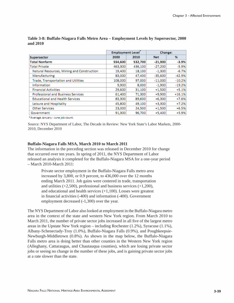
3-39
Chapter 3 – Affected Environment
NIAGARA FALLS NATIONAL HERITAGE AREA ENVIRONMENTAL ASSESSMENT
Table 3-8: Buffalo-Niagara Falls Metro Area – Employment Levels by Supersector, 2000 and 2010
Source: NYS Department of Labor, The Decade in Review: New York State’s Labor Markets, 2000-2010, December 2010
Buffalo-Niagara Falls MSA, March 2010 to March 2011The information in the preceding section was released in December 2010 for change that occurred over ten years. In spring of 2011, the NYS Department of Labor released an analysis it completed for the Buffalo-Niagara MSA for a one-year period – March 2010-March 2011:
Private sector employment in the Buffalo-Niagara Falls metro area increased by 3,800, or 0.9 percent, to 436,000 over the 12 months ending March 2011. Job gains were centered in trade, transportation and utilities (+2,500), professional and business services (+1,200), and educational and health services (+1,100). Losses were greatest in fi nancial activities (-400) and information (-400). Government employment decreased (-1,300) over the year.
The NYS Department of Labor also looked at employment in the Buffalo-Niagara metro area in the context of the state and western New York region. From March 2010 to March 2011, the number of private sector jobs increased in all fi ve of the largest metro areas in the Upstate New York region – including Rochester (1.2%), Syracuse (1.1%), Albany-Schenectady-Troy (1.0%), Buffalo-Niagara Falls (0.9%), and Poughkeepsie-Newburgh-Middletown (0.8%). As shown in the map below, the Buffalo-Niagara Falls metro area is doing better than other counties in the Western New York region (Alleghany, Cattaraugus, and Chautauqua counties), which are losing private sector jobs or seeing no change in the number of these jobs, and is gaining private sector jobs at a rate slower than the state.

3-40 NIAGARA FALLS NATIONAL HERITAGE AREA ENVIRONMENTAL ASSESSMENT
Chapter 3 – Affected Environment
Figure 3-3: Percent change in Private Sector Jobs by Area, New York State, March 2010 – March 2011
Regional Business and Working Environment: Market PositivesThe Buffalo-Niagara Enterprise, a private nonprofi t focused on promoting economic development in the region, identifi es several positive aspects of doing business in the Buffalo-Niagara Falls MSA. The resources it references are located throughout the Western New York Region, which the Buffalo-Niagara Enterprise identifi es as Erie, Niagara, Allegany, Cattaraugus, Chautauqua, Wyoming, Genesee, and Orleans counties.
Market Range: It has access to a large market since it is located within 500 miles of 40% of the U.S. population and 59% of Canada’s population.Access and Transportation: There are seven different ports of entry to Canada. It has “one of the most highly developed rail systems in the works”.Large and Educated Workforce: Western New York has a workforce of 750,000, and 20,000 people graduating annually from 15 four-year colleges and universities and 20 two-year schools.Affordable Cost of Living and Cost of Doing Business: Low housing costs, average household incomes of $53,000, and health insurance that costs 25% below the national average make the region affordable to employees and the regional workforce affordable to business.Work Ethic: The absenteeism and turnover rates are low compared to the rest of the country.

3-41
Chapter 3 – Affected Environment
NIAGARA FALLS NATIONAL HERITAGE AREA ENVIRONMENTAL ASSESSMENT
In July 2010, Forbes Woman magazine ranked the Buffalo-Niagara Falls metro area the 10th best place in the nation for working mothers based on women’s income, cost of living, access to pediatricians, unemployment rates, crime levels, and spending by school systems per student.
Buffalo, N.Y.’s school system had the highest spending per student. The article assessed quality of life in the 50 largest metropolitan statistical areas in the United States. The top three MSA’s on the list were (1) Minneapolis-St. Paul, (2) Washington, D.C., and (3) Boston. The above article is based upon U.S. Census data, which defi nes the Buffalo-Niagara Falls Metropolitan Statistical Area as Niagara and Erie counties.
Niagara County and Municipalities in the Heritage AreaData released in March 2011 by the New York State Department of Labor, Division of Research and Statistics indicates that Niagara County has the 26th highest unemployment rate of New York’s 62 counties, with a 9.0 percent unemployment rate. The nation’s unemployment rate is 9.0 percent as reported by the U.S. Bureau of Labor Statistics for April 2011. New York State has an 8 percent unemployment rate, as of March 2011.13
For the employed population 16 years or older, the top employers in Niagara County were: educational services, health care, and social assistance (23%); and manufacturing (15%).
The most common types of jobs were management, professional and related occupations (29%) and sales and offi ce occupations (27%). Other typical jobs include: service (19%); production, transportation, and material moving (16%), and construction, extraction, maintenance, and repair (9%). Most employed people were private wage and salary workers (81%); 15 percent were employed by the federal, state or local government; and self-employed workers totaled 5 percent of the employed population (U.S. Census Bureau 2005-2009).
The Niagara Communities Comprehensive Plan (2009) shows that many of the county’s major employers, for instance the NY Power Authority, are located within the heritage area, mostly within the City of Niagara Falls. The major employers of the jurisdictions within the heritage area are listed below14.
City of Niagara Falls – Major EmployersSeneca Niagara Casino and HotelNiagara Falls City School DistrictNiagara Falls Memorial Medical CenterDuPont CompanyWashington Mills Electro Minerals CorporationGoodyear Tire and Rubber CompanySaint-Gobain Structural CeramicsOlin Corporation
13 National and state unemployment fi gures are seasonally adjusted.14 Source of major employer data is from the Niagara County Center for Economic Development’s “Industrial and Business Directory 2008”. No major employers are listed for the Youngstown, NY.

3-42 NIAGARA FALLS NATIONAL HERITAGE AREA ENVIRONMENTAL ASSESSMENT
Chapter 3 – Affected Environment
Ferro Electronic MineralsSevenson Environmental Services Moore North America
Table 3-9: Employment by Industry, Niagara County, 2005-2009
Village of Lewiston – Major EmployersMount St. Mary’s HospitalWaste Technology ServicesEdwin Mellen PressLewny Tools
Town of Lewiston – Major EmployersMount St. Mary’s Hospital/Our Lady of Peace Nursing HomeNiagara UniversityModern Disposal SystemNY Power AuthorityTown of LewistonD.F. Calkins Lumber, Inc.

3-43
Chapter 3 – Affected Environment
NIAGARA FALLS NATIONAL HERITAGE AREA ENVIRONMENTAL ASSESSMENT
H2 Gro, LLCKen Wendt’s Propane Gas Service, Inc.Tuskewe KraftsUnit Step, Gamble, Inc.
Town of Porter – Major EmployersWaste Management, Inc.J.F. Matching Co., Inc.
3.3.3 Growth Patterns The 2009 Niagara Communities Comprehensive Plan found that between 1980 and 2000 household growth was concentrated in rural areas or on the fringes of its three cities: City of Niagara Falls, North Tonawanda, and Lockport. During these last few decades, there was a 33.4 percent increase in rural households versus a 1 percent increase in number of households located in urban or developed areas. The County Plan indicated that this trend of sprawling growth patterns was likely to continue (CHA 2009:III-22). Data collected from the 2010 census regarding urban and rural populations will be released by the U.S. Census Bureau in October 2012.
Growth in Niagara County between 1980 and 2010 was concentrated in former rural areas in the eastern portion of the county or on the suburban fringe of its three cities: Niagara Falls, North Tonawanda, and Lockport.
3.3.4 Race and Ethnicity
The U.S. Census Bureau uses seven categories of race: White, Black or African American, American Indian or Alaskan Native, Asian, Native Hawaiian and Other Pacifi c Islander, Some Other Race, and Two or More Races. The Some Other Race category was provided as an option for people unable to identify with any of the fi ve race categories. Responders choosing more than one of the six race categories are included in the Two or More Races population. In the U.S. Census, race and Hispanic origin are considered to be two separate concepts. People are asked to identify their race and answer whether or not they are Spanish, Hispanic, or Latino.

3-44 NIAGARA FALLS NATIONAL HERITAGE AREA ENVIRONMENTAL ASSESSMENT
Chapter 3 – Affected Environment
Race & Ethnicity
United States 2000 / 2010
Buffalo-NiagaraMSA
2000 / 2010
Niagara County 2000 / 2010
Erie County 2000 / 2010
City of Niagara Falls
2000 / 2010
White 75.1% 72.4% 83.8% 81.6% 90.7% 89.94% 82.2% 82.4% 76.2% 70.5%Black or AfricanAmerican
12.3% 12.6% 11.7% 12.2% 6.1% 6.61% 13% 13.62% 18.7% 21.6%
American Indian or AlaskanNative
.9% .9% .7% .7% .9% 1.15% .6% .71% 1.6% 1.9%
Asian 3.6% 4.8% 1.3% 2.3% .6% .9% 1.5% 1.94% .7% 1.2%NativeHawaiianand other PacificIslander
.1% .2% <0.1% 0.0% 0% .03% 0% .05% 0.0% 0.0%
SomeOtherRace
5.5% 6.2% 1.2% 1.3% .4% .35% 1.4% .64% .7% .8%
Two or MoreRaces
2.4% 2.9% 1.3% 1.9% 1.2% 1.11% 1.3% .64% 2.0% 3.9%
Hispanicor Latino
12.5% 16.3% 2.9% 4.1% 1.3% 1.93% 3.3% 4.04% 2.0% 3.0%
Table 3-10: Percentage of Total Population by Race, 2000-2010
Source: U.S. Census Bureau, 2000 and 2010 Decennial Census
For the populations of the Buffalo – Niagara Falls MSA, Niagara and Erie counties, and City of Niagara Falls, the 2000 and 2010 census data refl ects two consistent pieces of information: (1) like the United States, the majority population is white and the largest minority population is black or African-American; and (2) like the United States as a whole, minority groups are becoming a larger portion of the population.
Distinctions between localities in the region include the following: The white population is notably larger and the black population smaller in Niagara County relative to the nation, Buffalo-Niagara MSA, Erie County, and the City of Niagara Falls. Niagara County and the City of Niagara Falls have a higher percentage of American Indian or Alaskan Natives relative to Erie County, the Buffalo-Niagara MSA and the nation. Overall, multi-racial populations and people of Hispanic or Latino origin represent a small portion of the population in the heritage area and the region relative to the nation.
The 2009 Niagara Communities Comprehensive Plan reported that the City of Niagara Falls is the most diverse locality in Niagara County. Based on census data from 2000, the

3-45
Chapter 3 – Affected Environment
NIAGARA FALLS NATIONAL HERITAGE AREA ENVIRONMENTAL ASSESSMENT
City of Niagara Falls had 23.8 percent minority races whereas other county jurisdictions had minority populations of less than 10 percent (CHA 2009:22). Census data from 2010 indicates that the City of Niagara Falls continues to have a diverse population with a 29.4 percent minority population.
In the Buffalo-Niagara MSA, according to 2010 census data, minority groups represent 18.4 percent of the population. The Buffalo-Niagara Enterprise, a private nonprofi t organization focused on regional economic development, estimated population by race and ethnicity for 2015 and these results show that: the percentage of minority populations will likely increase; the white population will probably continue to decrease its share of the total population yet remain the largest racial group; and the American Indian or Alaskan Native population may see a decline from .6 percent to .5 percent of the total population.
In the Buffalo-Niagara MSA, according to 2010 census data, minority groups represent 18.4 percent of the population. Like the United States as a whole, minority groups in the City of Niagara Falls and the metro area are becoming a larger portion of the population. In the City of Niagara Falls, the largest minority group is black or African American (20.9%) and the second largest is people of two or more races (3.9%), and American Indian or Alaskan Natives represent 1.9 percent of the population. According to 2005 to 2006 ACS data, only a very small percentage of people in the heritage area, Niagara County, and Buffalo-Niagara Falls MSA are foreign born, and the majority of the native born population was born in New York State. The percentage of individuals, fi ve years old and above, speaking another language besides English in the home is also small – ranging from 3 to 8 percent – though less than half of people in this group state that they do not speak English “very well.”
3.3.5 Foreign Born
The following information is gathered from the 2005-2009 ACS, which is produced by the U.S. Census Bureau. The majority of people living in Niagara County were born in the United States and 84 percent were born in New York State. Only four percent of the Niagara County population was born in other countries. About six percent of people fi ve years old and older spoke a language other than English at home, with less than half of this group speaking Spanish and 67 percent of this group speaking some other language. Twenty-fi ve percent of people speaking another language in the home besides English noted that they did not speak English “very well”.The statistics for foreign born people and language in Niagara County are generally the same for the Buffalo-Niagara Falls MSA, City of Niagara Falls, Town of Lewiston, and Town of Porter with only slight variations in numbers. Foreign born populations in these jurisdictions range from 5 to 7 percent, and the percentage of people speaking a language other than English at home ranged from 3 to 8 percent. The Village of Lewiston has a higher percentage of people born in other countries (10%). Of the 90 percent native residents in the Village of Lewiston, 78 percent were born in New York State. The seven percent of the village population that speaks another language at home besides English, mostly speak a language besides Spanish. Twenty-four percent speak Spanish and 76 percent speak another language. Of the people in the heritage area and metro area that spoke another language in the home besides English, 22 to 41 percent reported not being able to speak English “very well.”
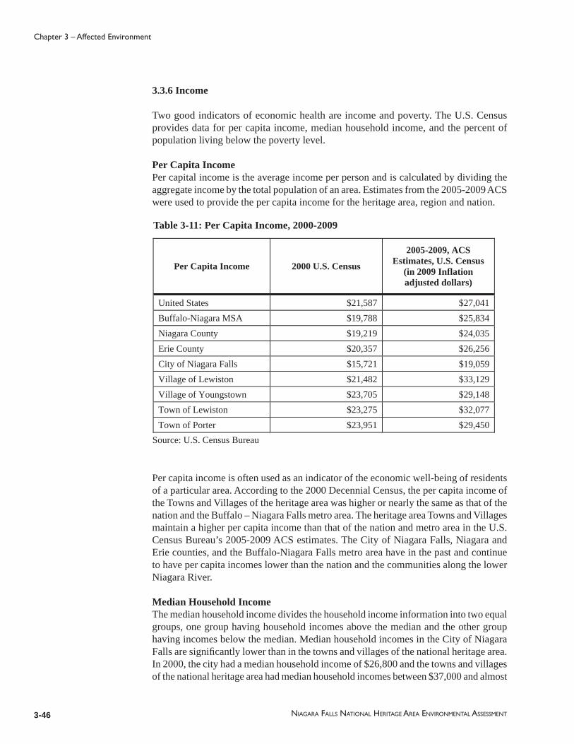
3-46 NIAGARA FALLS NATIONAL HERITAGE AREA ENVIRONMENTAL ASSESSMENT
Chapter 3 – Affected Environment
3.3.6 Income
Two good indicators of economic health are income and poverty. The U.S. Census provides data for per capita income, median household income, and the percent of population living below the poverty level.
Per Capita IncomePer capital income is the average income per person and is calculated by dividing the aggregate income by the total population of an area. Estimates from the 2005-2009 ACS were used to provide the per capita income for the heritage area, region and nation.
Table 3-11: Per Capita Income, 2000-2009
Source: U.S. Census Bureau
Per Capita Income 2000 U.S. Census
2005-2009, ACS Estimates, U.S. Census
(in 2009 Inflation adjusted dollars)
United States $21,587 $27,041 Buffalo-Niagara MSA $19,788 $25,834 Niagara County $19,219 $24,035 Erie County $20,357 $26,256 City of Niagara Falls $15,721 $19,059 Village of Lewiston $21,482 $33,129 Village of Youngstown $23,705 $29,148 Town of Lewiston $23,275 $32,077 Town of Porter $23,951 $29,450
Per capita income is often used as an indicator of the economic well-being of residents of a particular area. According to the 2000 Decennial Census, the per capita income of the Towns and Villages of the heritage area was higher or nearly the same as that of the nation and the Buffalo – Niagara Falls metro area. The heritage area Towns and Villages maintain a higher per capita income than that of the nation and metro area in the U.S. Census Bureau’s 2005-2009 ACS estimates. The City of Niagara Falls, Niagara and Erie counties, and the Buffalo-Niagara Falls metro area have in the past and continue to have per capita incomes lower than the nation and the communities along the lower Niagara River.
Median Household IncomeThe median household income divides the household income information into two equal groups, one group having household incomes above the median and the other group having incomes below the median. Median household incomes in the City of Niagara Falls are signifi cantly lower than in the towns and villages of the national heritage area. In 2000, the city had a median household income of $26,800 and the towns and villages of the national heritage area had median household incomes between $37,000 and almost

3-47
Chapter 3 – Affected Environment
NIAGARA FALLS NATIONAL HERITAGE AREA ENVIRONMENTAL ASSESSMENT
$51,000. In the 2005-2009 ACS estimates, the city’s median house income was $31,336 and that of the heritage area towns and villages was between $58,000 and nearly $60,000. The city has a low median household income in comparison to all other jurisdictions in the table below, including the nation, Buffalo-Niagara MSA and surrounding counties. The communities along the lower Niagara River generally do better on a household income basis than the nation, the metro area, and Niagara and Erie counties.
Table 3-12: Median Household Income, 2000-2009
Source: U.S. Census Bureau
Median Household Income 2000 U.S. Census
2005-2009, ACS Estimates, U.S. Census
(in 2009 Inflation adjusted dollars)
United States $41,994 $51, 425 Buffalo-Niagara MSA $38,604 $46,427 Niagara County $38,136 $45,749 Erie County $38,567 $46,609 City of Niagara Falls $26,800 $31,336 Village of Lewiston $37,598 $58,576 Village of Youngstown $48,333 $58,008 Town of Lewiston $50,819 $59,719 Town of Porter $50,425 $59,338
PovertyThe U.S. Census Bureau establishes an income threshold to determine who is poor. This helps the government determine, among other things, who is eligible for assistance from various federal programs. If total income for a family or individual falls below the income threshold, then the family or individual is classifi ed as being below the poverty level. The poverty threshold or poverty level used in the U.S. Census is the minimum income that the federal government has determined a family or person needs to adequately live in the United States. The average poverty threshold for a family of four in 2000 was $17,603. The estimated average poverty threshold for a family of four in 2010, as released by the U.S. Census Bureau in January 2011, is $22,314. The 2010 estimate may change slightly as the fi nal threshold will be published in September 2011, along with the release of the offi cial poverty estimates for 2010.
The poverty rate is the percent of the total population that lives below the poverty level. Between 1999 and 2009, the towns and villages of the heritage area have had a poverty rate lower and often much lower than that of the nation, Buffalo-Niagara MSA, and Niagara and Erie counties. The Village of Lewiston notably had poverty rates for families drop from 8.1 percent to 0.0 percent and for individuals drop from 8.6 percent to 2.2 percent over the span of ten years. The village’s population loss between 2000 and 2010 cannot account for this drop entirely. In the same timeframe, the rate of poverty in

3-48 NIAGARA FALLS NATIONAL HERITAGE AREA ENVIRONMENTAL ASSESSMENT
Chapter 3 – Affected Environment
the City of Niagara Falls has far exceeded that of all other jurisdictions in the heritage area, the metro area, and the nation. The city is the largest jurisdiction in the heritage area and has also, over the last decade, had the lowest per capita income and median household income in the Buffalo-Niagara metro area. The poverty rate of the Buffalo-Niagara MSA and Niagara County, from 2000 to 2009, was the same as or very close to the poverty rate of the nation.
Table 3-13: Rates of Poverty, 2000-2009
U.S. Census: 2000 Decennial Census, 2005-2009 American Community Survey 5-Year Estimates
Percent of Families and Individuals living below
Poverty Level
2000 U.S. Census 2005-2009, ACS Estimates, U.S. Census
Families Individuals Families Individuals
United States 9.2% 12.4% 9.9% 13.5% Buffalo-Niagara MSA 9.0% 11.9% 9.9% 13.6% Niagara County 8.2% 10.6% 9.2% 12.3% Erie County 9.2% 12.2% 10.1% 13.9% City of Niagara Falls 15.6% 19.5% 17.3% 20.9% Village of Lewiston 8.1% 8.6% 0.0% 2.2% Village of Youngstown 3.0% 3.9% 1.2% 4.5% Town of Lewiston 4.3% 5.8% 2.9% 4.9% Town of Porter 2.2% 4.1% 4.2% 7.4%
3.3.7 EducationThe information below compares educational attainment of jurisdictions in the heritage area, the Buffalo-Niagara MSA, and the nation. The metro area, Niagara County, and Town of Porter all have roughly the same level of educational attainment as the nation. Compared to the rest of the country, the City of Niagara Falls has a slightly higher percentage of people 25 years or older who hold a high school diploma or higher level of education. Yet, the percentage of people in the city with a bachelor’s degree or higher is less than half that of the nation. Each community of the heritage area located along the lower Niagara River generally has more people with high school diplomas, bachelor’s degrees or higher education than the city, county, metro area and nation.

3-49
Chapter 3 – Affected Environment
NIAGARA FALLS NATIONAL HERITAGE AREA ENVIRONMENTAL ASSESSMENT
Table 3-14: Educational Attainment, Population 25 Years and Over, 2009
Source: 2005-2009 American Community Survey 5-Year Estimate, U.S. Census
Educational Attainment High School Graduate or Higher
Bachelor’s Degree or Higher
United States 84.6% 27.5%Buffalo-Niagara MSA 87.9% 26.7%Niagara County 87.8% 19.1%City of Niagara Falls 83.7% 12.4%Village of Lewiston 92.9% 27.2%Village of Youngstown 91.8% 33.2%Town of Lewiston 95.7% 37.4%Town of Porter 87.9% 27.0%
Post-Secondary Educational InstitutionsThere are two post-secondary institutions in the area: Niagara University located in the Town of Lewiston and Niagara Community College located in Sanborn. These schools are active in the community and offer continuing education programs and co-operative education options to students. The Comprehensive Plan identifi ed the need for “continuing education and retraining programs linked to the local economy” and “a safe, accessible school system with magnet or specialized programs linked to industry and cultural resources” (CNF 2009:20-22).
The Cornell Cooperative Extension of Niagara County provides educational opportunities to the county residents through workshops, seminars, publications, teleconferences and volunteer opportunities related to economic, societal, environmental, and agricultural needs and concerns.
3.3.8 The Impact of the Heritage Area on Socio-economic Factors (EA Impact Topic)
The more affl uent lower Niagara River communities and the larger, economically stable Buffalo-Niagara Falls MSA provide a signifi cant “home-grown” audience that can and does support tourism within the heritage area. Though the City of Niagara Falls is more densely populated than other parts of the heritage area, the high numbers of people living below the poverty line and the low median household income and per capita income indicate that city residents may be less likely to engage in spending on tourism related activities. It is helpful to note here that the City of Niagara Falls has outlined signifi cant revitalization strategies for the areas within the core city, generally adjacent to the Niagara Falls State Park that would increase the local audience as well as attract more tourists.
The local audience in the heritage area, Niagara County, and Buffalo-Niagara MSA for marketing messages and interpretation efforts is largely native New Yorkers and a small percentage of people who speak another language besides English in the home – which is Spanish and other languages.

3-50 NIAGARA FALLS NATIONAL HERITAGE AREA ENVIRONMENTAL ASSESSMENT
Chapter 3 – Affected Environment
Development pressure is present in rural or less developed areas of the heritage area, as it is throughout Niagara County, and should be considered when determining need and measures for protecting natural and scenic resources (including farmland), open space, and landscape context of historic buildings, structures, and villages.
Government jobs have decreased in the metro area during the last year (March 2010- March 2011), and private sector jobs have increased. This may refl ect a need to bolster publicly owned heritage sites through funding, technical assistance, and supporting increased collaboration among heritage sites and with tourism agencies. It also suggests consideration of programs to help develop or grow local businesses.
The region seeks to create a vision for the future that builds upon its assets and provides opportunities for its residents to improve the local quality of life. The heritage area can play a central role in implementing this vision. The socio-economic impact is anticipated to have a positive effect on employment, income disparity, education including minority and low income populations.
3.3.9 Sources of Demographic Information
Data collected for this section came from several sources, including: the U.S. Census Bureau; U.S. Department of Labor, Bureau of Labor Statistics; the New York Department of Labor; Niagara Communities Comprehensive Plan; Niagara County Center for Economic Development; and the Buffalo Niagara Enterprise.
The U.S. Census provides data regarding population, race and ethnicity, employment, household income and education. The Decennial Census of population and housing, conducted once every ten years, was recently completed for 2010 and the results from this census either have been released in the early months of 2011 or are being released over the next months and years. When available, data from the 2010 Census is incorporated herein. Data for this report was also gathered from the American Community Survey (ACS) which takes places every year and provides annual and multi-year estimates of population and housing characteristics. Data presented in this discussion of the socio-economic environment relies upon the Decennial Census from 1980 to 2010 and the American Community Survey from 2005-2009.
The information below focuses upon the individual jurisdictions of the National Heritage Area and the Buffalo-Niagara Falls Metropolitan Statistical Area (MSA), which consists of Niagara and Erie counties. Metropolitan Statistical Areas are geographic entities defi ned by the federal government for the purpose of collecting, tabulating, and publishing federal statistics. A metro area has a minimum core urban area population of 50,000 or more, and consists of one or more counties that contain the core urban area and any adjacent counties that are signifi cantly integrated, socially and economically, with the urban core. In this case, the City of Buffalo is the core urban area and the MSA includes Erie County, where Buffalo is located, and adjacent Niagara County.

3-51
Chapter 3 – Affected Environment
NIAGARA FALLS NATIONAL HERITAGE AREA ENVIRONMENTAL ASSESSMENT
3.4 Regional and Community Planning15
The purpose of this section is two-fold. (1) It describes plans and activities that may affect the possible range of heritage area activities – natural and historic resource protection, recreation, heritage tourism, community development, and economic development. This includes highlighting applicable land and water use plans. (2) It also outlines the physical infrastructure – transportation and utilities – of the communities located within the heritage area boundaries.
3.4.1 Niagara River Greenway Plan, 2007
The Niagara River Greenway Plan, completed in April 2007, establishes a vision, principles, and priorities for actions for the Greenway. It includes an inventory of Greenway resources, and identifi es transportation issues, funding sources, and potential partnerships. It makes supportive comments about the possible creation of the Niagara Falls National Heritage Area as the 2005 heritage area feasibility study had been completed and the designation process underway at the time the Greenway Plan was produced. The Greenway encompasses much of the Niagara Falls National Heritage Area and extends from Fort Niagara State Park on Lake Ontario to just south of the City of Buffalo on Lake Erie. Several of the natural, cultural and historic resources listed for the Greenway inventory are also included in the inventory of heritage area resources. The most recent update regarding Greenway projects completed and in progress was provided in March 2011 by the Niagara River Greenway Commission. Many Greenway projects have been completed or are in progress in communities of the Niagara Falls National Heritage Area.
3.4.2 The Great Lakes Seaway Trail
The Great Lakes Seaway Trail is a 518 mile long driving route that connects historic villages, cities and scenic landscapes along the St. Lawrence River, Lake Ontario, Niagara River and Lake Erie. The trail has kiosks with maps and information as well as interpretive panels, and was one of the fi rst roads to be designated a National Scenic Byway. The mission statement of Seaway Trail Inc., the nonprofi t managing organization, is “to increase tourism revenues and to enhance the economic well-being and quality of life for travelers, communities, and members throughout the Great Lakes Seaway Trail by managing and marketing it as the leading scenic byway” (GLST 2011). There are Tourism Development Plans for Seaway Trail regions, there is a Byway Interpretation Plan, and a Conservation Plan and a Bicycle Plan are under development. The Seaway Trail runs through the heritage area.
3.4.3 State and National Heritage Areas
New York State Heritage AreasNew York State recognizes places with special, historic signifi cance to the state through its Heritage Area System. The Niagara Falls Underground Railroad Heritage Area,
15 Planning issues such as transportation and land use were dismissed as impact topics for the Environmental Assessment. This section is provided as background information to assist the heritage area organization with coordination.

3-52 NIAGARA FALLS NATIONAL HERITAGE AREA ENVIRONMENTAL ASSESSMENT
Chapter 3 – Affected Environment
List of Previously Submitted Projects for the Niagara River Greenway(As of May 2012)
Gretchen DulingFrom the Mouth of the Lower Niagara River May 2012
City of BuffaloBird Island Pier Reconstruction May 2012
Challenger Learning Center Creation of "Space Space" activity & exhibit area May 2012
Research Foundation of State University of New York5000 Years of Fishing on the Upper River May 2012
Erie County Department of Environment and PlanningUniform Shoreline Trail & Greenway Facility SignageMay 2012
Historic Palace Theatre, Inc.Historic Palace Theatre Exterior Renovation Project March 2012
Great Lakes Center, Buffalo State CollegeNiagara River Observatory March 2012
Town of HartlandThe Hartland Town Park Enhancement Initiative March 2012
WNY Land Conservancy & Ecology & Environment, Inc.The Niagara Escarpment Legacy March 2012
Town of WilsonTown of Wilson Walkway & Bicycle Trail January 2012
Niagara County Community CollegeNiagara Community Trail January 2012
Buffalo Urban Development Corp.RiverBend Master Plan & Green Infrastructure Plan January 2012
Niagara 1812 Bicentennial Legacy CouncilNiagara 1812 Bicentennial Commemoration January 2012
Buffalo Niagara RiverkeeperNiagara River Riparian Restoration Program January 2012
Buffalo Olmsted Parks ConservancyFront Park Gateway January 2012
Town of LewistonJoseph Davis State Park Improvement Project January 2012
Buffalo Museum of ScienceTifft Nature Preserve Sustainability Center ExpansionNovember 2011
Zoological Society of Buffalo, Inc.The Buffalo Zoo - Entry Plaza and Arctic Edge Exhibit November 2011
Town of LewistonAcademy Park Ice Rink September 2011
Town of LewistonCouncil on the Arts “Marble Orchid; Spirit of 1812 Mobile Presentation September 2011
City of TonawandaNiawanda Park River Walk Trail Stabilization September 2011
City of TonawandaCity of Tonawanda ‘s ADA Fishing Pier September 2011
Seaway Trail, Inc.War of 1812 Bicentennial Commemoration Signs September 2011
City of Niagara FallsGriffon Park September 2011
Niagara Wheatfield Central School DistrictNWCSD Eco Campus Outdoor ConservationSeptember 2011
Tonawanda's Gateway Harbor, Inc.Tonawanda's Gateway Harbor Programming July 2011
Table 3-15: List of Greenway Projects (As of May 2012)

3-53
Chapter 3 – Affected Environment
NIAGARA FALLS NATIONAL HERITAGE AREA ENVIRONMENTAL ASSESSMENT
List of Previously Submitted Projects for the Niagara River Greenway(As of May 2012)
Town of LewistonBattle of Queenston Heights Reenactment July 2011
Town of LewistonTuscarora Heroes Monument July 2011
Town of LewistonHistoric Lewiston Jazz Festival 2011 July 2011
New York State ParksAmerican Falls Historic Bridges Restoration May 2011
The Great Lakes ExperienceSitting Study May 2011
New York State ParksBeaver Island State Park Habitat Restoration Project May 2011
Town of LewistonColonial Village Park Restoration Project May 2011
Olcott Beach Carousel Park, Inc.Comfort Station & Information Kiosk May 2011
Town of LewistonToohey Park Greenway Project May 2011
Wild Ones NiagaraPollinator Pathway - Niagara Falls, NY March 2011
City of BuffaloTifft Street Pier January 2011
Friends of Edward M. CotterNational Historical Landmark Fireboat Restoration & Preservation Project January 2011
Niagara Street Business & Professional Assoc.Gill Creek Educational Nature Trail Project January 2011
North Tonawanda History MuseumLumber City History Center January 2011
Niagara Falls Family YMCANiagara Falls Family YMCA Capital Repair Project January 2011
Town of LockportLytle Nature Preserve November 2010
Town of Grand IslandScenic Woods - Bicentennial Park November 2010
Buffalo Niagara RiverkeeperNiagara River Greenway Habitat Restoration StrategyNovember 2010
Research Foundation of State University of New YorkEvaluation of Nearshore Fish Habitat in Niagara River November 2010
City of Niagara FallsRestoration of Hyde Park Comfort Station & Lounge November 2010
City of North TonawandaGratwick Riverside Park Marina Redevelopment September 2010
Erie CountyBlack Rock Canal Park & Cornelius Creek Park September 2010
Forest Lawn CemeteryScajaquada Creek Water Quality & Habitat Restoration September 2010
Town of LewistonLower Niagara River Road Comfort Station September 2010
Town of WheatfieldWheatfield River Road Park Improvement Phase 1 September 2010
Fenian Marker CommitteeFenian Invasion of 1866 Marker September 2010

3-54 NIAGARA FALLS NATIONAL HERITAGE AREA ENVIRONMENTAL ASSESSMENT
Chapter 3 – Affected Environment
List of Previously Submitted Projects for the Niagara River Greenway(As of May 2012)
Town of Lewiston - Artpark & CompanyArtpark's Summer Programs Support July 2010
Town of PorterPorter-on-the-Lake Park Improvement July 2010
Artpark & CompanyArtpark Capital Improvement Project July 2010
New York State ParksFort Niagara State Park Electrical System Upgrades July 2010
Riviera Theatre & Organ Preservation Co.Riviera Theatre Expansion Project July 2010
City of North TonawandaGratwick Riverside Park Marina Redevelopment July 2010
Buffalo Audubon Society, inc.Enhancement of Bird Habitat & Ecotourism ProjectMay 2010
NW Buffalo Community Development CenterBlack Rock Heritage Trail War of 1812 May 2010
New York State Parks and Village of YoungstownFour Mile Creek 200 Loop Comfort Station May 2010
New York State Parks and Village of YoungstownFort Niagara Soccer Field Comfort Station/Pavilion May 2010
Town of LewistonKiwanis Park Playground May 2010
Town of LewistonSanborn “Main Street” Streetscape Improvement May 2010
Town of LewistonSanborn Area Historical Society Improvement May 2010
Town of LewistonPlateau Dog Park & Nature Preserve May 2010
Village of LewistonHistoric Piper Law Office Welcome Center May 2010
Buffalo Audubon Society, inc.Niagara Greenway Environmental Education Program May 2010
City of Tonawanda Eastern Park Kayak/Canoe Launch Project March 2010
City of BuffaloLaSalle Park Master Plan Phase 2 March 2010
Buffalo-Niagara RiverkeeperBuffalo Access Acquisition Feasibility Study January 2010
Niagara County Historical SocietyThe Charles Rand Penny Collection January 2010
Niagara CountyNiagara County Parks and Signage Project January 2010
City of Niagara FallsLaSalle Waterfront Park January 2010
Carousel Society of the Niagara FrontierKiddieland January 2010
Buffalo Museum of ScienceTifft Nature Preserve Sustainability Center UpgradeNovember 2009
NYS Office of Parks, Recreation and Historic PreservationHeritage Park Restoration November 2009
NYS Office of Parks, Recreation and Historic PreservationNiagara Falls State Park 125th Anniversary Celebration November 2009

3-55
Chapter 3 – Affected Environment
NIAGARA FALLS NATIONAL HERITAGE AREA ENVIRONMENTAL ASSESSMENT
List of Previously Submitted Projects for the Niagara River Greenway(As of May 2012)
Wild Ones NiagaraEcological Restoration of the Niagara Gorge Rim Study November 2009
City of BuffaloFirst Impression Plan for LaSalle Park September 2009
Buffalo Olmsted Parks ConservancyFront Park Shelter & Foot of Porter Avenue Project September 2009
Buffalo Olmsted Parks ConservancyRiverside Park- Central Concourse Restoration September 15, 2009
City of LockportCanalside Wine Emporium September 2009
Green Trade MarketingGoGreenway.org September 2009
Keep Western New York BeautifulRe-Tree WNY - The 100,000 Tree Campaign July 2009
Niagara River Gorge Hiking Trail SystemNiagara Region "Design-Build" Gorge Trail Crew Proposal July 2009
New York State ParksBeaver Island State Park East River Marsh Connector Trail May 2009
Town of PorterPorter on the Lake Recreational Master Plan May 2009
Town of LewistonLewiston Pathway Scenic Project May 2009
Buffalo Museum of ScienceTree Regeneration at Tifft Nature Preserve May 2009
Buffalo Urban Development Corp.Union Ship Canal Public Open Space May 2009
City of LockportCanalside Wine Emporium May 2009
New York State ParksCave of the Winds Access Trail & Safety Improvements May 2009
New York State ParksArtpark Mainstage Lawn & Amphitheater Access Stairs May 2009
New York State ParksNiagara Reservation Comprehensive Operations Plan May 2009
New York State ParksBeaver Island State Park Paddle Sports Launch System May 2009
Village of Youngstown - Water/FerryStreets Waterfront Access March 2009
Valley Community AssociationBuffalo River Fest Park March 2009
Tuscarora NationRestoration Projects March 2009
SPONSORBoundary Waters Treaty Celebration March 2009
SUNY Research FoundationInformation for Successful Management March 2009
Niagara FallsGill Creek Park Lighting March 2009
Town of WheatfieldRiver Road Multi-use Trail Study November 2008
City of BuffaloTimes Beach Enhancements November 2008

3-56 NIAGARA FALLS NATIONAL HERITAGE AREA ENVIRONMENTAL ASSESSMENT
Chapter 3 – Affected Environment
List of Previously Submitted Projects for the Niagara River Greenway(As of May 2012)
Buffalo-Niagara RiverkeeperNiagara River Riparian Restoration Program November 2008
City of Niagara FallsCustoms House Restoration September 2008
City of Niagara FallsParks Planning September 2008
City of Niagara FallsCentennial Circle Project September 2008
Buffalo Olmsted Parks ConservancyMinnow Pools Rehabilitation September 2008
City of Niagara Falls93rd Street Bridge Replacement September 2008
Buffalo Niagara RiverkeeperBlueway Guide to the Niagara River GreenwayJune 2008
City of TonawandaNia-wanda Park Boardwalk and Pavilion June 2008
Lewiston-Porter Central School DistrictLewiston-Porter Recreational Complex June 2008
3-57
Chapter 3 – Affected Environment
NIAGARA FALLS NATIONAL HERITAGE AREA ENVIRONMENTAL ASSESSMENT
Western Erie Canal Heritage Corridor, and Buffalo are three places included in the NYS Heritage Area System. Plans are underway to include a visitor center for the Niagara Falls Underground Railroad Heritage Area in the future the Niagara Falls International Railway Station/Intermodal Transportation Center (IRS-ITC), which will occupy a renovated Customs House on Whirlpool Street. In February 2011, the Niagara Falls Underground Railroad Heritage Area Commission requested proposals for the preparation of a Management Plan for this state heritage area. The Western Erie Canal Heritage Corridor runs southeast of the Niagara Falls National Heritage Area as the canal descends from Lockport to Buffalo. A visitor center is provided for the corridor and in Buffalo. The NYS Offi ce of Parks, Recreation, and Historic Preservation oversees the NYS Heritage Areas Program.
The Niagara Falls Underground Railroad State Heritage Area was designated by New York State in 2008. The legislation creating the state heritage area also established a Commission and tasked it with preparing and implementing a management plan. The Commission is in the process of preparing the management plan, which will document and interpret the history of the Underground Railroad, abolitionists, and other reform related activities. An Underground Railroad Interpretive Center is already planned for the historic Customhouse located in the City of Niagara Falls. The City hopes to convey, in part through the Interpretive Center, its own and the region’s historical connection to the Underground Railroad to 8 to 10 million annual visitors (CNF RFP 2010).
National Heritage Areas in New YorkThe Niagara Falls National Heritage Area is one of three National Heritage Areas located within New York State – with the other two being the Erie Canalway National Heritage Corridor and the Hudson River Valley National Heritage Area. One additional National Heritage Area, the Champlain Valley National Heritage Partnership, includes lands of Vermont as well as New York. The portion of the Erie Canal that runs near and generally southeast of the Niagara Falls National Heritage Area is included in both the state’s Western Erie Canal Heritage Corridor and the federally designated Erie Canalway National Heritage Corridor.
The two heritage corridors that are located nearest to the Niagara Falls National Heritage Corridor both have management plans:
Erie Canalway National Heritage Corridor: Final Preservation and Management Plan (2006); andWestern Erie Canal Heritage Corridor Management Plan (2006).
The Heritage Development Resource Guide 2007 was created for the New York Heritage Development Forum held on November 13, 2007. The Forum celebrated the 25th anniversary of the New York State Heritage Program and the 30th anniversary of the Hudson-Mohawk Heritage Area, and focused on ways to carry out heritage development on a statewide level. The Resource Guide profi les organizations and agencies who work on a statewide or regional basis in heritage development throughout New York State.

3-58 NIAGARA FALLS NATIONAL HERITAGE AREA ENVIRONMENTAL ASSESSMENT
Chapter 3 – Affected Environment
3.4.4 Economic Development: Plans and Organizations
Economic Development PlansThere are economic development documents and planning documents that include information about economic development:
2010, Comprehensive Economic Development Strategy, Niagara County;2009, Niagara Communities Comprehensive Plan;2009, City of Niagara Falls Comprehensive Plan2001, Rethinking the Niagara FrontierA Citizen’s Map for Niagara Falls
There are several tourism related plans:2010 – 2014 Strategic Plan, Niagara Tourism and Convention Center;2010 – 2011 Marketing Plan, Niagara Tourism and Convention Center;2008 Visitor Report;2005, A Cultural Tourism Strategy: Enriching Culture and Building Tourism in Buffalo Niagara2002, Revealing Niagara: Heritage and Cultural Tourism in the Bi-National Niagara Region2002, Cultural Tourism in The Buffalo-Niagara Region, Phase 1: Inventory of Cultural Tourism Planning Initiatives, Recommendations for Pursuing a Comprehensive Plan2002, USA Niagara Development Strategy: A Blueprint for Revitalization of Downtown Niagara Falls
Economic Development OrganizationsUSA Niagara Development Corporation – This organization is a subsidiary of Empire State Development Corporation and works to promote economic development initiatives in the City of Niagara Falls.Niagara Experience Center, Inc. – This nonprofi t corporation was formed to lead development of the Niagara Experience Center (NEC), a cultural tourism attraction seen as an anchor for additional hospitality – hotel, food, and entertainment – development in downtown Niagara Falls. Educational and cultural leaders from the community sit on the board of the nonprofi t and the USA Niagara Development Corporation serves as the NEC, Inc. staff.Downtown Niagara Falls Business Association, Inc.Main Street NiagaraNiagara USA Chamber of CommerceNiagara River Region Chamber of CommerceNew York Power AuthorityNiagara Falls Bridge CommissionSeneca Niagara Casino and Hotel
3.4.5 Niagara Power Project, New York Power Authority – Relicensing
The Federal Energy Regulatory Commission (FERC) issued the New York Power Authority a new 50-year federal license to operate the Niagara Power Project, which took effect September 1, 2007. Over 40 studies were conducted as part of the license-
3-59
Chapter 3 – Affected Environment
NIAGARA FALLS NATIONAL HERITAGE AREA ENVIRONMENTAL ASSESSMENT
related applicant-prepared Environmental Assessment. These studies relate to aquatic resources, water use and quality, terrestrial resources, climate and geology, socioeconomic resources, recreational resources, and land management and aesthetics. The full list of these studies is included in the appendices of the Niagara Falls National Heritage Area Environmental Assessment and Management Plan. Through the relicensing process, NYPA made commitments to community stakeholders and is continuing to work with government and non-governmental organizations to fulfi ll those commitments – which address environmental, cultural, and recreational resources as well as a scholarship program for the Tuscarora Nation.
3.4.6 Historical Organizations
The following historical organizations are located in the Erie-Niagara region:
Niagara Falls Historic Preservation Society, Inc.The Historical Association of Lewiston, Inc.Niagara County Historical SocietyPreservation Buffalo NiagaraBuffalo and Erie County Historical SocietyCampaign for Buffalo History, Architecture and CultureCanal Society of New York StatePreservation League of New York State
3.4.7 Environmental Protection: Plans and Organizations
Environmental Protection Plans2009, New York State Open Space Conservation Plan – This plan includes descriptions of three Regional Priority Conservation Projects planned for land included in the heritage area: (1) protection of ecological corridors, (2) preservation of exceptional forest communities, and (3) grassland preservation and restoration. The plan describes resources available for open space conservation.2009, Western New York Environmental Alliance, Final Report – This report provides WNYEA’s mission statement, goals and objectives, and next steps. The document focuses upon Erie and Niagara counties, and includes profi les of environmental organizations, environmental public agencies and environmental plan for Western New York.
Environmental Protection Organizations and AgenciesThe New York State Department of Environmental Conservation includes the Division of Fish, Wildlife and Marine Resources, which oversees the New York Natural Heritage Program. It provides information about rare or state-listed animals, plants, signifi cant natural communities and other signifi cant habitats. Other organizations and agencies include:
Niagara River Greenway CommissionThe Niagara Beautifi cation Commission, Inc.Buffalo Niagara Riverkeeper

3-60 NIAGARA FALLS NATIONAL HERITAGE AREA ENVIRONMENTAL ASSESSMENT
Chapter 3 – Affected Environment
Buffalo Olmsted Parks ConservancyBuffalo ZooWestern New York Land ConservancyNiagara Heritage PartnershipNiagara Frontier Wildlife Habitat CouncilResidents of Responsible GovernmentSierra Club, Niagara GroupUS Army Corp of Engineers, Buffalo DistrictBuffalo Association of Professional Geologists, Inc.
3.4.8 State Agencies
New York State Offi ce of Parks, Recreation and Historic PreservationThe NYS Offi ce of Parks, Recreation and Historic Preservation manages the eight state parks and the Niagara Gorge Trail located in the heritage area and the state heritage areas program. The State Historic Preservation Offi ce is operates within this state offi ce, as it administers the Statewide Historic Resources Survey, New York State and National Registers of Historic Places, the federal historic rehabilitation tax credit, the CLG program, grants programs, and a variety of other technical services.
New York State Parks in the Heritage AreaThere are seven State Parks within the heritage area: Niagara Falls State Park, Whirlpool State Park, De Veaux Woods State Park, Devil’s Hole State Park, Earl W. Brydges Artpark State Park, Joseph Davis State Park, and Fort Niagara State Park.
The Niagara Falls State Park, originally named the Niagara Reservation, is America’s oldest state park and was established in 1885. Frederick Law Olmsted, noted landscape architect, recommended that the reservation include land alongside and the islands above the Falls, and that any structures should be limited so as to preserve the natural scene. Olmsted and his associate designed and implemented the landscape plan for the park. The size of the original park has increased from 418 acres to 435 acres, and close to 140 acres of this land is under water. The park is a National Historic Landmark and the NHL Program reports that “while the Reservations vast surroundings have been compromised by intensive commercial development on the Canadian side of the Falls, impacting its visual setting, Niagara Reservation itself is not in imminent danger of losing its integrity” (NPS NHLP 1963).
Whirlpool State Park, established in 1933 and approximately 109 acres large, offers observation areas for viewing the rapids and trails into the gorge that lead to fi shing and connect to Devil’s Hole State Park, located further down the river. There are no historic attractions at the site, though interpretive materials (pamphlets and signage) offer historical information about the area.
De Veaux Woods State Park is 51 acres and purchased by New York State for the purpose of being a state park in 2000. The park includes ball fi elds, open space, fi ve acres of old-growth forest, and historic structures. The De Veaux School, once the De Veaux College for Orphans and Destitute Children, includes 19th century buildings and is listed on the State and National Registers of Historic Places.

3-61
Chapter 3 – Affected Environment
NIAGARA FALLS NATIONAL HERITAGE AREA ENVIRONMENTAL ASSESSMENT
Devil’s Hole State Park was established in 1927 and is 42 acres. It offers views of the gorge and overlooks the Whirlpool rapids. Trails from the park descend towards the river and are part of the Niagara Gorge Trail System. There is no visitor building and no historic attractions are present at the site, though interpretive signage is offered.
The Earl W. Brydges Artpark State Park is 200 acres just south of the Village of Lewiston, and includes the Performing Arts and Cultural Center, artist studios, outdoor amphitheater, access to the Niagara Gorge Trail, and a trail with interpretive signs to the Lewiston Mound and other features of the Lower Landing Archeological District. The park offers tours of its geologic and historic sites and nature trails. The Lewiston Mound and Lower Landing Archeological District are listed on the National Register of Historic Places. The Lower Landing Archeological District is part of the Colonial Niagara Historic District, which is a National Historic Landmark signifi cant for extant resources associated with Native American and European groups.
Joseph Davis State Park is 388 acres and includes a fi shing dock on the Lower Niagara River, nature trails, and cross-country skiing, snowshoeing and snowmobiling trails. It allows small-game hunting. The park is a state designated BCA or Bird Conservation Area. There are no buildings or historic attractions.
Fort Niagara State Park is 500 acres and includes the Old Fort Niagara, a National Historic Landmark whose history spans more than 300 years, and the Fort Niagara Light, a lighthouse listed on the National Register of Historic Places. The park offers recreational features, including two boat launches, trails, soccer fi elds, and picnic tables. The historic resources at the park are the most notable features at the park and – along with the Niagara Falls State Park and Niagara Falls, Gorge and Rapids – of the heritage area. The buildings of Old Fort Niagara are the oldest in the Great Lakes region, dating back to 1726. The Fort Niagara Light was built circa 1872.
New York Department of State The Department of State, Offi ce of Coastal, Local Government and Community Sustainability administers the state’s Coastal Management Program, which is important because the heritage area is located adjacent to two designated Signifi cant Coastal Fish and Wildlife Habitats (SCFWH). These are the Lower Niagara River Rapids SCFWH and the Buckhorn Island – Goat Island Rapids SCFWH. Projects which may impact the habitat are reviewed by DOS.
3.4.9 Regional Planning Initiatives
Framework for Regional Growth: Erie + Niagara Counties, New York, 2006Erie and Niagara counties prepared this document to facilitate coordinated and consistent decisions about growth and development. The document’s mission statement indicates that Framework will “be used to inform state and local governments, private developers, and nonprofi t organizations about the process and actions County government could undertake when making decisions affecting the region’s development” (Framework 2006:2). It includes policies, programs, and projects.

3-62 NIAGARA FALLS NATIONAL HERITAGE AREA ENVIRONMENTAL ASSESSMENT
Chapter 3 – Affected Environment
Urban Design Project, University of BuffaloThe Urban Design Project(UDP) is currently involved with several ongoing projects in the City of Buffalo and Western New York State. With regard to planning in the heritage area, the UDP is working with the Waste, Pollution Prevention and Water Task Group from the WNY Environmental Alliance to clean up pollutants in Niagara, Erie, and Cattaraugus counties. They are mapping the hazardous waste environment of Western New York, with the intent of using it develop a comprehensive strategy and campaign for environmental cleanup and restoration.
The UDP is responsible for three signifi cant reports about the Niagara Region including:
2001, Rethinking the Niagara Frontier – The report explores bi-national opportunities to stimulate economic growth and improve the quality of life in the region, and discusses tourism, redevelopment of industrial lands, and investment in the built and natural environment, trade and transportation, and knowledge-based industries.2002, Revealing Niagara: A Citizen Vision for Heritage and Cultural Tourism in the Bi-National Niagara Region2002, Achieving Niagara’s Future – This document focuses on waterfront planning in Niagara Falls.
Other documents include:1997, Niagara’s Future: A Citizens’ Vision for Niagara Falls and Region
National Trust Main Street ProgramThe National Trust for Historic Preservation operates Main Street programs, which use historic preservation minded development strategies to revitalize neighborhoods and commercial centers. No Main Street program operates within the heritage area; one is located east of Rochester in Palmyra, New York and is the Western Erie Canal Main Street Program. The Erie Canal is a site thematically linked to the Borderland/Border Crossing theme for the Niagara Falls National Heritage Area, as offered in the 2005 Niagara National Heritage Area Study. The shared history and the fact that the Main Street’s purpose is economic vitality for a heritage community may mean that the Western Erie Canal Main Street Program offers interesting insights for the City of Niagara Falls as it moves ahead with plans, as put forward in the City’s 2009 Comprehensive Plan, to rejuvenate its own residential neighborhoods and commercial corridors.
3.4.10 Tribal Nation Plans
The Seneca Nation of Indians, the Tuscarora Nation, and the Tonawanda Band of Seneca live within the region. All are part of the Iroquois Confederacy and known as the Haudenosaunee, or People of the Longhouse. The Seneca Nation operates a large business, the Seneca Niagara Falls Casino, within the heritage area and the Tuscarora Nation Reservation is located near the heritage area, just west of the Village of Lewiston. Each Native American Indian Nation has its own governing body. The Seneca Nation has an elective, constitutional form of government. The Tuscarora Nation has the traditional Council of Chiefs and Clan Mothers form of government. Consultations regarding heritage area planning should engage the Seneca and Tuscarora Nations. Representatives

3-63
Chapter 3 – Affected Environment
NIAGARA FALLS NATIONAL HERITAGE AREA ENVIRONMENTAL ASSESSMENT
from the Seneca and Tuscarora Nations are on the Niagara Falls National Heritage Area Federal Commission.
Seneca Niagara Falls Casino and Hotel: The casino and hotel are a major development in the downtown core section of the City of Niagara Falls and one of the city’s largest private sector employers. The Seneca Nation plans to expand the complex and redevelop a large portion of downtown Niagara Falls. The Seneca Gaming Corporation, through its subsidiaries, operates three casinos in Western New York – Niagara Falls, Salamanca, and Buffalo. The Nation-State Gaming Compact of 2002 grants the Seneca Nation the exclusive right to “build and operate three Class III gaming facilities in Western NY” (NCCP 2009:IV 2-3).
3.4.11 Planning by Local Governments
The City of Niagara Falls, towns and villages of the lower Niagara River and Niagara County have comprehensive plans, waterfront plans, and zoning ordinances. Two jurisdictions are Certifi ed Local Governments (CLGs). Through these plans, ordinances, and CLG status, the jurisdictions of the heritage area monitor and manage land and water use, and protection of natural and historic resources. These documents hold regulations and policies that affect heritage area resources and could be reviewed to determine adequacy of protection, conservation and support for heritage resources.
The City of Niagara Falls, the southern end of the heritage area, has a comprehensive plan (2009); a waterfront plan entitled “Achieving Niagara Falls’ Future: An Assessment of Niagara Fall’s Waterfront Planning (2002); and a draft City of Niagara Falls Local Waterfront Revitalization Program (LWRP) from 1992. Moving northward of the City of Niagara Falls, the Village of Lewiston has a LWRP (1991), the Town of Lewiston is in the process of updating their comprehensive plan and a 2011 draft is under review, the Town of Porter has a comprehensive plan (2004), and the Village of Youngstown has a LWRP (1990). Niagara County prepared the Niagara Communities Comprehensive Plan (2009).In a comprehensive plan, a local government articulates a vision for how the community can develop. The local government exercises control over land use, through planning policies and zoning ordinances, in an effort to achieve the community’s vision.
Local Waterfront Revitalization PlansThe Local Waterfront Revitalization Program (LWRP), overseen by New York State, includes a planning document prepared by the local community and a program to implement the plan. The LWRP plan is a land and water use plan and strategy for addressing coastal resources and issues such as waterfront development, historic and scenic resources, fl ooding and erosion, water quality, fi sh and wildlife habitats, public access and recreation, water uses and harbor management, and agriculture (NYSDOS, Division of Coastal Resources 2011). The Village of Lewiston and Village of Youngstown last produced a LWRP consistent with the New York state authorization program over twenty years ago, in 1991 and 1990 respectively which outline several capital improvement projects for the waterfronts of these two communities.
3-64 NIAGARA FALLS NATIONAL HERITAGE AREA ENVIRONMENTAL ASSESSMENT
Chapter 3 – Affected Environment
Certifi ed Local Government ProgramThe CLG program is administered by the National Park Service and State Historic Preservation Offi ce, and allows participating jurisdictions access to preservation-oriented technical assistance and to federal funding. To qualify for status as a CLG, the locality must (1) have legislation for the designation and protection of historic properties, (2) a historic preservation review commission, (3) an on-going effort to survey and inventory historic properties, and (4) allow for adequate public participation in the historic preservation program (NYS SHPO 2011).
Two jurisdictions within the heritage area, the City of Niagara Falls and the Village of Lewiston, are Certifi ed Local Governments (CLGs). This status allows these communities to have unique access to technical and fi nancial assistance for historic preservation from the State Historic Preservation Offi ce. Through the CLG program the Village of Lewiston and the City of Niagara Falls may receive preservation-related technical assistance, legal advice, and training; be involved in identifying properties for the State and National Registers of Historic Places; network with other CLG communities; and access grants specifi cally designed for CLG communities (NYSHPO website 2011).
City of Niagara Falls Comprehensive Plan, 2009The Comprehensive Plan for the City of Niagara Falls, USA, 2009 presents a long-term strategy for rebuilding the city both economically and physically. It includes a vision for how the Core City Planning Area, which is essentially downtown Niagara Falls, should develop over the next twenty years through 2030, strategies to achieve the vision, and citywide polices that guide development in the other three Planning Areas as well (De Veaux Highland, Hyde Park, and LaSalle).
The major element of the plan is reinvestment in and redevelopment of the Core City Area. “The Core City is targeted because it has the greatest potential with regard to tourism development, residential and commercial renewal and intensifi cation, the provision and growth of regional services and amenities, including education, and the creation of a more rich and diverse cultural and public realm” (NFC Comprehensive Plan 2009:2). The plan is premised on the idea that growth in the Core City will lead to renewal of the whole city.
The vision and policies put forth in the city’s comprehensive plan affect a large portion of the heritage area’s landmass and resources. The City of Niagara Falls is 16.8 square miles and contains, roughly, over half the land area of the National Heritage Area, adjoins four state parks of the heritage area (Niagara Falls State Park, NFSP Goat Island, De Veaux Woods State Park, Whirlpool State Park, and Devil’s Hole State Park), and includes historic districts and historic sites found on the inventory of resources for the heritage area.
The plan contains language and policy specifi c to the Niagara Falls National Heritage Area including the statement that it could bring “exciting partnership opportunities, as well as projects and fi nancial support to achieve signifi cant change along the city’s riverfront” (NF Comprehensive Plan 2009:15). Specifi c opportunities mentioned include heritage interpretation programs, tourism infrastructure, a regional parks agency, and other economic development initiatives. Specifi c goals, objectives and policies that address issues relevant to the heritage area include:

3-65
Chapter 3 – Affected Environment
NIAGARA FALLS NATIONAL HERITAGE AREA ENVIRONMENTAL ASSESSMENT
City Renewal Principle 3.0 - A well-designed network comprised of the riverfront, streets, parks, squares and other open spaces will not only advance the purposes and intent of developing the Niagara River Greenway and the Niagara National Heritage Area, but play a key role in enhancing the city’s image and its quality of life, while creating an attractive setting for high-quality private sector reinvestment. A network of green public spaces and improved public environments will extend the value of the City’s riverfront edge into larger areas of the Core City (NF Comprehensive Plan 2009:28).Core City Vision - By coordinating the establishment of the Niagara River National Heritage Area, the creation of a NYS Niagara River Greenway and URR Heritage Area, the creation of a ‘Gorge-View’ Cultural District, the reconfi guration of the Robert Moses Parkway, and other proposed waterfront projects, the city can create a riverfront corridor equal to, if not surpassing, the quality and diversity offered by the Niagara Parks Commission in Canada (NF Comprehensive Plan 2009:31).Core City Strategy 4.1.2 – Create the Cultural District: Establish the partnership arrangement necessary to undertake the Cultural District as a destination attraction within Niagara Falls”. “The National Park Service would become an important partner with the establishment of the National Heritage Area along the Niagara River corridor (NF Comprehensive Plan 2009:44-45).General Citywide Policy 7.4.10 – Establish agreements with State Parks and a management entity to implement the City Waterfront Programs and develop a Natural Heritage Area Master Plan and Programming Strategy (NFCP 2009:105).General Citywide Policy 7.9.1 – Develop the Niagara waterfront, the Falls, Gorge, and River as a great public space of international signifi cance. Action 2: Lead in the development of the Niagara Falls National Heritage Area (NF Comprehensive Plan 2009:116).
Town of Porter Comprehensive Plan, 2004The Town of Porter’s Comprehensive Plan entitled ‘Connecting Our Past with the Future’ provides direction for growth and development in areas outside of the Village of Youngstown.
Town of Lewiston, Comprehensive Plan, 2011 updateAt the time this report was prepared, the Town of Lewiston was in the process of updating its comprehensive plan.
Niagara Communities Comprehensive Plan 2030Prepared in 2009, this is the county’s fi rst comprehensive plan and it provides a vision and policy for county growth over the course of twenty years. The county’s overarching goals are to: “enhance Niagara County’s role as a world class destination, a center of commerce, a model for sustainable environments, and a premier place to live” (CHA 2009:2). It highlights concern over the adverse impacts of sprawl as growth patterns show development moving into formerly rural areas. It provides detailed information for each community in the heritage area and comments that the Niagara Falls National Heritage Area is expected to have a “signifi cant positive impact on the tourism industry” on the county (CHA 2009:III-38).
3-66 NIAGARA FALLS NATIONAL HERITAGE AREA ENVIRONMENTAL ASSESSMENT
Chapter 3 – Affected Environment
3.4.12 Transportation The heritage area is served by interstate highway that connects to other interstates and the highway system in Canada, by way of three international bridges. State highways run north-south through the heritage area and east-west across the City of Niagara Falls. The Niagara Falls Transit Authority maintains a bus terminal and Amtrak is currently developing a multi-modal transit facility in the city. There are three public boat launch facilities in the heritage area. The Niagara Falls International Airport is located just east of the City of Niagara Falls, and can accommodate charter fl ights and the largest cargo planes. The Buffalo Niagara International Airport is in nearby Buffalo and has an average of 133 daily fl ights and nonstop service to 22 cities (NCCED 2011).
A multi-modal transportation facility with a new International Train Station is planned for the Whirlpool Rapids bridgehead in the City of Niagara Falls. It will be a border crossing facility as well as providing passenger rail service. The city also plans to reconnect its downtown and neighborhoods to the waterfront through reconfi guring the Robert Moses Parkway, altering the street pattern, and adding trails.
With regard to transportation, the Niagara County Center for Economic Development notes that nearly 70% of goods are moved by truck, and that the rail system network connects to ports on the Atlantic, Pacifi c, Gulf of Mexico, Great Lakes and St. Lawrence Seaway.
Robert Moses ParkwayThe Robert Moses Parkway extends from the Grand Island Bridge to the Village of Youngstown. It is managed by the NYS Offi ce of Parks, Recreation and Historic Preservation, New York Power Authority, and the NYS Department of Transportation. The City of Niagara Falls Comprehensive Plan states that the parkway should be reconfi gured and some sections removed to allow pedestrian and street connections between the city and riverfront and to create new opportunities for economic development along the riverfront (NFCP 2009:36-37).
3.4.13 Utilities
Large utilities as well as small suppliers provide electricity and gas to Niagara County. The National Fuel Gas Distribution Corporation provides natural gas and National Grid supplies electricity to the heritage area as well as other parts of the county. The New York Power Authority (NYPA) is one of the world’s largest hydroelectric power plants. COVANTA Company of Niagara is a large waste to energy facility located in the City of Niagara Falls. Verizon, Sprint, Cingular, and other companies provide telecommunication services county-wide (CHA 2009:III-33).
3.5 Tourism and Visitor Experience (EA Impact Topic)
In the past, the City of Niagara Falls and other communities in the region relied upon manufacturing industries as the primary driver of the local economy. The tourism experience on the American side of the Falls was the domain of New York State Parks, their selected vendors, and loosely organized private tourism interests. Meanwhile, public and private sector interests in Niagara Falls, Ontario, joined forces to unite

3-67
Chapter 3 – Affected Environment
NIAGARA FALLS NATIONAL HERITAGE AREA ENVIRONMENTAL ASSESSMENT
behind a shared vision and plans leading to a dominant position as the regional visitor destination. This united approach to tourism by the Canadians has caused Niagara Falls, USA, to lose considerable market share. The revitalization of Niagara Falls, New York and increasing visitation regionally is dependent upon reversing this trend and creating a high-quality visitor experience based upon the assets and character in the heritage area.
3.5.1 National Trends in Heritage Tourism
The leisure market for travel and tourism directly contributed $526 billion to the United States economy in 2010. Three out of four domestic trips (77 percent) are for leisure travel. Travel and tourism is one of America’s largest employers, directly employing more than 7.4 million people and creating a payroll income of $188.3 billion, and $118 billion in tax revenues for federal, state and local governments. (Source: U.S. Travel Association, 2011)
In addition to creating new jobs, new business and higher property values, well-managed tourism improves the quality of life and builds community pride. According to a 2009 national research study on cultural and heritage travel in the United States by Mandela Research, 78 percent of all U.S. leisure travelers participate in cultural and/or heritage activities while traveling, which translates to 118.3 million adults each year. Cultural and heritage visitors spend, on average, $994 per trip compared to $611 for all U.S. travelers, and they stay longer than other U.S. travelers (Source: Cultural & Heritage Traveler Study, Mandela Research, LLC, 2009) Perhaps the biggest benefi ts of cultural heritage tourism, though, are diversifi cation of local economies and preservation of a community’s unique character.
The Cultural & Heritage Traveler Study also identifi ed activities of interest to cultural and heritage travelers. This study reconfi rmed the fi ndings of earlier national studies for this market segment, emphasizing that cultural heritage travelers are seeking a well-rounded visitor experience offering a variety of options and opportunities. Specifi cally, the study found that among cultural heritage travelers:
40% experienced local cuisine39% visited historic sites39% explored small towns38% visited state/national parks34% took a self-guided walking tour33% visited historic buildings32% shopped for local arts and crafts31% visited history museums/centers28% visited arts museums/galleries25% visited natural history museums/centers
3.5.2 Tourism in Niagara Falls
Niagara Falls is an established national and international tourism destination, attracting an estimated six to eight million visitors each year on the American side and an estimated 12 million visitors annually on the Canadian side of the Falls. Estimates for visitation

3-68 NIAGARA FALLS NATIONAL HERITAGE AREA ENVIRONMENTAL ASSESSMENT
Chapter 3 – Affected Environment
to the United States side in 2009 dropped to 5.5 million, a drop attributed to the weaker economy. In recent years visitation on the U.S. side has been helped by the value of the Canadian dollar versus the U.S. dollar, which has attracted Canadian shoppers to the United States. In addition, tighter international border restrictions have kept American visitors without passports on the American side. It should be noted that as Niagara Falls is not a gated attraction, it is diffi cult to accurately track the exact number of visitors who come to see the Falls each year.
The Niagara Falls National Heritage Area Feasibility Study states that citizens in Niagara Falls noted that while “Niagara Falls has been a major tourist attraction for almost 200 years, there is a feeling that on the American side of the Falls the presentation of the visitor experience has not kept pace with that of Niagara Falls, Ontario.” A number of stakeholders commented that while the Falls are a tremendous draw, once a visitor has seen the Falls, it is challenging to get them to stay for a more extensive experience in the region. Key goals for the Niagara Falls National Heritage Area are encouraging longer stays in the Niagara River valley; extending visitation in the shoulder and off seasons; and improving the quality of the visitor experience on the American side.
Additionally, visitation is concentrated in the summer months, with major attractions reaching capacity on peak weekends such as the Fourth of July, Memorial Day, and Labor Day. Some key attractions, such as the Maid of the Mist and Cave of the Winds, are only open seasonally due to weather considerations.
While there are a number of entities focused on tourism marketing for the region, there are fewer entities with a focus on tourism product development. A notable exception is USA Niagara, which has focused on a number of key bricks-and-mortar projects in the City of Niagara Falls. Recently completed projects include the Niagara Tourism and Convention Corporation’s visitor center, and USA Niagara has provided $13 million toward Niagara County Community College’s culinary center now under construction in downtown Niagara Falls. USA Niagara helped coordinate a holiday market in December 2011 featuring “pop-up retail” in downtown along with bonfi res, Santa, and the charm of cobblestone streets. It is hoped that this month-long event will become an annual opportunity to boost sales in the off season, and test out retail concepts that could grow into year-round businesses.
Niagara Falls National Heritage Area has some tremendous tourism strengths and opportunities, including:
Niagara Falls is already a well-known international tourism destination that attracts a large number of visitors from all over the world.The designation as a National Heritage Area brings the credibility of the National Park Service to the American side of the Falls.Niagara Falls is actively promoted by Niagara USA as well as by the Buffalo Niagara Convention and Visitors Bureau to both domestic and international travelers.The Niagara River valley experience on the American side offers spectacular natural areas along the gorge that are currently underutilized, since visitors tend to cluster at the Falls.

3-69
Chapter 3 – Affected Environment
NIAGARA FALLS NATIONAL HERITAGE AREA ENVIRONMENTAL ASSESSMENT
The gorge offers a variety of nature based experiences, including the string of state parks along the river and the trails that will ultimately provide a continuous experience from the Falls to the fort through the efforts of the Niagara Greenway and others.There is an ongoing investment in the Niagara River valley through dedicated funding sources such as the bricks-and-mortar funding available through Niagara USA for projects in the City of Niagara Falls and grants through the Niagara Greenway.The proximity of attractions within the Niagara River gorge. Visitors can travel from one end of the National Heritage Area to the other (from Niagara Falls State Park to Old Fort Niagara) in less than 20 minutes.The Niagara River valley has a rich history with stories about the natural phenomena of the Falls, the history of tourism, the development of power and industry, and the role of the river valley as a borderland and border crossing.The current favorable exchange rate is drawing Canadians across the border to the Buffalo-Niagara area for activities such as shopping and dining. In addition, tighter border restrictions have meant that Americans lacking passports stay on the American side of Niagara Falls and are not able to get to the Canadian side.Buffalo is undergoing a renaissance and is investing heavily in promoting the city’s architecture and arts attractions to cultural and heritage travelers. Buffalo’s new cultural heritage travelers could be an attractive target market for the Niagara Falls National Heritage Area.Between the combined marketing efforts of the Niagara Tourism and Convention Corporation, the Buffalo Niagara Convention and Visitors Bureau, and Niagara Falls Tourism in Ontario, millions of dollars are already being invested to promote this region to travelers.
Key challenges include:
Although Niagara Falls attracts a large number of visitors, those visitors typically do not have an extended stay in the area.The number of visitors to Niagara Falls, New York is about half the number of visitors attracted to Niagara Falls, Ontario.There is a lack of connections between sites in the Niagara River valley. This includes both physical connections (a comprehensive wayfi nding system to link sites throughout the corridor as well as the lack of any kind of public transportation to link sites together) as well as thematic connections (the lack of tourism products that link together heritage sites in Niagara Falls into connected story experiences for visitors). As one Niagara Falls National Heritage Area Commissioner observed “We have all the ingredients for success, what we currently lack is the way to put all the pieces together.”The City of Niagara Falls as seen from Niagara Falls State Park lacks visual appeal, which deters visitors at the state park from exploring outside the state park’s boundaries.While revitalization efforts are underway in the City of Niagara Falls, the city still lacks visitor services such as dining and retail. In addition, pockets of revitalization such as the Third Street commercial district are visually disconnected from Niagara Falls State Park, the primary attraction for many visitors.

3-70 NIAGARA FALLS NATIONAL HERITAGE AREA ENVIRONMENTAL ASSESSMENT
Chapter 3 – Affected Environment
While the City of Niagara Falls has some lodging properties downtown within walking distance of the Falls, few can offer a view of the Falls the way many Niagara Falls Ontario lodging properties can, which limits what lodging properties on the U.S. side can charge. Many of the Niagara Falls lodging properties are on the “strip” outside of downtown, limiting pedestrian traffi c downtown in the evenings.An existing history of competition rather than collaboration amongst many tourism partners. Tour operators compete for a share of the lucrative group tour market for Niagara Falls. There is also competition between Niagara Falls and Buffalo, as well as competition between the U.S. side and the Canadian side of Niagara Falls with each competing for their share of Niagara Falls visitors.Existing “turf” contests between the City of Niagara Falls and Niagara Falls State Park; between the City of Niagara Falls and other municipalities of the Niagara River valley; and between the Niagara River valley and the greater Niagara region including Erie County and Ontario, Canada, have all made partnership efforts challenging.Winter weather limits the season for some attractions, such as Maid of the Mist and Cave of the Winds.Poor economic conditions in the City of Niagara Falls, New York, resulting in areas of visual blight that signal a lack of community awareness and pride.Negative perceptions are also a barrier. For example, perceptions about Niagara Falls as a quick stop on the way to somewhere else instead of being a destination, or a once-in-a-lifetime stop rather than a destination for repeat visits; perceptions about harsh winter weather, and perceptions about the distance to other attractions in the Niagara River valley.
3.5.3 Profi le of Visitors to Niagara Falls, New York
According to a 2008 Visitor Report for Niagara Falls, NY completed by Longwoods, a little more than half (57 percent) of the 6 million person trips to Niagara Falls are day trips. While day trips generate tourism revenues, the economic impact of tourism goes up dramatically when visitors stay overnight, as lodging often makes up the single largest travel expense.
Length of Overnight Stays in Niagara Falls, NY
1 night (49%)
2 nights (31%)
3-4 nights (15%)
5-6 nights (2%)
7+ nights (2%)

3-71
Chapter 3 – Affected Environment
NIAGARA FALLS NATIONAL HERITAGE AREA ENVIRONMENTAL ASSESSMENT
Among current overnight travelers to Niagara Falls NY, 32 percent come from New York, 8 percent come from Florida, 8 percent come from Pennsylvania, 7 percent come from California, 6 percent come from Ohio, 6 percent come from New Jersey and 4 percent come from Michigan. New York City is one of the top city markets for overnight trips to Niagara Falls, comprising 15 percent of overnight person trips. Other strong city markets include Buffalo NY (11 percent), Rochester NY (6 percent), Cleveland OH (5 percent), San Francisco/Oakland/San Jose (4 percent), and Tampa/St. Petersburg FL (4 percent) (Longwoods 2008 Visitor Report for Niagara Falls). The Longwoods study found that the majority (80 percent) of overnight travelers stay only one or two nights in Niagara Falls with the average nights spent in Niagara Falls being 1.9 nights. Overnight visitors spend on average $167 per person overnight.
Other key fi ndings in the 2008 Visitor Report include the fact that Niagara Falls visitors are more likely to use the internet to both plan and book their trip (20 percent more than the U.S. average for internet use for travel) and are most likely to arrive in Niagara traveling by car. These fi ndings indicate that travelers within driving distance of Niagara Falls are a very strong target market. As indicated in the NTCC Marketing Plan 2010-1011, “The majority of domestic daytrip and overnight visitors to Niagara USA come from the Middle Atlantic states, within a 7-hour drive of the region. 65 percent of domestic visitors travel by car to the region, positioning Niagara USA as a great driving destination.”
3.5.4 Visitation at Niagara Falls, New York Attractions
Although the Falls attracts a large number of visitors, these visitors do not necessarily stay in the area to visit other attractions in the Niagara River valley (see Table 3-14).
The core boundaries of the Niagara Falls National Heritage Area extend from Niagara Falls to Old Fort Niagara. These two “book ends” are both National Historic Landmarks – a designation provided by the National Park Service to designate the nation’s most historically signifi cant landmarks. While both sites have this designation and they are only twenty minutes apart, Old Fort Niagara attracts only one percent of the number of visitors who come to Niagara Falls each year.
3.5.5 Closest Markets for Niagara Falls, New York
Niagara Falls is within easy driving distance of several major metropolitan cities. Day tours are even available from New York City, including the short fl ight between New York City to Buffalo and guided bus transportation from Buffalo up to Niagara Falls.
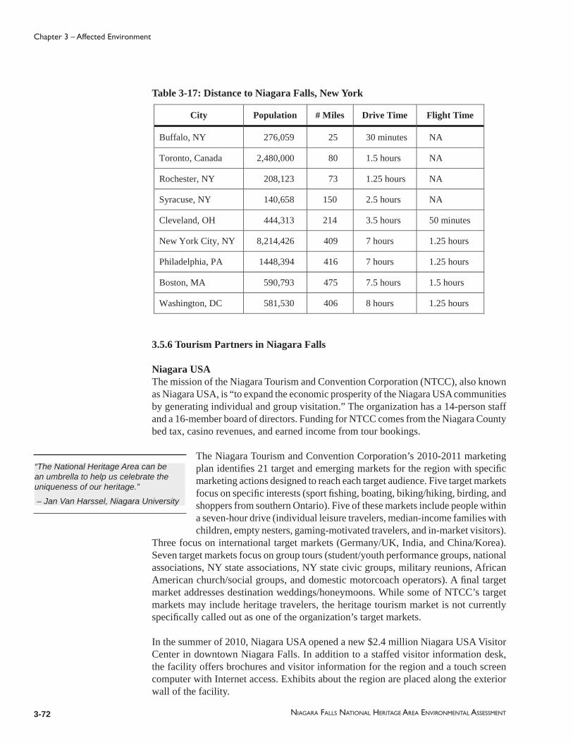
3-72 NIAGARA FALLS NATIONAL HERITAGE AREA ENVIRONMENTAL ASSESSMENT
Chapter 3 – Affected Environment
City Population # Miles Drive Time Flight Time
Buffalo, NY 276,059 25 30 minutes NA
Toronto, Canada 2,480,000 80 1.5 hours NA
Rochester, NY 208,123 73 1.25 hours NA
Syracuse, NY 140,658 150 2.5 hours NA
Cleveland, OH 444,313 214 3.5 hours 50 minutes
New York City, NY 8,214,426 409 7 hours 1.25 hours
Philadelphia, PA 1448,394 416 7 hours 1.25 hours
Boston, MA 590,793 475 7.5 hours 1.5 hours
Washington, DC 581,530 406 8 hours 1.25 hours
Table 3-17: Distance to Niagara Falls, New York
3.5.6 Tourism Partners in Niagara Falls
Niagara USAThe mission of the Niagara Tourism and Convention Corporation (NTCC), also known as Niagara USA, is “to expand the economic prosperity of the Niagara USA communities by generating individual and group visitation.” The organization has a 14-person staff and a 16-member board of directors. Funding for NTCC comes from the Niagara County bed tax, casino revenues, and earned income from tour bookings.
The Niagara Tourism and Convention Corporation’s 2010-2011 marketing plan identifi es 21 target and emerging markets for the region with specifi c marketing actions designed to reach each target audience. Five target markets focus on specifi c interests (sport fi shing, boating, biking/hiking, birding, and shoppers from southern Ontario). Five of these markets include people within a seven-hour drive (individual leisure travelers, median-income families with children, empty nesters, gaming-motivated travelers, and in-market visitors).
Three focus on international target markets (Germany/UK, India, and China/Korea). Seven target markets focus on group tours (student/youth performance groups, national associations, NY state associations, NY state civic groups, military reunions, African American church/social groups, and domestic motorcoach operators). A fi nal target market addresses destination weddings/honeymoons. While some of NTCC’s target markets may include heritage travelers, the heritage tourism market is not currently specifi cally called out as one of the organization’s target markets.
In the summer of 2010, Niagara USA opened a new $2.4 million Niagara USA Visitor Center in downtown Niagara Falls. In addition to a staffed visitor information desk, the facility offers brochures and visitor information for the region and a touch screen computer with Internet access. Exhibits about the region are placed along the exterior wall of the facility.
“The National Heritage Area can be an umbrella to help us celebrate the uniqueness of our heritage.”
– Jan Van Harssel, Niagara University
3-73
Chapter 3 – Affected Environment
NIAGARA FALLS NATIONAL HERITAGE AREA ENVIRONMENTAL ASSESSMENT
Panels describe the area’s history and heritage, arts and culture, and other regional efforts such as the panel pictured here describing the Great Lakes Seaway Trail. None of the panels currently on display describes the Niagara Falls National Heritage Area, which was just being formed when these panels were created.
While NTCC’s strategic plan includes an overall visitor profi le study, attendance number for individual attractions is not broken down. NTCC plans to undertake visitor satisfaction research, though this has not yet been implemented.
Niagara Falls State ParkAmerica’s oldest state park and clearly the anchor attraction for the Niagara Falls region, this state park welcomes between six and eight million visitors annually. The state park runs the Discovery Pass program, and has several concessionaires within the park who provide operational support under the direction of state parks. The largest of these concessionaires is Delaware North. Delaware North provides marketing assistance and operates the gift shops and food services within the state park. Delaware North hires over 300 seasonal employees to work in the park each year in addition to its year-round staff. New York State Parks operates the parking lots, trolleys, and the Cave of the Winds attraction. Destination Cinemas is the concessionaire for the Niagara Adventure Theater, and the Maid of the Mist Corporation is the concessionaire operating the Maid of the Mist.
Niagara River Region Chamber of CommerceThe Niagara River Region Chamber of Commerce (www.NiagaraRiverRegion.com) is a membership organization that supports businesses in Lewiston, Youngstown, Porter, Sanborn, and Ransomville. The Chamber has about a thousand members county-wide, with about a third in the City of Niagara Falls, a third in Lockport, and a third in the rest of the county. While tourism promotion is not its primary function, the Chamber does provide visitor information for travelers visiting the river communities north of Niagara Falls. It has launched a “shop local” campaign, worked with local restaurants on a farm-to-table program, offers professional development seminars, and generally serves as a business advocate.
Niagara University College of Hospitality and Tourism ManagementNiagara University has offered a bachelor’s degree in tourism since 1968, and faculty from this program have worked with both the Niagara Falls and Buffalo tourism agencies on a number of projects. The university has an ambassador program for the Niagara Falls conference center and has offered a number of hospitality training programs for front line staff.
Niagara 1812 Legacy CouncilThis Canada-based bi-national council (www.visit1812.com) has been working on plans to commemorate the bicentennial of the War of 1812. Participating sites in the United States include Old Fort Niagara and sites in eleven U.S. states as well as sites in Canada. While Canada has allocated substantial funding for the War of 1812 bicentennial, to date very little money has been allocated or secured by sites in the United States.

3-74 NIAGARA FALLS NATIONAL HERITAGE AREA ENVIRONMENTAL ASSESSMENT
Chapter 3 – Affected Environment
Private Tour OperatorsA number of private tour operators in the Niagara Falls area offer guided tour experiences in and around Niagara Falls, many offering multi-lingual experiences. Some tour operators offer specialized experiences such as the African-American heritage focus of Motherland Connextions or the sailing tours offered by Liberty Excursions. Most tour operators work with both Niagara USA and the Buffalo Niagara CVB. Tour operators working in the region include:
Bedore Tours, Inc.Club ToursEncounter Niagara ToursGray Line Niagara FallsHorizon ToursLiberty ExcursionsMirage ToursMotherland ConnextionsNiagara Christian Heritage ToursNiagara Frontier Scenic ToursOver the Falls Tours, Inc.Village Wine Tours
A number of tour operators offer a four-hour tour of the American side of Niagara Falls as well as a four-hour tour of the Canadian side. The standard tour of the American side of the Falls includes the Maid of the Mist and Cave of the Winds. As a number of tour operators offer a similar four-hour tour product, there is a highly competitive sales environment to capture a share of this lucrative market. Some tour operators collaborate with local hotels on exclusive arrangements whereby the hotel agrees to promote a specifi c tour product in exchange for a fi nancial return from the tour operator. Some tour operators have a desk or even an entire “Niagara Falls Visitor Center” operation in lodging properties.
Because the standard four-hour guided tour of the American side of the Falls overlaps with the offerings of the Niagara Falls State Park Discovery Pass, tour operators and lodging properties collaborating with tour operators do not have an incentive to promote the Discovery Pass because it includes many of the same attractions in the guided group tour product they are trying to sell.
Some tour operators, like Motherland Connextions, also offer value-added experiences to help visitors learn more about other aspects of the region’s heritage, such as the area’s connection to the Underground Railroad. This includes living history experiences tailored for the interests and timetable for each group. Some attractions in the area, such as Artpark, are diffi cult for tour operators to include because the summer season schedule is not announced until May, which is too late for most group tours.
Due to the large number of group tour businesses in Niagara Falls, the tour operators serving Niagara Falls provide additional tourism marketing for Niagara Falls, although marketing efforts are focused on promotion of their own group tour products and services. Tour operators also have the opportunity for direct contact with a large number of the visitors coming to the area.

3-75
Chapter 3 – Affected Environment
NIAGARA FALLS NATIONAL HERITAGE AREA ENVIRONMENTAL ASSESSMENT
Buffalo Niagara Convention and Visitors BureauThe primary target market for the Buffalo Niagara Convention and Visitors Bureau (BNCVB) is domestic cultural tourism with a strong focus on arts and architecture. While Erie County is the BNCVB’s primary service area, it markets attractions in Niagara County as well, due to the proximity and the draw of Niagara Falls for travelers. BNCVB CEO Dottie Gallagher Cohen explains, “We used to market Buffalo as a stop on the way back from Niagara Falls. Now we feel that there is a real story and an experience in Buffalo, so now we can lead with Buffalo and close with Niagara Falls.” Funding for the BNCVB comes from an Erie County grant as well as other sources for a total annual budget for 2011 of more than $3 million (source: Buffalo Niagara CVB 2011 Marketing and Sales Plan).
According to the Buffalo Niagara CVB’s 2011 Marketing and Sales Plan, the organization’s work plan includes sales, media relations, consumer advertising, visitor readiness and information (maintaining information centers and training local volunteers as Buffalo Ambassadors), and convention services. A key external sales and marketing strategy is to “develop and implement marketing strategies to promote arts, culture and history to external customers.” In addition, the BNCVB plans to support local marketing efforts “through the implementation of a Convention Concierge Program (and) the creation of a Community Relations position (in) response to the cultural community’s desire for a more aggressive dispersal of convention delegates throughout the community” (source: Buffalo Niagara: A Vision for the Future/A Plan for Success, Five Year Strategic Plan 2009-2013).
The BNCVB has received funding to work with the Bi-national Tourism Alliance and Niagara University on an analysis of visitor readiness as well as implementing training programs. The strategic plan also includes an action item for the BNCVB “to be more involved in regional projects that impact the tourism/hospitality sector” as well as being a strong advocate for “multi-modal linkages, asset improvements, and new systems to make connections among regional assets and amenities.” Specifi cally, this would include “updated and user friendly transportation systems and assets (including) a comprehensive wayfi nding system, linkages among transportation modes, visitor attractions and various amenities and improvements to ease-of-use of transportation systems/modes (i.e. NFTA, trolleys, Seaway Trail, Airport linkages, Bridges to Canada, etc.).”
According to a 2009 study by ArtsMarket, between 2006 and 2009 there has been a distinct shift in the visitors to Buffalo’s cultural destinations. A study completed by ArtsMarket in 2006 indicated that the majority of visitors were in Buffalo because they were visiting family and friends whereas in a follow-up 2009 study, cultural destinations are attracting visitors who specifi cally traveled to Buffalo for the arts and architecture.
The Buffalo Niagara 2011 Destination Planning Guide for me eting and travel professionals includes information about attractions in both Erie and Niagara counties. Many of the sample itineraries in the meeting planning guide include sites in the Niagara River valley, such as:

3-76 NIAGARA FALLS NATIONAL HERITAGE AREA ENVIRONMENTAL ASSESSMENT
Chapter 3 – Affected Environment
Makin’ Memories Tour includes Old Fort Niagara, Power Vista, Niagara Falls, and Niagara Adventure Theater, and other sites in Erie and Niagara counties.“Toss the Textbooks” Interactive Student Tour includes Old Fort Niagara, Maid of the Mist, Power Vista, Niagara Adventure Theater , the Whirlpool Jet Boat, an in-depth educational program about “Niagara’s Raging Rapids” and other sites in Erie and Niagara countiesNature’s Splendor Tour includes Artpark, Niagara Gorge Discovery Center, Niagara Falls State Park, Cave of the Winds, Maid of the Mist, Whirlpool Jet Boat Tours, Aquarium of Niagara, Niagara Falls, the Top of the Falls Restaurant, and other sites in Erie and Niagara counties.Historical Treasures Tour includes Old Fort Niagara, Freedom Crossing: The Underground Railroad at the Castellani Art Museum, and other sites in Erie and Niagara counties.Experience Edu-Excursion includes Niagara Falls, the Niagara Adventure Theater, the Niagara Gorge Discovery Center, Niagara Gorge Trail Hikes, Old Fort Niagara, and other sites in Erie and Niagara counties.
Agricultural ToursThe Niagara Wine Trail operates across the county to promote farms, and this helps sustain farms on the county’s historically agricultural landscape. The Niagara Escarpment Wine Trail is one of two routes that run through the county and it is the only one that traverses part of the heritage area – as it follows the natural contour of the escarpment as it extends through the Village of Lewiston to the Falls. Vineyards are not located in the heritage area, and the closest wineries are clustered near the intersection of Highways 425 and 104 west of Lockport.
Another organization that helps sustain and thereby preserve the agricultural landscape remaining in the heritage area and county is the Cornell Cooperative Extension of Niagara County (CCE), which provides a Pick Niagara Local Farm & Agri-Tourism Map that shows the following farmers markets within the heritage area: the Niagara Falls City Market (at 18th Street and Pine Avenue), the Bradt Tree Farms in Lewiston and Shippy Orchards in Youngstown. The CCE notes that Niagara County is “fi rst among New York counties in peaches, sweet cherries and plum/prunes, second in tart cherries and pears and fi fth in apple and berry production” (CCE 2011).
Bi-national Economic & Tourism AllianceThe mission of the Binational Economic & Tourism Alliance (BETA; www.btapartners.com) is “to provide the platform for U.S. and Canadian businesses and organizations to work collaboratively on cross-border economic and tourism development initiatives, in order to raise the regional and national awareness of the importance of cross-border communities to the North American economy, and ensure strong, sustainable growth and job creation in these communities” (source: www.btapartners.com). BETA is a not-for-profi t tourism industry trade organization with a two-person staff led by a volunteer board. BETA works in advocacy, professional development, and information sharing. Its primary focus area is the Niagara River corridor, although the hope is ultimately to expand to encompass the entire Great Lakes region.Since 2002, BETA has worked with a volunteer steering committee from Canada and the U.S. to coordinate an annual “Doors Open Niagara” event every fall. Heritage

3-77
Chapter 3 – Affected Environment
NIAGARA FALLS NATIONAL HERITAGE AREA ENVIRONMENTAL ASSESSMENT
properties on both sides of the border are open free of charge during this weekend-long event. The 2010 Doors Open Niagara included sites such as Power Vista and the Town of Porter Historical Society Museum in Youngstown.
Due to a combination of funding challenges and a change in the date for the event from October to June to coordinate with upcoming Bicentennial events for 2012-2014, the Doors Open event was not held in 2011 but is scheduled to resume in June of 2012.
Greater Niagara USAGreater Niagara USA (ww.GreaterNiagaraUSA.com) promotes attractions within a fi ve-county region in New York that includes Erie, Genesee, Niagara, Orleans, and Wyoming counties. The website includes suggested driving tours:
“ Niagara River Magic Driving Tour” which includes the Niagara Reservation State Park, Cave of the Winds, Maid of the Mist, the Niagara Discovery Center, Aquarium of Niagara, Power Vista, Castellani Art Museum, Historic Lewiston, and Artpark.“ Buffalo Niagara Heritage Trail North Driving Tour” which includes Niagara Falls, Maid of the Mist, and Old Fort Niagara as well as other attractions in Canada, Lockport, and Buffalo.“ War of 1812 Driving Tour” which includes Artpark and Old Fort Niagara as well as other attractions in Niagara County and Canada.“ Underground Railroad Driving Tour” which includes the First Presbyterian Church and the Freedom Crossing sculpture in Lewiston as well as other sites in Niagara and Erie counties and Canada.“ Family Fun Driving Tour” which includes Power Vista, Old Fort Niagara, and the Whirlpool Jet Boat Tours along with other attractions in Niagara and Erie counties and Canada.
New York State Division of TourismNew York’s state tourism website (www.iloveny.com) includes two suggested itineraries in the Greater Niagara tourism region, one of which is the Wonders of Nature and Design itinerary. This three-day suggested itinerary includes Niagara Falls State Park, the Niagara Gorge Discovery Center, the Maid of the Mist Boat Tour, Top of the Falls restaurant, Cave of the Winds, Aquarium of Niagara, Daredevil Museum, the Whirlpool Jet Boat Tours, and the Lockport Cave and Underground Boat Ride. The website also includes links to the Greater Niagara USA travel region and Niagara USA’s websites.
3.5.7 Lodging
Lodging options for overnight visitors to the Niagara Falls region are primarily clustered in Niagara Falls NY, Niagara Falls Ontario, and Buffalo. In Niagara Falls NY, several lodging properties are downtown within walking distance of the Falls, including the Comfort Inn, Crowne Plaza, and several other lodging properties. A number of other lodging properties are on Niagara Falls Boulevard within a short driving distance from the Falls. There are a few lodging options available in the river towns to the north of Niagara Falls. Given the large number of hotel rooms available across the river in Niagara Falls Ontario and in Buffalo, visitors also have the option of staying in those locations as their base and visiting New York’s Niagara River valley as a day trip.

3-78 NIAGARA FALLS NATIONAL HERITAGE AREA ENVIRONMENTAL ASSESSMENT
Chapter 3 – Affected Environment
For travelers seeking a more intimate lodging experience, there are eight bed & breakfast businesses in Niagara Falls offering a total of 36 rooms. Many are located in historic homes:
Butler House Bed & BreakfastElizabeth House Bed & BreakfastHanover House Bed & BreakfastHillcrest InnThe Holley Rankine HouseNiagara House Bed & Breakfast (vacation rental)Park Place Bed & BreakfastRainbow House Bed & Breakfast
Other historic lodging properties in Niagara Falls include the 31-room Red Coach Inn, which opened in 1923, and the Giacomo, a new boutique hotel located in the 1929 Art Deco-style United Offi ce Building in downtown Niagara Falls, which offers 38 hotel rooms and 24 apartments. This historic building, listed on both the New York State and National Registers of Historic Places, was renovated as part of a public-private partnership among USA Niagara, the City of Niagara Falls, and a private developer. After standing vacant since the 1980s, the United Offi ce building completed renovations in 2010.
There are roughly 4,000 hotel rooms in Niagara County, about 3,000 of which are in the City of Niagara Falls. Niagara Falls Ontario across the river has approximately 20,000 rooms, and an additional estimated 8,000 hotel rooms are available in Buffalo, NY. Average room rates in Niagara Falls New York tend to be lower than the average room rates in Buffalo and Niagara Falls Ontario.
3.5.8 Fully Independent Traveler Market
Visitors planning trips to the Niagara Falls area can consult a variety of tourism websites such as www.niagara-usa.com, the offi cial website for Niagara Falls, USA or www.niagarafallstourism.com , the offi cial website for Niagara Falls, Ontario. In addition, there is a section on the Buffalo Niagara Convention and Visitors Bureau website devoted to Niagara Falls (http://www.visitbuffaloniagara.com/visitors/niagarafalls/). Many individual attractions, hotels, and tourism related businesses in Niagara County also have their own websites as well.
Individual travelers can visit attractions in and around Niagara Falls on their own, or they can buy the Niagara USA Discovery Pass offered by Niagara Falls State Park. It includes admission to selected attractions on the American side of the Falls (Niagara: Legends of Adventure Theater, Aquarium of Niagara, Cave of the Winds, Niagara Gorge Discovery Center, the Maid of the Mist, and the Niagara Scenic Trolley, a shuttle within the state park). The pass costs $33/adult and $26/child and also includes discount coupons for a number of other attractions in the region. Participating vendors pay a fee to be included. Approximately 200,000 passes are printed each year, and passes are available in a number of locations, including the tollbooths leading from Canada into Niagara Falls. Passes can also be purchased online; travelers purchasing the Discovery Pass online receive a voucher which can be redeemed for an actual Discovery Pass after their arrival

3-79
Chapter 3 – Affected Environment
NIAGARA FALLS NATIONAL HERITAGE AREA ENVIRONMENTAL ASSESSMENT
in Niagara Falls. Because the Discovery Pass is a paper pass rather than an electronic pass, it is diffi cult to determine exact numbers of tickets redeemed at each participating attraction.
As New York State government regulations prohibit selling the Discovery Pass at wholesale rates to tour operators who could then resell the passes, those working in the tourism industry have no incentive to market the Discovery Pass as an alternative to their guided experiences. Tour operators must purchase the tickets in advance at full price and are not able to return unsold passes at the end of the season. Niagara Falls State Park does permit tour operators and other reselling the Discovery Pass to add on a $1 service fee to cover credit card charges and handling fees. Some tour operators have indicated that while they would prefer to offer the Discovery Pass because it includes attractions on the American side of the Falls, they sell the Canadian Power Pass instead because that pass is commissionable.
The binational Niagara Falls Power Pass includes entry to more than 20 Niagara Falls attractions in the United States and Canada. The Power Pass is offered as a one-day, two-day, three-day or fi ve-day pass with prices ranging from $69.99/person for a one-day pass to $142.99 for a fi ve-day pass. The Power Pass includes all the attractions in the Discovery Pass plus the following:
Additional “Power Pass” attractions in the United States:Herschell Carrousel Factory MuseumOld Fort NiagaraNiagara’s Wax Museum of HistoryGreg Frewin Magic ShowLockport Locks & Erie Canal CruiseMartin’s Fantasy Island Family Theme ParkSpecial Offer for the Whirlpool Jet BoatsShopping Package at Fashion Outlets of Niagara FallsNiagara Wine Train“Power Pass” attractions in Canada:Nightmares Fear FactoryBird KingdomIMAX NiagaraKonica Minolta Tower Centre Observation DeckLundy’s Lane Historical MuseumsLouis Tussaud’s WaxworksRipley’s Believe it or Not! MuseumRipley’s Moving TheaterWaves Indoor Waterpark
Due to the sheer numbers of travelers visiting Niagara Falls, tour operators are able to offer a variety of guided tour offerings that individual travelers can sign up for after arrival in Niagara Falls. In addition, tour operators and the convention and visitors bureaus work to bring groups to the area for guided tour experiences.
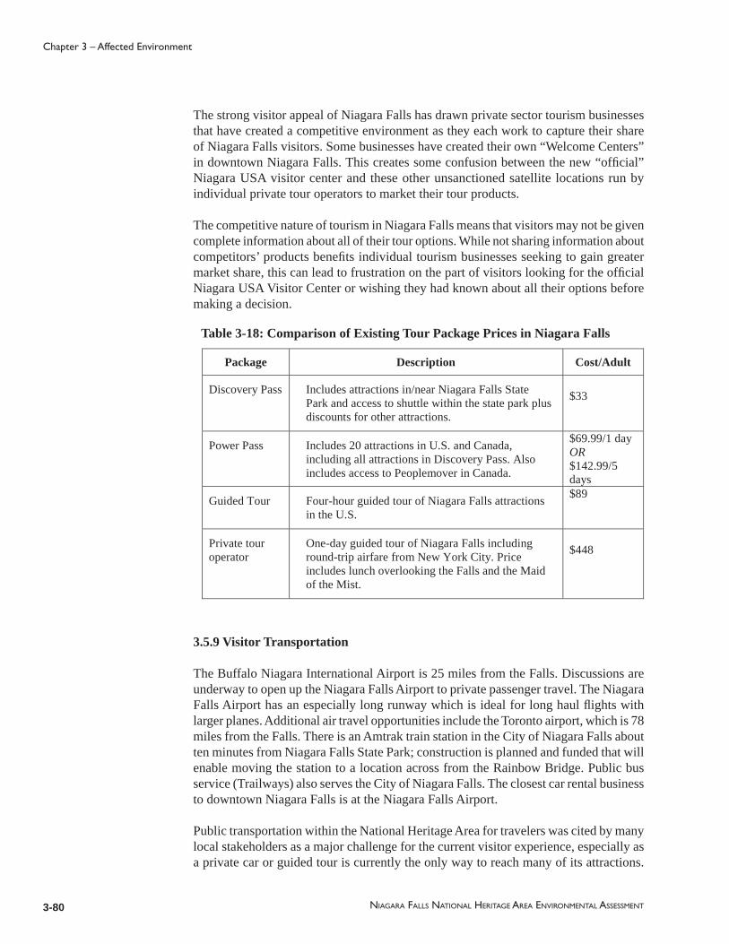
3-80 NIAGARA FALLS NATIONAL HERITAGE AREA ENVIRONMENTAL ASSESSMENT
Chapter 3 – Affected Environment
The strong visitor appeal of Niagara Falls has drawn private sector tourism businesses that have created a competitive environment as they each work to capture their share of Niagara Falls visitors. Some businesses have created their own “Welcome Centers” in downtown Niagara Falls. This creates some confusion between the new “offi cial” Niagara USA visitor center and these other unsanctioned satellite locations run by individual private tour operators to market their tour products.
The competitive nature of tourism in Niagara Falls means that visitors may not be given complete information about all of their tour options. While not sharing information about competitors’ products benefi ts individual tourism businesses seeking to gain greater market share, this can lead to frustration on the part of visitors looking for the offi cial Niagara USA Visitor Center or wishing they had known about all their options before making a decision.
Table 3-18: Comparison of Existing Tour Package Prices in Niagara Falls
Package Description Cost/Adult
Discovery Pass Includes attractions in/near Niagara Falls State Park and access to shuttle within the state park plus discounts for other attractions.
$33
Power Pass Includes 20 attractions in U.S. and Canada, including all attractions in Discovery Pass. Also includes access to Peoplemover in Canada.
$69.99/1 day OR$142.99/5 days
Guided Tour Four-hour guided tour of Niagara Falls attractions in the U.S.
$89
Private tour operator
One-day guided tour of Niagara Falls including round-trip airfare from New York City. Price includes lunch overlooking the Falls and the Maid of the Mist.
$448
3.5.9 Visitor Transportation
The Buffalo Niagara International Airport is 25 miles from the Falls. Discussions are underway to open up the Niagara Falls Airport to private passenger travel. The Niagara Falls Airport has an especially long runway which is ideal for long haul fl ights with larger planes. Additional air travel opportunities include the Toronto airport, which is 78 miles from the Falls. There is an Amtrak train station in the City of Niagara Falls about ten minutes from Niagara Falls State Park; construction is planned and funded that will enable moving the station to a location across from the Rainbow Bridge. Public bus service (Trailways) also serves the City of Niagara Falls. The closest car rental business to downtown Niagara Falls is at the Niagara Falls Airport.
Public transportation within the National Heritage Area for travelers was cited by many local stakeholders as a major challenge for the current visitor experience, especially as a private car or guided tour is currently the only way to reach many of its attractions.
3-81
Chapter 3 – Affected Environment
NIAGARA FALLS NATIONAL HERITAGE AREA ENVIRONMENTAL ASSESSMENT
Within Niagara Falls State Park, a seasonal shuttle service provides transportation, included with the purchase of the Discovery Pass or purchased separately for $2/pass. Across the river in Canada, there is a seasonal “Peoplemover” shuttle service that provides air-conditioned buses that depart from attractions every 20 minutes, serving a 19-mile loop along the Niagara Parkway. The Peoplemover includes commentary provided by the shuttle drivers. Like the shuttle service in Niagara Falls State Park, access to the Niagara Parks Peoplemover is included with the purchase of the Canadian “Power Pass.” Currently there is no comparable public or private shuttle option to link attractions within the Niagara Falls National Heritage Area on the United States side.
One individual attraction, Whirlpool Jet Boat Tours, has developed its own shuttle service to and from Niagara Falls State Park, offering free pick-up and drop-off service for ticketed customers several times a day.
For travelers arriving in Niagara Falls without a car, or for those who prefer to avoid parking fees and congestion at Niagara Falls State Park, many tour operators do provide tour service from area hotels for tours of the United States and/or Canadian side of the Falls. In addition, the Niagara Falls Transportation Authority (NFTA) operates a trolley system which links a number of Niagara Falls motels and the Outlet Mall with Niagara Falls State Park. This service is supported in part by the Niagara Falls bed tax. While area residents can pay to ride this shuttle, the primary riders for this shuttle service are tourists. A number of lodging facilities offer coupons for free shuttle service to the Falls for their overnight guests. For travelers who drive their own car to the state park, parking lots in Niagara Falls State Park currently cost $10/car, with additional pay lots available outside the state park. Parking fees decrease for lots further away from the entrance to the state park.
There have been a number of efforts to establish a hop-on, hop-off shuttle service to link attractions outside of Niagara Falls State Park, though to date they have not been successful. About fi ve or six years ago the NTCC worked on developing a public-private partnership with a local tour operator to link attractions outside the state park. While the original intent was to underwrite the cost so that the shuttle could be offered free of charge for the fi rst year, budget cuts prevented this plan from being implemented.
Private efforts to launch a hop-on, hop-off shuttle service outside of Niagara Falls State Park have had limited success to date. One pilot effort was tested by Grayline Tours in Niagara Falls several years ago. While Grayline has a successful track record of offering hop-on, hop-off shuttle service for many major destinations around the world, this private effort has had challenges generating ridership in Niagara Falls. The Grayline hop-on, hop-off shuttle tickets on the U.S. side of the Falls was priced at $29 per day per person or $39 for a two-day shuttle pass with half-price tickets for children.
Costs for the proposed Grayline shuttle were comparable with other hop-on, hop-off services offered by Grayline and substantially less than the per-person cost of a four-hour group tour ticket. However, ticket prices for the privately operated Grayline shuttle were signifi cantly more expensive than the Canadian Peoplemover operated by Niagara Parks. The Canadian Peoplemover tickets currently cost $8.85 for adults and $5.35 for children (in Canadian dollars) for an all-day pass, and the Peoplemover pass is included
3-82 NIAGARA FALLS NATIONAL HERITAGE AREA ENVIRONMENTAL ASSESSMENT
Chapter 3 – Affected Environment
as part of the binational “Power Pass.” The Peoplemover offers a 19-mile loop to connect key attractions on the Canadian side of the Falls.
Alternative modes of transportation have been tested by small businesses in the City of Niagara Falls to a limited extent. A new bike rental service for downtown Niagara Falls was launched during the 2011 season with several bikes to rent from a facility on Falls Street, and there is at least one private vendor who offers pedicab services near Niagara Falls State Park. There are currently no comparable services operating in Lewiston or Youngstown.

4-1NIAGARA FALLS NATIONAL HERITAGE AREA ENVIRONMENTAL ASSESSMENT
Chapter 4 – Environmental Consequences
4.1 General Methodology for Assessing Impacts
This chapter provides an overview of the potential impacts of each of the four alternatives described in Chapter 2, Alternatives, of the Environmental Assessment for the Niagara Falls National Heritage Area. As described in Chapter 1, Purpose and Need, the following impact topics by categories have been retained for analysis:
Natural Resources and LandscapesThe Niagara Gorge and Escarpment, Unique EcosystemVegetation/Threatened and Endangered Plant Species Important Wildlife
Historic and Cultural ResourcesHistoric Properties and DistrictsNative American Associated Sites other than Indian Trust Resources and Sacred SitesArcheological ResourcesInterpretive Facilities and Collections
Socio-economic ContextSocio-economic factors, employment
Tourism and Visitor ExperienceVisitor experience Scenic and recreation resources
The Environmental Assessment and Management Plan for the Niagara Falls National Heritage Area is conceptual and programmatic in scope. As a result of the plan’s broadly defi ned policies and programs, this discussion of environmental impacts focuses on the types of consequences that could be associated with certain strategies, policies, and action items, rather than site-specifi c or project-specifi c impacts. If individual projects within the Niagara Falls National Heritage Area are undertaken in the future, they would need to comply with all applicable state and local requirements including, but not limited to zoning statutes, wetlands and/or waterway permits, and fl oodplain regulations. Future projects that receive federal assistance would require additional compliance under such laws as the National Environmental Policy Act and Section 106 of the National Historic Preservation Act at the time they are undertaken.
The implementation of the management plan will depend upon the coordinated actions of a wide range of partner organizations and the public according to capacity, resources, and level of commitment and recognition. Therefore, while some of the impact topics

4-2 NIAGARA FALLS NATIONAL HERITAGE AREA ENVIRONMENTAL ASSESSMENT
Chapter 4 – Environmental Consequences
discussed here may be analyzed quantitatively, the programmatic nature of the overall management plan and its implementation lends itself to a qualitative discussion of anticipated environmental consequences.
In this chapter, each impact topic will be described briefl y, followed by an analysis of each alternative’s anticipated environmental consequences associated with that impact topic evaluated on both a short-term and long-term basis.
The environmental impact analysis includes an assessment of benefi cial and adverse impacts; direct, indirect, and cumulative impacts; and, to the extent possible, the context, duration, and intensity of impacts. Environmental impacts are evaluated and described comparatively in this chapter. The following terms are used to describe the general nature of an anticipated environmental impact:
Benefi cial – The impact is generally positive.Adverse – The impact is generally negative.
The following terms are used to describe the relative intensity of adverse environmental impacts:
Negligible – The impact is barely perceptible or not measurable.Minor – The impact is slightly detectable and measurable but is either localized or would not adversely affect resources.Moderate – The impact is clearly detectable and could have appreciable adverse effect on resources.Major – The impact is substantial and highly noticeable or measurable.
The following terms are used to describe the duration of anticipated environmental impacts:
Short-term – The impact within the fi rst year.Long-term – The impact within a two to ten year timeframe or longer.
Environmental impacts may also be direct, occurring in the same place and at the same time as the proposed action or alternative; indirect, occurring at a time or in a space somewhat removed from the proposed action or alternative; or cumulative, occurring as the result of multiple actions over time.
The majority of environmental impacts that result from the four potential alternative futures for heritage area management and implementation are expected to be positive because of the management plan’s focus on resource identifi cation, protection, and enhancement. In the impact assessments outlined below, the benefi cial impacts are described within a short-term and long-term framework.

4-3
Chapter 4 – Environmental Consequences
NIAGARA FALLS NATIONAL HERITAGE AREA ENVIRONMENTAL ASSESSMENT
4.2 Summary of Key Differences among the Alternatives
Four potential alternatives for heritage area management have been developed. The alternatives, described in detail in Chapter 2, include one “Current Conditions” alternative and three “Action” alternatives:
Alternative A, Current Conditions Continue (No Action)Alternative B, Focus on Interpretation Alternative C, Focus on Heritage Product DevelopmentAlternative D, Focus on Visitor Experience
Under Alternative A, Current Conditions Continue, (the no action alternative) the region would continue to develop without programming offered through the heritage area. Existing local and regional programs would continue to evolve as they are presently organized.
Alternatives B, C, and D (the action alternatives) all work to promote the following goals: providing opportunities for learning about the signifi cance of the Niagara Falls region through the fostering of close working relationships and partnerships; identifying, protecting, and promoting historic and cultural resources; enhancing and promoting the region’s natural, recreational, and scenic resources; providing opportunities for interpretation, education, and research of the area’s signifi cant social and geologic history; and promoting heritage tourism and a positive visitor experience throughout the region. Though the alternatives share these goals, each of the three alternatives emphasizes them and their associated strategies to varying degrees.
Alternative B, Focus on Interpretation, envisions a heritage area organization working primarily behind the scenes assisting partners as an organizer, facilitator, and coach. The primary focus would be creating a high-quality interpretive experience with secondary emphasis on other goals and strategies. The heritage area would implement this alternative through such activities as assisting attractions, sites, and communities with exhibits, living history, media, and programming.
Alternative C, Focus on Heritage Product Development, emphasizes an active, leadership role in which the heritage area’s local coordinating entity is out front as a primary player in the region, actively engaged in a wide range of potential projects and issues focused upon heritage development. While still working closely with partners, the heritage area might initiate, manage, and develop projects on its own. Projects undertaken under this alternative could include a new interpretive center, extensive trails system, and a network of interpretive exhibits. Among the alternatives, Alternative C is also most focused on stewardship. The local coordinating entity would seek opportunities to rehabilitate and restore blighted historic buildings and structures and enhance commercial centers and neighborhoods. It would also take an active role in restoring ecosystems along with plant and animal communities along the river.

4-4 NIAGARA FALLS NATIONAL HERITAGE AREA ENVIRONMENTAL ASSESSMENT
Chapter 4 – Environmental Consequences
Alternative D, Focus on Visitor Experience, is a hybrid of Alternatives B and C. Where existing groups can lead, the heritage area would play a facilitating and supportive role, as in Alternative B. Where no leadership exists, the heritage area would be an active leader and developer, as in Alternative C. Types of projects that could be undertaken under Alternative D could include supporting projects addressing economic development, community enhancement, and environmental quality; and operating a central interpretive center and working to fi ll gaps in such areas as hospitality programs and training, visitor transportation, and wayfi nding.
Alternative B primarily addresses enriching the interpretive experience. Alternative C includes interpretation along with trail development, community revitalization, ecosystem restoration, and visitor services among its top priorities. Alternative B emphasizes a partnership role whereas Alternative C represents an organization developing and implementing projects directly.
Alternative D is a more robust version of Alternative B with elements of Alternative C. In Alternative D the heritage area has a broader focus and more opportunities to act as a leader than in Alternative B, and Alternative D relies more upon partnership opportunities than Alternative C. Neither Alternatives B nor D includes the direct involvement in revitalization and environmental stewardship work that is proposed in Alternative C. Due to its direct role in environmental stewardship, Alternative C is identifi ed as the Environmentally Preferred Alternative in Chapter 2, Alternatives.
4.3 Natural Resources and Landscapes
The management, preservation, protection, and interpretation of natural resources, including policies and strategies for appropriate land and water resource management, is a primary purpose for which the heritage area was created. Each of the alternatives developed for the Niagara Falls National Heritage Area seeks to achieve the goal of natural resource protection, but do so to varying degrees. Therefore, potential impacts that concern natural resources must be considered, including: the Niagara Gorge and Escarpment, Unique Ecosystem; vegetation/threatened and endangered plant species; and important wildlife.
4.3.1 The Niagara Gorge and Escarpment, Unique Ecosystem
Alternative A, Current Conditions Continue, Alternative B, Focus on Heritage Interpretation, Alternative C, Focus on Heritage Product Development, and Alternative D, Focus on Visitor Experience, each would have an indirect, minor benefi cial impact on the geological features, hydrology, habitats, or any other resources associated with the Niagara Escarpment and Gorge within the heritage area on a short-term basis. For Alternative A, no applications have been submitted for the next year of funding that address this impact topic. For the three action alternatives, the heritage area organization will be focusing on other goals and priorities during the fi rst year.
Alternative A, Current Conditions Continue would have the same minor impact as the heritage area alternatives for the short-term because the ongoing implementation of

4-5
Chapter 4 – Environmental Consequences
NIAGARA FALLS NATIONAL HERITAGE AREA ENVIRONMENTAL ASSESSMENT
the Niagara River Greenway Plan identifi es the signifi cance of this unique ecosystem, but does not require that funds be used to specifi cally implement projects related to its preservation and enhancement. Goals and objectives are provided in the greenway plan, similar to the heritage area that seek to preserve and enhance the Niagara Gorge and Escarpment, but are only achieved if an applicant seeking funding for a specifi c project chooses to do so. No applicant has submitted an application that would directly achieve such objectives to date. The fact that an applicant for funding through the greenway program may submit such an application in the future warrants consideration that a direct, moderate benefi cial impact on the Niagara Gorge and Escarpment is feasible for the long-term under Alternative A.
Alternatives B and D, while encouraging and advocating the protection of environmental resources in the Niagara Gorge and Escarpment by heritage area partners, does not ever directly involve the heritage area organization in implementing actual environmental preservation or enhancement projects. However, the natural environment is a primary interpretive focus for the heritage area under the Natural Phenomenon heading and any interpretation efforts pursued under Alternative B and D likely enhancing and expanding opportunities for the public to appreciate and enjoy the natural resources associate with the gorge and escarpment. For this reason, the two alternatives are likely to both have a indirect, moderate benefi cial impact over the long-term.
Since ‘short-term’ is defi ned in this chapter as the activities and projects that happen within the fi rst three years of implementation of the heritage area program, this timeframe would not be suffi cient to allow any actual environmental preservation or enhancement projects to be executed under Alternative C. However, a long-term timeframe (3-10 years) would provide opportunity for the heritage area organization to move forward with specifi c environmental enhancement projects that would likely have a direct, moderate benefi cial impact on the Niagara Gorge and Escarpment under Alternative C.
It should be noted that no specifi c project that preserves or enhances the gorge and/or escarpment is identifi ed in the Niagara Falls National Heritage Area Management Plan. Each of the three action alternatives outlined in the management plan describes broadly defi ned policies and strategies rather than site-specifi c projects and proposals. These broad policies, guidelines, and strategies will, in general, support the protection of natural resources. If site-specifi c projects are proposed following the adoption of the management plan, supplemental environmental assessments will be required to meet federal, state, and local requirements.
4.3.2 Vegetation/Threatened and Endangered Plant Species
Through the Niagara River Greenway Plan, Alternative A, Current Conditions Continue, places high importance on conserving natural resources and developing recreational resources related to the Niagara River. Intergovernmental cooperation in and support for programs and projects related to the river would continue without the heritage area. Efforts to implement the Niagara River Greenway Plan have thus far not focused on the stabilization and enhancement of vegetative communities or the conservation of threatened and endangered plant species although funding for such projects and

4-6 NIAGARA FALLS NATIONAL HERITAGE AREA ENVIRONMENTAL ASSESSMENT
Chapter 4 – Environmental Consequences
programs is feasible. Therefore, the impact on vegetation and threatened or endangered plant species under Alternative A is an indirect, minor benefi cial impact for the short-term. The fact that an applicant for funding through the greenway program is likely to submit such an application in the future warrants consideration that a direct, moderate benefi cial impact on the Niagara Gorge and Escarpment is probable for the long-term under Alternative A.
Alternative B, Focus on Heritage Interpretation, and Alternative D, Focus on Visitor Experience would primarily focus on creating a high-quality interpretation experience. The natural environment is a primary interpretive focus for the heritage area under the Natural Phenomenon heading and any interpretation efforts pursued under Alternative B and D would likely enhance and expand opportunities for the public – visitors and residents alike – to learn about and appreciate the vegetative communities and rare plants associated with the Niagara River and its uplands. This awareness is likely to create interest in related natural history and environmental projects. For the short-term, the fi rst year will require the heritage area organization to focus efforts on program startup so its effect on these resources under these two alternatives will be indirect and of minor benefi t. For the long-term, through its positive focus on education and engagement, Alternative B and D would have an indirect, moderate benefi cial impact on vegetation and identifi ed threatened and endangered plant species.
Alternative C, Focus on Heritage Product Development, the heritage area organization would take an active role in restoring signifi cant ecosystems including plant communities along the river and its uplands. In addition, basic interpretive activities and programs would be provided as part of Alternative C. This alternative would thereby have a direct, moderate benefi cial impact on vegetation along with identifi ed threatened and endangered plant species in the heritage area over the long-term. For the short-term, the fi rst year will require the heritage area organization to focus efforts on program startup so its effect on these resources will be indirect and of minor benefi t.
Among the factors contributing to the degradation of vegetation and threatened or endangered plant species, is intensity of use. Over the decades, the development of the City of Niagara Falls as an urban and industrial community has had a severe negative impact upon the river corridor’s natural resources. The heritage area management plan supports current community goals of preserving and restoring remaining natural areas. Most of the region’s remaining natural areas, including rare and endangered plant species, are located within the parks along the river and in its gorge.
Intense visitor use of the parks due to Niagara Falls’ attraction as a tourist destination has also negatively impacted the vegetation within remaining natural areas. While none of the alternatives is anticipated to result in an increased number of visitors to the parks overall, some actions may result in changes to the ways specifi c areas are used, including the possibility of more intense uses in ecologically fragile areas, such as along trails. Planning and implementation of future projects must therefore be cognizant of such changes relative to the capacity of the natural areas to absorb them and include steps for mitigation and protection.
4-7
Chapter 4 – Environmental Consequences
NIAGARA FALLS NATIONAL HERITAGE AREA ENVIRONMENTAL ASSESSMENT
In addition, the construction of new projects such as trails, landscape exhibits, and visitor facilities has the potential for short-term adverse impact due to construction activities. Any potential short-term adverse impacts should be fully assessed and mitigated as future site-specifi c projects undertaken in support of the plan are proposed, planned, and reviewed.
4.3.3 Important Wildlife
Like Subsection 4.3.2 above, the implementation of the Niagara River Greenway Plan may encourage the stabilization or enhancement of certain signifi cant wildlife populations. Examples of viable projects include the proposed fi sh hatchery or birds of prey observation tower in Lewiston. Since high importance is placed on the conservation of natural resources associated with the Niagara River in the greenway plan, Alternative A, Current Conditions Continue, would exist without the heritage area program and should be considered to have a direct, moderate benefi cial impact for important wildlife populations over the long-term. Since no applications have been submitted for the next year of funding in the greenway program that address this impact topic the effect for the short-term is indirect and of minor benefi t.
Alternative B, Focus on Heritage Interpretation and Alternative D, Focus on Visitor Experience, proposes a high-quality interpretive program that would inform visitors about the special or unique nature of certain wildlife populations in the heritage area. Any efforts to develop interpretive programs on natural history would likely include important wildlife populations associated with the Niagara River and its uplands. Creating a sense of appreciation for such animals would likely have an indirect, moderate benefi cial impact on important wildlife populations found within the heritage area over the long-term. The fi rst year will require the heritage area organization to focus efforts on program startup so its short-term effect on important wildlife populations under these two alternatives will be an indirect, minor benefi cial impact.
As with the plant communities mentioned above, Alternative C, Focus on Heritage Product Development, the heritage area organization would take an active role in restoring signifi cant ecosystems including important wildlife populations along the river and its uplands. As part of Alternative C, basic interpretive activities and programs would be provided. This alternative would thereby have a direct, moderate benefi cial impact on wildlife in the heritage area over the long-term. However, the short-term impact on important wildlife would be of indirect, minor benefi t since the heritage area organization would focus efforts on program startup issues during the fi rst year.
4.4 Historic and Cultural Resources
The management, preservation, protection, and interpretation of historic and cultural resources are a primary purpose for which the Niagara Falls National Heritage Area was created. Therefore, all of the proposed management alternatives seek to achieve this goal but do so with varying degrees of priority and effectiveness. This section discusses historic properties and districts; Native American associated properties (excluding Indian Trust Resources and sacred sites); archeological resources; education; and interpretive facilities and collections.

4-8 NIAGARA FALLS NATIONAL HERITAGE AREA ENVIRONMENTAL ASSESSMENT
Chapter 4 – Environmental Consequences
4.4.1 Historic Properties and Districts
Under Alternative A, Current Conditions Continue, local organizations would continue to promote preservation within their respective communities. Important work has been done to inventory, rehabilitate, and restore historic buildings, but there is a signifi cant amount of work yet to be completed. However, existing private and public resources focused on historic preservation cannot fully address the historic preservation needs of the heritage area. Alternative A, therefore, would have a direct, minor benefi cial impact on historic buildings and districts for both the short-term and long-term.
Alternative B, Focus on Interpretation, would likely have a direct, minor benefi cial impact for both the short-term and long-term on the historic buildings and districts throughout the heritage area. Alternative B would provide interpretive and educational programming that directly supports community preservation goals. This would likely increase public appreciation and support for recognizing, rehabilitating, and restoring both public and private historic buildings.
Alternative C, Focus on Heritage Product Development, could have a direct, major benefi cial impact on historic buildings and districts over the long-term. Under Alternative C, the heritage area organization would create and implement a regional historic preservation plan, and actively seek opportunities to stabilize, rehabilitate, and restore historic buildings and structures in the City of Niagara Falls and throughout the heritage area, where many worthy buildings stand in need of attention. The short-term impact on historic properties would be of direct, moderate benefi t as the heritage area organization begins program implementation during the fi rst year.
Alternative D, Focus on Visitor Experience, would likely have a direct, moderate benefi cial impact on the historic buildings and districts in communities throughout the heritage area for both the short-term and long-term. Under Alternative D, the heritage area would immediately begin educating residents and visitors about the signifi cance of resources, as in Alternative B, but would also actively encourage and support the actions of partners in the preservation of resources throughout the course of the program.
4.4.2 Native American Associated Properties
Department of the Interior Secretarial Order 3175 requires that any anticipated impacts to Indian Trust Resources and Assets by a proposed project or action by agencies within the department be explicitly addressed in environmental documents. The federal Indian Trust responsibility is a legally enforceable obligation on the part of the United States to protect tribal lands, assets, resources, and treaty rights, and it represents a duty to carry out the mandates of federal laws with respect to federally-recognized Native American tribes. No such resources or assets were identifi ed within the heritage area. However, there are certain resources and features in the heritage area that are associated with Native American history. It is the desire of the Niagara Falls Heritage Area Commission to identify and interpret these properties as part of the overall heritage area program.
4-9
Chapter 4 – Environmental Consequences
NIAGARA FALLS NATIONAL HERITAGE AREA ENVIRONMENTAL ASSESSMENT
Under Alternative A, Current Conditions Continue, properties associated with Native American history in the heritage area would not receive any additional attention or focus unless addressed by an individual agency or organization. Any existing interpretation and programming would likely continue in isolation at established venues associate with tribal interests, state and local parks, and other heritage attractions. The status quo and lack of programmatic cohesion represented by Alternative A would result in an indirect, minor benefi cial impact for these properties for both the sort-term and long-term.
Alternatives B, C, and D support several initiatives that could specifi cally benefi t properties associated with the Native American story. Each of the action alternatives seek to identify specifi c cultural and natural resources related to the interpretive themes for the heritage area on an ongoing basis. As such resource are identifi ed the heritage area will develop partnerships with organizations to preserve, enhance, and interpret these resources as part of the overall plan to develop an interpretive framework. This will require state, local and tribal governments to prepare and update preservation plans and historic inventories. Technical assistance for these efforts is potentially available through the National Park Service. All three action alternatives will likely have a direct, minor benefi cial impact for properties associated with the Native American story in the short-term as the heritage area seeks to develop and implement programs during the fi rst year. As partnerships are formed and specifi c plans are implemented it is anticipated that any of the three action alternatives will have a direct, moderate benefi cial impact for properties associated with the Native American story over the course of the heritage area program.
4.4.3 Archeological Resources
Under Alternative A, Current Conditions Continue, New York State Parks will continue to protect and interpret archeological resources located on state lands; and national, state, and local laws will continue to protect archeological resources both within and outside of park lands. These conditions also hold true for Alternatives B, C, and D. With the lack of specifi c additional initiatives, however, Alternative A is anticipated to have a negligible impact upon archeological resources for both the short-term and long-term.
Alternatives B, C, and D support several initiatives that could specifi cally benefi t archeological resources. Each of the action alternatives seeks offi cial designation for signifi cant cultural and natural resources; creates or joins with organizations to preserve, enhance, and interpret these resources; collaborates with partners in developing an interpretive framework and plan and in networking attractions; and encourages local governments to prepare and update preservation plans and historic inventories, and seek planning grants and technical assistance through the Certifi ed Local Government program. All three action alternatives will have a direct, minor benefi cial impact for the short-term.
Alternative B, Focus on Interpretation, proposes to enrich the interpretive experience and in this way could enhance such sites as the Lower Landing Archeological District in Artpark State Park maintaining a direct, minor benefi cial impact throughout the duration of the heritage area program. Alternative C, Focus on Heritage Product Development, and

4-10 NIAGARA FALLS NATIONAL HERITAGE AREA ENVIRONMENTAL ASSESSMENT
Chapter 4 – Environmental Consequences
Alternative D, Focus on Visitor Experience, would also interpret and promote recognition of signifi cant archeological sites but in addition would implement a preservation plan for the region that could have additional benefi ts with respect to the identifi cation and protection of archeological resources. Both can therefore be anticipated to have a direct, moderate benefi cial impact upon archeological resources for the long-term.
4.4.4 Interpretive Facilities and Collections
The Niagara Falls region has a signifi cant number of facilities offering interpretation as well as collections of archival materials and artifacts. Under Alternative A, Current Conditions Continue, sites offering interpretation and organizations responsible for collections would continue to work independently with occasional, self-initiated collaboration. Programming would remain limited and fi nancial resources would continue to be scarce. Organizations responsible for collections would continue to be overwhelmed, and collections would remain inaccessible because of the lack of resources needed to inventory them and make them available to researchers and the public. Alternative A would therefore have a negligible impact upon interpretive facilities and collections.
Alternative B, Focus on Interpretation, Alternative C, Focus on Heritage Area Development, and Alternative D, Focus on Visitor Experience, would each concentrate upon enhancing interpretation and connecting interpretive sites through the heritage area’s four interpretive themes. In addition, each would assist local partners in establishing and supporting a central database of materials, publications, and artifacts related to interpretive subjects and would encourage scholarly research. Each of these alternatives can therefore be expected to have a direct, moderate benefi cial impact upon interpretive facilities and collections for both the short-term and long-term.
4.5 Socio-economic Environment
In Alternative A, Current Conditions Continue, local economic development organizations and municipalities continue to implement initiatives independently within their respective communities. Important projects have been developed and more are underway, although severe economic hardship has affected and continues to affect the City of Niagara Falls and the region as a whole. Through USA Niagara, the State of New York is making signifi cant investments that are intended to assist the city with the economic revitalization of its downtown. A variety of other public and private organizations are also working toward the economic and cultural revitalization of the city and region. Despite great diffi culty, through these initiatives, Alternative A is anticipated to have an indirect, minor benefi cial impact for the short-term and a direct, moderate benefi cial impact on the socio-economic environment of the region as efforts lead to job creation over the long-term.
Each of the three action alternatives is designed to support and enhance current economic, social, and cultural initiatives. Their programs related to heritage tourism and community engagement, especially with respect to young people, are specifi cally intended to have positive economic and social impacts for residents. They include programs to support

4-11
Chapter 4 – Environmental Consequences
NIAGARA FALLS NATIONAL HERITAGE AREA ENVIRONMENTAL ASSESSMENT
curriculum standards in area schools as well as internships, leadership programs, and collaborative programs with local youth organizations. For the short-term (fi rst year), however, the impact of the heritage area on job creation is expected to be minimal thereby representing an indirect, minor benefi cial impact.
In Alternative B, Focus on Interpretation, the main goal is networking and improving the interpretive and programming capability of sites. Enhanced interpretation and associated educational programs and employment opportunities for residents related to heritage tourism would have an indirect, minor benefi cial impact upon the socio-economic environment for the long-term.
Under Alternative C, Focus on Heritage Product Development, the heritage area organization would be actively engaged as a major player in economic revitalization through heritage tourism. A wide range of initiatives is proposed in which it would take a leadership role as in the model of USA Niagara. These initiatives would benefi t the City of Niagara Falls as well as the villages of Lewiston and Youngstown. In particular, Alternative C envisions an aggressive role in supporting small business initiatives related to heritage tourism, including offering grants and micro-loans to tourism related start-ups. The scale of the long-term economic challenges within the region is, however, large. Should the heritage area organization be able to achieve suffi cient traction on the wide range of projects proposed under Alternative C, it could be expected to have a direct, moderate benefi cial impact on employment in the local economy as well as other socio-economic conditions.
Alternative D, Focus on Visitor Services, emphasizes similar initiatives as those proposed under Alternative C, but the heritage area organization would serve as a promoter and facilitator of partner initiatives rather than undertaking the initiatives directly. Alternative D would therefore be expected to have a less aggressive, but still result in a direct, minor benefi cial impact on employment in the local economy and other socio-economic conditions.
4.6 Tourism and Visitor Experience
Tourism and the visitor experience on the American side of the Niagara River has been the domain of New York State Parks, their selected vendors, and loosely organized private tourism interests in the area. With the creation of the Niagara Falls National Heritage Area, public and private sector interests are joining forces in creating and implementing a shared vision for regaining lost tourism market share and improving the community’s position as a visitor destination. This united approach to tourism requires the revitalization of Niagara Falls, New York along with coordination and cooperation among governments, businesses and organizations in the region to create a high-quality visitor experience based upon the assets and amenities that exist within the heritage area boundary.

4-12 NIAGARA FALLS NATIONAL HERITAGE AREA ENVIRONMENTAL ASSESSMENT
Chapter 4 – Environmental Consequences
4.6.1 Visitor Experience
In Alternative A, Current Conditions Continue, local private and public efforts to offer visitor experiences, interpretation, and visitor services will continue as they currently exist. Niagara Falls is a world-class visitor destination, and many of the attractions on the New York side, such as the Maid of the Mist and Cave of the Winds, are well appreciated and of high quality. The City of Niagara Falls, the villages of Lewiston and Youngstown, and associated sites seek to engage visitors to the Falls and encourage them to explore and stay longer. Without additional assistance, however, current conditions are likely to have a negligible impact upon improving the overall visitor experience.
Creation of the Niagara Falls National Heritage Area is specifi cally intended to enhance and improve the visitor experience beyond the Falls and to encourage visitors to explore. Alternative B, Focus on Interpretation, would undertake specifi c initiatives in networking sites, increasing partner collaboration, establishing a national heritage area brand, and assisting partners in creating engaging interpretation and programming. Through its interpretive initiatives, Alternative B can be expected to have a direct, moderate benefi cial impact upon visitor experience within the region for both the short-term and long-term.
Alternative C, Focus on Heritage Product Development, and Alternative D, Focus on Visitor Experience, include programs outlined under Alternative B, but both have a stronger, more comprehensive focus on visitor experience, including interpretation, visitor services and facilities, transportation, community enhancements, quality assurance programs, resource protection, and more. As discussed previously, Alternative C takes a direct, active role in implementing programming, while Alternative D works more collaboratively with partners. If successful, both alternatives can be expected to have a direct, moderate benefi cial impact for the short-term and a direct, major benefi cial impact on visitor experience within the heritage area over the long-term.
4.6.2 Scenic and Recreational Resources
Niagara Falls is known for its scenic qualities. State and local parks, hiking and walking trails, car-touring routes, boat tours, and other resources and activities provide diverse opportunities for experiencing the region’s scenic qualities and for recreation by residents and visitors alike. Each of the alternatives presented in this plan supports the preservation and enhancement of scenic resources and opportunities for recreational activities.
Under Alternative A, Current Conditions Continue, state parks and local government would continue to offer recreational opportunities to visitors and residents. Scenic resources would also be preserved through the Niagara River Greenway’s stewardship of natural resources and trail development. However, efforts would be piecemeal and lack a united vision for resources and facilities in the heritage area. Therefore, these on-going efforts would have a direct, minor benefi cial impact on scenic and recreational resources over both the short-term and long-term.

4-13
Chapter 4 – Environmental Consequences
NIAGARA FALLS NATIONAL HERITAGE AREA ENVIRONMENTAL ASSESSMENT
In Alternative B, Focus on Interpretation, the heritage area organization would work primarily through existing partners and sites on enhancing resource-based recreational programming; encouraging trail maintenance, trail improvements, and new trail connections; providing engaging interpretation; and encouraging superior customer service and visitor facilities. It would play a coordinating, facilitating, and supporting role in these activities. With this supporting role in the enhancement of scenic and recreational resources, Alternative B would have an indirect, minor benefi cial impact for the short-term and an indirect, moderate benefi cial impact over the long-term.
Under Alternative C, Focus on Heritage Product Development, the heritage area organization would take an active role in raising funds for and implementing projects that enhance scenic qualities and recreational opportunities. It would design, restore, construct, and manage a comprehensive trails system from the Falls to the Fort. It would develop and promote resource-based recreational programming for residents and visitors using the trails system. It would create a program to train and certify guides and tour operators in an effort to enhance the level of customer service; support a transportation center focused on multi-modal touring opportunities – walking, biking, car, tour bus, and shuttles; and establish a mobile visitor center. The fi rst year will require the heritage area organization to focus efforts on program startup so its effect on these resources will result in a direct, minor benefi cial impact for the short-term. However, the cumulative impact in implementing this alternative over the course of the heritage area program would have a direct, major benefi cial impact for the long-term.
Alternative D, Focus on Visitor Experience, supports the same range of project discussed under Alternatives B and C: enhancing recreational programming, trails, transportation options, and customer service. The difference is that in Alternative D, the heritage area organization would take a more active role than proposed in Alternative B and a less active role than is proposed in Alternative C. Under Alternative D, the heritage area would have a direct, minor benefi cial impact after the fi rst year. Over the long-term, Alternative D has a direct, moderate benefi cial impact with a greater benefi cial impact than Alternative B and a less direct benefi cial impact than Alternative C as it is not always the project leader charged with originating or implementing the project.

4-14 NIAGARA FALLS NATIONAL HERITAGE AREA ENVIRONMENTAL ASSESSMENT
Chapter 4 – Environmental Consequences
4.7 Tables Summarizing Environmental Impacts
Alternative A: CurrentConditions Continue
Alternative B: Focus on Interpretation
Alternative C: Focus on Heritage Product Development
Alternative D: Focus on Visitor Experience
Natural Resources and Landscapes
Niagara Gorge & Escarpment, Unique Ecosystem
Indirect Minor Beneficial Impact
Indirect Minor Beneficial Impact
Indirect Minor Beneficial Impact
Indirect Minor Beneficial Impact
Vegetation/ Threatened & Endangered Species
Indirect Minor Beneficial Impact
Indirect Minor Beneficial Impact
Indirect Minor Beneficial Impact
Indirect Minor Beneficial Impact
Important Wildlife Indirect Minor Beneficial Impact
Indirect Minor Beneficial Impact
Indirect Minor Beneficial Impact
Indirect Minor Beneficial Impact
Historic and Cultural Resources
Historic Properties and Districts
Direct Minor Beneficial Impact
Direct Minor Beneficial Impact
Direct Moderate Beneficial Impact
Direct Moderate Beneficial Impact
Native American Associated Properties
Indirect Minor Beneficial Impact
Direct Minor Beneficial Impact
Direct Minor Beneficial Impact
Direct Minor Beneficial Impact
Archeological Resources Negligible Impact Direct Minor
Beneficial Impact Direct Minor Beneficial Impact
Direct Minor Beneficial Impact
Interpretive Facilities and Collections Negligible Impact Direct Moderate
Beneficial Impact Direct Moderate Beneficial Impact
Direct Moderate Beneficial Impact
Socio-economic Factors
Employment Indirect Minor Beneficial Impact
Indirect Minor Beneficial Impact
Indirect Minor Beneficial Impact
Indirect Minor Beneficial Impact
Tourism and Visitor Experience
Visitor Experience Negligible Impact Direct Moderate Beneficial Impact
Direct Moderate Beneficial Impact
Direct Moderate Beneficial Impact
Scenic and RecreationalResources
Direct Minor Beneficial Impact
Indirect Minor Beneficial Impact
Direct Minor Beneficial Impact
Direct Minor Beneficial Impact
Table 4-1: Summary of Short-term Environmental Impacts for All Alternatives

4-15
Chapter 4 – Environmental Consequences
NIAGARA FALLS NATIONAL HERITAGE AREA ENVIRONMENTAL ASSESSMENT
Alternative A: CurrentConditions Continue
Alternative B: Focus on Interpretation
Alternative C: Focus on Heritage Product Development
Alternative D: Focus on Visitor Experience
Natural Resources and Landscapes
Niagara Gorge & Escarpment, Unique Ecosystem
Direct Moderate Beneficial Impact
Indirect Moderate Beneficial Impact
Direct Moderate Beneficial Impact
Indirect Moderate Beneficial Impact
Vegetation/Threatened& Endangered Species
Direct Moderate Beneficial Impact
Indirect Moderate Beneficial Impact
Direct Moderate Beneficial Impact
Indirect Moderate Beneficial Impact
Important Wildlife Direct Moderate Beneficial Impact
Indirect Moderate Beneficial Impact
Direct Moderate Beneficial Impact
Indirect Moderate Beneficial Impact
Historic and Cultural Resources
Historic Properties and Districts
Direct Minor Beneficial Impact
Direct Minor Beneficial Impact
Direct Major Beneficial Impact
Direct Moderate Beneficial Impact
Native American Associated Sites
Indirect Minor Beneficial Impact
Direct Moderate Beneficial Impact
Direct Moderate Beneficial Impact
Direct Moderate Beneficial Impact
Archeological Resources Negligible Impact Direct Minor
Beneficial Impact Direct Moderate Beneficial Impact
Direct Moderate Beneficial Impact
Interpretive Facilities and Collections Negligible Impact Direct Moderate
Beneficial Impact Direct Moderate Beneficial Impact
Direct Moderate Beneficial Impact
Socio-economic Factors
Employment Direct Moderate Beneficial Impact
Indirect Minor Beneficial Impact
Direct Moderate Beneficial Impact
Direct Minor Beneficial Impact
Tourism and Visitor Experience
Visitor Experience Negligible Impact Direct Moderate Beneficial Impact
Direct Major Beneficial Impact
Direct Major Beneficial Impact
Scenic and RecreationalResources
Direct Minor Beneficial Impact
Indirect Moderate Beneficial Impact
Direct Major Beneficial Impact
Direct Moderate Beneficial Impact
Table 4-2: Summary of Long-term Environmental Impacts for All Alternatives
4.8 Adverse and Cumulative Impacts
As outlined above, there are no anticipated adverse impacts associated with the impact topics retained for detailed analysis. In large measure, this is due to the benefi cial nature of the heritage area purpose and program as directed in Niagara Falls National Heritage Area enabling legislation. The alternatives discussed above are related to broad programmatic initiatives, the details of which will be developed with local partners over time. The alternatives do not provide site-specifi c details or recommendations. Should future initiatives with the potential for site-specifi c impacts be undertaken by the heritage area organization and its partners, all federal, state, and local laws, regulations, and review procedures will be followed by those partners with respect to those initiatives.

4-16 NIAGARA FALLS NATIONAL HERITAGE AREA ENVIRONMENTAL ASSESSMENT
Chapter 4 – Environmental Consequences
The Niagara Falls National Heritage Area is one of several current initiatives in the region that seek to promote resource stewardship, community and economic development, and heritage tourism. The heritage area will be working in coordination with the programs of local, regional, and statewide organizations that are described in Chapter 3 of this plan. Together, these programs and initiatives will have a cumulative benefi cial impact upon the region. No adverse cumulative impacts related to these types of cooperative programs are anticipated.
Any further analysis of impacts for construction of new trails or structures (including those for restoration efforts and the interpretive center mentioned here above) can only be handled once specifi c locations have been chosen, and at this point none have. Current projects involving trails or structures being undertaken by partners that are supportive of the heritage area goals predate the management plan process and are undergoing environmental assessment under separate review processes.
In the future implementation of any of the alternatives in which a subsequent action would have a recognizable direct impact on an aspect of the cultural or natural environment (e.g., the construction of a new trail at a specifi c location), the project sponsor or applicant involved in the action would conduct the site-specifi c planning required for protection of the resources and would not implement that action until the appropriate environmental analyses were completed and the appropriate permits, if required, are obtained.
5-1NIAGARA FALLS NATIONAL HERITAGE AREA ENVIRONMENTAL ASSESSMENT
Chapter 5 – Consultation and Coordination
The management planning process, in general, serves as a mechanism to guide understanding, encourage involvement, and build consensus among community members, existing and potential partners, and the general public. The management planning and public involvement process related to the Niagara Falls National Heritage Area began in December 2009. At that time, nominations for members of the Niagara Falls National Heritage Area Commission (Commission) had been submitted to the Department of the Interior for approval and representatives of the National Park Service and the consulting team had their fi rst joint fi eld visit. Final approval of the Commissionership by federal agencies in Washington occurred in October 2010, and the fi rst meeting of the Commission was held on December 8, 2010.
The process of developing management alternatives and selecting a preferred alternative plan took eight months, from December 2010 through August 2011. The Environmental Assessment, a NEPA-required document that describes the process of developing and selecting a preferred management alternative, was then prepared and submitted for public review and comment. Also the development of a detailed management and implementation plan for the heritage area was undertaken, also with public involvement and review.
This fi rst section of this chapter describes the nature of public involvement associated with each of the eight phases of the planning process:
Project Initiation; Existing Conditions and Resource Assessment; Partner Survey;Vision, Goals, and Strategies Development; Development and Analysis of Alternatives; Selection of a Preliminary Preferred Alternative;Development of the Environmental Assessment; andPublic Review of the Environmental Assessment.
Although more detailed descriptions of certain aspects of the planning process appear elsewhere in this environmental assessment, this section is intended to provide a brief yet thorough overview of the entire process. The second section of this chapter describes the nature of consultation that occurred among key agencies involved in the management planning process.
5.1 Public Involvement in the Planning Process: An Overview
Throughout the planning process, the Commission and consulting team together managed a program of outreach and engagement with partners and the general public. Outreach was designed to provide a forum for interested organizations and individuals to collectively determine the heritage area’s mission, goals, and future. The

5-2 NIAGARA FALLS NATIONAL HERITAGE AREA ENVIRONMENTAL ASSESSMENT
Chapter 5 – Consultation and Coordination
public involvement process began in December 2009 when the consulting team was contracted and conducted its fi rst fi eld visit to the heritage area. From this time until the Commission was offi cially seated and held its initial meeting a year later, the consulting team researched potential partners and consulted with a number of key partners in order to become familiar with issues and conditions in the region.
Upon the seating of the Commission, a public outreach committee was created to guide the public involvement process and build support for the heritage area management plan throughout the region. The consulting team prepared a civic engagement memorandum for review by the committee to help organize and initiate public involvement. A copy of the memorandum is provided in the appendices of the environmental assessment.
The civic engagement memorandum outlined the status of public participation in the project and how the planning process might reach as many interested groups as possible in the best ways possible, so that by the end of the process the heritage area would comprise many willing partners. The memo provided an initial list of possible partners and interested organizations under categories of activity and provided a blueprint for civic engagement through the alternatives phase of the planning process. As a working document, the memorandum was adapted in its implementation to changing circumstances in order to maximize effectiveness. Documentation of the public participation process was undertaken through notes, meeting minutes, and revisions to planning documents in order to respond to the input received and demonstrate the extent of public involvement.
Overall, civic engagement was organized around the monthly Commission meetings and included public workshops, small group meetings, and one-on-one consultations. Commission meetings were open to the public and public comments and input were encouraged. Consultations with potential partners were undertaken by the consulting team around visits for each monthly meeting of the Commission to inform and engage various interest groups. Additional consultations and presentations have been conducted by Commissioners. Workshops were held both with the Commission and with the general public. The public was invited to monthly Commission meetings and public workshops through notifi cation on the Niagara Falls National Heritage Area website, press releases, newsletters distributed through numerous email list-serves, and personal invitation. Public workshop attendees included representatives of many potential heritage area partnering organizations.
The planning process unfolded over a two-year period:
December 2009 to December 2010 – The consulting team and National Park Service staff conducted fi eld work, met with potential partners, and provided organizational support before the Commission’s members were approved and seated.December 2010 to December 2011 – The fi rst meeting of the Commission occurred on December 8, 2010, during which organizing activities were undertaken. Since then, the Commission has held regular monthly meetings while progressing through the planning process.

5-3
Chapter 5 – Consultation and Coordination
NIAGARA FALLS NATIONAL HERITAGE AREA ENVIRONMENTAL ASSESSMENT
The consultations and fi eld visits by the consulting team from December 2009 to October 2010 and the meetings, workshops, and consultations held between December 2010 and March 2011 introduced the management planning process, engaged partners, and gathered initial input about historic preservation, environmental conservation, interpretation, visitor services, heritage tourism, and community revitalization. Discussion of vision, issues, and opportunities also began during this time. Results included completion of a vision statement, mission statement, and a set of nine goals for the heritage area.
Potential management alternatives were the focus of meetings from May through August 2011. The May and June meetings resulted in the crafting of four well-defi ned management alternatives, which were refi ned and presented in July 2011 at three public workshops to elicit input from the public as well as for further consideration by the Commission. The Commission meeting on August 31, 2011, was the venue at which the four management alternatives – further refi ned to incorporate public and Commission input from July – were further considered and the preferred management alternative for the heritage area was selected.
Following the August meeting, the consulting team prepared the Environmental Assessment document for the heritage area in accordance with NEPA requirements. A draft of the Environmental Assessment was completed in late fall of 2011 and posted online at the National Park Service’s offi cial Planning, Environment, and Public Comment (PEPC) website for public review and comment. Press releases and public announcements gave notifi cation of the availability of the draft for public review and encouraged review and comment.
5.1.1 Project Initiation
The Niagara Falls National Heritage Area management planning process and scoping began in December 2009, with the consulting team participating in a two-day tour of the heritage area. This tour, which included National Park Service staff, provided the consulting team with an overall sense of the quality, opportunities, and challenges of the heritage area. During the tour and over the next several months the consulting team identifi ed potential partners and organizations within the region that might have an interest in the heritage area and conducted existing conditions research and assessment. The consulting team made fi eld visits again in March and June 2010 to consult with key partners and document existing conditions. The consulting team was also able to discuss the planning, environmental assessment, NPS coordination, and public participation processes with National Park Service staff during the December 2009 fi eld visit and subsequent consultations.
5.1.2 Existing Conditions and Resource Assessment
The existing conditions and resource assessment phase of the project was informed by consulting team fi eld visits in December 2009 and March and June 2010; by intensive research (including the review of historical literature, planning documents, and maps) from March to May 2011; and through the consulting team’s continuing efforts to gather data from Commissioners, heritage area partners, the public, and other stakeholders at meetings and workshops and in one-on-one consultations. The purpose

5-4 NIAGARA FALLS NATIONAL HERITAGE AREA ENVIRONMENTAL ASSESSMENT
Chapter 5 – Consultation and Coordination
of this work was to fully understand the character and potential of the heritage area. Areas of focus for this phase of study included historic, cultural, and natural resources; existing organizations and programs; stewardship issues; heritage tourism potential; and community development issues.
5.1.3 Vision, Mission, and Goals
In January 2011, Commissioners met in a workshop to discuss a vision for the heritage area, issues the heritage area should address, and opportunities that were especially suitable to the heritage area initiative. The Commission continued these discussions at its February and March 2011 meetings, and public discussion was facilitated on these subjects during partnership meetings and public workshops in February and March.
Through these meetings and workshops, the Commission and consulting team identifi ed nine categories of regional issues, a set of guiding principles, and a series of potential strategies that the heritage area could pursue. From this work, the Commission and consulting team crafted a vision statement, a mission statement, and nine goals focusing upon:
Heritage area management and regional positioning;1. Interpretation and education;2. Visitor experience and heritage tourism;3. Engaging young people;4. Outdoor recreation;5. Sense of place and sense of community;6. Historic preservation;7. Nature and the river, and8. Economic revitalization.9.
5.1.4 Development and Analysis of Alternatives
Between May and August 2011, the Commission and consulting team developed and refi ned a series of draft alternatives for the heritage area. The alternatives were developed with varying strategies related to management; interpretation; heritage tourism; community engagement; community revitalization; recreation; and preservation of historic, cultural, and natural resources. Each alternative was analyzed in terms of its possible impacts and benefi ts and its potential for success. The alternatives were reviewed and refi ned both internally through Commission workshops and externally through workshops with partners and the interested public.
Potential alternatives were fi rst discussed with the Commission during its May 25, 2011, meeting in the Niagara Falls Conference Center. At this meeting, the consulting team presented three alternatives to the Commission: Alternative A, Current Conditions Continue (current conditions continue with evolutionary, locally initiated change); Alternative B, Niagara’s Interpretive Experience (working primarily with partners on interpretation); and Alternative C, Heritage Development (act as a lead developer of interpretation, tourism, and community enhancement related projects).
5-5
Chapter 5 – Consultation and Coordination
NIAGARA FALLS NATIONAL HERITAGE AREA ENVIRONMENTAL ASSESSMENT
As a result of discussion at the May meeting the three original alternatives were revised and a fourth alternative was added for consideration: Alternative D, Targeted Heritage Projects (a blending of approaches from of Alternatives B and C). These four alternatives were then presented for review and detailed discussion at a Commission workshop on June 29, 2011, in St. Vincent Hall on the Niagara University campus in Lewiston.
At the direction of the Commission, the consulting team further refi ned the alternatives and brought them back to the public and Commission for review and discussion during two public workshops and a Commission meeting held between July 25 and 27, 2011. The two public workshops were held at the Niagara Arts and Cultural Center and the Lewiston Public Library on July 25 and 26, 2011. The Commission’s meeting on July 27 took place at the Power Vista visitors’ center of the New York Power Authority.
The proposed alternatives were posted online at the Niagara Falls National Heritage Area website prior to the July workshops and Commission meeting and were available to partners and the public for review and comment through the end of August. Input by email, fax, and phone, and via PEPC on the NPS website, was encouraged.
At the meetings and workshops, the alternatives were presented to participants using handouts, PowerPoint presentations, and poster-size graphics. Discussion at the meetings and workshops was detailed and enthusiastic. On average approximately 20 to 30 individuals, including the Commission, participated in each public meeting or workshop.
The public discussion was instrumental in developing more robust versions of the four alternatives. Actions common to all of the alternatives were identifi ed, and the four names of the alternatives were changed to better refl ect the strategies they espoused. Detailed changes and refi nements were made to each. The revised names were: Alternative A, Current Conditions Continue; Alternative B, Focus on Heritage Interpretation; Alternative C, Focus on Heritage Product Development; and Alternative D, Focus on Visitor Experience. The four alternatives are discussed in detail in Chapter 2 of this Environmental Assessment.
5.1.5 Selection of a Preferred Alternative
The draft alternatives were emailed to partners for consideration in a July 2011 newsletter and posted on the Niagara Falls National Heritage Area website. Public workshops on the alternatives were conducted on July 25th and 26th after having been announced at the June Commission meeting and through a press release. On July 27th, the Commission met to consider the public input and to further discuss the proposed alternatives. Following the July workshops, Commission members were asked to submit any further comments on the alternatives to the consulting team by August 15th. Final modifi cations were made to the alternatives by the consulting team based upon the public and Commission comments received. The fi nal alternatives were then presented to the Commission at its August 31st meeting, at which Commission members selected Alternative D, Focus on Visitor Experience, as the Preferred Alternative by voice vote. Following the selection, the Commission and the consulting team began planning for the development of a Draft Management Plan to outline the strategies, actions, and responsibilities of partners in implementation of the Preferred Alternative.

5-6 NIAGARA FALLS NATIONAL HERITAGE AREA ENVIRONMENTAL ASSESSMENT
Chapter 5 – Consultation and Coordination
5.1.6 Public Review of the Environmental Assessment
Following the selection of the Preferred Alternative by the Commission in August 2011, the consulting team prepared a Draft Environmental Assessment as required under NEPA. The Draft Environmental Assessment describes the planning process, presents the range of reasonable alternatives considered, and analyzes and discloses the potential impacts and environmental consequences of those alternatives.
The Draft Environmental Assessment has been released for a 30-day public review and comment period. The Draft Environmental Assessment has been made publicly available on the National Park Service’s PEPC website, www.parkplanning.nps.gov, as well as on the Niagara Falls National Heritage Area website, www.nps.gov/nifa/index.htm. Public comments can be submitted electronically through the NPS PEPC website. Availability of the Draft Environmental Assessment has been publicized through Niagara Falls National Heritage Area emails, email newsletters, press releases, and personal communication.
During the public review period, the Niagara Falls National Heritage Area will continue to meet and receive input from partners and the public. All comments received during the review and comment period will be carefully considered, and appropriate changes may be made toward fi nalization of the Environmental Assessment and Preferred Alternative and its proposed implementation as the heritage area moves forward toward completing the heritage area’s management planning process.
5.1.7 Development of the Draft Management Plan
Upon selection of the Preferred Alternative, the Commission and consulting team began working on details for its implementation. The Management Plan for the Niagara Falls National Heritage Area will outline guidelines, actions, and recommendations for implementation of the heritage that are consistent with the strategies described in the preferred alternative. The management plan is being prepared in accordance with requirements outlined in the heritage area’s enabling legislation. Like the process for development and selection of the preferred alternative, the process for crafting the management plan will be undertaken with the engagement of partners and the public. Like the Environmental Assessment, the Draft Management Plan will be made available for public review and comment on the National Park Service’s PEPC website.
5.2 Agency Consultation
Section 106 of the National Historic Preservation Act of 1966, as amended (16 USC 470 et seq.) and National Park Service policy require federal agencies to consult with the State Historic Preservation Offi cer (SHPO), Advisory Council on Historic Preservation, and interested persons before undertaking an action affecting historic properties. Section 7 of the Endangered Species Act of 1973 as amended (16 USC 1531 et seq.) requires all federal agencies to consult with the United States Fish and Wildlife Service to ensure that any action authorized, funded, or carried out by a federal agency does not jeopardize the continued existence of listed species or critical habitat.

5-7
Chapter 5 – Consultation and Coordination
NIAGARA FALLS NATIONAL HERITAGE AREA ENVIRONMENTAL ASSESSMENT
Consultations were undertaken with the New York SHPO, local public agencies, and private organizations in the course of the project. The New York State Historic Preservation Offi ce staff, Historical Association of Lewiston, Inc., City of Niagara Falls, and the villages of Lewiston and Youngstown were consulted during the existing conditions phase of the project for background information, data, and GIS mapping. Representatives of these organizations and of the Niagara Falls Underground Railroad Heritage Area, Niagara County Historical Society, Seaway Trail, Inc., and Erie Canalway National Heritage Corridor are historical organizations with a local presence that have either been contacted directly by the consulting team or included in an email distribution list regarding the Niagara Falls National Heritage Area’s meetings, workshops, and planning process. A representative of the New York Offi ce of Parks, Recreation, and Historic Preservation and Niagara Falls State Park located within the heritage area serves on the Niagara Falls National Heritage Area Commission. Upon completion of the Draft Environmental Assessment, the New York State Historic Preservation Offi ce, Advisory Council, and Preservation League of New York State were contacted by letter and by telephone for review and comment.
Consultations were undertaken with the US Fish and Wildlife Service and the New York State Department of Environmental Conservation during the project. These consultations provided information about threatened and endangered species and critical habitat located within the heritage area. Correspondence received from these agencies identifying rare and endangered species within the project area is cited in Chapter 3 and included in an appendix to the Environmental Assessment. Additionally, as noted above, a representative of Niagara Falls State Park, where most of the listed rare and endangered species have been identifi ed, serves on the Niagara Falls National Heritage Area Commission. Upon completion of the Draft Environmental Assessment, these federal and state agencies were contacted by letter and telephone for review, input, and comment.
During the planning process for the heritage area’s feasibility study in 2005, consultation was undertaken with three federally recognized Native American Tribes – the Seneca Nation, Tuscarora Nation, and Tonawanda Band of Seneca. Consultation with each tribe also occurred in the current project. A representative of the Tuscarora Nation sits on the Niagara Falls National Heritage Area Commission and participated in the alternatives process. The Seneca Nation also has a seat on the Commission, but the seat unfortunately remained vacant during the alternatives process due to the death of the appointed member. All three tribes have been either contacted directly by the consulting team or included on an email distribution list regarding the Niagara Falls National Heritage Area’s meetings and planning process.
During the planning process an additional list of Native American tribal representatives with possible interest in the heritage area was provided to the Commission by the National Park Service. These tribal representatives were contacted by letter, informed of the planning process, and invited to consult in the review of the Preferred Alternative and development of the Management Plan. A list of the representatives contacted is included in an appendix to the Environmental Assessment.
5-8 NIAGARA FALLS NATIONAL HERITAGE AREA ENVIRONMENTAL ASSESSMENT
Chapter 5 – Consultation and Coordination
The management plan does include general recommended actions regarding improved interpretation and visitor services for sites within the heritage area. These actions may at some point affect known Native American resources, including the Lewiston Mound (a prehistoric burial mound); the Lower Landing Archeological District; and the Colonial Niagara Historic District. The Lower Landing Archeological District is part of the Colonial Niagara Historic District, which is a National Historic Landmark signifi cant for extant resources associated with Native Americans and European groups. However, no site-specifi c actions are proposed in the management plan for Native American archeological or burial sites and any potential actions to be undertaken in future implementation of the plan will require full compliance with all federal, state, and local laws and review procedures, including those related to archeological and Native American burial sites.
A variety of other national, state, and local agencies and organizations participated in development of the Niagara Falls National Heritage Area environmental assessment and management plan. Broad participation was received from organizations at all levels during the project with interests in historic preservation, historic sites, environmental, and parks and recreation. A list of participants is included in the appendix to the Environmental Assessment.

PO Box 1932, Niagara University, NY 14109716.286.8579
www.nps.gov/nifa/