Niagara TMP - Subarea Analysis Summary · “Environment Assessment of a New Interchange on Highway...
11
Niagara Region Transportation Master Plan Subarea Analysis Summary
Transcript of Niagara TMP - Subarea Analysis Summary · “Environment Assessment of a New Interchange on Highway...

Niagara Region Transportation Master Plan
Subarea Analysis Summary
Niagara Region Transportation Master Plan Subarea Analysis Summary
June 2017 HOW WE GO i
Table of Contents
1. Subarea Analysis ...................................................................................................... 1
2. Subarea #1: QEW – Glendale Avenue – Highway 405 ............................................ 1
3. Subarea #2: West St. Catharines ............................................................................. 3
4. Subarea #3: Port Robinson ...................................................................................... 4
5. Subarea #4: Welland ................................................................................................ 6
6. Subarea #5: Smithville .............................................................................................. 8
List of Exhibits
Exhibit 2.1: Subarea 1 Recommendations ...................................................................... 2
Exhibit 3.1: Subarea 2 Recommendations ...................................................................... 4
Exhibit 4.1: Subarea 3 Recommendations ...................................................................... 5
Exhibit 5.1: Subarea 4 recommendations ........................................................................ 8

Niagara Region Transportation Master Plan Subarea Analysis Summary
June 2017 HOW WE GO 1
1. Subarea Analysis
1.1 Overview and Purpose
As part of the Niagara Region Transportation Master Plan (TMP), a detailed transportation modeling exercise was undertaken for five subareas within the Region which have been identified as special analysis areas. This assessment evaluates the subareas at a higher level of detail for both the macro and meso levels in order to address local issues. The boundaries for the subareas were defined at the start of the study in consultation with the project team and Niagara Region.
This document presents an overview the analysis undertaken and the recommendations for each subarea.
1.2 Subarea Workplan
In general, the subarea analysis was undertaken using one of the following:
1. outputs from the regional macroscopic travel demand model only;
2. mesoscopic simulation analysis; or
3. microscopic simulation analysis.
The level of modeling used was dependent on the type of issues to be addressed and the accuracy of the Emme model at the subarea level. For this reason, the analysis for each subarea cannot be solely based on the results of the regional Emme model. In most cases, a more detailed subarea calibration of the macro model may be necessary to ensure the output of the Emme model is reliable and accurate enough for use at a finer level of analysis (e.g. link, volumes, etc.).
The general approach for all subareas was to update the Emme subarea model to answer some of the bigger “what if” questions, and to use Synchro, meso- or micro- modelling to analyze the more local “what if” questions.
2. Subarea #1: QEW – Glendale Avenue –
Highway 405
2.1 Project Description
Subarea 1 is bounded by the Welland Canal to the west, Concession Road 6 to the east, Queenston Road to the north, and Glendale Avenue to the south.
The QEW passes through this area, and forks into Highway 405 and QEW south-east of the subarea. The Glendale Avenue interchange serves as a key access point to the freeway system for the Glendale community, Old Town, Virgil, and Villages of St. David’s and Queenston.
Another key location is the Niagara District Airport, located north of the subarea. Future development plans for the airport include building a new hanger, increasing the capacity

Niagara Region Transportation Master Plan Subarea Analysis Summary
June 2017 HOW WE GO 2
of the airport for moving people and goods between the Region and other parts of Canada and the States.
Lastly, vehicular and pedestrian activity in the area has increased significantly as residential, commercial, and academic investments have increased. Most notably, Niagara College is a draw for students and the QEW presents itself as a barrier when considering improved active transportation access.
2.2 Recommendations
Based on the Post-Workshop considerations, we recommend that a special study be undertaken by the Region to examine the need and justification for roadway improvements in the vicinity of the Highway 405 / Concession 6 crossing. The study area should be sufficient to address the potential of a new full or partial interchange at Highway 405 / Concession 6, the re-establishment of the Mewburn Road Bridge, benefits to the Glendale Avenue / QEW interchange, and the benefits to Mountain Road.
Based on the subarea results, our recommendations for Subarea 1 are as follows:
1. Extend Glendale Avenue (2 lanes) from York Road to Queenston Road, with a signalized intersection at the new Queenston Road / Glendale Avenue intersection;
2. Reconfigure the Glendale Avenue / QEW interchange by adding a new S-W loop ramp and the proposed intersection modifications;
3. Introduce new traffic signals at the intersection of Glendale Avenue / QEW W-S / N/S-E and the intersection of Airport Road / Queenston Road;
4. Improved traffic signals / intersection configuration at the York Road / Glendale Avenue intersection and the York Road / Airport Road intersection; and
5. The Queenston Road re-alignment (subject to QEW Garden City Skyway twinning).
The improvements are summarized in Exhibit 2.1.
Exhibit 2.1: Subarea 1 Recommendations

Niagara Region Transportation Master Plan Subarea Analysis Summary
June 2017 HOW WE GO 3
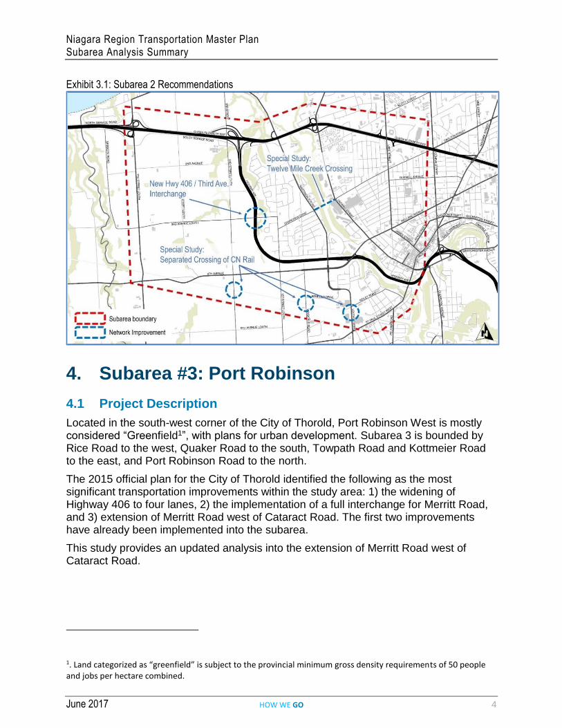
3. Subarea #2: West St. Catharines
3.1 Project Description
Subarea 2 was initially bounded by Seventh Street Louth to the west, the CN rail tracks to the south, QEW to the north, and Geneva Street to the east. Highway 406 passes through this area, with one interchange at Fourth Ave Louth. There are four connections between the east and the west of the Creek: QEW, Highway 406, Fourth/Welland Avenue, and St. Paul Street (Burgoyne Bridge).
Studies such as the “West St. Catharines Transportation Study (WSCTS)” and “Environment Assessment of a New Interchange on Highway 406 between Fourth Avenue Louth and Third Avenue Louth” identified several traffic operational issues at locations such as: the current interchange at Highway 406 and Fourth Ave, Martindale Road, Ontario Street, Fourth Ave, QEW interchanges at Martindale Road and Ontario Street. As a result, a wide range of alternatives for improvement were identified as follows:
Improved connectivity to Highway 406 such as the need for a new interchange between Fourth Avenue Louth and Third Avenue Louth with or without a new service road;
Road improvements such as widening of Fourth Ave, Ontario Street; and
Intersection improvements such as at Welland Ave and Ontario Street, new turn lanes, signalizing the intersection of Martindale Road and Vansickle Road.
3.2 Recommendations
In accordance with the model analysis detailed above, the following recommendations are proposed for Subarea 2:
A new 4 lane structure should be considered for crossing the 12 Mike Creek, located somewhere between the QEW and Fourth Avenue. Although this is presently assumed to be located at approximately where a Carlton Street extension might align, further study and an Environmental Assessment should be undertaken to confirm the location and the non-vehicle requirements, such as cycle lanes and pedestrian facilities.
Implement Third Avenue Louth / Highway 406 new interchange, with connection to the new hospital (including widening of Third Avenue Louth at interchange location).
Although the modelling could not confirm that a grade separation of the rail line south of Fourth Avenue is warranted, this area now includes the new hospital and is anticipated to include the new St. Catharines GO station and possibly a Mobility Hub. To ensure all these new investments in the area function as anticipated, the road network should be studied further to confirm that accessibility and redundancy in the network is adequate and if a rail grade separation is required.
The recommendations are summarized in Exhibit 3.1 below.
Niagara Region Transportation Master Plan Subarea Analysis Summary
June 2017 HOW WE GO 4
Exhibit 3.1: Subarea 2 Recommendations
4. Subarea #3: Port Robinson
4.1 Project Description
Located in the south-west corner of the City of Thorold, Port Robinson West is mostly considered “Greenfield1”, with plans for urban development. Subarea 3 is bounded by Rice Road to the west, Quaker Road to the south, Towpath Road and Kottmeier Road to the east, and Port Robinson Road to the north.
The 2015 official plan for the City of Thorold identified the following as the most significant transportation improvements within the study area: 1) the widening of Highway 406 to four lanes, 2) the implementation of a full interchange for Merritt Road, and 3) extension of Merritt Road west of Cataract Road. The first two improvements have already been implemented into the subarea.
This study provides an updated analysis into the extension of Merritt Road west of Cataract Road.
1. Land categorized as “greenfield” is subject to the provincial minimum gross density requirements of 50 people and jobs per hectare combined.

Niagara Region Transportation Master Plan Subarea Analysis Summary
June 2017 HOW WE GO 5
4.2 Recommendations
The Niagara Region Capital Budget 2017 includes a project (ID: J_20000491) entitled RR37/Merritt/Rice Road – Highway 406 to Rice Road/Merritt Road to Quaker Road. This project is considered creating a new Regional asset, including:
The rehabilitation of Regional Road 37 (Merritt Road) between Highway 406 and Cataract Road; and
New road construction to connect the unopened road allowance on Merritt Road between Cataract Road and Rice Road in Thorold. This section is a candidate to become a Regional Road asset.
The findings of this subarea model work would support these recommendations as the new Regional Road connection will provide an alternate connection to Highway 406 in the south, providing some relief to traffic on Highway 20 and the parallel routes. It also complete the Regional Road network and takes advantage of the newly built interchange at Merritt Road and Highway 20 by the Province. These recommendations are shown in Exhibit 4.1.
As this project is initiated, it should be considered as a Complete Street initiative and the initial typology considered could be a Rural typology.
This undertaking is identified as recommended for Phase 3 and 4 of the Municipal Class EA.
Exhibit 4.1: Subarea 3 Recommendations
Imagery ©2017 DigitalGlobe, Google, Map data ©2017 Google.

Niagara Region Transportation Master Plan Subarea Analysis Summary
June 2017 HOW WE GO 6
5. Subarea #4: Welland
5.1 Project Description
This subarea is located in the City of Welland, and is bounded by the Welland Canal to the west, Division Street to the south and east, and East Main Street to the north. East Main Street continues east and connects to Highway 406 at the roundabout.
The two streets pass through the downtown area of Welland and the BIA, and play a vital role in moving traffic between the downtown, the west of the Canal, and Highway 406. West Main Street throughout Welland is a Regional Road (RR 27). Division Street as the other one-way street couplet to West Main Street is also a Regional Road (RR 527). Additionally, the north-south roads connecting West Main Street and Divison Street are not Regional Roads, with King Street being the only exception as it is a Regional Road between Division Street and East Main Street (RR 68).
In 2001, the Welland Transportation Master Plan was conducted that included a review of the downtown traffic circulation that included a review of the one-way vs two-way conversion option.
Currently Main Street and Division Street are one-way streets in opposite directions. The option that will be analyzed in this subarea is to convert both of these streets into two-way streets.
5.2 Recommendations
The subarea model exercise illustrates that converting the Main Street / Division Street couplet from one-way operation to two-way operation increases the level of congestion through downtown Welland and reduces the average speed while also increasing travel times. These may be considered good outcomes by the local economic stakeholders and perhaps contribute to more livable downtown streets, but they are not considered positive results for major arterial corridors or Regional Roads. In order for a two-way street conversion to operate without congestion, additional capacity would be required, which would likely impact parking.
In addition to the subarea model results, we must reflect on the many other operational and geometric issues that were addressed in the previous Welland TMP, dated April 2001, which for the most part are still valid today. As quoted in that study, these include:
“Parking: Parking availability is seen as a critical link to the stability of the downtown core. The more convenient and accessible the parking situation is in the downtown, the more attractive it will be to patrons of downtown businesses. Since parking availability is perceived as an issue to the continued patronizing of local businesses in the downtown core, it would seem that its reduction and/or elimination would adversely affect the current servicing of businesses.”
“Building Constraints: The modification of the geometrics of the downtown road network is constrained by a large number of buildings which are located very close to the existing roadway and sidewalks. There are also historical landmarks constraints, such as the Historic Lift Bridge over the Old Welland Canal, which

Niagara Region Transportation Master Plan Subarea Analysis Summary
June 2017 HOW WE GO 7
further hamper or constrain the freedom to restore one-way streets back to a two-way network.”
“Existing Traffic System: The current traffic system is not capable of handling the conversion to two-way operation. Therefore it would have to be replaced under a full two-way traffic scenario. However, given the close spacing of the intersections and the amount of parking maneuvers on both sides of the road, it would be very difficult (if not impossible) to achieve good signal progression. The corridor would break down during peak periods.”
“Geometrics: There are several geometric concerns with the conversion to two-way operation including:
– The misalignment of West Main Street with the lift bridge would create operational/safety problems under a two-way Main Street scenario given the high volume of straight through traffic;
– The horizontal curve (i.e. Bend) at the east end of Division Street would not operate effectively as a two-way roadway because of the small radius;
– The roadway cross-section is 13m which consists of 4.2m parking and 8.8m of travel lanes;
– Currently there are no left turns across opposing traffic movements from any of the one-way streets. Under a two-way street scenario this situation would occur. Therefore, left turn lanes would be required at major intersections in order to allow through traffic to by-pass the waiting left turning vehicles (i.e. Burgar Street, Hellems Avenue, Cross Street, and King Street). This is due to the fact that the existing parking would have to be removed from both sides of the roadway to allow for a left turn lane. If a left turn lane were not available, the delays and queues throughout the downtown core would cause failure in the operation of the roadway; and
– The possibility of adding additional lanes is not an option because many of the existing downtown buildings would have to be removed to make way for the new lanes.”
Based on the subarea results and the constraints noted above, our recommendations, as shown in Exhibit 5.1, would reconfirm the previous recommendations of the Welland TMP, dated April 2001, whereby the Main Street/Division Street couplet should remain as one-way street corridors.

Niagara Region Transportation Master Plan Subarea Analysis Summary
June 2017 HOW WE GO 8
Exhibit 5.1: Subarea 4 recommendations
Map data ©2017 Google.
6. Subarea #5: Smithville
6.1 Project Description
The Village of Smithville is the largest urban centre in the Township of West Lincoln. Subarea 5 is bounded by Grimsby Road 5 to the west, the CP rail tracks to the north, Industrial Park Road to the east, and Smithville Road to the south.
The study area includes approximately 2 km of the Regional Road 20 (locally named as St. Catharine Street and West Street). Regional Road 20 connects the Village to the City of Hamilton from the west and the Town of Pelham from the east, making it a primary east/west corridor through the subarea. The urban area in the Village has a mixed land use of schools, churches, restaurants, grocery, residential, etc.
According to the “Smithville Safety Study of 2011” in 2006, there were approximately 14.5% heavy truck traffic at West Street and South Grimsby Road 6. This study recognized that this is considered a high percentage of truck traffic for this area, but is not considered a safety issue at this stage.
The “Official Plan of the Township of West Lincoln” has suggested that without improvements to the Regional Road, the LOS for this road will drop significantly by 2040. Alternatives such as bridge crossings, CPR crossings, truck routes, Industrial Park Road extension, revisiting the sudden large reduction in speed limits as traffic approaches the Village, and Widening of Regional Road 20 were all identified as potential improvements requiring further analysis.
The purpose of the bypass is to reduce the volume of heavy vehicles on local roads, and provide a continuous uninterrupted route for commercial vehicles travelling between Hamilton and Niagara Falls.

Niagara Region Transportation Master Plan Subarea Analysis Summary
June 2017 HOW WE GO 9
6.2 Recommendations
Since it has not yet been established how the Smithville bypass is to be configured, this subarea analysis was put on hold.
Although the subarea analysis was not conducted for the Smithville Bypass, consideration of the bypass has identified that several transportation initiatives that may be interconnected and as such should be addressed. Based on these considerations, the following is recommended:
1. That the Region and the Town of West Lincoln establish the preferred routing for the Smithville Bypass, either on the north side or south side of downtown Smithville, and conduct the subarea analysis to establish local traffic impacts and identify required infrastructure and operational improvements;
2. That the Region continue working with Hamilton, Halton, Peel and Waterloo Region to advocate for a Niagara-GTA corridor as an alternate route to the QEW, connecting Fort Erie to the GTA through south Niagara (previously known as the Mid-Peninsula highway); and
3. That the Region undertake Phases 3 and 4 of the Municipal Class Environmental Assessment (EA) process (Schedule C) to develop a preferred alignment and preliminary design for the Bartlett Avenue Extension.