Niagara Region Transportation Master Plan Strategic Cycling … · · 2017-07-24Niagara Region...
33
[Type here] Niagara Region Transportation Master Plan Strategic Cycling Network Development Technical Paper
Transcript of Niagara Region Transportation Master Plan Strategic Cycling … · · 2017-07-24Niagara Region...
[Type here]
Niagara Region Transportation Master Plan
Strategic Cycling Network Development
Technical Paper
Niagara Region Transportation Master Plan Strategic Cycling Network Development Technical Paper
June 2017 HOW WE GO i
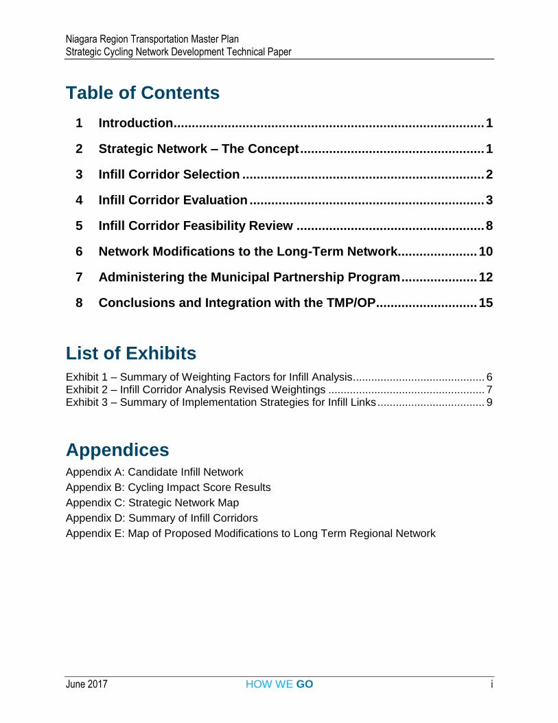
Table of Contents
1 Introduction ...................................................................................... 1
2 Strategic Network – The Concept ................................................... 1
3 Infill Corridor Selection ................................................................... 2
4 Infill Corridor Evaluation ................................................................. 3
5 Infill Corridor Feasibility Review .................................................... 8
6 Network Modifications to the Long-Term Network ...................... 10
7 Administering the Municipal Partnership Program ..................... 12
8 Conclusions and Integration with the TMP/OP ............................ 15
List of Exhibits Exhibit 1 – Summary of Weighting Factors for Infill Analysis ........................................... 6 Exhibit 2 – Infill Corridor Analysis Revised Weightings ................................................... 7 Exhibit 3 – Summary of Implementation Strategies for Infill Links ................................... 9
Appendices
Appendix A: Candidate Infill Network
Appendix B: Cycling Impact Score Results
Appendix C: Strategic Network Map
Appendix D: Summary of Infill Corridors
Appendix E: Map of Proposed Modifications to Long Term Regional Network
Niagara Region Transportation Master Plan Strategic Cycling Network Development Technical Paper
June 2017 HOW WE GO 1
1. Introduction This technical report summarizes the development of the Strategic Cycling Network concept as part of the active transportation component of the 2017 Niagara Region Transportation Master Plan (TMP). This technical report follows and supplements two previous memos that were prepared over the course of the project with respect to the strategic cycling network:
An initial memo with the proposed methodology for evaluating a network of infill links submitted to the Region on May 2nd, 2016; and
A cycling infill analysis progress report submitted August 24th, 2016 documenting the preliminary results of the infill analysis evaluation.
2. Strategic Network – The Concept This section introduces and explains the how the infill network to be evaluated for inclusion in the strategic network was identified.
Niagara Region has an extensive history of bikeways network planning. The most recent cycling network plan for the Region of Niagara, the Bikeways Master Plan Study (BMPS), was approved by Council in 2005. This study identified a significant network of 1200 km of on- and off-road facilities. The Region has been implementing the BMPS network through their road capital program, i.e. when roads are reconstructed or resurfaced. The Region also contributes $200,000 annually to help local area municipalities implement pieces of the network.
This approach to building cycling facilities has grown the network over time, however it has not always resulted in a connected network of facilities. There are many gaps and underserved areas across the Region. With the significant shift towards complete streets captured in the vision for the current Multi-Modal Transportation Plan, there is an opportunity to expand the scope of bikeway implementation and to target strategic infill corridors of the cycling network outside of the road capital and rehab programs. This report outlines the approach developed to identify, prioritize and implement infill corridors to create a connected network over a shorter-term horizon of ten years.
The Strategic Cycling Network is a shorter-term network developed using several components:
Existing Network – The existing region-wide cycling network forms the foundation of the strategic network. It is noted that through on-going capital work, many network links have been constructed since the BMPS that are not part of the current regional network, but these links feed and connect to the larger regional network. This network draws on opportunities to connect existing facilities even where they may lie outside of the current Regional network.
Niagara Region Transportation Master Plan Strategic Cycling Network Development Technical Paper
June 2017 HOW WE GO 2
Planned Capital Investment – In keeping with on-going practice, the capital plan provides an opportunity to provide cycling facilities as roads are reconstructed. Capital plan projects are leveraged as part of the strategic network. This is a cost-effective method of implementing cycling facilities with savings realized through the larger road reconstruction projects. Through the complete streets process, the incremental costs for the inclusion of cycling facilities in these capital projects have been costed separately.
Infill Corridors – These infill links are the primary new components of the strategic network, identified to connect the missing links between capital investment, the existing network and key destinations. These links are intended to be implemented under retrofit conditions.
3. Infill Corridor Selection This section identifies how the infill network to be evaluated for inclusion in the strategic network was identified.
The basis for the candidate infill corridor network was the Bikeways Master Plan Network – with a small subset of network additions as noted in the following section of the report. The scope of work proposed as part of this TMP did not involve development of a completely new long-term cycling network, and general consensus was that the focus for the work would be on implementation rather than network planning. In other words, it was felt that the biggest challenge to advancing cycling in Niagara Region is not that planning documents do not reflect a desirable network, but instead that implementation is lagging in terms of network build-out.
As a result, new links were generally not added to the previously proposed Regional Cycling Network from the Bikeways Master Plan, except under exceptional circumstances as noted below:
In cases where the evolution of the existing network (municipal or regional) and / or planned capital improvements result in new connections emerging as important to overall regional network connectivity.
In cases where feedback from stakeholders or the public consultation highlighted an important route to be considered in the network and it was found to be feasible to implement it over a short term horizon (more detail is provided on the inclusion of consultation results was provided in the previous memo dated August 24th, 2016).
In cases where more recent municipal active transportation planning documents (for example, the Pelham Active Transportation Master Plan) identified key regional corridors.
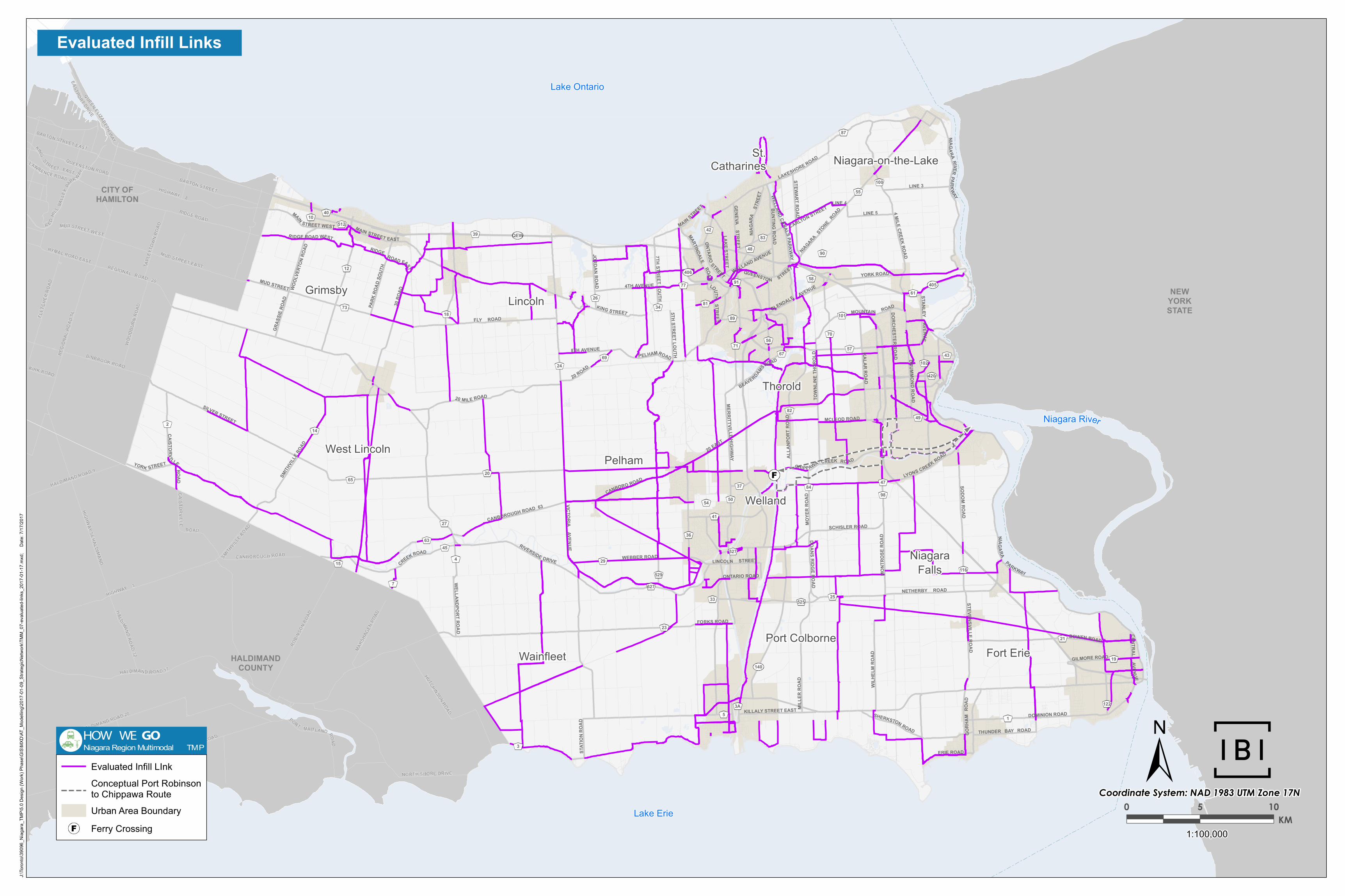
The candidate infill network that was evaluated as part of the cycling impact analysis is shown in Appendix A.
Niagara Region Transportation Master Plan Strategic Cycling Network Development Technical Paper
June 2017 HOW WE GO 3
4. Infill Corridor Evaluation This section details how the cycling impact of potential infill corridors was evaluated.
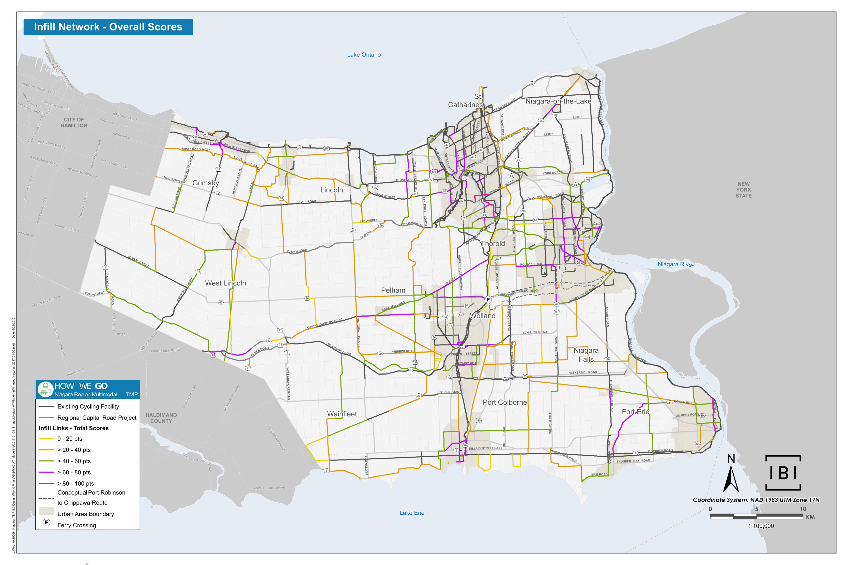
For each potential infill corridor, the link was evaluated based on a tool developed in GIS to score cycling impact. The criteria were developed in consultation with staff and the larger active transportation community, including the Region's Active Transportation Sub-Committee. In total, five factors were used to evaluate the overall priority of a link: connectivity, density, potential demand, key destinations, and barriers.
The analysis factors are discussed in the following sections:
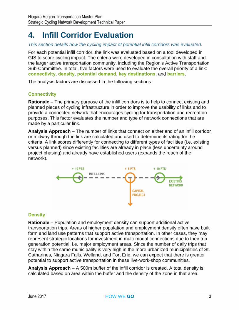
Connectivity
Rationale – The primary purpose of the infill corridors is to help to connect existing and planned pieces of cycling infrastructure in order to improve the usability of links and to provide a connected network that encourages cycling for transportation and recreation purposes. This factor evaluates the number and type of network connections that are made by a particular link.
Analysis Approach – The number of links that connect on either end of an infill corridor or midway through the link are calculated and used to determine its rating for the criteria. A link scores differently for connecting to different types of facilities (i.e. existing versus planned) since existing facilities are already in place (less uncertainty around project phasing) and already have established users (expands the reach of the network).
Density
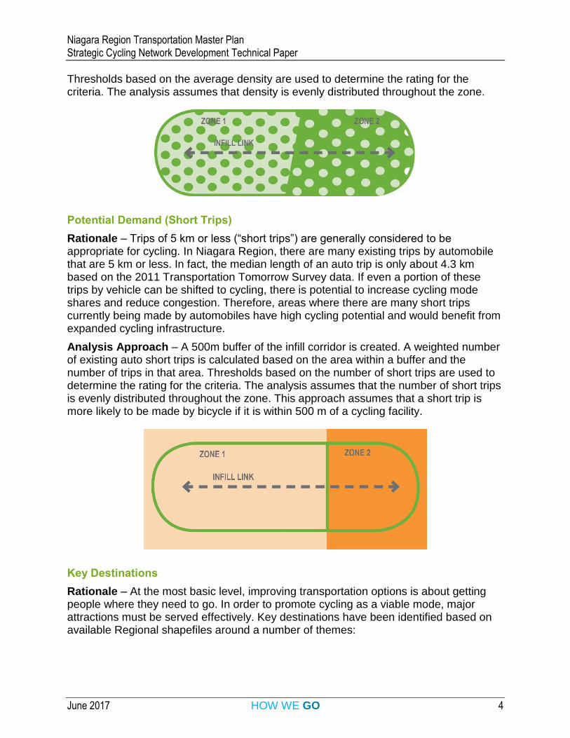
Rationale – Population and employment density can support additional active transportation trips. Areas of higher population and employment density often have built form and land use patterns that support active transportation. In other cases, they may represent strategic locations for investment in multi-modal connections due to their trip generation potential, i.e. major employment areas. Since the number of daily trips that stay within the same municipality is very high in the more urbanized municipalities of St. Catharines, Niagara Falls, Welland, and Fort Erie, we can expect that there is greater potential to support active transportation in these live-work-shop communities.
Analysis Approach – A 500m buffer of the infill corridor is created. A total density is calculated based on area within the buffer and the density of the zone in that area.
Niagara Region Transportation Master Plan Strategic Cycling Network Development Technical Paper
June 2017 HOW WE GO 4
Thresholds based on the average density are used to determine the rating for the criteria. The analysis assumes that density is evenly distributed throughout the zone.
Potential Demand (Short Trips)
Rationale – Trips of 5 km or less (“short trips”) are generally considered to be appropriate for cycling. In Niagara Region, there are many existing trips by automobile that are 5 km or less. In fact, the median length of an auto trip is only about 4.3 km based on the 2011 Transportation Tomorrow Survey data. If even a portion of these trips by vehicle can be shifted to cycling, there is potential to increase cycling mode shares and reduce congestion. Therefore, areas where there are many short trips currently being made by automobiles have high cycling potential and would benefit from expanded cycling infrastructure.
Analysis Approach – A 500m buffer of the infill corridor is created. A weighted number of existing auto short trips is calculated based on the area within a buffer and the number of trips in that area. Thresholds based on the number of short trips are used to determine the rating for the criteria. The analysis assumes that the number of short trips is evenly distributed throughout the zone. This approach assumes that a short trip is more likely to be made by bicycle if it is within 500 m of a cycling facility.
Key Destinations
Rationale – At the most basic level, improving transportation options is about getting people where they need to go. In order to promote cycling as a viable mode, major attractions must be served effectively. Key destinations have been identified based on available Regional shapefiles around a number of themes:
Niagara Region Transportation Master Plan Strategic Cycling Network Development Technical Paper
June 2017 HOW WE GO 5
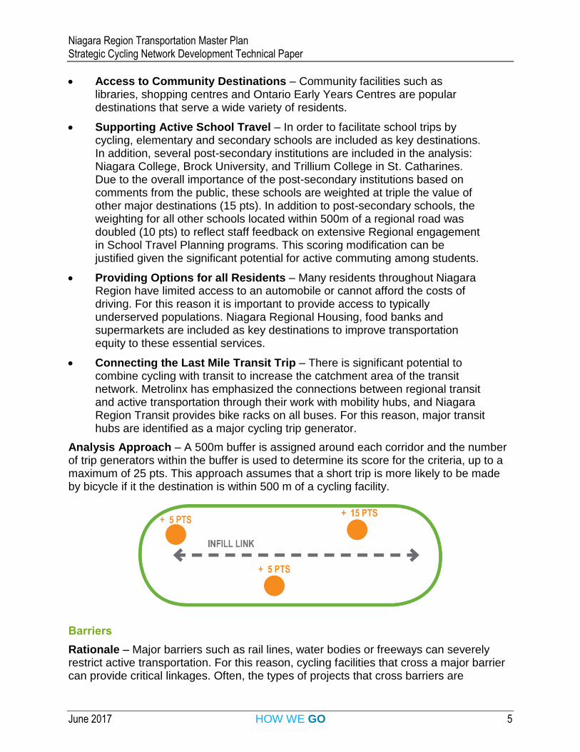
Access to Community Destinations – Community facilities such as libraries, shopping centres and Ontario Early Years Centres are popular destinations that serve a wide variety of residents.
Supporting Active School Travel – In order to facilitate school trips by cycling, elementary and secondary schools are included as key destinations. In addition, several post-secondary institutions are included in the analysis: Niagara College, Brock University, and Trillium College in St. Catharines. Due to the overall importance of the post-secondary institutions based on comments from the public, these schools are weighted at triple the value of other major destinations (15 pts). In addition to post-secondary schools, the weighting for all other schools located within 500m of a regional road was doubled (10 pts) to reflect staff feedback on extensive Regional engagement in School Travel Planning programs. This scoring modification can be justified given the significant potential for active commuting among students.
Providing Options for all Residents – Many residents throughout Niagara Region have limited access to an automobile or cannot afford the costs of driving. For this reason it is important to provide access to typically underserved populations. Niagara Regional Housing, food banks and supermarkets are included as key destinations to improve transportation equity to these essential services.
Connecting the Last Mile Transit Trip – There is significant potential to combine cycling with transit to increase the catchment area of the transit network. Metrolinx has emphasized the connections between regional transit and active transportation through their work with mobility hubs, and Niagara Region Transit provides bike racks on all buses. For this reason, major transit hubs are identified as a major cycling trip generator.
Analysis Approach – A 500m buffer is assigned around each corridor and the number of trip generators within the buffer is used to determine its score for the criteria, up to a maximum of 25 pts. This approach assumes that a short trip is more likely to be made by bicycle if it the destination is within 500 m of a cycling facility.
Barriers
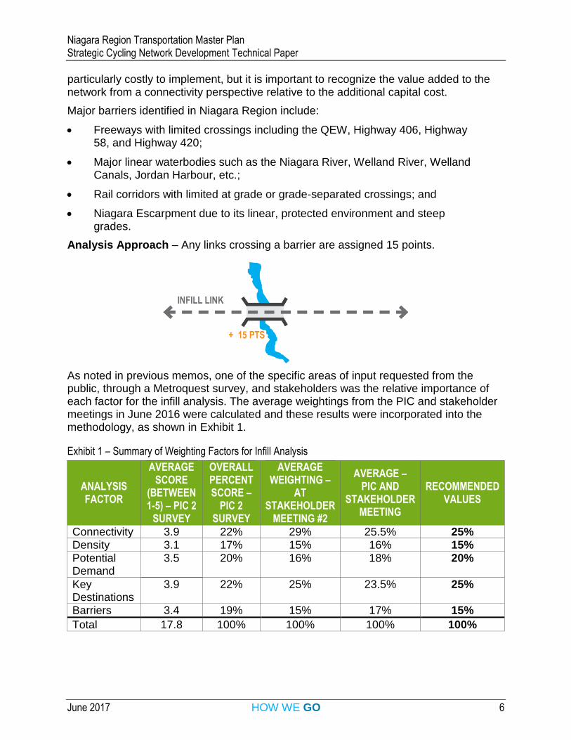
Rationale – Major barriers such as rail lines, water bodies or freeways can severely restrict active transportation. For this reason, cycling facilities that cross a major barrier can provide critical linkages. Often, the types of projects that cross barriers are
Niagara Region Transportation Master Plan Strategic Cycling Network Development Technical Paper
June 2017 HOW WE GO 6
particularly costly to implement, but it is important to recognize the value added to the network from a connectivity perspective relative to the additional capital cost.
Major barriers identified in Niagara Region include:
Freeways with limited crossings including the QEW, Highway 406, Highway 58, and Highway 420;
Major linear waterbodies such as the Niagara River, Welland River, Welland Canals, Jordan Harbour, etc.;
Rail corridors with limited at grade or grade-separated crossings; and
Niagara Escarpment due to its linear, protected environment and steep grades.
Analysis Approach – Any links crossing a barrier are assigned 15 points.
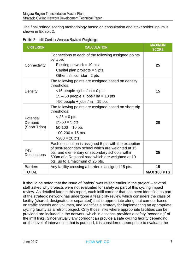
As noted in previous memos, one of the specific areas of input requested from the public, through a Metroquest survey, and stakeholders was the relative importance of each factor for the infill analysis. The average weightings from the PIC and stakeholder meetings in June 2016 were calculated and these results were incorporated into the methodology, as shown in Exhibit 1.
Exhibit 1 – Summary of Weighting Factors for Infill Analysis
ANALYSIS FACTOR
AVERAGE SCORE
(BETWEEN 1-5) – PIC 2
SURVEY
OVERALL PERCENT SCORE –
PIC 2 SURVEY
AVERAGE WEIGHTING –
AT STAKEHOLDER
MEETING #2
AVERAGE – PIC AND
STAKEHOLDER MEETING
RECOMMENDED VALUES
Connectivity 3.9 22% 29% 25.5% 25% Density 3.1 17% 15% 16% 15% Potential Demand
3.5 20% 16% 18% 20%
Key Destinations
3.9 22% 25% 23.5% 25%
Barriers 3.4 19% 15% 17% 15%
Total 17.8 100% 100% 100% 100%
Niagara Region Transportation Master Plan Strategic Cycling Network Development Technical Paper
June 2017 HOW WE GO 7
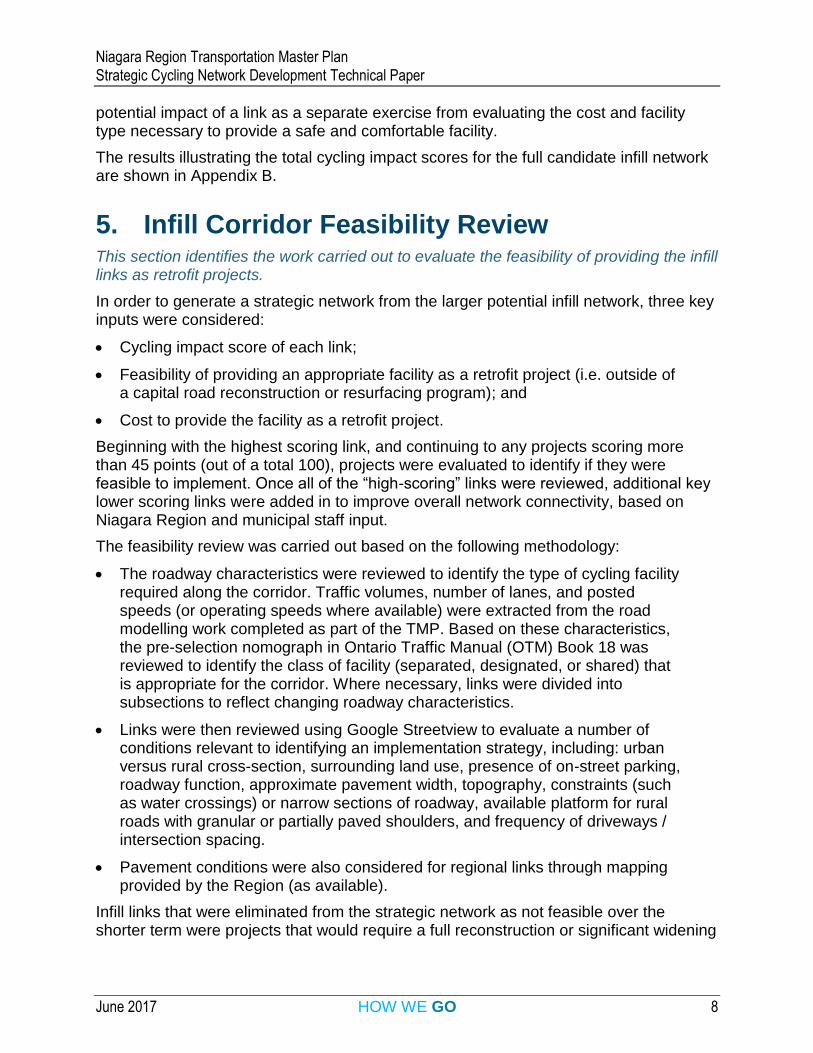
The final refined scoring methodology based on consultation and stakeholder inputs is shown in Exhibit 2.
Exhibit 2 – Infill Corridor Analysis Revised Weightings
CRITERION CALCULATION MAXIMUM
SCORE
Connectivity
Connections to each of the following assigned points by type:
Existing network = 10 pts
Capital plan projects = 5 pts
Other infill corridor =2 pts
25
Density
The following points are assigned based on density thresholds:
<15 people +jobs /ha = 0 pts
15 – 50 people + jobs / ha = 10 pts
>50 people + jobs /ha = 15 pts
15
Potential Demand (Short Trips)
The following points are assigned based on short trip thresholds:
< 25 = 0 pts
25-50 = 5 pts
50-100 = 10 pts
100-200 = 15 pts
>200 = 20 pts
20
Key Destinations
Each destination is assigned 5 pts with the exception of post-secondary school which are weighted at 15 pts, and elementary or secondary schools within 500m of a Regional road which are weighted at 10 pts, up to a maximum of 25 pts.
25
Barriers Any facility crossing a barrier is assigned 15 pts. 15
TOTAL MAX 100 PTS
It should be noted that the issue of “safety” was raised earlier in the project – several staff asked why projects were not evaluated for safety as part of this cycling impact review. As detailed later in this report, each infill corridor that has been identified as part of the strategic network has undergone a feasibility review which considers the class of facility (shared, designated or separated) that is appropriate along that corridor based on traffic speeds and volumes, and identifies a strategy for implementing an appropriate cycling facility as a retrofit project. Only those links where appropriate facilities can be provided are included in the network, which in essence provides a safety “screening” of the infill links. Since virtually any corridor can provide a safe cycling facility depending on the level of intervention that is pursued, it is considered appropriate to evaluate the
Niagara Region Transportation Master Plan Strategic Cycling Network Development Technical Paper
June 2017 HOW WE GO 8
potential impact of a link as a separate exercise from evaluating the cost and facility type necessary to provide a safe and comfortable facility.
The results illustrating the total cycling impact scores for the full candidate infill network are shown in Appendix B.
5. Infill Corridor Feasibility Review This section identifies the work carried out to evaluate the feasibility of providing the infill links as retrofit projects.
In order to generate a strategic network from the larger potential infill network, three key inputs were considered:
Cycling impact score of each link;
Feasibility of providing an appropriate facility as a retrofit project (i.e. outside of a capital road reconstruction or resurfacing program); and
Cost to provide the facility as a retrofit project.
Beginning with the highest scoring link, and continuing to any projects scoring more than 45 points (out of a total 100), projects were evaluated to identify if they were feasible to implement. Once all of the “high-scoring” links were reviewed, additional key lower scoring links were added in to improve overall network connectivity, based on Niagara Region and municipal staff input.
The feasibility review was carried out based on the following methodology:
The roadway characteristics were reviewed to identify the type of cycling facility required along the corridor. Traffic volumes, number of lanes, and posted speeds (or operating speeds where available) were extracted from the road modelling work completed as part of the TMP. Based on these characteristics, the pre-selection nomograph in Ontario Traffic Manual (OTM) Book 18 was reviewed to identify the class of facility (separated, designated, or shared) that is appropriate for the corridor. Where necessary, links were divided into subsections to reflect changing roadway characteristics.
Links were then reviewed using Google Streetview to evaluate a number of conditions relevant to identifying an implementation strategy, including: urban versus rural cross-section, surrounding land use, presence of on-street parking, roadway function, approximate pavement width, topography, constraints (such as water crossings) or narrow sections of roadway, available platform for rural roads with granular or partially paved shoulders, and frequency of driveways / intersection spacing.
Pavement conditions were also considered for regional links through mapping provided by the Region (as available).
Infill links that were eliminated from the strategic network as not feasible over the shorter term were projects that would require a full reconstruction or significant widening
Niagara Region Transportation Master Plan Strategic Cycling Network Development Technical Paper
June 2017 HOW WE GO 9
to provide cycling facilities, or would require a new major crossing facility. In some cases, projects with a high cycling impact (value) were excluded from the short term network due to feasibility challenges. These represent instances were, should capital work be planned at the municipal level, there would be significant value in advancing the corridors.
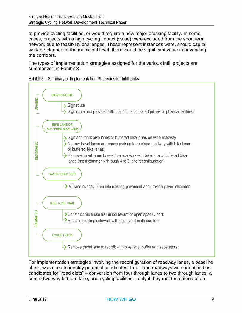
The types of implementation strategies assigned for the various infill projects are summarized in Exhibit 3.
Exhibit 3 – Summary of Implementation Strategies for Infill Links
For implementation strategies involving the reconfiguration of roadway lanes, a baseline check was used to identify potential candidates. Four-lane roadways were identified as candidates for “road diets” – conversion from four through lanes to two through lanes, a centre two-way left turn lane, and cycling facilities – only if they met the criteria of an
Niagara Region Transportation Master Plan Strategic Cycling Network Development Technical Paper
June 2017 HOW WE GO 10
AADT less than 20,000, based on future 2041 road volumes (to be conservative). The threshold of 20,000 is based on highly regarded sources including the FHWA’s Road Diet Informational Guide (2014). Nonetheless, it is a high level screening only, and should be subject to further evaluation.
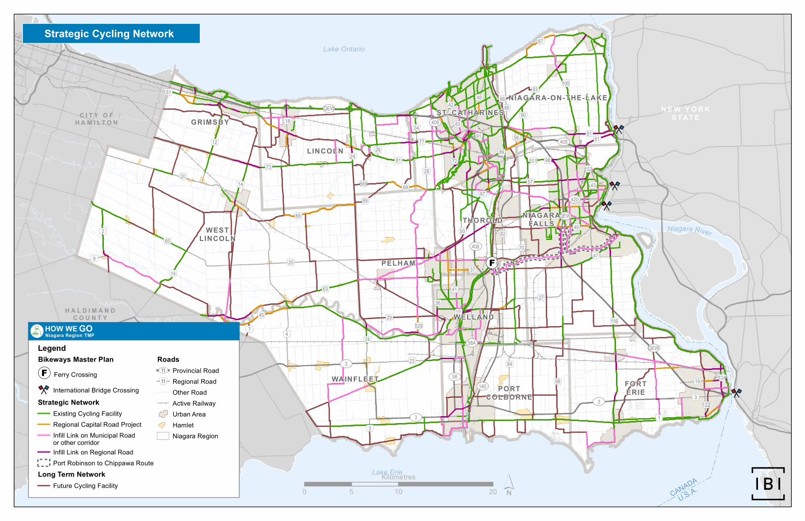
The feasibility review carried out for this network is considered a high-level review, which is appropriate in the context of a TMP. The primary purpose of this review is to identify the appropriate class of facility and to identify whether the link could feasibly be provided as an infill project. The facility type identified through this process does not necessarily reflect the preferred ultimate facility type, however it does reflect an appropriate facility for the street context. In cases where a designated or separated route was indicated based on the OTM Book 18 nomograph, but it was deemed not feasible to provide this higher order class of facility, the link was removed from the strategic network. In the future, should a regional or municipal capital program include these “high value” links, the network should be revised to reflect these opportunities.
Factors which were not considered due to a lack of data but could influence the selection of a cycling facility at the functional design stage include: collision history, available right-of-way, actual pavement width and future developments.
The network of infill links, and the larger strategic network, should therefore be viewed as a network concept. In other words, it is intended to provide a base network that can evolve over time as new opportunities become available. It is not intended that this network be enshrined in policy, such as through inclusion in the OP, but rather that it feed directly into the oversight and implementation of the network through the municipal partnership program and Regional cycling network planning processes.
A map illustrating the full strategic network is provided in Appendix C and a table summarizing the location, implementation strategy and cost for each infill link by municipality is included in Appendix D.
6. Network Modifications to the Long-Term Network
This section identifies the recommended long-term revisions to the Regional Cycling Plan.
As a result of developing the strategic network, a small number of new links emerged as critical from a Regional perspective. It is worth considering adding these links to the Regional Bicycle Master Plan network.
These links are made up of:
Candidate infill links that were added to the candidate network based on staff, stakeholder or public input and scored highly in terms of cycling impacts and therefore were added to the strategic network.
Niagara Region Transportation Master Plan Strategic Cycling Network Development Technical Paper
June 2017 HOW WE GO 11
Candidate infill links that were added to the candidate network based on staff, stakeholder or public input and scored highly in terms of cycling impacts but were not added to the strategic network as a result of short-term feasibility challenges.
Existing network links that have been constructed and can supplement or enhance the Regional network by improving connectivity to existing or planned facilities, or that serve urban areas by providing a more densely-spaced grid of cycling facilities. Some of the links are under municipal jurisdiction – including them in the Regional network simply reflects their importance in the context of the regional network.
Longer-term links that enhance connectivity based on the strategic network.
Major network links that are identified through various municipal planning documents and that will serve a regional role when completed.
Key network modifications include:
Addition of Victoria Avenue (RR 24) from Fly Road to King Street (Town of Lincoln) – this link connects existing paved shoulder facilities along Fly Rd into Vineland. This link is also identified in the Town of Lincoln’s Official Plan as a paved shoulder / bike lane with a special note indicating that it is being considered for addition into the Regional Cycling Plan.
Addition of Highway 20, Victoria Avenue to the Welland Canal Trial – a large portion of this corridor (Victoria Avenue to just east of Rice Road) was identified in the Pelham Active Transportation Master Plan. The plan identifies Hwy 20 between municipal boundaries as a “Regional Connector”. For network connectivity, it is recommended that the limits be extended to Victoria Avenue.
Addition of Ontario St. between the North Service Road and RR 81 in Beamsville – This link was recommended by an active transportation stakeholder committee member, scored highly on cycling impact and was incorporated into the strategic network.
Addition of Thorold Stone Road between Dorchester Road and Stanley Avenue – The addition of Thorold Stone Road (for its full extent) was recommended by a member of the public through a comment on a Metroquest survey. This section scored highly in the cycling impact evaluation and was incorporated into the strategic network.
Addition of Lundy’s Lane (RR 20) between Welland Canal and Kalar Road – This section of Lundy’s Lane is a logical extension of the links added through the Pelham AT Plan to provide a continuous, direct connection between Pelham and Niagara Falls The addition of Lundy’s Lane (for its full extent) was recommended by a member of the public through a comment on a Metroquest survey.
Millennium Trail has been added to the Regional network as the facility (when complete) will provide an important off-road connection throughout much of
Niagara Region Transportation Master Plan Strategic Cycling Network Development Technical Paper
June 2017 HOW WE GO 12
Niagara Falls, and is highlighted in Niagara Fall’s Sustainable Transportation Master Plan (STMP).
King Street (Brookside Drive to Nineteenth Street) through the valley in Jordan which has been recognized as a highly desired link with existing challenges to implementation that may be achievable over a long term horizon.
Portions of the proposed Port-Robinson to Chippawa route including Grassy Brook Road (Darby Road to Montrose Road) (in addition to several shorter links).
Denser urban networks made up of both existing and future facilities in Niagara Falls (addition of Thorold Stone Road, Victoria Avenue, Bridge Street – RR-43, etc.) and St. Catharines (addition of Scott Street, Linwell Road, Vine Street, etc.). Many of these links were identified as desirable or important connections through public consultation including Thorold Stone Road and Victoria Avenue.
A map illustrating the full set of proposed additions to the Regional Cycling Network is included in Appendix E.
7. Administering the Municipal Partnership Program
This section identifies the current partnership program and proposed changes to delivery.
The strategic network can play a crucial role in improving the delivery of regional cycling facilities. At present, municipalities can apply for a limited amount of annual funding through an existing partnership program (Bicycle Facilities Grants for Regional Bikeways Network Facilities on Local Roads) to offset the costs of providing a cycling facility identified in the current Bikeways Master Plan. However, staff noted some challenges to the success of this program in systematically advancing the cycling network:
Total funding available is limited ($200,000 annually) so only a few projects can be funded each year.
Historically, there was no coordinated approach to evaluating the projects, i.e. the program was essentially first come first serve, which meant that projects that were awarded funding were not necessarily the most critical to the cycling network. As of 2013, a process was established for evaluating project in cases where the total funding applied for exceeded the amount available through the grant program. In those instances, projects are vetted by the Regional Niagara Bicycling Committee. Issues that are considered by the committee (as noted in the February 19, 2013 report to Public Works Committee) include:
– Amount of past Bicycle Facilities Grants received from Niagara Region by each local area municipality
Niagara Region Transportation Master Plan Strategic Cycling Network Development Technical Paper
June 2017 HOW WE GO 13
– Number and amount of current Bicycle Facilities Grant request(s) by each local area municipality
– Lane kilometres of bicycle facilities to be constructed with the requested grant money
– Connectivity to existing active transportation facilities within the Regional Niagara Bikeways Network
– Presence/absence of complementary initiatives such as sidewalks, Complete Streets plan, Community Improvement Plan (CIP), etc.
– Collision history and/or past reports of cycling safety concerns
– Cyclist and/or pedestrian counts, if available.
Municipalities are not required to achieve a particular facility type or quality of design, so cycling facilities may be built through the program which may not reflect the quality of facility that is appropriate along a regionally-significant route.
The strategic network concept, and the infill evaluation results are intended to assist staff in developing an improved partnership program with municipalities.
It is recommended that the following features be incorporated into the revised partnership program:
Municipalities be requested to submit applications annually for funding for the program (per current practice).
Routes could be evaluated /shortlisted based on their cycling impact (addressing connectivity, access to key destinations, population and employment density, short trips and barriers – derived from the infill evaluation results), and quality of design.
Preference would be given to the development of routes on the strategic network, or for routes that have a high cycling impact but were not necessarily identified in the strategic network as they had feasibility concerns that a municipality can overcome (i.e. through planned capital work).
For routes on the strategic network, municipalities would be required to provide a design justification that document how the facility is appropriate for the road volume and speed and will support the Region’s vision to provide a high-quality cycling network. If the cycling facility is deemed to be inadequate for the operating context, the project will be ineligible to receive grant funding.
Should a route not be identified on the Strategic Network, but is identified through the longer term Regional Bikeways Master Plan network, municipalities would be required to illustrate how that route serves as a primary connection from a regional context , either providing an alternative to, or supplementing one of the routes currently identified in the strategic network concept.
Niagara Region Transportation Master Plan Strategic Cycling Network Development Technical Paper
June 2017 HOW WE GO 14
To support the local area municipalities in implementing the municipal components of the Strategic Cycling Network, funding for the bicycle facilities should be increased to $1 million per year for the next 10 years.
In a parallel process, the Region can use the municipal applications to the grant program to inform the selection of Regional infill projects year over year by identifying synergies where retrofits to Regional roads could connect to planned municipal improvements. The full cost of the strategic network components located on Regional roads will be committed through the TMP process (approx. $15.7M), and is intended to be delivered in parallel over the 10-year horizon.
It is recommended that the Region implement their annual program of infill links based on the following considerations:
Cycling Impact Scores – Links along the regional road that score higher on the cycling impact score are likely to have a higher potential importance to the overall regional cycling network.
Coordination with municipalities – As noted above, as municipalities implement portions of the strategic network, the Region can implement the links on Regional roads that supplement and connect to the links installed on municipal roads.
Implementation Strategies – As noted through the feasibility review.
A well-designed cycling implementation program will incorporate a few common features:
Balance of simple projects with more complex, critical links to even out workload year over year while helping to build momentum;
Balance of upgrades to some existing facilities with expanding network reach;
Providing enough lead time on projects to account for any EA / planning /public outreach work required before implementation; and
Consideration of annual funding envelopes.
Niagara Region Transportation Master Plan Strategic Cycling Network Development Technical Paper
June 2017 HOW WE GO 15
8. Conclusions and Integration with the TMP/OP
This technical report summarizes the work completed to develop the strategic network. The concept of the strategic network has been rolled into the Transportation Master Plan document in the following ways:
Inclusion of the partnership grant increase from $200K to $1M;
Inclusion of the costs for the Regional links in the strategic network (approx. $15.7M);
High-level policy direction supporting implementation of the strategic network and the longer term Regional network; and
Supporting policies that recognize the need to take advantage of different opportunities as they arise such as encouraging the Region to protect rights-of-ways of abandoned railways for use as active transportation trails (even where they may not be currently reflected in existing networks).
Official Plan (OP) policies are currently under review and will be updated to reflect the Strategic Cycling Network and other policies identified in the TMP.

Appendix A: Candidate Infill Network
KING STREET
LINCOLN STREET
LAKESHORE ROAD
MUD STREET
FLY ROAD
YORK ROAD
DRUMMOND ROAD
ONTARIO ROAD
20 EAST
WELLAND AVENUE
BEAVERDAMSROAD
CAISTORV I LLEROAD
MAIN STREETCENTRAL
AVENUE
GENEVA STREET
DOMINION ROAD
BUNTING ROAD
MCLEOD ROAD
7TH STREET LOUTH
CANBORO ROAD
STEWART ROAD
MARTINDALEROAD
LINE 4
QUEENSTON STREET
NIAGARA
PARKWAY
SILVER STREET
GORH
AMRO
AD
4TH AVENUE
MAIN STREET WEST
GILMORE ROAD
KALAR ROAD
CARLTON STREET
BOWEN ROAD
VICTORIA AVENUE
MAIN STREET EAST
ALLA
NPOR
T ROA
D
LAKE STREET
LINE 3
MONT
ROSE
ROA
D
SMITH
VILLE
ROAD
NETHERBY ROAD
SCHISLER ROAD
20 MILE ROAD
SODOM ROAD
PELHAMROAD
MOUNTAIN ROAD
JORDAN ROAD
RIVERSIDE DRIVE
KILLALY STREET EAST
20 ROAD
WEBBER ROAD
TOW
NLIN
ETH
OROL
D
ERIE ROAD
NIAGA RARIVER
PARKWAY
THUNDER BAY ROAD
R IDGE ROAD WEST
YORK STREET
SHERKSTON ROAD
CANBOROUGH ROAD
8TH AVENUE
LINE 5
WELLAND CANALSPARKWAY
RIDGE ROAD EAST
CHIPPAWA CREEK RO AD
WOOL
VERT
ON RO
AD
GRAS
SIE RO
AD
LYONS CREEK ROAD
FORKS ROAD
CREEK ROAD
PARK
ROAD
SOUT
H
WELLANDPORT ROAD
63
STAT
ION
ROAD
GLENDALE AVENUE
NIAGARASTO
NEROAD 4MILE CREEK
ROAD
DORCHESTER ROAD
NIAG
ARA
STRE
ET
STANL EYAVE NUE
30 R
OAD
STEVENSVILLE ROAD
ME RR ITTVILLE HI GHWAY
LOUTHS TRE ET
DOANS RIDGE ROAD
MOYE
R RO
AD
5TH STREET LOUTH
MILL
ER R
OAD
WILH
ELM
ROAD
ONTARIOSTREET
St.Catharines
140
406
405
QEW
Niagara River
Lake Ontario
Lake Erie
CITY OFHAMILTON
NEWYORKSTATE
HALDIMANDCOUNTY
CANBOROUGH ROAD
KINGSTREET EAST
TAPL
EYTO
WNRO
AD
RYMAL ROAD EAST
HALDIMAND ROAD 17
LAWRENCE ROAD
QUEENSTON ROAD
BINBROOK ROAD
RAINHAM ROAD
BARTON STREET EAST
NORTH SHORE DRIVE
REGIONAL ROAD 20
BARTON STREET
HIGHWAY 3
MUD STREET EAST
FLET
CHER
ROAD
HUTCHINSON ROAD
HIGHWAY 8
CAISTORV I LL E
ROAD
ROBIN
SON R
OAD
HALDIMAND ROAD 20
MUD STREET WEST
RIDGE ROADR ED
HILL
VALL
EYPA
RK WAY
HALDIMAND ROAD 50
HALDIMAND ROAD 9
HIGHWAY 56 HALDIMAND
KIRK ROAD
PORT MAITLAND ROAD
SMITHVILL
E ROAD
QUEEN ELIZABETH WAY
WOOD
BURN
ROA
D
EASTPORT DRIVE
REGI
ONAL
ROAD
56
MARS
HAGE
N ROA
DHALDIMAND ROAD32
36
73
20
40
420
627
55
84
101
116
12
3A
70
83
81
29
24
48
19
100
89
527
69 43
50
15
10
91
34
525
122
87
67
61
42
58
1
14
26
21
56
512
54
18
5
27
23
77
102
90
49
37
71
41
39
33
98
57
2
3
45
25
47
4
63
5297
65
82
GrimsbyLincoln
Niagara-on-the-Lake
NiagaraFalls
Thorold
Welland
PelhamWest Lincoln
WainfleetPort Colborne
Fort Erie
Evaluated Infill Links
1:100,000
0 5 10KM
Coordinate System: NAD 1983 UTM Zone 17N
HOW WE GONiagara Region Multimodal TMP
Evaluated Infill LInkConceptual Port Robinsonto Chippawa RouteUrban Area BoundaryFerry Crossing
J:\To
ronto\
3909
6_Ni
agara
_TMP
\5.0 D
esign
(Work
) Pha
se\G
IS\M
XD\AT
_Mod
elling
\2017
-01-09
_Stra
tegicN
etwork
\TMM_
07-ev
aluate
d-link
s_20
17-01
-17.m
xd;
Date
: 7/17
/2017
June 2017 HOW WE GO
Appendix B: Cycling Impact Score Results
KING STREET
LINCOLN STREET
LAKESHORE ROAD
MUD STREET
FLY ROAD
YORK ROAD
DRUMMOND ROAD
ONTARIO ROAD
20 EAST
WELLAND AVENUE
BEAVERDAMSROAD
CAISTORV I LLEROAD
MAIN STREETCENTRAL
AVENUE
GENEVASTREET
DOMINION ROAD
BUNTING ROAD
MCLEOD ROAD
7TH STREET LOUTH
CANBORO ROAD
STEWART ROAD
MARTINDALEROAD
LINE 4
QUEENSTON STREET
NIAGARA
PARKWAY
SILVER STREET
GORH
AMRO
AD
4TH AVENUE
MAIN STREET WEST
GILMORE ROAD
KALAR ROAD
CARLTON STREET
BOWEN ROAD
VICTORIA AVENUE
MAIN STREET EAST
ALLA
NPOR
T ROA
D
LAKE STREET
LINE 3
MONT
ROSE
ROA
D
SMITH
VILLE
ROAD
NETHERBY ROAD
SCHISLER ROAD
20 MILE ROAD
SODOM ROAD
PELHAMROAD
MOUNTAIN ROAD
JORDAN ROAD
RIVERSIDE DRIVE
KILLALY STREET EAST
20 ROAD
WEBBER ROAD
TOW
NLIN
ETH
OROL
D
ERIE ROAD
NIAGA RARIVER
PARKWAY
THUNDER BAY ROAD
R IDGE ROAD WEST
YORK STREET
SHERKSTON ROAD
CANBOROUGH ROAD
8TH AVENUE
LINE 5
WELLAND CANALSPARKWAY
RIDGE ROAD EAST
CHIPPAWA CREEK RO AD
WOOL
VERT
ON RO
AD
GRAS
SIE RO
AD
LYONS CREEK ROAD
FORKS ROAD
CREEK ROAD
PARK
ROAD
SOUT
H
WELLANDPORT ROAD
63
STAT
ION
ROAD
GLENDALE AVENUE
NIAGARASTO
NEROAD 4MILE CREEK
ROAD
DORCHESTER ROAD
NIAG
ARA
STRE
ET
STANL EYAVE NUE
30 R
OAD
STEVENSVILLE ROAD
ME RR ITTVILLE HI GHWAY
LOUTHS TRE ET
DOANS RIDGE ROAD
MOYE
R RO
AD
5TH STREET LOUTH
MILL
ER R
OAD
WILH
ELM
ROAD
ONTARIOSTREET
St.Catharines
140
406
405
QEW
Niagara River
Lake Ontario
Lake Erie
CITY OFHAMILTON
NEWYORKSTATE
HALDIMANDCOUNTY
CANBOROUGH ROAD
KINGSTREET EAST
TAPL
EYTO
WNRO
AD
RYMAL ROAD EAST
HALDIMAND ROAD 17
LAWRENCE ROAD
QUEENSTON ROAD
BINBROOK ROAD
RAINHAM ROAD
BARTON STREET EAST
NORTH SHORE DRIVE
REGIONAL ROAD 20
BARTON STREET
HIGHWAY 3
MUD STREET EAST
FLET
CHER
ROAD
HUTCHINSON ROAD
HIGHWAY 8
CAISTORV I LL E
ROAD
ROBIN
SON R
OAD
HALDIMAND ROAD 20
MUD STREET WEST
RIDGE ROADR ED
HILL
VALL
EYPA
RK WAY
HALDIMAND ROAD 5
HALDIMAND ROAD 9
HIGHWAY 56 HALDIMAND
KIRK ROAD
PORT MAITLAND ROAD
SMITHVILL
E ROAD
QUEEN ELIZABETH WAY
WOOD
BURN
ROA
D
EASTPORT DRIVE
REGI
ONAL
ROAD
56
MARS
HAGE
N ROA
DHALDIMAND ROAD32
36
73
20
40
420
627
55
84
101
116
12
3A
70
83
81
29
24
48
19
100
89
527
69 43
50
15
10
91
34
525
122
87
67
61
42
58
1
14
26
21
56
512
54
18
5
27
23
77
102
90
49
37
71
41
39
33
98
57
2
3
45
25
47
4
63
5297
65
82
GrimsbyLincoln
Niagara-on-the-Lake
NiagaraFalls
Thorold
Welland
PelhamWest Lincoln
WainfleetPort Colborne
Fort Erie
J:\To
ronto\
3909
6_Ni
agara
_TMP
\5.0 D
esign
(Work
) Pha
se\G
IS\M
XD\AT
_Mod
elling
\2017
-01-09
_Stra
tegicN
etwork
\TMM_
04-in
fill-ne
twork
-score
s_20
17-01
-09.m
xd;
Date
: 6/26
/2017
Infill Network - Overall Scores
1:100,000
0 5 10KM
Coordinate System: NAD 1983 UTM Zone 17N
HOW WE GONiagara Region Multimodal TMPExisting Cycling FacilityRegional Capital Road Project
Infill Links - Total Scores0 - 20 pts> 20 - 40 pts> 40 - 60 pts> 60 - 80 pts> 80 - 100 ptsConceptual Port Robinson
to Chippawa Route
Urban Area BoundaryFerry Crossing
0
June 2017 HOW WE GO
Appendix C: Strategic Network Map
!(F
QEW
405
406
420
58A
58
140
3
20
65
61
3
45
84
50
12
98
9
28
86
4
63
69
70
14
122
2
19
27
116
87
24
529
82
29
81
26
669
90
101
58
34
57
77
10083
67
102
1
23
7
47
88
89
36
37
4842
124
41
49
43
72
91
18
81
3
83
98
69
14
27
3
3
QEW
QEW
406
73
24
20
69
81
N E W Y O R KS TAT EC I T Y O F
H A M I L T O N
H A L D I M A N DC O U N T Y
GRIMSBY
LINCOLN
ST. CATHARINES
NIAGARA-ON-THE-LAKE
NIAGARAFALLSTHOROLD
WELLAND
PELHAM
WESTLINCOLN
WAINFLEETPORT
COLBORNE
FORTERIE
Lake Ontario
Lake Erie
Niagara River
CANADA
U.S.A.´0 10 205
Kilometres
LegendBikeways Master Plan
!(F Ferry Crossing
International Bridge Crossing
Strategic NetworkExisting Cycling Facility
Regional Capital Road Project
Infill Link on Municipal Road
Infill Link on Regional Road
Port Robinson to Chippawa Route
Long Term NetworkFuture Cycling Facility
Roads11 Provincial Road11 Regional Road
Other Road
Active Railway
Urban Area
Hamlet
Niagara Region
Strategic Cycling Network
HOW WE GONiagara Region TMP
Strategic NetworkExisting Cycling Facility
Regional Capital Road Project
Infill Link on Municipal Road
Infill Link on Regional Road
Long Term Network
RoadsProvincial Road
Regional Road
Other Road
Active Railway
Urban Area
Hamlet
or other corridor
LegendBikeways Master Plan
!(F Ferry Crossing
International Bridge Crossing
Port Robinson to Chippawa Route
Future Cycling Facility
11
11
Niagara Region
HOW WE GONiagara Region TMP
June 2017 HOW WE GO
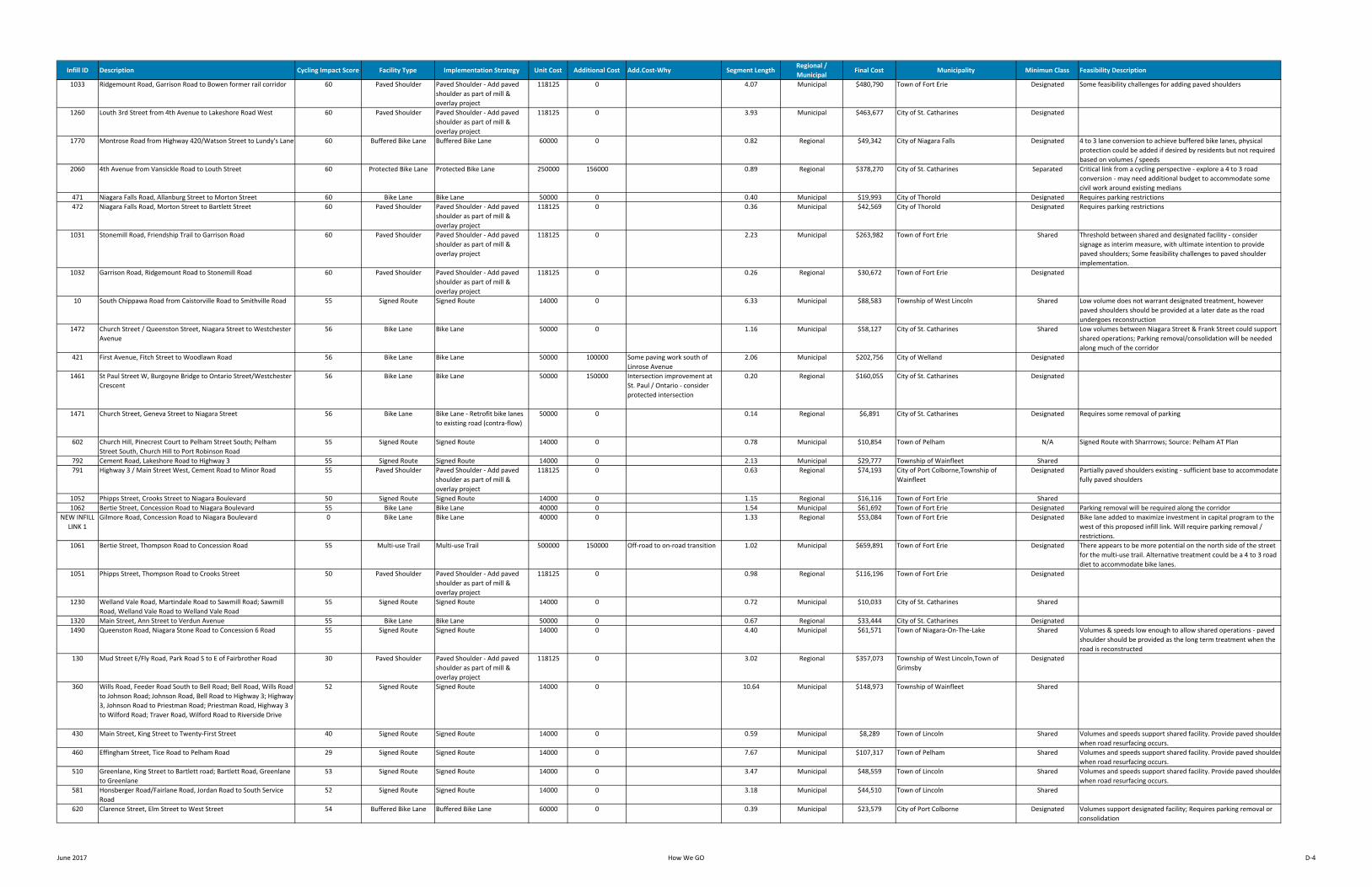
Appendix D: Summary of Infill Corridors
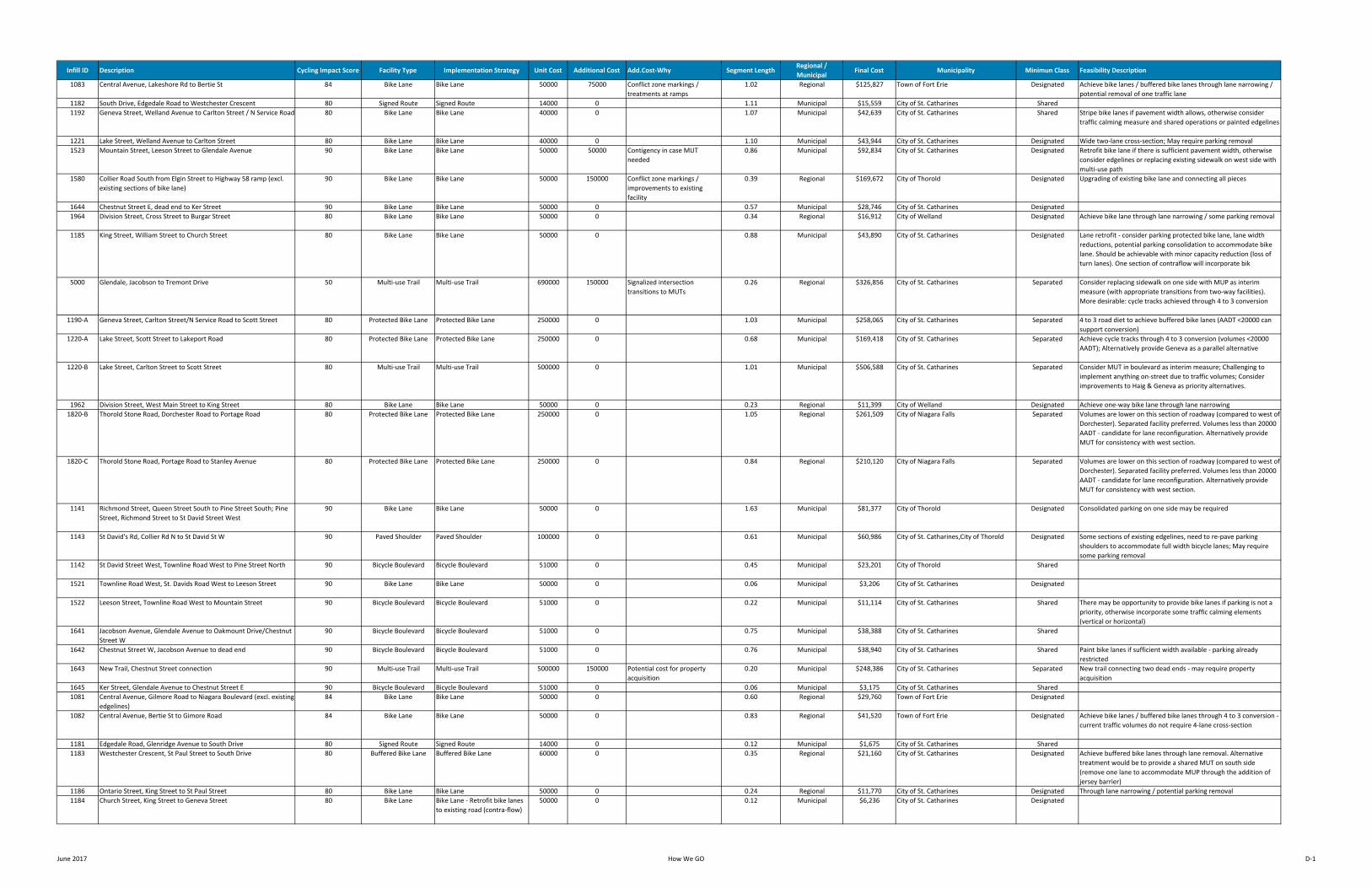
Infill ID Description Cycling Impact Score Facility Type Implementation Strategy Unit Cost Additional Cost Add.Cost‐Why Segment LengthRegional / Municipal
Final Cost Municipality Minimun Class Feasibility Description
1083 Central Avenue, Lakeshore Rd to Bertie St 84 Bike Lane Bike Lane 50000 75000 Conflict zone markings / treatments at ramps
1.02 Regional $125,827 Town of Fort Erie Designated Achieve bike lanes / buffered bike lanes through lane narrowing / potential removal of one traffic lane
1182 South Drive, Edgedale Road to Westchester Crescent 80 Signed Route Signed Route 14000 0 1.11 Municipal $15,559 City of St. Catharines Shared1192 Geneva Street, Welland Avenue to Carlton Street / N Service Road 80 Bike Lane Bike Lane 40000 0 1.07 Municipal $42,639 City of St. Catharines Shared Stripe bike lanes if pavement width allows, otherwise consider
traffic calming measure and shared operations or painted edgelines
1221 Lake Street, Welland Avenue to Carlton Street 80 Bike Lane Bike Lane 40000 0 1.10 Municipal $43,944 City of St. Catharines Designated Wide two‐lane cross‐section; May require parking removal1523 Mountain Street, Leeson Street to Glendale Avenue 90 Bike Lane Bike Lane 50000 50000 Contigency in case MUT
needed0.86 Municipal $92,834 City of St. Catharines Designated Retrofit bike lane if there is sufficient pavement width, otherwise
consider edgelines or replacing existing sidewalk on west side with multi‐use path
1580 Collier Road South from Elgin Street to Highway 58 ramp (excl. existing sections of bike lane)
90 Bike Lane Bike Lane 50000 150000 Conflict zone markings / improvements to existing facility
0.39 Regional $169,672 City of Thorold Designated Upgrading of existing bike lane and connecting all pieces
1644 Chestnut Street E, dead end to Ker Street 90 Bike Lane Bike Lane 50000 0 0.57 Municipal $28,746 City of St. Catharines Designated1964 Division Street, Cross Street to Burgar Street 80 Bike Lane Bike Lane 50000 0 0.34 Regional $16,912 City of Welland Designated Achieve bike lane through lane narrowing / some parking removal
1185 King Street, William Street to Church Street 80 Bike Lane Bike Lane 50000 0 0.88 Municipal $43,890 City of St. Catharines Designated Lane retrofit ‐ consider parking protected bike lane, lane width reductions, potential parking consolidation to accommodate bike lane. Should be achievable with minor capacity reduction (loss of turn lanes). One section of contraflow will incorporate bik
5000 Glendale, Jacobson to Tremont Drive 50 Multi‐use Trail Multi‐use Trail 690000 150000 Signalized intersection transitions to MUTs
0.26 Regional $326,856 City of St. Catharines Separated Consider replacing sidewalk on one side with MUP as interim measure (with appropriate transitions from two‐way facilities). More desirable: cycle tracks achieved through 4 to 3 conversion
1190‐A Geneva Street, Carlton Street/N Service Road to Scott Street 80 Protected Bike Lane Protected Bike Lane 250000 0 1.03 Municipal $258,065 City of St. Catharines Separated 4 to 3 road diet to achieve buffered bike lanes (AADT <20000 can support conversion)
1220‐A Lake Street, Scott Street to Lakeport Road 80 Protected Bike Lane Protected Bike Lane 250000 0 0.68 Municipal $169,418 City of St. Catharines Separated Achieve cycle tracks through 4 to 3 conversion (volumes <20000 AADT); Alternatively provide Geneva as a parallel alternative
1220‐B Lake Street, Carlton Street to Scott Street 80 Multi‐use Trail Multi‐use Trail 500000 0 1.01 Municipal $506,588 City of St. Catharines Separated Consider MUT in boulevard as interim measure; Challenging to implement anything on‐street due to traffic volumes; Consider improvements to Haig & Geneva as priority alternatives.
1962 Division Street, West Main Street to King Street 80 Bike Lane Bike Lane 50000 0 0.23 Regional $11,399 City of Welland Designated Achieve one‐way bike lane through lane narrowing1820‐B Thorold Stone Road, Dorchester Road to Portage Road 80 Protected Bike Lane Protected Bike Lane 250000 0 1.05 Regional $261,509 City of Niagara Falls Separated Volumes are lower on this section of roadway (compared to west of
Dorchester). Separated facility preferred. Volumes less than 20000 AADT ‐ candidate for lane reconfiguration. Alternatively provide MUT for consistency with west section.
1820‐C Thorold Stone Road, Portage Road to Stanley Avenue 80 Protected Bike Lane Protected Bike Lane 250000 0 0.84 Regional $210,120 City of Niagara Falls Separated Volumes are lower on this section of roadway (compared to west of Dorchester). Separated facility preferred. Volumes less than 20000 AADT ‐ candidate for lane reconfiguration. Alternatively provide MUT for consistency with west section.
1141 Richmond Street, Queen Street South to Pine Street South; Pine Street, Richmond Street to St David Street West
90 Bike Lane Bike Lane 50000 0 1.63 Municipal $81,377 City of Thorold Designated Consolidated parking on one side may be required
1143 St David's Rd, Collier Rd N to St David St W 90 Paved Shoulder Paved Shoulder 100000 0 0.61 Municipal $60,986 City of St. Catharines,City of Thorold Designated Some sections of existing edgelines, need to re‐pave parking shoulders to accommodate full width bicycle lanes; May require some parking removal
1142 St David Street West, Townline Road West to Pine Street North 90 Bicycle Boulevard Bicycle Boulevard 51000 0 0.45 Municipal $23,201 City of Thorold Shared
1521 Townline Road West, St. Davids Road West to Leeson Street 90 Bike Lane Bike Lane 50000 0 0.06 Municipal $3,206 City of St. Catharines Designated
1522 Leeson Street, Townline Road West to Mountain Street 90 Bicycle Boulevard Bicycle Boulevard 51000 0 0.22 Municipal $11,114 City of St. Catharines Shared There may be opportunity to provide bike lanes if parking is not a priority, otherwise incorporate some traffic calming elements (vertical or horizontal)
1641 Jacobson Avenue, Glendale Avenue to Oakmount Drive/Chestnut Street W
90 Bicycle Boulevard Bicycle Boulevard 51000 0 0.75 Municipal $38,388 City of St. Catharines Shared
1642 Chestnut Street W, Jacobson Avenue to dead end 90 Bicycle Boulevard Bicycle Boulevard 51000 0 0.76 Municipal $38,940 City of St. Catharines Shared Paint bike lanes if sufficient width available ‐ parking already restricted
1643 New Trail, Chestnut Street connection 90 Multi‐use Trail Multi‐use Trail 500000 150000 Potential cost for property acquisition
0.20 Municipal $248,386 City of St. Catharines Separated New trail connecting two dead ends ‐ may require property acquisition
1645 Ker Street, Glendale Avenue to Chestnut Street E 90 Bicycle Boulevard Bicycle Boulevard 51000 0 0.06 Municipal $3,175 City of St. Catharines Shared1081 Central Avenue, Gilmore Road to Niagara Boulevard (excl. existing
edgelines)84 Bike Lane Bike Lane 50000 0 0.60 Regional $29,760 Town of Fort Erie Designated
1082 Central Avenue, Bertie St to Gimore Road 84 Bike Lane Bike Lane 50000 0 0.83 Regional $41,520 Town of Fort Erie Designated Achieve bike lanes / buffered bike lanes through 4 to 3 conversion ‐ current traffic volumes do not require 4‐lane cross‐section
1181 Edgedale Road, Glenridge Avenue to South Drive 80 Signed Route Signed Route 14000 0 0.12 Municipal $1,675 City of St. Catharines Shared1183 Westchester Crescent, St Paul Street to South Drive 80 Buffered Bike Lane Buffered Bike Lane 60000 0 0.35 Regional $21,160 City of St. Catharines Designated Achieve buffered bike lanes through lane removal. Alternative
treatment would be to provide a shared MUT on south side (remove one lane to accommodate MUP through the addition of jersey barrier)
1186 Ontario Street, King Street to St Paul Street 80 Bike Lane Bike Lane 50000 0 0.24 Regional $11,770 City of St. Catharines Designated Through lane narrowing / potential parking removal1184 Church Street, King Street to Geneva Street 80 Bike Lane Bike Lane ‐ Retrofit bike lanes
to existing road (contra‐flow)50000 0 0.12 Municipal $6,236 City of St. Catharines Designated
June 2017 How We GO D‐1
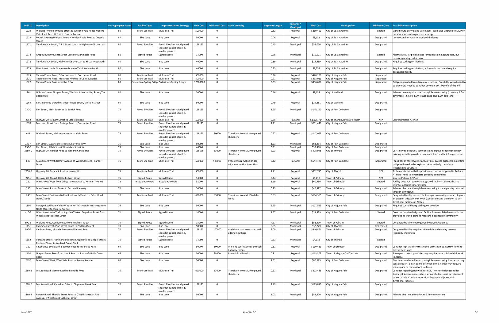
Infill ID Description Cycling Impact Score Facility Type Implementation Strategy Unit Cost Additional Cost Add.Cost‐Why Segment LengthRegional / Municipal
Final Cost Municipality Minimun Class Feasibility Description
1223 Welland Avenue, Ontario Street to Welland Vale Road; Welland Vale Road, Merritt Trail to Fourth Avenue
80 Multi‐use Trail Multi‐use Trail 500000 0 0.52 Regional $260,459 City of St. Catharines Shared Signed route on Welland Vale Road ‐ could also upgrade to MUP on the south side as longer term strategy
1222 Fourth Avenue/Welland Avenue, Welland Vale Road to Ontario Street
80 Bike Lane Bike Lane 50000 0 0.06 Regional $3,131 City of St. Catharines Designated Lane reconfiguration to provide bike lanes
1271 Third Avenue Louth, Third Street Louth to Highway 406 overpass 80 Paved Shoulder Paved Shoulder ‐ Add paved shoulder as part of mill & overlay project
118125 0 0.45 Municipal $53,010 City of St. Catharines Designated
1274 Grapeview Drive, First Street Louth to Martindale Road 80 Signed Route Signed Route 14000 0 0.76 Municipal $10,571 City of St. Catharines Shared Alternatively, stripe bike lane for traffic calming purposes, but requires parking restrictions
1272 Third Avenue Louth, Highway 406 overpass to First Street Louth 80 Bike Lane Bike Lane 40000 0 0.39 Municipal $15,639 City of St. Catharines Designated Requires parking restrictions;
1273 First Street Louth, Grapeview Drive to Third Avenue Louth 80 Bike Lane Bike Lane 40000 0 0.23 Municipal $9,352 City of St. Catharines Designated Requires parking restrictions; volumes in north end require designated facility
1823 Thorold Stone Road, QEW overpass to Dorchester Road 80 Multi‐use Trail Multi‐use Trail 500000 0 0.96 Regional $478,260 City of Niagara Falls Separated1821 Thorold Stone Road, Montrose Avenue to QEW overpass 80 Multi‐use Trail Multi‐use Trail 500000 0 0.71 Regional $353,011 City of Niagara Falls Separated1822 Thorold Stone Road over the QEW 80 Pedestrian‐Cycling BridgePedestrian‐Cycling Bridge 12000000 0 0.03 Regional $356,696 City of Niagara Falls Separated Bridge suspended from freeway structure; Feasibility would need to
be explored; Need to consider potential cost‐benefit of the link
1961 W Main Street, Niagara Street/Division Street to King Street/The Boardwalk
80 Bike Lane Bike Lane 50000 0 0.16 Regional $8,132 City of Welland Designated Achieve one‐way bike lane through lane narrowing (currently 8.5m pavement ‐ 2 X 3.0‐3.5m travel lanes plus 1.5m bike lane)
1963 E Main Street, Dorothy Street to Ross Street/Division Street 80 Bike Lane Bike Lane 50000 0 0.49 Regional $24,281 City of Welland Designated
730‐C Elm Street, Main Street W to Barrick Road 75 Paved Shoulder Paved Shoulder ‐ Add paved shoulder as part of mill & overlay project
118125 0 1.25 Municipal $148,190 City of Port Colborne Designated
2252 Highway 20, Pelham Street to Cataract Road 75 Multi‐use Trail Multi‐use Trail 500000 0 2.35 Regional $1,176,714 City of Thorold,Town of Pelham N/A Source: Pelham AT Plan1870 Morrison Street from Portage Road to Dorchester Road 79 Paved Shoulder Paved Shoulder ‐ Add paved
shoulder as part of mill & overlay project
118125 0 1.71 Municipal $201,449 City of Niagara Falls Designated
611 Welland Street, Mellanby Avenue to Main Street 75 Paved Shoulder Paved Shoulder ‐ Add paved shoulder as part of mill & overlay project
118125 80000 Transition from MUP to paved shoulders
0.57 Regional $147,053 City of Port Colborne Designated
730‐A Elm Street, Sugarloaf Street to Killaly Street W 75 Bike Lane Bike Lane 50000 0 1.23 Municipal $61,384 City of Port Colborne Designated730‐B Elm Street, Killaly Street W to Main Street W 75 Bike Lane Bike Lane 40000 0 0.81 Municipal $32,418 City of Port Colborne Designated2250‐C Highway 20, Hansler Road to Welland Canals Trail 75 Paved Shoulder Paved Shoulder ‐ Add paved
shoulder as part of mill & overlay project
118125 83000 Transition from MUP to paved shoulders
2.93 Regional $428,948 City of Thorold Designated Cost likely to be lower, some sections of paved shoulder already existing, need to provide a minimum 1.5m width, 2.0m preferred.
612 Main Street West, Ramey Avenue to Welland Street / Barber Drive
75 Multi‐use Trail Multi‐use Trail 500000 583000 Pedestrian & cycling bridge, with intersection transitions
0.12 Regional $644,420 City of Port Colborne Separated Feasibility of cantilevering pedestrian / cycling bridge from existing bridge will need to be explored. Alternatively consider a freestanding structure.
2250‐B Highway 20, Cataract Road to Hansler Rd 75 Multi‐use Trail Multi‐use Trail 500000 0 1.71 Regional $852,715 City of Thorold N/A To be consistent with the previous section as proposed in Pelham AT Plan ‐ need to investigate property constraints
2251 Highway 20, Church Hill to Pelham Street 75 Signed Route Signed Route 14000 0 0.44 Regional $6,218 Town of Pelham N/A Source: Pelham AT Plan220 Main Street West from Livingstone Avenue to Kerman Avenue 72 Bicycle Boulevard Bicycle Boulevard 51000 0 1.19 Regional $60,936 Town of Grimsby Shared Facility does not require a designated facility ‐ calm traffic and
improve operations for cyclists230 Main Street, Patton Street to Orchard Parkway 70 Bike Lane Bike Lane 50000 0 0.93 Regional $46,397 Town of Grimsby Designated Achieve bike lane through lane narrowing / some parking removal
through downtown240 Main Street East from Nelles Road North/South to Baker Road
North/South70 Multi‐use Trail Multi‐use Trail 690000 83000 Transition from MUP to bike
lanes0.83 Regional $654,355 Town of Grimsby Designated Designated facility needed, but no space/capacity on‐road. Replace
an existing sidewalk with MUP (south side) and transition to uni‐directional facilities at Nelles
1880 Portage Road from Valley Way to North Street; Main Street from North Street to Stanley Avenue
74 Bike Lane Bike Lane 50000 0 2.15 Municipal $107,569 City of Niagara Falls Designated Requires consolidating parking on one side
410‐B West Street from Trail to Sugarloaf Street; Sugarloaf Street from West Street to Steele Street
71 Signed Route Signed Route 14000 0 1.57 Municipal $21,929 City of Port Colborne Shared Does not require designated facility, however bike lanes could be provided as traffic calming measure if desired by community
690‐B Welland Road, Canboro Road to Effingham Street 70 Signed Route Signed Route 14000 0 4.17 Municipal $58,310 Town of Pelham Shared Designated facility not required by speeds/volumes1151 Richmond Street, Pine Street South to Portland Street 70 Bike Lane Bike Lane 50000 0 0.65 Municipal $32,279 City of Thorold Designated690‐A Canboro Road, Victoria Avenue to Welland Road 70 Paved Shoulder Paved Shoulder ‐ Add paved
shoulder as part of mill & overlay project
118125 100000 Additional cost associated with adding new base
2.09 Municipal $346,854 Town of Pelham Designated Designated facility required ‐ Paved shoulders may present feasibility challenges
1152 Portland Street, Richmond Street to Chapel Street; Chapel Street, Portland Street to Welland Canals Trail
70 Signed Route Signed Route 14000 0 0.33 Municipal $4,613 City of Thorold Shared
210 Casablanca Boulevard, S Service Road to N Service Road 65 Bike Lane Bike Lane 50000 80000 Marking conflict zones through highway ramps
0.61 Regional $110,419 Town of Grimsby Designated Consider high visibility treatments across ramps. Narrow lanes to provide bike lanes
1130 Niagara Stone Road from Line 1 Road to South of 4 Mile Creek Road
65 Bike Lane Bike Lane 50000 78000 Potential civil work 0.81 Regional $118,303 Town of Niagara‐On‐The‐Lake Designated Some pinch points possible ‐ may require some minimal civil work (medians)
2392 Main Street West, West Side Road to Ramey Avenue 69 Bike Lane Bike Lane 50000 0 1.61 Regional $80,525 City of Port Colborne Designated Bike lanes can be achieved through lane narrowing / some parking consolidation ‐ pinch points between Elm & Ramey may require share space or removal of turn lanes
1680‐B McLeod Road, Garner Road to Parkside Road 70 Multi‐use Trail Multi‐use Trail 690000 83000 Transition from MUP to paved shoulders
0.67 Municipal $803,435 City of Niagara Falls Designated Consider replacing sidewalk with MUT on north side (consider drainage). Accommodates high school students and development on north side. Consider transitions between adjacent uni‐directional facilities.
1680‐D Montrose Road, Canadian Drive to Chippawa Creek Road 70 Paved Shoulder Paved Shoulder ‐ Add paved shoulder as part of mill & overlay project
118125 0 1.49 Regional $175,810 City of Niagara Falls Designated
1860‐B Portage Road, Thorold Stone Road to O'Neill Street; St Paul Avenue, O'Neill Street to Russel Street
69 Bike Lane Bike Lane 50000 0 1.03 Municipal $51,270 City of Niagara Falls Designated Achieve bike lane through 4 to 3 lane conversion
June 2017 How We GO D‐2
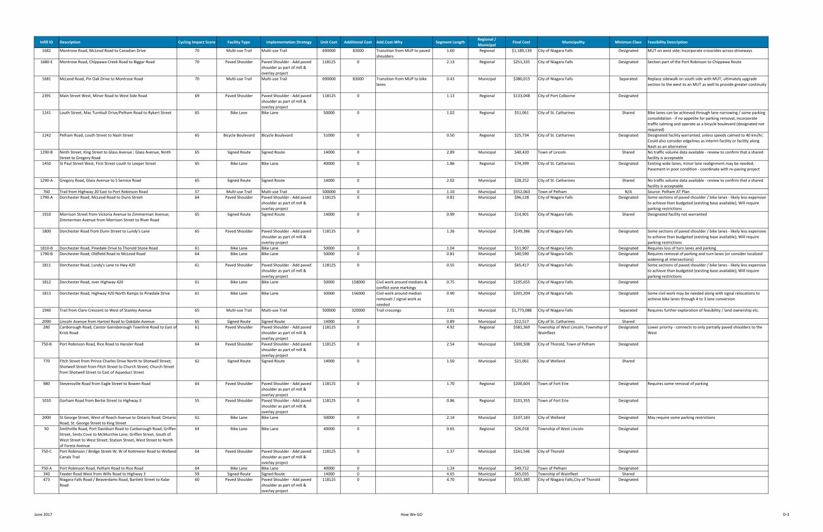
Infill ID Description Cycling Impact Score Facility Type Implementation Strategy Unit Cost Additional Cost Add.Cost‐Why Segment LengthRegional / Municipal
Final Cost Municipality Minimun Class Feasibility Description
1682 Montrose Road, McLeod Road to Canadian Drive 70 Multi‐use Trail Multi‐use Trail 690000 83000 Transition from MUP to paved shoulders
1.60 Regional $1,189,139 City of Niagara Falls Designated MUT on west side; Incorporate crossrides across driveways
1680‐E Montrose Road, Chippawa Creek Road to Biggar Road 70 Paved Shoulder Paved Shoulder ‐ Add paved shoulder as part of mill & overlay project
118125 0 2.13 Regional $251,335 City of Niagara Falls Designated Section part of the Port Robinson to Chippawa Route
1681 McLeod Road, Pin Oak Drive to Montrose Road 70 Multi‐use Trail Multi‐use Trail 690000 83000 Transition from MUP to bike lanes
0.43 Municipal $380,015 City of Niagara Falls Separated Replace sidewalk on south side with MUT; ultimately upgrade section to the west to an MUT as well to provide greater continuity
2391 Main Street West, Minor Road to West Side Road 69 Paved Shoulder Paved Shoulder ‐ Add paved shoulder as part of mill & overlay project
118125 0 1.13 Regional $133,048 City of Port Colborne Designated
1241 Louth Street, Mac Turnbull Drive/Pelham Road to Rykert Street 65 Bike Lane Bike Lane 50000 0 1.02 Regional $51,061 City of St. Catharines Shared Bike lanes can be achieved through lane narrowing / some parking consolidation ‐ if no appetite for parking removal, incorporate traffic calming and operate as a bicycle boulevard (designated not required)
1242 Pelham Road, Louth Street to Nash Street 65 Bicycle Boulevard Bicycle Boulevard 51000 0 0.50 Regional $25,734 City of St. Catharines Designated Designated facility warranted, unless speeds calmed to 40 km/hr; Could also consider edgelines as interim facility or facility along Nash as an alternative
1290‐B Ninth Street, King Street to Glass Avenue ; Glass Avenue, Ninth Street to Gregory Road
65 Signed Route Signed Route 14000 0 2.89 Municipal $40,420 Town of Lincoln Shared No traffic volume data available ‐ review to confirm that a shared facility is acceptable
1450 St Paul Street West, First Street Louth to Leeper Street 65 Bike Lane Bike Lane 40000 0 1.86 Regional $74,399 City of St. Catharines Designated Existing wide lanes, minor lane realignment may be needed; Pavement in poor condition ‐ coordinate with re‐paving project
1290‐A Gregory Road, Glass Avenue to S Service Road 65 Signed Route Signed Route 14000 0 2.02 Municipal $28,252 City of St. Catharines Shared No traffic volume data available ‐ review to confirm that a shared facility is acceptable
760 Trail from Highway 20 East to Port Robinson Road 57 Multi‐use Trail Multi‐use Trail 500000 0 1.10 Municipal $552,063 Town of Pelham N/A Source: Pelham AT Plan1790‐A Dorchester Road, McLeod Road to Dunn Street 64 Paved Shoulder Paved Shoulder ‐ Add paved
shoulder as part of mill & overlay project
118125 0 0.81 Municipal $96,128 City of Niagara Falls Designated Some sections of paved shoulder / bike lanes ‐ likely less expensive to achieve than budgeted (existing base available); Will require parking restrictions
1910 Morrison Street from Victoria Avenue to Zimmerman Avenue; Zimmerman Avenue from Morrison Street to River Road
65 Signed Route Signed Route 14000 0 0.99 Municipal $14,901 City of Niagara Falls Shared Designated facility not warranted
1800 Dorchester Road from Dunn Street to Lundy's Lane 65 Paved Shoulder Paved Shoulder ‐ Add paved shoulder as part of mill & overlay project
118125 0 1.26 Municipal $149,386 City of Niagara Falls Designated Some sections of paved shoulder / bike lanes ‐ likely less expensive to achieve than budgeted (existing base available); Will require parking restrictions
1810‐B Dorchester Road, Pinedale Drive to Thorold Stone Road 61 Bike Lane Bike Lane 50000 0 1.04 Municipal $51,907 City of Niagara Falls Designated Requires loss of turn lanes and parking1790‐B Dorchester Road, Oldfield Road to McLeod Road 64 Bike Lane Bike Lane 50000 0 0.81 Municipal $40,590 City of Niagara Falls Designated Requires removal of parking and turn lanes (or consider localized
widening at intersections)1811 Dorchester Road, Lundy's Lane to Hwy 420 61 Paved Shoulder Paved Shoulder ‐ Add paved
shoulder as part of mill & overlay project
118125 0 0.55 Municipal $65,417 City of Niagara Falls Designated Some sections of paved shoulder / bike lanes ‐ likely less expensive to achieve than budgeted (existing base available); Will require parking restrictions
1812 Dorchester Road, over Highway 420 61 Bike Lane Bike Lane 50000 158000 Civil work around medians & conflict zone markings
0.75 Municipal $195,655 City of Niagara Falls Designated
1813 Dorchester Road, Highway 420 North Ramps to Pinedale Drive 61 Bike Lane Bike Lane 50000 156000 Civil work around median removals / signal work as needed
0.90 Municipal $201,204 City of Niagara Falls Designated Some civil work may be needed along with signal relocations to achieve bike lanes through 4 to 3 lane conversion
1940 Trail from Clare Crescent to West of Stanley Avenue 65 Multi‐use Trail Multi‐use Trail 500000 320000 Trail crossings 2.91 Municipal $1,773,088 City of Niagara Falls Separated Requires further exploration of feasibility / land ownership etc.
2090 Lincoln Avenue from Hartzel Road to Oakdale Avenue 65 Signed Route Signed Route 14000 0 0.89 Municipal $12,517 City of St. Catharines Shared280 Canborough Road, Caistor Gainsborough Townline Road to East of
Krick Road61 Paved Shoulder Paved Shoulder ‐ Add paved
shoulder as part of mill & overlay project
118125 0 4.92 Regional $581,369 Township of West Lincoln, Township of Wainfleet
Designated Lower priority ‐ connects to only partially paved shoulders to the West
750‐B Port Robinson Road, Rice Road to Hansler Road 64 Paved Shoulder Paved Shoulder ‐ Add paved shoulder as part of mill & overlay project
118125 0 2.54 Municipal $300,508 City of Thorold, Town of Pelham Designated
770 Fitch Street from Prince Charles Drive North to Shotwell Street; Shotwell Street from Fitch Street to Church Street; Church Street from Shotwell Street to East of Aqueduct Street
62 Signed Route Signed Route 14000 0 1.50 Municipal $21,061 City of Welland Shared
980 Stevensville Road from Eagle Street to Bowen Road 64 Paved Shoulder Paved Shoulder ‐ Add paved shoulder as part of mill & overlay project
118125 0 1.70 Regional $200,604 Town of Fort Erie Designated Requires some removal of parking
1010 Gorham Road from Bertie Street to Highway 3 55 Paved Shoulder Paved Shoulder ‐ Add paved shoulder as part of mill & overlay project
118125 0 0.86 Regional $101,355 Town of Fort Erie Designated
2000 St George Street, West of Roach Avenue to Ontario Road; Ontario Road, St. George Street to King Street
61 Bike Lane Bike Lane 50000 0 2.14 Municipal $107,183 City of Welland Designated May require some parking restrictions
50 Smithville Road, Port Davidson Road to Canborough Road; Griffen Street, Smits Cove to McMurchie Lane; Griffen Street, South of West Street to West Street; Station Street, West Street to North of Forest Avenue
64 Bike Lane Bike Lane 40000 0 0.65 Regional $26,018 Township of West Lincoln Designated
750‐C Port Robinson / Bridge Street W, W of Kottmeier Road to Welland Canals Trail
64 Paved Shoulder Paved Shoulder ‐ Add paved shoulder as part of mill & overlay project
118125 0 1.37 Municipal $161,546 City of Thorold Designated
750‐A Port Robinson Road, Pelham Road to Rice Road 64 Bike Lane Bike Lane 40000 0 1.24 Municipal $49,712 Town of Pelham Designated340 Feeder Road West from Wills Road to Highway 3 59 Signed Route Signed Route 14000 0 4.65 Municipal $65,035 Township of Wainfleet Shared473 Niagara Falls Road / Beaverdams Road, Bartlett Street to Kalar
Road60 Paved Shoulder Paved Shoulder ‐ Add paved
shoulder as part of mill & overlay project
118125 0 4.70 Municipal $555,385 City of Niagara Falls,City of Thorold Designated
June 2017 How We GO D‐3
Infill ID Description Cycling Impact Score Facility Type Implementation Strategy Unit Cost Additional Cost Add.Cost‐Why Segment LengthRegional / Municipal
Final Cost Municipality Minimun Class Feasibility Description
1033 Ridgemount Road, Garrison Road to Bowen former rail corridor 60 Paved Shoulder Paved Shoulder ‐ Add paved shoulder as part of mill & overlay project
118125 0 4.07 Municipal $480,790 Town of Fort Erie Designated Some feasibility challenges for adding paved shoulders
1260 Louth 3rd Street from 4th Avenue to Lakeshore Road West 60 Paved Shoulder Paved Shoulder ‐ Add paved shoulder as part of mill & overlay project
118125 0 3.93 Municipal $463,677 City of St. Catharines Designated
1770 Montrose Road from Highway 420/Watson Street to Lundy's Lane 60 Buffered Bike Lane Buffered Bike Lane 60000 0 0.82 Regional $49,342 City of Niagara Falls Designated 4 to 3 lane conversion to achieve buffered bike lanes, physical protection could be added if desired by residents but not required based on volumes / speeds
2060 4th Avenue from Vansickle Road to Louth Street 60 Protected Bike Lane Protected Bike Lane 250000 156000 0.89 Regional $378,270 City of St. Catharines Separated Critical link from a cycling perspective ‐ explore a 4 to 3 road conversion ‐ may need additional budget to accommodate some civil work around existing medians
471 Niagara Falls Road, Allanburg Street to Morton Street 60 Bike Lane Bike Lane 50000 0 0.40 Municipal $19,993 City of Thorold Designated Requires parking restrictions472 Niagara Falls Road, Morton Street to Bartlett Street 60 Paved Shoulder Paved Shoulder ‐ Add paved
shoulder as part of mill & overlay project
118125 0 0.36 Municipal $42,569 City of Thorold Designated Requires parking restrictions
1031 Stonemill Road, Friendship Trail to Garrison Road 60 Paved Shoulder Paved Shoulder ‐ Add paved shoulder as part of mill & overlay project
118125 0 2.23 Municipal $263,982 Town of Fort Erie Shared Threshold between shared and designated facility ‐ consider signage as interim measure, with ultimate intention to provide paved shoulders; Some feasibility challenges to paved shoulder implementation.
1032 Garrison Road, Ridgemount Road to Stonemill Road 60 Paved Shoulder Paved Shoulder ‐ Add paved shoulder as part of mill & overlay project
118125 0 0.26 Regional $30,672 Town of Fort Erie Designated
10 South Chippawa Road from Caistorville Road to Smithville Road 55 Signed Route Signed Route 14000 0 6.33 Municipal $88,583 Township of West Lincoln Shared Low volume does not warrant designated treatment, however paved shoulders should be provided at a later date as the road undergoes reconstruction
1472 Church Street / Queenston Street, Niagara Street to Westchester Avenue
56 Bike Lane Bike Lane 50000 0 1.16 Municipal $58,127 City of St. Catharines Shared Low volumes between Niagara Street & Frank Street could support shared operations; Parking removal/consolidation will be needed along much of the corridor
421 First Avenue, Fitch Street to Woodlawn Road 56 Bike Lane Bike Lane 50000 100000 Some paving work south of Linrose Avenue
2.06 Municipal $202,756 City of Welland Designated
1461 St Paul Street W, Burgoyne Bridge to Ontario Street/Westchester Crescent
56 Bike Lane Bike Lane 50000 150000 Intersection improvement at St. Paul / Ontario ‐ consider protected intersection
0.20 Regional $160,055 City of St. Catharines Designated
1471 Church Street, Geneva Street to Niagara Street 56 Bike Lane Bike Lane ‐ Retrofit bike lanes to existing road (contra‐flow)
50000 0 0.14 Regional $6,891 City of St. Catharines Designated Requires some removal of parking
602 Church Hill, Pinecrest Court to Pelham Street South; Pelham Street South, Church Hill to Port Robinson Road
55 Signed Route Signed Route 14000 0 0.78 Municipal $10,854 Town of Pelham N/A Signed Route with Sharrrows; Source: Pelham AT Plan
792 Cement Road, Lakeshore Road to Highway 3 55 Signed Route Signed Route 14000 0 2.13 Municipal $29,777 Township of Wainfleet Shared791 Highway 3 / Main Street West, Cement Road to Minor Road 55 Paved Shoulder Paved Shoulder ‐ Add paved
shoulder as part of mill & overlay project
118125 0 0.63 Regional $74,193 City of Port Colborne,Township of Wainfleet
Designated Partially paved shoulders existing ‐ sufficient base to accommodate fully paved shoulders
1052 Phipps Street, Crooks Street to Niagara Boulevard 50 Signed Route Signed Route 14000 0 1.15 Regional $16,116 Town of Fort Erie Shared1062 Bertie Street, Concession Road to Niagara Boulevard 55 Bike Lane Bike Lane 40000 0 1.54 Municipal $61,692 Town of Fort Erie Designated Parking removal will be required along the corridor
NEW INFILL LINK 1
Gilmore Road, Concession Road to Niagara Boulevard 0 Bike Lane Bike Lane 40000 0 1.33 Regional $53,084 Town of Fort Erie Designated Bike lane added to maximize investment in capital program to the west of this proposed infill link. Will require parking removal / restrictions.
1061 Bertie Street, Thompson Road to Concession Road 55 Multi‐use Trail Multi‐use Trail 500000 150000 Off‐road to on‐road transition 1.02 Municipal $659,891 Town of Fort Erie Designated There appears to be more potential on the north side of the street for the multi‐use trail. Alternative treatment could be a 4 to 3 road diet to accommodate bike lanes.
1051 Phipps Street, Thompson Road to Crooks Street 50 Paved Shoulder Paved Shoulder ‐ Add paved shoulder as part of mill & overlay project
118125 0 0.98 Regional $116,196 Town of Fort Erie Designated
1230 Welland Vale Road, Martindale Road to Sawmill Road; Sawmill Road, Welland Vale Road to Welland Vale Road
55 Signed Route Signed Route 14000 0 0.72 Municipal $10,033 City of St. Catharines Shared
1320 Main Street, Ann Street to Verdun Avenue 55 Bike Lane Bike Lane 50000 0 0.67 Regional $33,444 City of St. Catharines Designated1490 Queenston Road, Niagara Stone Road to Concession 6 Road 55 Signed Route Signed Route 14000 0 4.40 Municipal $61,571 Town of Niagara‐On‐The‐Lake Shared Volumes & speeds low enough to allow shared operations ‐ paved
shoulder should be provided as the long term treatment when the road is reconstructed
130 Mud Street E/Fly Road, Park Road S to E of Fairbrother Road 30 Paved Shoulder Paved Shoulder ‐ Add paved shoulder as part of mill & overlay project
118125 0 3.02 Regional $357,073 Township of West Lincoln,Town of Grimsby
Designated
360 Wills Road, Feeder Road South to Bell Road; Bell Road, Wills Road to Johnson Road; Johnson Road, Bell Road to Highway 3; Highway 3, Johnson Road to Priestman Road; Priestman Road, Highway 3 to Wilford Road; Traver Road, Wilford Road to Riverside Drive
52 Signed Route Signed Route 14000 0 10.64 Municipal $148,973 Township of Wainfleet Shared
430 Main Street, King Street to Twenty‐First Street 40 Signed Route Signed Route 14000 0 0.59 Municipal $8,289 Town of Lincoln Shared Volumes and speeds support shared facility. Provide paved shoulderwhen road resurfacing occurs.
460 Effingham Street, Tice Road to Pelham Road 29 Signed Route Signed Route 14000 0 7.67 Municipal $107,317 Town of Pelham Shared Volumes and speeds support shared facility. Provide paved shoulderwhen road resurfacing occurs.
510 Greenlane, King Street to Bartlett road; Bartlett Road, Greenlane to Greenlane
53 Signed Route Signed Route 14000 0 3.47 Municipal $48,559 Town of Lincoln Shared Volumes and speeds support shared facility. Provide paved shoulderwhen road resurfacing occurs.
581 Honsberger Road/Fairlane Road, Jordan Road to South Service Road
52 Signed Route Signed Route 14000 0 3.18 Municipal $44,510 Town of Lincoln Shared
620 Clarence Street, Elm Street to West Street 54 Buffered Bike Lane Buffered Bike Lane 60000 0 0.39 Municipal $23,579 City of Port Colborne Designated Volumes support designated facility; Requires parking removal or consolidation
June 2017 How We GO D‐4
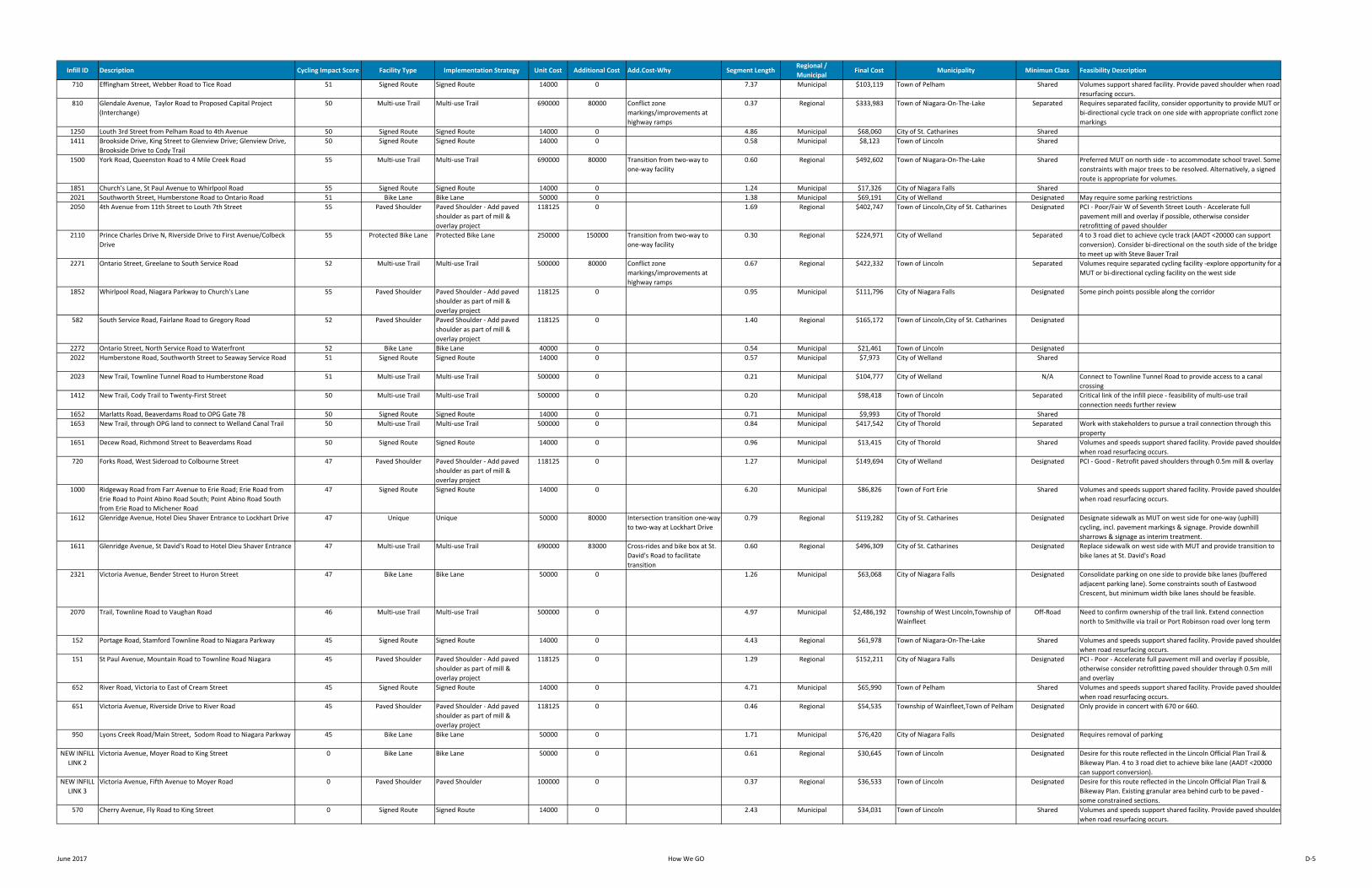
Infill ID Description Cycling Impact Score Facility Type Implementation Strategy Unit Cost Additional Cost Add.Cost‐Why Segment LengthRegional / Municipal
Final Cost Municipality Minimun Class Feasibility Description
710 Effingham Street, Webber Road to Tice Road 51 Signed Route Signed Route 14000 0 7.37 Municipal $103,119 Town of Pelham Shared Volumes support shared facility. Provide paved shoulder when road resurfacing occurs.
810 Glendale Avenue, Taylor Road to Proposed Capital Project (Interchange)
50 Multi‐use Trail Multi‐use Trail 690000 80000 Conflict zone markings/improvements at highway ramps
0.37 Regional $333,983 Town of Niagara‐On‐The‐Lake Separated Requires separated facility, consider opportunity to provide MUT or bi‐directional cycle track on one side with appropriate conflict zone markings
1250 Louth 3rd Street from Pelham Road to 4th Avenue 50 Signed Route Signed Route 14000 0 4.86 Municipal $68,060 City of St. Catharines Shared1411 Brookside Drive, King Street to Glenview Drive; Glenview Drive,
Brookside Drive to Cody Trail50 Signed Route Signed Route 14000 0 0.58 Municipal $8,123 Town of Lincoln Shared
1500 York Road, Queenston Road to 4 Mile Creek Road 55 Multi‐use Trail Multi‐use Trail 690000 80000 Transition from two‐way to one‐way facility
0.60 Regional $492,602 Town of Niagara‐On‐The‐Lake Shared Preferred MUT on north side ‐ to accommodate school travel. Some constraints with major trees to be resolved. Alternatively, a signed route is appropriate for volumes.
1851 Church's Lane, St Paul Avenue to Whirlpool Road 55 Signed Route Signed Route 14000 0 1.24 Municipal $17,326 City of Niagara Falls Shared2021 Southworth Street, Humberstone Road to Ontario Road 51 Bike Lane Bike Lane 50000 0 1.38 Municipal $69,191 City of Welland Designated May require some parking restrictions2050 4th Avenue from 11th Street to Louth 7th Street 55 Paved Shoulder Paved Shoulder ‐ Add paved
shoulder as part of mill & overlay project
118125 0 1.69 Regional $402,747 Town of Lincoln,City of St. Catharines Designated PCI ‐ Poor/Fair W of Seventh Street Louth ‐ Accelerate full pavement mill and overlay if possible, otherwise consider retrofitting of paved shoulder
2110 Prince Charles Drive N, Riverside Drive to First Avenue/Colbeck Drive
55 Protected Bike Lane Protected Bike Lane 250000 150000 Transition from two‐way to one‐way facility
0.30 Regional $224,971 City of Welland Separated 4 to 3 road diet to achieve cycle track (AADT <20000 can support conversion). Consider bi‐directional on the south side of the bridge to meet up with Steve Bauer Trail
2271 Ontario Street, Greelane to South Service Road 52 Multi‐use Trail Multi‐use Trail 500000 80000 Conflict zone markings/improvements at highway ramps
0.67 Regional $422,332 Town of Lincoln Separated Volumes require separated cycling facility ‐explore opportunity for aMUT or bi‐directional cycling facility on the west side
1852 Whirlpool Road, Niagara Parkway to Church's Lane 55 Paved Shoulder Paved Shoulder ‐ Add paved shoulder as part of mill & overlay project
118125 0 0.95 Municipal $111,796 City of Niagara Falls Designated Some pinch points possible along the corridor
582 South Service Road, Fairlane Road to Gregory Road 52 Paved Shoulder Paved Shoulder ‐ Add paved shoulder as part of mill & overlay project
118125 0 1.40 Regional $165,172 Town of Lincoln,City of St. Catharines Designated
2272 Ontario Street, North Service Road to Waterfront 52 Bike Lane Bike Lane 40000 0 0.54 Municipal $21,461 Town of Lincoln Designated2022 Humberstone Road, Southworth Street to Seaway Service Road 51 Signed Route Signed Route 14000 0 0.57 Municipal $7,973 City of Welland Shared
2023 New Trail, Townline Tunnel Road to Humberstone Road 51 Multi‐use Trail Multi‐use Trail 500000 0 0.21 Municipal $104,777 City of Welland N/A Connect to Townline Tunnel Road to provide access to a canal crossing
1412 New Trail, Cody Trail to Twenty‐First Street 50 Multi‐use Trail Multi‐use Trail 500000 0 0.20 Municipal $98,418 Town of Lincoln Separated Critical link of the infill piece ‐ feasibility of multi‐use trail connection needs further review
1652 Marlatts Road, Beaverdams Road to OPG Gate 78 50 Signed Route Signed Route 14000 0 0.71 Municipal $9,993 City of Thorold Shared1653 New Trail, through OPG land to connect to Welland Canal Trail 50 Multi‐use Trail Multi‐use Trail 500000 0 0.84 Municipal $417,542 City of Thorold Separated Work with stakeholders to pursue a trail connection through this
property1651 Decew Road, Richmond Street to Beaverdams Road 50 Signed Route Signed Route 14000 0 0.96 Municipal $13,415 City of Thorold Shared Volumes and speeds support shared facility. Provide paved shoulder
when road resurfacing occurs.720 Forks Road, West Sideroad to Colbourne Street 47 Paved Shoulder Paved Shoulder ‐ Add paved
shoulder as part of mill & overlay project
118125 0 1.27 Municipal $149,694 City of Welland Designated PCI ‐ Good ‐ Retrofit paved shoulders through 0.5m mill & overlay
1000 Ridgeway Road from Farr Avenue to Erie Road; Erie Road from Erie Road to Point Abino Road South; Point Abino Road South from Erie Road to Michener Road
47 Signed Route Signed Route 14000 0 6.20 Municipal $86,826 Town of Fort Erie Shared Volumes and speeds support shared facility. Provide paved shoulderwhen road resurfacing occurs.
1612 Glenridge Avenue, Hotel Dieu Shaver Entrance to Lockhart Drive 47 Unique Unique 50000 80000 Intersection transition one‐way to two‐way at Lockhart Drive
0.79 Regional $119,282 City of St. Catharines Designated Designate sidewalk as MUT on west side for one‐way (uphill) cycling, incl. pavement markings & signage. Provide downhill sharrows & signage as interim treatment.
1611 Glenridge Avenue, St David's Road to Hotel Dieu Shaver Entrance 47 Multi‐use Trail Multi‐use Trail 690000 83000 Cross‐rides and bike box at St. David's Road to facilitate transition
0.60 Regional $496,309 City of St. Catharines Designated Replace sidewalk on west side with MUT and provide transition to bike lanes at St. David's Road
2321 Victoria Avenue, Bender Street to Huron Street 47 Bike Lane Bike Lane 50000 0 1.26 Municipal $63,068 City of Niagara Falls Designated Consolidate parking on one side to provide bike lanes (buffered adjacent parking lane). Some constraints south of Eastwood Crescent, but minimum width bike lanes should be feasible.
2070 Trail, Townline Road to Vaughan Road 46 Multi‐use Trail Multi‐use Trail 500000 0 4.97 Municipal $2,486,192 Township of West Lincoln,Township of Wainfleet
Off‐Road Need to confirm ownership of the trail link. Extend connection north to Smithville via trail or Port Robinson road over long term
152 Portage Road, Stamford Townline Road to Niagara Parkway 45 Signed Route Signed Route 14000 0 4.43 Regional $61,978 Town of Niagara‐On‐The‐Lake Shared Volumes and speeds support shared facility. Provide paved shoulderwhen road resurfacing occurs.
151 St Paul Avenue, Mountain Road to Townline Road Niagara 45 Paved Shoulder Paved Shoulder ‐ Add paved shoulder as part of mill & overlay project
118125 0 1.29 Regional $152,211 City of Niagara Falls Designated PCI ‐ Poor ‐ Accelerate full pavement mill and overlay if possible, otherwise consider retrofitting paved shoulder through 0.5m mill and overlay
652 River Road, Victoria to East of Cream Street 45 Signed Route Signed Route 14000 0 4.71 Municipal $65,990 Town of Pelham Shared Volumes and speeds support shared facility. Provide paved shoulderwhen road resurfacing occurs.
651 Victoria Avenue, Riverside Drive to River Road 45 Paved Shoulder Paved Shoulder ‐ Add paved shoulder as part of mill & overlay project
118125 0 0.46 Regional $54,535 Township of Wainfleet,Town of Pelham Designated Only provide in concert with 670 or 660.
950 Lyons Creek Road/Main Street, Sodom Road to Niagara Parkway 45 Bike Lane Bike Lane 50000 0 1.71 Municipal $76,420 City of Niagara Falls Designated Requires removal of parking
NEW INFILL LINK 2
Victoria Avenue, Moyer Road to King Street 0 Bike Lane Bike Lane 50000 0 0.61 Regional $30,645 Town of Lincoln Designated Desire for this route reflected in the Lincoln Official Plan Trail & Bikeway Plan. 4 to 3 road diet to achieve bike lane (AADT <20000 can support conversion).
NEW INFILL LINK 3
Victoria Avenue, Fifth Avenue to Moyer Road 0 Paved Shoulder Paved Shoulder 100000 0 0.37 Regional $36,533 Town of Lincoln Designated Desire for this route reflected in the Lincoln Official Plan Trail & Bikeway Plan. Existing granular area behind curb to be paved ‐ some constrained sections.
570 Cherry Avenue, Fly Road to King Street 0 Signed Route Signed Route 14000 0 2.43 Municipal $34,031 Town of Lincoln Shared Volumes and speeds support shared facility. Provide paved shoulderwhen road resurfacing occurs.
June 2017 How We GO D‐5
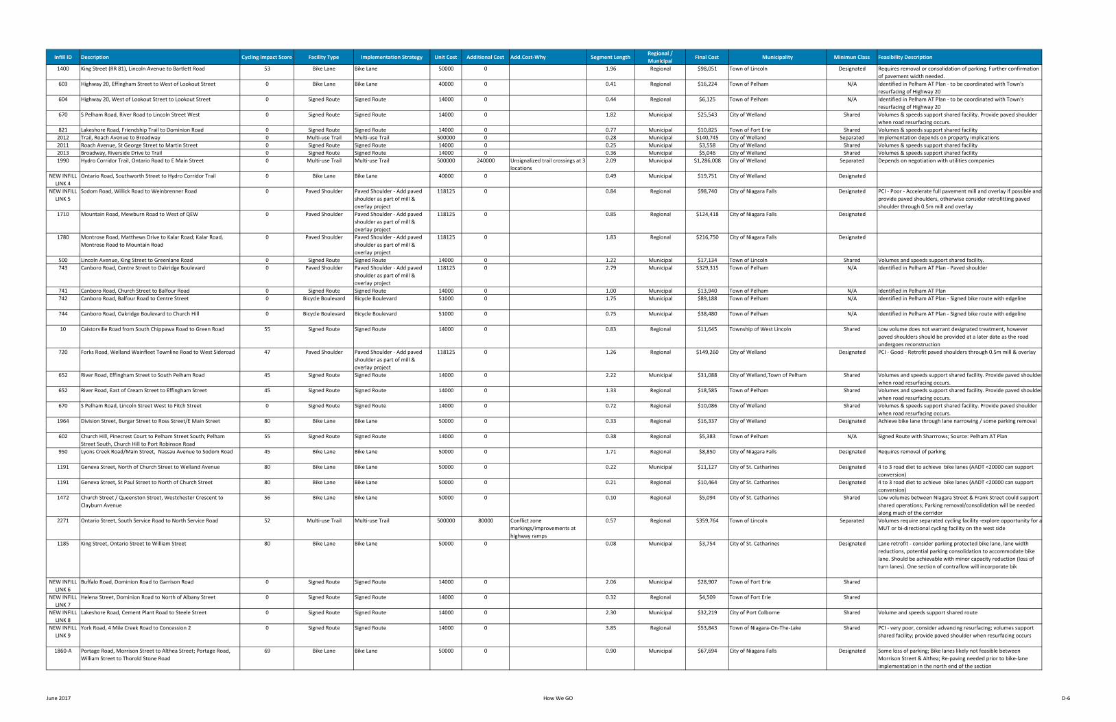
Infill ID Description Cycling Impact Score Facility Type Implementation Strategy Unit Cost Additional Cost Add.Cost‐Why Segment LengthRegional / Municipal
Final Cost Municipality Minimun Class Feasibility Description
1400 King Street (RR 81), Lincoln Avenue to Bartlett Road 53 Bike Lane Bike Lane 50000 0 1.96 Regional $98,051 Town of Lincoln Designated Requires removal or consolidation of parking. Further confirmation of pavement width needed.
603 Highway 20, Effingham Street to West of Lookout Street 0 Bike Lane Bike Lane 40000 0 0.41 Regional $16,224 Town of Pelham N/A Identified in Pelham AT Plan ‐ to be coordinated with Town's resurfacing of Highway 20
604 Highway 20, West of Lookout Street to Lookout Street 0 Signed Route Signed Route 14000 0 0.44 Regional $6,125 Town of Pelham N/A Identified in Pelham AT Plan ‐ to be coordinated with Town's resurfacing of Highway 20
670 S Pelham Road, River Road to Lincoln Street West 0 Signed Route Signed Route 14000 0 1.82 Municipal $25,543 City of Welland Shared Volumes & speeds support shared facility. Provide paved shoulder when road resurfacing occurs.
821 Lakeshore Road, Friendship Trail to Dominion Road 0 Signed Route Signed Route 14000 0 0.77 Municipal $10,825 Town of Fort Erie Shared Volumes & speeds support shared facility2012 Trail, Roach Avenue to Broadway 0 Multi‐use Trail Multi‐use Trail 500000 0 0.28 Municipal $140,745 City of Welland Separated Implementation depends on property implications2011 Roach Avenue, St George Street to Martin Street 0 Signed Route Signed Route 14000 0 0.25 Municipal $3,558 City of Welland Shared Volumes & speeds support shared facility2013 Broadway, Riverside Drive to Trail 0 Signed Route Signed Route 14000 0 0.36 Municipal $5,046 City of Welland Shared Volumes & speeds support shared facility1990 Hydro Corridor Trail, Ontario Road to E Main Street 0 Multi‐use Trail Multi‐use Trail 500000 240000 Unsignalized trail crossings at 3
locations2.09 Municipal $1,286,008 City of Welland Separated Depends on negotiation with utilities companies
NEW INFILL LINK 4
Ontario Road, Southworth Street to Hydro Corridor Trail 0 Bike Lane Bike Lane 40000 0 0.49 Municipal $19,751 City of Welland Designated
NEW INFILL LINK 5
Sodom Road, Willick Road to Weinbrenner Road 0 Paved Shoulder Paved Shoulder ‐ Add paved shoulder as part of mill & overlay project
118125 0 0.84 Regional $98,740 City of Niagara Falls Designated PCI ‐ Poor ‐ Accelerate full pavement mill and overlay if possible and provide paved shoulders, otherwise consider retrofitting paved shoulder through 0.5m mill and overlay
1710 Mountain Road, Mewburn Road to West of QEW 0 Paved Shoulder Paved Shoulder ‐ Add paved shoulder as part of mill & overlay project
118125 0 0.85 Regional $124,418 City of Niagara Falls Designated
1780 Montrose Road, Matthews Drive to Kalar Road; Kalar Road, Montrose Road to Mountain Road
0 Paved Shoulder Paved Shoulder ‐ Add paved shoulder as part of mill & overlay project
118125 0 1.83 Regional $216,750 City of Niagara Falls Designated
500 Lincoln Avenue, King Street to Greenlane Road 0 Signed Route Signed Route 14000 0 1.22 Municipal $17,134 Town of Lincoln Shared Volumes and speeds support shared facility.743 Canboro Road, Centre Street to Oakridge Boulevard 0 Paved Shoulder Paved Shoulder ‐ Add paved
shoulder as part of mill & overlay project
118125 0 2.79 Municipal $329,315 Town of Pelham N/A Identified in Pelham AT Plan ‐ Paved shoulder
741 Canboro Road, Church Street to Balfour Road 0 Signed Route Signed Route 14000 0 1.00 Municipal $13,940 Town of Pelham N/A Identified in Pelham AT Plan742 Canboro Road, Balfour Road to Centre Street 0 Bicycle Boulevard Bicycle Boulevard 51000 0 1.75 Municipal $89,188 Town of Pelham N/A Identified in Pelham AT Plan ‐ Signed bike route with edgeline
744 Canboro Road, Oakridge Boulevard to Church Hill 0 Bicycle Boulevard Bicycle Boulevard 51000 0 0.75 Municipal $38,480 Town of Pelham N/A Identified in Pelham AT Plan ‐ Signed bike route with edgeline
10 Caistorville Road from South Chippawa Road to Green Road 55 Signed Route Signed Route 14000 0 0.83 Regional $11,645 Township of West Lincoln Shared Low volume does not warrant designated treatment, however paved shoulders should be provided at a later date as the road undergoes reconstruction
720 Forks Road, Welland Wainfleet Townline Road to West Sideroad 47 Paved Shoulder Paved Shoulder ‐ Add paved shoulder as part of mill & overlay project
118125 0 1.26 Regional $149,260 City of Welland Designated PCI ‐ Good ‐ Retrofit paved shoulders through 0.5m mill & overlay
652 River Road, Effingham Street to South Pelham Road 45 Signed Route Signed Route 14000 0 2.22 Municipal $31,088 City of Welland,Town of Pelham Shared Volumes and speeds support shared facility. Provide paved shoulderwhen road resurfacing occurs.
652 River Road, East of Cream Street to Effingham Street 45 Signed Route Signed Route 14000 0 1.33 Regional $18,585 Town of Pelham Shared Volumes and speeds support shared facility. Provide paved shoulderwhen road resurfacing occurs.
670 S Pelham Road, Lincoln Street West to Fitch Street 0 Signed Route Signed Route 14000 0 0.72 Regional $10,086 City of Welland Shared Volumes & speeds support shared facility. Provide paved shoulder when road resurfacing occurs.
1964 Division Street, Burgar Street to Ross Street/E Main Street 80 Bike Lane Bike Lane 50000 0 0.33 Regional $16,337 City of Welland Designated Achieve bike lane through lane narrowing / some parking removal
602 Church Hill, Pinecrest Court to Pelham Street South; Pelham Street South, Church Hill to Port Robinson Road
55 Signed Route Signed Route 14000 0 0.38 Regional $5,383 Town of Pelham N/A Signed Route with Sharrrows; Source: Pelham AT Plan
950 Lyons Creek Road/Main Street, Nassau Avenue to Sodom Road 45 Bike Lane Bike Lane 50000 0 1.71 Regional $8,850 City of Niagara Falls Designated Requires removal of parking
1191 Geneva Street, North of Church Street to Welland Avenue 80 Bike Lane Bike Lane 50000 0 0.22 Municipal $11,127 City of St. Catharines Designated 4 to 3 road diet to achieve bike lanes (AADT <20000 can support conversion)
1191 Geneva Street, St Paul Street to North of Church Street 80 Bike Lane Bike Lane 50000 0 0.21 Regional $10,464 City of St. Catharines Designated 4 to 3 road diet to achieve bike lanes (AADT <20000 can support conversion)
1472 Church Street / Queenston Street, Westchester Crescent to Clayburn Avenue
56 Bike Lane Bike Lane 50000 0 0.10 Regional $5,094 City of St. Catharines Shared Low volumes between Niagara Street & Frank Street could support shared operations; Parking removal/consolidation will be needed along much of the corridor
2271 Ontario Street, South Service Road to North Service Road 52 Multi‐use Trail Multi‐use Trail 500000 80000 Conflict zone markings/improvements at highway ramps
0.57 Regional $359,764 Town of Lincoln Separated Volumes require separated cycling facility ‐explore opportunity for aMUT or bi‐directional cycling facility on the west side
1185 King Street, Ontario Street to William Street 80 Bike Lane Bike Lane 50000 0 0.08 Municipal $3,754 City of St. Catharines Designated Lane retrofit ‐ consider parking protected bike lane, lane width reductions, potential parking consolidation to accommodate bike lane. Should be achievable with minor capacity reduction (loss of turn lanes). One section of contraflow will incorporate bik
NEW INFILL LINK 6
Buffalo Road, Dominion Road to Garrison Road 0 Signed Route Signed Route 14000 0 2.06 Municipal $28,907 Town of Fort Erie Shared
NEW INFILL LINK 7
Helena Street, Dominion Road to North of Albany Street 0 Signed Route Signed Route 14000 0 0.32 Regional $4,509 Town of Fort Erie Shared
NEW INFILL LINK 8
Lakeshore Road, Cement Plant Road to Steele Street 0 Signed Route Signed Route 14000 0 2.30 Municipal $32,219 City of Port Colborne Shared Volume and speeds support shared route
NEW INFILL LINK 9
York Road, 4 Mile Creek Road to Concession 2 0 Signed Route Signed Route 14000 0 3.85 Regional $53,843 Town of Niagara‐On‐The‐Lake Shared PCI ‐ very poor, consider advancing resurfacing; volumes support shared facility; provide paved shoulder when resurfacing occurs
1860‐A Portage Road, Morrison Street to Althea Street; Portage Road, William Street to Thorold Stone Road
69 Bike Lane Bike Lane 50000 0 0.90 Municipal $67,694 City of Niagara Falls Designated Some loss of parking; Bike lanes likely not feasible between Morrison Street & Althea; Re‐paving needed prior to bike‐lane implementation in the north end of the section
June 2017 How We GO D‐6
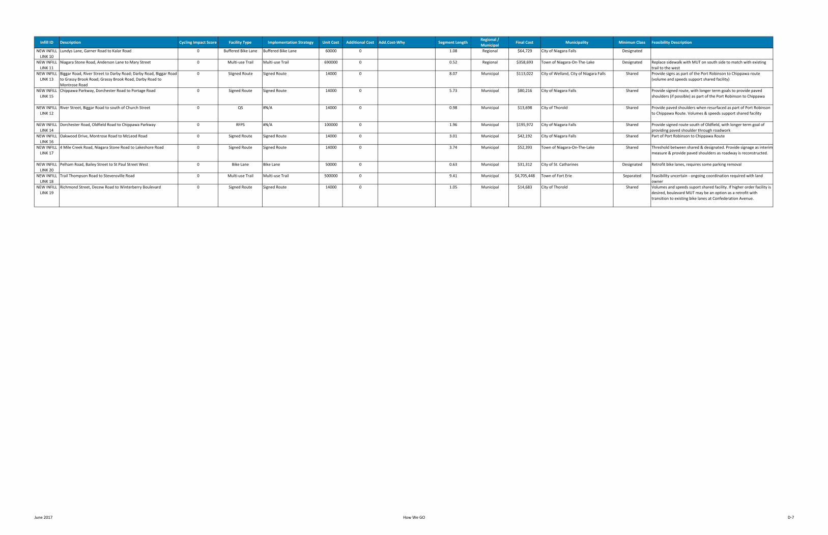
Infill ID Description Cycling Impact Score Facility Type Implementation Strategy Unit Cost Additional Cost Add.Cost‐Why Segment LengthRegional / Municipal
Final Cost Municipality Minimun Class Feasibility Description
NEW INFILL LINK 10
Lundys Lane, Garner Road to Kalar Road 0 Buffered Bike Lane Buffered Bike Lane 60000 0 1.08 Regional $64,729 City of Niagara Falls Designated
NEW INFILL LINK 11
Niagara Stone Road, Anderson Lane to Mary Street 0 Multi‐use Trail Multi‐use Trail 690000 0 0.52 Regional $358,693 Town of Niagara‐On‐The‐Lake Designated Replace sidewalk with MUT on south side to match with existing trail to the west
NEW INFILL LINK 13
Biggar Road, River Street to Darby Road; Darby Road, Biggar Road to Grassy Brook Road; Grassy Brook Road, Darby Road to Montrose Road
0 Siigned Route Signed Route 14000 0 8.07 Municipal $113,022 City of Welland, City of Niagara Falls Shared Provide signs as part of the Port Robinson to Chippawa route (volume and speeds support shared facility)
NEW INFILL LINK 15
Chippawa Parkway, Dorchester Road to Portage Road 0 Signed Route Signed Route 14000 0 5.73 Municipal $80,216 City of Niagara Falls Shared Provide signed route, with longer term goals to provide paved shoulders (if possible) as part of the Port Robinson to Chippawa
NEW INFILL LINK 12
River Street, Biggar Road to south of Church Street 0 QS #N/A 14000 0 0.98 Municipal $13,698 City of Thorold Shared Provide paved shoulders when resurfaced as part of Port Robinson to Chippawa Route. Volumes & speeds support shared facility
NEW INFILL LINK 14
Dorchester Road, Oldfield Road to Chippawa Parkway 0 RFPS #N/A 100000 0 1.96 Municipal $195,972 City of Niagara Falls Shared Provide signed route south of Oldfield, with longer term goal of providing paved shoulder through roadwork
NEW INFILL LINK 16
Oakwood Drive, Montrose Road to McLeod Road 0 Signed Route Signed Route 14000 0 3.01 Municipal $42,192 City of Niagara Falls Shared Part of Port Robinson to Chippawa Route
NEW INFILL LINK 17
4 Mile Creek Road, Niagara Stone Road to Lakeshore Road 0 Signed Route Signed Route 14000 0 3.74 Municipal $52,393 Town of Niagara‐On‐The‐Lake Shared Threshold between shared & designated. Provide signage as interim measure & provide paved shoulders as roadway is reconstructed.
NEW INFILL LINK 20
Pelham Road, Bailey Street to St Paul Street West 0 Bike Lane Bike Lane 50000 0 0.63 Municipal $31,312 City of St. Catharines Designated Retrofit bike lanes, requires some parking removal
NEW INFILL LINK 18
Trail Thompson Road to Stevensville Road 0 Multi‐use Trail Multi‐use Trail 500000 0 9.41 Municipal $4,705,448 Town of Fort Erie Separated Feasibility uncertain ‐ ongoing coordination required with land owner
NEW INFILL LINK 19
Richmond Street, Decew Road to Winterberry Boulevard 0 Signed Route Signed Route 14000 0 1.05 Municipal $14,683 City of Thorold Shared Volumes and speeds suport shared facility. If higher order facility is desired, boulevard MUT may be an option as a retrofit with transition to existing bike lanes at Confederation Avenue.
June 2017 How We GO D‐7
June 2017 HOW WE GO
Appendix E: Summary of Proposed Modifications to Long-Term Regional Network
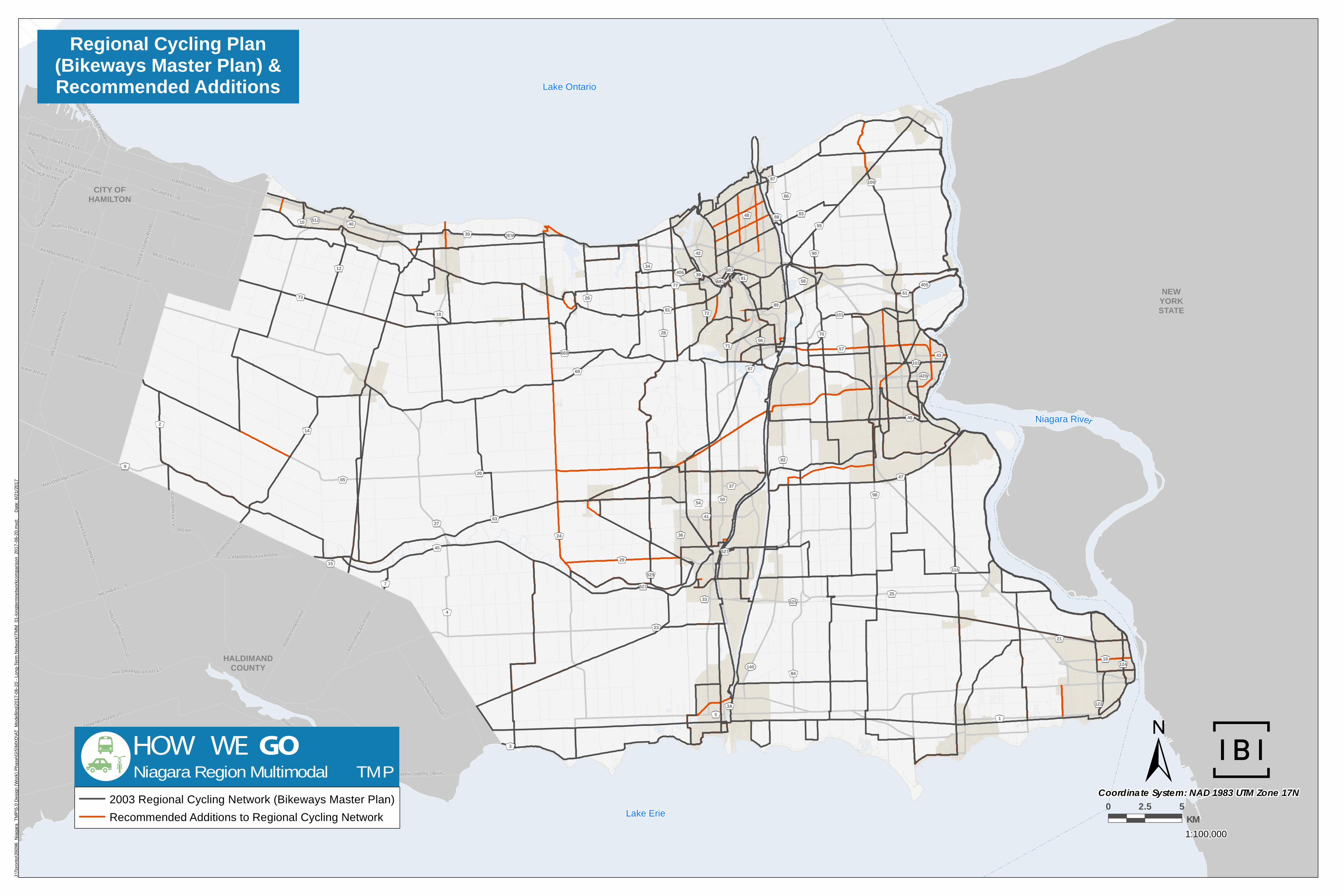
140
406
405
QEW
Niagara River
Lake Ontario
Lake Erie
CITY OFHAMILTON
NEWYORKSTATE
HALDIMANDCOUNTY
CANBOROUGH ROAD
KINGSTREET EAST
TAPL
EYTO
WNRO
AD
RYMAL ROAD EAST
HALDIMAND ROAD 17
LAWRENCE ROAD
QUEENSTON ROAD
BINBROOK ROAD
RAINHAM ROAD
BARTON STREET EAST
NORTH SHORE DRIVE
REGIONAL ROAD 20
BARTON STREET
HIGHWAY 3
MUD STREET EAST
FLET
CHER
ROAD
HUTCHINSON ROAD
HIGHWAY 8
CAISTORV I LL E
ROAD
ROBIN
SON R
OAD
HALDIMAND ROAD 20
MUD STREET WEST
RIDGE ROADR ED
HILL
VALL
EYPA
RK WAY
HALDIMAND ROAD 50
HALDIMAND ROAD 9
HIGHWAY 56 HALDIMAND
KIRK ROAD
PORT MAITLAND ROAD
SMITHVILL
E ROAD
QUEEN ELIZABETH WAY
WOOD
BURN
ROA
D
EASTPORT DRIVE
REGI
ONAL
ROAD
56
MARS
HAGE
N ROA
DHALDIMAND ROAD32
36
73
20
40
420
627
55
84
101
116
12
3A
70
91
81
29
24
48
19
100
89
527
69
43
50
42
681
15
72
10
34
525
122
87
67
61
58
1
14
26
21
9
669
56
512
124
38
54
18
581
5
86
27
23
77
102
47
90
49
37
71
41
83
39
33
98
57
2
3
45
25
4
63
5297
88
65
82
28
J:\
To
ron
to\3
90
96
_N
iag
ara
_T
MP
\5.0
De
sig
n (
Wo
rk)
Ph
ase\G
IS\M
XD
\AT
_M
od
elli
ng
\20
17
-06
-20 -
Lo
ng-T
erm
Ne
two
rk\T
MM
_01
-lo
ng
term
ne
two
rkco
mp
ari
so
n_
20
17
-06-2
0.m
xd
;
D
ate
: 6
/21
/20
17
Regional Cycling Plan(Bikeways Master Plan) &Recommended Additions
1:100,000
0 2.5 5KM
Coordinate System: NAD 1983 UTM Zone 17N
HOW WE GONiagara Region Multimodal TMP
2003 Regional Cycling Network (Bikeways Master Plan)
Recommended Additions to Regional Cycling Network