Next-Generation Satellite Modeling for the National Solar ... · Next-Generation Satellite Modeling...
18
NREL is a national laboratory of the U.S. Department of Energy, Office of Energy Efficiency and Renewable Energy, operated by the Alliance for Sustainable Energy, LLC. Next-Generation Satellite Modeling for the National Solar Radiation Database (NSRDB) Dr. Manajit Sengupta Aron Habte , Anthony Lopez, and Andrew Weekley, NREL Christine Molling CIMMS, University of Wisconsin Andrew Heidinger, NOAA PV Modeling Workshop, Cologne, Germany October 22-23, 2015 Work is funded by the US Department of Energy
Transcript of Next-Generation Satellite Modeling for the National Solar ... · Next-Generation Satellite Modeling...

NREL is a national laboratory of the U.S. Department of Energy, Office of Energy Efficiency and Renewable Energy, operated by the Alliance for Sustainable Energy, LLC.
Next-Generation Satellite Modeling for the National Solar Radiation Database (NSRDB)
Dr. Manajit Sengupta Aron Habte , Anthony Lopez, and Andrew Weekley, NREL Christine Molling CIMMS, University of Wisconsin Andrew Heidinger, NOAA PV Modeling Workshop, Cologne, Germany October 22-23, 2015
Work is funded by the US Department of Energy

2
Evolution of Solar Resource Data 1952-1975 SOLMET1 [ERDA, NOAA, 1979]
1961-1990 NSRDB2 [DOE, NOAA, 1994]
1991-2005 NSRDB-II3 [DOE, NOAA, 2007]
1998-2014 NSRDB [DOE, NOAA, UW 2015]
National Solar Radiation Data Base
(1)
248 stations with
26 Measurement
Stations
1977-80
(2)
239
Modeled
Stations with
56 partial
measureme
nt stations
1990
(3)
1,454 Modeled
Locations
1991-2005
http://nsrdb.nrel.gov
Satellite-based, gridded
4 km x 4 km
Half-hourly
1998-2014

3
• Empirical Approach (Industry standard
traditional approach):
– Build model relating satellite measurements and ground
observations.(cloud index and clearness index)
– Use those models to obtain solar radiation at the surface
from satellite measurements.
• Physical Approach: (the new approach)
– Retrieve cloud and aerosol information from satellites
– Use the information in a radiative transfer model
How do satellites model surface radiation?

4
F+G = a – b F-
TOA F+
TOA F+TOA
Basic principle
Richard Perez, et al.
Clearness Index Satellite Reflectance
(cloud Index)
Empirical Approach to Satellite Modeling

5
Satellite image Cloud Properties
Solar Radiation
Satellite based Cloud Retrieval Model
Radiative Transfer Models
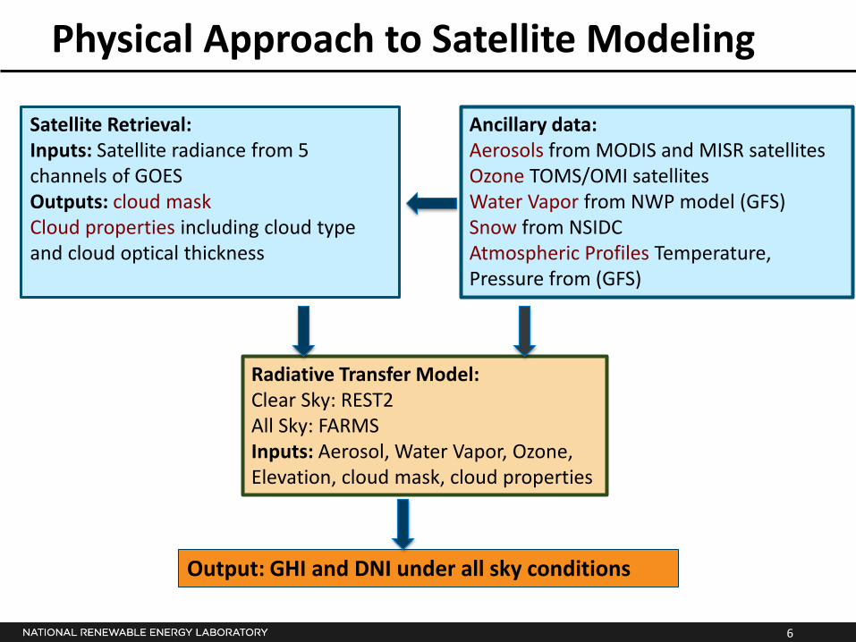
Physical Approach to Satellite Modeling
6
Physical Approach to Satellite Modeling
Satellite Retrieval: Inputs: Satellite radiance from 5 channels of GOES Outputs: cloud mask Cloud properties including cloud type and cloud optical thickness
Ancillary data: Aerosols from MODIS and MISR satellites Ozone TOMS/OMI satellites Water Vapor from NWP model (GFS) Snow from NSIDC Atmospheric Profiles Temperature, Pressure from (GFS)
Radiative Transfer Model: Clear Sky: REST2 All Sky: FARMS Inputs: Aerosol, Water Vapor, Ozone, Elevation, cloud mask, cloud properties
Output: GHI and DNI under all sky conditions

7
GIS based data access with web-service for multi-pixel download Includes ancillary meteorological data for PV/CST modeling using SAM
Accessing the NSRDB Data
http://nsrdb.nrel.gov

8
Product Timeline
• Beta product (2005-2012) currently online (V. 1)
• V2 Product (1998-2014) available by October 2015
• Typical Meteorological Year (TMY) product by October 2015
• Quarterly monthly update available from 2016
• From 2016 annual datasets will be available by following March

9
Validation of Satellite product (V1.0.1) using Ground Data
http://www.esrl.noaa.gov/gmd/grad/surfrad/
Code Name Latitude Longitude Elevation Time Zone Installed
BND Bondville, Illinois 40.05° N 88.37° W 230 m 6 hours from UTC Apr-94
TBL Table Mountain, Boulder, Colorado 40.13° N 105.24° W 1689 m 7 hours from UTC Jul-95
DRA Desert Rock, Nevada 36.63° N 116.02° W 1007 m 8 hours from UTC Mar-98
FPK Fort Peck, Montana 48.31° N 105.10° W 634 m 7 hours from UTC Nov-94
GCM Goodwin Creek, Mississippi 34.25° N 89.87° W 98 m 6 hours from UTC Dec-94
PSU Penn. State Univ., Pennsylvania 40.72° N 77.93° W 376 m 5 hours from UTC Jun-98
SXF Sioux Falls, South Dakota 43.73° N 96.62° W 473 m 6 hours from UTC Jun-03
NOAA SURFRAD DATASTREAMS: GHI, DNI and Diffuse Comparison with 2005-2012 satellite product

10
Validation with Surface Measurements
GHI: Mean Bias Error (MBE)
±5%

11
Validation with Surface Measurements
GHI: Root Mean Square Deviation (RMSD)

12
Validation with Surface Measurements
DNI: Mean Bias Error (MBE)
±5%
13
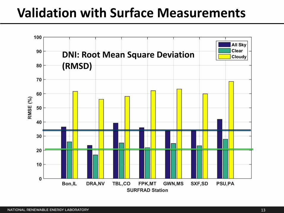
Validation with Surface Measurements
DNI: Root Mean Square Deviation (RMSD)

14
Validation with Surface Measurements
Bondville, IL: GHI for all cases

15
Bondville, IL: GHI Clear Sky Cases
Cloudy Sky Cases
Validation with Surface Measurements

16
Conclusions
• New gridded satellite product available publicly from NREL (http://nsrdb.nrel.gov )
• Datasets is 4 km, 30 minute resolution with meteorological variable from NASA MERRA.
• 2005-2012 currently available with 1998-2014 online by the end of October.
• Accurate aerosol and water vapor information is critical in properly modeling clear sky GHI and DNI.
• Improved All Sky model FARMS for cloudy sky.
• Significant uncertainty in cloudy cases.

17
Future Work
• Inclusion of daily variability of aerosols from MACC/aerosols.
• Improved surface albedo time series to reflect land use changes.
• Improved identification of high albedo surfaces (sand and snow).
• 5 minute data from GOES-R.
• Spectral long-term datasets in Plane of Array.
18
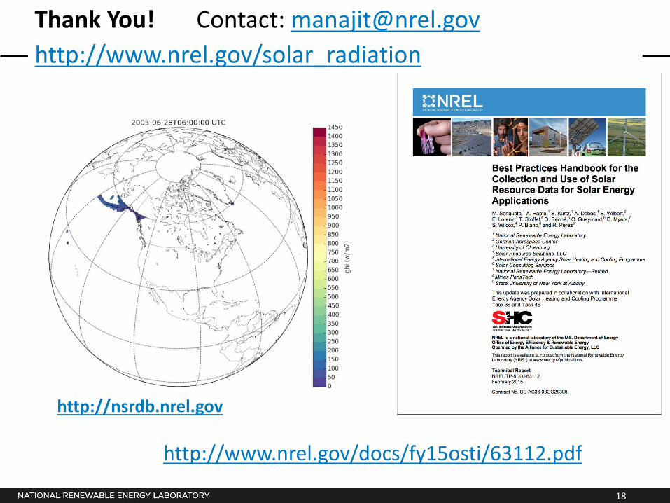
Thank You! Contact: [email protected]
http://www.nrel.gov/solar_radiation
http://www.nrel.gov/docs/fy15osti/63112.pdf
http://nsrdb.nrel.gov