NewsRelease V2012-6
9
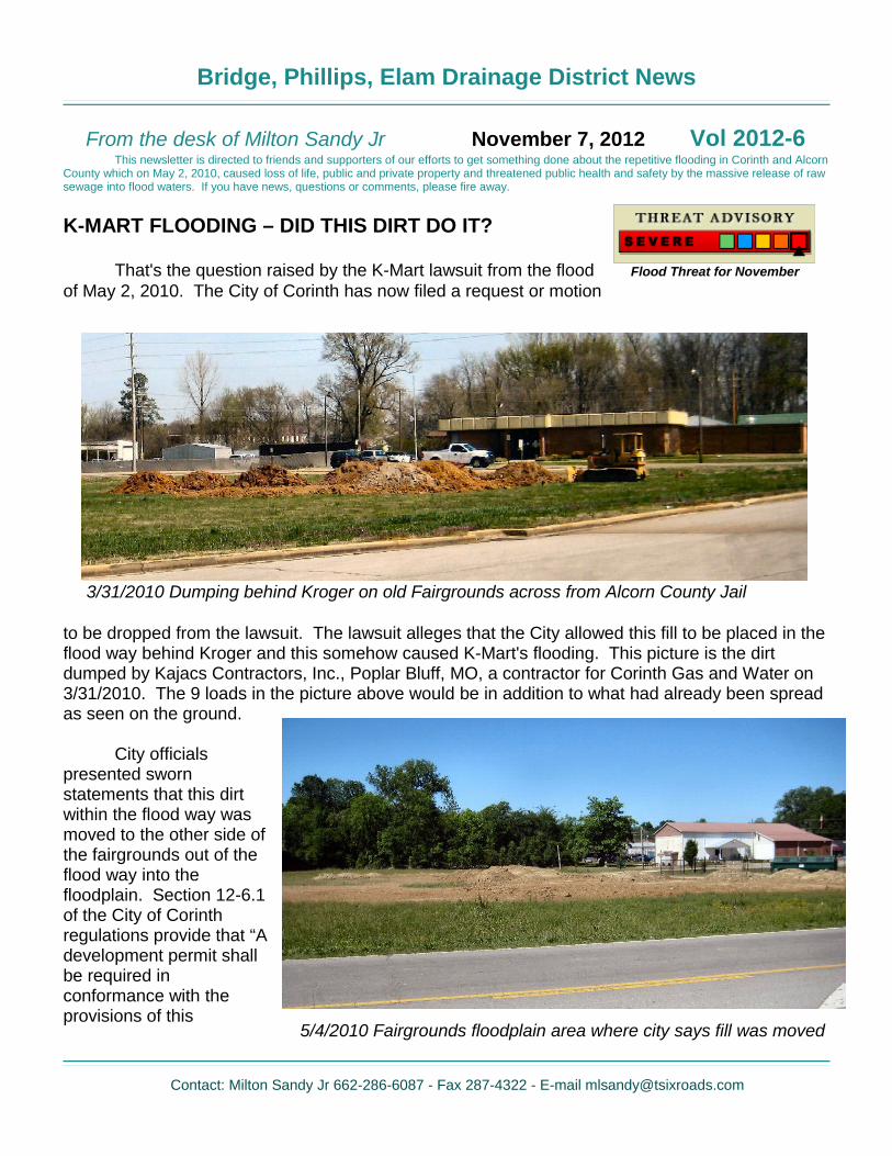
Bridge, Phillips, Elam Drainage District News From the desk of Milton Sandy Jr November 7, 2012 Vol 2012-6 This newsletter is directed to friends and supporters of our efforts to get something done about the repetitive flooding in Corinth and Alcorn County which on May 2, 2010, caused loss of life, public and private property and threatened public health and safety by the massive release of raw sewage into flood waters. If you have news, questions or comments, please fire away. K-MART FLOODING – DID THIS DIRT DO IT? That's the question raised by the K-Mart lawsuit from the flood of May 2, 2010. The City of Corinth has now filed a request or motion to be dropped from the lawsuit. The lawsuit alleges that the City allowed this fill to be placed in the flood way behind Kroger and this somehow caused K-Mart's flooding. This picture is the dirt dumped by Kajacs Contractors, Inc., Poplar Bluff, MO, a contractor for Corinth Gas and Water on 3/31/2010. The 9 loads in the picture above would be in addition to what had already been spread as seen on the ground. City officials presented sworn statements that this dirt within the flood way was moved to the other side of the fairgrounds out of the flood way into the floodplain. Section 12-6.1 of the City of Corinth regulations provide that “A development permit shall be required in conformance with the provisions of this Contact: Milton Sandy Jr 662-286-6087 - Fax 287-4322 - E-mail [email protected] Flood Threat for November 3/31/2010 Dumping behind Kroger on old Fairgrounds across from Alcorn County Jail 5/4/2010 Fairgrounds floodplain area where city says fill was moved
-
Upload
milton-sandy -
Category
Documents
-
view
222 -
download
1
description
Newsletter
Transcript of NewsRelease V2012-6
Bridge, Phillips, Elam Drainage District News
From the desk of Milton Sandy Jr November 7, 2012 Vol 2012-6This newsletter is directed to friends and supporters of our efforts to get something done about the repetitive flooding in Corinth and Alcorn
County which on May 2, 2010, caused loss of life, public and private property and threatened public health and safety by the massive release of raw sewage into flood waters. If you have news, questions or comments, please fire away.
K-MART FLOODING – DID THIS DIRT DO IT?
That's the question raised by the K-Mart lawsuit from the flood of May 2, 2010. The City of Corinth has now filed a request or motion
to be dropped from the lawsuit. The lawsuit alleges that the City allowed this fill to be placed in the flood way behind Kroger and this somehow caused K-Mart's flooding. This picture is the dirt dumped by Kajacs Contractors, Inc., Poplar Bluff, MO, a contractor for Corinth Gas and Water on 3/31/2010. The 9 loads in the picture above would be in addition to what had already been spread as seen on the ground.
City officials presented sworn statements that this dirt within the flood way was moved to the other side of the fairgrounds out of the flood way into the floodplain. Section 12-6.1 of the City of Corinth regulations provide that “A development permit shall be required in conformance with the provisions of this
Contact: Milton Sandy Jr 662-286-6087 - Fax 287-4322 - E-mail [email protected]
Flood Threat for November
3/31/2010 Dumping behind Kroger on old Fairgrounds across from Alcorn County Jail
5/4/2010 Fairgrounds floodplain area where city says fill was moved
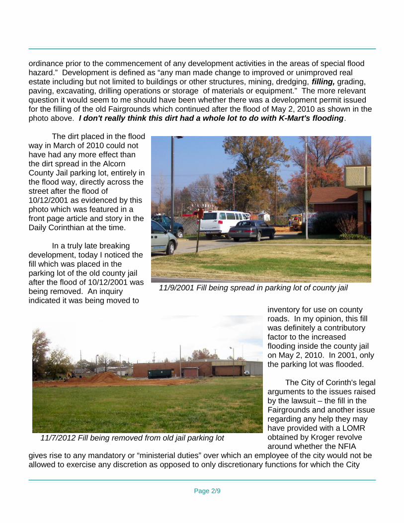
ordinance prior to the commencement of any development activities in the areas of special flood hazard.” Development is defined as “any man made change to improved or unimproved real estate including but not limited to buildings or other structures, mining, dredging, filling, grading, paving, excavating, drilling operations or storage of materials or equipment.” The more relevant question it would seem to me should have been whether there was a development permit issued for the filling of the old Fairgrounds which continued after the flood of May 2, 2010 as shown in the photo above. I don't really think this dirt had a whole lot to do with K-Mart's flooding.
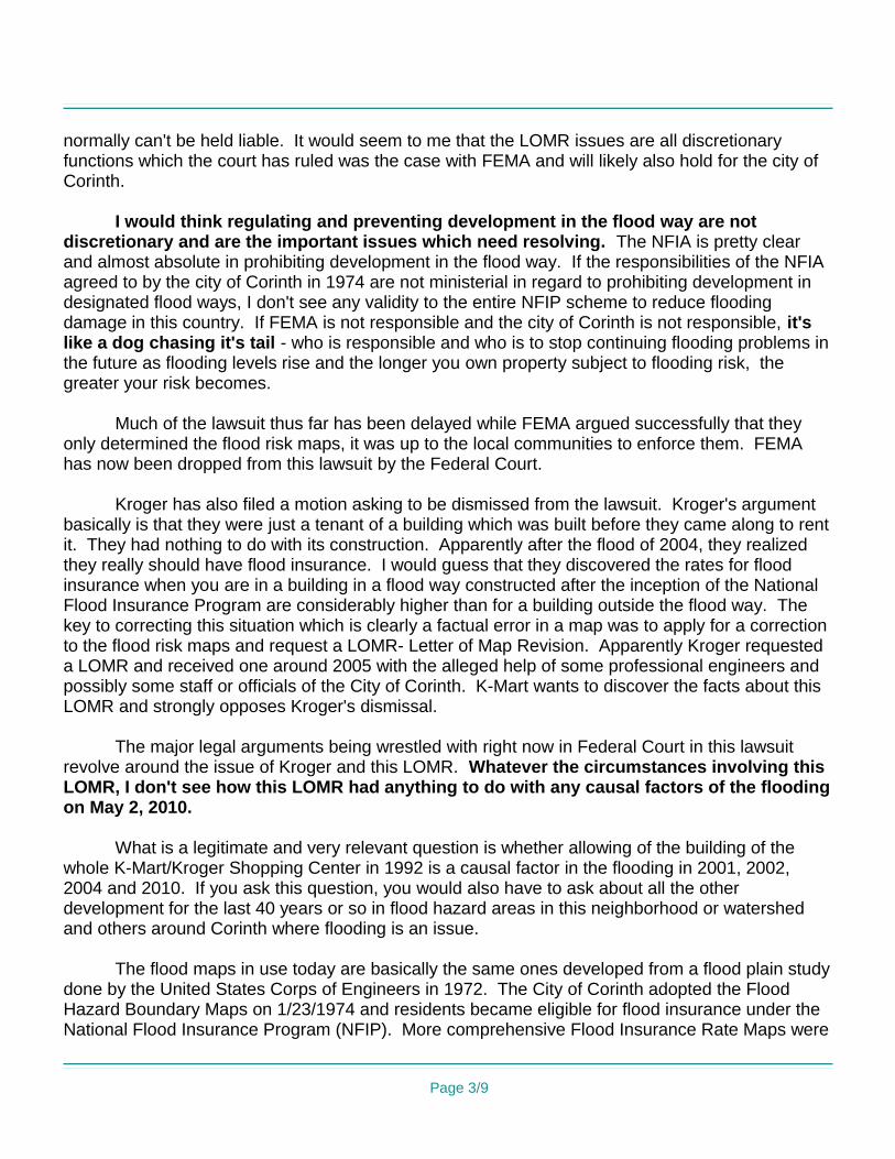
The dirt placed in the flood way in March of 2010 could not have had any more effect than the dirt spread in the Alcorn County Jail parking lot, entirely in the flood way, directly across the street after the flood of 10/12/2001 as evidenced by this photo which was featured in a front page article and story in the Daily Corinthian at the time.
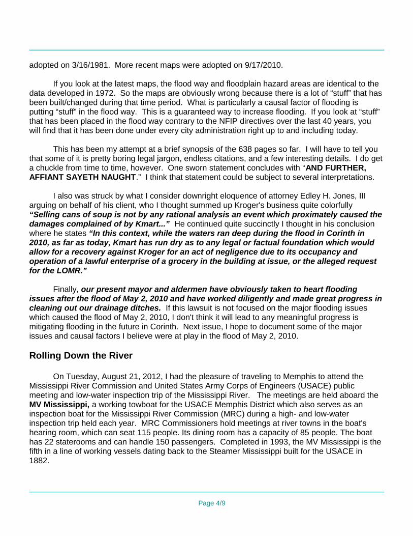
In a truly late breaking development, today I noticed the fill which was placed in the parking lot of the old county jail after the flood of 10/12/2001 was being removed. An inquiry indicated it was being moved to
inventory for use on county roads. In my opinion, this fill was definitely a contributory factor to the increased flooding inside the county jail on May 2, 2010. In 2001, only the parking lot was flooded.
The City of Corinth's legal arguments to the issues raised by the lawsuit – the fill in the Fairgrounds and another issue regarding any help they may have provided with a LOMR obtained by Kroger revolve around whether the NFIA
gives rise to any mandatory or “ministerial duties” over which an employee of the city would not be allowed to exercise any discretion as opposed to only discretionary functions for which the City
Page 2/9
11/9/2001 Fill being spread in parking lot of county jail
11/7/2012 Fill being removed from old jail parking lot
normally can't be held liable. It would seem to me that the LOMR issues are all discretionary functions which the court has ruled was the case with FEMA and will likely also hold for the city of Corinth.
I would think regulating and preventing development in the flood way are not discretionary and are the important issues which need resolving. The NFIA is pretty clear and almost absolute in prohibiting development in the flood way. If the responsibilities of the NFIA agreed to by the city of Corinth in 1974 are not ministerial in regard to prohibiting development in designated flood ways, I don't see any validity to the entire NFIP scheme to reduce flooding damage in this country. If FEMA is not responsible and the city of Corinth is not responsible, it's like a dog chasing it's tail - who is responsible and who is to stop continuing flooding problems in the future as flooding levels rise and the longer you own property subject to flooding risk, the greater your risk becomes.
Much of the lawsuit thus far has been delayed while FEMA argued successfully that they only determined the flood risk maps, it was up to the local communities to enforce them. FEMA has now been dropped from this lawsuit by the Federal Court.
Kroger has also filed a motion asking to be dismissed from the lawsuit. Kroger's argument basically is that they were just a tenant of a building which was built before they came along to rent it. They had nothing to do with its construction. Apparently after the flood of 2004, they realized they really should have flood insurance. I would guess that they discovered the rates for flood insurance when you are in a building in a flood way constructed after the inception of the National Flood Insurance Program are considerably higher than for a building outside the flood way. The key to correcting this situation which is clearly a factual error in a map was to apply for a correction to the flood risk maps and request a LOMR- Letter of Map Revision. Apparently Kroger requested a LOMR and received one around 2005 with the alleged help of some professional engineers and possibly some staff or officials of the City of Corinth. K-Mart wants to discover the facts about this LOMR and strongly opposes Kroger's dismissal.
The major legal arguments being wrestled with right now in Federal Court in this lawsuit revolve around the issue of Kroger and this LOMR. Whatever the circumstances involving this LOMR, I don't see how this LOMR had anything to do with any causal factors of the flooding on May 2, 2010.
What is a legitimate and very relevant question is whether allowing of the building of the whole K-Mart/Kroger Shopping Center in 1992 is a causal factor in the flooding in 2001, 2002, 2004 and 2010. If you ask this question, you would also have to ask about all the other development for the last 40 years or so in flood hazard areas in this neighborhood or watershed and others around Corinth where flooding is an issue.
The flood maps in use today are basically the same ones developed from a flood plain study done by the United States Corps of Engineers in 1972. The City of Corinth adopted the Flood Hazard Boundary Maps on 1/23/1974 and residents became eligible for flood insurance under the National Flood Insurance Program (NFIP). More comprehensive Flood Insurance Rate Maps were
Page 3/9
adopted on 3/16/1981. More recent maps were adopted on 9/17/2010.
If you look at the latest maps, the flood way and floodplain hazard areas are identical to the data developed in 1972. So the maps are obviously wrong because there is a lot of “stuff” that has been built/changed during that time period. What is particularly a causal factor of flooding is putting “stuff” in the flood way. This is a guaranteed way to increase flooding. If you look at “stuff” that has been placed in the flood way contrary to the NFIP directives over the last 40 years, you will find that it has been done under every city administration right up to and including today.
This has been my attempt at a brief synopsis of the 638 pages so far. I will have to tell you that some of it is pretty boring legal jargon, endless citations, and a few interesting details. I do get a chuckle from time to time, however. One sworn statement concludes with “AND FURTHER, AFFIANT SAYETH NAUGHT.” I think that statement could be subject to several interpretations.
I also was struck by what I consider downright eloquence of attorney Edley H. Jones, III arguing on behalf of his client, who I thought summed up Kroger's business quite colorfully “Selling cans of soup is not by any rational analysis an event which proximately caused the damages complained of by Kmart...” He continued quite succinctly I thought in his conclusion where he states “In this context, while the waters ran deep during the flood in Corinth in 2010, as far as today, Kmart has run dry as to any legal or factual foundation which would allow for a recovery against Kroger for an act of negligence due to its occupancy and operation of a lawful enterprise of a grocery in the building at issue, or the alleged request for the LOMR.”
Finally, our present mayor and aldermen have obviously taken to heart flooding issues after the flood of May 2, 2010 and have worked diligently and made great progress in cleaning out our drainage ditches. If this lawsuit is not focused on the major flooding issues which caused the flood of May 2, 2010, I don't think it will lead to any meaningful progress is mitigating flooding in the future in Corinth. Next issue, I hope to document some of the major issues and causal factors I believe were at play in the flood of May 2, 2010.
Rolling Down the River
On Tuesday, August 21, 2012, I had the pleasure of traveling to Memphis to attend the Mississippi River Commission and United States Army Corps of Engineers (USACE) public meeting and low-water inspection trip of the Mississippi River. The meetings are held aboard the MV Mississippi, a working towboat for the USACE Memphis District which also serves as an inspection boat for the Mississippi River Commission (MRC) during a high- and low-water inspection trip held each year. MRC Commissioners hold meetings at river towns in the boat's hearing room, which can seat 115 people. Its dining room has a capacity of 85 people. The boat has 22 staterooms and can handle 150 passengers. Completed in 1993, the MV Mississippi is the fifth in a line of working vessels dating back to the Steamer Mississippi built for the USACE in 1882.
Page 4/9
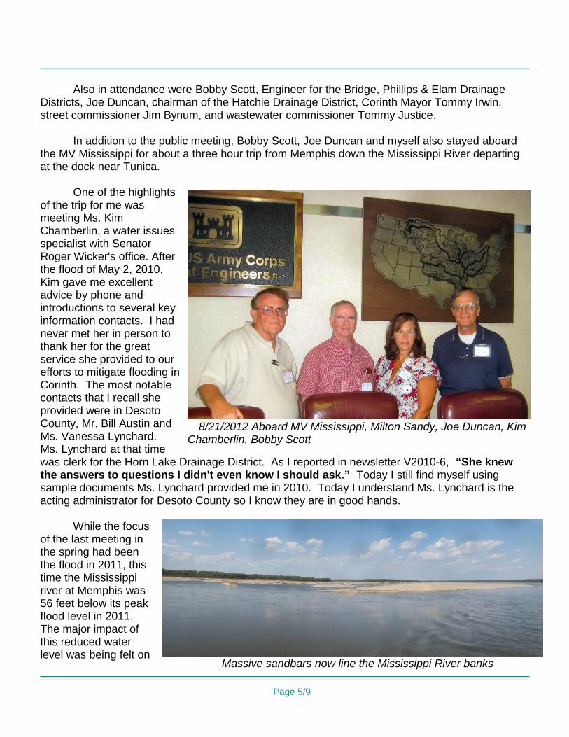
Also in attendance were Bobby Scott, Engineer for the Bridge, Phillips & Elam Drainage Districts, Joe Duncan, chairman of the Hatchie Drainage District, Corinth Mayor Tommy Irwin, street commissioner Jim Bynum, and wastewater commissioner Tommy Justice.
In addition to the public meeting, Bobby Scott, Joe Duncan and myself also stayed aboard the MV Mississippi for about a three hour trip from Memphis down the Mississippi River departing at the dock near Tunica.
One of the highlights of the trip for me was meeting Ms. Kim Chamberlin, a water issues specialist with Senator Roger Wicker's office. After the flood of May 2, 2010, Kim gave me excellent advice by phone and introductions to several key information contacts. I had never met her in person to thank her for the great service she provided to our efforts to mitigate flooding in Corinth. The most notable contacts that I recall she provided were in Desoto County, Mr. Bill Austin and Ms. Vanessa Lynchard. Ms. Lynchard at that time was clerk for the Horn Lake Drainage District. As I reported in newsletter V2010-6, “She knew the answers to questions I didn't even know I should ask.” Today I still find myself using sample documents Ms. Lynchard provided me in 2010. Today I understand Ms. Lynchard is the acting administrator for Desoto County so I know they are in good hands.
While the focus of the last meeting in the spring had been the flood in 2011, this time the Mississippi river at Memphis was 56 feet below its peak flood level in 2011. The major impact of this reduced water level was being felt on
Page 5/9
8/21/2012 Aboard MV Mississippi, Milton Sandy, Joe Duncan, Kim Chamberlin, Bobby Scott
Massive sandbars now line the Mississippi River banks
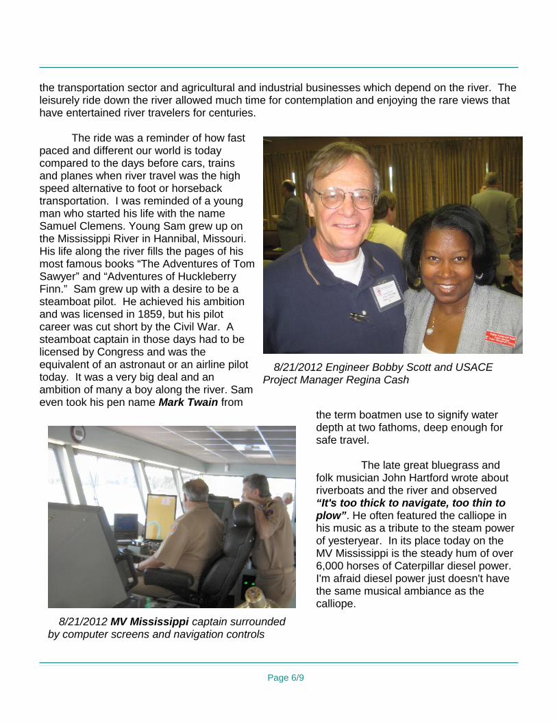
the transportation sector and agricultural and industrial businesses which depend on the river. The leisurely ride down the river allowed much time for contemplation and enjoying the rare views that have entertained river travelers for centuries.
The ride was a reminder of how fast paced and different our world is today compared to the days before cars, trains and planes when river travel was the high speed alternative to foot or horseback transportation. I was reminded of a young man who started his life with the name Samuel Clemens. Young Sam grew up on the Mississippi River in Hannibal, Missouri. His life along the river fills the pages of his most famous books “The Adventures of Tom Sawyer” and “Adventures of Huckleberry Finn.” Sam grew up with a desire to be a steamboat pilot. He achieved his ambition and was licensed in 1859, but his pilot career was cut short by the Civil War. A steamboat captain in those days had to be licensed by Congress and was the equivalent of an astronaut or an airline pilot today. It was a very big deal and an ambition of many a boy along the river. Sam even took his pen name Mark Twain from
the term boatmen use to signify water depth at two fathoms, deep enough for safe travel.
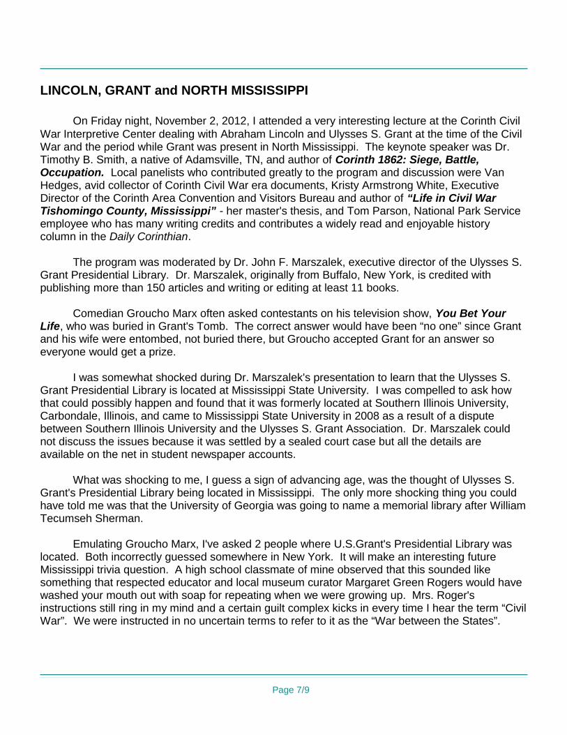
The late great bluegrass and folk musician John Hartford wrote about riverboats and the river and observed “It's too thick to navigate, too thin to plow”. He often featured the calliope in his music as a tribute to the steam power of yesteryear. In its place today on the MV Mississippi is the steady hum of over 6,000 horses of Caterpillar diesel power. I'm afraid diesel power just doesn't have the same musical ambiance as the calliope.
Page 6/9
8/21/2012 MV Mississippi captain surrounded by computer screens and navigation controls
8/21/2012 Engineer Bobby Scott and USACE Project Manager Regina Cash
LINCOLN, GRANT and NORTH MISSISSIPPI
On Friday night, November 2, 2012, I attended a very interesting lecture at the Corinth Civil War Interpretive Center dealing with Abraham Lincoln and Ulysses S. Grant at the time of the Civil War and the period while Grant was present in North Mississippi. The keynote speaker was Dr. Timothy B. Smith, a native of Adamsville, TN, and author of Corinth 1862: Siege, Battle, Occupation. Local panelists who contributed greatly to the program and discussion were Van Hedges, avid collector of Corinth Civil War era documents, Kristy Armstrong White, Executive Director of the Corinth Area Convention and Visitors Bureau and author of “Life in Civil War Tishomingo County, Mississippi” - her master's thesis, and Tom Parson, National Park Service employee who has many writing credits and contributes a widely read and enjoyable history column in the Daily Corinthian.
The program was moderated by Dr. John F. Marszalek, executive director of the Ulysses S. Grant Presidential Library. Dr. Marszalek, originally from Buffalo, New York, is credited with publishing more than 150 articles and writing or editing at least 11 books.
Comedian Groucho Marx often asked contestants on his television show, You Bet Your Life, who was buried in Grant's Tomb. The correct answer would have been “no one” since Grant and his wife were entombed, not buried there, but Groucho accepted Grant for an answer so everyone would get a prize.
I was somewhat shocked during Dr. Marszalek's presentation to learn that the Ulysses S. Grant Presidential Library is located at Mississippi State University. I was compelled to ask how that could possibly happen and found that it was formerly located at Southern Illinois University, Carbondale, Illinois, and came to Mississippi State University in 2008 as a result of a dispute between Southern Illinois University and the Ulysses S. Grant Association. Dr. Marszalek could not discuss the issues because it was settled by a sealed court case but all the details are available on the net in student newspaper accounts.
What was shocking to me, I guess a sign of advancing age, was the thought of Ulysses S. Grant's Presidential Library being located in Mississippi. The only more shocking thing you could have told me was that the University of Georgia was going to name a memorial library after William Tecumseh Sherman.
Emulating Groucho Marx, I've asked 2 people where U.S.Grant's Presidential Library was located. Both incorrectly guessed somewhere in New York. It will make an interesting future Mississippi trivia question. A high school classmate of mine observed that this sounded like something that respected educator and local museum curator Margaret Green Rogers would have washed your mouth out with soap for repeating when we were growing up. Mrs. Roger's instructions still ring in my mind and a certain guilt complex kicks in every time I hear the term “Civil War”. We were instructed in no uncertain terms to refer to it as the “War between the States”.
Page 7/9
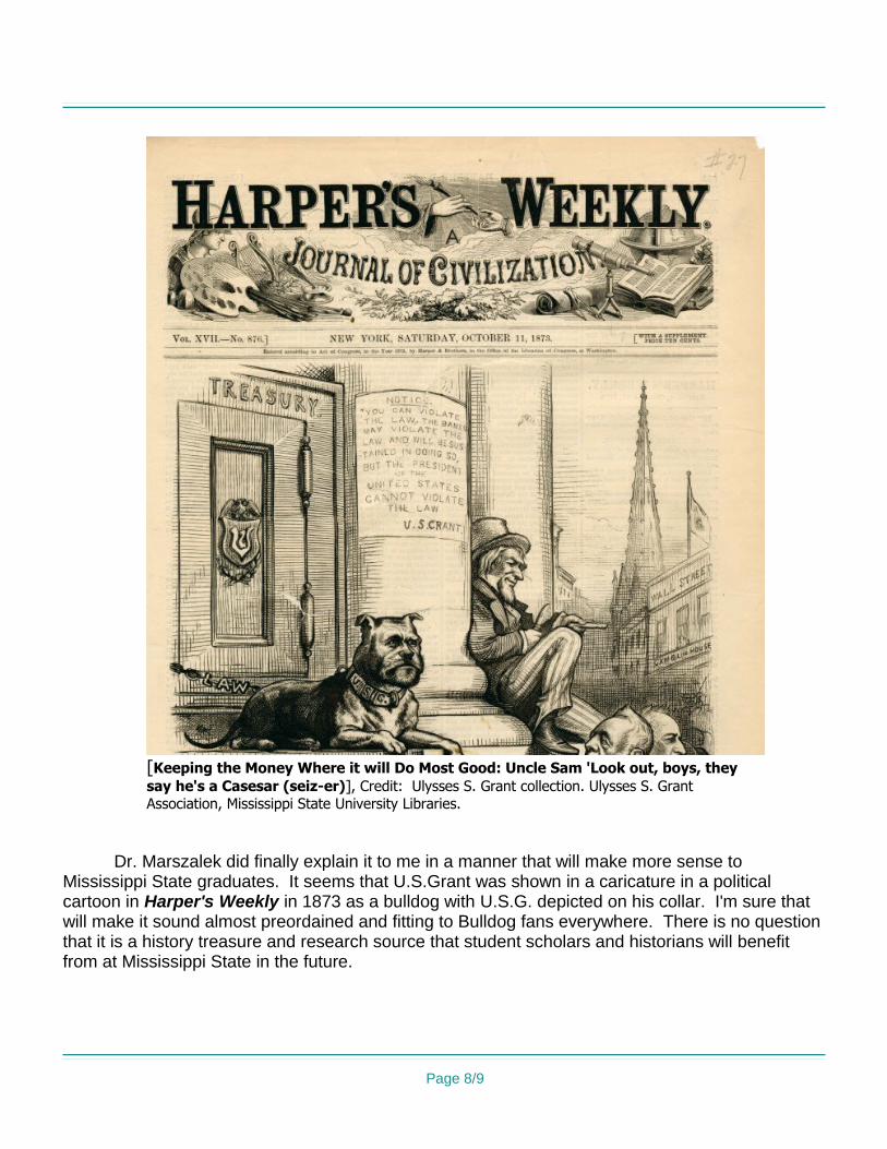
Dr. Marszalek did finally explain it to me in a manner that will make more sense to Mississippi State graduates. It seems that U.S.Grant was shown in a caricature in a political cartoon in Harper's Weekly in 1873 as a bulldog with U.S.G. depicted on his collar. I'm sure that will make it sound almost preordained and fitting to Bulldog fans everywhere. There is no question that it is a history treasure and research source that student scholars and historians will benefit from at Mississippi State in the future.
Page 8/9
[Keeping the Money Where it will Do Most Good: Uncle Sam 'Look out, boys, they say he's a Casesar (seiz-er)], Credit: Ulysses S. Grant collection. Ulysses S. Grant Association, Mississippi State University Libraries.
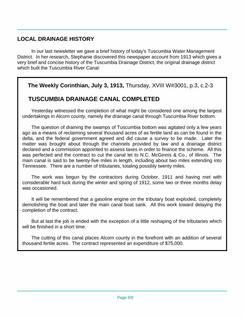
LOCAL DRAINAGE HISTORY
In our last newsletter we gave a brief history of today's Tuscumbia Water Management District. In her research, Stephanie discovered this newspaper account from 1913 which gives a very brief and concise history of the Tuscumbia Drainage District, the original drainage district which built the Tuscumbia River Canal:
The Weekly Corinthian, July 3, 1913, Thursday, XVIII W#3001, p.3, c.2-3
TUSCUMBIA DRAINAGE CANAL COMPLETED
Yesterday witnessed the completion of what might be considered one among the largest undertakings in Alcorn county, namely the drainage canal through Tuscumbia River bottom.
The question of draining the swamps of Tuscumbia bottom was agitated only a few years ago as a means of reclaiming several thousand acres of as fertile land as can be found in the delta, and the federal government agreed and did cause a survey to be made. Later the matter was brought about through the channels provided by law and a drainage district declared and a commission appointed to assess taxes in order to finance the scheme. All this was perfected and the contract to cut the canal let to N.C. McGinnis & Co., of Illinois. The main canal is said to be twenty-five miles in length, including about two miles extending into Tennessee. There are a number of tributaries, totaling possibly twenty miles.
The work was begun by the contractors during October, 1911 and having met with considerable hard luck during the winter and spring of 1912, some two or three months delay was occasioned.
It will be remembered that a gasoline engine on the tributary boat exploded, completely demolishing the boat and later the main canal boat sank. All this work toward delaying the completion of the contract.
But at last the job is ended with the exception of a little reshaping of the tributaries which will be finished in a short time.
The cutting of this canal places Alcorn county in the forefront with an addition of several thousand fertile acres. The contract represented an expenditure of $75,000.
Page 9/9