Instructional Project: Onsets, Rimes, and Basic Phonic Patterns
NEW MEMBER STATES
Regional Integrated Multi-Hazard Early Warning System for Africa and Asia
NEWSLETTERVolume 1 Issue 1, 2011
MESSAGE FROM THE COUNCIL CHAIRI am very pleased to introduce the maiden issue of the RIMES Newsletter. The newsletter shall share RIMES work and activities with Member States, collaborating countries, partners, and the general public.
RIMES, as a boundary organization, bridges at-risk communities with science and institutions, for enhancing responses to warning information and increasing resilience to multiple hazards. Towards this end, RIMES
shall expand engagement and increase interactions with a range of stakeholders involved in socio-economic research, management practice, and scientific and technical innovations, and create a wealth of knowledge, experiences, and best practices, which we shall also share through this newsletter.
This first publication features the 11 March 2011 Tohoku earthquake and tsunami, and potential tsunami impact in the South China Sea and Indian Ocean, RIMES’ area of responsibility. News features include the 4th meeting of the RIMES Council, which made key decisions on governance and operations, and other developments at RIMES. In recent months, India and Papua New Guinea signed the RIMES Cooperation Agreement. We are much pleased to welcome them as our new RIMES Member States.
The RIMES Newsletter has been designed to be a participatory communications medium for RIMES stakeholders. Subsequent issues shall focus on special themes relating to RIMES mission, with the next issue focusing on generation and use of long-lead flood forecasts. We welcome, with anticipation, your contributions, and look forward to continued collaboration in building capacities towards forearmed, forewarned, and resilient communities.
Dr. Shailesh NayakSecretary, Ministry of Earth Sciences, Government of India
Chair, RIMES Council
RIMES: QUICK FACTSEstablished on 30 April 2009 and registered with the United Nations on 1 July 2009 as an international and inter-governmental organizationOwned and managed by Member States, with mandate to provide early warning services in response to their differential needs and demandsCurrently has 12 Member States that signed the RIMES Regional Cooperation Agreement: Bangladesh, Cambodia, Comoros, India, Lao PDR, Maldives, Mongolia, Mozambique, Papua New Guinea, Philippines, Seychelles, and Timor-Leste17 collaborating countries: Armenia, Bhutan, China, Indonesia, Kenya, Madagascar, Mauritius, Myanmar, Nepal, Pakistan, Somalia, Sri Lanka, Tanzania, Thailand, Uzbekistan, Vietnam, and YemenIndia as RIMES Council Chair; Maldives as Administrative Secretariat; and Mongolia as Program SecretariatRegional facility, located at the campus of the Asian Institute of Technology (AIT), Thailand, established with support from UNESCAP and DanidaInstitutional development support by UNESCAP
Papua New Guinea joins 13 March 2011
India joins 24 February 2011
New Resources OnlineDownload at www.rimes.int
Climate Information Requirements for Community-Level Risk Management and AdaptationRIMES Report: Tohoku Earthquake & East Japan TsunamiRIMES Report: Myanmar Earthquake
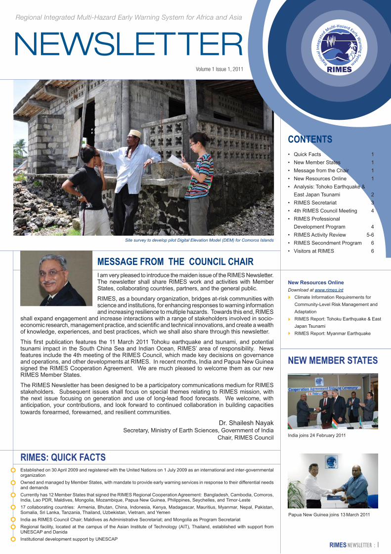
Site survey to develop pilot Digital Elevation Model (DEM) for Comoros Islands
CONTENTS• Quick Facts 1• New Member States 1• Message from the Chair 1• New Resources Online 1• Analysis: Tohoko Earthquake &
East Japan Tsunami 2• RIMES Secretariat 3• 4th RIMES Council Meeting 4• RIMES Professional
Development Program 4• RIMES Activity Review 5-6• RIMES Secondment Program 6• Visitors at RIMES 6
The Tohoku Earthquake of 11 March 2011 was the fourth largest in the world since 1900. In terms of strength, the U.S. Geological Survey placed the magnitude 9.0 earthquake just behind the 2004 earthquake off the coast of Sumatra, Indonesia. Though the tsunami did not pose a threat to the RIMES’ Area of Responsibility (AOR) in the South China Sea and the Indian Ocean, RIMES provided, on request, a potential impact assessment report, based on sea level observations and tsunami wave simulation results, to the Maldives. In future similar large events outside of the RIMES AOR, RIMES will share such reports with all its Member States.
Continued from page 2
Continued on page 3
c
a
b
c
a
b
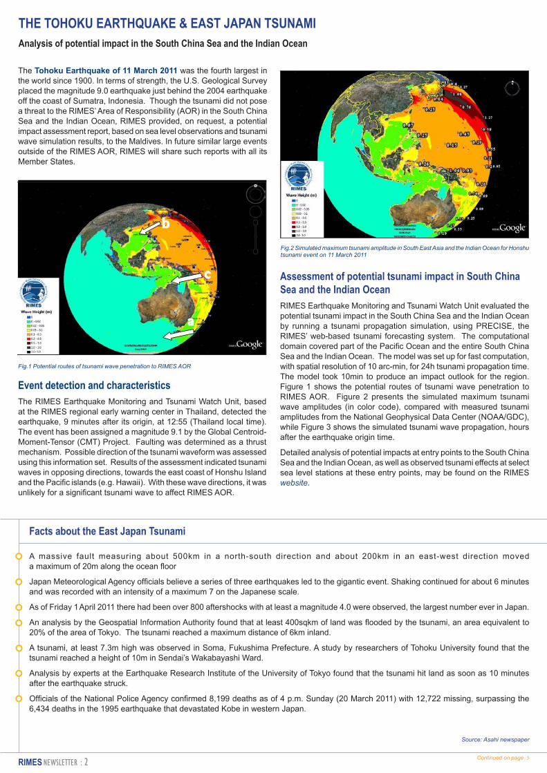
Fig.1 Potential routes of tsunami wave penetration to RIMES AOR
Fig.2 Simulated maximum tsunami amplitude in South East Asia and the Indian Ocean for Honshu tsunami event on 11 March 2011
THE TOHOKU EARTHQUAKE & EAST JAPAN TSUNAMI Analysis of potential impact in the South China Sea and the Indian Ocean
Facts about the East Japan Tsunami
A massive fault measuring about 500km in a north-south direction and about 200km in an east-west direction moved a maximum of 20m along the ocean floor
Japan Meteorological Agency officials believe a series of three earthquakes led to the gigantic event. Shaking continued for about 6 minutes and was recorded with an intensity of a maximum 7 on the Japanese scale.
As of Friday 1 April 2011 there had been over 800 aftershocks with at least a magnitude 4.0 were observed, the largest number ever in Japan.
An analysis by the Geospatial Information Authority found that at least 400sqkm of land was flooded by the tsunami, an area equivalent to 20% of the area of Tokyo. The tsunami reached a maximum distance of 6km inland.
A tsunami, at least 7.3m high was observed in Soma, Fukushima Prefecture. A study by researchers of Tohoku University found that the tsunami reached a height of 10m in Sendai’s Wakabayashi Ward.
Analysis by experts at the Earthquake Research Institute of the University of Tokyo found that the tsunami hit land as soon as 10 minutes after the earthquake struck.
Officials of the National Police Agency confirmed 8,199 deaths as of 4 p.m. Sunday (20 March 2011) with 12,722 missing, surpassing the 6,434 deaths in the 1995 earthquake that devastated Kobe in western Japan.
Source: Asahi newspaper
Event detection and characteristicsThe RIMES Earthquake Monitoring and Tsunami Watch Unit, based at the RIMES regional early warning center in Thailand, detected the earthquake, 9 minutes after its origin, at 12:55 (Thailand local time). The event has been assigned a magnitude 9.1 by the Global Centroid-Moment-Tensor (CMT) Project. Faulting was determined as a thrust mechanism. Possible direction of the tsunami waveform was assessed using this information set. Results of the assessment indicated tsunami waves in opposing directions, towards the east coast of Honshu Island and the Pacific islands (e.g. Hawaii). With these wave directions, it was unlikely for a significant tsunami wave to affect RIMES AOR.
Assessment of potential tsunami impact in South China Sea and the Indian OceanRIMES Earthquake Monitoring and Tsunami Watch Unit evaluated the potential tsunami impact in the South China Sea and the Indian Ocean by running a tsunami propagation simulation, using PRECISE, the RIMES’ web-based tsunami forecasting system. The computational domain covered part of the Pacific Ocean and the entire South China Sea and the Indian Ocean. The model was set up for fast computation, with spatial resolution of 10 arc-min, for 24h tsunami propagation time. The model took 10min to produce an impact outlook for the region. Figure 1 shows the potential routes of tsunami wave penetration to RIMES AOR. Figure 2 presents the simulated maximum tsunami wave amplitudes (in color code), compared with measured tsunami amplitudes from the National Geophysical Data Center (NOAA/GDC), while Figure 3 shows the simulated tsunami wave propagation, hours after the earthquake origin time.
Detailed analysis of potential impacts at entry points to the South China Sea and the Indian Ocean, as well as observed tsunami effects at select sea level stations at these entry points, may be found on the RIMES website.
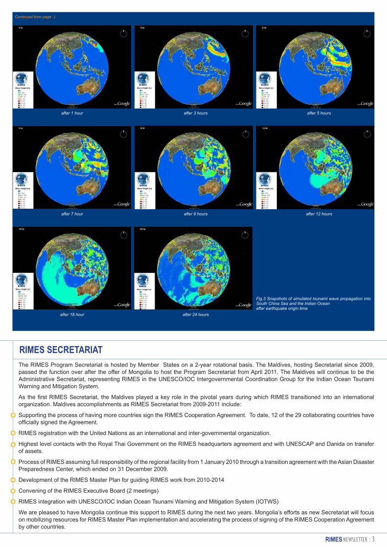
after 1 hour
after 7 hour
after 18 hour
after 3 hours
after 9 hours
after 24 hours
after 5 hours
after 12 hours
Fig.3 Snapshots of simulated tsunami wave propagation into South China Sea and the Indian Oceanafter earthquake origin time
Continued from page 2
RIMES SECRETARIATThe RIMES Program Secretariat is hosted by Member States on a 2-year rotational basis. The Maldives, hosting Secretariat since 2009, passed the function over after the offer of Mongolia to host the Program Secretariat from April 2011. The Maldives will continue to be the Administrative Secretariat, representing RIMES in the UNESCO/IOC Intergovernmental Coordination Group for the Indian Ocean Tsunami Warning and Mitigation System.
As the first RIMES Secretariat, the Maldives played a key role in the pivotal years during which RIMES transitioned into an international organization. Maldives accomplishments as RIMES Secretariat from 2009-2011 include:
Supporting the process of having more countries sign the RIMES Cooperation Agreement. To date, 12 of the 29 collaborating countries have officially signed the Agreement.
RIMES registration with the United Nations as an international and inter-governmental organization.
Highest level contacts with the Royal Thai Government on the RIMES headquarters agreement and with UNESCAP and Danida on transfer of assets.
Process of RIMES assuming full responsibility of the regional facility from 1 January 2010 through a transition agreement with the Asian Disaster Preparedness Center, which ended on 31 December 2009.
Development of the RIMES Master Plan for guiding RIMES work from 2010-2014
Convening of the RIMES Executive Board (2 meetings)
RIMES integration with UNESCO/IOC Indian Ocean Tsunami Warning and Mitigation System (IOTWS)
We are pleased to have Mongolia continue this support to RIMES during the next two years. Mongolia’s efforts as new Secretariat will focus on mobilizing resources for RIMES Master Plan implementation and accelerating the process of signing of the RIMES Cooperation Agreement by other countries.
“RIMES is an exceptional example of regional cooperation. Participating countries are now
contributing their own resources to an early warning system and services that they govern.” Zengpei Xuan,
UNESCAPMaldives shall remain as an Administrative Secretariat, representing RIMES in the Intergovernmental Coordination Group for the Indian Ocean Tsunami Warning and Mitigation System (IOTWS).
On behalf of the RIMES Council, Dr. Nayak thanked H.E. Vice-President of the Maldives for his sterling leadership and unparalleled commitment to RIMES. He also expressed gratitude to Mr. Shareef, for his perseverance and personal commitment, despite several challenges.
In the programmatic sessions, Dr. Peter Webster of the School of Earth and Atmospheric Sciences, Georgia Institute of Technology, USA, presented new-generation flood forecasting technologies developed using state-of-the-art technology supported by the US Government through the US National Science Program. Dr. Webster is collaborating with RIMES in testing these new-generation flood forecasting technologies and the application of resulting long-lead forecast products in resource and disaster risk management.
RIMES Program Unit shared with the Council its accomplishments in the past year, as well as ongoing programs and projects, in line with the Master Plan. Member States also shared relevant activities, and priority capacity gaps and needs for incorporation into the Master Plan. China Meteorological Agency (CMA) presented its potential contribution to RIMES, which includes capacity building in typhoon forecasting, satellite meteorology, and climate prediction, and provision of CMA’s global climate model outputs as input to RIMES’ climate downscaling activities.
Mr. Shareef stressed that “Contributions from better-developed Member States, such as China and India, will be critical to ensuring that the RIMES Master Plan is implemented.” Mr. Zengpei Xuan, Chief, Information and Communications Technology and Disaster Risk Reduction Division, UNESCAP, which has supported RIMES since its inception, noted that “RIMES is an exceptional example of regional cooperation. Participating countries are now contributing their own resources to an early warning system and services that they govern.”
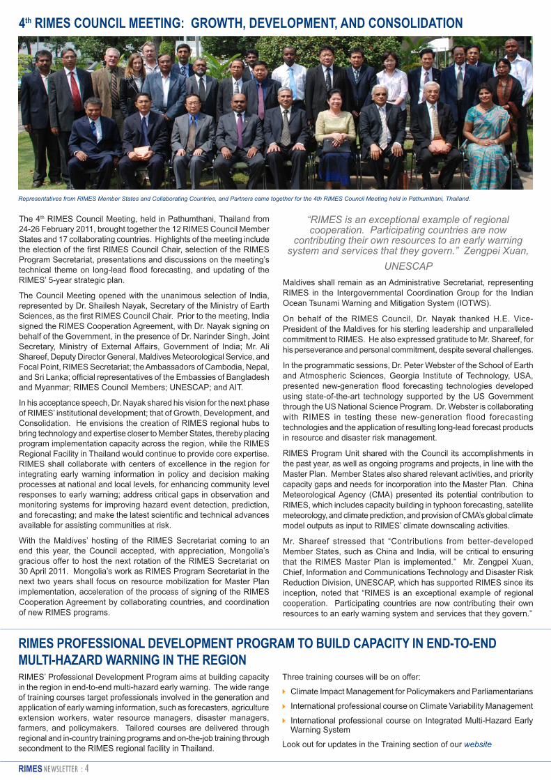
4th RIMES COUNCIL MEETING: GROWTH, DEVELOPMENT, AND CONSOLIDATION
The 4th RIMES Council Meeting, held in Pathumthani, Thailand from 24-26 February 2011, brought together the 12 RIMES Council Member States and 17 collaborating countries. Highlights of the meeting include the election of the first RIMES Council Chair, selection of the RIMES Program Secretariat, presentations and discussions on the meeting’s technical theme on long-lead flood forecasting, and updating of the RIMES’ 5-year strategic plan.
The Council Meeting opened with the unanimous selection of India, represented by Dr. Shailesh Nayak, Secretary of the Ministry of Earth Sciences, as the first RIMES Council Chair. Prior to the meeting, India signed the RIMES Cooperation Agreement, with Dr. Nayak signing on behalf of the Government, in the presence of Dr. Narinder Singh, Joint Secretary, Ministry of External Affairs, Government of India; Mr. Ali Shareef, Deputy Director General, Maldives Meteorological Service, and Focal Point, RIMES Secretariat; the Ambassadors of Cambodia, Nepal, and Sri Lanka; official representatives of the Embassies of Bangladesh and Myanmar; RIMES Council Members; UNESCAP; and AIT.
In his acceptance speech, Dr. Nayak shared his vision for the next phase of RIMES’ institutional development; that of Growth, Development, and Consolidation. He envisions the creation of RIMES regional hubs to bring technology and expertise closer to Member States, thereby placing program implementation capacity across the region, while the RIMES Regional Facility in Thailand would continue to provide core expertise. RIMES shall collaborate with centers of excellence in the region for integrating early warning information in policy and decision making processes at national and local levels, for enhancing community level responses to early warning; address critical gaps in observation and monitoring systems for improving hazard event detection, prediction, and forecasting; and make the latest scientific and technical advances available for assisting communities at risk.
With the Maldives’ hosting of the RIMES Secretariat coming to an end this year, the Council accepted, with appreciation, Mongolia’s gracious offer to host the next rotation of the RIMES Secretariat on 30 April 2011. Mongolia’s work as RIMES Program Secretariat in the next two years shall focus on resource mobilization for Master Plan implementation, acceleration of the process of signing of the RIMES Cooperation Agreement by collaborating countries, and coordination of new RIMES programs.
Representatives from RIMES Member States and Collaborating Countries, and Partners came together for the 4th RIMES Council Meeting held in Pathumthani, Thailand.
RIMES’ Professional Development Program aims at building capacity in the region in end-to-end multi-hazard early warning. The wide range of training courses target professionals involved in the generation and application of early warning information, such as forecasters, agriculture extension workers, water resource managers, disaster managers, farmers, and policymakers. Tailored courses are delivered through regional and in-country training programs and on-the-job training through secondment to the RIMES regional facility in Thailand.
RIMES PROFESSIONAL DEVELOPMENT PROGRAM TO BUILD CAPACITY IN END-TO-END MULTI-HAZARD WARNING IN THE REGION
Three training courses will be on offer:
Climate Impact Management for Policymakers and Parliamentarians
International professional course on Climate Variability Management
International professional course on Integrated Multi-Hazard Early Warning System
Look out for updates in the Training section of our website
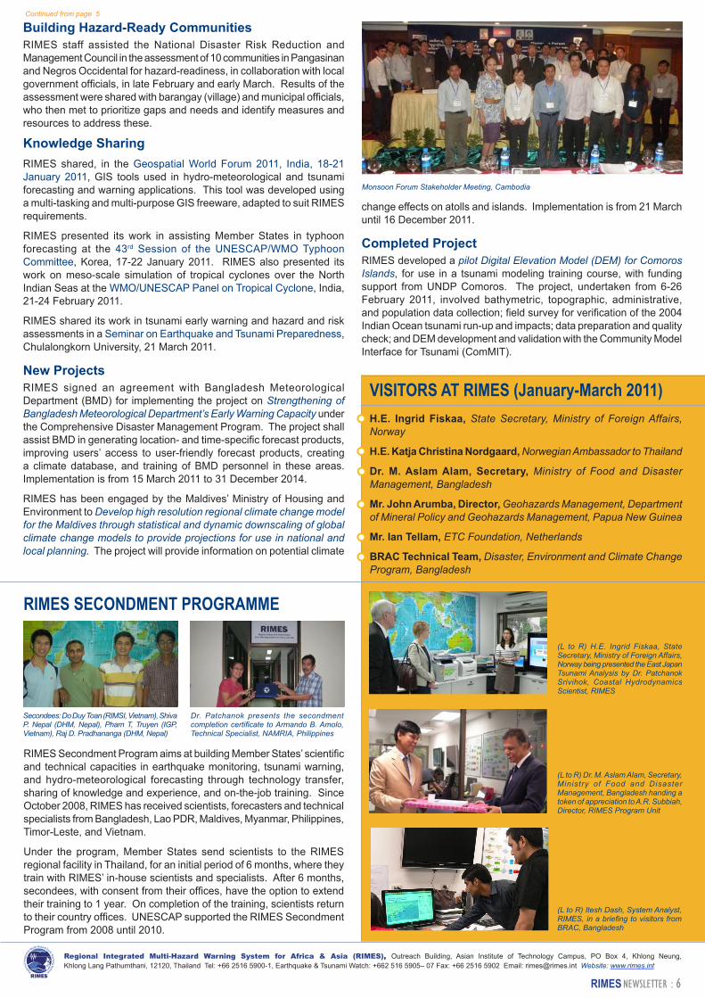
Agricultural Area Assessment, Timor Leste
Continued on page 6
RIMES ACTIVITY REVIEW
Strengthening Forecaster – User InterfaceRIMES facilitated the establishment of monsoon forums in Cambodia and Lao PDR, with funding support from the Food and Agriculture Organization (FAO) of the United Nations. A multi-disciplinary and multi-stakeholder national platform for forecast producers and users, the monsoon forum aims to ensure that early warning information products, including their uncertainties and limitations, are communicated to and understood by users; encourage climate and hydrological forecast application for mitigating risks in climate-sensitive sectors; receive user feedback for improving usability of forecast products; provide a platform for inter-agency coordination of policies, sectoral plans, and programs for dealing with potential impacts of hydro-meteorological hazards; and provide a platform for long-term process of understanding risks posed/ opportunities brought about by past, current, and future climate.
The first monsoon forum in Cambodia was convened by the Ministry of Water Resources and Meteorology in Phnom Penh from 25-26 January 2011, in collaboration with the Council for Agricultural and Rural Development, National Committee for Disaster Management, and Ministry of Agriculture, Forestry, and Fisheries. 40 participants, representing 25 government, UN and non-government organizations were in attendance, and found the forum useful for improving food security in Cambodia. Specific discussions during the meeting highlighted the need for a monitoring system for small scale disasters, including a climate data base, and a robust risk communications system, from national to local level.
In Lao PDR, the first monsoon forum, held in Vientiane from 3-4 February 2011, was convened by the Department of Meteorology and Hydrology (DHM), in collaboration with the Ministry of Agriculture and Forestry. With 80 participants representing 65 representatives from government, UN and non-government organizations, the forum agreed on the following recommendations: increase in the number of, and enhancement of, existing agro-meteorological stations for improving forecasts, the need for a policy on integration of seasonal climate information, for a drought and flood monitoring system, capacity building on agro-meteorological observation at DHM, and need for seasonal prediction trainings.
Also, with FAO support, the monsoon forum in Myanmar was revived after a gap of more than 2 years. Convened by the Department of Meteorology and Hydrology two meetings were held; in Nay Pyi Taw on 15-16 February, and Yangon on 18 February. The meetings were attended by 39 and 22 participants, respectively, representing government, UN and non-government organizations, and culminated in the agreement to enhance agro-meteorological observations, evolve a drought monitoring system, and employ user-friendly terminology in communicating forecasts.
RIMES, in collaboration with UNDP, assisted the Bangladesh Meteorological Department (BMD) initiate plans for a Climate Risk Management Forum that will bring together producers and users of weather, climate, and flood information. This inter-disciplinary and multi-stakeholder forum, to be held during the course of 2011, will
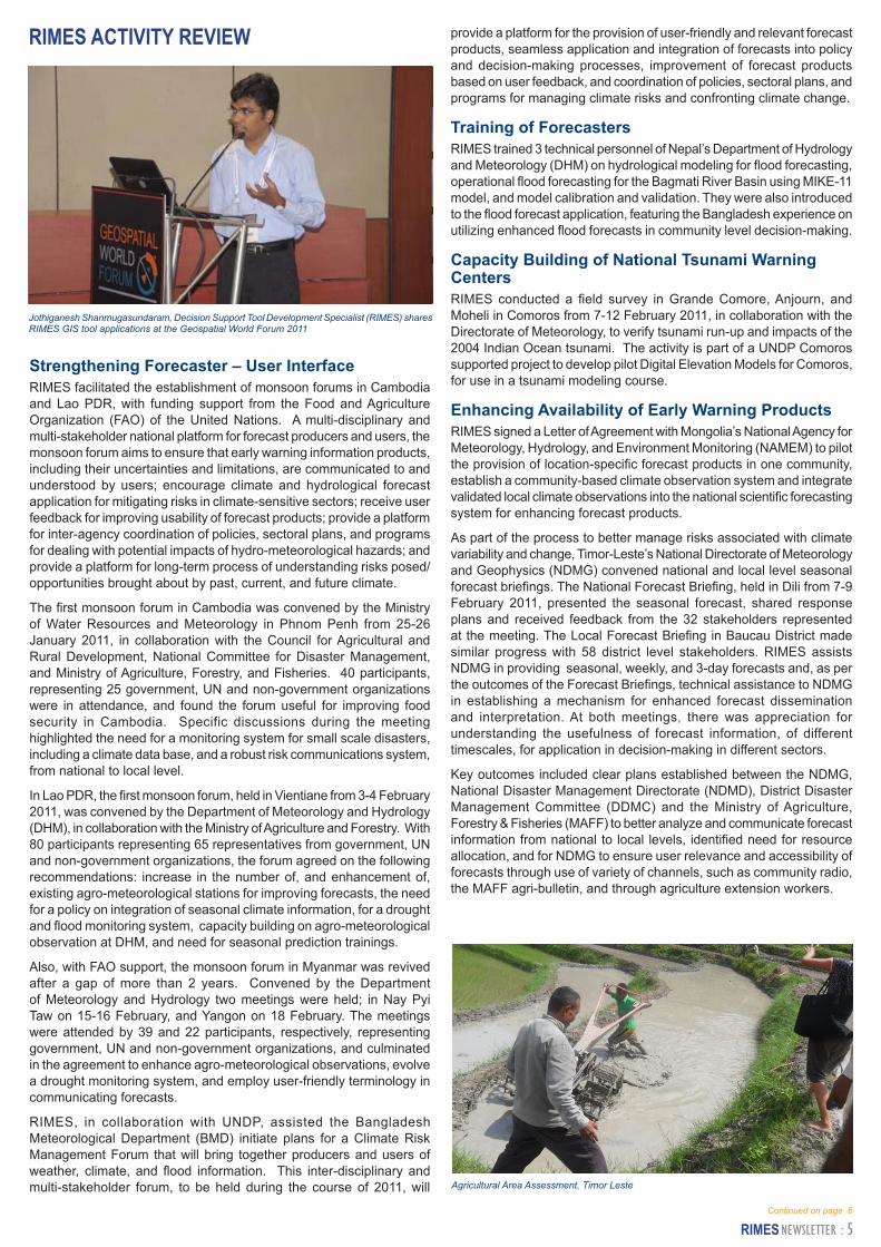
Jothiganesh Shanmugasundaram, Decision Support Tool Development Specialist (RIMES) shares RIMES GIS tool applications at the Geospatial World Forum 2011
provide a platform for the provision of user-friendly and relevant forecast products, seamless application and integration of forecasts into policy and decision-making processes, improvement of forecast products based on user feedback, and coordination of policies, sectoral plans, and programs for managing climate risks and confronting climate change.
Training of ForecastersRIMES trained 3 technical personnel of Nepal’s Department of Hydrology and Meteorology (DHM) on hydrological modeling for flood forecasting, operational flood forecasting for the Bagmati River Basin using MIKE-11 model, and model calibration and validation. They were also introduced to the flood forecast application, featuring the Bangladesh experience on utilizing enhanced flood forecasts in community level decision-making.
Capacity Building of National Tsunami Warning CentersRIMES conducted a field survey in Grande Comore, Anjourn, and Moheli in Comoros from 7-12 February 2011, in collaboration with the Directorate of Meteorology, to verify tsunami run-up and impacts of the 2004 Indian Ocean tsunami. The activity is part of a UNDP Comoros supported project to develop pilot Digital Elevation Models for Comoros, for use in a tsunami modeling course.
Enhancing Availability of Early Warning ProductsRIMES signed a Letter of Agreement with Mongolia’s National Agency for Meteorology, Hydrology, and Environment Monitoring (NAMEM) to pilot the provision of location-specific forecast products in one community, establish a community-based climate observation system and integrate validated local climate observations into the national scientific forecasting system for enhancing forecast products.
As part of the process to better manage risks associated with climate variability and change, Timor-Leste’s National Directorate of Meteorology and Geophysics (NDMG) convened national and local level seasonal forecast briefings. The National Forecast Briefing, held in Dili from 7-9 February 2011, presented the seasonal forecast, shared response plans and received feedback from the 32 stakeholders represented at the meeting. The Local Forecast Briefing in Baucau District made similar progress with 58 district level stakeholders. RIMES assists NDMG in providing seasonal, weekly, and 3-day forecasts and, as per the outcomes of the Forecast Briefings, technical assistance to NDMG in establishing a mechanism for enhanced forecast dissemination and interpretation. At both meetings, there was appreciation for understanding the usefulness of forecast information, of different timescales, for application in decision-making in different sectors.
Key outcomes included clear plans established between the NDMG, National Disaster Management Directorate (NDMD), District Disaster Management Committee (DDMC) and the Ministry of Agriculture, Forestry & Fisheries (MAFF) to better analyze and communicate forecast information from national to local levels, identified need for resource allocation, and for NDMG to ensure user relevance and accessibility of forecasts through use of variety of channels, such as community radio, the MAFF agri-bulletin, and through agriculture extension workers.
Monsoon Forum Stakeholder Meeting, Cambodia
Secondees: Do Duy Toan (RIMSI, Vietnam), Shiva P. Nepal (DHM, Nepal), Pham T, Truyen (IGP, Vietnam), Raj D. Pradhananga (DHM, Nepal)
Regional Integrated Multi-Hazard Warning System for Africa & Asia (RIMES), Outreach Building, Asian Institute of Technology Campus, PO Box 4, Khlong Neung, Khlong Lang Pathumthani, 12120, Thailand Tel: +66 2516 5900-1, Earthquake & Tsunami Watch: +662 516 5905– 07 Fax: +66 2516 5902 Email: [email protected] Website: www.rimes.int
Dr. Patchanok presents the secondment completion certificate to Armando B. Amolo, Technical Specialist, NAMRIA, Philippines
RIMES SECONDMENT PROGRAMME
(L to R) H.E. Ingrid Fiskaa, State Secretary, Ministry of Foreign Affairs, Norway being presented the East Japan Tsunami Analysis by Dr. Patchanok Srivihok, Coastal Hydrodynamics Scientist, RIMES
H.E. Ingrid Fiskaa, State Secretary, Ministry of Foreign Affairs, Norway
H.E. Katja Christina Nordgaard, Norwegian Ambassador to Thailand
Dr. M. Aslam Alam, Secretary, Ministry of Food and Disaster Management, Bangladesh
Mr. John Arumba, Director, Geohazards Management, Department of Mineral Policy and Geohazards Management, Papua New Guinea
Mr. Ian Tellam, ETC Foundation, Netherlands
BRAC Technical Team, Disaster, Environment and Climate Change Program, Bangladesh
VISITORS AT RIMES (January-March 2011)
Continued from page 5
Building Hazard-Ready CommunitiesRIMES staff assisted the National Disaster Risk Reduction and Management Council in the assessment of 10 communities in Pangasinan and Negros Occidental for hazard-readiness, in collaboration with local government officials, in late February and early March. Results of the assessment were shared with barangay (village) and municipal officials, who then met to prioritize gaps and needs and identify measures and resources to address these.
Knowledge SharingRIMES shared, in the Geospatial World Forum 2011, India, 18-21 January 2011, GIS tools used in hydro-meteorological and tsunami forecasting and warning applications. This tool was developed using a multi-tasking and multi-purpose GIS freeware, adapted to suit RIMES requirements.
RIMES presented its work in assisting Member States in typhoon forecasting at the 43rd Session of the UNESCAP/WMO Typhoon Committee, Korea, 17-22 January 2011. RIMES also presented its work on meso-scale simulation of tropical cyclones over the North Indian Seas at the WMO/UNESCAP Panel on Tropical Cyclone, India, 21-24 February 2011.
RIMES shared its work in tsunami early warning and hazard and risk assessments in a Seminar on Earthquake and Tsunami Preparedness, Chulalongkorn University, 21 March 2011.
New ProjectsRIMES signed an agreement with Bangladesh Meteorological Department (BMD) for implementing the project on Strengthening of Bangladesh Meteorological Department’s Early Warning Capacity under the Comprehensive Disaster Management Program. The project shall assist BMD in generating location- and time-specific forecast products, improving users’ access to user-friendly forecast products, creating a climate database, and training of BMD personnel in these areas. Implementation is from 15 March 2011 to 31 December 2014.
RIMES has been engaged by the Maldives’ Ministry of Housing and Environment to Develop high resolution regional climate change model for the Maldives through statistical and dynamic downscaling of global climate change models to provide projections for use in national and local planning. The project will provide information on potential climate
change effects on atolls and islands. Implementation is from 21 March until 16 December 2011.
Completed ProjectRIMES developed a pilot Digital Elevation Model (DEM) for Comoros Islands, for use in a tsunami modeling training course, with funding support from UNDP Comoros. The project, undertaken from 6-26 February 2011, involved bathymetric, topographic, administrative, and population data collection; field survey for verification of the 2004 Indian Ocean tsunami run-up and impacts; data preparation and quality check; and DEM development and validation with the Community Model Interface for Tsunami (ComMIT).
RIMES Secondment Program aims at building Member States’ scientific and technical capacities in earthquake monitoring, tsunami warning, and hydro-meteorological forecasting through technology transfer, sharing of knowledge and experience, and on-the-job training. Since October 2008, RIMES has received scientists, forecasters and technical specialists from Bangladesh, Lao PDR, Maldives, Myanmar, Philippines, Timor-Leste, and Vietnam.
Under the program, Member States send scientists to the RIMES regional facility in Thailand, for an initial period of 6 months, where they train with RIMES’ in-house scientists and specialists. After 6 months, secondees, with consent from their offices, have the option to extend their training to 1 year. On completion of the training, scientists return to their country offices. UNESCAP supported the RIMES Secondment Program from 2008 until 2010.
(L to R) Dr. M. Aslam Alam, Secretary, Ministry of Food and Disaster Management, Bangladesh handing a token of appreciation to A.R. Subbiah, Director, RIMES Program Unit
(L to R) Itesh Dash, System Analyst, RIMES, in a briefing to visitors from BRAC, Bangladesh