Newcastle Time Machine A Multi-disciplinary approach to ... · Newcastle Time Machine – A...
24
Newcastle Time Machine – A Multi-disciplinary approach to digital cultural heritage Gionni Di Gravio, Dr Ann Hardy, Charles Martin, Russell Rigby and Tim Davidson Abstract This article discusses the University of Newcastle's Hunter (Living) Histories initiative (HHI) and the multi-disciplinary heritage model to develop collaborative digital cultural heritage projects. The HHI engages across the university and wider communities to develop heritage projects that are shared globally across various social and digital media platforms. One of the projects undertaken by the group is the 3D Virtual Hunter Project which created the Newcastle Time Machine, embodying fly-throughs and 3D immersive recreations of the early Aboriginal and Colonial Newcastle, up until 1830. Its creators worked over many years in collaboration with the University's Cultural Collections and used archival written and visual sources to construct the base model for the project, analysing and comparing historic artworks and surveys to assess the most accurate and authentic original sources of the early Newcastle landscape. The methodology to use primary sources as evidence to construct a landscape as accurately as possible was crucial so that the historical past is interpreted with authenticity and integrity. As an educational tool, this project reflects the new digital age and changes in teaching and learning strategies, providing a vision of an historical past in a contemporary present. The Newcastle Time Machine has been further extended by incorporating Virtual Reality (VR) Technology to further enhance this experience. The Newcastle project provides a digital heritage platform that has implications for heritage management. The digital visualisation of the historic environment of
Transcript of Newcastle Time Machine A Multi-disciplinary approach to ... · Newcastle Time Machine – A...

Newcastle Time Machine – A Multi-disciplinary approach to digital cultural heritage
Gionni Di Gravio, Dr Ann Hardy, Charles Martin, Russell Rigby and Tim Davidson
Abstract
This article discusses the University of Newcastle's Hunter (Living) Histories
initiative (HHI) and the multi-disciplinary heritage model to develop
collaborative digital cultural heritage projects. The HHI engages across the
university and wider communities to develop heritage projects that are shared
globally across various social and digital media platforms. One of the projects
undertaken by the group is the 3D Virtual Hunter Project which created the
Newcastle Time Machine, embodying fly-throughs and 3D immersive
recreations of the early Aboriginal and Colonial Newcastle, up until 1830. Its
creators worked over many years in collaboration with the University's Cultural
Collections and used archival written and visual sources to construct the base
model for the project, analysing and comparing historic artworks and surveys
to assess the most accurate and authentic original sources of the early
Newcastle landscape. The methodology to use primary sources as evidence to
construct a landscape as accurately as possible was crucial so that the historical
past is interpreted with authenticity and integrity. As an educational tool, this
project reflects the new digital age and changes in teaching and learning
strategies, providing a vision of an historical past in a contemporary present.
The Newcastle Time Machine has been further extended by incorporating
Virtual Reality (VR) Technology to further enhance this experience. The
Newcastle project provides a digital heritage platform that has implications for
heritage management. The digital visualisation of the historic environment of
Newcastle past is a new way of perceiving the city, and more effective than
imagining what Newcastle would have looked like from only studying written
sources.
Keywords: Digital heritage, Virtual Reality, 3D model, Computer model, Historical analysis,
visual sources
Introduction
This article is a case study examining a digital heritage project undertaken by the UON’s HHI
using a multi-disciplinary approach and brings many participants together around history and
heritage (Eklund & Hardy). The case study explores how the multi-disciplinary approach was
also effective in the area of digital heritage to produce the ‘Newcastle Time Machine’. This
group previously known as the Coal River Working Party It is a model that also facilitates
university-community engagement and members of the group include academics, students,
and people from the wider community, as well as government and non-government
organisations. It must be noted here that the authors of this articles are contributors to HHI
and the Newcastle Time Machine.
Background – Towards heritage digitisation
The original inspiration to create a virtual experiential repository of historical resources for
Newcastle began in the mid-1990s, through involvement with the Mayfield Residents Group
University of Newcastle (UON) archivist Gionni di Gravio recollects:-
“On my way to one of their meetings, which incidentally was being held in the
upstairs of the local the Stag and Hunter Hotel, I passed two young men eating
their fish and chips in an alcove, and leaving their food scraps and rubbish all
over the ground. Upon arrival at the hotel I was very impressed with what I
saw; all around the foyer were printed photographs of the Mayfield houses and

landscape. As I proceeded up the stairs, the images changed to photographs of
the original Hotel when it was originally established as the Amos Hotel. I was
so inspired by what the publican had done with the history and historical
context of the Hotel, I thought to myself; maybe, if those two fellows eating the
fish and chips could understand more about the history of the ground beneath
their feet, and under the bitumen of the sidewalk, then maybe they wouldn’t
trash it. So, after the meeting, I rushed home, and upended the contents of my
filing cabinets containing historical photographs, notes and documents and
began digitising material on the history of Mayfield for eventual uploading to
the web.” (di Gravio, 2016)
Di Gravio had been working in the UON’s Auchmuty Library for a number of years, and had
thrown himself into learning HTML, as well as learning to digitise on rudimentary flatbed
scanners. He possessed the technical knowhow to enable the university library to digitise and
publish material online to the free Geocities site in 1995 as 'The Mayfield Website’ (The
Mayfield Website,1996), arranging the digitised material including texts, photographs, maps
and plans relating to the suburb in chronological order.
The National Library assessed the ‘The Mayfield Website’ for inclusion in their Pandora
archive as one of 'national significance'. The Mayfield website also led to further
collaborative projects, with the UON’s archivist participation on industrial, business and
community committees involved in initiatives utilising historical archival records held in the
University. This brought the University and the community closer together.
Meanwhile, a digital revolution was underway during the mid-1990s. Di Gravio recalls
playing 3D immersive ground breaking computer games such as Myst and Riven “and so,
after setting up a website for the University Archives in 1996, by 1998 he was trying to find

people who could help three dimensionalise the archives virtual experience. The following
email describes his dream:-
"I would like our virtual visitors to view a graphic Archives and Special
Collections homepage which consists of an image of a rare book room, a table
lies in the foreground with manuscripts strewn about, an hourglass etc, behind
lies a bookcase, to the left is the Archivist's office. If they wish to see the
Archives collection they walk towards the table and click on the manuscripts,
if they want the rare book collections they click on the bookcase, if they click
on the Archivist's door, Denis, (the University Archivist) appears and gives a 2
minute welcome and short introduction as a video piece. What do you think
about this sort of thing? I've been trying to convince the forces at be to not
look at the net as a series of word processed documents lying out in space but
as a living thing with living minds as visitors that want to see exciting visual
things and wish to interact and "meet" other virtual objects or experiences. I
would like to develop this sort of thing because I think there is quite a market
out there among Archivists and Rare Book Librarians to make their rare and
fragile collections accessible but at the same time safeguard preservation
issues.” (di Gravio, 1998)
At the end of 2000 Dr Glenn Albrecht, Senior Lecturer in Environmental Studies at the UON,
prepared a paper entitled Rediscovering the Coquun: Towards an Environmental History of
the Hunter River (Albrecht, 2000) where he attempted, through a series of historical accounts,
to provide a view of how things have changed with the River over time, and called
for continuing ecological restoration work and the establishment of a native sense of place by
restoring the Aboriginal place names with their English equivalents. He greatly appreciated

being able to use the online resources made available through the Mayfield Website, and
inspired the UON archives to expand the idea of the website to incorporate the entire Hunter
River Landscape, and bring together a listing of historic descriptions of the landscape across
time. These listings were arranged in chronological order and digitised, and it was at this
point that a vision of creating a virtual research landscape was born in an email to interested
colleagues. (di Gravio, 2000) The Virtual Coquun-Hunter River Project was launched two
weeks later expanding historical resources to the entire region.
In August 2002 the UON archives began to work on bringing together all original Aboriginal
sesources under the “Virtual Sourcebook for Aboriginal Studies in the Hunter
Region”(Cultural Collections, 2000). In 2003 the Nobbys Coal River Precinct website was set
up to support the work of the newly established Coal River Working Party (CRWP) (Coal
River Working Party, 2003). In 2004 CRWP founding member, and Professor of Surveying,
Emeritus Professor John Fryer, and his colleague Sabry El-Hakim, painstakingly constructed
a 3D representation of the Baiame Cave at Milbrodale Aboriginal Rock Art site in the Hunter
Valley (Fryer, 2016).
In 2006 di Gravio attended and presented at the eLearning Symposium held at RMIT
University (Mapping Historical Resources on the Google Earth Canvas for Teaching and
Research, eLearning symposium, 2006). To their credit, the teachers had invited a world of
outsiders to their symposium, which made it a compelling get together. Among the themes,
the hot topic was how to encourage teachers and their classrooms into the 3D game
environment, where most of their students currently were, and part of the ‘digital native’
generation (Iverson & Rachel Smith, 2012 ; Prensky, 2001)
Di Gravio presented his experiments in mapping archival historical research resources across
the three dimensional landscape of Google Earth and the future possibilities of building

virtual teaching environments that we would inhabit. He presented a similar paper Mapping
Historical Resources on the Google Earth Canvas for Teaching and Research to the
Australian Society of Archivists National Conference in Alice Springs in 2007. In 2007 the
initial 3D virtual Nobbys was constructed and imported into Google Earth for the New
Institute. (di Gravio & Sherlock, 2007). In 2008 it was formally announced (with tongue in
cheek) that The UON’s CRWP would begin construction of a real time machine (Coal River
Working Party, 2008). Following the announcement, very little progress in an actual 3D
virtual landscape materialised. There was however significant work that established the
validity and reliability of the methods being used by the members of the CRWP, and formed
the technical foundation for all of the subsequent 3D constructions.
Between 2007 and 2011 surveying students at UON, under the supervision of Peter Sherlock
of the CRWP, evaluated the 1830 Armstrong map and 1828 Mitchell field books for their
final-year projects. (Towers and Sumner, 2009). The students' work showed that the original
survey work and mapping was of a very high standard, and readily relatable to the 21st
Century cadastre and surveys of Newcastle, with an accuracy in the range 1-3 metres. This
increased the confidence in using the 19th Century mapping, and also improved the reliability
of other early mapping.
In 2010 and 2011 Russell Rigby and John Fryer of the CRWP demonstrated that the original
height of Nobbys, recorded as 61 metres (203 feet) in the Historical Records of Australia for
more than 100 years, was grossly in error. They used a combination of the early 19th Century
mapping, a detailed study of the geometric and textural relationships in colonial-era artworks,
and contemporary reports to show that the original height was 45 metres, before the reduction
to the present height of 30 metres for the erection of the Nobbys Lighthouse in 1857. The
consistency of the results obtained from various sources and methods showed that the

colonial artworks were much more than just pretty pictures, but contained valuable
information that could be used in recovering the shape and detail of the heritage landscape.
It was not until early 2012 when the UON archives engaged Charles Martin that the first 3D
historical terrain map for Newcastle was created with the assistance of Russell Rigby. This
terrain map made its debut at the November 2012 meeting of the CRWP to an excited
audience and community (Coal River Working Party, Nov 5 & Nov 29, 2012). The
Newcastle Herald even made it front page news (Ray, 2012).
About the 3D Virtual Hunter Project
As already described the idea of a 3D Virtual Hunter Project was conceived during the 2000s
and eventually animated fly-throughs of early Newcastle were created in 2013-2014 as part
of work on the 3D Virtual Newcastle Time Machine (Newcastle Time Machine – 1830- Dec
2013).
This virtual model presents historic sources on a digital platform for free public access to tell
the Newcastle Story, and engender a much greater understanding of Newcastle’s history and
heritage, and its unique place in Australia’s Aboriginal and European history. The creator
worked in collaboration with the UON’s Coal River Working Party (renamed Hunter (Living)
Histories Initiative in 2016) to produce several digital fly-throughs of early Newcastle in the
decades between 1800 and 1830 (Ray, 2012). The nominated decades represent the period
leading up to the commencement of the construction of the breakwater (Macquarie Pier) in
1818, and the clearing of a major track of coastal dune vegetation at Flagstaff Hill (Fort
Scratchley), which later led to the encroachment of the sand dunes.
There were limitations to budget and timing, the work was funded by the Vera Deacon
Regional History Fund and supported by the UON’s Auchmuty Library (Coal River Working
Party, 2013). This project was later renamed the 3D Virtual Hunter Project with aims to
expand to include the entire Hunter Region, NSW.
The creator of the fly-throughs during this phase was an architect, visual designer/artist, and
his initial task was to survey the various historical resources and complete a geospatial
analysis relating to archaeology and heritage.
Historical analysis and interpretation
The following is an overview of the initial work and methodology used in constructing the
3D model of early Aboriginal and Colonial Newcastle, up until 1830. Research and
investigation of historical sources was a significant and essential part of the survey process. It
has taken particular skill and expertise to decipher traditional research materials (e.g., historic
documents, site maps) into engaging, immersive, and interactive experiences.
Newcastle’s rich and varied history has been documented in primary sources from time of
“discovery” by Lieutenant Shortland to the subsequent establishment of a settlement and port
at the mouth of the Hunter River in the early 1800s. The first attempt to settle this port in
1801 was short lived due to poor management. The area was resettled in 1804 as a place for
reoffending convicts after the Castle Hill uprising and it remained the centre of secondary
punishment in the colony until 1823. At the time of early settlement Newcastle played host
some fine artists and map makers.
Survey Process
With the advent of computers and the ability to re-interpret primary sources in a
contemporary way this allows a completely new appraisal and understanding of the physical
nature of the early settlement.

Early visual sources such as artworks and maps were cross referenced and data collated and
incorporated into 3D technology. What became evident in the interpretation stage of this
project was that over a short period changes to the landscape were considerable, not only was
the built environment developed but the topographical nature of the environment underwent
much change, largely with the construction of the breakwater out to Nobbys Island. Many of
the primary drawings executed on site in Newcastle are more reliable in terms of accuracy
than visual sources copied from sketches and other works. Whereas, secondary sources are
more suspect in terms of accuracy because detail could be easily changed by the creator who
may not have visited the place in which they were depicting, nor interested in documenting
the exactness of the topography and built environment.
Fig. 1. Comparative view using various visual sources (1807 to 1829) are analysed to gain a
better understanding of changing landscape and built environment of early Newcastle.Source:
Cultural Collections, University of Newcastle. Creator Charles Martin.
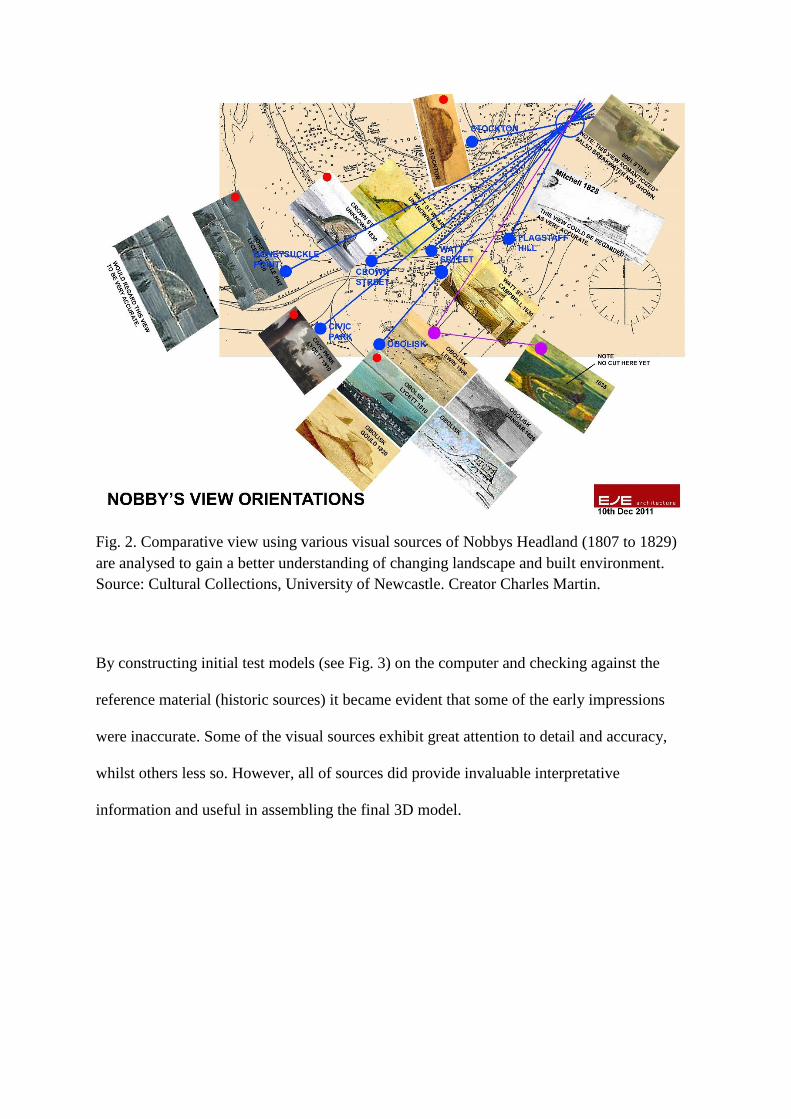
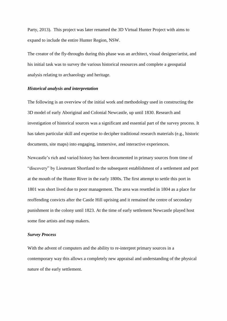
Fig. 2. Comparative view using various visual sources of Nobbys Headland (1807 to 1829)
are analysed to gain a better understanding of changing landscape and built environment.
Source: Cultural Collections, University of Newcastle. Creator Charles Martin.
By constructing initial test models (see Fig. 3) on the computer and checking against the
reference material (historic sources) it became evident that some of the early impressions
were inaccurate. Some of the visual sources exhibit great attention to detail and accuracy,
whilst others less so. However, all of sources did provide invaluable interpretative
information and useful in assembling the final 3D model.
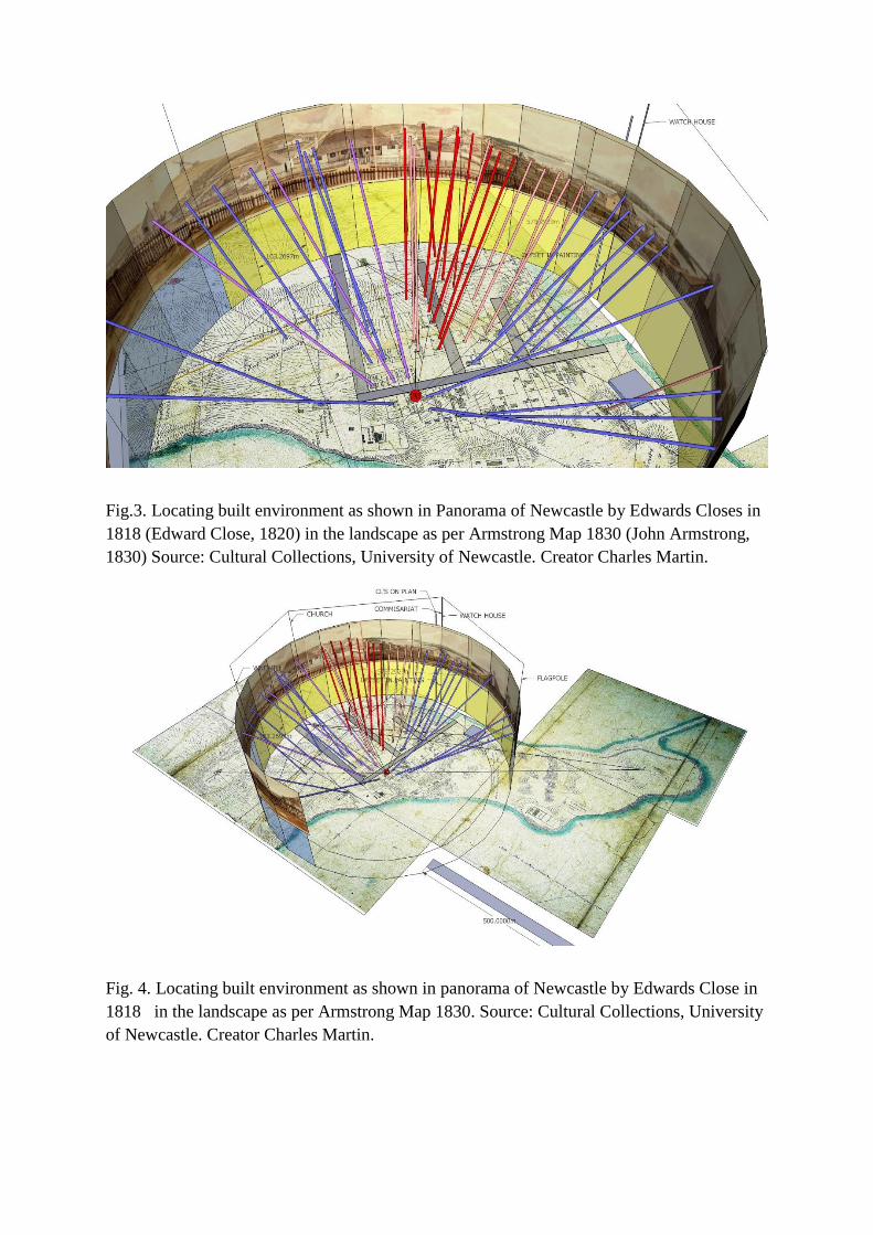
Fig.3. Locating built environment as shown in Panorama of Newcastle by Edwards Closes in
1818 (Edward Close, 1820) in the landscape as per Armstrong Map 1830 (John Armstrong,
1830) Source: Cultural Collections, University of Newcastle. Creator Charles Martin.
Fig. 4. Locating built environment as shown in panorama of Newcastle by Edwards Close in
1818 in the landscape as per Armstrong Map 1830. Source: Cultural Collections, University
of Newcastle. Creator Charles Martin.

Sketchup software was used to create the computer model of the Newcastle Time Machine.
This is a simple modelling program. For rendering of the model the software Photoshop was
used to create a painted over effect and artistic overlay.
Fig. 5. Comparative Computer Model showing from the Windmill (now Obelisk Hill).
Source: Cultural Collections, University of Newcastle. Creator Charles Martin.
Maps were also used in a comparative analysis to gain as accurate as possible delineation of
the landscape and built structures. The Meehan (1818) and Armstrong (1830) maps, these
two maps were the best contemporary references available, and by creating composites each
map shows the way Newcastle’s early streets were laid out and it was not long after this that a
grid street layout was adopted (referred to as the Dangar Plan), which remains present in
Newcastle’s street layout in 2017.
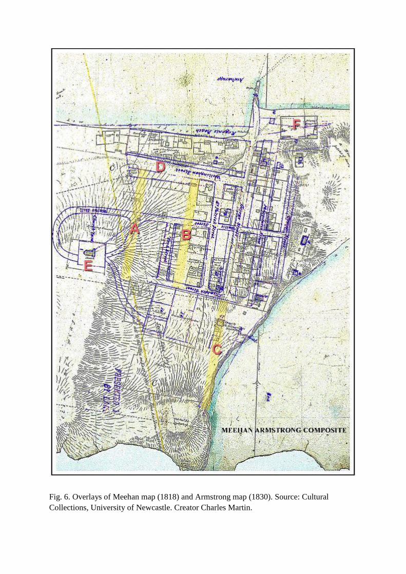
Fig. 6. Overlays of Meehan map (1818) and Armstrong map (1830). Source: Cultural
Collections, University of Newcastle. Creator Charles Martin.
Figure 6 shows the former Commandant’s Residence (C) situated on later became the
extension of Watt Street to Ordnance Street. Hunter Street (D) then Wellington Street was a
simple track leading to the west. Christ Church (E) commanded on the most prominent
positions of Newcastle, and was by far the tallest structure in the settlement in 1830. By the
time Armstrong had compiled his map the Lumber Yard (F) had been formalised into a
rectilinear enclosure. The boundaries of this remain evident in 2017. Of particular interest is
that the harbour foreshore was still in its original pristine state with a sandy beach (Regent’s
Beach) and had deep channels.
Collaboration and consultation
As the models continued to be worked up and ongoing consultation with historians and
members of the CRWP to identify buildings took place, and where possible inhabitants
identified bringing a human perspective to the project. Members of the CRWP come from the
disciplines of history, engineering, geology, surveying, archaeology, creative arts, education,
digital/ IT, and is an approach that engages the UON and the community (Hardy & Eklund,
2014). It is a wide disciplinary membership. The methodology of the Newcastle Time
Machine was well suited to a multidisciplinary model because it meant historical, archival,
surveying and geological knowledge and expertise was always available.
During this phase the creator gained considerable knowledge of the landscape and
environment of early Newcastle. However, inaccuracies in the primary sources raised new
questions about the early Newcastle environment. Questions were posed to historians and
others in specialist fields and in some cases discrepancies were resolved, while other
questions remained unresolved. Often an ‘educated’ guess was made to locate as best as
possible the position of buildings and landmarks.

The project was a ‘work in progress’ and under regular review with further research and
development required. The plan was for the model to be transferred to a more sophisticated
program and to seek partners and benefactors to progress the digital experience.
Conversion of the Newcastle Time Machine to a Virtual Reality experience.
In 2014 the Newcastle Time Machine was further extended by incorporating Virtual Reality
(VR) Technology. The 3D model, renders and flythrough of early Newcastle and other files
were provided to a virtual reality and augmented reality development studio under the
direction of Tim Davidson. The earlier model was converted to an interactive 360 degree
virtual reality experience using the Oculus Rift VR headset. Using the Oculus Rift as our VR
platform viewers could experience a truly immersive tour of early Newcastle.
The conversion process imported models into Unity 3D, a real-time render and game
development engine. The original models were very high in detail and resolution and
although these were ideal for flythrough animations and 3D images, for interactive
experiences, and virtual reality much of this detail was removed. This is called “mesh
cleaning”. Once the mesh cleaning and conversion was complete, a build of the virtual
environment surrounding the Newcastle Model began. During the conversion process the
landscape model was unable to correctly migrate across to the new software, and a new
model was built and a replica of the original model file. The landscape was then populated
with flora, textures and materials, as well as roads, paths and tracks retraced in accordance
with the original files and maps provided by Charles Martin. With the redevelopment of the
landscape complete, additional environmental aspects were included to the scene, such as
water and lighting. The “mesh cleaned” model was added, and this included lower resolution
models of the buildings, structures, ships, fences, and people into the scene. The interactive
Virtual Newcastle was starting to take shape. With the virtual environment complete,

capabilities were incorporated enabling the viewer to freely navigate around the landscape
using a game control pad. Virtual Reality component was added which allowed the
Newcastle Time Machine experience to be viewed using the Oculus Rift virtual reality
headset. This created a new and truly immersive experience in which users were able to feel
like they were actually there. Unfortunately after considerable user testing, it was discovered
that a number of users started to feel nauseous when navigating within the Virtual Reality
experience. This is a relatively common phenomenon known as “VR sickness” caused by the
mind expecting to receive feedback from the body when moving, and when it doesn’t receive
this, the user at times feels unwell. After extensive testing “VR Sickness” was overcome by
making two simple additions to the experience. The first was to place the user on a “tour”
path. This meant that the user could no longer freely roam, but were taken on a pre-defined
tour of the township. Whilst this limited the level of interactivity, the user could still have a
similar immersive experience and the likelihood of VR sickness was significantly reduced.
The second element used to prevent VR Sickness was to place the user inside a virtual “Horse
and buggy”, this saw lingering nausea subside almost completely.
Digital Heritage Perspective
The heritage discourse in Australia has changed significantly over the decades, and is
gradually shifting away from a dominance of ‘heritage professionals’ and ‘old buildings’, but
has multiple definitions (Australian Government, Dept. of the Environment & Energy, 2016).
Although digital heritage is not explicitly mentioned in the National Heritage Strategy (2016)
it is relevant in heritage circles because digital technologies are used in cultural heritage
practices, thus expanding and challenging the definition of ‘heritage’. Digital heritage has
broad use (Wu and Din, 2015, xli), referring to digital technologies, archaeology, virtual
world environments, video games, and other online methods for exploring the past, and
therefore makes sense that contributors to digital heritage also came from many diverse

fields. The idea of multiple digital heritage players is legitimised by the status given as stated
in UNESCO Charter on the Preservation of Digital Heritage “embraces cultural, educational,
scientific and administrative resources, as technical, legal, medical and other kinds of
information created digitally, or converted into digital form from existing analogue
resources.” (UNESCO, 2003b). As Cameron and Kenderine suggest, digital innovation is
opening up discussions about current heritage practices and the future direction of heritage
(2010, 3). This new shift of the heritage sector into the digital realm could be further
strengthened by using multi-disciplinary approaches, particularly information technology and
digital specialists.
Digital heritage projects can be tailor made depending on the locality, expertise and
technological support available. Digital platforms are becoming a normalised part of
contemporary society and digital heritage will continue to take many forms, and be applied to
diverse heritage and histories. Diversity of digital heritage is outlined in Cultural Heritage in
a Changing World (Borowiecki, Forbes & Fresa, 2006) and the work around digital dance
and performance by Whatley and Sabiescu (2006; 17-36.) shows just how distinct and unique
digital heritage projects can be.
Digital technologies are increasingly being used in the heritage industry and the digital
revolution will provide collaborative opportunities. ‘Heritage’ is becoming very technical
due to digital implementation and therefore it is increasingly necessary for heritage
professions to learn new digital techniques. The diversity of these skills are described in
Digital Heritage: Applying Digital Imaging to Cultural Heritage (MacDonald, 2006). It is
therefore essential to support shareholders in the realm of digital heritage, including bodies
such as ICOMOS, National Trust of Australia (NSW), education sector, GLAM
organisations, and the tourism sector. It is also important that digital heritage as a concept is
incorporated in the Burra Charter, as ‘digital heritage’ incorporated in the UNESCO Charter
on the Preservation of Digital Heritage. Similarly, efforts to reach out to the digital
humanities profession and other associated bodies as there seems to be a digital revolution in
the area humanities. As Combi (Combi, 2016, 4) points out technical revolutions often turn
out to be cultural revolutions.
In other parts of the world digital archiving is used to safeguard buildings and monuments
(see work by Cyark) usually from natural disasters, whereas the Newcastle project impresses
the historic city of the early 1800s onto a contemporary digital platform. It does not document
the modern city in 2017. Nevertheless, the Newcastle 3D model can be used to read the
modern landscape and understand impacts from proposed change, such as urban revitalisation
and development, a pressing threat to the cultural heritage of the city.
An advantage of digital heritage and 3D modelling is that audiences can experience history
visually rather than via the often limited written sources (as was the case in Newcastle) by the
recreation using 3D models. Digital heritage can to be used by heritage professionals and
others.
3D technology is aiding digital preservation and heritage conservation practice. Virtual
digital models that use relatively reliable primary sources (as described in this Newcastle
project) are effective heritage management tools that assist in the better understanding of
historic landscapes. The lack of historical secondary sources has meant historical evidence is
not always there, evidence that is usually crucial to heritage conservation practice
underpinning conservation documents (such as Conservation Management Plans).
Digital technology has many applications in cultural heritage management and protection,
and digital heritage can be effectual in embedding cultural understanding into planning
instruments. Newcastle is undergoing revitalisation since the closure of BHP in 1999, and in
2017 major new development is taking place, or planned, such as major transport
infrastructure including light rail (Farquhar, 2016). Digital heritage 3D project provides
knowledge about the city landscape to better understand the topography, and features such as
water courses, shorelines and sites of early human occupation by indigenising the City and
embodying Aboriginal knowledge and wisdom into planning frameworks to create
sustainable cities of the future. (Hardy, di Gravio & Robertson, 2015). The layout of the built
environment as it was in the early 1800s is valuable information that can inform urban
planners of the potential of archaeological sites. This is particularly pertinent to Aboriginal
and European historical archaeology scattered across the Newcastle landscape. It is not
unusual for significant relics to be discovered or rediscovered during development in the
inner city, and 3D virtual projects are effective heritage conservation management tools that
can inform planning.
This project has made good use of the primary sources and has embed historical evidence
into digital platforms to produce a relative accurate 3D model, and is an educational,
professional and academic research tool.
Conclusion
The ‘Newcastle Time Team’ project has had many contributors actively involved at particular
phases of the project, from locating and digitally repatriating historic sources, to researching
and re-interpreting sources in digital forms. As discussed, the project is not about digitising
Newcastle as a heritage city in 3D representations, but interprets the historic landscape of the
past. The process has required particular expertise to analyse research material, and has taken
considerable period to create (mid-1990s to 2017) to formulate ideas, procure relevant
documents, analyse sources and apply cultural sources to digital imaging to create a model
that is as reliable as can be. At the heart of this project has been time, and documentary
evidence.

We acknowledge that a single case study is not a broadly-based review of the effectiveness of
the multi-disciplinary approach, however qualitative statistics related to this digital project
have come after an article “Turning Back Time” was published on the front page of the
Newcastle Herald and received over 1K ‘likes’ and 432 ‘shares’ on the Herald’s Facebook
page within a month. (Owen, 2017).
Finally, the collaborative aspects of this digital heritage project can significantly enrich
outcomes because of the multidisciplinary approach that was taken. The multidisciplinary
model used by HHI could be used by other tertiary institutions to develop digital heritage
projects associated with an individual university. It is an approach not typically used in the
tertiary setting, but has come about due to the shift towards innovative ways to digitise and
interpret archival sources. The multidisciplinary approach is an appropriate mechanism that
provides a forum where many voices are heard and recognises the value of collaboration,
particularly with those in the digital and creative industries.
References
Australian Government, Dept. of the Environment & Energy. 2016. Definition ‘Heritage.
Accessed 13 Jan 2017. https://www.environment.gov.au/heritage/about/national .“Australia's
national heritage comprises exceptional natural and cultural places that contribute to
Australia's national identity. National heritage defines the critical moments in our
development as a nation and reflects achievements, joys and sorrows in the lives of
Australians. It also encompasses those places that reveal the richness of Australia's
extraordinarily diverse natural heritage.”
Albrecht, Glenn. 2000. “Rediscovering the Coquun: Towards an environmental history of the
Hunter River.” Address given at the River Forum 2000 at Wyndham Estate, Hunter River.
Accessed January 13, 2017. http://libguides.newcastle.edu.au/chrp/albrecht#s-lg-box-
wrapper-5982476
Armstrong, John. "The Town of Newcastle, New South Wales." (1830) Map showing its
present actual state, with part of the adjoining Country, and The Coal Works of The
Australian Agricultural Company, from a Careful Survey in 1830 by Jno. Armstrong.
Wellington: Alexander Turnbull Library, The National Library of New Zealand.

Borowiecki, KJ, Forbes, N & Fresa, A. eds. 2006. Cultural Heritage in a Changing World,
Springer Press.
Cameron, F & Kenderine, S, eds. 2010. Theorizing Digital Cultural Heritage: A Critical
Discourse. Cambridge: MIT Press.
Close, Edward. 1820. “Barracks with Christ Church in the distance, Newcastle, New South
Wales.” Artwork. National Library of Australia. Catalogue number 4564445.
Coal River Working Party blog. 2003. “ABOUT”. Assessed January 13, 2017.
https://hunterlivinghistories.com/about/
Coal River Working Party blog. 2008. “The Coal River Time Machine”, March 13. Accessed
January 13, 2017. https://hunterlivinghistories.com/2008/03/13/the-coal-river-time-machine/
Coal River Working Party blog. November 29, 2012. “Virtual Newcastle circa 1800”, March
13. Accessed January 13, 2017. https://hunterlivinghistories.com/2012/11/29/virtual-
newcastle-circa-1800-1830-ad/
Coal River Working Party blog. February 16, 2014. “3D Virtual Newcastle – What Charles
and Vera achieved in 34 days of 2013”, March 13. Accessed January 13, 2017.
https://hunterlivinghistories.com/2014/02/16/34-days/
Combi, Mariella. 2016. “Cultures and Technology: An Analysis of some of the changes in
Progress- Digital, Global and Local Culture.” In Cultural Heritage in a Changing World,
edited by Karol Jan Borowiecki, Neil Forbes, and Antonella Fresa, 3-16.Springer Press
Cultural Collections, UON Library WordPress. (2007) “Coal River Surveying Students win
Excellence in Surveying Awards.” Accessed January 13, 2017.
https://uoncc.wordpress.com/2007/10/04/coal-river-surveying-students-win-excellence-in-
surveying-awards/
Cultural Collections, University of Newcastle. 2000. “Virtual Coquun-Hunter River Project
Guide”. Virtual guide produced by the University of Newcastle, Australia. Accessed January
13, 2017. http://libguides.newcastle.edu.au/chrp
Cyark. 2014. Accessed January 13, 2017. http://cyark.org/
Di Gravio, G and Sherlock, P. 2007. “The Coal River Project – from Convicts and the
Dreamtime to Google Earth”. Presentation (Monteath's 3D programmers Andrew Baker,
David Wallace and landscape mapper) at the UON Coal River Working Party meeting,
Callaghan Campus, Newcastle, March 29.
Di Gravio. 2012. “Virtual Newcastle circa 1800-183AD” Hunter Living Histories blog on
November 29, 2012. https://hunterlivinghistories.com/2012/11/29/virtual-newcastle-circa-
1800-1830-ad/
Di Gravio, Gionni, e-mail to Greg Preston, September 11, 1998.
Di Gravio, Gionni, e-mail to research colleagues, December 1, 2000.
Di Gravio, Gionni. 10 January 2016. Personal reflection of association between ‘heritage’
and ‘digital’.
Din, Herminia & Wu, Steven, eds. (2015) Digital Heritage and Culture: Strategy and
Implementation. Singapore: World Scientific Publishing.
Farquhar, Liz. 2016. “NSW Government releases further details of Newcastle’s new light
rail.” 1233 ABC News. April 11. Accessed January 13, 2017.
http://www.abc.net.au/news/2016-04-05/nsw-government-releases-further-details-of-new-
light-rail/7300302
Fryer, John. 2016. “The Past Matters: Rock art and Indigenous Heritage Workshop.”
YouTube video recording at Past Matters Rock Art & Indigenous Heritage Workshop, May
20, 2016 at University of Newcastle’s Auchmuty Library. Accessed January 13, 2016.
https://www.youtube.com/watch?v=GbHtRNw2fUg
Hardy, AV, Eklund E. 2014. “Multidisciplinary Approach to University - Community
Engagement.” The Australasian Journal of University-Community Engagement 9:77-99.
Hardy, di Gravio and Robertson, 2015. WordPress post “Indigenising the City: Embodying
Aboriginal knowledge and wisdom into planning frameworks to create sustainable cities of
the future.” Paper presented at the Spaces and Flows: Sixth International Conference.
University Center Chicago. Accessed January 13, 2017.
https://hunterlivinghistories.com/2015/11/03/indigenising-the-city/
Iverson, Ole S. and Smith, Rachel Charlotte. 2012. “Connecting to Everyday Practices:
Experiences from the Digital Natives exhibition.” In Heritage and Social Media:
Understanding heritage in a participatory culture, edited by Elis Giaccardi. London:
Routledge. 2012. 130.
Kelly, Mathew. 2011. “6500-year-old heritage junked.” Newcastle Herald, May 20.
MacDonald, Lindsey (ed). 2006. Digital Heritage : Applying Digital Imaging to Cultural
Heritage. Oxford: Butter- Heinemann.

Owen, Brodie. 2017. “Turning Back Time”. Newcastle Herald, April 20. Accessed May 17,
2017.
Prensky, M. (2001, October). Digital natives, digital immigrants. Horizon, 9(5), 1-6.
Ray, Greg. 2012. “VIDEO: Fly through 3D history of Newcastle.” Newcastle Herald,
November 30. Accessed January 13, 2017.
http://www.theherald.com.au/story/1157494/video-fly-through-3d-history-of-newcastle/
Royal Commission of Inquiry into the Coal Industry (New South Wales). Accessed January
13, 2017. http://search.records.nsw.gov.au/agencies/4978
The Mayfield Website. 1996. Accessed January 13, 2017. http://pandora.nla.gov.au/nph-
wb/20000720130000/http://www.library.newcastle.edu.au/archives/mayfield.html)
Thomson, John. Letter from Mr John Thomson to Captain Schanck, H.R.N.S.W., Vol. III
(September 8, 1799): 716 – 718.
Towers, Chris and Sumner, Troy. 2009. “Sir Thomas Mitchell 1828 Newcastle Survey Report
– Full Report and Summary” Accessed January 13, 2017.
Sir Thomas Mitchell’s Angular Observations and Field-Note Sketches of Newcastle.
UNESCO. 2003b. “Charter on the Preservation of Digital Heritage”. Paris, UNESCO
Website. Accessed January 13, 2017. http://portal.unesco.org/en/ev.php-
URL_ID=17721&URL_DO=DO_TOPIC&URL_SECTION=201.html
http://www.cyark.org/
University of Newcastle, Coal River Working Party Minutes 5 November 2012. Accessed
online Jan 2017 https://coalriver.files.wordpress.com/2014/01/crwp-minutes-2012-
november.pdf
Whatley, Sarah and Sabiescu, Amalia G. 2006. “Interdisciplinary Collaborations in the
Creation of Digital Dance and Performance: A critical Examination.” In Cultural Heritage in
a Changing World, edited by Karol Jan Borowiecki, Neil Forbes, and Antonella Fresa, 17-36.
:Springer Press.
Wilson, John & Widgery, Alex. 2007. “Fort Scratchley DTM and Coal River Working Party
Surveying project Report.” University of Newcastle Students. Accessed January 13, 2017.
https://downloads.newcastle.edu.au/library/cultural%20collections/pdf/johnwilson_coalriver
%20report_full.pdf

WORD COUNT : 5866