NEWCASTLE CITY COUNCIL OUSEBURN VALLEY … NEWCASTLE CITY COUNCIL OUSEBURN VALLEY PARKING – DESK...
14
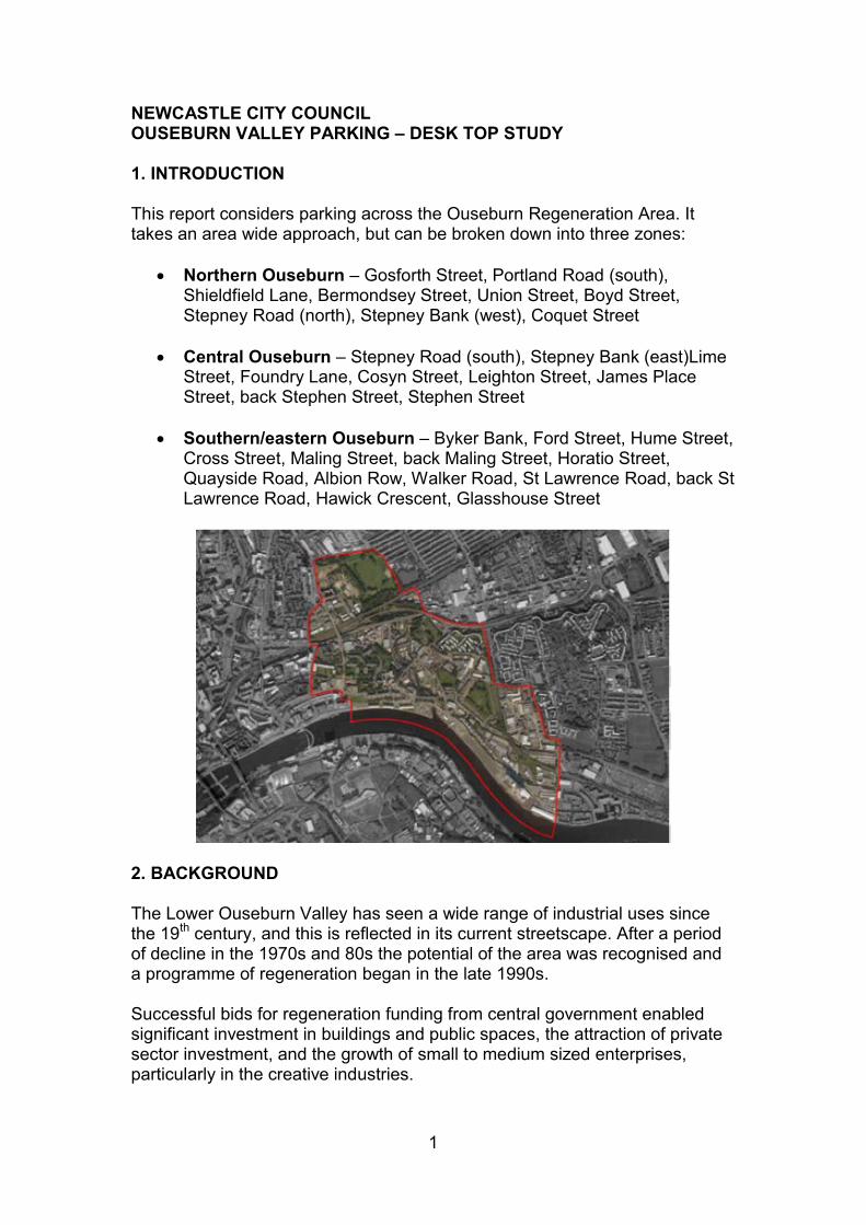
1 NEWCASTLE CITY COUNCIL OUSEBURN VALLEY PARKING – DESK TOP STUDY 1. INTRODUCTION This report considers parking across the Ouseburn Regeneration Area. It takes an area wide approach, but can be broken down into three zones: Northern Ouseburn – Gosforth Street, Portland Road (south), Shieldfield Lane, Bermondsey Street, Union Street, Boyd Street, Stepney Road (north), Stepney Bank (west), Coquet Street Central Ouseburn – Stepney Road (south), Stepney Bank (east)Lime Street, Foundry Lane, Cosyn Street, Leighton Street, James Place Street, back Stephen Street, Stephen Street Southern/eastern Ouseburn – Byker Bank, Ford Street, Hume Street, Cross Street, Maling Street, back Maling Street, Horatio Street, Quayside Road, Albion Row, Walker Road, St Lawrence Road, back St Lawrence Road, Hawick Crescent, Glasshouse Street 2. BACKGROUND The Lower Ouseburn Valley has seen a wide range of industrial uses since the 19 th century, and this is reflected in its current streetscape. After a period of decline in the 1970s and 80s the potential of the area was recognised and a programme of regeneration began in the late 1990s. Successful bids for regeneration funding from central government enabled significant investment in buildings and public spaces, the attraction of private sector investment, and the growth of small to medium sized enterprises, particularly in the creative industries.
Transcript of NEWCASTLE CITY COUNCIL OUSEBURN VALLEY … NEWCASTLE CITY COUNCIL OUSEBURN VALLEY PARKING – DESK...
1
NEWCASTLE CITY COUNCIL OUSEBURN VALLEY PARKING – DESK TOP STUDY 1. INTRODUCTION This report considers parking across the Ouseburn Regeneration Area. It takes an area wide approach, but can be broken down into three zones:
Northern Ouseburn – Gosforth Street, Portland Road (south), Shieldfield Lane, Bermondsey Street, Union Street, Boyd Street, Stepney Road (north), Stepney Bank (west), Coquet Street
Central Ouseburn – Stepney Road (south), Stepney Bank (east)Lime Street, Foundry Lane, Cosyn Street, Leighton Street, James Place Street, back Stephen Street, Stephen Street
Southern/eastern Ouseburn – Byker Bank, Ford Street, Hume Street,
Cross Street, Maling Street, back Maling Street, Horatio Street, Quayside Road, Albion Row, Walker Road, St Lawrence Road, back St Lawrence Road, Hawick Crescent, Glasshouse Street
2. BACKGROUND The Lower Ouseburn Valley has seen a wide range of industrial uses since the 19th century, and this is reflected in its current streetscape. After a period of decline in the 1970s and 80s the potential of the area was recognised and a programme of regeneration began in the late 1990s. Successful bids for regeneration funding from central government enabled significant investment in buildings and public spaces, the attraction of private sector investment, and the growth of small to medium sized enterprises, particularly in the creative industries.
2
It also saw the establishment of a number of major visitor attractions – the Biscuit Factory, Northern Print, Seven Stories and Ouseburn Farm, plus a variety of pubs, cafes and music venues. The current phase of investment in the area is predominantly based around housing, with a significant amount of student accommodation being built to the north, some affordable rented properties in the central area, and a mix of house types for sale in the south of the Valley, adjacent to the quayside. All of this activity has increased demand for parking in the area. 3. TRANSPORT POLICY CONTEXT Ouseburn Parking and Accessibility Study (2003, revised 2008) The Council appointed Symonds Group Ltd to undertake the Ouseburn Parking and Accessibility Study (OPAS) in 2003. The aim of the Study was to:
identify improvements required in the Lower Ouseburn Valley that would increase accessibility by all modes of transport
establish a developer contribution model to enable these improvements to be made
ensure the regeneration potential of the area was achieved. The Study included an investigation into the appropriate level of parking provision for the proposed developments and identification of a recommended approach. The intention was to provide parking:
On-site – minimum level to make developments commercially acceptable
Off-site – communal areas of parking that could be shared between visitors to offices, homes etc
In 2008 the Study was updated to reflect changes to the scale and type of future developments, work undertaken by NCC and changes to public transport provision in the area. The report indicated that maximum parking standards were to be revised, resulting in the provision indicated in Table 1 below.
Table 1 Car parking standards, 2008
Land use On-site provision Off-site provision
Residential 1 space per dwelling 0.3 spaces per dwelling
B1 Office 1 space per 60m2 1 space per 60m2
Other commercial 1 space per 100m2 1 space per 100m2
It was proposed to be realistic about car ownership but not encourage use of the car especially for work trips in peak hours. As such it was necessary to make it possible for residents to leave their cars at home during the day, and as a result the report concludes that while there is potential to share spaces
3
between employees and residents, the appropriate figure for residential spaces available during the day would be around 33%. The report continued to support the provision of off-street options on the outskirts of the Valley for long stay parking, e.g. Spillers Quay. The Study update shows the off-street parking demands that could be met at Spillers Quay as being 547 for employees and 184 for residents/visitors. It goes on to say that if Spillers is to be developed then the provision on the site could be scaled down to 400 spaces. Interim Planning Guidance (IPG) for Newcastle upon Tyne, April 2010 This document was published by Newcastle City Council and covers the whole of the City. It is used as part of the assessment of planning applications and remains compliant with the National Planning Policy Framework. The IPG includes a section which covers Transport Assessments, Travel Plans and Parking, including car parking for residential and non-residential developments, developer contribution models, cycle parking and powered two wheeler parking. It states that car parking needs to be considered as an important part of any scheme. The City Council will seek to ensure that car parking provision is at an appropriate level to cater for the development and visitors, taking into account the location and circumstances in the surrounding area, for example heritage assets, nature of the development, sustainability, impact on residential amenity and highway safety, and the availability of public transport. Car parking standards for various land uses are contained within the IPG. Maximum residential parking levels (citywide) are shown in Table 2. Table 2 IPG car parking standards 2010
Residential Accommodation
Number of allocated spaces
No allocated spaces
1 Allocated
space
2 Allocated spaces
3 rooms 0.5 1.3 2.3
4 rooms 1.1 1.5 2.4
5 rooms 1.8 2 2.1
6 rooms 2.3 2.5 2.7
7 rooms 2.5 2.8 2.9
8 rooms 2.6 2.8 3
One car parking space per 50sqm is set as the maximum requirement for B1 office use in urban areas, and further standards are identified for other
4
commercial uses. These standards supercede the figures stated in the OPAS 2008 review. Developer Contribution Models The City Council has adopted developer contribution models either for specific policy objectives or to address issues of accessibility arising from numerous potential development sites in a defined geographical area. The OPAS Developer Contribution Model secured funds from developments in the area to enable delivery of the interventions recommended in the Study. OPAS has now been replaced by the Urban Core Model, which covers the whole of the city centre. Some funds remain in the OPAS model, which are being considered as detailed at Section 5 of this report. There has not been any income into the Urban Core Model for Ouseburn to date. 4. CURRENT ARRANGEMENTS See Appendix 1 (summary of current arrangements). The majority of roads in Ouseburn currently either have double yellow lines in place or have unrestricted parking. There are small areas of permit/short stay parking in the northern zone. There is Council owned, unrestricted off-street parking at:
Stepney Road (appx 10 spaces, unmarked and unadopted) Stepney Road south (appx 15 spaces, unmarked and unadopted) McPhees Yard (57 marked spaces, unadopted) Spillers Quay (appx 300 spaces available at present)
There are also two public car parks owned by the Ouseburn Trust on Stepney Bank, with 20 charged spaces between the two of them. There is a range of private parking provision across the area. Publicly accessible disabled parking spaces are distributed as follows:
1 space in each of the two Ouseburn Trust car parks, Stepney Bank 1 space adjacent to the Media Exchange car park on Stepney Bank 1 space on Lime Street adjacent to Village Green 4 spaces on Foundry Lane near the footbridge 6 spaces at Spillers Quay
There is a bus stop on Lime Street which when free of vehicles can be used for coach drop-offs to Seven Stories and other venues, but this often is parked up with cars. There is no identified coach parking in the area. Pending activity
5
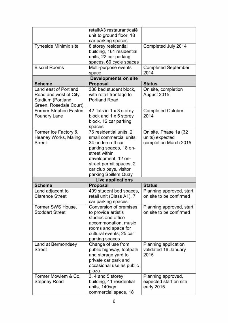
Maling Street Section 278 works The proposals will introduce permit parking areas on Maling Street, back Maling Street, Hume Street and Ford Street, with all those except the spaces on Maling Street also allowing 2 hours limited waiting for those without permits. Hume Street will also have a strip of 30 minutes limited waiting parking, and two car club bays. The proposal was advertised in February 2014, and again with amendments in June 2014. Objections have been received, and amendments are being considered which may allow some of the objections to be withdrawn, however it is looking likely that the proposals may need to go to a Regulatory and Appeals Sub Committee. The effect of the proposals on parking capacity has been taken into account in Carillion Igloo’s Parking Study. Ouseburn DIY Streets NCC secured £5.6m through the national Cycle City Ambition Fund. £150k of this has been allocated to the Lower Ouseburn Valley for a DIY Streets project. A project team made up of Sustrans, Ouseburn Futures, local businesses/stakeholders and NCC has been formed which has led to the drafting of a number of proposed improvements to encourage the use of sustainable forms of transport across the focus streets of Stepney Road, Stepney Bank and Lime Street. The current programme is for detailed designs to be complete by summer 2015, and delivery of physical improvements to take place in autumn 2015. 5. IN PROGRESS/PROPOSED DEVELOPMENTS A number of developments have recently been completed, have live planning applications, are currently on-site or have potential to come forward in the future. These are relevant in terms of their impact on parking in the area, and the developer contributions they may generate for highways improvements. Table 3 – in progress/proposed developments November 2014
Recently completed Scheme Proposal Status Former Winn Products, Stoddart Street
91 units of student accommodation comprising 396 bed spaces, 10 car parking spaces
Completed 2013
Land east of Stoddart Street (Portland Green, Turner Court)
275 student bed spaces, 1 x Class A1 retail unit and 1 x Class A1
Turner Court, completed August 2013
6
retail/A3 restaurant/café unit to ground floor, 18 car parking spaces
Tyneside Minimix site 8 storey residential building, 161 residential units, 22 car parking spaces, 60 cycle spaces
Completed July 2014
Biscuit Rooms Multi-purpose events space
Completed September 2014
Developments on site Scheme Proposal Status Land east of Portland Road and west of City Stadium (Portland Green, Rosedale Court)
338 bed student block, with retail frontage to Portland Road
On site, completion August 2015
Former Stephen Easten, Foundry Lane
42 flats in 1 x 3 storey block and 1 x 5 storey block, 12 car parking spaces
Completed October 2014
Former Ice Factory & Heaney Works, Maling Street
76 residential units, 2 small commercial units, 34 undercroft car parking spaces, 18 on-street within development, 12 on-street permit spaces, 2 car club bays, visitor parking Spillers Quay
On site, Phase 1a (32 units) expected completion March 2015
Live applications Scheme Proposal Status Land adjacent to Clarence Street
409 student bed spaces, retail unit (Class A1), 7 car parking spaces
Planning approved, start on site to be confirmed
Former SWS House, Stoddart Street
Conversion of premises to provide artist’s studios and office accommodation, music rooms and space for cultural events, 25 car parking spaces
Planning approved, start on site to be confirmed
Land at Bermondsey Street
Change of use from public highway, footpath and storage yard to private car park and occasional use as public plaza
Planning application validated 16 January 2015
Former Mowlem & Co, Stepney Road
3, 4 and 5 storey building, 41 residential units, 140sqm commercial space, 18
Planning approved, expected start on site early 2015
7
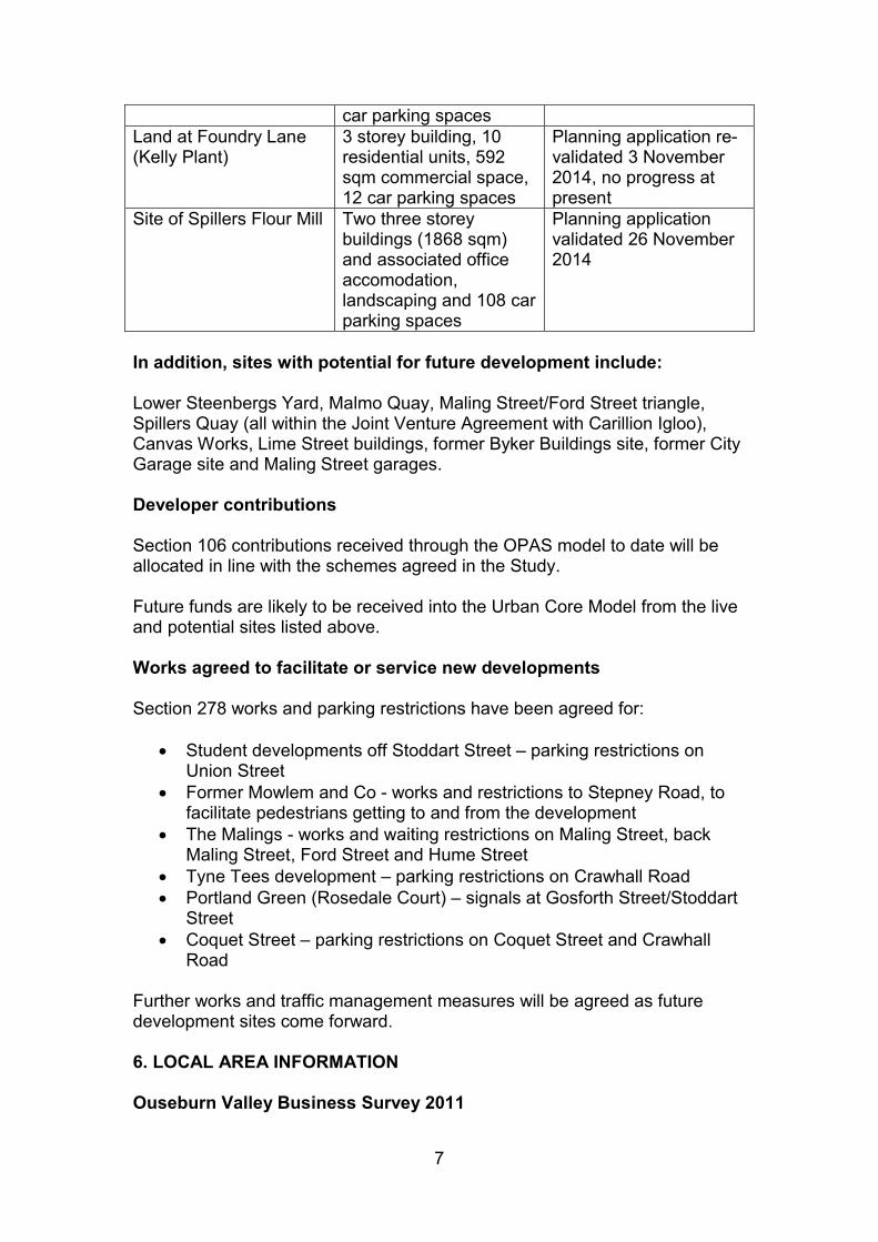
car parking spaces Land at Foundry Lane (Kelly Plant)
3 storey building, 10 residential units, 592 sqm commercial space, 12 car parking spaces
Planning application re-validated 3 November 2014, no progress at present
Site of Spillers Flour Mill Two three storey buildings (1868 sqm) and associated office accomodation, landscaping and 108 car parking spaces
Planning application validated 26 November 2014
In addition, sites with potential for future development include: Lower Steenbergs Yard, Malmo Quay, Maling Street/Ford Street triangle, Spillers Quay (all within the Joint Venture Agreement with Carillion Igloo), Canvas Works, Lime Street buildings, former Byker Buildings site, former City Garage site and Maling Street garages. Developer contributions Section 106 contributions received through the OPAS model to date will be allocated in line with the schemes agreed in the Study. Future funds are likely to be received into the Urban Core Model from the live and potential sites listed above. Works agreed to facilitate or service new developments Section 278 works and parking restrictions have been agreed for:
Student developments off Stoddart Street – parking restrictions on Union Street
Former Mowlem and Co - works and restrictions to Stepney Road, to facilitate pedestrians getting to and from the development
The Malings - works and waiting restrictions on Maling Street, back Maling Street, Ford Street and Hume Street
Tyne Tees development – parking restrictions on Crawhall Road Portland Green (Rosedale Court) – signals at Gosforth Street/Stoddart
Street Coquet Street – parking restrictions on Coquet Street and Crawhall
Road Further works and traffic management measures will be agreed as future development sites come forward.
6. LOCAL AREA INFORMATION Ouseburn Valley Business Survey 2011
8
A survey was undertaken by NCC’s East Regeneration Team. 382 businesses were surveyed over a one month period of which 86 responded. It included two questions relating to transport. 41% of respondents commented that their staff faced journey cost/time reduction issues, stating that public transport connections were not good 23% commented on parking issues, noting lack of parking for staff who need to use a car to visit clients, and too many people parking in the Valley and walking into the city centre. When asked how their staff travel to work the response was 603 by car, 323 by bus, 366 by foot or cycle, and 73 by Metro. Toffee Factory Travel Survey, April 2014 Approximately 117 people were surveyed as part of this study, which took information from clients and visitors. 63% travelled by car, 12% walked, 9% cycled, 6% used the bus, 3% metro and 5% by other means. The majority of people travelling by car parked at Spillers Quay, followed by on-street, on site or by the Free Trade. Comments included:
Parking is usually ok, public transport not convenient Walking is quicker than public transport as no direct bus/metro from
Jesmond Cycle Hub car-park gets too full Public transport is expensive If I arrive after 10am there are no spaces at the Cycle Hub
Boyd Street area Local businesses in the Boyd Street area raised issues earlier in 2014 as a result of contractor parking for the Union Street development affecting the availability of space for their day to day activities. A solution was agreed whereby NCC provided permits to the contractors to park in alternative locations. This helped to mitigate tensions and is an approach that could be replicated for future development sites. Seven Stories Seven Stories is a major attraction to the area, generating around 80,000 visitors per year. Their peak times are during the school holidays, and they feel that the current parking situation is affecting their viability. Conversations with NCC have been on-going for some time, and Seven Stories are closely monitoring visitor numbers, correlated to the availability of parking. Market research carried out during the May 2014 half term holiday identified that:
100% of visitors said it was difficult or very difficult to park 100% said it took over 15 minutes to find somewhere to park 100% said they feel access is unsafe for children
9
Many cited concerns about bottles and glass around the Cluny and on pathways
Many said they would be willing to pay for parking if it improved access Issues have also been raised by visitors about the lack of disabled parking spaces and the general poor accessibility in the area for wheelchair users. Biscuit Factory Another major visitor attraction in the area is the Biscuit Factory and its associated venues - the recently completed Biscuit Rooms (multi-purpose events space) and the proposed Biscuit Box (artist’s studios, office accommodation, music rooms, teaching space and space for cultural events). The Biscuit Box is being built on the site of the former Council owned SWS House. Sale of the site included disposal of 20 marked car parking spaces previously identified as ‘Ouseburn North’. These spaces are now reserved for Biscuit Factory use. The developer has submitted a proposal to use part of the site and the adjacent Bermondsey Street to create a public plaza with private parking, which is under consideration. Ouseburn Futures Co-ordinating Group A number of points were raised with NCC by the group in June 2014. They noted that parking is a major concern for businesses in the area and could affect future relocation choices and the potential to support business and employment growth, and that there is concern that conversations around parking are not joined up, and that an area wide view is required. They suggested a series of objectives and actions as follows:
Implement an Ouseburn wide scheme for above rather than piecemeal approach
Provide just enough parking to satisfy demand/need but at the same
time encourage other modes of transport by making walking, cycling and public transport more attractive in Ouseburn
Stop city centre commuter parking and achieve a balance between
business staff parking and visitor/client/customer parking
Look at permit parking for businesses etc over a wider area than just the northern part of Ouseburn
Off Street parking public car parks - longer term parking
- formalise Spillers and McPhees by doing the legals, maintain them properly and put in day or half day or free for first hours ticketing
10
- expand Spillers asap - construct new off street parking at Ingham Place and other
locations to achieve target space numbers and spread - look at very local arrangements for sharing private off street
parking - look at temporary parking suitable for 7 Stories visitors at half
term etc - look at some of the unrecognised NCC owned off street car
parks and legalise/control – e.g. Stepney Road and top of Coquet Street
On street parking - shorter term parking
- implement time limits and possibly charging - the duration depending on needs of local businesses i.e. around 7 Stories might be 4 hours and elsewhere 2 hours
- fill in gaps where there are no controls i.e. bottom of Stepney Bank
- expand numbers where appropriate (using spaces as part of traffic calming)
Look at on-site parking requirements for developments again - review
OPAS, the effect of CIL etc, and consider student housing development conditions - are they working?
Scheme for encouraging people to walk, bike or catch bus
Consider the temporary impact of development sites – are there ways
to control this traffic
Consider day and night-time usage Ouseburn Developers Forum A request was made at the September 2014 Developers Forum to arrange a specific meeting around parking, to present the findings of recent reports and set out NCC’s strategic approach to the issues. 7. RECENT PARKING STUDIES Carillion Igloo Car Parking Assessment (draft September 2014) Carillion Igloo produced a Car Parking Assessment of the southern end of the Valley in their capacity as Framework Development Partner in the Ouseburn Joint Venture area. The Assessment surveyed on and off street car parking in order to understand current use and identify available capacity. It took into account Carillion Igloo’s proposed development at Lower Steenbergs Yard, Malmo Quay and Spillers Quay, and proposed a set of modifications to make best use of available parking.
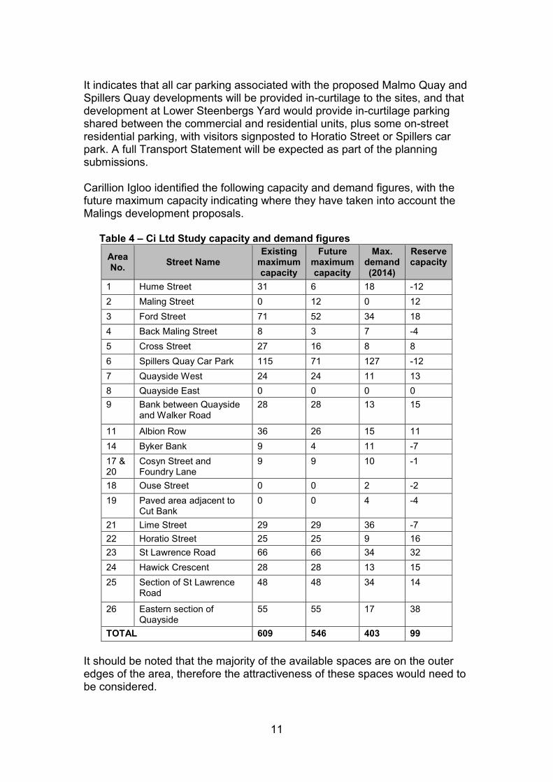
11
It indicates that all car parking associated with the proposed Malmo Quay and Spillers Quay developments will be provided in-curtilage to the sites, and that development at Lower Steenbergs Yard would provide in-curtilage parking shared between the commercial and residential units, plus some on-street residential parking, with visitors signposted to Horatio Street or Spillers car park. A full Transport Statement will be expected as part of the planning submissions. Carillion Igloo identified the following capacity and demand figures, with the future maximum capacity indicating where they have taken into account the Malings development proposals. Table 4 – Ci Ltd Study capacity and demand figures
Area No.
Street Name Existing
maximum capacity
Future maximum capacity
Max. demand (2014)
Reserve capacity
1 Hume Street 31 6 18 -12
2 Maling Street 0 12 0 12
3 Ford Street 71 52 34 18
4 Back Maling Street 8 3 7 -4
5 Cross Street 27 16 8 8
6 Spillers Quay Car Park 115 71 127 -12
7 Quayside West 24 24 11 13
8 Quayside East 0 0 0 0
9 Bank between Quayside and Walker Road
28 28 13 15
11 Albion Row 36 26 15 11
14 Byker Bank 9 4 11 -7
17 & 20
Cosyn Street and Foundry Lane
9 9 10 -1
18 Ouse Street 0 0 2 -2
19 Paved area adjacent to Cut Bank
0 0 4 -4
21 Lime Street 29 29 36 -7
22 Horatio Street 25 25 9 16
23 St Lawrence Road 66 66 34 32
24 Hawick Crescent 28 28 13 15
25 Section of St Lawrence Road
48 48 34 14
26 Eastern section of Quayside
55 55 17 38
TOTAL 609 546 403 99
It should be noted that the majority of the available spaces are on the outer edges of the area, therefore the attractiveness of these spaces would need to be considered.

12
Tables 5 and 6 show the number of vehicles and duration of stay across the surveyed streets: Table 5 – Ci Ltd Study duration of stay Thursday 24 April
Table 6 - Ci Ltd Study duration of stay Saturday 26 April
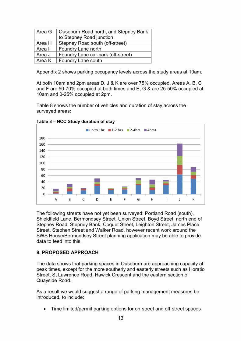
NCC Parking Survey (central area) Newcastle City Council carried out a survey of the central area of the Valley on 19 June 2014. This was carried out using MicroMatch Registration Matching Software between 7am and 8pm, with a maximum interval between consecutive patrols of 15 minutes. The survey considered the following areas: Table 7 – NCC Study survey areas
Area A Lime Street South Area B Lime Street mid-South Area C Lime Street mid-North Area D Lime Street North and Ouseburn Road
South Area E Ouseburn Trust car-park east, Stepney
Bank (off-street) Area F Ouseburn Trust car-park west, Stepney
Bank (off-street)
020406080
100120140
up to 1hr 1-2 hrs 2-4hrs 4hrs+
0
10
20
30
40
50
up to 1hr 1-2 hrs 2-4hrs 4hrs+
13
Area G Ouseburn Road north, and Stepney Bank to Stepney Road junction
Area H Stepney Road south (off-street) Area I Foundry Lane north Area J Foundry Lane car-park (off-street) Area K Foundry Lane south Appendix 2 shows parking occupancy levels across the study areas at 10am. At both 10am and 2pm areas D, J & K are over 75% occupied. Areas A, B. C and F are 50-70% occupied at both times and E, G & are 25-50% occupied at 10am and 0-25% occupied at 2pm. Table 8 shows the number of vehicles and duration of stay across the surveyed areas: Table 8 – NCC Study duration of stay
The following streets have not yet been surveyed: Portland Road (south), Shieldfield Lane, Bermondsey Street, Union Street, Boyd Street, north end of Stepney Road, Stepney Bank, Coquet Street, Leighton Street, James Place Street, Stephen Street and Walker Road, however recent work around the SWS House/Bermondsey Street planning application may be able to provide data to feed into this. 8. PROPOSED APPROACH The data shows that parking spaces in Ouseburn are approaching capacity at peak times, except for the more southerly and easterly streets such as Horatio Street, St Lawrence Road, Hawick Crescent and the eastern section of Quayside Road. As a result we would suggest a range of parking management measures be introduced, to include:
Time limited/permit parking options for on-street and off-street spaces
0
20
40
60
80
100
120
140
160
180
A B C D E F G H I J K
up to 1hr 1-2 hrs 2-4hrs 4hrs+
14
Consideration of options for additional off-street parking A review of the availability of disabled parking spaces Identification of coach drop-off and parking locations A review of signage and lighting Introduction of measures to support sustainable transport choices by
supporting physical improvements through the DIY Streets project, promoting alternative options through Council initiatives and introducing a car club/electric vehicle bay
Implementation of the proposals will be delivered in phases, starting with the central area, and followed by either the northern or southern streets depending on the impact of the first phase. 9. APPROACH TO DEVELOPING THE PROPOSALS
Discuss initial ideas with Ouseburn and Byker Ward Councillors
(complete)
Discuss initial ideas with some local stakeholders (complete – Seven
Stories, Ouseburn Farm, Ouseburn Trust, Biscuit Factory, Cobalt
Studios/Ernest, Foundry Lane/Shieldfield Industrial Estate manager, i4
Business Development Centre Manager, Toffee Factory and Cycle
Hub)
Present draft proposals to Ouseburn Developers Forum including wider
stakeholders
Carry out further in depth consultation
Sign off the proposals
Carry out the statutory consultation process
Implement the proposals, in three phases
Report completed January 2015