NEW YORK KOREAN EVANGELICAL CHURCH
62
NEW YORK KOREAN EVANGELICAL CHURCH CEQR ENVIRONMENTAL ASSESSMENT STATEMENT SHORT FORM Subject Property Address 333 Arden Ave Staten Island, NY 10312 CEQR No.: 10DCP036R ULIRP Nos. N120370CR Report Date: December 12, 2013 Lead Agency: New York City Department of City Planning Office of Environmental Assessment and Review Prepared by: ENVIRONMENTAL RISK MANAGEMENT & CONSULTING ODELPHI ENVIRONMENTAL, INC. 76 W RUBY AVE., UNIT A PALISADES PARK, NJ 07650 www.odelphi.com (201) 943-5000, FAX (201) 943-5003
Transcript of NEW YORK KOREAN EVANGELICAL CHURCH
NEW YORK KOREAN EVANGELICAL CHURCH
CEQR ENVIRONMENTAL ASSESSMENT STATEMENT SHORT FORM
Subject Property Address
333 Arden Ave Staten Island, NY 10312 CEQR No.: 10DCP036R ULIRP Nos. N120370CR
Report Date:
December 12, 2013
Lead Agency:
New York City Department of City Planning Office of Environmental Assessment and Review
Prepared by:
ENVIRONMENTAL RISK MANAGEMENT & CONSULTING
ODELPHI ENVIRONMENTAL, INC.
76 W RUBY AVE., UNIT A PALISADES PARK, NJ 07650
www.odelphi.com (201) 943-5000, FAX (201) 943-5003

TABLE OF CONTENTS
ENVIRONMENTAL ASSESSMENT STATEMENT SHORT FORM…...……...….………4
PROJECT DESCRIPTION……………………………………………………………………11
ANALYSES…………...………………………………………………………………………...20
EASSF SUPPLEMENTAL DATA.………………………………………..…………………..38
Appendix A. Figures
Figure 1. Site Location Map and Project Rendering ……...…………..…39
Figure 2. Site Tax Map…………………………………………………..…41
Figure 3. Site Aerial Photograph…………………………………………..42
Figure BPP 006.08. Landscaping and Restoration Plan…………………43
Figure 5. Land Use Map..…………………………………………………..44
Figure 6. Historical Sanborn Insurance Map…………………………….45
Appendix B. Site Photographs
Photograph 1. Front view of the NY Korean Evangelical Church………47
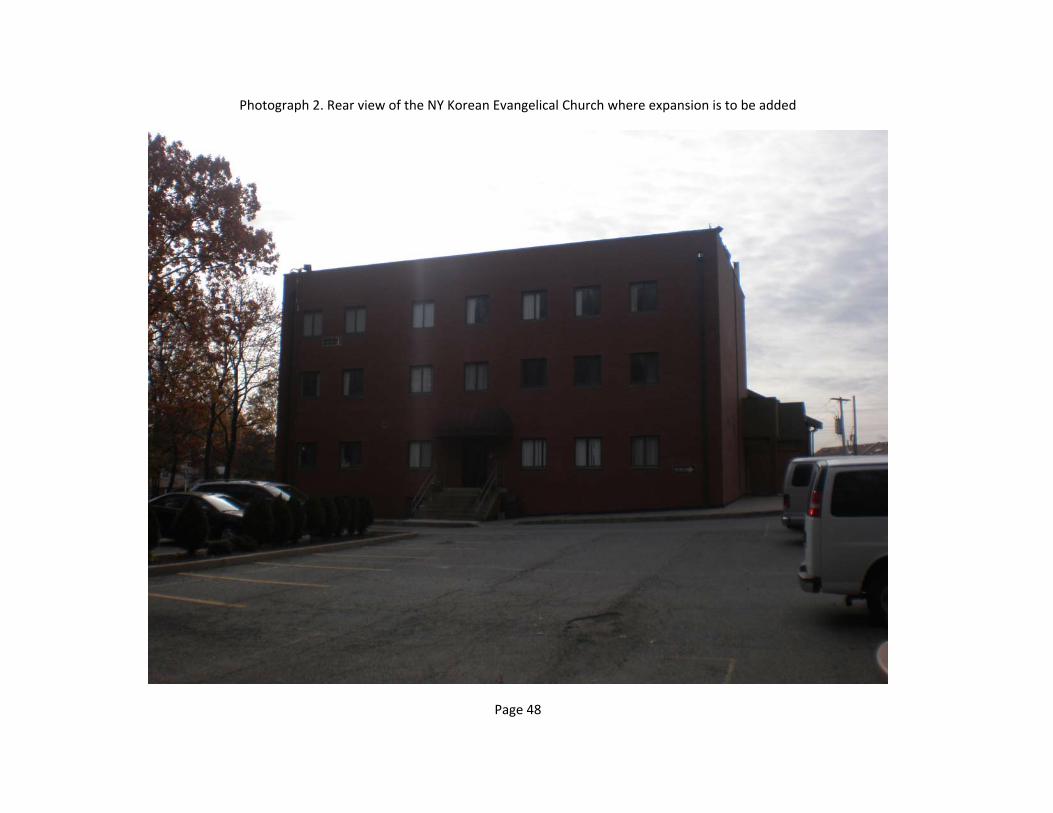
Photograph 2. Rear view of the NY Korean Evangelical Church where expansion is to be added………………………………………………..48
Photograph 3. Front view of a residential dwelling on 323 Arden Ave to be demolished……………………………………………………...……49
Photograph 4. Rear view of a residential dwelling on 323 Arden Ave to be demolished………………………………………………….………..….50
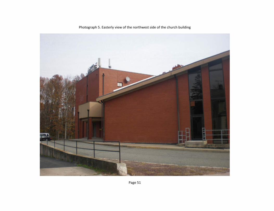
Photograph 5. Easterly view of the northwest side of the church building
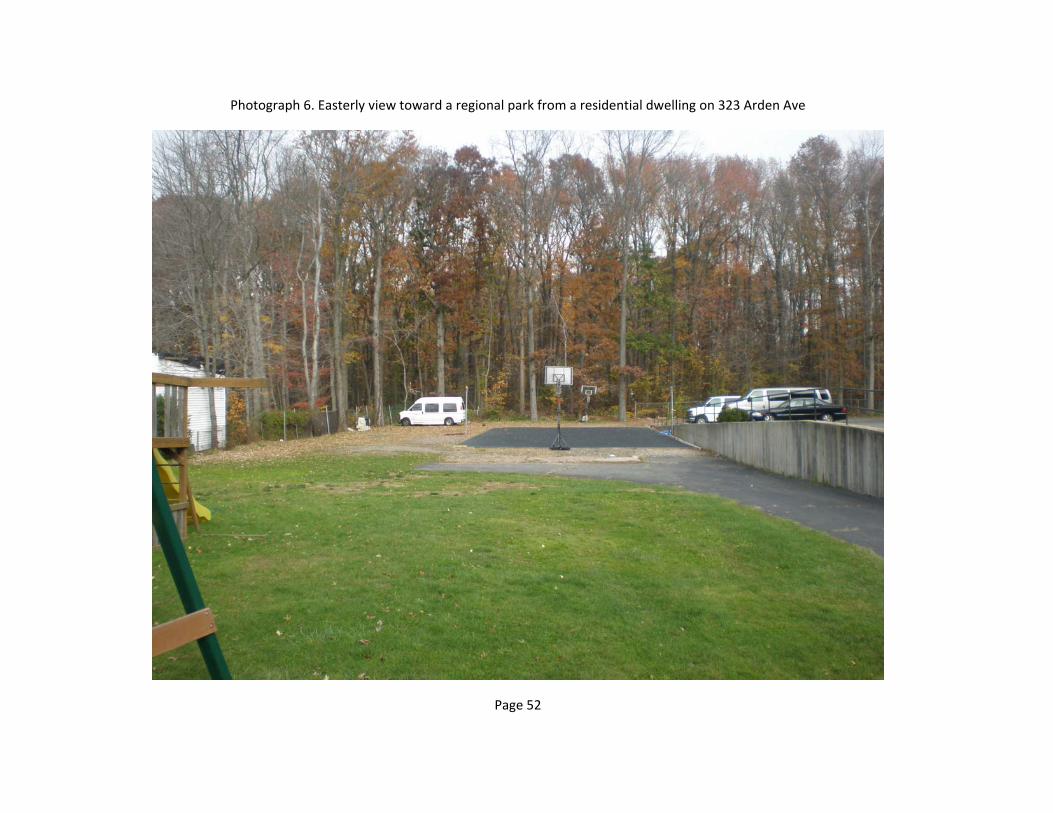
Photograph 6. Easterly view toward a regional park from a residential dwelling on 323 Arden Ave…………………………………………….52
Appendix C. Finding and Conclusions and Recommendation Section of Phase I
Environmental Site Assessment………………………………………………..54

Appendix D. New York City Waterfront Re vitalization Program, Consistency Assessment Forn……………………………………………………………….58
tM City Environmental Quality ReviewENVIRONMENTAL ASSESSMENT STATEMENT SHORT FORM ● for unlisted actions onlyPlease fill out, print and submit to the appropriate agency (see instructions)
PART I: GENERAL INFORMATION
1. Does Action Exceed Any Type I Threshold In 6 Nycrr Part 617.4 or 43 rcNy §6-15(A) (Executive Order 91 of 1977, as amended)?
Yes NoIf yes, STOP, and complete the FULL EAS
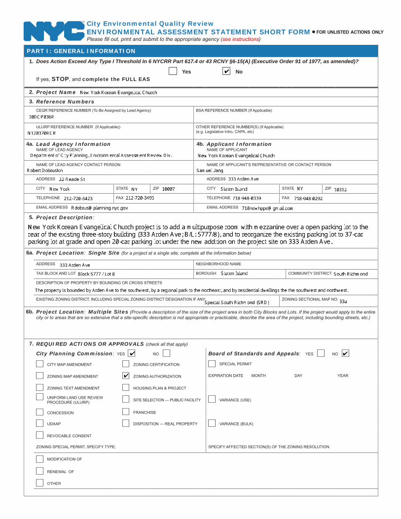
2. Project Name
3. Reference Numbers
CEQR REFERENCE NUMBER (To Be Assigned by Lead Agency) BSA REFERENCE NUMBER (If Applicable)
ULURP REFERENCE NUMBER (If Applicable)) OTHER REFERENCE NUMBER(S) (If Applicable) (e.g. Legislative Intro, CAPA, etc)
4a. Lead Agency InformationNAME OF LEAD AGENCY
4b. Applicant InformationNAME OF APPLICANT
NAME OF LEAD AGENCY CONTACT PERSON NAME OF APPLICANT’S REPRESENTATIVE OR CONTACT PERSON
ADDRESS ADDRESS
CITY STATE ZIP CITY STATE ZIP
TELEPHONE FAX TELEPHONE FAX
EMAIL ADDRESS EMAIL ADDRESS
5. Project Description:
6a. Project Location: Single Site (for a project at a single site, complete all the information below)
ADDRESS NEIGHBORHOOD NAME
TAX BLOCK AND LOT BOROUGH COMMUNITY DISTRICT
DESCRIPTION OF PROPERTY BY BOUNDING OR CROSS STREETS
EXISTING ZONING DISTRICT, INCLUDING SPECIAL ZONING DISTRICT DESIGNATION IF ANY: ZONING SECTIONAL MAP NO:
6b. Project Location: Multiple Sites (Provide a description of the size of the project area in both City Blocks and Lots. If the project would apply to the entire city or to areas that are so extensive that a site-specific description is not appropriate or practicable, describe the area of the project, including bounding streets, etc.)
7. REQUIRED ACTIONS OR APPROVALS (check all that apply)
City Planning Commission: YES NO Board of Standards and Appeals: YES NO
CITY MAP AMENDMENT ZONING CERTIFICATION SPECIAL PERMIT
ZONING MAP AMENDMENT ZONING AUTHORIZATION EXPIRATION DATE MONTH DAY YEAR
ZONING TEXT AMENDMENT HOUSING PLAN & PROjECT
UNIFORM LAND USE REVIEW PROCEDURE (ULURP) SITE SELECTION — PUBLIC FACILITY VARIANCE (USE)
CONCESSION FRANCHISE
UDAAP DISPOSITION — REAL PROPERTY VARIANCE (BULK)
REVOCABLE CONSENT
ZONING SPECIAL PERMIT, SPECIFY TYPE: SPECIFY AFFECTED SECTION(S) OF THE ZONING RESOLUTION
MODIFICATION OF
RENEWAL OF
other

eas short form page 2
Department of Environmental Protection: YES NO IF YES, IDENTIFY:
Other City Approvals: YES NO
LEGISLATION RULEMAKING
FUNDING OF CONSTRUCTION; SPECIFY: CONSTRUCTION OF PUBLIC FACILITIES
POLICY OR PLAN; SPECIFY: FUNDING OF PROGRAMS; SPECIFY:
LANDMARKS PRESERVATION COMMISSION APPROVAL (not subject to CEQR) PERMITS; SPECIFY:
384(b)(4) APPROVAL OTHER; EXPLAIN
PERMITS FROM DOT’S OFFICE OF CONSTRUCTION MITIGATION AND COORDINATION (OCMC) (not subject to CEQR)
State or Federal Actions/Approvals/Funding: YES NO IF “YES,” IDENTIFY:
8. Site Description: Except where otherwise indicated, provide the following information with regard to the directly affected area. The directly affected area consists of the project site and the area subject to any change in regulatory controls.GRAPhICS The following graphics must be attached and each box must be checked off before the EAS is complete. Each map must clearly depict the boundaries of
the directly affected area or areas and indicate a 400-foot radius drawn from the outer boundaries of the project site. Maps may not exceed 11×17 inches in size and must be folded to 8.5 ×11 inches for submission
Site location map Zoning map Photographs of the project site taken within 6 months of EAS submission and keyed to the site location map
Sanborn or other land use map Tax map For large areas or multiple sites, a GIS shape file that defines the project sites
PhySICAL SETTING (both developed and undeveloped areas)
Total directly affected area (sq. ft.): Type of Waterbody and surface area (sq. ft.): Roads, building and other paved surfaces (sq. ft.)
Other, describe (sq. ft.):
9. Physical Dimensions and Scale of Project (if the project affects multiple sites, provide the total development below facilitated by the action)
Size of project to be developed: (gross sq. ft.)
Does the proposed project involve changes in zoning on one or more sites? YES NO
If ‘Yes,’ identify the total square feet owned or controlled by the applicant: Total square feet of non-applicant owned development:
Does the proposed project involve in-ground excavation or subsurface disturbance, including but not limited to foundation work, pilings, utility lines, or grading? YES NO
If ‘Yes,’ indicate the estimated area and volume dimensions of subsurface disturbance (if known):
Area: sq. ft. (width × length) Volume: cubic feet (width × length × depth)
DESCRIPTION OF PROPOSED USES (please complete the following information as appropriate)
Residential Commercial Community Facility Industrial/Manufacturing
Size(in gross sq. ft.)
Type (e.g. retail, office, school) units
Does the proposed project increase the population of residents and/or on-site workers? YES NO Number of additional residents?
Number of additional workers?
Provide a brief explanation of how these numbers were determined:
Does the project create new open space? YES NO if Yes (sq. ft)
Using Table 14-1, estimate the project’s projected operational solid waste generation, if applicable: (pounds per week)
Using energy modeling or Table 15-1, estimate the project’s projected energy use: (annual BTUs)
Has a No-Action scenario been defined for this project that differs from the existing condition? YES NO
If ‘Yes,’ see Chapter 2, “Establishing the AnalysisFramework” and describe briefly:

eas short form page 3
PART II: TECHNICAL ANALYSES
INSTRUCTIONS: The questions in the following table refer to the thresholds for each analysis area in the respective chapter of the CEQR Technical Manual.
If the proposed project can be demonstrated not to meet or exceed the threshold, check the ‘• No’ box.
If the proposed project will meet or exceed the threshold, or if this cannot be determined, check the ‘• Yes’ box.
Often, a ‘Yes’ answer will result in a preliminary analysis to determine whether further analysis is needed. For each ‘Yes’ •response, consult the relevant chapter of the CEQR Technical Manual for guidance on providing additional analyses (and attach supporting information, if needed) to determine whether detailed analysis is needed. Please note that a ‘Yes’ answer does not mean that an EIS must be prepared—it often only means that more information is required for the lead agency to make a determination of significance.
The lead agency, upon reviewing Part II, may require an applicant either to provide additional information to support this Short •EAS Form or complete a Full EAS Form. For example, if a question is answered ‘No,’ an agency may request a short explanation for this response. In addition, if a large number of the questions are marked ‘Yes,’ the lead agency may determine that it is appropriate to require completion of the Full EAS Form.
YES NO1. LAND USE, ZONING AND PUBLIC POLICy: CEQR Technical Manual Chapter 4
(a) Would the proposed project result in a change in land use or zoning that is different from surrounding land uses and/or zoning?Is there the potential to affect an applicable public policy? If “Yes”, complete a preliminary assessment and attach.
(b) Is the project a large, publicly sponsored project? If “Yes”, complete a PlaNYC assessment and attach.
(c) Is any part of the directly affected area within the City’s Waterfront Revitalization Program boundaries?If “Yes”, complete the Consistency Assessment Form.
2. SOCIOECONOMIC CONDITIONS: CEQR Technical Manual Chapter 5
(a) Would the proposed project:
Generate a net increase of 200 or more residential units?•
Generate a net increase of 200,000 or more square feet of commercial space?•
Directly displace more than 500 residents?•
Directly displace more than 100 employees?•
Affect conditions in a specific industry?•
3. COMMUNITy FACILITIES: CEQR Technical Manual Chapter 6
(a) Does the proposed project exceed any of the thresholds outlined in Table 6-1 of Chapter 6?
4. OPEN SPACE: CEQR Technical Manual Chapter 7
(a) Would the proposed project change or eliminate existing open space?
(b) Is the proposed project within an underserved area in the Bronx, Brooklyn, Manhattan, Queens, or Staten Island?If “Yes,” would the proposed project generate 50 or more additional residents?
If “Yes,” would the proposed project generate 125 or more additional employees?
(c) Is the proposed project in a well-served area in the Bronx, Brooklyn, Manhattan, Queens, or Staten Island?If “Yes,” would the proposed project generate 300 or more additional residents?
If “Yes,” would the proposed project generate 750 or more additional employees?
(d) If the proposed project is not located in an underserved or well-served area, would the proposed project generate:200 or more additional residents?
500 additional employees?
10. Analysis year CEQR Technical Manual Chapter 2ANTICIPATED BUILD YEAR (DATE THE PROjECT WOULD BE COMPLETED AND OPERATIONAL): ANTICIPATED PERIOD OF CONSTRUCTION IN MONTHS:
WOULD THE PROjECT BE IMPLEMENTED IN A SINGLE PHASE? YES NO IF MULTIPLE PHASES, HOW MANY PHASES:
BRIEFLY DESCRIBE PHASES AND CONSTRUCTION SCHEDULE:
11. What is the Predominant Land Use in Vicinity of Project? (Check all that apply)
RESIDENTIAL MANUFACTURING COMMERCIAL PARK/FOREST/OPEN SPACE OTHER, Describe:

eas short form page 4
YES NO5. ShADOWS: CEQR Technical Manual Chapter 8
(a) Would the proposed project result in a net height increase of any structure of 50 feet or more?
(b) Would the proposed project result in any increase in structure height and be located adjacent to or across the street from a sunlight-sensitive resource?
6. hISTORIC AND CULTURAL RESOURCES: CEQR Technical Manual Chapter 9(a) Does the proposed project site or an adjacent site contain any architectural and/or archaeological resource that is eligible for, or
has been designated (or is calendared for consideration) as a New York City Landmark, Interior Landmark or Scenic Landmark; is listed or eligible for listing on the New York State or National Register of Historic Places; or is within a designated or eligible New York City, New York State, or National Register Historic District?
If “Yes,” list the resources and attach supporting information on whether the project would affect any of these resources.
7. URBAN DESIGN: CEQR Technical Manual Chapter 10
(a) Would the proposed project introduce a new building, a new building height, or result in any substantial physical alteration to the streetscape or public space in the vicinity of the proposed project that is not currently allowed by existing zoning?
(b) Would the proposed project result in obstruction of publicly accessible views to visual resources that is not currently allowed by existing zoning?
8. NATURAL RESOURCES: CEQR Technical Manual Chapter 11(a) Is any part of the directly affected area within the jamaica Bay Watershed?
If “Yes,” complete the jamaica Bay Watershed Form.
(b) Does the proposed project site or a site adjacent to the project contain natural resources as defined in section 100 of Chapter 11?If “Yes,” list the resources and attach supporting information on whether the project would affect any of these resources.
9. hAZARDOUS MATERIALS: CEQR Technical Manual Chapter 12(a) Would the project allow commercial or residential use in an area that is currently, or was historically, a manufacturing area that
involved hazardous materials? (b) Does the project site have existing institutional controls (e.g. (E) designations or a Restrictive Declaration) relating to hazardous
materials that preclude the potential for significant adverse impacts?(c) Would the project require soil disturbance in a manufacturing zone or any development on or near a manufacturing zone or
existing/historic facilities listed in Appendix 1 (including nonconforming uses)?(d) Would the project result in the development of a site where there is reason to suspect the presence of hazardous materials,
contamination, illegal dumping or fill, or fill material of unknown origin?(e) Would the project result in development where underground and/or aboveground storage tanks (e.g. gas stations) are or were
on or near the site?(f) Would the project result in renovation of interior existing space on a site with potential compromised air quality, vapor intrusion
from on-site or off-site sources, asbestos, PCBs or lead-based paint?(g) Would the project result in development on or near a government-listed voluntary cleanup/brownfield site, current or former power
generation/transmission facilities, municipal incinerators, coal gasification or gas storage sites, or railroad tracks and rights-of-way?(h) Has a Phase I Environmental Site Assessment been performed for the site?
If ‘Yes,” were RECs identified? Briefly identify:10. INFRASTRUCTURE: CEQR Technical Manual Chapter 13(a) Would the proposed project result in water demand of more than one million gallons per day?
(b) Is the proposed project located in a combined sewer area and result in at least 1,000 residential units or 250,000 SF or more of commercial space in Manhattan or at least 400 residential units or 150,000 SF or more of commercial space in the Bronx, Brooklyn, Staten Island or Queens?
(c) Is the proposed project located in a separately sewered area and result in the same or greater development than that listed in Table 13-1 of Chapter 13?
(d) Would the project involve development on a site five acres or larger where the amount of impervious surface would increase?
(e) Would the project involve development on a site one acre or larger where the amount of impervious surface would increase and is located within the jamaica Bay Watershed or in certain specific drainage areas including: Bronx River, Coney Island Creek, Flushing Bay and Creek, Gowanus Canal, Hutchinson River, Newtown Creek, or Westchester Creek?
(f) Is the project located in an area that is partially sewered or currently unsewered?
(g) Is the project proposing an industrial facility or activity that would contribute industrial discharges to a WWTP and/or generate contaminated stormwater in a separate storm sewer system?
(h) Would the project involve construction of a new stormwater outfall that requires federal and/or state permits?
11. SOLID WASTE AND SANITATION SERVICES: CEQR Technical Manual Chapter 14(a) Would the proposed project have the potential to generate 100,000 pounds (50 tons) or more of solid waste per week?
(b) Would the proposed project involve a reduction in capacity at a solid waste management facility used for refuse or recyclables generated within the City?

eas short form page 5
YES NO12. ENERGy: CEQR Technical Manual Chapter 15
(a) Would the proposed project affect the transmission or generation of energy?
13. TRANSPORTATION: CEQR Technical Manual Chapter 16
(a) Would the proposed project exceed any threshold identified in Table 16-1 of Chapter 16?
(b) If “Yes,” conduct the screening analyses, attach appropriate back up data as needed for each stage, and answer the following questions:
(1) Would the proposed project result in 50 or more Passenger Car Equivalents (PCEs) per project peak hour? If “Yes,” would the proposed project result in 50 or more vehicle trips per project peak hour at any given intersection?
**It should be noted that the lead agency may require further analysis of intersections of concern even when a project generates fewer than 50 vehicles in the peak hour. See Subsection 313 of Chapter 16, “Transporation,” for information.
(2) Would the proposed project result in more than 200 subway/rail or bus trips per project peak hour? If “Yes,” would the proposed project result, per project peak hour, in 50 or more bus trips on a single line (in one direction) or 200 subway trips per station or line?
(3) Would the proposed project result in more than 200 pedestrian trips per project peak hour? If “Yes,” would the proposed project result in more than 200 pedestrian trips per project peak hour to any given pedestrian or transit element, crosswalk, subway stair, or bus stop?
14. AIR QUALITy: CEQR Technical Manual Chapter 17
(a) Mobile Sources: Would the proposed project result in the conditions outlined in Section 210 of Chapter 17?
(b)Stationary Sources: Would the proposed project result in the conditions outlined in Section 220 of Chapter 17? If ‘Yes,’ would the proposed project exceed the thresholds in the Figure 17-3, Stationary Source Screen Graph? (attach
graph as needed)
(c) Does the proposed project involve multiple buildings on the project site?
(d) Does the proposed project require Federal approvals, support, licensing, or permits subject to conformity requirements?
(e) Does the proposed project site have existing institutional controls (e.g. E-designations or a Restrictive Declaration) relating to air quality that preclude the potential for significant adverse impacts?
15. GREENhOUSE GAS EMISSIONS: CEQR Technical Manual Chapter 18
(a) Is the proposed project a city capital project, a power plant, or would fundamentally change the City’s solid waste management system?
(b) If “Yes,” would the proposed project require a GHG emissions assessment based on the guidance in Chapter 18?
16. NOISE: CEQR Technical Manual Chapter 19
(a) Would the proposed project generate or reroute vehicular traffic?
(b)Would the proposed project introduce new or additional receptors (see Section 124 of Chapter 19) near heavily trafficked roadways, within one horizontal mile of an existing or proposed flight path, or within 1,500 feet of an existing or proposed rail line with a direct line of site to that rail line?
(c) Would the proposed project cause a stationary noise source to operate within 1,500 feet of a receptor with a direct line of sight to that receptor or introduce receptors into an area with high ambient stationary noise?
(d) Does the proposed project site have existing institutional controls (e.g. E-designations or a Restrictive Declaration) relating to noise that preclude the potential for significant adverse impacts?
17. PUBLIC hEALTh: CEQR Technical Manual Chapter 20
(a) Would the proposed project warrant a public health assessment based upon the guidance in Chapter 20?
18. NEIGhBORhOOD ChARACTER: CEQR Technical Manual Chapter 21
(a) Based upon the analyses conducted for the following technical areas, check yes if any of the following technical areas required a detailed analysis: Land Use, Zoning, and Public Policy, Socioeconomic Conditions, Open Space, Historic and Cultural Resources, Urban Design and Visu al Resources, Shadows, Transportation, Noise
If “Yes,” explain here why or why not an assessment of neighborhood character is warranted based on the guidance of in Chapter 21, “Neighborhood Character.” Attach a preliminary analysis, if necessary.


11
1. PROJECT DESCRIPTION
A. INTRODUCTION
New York Korean Evangelical Church project is to add a multipurpose room with a mezzanine
over a open parking lot to the rear of the existing three-story building on rear (333 Arden Ave;
Block / Lot: 5777 / 8) and to reorganize the existing parking lot to a 37-car parking lot at grade
and open 20-car parking lot under the new addition on the project site, including 37-car parking
spaces on the existing residential lot (323 Arden Ave; Block / Lot: 5777 / 15) that will require
demolishing the existing residential building.
Lots 8 and 15 on 333 Arden Ave and 323 Arden Ave, respectively, were merged into lot 8 and as
333 Arden Ave during the builder’s pavement plan submission with DOB and DOT.
The proposed action is located to the northeast of Arden Ave, generally bounded to the
southwest by the Arden Ave and Vespa Ave, to the northeast by a regional park, and to the
southwest and northwest by residential dwellings.
On April 9, 2010 the Applicant, New York Korean Evangelical Church filed with New York
City Department of City Planning for zoning authorizations relating to zoning resolution section
numbers 107-64 (Removal of Trees) and 107-68 (Modification of Group Parking and Access
Regulations). The project was assigned ULURP application Nos. N100301RAR, N100302RAR
and CEQR No. 10DCP036R. On March 24, 2011 the two ULURP applications were referred to
the Staten Island Community Board 3 by the Staten Island Department of City Planning (DCP).
A Negative Declaration was issued on March 28, 2011. The Project was referred out to the
Community Board on April 9, 2011 and received Community Board approval in May 2011 and
was referred to the City Planning Commission for approval.
12
In May 2011, prior to the City Planning Commission vote, the church was cited for trimming
trees on the property which was determined by the City of New York Parks & Recreation to have
damaged a tree marked for preservation. At this point, the project was put on hold and did not
proceed towards a CPC vote. On December 20, 2011 NYC Department of Buildings issued a
violation for the work conducted at the site. To correct the NYC Department of Buildings
violation the applicant filed with the NYC Department of City Planning for a Certification
Pursuant to ZR107-321. The ULURP (#N120370RCR) package was resubmitted with revised
site drawings, supplemental information and a new Discussion of Findings because the project
had not been formally approved by the City Planning Commission. This EAS has been revised
to take into account the proposed modification together with the original zoning authorization.
The proposed modification will not alter the conclusions of the previous environmental review
and Negative Declaration that was issued on March 28, 2011.
B. PROPOSED ACTIONS
1. The proposed action is a one (1) story multipurpose room with a mezzanine and open
parking spaces at grade beneath it (See Landscaping and Restoration Plan) for the
existing church. The proposed project will add 13,008 square feet (floor area) to the
existing church, thus making the total 28,013 square feet. The addition will include
offices and a grounds keeper’s apartment on the mezzanine floor, and a multipurpose
room, storage room, locker rooms, toilet rooms and a kitchen on the second floor.
Ground floor will be reorganized from the existing 40 stall open parking lot to a 20 stall
open lot. In addition, the proposed action will also create a new 37 stall open parking lot
13
(See Landscaping and Restoration Plan) on the northwest side of the site. The action
involves demolition of the existing residential building with minimal grading requirement.
The proposed action would require authorization of the Staten Island Special South
Richmond District Zoning Regulations 107-64 and 107-68 would facilitate compliance of
the church to the zoning regulation.
2. The proposed action will eliminate the illegal parking spaces on the Designated Open
Space (DOS) land on the northeast corner of the project site and resolve the violation
(Violation No.: 34856817Y) issued by the Department of Building on December 23,
2010 pursuant an authorization of ZR 107-68 from the Special South Richmond
Development District Zoning Regulations. The total number of parking will increase
from 40 to 57. The proposed action will remove the 6’ fence and asphalt illegally
occupying the DOS land and will restore the encroaching parking space to DOS with
DOS plantings. The proposed action would allow the church comply with the zoning
regulations. In addition, tree planting and screening within the proposed open parking
area will comply with Section 107-483 (Planting and screening for open parking areas).
3. The proposed action will resolve the violation (DOB Violation No.: 122011Z0303MJ)
that was resulted from excessive pruning of tree # 4P (now shown as tree 7R) at rear of
the property without prior approval by the City Planning Commission. The violation was
issued by the Department of Building on December 21, 2011. City Planning Department
requires replanting of six (6) trees to remove the violation as per Tree Preservation
Requirements of ZR 107-321D from the Special South Richmond Development District
Zoning Regulations. The proposed action will plant six (6) trees on CPC approved
location, bringing the applicant property into compliance with zoning regulations.
14
C. SITE DESCRIPTION
The New York Korean Evangelical Church is located in southwestern Staten Island between the
Pearl Harbor Memorial Expressway and the Korean War Memorial Parkway on the Arden Ave.
The project site consists of 1 zoning lot of 65,951 sq. ft. or 1.514 acres (62,850 sq. ft. or 1.442
acres to widening line) located on the northeast side of Arden Avenue directly opposite Vespa
Avenue. Originally there were two (2) lots: one irregular-shaped church building (approximately
15,005 square feet) on rectangular-shaped building lot (333 Arden Ave; Block / Lot: 5777 / 8),
and one rectangular-shaped (approximately 2,000 square feet) on rectangular-shaped lot (323
Arden Ave; Block / Lot: 5777 / 15). These two (2) lots 8 and 15 were merged to lot 8 during the
builder’s pavement plan submission with DOB and DOT. The area in general is residential
dwellings with a local park in R3X zone except a commercial development (retail shopping),
approximately 800 feet to the northeast of the project site.
D. PROPOSED PROJECT
The proposed project will add 13,008 square feet (floor area) to the existing church, thus making
the total 28,013 square feet. Already serving the area’s community needs by providing meeting
space for local PBA 123 and Council meeting, the expansion would serve the church as the
Youth Vision and Mission Center. The purpose of the action is to provide youth activity space
that is currently missing. It is also to accommodate the church’s need for the expanding overseas
missionary activity. It would provide visiting missionaries from overseas and their support
group a conference space for meeting. The added space would also be utilized as community’s
meeting space (i.e. local PBA and Council meeting).
15
The proposed project will also add 17-space parking spaces to the existing parking lot to be
reorganized therefore creating a 57-car space parking lot on the project site. The new parking
space would meet the church’s need (40 +/-) at the peak time of Sunday noon. This action would
minimize the possibility of street parking nearby the project site. The most recent U.S. Census
data
(http://www.hawaii.edu/hivandaids/Census_Profile__Asian_American_Population_in_Staten_Isl
and.pdf) indicated that the Korean population, which represents the basic ethnicity of the church,
in Staten Island, NY is approximately 3,500. Considering the number of Korean churches (total
10 churches) in Staten Island, the parking space of the proposed action is appropriate to
accommodate future needs. The anticipated build year would be 2014 with the anticipated
period of construction in 12 months.
The proposed action is only 2.66 feet taller than the existing building. The action is to construct
the expansion above the current parking lot behind the existing building parapet. Therefore no
environmental impact to natural resources is expected. The proposed project also requires two
land use actions, no public policy change, no special permits, no zoning map change and no
zoning text amendments (see Analyses). The proposed project does not involve in excavation
greater than two feet or city map changes for that the action is site-specific. The proposed action
will require land use alterations for authorization of zoning regulation 107-64 and 107-68 for
removal of trees and modification of group parking.
The existing church and parking lot were originally approved for 30-car parking spaces in 1990
by the Department of Buildings. Sometimes after the Certificate of Occupancy was issued, ten
additional parking spaces were added in the rear of the property without CPC approval.

16
Currently the illegal parking spaces are located on the Designated Open Space (DOS) land. The
DOB issued a Notice of Violation and Hearing (Violation No.: 34856817Y) to the Church,
which was ordered to cure the violation by February 10, 2012. The proposed action will
eliminate the illegal parking spaces on DOS land and thus remedy the violation through an
authorization of ZR 107-68 modification of group parking from Special South Richmond
Development District Zoning Regulations. Tree planting and screening within the proposed
open parking area will comply with Section 107-483 (Planting and screening for open parking
areas).
An existing tree (# 7R of CPC approved site plan BPP-006.07 and formerly #4P) was
excessively pruned in summer of 2011. This excessive pruning of tree # 4P affected the future
survival of said tree and resulted in violation of ZR 107-321D (DOB Violation No.:
122011Z0303MJ). The proposed action will remedy the violation through planting of six (6)
trees in CPC approved locations within the subject property.
E. REASONABLE WORST-CASE DEVELOPMENT SCENARIO (RWCDS)
The proposed project represents a worst-case development scenario. The demolition of the
existing residential dwelling would remove the house from the site and create 57-space parking
lot (37-car parking lot and a 20-car open parking lot beneath the addition). This site-specific
action, 323 Arden Ave, and the reasonable worst case development scenario are the same.
1. Proposed Modification

17
In with-action condition, one (1) residential building will be demolished and replaced by
parking spaces. Displacement of one (1) residential building will not impact housing
needs for the area (refer to the site plan). This proposed action will also facilitate
compliance of the church to Zoning Regulation for violation of illegal parking spaces by
returning the illegally occupied DOS land by and for the church to the DOS. The land
would be landscaped to match the appearance to the surrounding of the DOS lands. In
addition, this proposed action will remedy the violation as a result of excessive pruning
of tree # 7R by planting six (6) 5” trees.
Currently the existing church (333 Arden Ave/ Lot 8) has +/- 40-car parking spaces with
one residential building. Ten (10) illegal parking spaces were added in the rear of the
property without CPC approval. A few parking spaces were added on the Designated
Open Space (DOS) land, which was covered with asphalt and bordered by 6’ fence. At
the time when the church was approved with 30 parking spaces in 1990, the church’s
parking need was met with 30 parking spaces. When the church needed more spaces, the
illegal parking spaces were added on the DOS land sometime after the Certificate of
Occupancy (C/O) was issued. Later the illegal parking area on DOS land was paved with
asphalt and fenced with 6’ fence. However, ten (10) illegal parking spaces including
parking spaces on the DOS land will be removed. The DOS land will be recovered by
removing asphalt and 6’ fence by planting DOS plantings. The applicant contends this
will further aggravate the parking situation at the existing church, thus resulting in
parking of the church members in the neighborhood.
2. Effects of the Proposed Modification

18
The proposed modification will remove the violations (DOB Violation No.: 34856817Y
and DOB Violation No.: 122011Z0303MJ) and does not involve the building expansion.
The proposed modification will remove one tree (#7R) and plant six (6) additional trees
conforming to the existing surroundings of the DOS lands in location and types approved
by the CPC. In addition, the proposed modification will remove illegal parking space and
restoration of DOS lands through Authorization 107-68 and 107-321 of Zoning
Resolution, respectively. Therefore, the proposed modification will not affect the
conclusions of the previous environmental review on March 28, 2011.
The following table summarizes the RWCDS.
Table. Reasonable Worst-Case Development Scenario for Analysis
Current (sq. ft.) Anticipated (sq. ft.)
Lot 65, 951 65,951
Designated Open Space
(illegal space) 1,207.7 0
Church Building 15,005 15,005
Multipurpose room
expansion 0 13,008
Total for the church
building 15,005 28,013
Residential building 1,688 0
Parking (space) 40 57

19
Total (lot for the project
site) 67,158.7 65,951

20
2. Analyses
4. OPEN SPACE See CEQR Technical Manual Chapter 7 According to the CEQR Technical Manual, an open space assessment is typically conducted if the proposed action would directly affect an open space or if the action would increase the population by more than 200 residents or 500 workers. The proposed project is located neither in an under-served area nor in a well-served area per the CEQR Technical Manual (page 7-4). The proposed project will not result in increases in the number of residents and workers exceeding threshold of 500 workers and 200 residents that triggers quantified open space assessment. In addition the proposed action will restore the illegally occupied DOS land by the Church, in consultation with New York City Department of Parks and Recreation (DPR). Therefore the open space study will not be warranted for the proposed action.

21
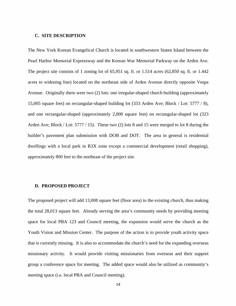
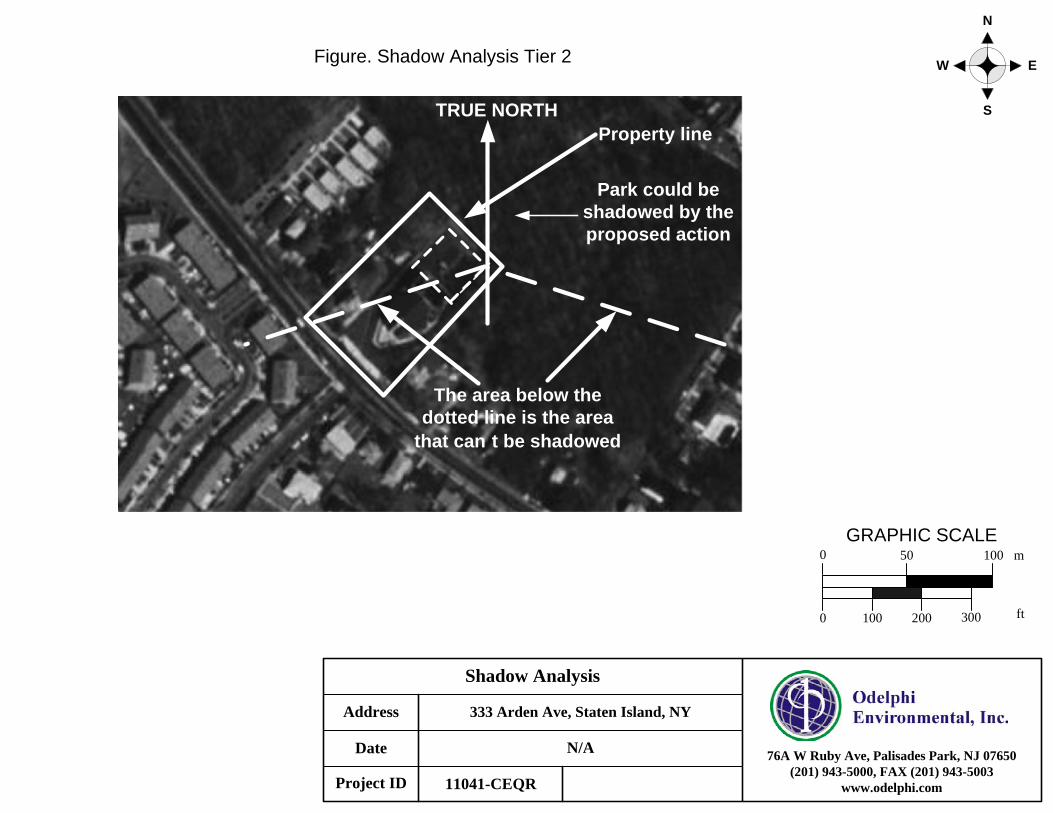
5. SHADOWS See CEQR Technical Manual Chapter 8 According to the CEQR Technical Manual, a shadow is defined as the circumstance in which a building or other built structure blocks the sun from the land. The manual stated that actions less than 50 feet tall generally require no shadow assessment. The proposed action is less than 50 feet tall but located adjacent to the sunlight-sensitive resource (Arden Heights Woods). Thus a shadow assessment is warranted for the proposed action as followed: Tier 1 Screening Assessment: Per 2010 CEQR Technical Manual, a base map is developed (Figure Shadow Analysis Tier 1, Page 23). The proposed action would result in expansion of the existing church with 41.08 feet height. Therefore, by using factor of 4.3, the longest shadow will be 176.6 feet long. The sunlight-sensitive park falls under the shadow of the proposed action. This warrants further assessment for shadow resulted by the proposed action. Tier 2 Screening Assessment: The base map shows the area that cannot be shaded by the proposed project. The northeastern side of the park from the project site can be shadowed by the proposed action (Figure Shadow Analysis Tier 2, Page 24). This warrant further assessment for shadow resulted by the proposed action. Tier 3 Screening Assessment: The proposed action presents itself as the worst case scenario for shadow from the building resulting from the proposed action. The distance to the park from the entering and existing is approximately 155 ft. The distance for the worst case scenario is 176.6 feet (Figure Shadow Analysis Tier 3 and Table 1. Shadow Analysis Summary, Page 25 and 26, respectively). Proposed
Action Reasonable Worst Case Development Scenario
No-Action
Condition
• As shown in Figure 1.1 (Page 27), the longest shadow would not
reach to the Arden Heights Park year-around.
With-
Action
Condition
• As shown in Figure 1.2 (Page 28), the longest shadow is 103 feet
based on the CEQR Technical Manual Shadow Appendix and occurs
on December 21. A sunlight-sensitive natural resource on the
northeast side of the project site is affected by the proposed action.
Detailed Shadow Analysis was performed based on the finding
(Figure 1.2 and Table 2).

22
Tier 4 Detailed Shadow Analysis: The proposed action shad shadows long enough to reach the sunlight-sensitive natural resource (Arden Heights Park) on the northeast side of the project site. Shadow entering and exiting angles are approximately -32o and 108o, respectively. Distances from shadow entering and existing point to the natural resource are approximately 160 feet and 170 feet, respectively. Distances to the sunlight-sensitive resource of shadow angle at -15 o, 0 o, and 45o are 85 feet, 65 feet, and 45 feet, respectively. The shortest distance from the shadow entering point to the natural resources is 34 feet from the northeast corner of the proposed building to the Arden Height Park. The proposed action would result in enlargement of the existing church building height to 41.08 feet. An hour and a half after sun-rise and before sunset was not utilized for analysis because of its insignificance to the natural resources per the CEQR Technical Manual (May 2010). Using these numbers, detailed shadow analysis was performed and the result is summarized in Table 2. Incremental shadows from the proposed building would reach the sunlight-sensitive source on December 21, March 21/September 21, May 6/August 6, and June 21. On December 21 analysis day, incremental shadow from the proposed building would enter the sunlight-sensitive resource at 10:53 a.m. and would exit the resource at 13:34 p.m., remaining in the resource for a total of 2 hour and 41 minutes. Considering the fact that the December 21 analysis day is not growing season for the natural resource, therefore, the shadow impact on the natural resource is not significant in winter season. On March 21/September 21, incremental shadow from the proposed building would enter the sunlight-sensitive resource at 13:32 p.m. and would exit the resource at 14:56 p.m., remaining in the resource for a total of 1 hour and 24 minutes. The impacted area of the sunlight sensitive resource receives approximately 4 hours and 26 minutes of direct sunlight. March 21/September analysis days are not growing season. Therefore the shadow impact on the natural resource is not considered significant. On May 21/August 21, incremental shadow from the proposed building would enter the sunlight-sensitive resource at 14:48 p.m. and would exit the resource at 15:47 p.m., remaining in the resource for a total of 59 minutes. The impacted area of the sunlight sensitive resource receives approximately 4 hours and 54 minutes of direct sunlight. The incremental shadow from the proposed building would cover only a small portion of the resource and the majority of the resource would continue to receive direct sunlight during this period of time. Give the marginal extent and relatively short duration of the incremental shadow on this analysis day, the incremental shadow is not considered significant. On June 21, incremental shadow from the proposed building would enter the sunlight-sensitive resource at 15:09 p.m. and would exit the resource at 16:33 p.m., remaining in the resource for a total of 1 hour and 24 minutes. The impacted area of the sunlight sensitive resource receives approximately 5 hours and 22 minutes of direct sunlight throughout the day. The incremental shadow from the proposed building would cover only a small portion of the resource and the majority of the resource would continue to receive direct sunlight during this period of time. Give the marginal extent and relatively short duration of the

23
incremental shadow on this analysis day, the incremental shadow is not considered significant. Determination of the Impact Significance: Incremental shadow would reach the sunlight sensitive resource in analysis days listed in the CEQR Technical Manual (May 2010) Shadow Appendix. However, the incremental shadow is not considered significant based on following reasons:
1) Relatively short duration of the shadow on the sunlight sensitive resource: Maximum incremental shadow occurs during non growing season. For growing season from May to August, the incremental shadow reaches the resource only for short duration. The resource also receives minimum of 4 hours of direct sunlight during growing season.
2) Relatively small impacted area: The incremental shadow from the proposed building would cover only small portion of the sunlight sensitive resource and the majority of the resource would continue to receive direct sunlight during the peak growing season.
3) Natural resource uses: The portion of the area impacted by the incremental shadow has neither passive use nor active use. The incremental shadow would not impact the resource uses.
4) Vegetation in the incremental shadow impacted area: The portion of the area impacted by the incremental shadow is mainly covered by 20 to 30 feet-high trees. The vegetation in the area is already shaded by the tree canopies. The trees in the area receives minimum of 4 hours of direct sunlight.

Shadow Analysis
N/A
11041-CEQR
N
S
EW
333 Arden Ave, Staten Island, NYAddress
Date
Project ID
76A W Ruby Ave, Palisades Park, NJ 07650(201) 943-5000, FAX (201) 943-5003
www.odelphi.com
GRAPHIC SCALE0 50 100 m
0 100 200 300 ft
Longest shadowTRUE NORTH
Figure. Shadow Analysis Tier 1
Park is located within the longest
shadow
Shadow Analysis
N/A
11041-CEQR
N
S
EW
333 Arden Ave, Staten Island, NYAddress
Date
Project ID
76A W Ruby Ave, Palisades Park, NJ 07650(201) 943-5000, FAX (201) 943-5003
www.odelphi.com
GRAPHIC SCALE0 50 100 m
0 100 200 300 ft
The area below the dotted line is the area
that can t be shadowed
TRUE NORTH
Figure. Shadow Analysis Tier 2
Property line
Park could be shadowed by the proposed action

Shadow Analysis
N/A
11041-CEQR
N
S
EW
333 Arden Ave, Staten Island, NYAddress
Date
Project ID
76A W Ruby Ave, Palisades Park, NJ 07650(201) 943-5000, FAX (201) 943-5003
www.odelphi.com
GRAPHIC SCALE0 50 100 m
0 100 200 300 ft
Longest shadow
The area below the dotted line is the area
that can t be shadowed
TRUE NORTH
Figure Shadow Analysis Tier 3

Table 1. Shadow Analysis Summary for Arden Heights Woods
Table 1. Shadow Analysis Summary for Arden Heights Woods Analysis Day December 21 March 21/
September 21 May 6/ August 6
June 21
Timeframe window
10:22 AM – 13:34 PM 9:05 AM – 14:56 PM 7:58 AM – 15:47 PM 7:25 PM – 16:33 PM
Shadow enter – exit time
10:22 AM – 13:34 PM 10:33 AM – 14:56 PM 10:53 AM – 15:47 PM 11:11 AM – 16:33 PM
Incremental shadow duration
3 hr 12 min 4 hr 23 min 4 hr 54 min 5 hr 22 min
Shadow enter – exit distance (ft)
100 – 103 42 – 63 21 – 60 14 – 70
Note: Daylight savings time not used

Shadow Analysis: future No-Action Condition
N/A
11041-CEQR
N
S
EW
333 Arden Ave, Staten Island, NYAddress
Date
Project ID
76A W Ruby Ave, Palisades Park, NJ 07650(201) 943-5000, FAX (201) 943-5003
www.odelphi.com
GRAPHIC SCALE0 50 100 m
0 100 200 300 ft
The area below the dotted line is the area that can t be shadowed
TRUE NORTH
Figure 1.1 Shadow Analysis: future No-Action Condition
Entering Angle
Exiting Angle
Arden Heights Park
Longest shadow
Shadow Analysis: future With-Action Condition
N/A
11041-CEQR
N
S
EW
333 Arden Ave, Staten Island, NYAddress
Date
Project ID
76A W Ruby Ave, Palisades Park, NJ 07650(201) 943-5000, FAX (201) 943-5003
www.odelphi.com
GRAPHIC SCALE0 50 100 m
0 100 200 300 ft
The area below the dotted line is the area that can t be shadowed
TRUE NORTH
Figure 1.2 Shadow Analysis: future With-Action Condition
Entering Angle
Exiting Angle
Arden Heights ParkLongest shadow
Proposed Action

Table 2. Shade Distance by the Shadow Factors and Time of Day for Each Shadow Angle
Angle June 21 May 6/August 6 March 21/September 21 December 21 Shadow Length Factor
Eastern Standard Time
Shadow Length (feet)
Shadow Length Factor
Eastern Standard Time
Shadow Length (feet)
Shadow Length Factor
Eastern Standard Time
Shadow Length (feet)
Shadow Length Factor
Eastern Standard Time
Shadow Length (feet)
‐32 0.36 11:11 14.8 0.53 10:53 21.7 1.03 10:33 42.2 ‐23 2.44 10:22 100.1 ‐22 0.49 11:13 20.1 0.94 11:03 38.5 ‐15 2.21 10:53 86.5 ‐11 0.32 11:41 13.1 0.89 11:33 36.5 ‐7 0.46 11:40 18.9 2.09 11:25 85.7 0 0.87 12:03 35.6 1 1.07 11:56 84.9 9 2.11 12:28 86.5 11 0.89 12:32 36.5 12 0.32 12:11 13.1 0.47 12:14 19.2 16 2.23 12:56 91.4 22 0.94 13:02 38.5 25 2.52 13:34 103.3 30 0.52 12:48 21.32 32 1.03 13:32 42.2 33 0.36 12:42 14.8 41 1.16 14:02 47.6 42 0.59 13:15 24.2 49 0.44 13:13 18.1 1.33 14.31 54.5 55 0.71 13:48 29.1 1.54 14:56 63.1 61 0.55 13:44 22.5 0.81 14:12 33.2 70 0.67 14:14 27.5 1.01 14:48 41.4 77 0.81 14:44 33.3 1.24 15:16 50.84 82 0.96 15:09 39.4 1.48 15:47 60.7 90 1.29 15:54 52.9 96 1.72 16:33 70.5

• Analysis for shaded cells are not applicable to the proposed action
• Bold and red font indicates the shadow reaching the sunlight‐sensitive natural resources.

32
7. URBAN DESIGN See CEQR Technical Manual Chapter 10 According to the CEQR Technical Manual, an assessment of urban design is appropriate if an action would be expected to result in a significant change in building or structures substantially different in height, bulk, form, setback, size, scale, use or arrangement than exists; or block form; or demapping an active street; mapping a new street; or affecting the street hierarchy, street wall, curb cuts, pedestrian activity, or other streetscape elements. The proposed action will not significantly change built form and arrangement of streets in the project area. The expansion would only be 3 feet higher than the existing building and is located behind the existing building. The expansion would not have conspicuous view from the street because the existing building blocks the view of the proposed expansion. The proposed action will be constructed within existing zoning envelopes and will not result in physical changes beyond the bulk and form permitted “as-of-right.” Therefore, the proposed action does not warrant a detailed Urban Design Assessment.

33
9. HAZARDOUS MATERIALS See CEQR Technical Manual Chapter 12 According to the CEQR Technical Manual, a hazardous material is a substance that poses a threat to human health or the environment. Substances that can be of concern include, but are not limited to, heavy metal, volatile organic compounds, semivolatile organic compounds, methane, polychlorinated biphenyls, pesticides, polychlorinated dibenzodioxins and dibenzofurans, and hazardous wastes. A hazardous material assessment is warranted when: a) elevated levels of hazardous materials exist on a site; b) an action would increase pathways to their exposure, either human or environmental; or c) an action would introduce new activities or processes using hazardous materials and the risk of human or environmental exposure is increased. A Phase I Environmental Site Assessment (ESA) was prepared for the project site in December 2008 and recommended no further action or subsurface investigation due to the minimal risk of contamination. New York City Department of Environmental Protection (DEP) and Bureau of Environmental Planning and Analysis had reviewed the Phase I. The City DEP concluded that there is minimal risk of contamination and recommended no further action and /or subsurface investigation in a correspondence to Mr. Robert Dobruskin of the City Department of City Planning, dated March 9, 2011 with tracking number of 11DEPTECH0378R assigned (see attached, page 33-34). Executive Summary is attached in Appendix C. Full Phase I ESA is provided in a CD. The project site is used as a church building and a residential building. The current use of the site does not involve in use of any hazardous materials per the CEQR Technical Manual. Visual inspection did not identify any presence of hazardous materials and any indication of contamination such as distressed vegetation, stains, smells, and hazardous material containers. No vent pipe or fill port was observed. The historical records such as Sanborn Fire Insurance Map, historical aerial photographs, and historical city directories indicated that the project site has not been used as industrial or commercial premises that involve in using hazardous materials such as oils, gasoline, pesticides, and industrial and commercial solvents. The project site has been historically a residential dwelling that was converted to a church in 1991 and appeared to be vacant land prior to the construction of the former residential building. Staten Island Building Department indicated that the proposed site has no records of environmental concerns such as heating oil underground storage tank. Government environmental database (EDR) was reviewed and did not identify the project site in any of the list. Therefore the Environmental Impact Assessment (EIS) is not warranted because of absence of hazardous materials, no human or environmental exposure pathways, and no activities or processes using hazardous materials.

36
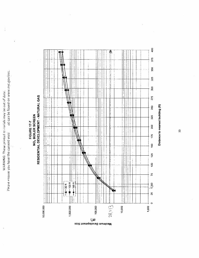
14. AIR QUALITY See CEQR Technical Manual Chapter 17 According to the CEQR Technical Manual, a detailed air quality assessment is required for actions that can result in significant mobile source air quality impacts when they increase or cause a redistribution of traffic, create any other mobile sources of pollutants, or add new uses near mobile sources. It is also required for actions that can result in stationary source air quality impacts when they create new stationary sources of pollutants such as emission stacks for industrial plants, hospital, or other large institutional uses. The proposed action will not significantly change the traffic volume and pattern in the area. The project site is for use on Sunday and peak hour traffic would be below 150 vehicular trip air quality threshold during any peak hour for this area of the city. Also the action will not create new mobile air quality sources. Screening analysis was performed for the proposed action as per the CEQR Technical Manual (Chapter 7, section 322.1). The proposed action will enlarge the existing building with maximum height of 41.08 feet. Thus the stack height for the building is assumed to be 44.08 feet per the CEQR Technical Manual. Based on the Staten Island Borough President Map and NYCityMap (http://gis.nyc.gov/doitt/nycitymap/), no building or structure with similar or greater height than the proposed stack height was identified within 400 ft. Therefore the distance was assumed to be 400 ft. The size of the proposed development is 28,013 sq. ft. From Figure 17-7 (see attached, Page 33), the proposed action is below the applicable curve of 30 feet building height. Therefore a potential significant impact due to boiler stack emissions is unlikely and no further analysis is needed.

Appendix A. Figures

Figure 1. Site Location Map
Page 39

Project Rendering
Page 40

Figure 2. Site Tax Map

Figuire 3. Site Aerial Photograph
Page 42
Casey Oh
Polygonal Line

bill
Polygon
bill
Oval
bill
Oval
bill
Oval
bill
Oval
bill
Oval
bill
Oval
bill
Oval
bill
Oval
Page 44
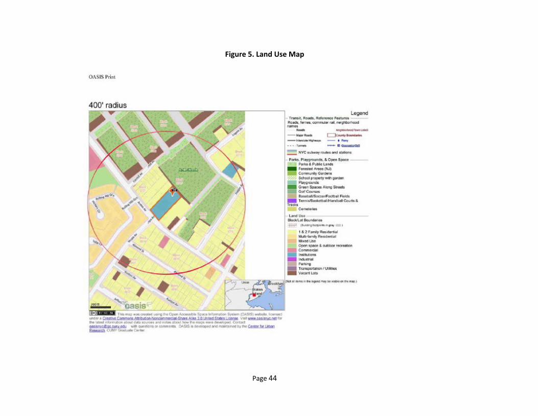
Figure 5. Land Use Map

Figure 6. Historical Sanborn Insurance Map
Page 45

Appendix B. Site Photographs

Photograph 1. Front view of the NY Korean Evangelical Church
Page 47
Photograph 2. Rear view of the NY Korean Evangelical Church where expansion is to be added
Page 48

Photograph 3. Front view of a residential dwelling on 323 Arden Ave to be demolished
Page 49

Photograph 4. Rear view of a residential dwelling on 323 Arden Ave to be demolished
Page 50
Photograph 5. Easterly view of the northwest side of the church building
Page 51
Photograph 6. Easterly view toward a regional park from a residential dwelling on 323 Arden Ave
Page 52

Appendix C. Phase I Environmental Site Assessment
4
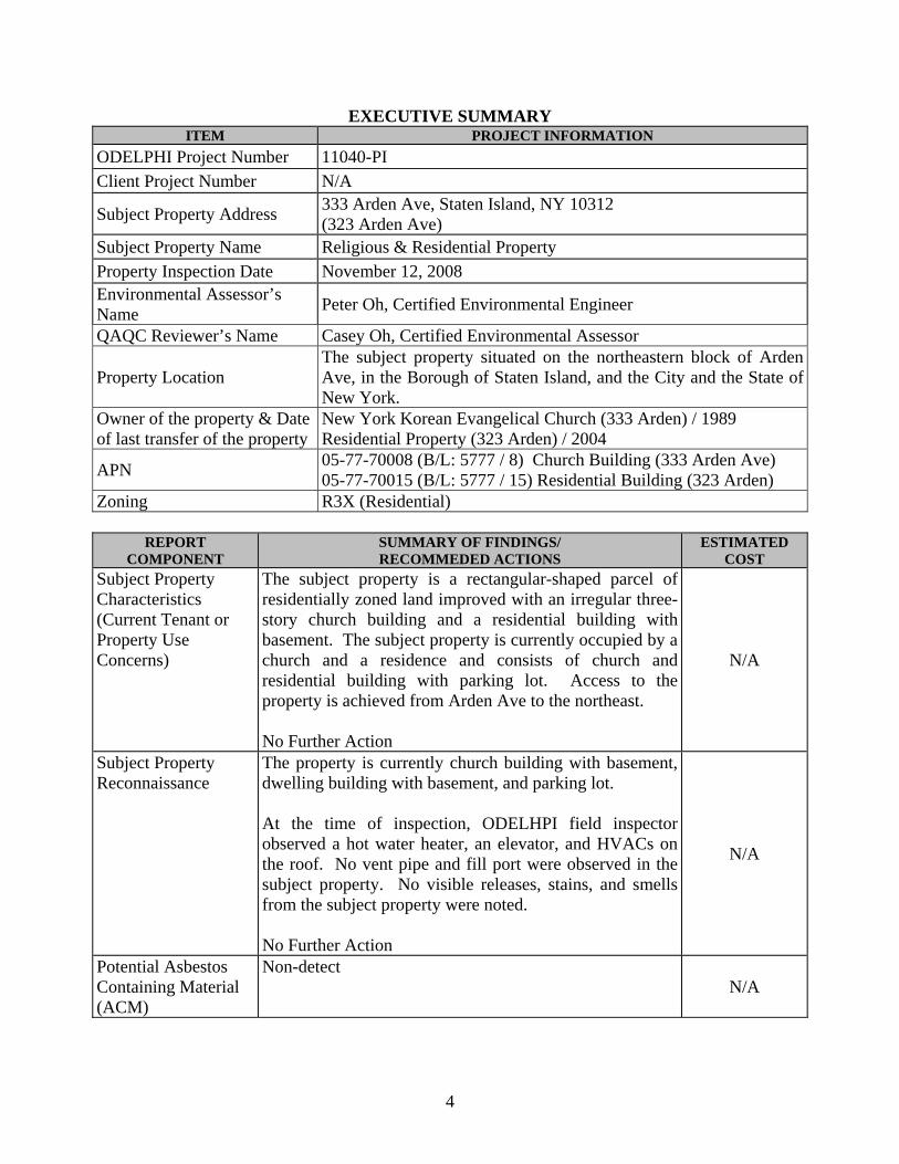
EXECUTIVE SUMMARY ITEM PROJECT INFORMATION
ODELPHI Project Number 11040-PI Client Project Number N/A
Subject Property Address 333 Arden Ave, Staten Island, NY 10312 (323 Arden Ave)
Subject Property Name Religious & Residential Property Property Inspection Date November 12, 2008 Environmental Assessor’s Name Peter Oh, Certified Environmental Engineer
QAQC Reviewer’s Name Casey Oh, Certified Environmental Assessor
Property Location The subject property situated on the northeastern block of Arden Ave, in the Borough of Staten Island, and the City and the State of New York.
Owner of the property & Date of last transfer of the property
New York Korean Evangelical Church (333 Arden) / 1989 Residential Property (323 Arden) / 2004
APN 05-77-70008 (B/L: 5777 / 8) Church Building (333 Arden Ave) 05-77-70015 (B/L: 5777 / 15) Residential Building (323 Arden)
Zoning R3X (Residential)
REPORT COMPONENT
SUMMARY OF FINDINGS/ RECOMMEDED ACTIONS
ESTIMATED COST
Subject Property Characteristics (Current Tenant or Property Use Concerns)
The subject property is a rectangular-shaped parcel of residentially zoned land improved with an irregular three-story church building and a residential building with basement. The subject property is currently occupied by a church and a residence and consists of church and residential building with parking lot. Access to the property is achieved from Arden Ave to the northeast. No Further Action
N/A
Subject Property Reconnaissance
The property is currently church building with basement, dwelling building with basement, and parking lot. At the time of inspection, ODELHPI field inspector observed a hot water heater, an elevator, and HVACs on the roof. No vent pipe and fill port were observed in the subject property. No visible releases, stains, and smells from the subject property were noted. No Further Action
N/A
Potential Asbestos Containing Material (ACM)
Non-detect N/A
5
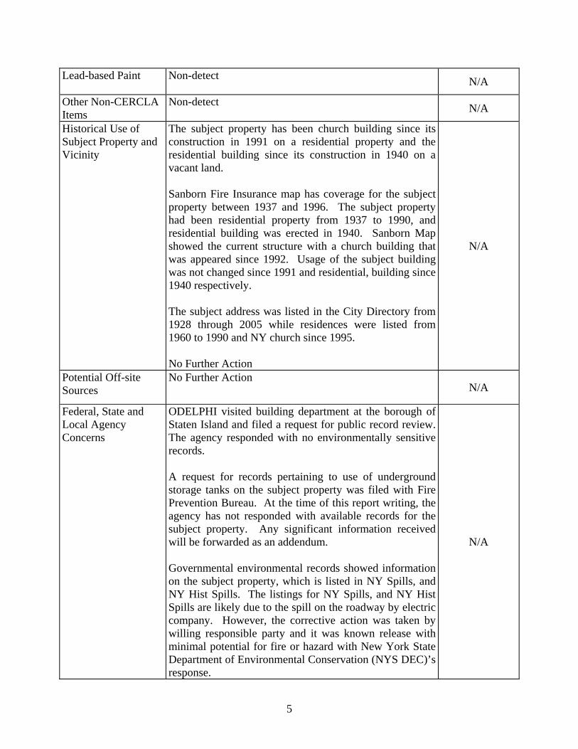
Lead-based Paint Non-detect N/A
Other Non-CERCLA Items
Non-detect N/A
Historical Use of Subject Property and Vicinity
The subject property has been church building since its construction in 1991 on a residential property and the residential building since its construction in 1940 on a vacant land. Sanborn Fire Insurance map has coverage for the subject property between 1937 and 1996. The subject property had been residential property from 1937 to 1990, and residential building was erected in 1940. Sanborn Map showed the current structure with a church building that was appeared since 1992. Usage of the subject building was not changed since 1991 and residential, building since 1940 respectively. The subject address was listed in the City Directory from 1928 through 2005 while residences were listed from 1960 to 1990 and NY church since 1995. No Further Action
N/A
Potential Off-site Sources
No Further Action N/A
Federal, State and Local Agency Concerns
ODELPHI visited building department at the borough of Staten Island and filed a request for public record review. The agency responded with no environmentally sensitive records. A request for records pertaining to use of underground storage tanks on the subject property was filed with Fire Prevention Bureau. At the time of this report writing, the agency has not responded with available records for the subject property. Any significant information received will be forwarded as an addendum. Governmental environmental records showed information on the subject property, which is listed in NY Spills, and NY Hist Spills. The listings for NY Spills, and NY Hist Spills are likely due to the spill on the roadway by electric company. However, the corrective action was taken by willing responsible party and it was known release with minimal potential for fire or hazard with New York State Department of Environmental Conservation (NYS DEC)’s response.
N/A

6
Adjacent properties were not appeared to impact the subject property considering their distance, geology, and regulatory status. No Further Action
Inaccessible or un-surveyed portions of subject property
There were no other notable portions of the subject property excluded from this survey.
N/A
Based on the visual inspection, historical database search, Federal, State, and local agencies record searches, and interviews, ODELPHI identified the following Recognized Environmental Condition:
• Governmental environmental records showed information on the subject property, which is listed in NY Spills, and NY Hist Spills. The listings for NY Spills, and NY Hist Spills are likely due to the spill on the roadway by electric company. However, the corrective action was taken by willing responsible party and it was known release with minimal potential for fire or hazard with New York State Department of Environmental Conservation (NYS DEC)’s response.
Considering the historical and the current use of the subject property, no further action and subsurface investigation are recommended based on the current site condition and available public records due to the minimal risk of contamination at the subject property.

Appendix D. New York City Waterfront Re vitalization Program,
Consistency Assessment Forn

WRP consistency form - January 2003 2
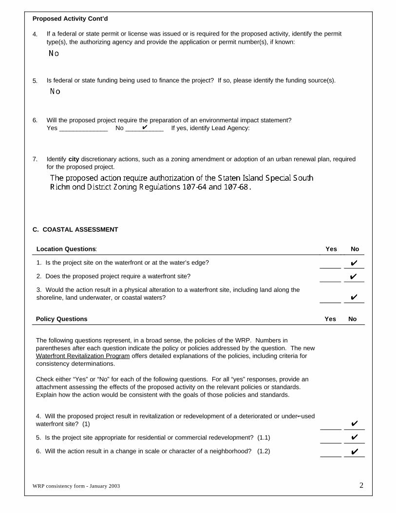
Proposed Activity Cont’d
4. If a federal or state permit or license was issued or is required for the proposed activity, identify the permittype(s), the authorizing agency and provide the application or permit number(s), if known:
5. Is federal or state funding being used to finance the project? If so, please identify the funding source(s).
6. Will the proposed project require the preparation of an environmental impact statement? Yes ______________ No ___________ If yes, identify Lead Agency:
7. Identify city discretionary actions, such as a zoning amendment or adoption of an urban renewal plan, requiredfor the proposed project.
C. COASTAL ASSESSMENT
Location Questions: Yes No
1. Is the project site on the waterfront or at the water’s edge?
2. Does the proposed project require a waterfront site?
3. Would the action result in a physical alteration to a waterfront site, including land along theshoreline, land underwater, or coastal waters?
Policy Questions Yes No
The following questions represent, in a broad sense, the policies of the WRP. Numbers in parentheses after each question indicate the policy or policies addressed by the question. The newWaterfront Revitalization Program offers detailed explanations of the policies, including criteria forconsistency determinations.
Check either “Yes” or “No” for each of the following questions. For all “yes” responses, provide anattachment assessing the effects of the proposed activity on the relevant policies or standards.Explain how the action would be consistent with the goals of those policies and standards.
4. Will the proposed project result in revitalization or redevelopment of a deteriorated or under- usedwaterfront site? (1)
5. Is the project site appropriate for residential or commercial redevelopment? (1.1)
6. Will the action result in a change in scale or character of a neighborhood? (1.2)

WRP consistency form - January 2003 3
Policy Questions cont’d Yes No
7. Will the proposed activity require provision of new public services or infrastructure in undevelopedor sparsely populated sections of the coastal area? (1.3)
8. Is the action located in one of the designated Significant Maritime and Industrial Areas (SMIA):South Bronx, Newtown Creek, Brooklyn Navy Yard, Red Hook, Sunset Park, or Staten Island? (2)
9. Are there any waterfront structures, such as piers, docks, bulkheads or wharves, located on theproject sites? (2)
10. Would the action involve the siting or construction of a facility essential to the generation or transmission of energy, or a natural gas facility, or would it develop new energy resources? (2.1)
11. Does the action involve the siting of a working waterfront use outside of a SMIA? (2.2)
12. Does the proposed project involve infrastructure improvement, such as construction or repair ofpiers, docks, or bulkheads? (2.3, 3.2)
13. Would the action involve mining, dredging, or dredge disposal, or placement of dredged or fillmaterials in coastal waters? (2.3, 3.1, 4, 5.3, 6.3)
14. Would the action be located in a commercial or recreational boating center, such as CityIsland, Sheepshead Bay or Great Kills or an area devoted to water-dependent transportation? (3)
15. Would the proposed project have an adverse effect upon the land or water uses within acommercial or recreation boating center or water-dependent transportation center? (3.1)
16. Would the proposed project create any conflicts between commercial and recreational boating? (3.2)
17. Does the proposed project involve any boating activity that would have an impact on the aquaticenvironment or surrounding land and water uses? (3.3)
18. Is the action located in one of the designated Special Natural Waterfront Areas (SNWA): LongIsland Sound- East River, Jamaica Bay, or Northwest Staten Island? (4 and 9.2)
19. Is the project site in or adjacent to a Significant Coastal Fish and Wildlife Habitat? (4.1)
20. Is the site located within or adjacent to a Recognized Ecological Complex: South Shore ofStaten Island or Riverdale Natural Area District? (4.1and 9.2)
21. Would the action involve any activity in or near a tidal or freshwater wetland? (4.2)
22. Does the project site contain a rare ecological community or would the proposed project affect avulnerable plant, fish, or wildlife species? (4.3)
23. Would the action have any effects on commercial or recreational use of fish resources? (4.4)
24. Would the proposed project in any way affect the water quality classification of nearby waters or be unable to be consistent with that classification? (5)
25. Would the action result in any direct or indirect discharges, including toxins, hazardoussubstances, or other pollutants, effluent, or waste, into any waterbody? (5.1)
26. Would the action result in the draining of stormwater runoff or sewer overflows into coastalwaters? (5.1)
27. Will any activity associated with the project generate nonpoint source pollution? (5.2)
28. Would the action cause violations of the National or State air quality standards? (5.2)

WRP consistency form - January 2003 4
Policy Questions cont’d Yes No
29. Would the action result in significant amounts of acid rain precursors (nitrates and sulfates)?(5.2C)
30. Will the project involve the excavation or placing of fill in or near navigable waters, marshes,estuaries, tidal marshes or other wetlands? (5.3)
31. Would the proposed action have any effects on surface or ground water supplies? (5.4)
32. Would the action result in any activities within a federally designated flood hazard area or state-designated erosion hazards area? (6)
33. Would the action result in any construction activities that would lead to erosion? (6)
34. Would the action involve construction or reconstruction of a flood or erosion control structure? (6.1)
35. Would the action involve any new or increased activity on or near any beach, dune, barrierisland, or bluff? (6.1)
36. Does the proposed project involve use of public funds for flood prevention or erosion control?(6.2)
37. Would the proposed project affect a non-renewable source of sand ? (6.3)
38. Would the action result in shipping, handling, or storing of solid wastes, hazardous materials, orother pollutants? (7)
39. Would the action affect any sites that have been used as landfills? (7.1)
40. Would the action result in development of a site that may contain contamination or that hasa history of underground fuel tanks, oil spills, or other form or petroleum product use or storage? (7.2)
41. Will the proposed activity result in any transport, storage, treatment, or disposal of solid wastesor hazardous materials, or the siting of a solid or hazardous waste facility? (7.3)
42. Would the action result in a reduction of existing or required access to or along coastal waters,public access areas, or public parks or open spaces? (8)
43. Will the proposed project affect or be located in, on, or adjacent to any federal, state, or citypark or other land in public ownership protected for open space preservation? (8)
44. Would the action result in the provision of open space without provision for its maintenance? (8.1)
45. Would the action result in any development along the shoreline but NOT include new water-enhanced or water-dependent recreational space? (8.2)
46. Will the proposed project impede visual access to coastal lands, waters and open space? (8.3)
47. Does the proposed project involve publicly owned or acquired land that could accommodate waterfront open space or recreation? (8.4)
48. Does the project site involve lands or waters held in public trust by the state or city? (8.5)
49. Would the action affect natural or built resources that contribute to the scenic quality of acoastal area? (9)
50. Does the site currently include elements that degrade the area’s scenic quality or block viewsto the water? (9.1)