New Urban Regeneration for the City of Amman Using ...
14
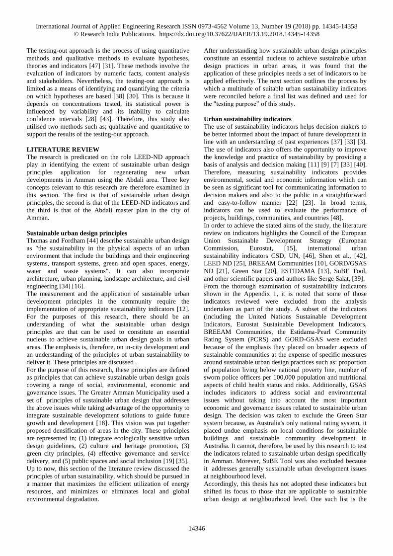
International Journal of Applied Engineering Research ISSN 0973-4562 Volume 13, Number 19 (2018) pp. 14345-14358 © Research India Publications. https://dx.doi.org/10.37622/IJAER/13.19.2018.14345-14358 14345 New Urban Regeneration for the City of Amman Using Sustainable Urban Design Principles: Al-Abdali Area As a Case Study Rami Khaled Al Shawabkeh 1 Research Scholar, Department of Architecture, Al-Albayt University, Mafraq 25113, Jordan. Abstract This research tries to define and explore the application of LEED-ND approach as a tool to evaluate the extent of sustainable urban design principles (SUDP) application for regenerating new urban developments in the Amman Master Plan, Jordan. Sustainability; the use of resource and materials as well as the delivery of resource efficient spaces, products and services, are an increasingly important factor in the evolution of urban environments. Urban regeneration is an urban development comprising a small to medium-sized district with a broad range of housing and planned commercial, and recreational facilities. This is to address community demands due to increasing population and migratory trends into cities. The need to undertake this research in Amman is that Amman remains a little studied city in spite of a growing body of work on Arab urbanism. It has therefore become necessary to address the issues taking advantage of the opportunity to integrate sustainable development solutions to guide future development. The primary research aim is to explore the applicability of defined SUDP in the Amman context, to investigate criteria to regenerate sustainable urban development centers in Amman. Using existing literature, this paper will review global SUDP as it applies to the Amman context and highlight the extent of SUDP application for regenerating new urban developments in the selected case study area. Context-derived data and statistics analysed together with the Amman Master Plan will then be used to explore the guidelines for the application of sustainable urban design principles using LEED-ND approach, by exploring the indicators affecting the effective delivery of the new urban developments in the specified area. The paper concludes with a series of multi-faceted recommendations based on lessons learnt from Al-Abdali area as a case study, therefore it contributes to develop the Amman master plan through regenerating new urban developed areas. Keywords: LEED-ND, Sustainable Urban Design Principles (SUDP), Urban Development, Amman, Al-Abdali INTRODUCTION Sustainable urban design, based on an environment-friendly practice, is a prevalent concept in architectural and urban thinking. Miller [32] argued that understanding sustainable urban design requires an examination of the relationship between urban design and sustainability. It focuses on the relationship between buildings and the environment considering the importance of meeting present needs without losing sight of the right of future generations. This research was built on previous work for the development of the 2015 Abdali Master Plan. sustainable high density mixed use (HDMU) development in the Abdali area conceived as part of master planned areas in a new one area of activity for Amman and for Jordan. This area was built on the application of sustainable urban design principles. At the commencement of this research, it was not known how these principles were implemented in the Abdali context or what criteria/indicators could be applied to enable this to happen. Accordingly, there was a need to research and identify a framework addresses the issues taking advantage of the opportunity to integrate sustainable development solutions to guide future development. The research aims to explore the applicability of defined sustainable urban design principles in the Amman context using sustainable urban design approaches such as; LEED-ND through discussing and exploring key aspects related to sustainable urban design indicators, to investigate criteria to regenerate sustainable urban developments in Amman. It proposes a set of multi recommendations that can constitute a framework for providing the guidelines for implementing sustainable urban design principles in a rapidly growing city. Research problem The primary research problem defined with examining the Abdali area design, and highlighting the use of sustainable urban design principles and the extent of the success of designer ideas in applying them. This paper seeks to explore whether the Abdali area in Amman achieves the main purpose that is designed for. This could be achieved through testing sustainable urban design approaches such as; LEED- ND using its indicators. Methodology The research used the testing-out approach in depending on a mixed method to achieve the main objectives at two stages. The first, it tested the quantitative indicators identified in the literature review in the context of the Abdali master plan in Amman by the content analysis. this was achieved by using study visits, direct observation unstructured interviews as a qualitative method, which were used to understand the main features of the Abdali Master Plan. The second, it was used to test variables defined as: qualitative indicators and check quantitative indicators by using a questionnaire survey as a quantitative method, which increases the credibility of research results. The survey analysis was done by developing and distributing questionnaire to a wide range of stakeholders in the Abdali master plan in Amman. The study analyzed all collected data to get the research findings achieving the main aim of this research.
Transcript of New Urban Regeneration for the City of Amman Using ...

International Journal of Applied Engineering Research ISSN 0973-4562 Volume 13, Number 19 (2018) pp. 14345-14358
© Research India Publications. https://dx.doi.org/10.37622/IJAER/13.19.2018.14345-14358
14345
New Urban Regeneration for the City of Amman Using Sustainable Urban
Design Principles: Al-Abdali Area As a Case Study
Rami Khaled Al Shawabkeh
1Research Scholar, Department of Architecture, Al-Albayt University, Mafraq 25113, Jordan.
Abstract
This research tries to define and explore the application of
LEED-ND approach as a tool to evaluate the extent of
sustainable urban design principles (SUDP) application for
regenerating new urban developments in the Amman Master
Plan, Jordan. Sustainability; the use of resource and materials
as well as the delivery of resource efficient spaces, products
and services, are an increasingly important factor in the
evolution of urban environments. Urban regeneration is an
urban development comprising a small to medium-sized
district with a broad range of housing and planned
commercial, and recreational facilities. This is to address
community demands due to increasing population and
migratory trends into cities. The need to undertake this
research in Amman is that Amman remains a little studied
city in spite of a growing body of work on Arab urbanism. It
has therefore become necessary to address the issues taking
advantage of the opportunity to integrate sustainable
development solutions to guide future development. The
primary research aim is to explore the applicability of
defined SUDP in the Amman context, to investigate criteria
to regenerate sustainable urban development centers in
Amman. Using existing literature, this paper will review
global SUDP as it applies to the Amman context and
highlight the extent of SUDP application for regenerating
new urban developments in the selected case study area.
Context-derived data and statistics analysed together with the
Amman Master Plan will then be used to explore the
guidelines for the application of sustainable urban design
principles using LEED-ND approach, by exploring the
indicators affecting the effective delivery of the new urban
developments in the specified area. The paper concludes with
a series of multi-faceted recommendations based on lessons
learnt from Al-Abdali area as a case study, therefore it
contributes to develop the Amman master plan through
regenerating new urban developed areas.
Keywords: LEED-ND, Sustainable Urban Design Principles
(SUDP), Urban Development, Amman, Al-Abdali
INTRODUCTION Sustainable urban design, based on an environment-friendly
practice, is a prevalent concept in architectural and urban
thinking. Miller [32] argued that understanding sustainable
urban design requires an examination of the relationship
between urban design and sustainability. It focuses on the
relationship between buildings and the environment
considering the importance of meeting present needs without
losing sight of the right of future generations.
This research was built on previous work for the
development of the 2015 Abdali Master Plan. sustainable
high density mixed use (HDMU) development in the Abdali
area conceived as part of master planned areas in a new one
area of activity for Amman and for Jordan. This area was
built on the application of sustainable urban design
principles. At the commencement of this research, it was not
known how these principles were implemented in the Abdali
context or what criteria/indicators could be applied to enable
this to happen. Accordingly, there was a need to research and
identify a framework addresses the issues taking advantage
of the opportunity to integrate sustainable development
solutions to guide future development. The research aims to
explore the applicability of defined sustainable urban design
principles in the Amman context using sustainable urban
design approaches such as; LEED-ND through discussing
and exploring key aspects related to sustainable urban design
indicators, to investigate criteria to regenerate sustainable
urban developments in Amman. It proposes a set of multi
recommendations that can constitute a framework for
providing the guidelines for implementing sustainable urban
design principles in a rapidly growing city.
Research problem
The primary research problem defined with examining the
Abdali area design, and highlighting the use of sustainable
urban design principles and the extent of the success of
designer ideas in applying them. This paper seeks to explore
whether the Abdali area in Amman achieves the main
purpose that is designed for. This could be achieved through
testing sustainable urban design approaches such as; LEED-
ND using its indicators.
Methodology
The research used the testing-out approach in depending on a
mixed method to achieve the main objectives at two stages.
The first, it tested the quantitative indicators identified in the
literature review in the context of the Abdali master plan in
Amman by the content analysis. this was achieved by using
study visits, direct observation unstructured interviews as a
qualitative method, which were used to understand the main
features of the Abdali Master Plan. The second, it was used
to test variables defined as: qualitative indicators and check
quantitative indicators by using a questionnaire survey as a
quantitative method, which increases the credibility of
research results. The survey analysis was done by developing
and distributing questionnaire to a wide range of
stakeholders in the Abdali master plan in Amman. The study
analyzed all collected data to get the research findings
achieving the main aim of this research.
International Journal of Applied Engineering Research ISSN 0973-4562 Volume 13, Number 19 (2018) pp. 14345-14358
© Research India Publications. https://dx.doi.org/10.37622/IJAER/13.19.2018.14345-14358
14346
The testing-out approach is the process of using quantitative
methods and qualitative methods to evaluate hypotheses,
theories and indicators [47] [31]. These methods involve the
evaluation of indicators by numeric facts, content analysis
and stakeholders. Nevertheless, the testing-out approach is
limited as a means of identifying and quantifying the criteria
on which hypotheses are based [38] [30]. This is because it
depends on concentrations tested, its statistical power is
influenced by variability and its inability to calculate
confidence intervals [28] [43]. Therefore, this study also
utilised two methods such as; qualitative and quantitative to
support the results of the testing-out approach.
LITERATURE REVIEW
The research is predicated on the role LEED-ND approach
play in identifying the extent of sustainable urban design
principles application for regenerating new urban
developments in Amman using the Abdali area. Three key
concepts relevant to this research are therefore examined in
this section. The first is that of sustainable urban design
principles, the second is that of the LEED-ND indicators and
the third is that of the Abdali master plan in the city of
Amman.
Sustainable urban design principles
Thomas and Fordham [44] describe sustainable urban design
as "the sustainability in the physical aspects of an urban
environment that include the buildings and their engineering
systems, transport systems, green and open spaces, energy,
water and waste systems". It can also incorporate
architecture, urban planning, landscape architecture, and civil
engineering [34] [16].
The measurement and the application of sustainable urban
development principles in the community require the
implementation of appropriate sustainability indicators [12].
For the purposes of this research, there should be an
understanding of what the sustainable urban design
principles are that can be used to constitute an essential
nucleus to achieve sustainable urban design goals in urban
areas. The emphasis is, therefore, on in-city development and
an understanding of the principles of urban sustainability to
deliver it. These principles are discussed .
For the purpose of this research, these principles are defined
as principles that can achieve sustainable urban design goals
covering a range of social, environmental, economic and
governance issues. The Greater Amman Municipality used a
set of principles of sustainable urban design that addresses
the above issues while taking advantage of the opportunity to
integrate sustainable development solutions to guide future
growth and development [18]. This vision was put together
proposed densification of areas in the city. These principles
are represented in; (1) integrate ecologically sensitive urban
design guidelines, (2) culture and heritage promotion, (3)
green city principles, (4) effective governance and service
delivery, and (5) public spaces and social inclusion [19] [35].
Up to now, this section of the literature review discussed the
principles of urban sustainability, which should be pursued in
a manner that maximizes the efficient utilization of energy
resources, and minimizes or eliminates local and global
environmental degradation.
After understanding how sustainable urban design principles
constitute an essential nucleus to achieve sustainable urban
design practices in urban areas, it was found that the
application of these principles needs a set of indicators to be
applied effectively. The next section outlines the process by
which a multitude of suitable urban sustainability indicators
were reconciled before a final list was defined and used for
the "testing purpose” of this study.
Urban sustainability indicators
The use of sustainability indicators helps decision makers to
be better informed about the impact of future development in
line with an understanding of past experiences [37] [33] [3].
The use of indicators also offers the opportunity to improve
the knowledge and practice of sustainability by providing a
basis of analysis and decision making [11] [9] [7] [33] [40].
Therefore, measuring sustainability indicators provides
environmental, social and economic information which can
be seen as significant tool for communicating information to
decision makers and also to the public in a straightforward
and easy-to-follow manner [22] [23]. In broad terms,
indicators can be used to evaluate the performance of
projects, buildings, communities, and countries [48].
In order to achieve the stated aims of the study, the literature
review on indicators highlights the Council of the European
Union Sustainable Development Strategy (European
Commission, Eurostat, [15], international urban
sustainability indicators CSD, UN, [46], Shen et al., [42],
LEED ND [25], BREEAM Communities [10], GORD/GSAS
ND [21], Green Star [20], ESTIDAMA [13], SuBE Tool,
and other scientific papers and authors like Serge Salat, [39].
From the thorough examination of sustainability indicators
shown in the Appendix 1, it is noted that some of those
indicators reviewed were excluded from the analysis
undertaken as part of the study. A subset of the indicators
(including the United Nations Sustainable Development
Indicators, Eurostat Sustainable Development Indicators,
BREEAM Communities, the Estidama-Pearl Community
Rating System (PCRS) and GORD-GSAS were excluded
because of the emphasis they placed on broader aspects of
sustainable communities at the expense of specific measures
around sustainable urban design practices such as: proportion
of population living below national poverty line, number of
sworn police officers per 100,000 population and nutritional
aspects of child health status and risks. Additionally, GSAS
includes indicators to address social and environmental
issues without taking into account the most important
economic and governance issues related to sustainable urban
design. The decision was taken to exclude the Green Star
system because, as Australia's only national rating system, it
placed undue emphasis on local conditions for sustainable
buildings and sustainable community development in
Australia. It cannot, therefore, be used by this research to test
the indicators related to sustainable urban design specifically
in Amman. Morever, SuBE Tool was also excluded because
it addresses generally sustainable urban development issues
at neighbourhood level.
Accordingly, this thesis has not adopted these indicators but
shifted its focus to those that are applicable to sustainable
urban design at neighbourhood level. One such list is the
International Journal of Applied Engineering Research ISSN 0973-4562 Volume 13, Number 19 (2018) pp. 14345-14358
© Research India Publications. https://dx.doi.org/10.37622/IJAER/13.19.2018.14345-14358
14347
LEED-ND approach which will be examined.
Leadership in Energy and Environmental Design for
Neighbourhood Development (LEED-ND)
LEED is a certification programme developed by U.S. Green
Building Council at the end of the 1990s [36] [26]. The
motivation to create this system was the demand for an
assessment tool that can measure and compare the
sustainability of the buildings [27]. The Natural Resources
Defence Council (NRDC), the U.S. Green Building Council
(USGBC) and the Congress for the New Urbanism (CNU)
have jointly established a measurement system for evaluating
and rewarding neighbourhood planning and development
practices according to the framework of the LEED Green
Building Rating System [25]. The LEED-ND approach has
three basic indicators: smart location and linkage,
neighbourhood pattern and design, and green infrastructure
and buildings [4]. It also includes two additional categories:
innovation and design process and regional [36] [25] [41].
From the literature, it is obvious that LEED-ND attempts to
enable its use in and suitability for other countries but, as yet,
it has been implemented outside the United States
successfully. It can, therefore, be considered an approach that
fits another local government policies although existing
differences between them across districts, which affect local
development patterns [26] [27] [5]. Moreover, this approach
includes indicators that address environmental design with
taking into account the most important social, economic
issues as related to sustainable urban design. Additionally, it
applies to new land development projects or redevelopment
projects containing residential uses, non-residential uses, or a
mix. This therefore accords with the selected case in this
study, which was designed based on the above identified
sustainable urban design principles by the Greater Amman
Municipality.
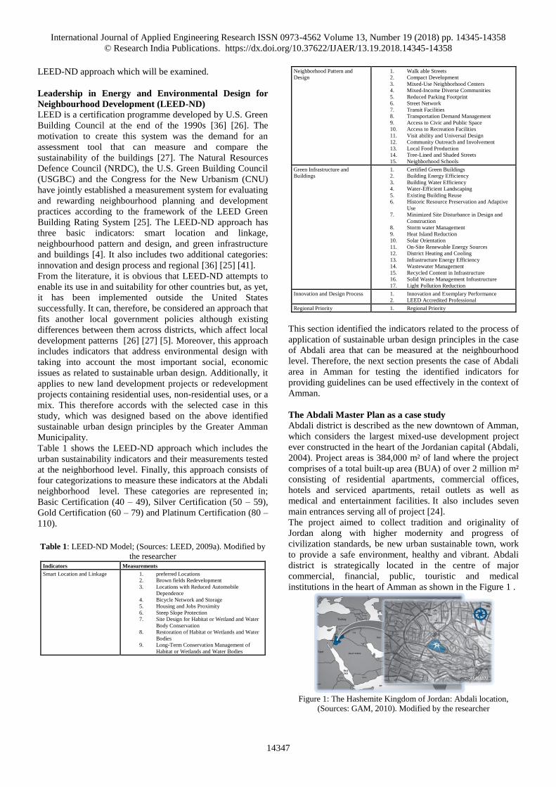
Table 1 shows the LEED-ND approach which includes the
urban sustainability indicators and their measurements tested
at the neighborhood level. Finally, this approach consists of
four categorizations to measure these indicators at the Abdali
neighborhood level. These categories are represented in;
Basic Certification (40 – 49), Silver Certification (50 – 59),
Gold Certification (60 – 79) and Platinum Certification (80 –
110).
Table 1: LEED-ND Model; (Sources: LEED, 2009a). Modified by
the researcher Indicators Measurements
Smart Location and Linkage 1. preferred Locations
2. Brown fields Redevelopment
3. Locations with Reduced Automobile
Dependence
4. Bicycle Network and Storage
5. Housing and Jobs Proximity
6. Steep Slope Protection
7. Site Design for Habitat or Wetland and Water
Body Conservation
8. Restoration of Habitat or Wetlands and Water
Bodies
9. Long-Term Conservation Management of
Habitat or Wetlands and Water Bodies
Neighborhood Pattern and
Design
1. Walk able Streets
2. Compact Development
3. Mixed-Use Neighborhood Centers
4. Mixed-Income Diverse Communities
5. Reduced Parking Footprint
6. Street Network
7. Transit Facilities
8. Transportation Demand Management
9. Access to Civic and Public Space
10. Access to Recreation Facilities
11. Visit ability and Universal Design
12. Community Outreach and Involvement
13. Local Food Production
14. Tree-Lined and Shaded Streets
15. Neighborhood Schools
Green Infrastructure and
Buildings
1. Certified Green Buildings
2. Building Energy Efficiency
3. Building Water Efficiency
4. Water-Efficient Landscaping
5. Existing Building Reuse
6. Historic Resource Preservation and Adaptive
Use
7. Minimized Site Disturbance in Design and
Construction
8. Storm water Management
9. Heat Island Reduction
10. Solar Orientation
11. On-Site Renewable Energy Sources
12. District Heating and Cooling
13. Infrastructure Energy Efficiency
14. Wastewater Management
15. Recycled Content in Infrastructure
16. Solid Waste Management Infrastructure
17. Light Pollution Reduction
Innovation and Design Process 1. Innovation and Exemplary Performance
2. LEED Accredited Professional
Regional Priority 1. Regional Priority
This section identified the indicators related to the process of
application of sustainable urban design principles in the case
of Abdali area that can be measured at the neighbourhood
level. Therefore, the next section presents the case of Abdali
area in Amman for testing the identified indicators for
providing guidelines can be used effectively in the context of
Amman.
The Abdali Master Plan as a case study
Abdali district is described as the new downtown of Amman,
which considers the largest mixed-use development project
ever constructed in the heart of the Jordanian capital (Abdali,
2004). Project areas is 384,000 m² of land where the project
comprises of a total built-up area (BUA) of over 2 million m²
consisting of residential apartments, commercial offices,
hotels and serviced apartments, retail outlets as well as
medical and entertainment facilities. It also includes seven
main entrances serving all of project [24].
The project aimed to collect tradition and originality of
Jordan along with higher modernity and progress of
civilization standards, be new urban sustainable town, work
to provide a safe environment, healthy and vibrant. Abdali
district is strategically located in the centre of major
commercial, financial, public, touristic and medical
institutions in the heart of Amman as shown in the Figure 1 .
Figure 1: The Hashemite Kingdom of Jordan: Abdali location,
(Sources: GAM, 2010). Modified by the researcher

International Journal of Applied Engineering Research ISSN 0973-4562 Volume 13, Number 19 (2018) pp. 14345-14358
© Research India Publications. https://dx.doi.org/10.37622/IJAER/13.19.2018.14345-14358
14348
At the heart of the Middle East and providing easy access to
North Africa, the GCC and the Levant, Jordan has a lot to
offer [24] [2]. Besides its strategic location, the Hashemite
Kingdom enjoys a progressive free-market economy and
political stability, making it a preferred destination for
business leaders, investors and visitors alike [49]. With the
new downtown, Abdali, rising in the capital and other large-
scale projects taking place in Jordan as a whole, the
country’s offerings are exponentially advancing toward
becoming a safe and prosperous haven for all businesses
(Figure. 1). Therefore, this case was chosen due to it is
situated in the heart of Amman, Abdali is the first area in
Amman that is being developed under the new local mixed-
use planning codes, which represents the exceptional synergy
of residential, commercial, hospitality, medical and retail
outlets in one vibrant and prestigious address. Generally, the
Abdali district creates a modern downtown previously
missing from Amman, which will cater to business and
lifestyle requirements, as well as create additional
employment opportunities and provoking an unprecedented
influx of investments from Jordan and the region.
It is noted that the first phase of Abdali project lies on
251,000 sqm of land and contains 33 separate mid-rise
building and tower projects owned which were developed by
a multitude of local and international investors (Figure. 2).
The second phase lies on 133,000 sqm adjacent to the first
phase. Table 2 also offers the identified built-up areas to each
function of the main zoning at the two phases. The
infrastructure for the two phases mirrors that the Abdali
district will be the new downtown reinforced with the
concepts of a smart city.
Figure 2: Abdali plan phases, (Sources: GAM, 2017). Modified by the
researcher
Table 2: The data extracted from the content analysis of Abdali area
(Sources: the researcher)
Phase 1 Phase 2 Total Area
Built-up area 1,030,000 m2 970,000 m2 2 million m²
Residential 261,000 = 25% 708,000 = 72% 969,000 =
49%
Commercial 547,000 = 53% 186,000 = 20% 733,000 =
36%
Medical 73,000 = 08% ------------------- 73,000 = 4%
Hotel 149,000 = 14% 75,000 = 08% 224,000 =
11%
Data analysis
The purpose of this section of the research is to test the
indicators identified as part of the literature review at the
neighbourhood level, in the case of Al-abdali area in
Amman.
From the literature review, urban sustainability indicators
were classified as smart location and linkage, neighbourhood
pattern and design, green infrastructure and buildings,
innovation and design process and regional priority as shown
in Table 2. The following sections present the findings in the
appointed case study area.
Indicator 1: Smart Location and Linkage
Measure 1.1: Preferred Locations
This measure refers to the development on a site that is
highly accessible and connected to other nearby
development. This project was developed within existing city
to reduce adverse public and environmental health effects
associated with sprawl. Accessibility is achieved from 5
streets by 7 Main entrances and 9 sub- entrances as shown in
Figure. 3
Figure 3: Al-abdali area accessibility, (Sources: Google,
2017). Modified by the researcher
Measure 1.2: Brownfield Redevelopment
This measure refers to the remediation of a contaminated
site. Al-abdali project is considered to be a prime urban
location which is appropriate for development. This was
because of Avoiding the development of inappropriate sites
and reducing the environmental impact from the location of
this area on the site, thereby reducing pressure on
undeveloped land.
Measure 1.3: Locations with Reduced Automobile
Dependence
This measure refers to the development in an area that is
well-served by transit or has a low average driving rate. It is
noted that this project location has multimodal transportation
choices as shown in Figure. 4.
Figure 5: multimodal transportation choices in Abdali area, (Sources: the
researcher, 2017).
Measure 1.4: Bicycle Network and Storage
This measure refers to locate along a bicycle network and
International Journal of Applied Engineering Research ISSN 0973-4562 Volume 13, Number 19 (2018) pp. 14345-14358
© Research India Publications. https://dx.doi.org/10.37622/IJAER/13.19.2018.14345-14358
14349
provide bicycle storage and parking. Al-abdali project
promoted bicycling and transportation efficiency, including
reduced vehicle miles traveled (VMT). Figure. 5 shows that
this project provided an existing bicycle network of at least 5
continuous miles in length is within 1/4-mile bicycling
distance of the project boundary. Moreover, the project
secures an enclosed bicycle storage areas, which are locked
and easily accessible to residents and workers, in addition to
informational signage on using the storage facilities as
shown in Figure. 6.
Figure 5: Bicycle’s baths Figure 6: Bicycle’s parking in Abdali area,
in Abdali area, (Sources: Sources: the researcher, 2017).
the researcher, 2017).
Measure 1.5: Housing and Jobs Proximity
This measure refers to locate jobs and housing, particularly
affordable housing, nearby each other. It is noted that this
project provided affordable residential component, in
addition to encouraging balanced communities with a
diversity of uses and employment opportunities (Figure. 7
and 8).
Figure 7: Mixed uses in the Al-abdali area, (Sources: the researcher, 2017).
Figure 8: Land uses in the Al-abdali area, (Sources: GAM, 2017).
Modified by the researcher
Measure 1.6: Steep Slope Protection
This measure refers to the protection of steep slopes from
development.
N/A
Measure 1.7: Site Design for Habitat or Wetland and
Water Body Conservation This measure refers to the conservation of pre-existing on-
site habitat, wetlands, or water bodies in perpetuity.
N/A
Measure 1.8: Restoration of Habitat or Wetlands and
Water Bodies
This measure refers to the restoration of degraded on-site
habitat, wetlands, or water bodies, and conserve in
perpetuity.
N/A
Measure 1.9: Long-Term Conservation Management of
Habitat or Wetlands and Water Bodies
This measure refers to the implementation of a long-term
management plan for on-site habitat, wetlands, or water
bodies.
N/A
Indicator 2: Neighbourhood Pattern and Design
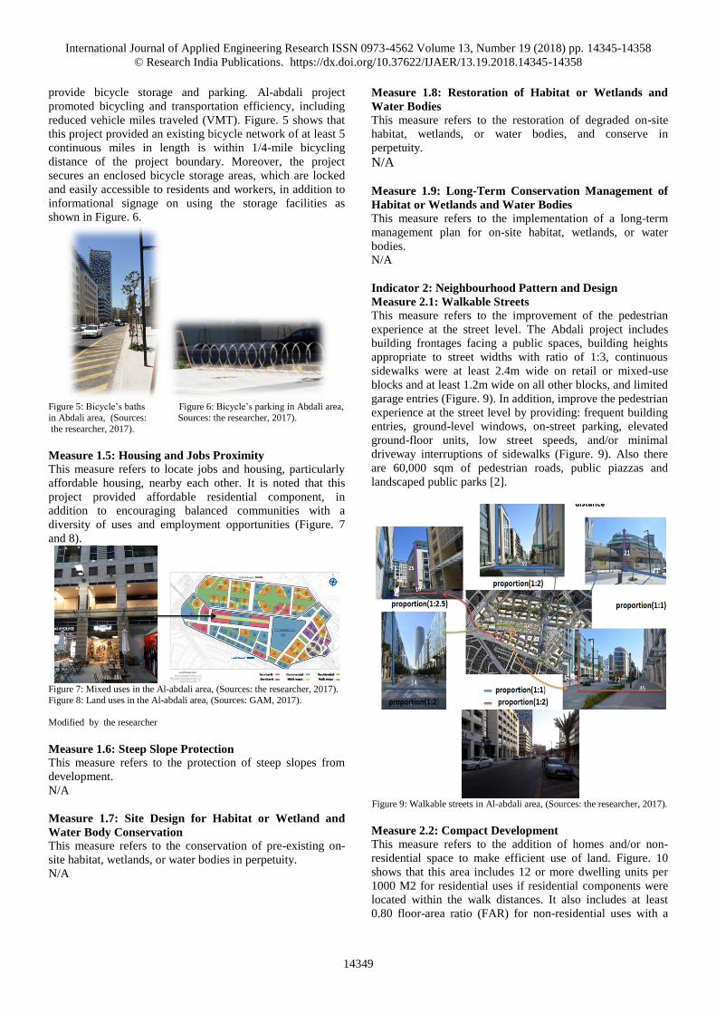
Measure 2.1: Walkable Streets
This measure refers to the improvement of the pedestrian
experience at the street level. The Abdali project includes
building frontages facing a public spaces, building heights
appropriate to street widths with ratio of 1:3, continuous
sidewalks were at least 2.4m wide on retail or mixed-use
blocks and at least 1.2m wide on all other blocks, and limited
garage entries (Figure. 9). In addition, improve the pedestrian
experience at the street level by providing: frequent building
entries, ground-level windows, on-street parking, elevated
ground-floor units, low street speeds, and/or minimal
driveway interruptions of sidewalks (Figure. 9). Also there
are 60,000 sqm of pedestrian roads, public piazzas and
landscaped public parks [2].
Figure 9: Walkable streets in Al-abdali area, (Sources: the researcher, 2017).
Measure 2.2: Compact Development
This measure refers to the addition of homes and/or non-
residential space to make efficient use of land. Figure. 10
shows that this area includes 12 or more dwelling units per
1000 M2 for residential uses if residential components were
located within the walk distances. It also includes at least
0.80 floor-area ratio (FAR) for non-residential uses with a

International Journal of Applied Engineering Research ISSN 0973-4562 Volume 13, Number 19 (2018) pp. 14345-14358
© Research India Publications. https://dx.doi.org/10.37622/IJAER/13.19.2018.14345-14358
14350
diversity of uses and employment opportunities (Figure. 10).
Moreover, this project was designed with internal streets
such that its internal connectivity is at least 35 intersections
per square kilometre [19].
Figure 10: land uses of the Al-abdali area, (Sources: GAM, 2017). Modified
by the researcher
Measure 2.3: Mixed-Use Neighbourhood Centres
This measure refers to providing neighbourhood shops,
services, and amenities clustered in neighbourhood centres
within walking distance of residents and each other. It is
noted that this area includes a wide range of services like
libraries, civic buildings, community centres, places of
worship, in addition to it contains on recreation facilities like
parks, gardens, open spaces and ecological areas are
particularly important for urban environments (Figure. 11).
Figure 11: Mixed-use neighbourhood centres in the Abdali area,
(Sources: the researcher, 2017).
Measure 2.4: Mixed-Income Diverse Communities
This measure refers to providing diverse housing types and
affordability levels to encourage balanced communities with
a diversity of uses and employment opportunities.
N/A
Measure 2.5: Reduced Parking Footprint
This measure refers to minimizing surface parking lots and
discourage them along building frontages. Also provide
bicycle and car-share parking. Figure. 12 shows that the
project used multiple strategies that can reduce the need for
car use like ride sharing, flexible working hours, pedestrian
and bicycle promotion, reduced amounts of parking, and
minimized surface parking lots. Therefore, this area was
serviced by sufficient, secure, and well-placed bicycle and
car-share parking for visitors and building occupants.
Figure 12: Parking footprint in the Abdali area, (Sources: the researcher,
2017).
Measure 2.6: Street Network
This measure refers to providing superior connection of
streets to each other and adjacent areas, and avoid cul-de
sacs. Al-abdali project has high levels of internal
connectivity and are well connected to the community at
large (Figure. 13). As well as it promoted the use of
multimodal transportation which improve public health by
encouraging daily physical activity and reducing the negative
effects of motor vehicle emissions. Figure 13 offers a set of
sidewalks and streets were available for general public use
and not gated.
Figure 13: Street network in the Abdali area, (Sources: the researcher, 2017).
Measure 2.7: Transit Facilities
This measure refers to ensuring shelters, benches, lighting,
and information displays at transit stops. Amenities like
shelters, benches, lighting, and information displays at transit
stops are available within the abdali project for providing
fully comfort for the stakeholders (Figure. 14).
Figure 14: Transit facilities in the Abdali area, (Sources: the researcher,
2017).
International Journal of Applied Engineering Research ISSN 0973-4562 Volume 13, Number 19 (2018) pp. 14345-14358
© Research India Publications. https://dx.doi.org/10.37622/IJAER/13.19.2018.14345-14358
14351
Measure 2.8: Transportation Demand Management
This measure refers to the encouragement of use of
environmentally preferable transportation choices with
transit passes, shuttles, vehicle sharing, and/or unbundled
parking pricing. N/A
Measure 2.9: Access to Civic and Public Spaces
This measure refers to providing squares, parks, and plazas
within walking distance of residents and commercial tenants.
Figure. 15 shows that a wide range of amenities like civic
buildings, open spaces and community centres are
constructed by this project to meeting a community’s
cultural, physical, social, and spiritual needs.
Figure 15: Civic and Public Spaces in the Abdali area, (Sources: the
researcher, 2017).
Measure 2.10: Access to Recreation Facilities
This measure refers to providing indoor or outdoor
recreational facilities. Amenities like open spaces, parks,
ecological areas, and gardens are particularly designed for
urban environment to increase social interaction and more
physical activity for community (Figure. 16).
Figure 16: Recreation facilities in the Abdali area, (Sources: the researcher,
2017).
Measure 2.11: Visitability and Universal Design
This measure refers to designing public spaces and dwelling
units for all abilities. Figure. 17 shows that the project has
considered design of a wide range of public spaces and
dwelling units for all society strata, but it focused on the high
society strata more than other strata due to expensive prices
and costs inside the abdali area [2].
Figure 17: Public spaces in the Abdali area, (Sources: the researcher, 2017).
Measure 2.12: Community Outreach and Involvement
This measure refers to base project designs on community
input. There was an effective participation by the local
community to hear their views about Greater Amman
Municipality’s proposals for the abdali project. There also
were some meetings with the local community to take
account of their views for the new design for the abdali
project. However, there are many existing issues between
them which have not yet been resolved. These problems
arose because of the unsuitability of a set of regulations and
laws which govern land use [19].
Measure 2.13: Local Food Production
Provide access to gardening space, local produce, or a
farmer’s market.
N/A
Measure 2.14: Tree-Lined and Shaded Streets
This measure refers to designing line and shade streets with
trees. It is noted that the project uses two options to achieve
this criteria. The first is tree-lined streets that were designed
and built to provide street trees on both sides of at least 60%
of existing streets within the project, in addition to the use of
this option on the project side of bordering streets and
between the vehicle travel ways and walkways, at intervals
averaging 12 M. The second is shaded streets that provide
shade over at least 40% of the length of sidewalks on streets
within the project (Figure. 18).
Figure 18: Tree-Lined and Shaded Streets in the Abdali area, (Sources: the
researcher, 2017).
Measure 2.15: Neighborhood Schools
This measure refers to locate within walking distance to local
schools.
N/A
Indicator 3: Green Infrastructure and Buildings
Measure 3.1: Certified Green Buildings
This measure refers to containing at least one building
certified under LEED or a similar green building rating
system.
N/A
Measure 3.2: Building Energy Efficiency
This measure refers to providing superior building energy
efficiency. It is noted that the project included the
construction of energy-efficient buildings that reduce water,
air, and land pollution and adverse environmental effects
from energy consumption and production (Figure. 19).
International Journal of Applied Engineering Research ISSN 0973-4562 Volume 13, Number 19 (2018) pp. 14345-14358
© Research India Publications. https://dx.doi.org/10.37622/IJAER/13.19.2018.14345-14358
14352
Figure 19: Building energy design in the Abdali area, (Sources: the
researcher, 2017).
Measure 3.3: Building Water Efficiency
This measure refers to providing superior building water
efficiency. The project encouraged sustainable water use in
the operation of buildings and their sites [1]. Figure. 20
clarifies that it succeed to maximize water efficiency within
buildings through identifying means of reducing potable
water consumption to reduce the burden on municipal water
supply and wastewater systems, therefore reducing effects on
natural water resources. This was achieved by employing
multi strategies like efficient toilet fixtures and grey water
treatment system, which use nearly 50% less water than
water use baseline calculated for the building [19].
Figure 20: Water energy design in the Abdali area, (Sources, Al-abdali,
2008).
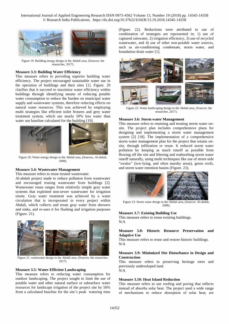
Measure 3.4: Wastewater Management
This measure refers to reuse treated wastewater.
Al-abdali project made to reduce pollution from wastewater
and encouraged reusing wastewater from buildings [2].
Wastewater reuse ranges from relatively simple gray water
systems that exploited non-sewer wastewater for irrigation
onsite. Gray water treatment was achieved by a water
circulation that is incorporated in every project within
Abdali, which collects and treats gray water from showers
and sinks, and re-uses it for flushing and irrigation purposes
(Figure. 21).
Figure 21: wastewater design in the Abdali area, (Sources: the researcher,
2017).
Measure 3.5: Water-Efficient Landscaping
This measure refers to reducing water consumption for
outdoor landscaping. The project sought to limit the use of
potable water and other natural surface or subsurface water
resources for landscape irrigation of the project site by 50%
from a calculated baseline for the site’s peak watering time
(Figure. 22). Reductions were attributed to use of
combination of strategies are represented in; 1) use of
captured rainwater, 2) irrigation efficiency, 3) use of recycled
wastewater, and 4) use of other non-potable water sources,
such as air-conditioning condensate, storm water, and
foundation drain water [1].
Figure 22: Water landscaping design in the Abdali area, (Sources: the
researcher, 2017).
Measure 3.6: Storm water Management
This measure refers to retaining and treating storm water on-
site. The project plan includes comprehensive plans for
designing and implementing a storm water management
system [2] [18]. The implementation of a comprehensive
storm water management plan for the project that retains on-
site, through infiltration or reuse. It reduced storm water
pollution by keeping as much runoff as possible from
flowing off the site and filtering and reabsorbing storm water
runoff naturally, using multi techniques like use of street-side
“swales” (low-lying, and often marshy areas), green roofs,
and storm water retention basins (Figure. 23).
Figure 23: Storm water design in the Abdali area, (Sources: Al-abdali,
2008).
Measure 3.7: Existing Building Use
This measure refers to reuse existing buildings.
N/A
Measure 3.8: Historic Resource Preservation and
Adaptive Use
This measure refers to reuse and restore historic buildings.
N/A
Measure 3.9: Minimized Site Disturbance in Design and
Construction
This measure refers to preserving heritage trees and
previously undeveloped land.
N/A
Measure 3.10: Heat Island Reduction
This measure refers to use roofing and paving that reflects
instead of absorbs solar heat. The project used a wide range
of mechanisms to reduce absorption of solar heat, are

International Journal of Applied Engineering Research ISSN 0973-4562 Volume 13, Number 19 (2018) pp. 14345-14358
© Research India Publications. https://dx.doi.org/10.37622/IJAER/13.19.2018.14345-14358
14353
represented in providing shade from open structures, such as
canopied walkways and solar photovoltaic panels, and using
high-reflectance and vegetated roofs of new buildings within
the project at least 50% of the buildings roofs (Figure. 24).
Figure 24: Roof gardens in the Abdali area, (Sources: the researcher, 2017).
Measure 3.11: Solar Orientation
This measure refers to increasing passive and solar access by
orienting buildings or dense blocks to maximize north- and
south facing exposure. To encourage energy efficiency, it is
noted that the Al-abdali area tried to create optimum
conditions for using passive and active solar strategies. These
strategies could be summarized in; the project was located on
existing blocks which was oriented at least 75% of the blocks
have one axis within plus or minus 15 degrees of
geographical east-west (Figure. 25).
Figure 25: Abdali plan, (Sources: GAM, 2017). Modified by the researcher
Measure 3.12: Light Pollution Reduction
This measure refers to the limitation of exterior illumination
and direct it downward. Multi strategies for reducing light
pollution were used by the buildings of project to increase
night sky access and improve night-time visibility [18].
These strategies could be included directing artificial light
downward instead of upward and outward, in addition to
using more frequently spaced, lower intensity lights instead
of only a few very bright lights (Figure. 26).
Figure 26: Light design in the Abdali area, (Sources: the researcher, 2017).
Measure 3.13: District Heating and Cooling
This measure refers to providing building heating and
cooling through a shared neighborhood-wide system.
For the encouragement of the development of energy-
efficient neighbourhood, the buildings employed district
heating and cooling strategies at neighbourhood level to
reduce energy use and adverse energy-related environmental
effects (Figure. 27).
Figure 27: Heating and Cooling system, (Sources: the researcher, 2017).
Measure 3.14: Infrastructure Energy Efficiency
This measure refers to providing energy-efficient
neighbourhood infrastructure. The project tried to limit
adverse environmental effects from energy used for
operating infrastructure [18]. This was achieved through
working with the municipality to design and implement all of
new infrastructure, including but not limited to street lights,
and water and wastewater pumps, therefore achieving a 15%
annual energy reduction below an estimated baseline energy
use for the infrastructure of this project (Figure.28).
Figure 28: infrastructure energy system within the Abdali area, (Sources:
GAM, 2017). Modified by the researcher
Measure 3.15: On-Site Renewable Energy Sources
This measure refers to generating renewable energy on-site.
The project encouraged on-site renewable energy production
to limit the adverse environmental and economic effects
associated with fossil fuel energy use [2]. It is noted that the
Greater Amman Municipality worked to develop on-site
International Journal of Applied Engineering Research ISSN 0973-4562 Volume 13, Number 19 (2018) pp. 14345-14358
© Research India Publications. https://dx.doi.org/10.37622/IJAER/13.19.2018.14345-14358
14354
renewable energy generation systems and technologies like
Wind Geothermal small scale/ to meet the main needs of the
project (Figure. 29). In addition, park lights, water pumps,
sewer systems and light-emitting diode (LED) technology for
traffic also significantly minimized a neighbourhood's total
level of energy consumption.
Figure 29: Renewable energy system in the Abdali area, (Sources: the
researcher, 2017).
Indicator 4: Innovation and Design Process
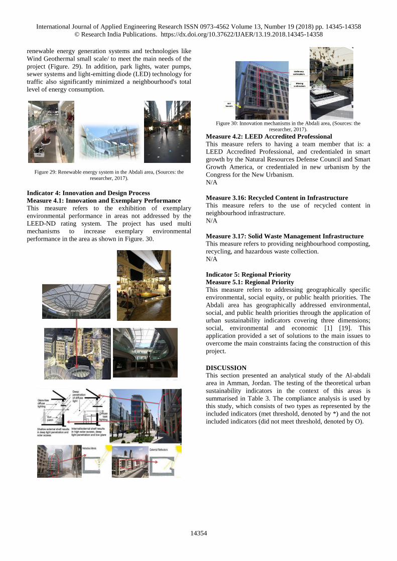
Measure 4.1: Innovation and Exemplary Performance
This measure refers to the exhibition of exemplary
environmental performance in areas not addressed by the
LEED-ND rating system. The project has used multi
mechanisms to increase exemplary environmental
performance in the area as shown in Figure. 30.
Figure 30: Innovation mechanisms in the Abdali area, (Sources: the
researcher, 2017).
Measure 4.2: LEED Accredited Professional
This measure refers to having a team member that is: a
LEED Accredited Professional, and credentialed in smart
growth by the Natural Resources Defense Council and Smart
Growth America, or credentialed in new urbanism by the
Congress for the New Urbanism.
N/A
Measure 3.16: Recycled Content in Infrastructure This measure refers to the use of recycled content in
neighbourhood infrastructure.
N/A
Measure 3.17: Solid Waste Management Infrastructure
This measure refers to providing neighbourhood composting,
recycling, and hazardous waste collection.
N/A
Indicator 5: Regional Priority
Measure 5.1: Regional Priority
This measure refers to addressing geographically specific
environmental, social equity, or public health priorities. The
Abdali area has geographically addressed environmental,
social, and public health priorities through the application of
urban sustainability indicators covering three dimensions;
social, environmental and economic [1] [19]. This
application provided a set of solutions to the main issues to
overcome the main constraints facing the construction of this
project.
DISCUSSION
This section presented an analytical study of the Al-abdali
area in Amman, Jordan. The testing of the theoretical urban
sustainability indicators in the context of this areas is
summarised in Table 3. The compliance analysis is used by
this study, which consists of two types as represented by the
included indicators (met threshold, denoted by *) and the not
included indicators (did not meet threshold, denoted by O).

International Journal of Applied Engineering Research ISSN 0973-4562 Volume 13, Number 19 (2018) pp. 14345-14358
© Research India Publications. https://dx.doi.org/10.37622/IJAER/13.19.2018.14345-14358
14355
Table 3: The comparison between the three selected areas (A, B, C)
in Amman indicators measurements Results
Points
Smart Location and
Linkage
preferred Locations * 5
Brown fields Redevelopment * 1.5
Locations with Reduced Automobile
Dependence
* 4
Bicycle Network and Storage * 1
Housing and Jobs Proximity * 2
Steep Slope Protection O 0
Site Design for Habitat or Wetland and Water
Body Conservation
O 0
Restoration of Habitat or Wetlands and Water
Bodies
O 0
Long-Term Conservation Management of
Habitat or Wetlands and Water Bodies
O 0
13.5
Neighborhood
Pattern and Design
Walk able Streets * 6
Compact Development * 3.5
Mixed-Use Neighborhood Centers * 2.5
Mixed-Income Diverse Communities O 0
Reduced Parking Footprint. * 1
Street Network * 1.5
Transit Facilities * 1
Transportation Demand Management O 0
Access to Civic and Public Space * 1
Access to Recreation Facilities * 1
Visit ability and Universal Design * 1
Community Outreach and Involvement * 1.5
Local Food Production O 0
Tree-Lined and Shaded Streets * 1.5
Neighborhood Schools O 0
20.5
Green
Infrastructure and
Buildings
Certified Green Buildings O 0
Building Energy Efficiency * 1.5
Building Water Efficiency * 1
Water-Efficient Landscaping * 1
Existing Building Reuse O 0
Historic Resource Preservation and Adaptive
Use
O 0
Minimized Site Disturbance in Design and
Construction
O 0
Storm water Management * 2.5
Heat Island Reduction * 1
Solar Orientation * 1
On-Site Renewable Energy Sources * 2
District Heating and Cooling * 1.5
Infrastructure Energy Efficiency * 1
Wastewater Management * 1.5
Recycled Content in Infrastructure O 0
Solid Waste Management Infrastructure O 0
Light Pollution Reduction * 1
15
Innovation and
Design Process
Innovation and Exemplary Performance * 3
LEED Accredited Professional O O
4
Regional Priority Regional Priority 2.5
2.5
Total 54.5
• * met threshold (included)
• O did not meet threshold (not included)
Figure 31: The percentage of application of urban sustainability indicators
Figure 32: Compliance with the 5 indicators
Figure 31 shows the sustainable urban indicators results that
were applied at the neighbourhood level of the Abdali area. It
confirms that neighbourhood pattern and design indicator
represent the highest percentage of urban sustainability
indicators, where 11 of 15 are included measurements.
Therefore, it is identified as the most suitable indicator for
this area and is, therefore, can be used to develop the
surrounding areas within Amman Master Plan. As for the
lowest percentage of these indicators, they are represented in
innovation and design and regional priority indicators,
therefore are considered the least favourable indicators to be
applied to the Abdali area.
A priority was given for the neighbourhood pattern and
design indicator in the Abdali master plan. It was also found
that this indicator have positively influenced the Abdali area,
through the increase of the percentage of its successful
measurements (Figure 32). In addition, the Green
infrastructure and buildings and smart location and linkage
indicators implemented in the Abdali master plan have
contributed to improvements to the Amman master plan
which in turn positively serves the local community and
investors.
According to the indicators test, the research identified the
suitable indicators and their ranking for the Abdali area
based on their measurements which met the threshold as
shown in Table 4 below.

International Journal of Applied Engineering Research ISSN 0973-4562 Volume 13, Number 19 (2018) pp. 14345-14358
© Research India Publications. https://dx.doi.org/10.37622/IJAER/13.19.2018.14345-14358
14356
Table 4 : The suitable indicators and their measurements for the
Abdali area indicators measurements
1) Neighborhood Pattern and Design
Walk able Streets
Compact Development
Mixed-Use Neighborhood Centers
Reduced Parking Footprint
Street Network
Transit Facilities
Access to Civic and Public Space
Access to Recreation Facilities
Visit ability and Universal Design
Community Outreach and Involvement
Tree-Lined and Shaded Streets
2) Green
Infrastructure and
Buildings
Building Energy Efficiency
Building Water Efficiency
Water-Efficient Landscaping
Storm water Management
Heat Island Reduction
Solar Orientation
On-Site Renewable Energy Sources
District Heating and Cooling
Infrastructure Energy Efficiency
Wastewater Management
Light Pollution Reduction
3) Smart Location
and Linkage
preferred Locations
Brown fields Redevelopment
Locations with Reduced Automobile
Dependence
Bicycle Network and Storage
Housing and Jobs Proximity
4) Innovation and
Design Process
Innovation and Exemplary Performance
LEED Accredited Professional
5) Regional Priority Regional Priority
CONCLUSIONS AND RECOMMENDATIONS
The study enhanced the knowledge level required for the
implementation of sustainable urban design principles at the
neighbourhood level. This was achieved by introducing a
framework focusing on the key suitable indicators for the
implementation of sustainable urban design principles in
Amman, which can be used effectively and further fine-tuned
to reflect place specific variables. This research identified a
broad variety of suitable indicators and their ranking for the
Abdali area, which can be implemented is: (1)
Neighbourhood Pattern and Design (2) Green Infrastructure
and Buildings (3) Smart Location and Linkage (4)
Innovation and Design Process (5) Regional Priority. Hence,
this ranking represents the priority for implementing these
indicators in the Abdali master plan, enhancing the effective
implementation of the sustainable urban design principles in
Amman.
This research recommends to develop the guidelines
responsible for the Abdali master plan based on the suitable
indicators identified by this study as clarified in Table 4.
Moreover, it takes into account the ranking of these suitable
indicators for the purpose of prioritising their implementation
in the Amman master plan. This ranking provides a feedback
which identifies the main priorities to each principle to
overcome the constraints facing the construction of
sustainable neighbourhood in the Amman master plan. This
will help to implement and manage sustainable urban design
principles at the neighbourhood level in the Amman context.
This knowledge therefore provides an opportunity to the city
of Amman for informing the future development of the
master plan.
Reflections
The focus on a single case study was decided in order to
understand and realize the complexity and uniqueness of the
individual case. Researchers such as Yin [50] considered the
limitations of the single case study strategy in that it could
only reflect the uniqueness, or special conditions, that apply
to the case study in question. Whilst recognising this,
Researchers such as Bennett [8], Tunnard and Wilson [45]
and Flyvbjerg [17], state that one can generalise on the basis
of a single case as supplementary to scientific development.
The knowledge therefore can enter into the collective process
of knowledge accumulation in a given field [6]. Ettlinger
[14] stated that a single case study strategy can offer valuable
insight into a “set of possibilities that may become scaled
up”. Therefore, this study presents valuable insight into the
relationship between the physical environment, sustainability
and locational elements that can in turn impact on the
sustainability performance of a neighbourhood, which can
be scaled up in the future.
ACKNOWLEDGEMENT
The generous funding of the Department of ARchitecture at
the Al al-Bayt University from 2017 to 2018 is gratefully
acknowledged. The GIS Department of the Greater Irbid
Municipality kindly provided data on the urban development
of the city of Irbid.
REFERENCES
1) Abdali. (2004). Abdali: The New Downtown of
Amman. Amman: Abdali Investment & Development
PSC.
2) Abdali. 2008. Abdali; Facts and figures.
http://www.abdali.jo/index.php?r=site/page&id=6, 20-
8-2017).
3) AlWaer, H., and Simbley, M. (2006): Sustainable
Development for Regional Shopping Centres in the
UK: Measuring the Level of Sustainability and
Application of a Sustainability Assessment Model
/SCRSC/. International conference on urbanism and
sustainability in a changing world. Jeddah urban
forum.
4) Ayyoob, A., and Akito, M. (2013b): "A critical review
of seven selected neighborhood sustainability
assessment tools". Environmental Impact Assessment
Review 38.doi:10.1016/j.eiar.2012.06.006.
5) Ayyoob, S., and Akito, M. (2014): "Viability of using
global standards for neighbourhood sustainability
assessment: insights from a comparative case study".
Journal of Environmental Planning and Management:
1–23. doi:10.1080/09640568.2013.866077.
6) Basaiawmoit, R., and Wanger, K. (2015): Auto-
Ethnographic perspective of social entrepreneurship
focused student case-competition. The proceedings of
3rd International Conference on Innovation and
Entrepreneurship (ICIE). The university of Kwazulu
Natal Durban.
7) Baslas, C. (2004): Measuring the liveability of an
urban center: An exploratory study of key
performance indicators, Planning practise and
International Journal of Applied Engineering Research ISSN 0973-4562 Volume 13, Number 19 (2018) pp. 14345-14358
© Research India Publications. https://dx.doi.org/10.37622/IJAER/13.19.2018.14345-14358
14357
research, 19 (1). 101-110.
8) Bennett, A., and Elman, C. (2006): Qualitative
research: Recent developments in case study methods.
Annual Review of Political Science, 9(1), 455-476.
9) Brandon, S., and Lombardi, P. ( 2011): Evaluating
Sustainable Development in the Built Environment. II
Edition, Wiley-Blackwell (GBR), pp. 272, ISBN:
9781405192583; REFERENCE PROFESSOR(S)-
Patrizia Lombardi
10) BREEAM Communities. (2012): Integrating
sustainable design into master planning. Available
online at [www.breeam.org/ communities].
11) Cocca, P., and Alberti, M. (2010): A framework to
assess Performance Measurement Systems in SMEs,
International Journal of Productivity and Performance
Management, Special Issue “Performance
measurement and management: what is next?”, Vol.
59, No. 2, pp.186–200, ISSN 1741–0401
12) Deeb, R., Mhana, S. (2009): Planning for sustainable
development. Journal of engineering science,
Damascus University.
13) Estidama. (2010): Pearl Community Rating System
(PBCS): Design and Construction, Version 1.0. Abu
Dhabi Urban Planning Council
14) Ettlinger, N. 2009. Problematizing the presentation of
post-structural case-study research, or working out the
crisis of representation in the presentation of
empirics,” Environment and Planning A 41: 1017-
1019.
15) European Commission, Eurostat (2009a): Indicators
for Monitoring the EU Sustainable Development
Strategy.
http://epp.eurostat.ec.europa.eu/portal/page/portal/sdi/i
ntroduction.
16) Farr, D. (2007): Sustainable Urbanism: urban design
with nature. New York: John Wiley.
17) Flyvbjerg, B. (2006): "Five Misunderstandings About
Case-Study Research," Qualitative Inquiry, vol. 12,
no. 2, April 2006, pp. 219-245.
18) GAM. (2007). Interim Growth Strategy (HDMU)
Development Manual. Amman: Greater Amman
Municipality.
19) GAM. (2008). The Amman plan: Metropolitan
Growth. Amman: Greater Amman Municipality.
20) Green Star Team. (2012): Green Star System. Green
Building Council of Australia. Available online at
[https://www.gbca.org.au/green-star/]
21) Gulf Organization for Research and Development
institute (GORD). (2014): Global Sustainability
Assessment System (GSAS), Qatar Sustainability
Assessment System (QSAS). Available online at
[http://www.gord.qa/uploads/formsnew/GSAS_Overvi
ew_07_for_web.pdf]
22) Haapio, A., and Viitaniemi, P. (2007): Environmental
criteria and indicators used in environmental
assessment of buildings. Proceedings, CIB World
Congress, Construction for Development, 14–7 May;
2007. Cape Town, South Africa.
23) Haapio, A. (2012): Towards sustainable urban
communities. Environmental Impact Assessment
Review. 32 (2012) 165–169.
24) Khawaja, H. 2015. Public Spaces under Threat:
Scenes from Amman. Research Master Planning and
Sustainability: Urban and Regional Planning. Polytech
university tour. France
25) LEED. (2009a): LEED for Neighborhood
Development Rating System. Created by the Congress
for the New Urbanism, Natural Resources Defense
Council, and the U.S. Green Building Council.
(Updated May 2011)
26) LEED. (2009b): LEED for New Construction and
Major Renovations Rating System With Alternative
Compliance Paths For Projects Outside the U.S., U.S.
Green Building Council, Washington DC.
27) LEED. (2011): LEED 2009 for New Construction and
Major Renovations Rating System With Alternative
Compliance Paths For Projects Outside the U.S.
(Updated November 2011) U.S. Green Building
Council, Washington DC.
28) Martien, K., and Taylor, B. (2003): Limitations of
hypothesis-testing in defining management units for
continuously distributed species. J. Cetacean res.
manage. 5(3):213–218.
29) McGeough, U., Newman, D., Wrobel, J. (2004):
Model for Sustainable Urban Design. Sustainable
Energy Planning Office (ORNL), Gas Technology
Institute (GTI)
30) McIntyre, P. (2004): Creativity and Cultural
Production: A Study of Contemporary
31) McIntyre, P. (2006): Creative Practice as Research:
‘Testing Out’ the Systems Model of Creativity
through Practitioner Based Enquiry. Speculation and
Innovation: applying practice led research in the
Creative Industries. School of Design,
Communication and Information Technology.
University of Newcastle. Working paper.
32) Miller, T. (2002): Living in the Environment:
Principles, connections and solutions, 12th edition,
Thomson Learning, Inc: New York.
33) Ndeke, E. (2011): A critical review of the
development of sustainability indicators for the City
of Cape Town: A focus on environmental and socio-
economic sustainability. Thesis presented in fulfilment
of the requirements for the degree of Master of
Philosophy in Sustainable Development Planning and
Management in the Faculty of Economic and
Management Sciences at Stellenbosch University.
34) Neuman, M. (2005): “The Compact City Fallacy.”
Journal of Planning Education and Research. Vol. 25.
pp. 11-26.
35) Potter R., Darmame K., Barhamb N. & Nortcliff S.
(2009). ‘‘Ever-growing Amman’’, Jordan: Urban
expansion, social polarisation and contemporary urban
planning issues. Habitat International 33, 81–92.
36) Reed, R., Bilos, A., Wilkinson, S. and Schulte, K.
(2011): "International Comparison of Sustainable
Rating Tools", American Real Estate Society
American Real Estate Society, vol. 1, no. Number 1 /
2009, pp. 1-22.
37) Rowan, L. (2002): Sustainable Development
International Journal of Applied Engineering Research ISSN 0973-4562 Volume 13, Number 19 (2018) pp. 14345-14358
© Research India Publications. https://dx.doi.org/10.37622/IJAER/13.19.2018.14345-14358
14358
Indicators and Local Government. Thesis submitted
for the degree of Doctor of Philosophy. Department of
Management and Organisation. University of Stirling
38) Runco, M., and Pritzker, S. (Eds.) (1999):
Encyclopedia of Creativity. San Diego, Calif.,
Academic Press.
39) Salat, S., Bourdic, L., and Nowacki, C. (2012):
Assessing cities: A new system of spatial indicators.
Building Research and Information Volume 40, Issue
5, 2012. Special Issue: Spatial and temporal scales in
sustainability: SB11
40) Scipioni, A., Mazzi, A., Mason, M., Manzardo, A.
(2009): “The Dashboard of sustainability to measure
local urban sustainable development. The case study
of Padua Municipality”. Ecological Indicators. Vol. 9:
pp 364-380.
41) Sharifi, A., and Murayama, A. (2014): Neighborhood
sustainability assessment in action: Cross-evaluation
of three assessment systems and their cases from the
US, the UK, and Japan. Building and Environment,
72, 243-258.
42) Shen,L., Ochoa,J., Shah,M., Zhang,X. (2011): The
application of urban sustainability indicators e A
comparison between various practices. Habitat
International, 35 (2011), P. 17-29
43) Stockburger, D. (2007): "Hypothesis and hypothesis
testing", Encyclopedia of Measurement and Statistics
(editor—Salkind N.J.), Sage Publications.
44) Thomas, R., and Ferdham, M. (2003): Sustainable
urban design – an environmental approach, Taylor and
Francis, 2003.
45) Tunnard, C., and Wilson, B. (2014): Comparison of
neuropsychological rehabilitation techniques for
unilateral neglect: an ABACADAEAF single-case
experimental design. Neuropsychol Rehabil.
2014;24(3-4):382-99. doi:
10.1080/09602011.2013.872041. Epub 2014 Jan 13.
46) United Nations, Commission on Sustainable
Development (CSD). (2007a): Indicators of
sustainable development: Guidelines and
methodologies; International Urban Sustainability
Indicators List (IUSIL), New York
47) William, M. (1982): Concept Testing. Journal of
Business Research 10, 279-294
48) Xing, Y., Horner, R., El-haram, M., Bebbington, J.
(2009): A framework model for assessing
sustainability impacts of urban develpment.
Accounting forum. 33, 209-224.
49) Ziod, R. (2012). The Development of Commercial
districts in Amman 1950-2009. Amman: Greater
Amman Municipality- Cultural Department.
50) Yin, R. (2009): Case study Research: design and
methods. 4th edition. London: Sage.