New Orleans Area Contingency Plan - losco.state.la.us Orleans Area Contingency Plan ... Draft maps...
349
2013 Geographic Response Plan Jefferson Parish New Orleans Area Contingency Plan U. S. Coast Guard Sector New Orleans 200 Hendee Street New Orleans, LA 70114
Transcript of New Orleans Area Contingency Plan - losco.state.la.us Orleans Area Contingency Plan ... Draft maps...

2013
Geographic Response PlanJefferson Parish
New Orleans Area Contingency Plan
U. S. Coast Guard Sector New Orleans
200 Hendee Street
New Orleans, LA 70114

This page is intentionally left blank

New Orleans Area Contingency Plan Geographic Response Plan- Jefferson Parish
Jefferson Parish Geographic Response Plan Signature Page
Peter W. Gautier Captain, US Coast Guard
Commander, Sector New Orleans Federal On-Scene Coordinator, New Orleans
Brian Wynne Acting, Louisiana Oil Spill Coordinator
John F. Young, Jr. President, Jefferson Parish
i

New Orleans Area Contingency Plan Geographic Response Plan- Jefferson Parish
ii
This page is intentionally left blank

New Orleans Area Contingency Plan Geographic Response Plan- Jefferson Parish
Record of Changes Date Change
Number Summary of Changes Initials of
person making
changes
iii

New Orleans Area Contingency Plan Geographic Response Plan- Jefferson Parish
iv
This page is intentionally left blank

New Orleans Area Contingency Plan Geographic Response Plan- Jefferson Parish
Table of Contents Jefferson Parish Geographic Response Plan Signature Page .......................................... i Record of Changes ........................................................................................................... iii 1. Introduction ................................................................................................................ 1
1.1 Scope ...................................................................................................................... 2
1.2 Development ........................................................................................................... 2
1.3 Guiding Principles of the GRP ................................................................................. 3
1.4 Sensitive Resources Addressed by GRPs .............................................................. 4
1.5 Evaluation Criteria for GRPs ................................................................................... 5
1.6 Prioritization ............................................................................................................. 8
1.7 Strategy Selection ................................................................................................. 10
2 Site Description ............................................................................................................ 12 3 Maps ............................................................................................................................ 14 Original GRP Contributors ............................................................................................ 353 GRP Comments/Corrections/Suggestions ........................................................ Appendix B
v

New Orleans Area Contingency Plan Geographic Response Plan- Jefferson Parish
vi
This page is intentionally left blank
New Orleans Area Contingency Plan Geographic Response Plan- Jefferson Parish
Jefferson Parish Geographic Response Plan
1. Introduction This Geographic Response Plan (GRP) is an annex to the New Orleans Area Contingency Plan (NOACP) and a key element of both facility and vessel contingency plans. This GRP has two main functions:
• From a planning perspective, the GRP provides a description of sensitive biological, cultural, and economic resources that must be addressed to be in compliance with:
o The National Oil and Hazardous Substance Pollution Contingency Plan (NCP, 40 CFR Part 300.210(3)(i).). Area Contingency Plans are required to describe areas of special economic and environmental importance that could be impacted during an oil spill.
o The National Historic Preservation Act of 1966 contains applicable,
relevant and appropriate requirements. The GRPs also address sensitive historic and prehistoric resources.
• From an operational perspective, the GRP guides responders in the first
24-48 hours of an oil spill by:
o Providing a prioritized list of tactical response strategies to be implemented during the early hours of an oil spill (usually before the formation of the Unified Command);
o Providing detailed information for booming strategies that could be utilized to minimize impacts to predetermined sensitive resources.
Once the Unified Command is formed, additional operational strategies and tactics will be relayed to the field in the form of the ICS-204 work assignment sheets. Because the GRP is the primary tool used during an initial phase of the response and fairly broad in their scope, they are not intended to minimize impacts to all possible sensitive areas that could be affected by an oil spill. Likewise, the GRPs are not intended to be an exhaustive list of all the tactical strategies that could, or should, be implemented during a spill.
1

New Orleans Area Contingency Plan Geographic Response Plan- Jefferson Parish
1.1 Scope This Geographic Response Plan (GRP) is intended to help the first responders of an oil discharge or hazardous substance release avoiding the initial confusion that generally accompanies any incident. This document serves as the federal and state on-scene-coordinators “orders” during an incident in the area covered by this GRP (see Section 2 for area covered). As such it has been approved by the U.S. Coast Guard Sector New Orleans, the Louisiana Oil Spill Coordinator’s Office, and Jefferson Parish. Changes to this document are expected as testing is conducted through drills, site visits, and actual use in an incident. To submit comments, corrections, or suggestions please refer to Appendix B. The scope of this GRP is to identify sensitive sites to be considered for protection in the first 24 to 48 hours of an incident and the generic response strategy for this site considering unique characteristics, noted hydrology and climatic considerations. This index is not all encompassing as sites not identified in this index may need to be evaluated for protection as an incident progresses. GRPs only address protection of sensitive public resources. It is the responsibility of private resource owners and/or potentially liable parties to address protection of private resources (such as commercial marina and private water intakes).
1.2 Development This Index has been developed for the Coastal Zone, as defined in the National Contingency Plan (40 CFR Part 300) for Jefferson Parish. It is prepared through the efforts and cooperation of Louisiana State Trustee Agencies, Parish Representatives, and Federal Trustee Agencies, other federal and state agencies, response organizations, and local emergency responders. This Index was developed through workshops involving federal, state, and local stakeholders. Workshop participants identified resources which require protection and developed operational strategies. Following the workshops, the data gathered was processed and reproduced in the form of maps and matrices which appear in Chapter 3. The maps were generated using ArcGIS, and the tables were created using Microsoft Access. The first goal of a GRP is to identify resources needing protection; response resources needed; tribal and local response community contacts; and local conditions that may affect response strategies. Secondly, response strategies were developed based on the sensitive resources noted hydrology and climatic considerations. Individual response strategies identify the appropriate boom implementation.
2

New Orleans Area Contingency Plan Geographic Response Plan- Jefferson Parish
Draft maps and matrices were sent out for review and consideration of strategy viability. Verification at local, state, and federal levels was conducted and changed proposed by the participants were included in a semi-final draft, which was offered for final review. Finally, the final GRP was complied along with site description, reference maps, and information to support logistical needs.
1.3 Guiding Principles of the GRP Safety and health of the responders always takes precedence over the protection of sensitive environmental resources. Source control and containment are always a HIGER priority over GRP strategy deployments. The protection strategies in the GRPs have been designed for the use with persistent oils and may not be suitable for other petroleum or hazardous substances. Environmental conditions (winds, currents, and tides), together with the physical limitations of existing spill response technology, may preclude the effective protection of some areas. Once a coordinated response has been established during an oil spill incident, booming strategy selection and prioritization are refined and supplemented based on real-time assessments. The UC has the authority to supersede the strategies proposed in the GRPs. Response personnel may find it necessary to deviate from the exact details provided for deploying a particular strategy. An onsite evaluation of actual conditions is often needed to determine whether a strategy is safe to deploy, whether it will be effective under existing environmental conditions, or effective for the particular type of oil involved. Therefore, field personnel should use their best judgment to modify existing strategies based on real-time conditions and notify command accordingly. Field personnel are also encouraged to notify the command post regarding opportunities for deployment additional strategies that might be used to take advantage of incident-specific conditions. The GRPs Include the Following Types of Response Strategies Collection Booming with On-Water Recovery: Deploying various types of boom to collect oil for mechanical removal using sorbent materials, vacuum trucks, or near shore skimming devices;
3

New Orleans Area Contingency Plan Geographic Response Plan- Jefferson Parish
Exclusion Booming: Deploying various types of boom to reduce oiling in sensitive areas; Deflection Booming: Deploying various types of boom to divert oil away from a sensitive area and/or divert oil toward a collection point. GRPs Do Not Include In-Situ Burning: Burning oil on the water; usually requires containment by fire-resistant boom. Chapter 9000, Appendix C for additional NOAC policy on in-situ burning use; Dispersants: Applying chemical agents, usually by aircraft, to aid in breaking up surface slicks and dispersing oil within the water column. See Chapter 9000, Appendix D for NOAC policy on dispersant use; Shoreline Cleanup: Physical removal or chemical treatment of stranded oil. See Chapter 9000, Appendix G for the NOAA Shoreline Countermeasure Manual for Tropical Coastal Environments and Appendix F Oil Spill Best Management Practices for guidance on shoreline cleanup; Open-Water Mechanical Recovery: Physical removal of oil using boats and/or vessels specifically outfitted with collection and separation equipment. No Action: Appropriate when weather, sea, or other conditions make deployments unsafe and/or infeasible and when response actions or site access will cause further environmental damage (e.g., wetlands).
1.4 Sensitive Resources Addressed by GRPs The NCP, 40 CFR Part 300.120(3)(i) requires that Area Committees identify and prioritize sensitive areas requiring protection. In the NOACP, sensitive areas are broken into three main categories described below. Environmentally Sensitive Resources Key natural resource areas are identified using a wide range of data provided by resource trustees, tribes, plan holders, spill response organizations, contingency plan holders, and other interested stakeholders during the process of GRP development and review. The Environmental Sensitivity Index (ESI) maps developed by NOAA are one example of the type of natural resource information available (http://response.restoration.noaa.gov). When appropriate, tactical response strategies are designed for implementation during the early hours of an oil spill to reduce impacts to those areas, and trajectory models or other assessment techniques are used to establish initial response priorities.
4

New Orleans Area Contingency Plan Geographic Response Plan- Jefferson Parish
Historically or Culturally Sensitive Resources Information on sensitive historic and cultural sites is coordinated through contact with the various tribal governments, State Historic Preservation Office (SHPO), and the United States Department of the Interior may assist as needed. Due to the sensitive nature of this information, the specifics regarding the location and nature of such sites are not included in the GRP documents. However, in order to ensure that tactical response strategies do not inadvertently harm historical and culturally sensitive sites, historic preservation specialists are consulted to review the GRP documents prior to finalization. The Louisiana SHPO can be contacted at: Physical Address: State Historic Preservation Office Division of Archaeology Capital Annex Building 1051 North Third Street Baton Rouge, Louisiana 70804 Mailing Address: P.O. Box 44247 Baton Rouge LA, 70804 Phone: (225) 342-8160 (general office) (225) 219-4598 (Division of Archaeology office) Fax: (225) 342-4480 Socio-Economically Sensitive Resources Economically sensitive areas are facilities or locations that rely on a body of water to be economically viable and that could be severely impacted by an oil spill. Economically sensitive areas are broken down into three separate categories: Critical infrastructure, water dependent commercial and recreational areas. Information on economic resources will be gathered for inclusion as an appendix to the GRPs.
1.5 Evaluation Criteria for GRPs Specific strategies for response to spills in the sensitive areas are detailed in the GRPs. Below is a list of some of the biological, cultural, and booming criteria used to determine whether it is appropriate to develop and maintain GRP strategies at specific locations. These criteria are not intended to be exhaustive, or ranked in order of priority, they are meant to help frame the evaluation of GRP strategies. Key Criteria for Biological Sites, Species, and Habitats of Concern
• Temporal considerations- o What is the expected recovery time for habitats of fish and wildlife
resources? o What is the residence time of the oil?
5

New Orleans Area Contingency Plan Geographic Response Plan- Jefferson Parish
• Substrate-
o What is the exposure risk? What is the likelihood that a habitat or species will be exposed to direct contact with surface oil or to dispersed/dissolved oil in the water column?
o Given the substrate, is clean-up feasible?
• Habitat quantity, quality, and pattern- o Is the impacted habitat considered scarce at local, regional, or
statewide scales? o Is the size of the impacted habitat significant compared to other
sites in the region? o Is the species diversity or endemism high? Is this true year-round
or is it seasonal? o Is abundance of fish and/or wildlife high? Is this true year-round or
is it seasonal? o What life stages of organisms are present? o Is the habitat important to threatened or endangered species? o What is the status of the habitat’s integrity (i.e., is the area
undeveloped or highly altered?) o Does the habitat have a special designation or status (i.e., Marine
Protected Area, biological research area, restoration site, etc.)? o Are the habitat and/or its associated fish and wildlife resources
especially susceptible to injury by oil? Key Criteria for Archeological and Cultural Sites of Concern Deployment- Does the act of deploying the GRP strategy threaten the archeological site (anchoring the boom, parking vehicles, etc.) Purpose- Will implementing the GRP strategy type (collection, diversion, deflection) negatively impact the site? Review- If either of the above is possible, then a review of the site records is necessary to determine the exact location and sensitivity of the site. If the site records are old or insufficient, then a field visit is necessary. Significant developments- Are there significant developments that may make any concern about the impacts irrelevant (housing developments etc.)? Additional criteria for archaeological sites without existing GRP strategies-
• Impacts- Does the site extend below the high tide line? • Vulnerability- Will it be damaged or destroyed if oil were to hit the area (or
by the placement of response equipment in the area, e.g., vacuum trucks, etc.)?
6

New Orleans Area Contingency Plan Geographic Response Plan- Jefferson Parish
• Integrity- Has the site been disturbed yet, or is it still intact? • Historic Importance- Is the site nominated for, or already on, the National
Register of Historic Places or the State equivalent? • Tribal Importance- Does the site hold special tribal importance? • Parish Importance- Does the site hold special Parish importance? • Feasibility- Is booming the site feasible?
Key Criteria for Socio-Economic Sites of Concern Strictly economic resources are designated as the third priority for dedication of oil spill response resources, following human health and safety and environmental resources. The designation of economic resources is highly dependent upon the priorities of the local government. Each GRP contains detailed information of economic sites in each Parish or Geographical Response Area. This information includes geographic locations of resources, a brief description of the resource at risk, contact names and numbers, and the priority response ranking. Key Criteria for the Use of Boom Effectiveness- Is booming the most effective strategy for reducing oil spill impacts? Would other alternatives such as a phone call to an operator, shutting off a water intake, or closing a tidal gate be as effective? Safety- Determine if safety of human responder will be put at risk for limited likelihood of strategy success. Strategy- Determine what type of booming strategy would be the most effective at reducing oil impacts to the resource under prevailing conditions (collection, deflection, or exclusion). Evaluation- Evaluate the site for advantageous characteristics based on:
• Anchoring substrate. Does the substrate allow responders to easily anchor the boom?
• Accessibility. Can the site be easily accessed by vessel or vehicles?
• Time to arrive on scene. How long will it take to get to the site?
• Potential for oiling. Is the site located near shipping activity or fueling operations?
• Beach substrate. Used Environmental Sensitivity Index (ESI) or Shore-
Zone classification to determine vulnerability to oiling and likely oil longevity based on the shoreline type.
7
New Orleans Area Contingency Plan Geographic Response Plan- Jefferson Parish
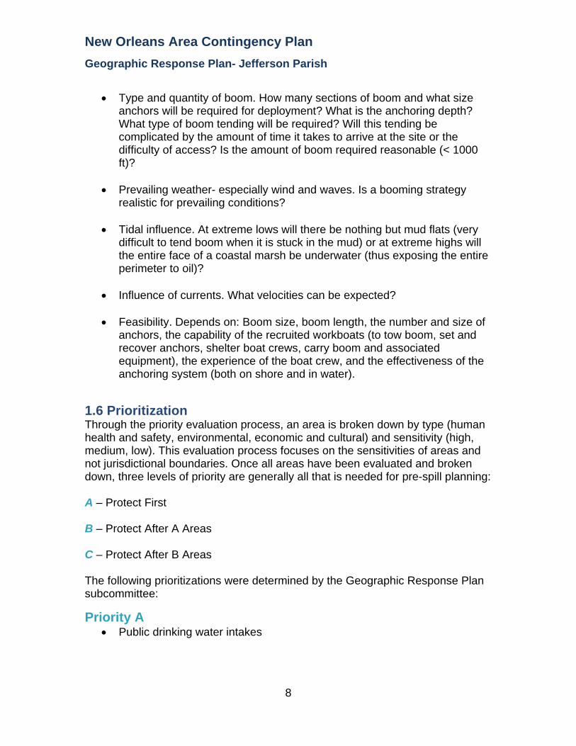
• Type and quantity of boom. How many sections of boom and what size
anchors will be required for deployment? What is the anchoring depth? What type of boom tending will be required? Will this tending be complicated by the amount of time it takes to arrive at the site or the difficulty of access? Is the amount of boom required reasonable (< 1000 ft)?
• Prevailing weather- especially wind and waves. Is a booming strategy
realistic for prevailing conditions?
• Tidal influence. At extreme lows will there be nothing but mud flats (very difficult to tend boom when it is stuck in the mud) or at extreme highs will the entire face of a coastal marsh be underwater (thus exposing the entire perimeter to oil)?
• Influence of currents. What velocities can be expected?
• Feasibility. Depends on: Boom size, boom length, the number and size of
anchors, the capability of the recruited workboats (to tow boom, set and recover anchors, shelter boat crews, carry boom and associated equipment), the experience of the boat crew, and the effectiveness of the anchoring system (both on shore and in water).
1.6 Prioritization Through the priority evaluation process, an area is broken down by type (human health and safety, environmental, economic and cultural) and sensitivity (high, medium, low). This evaluation process focuses on the sensitivities of areas and not jurisdictional boundaries. Once all areas have been evaluated and broken down, three levels of priority are generally all that is needed for pre-spill planning: A – Protect First B – Protect After A Areas C – Protect After B Areas The following prioritizations were determined by the Geographic Response Plan subcommittee:
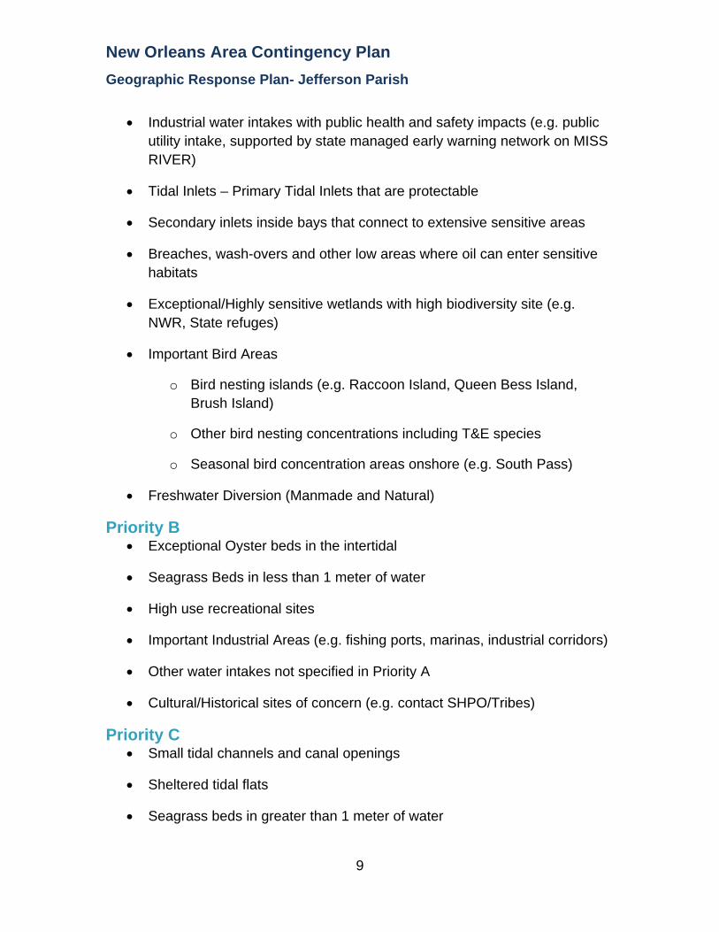
Priority A • Public drinking water intakes
8
New Orleans Area Contingency Plan Geographic Response Plan- Jefferson Parish
• Industrial water intakes with public health and safety impacts (e.g. public
utility intake, supported by state managed early warning network on MISS RIVER)
• Tidal Inlets – Primary Tidal Inlets that are protectable
• Secondary inlets inside bays that connect to extensive sensitive areas
• Breaches, wash-overs and other low areas where oil can enter sensitive habitats
• Exceptional/Highly sensitive wetlands with high biodiversity site (e.g. NWR, State refuges)
• Important Bird Areas
o Bird nesting islands (e.g. Raccoon Island, Queen Bess Island, Brush Island)
o Other bird nesting concentrations including T&E species
o Seasonal bird concentration areas onshore (e.g. South Pass)
• Freshwater Diversion (Manmade and Natural)
Priority B • Exceptional Oyster beds in the intertidal
• Seagrass Beds in less than 1 meter of water
• High use recreational sites
• Important Industrial Areas (e.g. fishing ports, marinas, industrial corridors)
• Other water intakes not specified in Priority A
• Cultural/Historical sites of concern (e.g. contact SHPO/Tribes)
Priority C • Small tidal channels and canal openings
• Sheltered tidal flats
• Seagrass beds in greater than 1 meter of water
9
New Orleans Area Contingency Plan Geographic Response Plan- Jefferson Parish
10
• Aquaculture sites and oyster lease areas
• Wetland restoration areas
• Other industrial areas
• Areas identified by local authorities not previously noted in Priority A or B
The following areas were not included due to the initial protection difficulty: • Open gulf beaches
• Exposed wetland shorelines (exposed to waves and currents) (as described in Appendix G)
• Exposed rip-rap
1.7 Strategy Selection Booming strategy recommendations were developed using local knowledge, scientific data, and known operational uses and limitation of common oil spill response equipment. Utilizing publications, such as the Exxon Mobil Oil Spill Response Manual and the National Oceanic Atmospheric Administration’s Characteristic Coastal Habitats Choosing Spill Response Alternatives) a quick reference job-aid was developed to assist with the selection of an appropriate site given the noted hydrology and climatic considerations. This process applies a consistent and standard analysis of each site. All water body openings, cuts, and lengths between two points of land greater than one thousand feet (1,000 ft) received a strategy of Deferred Action due to limited resources available during initial response. All sites related to infrastructure or private resources received a strategy of Notification to Site Manager. However, these sites are considered sensitive and should be given due consideration for more defensive response actions by the Incident Command.
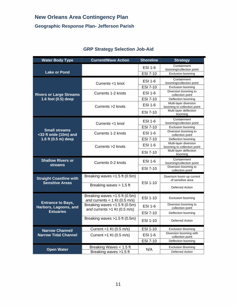
New Orleans Area Contingency Plan Geographic Response Plan- Jefferson Parish
GRP Strategy Selection Job-Aid
Water Body Type Current/Wave Action Shoreline Strategy
Lake or Pond ESI 1-6 Containment
booming/collection point ESI 7-10 Exclusion booming
Rivers or Large Streams 1.6 feet (0.5) deep
Currents <1 knot ESI 1-6 Containment booming/collection point
ESI 7-10 Exclusion booming
Currents 1-2 knots
ESI 1-6 Diversion booming to collection point
ESI 7-10 Deflection booming
Currents >2 knots
ESI 1-6 Multi-layer diversion booming to collection point
ESI 7-10 Multi-layer deflection booming
Small streams <33 ft wide (10m) and
1.6 ft (0.5 m) deep
Currents <1 knot ESI 1-6 Containment booming/collection point
ESI 7-10 Exclusion booming
Currents 1-2 knots
ESI 1-6 Diversion booming to collection point
ESI 7-10 Deflection booming
Currents >2 knots
ESI 1-6 Multi-layer diversion booming to collection point
ESI 7-10 Multi-layer deflection booming
Shallow Rivers or streams
Currents 0-2 knots
ESI 1-6 Containment
booming/collection point
ESI 7-10 Diversion booming to collection point
Straight Coastline with Sensitive Areas
Breaking waves <1.5 ft (0.5m) ESI 1-10
Diversion boom up current of sensitive area
Breaking waves > 1.5 ft Deferred Action
Entrance to Bays, Harbors, Lagoons, and
Estuaries
Breaking waves <1.5 ft (0.5m) and currents < 1 Kt (0.5 m/s) ESI 1-10 Exclusion booming
Breaking waves <1.5 ft (0.5m) and currents >1 Kt (0.5 m/s)
ESI 1-6 Diversion booming to collection point
ESI 7-10 Deflection booming
Breaking waves >1.5 ft (0.5m) ESI 1-10 Deferred Action
Narrow Channel/ Narrow Tidal Channel
Current <1 Kt (0.5 m/s) ESI 1-10 Exclusion Booming
Current >1 Kt (0.5 m/s)
ESI 1-6 Diversion booming with collection point
ESI 7-10 Deflection booming
Open Water Breaking Waves < 1.5 ft N/A Exclusion Booming Breaking waves >1.5 ft Deferred Action
11
New Orleans Area Contingency Plan Geographic Response Plan- Jefferson Parish
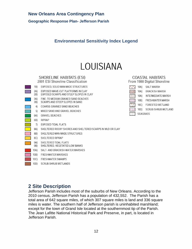
Environmental Sensitivity Index Legend
2 Site Description Jefferson Parish includes most of the suburbs of New Orleans. According to the 2010 census, Jefferson Parish has a population of 432,552. The Parish has a total area of 642 square miles, of which 307 square miles is land and 336 square miles is water. The southern half of Jefferson parish is uninhabited marshland; except for the town of Grand Isle located at the southernmost tip of the Parish. The Jean Lafitte National Historical Park and Preserve, in part, is located in Jefferson Parish.
12
New Orleans Area Contingency Plan Geographic Response Plan- Jefferson Parish
13
This Index is broken up into 19 maps listed on the following page. LA BRANCHE
INDIAN BEACH
SPANISH FORT
LULING
NEW ORLEANS WEST
NEW ORLEANS EAST
LAKE CATAOUATCHE EAST
BERTRANDVILLE
BARATARIA
LAFITTE
BAY L’OURS
THREE BAYOU BAY
LAKE LAURIER
BAY DOSGRIS
WILKINSON BAY
BAY TAMBOUR
BARATARIA PASS
CAMINADA PASS
GRAND ISLE

New Orleans Area Contingency Plan Geographic Response Plan- Jefferson Parish
3 Maps The following pages contain the above mentioned maps and the associated sensitive sites and recommended response strategies.
14

Sector New Orleans GRP Jefferson Parish Index Map

New Orleans Area Contingency Plan
Geographic Response Plan- Jefferson Parish
This page is intentionally left blank

!
!
Louis ArmstrongLouis ArmstrongNew OrleansNew OrleansInternational AirportInternational Airport
CanalNO 2
CanalNO 2
CanalNO 11
CanalNO 11
Cana
l
Cana
lNO
17
BayouTrepagnier
Canal NO 12
Cana
l NO
17Dr
ain D
itch N
O 7
Canal NO 14Du
ncan
Cana
l
Canal NO 7
Canal NO 13
Cana
l NO
10
Pipeli
neCa
nal
LakePontchartrain
§̈¦310
§̈¦10§̈¦10
LAPL
ACE
LA B
RANC
HE
LULINGLA BRANCHE
LA BRANCHEBONNET CARRE NE
A2
A1
St. Johnthe BaptistParish
St.CharlesParish
JeffersonParish
90°15'0"W
90°15'0"W
90°22'30"W
90°22'30"W
30°7'
30"N
30°7'
30"N
30°0'
0"N
30°0'
0"N
±0 1 2 30.5
Miles
LA BRANCHE Quad
MetairieMetairieLafayetteLafayette
Baton RougeBaton Rouge
New OrleansNew Orleans
§̈¦12§̈¦55
§̈¦310
§̈¦110
§̈¦10
LOUISIANALOUISIANA
Gulf of Mexico
Legend! GRP Sites
Quad BoundaryParish Boundaries
0 1 2 30.5Kilometers
Locator MapLocator Map
New Orleans Area Contingency Plan Sensitive Site Index
Response Considerations
Resources At Risk
Contact Information
Site Statistics
Resources At Risk Comments:
Sensitive Habitat
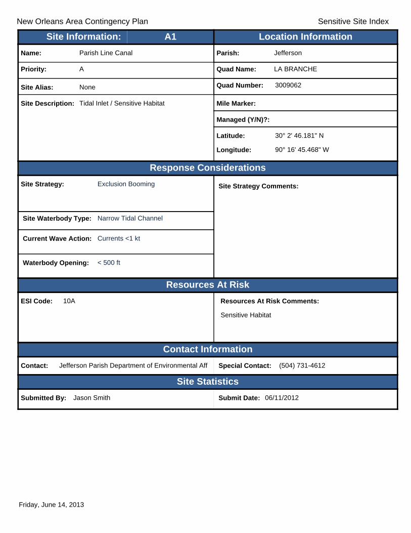
Contact: Jefferson Parish Department of Environmental Aff Special Contact: (504) 731-4612
Submitted By: Jason Smith Submit Date: 06/11/2012
Site Strategy: Exclusion Booming Site Strategy Comments:
Site Waterbody Type: Narrow Tidal Channel
Current Wave Action: Currents <1 kt
Waterbody Opening: < 500 ft
ESI Code: 10A
Priority: A
Name: Parish Line Canal
Site Alias: None
Site Description: Tidal Inlet / Sensitive Habitat
Parish: Jefferson
Quad Name: LA BRANCHE
Quad Number: 3009062
Mile Marker:
Managed (Y/N)?:
Latitude: 30° 2' 46.181" N
Longitude: 90° 16' 45.468" W
Site Information: Location InformationText416:A1
Friday, June 14, 2013

New Orleans Area Contingency Plan Sensitive Site Index
Response Considerations
Resources At Risk
Contact Information
Site Statistics
Resources At Risk Comments:
None
Contact: Special Contact:
Submitted By: Mitch Theriot Submit Date: 4/24/2012
Site Strategy: Notification to Site Manager Site Strategy Comments:
Requires Review. Dot needs relocation.
Site Waterbody Type: Narrow Tidal Channel
Current Wave Action: Currents <1 kt
Waterbody Opening: Not Applicable
ESI Code: 10D
Priority: A
Name: Parish Line Pump Station
Site Alias: Pump Station #5
Site Description: Pump Station
Parish: Jefferson
Quad Name: LA BRANCHE
Quad Number: 3009062
Mile Marker:
Managed (Y/N)?:
Latitude: 30° 0' 40.251" N
Longitude: 90° 16' 46.718" W
Site Information: Location InformationText416:A2
Friday, June 14, 2013

New Orleans Area Contingency Plan
Geographic Response Plan- Jefferson Parish
This page is intentionally left blank

!
!
!
!
!
!
LinearPark
Canal StCanal
CanalNO 14
CanalNO 11
Canal NO 2
CanalNO 7
CanalNO 12
CanalNO 13
SoniatCanal
Drain
D itch
NO8
CanalNO 4
Bonn
abel
Cana
l Canal NO 2
Suburban Canal
Canal NO 1
Elmwood CanalDunc
an C
anal
Canal NO 3
LakePontchartrain
§̈¦10 §̈¦10
KennerKenner
NEW ORLEANS WESTINDIAN BEACH
LA B
RANC
HEIN
DIAN
BEA
CH
INDI
AN B
EACH
SPAN
ISH FO
RT
A1 A2
A3B1A4
C1
JeffersonParish
OrleansParish
90°7'30"W
90°7'30"W
90°15'0"W
90°15'0"W
30°7'
30"N
30°7'
30"N
30°0'
0"N
30°0'
0"N
±0 1 2 30.5
Miles
INDIAN BEACH Quad
MetairieMetairieLafayetteLafayette
Baton RougeBaton Rouge
New OrleansNew Orleans
§̈¦12§̈¦55
§̈¦310
§̈¦110
§̈¦10
LOUISIANALOUISIANA
Gulf of Mexico
Legend! GRP Sites
Quad BoundaryParish Boundaries
0 1 2 30.5Kilometers
Locator MapLocator Map

New Orleans Area Contingency Plan Sensitive Site Index
Response Considerations
Resources At Risk
Contact Information
Site Statistics
Resources At Risk Comments:
None
Contact: Special Contact:
Submitted By: Mitch Theriot Submit Date: 4/24/2012
Site Strategy: Notification to Site Manager Site Strategy Comments:
Site Waterbody Type: Entrance to Bays, etc
Current Wave Action: Breaking Waves <1.5 ft
Waterbody Opening: < 500 ft
ESI Code:
Priority: A
Name: Duncan Street Pump Station
Site Alias: Pump Station #4
Site Description: Pump Station
Parish: Jefferson
Quad Name: INDIAN BEACH
Quad Number: 3009063
Mile Marker:
Managed (Y/N)?:
Latitude: 30° 2' 27.397" N
Longitude: 90° 14' 39.330" W
Site Information: Location InformationText416:A1
Thursday, June 13, 2013

New Orleans Area Contingency Plan Sensitive Site Index
Response Considerations
Resources At Risk
Contact Information
Site Statistics
Resources At Risk Comments:
None
Contact: Special Contact:
Submitted By: Mitch Theriot Submit Date: 4/24/2012
Site Strategy: Notification to Site Manager Site Strategy Comments:
Site Waterbody Type: Entrance to Bays, etc
Current Wave Action: Breaking Waves <1.5 ft
Waterbody Opening: < 500 ft
ESI Code:
Priority: A
Name: Elmwood Pump Station
Site Alias: Pump Station #3
Site Description: Pump Station
Parish: Jefferson
Quad Name: INDIAN BEACH
Quad Number: 3009063
Mile Marker:
Managed (Y/N)?:
Latitude: 30° 2' 1.781" N
Longitude: 90° 13' 6.260" W
Site Information: Location InformationText416:A2
Thursday, June 13, 2013

New Orleans Area Contingency Plan Sensitive Site Index
Response Considerations
Resources At Risk
Contact Information
Site Statistics
Resources At Risk Comments:
None
Contact: Special Contact:
Submitted By: Mitch Theriot Submit Date: 4/24/2012
Site Strategy: Notification to Site Manager Site Strategy Comments:
Site Waterbody Type: Entrance to Bays, etc
Current Wave Action: Breaking Waves <1.5 ft
Waterbody Opening: < 500 ft
ESI Code:
Priority: A
Name: Suburban Pump Station
Site Alias: Pump Station #2
Site Description: Pump Station
Parish: Jefferson
Quad Name: INDIAN BEACH
Quad Number: 3009063
Mile Marker:
Managed (Y/N)?:
Latitude: 30° 1' 20.490" N
Longitude: 90° 10' 49.124" W
Site Information: Location InformationText416:A3
Thursday, June 13, 2013

New Orleans Area Contingency Plan Sensitive Site Index
Response Considerations
Resources At Risk
Contact Information
Site Statistics
Resources At Risk Comments:
Contact: Special Contact:
Submitted By: Mitch Theriot Submit Date: 20120424
Site Strategy: Notification to Site Manager Site Strategy Comments:
Site Waterbody Type: Entrance to Bays, etc
Current Wave Action: Breaking Waves <1.5 ft
Waterbody Opening: < 500 ft
ESI Code:
Priority: A
Name: Bonnabel Pump Station
Site Alias: Pump Station #1
Site Description: Pump Station
Parish: Jefferson
Quad Name: INDIAN BEACH
Quad Number: 3009063
Mile Marker:
Managed (Y/N)?:
Latitude: 30° 1' 10.931" N
Longitude: 90° 8' 40.978" W
Site Information: Location InformationText416:A4
Friday, June 14, 2013

New Orleans Area Contingency Plan Sensitive Site Index
Response Considerations
Resources At Risk
Contact Information
Site Statistics
Resources At Risk Comments:
Sensitive Habitat
Contact: Special Contact:
Submitted By: Jefferson Parish - Env Aff. Submit Date: 4/24/2012
Site Strategy: Deferred Action Site Strategy Comments:
Site Waterbody Type: Straight Coastline
Current Wave Action: Breaking Waves >1.5 ft
Waterbody Opening: Not Applicable
ESI Code:
Priority: B
Name: Bucktown Harbor
Site Alias: None
Site Description: Inlet to Bucktown Harbor Marsh
Parish: Jefferson
Quad Name: INDIAN BEACH
Quad Number: 3009063
Mile Marker:
Managed (Y/N)?: No
Latitude: 30° 1' 15.353" N
Longitude: 90° 7' 42.711" W
Site Information: Location InformationText416:B1
Thursday, June 13, 2013

New Orleans Area Contingency Plan Sensitive Site Index
Response Considerations
Resources At Risk
Contact Information
Site Statistics
Resources At Risk Comments:
Contact: Special Contact:
Submitted By: Jefferson Parish - Env Aff. / J-471:Jefferson Submit Date: 20120424
Site Strategy: Deferred Action Site Strategy Comments:
Site Waterbody Type: Entrance to Bays, etc
Current Wave Action: Breaking Waves >1.5 ft
Waterbody Opening: < 500 ft
ESI Code:
Priority: C
Name: Kenner Boat Launch
Site Alias: None
Site Description:
Parish: Jefferson
Quad Name: INDIAN BEACH
Quad Number: 3009063
Mile Marker:
Managed (Y/N)?:
Latitude: 30° 2' 35.837" N
Longitude: 90° 14' 14.766" W
Site Information: Location InformationText416:C1
Thursday, June 13, 2013

New Orleans Area Contingency Plan
Geographic Response Plan- Jefferson Parish
This page is intentionally left blank

!
!
!
! !
!
!!
! !
!
!
!
CityPark
LakefrontLakefrontAirportAirport
Lago
onNO
7Ba
you
St Jo
hn
DwyerCanal
Peop
lesCa
nal
Lago
onNO
1
Lawrence
Canal
CanalNO 2 Dwyer Canal
LambCanal
St Charles Canal
Dwyer CanalMorrison Canal
LakePontchartrain
£¤90£¤90 §̈¦10
§̈¦10
INDI
AN B
EACH
SPAN
ISH
FORT
NEW ORLEANS EASTSPANISH FORT
SPAN
ISH
FORT
LITTL
E W
OODS
A5
B7 B6B5 A3 A4
C1
A2
B4 B3
B2A1
B1
JeffersonParish
OrleansParish
90°0'0"W
90°0'0"W
90°7'30"W
90°7'30"W
30°7'
30"N
30°7'
30"N
30°0'
0"N
30°0'
0"N
±0 1 2 30.5
Miles
SPANISH FORT Quad
MetairieMetairieLafayetteLafayette
Baton RougeBaton Rouge
New OrleansNew Orleans
§̈¦12§̈¦55
§̈¦310
§̈¦110
§̈¦10
LOUISIANALOUISIANA
Gulf of Mexico
Legend! GRP Sites
Quad BoundaryParish Boundaries
0 1 2 30.5Kilometers
Locator MapLocator Map

New Orleans Area Contingency Plan Sensitive Site Index
Response Considerations
Resources At Risk
Contact Information
Site Statistics
Resources At Risk Comments:
None
Contact: Special Contact:
Submitted By: Paul Reeb Submit Date: 4/30/2012
Site Strategy: Notification to Site Manager Site Strategy Comments:
Site Waterbody Type: Entrance to Bays, etc
Current Wave Action: Breaking Waves >1.5 ft
Waterbody Opening: < 500 ft
ESI Code:
Priority: A
Name: Wales Street Pumping Station
Site Alias: None
Site Description: Pumping Station
Parish: Orleans
Quad Name: SPANISH FORT
Quad Number: 3009064
Mile Marker:
Managed (Y/N)?:
Latitude: 30° 2' 18.381" N
Longitude: 90° 0' 42.129" W
Site Information: Location InformationText416:A1
Thursday, June 13, 2013

New Orleans Area Contingency Plan Sensitive Site Index
Response Considerations
Resources At Risk
Contact Information
Site Statistics
Resources At Risk Comments:
None
Contact: Special Contact:
Submitted By: Paul Reeb Submit Date: 4/30/2012
Site Strategy: Notification to Site Manager Site Strategy Comments:
Site Waterbody Type: Entrance to Bays, etc
Current Wave Action: Breaking Waves >1.5 ft
Waterbody Opening: 500-1000 ft
ESI Code:
Priority: A
Name: Inner Harbor Navigational Canal
Site Alias: None
Site Description: Industrial Canal
Parish: Orleans
Quad Name: SPANISH FORT
Quad Number: 3009064
Mile Marker:
Managed (Y/N)?:
Latitude: 30° 1' 53.611" N
Longitude: 90° 2' 4.318" W
Site Information: Location InformationText416:A2
Thursday, June 13, 2013
New Orleans Area Contingency Plan Sensitive Site Index
Response Considerations
Resources At Risk
Contact Information
Site Statistics
Resources At Risk Comments:
None
Contact: Special Contact:
Submitted By: Paul Reeb Submit Date: 4/30/2012
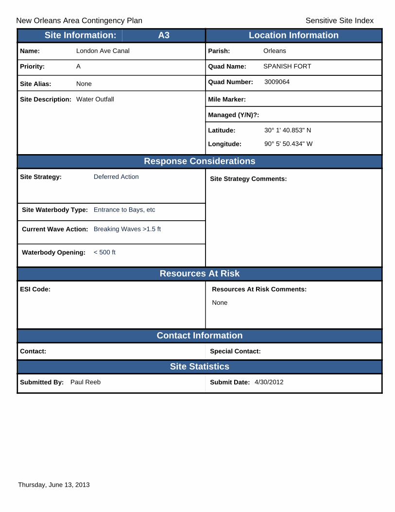
Site Strategy: Deferred Action Site Strategy Comments:
Site Waterbody Type: Entrance to Bays, etc
Current Wave Action: Breaking Waves >1.5 ft
Waterbody Opening: < 500 ft
ESI Code:
Priority: A
Name: London Ave Canal
Site Alias: None
Site Description: Water Outfall
Parish: Orleans
Quad Name: SPANISH FORT
Quad Number: 3009064
Mile Marker:
Managed (Y/N)?:
Latitude: 30° 1' 40.853" N
Longitude: 90° 5' 50.434" W
Site Information: Location InformationText416:A3
Thursday, June 13, 2013
New Orleans Area Contingency Plan Sensitive Site Index
Response Considerations
Resources At Risk
Contact Information
Site Statistics
Resources At Risk Comments:
None
Contact: Special Contact:
Submitted By: Paul Reeb Submit Date: 4/30/2012
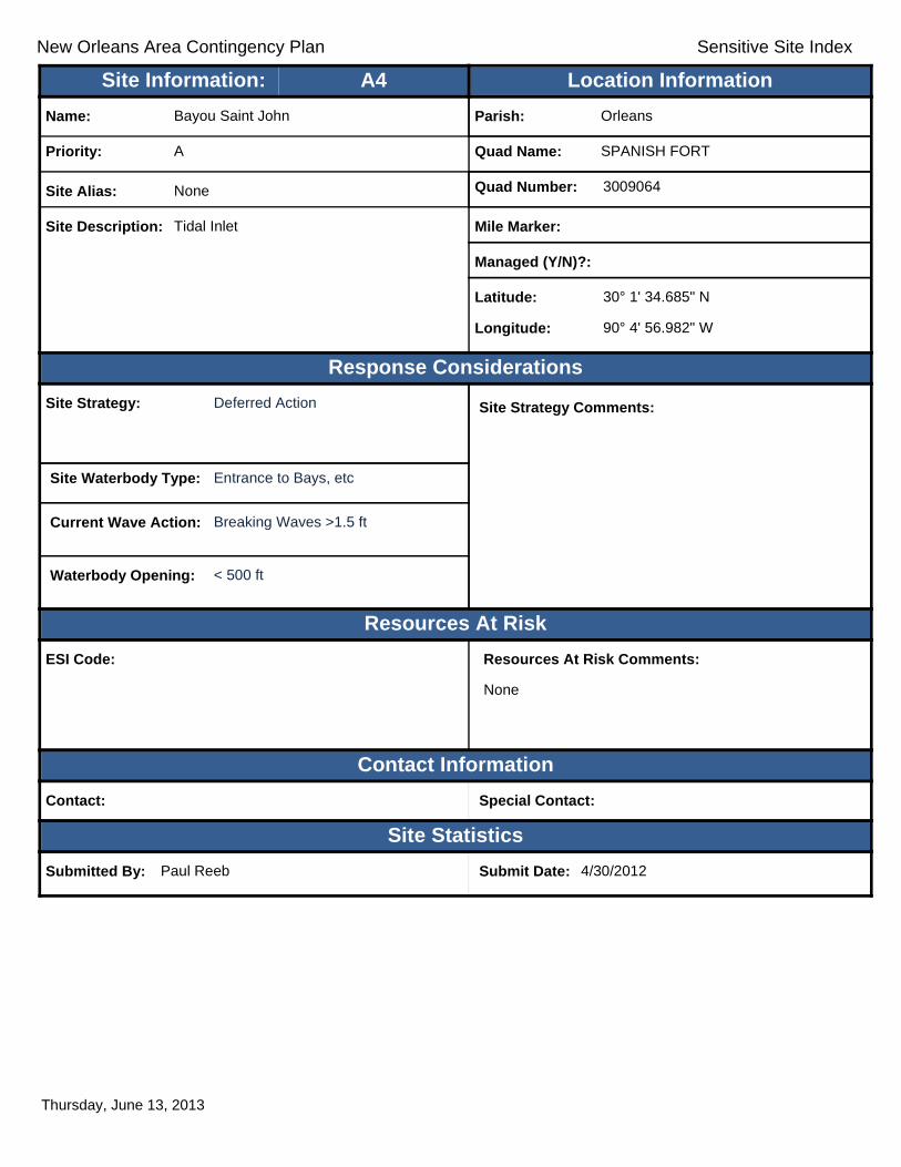
Site Strategy: Deferred Action Site Strategy Comments:
Site Waterbody Type: Entrance to Bays, etc
Current Wave Action: Breaking Waves >1.5 ft
Waterbody Opening: < 500 ft
ESI Code:
Priority: A
Name: Bayou Saint John
Site Alias: None
Site Description: Tidal Inlet
Parish: Orleans
Quad Name: SPANISH FORT
Quad Number: 3009064
Mile Marker:
Managed (Y/N)?:
Latitude: 30° 1' 34.685" N
Longitude: 90° 4' 56.982" W
Site Information: Location InformationText416:A4
Thursday, June 13, 2013

New Orleans Area Contingency Plan Sensitive Site Index
Response Considerations
Resources At Risk
Contact Information
Site Statistics
Resources At Risk Comments:
Contact: Special Contact:
Submitted By: Paul Reeb Submit Date: 20120430
Site Strategy: Notification to Site Manager Site Strategy Comments:
Site Waterbody Type: Entrance to Bays, etc
Current Wave Action: Breaking Waves >1.5 ft
Waterbody Opening: < 500 ft
ESI Code:
Priority: A
Name: 17th Street Canal
Site Alias: None
Site Description:
Parish: Jefferson
Quad Name: SPANISH FORT
Quad Number: 3009064
Mile Marker:
Managed (Y/N)?:
Latitude: 30° 1' 19.492" N
Longitude: 90° 7' 16.334" W
Site Information: Location InformationText416:A5
Thursday, June 13, 2013
New Orleans Area Contingency Plan Sensitive Site Index
Response Considerations
Resources At Risk
Contact Information
Site Statistics
Resources At Risk Comments:
None
Contact: Special Contact:
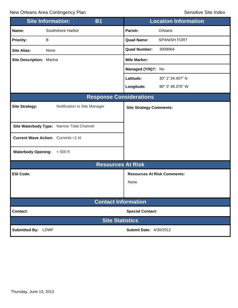
Submitted By: LDWF Submit Date: 4/30/2012
Site Strategy: Notification to Site Manager Site Strategy Comments:
Site Waterbody Type: Narrow Tidal Channel
Current Wave Action: Currents <1 kt
Waterbody Opening: < 500 ft
ESI Code:
Priority: B
Name: Southshore Harbor
Site Alias: None
Site Description: Marina
Parish: Orleans
Quad Name: SPANISH FORT
Quad Number: 3009064
Mile Marker:
Managed (Y/N)?: No
Latitude: 30° 2' 34.407" N
Longitude: 90° 0' 48.376" W
Site Information: Location InformationText416:B1
Thursday, June 13, 2013

New Orleans Area Contingency Plan Sensitive Site Index
Response Considerations
Resources At Risk
Contact Information
Site Statistics
Resources At Risk Comments:
None
Contact: Special Contact:
Submitted By: LDWF Submit Date: 4/30/2012
Site Strategy: Notification to Site Manager Site Strategy Comments:
Site Waterbody Type: Straight Coastline
Current Wave Action: Breaking Waves >1.5 ft
Waterbody Opening: Not Applicable
ESI Code:
Priority: B
Name: Lakefront Airport
Site Alias: None
Site Description: Industrial Area
Parish: Orleans
Quad Name: SPANISH FORT
Quad Number: 3009064
Mile Marker:
Managed (Y/N)?: No
Latitude: 30° 2' 24.201" N
Longitude: 90° 1' 35.438" W
Site Information: Location InformationText416:B2
Thursday, June 13, 2013

New Orleans Area Contingency Plan Sensitive Site Index
Response Considerations
Resources At Risk
Contact Information
Site Statistics
Resources At Risk Comments:
None
Contact: Special Contact:
Submitted By: Paul Reeb Submit Date: 4/30/2012
Site Strategy: Deferred Action Site Strategy Comments:
Site Waterbody Type: Entrance to Bays, etc
Current Wave Action: Breaking Waves >1.5 ft
Waterbody Opening: < 500 ft
ESI Code:
Priority: B
Name: Seabrook Boat Launch
Site Alias: None
Site Description: Boat Launch
Parish: Orleans
Quad Name: SPANISH FORT
Quad Number: 3009064
Mile Marker:
Managed (Y/N)?:
Latitude: 30° 2' 3.467" N
Longitude: 90° 2' 31.016" W
Site Information: Location InformationText416:B3
Thursday, June 13, 2013

New Orleans Area Contingency Plan Sensitive Site Index
Response Considerations
Resources At Risk
Contact Information
Site Statistics
Resources At Risk Comments:
None
Contact: Special Contact:
Submitted By: LA CPRA/DNR Submit Date: 5/16/2012
Site Strategy: Deferred Action Site Strategy Comments:
Site Waterbody Type: Straight Coastline
Current Wave Action: Breaking Waves >1.5 ft
Waterbody Opening: Not Applicable
ESI Code:
Priority:
Name: Pontchartrain Beach
Site Alias: None
Site Description: Recreational Area
Parish: Orleans
Quad Name: SPANISH FORT
Quad Number: 3009064
Mile Marker: 0
Managed (Y/N)?:
Latitude: 30° 2' 2.540" N
Longitude: 90° 3' 43.691" W
Site Information: Location InformationText416:B4
Thursday, June 13, 2013

New Orleans Area Contingency Plan Sensitive Site Index
Response Considerations
Resources At Risk
Contact Information
Site Statistics
Resources At Risk Comments:
Contact: Special Contact:
Submitted By: Paul Reeb Submit Date: 20120430
Site Strategy: Notification to Site Manager Site Strategy Comments:
Site Waterbody Type: Narrow Tidal Channel
Current Wave Action: Currents <1 kt
Waterbody Opening: < 500 ft
ESI Code:
Priority: B
Name: New Orleans Marina
Site Alias: None
Site Description:
Parish: Orleans
Quad Name: SPANISH FORT
Quad Number: 3009064
Mile Marker:
Managed (Y/N)?:
Latitude: 30° 1' 41.524" N
Longitude: 90° 6' 53.042" W
Site Information: Location InformationText416:B5
Thursday, June 13, 2013

New Orleans Area Contingency Plan Sensitive Site Index
Response Considerations
Resources At Risk
Contact Information
Site Statistics
Resources At Risk Comments:
None
Contact: Special Contact:
Submitted By: Paul Reeb Submit Date: 4/30/2012
Site Strategy: Exclusion Booming Site Strategy Comments:
Site Waterbody Type: Narrow Tidal Channel
Current Wave Action: Currents <1 kt
Waterbody Opening: < 500 ft
ESI Code:
Priority: B
Name: Orleans Outfall Canal
Site Alias: None
Site Description: Water Outfall
Parish: Orleans
Quad Name: SPANISH FORT
Quad Number: 3009064
Mile Marker:
Managed (Y/N)?:
Latitude: 30° 1' 36.711" N
Longitude: 90° 6' 50.207" W
Site Information: Location InformationText416:B6
Thursday, June 13, 2013

New Orleans Area Contingency Plan Sensitive Site Index
Response Considerations
Resources At Risk
Contact Information
Site Statistics
Resources At Risk Comments:
Contact: Special Contact:
Submitted By: Jefferson Parish - Env Aff. / J-248:Blank Submit Date: 20120424
Site Strategy: Notification to Site Manager Site Strategy Comments:
Site Waterbody Type: Entrance to Bays, etc
Current Wave Action: Breaking Waves >1.5 ft
Waterbody Opening: < 500 ft
ESI Code:
Priority: B
Name: Bucktown Marina
Site Alias: None
Site Description:
Parish: Jefferson
Quad Name: SPANISH FORT
Quad Number: 3009064
Mile Marker:
Managed (Y/N)?:
Latitude: 30° 1' 27.818" N
Longitude: 90° 7' 19.218" W
Site Information: Location InformationText416:B7
Thursday, June 13, 2013

New Orleans Area Contingency Plan Sensitive Site Index
Response Considerations
Resources At Risk
Contact Information
Site Statistics
Resources At Risk Comments:
None
Contact: Orleans Parish Special Contact:
Submitted By: Submit Date: 06/11/2012
Site Strategy: Deferred Action Site Strategy Comments:
Site Waterbody Type: Entrance to Bays, etc
Current Wave Action: Breaking Waves >1.5 ft
Waterbody Opening: < 500 ft
ESI Code:
Priority:
Name: London Ave. Canal Outfall
Site Alias: None
Site Description:
Parish: Orleans
Quad Name: SPANISH FORT
Quad Number: 3009064
Mile Marker:
Managed (Y/N)?:
Latitude: 30° 1' 55.370" N
Longitude: 90° 4' 27.629" W
Site Information: Location InformationText416:C1
Thursday, June 13, 2013
!
!
Louis ArmstrongLouis ArmstrongNew OrleansNew Orleans
International AirportInternational Airport
Sauls
Canal
BayouVerret
Cous
inCa
nal
Garl a
ndC a
nal
Peter
son C
anal
Dusu
aus
Cana
l
Lake Cataouatche
Levee Canals
DuncanCanal
Cana
lNO
17
Sauls
Canal
Dunc
anCa
nal
Cana
lNO
7
BayouVerret
Sauls
Can
al
Lower Lanaux
Canal
Cros
s Bay
ouCa
nal
Dusu
aus C
anal
D r a i n
D i tc h NO8
Lower LanauxCanal
Outfall
CanalEllingtonCanal
Pipe
line
C an a
l
Canal NO 15
Canal NO 14
Blouin Canal
Sellers Canal
ST3060
ST48ST48
ST48
ST18
ST3060ST52
ST626
ST48
ST18
£¤90
£¤61£¤61£¤61
£¤61
£¤90
§̈¦310§̈¦310
AmaAma
LulingLuling
St. RoseSt. Rose
LULIN
GNE
W OR
LEAN
S WE
ST
LULINGLA BRANCHE
A1
A2
St.CharlesParish
JeffersonParish
90°15'0"W
90°15'0"W
90°22'30"W
90°22'30"W
30°0'
0"N
30°0'
0"N
29°52
'30"N
29°52
'30"N
±0 1 2 30.5
Miles
LULING Quad
MetairieMetairieLafayetteLafayette
Baton RougeBaton Rouge
New OrleansNew Orleans
§̈¦12§̈¦55
§̈¦310
§̈¦110
§̈¦10
LOUISIANALOUISIANA
Gulf of Mexico
Legend! GRP Sites
Quad BoundaryParish Boundaries
0 1 2 30.5Kilometers
Locator MapLocator Map

New Orleans Area Contingency Plan Sensitive Site Index
Response Considerations
Resources At Risk
Contact Information
Site Statistics
Resources At Risk Comments:
Natural Resources
Contact: Gene Tierney Special Contact: 504-431-6558
Submitted By: Jefferson Parish HAZMAT Submit Date: 4/24/2012
Site Strategy: Notification to Site Manager Site Strategy Comments:
Site Waterbody Type: Rivers or Large Streams
Current Wave Action: Currents >2 kts
Waterbody Opening: Not Applicable
ESI Code: 10C
Priority: A
Name: Cornerstone Chemical
Site Alias: Cytex
Site Description: Chemical Plant
Parish: Jefferson
Quad Name: LULING
Quad Number: 2909006
Mile Marker: 114.5
Managed (Y/N)?: No
Latitude: 29° 57' 52.194" N
Longitude: 90° 16' 18.447" W
Site Information: Location InformationText416:A1
Thursday, June 13, 2013
New Orleans Area Contingency Plan Sensitive Site Index
Response Considerations
Resources At Risk
Contact Information
Site Statistics
Resources At Risk Comments:
Contact: Special Contact:
Submitted By: LA CPRA Submit Date: 6/28/2012
Site Strategy: Multi-Layer Deflection Booming Site Strategy Comments:
Notification to Site Manager.
Site Waterbody Type: Rivers or Large Streams
Current Wave Action: Currents >2 kts
Waterbody Opening: Not Applicable
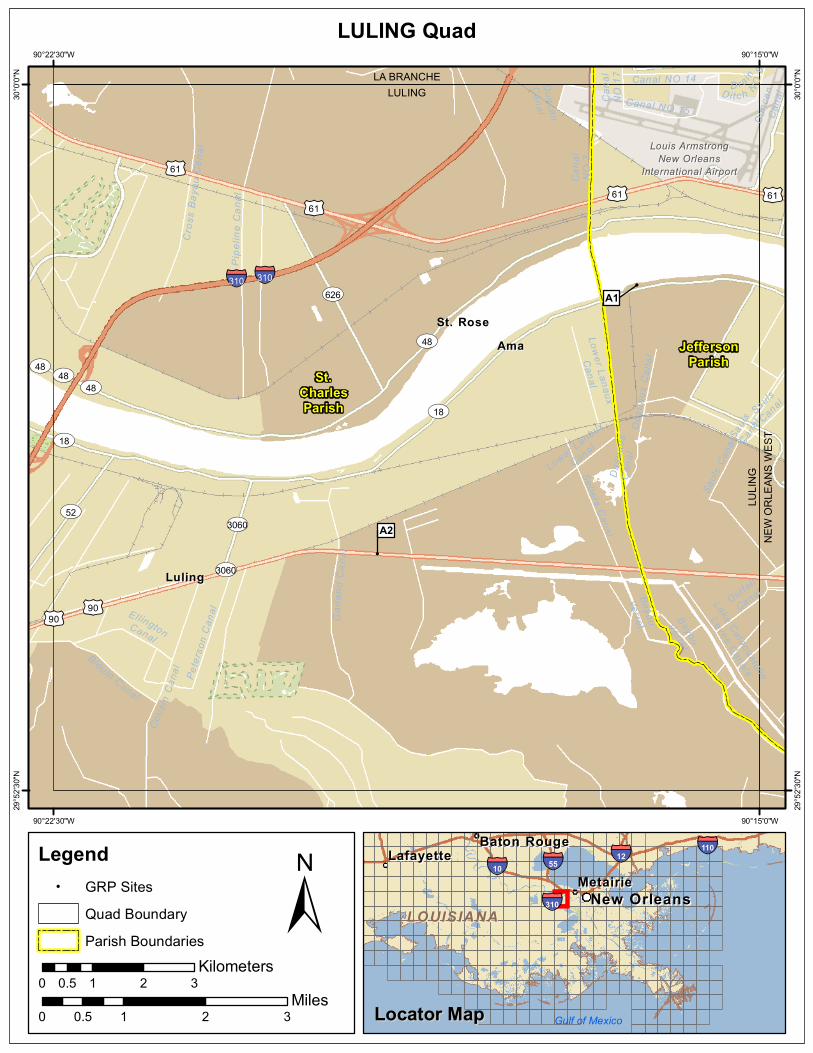
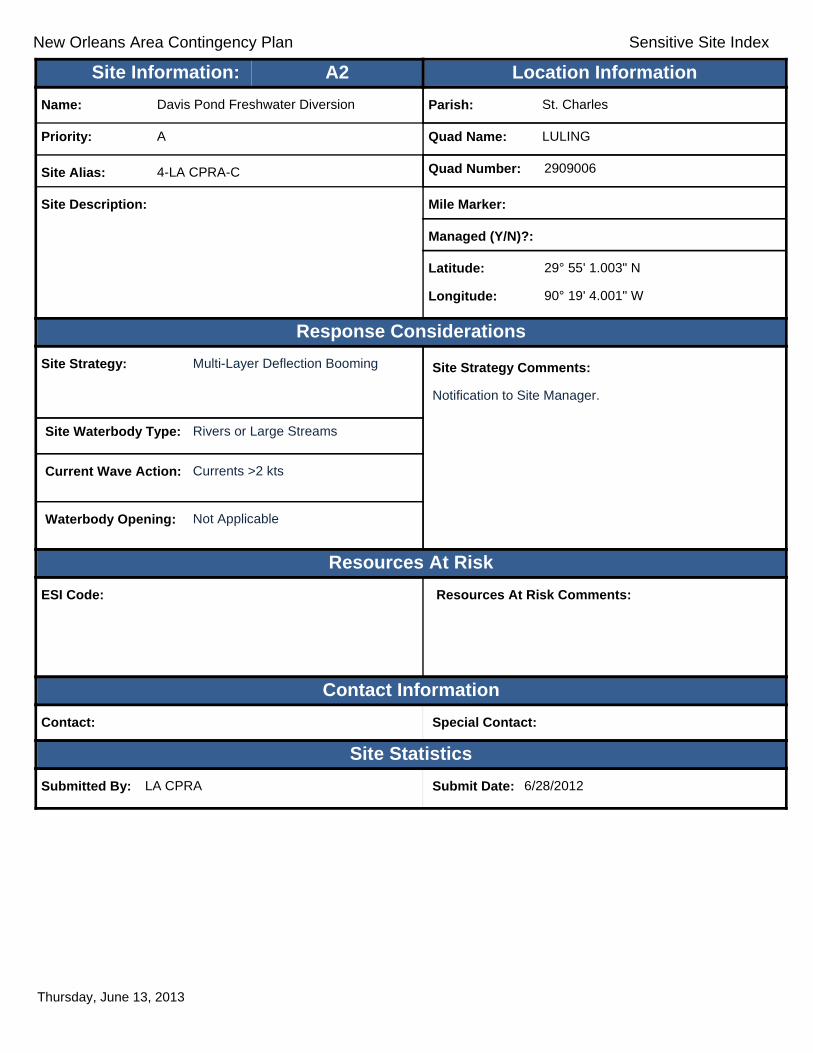
ESI Code:
Priority: A
Name: Davis Pond Freshwater Diversion
Site Alias: 4-LA CPRA-C
Site Description:
Parish: St. Charles
Quad Name: LULING
Quad Number: 2909006
Mile Marker:
Managed (Y/N)?:
Latitude: 29° 55' 1.003" N
Longitude: 90° 19' 4.001" W
Site Information: Location InformationText416:A2
Thursday, June 13, 2013
New Orleans Area Contingency Plan
Geographic Response Plan- Jefferson Parish
This page is intentionally left blank

!
!
!
!
!
!
!
!
! !
!
AvengerPark
TPCLouisiana
CanalNO 5
Sauls
Cana
l
DugasCanal
Railro
adCa
nal
Whiskey
Bayou
Whiske
yBa
you
Canal NO 5 CanalNO 3
BayouSegnette
SoniatCanal
BayouSegnette
Avon
dale
Home
s Can
al
SoniatCanal
CanalNO 5
CanalNO 3
Labra
nche
Cana
l
Drain
D itch
NO8
Railroa
dCan
al
Cana
l NO
1
Wag
gama
nCa
nal
Wagg
aman
Cana
l
Canal StCanal
MainCan
al
Dunc
anCa
nal
Outfall
Canal
Canal NO 5
Bonn
abel
Cana
l
Sauls Canal
MayronneCanalMayronne Canal
Canal NO 5
Westw
ego
Drain
age C
a
Suburban Canal
Cana
l NO
2
Lake Cataouatche
Levee Canals
Soniat Canal
Duga
s Can
al
Main
Cana
l
Main
Cana
l
Canal NO 4
ST18
ST48
ST48
ST541
ST18
ST541
ST18
ST48
£¤90
£¤90
£¤61£¤61
£¤90
£¤90
£¤90£¤90
£¤90£¤90
§̈¦610§̈¦10 §̈¦10
MetairieMetairie
AvondaleAvondale
BridgeBridgeCityCity
ElmwoodElmwood
HarahanHarahan
JeffersonJeffersonRiverRiverRidgeRidge
WaggamanWaggaman
WestwegoWestwego
NEW ORLEANS WESTINDIAN BEACH
LULIN
GNE
W O
RLEA
NS W
EST
NEW ORLEANS WESTLAKE CATAOUATCHE EAST
NEW
ORL
EANS
WES
TNE
W O
RLEA
NS E
AST
A9
A8
B2
A7
A6
B1A5
A4
A2 A3A1
St.CharlesParish
JeffersonParish
OrleansParish
90°7'30"W
90°7'30"W
90°15'0"W
90°15'0"W
30°0'
0"N
30°0'
0"N
29°52
'30"N
29°52
'30"N
±0 1 2 30.5
Miles
NEW ORLEANS WEST Quad
MetairieMetairieLafayetteLafayette
Baton RougeBaton Rouge
New OrleansNew Orleans
§̈¦12§̈¦55
§̈¦310
§̈¦110
§̈¦10
LOUISIANALOUISIANA
Gulf of Mexico
Legend! GRP Sites
Quad BoundaryParish Boundaries
0 1 2 30.5Kilometers
Locator MapLocator Map

New Orleans Area Contingency Plan Sensitive Site Index
Response Considerations
Resources At Risk
Contact Information
Site Statistics
Resources At Risk Comments:
Drinking water
Contact: Jefferson Parish Water Dept. Special Contact: 504-838-4363
Submitted By: Jefferson Parish HAZMAT Submit Date: 4/24/2012
Site Strategy: Notification to Site Manager Site Strategy Comments:
Site Waterbody Type: Rivers or Large Streams
Current Wave Action: Currents >2 kts
Waterbody Opening: Not Applicable
ESI Code: 10C
Priority: A
Name: East Bank Water Intake
Site Alias: None
Site Description: Drinking Water Supply Intake
Parish: Jefferson
Quad Name: NEW ORLEANS WEST
Quad Number: 2909007
Mile Marker: 105.4
Managed (Y/N)?: No
Latitude: 29° 57' 16.423" N
Longitude: 90° 9' 47.323" W
Site Information: Location InformationText416:A1
Thursday, June 13, 2013

New Orleans Area Contingency Plan Sensitive Site Index
Response Considerations
Resources At Risk
Contact Information
Site Statistics
Resources At Risk Comments:
Generation Plant
Contact: Entergy Corp. Special Contact: Entergy Corp.
Submitted By: Jefferson Parish HAZMAT Submit Date: 4/24/2012
Site Strategy: Notification to Site Manager Site Strategy Comments:
Site Waterbody Type: Rivers or Large Streams
Current Wave Action: Currents >2 kts
Waterbody Opening: Not Applicable
ESI Code:
Priority: A
Name: Entergy 9 Mile Point
Site Alias: None
Site Description: Electrical Generation Plant
Parish: Jefferson
Quad Name: NEW ORLEANS WEST
Quad Number: 2909007
Mile Marker: 104.0
Managed (Y/N)?: No
Latitude: 29° 57' 4.413" N
Longitude: 90° 8' 47.531" W
Site Information: Location InformationText416:A2
Thursday, June 13, 2013

New Orleans Area Contingency Plan Sensitive Site Index
Response Considerations
Resources At Risk
Contact Information
Site Statistics
Resources At Risk Comments:
Drinking water
Contact: Special Contact:
Submitted By: Paul Reeb Submit Date: 4/30/2012
Site Strategy: Notification to Site Manager Site Strategy Comments:
Site Waterbody Type: Rivers or Large Streams
Current Wave Action: Currents >2 kts
Waterbody Opening: Not Applicable
ESI Code: 10D
Priority: A
Name: Dakin Water Intake
Site Alias: None
Site Description: Water Intake
Parish: Orleans
Quad Name: NEW ORLEANS WEST
Quad Number: 2909007
Mile Marker: 104.2
Managed (Y/N)?:
Latitude: 29° 57' 3.482" N
Longitude: 90° 8' 13.822" W
Site Information: Location InformationText416:A3
Thursday, June 13, 2013

New Orleans Area Contingency Plan Sensitive Site Index
Response Considerations
Resources At Risk
Contact Information
Site Statistics
Resources At Risk Comments:
Drinking water
Contact: Special Contact:
Submitted By: Paul Reeb Submit Date: 4/30/2012
Site Strategy: Notification to Site Manager Site Strategy Comments:
Site Waterbody Type: Rivers or Large Streams
Current Wave Action: Currents >2 kts
Waterbody Opening: Not Applicable
ESI Code: 10C
Priority: A
Name: Oak Street Water Intake
Site Alias: None
Site Description: Water Intake
Parish: Orleans
Quad Name: NEW ORLEANS WEST
Quad Number: 2909007
Mile Marker: 103.9
Managed (Y/N)?:
Latitude: 29° 56' 31.805" N
Longitude: 90° 8' 9.551" W
Site Information: Location InformationText416:A4
Thursday, June 13, 2013
New Orleans Area Contingency Plan Sensitive Site Index
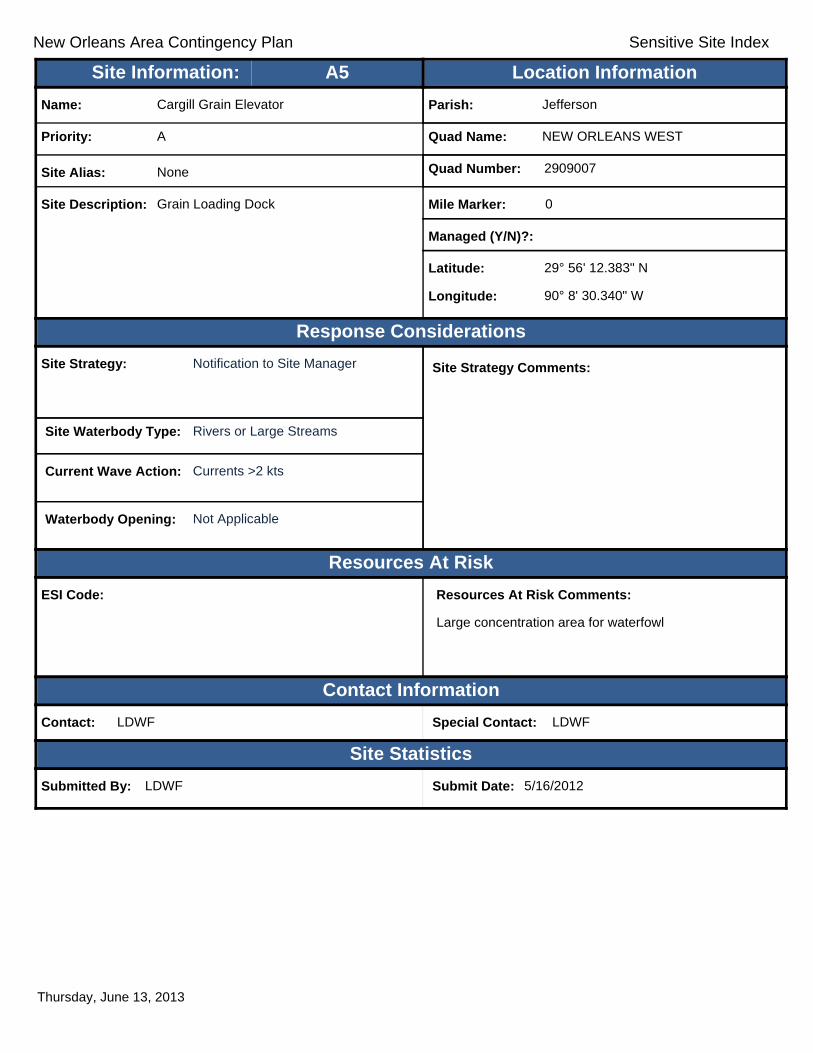
Response Considerations
Resources At Risk
Contact Information
Site Statistics
Resources At Risk Comments:
Large concentration area for waterfowl
Contact: LDWF Special Contact: LDWF
Submitted By: LDWF Submit Date: 5/16/2012
Site Strategy: Notification to Site Manager Site Strategy Comments:
Site Waterbody Type: Rivers or Large Streams
Current Wave Action: Currents >2 kts
Waterbody Opening: Not Applicable
ESI Code:
Priority: A
Name: Cargill Grain Elevator
Site Alias: None
Site Description: Grain Loading Dock
Parish: Jefferson
Quad Name: NEW ORLEANS WEST
Quad Number: 2909007
Mile Marker: 0
Managed (Y/N)?:
Latitude: 29° 56' 12.383" N
Longitude: 90° 8' 30.340" W
Site Information: Location InformationText416:A5
Thursday, June 13, 2013

New Orleans Area Contingency Plan Sensitive Site Index
Response Considerations
Resources At Risk
Contact Information
Site Statistics
Resources At Risk Comments:
Water
Contact: Special Contact:
Submitted By: Jefferson Parish HAZMAT Submit Date: 4/24/2012
Site Strategy: Notification to Site Manager Site Strategy Comments:
Site Waterbody Type: Rivers or Large Streams
Current Wave Action: Currents >2 kts
Waterbody Opening: Not Applicable
ESI Code:
Priority: A
Name: International Matex Tank Terminal
Site Alias: IMTT Avondale
Site Description: Tank Terminal
Parish: Jefferson
Quad Name: NEW ORLEANS WEST
Quad Number: 2909007
Mile Marker: 108.1
Managed (Y/N)?: No
Latitude: 29° 55' 24.674" N
Longitude: 90° 11' 24.712" W
Site Information: Location InformationText416:A6
Thursday, June 13, 2013

New Orleans Area Contingency Plan Sensitive Site Index
Response Considerations
Resources At Risk
Contact Information
Site Statistics
Resources At Risk Comments:
Drinking water intake
Contact: City of Westwego Special Contact: 504-431-3424
Submitted By: Submit Date: 4/24/2012
Site Strategy: Notification to Site Manager Site Strategy Comments:
Site Waterbody Type: Rivers or Large Streams
Current Wave Action: Currents >2 kts
Waterbody Opening: Not Applicable
ESI Code: 10C
Priority: A
Name: Westwego Water Intake
Site Alias: None
Site Description: Water Intake
Parish: Jefferson
Quad Name: NEW ORLEANS WEST
Quad Number: 2909007
Mile Marker: 101.5
Managed (Y/N)?: No
Latitude: 29° 55' 9.008" N
Longitude: 90° 8' 33.693" W
Site Information: Location InformationText416:A7
Thursday, June 13, 2013
New Orleans Area Contingency Plan Sensitive Site Index
Response Considerations
Resources At Risk
Contact Information
Site Statistics
Resources At Risk Comments:
None
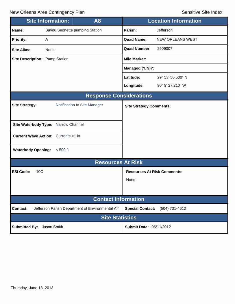
Contact: Jefferson Parish Department of Environmental Aff Special Contact: (504) 731-4612
Submitted By: Jason Smith Submit Date: 06/11/2012
Site Strategy: Notification to Site Manager Site Strategy Comments:
Site Waterbody Type: Narrow Channel
Current Wave Action: Currents <1 kt
Waterbody Opening: < 500 ft
ESI Code: 10C
Priority: A
Name: Bayou Segnette pumping Station
Site Alias: None
Site Description: Pump Station
Parish: Jefferson
Quad Name: NEW ORLEANS WEST
Quad Number: 2909007
Mile Marker:
Managed (Y/N)?:
Latitude: 29° 53' 50.500" N
Longitude: 90° 9' 27.210" W
Site Information: Location InformationText416:A8
Thursday, June 13, 2013

New Orleans Area Contingency Plan Sensitive Site Index
Response Considerations
Resources At Risk
Contact Information
Site Statistics
Resources At Risk Comments:
None
Contact: Jefferson Parish Department of Environmental Aff Special Contact: (504) 731-4612
Submitted By: Submit Date: 06/11/2012
Site Strategy: Notification to Site Manager Site Strategy Comments:
Site Waterbody Type: Narrow Channel
Current Wave Action: Currents <1 kt
Waterbody Opening: < 500 ft
ESI Code: 10C
Priority: A
Name: Westwego #2 Pumping Station
Site Alias: None
Site Description: Pump Station
Parish: Jefferson
Quad Name: NEW ORLEANS WEST
Quad Number: 2909007
Mile Marker:
Managed (Y/N)?:
Latitude: 29° 53' 25.300" N
Longitude: 90° 9' 23.350" W
Site Information: Location InformationText416:A9
Friday, June 14, 2013

New Orleans Area Contingency Plan Sensitive Site Index
Response Considerations
Resources At Risk
Contact Information
Site Statistics
Resources At Risk Comments:
Water
Contact: Special Contact:
Submitted By: Jefferson Parish HAZMAT Submit Date: 4/24/2012
Site Strategy: Notification to Site Manager Site Strategy Comments:
Site Waterbody Type: Rivers or Large Streams
Current Wave Action: Currents >2 kts
Waterbody Opening: Not Applicable
ESI Code:
Priority: B
Name: Huntington-Ingalls Shipyard
Site Alias: Ship Yard
Site Description: Ship Yard
Parish: Jefferson
Quad Name: NEW ORLEANS WEST
Quad Number: 2909007
Mile Marker: 107.2
Managed (Y/N)?: No
Latitude: 29° 55' 50.522" N
Longitude: 90° 10' 42.936" W
Site Information: Location InformationText416:B1
Thursday, June 13, 2013
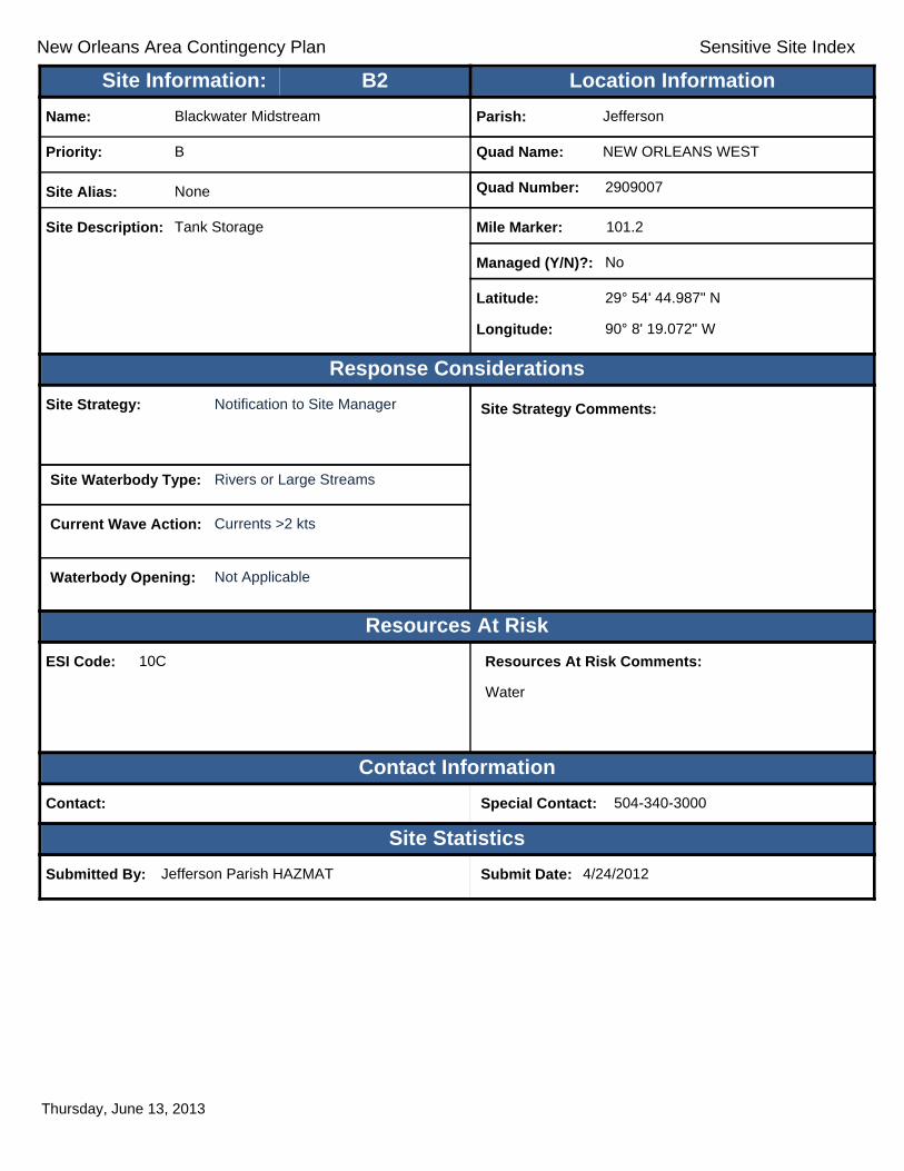
New Orleans Area Contingency Plan Sensitive Site Index
Response Considerations
Resources At Risk
Contact Information
Site Statistics
Resources At Risk Comments:
Water
Contact: Special Contact: 504-340-3000
Submitted By: Jefferson Parish HAZMAT Submit Date: 4/24/2012
Site Strategy: Notification to Site Manager Site Strategy Comments:
Site Waterbody Type: Rivers or Large Streams
Current Wave Action: Currents >2 kts
Waterbody Opening: Not Applicable
ESI Code: 10C
Priority: B
Name: Blackwater Midstream
Site Alias: None
Site Description: Tank Storage
Parish: Jefferson
Quad Name: NEW ORLEANS WEST
Quad Number: 2909007
Mile Marker: 101.2
Managed (Y/N)?: No
Latitude: 29° 54' 44.987" N
Longitude: 90° 8' 19.072" W
Site Information: Location InformationText416:B2
Thursday, June 13, 2013

!!
!
!
!!
!
!
!
!
LagoonNO 7
Lago
onNO
7
Can alNO
3
Bayo
uSt
John
Bayou
St John
Bayo
uSt
John
LagoonNO 11
Lake
Inner HBRNav CN
CanalNO 2
HarveyCanal
Eicke
sCa
nal
Drain
D itch
Lago
onNO
9
Whit
ney C
anal
Bara
taria
Otfl
Cana
l
BayouFatma
PatriotCanal
Outfa
llCa
nal
FloridaAv Canal
Verre
tCa
nal
FloridaAv Canal
Florid
aWalk
Can
al
CanalNO 4
DonnerCanal
BaratariaOtfl CanalPe
oples
Cana
l
Drain
age
Ditch
Norman Canal
BayouFatma
Brown Canal
Bayo
uBa
rr ier
ePatriot Canal
MayronneCanal
MetairieRelief Canal
Whit
ney C
anal
Drain
Ditc
h NO
2
Industry Canal
Drain Ditch NO 7
Outfall Canal
Canal NO 5
Twelv
eAc
re C
anal
Gard
ere
Cana
l
Magellan Canal
Drain
Ditc
h NO
1Dra i n
Dit ch
NO3
ST23
ST18
ST46
ST18
ST39
ST18
ST46ST46
ST45ST45
ST39
ST541
ST23
£¤61
£¤90
£¤90
£¤90
£¤90
£¤90
£¤90
£¤90
£¤61
§̈¦10
§̈¦610
§̈¦10
§̈¦610
NewNewOrleansOrleans
HarveyHarvey
MarreroMarrero
TerrytownTerrytown
ArabiArabi
GretnaGretna
TimberlaneTimberlane
NEW
ORL
EANS
WES
TNE
W O
RLEA
NS E
AST
NEW ORLEANS EASTBERTRANDVILLE
NEW
ORL
EANS
EAS
TCH
ALME
TTE
NEW ORLEANS EASTSPANISH FORT
A6 C1
B3 A5B2 A4
B1
A3
A2
A1
JeffersonParish
JeffersonParish
OrleansParish
PlaqueminesParish
St.BernardParish
90°0'0"W
90°0'0"W
90°7'30"W
90°7'30"W
30°0'
0"N
30°0'
0"N
29°52
'30"N
29°52
'30"N
±0 1 2 30.5
Miles
NEW ORLEANS EAST Quad
MetairieMetairieLafayetteLafayette
Baton RougeBaton Rouge
New OrleansNew Orleans
§̈¦12§̈¦55
§̈¦310
§̈¦110
§̈¦10
LOUISIANALOUISIANA
Gulf of Mexico
Legend! GRP Sites
Quad BoundaryParish Boundaries
0 1 2 30.5Kilometers
Locator MapLocator Map

New Orleans Area Contingency Plan Sensitive Site Index
Response Considerations
Resources At Risk
Contact Information
Site Statistics
Resources At Risk Comments:
N/A
Contact: Special Contact:
Submitted By: DEQ Submit Date: 5/16/2012
Site Strategy: Multi-Layer Deflection Booming Site Strategy Comments:
Notification to Site Manager (Locks).
Site Waterbody Type: Narrow Channel
Current Wave Action: Currents <1 kt
Waterbody Opening: < 500 ft
ESI Code:
Priority: A
Name: Intercoastal Waterway
Site Alias: ICW
Site Description: Sensitive Area
Parish: Orleans
Quad Name: NEW ORLEANS EAST
Quad Number: 2909008
Mile Marker: 0
Managed (Y/N)?:
Latitude: 29° 57' 27.812" N
Longitude: 90° 1' 39.333" W
Site Information: Location InformationText416:A1
Thursday, June 13, 2013

New Orleans Area Contingency Plan Sensitive Site Index
Response Considerations
Resources At Risk
Contact Information
Site Statistics
Resources At Risk Comments:
Drinking Water
Contact: Special Contact:
Submitted By: Paul Reeb Submit Date: 4/30/2012
Site Strategy: Notification to Site Manager Site Strategy Comments:
Site Waterbody Type: Rivers or Large Streams
Current Wave Action: Currents >2 kts
Waterbody Opening: Not Applicable
ESI Code: 10C
Priority: A
Name: Algiers Water Intake
Site Alias: None
Site Description: Water Intake
Parish: Orleans
Quad Name: NEW ORLEANS EAST
Quad Number: 2909008
Mile Marker: 95.5
Managed (Y/N)?:
Latitude: 29° 56' 35.872" N
Longitude: 90° 3' 20.489" W
Site Information: Location InformationText416:A2
Thursday, June 13, 2013
New Orleans Area Contingency Plan Sensitive Site Index
Response Considerations
Resources At Risk
Contact Information
Site Statistics
Resources At Risk Comments:
Drinking Water
Contact: City of Grenta Special Contact: 504-363-1540
Submitted By: Jefferson Parish HAZMAT Submit Date: 4/24/2012
Site Strategy: Notification to Site Manager Site Strategy Comments:
Site Waterbody Type: Rivers or Large Streams
Current Wave Action: Currents >2 kts
Waterbody Opening: Not Applicable
ESI Code: 10C
Priority: A
Name: Gretna Water Intake
Site Alias: None
Site Description: Water Intake
Parish: Jefferson
Quad Name: NEW ORLEANS EAST
Quad Number: 2909008
Mile Marker: 95.7
Managed (Y/N)?: No
Latitude: 29° 55' 21.540" N
Longitude: 90° 3' 42.830" W
Site Information: Location InformationText416:A3
Thursday, June 13, 2013
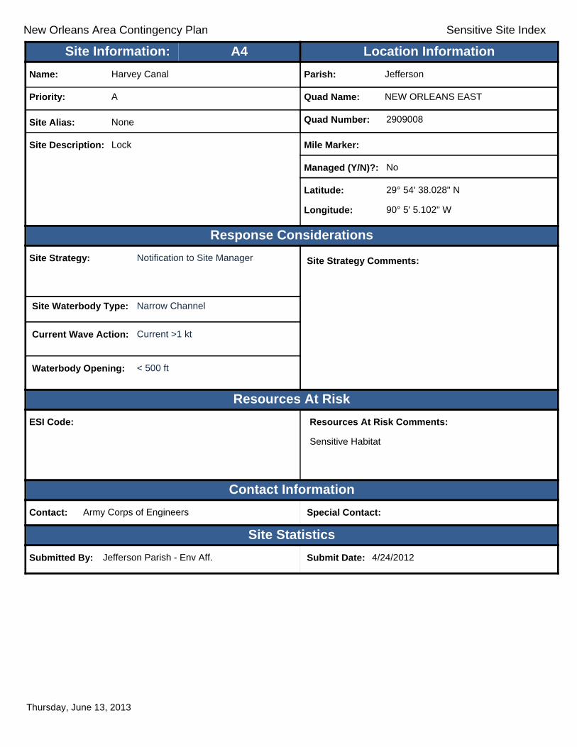
New Orleans Area Contingency Plan Sensitive Site Index
Response Considerations
Resources At Risk
Contact Information
Site Statistics
Resources At Risk Comments:
Sensitive Habitat
Contact: Army Corps of Engineers Special Contact:
Submitted By: Jefferson Parish - Env Aff. Submit Date: 4/24/2012
Site Strategy: Notification to Site Manager Site Strategy Comments:
Site Waterbody Type: Narrow Channel
Current Wave Action: Current >1 kt
Waterbody Opening: < 500 ft
ESI Code:
Priority: A
Name: Harvey Canal
Site Alias: None
Site Description: Lock
Parish: Jefferson
Quad Name: NEW ORLEANS EAST
Quad Number: 2909008
Mile Marker:
Managed (Y/N)?: No
Latitude: 29° 54' 38.028" N
Longitude: 90° 5' 5.102" W
Site Information: Location InformationText416:A4
Thursday, June 13, 2013

New Orleans Area Contingency Plan Sensitive Site Index
Response Considerations
Resources At Risk
Contact Information
Site Statistics
Resources At Risk Comments:
Water
Contact: Jefferson Parrish Water Dept. Special Contact: 504-349-5081
Submitted By: Jefferson Parish HAZMAT Submit Date: 4/24/2012
Site Strategy: Notification to Site Manager Site Strategy Comments:
Site Waterbody Type: Rivers or Large Streams
Current Wave Action: Currents >2 kts
Waterbody Opening: Not Applicable
ESI Code: 10C
Priority: A
Name: West Bank Water Intake
Site Alias: None
Site Description: Water Intake
Parish: Jefferson
Quad Name: NEW ORLEANS EAST
Quad Number: 2909008
Mile Marker: 99.1
Managed (Y/N)?: No
Latitude: 29° 54' 25.143" N
Longitude: 90° 5' 52.074" W
Site Information: Location InformationText416:A5
Thursday, June 13, 2013

New Orleans Area Contingency Plan Sensitive Site Index
Response Considerations
Resources At Risk
Contact Information
Site Statistics
Resources At Risk Comments:
Water
Contact: Jefferson Parish Drainage Department Special Contact: 504-763-6752
Submitted By: Jefferson Parish Drainage Department Submit Date: 4/24/2012
Site Strategy: Notification to Site Manager Site Strategy Comments:
Site Waterbody Type: Narrow Channel
Current Wave Action: Currents <1 kt
Waterbody Opening: < 500 ft
ESI Code:
Priority: A
Name: Harvey Pump Station
Site Alias: None
Site Description: Pump Station
Parish: Jefferson
Quad Name: NEW ORLEANS EAST
Quad Number: 2909008
Mile Marker:
Managed (Y/N)?: No
Latitude: 29° 53' 0.287" N
Longitude: 90° 4' 28.522" W
Site Information: Location InformationText416:A6
Thursday, June 13, 2013
New Orleans Area Contingency Plan Sensitive Site Index
Response Considerations
Resources At Risk
Contact Information
Site Statistics
Resources At Risk Comments:
Water
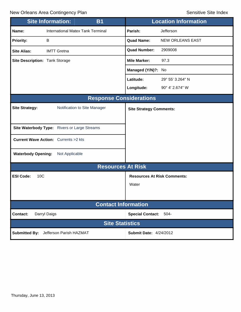
Contact: Darryl Daigs Special Contact: 504-
Submitted By: Jefferson Parish HAZMAT Submit Date: 4/24/2012
Site Strategy: Notification to Site Manager Site Strategy Comments:
Site Waterbody Type: Rivers or Large Streams
Current Wave Action: Currents >2 kts
Waterbody Opening: Not Applicable
ESI Code: 10C
Priority: B
Name: International Matex Tank Terminal
Site Alias: IMTT Gretna
Site Description: Tank Storage
Parish: Jefferson
Quad Name: NEW ORLEANS EAST
Quad Number: 2909008
Mile Marker: 97.3
Managed (Y/N)?: No
Latitude: 29° 55' 3.264" N
Longitude: 90° 4' 2.674" W
Site Information: Location InformationText416:B1
Thursday, June 13, 2013

New Orleans Area Contingency Plan Sensitive Site Index
Response Considerations
Resources At Risk
Contact Information
Site Statistics
Resources At Risk Comments:
Water
Contact: Jim Pasternak Special Contact: 504-340-4911
Submitted By: Jefferson Parish HAZMAT Submit Date: 4/24/2012
Site Strategy: Notification to Site Manager Site Strategy Comments:
Site Waterbody Type: Rivers or Large Streams
Current Wave Action: Currents >2 kts
Waterbody Opening: Not Applicable
ESI Code:
Priority: B
Name: Kinder Morgan
Site Alias: DELTA Terminal
Site Description: Tank Storage
Parish: Jefferson
Quad Name: NEW ORLEANS EAST
Quad Number: 2909008
Mile Marker: 98.7
Managed (Y/N)?: No
Latitude: 29° 54' 35.587" N
Longitude: 90° 5' 24.136" W
Site Information: Location InformationText416:B2
Thursday, June 13, 2013

New Orleans Area Contingency Plan Sensitive Site Index
Response Considerations
Resources At Risk
Contact Information
Site Statistics
Resources At Risk Comments:
Water
Contact: Special Contact: 504-341-4255
Submitted By: Jefferson Parish HAZMAT Submit Date: 4/24/2012
Site Strategy: Notification to Site Manager Site Strategy Comments:
Site Waterbody Type: Rivers or Large Streams
Current Wave Action: Currents >2 kts
Waterbody Opening: Not Applicable
ESI Code: 10C
Priority: B
Name: Magellan Terminal
Site Alias: Omega
Site Description: Tank Storage
Parish: Jefferson
Quad Name: NEW ORLEANS EAST
Quad Number: 2909008
Mile Marker: 99.5
Managed (Y/N)?: No
Latitude: 29° 54' 18.616" N
Longitude: 90° 6' 17.400" W
Site Information: Location InformationText416:B3
Thursday, June 13, 2013

New Orleans Area Contingency Plan Sensitive Site Index
Response Considerations
Resources At Risk
Contact Information
Site Statistics
Resources At Risk Comments:
N/A
Contact: Special Contact:
Submitted By: Submit Date: 5/16/2012
Site Strategy: Notification to Site Manager Site Strategy Comments:
Site Waterbody Type: Narrow Channel
Current Wave Action: Currents <1 kt
Waterbody Opening: < 500 ft
ESI Code: 10C
Priority: C
Name:
Site Alias: None
Site Description: Pumping Station
Parish: Plaquemines
Quad Name: NEW ORLEANS EAST
Quad Number: 2909008
Mile Marker: 0
Managed (Y/N)?:
Latitude: 29° 53' 2.466" N
Longitude: 90° 0' 15.210" W
Site Information: Location InformationText416:C1
Thursday, June 13, 2013

New Orleans Area Contingency Plan
Geographic Response Plan- Jefferson Parish
This page is intentionally left blank
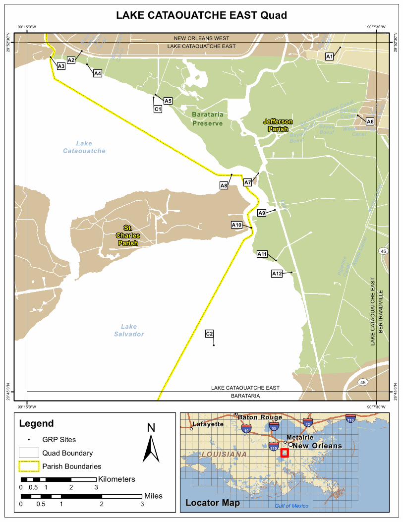
!
!
!
!
!
!!
!
!
!
!
!
!
!
BaratariaPreserve
LakeBayou
Boeuf
Pipe
line
Cana
l
Duga
sCa
nal
BayouBoeuf
MainCan
al
Wagg
aman
Cana
l
Kenta
Cana
l
BayouBoeuf
MainCan
al
Kenta
Can
al
EstelleCanal
Woods PlaceCanal
Mil laudon Canal
Kenta
Can
al
LakeCataouatche
LakeSalvador
ST45
ST45LAKE CATAOUATCHE EAST
BARATARIA
LAKE
CAT
AOUA
TCHE
EAST
BERT
RAND
VILL
E
LAKE CATAOUATCHE EASTNEW ORLEANS WEST
C2
A12
A11
A10A9
A8 A7
A6
C1A5
A4A3
A2 A1
St.CharlesParish
JeffersonParish
90°7'30"W
90°7'30"W
90°15'0"W
90°15'0"W
29°52
'30"N
29°52
'30"N
29°45
'0"N
29°45
'0"N
±0 1 2 30.5
Miles
LAKE CATAOUATCHE EAST Quad
MetairieMetairieLafayetteLafayette
Baton RougeBaton Rouge
New OrleansNew Orleans
§̈¦12§̈¦55
§̈¦310
§̈¦110
§̈¦10
LOUISIANALOUISIANA
Gulf of Mexico
Legend! GRP Sites
Quad BoundaryParish Boundaries
0 1 2 30.5Kilometers
Locator MapLocator Map
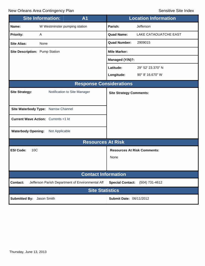
New Orleans Area Contingency Plan Sensitive Site Index
Response Considerations
Resources At Risk
Contact Information
Site Statistics
Resources At Risk Comments:
None
Contact: Jefferson Parish Department of Environmental Aff Special Contact: (504) 731-4612
Submitted By: Jason Smith Submit Date: 06/11/2012
Site Strategy: Notification to Site Manager Site Strategy Comments:
Site Waterbody Type: Narrow Channel
Current Wave Action: Currents <1 kt
Waterbody Opening: Not Applicable
ESI Code: 10C
Priority: A
Name: W Westminster pumping station
Site Alias: None
Site Description: Pump Station
Parish: Jefferson
Quad Name: LAKE CATAOUATCHE EAST
Quad Number: 2909015
Mile Marker:
Managed (Y/N)?:
Latitude: 29° 52' 23.370" N
Longitude: 90° 8' 16.670" W
Site Information: Location InformationText416:A1
Thursday, June 13, 2013
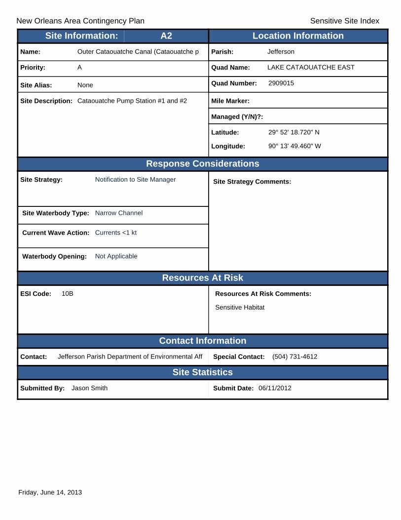
New Orleans Area Contingency Plan Sensitive Site Index
Response Considerations
Resources At Risk
Contact Information
Site Statistics
Resources At Risk Comments:
Sensitive Habitat
Contact: Jefferson Parish Department of Environmental Aff Special Contact: (504) 731-4612
Submitted By: Jason Smith Submit Date: 06/11/2012
Site Strategy: Notification to Site Manager Site Strategy Comments:
Site Waterbody Type: Narrow Channel
Current Wave Action: Currents <1 kt
Waterbody Opening: Not Applicable
ESI Code: 10B
Priority: A
Name: Outer Cataouatche Canal (Cataouatche p
Site Alias: None
Site Description: Cataouatche Pump Station #1 and #2
Parish: Jefferson
Quad Name: LAKE CATAOUATCHE EAST
Quad Number: 2909015
Mile Marker:
Managed (Y/N)?:
Latitude: 29° 52' 18.720" N
Longitude: 90° 13' 49.460" W
Site Information: Location InformationText416:A2
Friday, June 14, 2013
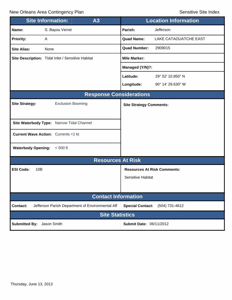
New Orleans Area Contingency Plan Sensitive Site Index
Response Considerations
Resources At Risk
Contact Information
Site Statistics
Resources At Risk Comments:
Sensitive Habitat
Contact: Jefferson Parish Department of Environmental Aff Special Contact: (504) 731-4612
Submitted By: Jason Smith Submit Date: 06/11/2012
Site Strategy: Exclusion Booming Site Strategy Comments:
Site Waterbody Type: Narrow Tidal Channel
Current Wave Action: Currents <1 kt
Waterbody Opening: < 500 ft
ESI Code: 10B
Priority: A
Name: S. Bayou Verret
Site Alias: None
Site Description: Tidal Inlet / Sensitive Habitat
Parish: Jefferson
Quad Name: LAKE CATAOUATCHE EAST
Quad Number: 2909015
Mile Marker:
Managed (Y/N)?:
Latitude: 29° 52' 10.850" N
Longitude: 90° 14' 29.630" W
Site Information: Location InformationText416:A3
Thursday, June 13, 2013

New Orleans Area Contingency Plan Sensitive Site Index
Response Considerations
Resources At Risk
Contact Information
Site Statistics
Resources At Risk Comments:
Sensitive Habitat
Contact: Jefferson Parish Department of Environmental Aff Special Contact: (504) 731-4612
Submitted By: Jason Smith Submit Date: 06/11/2012
Site Strategy: Deferred Action Site Strategy Comments:
Site Waterbody Type: Entrance to Bays, etc
Current Wave Action: Breaking Waves >1.5 ft
Waterbody Opening: < 500 ft
ESI Code: 10D
Priority: A
Name: N. Lake Salvador
Site Alias: None
Site Description: Tidal Inlet / Sensitive Habitat
Parish: Jefferson
Quad Name: LAKE CATAOUATCHE EAST
Quad Number: 2909015
Mile Marker:
Managed (Y/N)?:
Latitude: 29° 52' 1.540" N
Longitude: 90° 13' 42.630" W
Site Information: Location InformationText416:A4
Thursday, June 13, 2013

New Orleans Area Contingency Plan Sensitive Site Index
Response Considerations
Resources At Risk
Contact Information
Site Statistics
Resources At Risk Comments:
Sensitive Habitat
Contact: Jefferson Parish Department of Environmental Aff Special Contact: (504) 731-4612
Submitted By: Jason Smith Submit Date: 06/11/2012
Site Strategy: Exclusion Booming Site Strategy Comments:
Site Waterbody Type: Narrow Tidal Channel
Current Wave Action: Currents <1 kt
Waterbody Opening: < 500 ft
ESI Code: 10B
Priority: A
Name: S. Whisky Canal
Site Alias: None
Site Description: Tidal Inlet / Sensitive Habitat
Parish: Jefferson
Quad Name: LAKE CATAOUATCHE EAST
Quad Number: 2909015
Mile Marker:
Managed (Y/N)?:
Latitude: 29° 51' 22.610" N
Longitude: 90° 12' 14.520" W
Site Information: Location InformationText416:A5
Thursday, June 13, 2013

New Orleans Area Contingency Plan Sensitive Site Index
Response Considerations
Resources At Risk
Contact Information
Site Statistics
Resources At Risk Comments:
Sensitive Habitat
Contact: Jefferson Parish Department of Environmental Aff Special Contact: (504) 731-4612
Submitted By: Jason Smith Submit Date: 06/11/2012
Site Strategy: Notification to Site Manager Site Strategy Comments:
Site Waterbody Type: Narrow Channel
Current Wave Action: Currents <1 kt
Waterbody Opening: Not Applicable
ESI Code: 10C
Priority: A
Name: Oak Cove pumping station
Site Alias: None
Site Description: Tidal Inlet / Sensitive Habitat
Parish: Jefferson
Quad Name: LAKE CATAOUATCHE EAST
Quad Number: 2909015
Mile Marker:
Managed (Y/N)?:
Latitude: 29° 50' 55.930" N
Longitude: 90° 7' 54.300" W
Site Information: Location InformationText416:A6
Thursday, June 13, 2013

New Orleans Area Contingency Plan Sensitive Site Index
Response Considerations
Resources At Risk
Contact Information
Site Statistics
Resources At Risk Comments:
Sensitive Habitat
Contact: Jefferson Parish Department of Environmental Aff Special Contact: (504) 731-4612
Submitted By: Jason Smith Submit Date: 06/11/2012
Site Strategy: Exclusion Booming Site Strategy Comments:
Site Waterbody Type: Narrow Tidal Channel
Current Wave Action: Currents <1 kt
Waterbody Opening: < 500 ft
ESI Code: 10B
Priority: A
Name: Bayou Segnette
Site Alias: None
Site Description: Tidal Inlet / Sensitive Habitat
Parish: Jefferson
Quad Name: LAKE CATAOUATCHE EAST
Quad Number: 2909015
Mile Marker:
Managed (Y/N)?:
Latitude: 29° 49' 41.420" N
Longitude: 90° 10' 1.990" W
Site Information: Location InformationText416:A7
Thursday, June 13, 2013

New Orleans Area Contingency Plan Sensitive Site Index
Response Considerations
Resources At Risk
Contact Information
Site Statistics
Resources At Risk Comments:
Sensitive Habitat
Contact: Jefferson Parish Department of Environmental Aff Special Contact: (504) 731-4612
Submitted By: Jason Smith Submit Date: 06/11/2012
Site Strategy: Exclusion Booming Site Strategy Comments:
Requires Detailed Review. Jason Smith: Identify correct location of Bayou Bardeaux.
Site Waterbody Type: Narrow Tidal Channel
Current Wave Action: Currents <1 kt
Waterbody Opening: < 500 ft
ESI Code: 10B
Priority: A
Name: Bayou Bardeaux
Site Alias: None
Site Description: Tidal Inlet / Sensitive Habitat
Parish: Jefferson
Quad Name: LAKE CATAOUATCHE EAST
Quad Number: 2909015
Mile Marker:
Managed (Y/N)?:
Latitude: 29° 49' 39.720" N
Longitude: 90° 10' 36.552" W
Site Information: Location InformationText416:A8
Thursday, June 13, 2013

New Orleans Area Contingency Plan Sensitive Site Index
Response Considerations
Resources At Risk
Contact Information
Site Statistics
Resources At Risk Comments:
Sensitive Habitat
Contact: Jefferson Parish Department of Environmental Aff Special Contact: (504) 731-4612
Submitted By: Jason Smith Submit Date: 06/11/2012
Site Strategy: Exclusion Booming Site Strategy Comments:
Site Waterbody Type: Narrow Tidal Channel
Current Wave Action: Currents <1 kt
Waterbody Opening: 500-1000 ft
ESI Code: 10B
Priority: A
Name: Bayou Bardeaux
Site Alias: None
Site Description: Tidal Inlet / Sensitive Habitat
Parish: Jefferson
Quad Name: LAKE CATAOUATCHE EAST
Quad Number: 2909015
Mile Marker:
Managed (Y/N)?:
Latitude: 29° 48' 54.100" N
Longitude: 90° 9' 40.730" W
Site Information: Location InformationText416:A9
Thursday, June 13, 2013
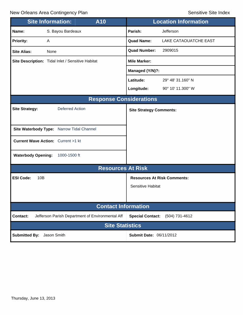
New Orleans Area Contingency Plan Sensitive Site Index
Response Considerations
Resources At Risk
Contact Information
Site Statistics
Resources At Risk Comments:
Sensitive Habitat
Contact: Jefferson Parish Department of Environmental Aff Special Contact: (504) 731-4612
Submitted By: Jason Smith Submit Date: 06/11/2012
Site Strategy: Deferred Action Site Strategy Comments:
Site Waterbody Type: Narrow Tidal Channel
Current Wave Action: Current >1 kt
Waterbody Opening: 1000-1500 ft
ESI Code: 10B
Priority: A
Name: S. Bayou Bardeaux
Site Alias: None
Site Description: Tidal Inlet / Sensitive Habitat
Parish: Jefferson
Quad Name: LAKE CATAOUATCHE EAST
Quad Number: 2909015
Mile Marker:
Managed (Y/N)?:
Latitude: 29° 48' 31.160" N
Longitude: 90° 10' 11.300" W
Site Information: Location InformationText416:A10
Thursday, June 13, 2013

New Orleans Area Contingency Plan Sensitive Site Index
Response Considerations
Resources At Risk
Contact Information
Site Statistics
Resources At Risk Comments:
Sensitive Habitat
Contact: Jefferson Parish Department of Environmental Aff Special Contact: (504) 731-4612
Submitted By: Jason Smith Submit Date: 06/11/2012
Site Strategy: Deflection Booming Site Strategy Comments:
Site Waterbody Type: Narrow Tidal Channel
Current Wave Action: Current >1 kt
Waterbody Opening: < 500 ft
ESI Code: 10C
Priority: A
Name: E. Lake Salvador
Site Alias: None
Site Description: Tidal Inlet / Sensitive Habitat
Parish: Jefferson
Quad Name: LAKE CATAOUATCHE EAST
Quad Number: 2909015
Mile Marker:
Managed (Y/N)?:
Latitude: 29° 47' 49.270" N
Longitude: 90° 9' 39.240" W
Site Information: Location InformationText416:A11
Thursday, June 13, 2013

New Orleans Area Contingency Plan Sensitive Site Index
Response Considerations
Resources At Risk
Contact Information
Site Statistics
Resources At Risk Comments:
Sensitive Habitat
Contact: Jefferson Parish Department of Environmental Aff Special Contact: (504) 731-4612
Submitted By: Jason Smith Submit Date: 06/11/2012
Site Strategy: Deflection Booming Site Strategy Comments:
Site Waterbody Type: Narrow Tidal Channel
Current Wave Action: Current >1 kt
Waterbody Opening: < 500 ft
ESI Code: 10C
Priority: A
Name: W. Tenneco Drill Hole Canal
Site Alias: None
Site Description: Tidal Inlet / Sensitive Habitat
Parish: Jefferson
Quad Name: LAKE CATAOUATCHE EAST
Quad Number: 2909015
Mile Marker:
Managed (Y/N)?:
Latitude: 29° 47' 33.650" N
Longitude: 90° 9' 19.180" W
Site Information: Location InformationText416:A12
Thursday, June 13, 2013

New Orleans Area Contingency Plan Sensitive Site Index
Response Considerations
Resources At Risk
Contact Information
Site Statistics
Resources At Risk Comments:
Restoration Project Monitoring Equipment
Contact: Special Contact:
Submitted By: LA CPRA Submit Date: 6/28/2012
Site Strategy: Notification to Site Manager Site Strategy Comments:
Site Waterbody Type: Open Water
Current Wave Action: Breaking Waves >1.5 ft
Waterbody Opening: Not Applicable
ESI Code: 10B
Priority: C
Name: Davis Pond Freshwater Diversion
Site Alias: DCPBA04
Site Description: Hydrographic Data Collection Platform
Parish: Jefferson
Quad Name: LAKE CATAOUATCHE EAST
Quad Number: 2909015
Mile Marker:
Managed (Y/N)?:
Latitude: 29° 51' 19.000" N
Longitude: 90° 12' 17.000" W
Site Information: Location InformationText416:C1
Thursday, June 13, 2013

New Orleans Area Contingency Plan Sensitive Site Index
Response Considerations
Resources At Risk
Contact Information
Site Statistics
Resources At Risk Comments:
Restoration Project Monitoring Equipment
Contact: Special Contact:
Submitted By: LA CPRA Submit Date: 6/28/2012
Site Strategy: Notification to Site Manager Site Strategy Comments:
Site Waterbody Type: Open Water
Current Wave Action: Breaking Waves >1.5 ft
Waterbody Opening: Not Applicable
ESI Code:
Priority: C
Name: Davis Pond Freshwater Diversion
Site Alias: DCPBA05
Site Description: Hydrographic Data Collection Platform
Parish: Jefferson
Quad Name: LAKE CATAOUATCHE EAST
Quad Number: 2909015
Mile Marker:
Managed (Y/N)?:
Latitude: 29° 45' 59.800" N
Longitude: 90° 10' 59.499" W
Site Information: Location InformationText416:C2
Thursday, June 13, 2013

New Orleans Area Contingency Plan
Geographic Response Plan- Jefferson Parish
This page is intentionally left blank

!
!
!
!
!
!
!
!
!
!
!
!
!!
!
BaratariaPreserve
New OrleansNaval AirStation
New OrleansNew OrleansNaval AirNaval Air
Station JointStation JointReserve BaseReserve Base
Bayou des Famil les
Pipeline
CanalPipelineCanal
DrainDitch NO 7
Drain
D itch
EstelleCanal
Kenta
Cana
l
BayouChaland
CanalNO 5
Kenta
Cana
l
Drain
Ditch
NO
2
Drain
Ditch
NO
3
LemingCanal
Kenta
Can
al
Drain
Ditch
NO
1
MillaudonCanal
Canal
Ross Canal
Keithway Canal
LPL Canal
Pipeline CanalBayou auxCarpes
Drain
Ditc h
NO8
Drain Ditch NO 7
Woods Place
Canal
BayouFatmaWoodmereCanal Canal
BayouFatma
Sarah Canal
Twelv
eAc
reCa
nal
Bayou B
arrier
e
Canal
Murphy Canal
Kenta Canal
Pipeline Canal
Bayou des
FamillesST45
ST23
ST45
ST45ST23
ST45
ST23
ST45
ST3134ST3134
ST39
ST23
BelleBelleChasseChasse
EstelleEstelle
JeanJeanLafitteLafitte
WoodmereWoodmere
BELL
E CHA
SSE
BERT
RAND
VILLE
NEW ORLEANS EASTBERTRANDVILLE
LAKE
CAT
AOUA
TCHE
EAST
BERT
RAND
VILLE
BERTRANDVILLELAFITTE
A6A7
B1
A8
C4
A3A4
C2
C1
C3
A1
A2
A5B3
B4
JeffersonParish
PlaqueminesParish
90°0'0"W
90°0'0"W
90°7'30"W
90°7'30"W
29°52
'30"N
29°52
'30"N
29°45
'0"N
29°45
'0"N
±0 1 2 30.5
Miles
BERTRANDVILLE Quad
MetairieMetairieLafayetteLafayette
Baton RougeBaton Rouge
New OrleansNew Orleans
§̈¦12§̈¦55
§̈¦310
§̈¦110
§̈¦10
LOUISIANALOUISIANA
Gulf of Mexico
Legend! GRP Sites
Quad BoundaryParish Boundaries
0 1 2 30.5Kilometers
Locator MapLocator Map

New Orleans Area Contingency Plan Sensitive Site Index
Response Considerations
Resources At Risk
Contact Information
Site Statistics
Resources At Risk Comments:
None
Contact: Jefferson Parish Department of Environmental Aff Special Contact: (504) 731-4612
Submitted By: Submit Date: 06/11/2012
Site Strategy: Notification to Site Manager Site Strategy Comments:
Site Waterbody Type: Narrow Channel
Current Wave Action: Currents <1 kt
Waterbody Opening: Not Applicable
ESI Code: 10C
Priority: A
Name: Cousins Pumping Station
Site Alias: None
Site Description: Pump Station
Parish: Jefferson
Quad Name: BERTRANDVILLE
Quad Number: 2909016
Mile Marker:
Managed (Y/N)?:
Latitude: 29° 52' 16.100" N
Longitude: 90° 4' 23.350" W
Site Information: Location InformationText416:A1
Thursday, June 13, 2013
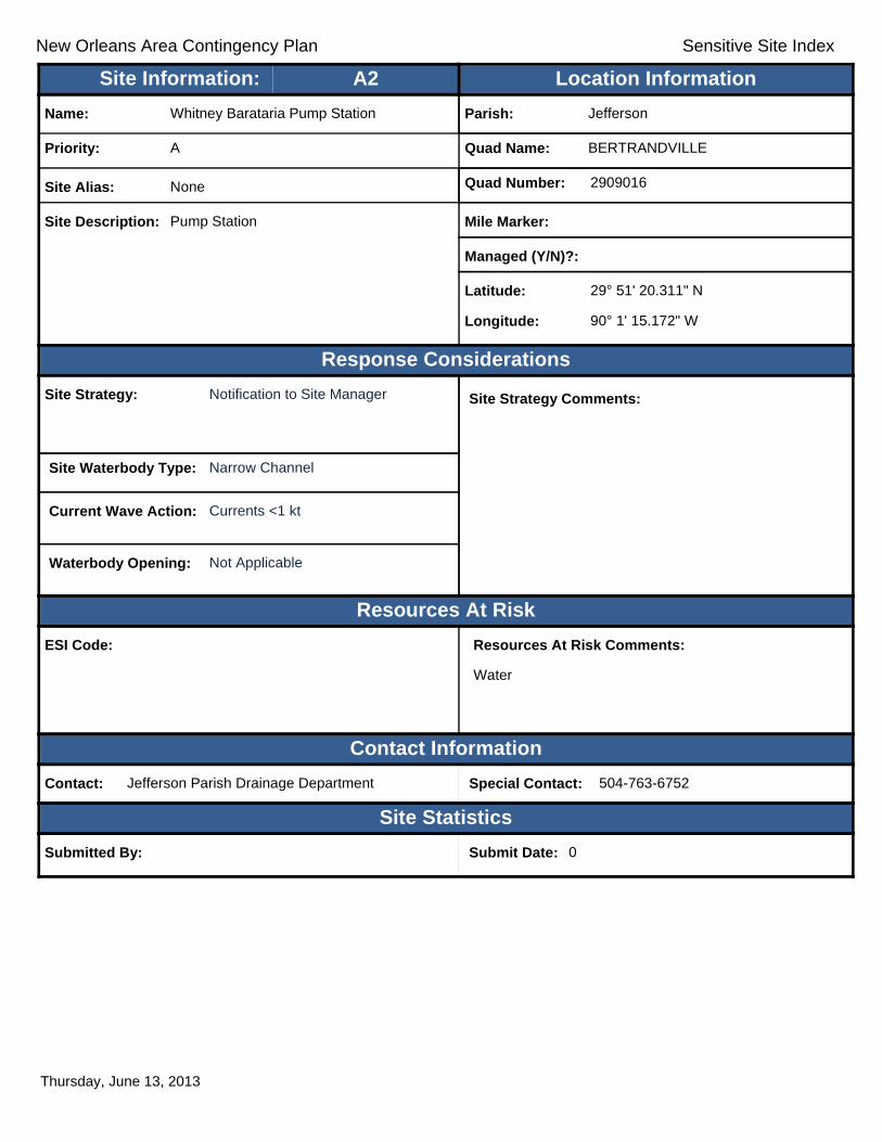
New Orleans Area Contingency Plan Sensitive Site Index
Response Considerations
Resources At Risk
Contact Information
Site Statistics
Resources At Risk Comments:
Water
Contact: Jefferson Parish Drainage Department Special Contact: 504-763-6752
Submitted By: Submit Date: 0
Site Strategy: Notification to Site Manager Site Strategy Comments:
Site Waterbody Type: Narrow Channel
Current Wave Action: Currents <1 kt
Waterbody Opening: Not Applicable
ESI Code:
Priority: A
Name: Whitney Barataria Pump Station
Site Alias: None
Site Description: Pump Station
Parish: Jefferson
Quad Name: BERTRANDVILLE
Quad Number: 2909016
Mile Marker:
Managed (Y/N)?:
Latitude: 29° 51' 20.311" N
Longitude: 90° 1' 15.172" W
Site Information: Location InformationText416:A2
Thursday, June 13, 2013

New Orleans Area Contingency Plan Sensitive Site Index
Response Considerations
Resources At Risk
Contact Information
Site Statistics
Resources At Risk Comments:
Water
Contact: Jefferson Parish Drainage Department Special Contact: 504-736-6752
Submitted By: Jefferson Parish Drainage Department Submit Date: 4/24/2012
Site Strategy: Notification to Site Manager Site Strategy Comments:
Site Waterbody Type: Narrow Channel
Current Wave Action: Currents <1 kt
Waterbody Opening: Not Applicable
ESI Code: 10C
Priority: A
Name: Hero Pump Station
Site Alias: None
Site Description: Pump Station
Parish: Jefferson
Quad Name: BERTRANDVILLE
Quad Number: 2909016
Mile Marker:
Managed (Y/N)?: No
Latitude: 29° 50' 18.101" N
Longitude: 90° 3' 29.791" W
Site Information: Location InformationText416:A3
Thursday, June 13, 2013

New Orleans Area Contingency Plan Sensitive Site Index
Response Considerations
Resources At Risk
Contact Information
Site Statistics
Resources At Risk Comments:
Water
Contact: Jefferson Parish Drainage Department Special Contact: 504-763-6752
Submitted By: Jefferson Parish Drainage Department Submit Date: 4/24/2012
Site Strategy: Notification to Site Manager Site Strategy Comments:
Site Waterbody Type: Narrow Channel
Current Wave Action: Currents <1 kt
Waterbody Opening: Not Applicable
ESI Code: 10C
Priority: A
Name: New Estelle Pump Station
Site Alias: None
Site Description: Pump Station
Parish: Jefferson
Quad Name: BERTRANDVILLE
Quad Number: 2909016
Mile Marker:
Managed (Y/N)?: No
Latitude: 29° 50' 1.781" N
Longitude: 90° 4' 6.145" W
Site Information: Location InformationText416:A4
Thursday, June 13, 2013
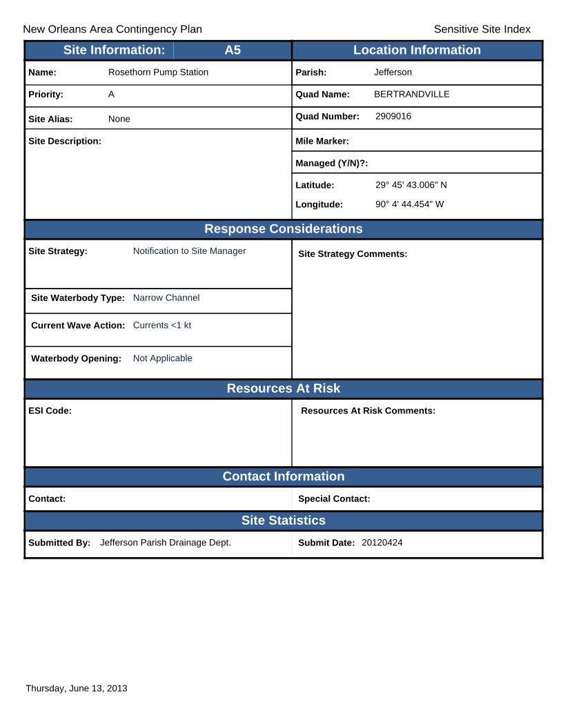
New Orleans Area Contingency Plan Sensitive Site Index
Response Considerations
Resources At Risk
Contact Information
Site Statistics
Resources At Risk Comments:
Contact: Special Contact:
Submitted By: Jefferson Parish Drainage Dept. Submit Date: 20120424
Site Strategy: Notification to Site Manager Site Strategy Comments:
Site Waterbody Type: Narrow Channel
Current Wave Action: Currents <1 kt
Waterbody Opening: Not Applicable
ESI Code:
Priority: A
Name: Rosethorn Pump Station
Site Alias: None
Site Description:
Parish: Jefferson
Quad Name: BERTRANDVILLE
Quad Number: 2909016
Mile Marker:
Managed (Y/N)?:
Latitude: 29° 45' 43.006" N
Longitude: 90° 4' 44.454" W
Site Information: Location InformationText416:A5
Thursday, June 13, 2013

New Orleans Area Contingency Plan Sensitive Site Index
Response Considerations
Resources At Risk
Contact Information
Site Statistics
Resources At Risk Comments:
Pump Station
Contact: JP Drainage Dept. Special Contact: 504 736-6751
Submitted By: Jefferson Parish Drainage Dept. Submit Date: 4/24/2012
Site Strategy: Notification to Site Manager Site Strategy Comments:
Site Waterbody Type: Narrow Channel
Current Wave Action: Currents <1 kt
Waterbody Opening: Not Applicable
ESI Code: 10C
Priority: A
Name: Rosethorn Park Pump Station
Site Alias: None
Site Description: Pump Station
Parish: Jefferson
Quad Name: BERTRANDVILLE
Quad Number: 2909016
Mile Marker: 12.4
Managed (Y/N)?: No
Latitude: 29° 45' 38.254" N
Longitude: 90° 6' 51.244" W
Site Information: Location InformationText416:A6
Thursday, June 13, 2013

New Orleans Area Contingency Plan Sensitive Site Index
Response Considerations
Resources At Risk
Contact Information
Site Statistics
Resources At Risk Comments:
Pump Station
Contact: JP Drainage Dept. Special Contact: 504 736-6751
Submitted By: Jefferson Parish Drainage Dept. Submit Date: 4/24/2012
Site Strategy: Notification to Site Manager Site Strategy Comments:
Site Waterbody Type: Narrow Channel
Current Wave Action: Currents <1 kt
Waterbody Opening: Not Applicable
ESI Code: 10C
Priority: A
Name: Lafitte Pump Station
Site Alias: None
Site Description: Pump Station
Parish: Jefferson
Quad Name: BERTRANDVILLE
Quad Number: 2909016
Mile Marker:
Managed (Y/N)?: No
Latitude: 29° 45' 23.142" N
Longitude: 90° 5' 32.345" W
Site Information: Location InformationText416:A7
Thursday, June 13, 2013

New Orleans Area Contingency Plan Sensitive Site Index
Response Considerations
Resources At Risk
Contact Information
Site Statistics
Resources At Risk Comments:
Industrial
Contact: Army Corps of Engineers Special Contact:
Submitted By: Jefferson Parish - Drainage Submit Date: 4/24/2012
Site Strategy: Notification to Site Manager Site Strategy Comments:
Site Waterbody Type: Narrow Channel
Current Wave Action: Currents <1 kt
Waterbody Opening: Not Applicable
ESI Code: 10C
Priority: A
Name: Gulf Industrial West Closure Complex
Site Alias: None
Site Description: Drainage
Parish: Jefferson
Quad Name: BERTRANDVILLE
Quad Number: 2909016
Mile Marker:
Managed (Y/N)?: No
Latitude: 29° 48' 59.564" N
Longitude: 90° 4' 12.181" W
Site Information: Location InformationText416:A8
Thursday, June 13, 2013

New Orleans Area Contingency Plan Sensitive Site Index
Response Considerations
Resources At Risk
Contact Information
Site Statistics
Resources At Risk Comments:
None
Contact: Special Contact:
Submitted By: Robert Spears Submit Date: 4/27/2012
Site Strategy: Notification to Site Manager Site Strategy Comments:
Site Waterbody Type: Narrow Channel
Current Wave Action: Currents <1 kt
Waterbody Opening: Not Applicable
ESI Code: 10C
Priority: B
Name: Belle Chase Pump Station #1
Site Alias: None
Site Description: Drainage pump station/Boat Launch/Staging Area
Parish: Plaquemines
Quad Name: BERTRANDVILLE
Quad Number: 2909016
Mile Marker: 74.5
Managed (Y/N)?:
Latitude: 29° 51' 9.206" N
Longitude: 90° 1' 8.878" W
Site Information: Location InformationText416:B1
Thursday, June 13, 2013

New Orleans Area Contingency Plan Sensitive Site Index
Response Considerations
Resources At Risk
Contact Information
Site Statistics
Resources At Risk Comments:
Contact: Special Contact:
Submitted By: Jefferson Parish Fire Department Submit Date: 20120424
Site Strategy: Notification to Site Manager Site Strategy Comments:
Site Waterbody Type: Narrow Channel
Current Wave Action: Currents <1 kt
Waterbody Opening: Not Applicable
ESI Code:
Priority: B
Name: Rosethorn Park
Site Alias: None
Site Description:
Parish: Jefferson
Quad Name: BERTRANDVILLE
Quad Number: 2909016
Mile Marker:
Managed (Y/N)?:
Latitude: 29° 45' 39.989" N
Longitude: 90° 6' 9.241" W
Site Information: Location InformationText416:B3
Thursday, June 13, 2013

New Orleans Area Contingency Plan Sensitive Site Index
Response Considerations
Resources At Risk
Contact Information
Site Statistics
Resources At Risk Comments:
Sensitive Habitat
Contact: Special Contact:
Submitted By: Jefferson Parish - Env Aff. Submit Date: 4/24/2012
Site Strategy: Exclusion Booming Site Strategy Comments:
Requires Detailed Review. Marnie Winter: Description indicates a recreation site. Location is in the middle of the marsh.Site Waterbody Type: Narrow Tidal Channel
Current Wave Action: Currents <1 kt
Waterbody Opening: < 500 ft
ESI Code: 10B
Priority: B
Name: Vendome Canal
Site Alias: None
Site Description: Recreation Sites
Parish: Jefferson
Quad Name: BERTRANDVILLE
Quad Number: 2909016
Mile Marker:
Managed (Y/N)?: No
Latitude: 29° 45' 2.052" N
Longitude: 90° 4' 51.312" W
Site Information: Location InformationText416:B4
Thursday, June 13, 2013
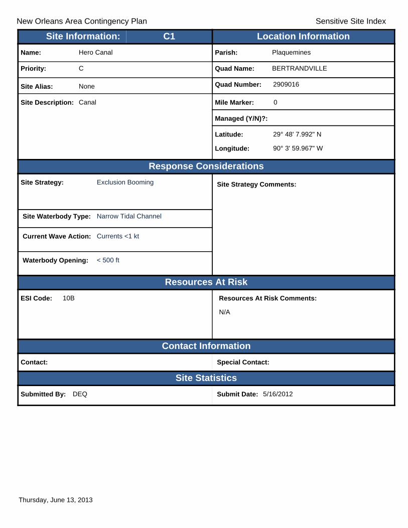
New Orleans Area Contingency Plan Sensitive Site Index
Response Considerations
Resources At Risk
Contact Information
Site Statistics
Resources At Risk Comments:
N/A
Contact: Special Contact:
Submitted By: DEQ Submit Date: 5/16/2012
Site Strategy: Exclusion Booming Site Strategy Comments:
Site Waterbody Type: Narrow Tidal Channel
Current Wave Action: Currents <1 kt
Waterbody Opening: < 500 ft
ESI Code: 10B
Priority: C
Name: Hero Canal
Site Alias: None
Site Description: Canal
Parish: Plaquemines
Quad Name: BERTRANDVILLE
Quad Number: 2909016
Mile Marker: 0
Managed (Y/N)?:
Latitude: 29° 48' 7.992" N
Longitude: 90° 3' 59.967" W
Site Information: Location InformationText416:C1
Thursday, June 13, 2013

New Orleans Area Contingency Plan Sensitive Site Index
Response Considerations
Resources At Risk
Contact Information
Site Statistics
Resources At Risk Comments:
N/A
Contact: Special Contact:
Submitted By: DEQ Submit Date: 5/16/2012
Site Strategy: Exclusion Booming Site Strategy Comments:
Site Waterbody Type: Narrow Tidal Channel
Current Wave Action: Currents <1 kt
Waterbody Opening: < 500 ft
ESI Code: 10C
Priority: C
Name: Bayou Concession
Site Alias: None
Site Description: Sensitive Area
Parish: Plaquemines
Quad Name: BERTRANDVILLE
Quad Number: 2909016
Mile Marker: 0
Managed (Y/N)?:
Latitude: 29° 47' 6.157" N
Longitude: 90° 3' 34.489" W
Site Information: Location InformationText416:C2
Thursday, June 13, 2013

New Orleans Area Contingency Plan Sensitive Site Index
Response Considerations
Resources At Risk
Contact Information
Site Statistics
Resources At Risk Comments:
N/A
Contact: Special Contact:
Submitted By: Submit Date: 5/16/2012
Site Strategy: Exclusion Booming Site Strategy Comments:
Site Waterbody Type: Narrow Tidal Channel
Current Wave Action: Currents <1 kt
Waterbody Opening: < 500 ft
ESI Code: 10B
Priority: C
Name:
Site Alias: None
Site Description: Pipeline
Parish: Plaquemines
Quad Name: BERTRANDVILLE
Quad Number: 2909016
Mile Marker: 0
Managed (Y/N)?:
Latitude: 29° 46' 39.955" N
Longitude: 90° 3' 59.763" W
Site Information: Location InformationText416:C3
Thursday, June 13, 2013

New Orleans Area Contingency Plan Sensitive Site Index
Response Considerations
Resources At Risk
Contact Information
Site Statistics
Resources At Risk Comments:
Sensitive Habitat
Contact: Special Contact:
Submitted By: Jefferson Parish - Env Aff. Submit Date: 4/24/2012
Site Strategy: Exclusion Booming Site Strategy Comments:
Site Waterbody Type: Narrow Tidal Channel
Current Wave Action: Currents <1 kt
Waterbody Opening: < 500 ft
ESI Code: 10C
Priority: C
Name: Van Donne Canal
Site Alias: None
Site Description: Inlet
Parish: Jefferson
Quad Name: BERTRANDVILLE
Quad Number: 2909016
Mile Marker:
Managed (Y/N)?: No
Latitude: 29° 46' 3.060" N
Longitude: 90° 4' 48.495" W
Site Information: Location InformationText416:C4
Thursday, June 13, 2013
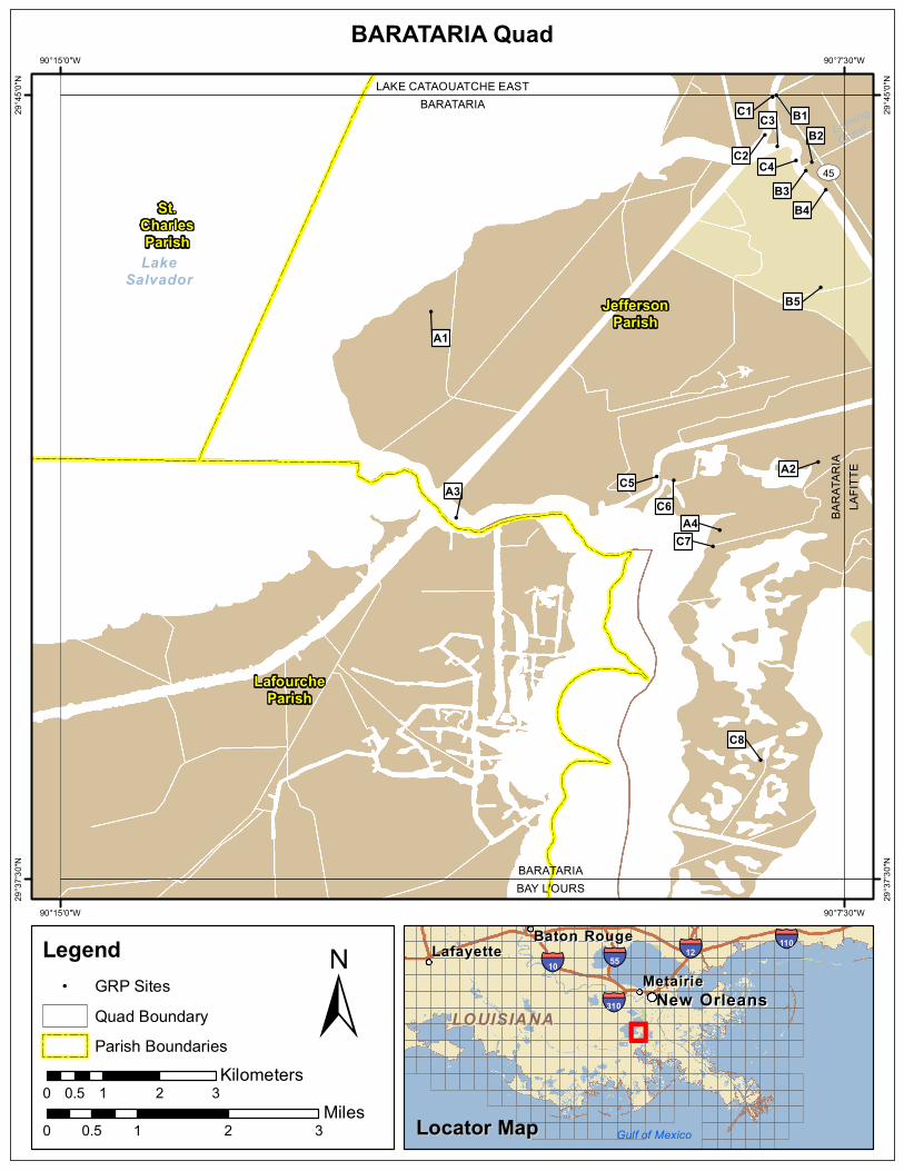
!
!
!
!
!!
!
!
!
!
! !
!
!
!
!!
Leming
Canal
LakeSalvador
ST45
BARATARIABAY L'OURS
BARA
TARI
ALA
FITTE
BARATARIALAKE CATAOUATCHE EAST
C8
A4C7
A3 C5C6
A2
A1
B5
B4
C4
B2
B3
C2
C3C1 B1
JeffersonParish
LafourcheParish
St.CharlesParish
90°7'30"W
90°7'30"W
90°15'0"W
90°15'0"W
29°45
'0"N
29°45
'0"N
29°37
'30"N
29°37
'30"N
±0 1 2 30.5
Miles
BARATARIA Quad
MetairieMetairieLafayetteLafayette
Baton RougeBaton Rouge
New OrleansNew Orleans
§̈¦12§̈¦55
§̈¦310
§̈¦110
§̈¦10
LOUISIANALOUISIANA
Gulf of Mexico
Legend! GRP Sites
Quad BoundaryParish Boundaries
0 1 2 30.5Kilometers
Locator MapLocator Map
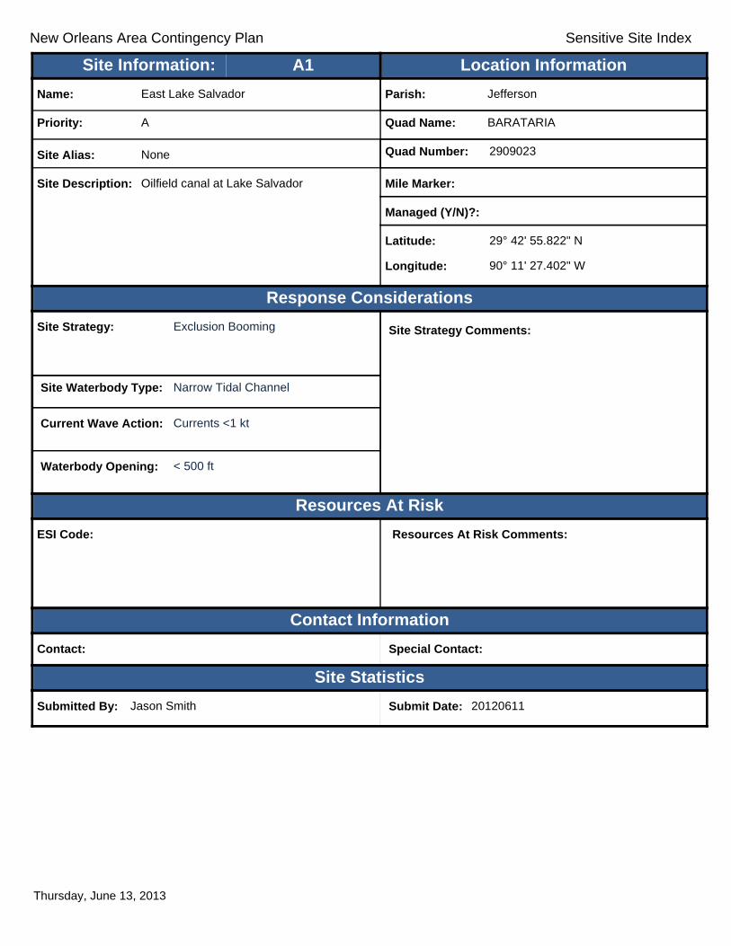
New Orleans Area Contingency Plan Sensitive Site Index
Response Considerations
Resources At Risk
Contact Information
Site Statistics
Resources At Risk Comments:
Contact: Special Contact:
Submitted By: Jason Smith Submit Date: 20120611
Site Strategy: Exclusion Booming Site Strategy Comments:
Site Waterbody Type: Narrow Tidal Channel
Current Wave Action: Currents <1 kt
Waterbody Opening: < 500 ft
ESI Code:
Priority: A
Name: East Lake Salvador
Site Alias: None
Site Description: Oilfield canal at Lake Salvador
Parish: Jefferson
Quad Name: BARATARIA
Quad Number: 2909023
Mile Marker:
Managed (Y/N)?:
Latitude: 29° 42' 55.822" N
Longitude: 90° 11' 27.402" W
Site Information: Location InformationText416:A1
Thursday, June 13, 2013
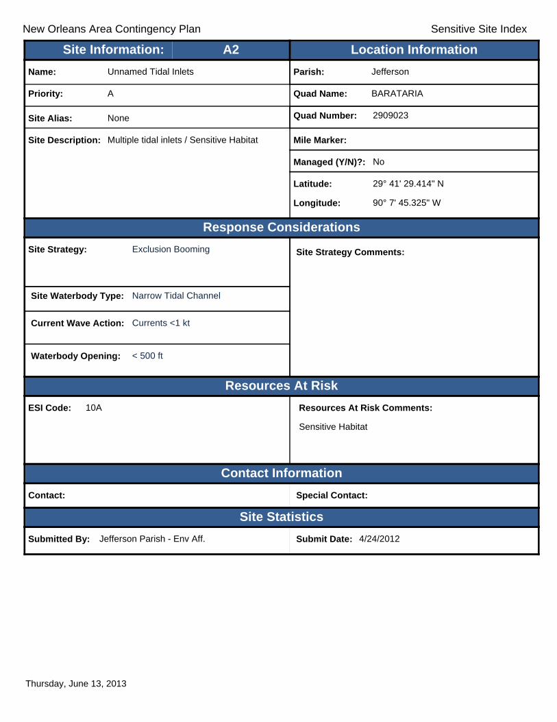
New Orleans Area Contingency Plan Sensitive Site Index
Response Considerations
Resources At Risk
Contact Information
Site Statistics
Resources At Risk Comments:
Sensitive Habitat
Contact: Special Contact:
Submitted By: Jefferson Parish - Env Aff. Submit Date: 4/24/2012
Site Strategy: Exclusion Booming Site Strategy Comments:
Site Waterbody Type: Narrow Tidal Channel
Current Wave Action: Currents <1 kt
Waterbody Opening: < 500 ft
ESI Code: 10A
Priority: A
Name: Unnamed Tidal Inlets
Site Alias: None
Site Description: Multiple tidal inlets / Sensitive Habitat
Parish: Jefferson
Quad Name: BARATARIA
Quad Number: 2909023
Mile Marker:
Managed (Y/N)?: No
Latitude: 29° 41' 29.414" N
Longitude: 90° 7' 45.325" W
Site Information: Location InformationText416:A2
Thursday, June 13, 2013

New Orleans Area Contingency Plan Sensitive Site Index
Response Considerations
Resources At Risk
Contact Information
Site Statistics
Resources At Risk Comments:
Sensitive Habitat
Contact: Jefferson Parish Department of Environmental Aff Special Contact: (504) 731-4612
Submitted By: Jason Smith Submit Date: 06/11/2012
Site Strategy: Deferred Action Site Strategy Comments:
Site Waterbody Type: Entrance to Bays, etc
Current Wave Action: Breaking Waves >1.5 ft
Waterbody Opening: 1000-1500 ft
ESI Code: 10A
Priority: A
Name: N. Bayou Perot/Lake Salvador/Intracoastal
Site Alias: None
Site Description: Multiple inlets
Parish: Jefferson
Quad Name: BARATARIA
Quad Number: 2909023
Mile Marker:
Managed (Y/N)?:
Latitude: 29° 40' 57.607" N
Longitude: 90° 11' 13.127" W
Site Information: Location InformationText416:A3
Thursday, June 13, 2013
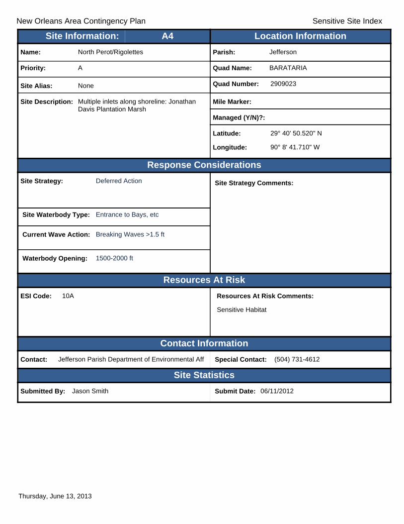
New Orleans Area Contingency Plan Sensitive Site Index
Response Considerations
Resources At Risk
Contact Information
Site Statistics
Resources At Risk Comments:
Sensitive Habitat
Contact: Jefferson Parish Department of Environmental Aff Special Contact: (504) 731-4612
Submitted By: Jason Smith Submit Date: 06/11/2012
Site Strategy: Deferred Action Site Strategy Comments:
Site Waterbody Type: Entrance to Bays, etc
Current Wave Action: Breaking Waves >1.5 ft
Waterbody Opening: 1500-2000 ft
ESI Code: 10A
Priority: A
Name: North Perot/Rigolettes
Site Alias: None
Site Description: Multiple inlets along shoreline: Jonathan Davis Plantation Marsh
Parish: Jefferson
Quad Name: BARATARIA
Quad Number: 2909023
Mile Marker:
Managed (Y/N)?:
Latitude: 29° 40' 50.520" N
Longitude: 90° 8' 41.710" W
Site Information: Location InformationText416:A4
Thursday, June 13, 2013
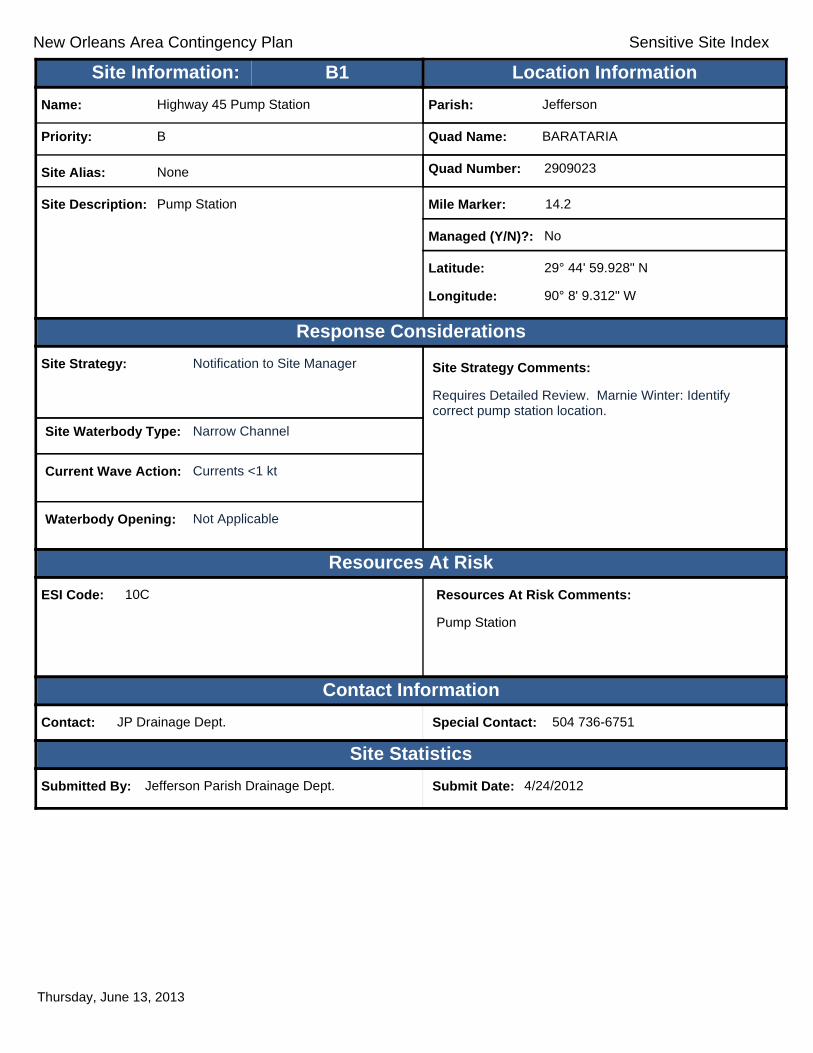
New Orleans Area Contingency Plan Sensitive Site Index
Response Considerations
Resources At Risk
Contact Information
Site Statistics
Resources At Risk Comments:
Pump Station
Contact: JP Drainage Dept. Special Contact: 504 736-6751
Submitted By: Jefferson Parish Drainage Dept. Submit Date: 4/24/2012
Site Strategy: Notification to Site Manager Site Strategy Comments:
Requires Detailed Review. Marnie Winter: Identify correct pump station location.
Site Waterbody Type: Narrow Channel
Current Wave Action: Currents <1 kt
Waterbody Opening: Not Applicable
ESI Code: 10C
Priority: B
Name: Highway 45 Pump Station
Site Alias: None
Site Description: Pump Station
Parish: Jefferson
Quad Name: BARATARIA
Quad Number: 2909023
Mile Marker: 14.2
Managed (Y/N)?: No
Latitude: 29° 44' 59.928" N
Longitude: 90° 8' 9.312" W
Site Information: Location InformationText416:B1
Thursday, June 13, 2013

New Orleans Area Contingency Plan Sensitive Site Index
Response Considerations
Resources At Risk
Contact Information
Site Statistics
Resources At Risk Comments:
Contact: Special Contact:
Submitted By: Jefferson Parish Drainage Dept. Submit Date: 20120424
Site Strategy: Notification to Site Manager Site Strategy Comments:
Site Waterbody Type: Narrow Channel
Current Wave Action: Currents <1 kt
Waterbody Opening: < 500 ft
ESI Code: 10A
Priority: B
Name: Fleming Pump Station
Site Alias: None
Site Description:
Parish: Jefferson
Quad Name: BARATARIA
Quad Number: 2909023
Mile Marker:
Managed (Y/N)?:
Latitude: 29° 44' 21.548" N
Longitude: 90° 7' 48.886" W
Site Information: Location InformationText416:B2
Thursday, June 13, 2013
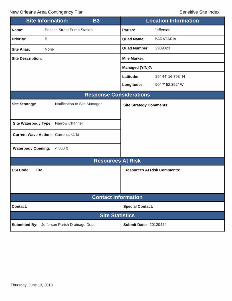
New Orleans Area Contingency Plan Sensitive Site Index
Response Considerations
Resources At Risk
Contact Information
Site Statistics
Resources At Risk Comments:
Contact: Special Contact:
Submitted By: Jefferson Parish Drainage Dept. Submit Date: 20120424
Site Strategy: Notification to Site Manager Site Strategy Comments:
Site Waterbody Type: Narrow Channel
Current Wave Action: Currents <1 kt
Waterbody Opening: < 500 ft
ESI Code: 10A
Priority: B
Name: Perkins Street Pump Station
Site Alias: None
Site Description:
Parish: Jefferson
Quad Name: BARATARIA
Quad Number: 2909023
Mile Marker:
Managed (Y/N)?:
Latitude: 29° 44' 16.793" N
Longitude: 90° 7' 52.352" W
Site Information: Location InformationText416:B3
Thursday, June 13, 2013

New Orleans Area Contingency Plan Sensitive Site Index
Response Considerations
Resources At Risk
Contact Information
Site Statistics
Resources At Risk Comments:
Contact: Special Contact:
Submitted By: Jefferson Parish Drainage Dept. Submit Date: 20120424
Site Strategy: Notification to Site Manager Site Strategy Comments:
Site Waterbody Type: Straight Coastline
Current Wave Action: Breaking Waves <1.5 ft
Waterbody Opening: Not Applicable
ESI Code:
Priority: B
Name: Church Point Pump Station
Site Alias: None
Site Description:
Parish: Jefferson
Quad Name: BARATARIA
Quad Number: 2909023
Mile Marker:
Managed (Y/N)?:
Latitude: 29° 44' 5.651" N
Longitude: 90° 7' 40.904" W
Site Information: Location InformationText416:B4
Thursday, June 13, 2013
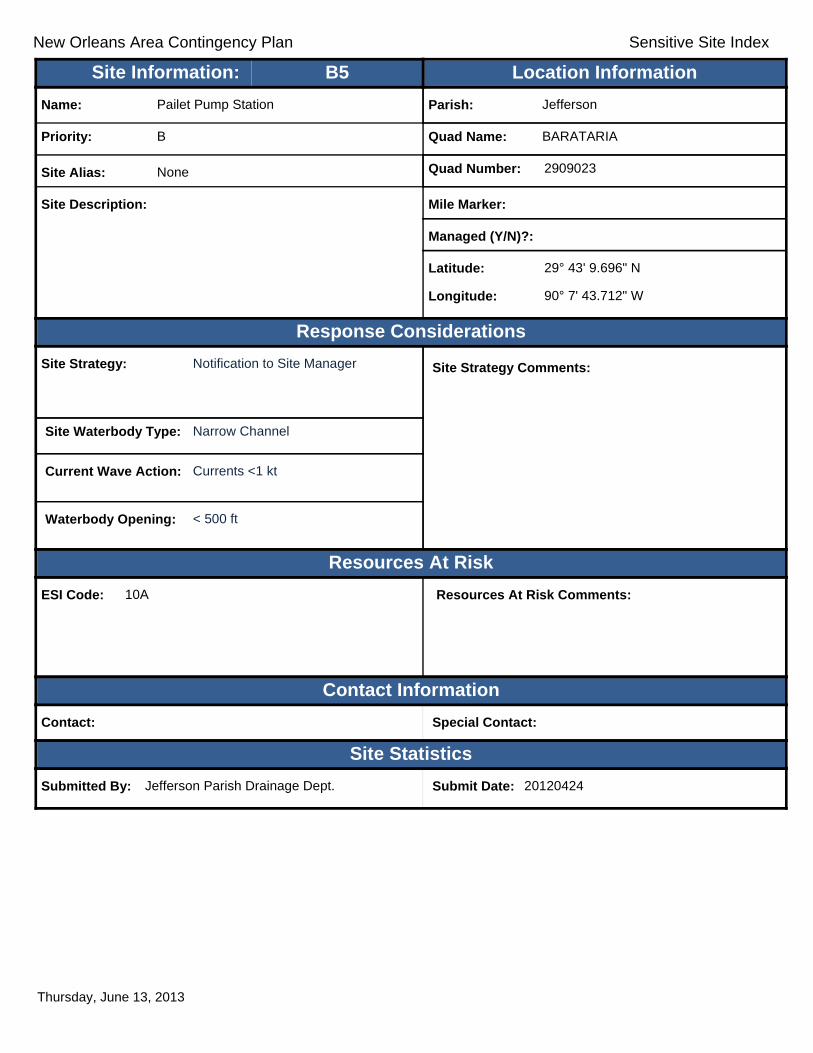
New Orleans Area Contingency Plan Sensitive Site Index
Response Considerations
Resources At Risk
Contact Information
Site Statistics
Resources At Risk Comments:
Contact: Special Contact:
Submitted By: Jefferson Parish Drainage Dept. Submit Date: 20120424
Site Strategy: Notification to Site Manager Site Strategy Comments:
Site Waterbody Type: Narrow Channel
Current Wave Action: Currents <1 kt
Waterbody Opening: < 500 ft
ESI Code: 10A
Priority: B
Name: Pailet Pump Station
Site Alias: None
Site Description:
Parish: Jefferson
Quad Name: BARATARIA
Quad Number: 2909023
Mile Marker:
Managed (Y/N)?:
Latitude: 29° 43' 9.696" N
Longitude: 90° 7' 43.712" W
Site Information: Location InformationText416:B5
Thursday, June 13, 2013

New Orleans Area Contingency Plan Sensitive Site Index
Response Considerations
Resources At Risk
Contact Information
Site Statistics
Resources At Risk Comments:
Contact: Special Contact:
Submitted By: Jefferson Parish - Env Aff. Submit Date: 20120425
Site Strategy: Deflection Booming Site Strategy Comments:
Site Waterbody Type: Narrow Tidal Channel
Current Wave Action: Current >1 kt
Waterbody Opening: < 500 ft
ESI Code: 10A
Priority: C
Name: Intracoastal Waterway
Site Alias: None
Site Description:
Parish: Jefferson
Quad Name: BARATARIA
Quad Number: 2909023
Mile Marker:
Managed (Y/N)?:
Latitude: 29° 44' 59.096" N
Longitude: 90° 8' 11.321" W
Site Information: Location InformationText416:C1
Thursday, June 13, 2013

New Orleans Area Contingency Plan Sensitive Site Index
Response Considerations
Resources At Risk
Contact Information
Site Statistics
Resources At Risk Comments:
Contact: Special Contact:
Submitted By: Jefferson Parish - Env Aff. Submit Date: 20120424
Site Strategy: Deflection Booming Site Strategy Comments:
Site Waterbody Type: Narrow Tidal Channel
Current Wave Action: Current >1 kt
Waterbody Opening: < 500 ft
ESI Code: 10A
Priority: C
Name: Intracoastal Waterway
Site Alias: None
Site Description:
Parish: Jefferson
Quad Name: BARATARIA
Quad Number: 2909023
Mile Marker:
Managed (Y/N)?:
Latitude: 29° 44' 37.118" N
Longitude: 90° 8' 15.832" W
Site Information: Location InformationText416:C2
Thursday, June 13, 2013

New Orleans Area Contingency Plan Sensitive Site Index
Response Considerations
Resources At Risk
Contact Information
Site Statistics
Resources At Risk Comments:
Contact: Special Contact:
Submitted By: Jefferson Parish - Env Aff. Submit Date: 20120424
Site Strategy: Deflection Booming Site Strategy Comments:
Site Waterbody Type: Narrow Tidal Channel
Current Wave Action: Current >1 kt
Waterbody Opening: < 500 ft
ESI Code: 10A
Priority: C
Name: Bayou Villars
Site Alias: None
Site Description:
Parish: Jefferson
Quad Name: BARATARIA
Quad Number: 2909023
Mile Marker:
Managed (Y/N)?:
Latitude: 29° 44' 30.505" N
Longitude: 90° 8' 8.635" W
Site Information: Location InformationText416:C3
Thursday, June 13, 2013

New Orleans Area Contingency Plan Sensitive Site Index
Response Considerations
Resources At Risk
Contact Information
Site Statistics
Resources At Risk Comments:
Contact: Special Contact:
Submitted By: Jefferson Parish - Env Aff. Submit Date: 20120424
Site Strategy: Deflection Booming Site Strategy Comments:
Site Waterbody Type: Narrow Tidal Channel
Current Wave Action: Current >1 kt
Waterbody Opening: < 500 ft
ESI Code: 10A
Priority: C
Name: Bayou Barataria
Site Alias: None
Site Description:
Parish: Jefferson
Quad Name: BARATARIA
Quad Number: 2909023
Mile Marker:
Managed (Y/N)?:
Latitude: 29° 44' 22.614" N
Longitude: 90° 7' 57.893" W
Site Information: Location InformationText416:C4
Thursday, June 13, 2013

New Orleans Area Contingency Plan Sensitive Site Index
Response Considerations
Resources At Risk
Contact Information
Site Statistics
Resources At Risk Comments:
Contact: Special Contact:
Submitted By: LA CPRA Submit Date: 20120628
Site Strategy: Deflection Booming Site Strategy Comments:
Site Waterbody Type: Narrow Tidal Channel
Current Wave Action: Current >1 kt
Waterbody Opening: < 500 ft
ESI Code:
Priority: C
Name: Jonathan Davis Wetland Protection
Site Alias: None
Site Description:
Parish: Jefferson
Quad Name: BARATARIA
Quad Number: 2909023
Mile Marker:
Managed (Y/N)?:
Latitude: 29° 41' 21.314" N
Longitude: 90° 9' 18.018" W
Site Information: Location InformationText416:C5
Thursday, June 13, 2013
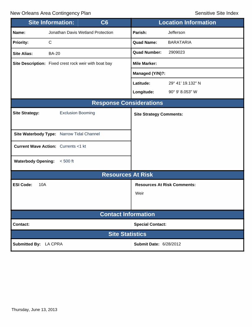
New Orleans Area Contingency Plan Sensitive Site Index
Response Considerations
Resources At Risk
Contact Information
Site Statistics
Resources At Risk Comments:
Weir
Contact: Special Contact:
Submitted By: LA CPRA Submit Date: 6/28/2012
Site Strategy: Exclusion Booming Site Strategy Comments:
Site Waterbody Type: Narrow Tidal Channel
Current Wave Action: Currents <1 kt
Waterbody Opening: < 500 ft
ESI Code: 10A
Priority: C
Name: Jonathan Davis Wetland Protection
Site Alias: BA-20
Site Description: Fixed crest rock weir with boat bay
Parish: Jefferson
Quad Name: BARATARIA
Quad Number: 2909023
Mile Marker:
Managed (Y/N)?:
Latitude: 29° 41' 19.132" N
Longitude: 90° 9' 8.053" W
Site Information: Location InformationText416:C6
Thursday, June 13, 2013
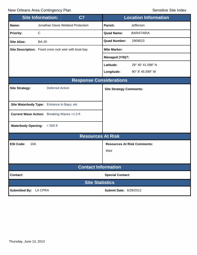
New Orleans Area Contingency Plan Sensitive Site Index
Response Considerations
Resources At Risk
Contact Information
Site Statistics
Resources At Risk Comments:
Weir
Contact: Special Contact:
Submitted By: LA CPRA Submit Date: 6/28/2012
Site Strategy: Deferred Action Site Strategy Comments:
Site Waterbody Type: Entrance to Bays, etc
Current Wave Action: Breaking Waves >1.5 ft
Waterbody Opening: < 500 ft
ESI Code: 10A
Priority: C
Name: Jonathan Davis Wetland Protection
Site Alias: BA-20
Site Description: Fixed crest rock weir with boat bay
Parish: Jefferson
Quad Name: BARATARIA
Quad Number: 2909023
Mile Marker:
Managed (Y/N)?:
Latitude: 29° 40' 41.098" N
Longitude: 90° 8' 45.599" W
Site Information: Location InformationText416:C7
Thursday, June 13, 2013
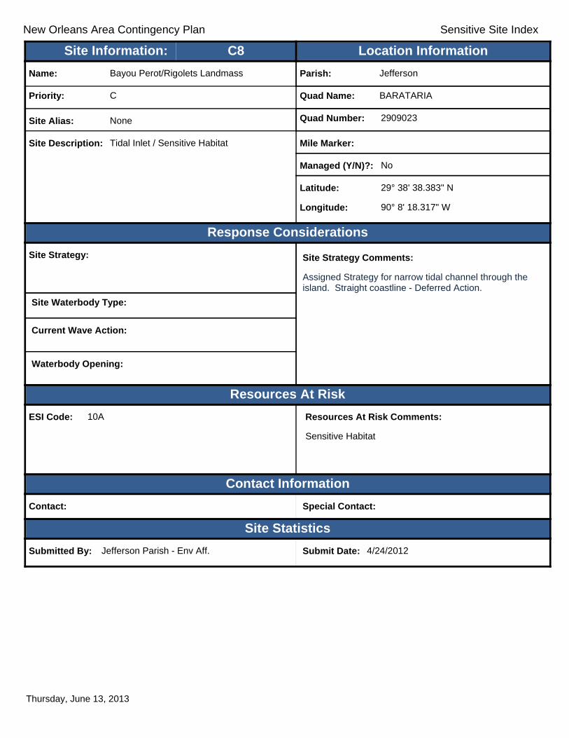
New Orleans Area Contingency Plan Sensitive Site Index
Response Considerations
Resources At Risk
Contact Information
Site Statistics
Resources At Risk Comments:
Sensitive Habitat
Contact: Special Contact:
Submitted By: Jefferson Parish - Env Aff. Submit Date: 4/24/2012
Site Strategy: Site Strategy Comments:
Assigned Strategy for narrow tidal channel through the island. Straight coastline - Deferred Action.
Site Waterbody Type:
Current Wave Action:
Waterbody Opening:
ESI Code: 10A
Priority: C
Name: Bayou Perot/Rigolets Landmass
Site Alias: None
Site Description: Tidal Inlet / Sensitive Habitat
Parish: Jefferson
Quad Name: BARATARIA
Quad Number: 2909023
Mile Marker:
Managed (Y/N)?: No
Latitude: 29° 38' 38.383" N
Longitude: 90° 8' 18.317" W
Site Information: Location InformationText416:C8
Thursday, June 13, 2013
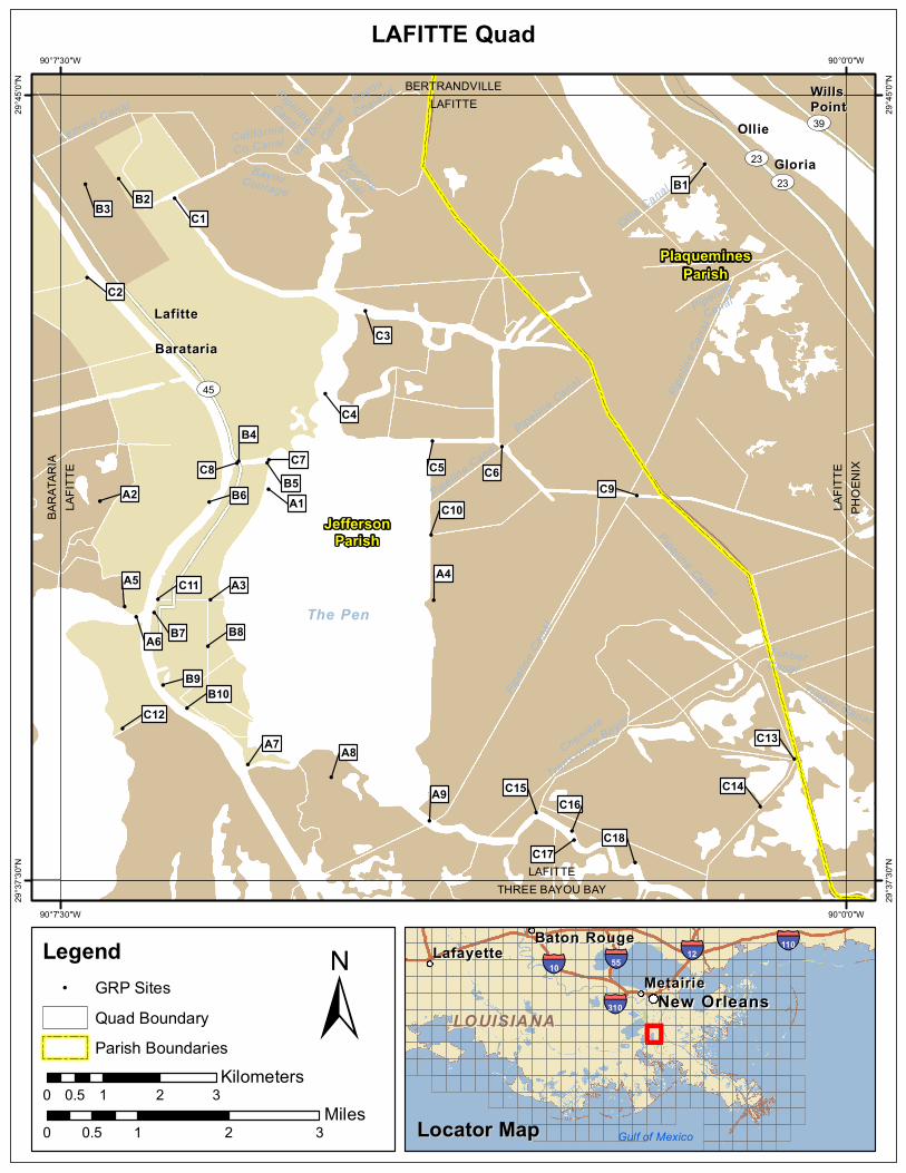
!
!
!
!
!
!
!
!
!
!
!
!
!
!
!
!
!
! !
!
!!
!
!
!!!!
!!
!
!
!
!
!!
!
TimberCanal
CaliforniaCo Canal
Bayou
Chaland
Pipeline
Canal
BayouCourage
PipelineCanal
Timber Canal
Pipeline Canal
PipelineCanal
Van D
onne
Canal
Ollie Canal
Pipeline Canal
Pipeline Canal
Leming Canal
Pipeli
ne C
anal
Cheniere
Transverse Bayou
Pipeli
ne C
anal
The Pen
ST39
ST23ST23
ST45
BaratariaBarataria
GloriaGloria
LafitteLafitte
OllieOllie
WillsWillsPointPoint
BARA
TARI
ALA
FITTE
LAFITTETHREE BAYOU BAY
LAFIT
TEPH
OENI
X
LAFITTEBERTRANDVILLE
C18
A9
C17
C16C15 C14
A7 A8C13
C12B10
B9
B8A6
A5 C11
B7
A3A4
C10B6A2 A1
C9
B4
C8 C7B5 C6C5
C4
C3
C2
C1B3 B2B1
JeffersonParish
PlaqueminesParish
90°0'0"W
90°0'0"W
90°7'30"W
90°7'30"W
29°45
'0"N
29°45
'0"N
29°37
'30"N
29°37
'30"N
±0 1 2 30.5
Miles
LAFITTE Quad
MetairieMetairieLafayetteLafayette
Baton RougeBaton Rouge
New OrleansNew Orleans
§̈¦12§̈¦55
§̈¦310
§̈¦110
§̈¦10
LOUISIANALOUISIANA
Gulf of Mexico
Legend! GRP Sites
Quad BoundaryParish Boundaries
0 1 2 30.5Kilometers
Locator MapLocator Map
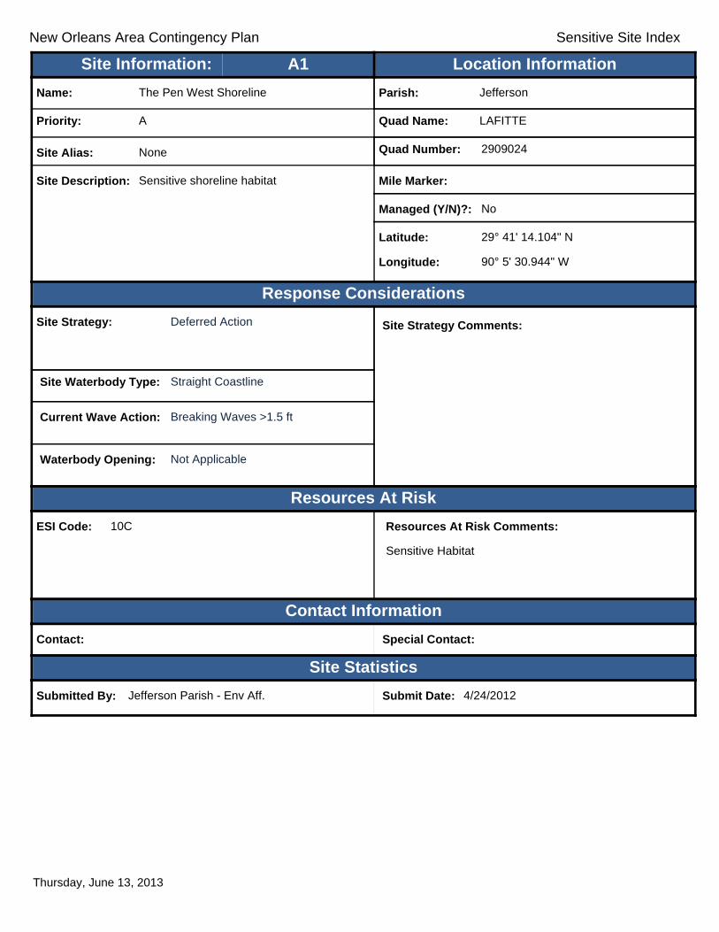
New Orleans Area Contingency Plan Sensitive Site Index
Response Considerations
Resources At Risk
Contact Information
Site Statistics
Resources At Risk Comments:
Sensitive Habitat
Contact: Special Contact:
Submitted By: Jefferson Parish - Env Aff. Submit Date: 4/24/2012
Site Strategy: Deferred Action Site Strategy Comments:
Site Waterbody Type: Straight Coastline
Current Wave Action: Breaking Waves >1.5 ft
Waterbody Opening: Not Applicable
ESI Code: 10C
Priority: A
Name: The Pen West Shoreline
Site Alias: None
Site Description: Sensitive shoreline habitat
Parish: Jefferson
Quad Name: LAFITTE
Quad Number: 2909024
Mile Marker:
Managed (Y/N)?: No
Latitude: 29° 41' 14.104" N
Longitude: 90° 5' 30.944" W
Site Information: Location InformationText416:A1
Thursday, June 13, 2013
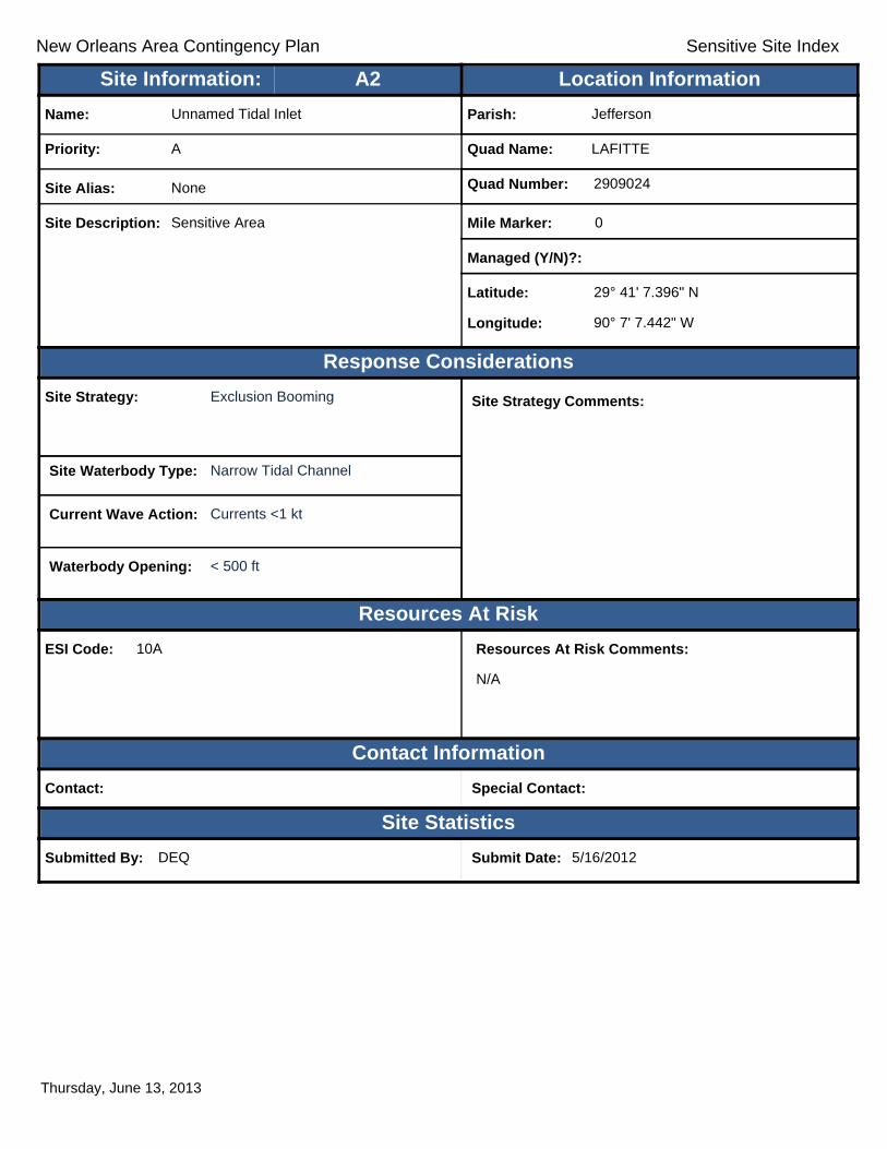
New Orleans Area Contingency Plan Sensitive Site Index
Response Considerations
Resources At Risk
Contact Information
Site Statistics
Resources At Risk Comments:
N/A
Contact: Special Contact:
Submitted By: DEQ Submit Date: 5/16/2012
Site Strategy: Exclusion Booming Site Strategy Comments:
Site Waterbody Type: Narrow Tidal Channel
Current Wave Action: Currents <1 kt
Waterbody Opening: < 500 ft
ESI Code: 10A
Priority: A
Name: Unnamed Tidal Inlet
Site Alias: None
Site Description: Sensitive Area
Parish: Jefferson
Quad Name: LAFITTE
Quad Number: 2909024
Mile Marker: 0
Managed (Y/N)?:
Latitude: 29° 41' 7.396" N
Longitude: 90° 7' 7.442" W
Site Information: Location InformationText416:A2
Thursday, June 13, 2013

New Orleans Area Contingency Plan Sensitive Site Index
Response Considerations
Resources At Risk
Contact Information
Site Statistics
Resources At Risk Comments:
Sensitive Habitat
Contact: Special Contact:
Submitted By: Jefferson Parish - Env Aff. Submit Date: 4/24/2012
Site Strategy: Exclusion Booming Site Strategy Comments:
Site Waterbody Type: Narrow Tidal Channel
Current Wave Action: Currents <1 kt
Waterbody Opening: < 500 ft
ESI Code: 10D
Priority: A
Name: Unnamed Canal
Site Alias: W. Pen Shoreline
Site Description: Tidal Inlet / Sensitive Habitat
Parish: Jefferson
Quad Name: LAFITTE
Quad Number: 2909024
Mile Marker:
Managed (Y/N)?: No
Latitude: 29° 40' 10.966" N
Longitude: 90° 6' 4.159" W
Site Information: Location InformationText416:A3
Thursday, June 13, 2013
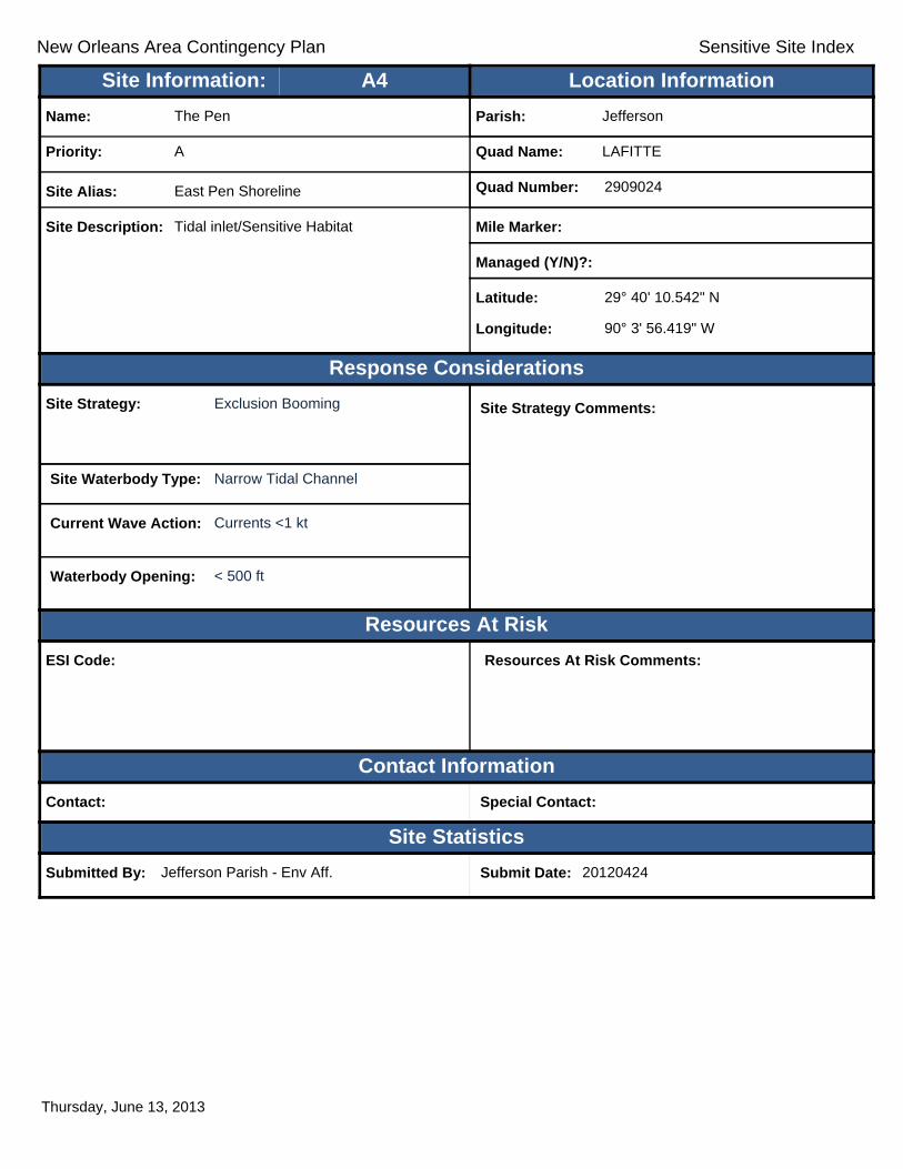
New Orleans Area Contingency Plan Sensitive Site Index
Response Considerations
Resources At Risk
Contact Information
Site Statistics
Resources At Risk Comments:
Contact: Special Contact:
Submitted By: Jefferson Parish - Env Aff. Submit Date: 20120424
Site Strategy: Exclusion Booming Site Strategy Comments:
Site Waterbody Type: Narrow Tidal Channel
Current Wave Action: Currents <1 kt
Waterbody Opening: < 500 ft
ESI Code:
Priority: A
Name: The Pen
Site Alias: East Pen Shoreline
Site Description: Tidal inlet/Sensitive Habitat
Parish: Jefferson
Quad Name: LAFITTE
Quad Number: 2909024
Mile Marker:
Managed (Y/N)?:
Latitude: 29° 40' 10.542" N
Longitude: 90° 3' 56.419" W
Site Information: Location InformationText416:A4
Thursday, June 13, 2013
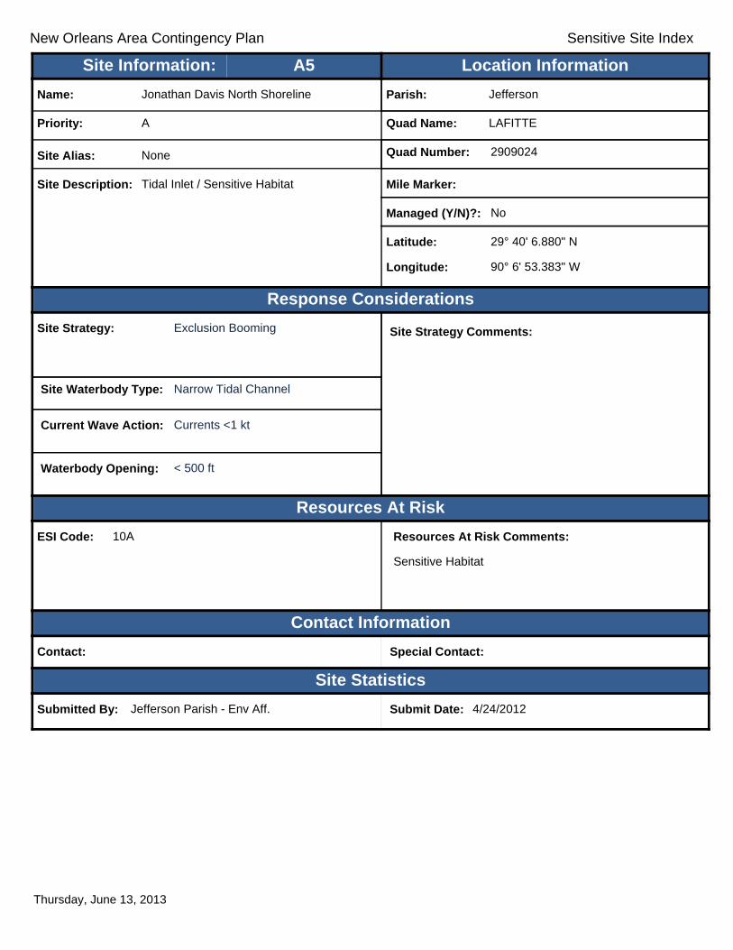
New Orleans Area Contingency Plan Sensitive Site Index
Response Considerations
Resources At Risk
Contact Information
Site Statistics
Resources At Risk Comments:
Sensitive Habitat
Contact: Special Contact:
Submitted By: Jefferson Parish - Env Aff. Submit Date: 4/24/2012
Site Strategy: Exclusion Booming Site Strategy Comments:
Site Waterbody Type: Narrow Tidal Channel
Current Wave Action: Currents <1 kt
Waterbody Opening: < 500 ft
ESI Code: 10A
Priority: A
Name: Jonathan Davis North Shoreline
Site Alias: None
Site Description: Tidal Inlet / Sensitive Habitat
Parish: Jefferson
Quad Name: LAFITTE
Quad Number: 2909024
Mile Marker:
Managed (Y/N)?: No
Latitude: 29° 40' 6.880" N
Longitude: 90° 6' 53.383" W
Site Information: Location InformationText416:A5
Thursday, June 13, 2013

New Orleans Area Contingency Plan Sensitive Site Index
Response Considerations
Resources At Risk
Contact Information
Site Statistics
Resources At Risk Comments:
Sensitive Habitat
Contact: Special Contact:
Submitted By: Jefferson Parish - Env Aff. Submit Date: 4/24/2012
Site Strategy: Deflection Booming Site Strategy Comments:
Site Waterbody Type: Entrance to Bays, etc
Current Wave Action: Breaking Waves <1.5 ft and Currents >1 kt
Waterbody Opening: 500-1000 ft
ESI Code: 10A
Priority: A
Name: Bayou Rigolets
Site Alias: None
Site Description: Tidal Inlet / Sensitive Habitat
Parish: Jefferson
Quad Name: LAFITTE
Quad Number: 2909024
Mile Marker:
Managed (Y/N)?: No
Latitude: 29° 40' 1.090" N
Longitude: 90° 6' 46.787" W
Site Information: Location InformationText416:A6
Thursday, June 13, 2013

New Orleans Area Contingency Plan Sensitive Site Index
Response Considerations
Resources At Risk
Contact Information
Site Statistics
Resources At Risk Comments:
Sensitive Habitat
Contact: Special Contact:
Submitted By: Jefferson Parish - Env Aff. Submit Date: 4/24/2012
Site Strategy: Deflection Booming Site Strategy Comments:
Site Waterbody Type: Narrow Tidal Channel
Current Wave Action: Current >1 kt
Waterbody Opening: < 500 ft
ESI Code: 10A
Priority: A
Name: Bayou Dupont
Site Alias: Pen Inlet
Site Description: Tidal Inlet / Sensitive Habitat
Parish: Jefferson
Quad Name: LAFITTE
Quad Number: 2909024
Mile Marker:
Managed (Y/N)?: No
Latitude: 29° 38' 36.521" N
Longitude: 90° 5' 42.655" W
Site Information: Location InformationText416:A7
Thursday, June 13, 2013

New Orleans Area Contingency Plan Sensitive Site Index
Response Considerations
Resources At Risk
Contact Information
Site Statistics
Resources At Risk Comments:
Sensitive Habitat
Contact: Special Contact:
Submitted By: Jefferson Parish - Env Aff. Submit Date: 4/24/2012
Site Strategy: Exclusion Booming Site Strategy Comments:
Site Waterbody Type: Entrance to Bays, etc
Current Wave Action: Breaking Waves <1.5 ft and Currents <1 kt
Waterbody Opening: 500-1000 ft
ESI Code: 10A
Priority: A
Name: The Pen
Site Alias: None
Site Description: Tidal Inlet / Sensitive Habitat
Parish: Jefferson
Quad Name: LAFITTE
Quad Number: 2909024
Mile Marker:
Managed (Y/N)?: No
Latitude: 29° 38' 29.150" N
Longitude: 90° 4' 55.026" W
Site Information: Location InformationText416:A8
Thursday, June 13, 2013

New Orleans Area Contingency Plan Sensitive Site Index
Response Considerations
Resources At Risk
Contact Information
Site Statistics
Resources At Risk Comments:
Sensitive Habitat
Contact: Special Contact:
Submitted By: Jefferson Parish - Env Aff. Submit Date: 4/24/2012
Site Strategy: Deflection Booming Site Strategy Comments:
Site Waterbody Type: Entrance to Bays, etc
Current Wave Action: Breaking Waves <1.5 ft and Currents >1 kt
Waterbody Opening: Not Applicable
ESI Code: 10A
Priority: A
Name: Bayou Dupont
Site Alias: None
Site Description: Tidal Inlet / Sensitive Habitat
Parish: Jefferson
Quad Name: LAFITTE
Quad Number: 2909024
Mile Marker:
Managed (Y/N)?: No
Latitude: 29° 38' 4.201" N
Longitude: 90° 3' 58.892" W
Site Information: Location InformationText416:A9
Thursday, June 13, 2013
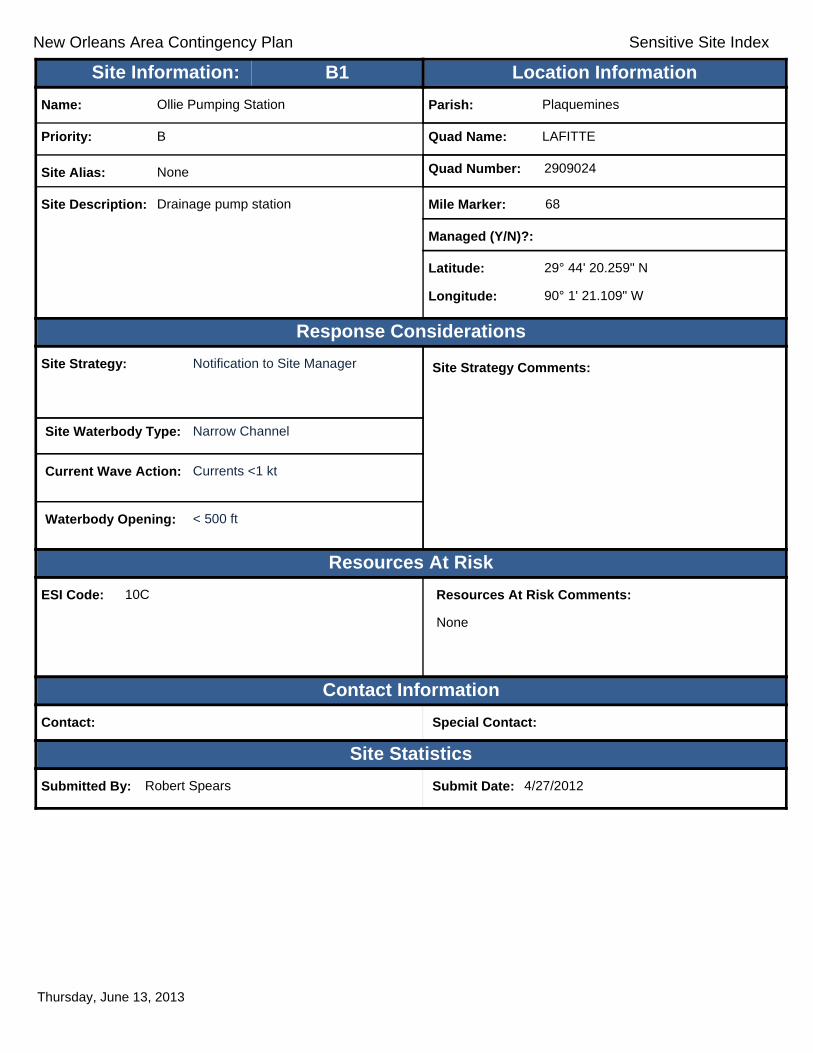
New Orleans Area Contingency Plan Sensitive Site Index
Response Considerations
Resources At Risk
Contact Information
Site Statistics
Resources At Risk Comments:
None
Contact: Special Contact:
Submitted By: Robert Spears Submit Date: 4/27/2012
Site Strategy: Notification to Site Manager Site Strategy Comments:
Site Waterbody Type: Narrow Channel
Current Wave Action: Currents <1 kt
Waterbody Opening: < 500 ft
ESI Code: 10C
Priority: B
Name: Ollie Pumping Station
Site Alias: None
Site Description: Drainage pump station
Parish: Plaquemines
Quad Name: LAFITTE
Quad Number: 2909024
Mile Marker: 68
Managed (Y/N)?:
Latitude: 29° 44' 20.259" N
Longitude: 90° 1' 21.109" W
Site Information: Location InformationText416:B1
Thursday, June 13, 2013

New Orleans Area Contingency Plan Sensitive Site Index
Response Considerations
Resources At Risk
Contact Information
Site Statistics
Resources At Risk Comments:
Contact: Special Contact:
Submitted By: Jefferson Parish Drainage Dept. Submit Date: 20120424
Site Strategy: Notification to Site Manager Site Strategy Comments:
Site Waterbody Type: Narrow Channel
Current Wave Action: Currents <1 kt
Waterbody Opening: < 500 ft
ESI Code: 10A
Priority: B
Name: Oak Drive Pump Station
Site Alias: None
Site Description:
Parish: Jefferson
Quad Name: LAFITTE
Quad Number: 2909024
Mile Marker:
Managed (Y/N)?:
Latitude: 29° 44' 11.994" N
Longitude: 90° 6' 56.639" W
Site Information: Location InformationText416:B2
Thursday, June 13, 2013

New Orleans Area Contingency Plan Sensitive Site Index
Response Considerations
Resources At Risk
Contact Information
Site Statistics
Resources At Risk Comments:
Contact: Special Contact:
Submitted By: Jefferson Parish Drainage Dept. Submit Date: 20120424
Site Strategy: Notification to Site Manager Site Strategy Comments:
Site Waterbody Type: Narrow Channel
Current Wave Action: Currents <1 kt
Waterbody Opening: < 500 ft
ESI Code:
Priority: B
Name: Gloria Drive Pump Station
Site Alias: None
Site Description:
Parish: Jefferson
Quad Name: LAFITTE
Quad Number: 2909024
Mile Marker:
Managed (Y/N)?:
Latitude: 29° 44' 8.984" N
Longitude: 90° 7' 15.758" W
Site Information: Location InformationText416:B3
Thursday, June 13, 2013
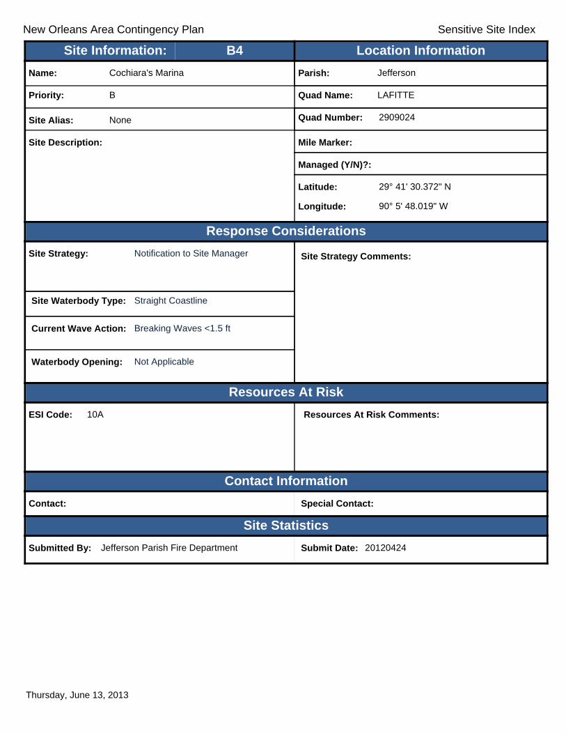
New Orleans Area Contingency Plan Sensitive Site Index
Response Considerations
Resources At Risk
Contact Information
Site Statistics
Resources At Risk Comments:
Contact: Special Contact:
Submitted By: Jefferson Parish Fire Department Submit Date: 20120424
Site Strategy: Notification to Site Manager Site Strategy Comments:
Site Waterbody Type: Straight Coastline
Current Wave Action: Breaking Waves <1.5 ft
Waterbody Opening: Not Applicable
ESI Code: 10A
Priority: B
Name: Cochiara's Marina
Site Alias: None
Site Description:
Parish: Jefferson
Quad Name: LAFITTE
Quad Number: 2909024
Mile Marker:
Managed (Y/N)?:
Latitude: 29° 41' 30.372" N
Longitude: 90° 5' 48.019" W
Site Information: Location InformationText416:B4
Thursday, June 13, 2013

New Orleans Area Contingency Plan Sensitive Site Index
Response Considerations
Resources At Risk
Contact Information
Site Statistics
Resources At Risk Comments:
Contact: Special Contact:
Submitted By: Jefferson Parish Drainage Dept. Submit Date: 20120424
Site Strategy: Notification to Site Manager Site Strategy Comments:
Site Waterbody Type: Straight Coastline
Current Wave Action: Breaking Waves <1.5 ft
Waterbody Opening: Not Applicable
ESI Code: 10A
Priority: B
Name: Goose Bayou Pump Station
Site Alias: None
Site Description:
Parish: Jefferson
Quad Name: LAFITTE
Quad Number: 2909024
Mile Marker:
Managed (Y/N)?:
Latitude: 29° 41' 29.256" N
Longitude: 90° 5' 31.794" W
Site Information: Location InformationText416:B5
Thursday, June 13, 2013

New Orleans Area Contingency Plan Sensitive Site Index
Response Considerations
Resources At Risk
Contact Information
Site Statistics
Resources At Risk Comments:
Contact: Special Contact:
Submitted By: Jefferson Parish Fire Department Submit Date: 20120424
Site Strategy: Notification to Site Manager Site Strategy Comments:
Site Waterbody Type: Straight Coastline
Current Wave Action: Breaking Waves <1.5 ft
Waterbody Opening: Not Applicable
ESI Code: 10A
Priority: B
Name: Joe's Landing
Site Alias: None
Site Description:
Parish: Jefferson
Quad Name: LAFITTE
Quad Number: 2909024
Mile Marker:
Managed (Y/N)?:
Latitude: 29° 41' 6.817" N
Longitude: 90° 6' 4.820" W
Site Information: Location InformationText416:B6
Thursday, June 13, 2013

New Orleans Area Contingency Plan Sensitive Site Index
Response Considerations
Resources At Risk
Contact Information
Site Statistics
Resources At Risk Comments:
Pump Station
Contact: JP Drainage Dept. Special Contact: 504 736-6751
Submitted By: Jefferson Parish Drainage Dept. Submit Date: 4/24/2012
Site Strategy: Notification to Site Manager Site Strategy Comments:
Requires Detailed Review. Marnie Winter: Identify correct location for the Marrero Street Pump Station.
Site Waterbody Type: Narrow Channel
Current Wave Action: Currents <1 kt
Waterbody Opening: Not Applicable
ESI Code:
Priority: B
Name: Marrero Street Pump Station
Site Alias: None
Site Description: Pump Station
Parish: Jefferson
Quad Name: LAFITTE
Quad Number: 2909024
Mile Marker:
Managed (Y/N)?: No
Latitude: 29° 40' 3.540" N
Longitude: 90° 6' 36.468" W
Site Information: Location InformationText416:B7
Thursday, June 13, 2013

New Orleans Area Contingency Plan Sensitive Site Index
Response Considerations
Resources At Risk
Contact Information
Site Statistics
Resources At Risk Comments:
Contact: Special Contact:
Submitted By: Jefferson Parish Drainage Dept. Submit Date: 20120424
Site Strategy: Notification to Site Manager Site Strategy Comments:
Site Waterbody Type: Narrow Channel
Current Wave Action: Currents <1 kt
Waterbody Opening: < 500 ft
ESI Code: 10A
Priority: B
Name: Orange Street Pump Station
Site Alias: None
Site Description:
Parish: Jefferson
Quad Name: LAFITTE
Quad Number: 2909024
Mile Marker:
Managed (Y/N)?:
Latitude: 29° 39' 44.280" N
Longitude: 90° 6' 5.771" W
Site Information: Location InformationText416:B8
Thursday, June 13, 2013
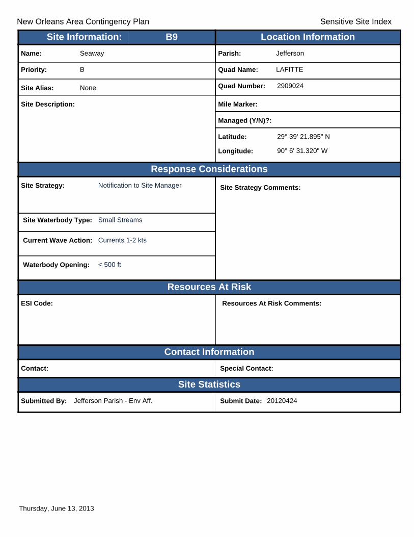
New Orleans Area Contingency Plan Sensitive Site Index
Response Considerations
Resources At Risk
Contact Information
Site Statistics
Resources At Risk Comments:
Contact: Special Contact:
Submitted By: Jefferson Parish - Env Aff. Submit Date: 20120424
Site Strategy: Notification to Site Manager Site Strategy Comments:
Site Waterbody Type: Small Streams
Current Wave Action: Currents 1-2 kts
Waterbody Opening: < 500 ft
ESI Code:
Priority: B
Name: Seaway
Site Alias: None
Site Description:
Parish: Jefferson
Quad Name: LAFITTE
Quad Number: 2909024
Mile Marker:
Managed (Y/N)?:
Latitude: 29° 39' 21.895" N
Longitude: 90° 6' 31.320" W
Site Information: Location InformationText416:B9
Thursday, June 13, 2013

New Orleans Area Contingency Plan Sensitive Site Index
Response Considerations
Resources At Risk
Contact Information
Site Statistics
Resources At Risk Comments:
Contact: Special Contact:
Submitted By: Jefferson Parish Fire Department Submit Date: 20120424
Site Strategy: Exclusion Booming Site Strategy Comments:
Site Waterbody Type: Entrance to Bays, etc
Current Wave Action: Breaking Waves <1.5 ft
Waterbody Opening: < 500 ft
ESI Code: 10A
Priority: B
Name: C&M Fuel Dock
Site Alias: None
Site Description:
Parish: Jefferson
Quad Name: LAFITTE
Quad Number: 2909024
Mile Marker:
Managed (Y/N)?:
Latitude: 29° 39' 8.669" N
Longitude: 90° 6' 17.585" W
Site Information: Location InformationText416:B10
Thursday, June 13, 2013

New Orleans Area Contingency Plan Sensitive Site Index
Response Considerations
Resources At Risk
Contact Information
Site Statistics
Resources At Risk Comments:
Sensitive Habitat
Contact: Special Contact:
Submitted By: Jefferson Parish - Env Aff. Submit Date: 4/24/2012
Site Strategy: Exclusion Booming Site Strategy Comments:
Requires Detailed Review. Marnie Winter: Identify correct location based on current description. Is there a potential threat?Site Waterbody Type: Narrow Tidal Channel
Current Wave Action: Currents <1 kt
Waterbody Opening: < 500 ft
ESI Code: 10B
Priority: C
Name: Cypress Bayou
Site Alias: None
Site Description: Tidal Inlet / Sensitive Habitat
Parish: Jefferson
Quad Name: LAFITTE
Quad Number: 2909024
Mile Marker:
Managed (Y/N)?: No
Latitude: 29° 44' 0.816" N
Longitude: 90° 6' 24.732" W
Site Information: Location InformationText416:C1
Thursday, June 13, 2013

New Orleans Area Contingency Plan Sensitive Site Index
Response Considerations
Resources At Risk
Contact Information
Site Statistics
Resources At Risk Comments:
Sensitive Habitat
Contact: Special Contact:
Submitted By: Jefferson Parish - Env Aff. Submit Date: 4/24/2012
Site Strategy: Exclusion Booming Site Strategy Comments:
Site Waterbody Type: Narrow Tidal Channel
Current Wave Action: Currents <1 kt
Waterbody Opening: < 500 ft
ESI Code: 10C
Priority: C
Name: Pailet Canal
Site Alias: None
Site Description: Tidal Inlet / Sensitive Habitat
Parish: Jefferson
Quad Name: LAFITTE
Quad Number: 2909024
Mile Marker:
Managed (Y/N)?: No
Latitude: 29° 43' 15.275" N
Longitude: 90° 7' 14.799" W
Site Information: Location InformationText416:C2
Thursday, June 13, 2013

New Orleans Area Contingency Plan Sensitive Site Index
Response Considerations
Resources At Risk
Contact Information
Site Statistics
Resources At Risk Comments:
Sensitive Habitat
Contact: Special Contact:
Submitted By: Jefferson Parish - Env Aff. Submit Date: 4/24/2012
Site Strategy: Deflection Booming Site Strategy Comments:
Site Waterbody Type: Narrow Tidal Channel
Current Wave Action: Current >1 kt
Waterbody Opening: 500-1000 ft
ESI Code: 10B
Priority: C
Name: Bayou DeFleur/Goose Bayou
Site Alias: None
Site Description: Tidal Inlet / Sensitive Habitat
Parish: Jefferson
Quad Name: LAFITTE
Quad Number: 2909024
Mile Marker:
Managed (Y/N)?: No
Latitude: 29° 42' 56.420" N
Longitude: 90° 4' 35.457" W
Site Information: Location InformationText416:C3
Thursday, June 13, 2013
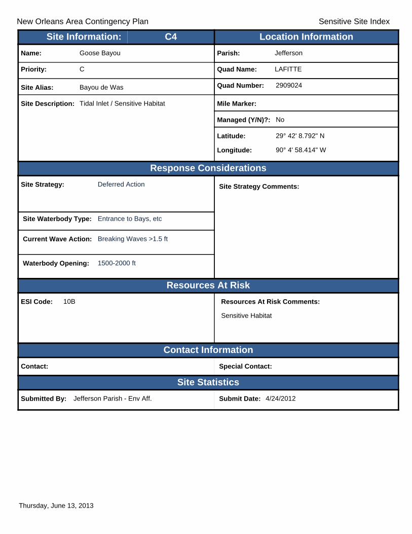
New Orleans Area Contingency Plan Sensitive Site Index
Response Considerations
Resources At Risk
Contact Information
Site Statistics
Resources At Risk Comments:
Sensitive Habitat
Contact: Special Contact:
Submitted By: Jefferson Parish - Env Aff. Submit Date: 4/24/2012
Site Strategy: Deferred Action Site Strategy Comments:
Site Waterbody Type: Entrance to Bays, etc
Current Wave Action: Breaking Waves >1.5 ft
Waterbody Opening: 1500-2000 ft
ESI Code: 10B
Priority: C
Name: Goose Bayou
Site Alias: Bayou de Was
Site Description: Tidal Inlet / Sensitive Habitat
Parish: Jefferson
Quad Name: LAFITTE
Quad Number: 2909024
Mile Marker:
Managed (Y/N)?: No
Latitude: 29° 42' 8.792" N
Longitude: 90° 4' 58.414" W
Site Information: Location InformationText416:C4
Thursday, June 13, 2013

New Orleans Area Contingency Plan Sensitive Site Index
Response Considerations
Resources At Risk
Contact Information
Site Statistics
Resources At Risk Comments:
Sensitive Habitat
Contact: Special Contact:
Submitted By: Jefferson Parish - Env Aff. Submit Date: 4/24/2012
Site Strategy: Exclusion Booming Site Strategy Comments:
Site Waterbody Type: Narrow Tidal Channel
Current Wave Action: Currents <1 kt
Waterbody Opening: < 500 ft
ESI Code: 10B
Priority: C
Name: Unnamed Canal
Site Alias: None
Site Description: Tidal Inlet / Sensitive Habitat
Parish: Jefferson
Quad Name: LAFITTE
Quad Number: 2909024
Mile Marker:
Managed (Y/N)?: No
Latitude: 29° 41' 41.724" N
Longitude: 90° 3' 57.081" W
Site Information: Location InformationText416:C5
Thursday, June 13, 2013

New Orleans Area Contingency Plan Sensitive Site Index
Response Considerations
Resources At Risk
Contact Information
Site Statistics
Resources At Risk Comments:
Sensitive Habitat
Contact: Special Contact:
Submitted By: Jefferson Parish - Env Aff. Submit Date: 4/24/2012
Site Strategy: Exclusion Booming Site Strategy Comments:
Site Waterbody Type: Narrow Tidal Channel
Current Wave Action: Currents <1 kt
Waterbody Opening: < 500 ft
ESI Code: 10B
Priority: C
Name: Unnamed Canal
Site Alias: None
Site Description: Tidal Inlet / Sensitive Habitat
Parish: Jefferson
Quad Name: LAFITTE
Quad Number: 2909024
Mile Marker:
Managed (Y/N)?: No
Latitude: 29° 41' 38.640" N
Longitude: 90° 3' 17.335" W
Site Information: Location InformationText416:C6
Thursday, June 13, 2013

New Orleans Area Contingency Plan Sensitive Site Index
Response Considerations
Resources At Risk
Contact Information
Site Statistics
Resources At Risk Comments:
Contact: Special Contact:
Submitted By: Jefferson Parish - Env Aff. Submit Date: 20120424
Site Strategy: Exclusion Booming Site Strategy Comments:
Site Waterbody Type: Entrance to Bays, etc
Current Wave Action: Breaking Waves <1.5 ft and Currents <1 kt
Waterbody Opening: < 500 ft
ESI Code: 10A
Priority: C
Name: Goose Bayou
Site Alias: None
Site Description:
Parish: Jefferson
Quad Name: LAFITTE
Quad Number: 2909024
Mile Marker:
Managed (Y/N)?:
Latitude: 29° 41' 30.919" N
Longitude: 90° 5' 30.750" W
Site Information: Location InformationText416:C7
Thursday, June 13, 2013

New Orleans Area Contingency Plan Sensitive Site Index
Response Considerations
Resources At Risk
Contact Information
Site Statistics
Resources At Risk Comments:
Contact: Special Contact:
Submitted By: Jefferson Parish - Env Aff. Submit Date: 20120424
Site Strategy: Deflection Booming Site Strategy Comments:
Site Waterbody Type: Narrow Tidal Channel
Current Wave Action: Current >1 kt
Waterbody Opening: < 500 ft
ESI Code: 10A
Priority: C
Name: Goose Bayou
Site Alias: None
Site Description:
Parish: Jefferson
Quad Name: LAFITTE
Quad Number: 2909024
Mile Marker:
Managed (Y/N)?:
Latitude: 29° 41' 29.098" N
Longitude: 90° 5' 49.106" W
Site Information: Location InformationText416:C8
Thursday, June 13, 2013
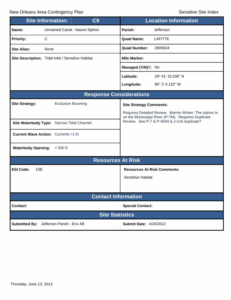
New Orleans Area Contingency Plan Sensitive Site Index
Response Considerations
Resources At Risk
Contact Information
Site Statistics
Resources At Risk Comments:
Sensitive Habitat
Contact: Special Contact:
Submitted By: Jefferson Parish - Env Aff. Submit Date: 4/24/2012
Site Strategy: Exclusion Booming Site Strategy Comments:
Requires Detailed Review. Marnie Winter: The siphon is on the Mississippi River (P-7M). Requires Duplicate Review. See P-7 & P-4044 & J-116 duplicate?Site Waterbody Type: Narrow Tidal Channel
Current Wave Action: Currents <1 kt
Waterbody Opening: < 500 ft
ESI Code: 10B
Priority: C
Name: Unnamed Canal - Naomi Siphon
Site Alias: None
Site Description: Tidal Inlet / Sensitive Habitat
Parish: Jefferson
Quad Name: LAFITTE
Quad Number: 2909024
Mile Marker:
Managed (Y/N)?: No
Latitude: 29° 41' 10.536" N
Longitude: 90° 2' 0.132" W
Site Information: Location InformationText416:C9
Thursday, June 13, 2013

New Orleans Area Contingency Plan Sensitive Site Index
Response Considerations
Resources At Risk
Contact Information
Site Statistics
Resources At Risk Comments:
N/A
Contact: Special Contact:
Submitted By: DEQ Submit Date: 5/16/2012
Site Strategy: Exclusion Booming Site Strategy Comments:
Site Waterbody Type: Narrow Tidal Channel
Current Wave Action: Currents <1 kt
Waterbody Opening: < 500 ft
ESI Code: 10B
Priority: C
Name: Unnamed Tidal Inlet
Site Alias: None
Site Description: Sensitive Area
Parish: Jefferson
Quad Name: LAFITTE
Quad Number: 2909024
Mile Marker: 0
Managed (Y/N)?:
Latitude: 29° 40' 48.001" N
Longitude: 90° 3' 57.802" W
Site Information: Location InformationText416:C10
Thursday, June 13, 2013

New Orleans Area Contingency Plan Sensitive Site Index
Response Considerations
Resources At Risk
Contact Information
Site Statistics
Resources At Risk Comments:
Contact: Special Contact:
Submitted By: Jefferson Parish - Env Aff. Submit Date: 20120424
Site Strategy: Deflection Booming Site Strategy Comments:
Site Waterbody Type: Narrow Tidal Channel
Current Wave Action: Current >1 kt
Waterbody Opening: < 500 ft
ESI Code: 10A
Priority: C
Name: Unnamed Canal
Site Alias: None
Site Description:
Parish: Jefferson
Quad Name: LAFITTE
Quad Number: 2909024
Mile Marker:
Managed (Y/N)?:
Latitude: 29° 40' 11.071" N
Longitude: 90° 6' 34.326" W
Site Information: Location InformationText416:C11
Thursday, June 13, 2013

New Orleans Area Contingency Plan Sensitive Site Index
Response Considerations
Resources At Risk
Contact Information
Site Statistics
Resources At Risk Comments:
Sensitive Habitat
Contact: Special Contact:
Submitted By: Jefferson Parish - Env Aff. Submit Date: 4/24/2012
Site Strategy: Exclusion Booming Site Strategy Comments:
Site Waterbody Type: Narrow Tidal Channel
Current Wave Action: Currents <1 kt
Waterbody Opening: < 500 ft
ESI Code: 10A
Priority: C
Name: Bayou Rigolets East Shoreline
Site Alias: None
Site Description: Tidal Inlet / Sensitive Habitat
Parish: Jefferson
Quad Name: LAFITTE
Quad Number: 2909024
Mile Marker:
Managed (Y/N)?: No
Latitude: 29° 38' 57.032" N
Longitude: 90° 6' 54.484" W
Site Information: Location InformationText416:C12
Thursday, June 13, 2013

New Orleans Area Contingency Plan Sensitive Site Index
Response Considerations
Resources At Risk
Contact Information
Site Statistics
Resources At Risk Comments:
N/A
Contact: Special Contact:
Submitted By: DEQ Submit Date: 5/16/2012
Site Strategy: Exclusion Booming Site Strategy Comments:
Site Waterbody Type: Narrow Tidal Channel
Current Wave Action: Currents <1 kt
Waterbody Opening: < 500 ft
ESI Code: 10A
Priority: C
Name: Unnamed Tidal Inlet
Site Alias: None
Site Description: Sensitive Area
Parish: Jefferson
Quad Name: LAFITTE
Quad Number: 2909024
Mile Marker: 0
Managed (Y/N)?:
Latitude: 29° 38' 39.746" N
Longitude: 90° 0' 29.872" W
Site Information: Location InformationText416:C13
Thursday, June 13, 2013

New Orleans Area Contingency Plan Sensitive Site Index
Response Considerations
Resources At Risk
Contact Information
Site Statistics
Resources At Risk Comments:
N/A
Contact: Special Contact:
Submitted By: DEQ Submit Date: 5/16/2012
Site Strategy: Exclusion Booming Site Strategy Comments:
Site Waterbody Type: Narrow Tidal Channel
Current Wave Action: Currents <1 kt
Waterbody Opening: < 500 ft
ESI Code: 10A
Priority: C
Name: Unnamed Tidal Inlet
Site Alias: None
Site Description: Sensitive Area
Parish: Jefferson
Quad Name: LAFITTE
Quad Number: 2909024
Mile Marker: 0
Managed (Y/N)?:
Latitude: 29° 38' 12.362" N
Longitude: 90° 0' 49.433" W
Site Information: Location InformationText416:C14
Thursday, June 13, 2013

New Orleans Area Contingency Plan Sensitive Site Index
Response Considerations
Resources At Risk
Contact Information
Site Statistics
Resources At Risk Comments:
Tidal Inlet
Contact: Special Contact:
Submitted By: LA CPRA Submit Date: 6/28/2012
Site Strategy: Deflection Booming Site Strategy Comments:
Site Waterbody Type: Narrow Tidal Channel
Current Wave Action: Current >1 kt
Waterbody Opening: < 500 ft
ESI Code: 10A
Priority: C
Name: Bayou Dupont
Site Alias: None
Site Description: Northshore of Bayou Dupont
Parish: Jefferson
Quad Name: LAFITTE
Quad Number: 2909024
Mile Marker:
Managed (Y/N)?:
Latitude: 29° 38' 8.851" N
Longitude: 90° 2' 57.635" W
Site Information: Location InformationText416:C15
Thursday, June 13, 2013

New Orleans Area Contingency Plan Sensitive Site Index
Response Considerations
Resources At Risk
Contact Information
Site Statistics
Resources At Risk Comments:
Tidal Inlet
Contact: Special Contact:
Submitted By: LA CPRA Submit Date: 6/28/2012
Site Strategy: Exclusion Booming Site Strategy Comments:
Site Waterbody Type: Narrow Tidal Channel
Current Wave Action: Currents <1 kt
Waterbody Opening: < 500 ft
ESI Code: 10A
Priority: C
Name: Bayou Dupont
Site Alias: None
Site Description: Northshore of Bayou Dupont
Parish: Jefferson
Quad Name: LAFITTE
Quad Number: 2909024
Mile Marker:
Managed (Y/N)?:
Latitude: 29° 37' 58.481" N
Longitude: 90° 2' 37.059" W
Site Information: Location InformationText416:C16
Thursday, June 13, 2013

New Orleans Area Contingency Plan Sensitive Site Index
Response Considerations
Resources At Risk
Contact Information
Site Statistics
Resources At Risk Comments:
Sensitive Habitat
Contact: Special Contact:
Submitted By: Jefferson Parish - Env Aff. Submit Date: 4/24/2012
Site Strategy: Deflection Booming Site Strategy Comments:
Site Waterbody Type: Narrow Tidal Channel
Current Wave Action: Current >1 kt
Waterbody Opening: 500-1000 ft
ESI Code: 10A
Priority: C
Name: Bayou Dupont
Site Alias: None
Site Description: Tidal Inlet / Sensitive Habitat
Parish: Jefferson
Quad Name: LAFITTE
Quad Number: 2909024
Mile Marker:
Managed (Y/N)?: No
Latitude: 29° 37' 53.181" N
Longitude: 90° 2' 35.875" W
Site Information: Location InformationText416:C17
Thursday, June 13, 2013
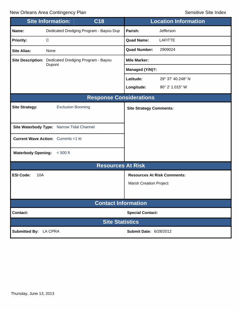
New Orleans Area Contingency Plan Sensitive Site Index
Response Considerations
Resources At Risk
Contact Information
Site Statistics
Resources At Risk Comments:
Marsh Creation Project
Contact: Special Contact:
Submitted By: LA CPRA Submit Date: 6/28/2012
Site Strategy: Exclusion Booming Site Strategy Comments:
Site Waterbody Type: Narrow Tidal Channel
Current Wave Action: Currents <1 kt
Waterbody Opening: < 500 ft
ESI Code: 10A
Priority: C
Name: Dedicated Dredging Program - Bayou Dup
Site Alias: None
Site Description: Dedicated Dredging Program - Bayou Dupont
Parish: Jefferson
Quad Name: LAFITTE
Quad Number: 2909024
Mile Marker:
Managed (Y/N)?:
Latitude: 29° 37' 40.248" N
Longitude: 90° 2' 1.015" W
Site Information: Location InformationText416:C18
Thursday, June 13, 2013

!
!
!!
!
!
!
!
Bayou des
Amoreux
LittleLake
BayLours
TurtleBay
BAY L'OURSGOLDEN MEADOW FARMS
BAY
L'OUR
STH
REE B
AYOU
BAY
BAY L'OURSBARATARIA
A6
A5
C2 A4A3
A2
A1
C1
JeffersonParish
LafourcheParish
90°7'30"W
90°7'30"W
90°15'0"W
90°15'0"W
29°37
'30"N
29°37
'30"N
29°30
'0"N
29°30
'0"N
±0 1 2 30.5
Miles
BAY L'OURS Quad
MetairieMetairieLafayetteLafayette
Baton RougeBaton Rouge
New OrleansNew Orleans
§̈¦12§̈¦55
§̈¦310
§̈¦110
§̈¦10
LOUISIANALOUISIANA
Gulf of Mexico
Legend! GRP Sites
Quad BoundaryParish Boundaries
0 1 2 30.5Kilometers
Locator MapLocator Map

New Orleans Area Contingency Plan Sensitive Site Index
Response Considerations
Resources At Risk
Contact Information
Site Statistics
Resources At Risk Comments:
Sensitive Habitat
Contact: Special Contact:
Submitted By: Jefferson Parish - Env Aff. Submit Date: 4/25/2012
Site Strategy: Deferred Action Site Strategy Comments:
Site Waterbody Type: Straight Coastline
Current Wave Action: Breaking Waves >1.5 ft
Waterbody Opening: Not Applicable
ESI Code: 10A
Priority: A
Name: Bayou Rigolets South
Site Alias: None
Site Description: Various Inlets / Sensitive Habitat
Parish: Jefferson
Quad Name: BAY L'OURS
Quad Number: 2909031
Mile Marker:
Managed (Y/N)?: No
Latitude: 29° 34' 55.593" N
Longitude: 90° 7' 42.258" W
Site Information: Location InformationText416:A1
Thursday, June 13, 2013

New Orleans Area Contingency Plan Sensitive Site Index
Response Considerations
Resources At Risk
Contact Information
Site Statistics
Resources At Risk Comments:
Sensitive Habitat
Contact: Special Contact:
Submitted By: Jefferson Parish - Env Aff. Submit Date: 4/24/2012
Site Strategy: Diversion Booming to Collection Point
Site Strategy Comments:
Site Waterbody Type: Narrow Tidal Channel
Current Wave Action: Current >1 kt
Waterbody Opening: < 500 ft
ESI Code: 10A
Priority: A
Name: Harvey Cut North
Site Alias: None
Site Description: Tidal Inlet / Sensitive Habitat
Parish: Jefferson
Quad Name: BAY L'OURS
Quad Number: 2909031
Mile Marker:
Managed (Y/N)?: No
Latitude: 29° 34' 25.896" N
Longitude: 90° 8' 12.946" W
Site Information: Location InformationText416:A2
Thursday, June 13, 2013

New Orleans Area Contingency Plan Sensitive Site Index
Response Considerations
Resources At Risk
Contact Information
Site Statistics
Resources At Risk Comments:
Sensitive Habitat
Contact: Special Contact:
Submitted By: Jefferson Parish - Env Aff. Submit Date: 4/24/2012
Site Strategy: Deferred Action Site Strategy Comments:
Site Waterbody Type: Entrance to Bays, etc
Current Wave Action: Breaking Waves >1.5 ft
Waterbody Opening: 1500-2000 ft
ESI Code: 10A
Priority: A
Name: Bayou Perot
Site Alias: None
Site Description: Various Inlets / Sensitive Habitat
Parish: Jefferson
Quad Name: BAY L'OURS
Quad Number: 2909031
Mile Marker:
Managed (Y/N)?: No
Latitude: 29° 33' 58.315" N
Longitude: 90° 10' 21.780" W
Site Information: Location InformationText416:A3
Thursday, June 13, 2013

New Orleans Area Contingency Plan Sensitive Site Index
Response Considerations
Resources At Risk
Contact Information
Site Statistics
Resources At Risk Comments:
Sensitive Habitat
Contact: Special Contact:
Submitted By: Jefferson Parish - Env Aff. Submit Date: 4/24/2012
Site Strategy: Diversion Booming to Collection Point
Site Strategy Comments:
Site Waterbody Type: Narrow Tidal Channel
Current Wave Action: Current >1 kt
Waterbody Opening: < 500 ft
ESI Code: 10A
Priority: A
Name: Unnamed Secondary Inlets
Site Alias: Harvey Cut W Landmass
Site Description: Various Inlets / Sensitive Habitat
Parish: Jefferson
Quad Name: BAY L'OURS
Quad Number: 2909031
Mile Marker:
Managed (Y/N)?: No
Latitude: 29° 33' 39.064" N
Longitude: 90° 9' 25.323" W
Site Information: Location InformationText416:A4
Thursday, June 13, 2013

New Orleans Area Contingency Plan Sensitive Site Index
Response Considerations
Resources At Risk
Contact Information
Site Statistics
Resources At Risk Comments:
Sensitive Habitat
Contact: Special Contact:
Submitted By: Jefferson Parish - Env Aff. Submit Date: 4/24/2012
Site Strategy: Deflection Booming Site Strategy Comments:
Site Waterbody Type: Narrow Tidal Channel
Current Wave Action: Current >1 kt
Waterbody Opening: < 500 ft
ESI Code: 10A
Priority: A
Name: Harvey Cut South
Site Alias: None
Site Description: Tidal Inlet / Sensitive Habitat
Parish: Jefferson
Quad Name: BAY L'OURS
Quad Number: 2909031
Mile Marker:
Managed (Y/N)?: No
Latitude: 29° 33' 9.632" N
Longitude: 90° 7' 59.618" W
Site Information: Location InformationText416:A5
Thursday, June 13, 2013

New Orleans Area Contingency Plan Sensitive Site Index
Response Considerations
Resources At Risk
Contact Information
Site Statistics
Resources At Risk Comments:
N/A
Contact: Special Contact:
Submitted By: DEQ Submit Date: 5/16/2012
Site Strategy: Deflection Booming Site Strategy Comments:
Site Waterbody Type: Narrow Tidal Channel
Current Wave Action: Current >1 kt
Waterbody Opening: < 500 ft
ESI Code: 10A
Priority: A
Name: Unnamed Tidal Inlet
Site Alias: None
Site Description: Sensitive Area
Parish: Jefferson
Quad Name: BAY L'OURS
Quad Number: 2909031
Mile Marker: 0
Managed (Y/N)?:
Latitude: 29° 32' 47.744" N
Longitude: 90° 9' 25.613" W
Site Information: Location InformationText416:A6
Thursday, June 13, 2013

New Orleans Area Contingency Plan Sensitive Site Index
Response Considerations
Resources At Risk
Contact Information
Site Statistics
Resources At Risk Comments:
Sensitive Habitat
Contact: Special Contact:
Submitted By: Jefferson Parish - Env Aff. Submit Date: 4/24/2012
Site Strategy: Deflection Booming Site Strategy Comments:
Assigned Strategy for narrow tidal channel through the island. Straight coastline - Deferred Action.
Site Waterbody Type: Narrow Tidal Channel
Current Wave Action: Current >1 kt
Waterbody Opening: < 500 ft
ESI Code: 10A
Priority: C
Name: Bayou Perot/Rigolets Landmass
Site Alias: None
Site Description: Various Inlets / Sensitive Habitat
Parish: Jefferson
Quad Name: BAY L'OURS
Quad Number: 2909031
Mile Marker:
Managed (Y/N)?: No
Latitude: 29° 36' 33.330" N
Longitude: 90° 8' 29.628" W
Site Information: Location InformationText416:C1
Thursday, June 13, 2013

New Orleans Area Contingency Plan Sensitive Site Index
Response Considerations
Resources At Risk
Contact Information
Site Statistics
Resources At Risk Comments:
Various Tidal Inlets
Contact: Special Contact:
Submitted By: LA CPRA Submit Date: 6/28/2012
Site Strategy: Deferred Action Site Strategy Comments:
Site Waterbody Type: Entrance to Bays, etc
Current Wave Action: Breaking Waves >1.5 ft
Waterbody Opening: < 500 ft
ESI Code: 10A
Priority: C
Name: Lake Northwest Shoreline
Site Alias: None
Site Description: Northwest Shore of Little Lake
Parish: Jefferson
Quad Name: BAY L'OURS
Quad Number: 2909031
Mile Marker:
Managed (Y/N)?:
Latitude: 29° 33' 36.434" N
Longitude: 90° 10' 19.887" W
Site Information: Location InformationText416:C2
Thursday, June 13, 2013

New Orleans Area Contingency Plan
Geographic Response Plan- Jefferson Parish
This page is intentionally left blank
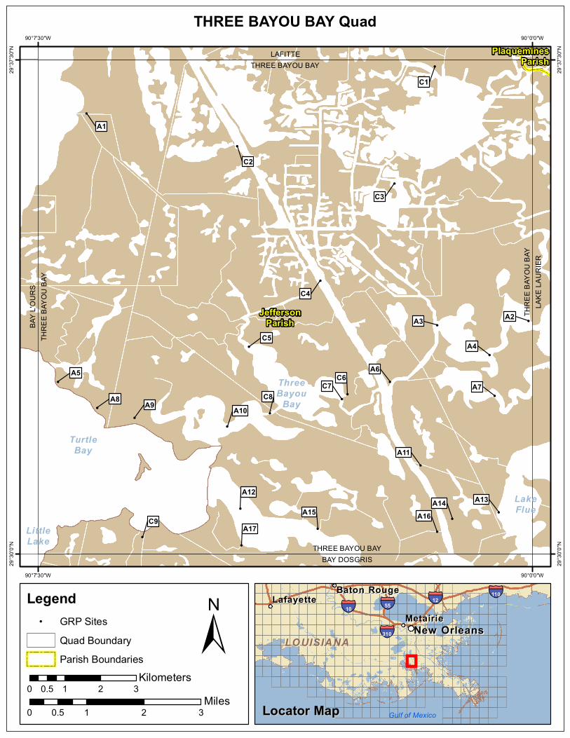
!
!
!!
!
!
!
!
!
!
!
!
!
!!
! !
!
!
!
!
!
!
!
!
!
LittleLake
TurtleBay
ThreeBayou
Bay
LakeFlue
BAY
L'OUR
STH
REE B
AYOU
BAY
THREE BAYOU BAYBAY DOSGRIS
THRE
E BAY
OU B
AYLA
KE LA
URIE
R
THREE BAYOU BAYLAFITTE
C9A17
A16A15A14
A12A13
A11
A10A8 A9
C8
C6C7 A7
A5 A6
A4C5
A3 A2
C4
C3
C2
A1
C1
JeffersonParish
PlaqueminesParish
90°0'0"W
90°0'0"W
90°7'30"W
90°7'30"W
29°37
'30"N
29°37
'30"N
29°30
'0"N
29°30
'0"N
±0 1 2 30.5
Miles
THREE BAYOU BAY Quad
MetairieMetairieLafayetteLafayette
Baton RougeBaton Rouge
New OrleansNew Orleans
§̈¦12§̈¦55
§̈¦310
§̈¦110
§̈¦10
LOUISIANALOUISIANA
Gulf of Mexico
Legend! GRP Sites
Quad BoundaryParish Boundaries
0 1 2 30.5Kilometers
Locator MapLocator Map

New Orleans Area Contingency Plan Sensitive Site Index
Response Considerations
Resources At Risk
Contact Information
Site Statistics
Resources At Risk Comments:
Contact: Special Contact:
Submitted By: Jefferson Parish - Env Aff. Submit Date: 20120424
Site Strategy: Deflection Booming Site Strategy Comments:
Site Waterbody Type: Narrow Tidal Channel
Current Wave Action: Current >1 kt
Waterbody Opening: < 500 ft
ESI Code:
Priority: A
Name: Bayou Rigolets East
Site Alias: None
Site Description:
Parish: Jefferson
Quad Name: THREE BAYOU BAY
Quad Number: 2909032
Mile Marker:
Managed (Y/N)?:
Latitude: 29° 36' 41.083" N
Longitude: 90° 6' 45.986" W
Site Information: Location InformationText416:A1
Thursday, June 13, 2013

New Orleans Area Contingency Plan Sensitive Site Index
Response Considerations
Resources At Risk
Contact Information
Site Statistics
Resources At Risk Comments:
Sensitive Habitat
Contact: Special Contact:
Submitted By: Jefferson Parish - Env Aff. Submit Date: 4/24/2012
Site Strategy: Deferred Action Site Strategy Comments:
Site Waterbody Type: Entrance to Bays, etc
Current Wave Action: Breaking Waves >1.5 ft
Waterbody Opening: 1500-2000 ft
ESI Code: 10A
Priority: A
Name: Unnamed Tidal Inlet
Site Alias: None
Site Description: Tidal Inlet / Sensitive Habitat
Parish: Jefferson
Quad Name: THREE BAYOU BAY
Quad Number: 2909032
Mile Marker:
Managed (Y/N)?: No
Latitude: 29° 33' 32.266" N
Longitude: 90° 0' 3.775" W
Site Information: Location InformationText416:A2
Thursday, June 13, 2013

New Orleans Area Contingency Plan Sensitive Site Index
Response Considerations
Resources At Risk
Contact Information
Site Statistics
Resources At Risk Comments:
N/A
Contact: Special Contact:
Submitted By: DEQ Submit Date: 5/16/2012
Site Strategy: Deferred Action Site Strategy Comments:
Site Waterbody Type: Entrance to Bays, etc
Current Wave Action: Breaking Waves <1.5 ft and Currents >1 kt
Waterbody Opening: 1000-1500 ft
ESI Code: 10A
Priority: A
Name: Goelette Bay
Site Alias: None
Site Description: Sensitive Area
Parish: Jefferson
Quad Name: THREE BAYOU BAY
Quad Number: 2909032
Mile Marker: 0
Managed (Y/N)?:
Latitude: 29° 33' 28.160" N
Longitude: 90° 1' 26.894" W
Site Information: Location InformationText416:A3
Thursday, June 13, 2013
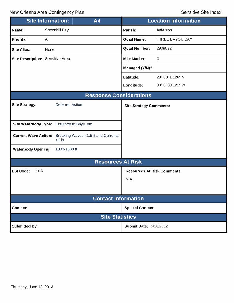
New Orleans Area Contingency Plan Sensitive Site Index
Response Considerations
Resources At Risk
Contact Information
Site Statistics
Resources At Risk Comments:
N/A
Contact: Special Contact:
Submitted By: Submit Date: 5/16/2012
Site Strategy: Deferred Action Site Strategy Comments:
Site Waterbody Type: Entrance to Bays, etc
Current Wave Action: Breaking Waves <1.5 ft and Currents >1 kt
Waterbody Opening: 1000-1500 ft
ESI Code: 10A
Priority: A
Name: Spoonbill Bay
Site Alias: None
Site Description: Sensitive Area
Parish: Jefferson
Quad Name: THREE BAYOU BAY
Quad Number: 2909032
Mile Marker: 0
Managed (Y/N)?:
Latitude: 29° 33' 1.126" N
Longitude: 90° 0' 39.121" W
Site Information: Location InformationText416:A4
Thursday, June 13, 2013

New Orleans Area Contingency Plan Sensitive Site Index
Response Considerations
Resources At Risk
Contact Information
Site Statistics
Resources At Risk Comments:
Sensitive Habitat
Contact: Special Contact:
Submitted By: Jefferson Parish - Env Aff. Submit Date: 4/24/2012
Site Strategy: Deflection Booming Site Strategy Comments:
Site Waterbody Type: Narrow Tidal Channel
Current Wave Action: Current >1 kt
Waterbody Opening: < 500 ft
ESI Code: 10A
Priority: A
Name: Northeast Turtle Bay
Site Alias: None
Site Description: Tidal Inlet / Sensitive Habitat
Parish: Jefferson
Quad Name: THREE BAYOU BAY
Quad Number: 2909032
Mile Marker:
Managed (Y/N)?: No
Latitude: 29° 32' 36.765" N
Longitude: 90° 7' 11.894" W
Site Information: Location InformationText416:A5
Thursday, June 13, 2013

New Orleans Area Contingency Plan Sensitive Site Index
Response Considerations
Resources At Risk
Contact Information
Site Statistics
Resources At Risk Comments:
N/A
Contact: Special Contact:
Submitted By: DEQ Submit Date: 5/16/2012
Site Strategy: Deflection Booming Site Strategy Comments:
Site Waterbody Type: Narrow Tidal Channel
Current Wave Action: Current >1 kt
Waterbody Opening: < 500 ft
ESI Code: 10A
Priority: A
Name: Goelette Bay
Site Alias: None
Site Description: Sensitive Area
Parish: Jefferson
Quad Name: THREE BAYOU BAY
Quad Number: 2909032
Mile Marker: 0
Managed (Y/N)?:
Latitude: 29° 32' 36.679" N
Longitude: 90° 2' 9.748" W
Site Information: Location InformationText416:A6
Thursday, June 13, 2013

New Orleans Area Contingency Plan Sensitive Site Index
Response Considerations
Resources At Risk
Contact Information
Site Statistics
Resources At Risk Comments:
N/A
Contact: Special Contact:
Submitted By: Submit Date: 5/16/2012
Site Strategy: Deflection Booming Site Strategy Comments:
Site Waterbody Type: Entrance to Bays, etc
Current Wave Action: Breaking Waves <1.5 ft and Currents >1 kt
Waterbody Opening: 500-1000 ft
ESI Code: 10A
Priority: A
Name: Spoonbill Bay
Site Alias: None
Site Description: Sensitive Area
Parish: Jefferson
Quad Name: THREE BAYOU BAY
Quad Number: 2909032
Mile Marker: 0
Managed (Y/N)?:
Latitude: 29° 32' 23.995" N
Longitude: 90° 0' 34.534" W
Site Information: Location InformationText416:A7
Thursday, June 13, 2013

New Orleans Area Contingency Plan Sensitive Site Index
Response Considerations
Resources At Risk
Contact Information
Site Statistics
Resources At Risk Comments:
Sensitive Habitat
Contact: Special Contact:
Submitted By: Jefferson Parish - Env Aff. Submit Date: 4/24/2012
Site Strategy: Deflection Booming Site Strategy Comments:
Site Waterbody Type: Narrow Tidal Channel
Current Wave Action: Current >1 kt
Waterbody Opening: < 500 ft
ESI Code: 10A
Priority: A
Name: Unnamed Tidal Inlets
Site Alias: None
Site Description: Tidal Inlet / Sensitive Habitat
Parish: Jefferson
Quad Name: THREE BAYOU BAY
Quad Number: 2909032
Mile Marker:
Managed (Y/N)?: No
Latitude: 29° 32' 12.917" N
Longitude: 90° 6' 36.117" W
Site Information: Location InformationText416:A8
Thursday, June 13, 2013

New Orleans Area Contingency Plan Sensitive Site Index
Response Considerations
Resources At Risk
Contact Information
Site Statistics
Resources At Risk Comments:
Sensitive Habitat
Contact: Special Contact:
Submitted By: Jefferson Parish - Env Aff. Submit Date: 4/24/2012
Site Strategy: Deflection Booming Site Strategy Comments:
Site Waterbody Type: Narrow Tidal Channel
Current Wave Action: Current >1 kt
Waterbody Opening: < 500 ft
ESI Code: 10A
Priority: A
Name: Unnamed Tidal Inlets
Site Alias: None
Site Description: Tidal Inlet / Sensitive Habitat
Parish: Jefferson
Quad Name: THREE BAYOU BAY
Quad Number: 2909032
Mile Marker:
Managed (Y/N)?: No
Latitude: 29° 32' 3.927" N
Longitude: 90° 6' 2.155" W
Site Information: Location InformationText416:A9
Thursday, June 13, 2013

New Orleans Area Contingency Plan Sensitive Site Index
Response Considerations
Resources At Risk
Contact Information
Site Statistics
Resources At Risk Comments:
Sensitive Habitat
Contact: Special Contact:
Submitted By: Jefferson Parish - Env Aff. Submit Date: 4/24/2012
Site Strategy: Deferred Action Site Strategy Comments:
Site Waterbody Type: Entrance to Bays, etc
Current Wave Action: Breaking Waves <1.5 ft and Currents >1 kt
Waterbody Opening: 1000-1500 ft
ESI Code: 10A
Priority: A
Name: Long Bay
Site Alias: None
Site Description: Tidal Inlet / Sensitive Habitat
Parish: Jefferson
Quad Name: THREE BAYOU BAY
Quad Number: 2909032
Mile Marker:
Managed (Y/N)?: No
Latitude: 29° 31' 56.218" N
Longitude: 90° 4' 37.916" W
Site Information: Location InformationText416:A10
Thursday, June 13, 2013
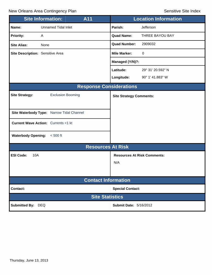
New Orleans Area Contingency Plan Sensitive Site Index
Response Considerations
Resources At Risk
Contact Information
Site Statistics
Resources At Risk Comments:
N/A
Contact: Special Contact:
Submitted By: DEQ Submit Date: 5/16/2012
Site Strategy: Exclusion Booming Site Strategy Comments:
Site Waterbody Type: Narrow Tidal Channel
Current Wave Action: Currents <1 kt
Waterbody Opening: < 500 ft
ESI Code: 10A
Priority: A
Name: Unnamed Tidal Inlet
Site Alias: None
Site Description: Sensitive Area
Parish: Jefferson
Quad Name: THREE BAYOU BAY
Quad Number: 2909032
Mile Marker: 0
Managed (Y/N)?:
Latitude: 29° 31' 20.592" N
Longitude: 90° 1' 41.883" W
Site Information: Location InformationText416:A11
Thursday, June 13, 2013

New Orleans Area Contingency Plan Sensitive Site Index
Response Considerations
Resources At Risk
Contact Information
Site Statistics
Resources At Risk Comments:
Sensitive Habitat
Contact: Special Contact:
Submitted By: Jefferson Parish - Env Aff. Submit Date: 4/24/2012
Site Strategy: Deferred Action Site Strategy Comments:
Site Waterbody Type: Entrance to Bays, etc
Current Wave Action: Breaking Waves <1.5 ft and Currents >1 kt
Waterbody Opening: 2000-2500 ft
ESI Code: 10A
Priority: A
Name: Unnamed Secondary Inlet
Site Alias: None
Site Description: Tidal Inlet / Sensitive Habitat
Parish: Jefferson
Quad Name: THREE BAYOU BAY
Quad Number: 2909032
Mile Marker:
Managed (Y/N)?: No
Latitude: 29° 30' 41.269" N
Longitude: 90° 4' 26.012" W
Site Information: Location InformationText416:A12
Thursday, June 13, 2013
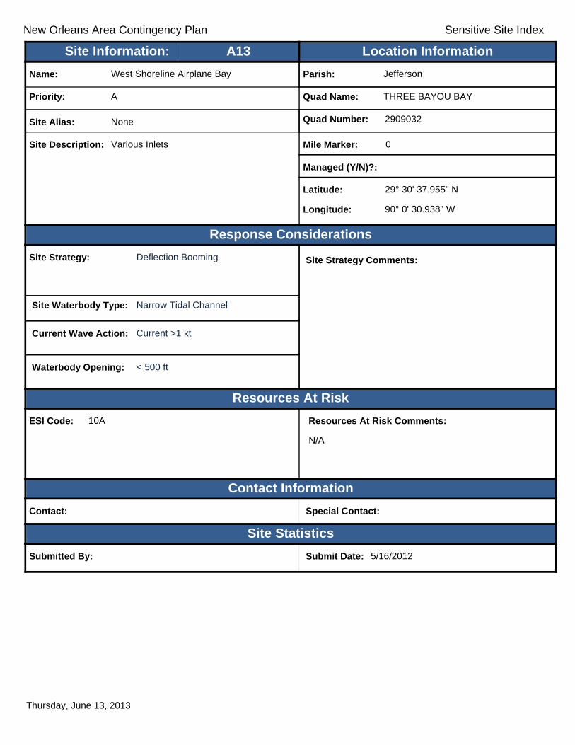
New Orleans Area Contingency Plan Sensitive Site Index
Response Considerations
Resources At Risk
Contact Information
Site Statistics
Resources At Risk Comments:
N/A
Contact: Special Contact:
Submitted By: Submit Date: 5/16/2012
Site Strategy: Deflection Booming Site Strategy Comments:
Site Waterbody Type: Narrow Tidal Channel
Current Wave Action: Current >1 kt
Waterbody Opening: < 500 ft
ESI Code: 10A
Priority: A
Name: West Shoreline Airplane Bay
Site Alias: None
Site Description: Various Inlets
Parish: Jefferson
Quad Name: THREE BAYOU BAY
Quad Number: 2909032
Mile Marker: 0
Managed (Y/N)?:
Latitude: 29° 30' 37.955" N
Longitude: 90° 0' 30.938" W
Site Information: Location InformationText416:A13
Thursday, June 13, 2013

New Orleans Area Contingency Plan Sensitive Site Index
Response Considerations
Resources At Risk
Contact Information
Site Statistics
Resources At Risk Comments:
N/A
Contact: Special Contact:
Submitted By: DEQ Submit Date: 5/16/2012
Site Strategy: Deflection Booming Site Strategy Comments:
Site Waterbody Type: Narrow Tidal Channel
Current Wave Action: Current >1 kt
Waterbody Opening: < 500 ft
ESI Code: 10A
Priority: A
Name: Unnamed Tidal Inlet
Site Alias: None
Site Description: Sensitive Area
Parish: Jefferson
Quad Name: THREE BAYOU BAY
Quad Number: 2909032
Mile Marker: 0
Managed (Y/N)?:
Latitude: 29° 30' 31.977" N
Longitude: 90° 1' 13.116" W
Site Information: Location InformationText416:A14
Thursday, June 13, 2013

New Orleans Area Contingency Plan Sensitive Site Index
Response Considerations
Resources At Risk
Contact Information
Site Statistics
Resources At Risk Comments:
N/A
Contact: Special Contact:
Submitted By: DEQ Submit Date: 5/16/2012
Site Strategy: Deflection Booming Site Strategy Comments:
Site Waterbody Type: Narrow Tidal Channel
Current Wave Action: Current >1 kt
Waterbody Opening: < 500 ft
ESI Code: 10A
Priority: A
Name: Bayou Cutler
Site Alias: None
Site Description: Sensitive Area
Parish: Jefferson
Quad Name: THREE BAYOU BAY
Quad Number: 2909032
Mile Marker: 0
Managed (Y/N)?:
Latitude: 29° 30' 23.079" N
Longitude: 90° 3' 15.667" W
Site Information: Location InformationText416:A15
Thursday, June 13, 2013

New Orleans Area Contingency Plan Sensitive Site Index
Response Considerations
Resources At Risk
Contact Information
Site Statistics
Resources At Risk Comments:
N/A
Contact: Special Contact:
Submitted By: Submit Date: 5/16/2012
Site Strategy: Deflection Booming Site Strategy Comments:
Site Waterbody Type: Narrow Tidal Channel
Current Wave Action: Current >1 kt
Waterbody Opening: < 500 ft
ESI Code: 10A
Priority: A
Name: Unnamed Tidal Inlet
Site Alias: Various Inlets
Site Description: Sensitive Area
Parish: Jefferson
Quad Name: THREE BAYOU BAY
Quad Number: 2909032
Mile Marker: 0
Managed (Y/N)?:
Latitude: 29° 30' 20.328" N
Longitude: 90° 1' 26.781" W
Site Information: Location InformationText416:A16
Thursday, June 13, 2013

New Orleans Area Contingency Plan Sensitive Site Index
Response Considerations
Resources At Risk
Contact Information
Site Statistics
Resources At Risk Comments:
Sensitive Habitat
Contact: Special Contact:
Submitted By: Jefferson Parish - Env Aff. Submit Date: 4/24/2012
Site Strategy: Deflection Booming Site Strategy Comments:
Site Waterbody Type: Entrance to Bays, etc
Current Wave Action: Breaking Waves <1.5 ft and Currents >1 kt
Waterbody Opening: < 500 ft
ESI Code: 10A
Priority: A
Name: Unnamed Secondary Inlet
Site Alias: None
Site Description: Tidal Inlet / Sensitive Habitat
Parish: Jefferson
Quad Name: THREE BAYOU BAY
Quad Number: 2909032
Mile Marker:
Managed (Y/N)?: No
Latitude: 29° 30' 7.807" N
Longitude: 90° 4' 25.013" W
Site Information: Location InformationText416:A17
Thursday, June 13, 2013

New Orleans Area Contingency Plan Sensitive Site Index
Response Considerations
Resources At Risk
Contact Information
Site Statistics
Resources At Risk Comments:
March Creation Project
Contact: Special Contact:
Submitted By: LA CPRA Submit Date: 6/28/2012
Site Strategy: Exclusion Booming Site Strategy Comments:
Site Waterbody Type: Narrow Tidal Channel
Current Wave Action: Currents <1 kt
Waterbody Opening: < 500 ft
ESI Code: 10A
Priority: C
Name: Dedicated Dredging Program - Bayou Dup
Site Alias: None
Site Description: Dedicated Dredging Program - Bayou Dupont
Parish: Jefferson
Quad Name: THREE BAYOU BAY
Quad Number: 2909032
Mile Marker:
Managed (Y/N)?:
Latitude: 29° 37' 23.855" N
Longitude: 90° 1' 28.885" W
Site Information: Location InformationText416:C1
Thursday, June 13, 2013

New Orleans Area Contingency Plan Sensitive Site Index
Response Considerations
Resources At Risk
Contact Information
Site Statistics
Resources At Risk Comments:
None
Contact: Special Contact:
Submitted By: LA CPRA/DNR Submit Date: 5/16/2012
Site Strategy: Diversion Booming to Collection Point
Site Strategy Comments:
Site Waterbody Type: Narrow Tidal Channel
Current Wave Action: Current >1 kt
Waterbody Opening: 500-1000 ft
ESI Code: 10A
Priority: C
Name: Barataria Waterway Shoreline Protection
Site Alias: None
Site Description: Restoration Project
Parish: Jefferson
Quad Name: THREE BAYOU BAY
Quad Number: 2909032
Mile Marker: 0
Managed (Y/N)?:
Latitude: 29° 36' 11.320" N
Longitude: 90° 4' 28.913" W
Site Information: Location InformationText416:C2
Thursday, June 13, 2013

New Orleans Area Contingency Plan Sensitive Site Index
Response Considerations
Resources At Risk
Contact Information
Site Statistics
Resources At Risk Comments:
Sensitive Habitat
Contact: Special Contact:
Submitted By: Jefferson Parish - Env Aff. Submit Date: 4/24/2012
Site Strategy: Deferred Action Site Strategy Comments:
Site Waterbody Type: Entrance to Bays, etc
Current Wave Action: Breaking Waves <1.5 ft and Currents <1 kt
Waterbody Opening: 1000-1500 ft
ESI Code: 10A
Priority: C
Name: Unnamed Inlets
Site Alias: None
Site Description: Tidal Inlet / Sensitive Habitat with various oil and gas access canals
Parish: Jefferson
Quad Name: THREE BAYOU BAY
Quad Number: 2909032
Mile Marker:
Managed (Y/N)?: No
Latitude: 29° 35' 37.188" N
Longitude: 90° 2' 5.669" W
Site Information: Location InformationText416:C3
Thursday, June 13, 2013

New Orleans Area Contingency Plan Sensitive Site Index
Response Considerations
Resources At Risk
Contact Information
Site Statistics
Resources At Risk Comments:
Sensitive Habitat
Contact: Special Contact:
Submitted By: Jefferson Parish - Env Aff. Submit Date: 4/24/2012
Site Strategy: Deflection Booming Site Strategy Comments:
Site Waterbody Type: Entrance to Bays, etc
Current Wave Action: Breaking Waves <1.5 ft and Currents >1 kt
Waterbody Opening: 500-1000 ft
ESI Code: 10A
Priority: C
Name: Barataria Waterway
Site Alias: Texaco Canals (Multiple)
Site Description: Tidal Inlet / Sensitive Habitat
Parish: Jefferson
Quad Name: THREE BAYOU BAY
Quad Number: 2909032
Mile Marker:
Managed (Y/N)?: No
Latitude: 29° 34' 8.787" N
Longitude: 90° 3' 13.094" W
Site Information: Location InformationText416:C4
Thursday, June 13, 2013

New Orleans Area Contingency Plan Sensitive Site Index
Response Considerations
Resources At Risk
Contact Information
Site Statistics
Resources At Risk Comments:
Sensitive Habitat
Contact: Special Contact:
Submitted By: Jefferson Parish - Env Aff. Submit Date: 4/24/2012
Site Strategy: Deflection Booming Site Strategy Comments:
Site Waterbody Type: Entrance to Bays, etc
Current Wave Action: Breaking Waves <1.5 ft and Currents >1 kt
Waterbody Opening: < 500 ft
ESI Code: 10A
Priority: C
Name: Three Bayou Bay
Site Alias: None
Site Description: Tidal Inlet / Sensitive Habitat
Parish: Jefferson
Quad Name: THREE BAYOU BAY
Quad Number: 2909032
Mile Marker:
Managed (Y/N)?: No
Latitude: 29° 33' 8.601" N
Longitude: 90° 4' 18.214" W
Site Information: Location InformationText416:C5
Thursday, June 13, 2013

New Orleans Area Contingency Plan Sensitive Site Index
Response Considerations
Resources At Risk
Contact Information
Site Statistics
Resources At Risk Comments:
Sensitive Habitat
Contact: Special Contact:
Submitted By: Jefferson Parish - Env Aff. Submit Date: 4/24/2012
Site Strategy: Deflection Booming Site Strategy Comments:
Site Waterbody Type: Narrow Tidal Channel
Current Wave Action: Current >1 kt
Waterbody Opening: < 500 ft
ESI Code: 10A
Priority: C
Name: Unnamed Tertiary Inlet
Site Alias: None
Site Description: Tidal Inlet / Sensitive Habitat
Parish: Jefferson
Quad Name: THREE BAYOU BAY
Quad Number: 2909032
Mile Marker:
Managed (Y/N)?: No
Latitude: 29° 32' 25.403" N
Longitude: 90° 2' 48.371" W
Site Information: Location InformationText416:C6
Thursday, June 13, 2013

New Orleans Area Contingency Plan Sensitive Site Index
Response Considerations
Resources At Risk
Contact Information
Site Statistics
Resources At Risk Comments:
Sensitive Habitat
Contact: Special Contact:
Submitted By: Jefferson Parish - Env Aff. Submit Date: 4/24/2012
Site Strategy: Deflection Booming Site Strategy Comments:
Site Waterbody Type: Narrow Tidal Channel
Current Wave Action: Current >1 kt
Waterbody Opening: < 500 ft
ESI Code: 10A
Priority: C
Name: Unnamed Tertiary Inlet
Site Alias: None
Site Description: Tidal Inlet / Sensitive Habitat
Parish: Jefferson
Quad Name: THREE BAYOU BAY
Quad Number: 2909032
Mile Marker:
Managed (Y/N)?: No
Latitude: 29° 32' 21.157" N
Longitude: 90° 2' 53.615" W
Site Information: Location InformationText416:C7
Thursday, June 13, 2013

New Orleans Area Contingency Plan Sensitive Site Index
Response Considerations
Resources At Risk
Contact Information
Site Statistics
Resources At Risk Comments:
Sensitive Habitat
Contact: Special Contact:
Submitted By: Jefferson Parish - Env Aff. Submit Date: 4/24/2012
Site Strategy: Deflection Booming Site Strategy Comments:
Site Waterbody Type: Entrance to Bays, etc
Current Wave Action: Breaking Waves <1.5 ft and Currents >1 kt
Waterbody Opening: < 500 ft
ESI Code: 10A
Priority: C
Name: Three Bayou Bay
Site Alias: None
Site Description: Tidal Inlet / Sensitive Habitat
Parish: Jefferson
Quad Name: THREE BAYOU BAY
Quad Number: 2909032
Mile Marker:
Managed (Y/N)?: No
Latitude: 29° 32' 8.210" N
Longitude: 90° 3' 58.941" W
Site Information: Location InformationText416:C8
Thursday, June 13, 2013

New Orleans Area Contingency Plan Sensitive Site Index
Response Considerations
Resources At Risk
Contact Information
Site Statistics
Resources At Risk Comments:
Sensitive Habitat
Contact: Special Contact:
Submitted By: Jefferson Parish - Env Aff. Submit Date: 4/24/2012
Site Strategy: Deflection Booming Site Strategy Comments:
Site Waterbody Type: Narrow Tidal Channel
Current Wave Action: Current >1 kt
Waterbody Opening: < 500 ft
ESI Code: 10A
Priority: C
Name: Southeast Turtle Bay
Site Alias: None
Site Description: Tidal Inlet / Sensitive Habitat
Parish: Jefferson
Quad Name: THREE BAYOU BAY
Quad Number: 2909032
Mile Marker:
Managed (Y/N)?: No
Latitude: 29° 30' 15.548" N
Longitude: 90° 5' 55.162" W
Site Information: Location InformationText416:C9
Thursday, June 13, 2013

New Orleans Area Contingency Plan
Geographic Response Plan- Jefferson Parish
This page is intentionally left blank

!
!
!
!!
!
!
! !
!
!
!
!
!
!
!
!
!
!
!
! !
GrandBayou
Jimmi
eCa
nal
Jimmi
eCa
nal
Ji mm i
eC a
nal
Deer
Rang
e Cana
l
RoundLake
LakeFlue
LakeJudgePerezLake
Laurier
WilkinsonBay
ST39
ST23ST23
BellevueBellevue
HarlemHarlem
THRE
E BAY
OU B
AYLA
KE LA
URIE
R
LAKE LAURIERWILKINSON BAY
LAKE
LAUR
IER
POIN
TEAL
AHAC
HE
LAKE LAURIERPHOENIX
C8
A10
A11
C7 C6C5A9
C3C4
A8
C2A7
A6B3A5
A4A3
C1
A2B2
A1 B1
JeffersonParish
PlaqueminesParish
89°52'30"W
89°52'30"W
90°0'0"W
90°0'0"W
29°37
'30"N
29°37
'30"N
29°30
'0"N
29°30
'0"N
±0 1 2 30.5
Miles
LAKE LAURIER Quad
MetairieMetairieLafayetteLafayette
Baton RougeBaton Rouge
New OrleansNew Orleans
§̈¦12§̈¦55
§̈¦310
§̈¦110
§̈¦10
LOUISIANALOUISIANA
Gulf of Mexico
Legend! GRP Sites
Quad BoundaryParish Boundaries
0 1 2 30.5Kilometers
Locator MapLocator Map

New Orleans Area Contingency Plan Sensitive Site Index
Response Considerations
Resources At Risk
Contact Information
Site Statistics
Resources At Risk Comments:
None
Contact: Special Contact:
Submitted By: Robert Spears Submit Date: 4/27/2012
Site Strategy: Notification to Site Manager Site Strategy Comments:
Site Waterbody Type: Rivers or Large Streams
Current Wave Action: Currents >2 kts
Waterbody Opening: Not Applicable
ESI Code: 10C
Priority: A
Name: International Matex Terminal Site
Site Alias: IMT Coal Terminal
Site Description: Industrial Water Intake
Parish: Plaquemines
Quad Name: LAKE LAURIER
Quad Number: 2908925
Mile Marker: 57
Managed (Y/N)?:
Latitude: 29° 37' 24.057" N
Longitude: 89° 55' 4.862" W
Site Information: Location InformationText416:A1
Thursday, June 13, 2013

New Orleans Area Contingency Plan Sensitive Site Index
Response Considerations
Resources At Risk
Contact Information
Site Statistics
Resources At Risk Comments:
None
Contact: Special Contact:
Submitted By: Robert Spears Submit Date: 4/27/2012
Site Strategy: Notification to Site Manager Site Strategy Comments:
Site Waterbody Type: Rivers or Large Streams
Current Wave Action: Currents >2 kts
Waterbody Opening: Not Applicable
ESI Code:
Priority: A
Name: United Bulk Terminal
Site Alias: None
Site Description: Industrial Water Intake
Parish: Plaquemines
Quad Name: LAKE LAURIER
Quad Number: 2908925
Mile Marker: 55.5
Managed (Y/N)?:
Latitude: 29° 37' 2.766" N
Longitude: 89° 53' 27.034" W
Site Information: Location InformationText416:A2
Thursday, June 13, 2013

New Orleans Area Contingency Plan Sensitive Site Index
Response Considerations
Resources At Risk
Contact Information
Site Statistics
Resources At Risk Comments:
Sensitive Habitat
Contact: Special Contact:
Submitted By: Jefferson Parish - Env Aff. Submit Date: 4/24/2012
Site Strategy: Multi-Layer Deflection Booming Site Strategy Comments:
Site Waterbody Type: Small Streams
Current Wave Action: Currents >2 kts
Waterbody Opening: 500-1000 ft
ESI Code: 10A
Priority: A
Name: Bayou Dupont Inlet
Site Alias: None
Site Description: Tidal Inlet / Sensitive Habitat
Parish: Jefferson
Quad Name: LAKE LAURIER
Quad Number: 2908925
Mile Marker:
Managed (Y/N)?: No
Latitude: 29° 34' 9.500" N
Longitude: 89° 59' 1.383" W
Site Information: Location InformationText416:A3
Thursday, June 13, 2013

New Orleans Area Contingency Plan Sensitive Site Index
Response Considerations
Resources At Risk
Contact Information
Site Statistics
Resources At Risk Comments:
Sensitive Habitat
Contact: Special Contact:
Submitted By: Jefferson Parish - Env Aff. Submit Date: 4/24/2012
Site Strategy: Deflection Booming Site Strategy Comments:
Site Waterbody Type: Narrow Tidal Channel
Current Wave Action: Current >1 kt
Waterbody Opening: 500-1000 ft
ESI Code: 10A
Priority: A
Name: Unnamed Tidal Inlet
Site Alias: None
Site Description: Tidal Inlet / Sensitive Habitat
Parish: Jefferson
Quad Name: LAKE LAURIER
Quad Number: 2908925
Mile Marker:
Managed (Y/N)?: No
Latitude: 29° 34' 2.490" N
Longitude: 89° 59' 32.214" W
Site Information: Location InformationText416:A4
Thursday, June 13, 2013
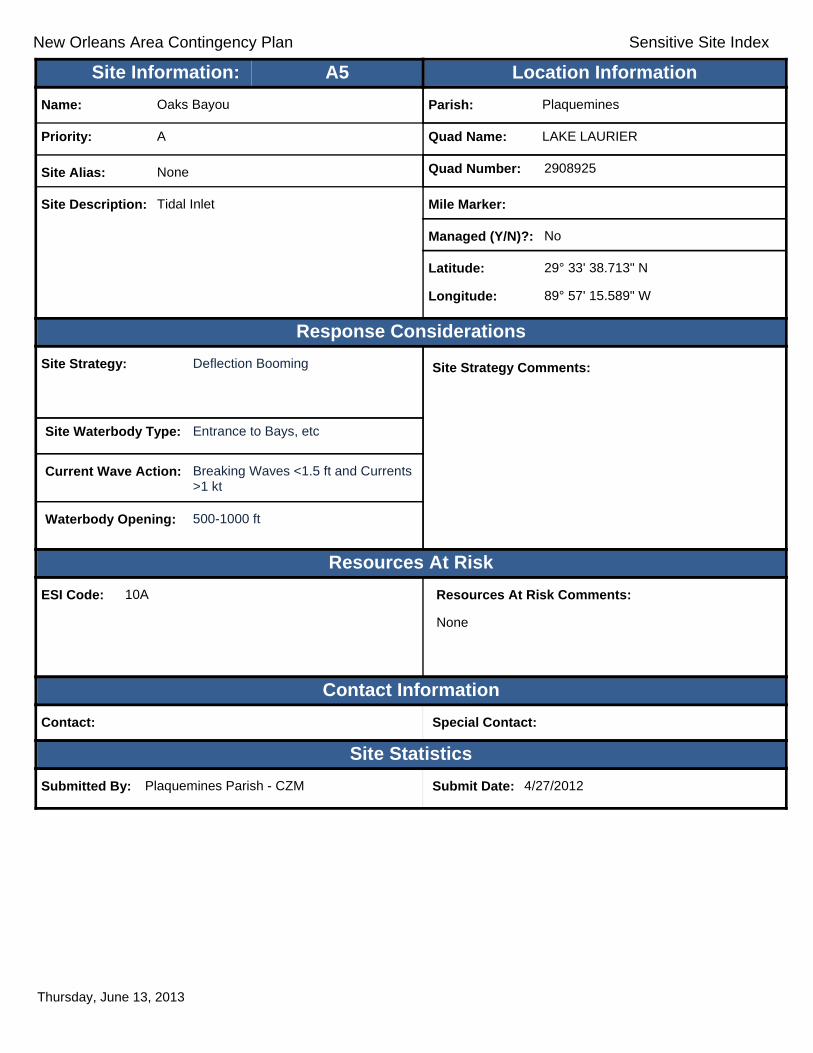
New Orleans Area Contingency Plan Sensitive Site Index
Response Considerations
Resources At Risk
Contact Information
Site Statistics
Resources At Risk Comments:
None
Contact: Special Contact:
Submitted By: Plaquemines Parish - CZM Submit Date: 4/27/2012
Site Strategy: Deflection Booming Site Strategy Comments:
Site Waterbody Type: Entrance to Bays, etc
Current Wave Action: Breaking Waves <1.5 ft and Currents >1 kt
Waterbody Opening: 500-1000 ft
ESI Code: 10A
Priority: A
Name: Oaks Bayou
Site Alias: None
Site Description: Tidal Inlet
Parish: Plaquemines
Quad Name: LAKE LAURIER
Quad Number: 2908925
Mile Marker:
Managed (Y/N)?: No
Latitude: 29° 33' 38.713" N
Longitude: 89° 57' 15.589" W
Site Information: Location InformationText416:A5
Thursday, June 13, 2013

New Orleans Area Contingency Plan Sensitive Site Index
Response Considerations
Resources At Risk
Contact Information
Site Statistics
Resources At Risk Comments:
None
Contact: Special Contact:
Submitted By: Plaquemines Parish - CZM Submit Date: 4/27/2012
Site Strategy: Deferred Action Site Strategy Comments:
Site Waterbody Type: Entrance to Bays, etc
Current Wave Action: Breaking Waves <1.5 ft and Currents >1 kt
Waterbody Opening: 1500-2000 ft
ESI Code: 10A
Priority: A
Name: Bayou Frances
Site Alias: None
Site Description: Tidal Inlet
Parish: Plaquemines
Quad Name: LAKE LAURIER
Quad Number: 2908925
Mile Marker:
Managed (Y/N)?: No
Latitude: 29° 33' 20.422" N
Longitude: 89° 55' 22.985" W
Site Information: Location InformationText416:A6
Thursday, June 13, 2013

New Orleans Area Contingency Plan Sensitive Site Index
Response Considerations
Resources At Risk
Contact Information
Site Statistics
Resources At Risk Comments:
Sensitive Habitat
Contact: Special Contact:
Submitted By: Jefferson Parish - Env Aff. Submit Date: 4/24/2012
Site Strategy: Deflection Booming Site Strategy Comments:
Site Waterbody Type: Narrow Tidal Channel
Current Wave Action: Current >1 kt
Waterbody Opening: 500-1000 ft
ESI Code: 10A
Priority: A
Name: Unnamed Tidal Inlet
Site Alias: None
Site Description: Tidal Inlet / Sensitive Habitat
Parish: Jefferson
Quad Name: LAKE LAURIER
Quad Number: 2908925
Mile Marker:
Managed (Y/N)?: No
Latitude: 29° 32' 51.210" N
Longitude: 89° 59' 51.338" W
Site Information: Location InformationText416:A7
Thursday, June 13, 2013

New Orleans Area Contingency Plan Sensitive Site Index
Response Considerations
Resources At Risk
Contact Information
Site Statistics
Resources At Risk Comments:
Contact: Special Contact:
Submitted By: Plaquemines Parish - CZM / P-2204:LDEQ Submit Date: 20120427
Site Strategy: Deferred Action Site Strategy Comments:
Site Waterbody Type: Entrance to Bays, etc
Current Wave Action: Breaking Waves >1.5 ft
Waterbody Opening: 500-1000 ft
ESI Code:
Priority: A
Name: Unnamed Tidal Inlet
Site Alias: None
Site Description:
Parish: Plaquemines
Quad Name: LAKE LAURIER
Quad Number: 2908925
Mile Marker:
Managed (Y/N)?:
Latitude: 29° 32' 15.000" N
Longitude: 89° 54' 12.000" W
Site Information: Location InformationText416:A8
Thursday, June 13, 2013

New Orleans Area Contingency Plan Sensitive Site Index
Response Considerations
Resources At Risk
Contact Information
Site Statistics
Resources At Risk Comments:
Sensitive Habitat
Contact: Special Contact:
Submitted By: Jefferson Parish - Env Aff. Submit Date: 4/24/2012
Site Strategy: Deflection Booming Site Strategy Comments:
Site Waterbody Type: Narrow Tidal Channel
Current Wave Action: Current >1 kt
Waterbody Opening: < 500 ft
ESI Code: 10A
Priority: A
Name: Unnamed Tidal Inlet
Site Alias: None
Site Description: Tidal Inlet / Sensitive Habitat
Parish: Jefferson
Quad Name: LAKE LAURIER
Quad Number: 2908925
Mile Marker:
Managed (Y/N)?: No
Latitude: 29° 31' 45.814" N
Longitude: 89° 59' 44.250" W
Site Information: Location InformationText416:A9
Thursday, June 13, 2013

New Orleans Area Contingency Plan Sensitive Site Index
Response Considerations
Resources At Risk
Contact Information
Site Statistics
Resources At Risk Comments:
Sensitive Habitat
Contact: Special Contact:
Submitted By: Jefferson Parish - Env Aff. Submit Date: 4/24/2012
Site Strategy: Deferred Action Site Strategy Comments:
Site Waterbody Type: Entrance to Bays, etc
Current Wave Action: Breaking Waves >1.5 ft
Waterbody Opening: 1000-1500 ft
ESI Code: 10A
Priority: A
Name: Unnamed Tidal Inlet
Site Alias: None
Site Description: Tidal Inlet / Sensitive Habitat
Parish: Jefferson
Quad Name: LAKE LAURIER
Quad Number: 2908925
Mile Marker:
Managed (Y/N)?: No
Latitude: 29° 31' 9.199" N
Longitude: 89° 59' 22.213" W
Site Information: Location InformationText416:A10
Thursday, June 13, 2013

New Orleans Area Contingency Plan Sensitive Site Index
Response Considerations
Resources At Risk
Contact Information
Site Statistics
Resources At Risk Comments:
Sensitive Habitat
Contact: Special Contact:
Submitted By: Jefferson Parish - Env Aff. Submit Date: 4/24/2012
Site Strategy: Deflection Booming Site Strategy Comments:
Site Waterbody Type: Entrance to Bays, etc
Current Wave Action: Breaking Waves <1.5 ft and Currents >1 kt
Waterbody Opening: 500-1000 ft
ESI Code: 10A
Priority: A
Name: Unnamed Tidal Inlet
Site Alias: None
Site Description: Tidal Inlet / Sensitive Habitat
Parish: Jefferson
Quad Name: LAKE LAURIER
Quad Number: 2908925
Mile Marker:
Managed (Y/N)?: No
Latitude: 29° 30' 58.205" N
Longitude: 89° 59' 6.537" W
Site Information: Location InformationText416:A11
Thursday, June 13, 2013

New Orleans Area Contingency Plan Sensitive Site Index
Response Considerations
Resources At Risk
Contact Information
Site Statistics
Resources At Risk Comments:
None
Contact: Special Contact:
Submitted By: Robert Spears Submit Date: 4/27/2012
Site Strategy: Notification to Site Manager Site Strategy Comments:
Site Waterbody Type: Narrow Channel
Current Wave Action: Currents <1 kt
Waterbody Opening: Not Applicable
ESI Code: 10A
Priority: B
Name: Bellevue Pump Station
Site Alias: None
Site Description: Drainage Pump Station
Parish: Plaquemines
Quad Name: LAKE LAURIER
Quad Number: 2908925
Mile Marker: 55
Managed (Y/N)?:
Latitude: 29° 37' 23.570" N
Longitude: 89° 52' 40.037" W
Site Information: Location InformationText416:B1
Thursday, June 13, 2013
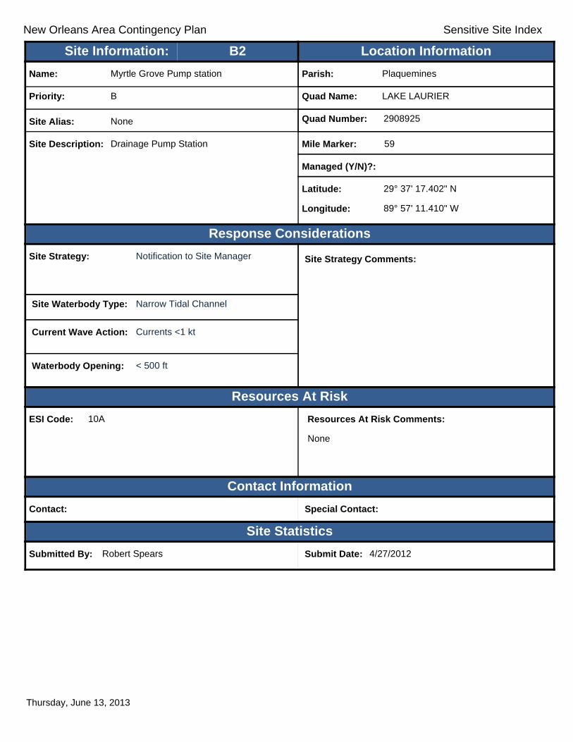
New Orleans Area Contingency Plan Sensitive Site Index
Response Considerations
Resources At Risk
Contact Information
Site Statistics
Resources At Risk Comments:
None
Contact: Special Contact:
Submitted By: Robert Spears Submit Date: 4/27/2012
Site Strategy: Notification to Site Manager Site Strategy Comments:
Site Waterbody Type: Narrow Tidal Channel
Current Wave Action: Currents <1 kt
Waterbody Opening: < 500 ft
ESI Code: 10A
Priority: B
Name: Myrtle Grove Pump station
Site Alias: None
Site Description: Drainage Pump Station
Parish: Plaquemines
Quad Name: LAKE LAURIER
Quad Number: 2908925
Mile Marker: 59
Managed (Y/N)?:
Latitude: 29° 37' 17.402" N
Longitude: 89° 57' 11.410" W
Site Information: Location InformationText416:B2
Thursday, June 13, 2013
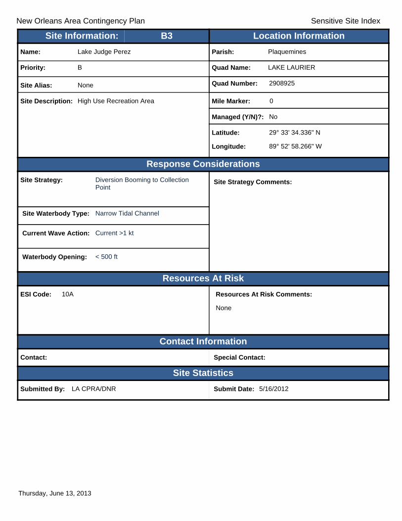
New Orleans Area Contingency Plan Sensitive Site Index
Response Considerations
Resources At Risk
Contact Information
Site Statistics
Resources At Risk Comments:
None
Contact: Special Contact:
Submitted By: LA CPRA/DNR Submit Date: 5/16/2012
Site Strategy: Diversion Booming to Collection Point
Site Strategy Comments:
Site Waterbody Type: Narrow Tidal Channel
Current Wave Action: Current >1 kt
Waterbody Opening: < 500 ft
ESI Code: 10A
Priority: B
Name: Lake Judge Perez
Site Alias: None
Site Description: High Use Recreation Area
Parish: Plaquemines
Quad Name: LAKE LAURIER
Quad Number: 2908925
Mile Marker: 0
Managed (Y/N)?: No
Latitude: 29° 33' 34.336" N
Longitude: 89° 52' 58.266" W
Site Information: Location InformationText416:B3
Thursday, June 13, 2013
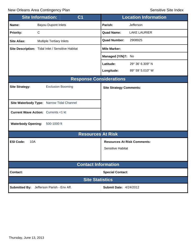
New Orleans Area Contingency Plan Sensitive Site Index
Response Considerations
Resources At Risk
Contact Information
Site Statistics
Resources At Risk Comments:
Sensitive Habitat
Contact: Special Contact:
Submitted By: Jefferson Parish - Env Aff. Submit Date: 4/24/2012
Site Strategy: Exclusion Booming Site Strategy Comments:
Site Waterbody Type: Narrow Tidal Channel
Current Wave Action: Currents <1 kt
Waterbody Opening: 500-1000 ft
ESI Code: 10A
Priority: C
Name: Bayou Dupont Inlets
Site Alias: Multiple Tertiary Inlets
Site Description: Tidal Inlet / Sensitive Habitat
Parish: Jefferson
Quad Name: LAKE LAURIER
Quad Number: 2908925
Mile Marker:
Managed (Y/N)?: No
Latitude: 29° 36' 6.309" N
Longitude: 89° 59' 5.010" W
Site Information: Location InformationText416:C1
Thursday, June 13, 2013

New Orleans Area Contingency Plan Sensitive Site Index
Response Considerations
Resources At Risk
Contact Information
Site Statistics
Resources At Risk Comments:
Sensitive Habitat
Contact: Special Contact:
Submitted By: LDEQ Submit Date: 3/30/2012
Site Strategy: Deferred Action Site Strategy Comments:
Site Waterbody Type: Narrow Tidal Channel
Current Wave Action: Current >1 kt
Waterbody Opening: 1000-1500 ft
ESI Code: 10A
Priority: C
Name: Unnamed Tidal Inlets
Site Alias: None
Site Description: Various Secondary Inlets
Parish: Plaquemines
Quad Name: LAKE LAURIER
Quad Number: 2908925
Mile Marker:
Managed (Y/N)?:
Latitude: 29° 32' 42.000" N
Longitude: 89° 53' 32.000" W
Site Information: Location InformationText416:C2
Thursday, June 13, 2013
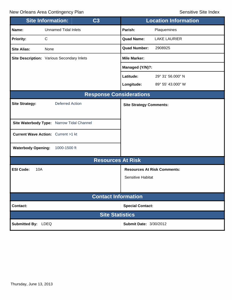
New Orleans Area Contingency Plan Sensitive Site Index
Response Considerations
Resources At Risk
Contact Information
Site Statistics
Resources At Risk Comments:
Sensitive Habitat
Contact: Special Contact:
Submitted By: LDEQ Submit Date: 3/30/2012
Site Strategy: Deferred Action Site Strategy Comments:
Site Waterbody Type: Narrow Tidal Channel
Current Wave Action: Current >1 kt
Waterbody Opening: 1000-1500 ft
ESI Code: 10A
Priority: C
Name: Unnamed Tidal Inlets
Site Alias: None
Site Description: Various Secondary Inlets
Parish: Plaquemines
Quad Name: LAKE LAURIER
Quad Number: 2908925
Mile Marker:
Managed (Y/N)?:
Latitude: 29° 31' 56.000" N
Longitude: 89° 55' 43.000" W
Site Information: Location InformationText416:C3
Thursday, June 13, 2013

New Orleans Area Contingency Plan Sensitive Site Index
Response Considerations
Resources At Risk
Contact Information
Site Statistics
Resources At Risk Comments:
Sensitive Habitat
Contact: Special Contact:
Submitted By: LDEQ Submit Date: 3/30/2012
Site Strategy: Deferred Action Site Strategy Comments:
Site Waterbody Type: Narrow Tidal Channel
Current Wave Action: Current >1 kt
Waterbody Opening: 1000-1500 ft
ESI Code: 10A
Priority: C
Name: Unnamed Tidal Inlets
Site Alias: None
Site Description: Secondary Inlets
Parish: Plaquemines
Quad Name: LAKE LAURIER
Quad Number: 2908925
Mile Marker:
Managed (Y/N)?:
Latitude: 29° 31' 55.000" N
Longitude: 89° 53' 23.000" W
Site Information: Location InformationText416:C4
Thursday, June 13, 2013
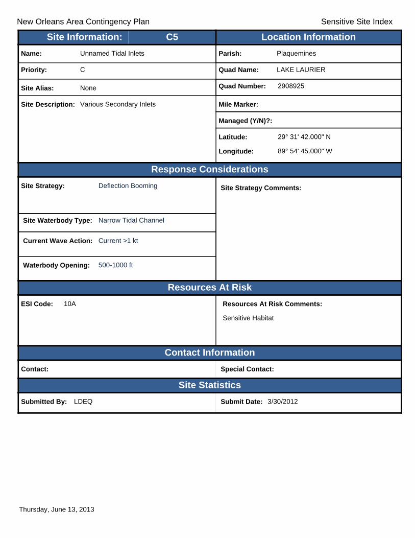
New Orleans Area Contingency Plan Sensitive Site Index
Response Considerations
Resources At Risk
Contact Information
Site Statistics
Resources At Risk Comments:
Sensitive Habitat
Contact: Special Contact:
Submitted By: LDEQ Submit Date: 3/30/2012
Site Strategy: Deflection Booming Site Strategy Comments:
Site Waterbody Type: Narrow Tidal Channel
Current Wave Action: Current >1 kt
Waterbody Opening: 500-1000 ft
ESI Code: 10A
Priority: C
Name: Unnamed Tidal Inlets
Site Alias: None
Site Description: Various Secondary Inlets
Parish: Plaquemines
Quad Name: LAKE LAURIER
Quad Number: 2908925
Mile Marker:
Managed (Y/N)?:
Latitude: 29° 31' 42.000" N
Longitude: 89° 54' 45.000" W
Site Information: Location InformationText416:C5
Thursday, June 13, 2013

New Orleans Area Contingency Plan Sensitive Site Index
Response Considerations
Resources At Risk
Contact Information
Site Statistics
Resources At Risk Comments:
N/A
Contact: Special Contact:
Submitted By: DEQ Submit Date: 5/16/2012
Site Strategy: Deflection Booming Site Strategy Comments:
Site Waterbody Type: Narrow Tidal Channel
Current Wave Action: Current >1 kt
Waterbody Opening: 500-1000 ft
ESI Code: 10A
Priority: C
Name: Unnamed Tidal Inlet
Site Alias: None
Site Description: Sensitive Area
Parish: Jefferson
Quad Name: LAKE LAURIER
Quad Number: 2908925
Mile Marker: 0
Managed (Y/N)?:
Latitude: 29° 31' 27.775" N
Longitude: 89° 58' 50.273" W
Site Information: Location InformationText416:C6
Thursday, June 13, 2013

New Orleans Area Contingency Plan Sensitive Site Index
Response Considerations
Resources At Risk
Contact Information
Site Statistics
Resources At Risk Comments:
Sensitive Habitat
Contact: Special Contact:
Submitted By: LDEQ Submit Date: 3/30/2012
Site Strategy: Deflection Booming Site Strategy Comments:
Site Waterbody Type: Narrow Tidal Channel
Current Wave Action: Current >1 kt
Waterbody Opening: < 500 ft
ESI Code: 10A
Priority: C
Name: Unnamed Tidal Inlet
Site Alias: None
Site Description: Secondary Tidal inlet
Parish: Jefferson
Quad Name: LAKE LAURIER
Quad Number: 2908925
Mile Marker:
Managed (Y/N)?:
Latitude: 29° 31' 25.000" N
Longitude: 89° 58' 55.000" W
Site Information: Location InformationText416:C7
Thursday, June 13, 2013
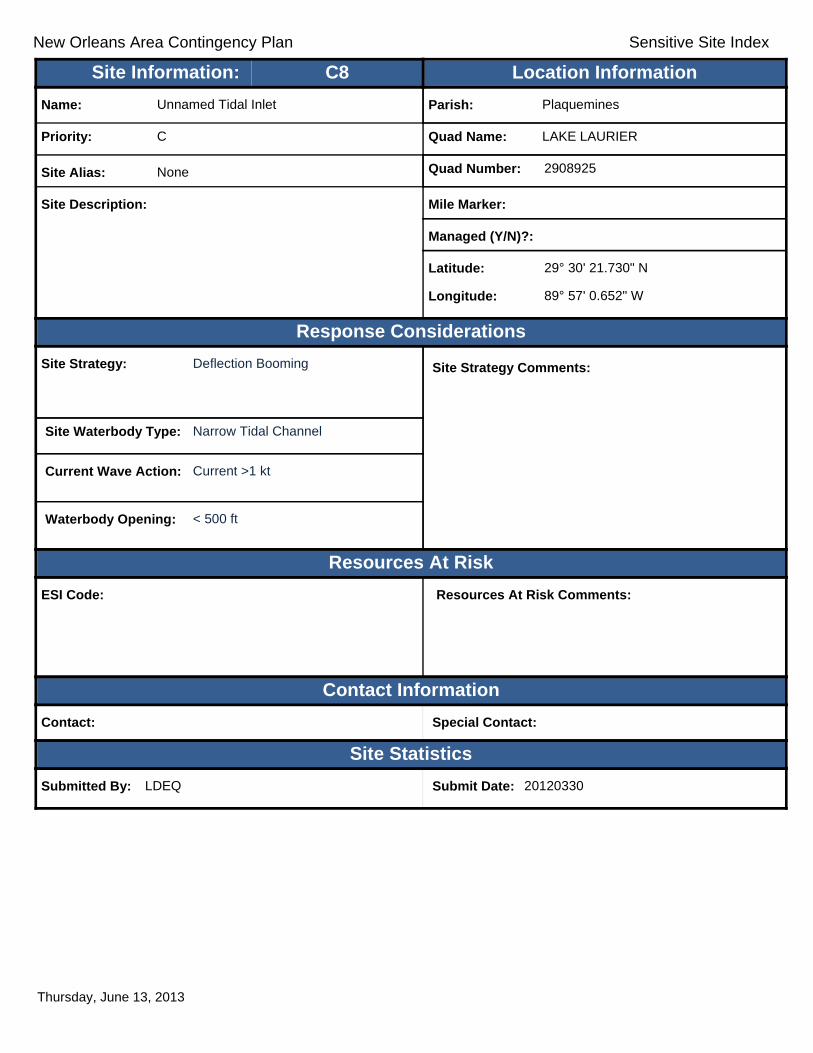
New Orleans Area Contingency Plan Sensitive Site Index
Response Considerations
Resources At Risk
Contact Information
Site Statistics
Resources At Risk Comments:
Contact: Special Contact:
Submitted By: LDEQ Submit Date: 20120330
Site Strategy: Deflection Booming Site Strategy Comments:
Site Waterbody Type: Narrow Tidal Channel
Current Wave Action: Current >1 kt
Waterbody Opening: < 500 ft
ESI Code:
Priority: C
Name: Unnamed Tidal Inlet
Site Alias: None
Site Description:
Parish: Plaquemines
Quad Name: LAKE LAURIER
Quad Number: 2908925
Mile Marker:
Managed (Y/N)?:
Latitude: 29° 30' 21.730" N
Longitude: 89° 57' 0.652" W
Site Information: Location InformationText416:C8
Thursday, June 13, 2013

New Orleans Area Contingency Plan
Geographic Response Plan- Jefferson Parish
This page is intentionally left blank
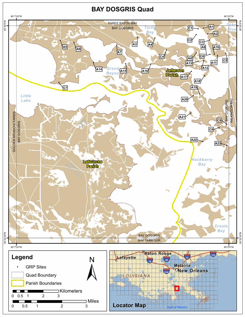
!
!
!
!
!
!!
!
!
!
!! !
!!
!
!!!
!!
!
!
!
!
!!
!
!
! !
!
Coffee
Bayou
East Fork
Bayou L Ours
LittleLake
TurtleBay
LakeFlue
CreoleBay
HackberryBay
GrandBayou
GOLD
EN M
EADO
W FA
RMS
BAY
DOSG
RIS
BAY DOSGRISBAY TAMBOUR
BAY
DOSG
RIS
WILK
INSO
N BA
Y
BAY DOSGRISTHREE BAYOU BAY
A23A22
C9
C8A21
A20
A19C7A18
A17
A14 A15 A16
A13A12
A8 C6
A9
A11
A10
C5
A7C4
A5 A6A3 A4 C3C2
C1 A1A2
JeffersonParish
LafourcheParish
90°0'0"W
90°0'0"W
90°7'30"W
90°7'30"W
29°30
'0"N
29°30
'0"N
29°22
'30"N
29°22
'30"N
±0 1 2 30.5
Miles
BAY DOSGRIS Quad
MetairieMetairieLafayetteLafayette
Baton RougeBaton Rouge
New OrleansNew Orleans
§̈¦12§̈¦55
§̈¦310
§̈¦110
§̈¦10
LOUISIANALOUISIANA
Gulf of Mexico
Legend! GRP Sites
Quad BoundaryParish Boundaries
0 1 2 30.5Kilometers
Locator MapLocator Map

New Orleans Area Contingency Plan Sensitive Site Index
Response Considerations
Resources At Risk
Contact Information
Site Statistics
Resources At Risk Comments:
Sensitive Habitat
Contact: Special Contact:
Submitted By: Submit Date: 4/24/2012
Site Strategy: Deflection Booming Site Strategy Comments:
Site Waterbody Type: Narrow Tidal Channel
Current Wave Action: Current >1 kt
Waterbody Opening: < 500 ft
ESI Code: 10A
Priority: A
Name: Barataria Waterway
Site Alias: None
Site Description: Tidal Inlet / Sensitive Habitat
Parish: Jefferson
Quad Name: BAY DOSGRIS
Quad Number: 2909040
Mile Marker:
Managed (Y/N)?: No
Latitude: 29° 29' 54.309" N
Longitude: 90° 0' 54.033" W
Site Information: Location InformationText416:A1
Thursday, June 13, 2013
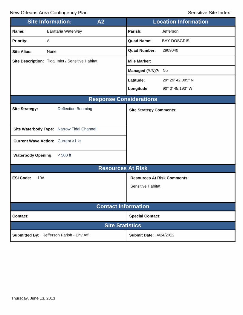
New Orleans Area Contingency Plan Sensitive Site Index
Response Considerations
Resources At Risk
Contact Information
Site Statistics
Resources At Risk Comments:
Sensitive Habitat
Contact: Special Contact:
Submitted By: Jefferson Parish - Env Aff. Submit Date: 4/24/2012
Site Strategy: Deflection Booming Site Strategy Comments:
Site Waterbody Type: Narrow Tidal Channel
Current Wave Action: Current >1 kt
Waterbody Opening: < 500 ft
ESI Code: 10A
Priority: A
Name: Barataria Waterway
Site Alias: None
Site Description: Tidal Inlet / Sensitive Habitat
Parish: Jefferson
Quad Name: BAY DOSGRIS
Quad Number: 2909040
Mile Marker:
Managed (Y/N)?: No
Latitude: 29° 29' 42.385" N
Longitude: 90° 0' 45.193" W
Site Information: Location InformationText416:A2
Thursday, June 13, 2013

New Orleans Area Contingency Plan Sensitive Site Index
Response Considerations
Resources At Risk
Contact Information
Site Statistics
Resources At Risk Comments:
Sensitive Habitat
Contact: Special Contact:
Submitted By: Jefferson Parish - Env Aff. Submit Date: 4/24/2012
Site Strategy: Deflection Booming Site Strategy Comments:
Site Waterbody Type: Entrance to Bays, etc
Current Wave Action: Breaking Waves <1.5 ft and Currents >1 kt
Waterbody Opening: 500-1000 ft
ESI Code: 10A
Priority: A
Name: Bayou St. Dennis
Site Alias: None
Site Description: Tidal Inlet / Sensitive Habitat
Parish: Jefferson
Quad Name: BAY DOSGRIS
Quad Number: 2909040
Mile Marker:
Managed (Y/N)?: No
Latitude: 29° 29' 35.806" N
Longitude: 90° 3' 13.626" W
Site Information: Location InformationText416:A3
Thursday, June 13, 2013

New Orleans Area Contingency Plan Sensitive Site Index
Response Considerations
Resources At Risk
Contact Information
Site Statistics
Resources At Risk Comments:
Sensitive Habitat
Contact: Special Contact:
Submitted By: Submit Date: 4/24/2012
Site Strategy: Deferred Action Site Strategy Comments:
Site Waterbody Type: Entrance to Bays, etc
Current Wave Action: Breaking Waves <1.5 ft
Waterbody Opening: 1500-2000 ft
ESI Code: 10A
Priority: A
Name: Bayou St. Denis
Site Alias: None
Site Description: Tidal Inlet / Sensitive Habitat
Parish: Jefferson
Quad Name: BAY DOSGRIS
Quad Number: 2909040
Mile Marker:
Managed (Y/N)?: No
Latitude: 29° 29' 34.161" N
Longitude: 90° 2' 36.620" W
Site Information: Location InformationText416:A4
Friday, June 14, 2013

New Orleans Area Contingency Plan Sensitive Site Index
Response Considerations
Resources At Risk
Contact Information
Site Statistics
Resources At Risk Comments:
Sensitive Habitat
Contact: Special Contact:
Submitted By: Jefferson Parish - Env Aff. Submit Date: 4/24/2012
Site Strategy: Deflection Booming Site Strategy Comments:
Site Waterbody Type: Narrow Tidal Channel
Current Wave Action: Current >1 kt
Waterbody Opening: < 500 ft
ESI Code: 10A
Priority: A
Name: Unnamed Secondary Inlets
Site Alias: None
Site Description: Secondary Tidal Inlet / Sensitive Habitat
Parish: Jefferson
Quad Name: BAY DOSGRIS
Quad Number: 2909040
Mile Marker:
Managed (Y/N)?: No
Latitude: 29° 29' 29.227" N
Longitude: 90° 5' 57.066" W
Site Information: Location InformationText416:A5
Thursday, June 13, 2013

New Orleans Area Contingency Plan Sensitive Site Index
Response Considerations
Resources At Risk
Contact Information
Site Statistics
Resources At Risk Comments:
Sensitive Habitat
Contact: Special Contact:
Submitted By: Jefferson Parish - Env Aff. Submit Date: 4/24/2012
Site Strategy: Deflection Booming Site Strategy Comments:
Site Waterbody Type: Narrow Tidal Channel
Current Wave Action: Current >1 kt
Waterbody Opening: < 500 ft
ESI Code: 10A
Priority: A
Name: Bay Dosgris
Site Alias: None
Site Description: Tidal Inlet / Sensitive Habitat
Parish: Jefferson
Quad Name: BAY DOSGRIS
Quad Number: 2909040
Mile Marker:
Managed (Y/N)?: No
Latitude: 29° 29' 24.704" N
Longitude: 90° 5' 28.284" W
Site Information: Location InformationText416:A6
Thursday, June 13, 2013

New Orleans Area Contingency Plan Sensitive Site Index
Response Considerations
Resources At Risk
Contact Information
Site Statistics
Resources At Risk Comments:
Sensitive Habitat
Contact: Special Contact:
Submitted By: Jefferson Parish - Env Aff. Submit Date: 4/24/2012
Site Strategy: Deflection Booming Site Strategy Comments:
Site Waterbody Type: Entrance to Bays, etc
Current Wave Action: Breaking Waves <1.5 ft and Currents >1 kt
Waterbody Opening: 500-1000 ft
ESI Code: 10A
Priority: A
Name: Bayou St. Denis
Site Alias: None
Site Description: Tidal Inlet / Sensitive Habitat
Parish: Jefferson
Quad Name: BAY DOSGRIS
Quad Number: 2909040
Mile Marker:
Managed (Y/N)?: No
Latitude: 29° 29' 18.742" N
Longitude: 90° 3' 57.621" W
Site Information: Location InformationText416:A7
Thursday, June 13, 2013

New Orleans Area Contingency Plan Sensitive Site Index
Response Considerations
Resources At Risk
Contact Information
Site Statistics
Resources At Risk Comments:
Nesting Terns
Contact: LDWF Special Contact: LDWF
Submitted By: LDWF Submit Date: 5/16/2012
Site Strategy: Deflection Booming Site Strategy Comments:
Site Waterbody Type: Entrance to Bays, etc
Current Wave Action: Breaking Waves <1.5 ft and Currents >1 kt
Waterbody Opening: < 500 ft
ESI Code: 10A
Priority: A
Name: Mud Lake
Site Alias: None
Site Description: Bird Nesting Area
Parish: Jefferson
Quad Name: BAY DOSGRIS
Quad Number: 2909040
Mile Marker: 0
Managed (Y/N)?:
Latitude: 29° 29' 2.466" N
Longitude: 90° 1' 9.055" W
Site Information: Location InformationText416:A8
Thursday, June 13, 2013

New Orleans Area Contingency Plan Sensitive Site Index
Response Considerations
Resources At Risk
Contact Information
Site Statistics
Resources At Risk Comments:
Sensitive Habitat
Contact: Special Contact:
Submitted By: Jefferson Parish - Env Aff. Submit Date: 4/24/2012
Site Strategy: Deferred Action Site Strategy Comments:
Site Waterbody Type: Entrance to Bays, etc
Current Wave Action: Breaking Waves >1.5 ft
Waterbody Opening: >2500 ft
ESI Code:
Priority: A
Name: Unnamed Tidal Inlet
Site Alias: None
Site Description: Tidal Inlet / Sensitive Habitat
Parish: Jefferson
Quad Name: BAY DOSGRIS
Quad Number: 2909040
Mile Marker:
Managed (Y/N)?: No
Latitude: 29° 28' 59.417" N
Longitude: 90° 0' 48.277" W
Site Information: Location InformationText416:A9
Thursday, June 13, 2013

New Orleans Area Contingency Plan Sensitive Site Index
Response Considerations
Resources At Risk
Contact Information
Site Statistics
Resources At Risk Comments:
Sensitive Habitat
Contact: Special Contact:
Submitted By: Submit Date: 4/24/2012
Site Strategy: Deflection Booming Site Strategy Comments:
Site Waterbody Type: Narrow Tidal Channel
Current Wave Action: Current >1 kt
Waterbody Opening: < 500 ft
ESI Code: 10A
Priority: A
Name: Unnamed Secondary Inlets
Site Alias: None
Site Description: Tidal Inlet / Sensitive Habitat
Parish: Jefferson
Quad Name: BAY DOSGRIS
Quad Number: 2909040
Mile Marker:
Managed (Y/N)?: No
Latitude: 29° 28' 59.315" N
Longitude: 90° 0' 30.773" W
Site Information: Location InformationText416:A10
Thursday, June 13, 2013
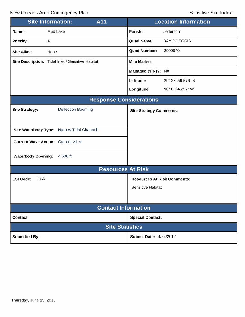
New Orleans Area Contingency Plan Sensitive Site Index
Response Considerations
Resources At Risk
Contact Information
Site Statistics
Resources At Risk Comments:
Sensitive Habitat
Contact: Special Contact:
Submitted By: Submit Date: 4/24/2012
Site Strategy: Deflection Booming Site Strategy Comments:
Site Waterbody Type: Narrow Tidal Channel
Current Wave Action: Current >1 kt
Waterbody Opening: < 500 ft
ESI Code: 10A
Priority: A
Name: Mud Lake
Site Alias: None
Site Description: Tidal Inlet / Sensitive Habitat
Parish: Jefferson
Quad Name: BAY DOSGRIS
Quad Number: 2909040
Mile Marker:
Managed (Y/N)?: No
Latitude: 29° 28' 56.576" N
Longitude: 90° 0' 24.297" W
Site Information: Location InformationText416:A11
Thursday, June 13, 2013

New Orleans Area Contingency Plan Sensitive Site Index
Response Considerations
Resources At Risk
Contact Information
Site Statistics
Resources At Risk Comments:
Nesting Terns; Gulls
Contact: LDWF Special Contact: LDWF
Submitted By: LDWF Submit Date: 5/16/2012
Site Strategy: Deferred Action Site Strategy Comments:
Site Waterbody Type: Straight Coastline
Current Wave Action: Breaking Waves >1.5 ft
Waterbody Opening: Not Applicable
ESI Code: 10A
Priority: A
Name: Unnamed Bird Nesting Area
Site Alias: None
Site Description: Bird Nesting Area
Parish: Jefferson
Quad Name: BAY DOSGRIS
Quad Number: 2909040
Mile Marker: 0
Managed (Y/N)?:
Latitude: 29° 28' 45.675" N
Longitude: 90° 0' 53.329" W
Site Information: Location InformationText416:A12
Thursday, June 13, 2013

New Orleans Area Contingency Plan Sensitive Site Index
Response Considerations
Resources At Risk
Contact Information
Site Statistics
Resources At Risk Comments:
Nesting Terns
Contact: LDWF Special Contact: LDWF
Submitted By: LDWF Submit Date: 5/16/2012
Site Strategy: Deferred Action Site Strategy Comments:
Site Waterbody Type: Straight Coastline
Current Wave Action: Breaking Waves >1.5 ft
Waterbody Opening: Not Applicable
ESI Code: 10A
Priority: A
Name: Unnamed Bird Nesting Area
Site Alias: None
Site Description: Bird Nesting Area
Parish: Jefferson
Quad Name: BAY DOSGRIS
Quad Number: 2909040
Mile Marker: 0
Managed (Y/N)?:
Latitude: 29° 28' 44.181" N
Longitude: 90° 1' 5.565" W
Site Information: Location InformationText416:A13
Thursday, June 13, 2013

New Orleans Area Contingency Plan Sensitive Site Index
Response Considerations
Resources At Risk
Contact Information
Site Statistics
Resources At Risk Comments:
Sensitive Habitat
Contact: Special Contact:
Submitted By: Jefferson Parish - Env Aff. Submit Date: 4/24/2012
Site Strategy: Deferred Action Site Strategy Comments:
Site Waterbody Type: Entrance to Bays, etc
Current Wave Action: Breaking Waves >1.5 ft
Waterbody Opening: 1500-2000 ft
ESI Code: 10A
Priority: A
Name: Bay Dosgris
Site Alias: None
Site Description: Tidal Inlet / Sensitive Habitat
Parish: Jefferson
Quad Name: BAY DOSGRIS
Quad Number: 2909040
Mile Marker:
Managed (Y/N)?: No
Latitude: 29° 28' 41.843" N
Longitude: 90° 4' 46.894" W
Site Information: Location InformationText416:A14
Thursday, June 13, 2013

New Orleans Area Contingency Plan Sensitive Site Index
Response Considerations
Resources At Risk
Contact Information
Site Statistics
Resources At Risk Comments:
Sensitive Habitat
Contact: Special Contact:
Submitted By: Jefferson Parish - Env Aff. Submit Date: 4/24/2012
Site Strategy: Deferred Action Site Strategy Comments:
Site Waterbody Type: Entrance to Bays, etc
Current Wave Action: Breaking Waves >1.5 ft
Waterbody Opening: 1500-2000 ft
ESI Code: 10A
Priority: A
Name: Bayou Dosgris
Site Alias: None
Site Description: Tidal Inlet / Sensitive Habitat
Parish: Jefferson
Quad Name: BAY DOSGRIS
Quad Number: 2909040
Mile Marker:
Managed (Y/N)?: No
Latitude: 29° 28' 39.308" N
Longitude: 90° 3' 38.437" W
Site Information: Location InformationText416:A15
Thursday, June 13, 2013

New Orleans Area Contingency Plan Sensitive Site Index
Response Considerations
Resources At Risk
Contact Information
Site Statistics
Resources At Risk Comments:
Sensitive Habitat
Contact: Special Contact:
Submitted By: Jefferson Parish - Env Aff. Submit Date: 4/24/2012
Site Strategy: Deferred Action Site Strategy Comments:
Site Waterbody Type: Entrance to Bays, etc
Current Wave Action: Breaking Waves <1.5 ft and Currents >1 kt
Waterbody Opening: 1000-1500 ft
ESI Code: 10A
Priority: A
Name: Bayou Dosgris
Site Alias: None
Site Description: Tidal Inlet / Sensitive Habitat
Parish: Jefferson
Quad Name: BAY DOSGRIS
Quad Number: 2909040
Mile Marker:
Managed (Y/N)?: No
Latitude: 29° 28' 38.409" N
Longitude: 90° 2' 45.499" W
Site Information: Location InformationText416:A16
Thursday, June 13, 2013

New Orleans Area Contingency Plan Sensitive Site Index
Response Considerations
Resources At Risk
Contact Information
Site Statistics
Resources At Risk Comments:
Sensitive Habitat
Contact: Special Contact:
Submitted By: Jefferson Parish - Env Aff. Submit Date: 4/24/2012
Site Strategy: Deferred Action Site Strategy Comments:
Site Waterbody Type: Entrance to Bays, etc
Current Wave Action: Breaking Waves >1.5 ft
Waterbody Opening: >2500 ft
ESI Code: 10A
Priority: A
Name: Bayou Dosgris
Site Alias: None
Site Description: Tidal Inlet / Sensitive Habitat
Parish: Jefferson
Quad Name: BAY DOSGRIS
Quad Number: 2909040
Mile Marker:
Managed (Y/N)?: No
Latitude: 29° 28' 23.234" N
Longitude: 90° 1' 19.732" W
Site Information: Location InformationText416:A17
Thursday, June 13, 2013

New Orleans Area Contingency Plan Sensitive Site Index
Response Considerations
Resources At Risk
Contact Information
Site Statistics
Resources At Risk Comments:
Nesting Terns
Contact: LDWF; USFWS Special Contact:
Submitted By: LDWF; USFWS Submit Date: 5/16/2012
Site Strategy: Deferred Action Site Strategy Comments:
Site Waterbody Type: Straight Coastline
Current Wave Action: Breaking Waves >1.5 ft
Waterbody Opening: Not Applicable
ESI Code: 10A
Priority: A
Name: Unnamed Bird Nesting Area
Site Alias: None
Site Description: Bird Nesting Area
Parish: Jefferson
Quad Name: BAY DOSGRIS
Quad Number: 2909040
Mile Marker: 0
Managed (Y/N)?:
Latitude: 29° 28' 14.125" N
Longitude: 90° 0' 51.038" W
Site Information: Location InformationText416:A18
Thursday, June 13, 2013

New Orleans Area Contingency Plan Sensitive Site Index
Response Considerations
Resources At Risk
Contact Information
Site Statistics
Resources At Risk Comments:
Sensitive Habitat
Contact: Special Contact:
Submitted By: Jefferson Parish - Env Aff. Submit Date: 4/24/2012
Site Strategy: Deferred Action Site Strategy Comments:
Site Waterbody Type: Entrance to Bays, etc
Current Wave Action: Breaking Waves >1.5 ft
Waterbody Opening: < 500 ft
ESI Code: 10A
Priority: A
Name: Unnamed Tidal Inlet
Site Alias: None
Site Description: Tidal Inlet / Sensitive Habitat
Parish: Jefferson
Quad Name: BAY DOSGRIS
Quad Number: 2909040
Mile Marker:
Managed (Y/N)?: No
Latitude: 29° 27' 34.922" N
Longitude: 90° 1' 1.846" W
Site Information: Location InformationText416:A19
Thursday, June 13, 2013

New Orleans Area Contingency Plan Sensitive Site Index
Response Considerations
Resources At Risk
Contact Information
Site Statistics
Resources At Risk Comments:
Sensitive Habitat
Contact: Special Contact:
Submitted By: Jefferson Parish - Env Aff. Submit Date: 4/24/2012
Site Strategy: Deferred Action Site Strategy Comments:
Site Waterbody Type: Entrance to Bays, etc
Current Wave Action: Breaking Waves >1.5 ft
Waterbody Opening: < 500 ft
ESI Code: 10A
Priority: A
Name: Unnamed Tidal Inlet
Site Alias: None
Site Description: Tidal Inlet / Sensitive Habitat
Parish: Jefferson
Quad Name: BAY DOSGRIS
Quad Number: 2909040
Mile Marker:
Managed (Y/N)?: No
Latitude: 29° 27' 31.838" N
Longitude: 90° 1' 15.620" W
Site Information: Location InformationText416:A20
Thursday, June 13, 2013

New Orleans Area Contingency Plan Sensitive Site Index
Response Considerations
Resources At Risk
Contact Information
Site Statistics
Resources At Risk Comments:
Nesting Terns
Contact: LDWF; USFWS Special Contact:
Submitted By: LDWF; USFWS Submit Date: 5/16/2012
Site Strategy: Deferred Action Site Strategy Comments:
Site Waterbody Type: Straight Coastline
Current Wave Action: Breaking Waves >1.5 ft
Waterbody Opening: Not Applicable
ESI Code: 10A
Priority: A
Name: Unnamed Bird Nesting Area
Site Alias: None
Site Description: Bird Nesting Area
Parish: Jefferson
Quad Name: BAY DOSGRIS
Quad Number: 2909040
Mile Marker: 0
Managed (Y/N)?:
Latitude: 29° 26' 54.853" N
Longitude: 90° 1' 20.937" W
Site Information: Location InformationText416:A21
Thursday, June 13, 2013

New Orleans Area Contingency Plan Sensitive Site Index
Response Considerations
Resources At Risk
Contact Information
Site Statistics
Resources At Risk Comments:
Nesting Terns and Gulls
Contact: LDWF; USFWS Special Contact:
Submitted By: LDWF; USFWS Submit Date: 5/16/2012
Site Strategy: Deferred Action Site Strategy Comments:
Site Waterbody Type: Straight Coastline
Current Wave Action: Breaking Waves >1.5 ft
Waterbody Opening: Not Applicable
ESI Code: 10A
Priority: A
Name: Unnamed Bird Nesting Area
Site Alias: None
Site Description: Bird Nesting Area
Parish: Jefferson
Quad Name: BAY DOSGRIS
Quad Number: 2909040
Mile Marker: 0
Managed (Y/N)?:
Latitude: 29° 25' 54.357" N
Longitude: 90° 0' 55.238" W
Site Information: Location InformationText416:A22
Thursday, June 13, 2013

New Orleans Area Contingency Plan Sensitive Site Index
Response Considerations
Resources At Risk
Contact Information
Site Statistics
Resources At Risk Comments:
Sensitive Habitat
Contact: Special Contact:
Submitted By: Jefferson Parish - Env Aff. Submit Date: 4/24/2012
Site Strategy: Deferred Action Site Strategy Comments:
Site Waterbody Type: Entrance to Bays, etc
Current Wave Action: Breaking Waves >1.5 ft
Waterbody Opening: 1000-1500 ft
ESI Code: 10A
Priority: A
Name: Unnamed Tidal Inlet
Site Alias: None
Site Description: Tidal Inlet / Sensitive Habitat
Parish: Jefferson
Quad Name: BAY DOSGRIS
Quad Number: 2909040
Mile Marker:
Managed (Y/N)?: No
Latitude: 29° 25' 46.578" N
Longitude: 90° 0' 4.487" W
Site Information: Location InformationText416:A23
Thursday, June 13, 2013

New Orleans Area Contingency Plan Sensitive Site Index
Response Considerations
Resources At Risk
Contact Information
Site Statistics
Resources At Risk Comments:
Sensitive Habitat
Contact: Special Contact:
Submitted By: Jefferson Parish - Env Aff. Submit Date: 4/25/2012
Site Strategy: Deflection Booming Site Strategy Comments:
Site Waterbody Type: Entrance to Bays, etc
Current Wave Action: Breaking Waves <1.5 ft and Currents >1 kt
Waterbody Opening: 500-1000 ft
ESI Code: 10A
Priority: C
Name: Bayou St. Dennis
Site Alias: None
Site Description: Tidal Inlet / Sensitive Habitat
Parish: Jefferson
Quad Name: BAY DOSGRIS
Quad Number: 2909040
Mile Marker:
Managed (Y/N)?: No
Latitude: 29° 29' 53.281" N
Longitude: 90° 1' 4.929" W
Site Information: Location InformationText416:C1
Thursday, June 13, 2013

New Orleans Area Contingency Plan Sensitive Site Index
Response Considerations
Resources At Risk
Contact Information
Site Statistics
Resources At Risk Comments:
Sensitive Habitat
Contact: Special Contact:
Submitted By: Jefferson Parish - Env Aff. Submit Date: 4/24/2012
Site Strategy: Deflection Booming Site Strategy Comments:
Site Waterbody Type: Entrance to Bays, etc
Current Wave Action: Breaking Waves <1.5 ft and Currents >1 kt
Waterbody Opening: 500-1000 ft
ESI Code: 10A
Priority: C
Name: Bayou St. Dennis
Site Alias: None
Site Description: Tidal Inlet / Sensitive Habitat
Parish: Jefferson
Quad Name: BAY DOSGRIS
Quad Number: 2909040
Mile Marker:
Managed (Y/N)?: No
Latitude: 29° 29' 41.151" N
Longitude: 90° 1' 9.247" W
Site Information: Location InformationText416:C2
Thursday, June 13, 2013

New Orleans Area Contingency Plan Sensitive Site Index
Response Considerations
Resources At Risk
Contact Information
Site Statistics
Resources At Risk Comments:
Sensitive Habitat
Contact: Special Contact:
Submitted By: Submit Date: 4/26/2012
Site Strategy: Deflection Booming Site Strategy Comments:
Site Waterbody Type: Entrance to Bays, etc
Current Wave Action: Breaking Waves <1.5 ft and Currents >1 kt
Waterbody Opening: < 500 ft
ESI Code: 10A
Priority: C
Name: Bayou St. Denis
Site Alias: None
Site Description: Tidal Inlet / Sensitive Habitat
Parish: Jefferson
Quad Name: BAY DOSGRIS
Quad Number: 2909040
Mile Marker:
Managed (Y/N)?: No
Latitude: 29° 29' 29.433" N
Longitude: 90° 0' 40.876" W
Site Information: Location InformationText416:C3
Thursday, June 13, 2013

New Orleans Area Contingency Plan Sensitive Site Index
Response Considerations
Resources At Risk
Contact Information
Site Statistics
Resources At Risk Comments:
Sensitive Habitat
Contact: Special Contact:
Submitted By: Jefferson Parish - Env Aff. Submit Date: 4/24/2012
Site Strategy: Deflection Booming Site Strategy Comments:
Site Waterbody Type: Entrance to Bays, etc
Current Wave Action: Breaking Waves <1.5 ft and Currents >1 kt
Waterbody Opening: 500-1000 ft
ESI Code: 10A
Priority: C
Name: Bayou St. Dennis
Site Alias: None
Site Description: Tidal Inlet / Sensitive Habitat
Parish: Jefferson
Quad Name: BAY DOSGRIS
Quad Number: 2909040
Mile Marker:
Managed (Y/N)?: No
Latitude: 29° 29' 8.669" N
Longitude: 90° 2' 11.950" W
Site Information: Location InformationText416:C4
Thursday, June 13, 2013

New Orleans Area Contingency Plan Sensitive Site Index
Response Considerations
Resources At Risk
Contact Information
Site Statistics
Resources At Risk Comments:
Sensitive Habitat
Contact: Special Contact:
Submitted By: Submit Date: 4/27/2012
Site Strategy: Deferred Action Site Strategy Comments:
Site Waterbody Type: Entrance to Bays, etc
Current Wave Action: Breaking Waves >1.5 ft
Waterbody Opening: < 500 ft
ESI Code: 10A
Priority: C
Name:
Site Alias: None
Site Description: Tidal Inlet / Sensitive Habitat
Parish: Jefferson
Quad Name: BAY DOSGRIS
Quad Number: 2909040
Mile Marker:
Managed (Y/N)?: No
Latitude: 29° 29' 1.292" N
Longitude: 90° 0' 6.737" W
Site Information: Location InformationText416:C5
Thursday, June 13, 2013

New Orleans Area Contingency Plan Sensitive Site Index
Response Considerations
Resources At Risk
Contact Information
Site Statistics
Resources At Risk Comments:
Restoration Project Monitoring Equipment
Contact: Special Contact:
Submitted By: LA CPRA Submit Date: 6/28/2012
Site Strategy: Deferred Action Site Strategy Comments:
Site Waterbody Type: Open Water
Current Wave Action: Breaking Waves >1.5 ft
Waterbody Opening: Not Applicable
ESI Code: 10A
Priority: C
Name: Davis Pond Freshwater Diversion
Site Alias: DCPBA06
Site Description: Hydrographic Data Collection Platform
Parish: Jefferson
Quad Name: BAY DOSGRIS
Quad Number: 2909040
Mile Marker:
Managed (Y/N)?:
Latitude: 29° 28' 58.997" N
Longitude: 90° 0' 40.000" W
Site Information: Location InformationText416:C6
Thursday, June 13, 2013

New Orleans Area Contingency Plan Sensitive Site Index
Response Considerations
Resources At Risk
Contact Information
Site Statistics
Resources At Risk Comments:
Restoration Project Monitoring Equipment
Contact: Special Contact:
Submitted By: LA CPRA Submit Date: 6/28/2012
Site Strategy: Deferred Action Site Strategy Comments:
Site Waterbody Type: Open Water
Current Wave Action: Breaking Waves >1.5 ft
Waterbody Opening: Not Applicable
ESI Code: 10A
Priority: C
Name: Davis Pond Freshwater Diversion
Site Alias: DCPBA07
Site Description: Hydrographic Data Collection Platform
Parish: Jefferson
Quad Name: BAY DOSGRIS
Quad Number: 2909040
Mile Marker:
Managed (Y/N)?:
Latitude: 29° 28' 0.001" N
Longitude: 90° 6' 0.000" W
Site Information: Location InformationText416:C7
Thursday, June 13, 2013

New Orleans Area Contingency Plan Sensitive Site Index
Response Considerations
Resources At Risk
Contact Information
Site Statistics
Resources At Risk Comments:
Sensitive Habitat
Contact: Special Contact:
Submitted By: Jefferson Parish - Env Aff. Submit Date: 4/24/2012
Site Strategy: Deferred Action Site Strategy Comments:
Site Waterbody Type: Entrance to Bays, etc
Current Wave Action: Breaking Waves >1.5 ft
Waterbody Opening: 500-1000 ft
ESI Code: 10A
Priority: C
Name: Unnamed Tidal Inlet
Site Alias: None
Site Description: Tidal Inlet / Sensitive Habitat
Parish: Jefferson
Quad Name: BAY DOSGRIS
Quad Number: 2909040
Mile Marker:
Managed (Y/N)?: No
Latitude: 29° 26' 31.190" N
Longitude: 90° 0' 4.487" W
Site Information: Location InformationText416:C8
Thursday, June 13, 2013

New Orleans Area Contingency Plan Sensitive Site Index
Response Considerations
Resources At Risk
Contact Information
Site Statistics
Resources At Risk Comments:
Sensitive Habitat
Contact: Special Contact:
Submitted By: Jefferson Parish - Env Aff. Submit Date: 4/24/2012
Site Strategy: Deferred Action Site Strategy Comments:
Site Waterbody Type: Entrance to Bays, etc
Current Wave Action: Breaking Waves >1.5 ft
Waterbody Opening: < 500 ft
ESI Code: 10A
Priority: C
Name: Unnamed Tidal Inlet
Site Alias: None
Site Description: Tidal Inlet / Sensitive Habitat
Parish: Jefferson
Quad Name: BAY DOSGRIS
Quad Number: 2909040
Mile Marker:
Managed (Y/N)?: No
Latitude: 29° 26' 23.789" N
Longitude: 90° 0' 20.728" W
Site Information: Location InformationText416:C9
Thursday, June 13, 2013

New Orleans Area Contingency Plan
Geographic Response Plan- Jefferson Parish
This page is intentionally left blank

!
!
!
!
!
!
!
!
!
!!
!
!
!
!
!
!
!
!
!
!
!
!
!
!
LakeFlue
Cat Bay
WilkinsonBay
BaratariaBay
BAY
DOSG
RIS
WILK
INSO
N BA
Y
WILKINSON BAYBARATARIA PASS
WILK
INSO
N BA
YBA
Y BAT
ISTE
WILKINSON BAYLAKE LAURIER
A18A17
B3B2
A16
A14
A15
A13A9 A11 A12
B1A10
A7A8
A6
A4C4
A5
C2 A3C3
A2
C1A1
JeffersonParish
PlaqueminesParish
89°52'30"W
89°52'30"W
90°0'0"W
90°0'0"W
29°30
'0"N
29°30
'0"N
29°22
'30"N
29°22
'30"N
±0 1 2 30.5
Miles
WILKINSON BAY Quad
MetairieMetairieLafayetteLafayette
Baton RougeBaton Rouge
New OrleansNew Orleans
§̈¦12§̈¦55
§̈¦310
§̈¦110
§̈¦10
LOUISIANALOUISIANA
Gulf of Mexico
Legend! GRP Sites
Quad BoundaryParish Boundaries
0 1 2 30.5Kilometers
Locator MapLocator Map

New Orleans Area Contingency Plan Sensitive Site Index
Response Considerations
Resources At Risk
Contact Information
Site Statistics
Resources At Risk Comments:
Contact: Special Contact:
Submitted By: LA CPRA/DNR / P-2177:LDEQ Submit Date: 20120516
Site Strategy: Deferred Action Site Strategy Comments:
Site Waterbody Type: Entrance to Bays, etc
Current Wave Action: Breaking Waves >1.5 ft
Waterbody Opening: 500-1000 ft
ESI Code:
Priority: A
Name: Upper Wilkinson Bay
Site Alias: None
Site Description:
Parish: Plaquemines
Quad Name: WILKINSON BAY
Quad Number: 2908933
Mile Marker:
Managed (Y/N)?:
Latitude: 29° 29' 39.834" N
Longitude: 89° 55' 20.791" W
Site Information: Location InformationText416:A1
Thursday, June 13, 2013

New Orleans Area Contingency Plan Sensitive Site Index
Response Considerations
Resources At Risk
Contact Information
Site Statistics
Resources At Risk Comments:
Contact: Special Contact:
Submitted By: LA CPRA/DNR / P-2175:LDEQ Submit Date: 20120516
Site Strategy: Deferred Action Site Strategy Comments:
Site Waterbody Type: Entrance to Bays, etc
Current Wave Action: Breaking Waves >1.5 ft
Waterbody Opening: 1000-1500 ft
ESI Code:
Priority: A
Name: Bayou Chene Fleur
Site Alias: None
Site Description:
Parish: Plaquemines
Quad Name: WILKINSON BAY
Quad Number: 2908933
Mile Marker:
Managed (Y/N)?:
Latitude: 29° 29' 28.895" N
Longitude: 89° 53' 26.167" W
Site Information: Location InformationText416:A2
Thursday, June 13, 2013

New Orleans Area Contingency Plan Sensitive Site Index
Response Considerations
Resources At Risk
Contact Information
Site Statistics
Resources At Risk Comments:
N/A
Contact: Special Contact:
Submitted By: DEQ Submit Date: 5/16/2012
Site Strategy: Deflection Booming Site Strategy Comments:
Site Waterbody Type: Entrance to Bays, etc
Current Wave Action: Breaking Waves <1.5 ft and Currents >1 kt
Waterbody Opening: 1500-2000 ft
ESI Code: 10A
Priority: A
Name: Unnamed Tidal Inlet
Site Alias: None
Site Description: Sensitive Area
Parish: Jefferson
Quad Name: WILKINSON BAY
Quad Number: 2908933
Mile Marker: 0
Managed (Y/N)?:
Latitude: 29° 29' 21.126" N
Longitude: 89° 59' 3.384" W
Site Information: Location InformationText416:A3
Thursday, June 13, 2013

New Orleans Area Contingency Plan Sensitive Site Index
Response Considerations
Resources At Risk
Contact Information
Site Statistics
Resources At Risk Comments:
Sensitive Habitat
Contact: Special Contact:
Submitted By: Jefferson Parish - Env Aff. Submit Date: 4/24/2012
Site Strategy: Deferred Action Site Strategy Comments:
Site Waterbody Type: Entrance to Bays, etc
Current Wave Action: Breaking Waves >1.5 ft
Waterbody Opening: < 500 ft
ESI Code: 10A
Priority: A
Name: Inlet From Mud lake
Site Alias: None
Site Description: Tidal Inlet / Sensitive Habitat
Parish: Jefferson
Quad Name: WILKINSON BAY
Quad Number: 2908933
Mile Marker:
Managed (Y/N)?: No
Latitude: 29° 29' 1.681" N
Longitude: 89° 59' 51.357" W
Site Information: Location InformationText416:A4
Thursday, June 13, 2013

New Orleans Area Contingency Plan Sensitive Site Index
Response Considerations
Resources At Risk
Contact Information
Site Statistics
Resources At Risk Comments:
Contact: Special Contact:
Submitted By: LA CPRA/DNR / P-2176:LDEQ Submit Date: 20120516
Site Strategy: Deferred Action Site Strategy Comments:
Site Waterbody Type: Entrance to Bays, etc
Current Wave Action: Breaking Waves >1.5 ft
Waterbody Opening: 1000-1500 ft
ESI Code:
Priority: A
Name: Wilkinson Bayou
Site Alias: None
Site Description:
Parish: Plaquemines
Quad Name: WILKINSON BAY
Quad Number: 2908933
Mile Marker:
Managed (Y/N)?:
Latitude: 29° 29' 1.000" N
Longitude: 89° 54' 36.000" W
Site Information: Location InformationText416:A5
Thursday, June 13, 2013

New Orleans Area Contingency Plan Sensitive Site Index
Response Considerations
Resources At Risk
Contact Information
Site Statistics
Resources At Risk Comments:
Sensitive Habitat
Contact: Special Contact:
Submitted By: Jefferson Parish - Env Aff. Submit Date: 4/24/2012
Site Strategy: Deferred Action Site Strategy Comments:
Site Waterbody Type: Entrance to Bays, etc
Current Wave Action: Breaking Waves >1.5 ft
Waterbody Opening: 500-1000 ft
ESI Code: 10A
Priority: A
Name: Inlet From Mud lake
Site Alias: None
Site Description: Tidal Inlet / Sensitive Habitat
Parish: Jefferson
Quad Name: WILKINSON BAY
Quad Number: 2908933
Mile Marker:
Managed (Y/N)?: No
Latitude: 29° 28' 30.170" N
Longitude: 89° 59' 25.317" W
Site Information: Location InformationText416:A6
Thursday, June 13, 2013

New Orleans Area Contingency Plan Sensitive Site Index
Response Considerations
Resources At Risk
Contact Information
Site Statistics
Resources At Risk Comments:
Nesting Birds, Terns
Contact: LDWF; USFWS Special Contact:
Submitted By: LDWF; USFWS Submit Date: 5/16/2012
Site Strategy: Deferred Action Site Strategy Comments:
Site Waterbody Type: Straight Coastline
Current Wave Action: Breaking Waves >1.5 ft
Waterbody Opening: Not Applicable
ESI Code: 10A
Priority: A
Name: Unnamed Bird Nesting Area
Site Alias: None
Site Description: Bird Nesting Area
Parish: Jefferson
Quad Name: WILKINSON BAY
Quad Number: 2908933
Mile Marker: 0
Managed (Y/N)?:
Latitude: 29° 27' 59.590" N
Longitude: 89° 59' 49.492" W
Site Information: Location InformationText416:A7
Thursday, June 13, 2013

New Orleans Area Contingency Plan Sensitive Site Index
Response Considerations
Resources At Risk
Contact Information
Site Statistics
Resources At Risk Comments:
Contact: Special Contact:
Submitted By: DEQ / P-2178:LDEQ Submit Date: 20120516
Site Strategy: Deflection Booming Site Strategy Comments:
Site Waterbody Type: Narrow Tidal Channel
Current Wave Action: Current >1 kt
Waterbody Opening: < 500 ft
ESI Code:
Priority: A
Name: Wilkinson Bay Inlet
Site Alias: None
Site Description:
Parish: Plaquemines
Quad Name: WILKINSON BAY
Quad Number: 2908933
Mile Marker:
Managed (Y/N)?:
Latitude: 29° 27' 56.000" N
Longitude: 89° 56' 2.000" W
Site Information: Location InformationText416:A8
Thursday, June 13, 2013

New Orleans Area Contingency Plan Sensitive Site Index
Response Considerations
Resources At Risk
Contact Information
Site Statistics
Resources At Risk Comments:
Nesting Birds; Terns
Contact: LDWF Special Contact: LDWF
Submitted By: LDWF Submit Date: 5/16/2012
Site Strategy: Deferred Action Site Strategy Comments:
Site Waterbody Type: Straight Coastline
Current Wave Action: Breaking Waves >1.5 ft
Waterbody Opening: Not Applicable
ESI Code: 10A
Priority: A
Name: Mud Lake
Site Alias: None
Site Description: Bird Nesting Area
Parish: Jefferson
Quad Name: WILKINSON BAY
Quad Number: 2908933
Mile Marker: 0
Managed (Y/N)?:
Latitude: 29° 27' 41.447" N
Longitude: 89° 59' 50.808" W
Site Information: Location InformationText416:A9
Thursday, June 13, 2013
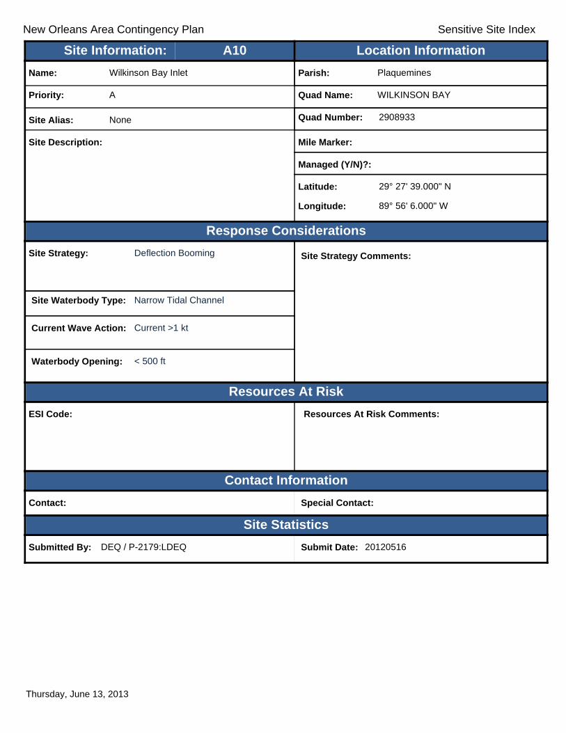
New Orleans Area Contingency Plan Sensitive Site Index
Response Considerations
Resources At Risk
Contact Information
Site Statistics
Resources At Risk Comments:
Contact: Special Contact:
Submitted By: DEQ / P-2179:LDEQ Submit Date: 20120516
Site Strategy: Deflection Booming Site Strategy Comments:
Site Waterbody Type: Narrow Tidal Channel
Current Wave Action: Current >1 kt
Waterbody Opening: < 500 ft
ESI Code:
Priority: A
Name: Wilkinson Bay Inlet
Site Alias: None
Site Description:
Parish: Plaquemines
Quad Name: WILKINSON BAY
Quad Number: 2908933
Mile Marker:
Managed (Y/N)?:
Latitude: 29° 27' 39.000" N
Longitude: 89° 56' 6.000" W
Site Information: Location InformationText416:A10
Thursday, June 13, 2013

New Orleans Area Contingency Plan Sensitive Site Index
Response Considerations
Resources At Risk
Contact Information
Site Statistics
Resources At Risk Comments:
Nesting Birds, Terns
Contact: LDWF; USFWS Special Contact:
Submitted By: LDWF; USFWS Submit Date: 5/16/2012
Site Strategy: Deferred Action Site Strategy Comments:
Site Waterbody Type: Straight Coastline
Current Wave Action: Breaking Waves >1.5 ft
Waterbody Opening: Not Applicable
ESI Code: 10A
Priority: A
Name: Unnamed Bird Nesting Area
Site Alias: None
Site Description: Bird Nesting Area
Parish: Jefferson
Quad Name: WILKINSON BAY
Quad Number: 2908933
Mile Marker: 0
Managed (Y/N)?:
Latitude: 29° 27' 36.427" N
Longitude: 89° 59' 35.990" W
Site Information: Location InformationText416:A11
Thursday, June 13, 2013
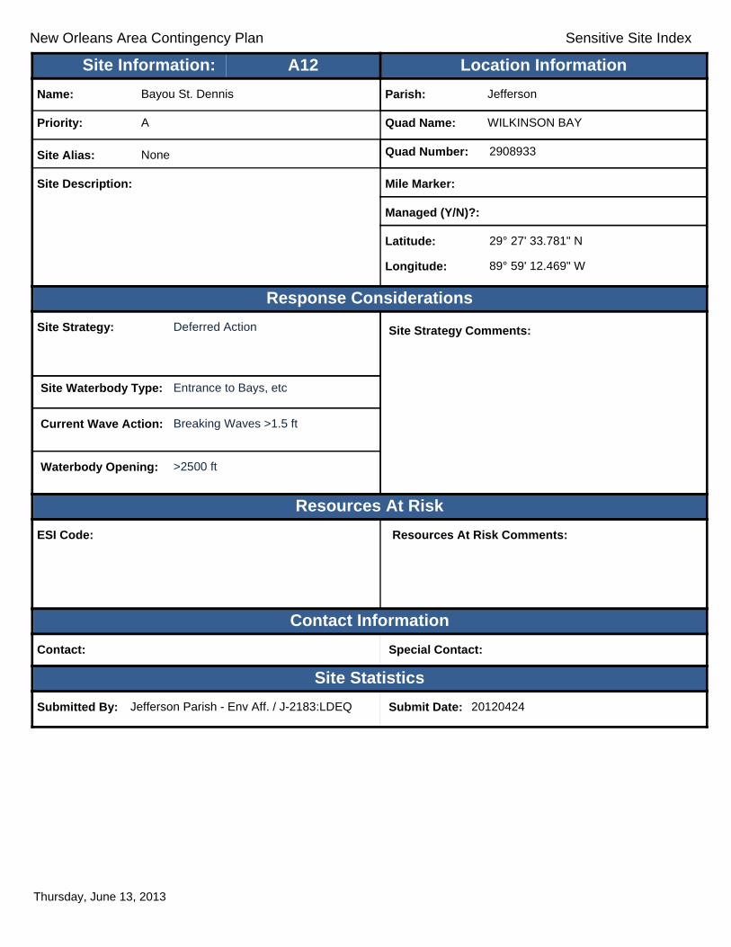
New Orleans Area Contingency Plan Sensitive Site Index
Response Considerations
Resources At Risk
Contact Information
Site Statistics
Resources At Risk Comments:
Contact: Special Contact:
Submitted By: Jefferson Parish - Env Aff. / J-2183:LDEQ Submit Date: 20120424
Site Strategy: Deferred Action Site Strategy Comments:
Site Waterbody Type: Entrance to Bays, etc
Current Wave Action: Breaking Waves >1.5 ft
Waterbody Opening: >2500 ft
ESI Code:
Priority: A
Name: Bayou St. Dennis
Site Alias: None
Site Description:
Parish: Jefferson
Quad Name: WILKINSON BAY
Quad Number: 2908933
Mile Marker:
Managed (Y/N)?:
Latitude: 29° 27' 33.781" N
Longitude: 89° 59' 12.469" W
Site Information: Location InformationText416:A12
Thursday, June 13, 2013

New Orleans Area Contingency Plan Sensitive Site Index
Response Considerations
Resources At Risk
Contact Information
Site Statistics
Resources At Risk Comments:
Sensitive Habitat
Contact: Special Contact:
Submitted By: LDEQ Submit Date: 3/30/2012
Site Strategy: Deferred Action Site Strategy Comments:
Site Waterbody Type: Entrance to Bays, etc
Current Wave Action: Breaking Waves >1.5 ft
Waterbody Opening: 1500-2000 ft
ESI Code: 10A
Priority: A
Name: Unnamed Tidal Inlet
Site Alias: None
Site Description: Major Tidal Inlet
Parish: Plaquemines
Quad Name: WILKINSON BAY
Quad Number: 2908933
Mile Marker:
Managed (Y/N)?:
Latitude: 29° 27' 25.000" N
Longitude: 89° 52' 48.000" W
Site Information: Location InformationText416:A13
Thursday, June 13, 2013

New Orleans Area Contingency Plan Sensitive Site Index
Response Considerations
Resources At Risk
Contact Information
Site Statistics
Resources At Risk Comments:
Contact: Special Contact:
Submitted By: DEQ / J-2182:LDEQ Submit Date: 20120516
Site Strategy: Deferred Action Site Strategy Comments:
Site Waterbody Type: Entrance to Bays, etc
Current Wave Action: Breaking Waves >1.5 ft
Waterbody Opening: 1000-1500 ft
ESI Code:
Priority: A
Name: Unnamed Tidal Inlet
Site Alias: None
Site Description:
Parish: Jefferson
Quad Name: WILKINSON BAY
Quad Number: 2908933
Mile Marker:
Managed (Y/N)?:
Latitude: 29° 26' 37.133" N
Longitude: 89° 59' 29.438" W
Site Information: Location InformationText416:A14
Thursday, June 13, 2013

New Orleans Area Contingency Plan Sensitive Site Index
Response Considerations
Resources At Risk
Contact Information
Site Statistics
Resources At Risk Comments:
Nesting Birds; Terns
Contact: LDWF Special Contact: LDWF
Submitted By: LDWF Submit Date: 5/16/2012
Site Strategy: Deferred Action Site Strategy Comments:
Site Waterbody Type: Straight Coastline
Current Wave Action: Breaking Waves >1.5 ft
Waterbody Opening: Not Applicable
ESI Code: 10A
Priority: A
Name: Unnamed Bird Nesting Area
Site Alias: None
Site Description: Bird Nesting Area
Parish: Jefferson
Quad Name: WILKINSON BAY
Quad Number: 2908933
Mile Marker: 0
Managed (Y/N)?:
Latitude: 29° 26' 33.296" N
Longitude: 89° 59' 2.494" W
Site Information: Location InformationText416:A15
Thursday, June 13, 2013
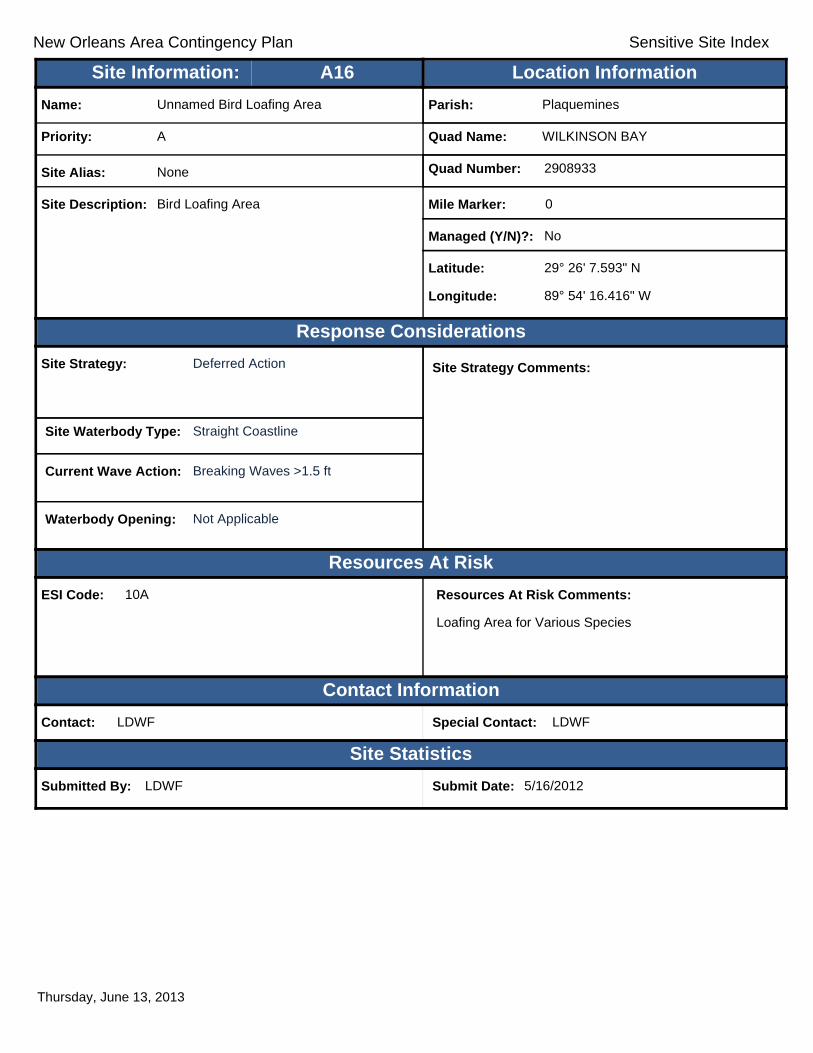
New Orleans Area Contingency Plan Sensitive Site Index
Response Considerations
Resources At Risk
Contact Information
Site Statistics
Resources At Risk Comments:
Loafing Area for Various Species
Contact: LDWF Special Contact: LDWF
Submitted By: LDWF Submit Date: 5/16/2012
Site Strategy: Deferred Action Site Strategy Comments:
Site Waterbody Type: Straight Coastline
Current Wave Action: Breaking Waves >1.5 ft
Waterbody Opening: Not Applicable
ESI Code: 10A
Priority: A
Name: Unnamed Bird Loafing Area
Site Alias: None
Site Description: Bird Loafing Area
Parish: Plaquemines
Quad Name: WILKINSON BAY
Quad Number: 2908933
Mile Marker: 0
Managed (Y/N)?: No
Latitude: 29° 26' 7.593" N
Longitude: 89° 54' 16.416" W
Site Information: Location InformationText416:A16
Thursday, June 13, 2013
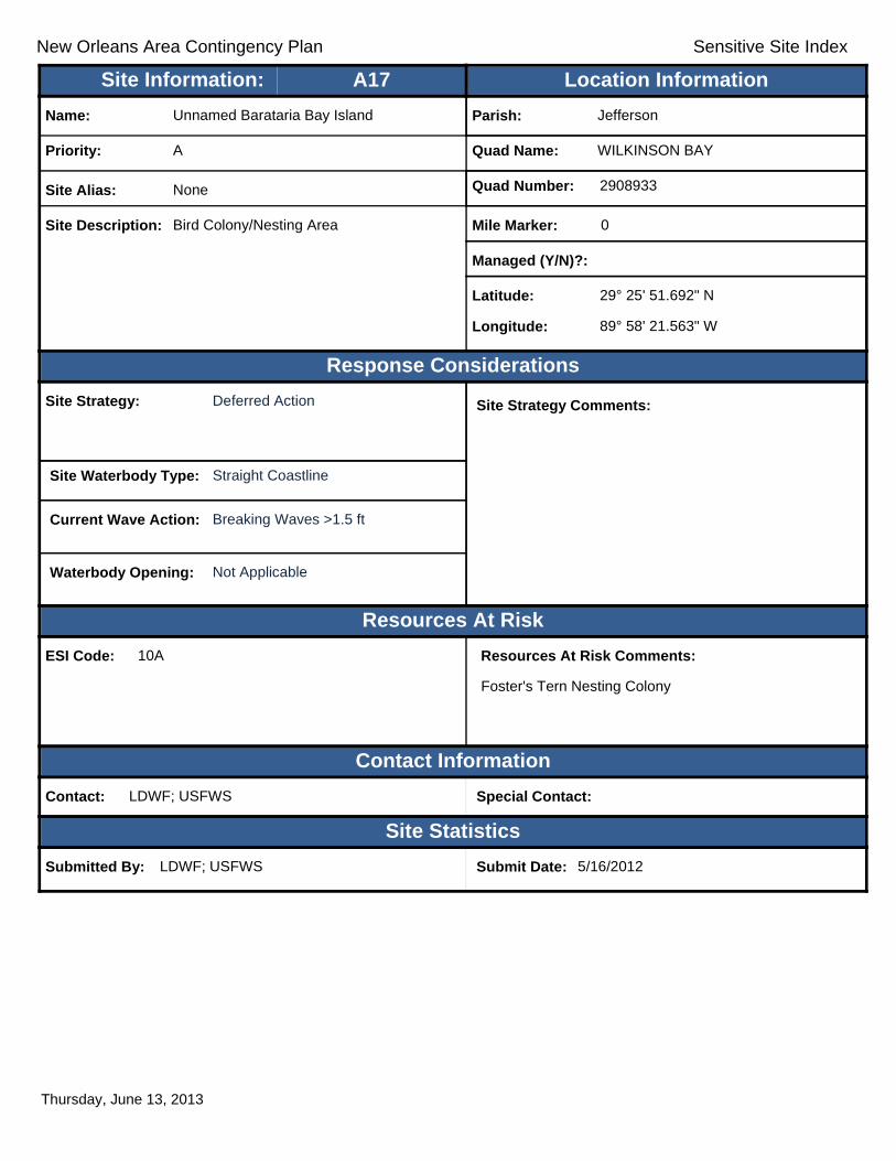
New Orleans Area Contingency Plan Sensitive Site Index
Response Considerations
Resources At Risk
Contact Information
Site Statistics
Resources At Risk Comments:
Foster's Tern Nesting Colony
Contact: LDWF; USFWS Special Contact:
Submitted By: LDWF; USFWS Submit Date: 5/16/2012
Site Strategy: Deferred Action Site Strategy Comments:
Site Waterbody Type: Straight Coastline
Current Wave Action: Breaking Waves >1.5 ft
Waterbody Opening: Not Applicable
ESI Code: 10A
Priority: A
Name: Unnamed Barataria Bay Island
Site Alias: None
Site Description: Bird Colony/Nesting Area
Parish: Jefferson
Quad Name: WILKINSON BAY
Quad Number: 2908933
Mile Marker: 0
Managed (Y/N)?:
Latitude: 29° 25' 51.692" N
Longitude: 89° 58' 21.563" W
Site Information: Location InformationText416:A17
Thursday, June 13, 2013

New Orleans Area Contingency Plan Sensitive Site Index
Response Considerations
Resources At Risk
Contact Information
Site Statistics
Resources At Risk Comments:
Contact: Special Contact:
Submitted By: Jefferson Parish - Env Aff. / J-2181:LDEQ Submit Date: 20120424
Site Strategy: Exclusion Booming Site Strategy Comments:
Site Waterbody Type: Narrow Tidal Channel
Current Wave Action: Currents <1 kt
Waterbody Opening: 500-1000 ft
ESI Code:
Priority: A
Name: Barataria Waterway
Site Alias: None
Site Description:
Parish: Jefferson
Quad Name: WILKINSON BAY
Quad Number: 2908933
Mile Marker:
Managed (Y/N)?:
Latitude: 29° 25' 33.000" N
Longitude: 89° 59' 34.000" W
Site Information: Location InformationText416:A18
Thursday, June 13, 2013

New Orleans Area Contingency Plan Sensitive Site Index
Response Considerations
Resources At Risk
Contact Information
Site Statistics
Resources At Risk Comments:
Contact: Special Contact:
Submitted By: LA CPRA/DNR / P-2180:LDEQ Submit Date: 20120516
Site Strategy: Deflection Booming Site Strategy Comments:
Site Waterbody Type: Narrow Tidal Channel
Current Wave Action: Current >1 kt
Waterbody Opening: < 500 ft
ESI Code:
Priority: B
Name: Wilkinson Canal
Site Alias: None
Site Description:
Parish: Plaquemines
Quad Name: WILKINSON BAY
Quad Number: 2908933
Mile Marker:
Managed (Y/N)?:
Latitude: 29° 27' 29.555" N
Longitude: 89° 57' 6.606" W
Site Information: Location InformationText416:B1
Thursday, June 13, 2013

New Orleans Area Contingency Plan Sensitive Site Index
Response Considerations
Resources At Risk
Contact Information
Site Statistics
Resources At Risk Comments:
Industrial Facility
Contact: Special Contact:
Submitted By: LDEQ Submit Date: 3/30/2012
Site Strategy: Notification to Site Manager Site Strategy Comments:
Site Waterbody Type: Open Water
Current Wave Action: Breaking Waves >1.5 ft
Waterbody Opening: Not Applicable
ESI Code: 10D
Priority: B
Name: Unnamed Oil and Gas Production Facility
Site Alias: None
Site Description: Oil & Gas Facility
Parish: Plaquemines
Quad Name: WILKINSON BAY
Quad Number: 2908933
Mile Marker:
Managed (Y/N)?:
Latitude: 29° 26' 20.000" N
Longitude: 89° 56' 4.000" W
Site Information: Location InformationText416:B2
Thursday, June 13, 2013

New Orleans Area Contingency Plan Sensitive Site Index
Response Considerations
Resources At Risk
Contact Information
Site Statistics
Resources At Risk Comments:
Industrial Facility
Contact: Special Contact:
Submitted By: LDEQ Submit Date: 3/30/2012
Site Strategy: Notification to Site Manager Site Strategy Comments:
Site Waterbody Type: Open Water
Current Wave Action: Breaking Waves >1.5 ft
Waterbody Opening: Not Applicable
ESI Code: 10A
Priority: B
Name: Unnamed Oil and Gas Production Facility
Site Alias: None
Site Description: Oil & Gas Facility
Parish: Plaquemines
Quad Name: WILKINSON BAY
Quad Number: 2908933
Mile Marker:
Managed (Y/N)?:
Latitude: 29° 25' 57.000" N
Longitude: 89° 56' 20.000" W
Site Information: Location InformationText416:B3
Thursday, June 13, 2013

New Orleans Area Contingency Plan Sensitive Site Index
Response Considerations
Resources At Risk
Contact Information
Site Statistics
Resources At Risk Comments:
Sensitive Habitat
Contact: Special Contact:
Submitted By: LDEQ Submit Date: 3/30/2012
Site Strategy: Deferred Action Site Strategy Comments:
Site Waterbody Type: Entrance to Bays, etc
Current Wave Action: Breaking Waves <1.5 ft and Currents <1 kt
Waterbody Opening: 1000-1500 ft
ESI Code: 10A
Priority: C
Name: Unnamed Tidal Inlet
Site Alias: None
Site Description: Secondary Tidal inlet
Parish: Jefferson
Quad Name: WILKINSON BAY
Quad Number: 2908933
Mile Marker:
Managed (Y/N)?:
Latitude: 29° 29' 48.000" N
Longitude: 89° 59' 30.000" W
Site Information: Location InformationText416:C1
Thursday, June 13, 2013

New Orleans Area Contingency Plan Sensitive Site Index
Response Considerations
Resources At Risk
Contact Information
Site Statistics
Resources At Risk Comments:
Sensitive Habitat
Contact: Special Contact:
Submitted By: Jefferson Parish - Env Aff. Submit Date: 4/24/2012
Site Strategy: Deflection Booming Site Strategy Comments:
Site Waterbody Type: Entrance to Bays, etc
Current Wave Action: Breaking Waves <1.5 ft and Currents >1 kt
Waterbody Opening: < 500 ft
ESI Code: 10A
Priority: C
Name: Unnamed Tidal Inlets
Site Alias: None
Site Description: Tidal Inlet / Sensitive Habitat
Parish: Jefferson
Quad Name: WILKINSON BAY
Quad Number: 2908933
Mile Marker:
Managed (Y/N)?: No
Latitude: 29° 29' 17.255" N
Longitude: 89° 59' 34.867" W
Site Information: Location InformationText416:C2
Thursday, June 13, 2013

New Orleans Area Contingency Plan Sensitive Site Index
Response Considerations
Resources At Risk
Contact Information
Site Statistics
Resources At Risk Comments:
Sensitive Habitat
Contact: Special Contact:
Submitted By: LDEQ Submit Date: 3/30/2012
Site Strategy: Exclusion Booming Site Strategy Comments:
Site Waterbody Type: Entrance to Bays, etc
Current Wave Action: Breaking Waves <1.5 ft and Currents <1 kt
Waterbody Opening: < 500 ft
ESI Code: 10A
Priority: C
Name: Unnamed Tidal Inlet
Site Alias: None
Site Description: Smaller tidal Inlet
Parish: Plaquemines
Quad Name: WILKINSON BAY
Quad Number: 2908933
Mile Marker:
Managed (Y/N)?:
Latitude: 29° 29' 8.000" N
Longitude: 89° 55' 52.000" W
Site Information: Location InformationText416:C3
Thursday, June 13, 2013

New Orleans Area Contingency Plan Sensitive Site Index
Response Considerations
Resources At Risk
Contact Information
Site Statistics
Resources At Risk Comments:
Sensitive Habitat
Contact: Special Contact:
Submitted By: LDEQ Submit Date: 3/30/2012
Site Strategy: Exclusion Booming Site Strategy Comments:
Site Waterbody Type: Narrow Tidal Channel
Current Wave Action: Currents <1 kt
Waterbody Opening: < 500 ft
ESI Code: 10A
Priority: C
Name: Unnamed Tidal Inlet
Site Alias: None
Site Description: Smaller tidal Inlet
Parish: Plaquemines
Quad Name: WILKINSON BAY
Quad Number: 2908933
Mile Marker:
Managed (Y/N)?:
Latitude: 29° 28' 51.000" N
Longitude: 89° 55' 57.000" W
Site Information: Location InformationText416:C4
Thursday, June 13, 2013
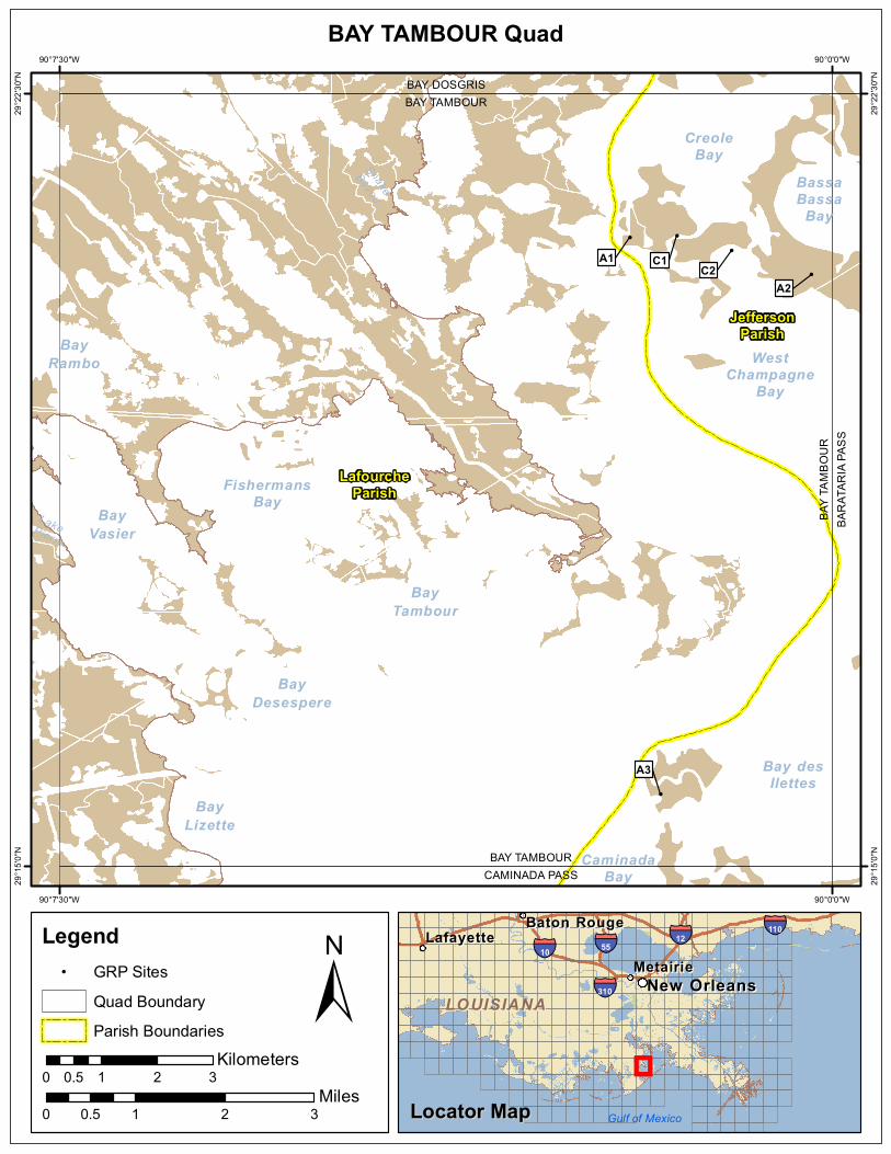
!
!
!
! !
LakePierreSnake
Bayou
FishermansBay
BayRambo
BayVasier
BayDesespere
BayLizette
CaminadaBay
BassaBassa
Bay
CreoleBay
Bay desIlettes
BayTambour
WestChampagne
Bay
BAY TAMBOURCAMINADA PASS
BAY T
AMBO
URBA
RATA
RIA P
ASS
BAY TAMBOURBAY DOSGRIS
A3
A2C2
A1 C1
JeffersonParish
LafourcheParish
90°0'0"W
90°0'0"W
90°7'30"W
90°7'30"W
29°22
'30"N
29°22
'30"N
29°15
'0"N
29°15
'0"N
±0 1 2 30.5
Miles
BAY TAMBOUR Quad
MetairieMetairieLafayetteLafayette
Baton RougeBaton Rouge
New OrleansNew Orleans
§̈¦12§̈¦55
§̈¦310
§̈¦110
§̈¦10
LOUISIANALOUISIANA
Gulf of Mexico
Legend! GRP Sites
Quad BoundaryParish Boundaries
0 1 2 30.5Kilometers
Locator MapLocator Map

New Orleans Area Contingency Plan Sensitive Site Index
Response Considerations
Resources At Risk
Contact Information
Site Statistics
Resources At Risk Comments:
Nesting Terns
Contact: LDWF Special Contact: LDWF
Submitted By: LDWF Submit Date: 5/16/2012
Site Strategy: Deferred Action Site Strategy Comments:
Site Waterbody Type: Straight Coastline
Current Wave Action: Breaking Waves >1.5 ft
Waterbody Opening: Not Applicable
ESI Code: 10A
Priority: A
Name: Unnamed Bird Nesting Area
Site Alias: None
Site Description: Bird Nesting Area
Parish: Jefferson
Quad Name: BAY TAMBOUR
Quad Number: 2909048
Mile Marker: 0
Managed (Y/N)?:
Latitude: 29° 21' 6.030" N
Longitude: 90° 1' 57.922" W
Site Information: Location InformationText416:A1
Thursday, June 13, 2013

New Orleans Area Contingency Plan Sensitive Site Index
Response Considerations
Resources At Risk
Contact Information
Site Statistics
Resources At Risk Comments:
Least Tern Nesting Area
Contact: LDWF; USFWS Special Contact:
Submitted By: LDWF; USFWS Submit Date: 5/16/2012
Site Strategy: Deferred Action Site Strategy Comments:
Site Waterbody Type: Straight Coastline
Current Wave Action: Breaking Waves >1.5 ft
Waterbody Opening: Not Applicable
ESI Code: 10A
Priority: A
Name: Bassa Bassa Island
Site Alias: None
Site Description: Bird Colony/Nesting Area
Parish: Jefferson
Quad Name: BAY TAMBOUR
Quad Number: 2909048
Mile Marker: 0
Managed (Y/N)?:
Latitude: 29° 20' 44.570" N
Longitude: 90° 0' 12.249" W
Site Information: Location InformationText416:A2
Thursday, June 13, 2013

New Orleans Area Contingency Plan Sensitive Site Index
Response Considerations
Resources At Risk
Contact Information
Site Statistics
Resources At Risk Comments:
Wildlife Habitat
Contact: Special Contact:
Submitted By: Jefferson Parish - Env Aff. Submit Date: 4/24/2012
Site Strategy: Deflection Booming Site Strategy Comments:
Assigned Strategy for narrow tidal channel through the island. Straight coastline - Deferred Action.
Site Waterbody Type: Narrow Tidal Channel
Current Wave Action: Current >1 kt
Waterbody Opening: < 500 ft
ESI Code: 10A
Priority: A
Name: Martigan Point Island
Site Alias: Western Inlet
Site Description: Sensitive Wildlife Habitat
Parish: Jefferson
Quad Name: BAY TAMBOUR
Quad Number: 2909048
Mile Marker:
Managed (Y/N)?: No
Latitude: 29° 15' 42.090" N
Longitude: 90° 1' 40.042" W
Site Information: Location InformationText416:A3
Thursday, June 13, 2013

New Orleans Area Contingency Plan Sensitive Site Index
Response Considerations
Resources At Risk
Contact Information
Site Statistics
Resources At Risk Comments:
Contact: Special Contact:
Submitted By: Jefferson Parish Environmental Submit Date: 20120424
Site Strategy: Deferred Action Site Strategy Comments:
Site Waterbody Type: Entrance to Bays, etc
Current Wave Action: Breaking Waves >1.5 ft
Waterbody Opening: < 500 ft
ESI Code:
Priority: C
Name: Southwest Pass of Creole Bay
Site Alias: None
Site Description:
Parish: Jefferson
Quad Name: BAY TAMBOUR
Quad Number: 2909048
Mile Marker:
Managed (Y/N)?:
Latitude: 29° 21' 7.013" N
Longitude: 90° 1' 30.529" W
Site Information: Location InformationText416:C1
Thursday, June 13, 2013

New Orleans Area Contingency Plan Sensitive Site Index
Response Considerations
Resources At Risk
Contact Information
Site Statistics
Resources At Risk Comments:
Salt Marsh Wetland Habitat
Contact: Special Contact:
Submitted By: Jefferson Parish Environmental Submit Date: 4/24/2012
Site Strategy: Deferred Action Site Strategy Comments:
Site Waterbody Type: Entrance to Bays, etc
Current Wave Action: Breaking Waves >1.5 ft
Waterbody Opening: 500-1000 ft
ESI Code: 10A
Priority: C
Name: Southeast Pass of Creole Bay
Site Alias: None
Site Description: Small Tidal Channel
Parish: Jefferson
Quad Name: BAY TAMBOUR
Quad Number: 2909048
Mile Marker: -
Managed (Y/N)?: No
Latitude: 29° 20' 58.643" N
Longitude: 90° 0' 58.640" W
Site Information: Location InformationText416:C2
Thursday, June 13, 2013

!
!
! !
!
!
!
!
!
!!
!
!!
!!
!
!
!
!
!
!
!
!
!
!
Gulf ofMexico
BassaBassa
Bay
Bay desIlettes
WestChampagne
Bay
Cat Bay
BayMelville
BaratariaBay
ST1
BAY T
AMBO
URBA
RATA
RIA P
ASS
BARATARIA PASSGRAND ISLE
BARA
TARI
A PAS
SBA
Y RO
NQUI
LLE
BARATARIA PASSWILKINSON BAY
A25A24
B1
A22A23
A21A20 A19
A17 A18C2A16
A13
A15
A12 A14A11
A10
A9
A7 A8
C1
A6
A5
A4A3
JeffersonParish
LafourcheParish
PlaqueminesParish
89°52'30"W
89°52'30"W
90°0'0"W
90°0'0"W
29°22
'30"N
29°22
'30"N
29°15
'0"N
29°15
'0"N
±0 1 2 30.5
Miles
BARATARIA PASS Quad
MetairieMetairieLafayetteLafayette
Baton RougeBaton Rouge
New OrleansNew Orleans
§̈¦12§̈¦55
§̈¦310
§̈¦110
§̈¦10
LOUISIANALOUISIANA
Gulf of Mexico
Legend! GRP Sites
Quad BoundaryParish Boundaries
0 1 2 30.5Kilometers
Locator MapLocator Map

New Orleans Area Contingency Plan Sensitive Site Index
Response Considerations
Resources At Risk
Contact Information
Site Statistics
Resources At Risk Comments:
Nesting Terns; Egrets
Contact: LDWF Special Contact: LDWF
Submitted By: LDWF Submit Date: 5/16/2012
Site Strategy: Deferred Action Site Strategy Comments:
Site Waterbody Type: Straight Coastline
Current Wave Action: Breaking Waves >1.5 ft
Waterbody Opening: Not Applicable
ESI Code: 10A
Priority: A
Name: Cat Island 3
Site Alias: None
Site Description: Bird Nesting Area
Parish: Plaquemines
Quad Name: BARATARIA PASS
Quad Number: 2908941
Mile Marker: 0
Managed (Y/N)?: No
Latitude: 29° 22' 18.451" N
Longitude: 89° 53' 36.806" W
Site Information: Location InformationText416:A3
Thursday, June 13, 2013
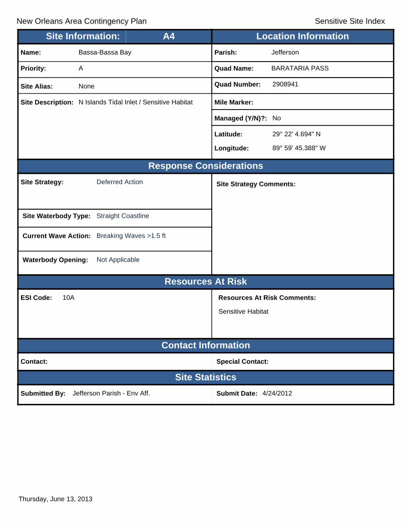
New Orleans Area Contingency Plan Sensitive Site Index
Response Considerations
Resources At Risk
Contact Information
Site Statistics
Resources At Risk Comments:
Sensitive Habitat
Contact: Special Contact:
Submitted By: Jefferson Parish - Env Aff. Submit Date: 4/24/2012
Site Strategy: Deferred Action Site Strategy Comments:
Site Waterbody Type: Straight Coastline
Current Wave Action: Breaking Waves >1.5 ft
Waterbody Opening: Not Applicable
ESI Code: 10A
Priority: A
Name: Bassa-Bassa Bay
Site Alias: None
Site Description: N Islands Tidal Inlet / Sensitive Habitat
Parish: Jefferson
Quad Name: BARATARIA PASS
Quad Number: 2908941
Mile Marker:
Managed (Y/N)?: No
Latitude: 29° 22' 4.694" N
Longitude: 89° 59' 45.388" W
Site Information: Location InformationText416:A4
Thursday, June 13, 2013

New Orleans Area Contingency Plan Sensitive Site Index
Response Considerations
Resources At Risk
Contact Information
Site Statistics
Resources At Risk Comments:
Nesting Terns
Contact: LDWF; USFWS Special Contact:
Submitted By: LDWF; USFWS Submit Date: 5/16/2012
Site Strategy: Deferred Action Site Strategy Comments:
Site Waterbody Type: Straight Coastline
Current Wave Action: Breaking Waves >1.5 ft
Waterbody Opening: Not Applicable
ESI Code: 10A/6A
Priority: A
Name: Unnamed Bird Nesting Area
Site Alias: None
Site Description: Bird Nesting Area
Parish: Jefferson
Quad Name: BARATARIA PASS
Quad Number: 2908941
Mile Marker: 0
Managed (Y/N)?:
Latitude: 29° 16' 52.422" N
Longitude: 89° 58' 3.055" W
Site Information: Location InformationText416:A5
Thursday, June 13, 2013
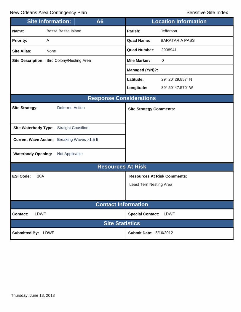
New Orleans Area Contingency Plan Sensitive Site Index
Response Considerations
Resources At Risk
Contact Information
Site Statistics
Resources At Risk Comments:
Least Tern Nesting Area
Contact: LDWF Special Contact: LDWF
Submitted By: LDWF Submit Date: 5/16/2012
Site Strategy: Deferred Action Site Strategy Comments:
Site Waterbody Type: Straight Coastline
Current Wave Action: Breaking Waves >1.5 ft
Waterbody Opening: Not Applicable
ESI Code: 10A
Priority: A
Name: Bassa Bassa Island
Site Alias: None
Site Description: Bird Colony/Nesting Area
Parish: Jefferson
Quad Name: BARATARIA PASS
Quad Number: 2908941
Mile Marker: 0
Managed (Y/N)?:
Latitude: 29° 20' 29.857" N
Longitude: 89° 59' 47.570" W
Site Information: Location InformationText416:A6
Thursday, June 13, 2013

New Orleans Area Contingency Plan Sensitive Site Index
Response Considerations
Resources At Risk
Contact Information
Site Statistics
Resources At Risk Comments:
Multiple Sensitive Habitats
Contact: Special Contact:
Submitted By: Jefferson Parish - Env Aff. Submit Date: 4/24/2012
Site Strategy: Deferred Action Site Strategy Comments:
Assigned Strategy for narrow tidal channel. Straight coastline - Deferred Action.
Site Waterbody Type: Narrow Tidal Channel
Current Wave Action: Current >1 kt
Waterbody Opening: < 500 ft
ESI Code: 10A
Priority: A
Name: Mendicant Island
Site Alias: None
Site Description: Multiple Tidal Inlets
Parish: Jefferson
Quad Name: BARATARIA PASS
Quad Number: 2908941
Mile Marker:
Managed (Y/N)?: No
Latitude: 29° 18' 45.585" N
Longitude: 89° 58' 34.825" W
Site Information: Location InformationText416:A7
Thursday, June 13, 2013

New Orleans Area Contingency Plan Sensitive Site Index
Response Considerations
Resources At Risk
Contact Information
Site Statistics
Resources At Risk Comments:
Critical Habitat for endangered piping plover and Wilson's plover, a species of concern
Contact: LDWF Special Contact: LDWF
Submitted By: LDWF Submit Date: 5/16/2012
Site Strategy: Deferred Action Site Strategy Comments:
Site Waterbody Type: Straight Coastline
Current Wave Action: Breaking Waves >1.5 ft
Waterbody Opening: Not Applicable
ESI Code: 3A/2A/7
Priority: A
Name: East Grand Terre
Site Alias: None
Site Description: Critical Plover Habitat
Parish: Plaquemines
Quad Name: BARATARIA PASS
Quad Number: 2908941
Mile Marker: 0
Managed (Y/N)?: No
Latitude: 29° 18' 37.791" N
Longitude: 89° 53' 37.383" W
Site Information: Location InformationText416:A8
Thursday, June 13, 2013
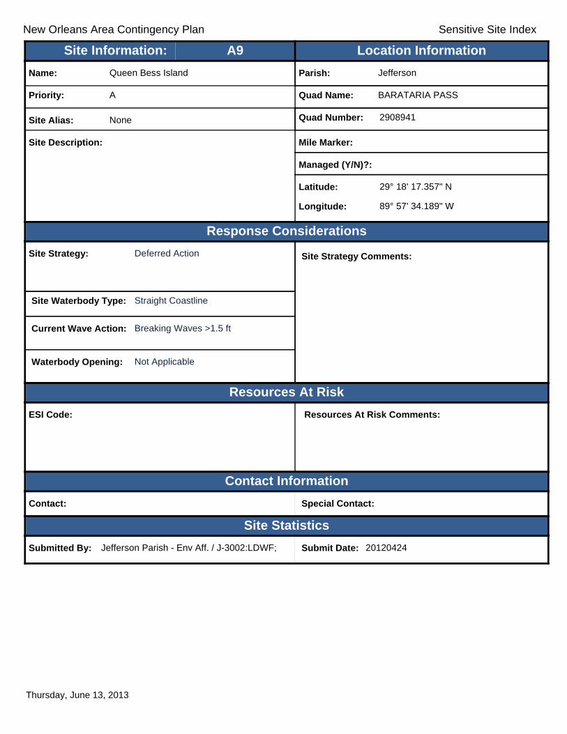
New Orleans Area Contingency Plan Sensitive Site Index
Response Considerations
Resources At Risk
Contact Information
Site Statistics
Resources At Risk Comments:
Contact: Special Contact:
Submitted By: Jefferson Parish - Env Aff. / J-3002:LDWF; Submit Date: 20120424
Site Strategy: Deferred Action Site Strategy Comments:
Site Waterbody Type: Straight Coastline
Current Wave Action: Breaking Waves >1.5 ft
Waterbody Opening: Not Applicable
ESI Code:
Priority: A
Name: Queen Bess Island
Site Alias: None
Site Description:
Parish: Jefferson
Quad Name: BARATARIA PASS
Quad Number: 2908941
Mile Marker:
Managed (Y/N)?:
Latitude: 29° 18' 17.357" N
Longitude: 89° 57' 34.189" W
Site Information: Location InformationText416:A9
Thursday, June 13, 2013

New Orleans Area Contingency Plan Sensitive Site Index
Response Considerations
Resources At Risk
Contact Information
Site Statistics
Resources At Risk Comments:
Restoration/Bird Loafing and Roosting Area for Multiple Species
Contact: Special Contact:
Submitted By: Jefferson Parish - Env Aff. Submit Date: 4/24/2012
Site Strategy: Deferred Action Site Strategy Comments:
Site Waterbody Type: Entrance to Bays, etc
Current Wave Action: Breaking Waves >1.5 ft
Waterbody Opening: < 500 ft
ESI Code: 3A/7
Priority: A
Name: Unnamed Tidal Inlet
Site Alias: None
Site Description: Sensitive Habitat/Wetland Restoration
Parish: Jefferson
Quad Name: BARATARIA PASS
Quad Number: 2908941
Mile Marker:
Managed (Y/N)?: No
Latitude: 29° 17' 41.126" N
Longitude: 89° 54' 40.366" W
Site Information: Location InformationText416:A10
Thursday, June 13, 2013

New Orleans Area Contingency Plan Sensitive Site Index
Response Considerations
Resources At Risk
Contact Information
Site Statistics
Resources At Risk Comments:
N/A
Contact: Special Contact:
Submitted By: DEQ Submit Date: 5/16/2012
Site Strategy: Deferred Action Site Strategy Comments:
Site Waterbody Type: Entrance to Bays, etc
Current Wave Action: Breaking Waves >1.5 ft
Waterbody Opening: < 500 ft
ESI Code: 10A/7
Priority: A
Name: Unnamed Tidal Inlet
Site Alias: None
Site Description: Sensitive Area
Parish: Jefferson
Quad Name: BARATARIA PASS
Quad Number: 2908941
Mile Marker: 0
Managed (Y/N)?:
Latitude: 29° 17' 5.982" N
Longitude: 89° 56' 4.169" W
Site Information: Location InformationText416:A11
Thursday, June 13, 2013

New Orleans Area Contingency Plan Sensitive Site Index
Response Considerations
Resources At Risk
Contact Information
Site Statistics
Resources At Risk Comments:
N/A
Contact: Special Contact:
Submitted By: DEQ Submit Date: 5/16/2012
Site Strategy: Deferred Action Site Strategy Comments:
Site Waterbody Type: Entrance to Bays, etc
Current Wave Action: Breaking Waves >1.5 ft
Waterbody Opening: < 500 ft
ESI Code: 10A/9A
Priority: A
Name: Unnamed Tidal Inlet
Site Alias: None
Site Description: Sensitive Area
Parish: Jefferson
Quad Name: BARATARIA PASS
Quad Number: 2908941
Mile Marker: 0
Managed (Y/N)?:
Latitude: 29° 16' 55.579" N
Longitude: 89° 56' 12.980" W
Site Information: Location InformationText416:A12
Thursday, June 13, 2013

New Orleans Area Contingency Plan Sensitive Site Index
Response Considerations
Resources At Risk
Contact Information
Site Statistics
Resources At Risk Comments:
Tidal Inlet/Sensitive Habitat
Contact: Special Contact:
Submitted By: Jefferson Parish - Env Aff. Submit Date: 4/24/2012
Site Strategy: Deflection Booming Site Strategy Comments:
Site Waterbody Type: Narrow Tidal Channel
Current Wave Action: Current >1 kt
Waterbody Opening: < 500 ft
ESI Code: 10A/9A
Priority: A
Name: Beauregard Island
Site Alias: None
Site Description: Sensitive Wildlife Habitat
Parish: Jefferson
Quad Name: BARATARIA PASS
Quad Number: 2908941
Mile Marker:
Managed (Y/N)?: No
Latitude: 29° 16' 54.508" N
Longitude: 89° 58' 9.433" W
Site Information: Location InformationText416:A13
Thursday, June 13, 2013

New Orleans Area Contingency Plan Sensitive Site Index
Response Considerations
Resources At Risk
Contact Information
Site Statistics
Resources At Risk Comments:
Restoration
Contact: CPRA Special Contact: CPRA
Submitted By: Jefferson Parish - Env Aff. Submit Date: 4/24/2012
Site Strategy: Deferred Action Site Strategy Comments:
Site Waterbody Type: Straight Coastline
Current Wave Action: Breaking Waves >1.5 ft
Waterbody Opening: Not Applicable
ESI Code: 3A
Priority: A
Name: Grand Terre
Site Alias: Grand Terre I
Site Description: Restoration Project, Beach; Bird nesting/feeding habitat
Parish: Jefferson
Quad Name: BARATARIA PASS
Quad Number: 2908941
Mile Marker:
Managed (Y/N)?: No
Latitude: 29° 16' 52.720" N
Longitude: 89° 55' 38.656" W
Site Information: Location InformationText416:A14
Thursday, June 13, 2013

New Orleans Area Contingency Plan Sensitive Site Index
Response Considerations
Resources At Risk
Contact Information
Site Statistics
Resources At Risk Comments:
Sensitive Habitat
Contact: Special Contact:
Submitted By: Jefferson Parish - Env Aff. Submit Date: 4/24/2012
Site Strategy: Exclusion Booming Site Strategy Comments:
Site Waterbody Type: Lake or Pond
Current Wave Action: Negligable
Waterbody Opening: Not Applicable
ESI Code:
Priority: A
Name: Blind Bay
Site Alias: None
Site Description: Tidal Inlet / Sensitive Habitat
Parish: Jefferson
Quad Name: BARATARIA PASS
Quad Number: 2908941
Mile Marker:
Managed (Y/N)?: No
Latitude: 29° 20' 50.887" N
Longitude: 89° 59' 19.111" W
Site Information: Location InformationText416:A15
Thursday, June 13, 2013

New Orleans Area Contingency Plan Sensitive Site Index
Response Considerations
Resources At Risk
Contact Information
Site Statistics
Resources At Risk Comments:
Tidal Inlet/Sensitive Habitat
Contact: Special Contact:
Submitted By: Jefferson Parish - Env Aff. Submit Date: 4/24/2012
Site Strategy: Deflection Booming Site Strategy Comments:
Site Waterbody Type: Narrow Tidal Channel
Current Wave Action: Current >1 kt
Waterbody Opening: < 500 ft
ESI Code: 10A/9A
Priority: A
Name: Beauregard Island
Site Alias: None
Site Description: Sensitive Wildlife Habitat
Parish: Jefferson
Quad Name: BARATARIA PASS
Quad Number: 2908941
Mile Marker:
Managed (Y/N)?: No
Latitude: 29° 16' 44.283" N
Longitude: 89° 58' 41.907" W
Site Information: Location InformationText416:A16
Thursday, June 13, 2013

New Orleans Area Contingency Plan Sensitive Site Index
Response Considerations
Resources At Risk
Contact Information
Site Statistics
Resources At Risk Comments:
Nesting Terns; Skimmers
Contact: LDWF Special Contact: LDWF
Submitted By: LDWF Submit Date: 5/16/2012
Site Strategy: Deferred Action Site Strategy Comments:
Site Waterbody Type: Straight Coastline
Current Wave Action: Breaking Waves >1.5 ft
Waterbody Opening: Not Applicable
ESI Code: 10A
Priority: A
Name: Beauregard Island
Site Alias: None
Site Description: Bird Nesting Area
Parish: Jefferson
Quad Name: BARATARIA PASS
Quad Number: 2908941
Mile Marker: 0
Managed (Y/N)?:
Latitude: 29° 16' 40.998" N
Longitude: 89° 58' 1.119" W
Site Information: Location InformationText416:A17
Thursday, June 13, 2013
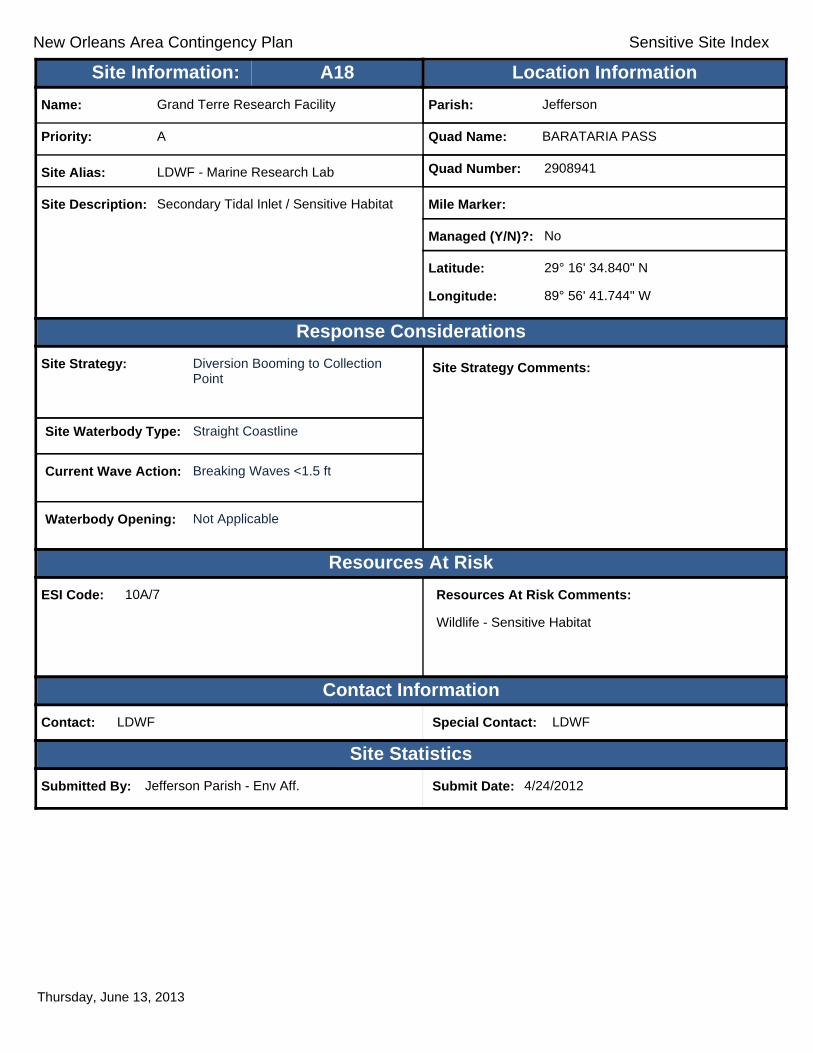
New Orleans Area Contingency Plan Sensitive Site Index
Response Considerations
Resources At Risk
Contact Information
Site Statistics
Resources At Risk Comments:
Wildlife - Sensitive Habitat
Contact: LDWF Special Contact: LDWF
Submitted By: Jefferson Parish - Env Aff. Submit Date: 4/24/2012
Site Strategy: Diversion Booming to Collection Point
Site Strategy Comments:
Site Waterbody Type: Straight Coastline
Current Wave Action: Breaking Waves <1.5 ft
Waterbody Opening: Not Applicable
ESI Code: 10A/7
Priority: A
Name: Grand Terre Research Facility
Site Alias: LDWF - Marine Research Lab
Site Description: Secondary Tidal Inlet / Sensitive Habitat
Parish: Jefferson
Quad Name: BARATARIA PASS
Quad Number: 2908941
Mile Marker:
Managed (Y/N)?: No
Latitude: 29° 16' 34.840" N
Longitude: 89° 56' 41.744" W
Site Information: Location InformationText416:A18
Thursday, June 13, 2013

New Orleans Area Contingency Plan Sensitive Site Index
Response Considerations
Resources At Risk
Contact Information
Site Statistics
Resources At Risk Comments:
Historical Site
Contact: Special Contact: SHPO
Submitted By: Jefferson Parish - Env Aff. Submit Date: 4/24/2012
Site Strategy: Diversion Booming to Collection Point
Site Strategy Comments:
Site Waterbody Type: Straight Coastline
Current Wave Action: Currents <1 kt
Waterbody Opening: Not Applicable
ESI Code: 3A
Priority: A
Name: Fort Livingston
Site Alias: Fort Livingston
Site Description: Historical Site/Cultural Site; National Historical Monument
Parish: Jefferson
Quad Name: BARATARIA PASS
Quad Number: 2908941
Mile Marker:
Managed (Y/N)?: Yes
Latitude: 29° 16' 21.176" N
Longitude: 89° 56' 39.564" W
Site Information: Location InformationText416:A19
Thursday, June 13, 2013

New Orleans Area Contingency Plan Sensitive Site Index
Response Considerations
Resources At Risk
Contact Information
Site Statistics
Resources At Risk Comments:
Wildlife - Sensitive Habitat
Contact: Special Contact:
Submitted By: Jefferson Parish - Env Aff. Submit Date: 4/24/2012
Site Strategy: Deferred Action Site Strategy Comments:
Site Waterbody Type: Entrance to Bays, etc
Current Wave Action: Breaking Waves >1.5 ft
Waterbody Opening: >2500 ft
ESI Code:
Priority: A
Name: Barataria Pass
Site Alias: Barataria Pass
Site Description: Major Gulf Facing Tidal Inlet
Parish: Jefferson
Quad Name: BARATARIA PASS
Quad Number: 2908941
Mile Marker:
Managed (Y/N)?: No
Latitude: 29° 16' 17.816" N
Longitude: 89° 56' 57.257" W
Site Information: Location InformationText416:A20
Thursday, June 13, 2013
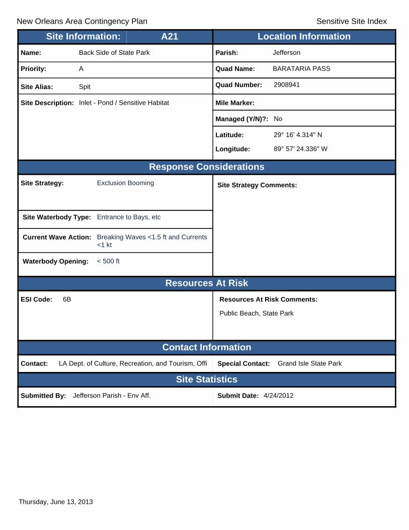
New Orleans Area Contingency Plan Sensitive Site Index
Response Considerations
Resources At Risk
Contact Information
Site Statistics
Resources At Risk Comments:
Public Beach, State Park
Contact: LA Dept. of Culture, Recreation, and Tourism, Offi Special Contact: Grand Isle State Park
Submitted By: Jefferson Parish - Env Aff. Submit Date: 4/24/2012
Site Strategy: Exclusion Booming Site Strategy Comments:
Site Waterbody Type: Entrance to Bays, etc
Current Wave Action: Breaking Waves <1.5 ft and Currents <1 kt
Waterbody Opening: < 500 ft
ESI Code: 6B
Priority: A
Name: Back Side of State Park
Site Alias: Spit
Site Description: Inlet - Pond / Sensitive Habitat
Parish: Jefferson
Quad Name: BARATARIA PASS
Quad Number: 2908941
Mile Marker:
Managed (Y/N)?: No
Latitude: 29° 16' 4.314" N
Longitude: 89° 57' 24.336" W
Site Information: Location InformationText416:A21
Thursday, June 13, 2013
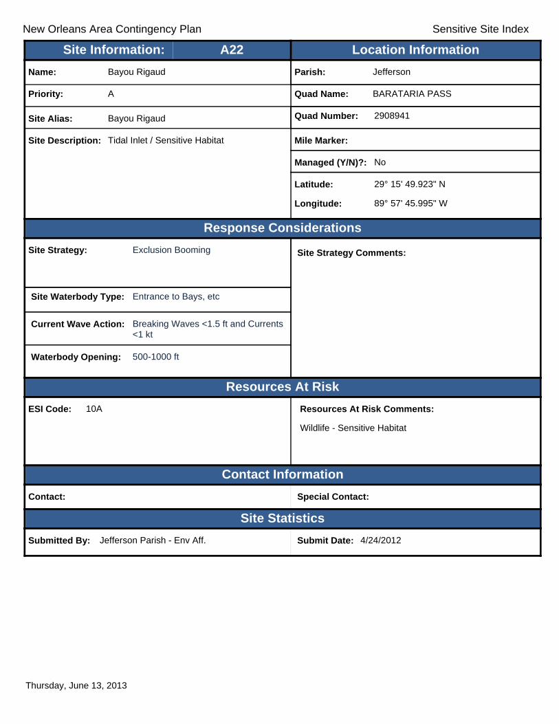
New Orleans Area Contingency Plan Sensitive Site Index
Response Considerations
Resources At Risk
Contact Information
Site Statistics
Resources At Risk Comments:
Wildlife - Sensitive Habitat
Contact: Special Contact:
Submitted By: Jefferson Parish - Env Aff. Submit Date: 4/24/2012
Site Strategy: Exclusion Booming Site Strategy Comments:
Site Waterbody Type: Entrance to Bays, etc
Current Wave Action: Breaking Waves <1.5 ft and Currents <1 kt
Waterbody Opening: 500-1000 ft
ESI Code: 10A
Priority: A
Name: Bayou Rigaud
Site Alias: Bayou Rigaud
Site Description: Tidal Inlet / Sensitive Habitat
Parish: Jefferson
Quad Name: BARATARIA PASS
Quad Number: 2908941
Mile Marker:
Managed (Y/N)?: No
Latitude: 29° 15' 49.923" N
Longitude: 89° 57' 45.995" W
Site Information: Location InformationText416:A22
Thursday, June 13, 2013

New Orleans Area Contingency Plan Sensitive Site Index
Response Considerations
Resources At Risk
Contact Information
Site Statistics
Resources At Risk Comments:
Public Beach, State Park
Contact: LA Dept. of Culture, Recreation, and Tourism, Offi Special Contact: Grand Isle State Park
Submitted By: Submit Date: 4/24/2012
Site Strategy: Deferred Action Site Strategy Comments:
Site Waterbody Type: Straight Coastline
Current Wave Action: Breaking Waves >1.5 ft
Waterbody Opening: Not Applicable
ESI Code: 3A
Priority: A
Name: Grand Isle
Site Alias: Grand Isle Beach (State Park)
Site Description: High use Recreational Site; Bird nesting/feeding habitat
Parish: Jefferson
Quad Name: BARATARIA PASS
Quad Number: 2908941
Mile Marker:
Managed (Y/N)?: No
Latitude: 29° 15' 43.963" N
Longitude: 89° 57' 0.060" W
Site Information: Location InformationText416:A23
Thursday, June 13, 2013

New Orleans Area Contingency Plan Sensitive Site Index
Response Considerations
Resources At Risk
Contact Information
Site Statistics
Resources At Risk Comments:
Oyster Bed Restoration Project Area
Contact: Special Contact:
Submitted By: Jefferson Parish - Env Aff. Submit Date: 4/24/2012
Site Strategy: Diversion Booming to Collection Point
Site Strategy Comments:
Site Waterbody Type: Straight Coastline
Current Wave Action: Breaking Waves <1.5 ft
Waterbody Opening: Not Applicable
ESI Code: 10A
Priority: A
Name: FiFi Island
Site Alias: None
Site Description: Sensitive Habitat
Parish: Jefferson
Quad Name: BARATARIA PASS
Quad Number: 2908941
Mile Marker:
Managed (Y/N)?: No
Latitude: 29° 15' 25.818" N
Longitude: 89° 58' 26.259" W
Site Information: Location InformationText416:A24
Thursday, June 13, 2013

New Orleans Area Contingency Plan Sensitive Site Index
Response Considerations
Resources At Risk
Contact Information
Site Statistics
Resources At Risk Comments:
Public Beach / State Park
Contact: LA Dept. of Culture, Recreation, and Tourism, Offi Special Contact: Grand Isle State Park
Submitted By: Submit Date: 4/24/2012
Site Strategy: Deferred Action Site Strategy Comments:
Site Waterbody Type: Straight Coastline
Current Wave Action: Breaking Waves >1.5 ft
Waterbody Opening: Not Applicable
ESI Code: 3A
Priority: A
Name:
Site Alias: Grand Isle Beach (State Park)
Site Description: High use Recreational Site; Bird nesting/feeding habitat
Parish: Jefferson
Quad Name: BARATARIA PASS
Quad Number: 2908941
Mile Marker:
Managed (Y/N)?: No
Latitude: 29° 15' 16.199" N
Longitude: 89° 57' 16.195" W
Site Information: Location InformationText416:A25
Thursday, June 13, 2013

New Orleans Area Contingency Plan Sensitive Site Index
Response Considerations
Resources At Risk
Contact Information
Site Statistics
Resources At Risk Comments:
Bird Loafing Area on Sandy Point; Oyster Bed Restoration Project Area
Contact: LDWF Special Contact: LDWF
Submitted By: LDWF Submit Date: 5/16/2012
Site Strategy: Deferred Action Site Strategy Comments:
Site Waterbody Type: Straight Coastline
Current Wave Action: Breaking Waves >1.5 ft
Waterbody Opening: Not Applicable
ESI Code: 10D
Priority: B
Name: Fifi Island
Site Alias: None
Site Description: Sensitive Wildlife Habitat
Parish: Jefferson
Quad Name: BARATARIA PASS
Quad Number: 2908941
Mile Marker: 0
Managed (Y/N)?:
Latitude: 29° 15' 49.827" N
Longitude: 89° 57' 51.128" W
Site Information: Location InformationText416:B1
Thursday, June 13, 2013

New Orleans Area Contingency Plan Sensitive Site Index
Response Considerations
Resources At Risk
Contact Information
Site Statistics
Resources At Risk Comments:
Restoration Project Monitoring Equipment
Contact: Special Contact:
Submitted By: LA CPRA Submit Date: 6/28/2012
Site Strategy: Deferred Action Site Strategy Comments:
Site Waterbody Type: Open Water
Current Wave Action: Breaking Waves >1.5 ft
Waterbody Opening: Not Applicable
ESI Code:
Priority: C
Name: Davis Pond Freshwater Diversion
Site Alias: DCPBA08
Site Description: Hydrographic Data Collection Platform
Parish: Jefferson
Quad Name: BARATARIA PASS
Quad Number: 2908941
Mile Marker:
Managed (Y/N)?:
Latitude: 29° 19' 29.004" N
Longitude: 89° 56' 25.800" W
Site Information: Location InformationText416:C1
Thursday, June 13, 2013
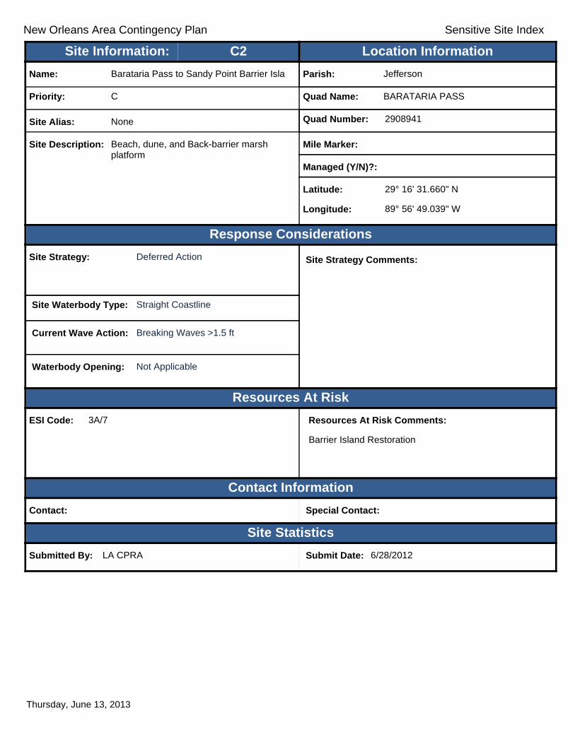
New Orleans Area Contingency Plan Sensitive Site Index
Response Considerations
Resources At Risk
Contact Information
Site Statistics
Resources At Risk Comments:
Barrier Island Restoration
Contact: Special Contact:
Submitted By: LA CPRA Submit Date: 6/28/2012
Site Strategy: Deferred Action Site Strategy Comments:
Site Waterbody Type: Straight Coastline
Current Wave Action: Breaking Waves >1.5 ft
Waterbody Opening: Not Applicable
ESI Code: 3A/7
Priority: C
Name: Barataria Pass to Sandy Point Barrier Isla
Site Alias: None
Site Description: Beach, dune, and Back-barrier marsh platform
Parish: Jefferson
Quad Name: BARATARIA PASS
Quad Number: 2908941
Mile Marker:
Managed (Y/N)?:
Latitude: 29° 16' 31.660" N
Longitude: 89° 56' 49.039" W
Site Information: Location InformationText416:C2
Thursday, June 13, 2013

New Orleans Area Contingency Plan
Geographic Response Plan- Jefferson Parish
This page is intentionally left blank

!
!
!
!
!
! !
!
!
!
!
!
!
!
!
!
Bayou
Moreau
Bayo
uTh
u nde
rVo
nTr
a nc
Bayou Thunder
Von Tranc
Gulf ofMexico
LakeLaurier
LakePalourde
Bay Lizette
BayMacoin
CaminadaBay
Bay desIlettes
ST1
CAMI
NADA
PASS
GRAN
D IS
LE
CAMINADA PASSBAY TAMBOUR
A14
A13A11
A12C1
A10 A9
A8A7 B1
A6
A5 A4
A3
A2
A1
JeffersonParish
LafourcheParish
90°0'0"W
90°0'0"W
90°7'30"W
90°7'30"W
29°15
'0"N
29°15
'0"N
29°7'
30"N
29°7'
30"N
±0 1 2 30.5
Miles
CAMINADA PASS Quad
MetairieMetairieLafayetteLafayette
Baton RougeBaton Rouge
New OrleansNew Orleans
§̈¦12§̈¦55
§̈¦310
§̈¦110
§̈¦10
LOUISIANALOUISIANA
Gulf of Mexico
Legend! GRP Sites
Quad BoundaryParish Boundaries
0 1 2 30.5Kilometers
Locator MapLocator Map
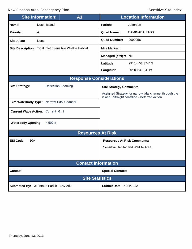
New Orleans Area Contingency Plan Sensitive Site Index
Response Considerations
Resources At Risk
Contact Information
Site Statistics
Resources At Risk Comments:
Sensitive Habitat and Wildlife Area
Contact: Special Contact:
Submitted By: Jefferson Parish - Env Aff. Submit Date: 4/24/2012
Site Strategy: Deflection Booming Site Strategy Comments:
Assigned Strategy for narrow tidal channel through the island. Straight coastline - Deferred Action.
Site Waterbody Type: Narrow Tidal Channel
Current Wave Action: Current >1 kt
Waterbody Opening: < 500 ft
ESI Code: 10A
Priority: A
Name: Dutch Island
Site Alias: None
Site Description: Tidal Inlet / Sensitive Wildlife Habitat
Parish: Jefferson
Quad Name: CAMINADA PASS
Quad Number: 2909056
Mile Marker:
Managed (Y/N)?: No
Latitude: 29° 14' 52.374" N
Longitude: 90° 0' 54.024" W
Site Information: Location InformationText416:A1
Thursday, June 13, 2013

New Orleans Area Contingency Plan Sensitive Site Index
Response Considerations
Resources At Risk
Contact Information
Site Statistics
Resources At Risk Comments:
Sensitive Bird Habitat (North-facing side various inlets)
Contact: Special Contact:
Submitted By: Jefferson Parish - Env Aff. Submit Date: 4/24/2012
Site Strategy: Deflection Booming Site Strategy Comments:
Assigned Strategy for narrow tidal channel through the island. Straight coastline - Deferred Action.
Site Waterbody Type: Narrow Tidal Channel
Current Wave Action: Current >1 kt
Waterbody Opening: < 500 ft
ESI Code: 10A
Priority: A
Name: Dutch Island
Site Alias: None
Site Description: Sensitive Bird Habitat
Parish: Jefferson
Quad Name: CAMINADA PASS
Quad Number: 2909056
Mile Marker:
Managed (Y/N)?: No
Latitude: 29° 14' 39.392" N
Longitude: 90° 0' 56.010" W
Site Information: Location InformationText416:A2
Thursday, June 13, 2013
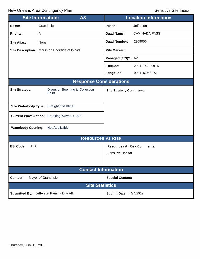
New Orleans Area Contingency Plan Sensitive Site Index
Response Considerations
Resources At Risk
Contact Information
Site Statistics
Resources At Risk Comments:
Sensitive Habitat
Contact: Mayor of Grand Isle Special Contact:
Submitted By: Jefferson Parish - Env Aff. Submit Date: 4/24/2012
Site Strategy: Diversion Booming to Collection Point
Site Strategy Comments:
Site Waterbody Type: Straight Coastline
Current Wave Action: Breaking Waves <1.5 ft
Waterbody Opening: Not Applicable
ESI Code: 10A
Priority: A
Name: Grand Isle
Site Alias: None
Site Description: Marsh on Backside of Island
Parish: Jefferson
Quad Name: CAMINADA PASS
Quad Number: 2909056
Mile Marker:
Managed (Y/N)?: No
Latitude: 29° 13' 42.990" N
Longitude: 90° 1' 5.948" W
Site Information: Location InformationText416:A3
Thursday, June 13, 2013
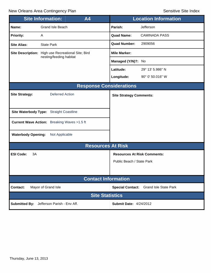
New Orleans Area Contingency Plan Sensitive Site Index
Response Considerations
Resources At Risk
Contact Information
Site Statistics
Resources At Risk Comments:
Public Beach / State Park
Contact: Mayor of Grand Isle Special Contact: Grand Isle State Park
Submitted By: Jefferson Parish - Env Aff. Submit Date: 4/24/2012
Site Strategy: Deferred Action Site Strategy Comments:
Site Waterbody Type: Straight Coastline
Current Wave Action: Breaking Waves >1.5 ft
Waterbody Opening: Not Applicable
ESI Code: 3A
Priority: A
Name: Grand Isle Beach
Site Alias: State Park
Site Description: High use Recreational Site; Bird nesting/feeding habitat
Parish: Jefferson
Quad Name: CAMINADA PASS
Quad Number: 2909056
Mile Marker:
Managed (Y/N)?: No
Latitude: 29° 13' 5.986" N
Longitude: 90° 0' 50.016" W
Site Information: Location InformationText416:A4
Thursday, June 13, 2013

New Orleans Area Contingency Plan Sensitive Site Index
Response Considerations
Resources At Risk
Contact Information
Site Statistics
Resources At Risk Comments:
Sensitive Habitat
Contact: Special Contact:
Submitted By: Jefferson Parish - Env Aff. Submit Date: 4/24/2012
Site Strategy: Deferred Action Site Strategy Comments:
Site Waterbody Type: Entrance to Bays, etc
Current Wave Action: Breaking Waves >1.5 ft
Waterbody Opening: 500-1000 ft
ESI Code: 10D
Priority: A
Name: Unnamed Tidal Inlet
Site Alias: None
Site Description: Sensitive Habitat between islands
Parish: Jefferson
Quad Name: CAMINADA PASS
Quad Number: 2909056
Mile Marker:
Managed (Y/N)?: No
Latitude: 29° 12' 59.048" N
Longitude: 90° 2' 50.535" W
Site Information: Location InformationText416:A5
Thursday, June 13, 2013

New Orleans Area Contingency Plan Sensitive Site Index
Response Considerations
Resources At Risk
Contact Information
Site Statistics
Resources At Risk Comments:
Sensitive Habitat
Contact: Special Contact:
Submitted By: Jefferson Parish - Env Aff. Submit Date: 4/24/2012
Site Strategy: Diversion Booming to Collection Point
Site Strategy Comments:
Site Waterbody Type: Entrance to Bays, etc
Current Wave Action: Breaking Waves <1.5 ft and Currents >1 kt
Waterbody Opening: < 500 ft
ESI Code: 6B
Priority: A
Name: Unnamed Tidal Inlet
Site Alias: None
Site Description: Opening Behind Spit / Sensitive Habitat
Parish: Jefferson
Quad Name: CAMINADA PASS
Quad Number: 2909056
Mile Marker:
Managed (Y/N)?: No
Latitude: 29° 12' 37.612" N
Longitude: 90° 2' 57.298" W
Site Information: Location InformationText416:A6
Thursday, June 13, 2013

New Orleans Area Contingency Plan Sensitive Site Index
Response Considerations
Resources At Risk
Contact Information
Site Statistics
Resources At Risk Comments:
Contact: Special Contact:
Submitted By: Jefferson Parish - Env Aff. Submit Date: 20120424
Site Strategy: Deflection Booming Site Strategy Comments:
Site Waterbody Type: Entrance to Bays, etc
Current Wave Action: Breaking Waves <1.5 ft and Currents >1 kt
Waterbody Opening: < 500 ft
ESI Code:
Priority: A
Name: Bayou Thunder
Site Alias: None
Site Description:
Parish: Jefferson
Quad Name: CAMINADA PASS
Quad Number: 2909056
Mile Marker:
Managed (Y/N)?:
Latitude: 29° 12' 18.839" N
Longitude: 90° 3' 42.829" W
Site Information: Location InformationText416:A7
Thursday, June 13, 2013

New Orleans Area Contingency Plan Sensitive Site Index
Response Considerations
Resources At Risk
Contact Information
Site Statistics
Resources At Risk Comments:
Sensitive Habitat
Contact: Special Contact:
Submitted By: Jefferson Parish - Env Aff. Submit Date: 4/24/2012
Site Strategy: Deferred Action Site Strategy Comments:
Site Waterbody Type: Entrance to Bays, etc
Current Wave Action: Breaking Waves >1.5 ft
Waterbody Opening: < 500 ft
ESI Code: 10A/9A
Priority: A
Name: Elmer's Island Pass
Site Alias: None
Site Description: Tidal Inlet / Sensitive Habitat
Parish: Jefferson
Quad Name: CAMINADA PASS
Quad Number: 2909056
Mile Marker:
Managed (Y/N)?: No
Latitude: 29° 11' 56.183" N
Longitude: 90° 3' 6.710" W
Site Information: Location InformationText416:A8
Thursday, June 13, 2013

New Orleans Area Contingency Plan Sensitive Site Index
Response Considerations
Resources At Risk
Contact Information
Site Statistics
Resources At Risk Comments:
Sensitive Habitat
Contact: Special Contact:
Submitted By: Jefferson Parish - Env Aff. Submit Date: 4/24/2012
Site Strategy: Deferred Action Site Strategy Comments:
Site Waterbody Type: Entrance to Bays, etc
Current Wave Action: Breaking Waves >1.5 ft
Waterbody Opening: >2500 ft
ESI Code:
Priority: A
Name: Caminada Pass
Site Alias: None
Site Description: Major Tidal Pass
Parish: Jefferson
Quad Name: CAMINADA PASS
Quad Number: 2909056
Mile Marker:
Managed (Y/N)?: No
Latitude: 29° 11' 46.992" N
Longitude: 90° 2' 39.460" W
Site Information: Location InformationText416:A9
Thursday, June 13, 2013

New Orleans Area Contingency Plan Sensitive Site Index
Response Considerations
Resources At Risk
Contact Information
Site Statistics
Resources At Risk Comments:
Sensitive Habitat
Contact: Special Contact:
Submitted By: Jefferson Parish - Env Aff. Submit Date: 4/24/2012
Site Strategy: Deferred Action Site Strategy Comments:
Site Waterbody Type: Entrance to Bays, etc
Current Wave Action: Breaking Waves >1.5 ft
Waterbody Opening: 1500-2000 ft
ESI Code: 10A
Priority: A
Name: Elmer's Island Pass
Site Alias: None
Site Description: Tidal Inlet / Sensitive Habitat
Parish: Jefferson
Quad Name: CAMINADA PASS
Quad Number: 2909056
Mile Marker:
Managed (Y/N)?: No
Latitude: 29° 11' 46.506" N
Longitude: 90° 3' 1.931" W
Site Information: Location InformationText416:A10
Thursday, June 13, 2013

New Orleans Area Contingency Plan Sensitive Site Index
Response Considerations
Resources At Risk
Contact Information
Site Statistics
Resources At Risk Comments:
Important Bird Habitat / Shallow Tidal Marsh
Contact: LDWF Special Contact: LDWF
Submitted By: LDWF Submit Date: 5/16/2012
Site Strategy: Exclusion Booming Site Strategy Comments:
Site Waterbody Type: Open Water
Current Wave Action: Breaking Waves <1.5 ft
Waterbody Opening: Not Applicable
ESI Code:
Priority: A
Name: Elmer's Island Back Marsh
Site Alias: None
Site Description: Sensitive Bird Habitat
Parish: Jefferson
Quad Name: CAMINADA PASS
Quad Number: 2909056
Mile Marker: 0
Managed (Y/N)?:
Latitude: 29° 11' 34.920" N
Longitude: 90° 3' 23.632" W
Site Information: Location InformationText416:A11
Thursday, June 13, 2013
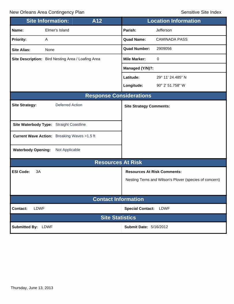
New Orleans Area Contingency Plan Sensitive Site Index
Response Considerations
Resources At Risk
Contact Information
Site Statistics
Resources At Risk Comments:
Nesting Terns and Wilson's Plover (species of concern)
Contact: LDWF Special Contact: LDWF
Submitted By: LDWF Submit Date: 5/16/2012
Site Strategy: Deferred Action Site Strategy Comments:
Site Waterbody Type: Straight Coastline
Current Wave Action: Breaking Waves >1.5 ft
Waterbody Opening: Not Applicable
ESI Code: 3A
Priority: A
Name: Elmer's Island
Site Alias: None
Site Description: Bird Nesting Area / Loafing Area
Parish: Jefferson
Quad Name: CAMINADA PASS
Quad Number: 2909056
Mile Marker: 0
Managed (Y/N)?:
Latitude: 29° 11' 24.485" N
Longitude: 90° 2' 51.758" W
Site Information: Location InformationText416:A12
Thursday, June 13, 2013

New Orleans Area Contingency Plan Sensitive Site Index
Response Considerations
Resources At Risk
Contact Information
Site Statistics
Resources At Risk Comments:
Sensitive Bird Habitat
Contact: Special Contact:
Submitted By: Jefferson Parish - Env Aff. Submit Date: 4/24/2012
Site Strategy: Deferred Action Site Strategy Comments:
Site Waterbody Type: Straight Coastline
Current Wave Action: Breaking Waves >1.5 ft
Waterbody Opening: Not Applicable
ESI Code: 3A
Priority: A
Name: Unnamed Gulf Facing Beaches
Site Alias: None
Site Description: Sensitive Wildlife Habitat
Parish: Jefferson
Quad Name: CAMINADA PASS
Quad Number: 2909056
Mile Marker:
Managed (Y/N)?: No
Latitude: 29° 11' 5.725" N
Longitude: 90° 3' 29.594" W
Site Information: Location InformationText416:A13
Thursday, June 13, 2013

New Orleans Area Contingency Plan Sensitive Site Index
Response Considerations
Resources At Risk
Contact Information
Site Statistics
Resources At Risk Comments:
Sensitive Habitat
Contact: Special Contact:
Submitted By: Jefferson Parish - Env Aff. Submit Date: 4/24/2012
Site Strategy: Deferred Action Site Strategy Comments:
Site Waterbody Type: Entrance to Bays, etc
Current Wave Action: Breaking Waves >1.5 ft
Waterbody Opening: 500-1000 ft
ESI Code: 3A
Priority: A
Name: Bayou Thunder
Site Alias: None
Site Description: Tidal Inlet / Sensitive Habitat
Parish: Jefferson
Quad Name: CAMINADA PASS
Quad Number: 2909056
Mile Marker:
Managed (Y/N)?: No
Latitude: 29° 9' 54.030" N
Longitude: 90° 5' 17.264" W
Site Information: Location InformationText416:A14
Thursday, June 13, 2013
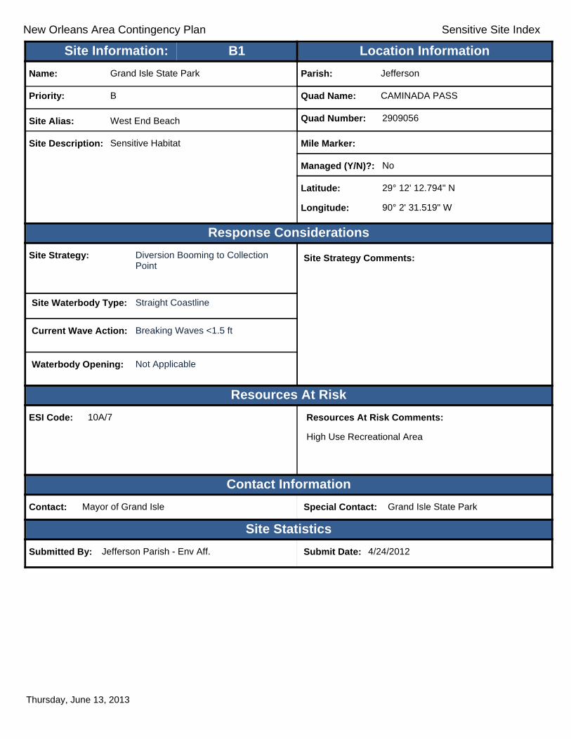
New Orleans Area Contingency Plan Sensitive Site Index
Response Considerations
Resources At Risk
Contact Information
Site Statistics
Resources At Risk Comments:
High Use Recreational Area
Contact: Mayor of Grand Isle Special Contact: Grand Isle State Park
Submitted By: Jefferson Parish - Env Aff. Submit Date: 4/24/2012
Site Strategy: Diversion Booming to Collection Point
Site Strategy Comments:
Site Waterbody Type: Straight Coastline
Current Wave Action: Breaking Waves <1.5 ft
Waterbody Opening: Not Applicable
ESI Code: 10A/7
Priority: B
Name: Grand Isle State Park
Site Alias: West End Beach
Site Description: Sensitive Habitat
Parish: Jefferson
Quad Name: CAMINADA PASS
Quad Number: 2909056
Mile Marker:
Managed (Y/N)?: No
Latitude: 29° 12' 12.794" N
Longitude: 90° 2' 31.519" W
Site Information: Location InformationText416:B1
Thursday, June 13, 2013

New Orleans Area Contingency Plan Sensitive Site Index
Response Considerations
Resources At Risk
Contact Information
Site Statistics
Resources At Risk Comments:
Barrier Island Restoration
Contact: Special Contact:
Submitted By: LA CPRA Submit Date: 6/28/2012
Site Strategy: Deferred Action Site Strategy Comments:
Site Waterbody Type: Straight Coastline
Current Wave Action: Breaking Waves >1.5 ft
Waterbody Opening: Not Applicable
ESI Code: 3A
Priority: C
Name: Belle Pass to Caminada Pass Barrier Islan
Site Alias: None
Site Description: Beach, dune, and Back-barrier marsh platform
Parish: Jefferson
Quad Name: CAMINADA PASS
Quad Number: 2909056
Mile Marker:
Managed (Y/N)?:
Latitude: 29° 11' 31.247" N
Longitude: 90° 2' 48.364" W
Site Information: Location InformationText416:C1
Thursday, June 13, 2013

New Orleans Area Contingency Plan
Geographic Response Plan- Jefferson Parish
This page is intentionally left blank

!
!
!
Gulf ofMexico
Bay desIlettes
ST1GrandGrandIsleIsle
CAMI
NADA
PASS
GRAN
D IS
LE
GRAN
D IS
LESO
UTH
OF B
AY R
ONQU
ILLE
GRAND ISLEBARATARIA PASS
C1
B1
A1
JeffersonParish
PlaqueminesParish
89°52'30"W
89°52'30"W
90°0'0"W
90°0'0"W
29°15
'0"N
29°15
'0"N
29°7'
30"N
29°7'
30"N
±0 1 2 30.5
Miles
GRAND ISLE Quad
MetairieMetairieLafayetteLafayette
Baton RougeBaton Rouge
New OrleansNew Orleans
§̈¦12§̈¦55
§̈¦310
§̈¦110
§̈¦10
LOUISIANALOUISIANA
Gulf of Mexico
Legend! GRP Sites
Quad BoundaryParish Boundaries
0 1 2 30.5Kilometers
Locator MapLocator Map
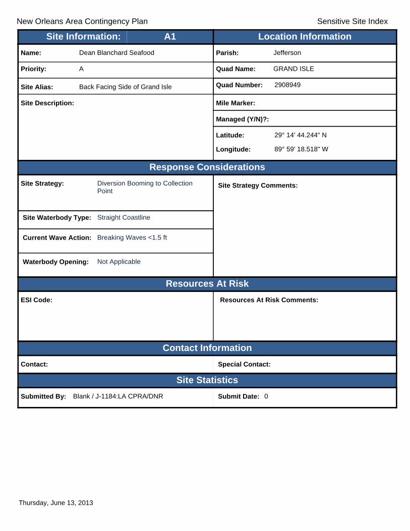
New Orleans Area Contingency Plan Sensitive Site Index
Response Considerations
Resources At Risk
Contact Information
Site Statistics
Resources At Risk Comments:
Contact: Special Contact:
Submitted By: Blank / J-1184:LA CPRA/DNR Submit Date: 0
Site Strategy: Diversion Booming to Collection Point
Site Strategy Comments:
Site Waterbody Type: Straight Coastline
Current Wave Action: Breaking Waves <1.5 ft
Waterbody Opening: Not Applicable
ESI Code:
Priority: A
Name: Dean Blanchard Seafood
Site Alias: Back Facing Side of Grand Isle
Site Description:
Parish: Jefferson
Quad Name: GRAND ISLE
Quad Number: 2908949
Mile Marker:
Managed (Y/N)?:
Latitude: 29° 14' 44.244" N
Longitude: 89° 59' 18.518" W
Site Information: Location InformationText416:A1
Thursday, June 13, 2013

New Orleans Area Contingency Plan Sensitive Site Index
Response Considerations
Resources At Risk
Contact Information
Site Statistics
Resources At Risk Comments:
Public Beach, State Park
Contact: Mayor of Grand Isle Special Contact: Grand Isle State Park
Submitted By: Jefferson Parish - Env Aff. Submit Date: 4/24/2012
Site Strategy: Deferred Action Site Strategy Comments:
Site Waterbody Type: Straight Coastline
Current Wave Action: Breaking Waves >1.5 ft
Waterbody Opening: Not Applicable
ESI Code: 3A
Priority: B
Name: Grand Isle
Site Alias: Grand Isle Beach (State Park)
Site Description: High use Recreational Site
Parish: Jefferson
Quad Name: GRAND ISLE
Quad Number: 2908949
Mile Marker:
Managed (Y/N)?: No
Latitude: 29° 14' 27.374" N
Longitude: 89° 58' 36.894" W
Site Information: Location InformationText416:B1
Thursday, June 13, 2013
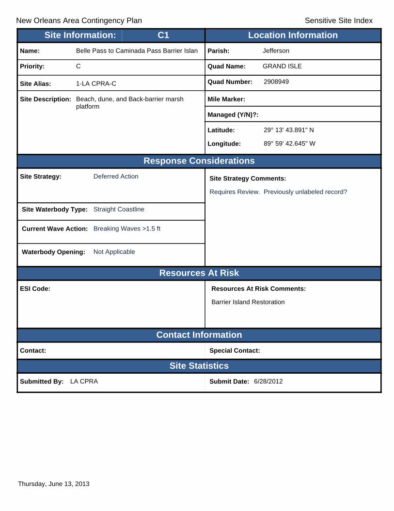
New Orleans Area Contingency Plan Sensitive Site Index
Response Considerations
Resources At Risk
Contact Information
Site Statistics
Resources At Risk Comments:
Barrier Island Restoration
Contact: Special Contact:
Submitted By: LA CPRA Submit Date: 6/28/2012
Site Strategy: Deferred Action Site Strategy Comments:
Requires Review. Previously unlabeled record?
Site Waterbody Type: Straight Coastline
Current Wave Action: Breaking Waves >1.5 ft
Waterbody Opening: Not Applicable
ESI Code:
Priority: C
Name: Belle Pass to Caminada Pass Barrier Islan
Site Alias: 1-LA CPRA-C
Site Description: Beach, dune, and Back-barrier marsh platform
Parish: Jefferson
Quad Name: GRAND ISLE
Quad Number: 2908949
Mile Marker:
Managed (Y/N)?:
Latitude: 29° 13' 43.891" N
Longitude: 89° 59' 42.645" W
Site Information: Location InformationText416:C1
Thursday, June 13, 2013
New Orleans Area Contingency Plan Geographic Response Plan- Jefferson Parish
Appendix A: Original GRP ContributorsBob Darcy Jefferson Parish Haz Mat
Brady Carter Coastal Protection and Restoration Authority
Brett Todd Jefferson Parish Sewerage
Brooklyn Susic U.S. Coast Guard
Cathy Woodruff OMI Environmental Services
Chance Greene U.S. Coast Guard
Chip McGimsey State Historic Preservation Officer
Danielle Wood U.S. Coast Guard
David Gisclair Louisiana Oil Spill Coordinators Office
DJ Garland Louisiana Department of Wildlife and Fisheries
Doug Dodt City of Kenner
Doug Pertoit Jefferson Parish Water
Doug Vincent Jefferson Parish Water
Fernando Terceros The Response Group
Heather Hillard Jefferson Parish President’s Office
Jason Smith Jefferson Parish Environmental
Jeff Dauzat Louisiana Department of Environmental Quality
Jeff Leonick Louisiana Department of Environmental Quality
John Hellmers City of Kenner Fire Department
Karolien Debusschere Louisiana Oil Spill Coordinators Office
Kathy Russo Jefferson Parish Environmental
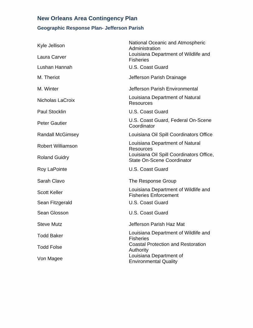
New Orleans Area Contingency Plan Geographic Response Plan- Jefferson Parish
Kyle Jellison National Oceanic and Atmospheric Administration
Laura Carver Louisiana Department of Wildlife and Fisheries
Lushan Hannah U.S. Coast Guard
M. Theriot Jefferson Parish Drainage
M. Winter Jefferson Parish Environmental
Nicholas LaCroix Louisiana Department of Natural Resources
Paul Stocklin U.S. Coast Guard
Peter Gautier U.S. Coast Guard, Federal On-Scene Coordinator
Randall McGimsey Louisiana Oil Spill Coordinators Office
Robert Williamson Louisiana Department of Natural Resources
Roland Guidry Louisiana Oil Spill Coordinators Office, State On-Scene Coordinator
Roy LaPointe U.S. Coast Guard
Sarah Clavo The Response Group
Scott Keller Louisiana Department of Wildlife and Fisheries Enforcement
Sean Fitzgerald U.S. Coast Guard
Sean Glosson U.S. Coast Guard
Steve Mutz Jefferson Parish Haz Mat
Todd Baker Louisiana Department of Wildlife and Fisheries
Todd Folse Coastal Protection and Restoration Authority
Von Magee Louisiana Department of Environmental Quality

New Orleans Area Contingency Plan Geographic Response Plan- Jefferson Parish
Appendix B: GRP Comments/Corrections/Suggestions If you have any questions regarding this document or find any errors, please notify one of the following agencies:
• U.S. Coast Guard Sector New Orleans Contingency Planning • Louisiana State Oil Spill Coordinators Office
Phone numbers: (504) 365-2102 Internet/E-mail Address: [email protected] Address: Commander U.S. Coast Guard Sector New Orleans 200 Hendee Street New Orleans, LA 70114 Attn: Planning, ACP
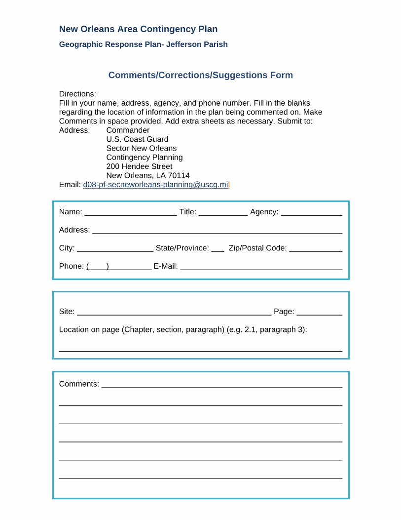
New Orleans Area Contingency Plan Geographic Response Plan- Jefferson Parish
Comments/Corrections/Suggestions Form Directions: Fill in your name, address, agency, and phone number. Fill in the blanks regarding the location of information in the plan being commented on. Make Comments in space provided. Add extra sheets as necessary. Submit to: Address: Commander U.S. Coast Guard Sector New Orleans Contingency Planning 200 Hendee Street New Orleans, LA 70114 Email: [email protected] Name: Title: Agency: Address: City: State/Province: Zip/Postal Code: Phone: ( ) E-Mail: Site: Page: Location on page (Chapter, section, paragraph) (e.g. 2.1, paragraph 3): Comments:

New Orleans Area Contingency Plan Geographic Response Plan- Jefferson Parish
This page is intentionally left blank
![Winter Contingency Plan 2019 - PDMA Contingency... · 2020. 12. 24. · [KHYBER PAKHTUNKHWA WINTER CONTINGENCY PLAN 2019-20] Winter Contingency Plan 5 | Page utilizing PAF strategic](https://static.fdocuments.in/doc/165x107/611400065caf3c03a80f7591/winter-contingency-plan-2019-pdma-contingency-2020-12-24-khyber-pakhtunkhwa.jpg)