New Occurrences of Late Paleozoic and Triassic Fossils ... › pp › 1678 › pdf ›...
26
Studies by the U.S. Geological Survey in Alaska, 2001 U.S. Geological Survey Professional Paper 1678 New Occurrences of Late Paleozoic and Triassic Fossils from the Seventymile and Yukon-Tanana Terranes, East-Central Alaska, with Comments on Previously Published Occurrences in the Same Area Abstract The discovery of several new fossil occurrences of late Paleozoic conodonts and radiolarians in the Seventymile and Yukon-Tanana terranes, and of Late Triassic conodonts in the Seventymile terrane in east-central Alaska, has prompted a reevaluation of other late Paleozoic and Triassic fossils reported from the same areas. The report, in 1995, of giant parafusulinids in the Seventymile terrane within the same stratigraphic interval that more than 20 years before produced poorly preserved Permian brachiopods helped to place these beds in the middle Guadalupian and to position the terrane at tropical to subtropical latitudes near ancestral North America during the Middle Permian. The Seventymile terrane in Alaska is equivalent to the Slide Mountain terrane in Canada; both terranes are oceanic assemblages composed of fault-bounded slices of serpentinized peridotite, weakly metamorphosed mafic volcanic rocks, and Mississippian to Upper Triassic sedimentary rocks. A more southerly Permian paleolatitude for the Slide Mountain terrane also is suggested by faunal data and by paleomagnetic data from the Sylvester Allochthon in northern and central British Columbia. Although general agreement exists that the Seventymile-Slide Mountain terrane represents a basin floored by oceanic crust off the western margin of ancestral North America, the original width of the ocean basin is disputed. Our Permian faunal data are consis- tent with formation of the basin in either a narrow ocean that was depositionally tied to ancestral North America, or a wider Paleozoic Pacific ocean adjacent to a rifted continental frag- ment. Late Carnian and early Norian (Late Triassic) conodonts occur in weakly metamorphosed sedimentary rocks of the Seventymile terrane in the Fortymile River area of east-central Alaska and are widespread in the Canadian Cordillera and in central and southeastern Alaska. It was previously proposed that Middle(?) and Upper Triassic siliciclastic-carbonate strata of the Sylvester Allochthon represent an overlap sequence which loosely links North America and the Slide Mountain terrane. Considerable uncertainty exists, however, regarding the original contact between the Upper Triassic rocks and By Cynthia Dusel-Bacon and Anita G. Harris both oceanic rocks of the Seventymile and Slide Mountain terranes and continental-margin rocks of the Yukon-Tanana terrane and ancestral North America. Therefore, we interpret the wide distribution of Late Triassic conodonts in the various allochthonous terranes and in the North American continental margin as indicating that these areas shared approximately similar warm, normal-marine conditions along the Late Trias- sic continental margin but not that they represent an overlap assemblage, in the sense of draping across contacts between outboard allochthonous pericratonic and arc fragments and the ancient Pacific margin. Introduction The Yukon-Tanana Upland of east-central Alaska is composed of fault-bounded assemblages of ductilely deformed Proterozoic(?) and Paleozoic metasedimentary and middle Paleozoic metaigneous rocks that are intruded by synkinematic to postkinematic Late Triassic and Early Jurassic granitoids and postkinematic Cretaceous and Tertiary granitoids (figs. 1–3). The ductilely deformed rocks are tectonically overlain by weakly metamorphosed oceanic igneous rocks and associated Paleozoic and Triassic sedimentary rocks of the Seventymile terrane and are stratigraphically overlain by Cretaceous and Tertiary volcanic rocks (Foster, 1992; Foster and others, 1994). The ages and origins of the various fault-bounded assemblages of metamorphic rocks, and their relation to each other and to the western continental margin of North America, are uncer- tain, largely owing to inadequate paleontologic age control. Fossil occurrences are few and far between in the weakly metamorphosed late Paleozoic and Triassic rocks of the Seven- tymile terrane and even more unusual in the underlying, more recrystallized and ductilely deformed assemblages. Some of the fossil localities we describe below have not been reported previously because the fossils, chiefly microfossils, are too poorly preserved to provide more than a generalized age assignment. In large areas of metamor- phosed bedrock, however, such as those that make up much
Transcript of New Occurrences of Late Paleozoic and Triassic Fossils ... › pp › 1678 › pdf ›...

Studies by the U.S. Geological Survey in Alaska, 2001U.S. Geological Survey Professional Paper 1678
New Occurrences of Late Paleozoic and Triassic Fossils from the Seventymile and Yukon-Tanana Terranes, East-Central Alaska, with Comments on Previously Published Occurrences in the Same Area
AbstractThe discovery of several new fossil occurrences of late
Paleozoic conodonts and radiolarians in the Seventymile and Yukon-Tanana terranes, and of Late Triassic conodonts in the Seventymile terrane in east-central Alaska, has prompted a reevaluation of other late Paleozoic and Triassic fossils reported from the same areas. The report, in 1995, of giant parafusulinids in the Seventymile terrane within the same stratigraphic interval that more than 20 years before produced poorly preserved Permian brachiopods helped to place these beds in the middle Guadalupian and to position the terrane at tropical to subtropical latitudes near ancestral North America during the Middle Permian. The Seventymile terrane in Alaska is equivalent to the Slide Mountain terrane in Canada; both terranes are oceanic assemblages composed of fault-bounded slices of serpentinized peridotite, weakly metamorphosed mafic volcanic rocks, and Mississippian to Upper Triassic sedimentary rocks. A more southerly Permian paleolatitude for the Slide Mountain terrane also is suggested by faunal data and by paleomagnetic data from the Sylvester Allochthon in northern and central British Columbia. Although general agreement exists that the Seventymile-Slide Mountain terrane represents a basin floored by oceanic crust off the western margin of ancestral North America, the original width of the ocean basin is disputed. Our Permian faunal data are consis-tent with formation of the basin in either a narrow ocean that was depositionally tied to ancestral North America, or a wider Paleozoic Pacific ocean adjacent to a rifted continental frag-ment. Late Carnian and early Norian (Late Triassic) conodonts occur in weakly metamorphosed sedimentary rocks of the Seventymile terrane in the Fortymile River area of east-central Alaska and are widespread in the Canadian Cordillera and in central and southeastern Alaska. It was previously proposed that Middle(?) and Upper Triassic siliciclastic-carbonate strata of the Sylvester Allochthon represent an overlap sequence which loosely links North America and the Slide Mountain terrane. Considerable uncertainty exists, however, regarding the original contact between the Upper Triassic rocks and
By Cynthia Dusel-Bacon and Anita G. Harris
both oceanic rocks of the Seventymile and Slide Mountain terranes and continental-margin rocks of the Yukon-Tanana terrane and ancestral North America. Therefore, we interpret the wide distribution of Late Triassic conodonts in the various allochthonous terranes and in the North American continental margin as indicating that these areas shared approximately similar warm, normal-marine conditions along the Late Trias-sic continental margin but not that they represent an overlap assemblage, in the sense of draping across contacts between outboard allochthonous pericratonic and arc fragments and the ancient Pacific margin.
IntroductionThe Yukon-Tanana Upland of east-central Alaska is
composed of fault-bounded assemblages of ductilely deformed Proterozoic(?) and Paleozoic metasedimentary and middle Paleozoic metaigneous rocks that are intruded by synkinematic to postkinematic Late Triassic and Early Jurassic granitoids and postkinematic Cretaceous and Tertiary granitoids (figs. 1–3). The ductilely deformed rocks are tectonically overlain by weakly metamorphosed oceanic igneous rocks and associated Paleozoic and Triassic sedimentary rocks of the Seventymile terrane and are stratigraphically overlain by Cretaceous and Tertiary volcanic rocks (Foster, 1992; Foster and others, 1994). The ages and origins of the various fault-bounded assemblages of metamorphic rocks, and their relation to each other and to the western continental margin of North America, are uncer-tain, largely owing to inadequate paleontologic age control. Fossil occurrences are few and far between in the weakly metamorphosed late Paleozoic and Triassic rocks of the Seven-tymile terrane and even more unusual in the underlying, more recrystallized and ductilely deformed assemblages.
Some of the fossil localities we describe below have not been reported previously because the fossils, chiefly microfossils, are too poorly preserved to provide more than a generalized age assignment. In large areas of metamor-phosed bedrock, however, such as those that make up much

6 Studies by the U.S. Geological Survey in Alaska, 2001 New Occurrences of Late Paleozoic and Triassic Fossils from the Seventymile and Yukon-Tanana Terranes, East-Central Alaska 7
of east-central Alaska, the announcement of any fossil find could encourage other workers to sample for microfossils that might, in turn, produce more biostratigraphically useful data. Since the late 1990s, late Paleozoic and Triassic conodonts have been reported from several new localities south of the Tintina Fault system in the Charley River, Eagle, and Big Delta quadrangles. We present these data here for the first time. In addition, we summarize information on previously published fossils of the same or similar age, terrane, and broad geographic area as our new occurrences, so that all the data are presented together.
Regional Geologic SettingThe ductilely deformed assemblages of the Yukon-Tanana
Upland, together with the granitoids that intrude them and the structurally juxtaposed oceanic rocks of the Seventymile ter-rane, occupy a suspect position in the northern Cordillera: the assemblages are fault bounded along most of their length and lie between autochthonous or slightly displaced North American strata and outboard allochthonous terranes (fig. 1). The ductilely deformed rocks were originally grouped as a single terrane, the Yukon-Tanana terrane, by Jones and others (1987) and Monger and Berg (1987) but were subsequently subdivided on the basis of differences in the composition and origin of protoliths and in the structural and metamorphic histories of their components (for example, Foster and others, 1985; Nokleberg and others, 1989; Hansen and others, 1991; Dusel-Bacon and others, 1995; Hansen and Dusel-Bacon, 1998; Dusel-Bacon and Cooper, 1999). In this chapter, we use the subdivision (assemblage) terminology of Dusel-Bacon and others (2002). Part of the Yukon-Tanana terrane, as originally defined, has been dextrally offset approximately 450 km by the Tintina Fault system (fig. 1), during Late Cretaceous through Eocene time (Roddick, 1967; Tempelman-Kluit, 1979).
The structurally lowest rocks exposed in the Alaskan part of the Yukon-Tanana Upland are the Lake George assemblage of Dusel-Bacon and Cooper (1999) and the undivided Fair-banks schist of Robinson and others (1990) and Chena River sequence of Smith and others (1994) (fig. 2); both of these units consist of amphibolite-facies orthogneiss (including bodies of augen gneiss), felsic and mafic schist and gneiss, and lesser amounts of pelitic schist, quartzite, and marble. Although no fossils have been found in the units, U-Pb dating of zircons from the metaigneous rocks indicate Middle and Late Devonian crystallization ages for their igneous protoliths (Dusel-Bacon and Aleinikoff, 1996; Dusel-Bacon and others, 2001). Depositional ages for the metasedimentary rocks that are assumed to be intruded by the protoliths of these metaigne-ous rocks are therefore Devonian or earlier.
Overlying the above-described amphibolite-facies assem-blage is a sequence of greenschist-facies, quartz-rich clastic metasedimentary rocks, mafic and felsic metavolcanic rocks, and marble that we assign to the Nisutlin assemblage of Han-sen and Dusel-Bacon (1998) (figs. 1, 2). The Nisutlin assem-
blage consists of a lower sequence of rocks characterized by carbonaceous quartzite and calc-phyllite (equivalent to the Nasina assemblage of Wheeler and McFeely, 1991); an upper sequence characterized by quartz-eye semischist, white-mica phyllite, quartzite, marble, and bimodal metavolcanic rocks (Foster and others, 1994); and, locally, Permian metavolcanic rocks. Devonian and Mississippian U-Pb zircon protolith ages have been determined for felsic metavolcanic rocks in both the upper (semischist) sequence and the lower (carbonaceous) sequence in east-central Alaska (Foster, 1992; Dusel-Bacon and others, 1993, 1998; Smith and others, 1994) and the Yukon Territory, Canada (Mortensen, 1992). Permian felsic metavol-canic rocks occur in association with carbonaceous rocks north of the Fortymile River, just west of the Alaska-Yukon Territory border (fig. 3; Dusel-Bacon and others, 1998). These Perm-ian rocks presumably are equivalent to the Klondike Schist of Mortensen (1988) that crops out along the Top-of-the-World Highway to the south (fig. 3).
In most areas, the contact between the greenschist-facies Nisutlin assemblage and adjacent amphibolite-facies assem-blages has been interpreted as a low-angle fault (for example, Pavlis and others, 1993; Foster and others, 1994; Hansen and Dusel-Bacon, 1998), but given the limited bedrock exposure in the region, a gradational stratigraphic contact, as proposed by Smith and others (1994) for the upper Chena River area (near lat 65° N., long 145° W., fig. 2), cannot be ruled out for at least some localities.
In the eastern part of the Yukon-Tanana Upland (fig. 3), the Nisutlin assemblage is overlain by amphibolite-facies garnet amphibolite, biotite±hornblende±garnet gneiss and schist, marble, quartzite, metachert, and pelitic schist (Foster, 1976; Hansen and others, 1991), as well as by small bodies of tonalitic orthogneiss (Day and others, 2000; Szumigala and others, 2000). The rocks were previously referred to as the Taylor Mountain assemblage (Hansen and others, 1991; Dusel-Bacon and others, 1995) but are now referred to as the Fortymile River assemblage (figs. 2, 3; see Dusel-Bacon and others, 2002, and for an explanation of this terminologic change). A Paleozoic protolith age for at least part of the layered metamorphic sequence was proposed by Foster (1976) on the basis of a few poorly preserved crinoid columnals in marble. An Early Mississippian or older age for at least some of the Fortymile River assemblage is indicated by a U-Pb zircon crystallization age of 343±4 Ma determined for tonalitic orthogneiss that presumably intrudes the adjacent schist and gneiss (Day and others, 2002).
The structurally highest rocks that crop out in the central and eastern parts of the Yukon-Tanana Upland (figs. 2, 3) are part of a belt of fault-bounded slices of varyingly serpentinized peridotite; weakly metamorphosed mafic volcanic rocks, including pillowed greenstone; and Mississippian to Upper Triassic sedimentary rocks. This assemblage is partly inter-preted as a dismembered ophiolite (Foster and others, 1994). These oceanic rocks, which are included in the Seventymile terrane in Alaska, are generally considered to be equivalent to the Slide Mountain terrane in Canada, as proposed by Harms

6 Studies by the U.S. Geological Survey in Alaska, 2001 New Occurrences of Late Paleozoic and Triassic Fossils from the Seventymile and Yukon-Tanana Terranes, East-Central Alaska 7
Figure 1 is a geologic map of the area of the northern Canadian and Alaskan Cordillera, including the area of figure 2, which extends from about latitude 63 to 66 degrees north and from longitude 141 to 148 degrees west. The map area covers parts of eastern Alaska, the central and southern Yukon Territory, and northern British Columbia, Canada. At the southeast edge of the map is the Denali Fault, and at the north and northeast edge is the Mackenzie Fold and Thrust Belt. The map area is mainly covered by units of the various terranes in two belts: the Overthrust belt, which includes the Seventymile-Slide Mountain terrane, the Chatanika assemblage of Hanson and Dusel-Bacon (1998), Teslin-Taylor Mountain (Fortymile River assemblage of Dusel-Bacon and others, 2002), and the Nisutlin assemblage of Hanson and Dusel-Bacon (1998); and the Underthrust belt, which includes the orthogneiss assemblage and inboard, parautochthonous terranes and the North American continental margin. Other units are Cretaceous granite, outboard, allochthonous terranes, and eclogite and blueschist. Caption follows…
����������
� ��� �����
��
��
��
��
����
��
��
��
��
��
��
�������� �����
��������� ����
���
������
����
���� ���
�����
������
�����
��������
�
�������
��������
���
���
��
��
��
��
�����������
���� �����
���������������
������������
����
���� ������ �
������ �����
�������������������
����
�������� ��� ����������������� ��� ������� �����
���
���
����
���
�
��
���
����
���
������������� �������
����������������� ����������������������� �����
��������� ���������� �� ������ �������������� ���������������� ���������� ������� ������ ��������� �������
�������� ���������� �� ������ ��� ����������� ���������������� ��������������� ��������� ��������������� ����� ������������ �������������� ���������� ������������ �������������� ������
����������� ���������������������������� ������� ������������ ��� ��������������������� �������� ��� ������������������ ������ ����������������������� ����� ������������������� �������
������������� �������� ���������� ��������������� �� ����������� ��� ������������������ �� ������������������������������� ������� ������� ������������� �������� ��� ����� �������� �������������� ��� �������� ������
�������� ���������������� ����������� ��� ����� �������� ����������������� ������
�����������
��������� ���������������������
Figure 1. Simplified terrane and tectonic assemblage map of northern Canadian and Alaskan Cordillera (modified from Hansen and others, 1991, and Dusel-Bacon and Cooper, 1999). Abbreviations in terrane map: Towns: Ds, Dawson; Fb, Fairbanks; Rr, Ross River; Sk, Skagway; Wh, Whitehorse. Terranes: Ca, Cassiar; Cc, Cache Creek; Do, Dorsey; Ns, Nisling; Qs, Quenellia; St, Stikinia; TSZ, Teslin suture zone. Unlabeled area surrounding Fairbanks is alluvium of the Tanana River Valley; unlabeled area adjacent to north side of the Denali Fault in Alaska comprises various terranes not discussed in this chapter. Tertiary granitoids not shown. The Yukon-Tanana Upland physiographic province in Alaska includes all the area north of the Tanana River Valley; units above that are included in the broadly defined Yukon-Tanana terrane are the Chatinika assemblage of Hansen and Dusel-Bacon (1998) (equivalent to unit ec of Foster and others, 1994), the Fortymile River assemblage of Dusel-Bacon and others (2002), the Nisutlin assemblage of Hansen and Dusel-Bacon (1998), and the orthogneiss assemblage of Hansen and Dusel-Bacon (1998).

8 Studies by the U.S. Geological Survey in Alaska, 2001 New Occurrences of Late Paleozoic and Triassic Fossils from the Seventymile and Yukon-Tanana Terranes, East-Central Alaska 9
Figure 2 is a geologic map of east-central Alaska, extending from about latitude 63 to 65 degrees north and from longitude 141 to 148 degrees west. The locations of conodont sample localities 6 through 10 are shown in the northeastern corner of the map (the locations of conodont sample localities 1 through 5 are shown in figure 3). The map area is covered by surficial deposits, postmetamorphic granitoids, and sedimentary and (or) volcanic rocks. Other units are divided into structurally higher rocks—the Chatanika assemblage, the Seventymile terrane, the Fortymile assemblage of Dusel-Bacon and others (2002), and the Nisutlin assemblage of Hanson and Dusel-Bacon (1998)—and structurally lower rocks—the undivided Fairbanks schist of Robinson and others (1990) and Chena River sequence of Smith and others (1994), and the Lake George assemblage of Dusel-Bacon and Cooper (1999). Caption follows…
Tok
Big Delta
TaylorMountain
FAULT
Sou
th F
k
Eagle
TINTINA
Salcha Rivergneissdome
Area of fig. 3
Fairbanks
0 30
KILOMETERS
10 20
?
?
? ?
Surficial deposits (Quaternary)
Postmetamorphic granitoids (Tertiary)
Postmetamorphic granitoids (Cretaceous)
Sedimentary and (or) volcanic rocks (Tertiary and Cretaceous)
EXPLANATION
STRUCTURALLY HIGHER ROCKS
Eclogite, marble, and pelitic schist—Chatanika assemblage
Peridotite, greenstone, metalimestone, metachert, and Mississippian to Triassic low-grade metasedimentary rocks—Seventymile terrane
Greenschist-facies schist, quartzite, mylonitic schist, phyllite, marble, and Devonian, Mississippian, and Permian metavolcanic rocks—Nisutlin assemblage of Hansen and Dusel-Bacon (1998)
Intermediate-composition granitoids (Early Jurassic and Late Triassic)
Amphibolite-facies gneiss, amphibolite, marble, quartzite, and metachert—Fortymile River assemblage of Dusel-Bacon and others (2002)
Amphibolite-facies pelitic schist, quartzite, marble, and amphibolite—undivided Fairbanks schist of Robinson and others (1990) and Chena River sequence of Smith and others (1994)
Amphibolite-facies Devonian and Mississippian augen gneiss (shown by pattern), pelitic schist, amphibolite, and quartzite—Lake George assemblage of Dusel-Bacon and Cooper (1999)
STRUCTURALLY LOWER ROCKS
Yuko
n-Ta
nana
terr
ane
Contact
Strike-slip fault—Arrows show direction of relative movement; dotted where concealed
Thrust fault—Sawteeth on upper plate; queried where uncertainLow-angle normal fault—Sawteeth on upper plate; dotted where concealed
Major river
Major town
Conodont sample locality8
Fork
Mosquito D
enison Fork
Tanana River
Salcha River
Fortymile River
Y ukonRiver
Mid
dle
Fork
SHAW CREEK FAULT
North Fork
810
69
(locs. 1-5)
7
144°00'
63°00'
141°00'
63°00'
65°00'
141°00'142°30'144°00'
147°00'
65°00'
64°00'
147°00'
148°00'
148°00'145°30'
Figure 2. Generalized geologic map of east-central Alaska, showing fossil localities in the Seventymile and Yukon-Tanana terranes. Geology from Foster (1992) and Dusel-Bacon and others (1993, 2002). Unpatterned areas are Late Proterozoic to Cambrian and Devonian sedi-mentary rocks north of the Tintina Fault, and Quaternary surficial deposits elsewhere.

8 Studies by the U.S. Geological Survey in Alaska, 2001 New Occurrences of Late Paleozoic and Triassic Fossils from the Seventymile and Yukon-Tanana Terranes, East-Central Alaska 9
Figure 3 is a generalized geologic map of eastern Alaska, extending from about latitude 64 degrees to 64 degrees 40 minutes north and from longitude 140 degrees 30 minutes to 142 degrees 30 minutes west. The locations of conodont sample localities 1 through 5 are also shown. The map area is covered by various units: unmetamorphosed volcanic and sedimentary rocks, postmetamorphic granitoids, synmetamorphic to postmetamorphic granitoids, and three groups: the Seventymile terrane of serpentinized peridotite, greenstone, diabase, metalimestone, metachert, and argillite and sandstone; the Fortymile River assemblage of amphibolite-facies biotite-hornblende gneiss, amphibolite, marble, and metachert, and granodioritic orthogneiss; and the Nisutlin assemblage, consisting of the Klondike Schist of Mortensen (1988), quartz-chlorite-muscovite±calcite schist, micaceous quartzite, and marble, the Nasina assemblage of Wheeler and McFeely (1991), and the Chicken Metamorphic Complex of Werdon and others (2001). Caption follows…
Figure 3. Generalized geologic map of eastern Alaska, showing fossil localities in the Fortymile River area (modified from Foster, 1976, 1992, and Mortensen, 1988). Units included in the broadly defined Yukon-Tanana terrane are the Fortymile River assemblage of Dusel-Bacon and others (2002), the Nisutlin assemblage of Hansen and Dusel-Bacon (1998), and the Chicken Metamorphic Complex of Werdon and others (2001).
���
��
��
������ ����
��������������� ���������� ������������
��������������� �������� ��� ����������� ����� ��������� ��� �����������
������������� ����������
����������� �������� ������������� ���������� �������� ��� ��������������� ��� ���������
��������� ��� �������������
������������������ ������������������ ������� ������������ ������ ���������������� ���� ������������� ���������
������������� ����������� ������ ��������������
���������������������������������� ������ ������������������ ������ �� ��������� ������
��������������������������������� ������� ��������� ���������� ��� ������ ���������������
������������ ���������� ������������������ ������� ��� ������ �������������� ��� �������������������������� �� ������� ��� ������� ������
�������������� �� ��������������� ���������� ������ �������� ��� ���� ���������
������������������ ��������������� ��� ����������� ����� ��������� ��� ����������������������������� ������� �� ������ ��� ������ ������
������ ������ �������� �� ����� ������ ������� ����� ���������
��������
������� ����� ������������ ������ ���������
�
��������� ����� ����������
����������� ������ ������������� ������
����������� �������
�����������
�������� ����������
�
�
�������
� ��������
��� �����
�����
�
�������� ����� ������� ����
��� �� ��� ����������
��
����������
����� �����
������������
��
�
��
��
��
��������� �����
�������� �����
������� �������
������
�������
������
��
�
��
��
��
�����
�
�
�
�

10 Studies by the U.S. Geological Survey in Alaska, 2001 New Occurrences of Late Paleozoic and Triassic Fossils from the Seventymile and Yukon-Tanana Terranes, East-Central Alaska 11
and others (1984). Rocks of the Seventymile terrane are low grade, not penetratively deformed, and structurally overlie (in east-central Alaska; Foster, 1992) or are imbricated with (in the Yukon Territory, Canada; Mortensen, 1990) rocks of the Nisutlin or Fortymile River assemblage (fig. 3).
In the northwestern part of the Yukon-Tanana Upland, klippen of continental-margin metamorphic rocks, includ-ing marble and pelitic schist, locally contain occurrences of high-pressure and high-temperature eclogite (Dusel-Bacon and others, 1989). These klippen, referred to as the Chatanika assemblage (terminology of Hansen and Dusel-Bacon, 1998; equivalent to unit ec of Foster and others, 1994), were thrust over rocks of the undivided Fairbanks schist-Chena River sequence (figs. 1, 2).
Microfossils
Conodonts
Conodonts are one of the major biostratigraphic indices for marine rocks of latest Cambrian through Triassic age. They can be mechanically and chemically concentrated from various unmetamorphosed clastic and carbonate rock types (Harris and Sweet, 1989). Their extraction from low- to medium-grade metamorphic rocks is mostly limited to meta-limestone, metadolostone, marble, and metachert (Rejebian and others, 1987). Conodonts, which can be freed from chert by using the same technique as for radiolarian extraction (Harris and Sweet, 1989), are commonly a paleontologic bonus in radiolarian chert residues. Conodonts are also the microfossils of choice in metamorphosed carbonate areas where other fossil groups are unlikely to be preserved well enough for other than generalized age assignment. The con-odont localities discussed below are mainly from very low grade to low-grade metamorphosed carbonate and unmeta-morphosed biosiliceous rocks.
Late Triassic Conodonts in East-Central Alaska
Locality 1Relatively abundant conodonts were recovered from
an approximately 10-ft-thick core interval (731.6–741.1-ft interval of diamond-drill hole LC–7, fig. 4) of locally recrys-tallized, slightly pyritic, gray-and-black carbonaceous quartz-ose limestone of the Seventymile terrane that was drilled by WGM, Inc., on the Lead Creek property of Doyon Ltd. (see Dusel-Bacon, Mortensen, and Fredericksen, this volume) in the southwestern part of the Eagle C–1 quadrangle (loc. 1, fig. 3; table 1). The only other acid-resistant mineralized fossils from the core are phosphatized sponge fragments. All con-odonts in the collection are Pa elements (platform elements that in metapolygnathids and epigondolellids function as food shredders and grinders; pl. 1) except for one M element (pick-
shaped elements that likely grasped, pierced, and may also have shredded food). The conodonts are mostly incomplete and poorly preserved juveniles and subadults that probably represent post-mortem sorting during hydraulic transport. In this depositional setting, most of the adult Pa elements were probably left in lag concentrates in slightly higher energy environments, while the more delicate, lighter ramiform elements (serrated single-bladed to multibladed shredding elements) were likely carried into lower-energy environments as winnows. Some diagnostic features of the few relatively complete adult specimens in the collection (pl. 1) are partly to mostly obscured by annealed sand- to silt-size quartz grains and pyrite. Nearly all specimens are incomplete because of post-mortem transport from or within a relatively shallow water, high-energy, quartz-rich regime, a probable second interval of transport during redeposition of some or all of the conodonts, and later tectonic fracturing and minor attenuation. The conodonts have a color-alteration index (CAI; Epstein and others, 1977) of 5, indicating that they were subjected to a thermal regime that reached a temperature of at least 300°C. Although a mid-Cretaceous (96 Ma) felsic dike or sill that cuts low-grade metacarbonate and metasedimentary rocks of the Seventymile terrane 53 ft higher up in drill hole LC–7 (see Dusel-Bacon, Mortensen, and Fredericksen, this volume) likely supplied the latest heat to affect the conodonts, regional thrusting and emplacement of rocks of the Seventymile terrane during the early Mesozoic (Hansen and Dusel-Bacon, 1998; Dusel-Bacon and others, 2002) may also have been respon-sible for the elevated CAI value.
Four conodont species were identified in the Lead Creek collection: 1) Epigondolella quadrata Orchard (pl. 1, figs. 1–15), (2) Metapolygnathus nodosus (Hayashi), (3) M. primi-tius (Mosher) (pl. 1, figs. 16, 17), and (4) M. samueli Orchard (identified by M.J. Orchard, Geological Survey of Canada). Specimens of E. quadrata overwhelmingly dominate the col-lection; Metapolygnathus spp. It is represented by only one to a few specimens each (loc. 1, fig. 3; table 1). The Pa elements of most metapolygnathids and epigondolellids have a rela-tively coarsely ornate platform and a free blade that joins the platform in a central position. Similar Pa elements in Devonian and younger Paleozoic conodont faunas (for example, poly-gnathids and pseudopolygnathids of the Devonian and Early Mississippian) occupied warm, relatively shallow water, nor-mal-marine environments. The Lead Creek metapolygnathid and epigondolellid species and their taphonomy suggest deri-vation from a similar habitat.
Although all the conodont species from the Lead Creek core probably originated in similar environments, not all have overlapping ranges (fig. 4). Metapolygnathus nodosus is the most common and widespread late Carnian to very earli-est Norian conodont, occurring in the Tethyan region in the western part of the North American Cordillera, and elsewhere (Orchard, 1991c). M. nodosus completely overlaps the range of M. samueli, as well as the early part of the range of M. primitius (fig. 4). M. primitius is restricted to its zone, which straddles the Carnian-Norian boundary (fig. 4). M. primitius

10 Studies by the U.S. Geological Survey in Alaska, 2001 New Occurrences of Late Paleozoic and Triassic Fossils from the Seventymile and Yukon-Tanana Terranes, East-Central Alaska 11
Figure 4 is a box chart showing the age ranges of conodonts from drill core in the study area. Fossil species span the Upper Carnian to Lower Norian stages of the Upper Triassic series; the boundary between these two stages is at 220.7±4.4 Ma. Caption follows…
Figure 4. Age range of conodonts from core drilled by WGM, Inc., on the Lead Creek property of Doyon Ltd. (loc. 1, fig. 3; table 1). Conodont data are explainable in several ways; three interpretations are shown here. Condensed section: Very slow to intermittent deposition from the Upper Metapolygnathus nodosus Zone into the Epigondolella quadrata Zone so that at least part of the range of all four species is repre-sented. Redeposition during the E. quadrata Zone: Conodonts from deposits of at least M. communisti Zone into Lower M. primitius Zone age are redeposited during the E. quadrata Zone (gray band shows minimum interval of overlap of M. nodosus, M. samueli, and M. primitius). Post-E. quadrata Zone redepo-sition: All species are redeposited so that age of core interval can be no older than the E. quadrata Zone. Several other interpretations are possible, including a structural discontinuity. Isotopic age for Carnian-Norian boundary from Gradstein and others (1995).
�� ��������
�� ����������
�� ����������������������
�� �������
�� ���������
�����
������
�����
�����
�����
�� ������������
�����������
��������
������������
������
�����
�����������
�����
������
�����
���
����
��
���
������
��
���
����
��
����������������
�����
����
���������
�����������
������������������
����������
����
����
���
������
���
����
����
�
���
����
��
�
�������� ������������� �������� �������
��
��������� �
��
��� ����� �� �������� ������� ��� ��������������� ����� ����������� �� ����� ������� �� ���� ����
������������� ���� ����
������������ ��������� �� �������� ����
������� ������������ ������������
�
is widespread in the northern part of the western Cordillera (Orchard, 1983, 1991b, c; B.R. Wardlaw and A.G. Harris, U.S. Geological Survey unpub. collns.) and the Tethyan region; the holotype is from western Nevada (Mosher, 1970). M. samueli and E. quadrata also are known from the northwestern part of the Canadian Cordillera (Orchard, 1991b, c). E. quadrata is not known to cooccur with any of the three conodont species with which it cooccurs in the Lead Creek drill core.
The occurrence of Metapolygnathus nodosus, M. samu-eli, M. primitius, and Epigondolella quadrata in the Lead Creek drill core is explainable in several ways (fig. 4): (1) The cored interval is a condensed section (that is, sediment was very slowly and (or) intermittently deposited) that includes part or all of the overlapping range of M. nodosus with M. samueli and M. primitius, as well as part or all of the range of E. quadrata; (2) Upper M. nodosus Zone and Lower and (or) lower Upper M. primitius Zone conodont-bearing deposits were redeposited during the E. quadrata Zone, in which case
the cored interval would be of E. quadrata Zone age; or (3) all the conodont species were redeposited after the E. quadrata Zone, and so the cored interval could be considered only no older than the E. quadrata Zone (no older than very early Norian). Given the dominance of specimens of E. quadrata, the older species were more likely redeposited during the E. quadrata Zone.
Locality 2Another late Carnian or early Norian conodont locality
lies 11 km southeast of the Lead Creek site (loc. 2, fig. 3; table 1; Foster and others, 1994, p. 231) and within the greenstone unit of the Seventymile terrane. This locality yielded Meta-polygnathus primitius (T.R. Carr, written commun. to H.L. Foster, U.S. Geological Survey, 1985), a latest Carnian and earliest Norian species that is only slightly older than the youngest conodont (Epigondolella quadrata) from the Lead Creek core (fig. 4).

12 Studies by the U.S. Geological Survey in Alaska, 2001 New Occurrences of Late Paleozoic and Triassic Fossils from the Seventymile and Yukon-Tanana Terranes, East-Central Alaska 13
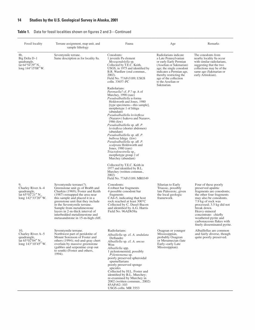
Fossil locality Terrane assignment, map unit, and sample lithology
Fauna Age Remarks
1 (fig. 3),Eagle C–1 quadrangle,lat 64°31′09″ N.,long 141°25′42″ W.
Seventymile terrane.Unit Pq of Foster (1976); quartzite and argillite that includes unmetamorphosed to slightly metamorphosed phyllite, metaconglomerate, chert, limestone and (or) marble, and graywacke to metagraywacke.Core consists of gray and black carbonaceous, quartzose limestone that is locally recrystallized and has poorly developed stylolites, as well as minor white calcite veins, rare quartz veins as much as 1.3 cm in diameter, and scattered pyrite.From WGM, Inc.’s, drilling of Doyon Ltd.’s Lead Creek property, diamond-drill hole LC–7; core split vertically from 731.6 to 741.1 ft below the surface.
Conodonts:75 chiefly juvenile, subadult, and a few adult Pa elements Epigondolella quadrata Orchard (pl. 1, figs. 1–15)Indigenous and (or) redeposited conodonts:73 epigondolellid and (or) metapolygnathid Pa element fragments 1 xaniognathiform Pb element Redeposited(?) conodonts of late Carnian and very earliest Norian age (see pl. 1 for age range of redeposited? species):1 Pa element Metapolygnathus nodosus (Hayashi)2 Pa elements M. primitius (Mosher) (pl, 1, figs. 16, 17)1 Pa element M. samueli OrchardCAI=5, indicating that host rock reached at least 300°C.Collected by WGM, Inc., geologists and submitted by C. Dusel-Bacon; identified by A.G. Harris.USGS colln. Mes. 35008
No older than E. quadrata Zone (no older than early early Norian, exclusive of Upper M. primitius Zone); see figure 4 for late Carnian and early Norian conodont zonation.
9.8 kg of rock was processed; 3.42 kg did not break down.Heavy-mineral concentrate: chiefly rhombohedral dolomite, euhedral pyrite, carbonaceous flakes, quartz, minor composite ferruginous flakes, conodonts, phosphatized sponge fragments, and rare well-rounded zircons.
2 (fig. 3),Eagle B–1 quadrangle,lat 64°28′40″ N.,long 141°14′35″ W.Outcrop at mile 130.5 along the Taylor Highway.
Seventymile terrane.Unit |q of Foster (1976); mainly greenstone but includes chert, phyllite, and quartzite. Conodonts are from carbonate within unit.
Conodonts:Metapolygnathus primitius (Mosher)Collected by Arco Oil and Gas Co. geologists and identified by T.R. Carr (written commun., 1985).
M. primitius Zone (latest Carnian and earliest Norian); see figure 4 for conodont zonation and age range of M. primitius.
---
Table 1. Data for fossil localities shown in figures 2 and 3.
[CAI, color-alteration index of Epstein and others (1977) and Rejebian and others (1987)]
3,Eagle C–1 quadrangle, lat 64°40′30″ N.,long 141°02′30″ W.
Quartz-chlorite-muscovite schist unit of the Yukon-Tanana terrane (Nisutlin assemblage of Hansen and Dusel-Bacon, 1998).Unit |q of Foster (1976); quartz-mica schist and greenschist but also includes quartzite, marble, quartz phyllite, and greenstone.
Poorly preserved conodonts of late Paleozoic ageCollected by Arco Oil and Gas Co. geologists and identified by T.R. Carr (oral commun., 1985).
Late Paleozoic, possibly Mississippian.
---
4,Eagle A–2 quadrangle, lat 64°07′00″ N.,long 141°46′15″ W.
Chicken Metamorphic Complex (Werdon and others, 2001) of uncertain origin. Collected near confluence of Napoleon Creek and the South Fork of the Fortymile River. Sample is from metalimestone interlayered with greenstone.
Poorly preserved conodonts of late Paleozoic ageCollected by Arco Oil and Gas Co. geologists and identified by T.R. Carr (oral commun., USGS,1985).
Late Paleozoic, possibly Mississippian.
---
5,Eagle B–2 quadrangle,lat 64°24′52″ N., long 141°46′59″ W.
Fortymile River assemblage of the Yukon-Tanana terrane (Dusel-Bacon and others, 2002).Outcrop of alternating quartzose and metacarbonate layers; collection from several metacarbonate layers through 1 m of section. Sample is from a large marble body within amphibolite-facies unit characterized by biotite gneiss and amphibolite.
Conodonts:8 incomplete recrystallized Pa elements of Cavusgnathus sp. or Adetognathus sp. (1 speci- men retains a small remnant of a right-margin free blade)14 indeterminate fragmentsCAI=6.5−8, indicating that host rock reached at least 450°C.Collected by C. Dusel-Bacon and identified by A.G. Harris.Field No. 96ADb60b; USGS colln. 33342–PC
Late Meramecian to early Sakmarian (Late Mississippian to early Early Permian).
The predominance of representatives of the family Cavusgnathidae suggests a warm, possibly intermittently restricted, shallow-water depositional setting.7.4 kg of rock was processed; 0.8 kg did not break down. Heavy-mineral concentrate: chiefly ferruginous composite partly carbonaceous muscovite grains.

12 Studies by the U.S. Geological Survey in Alaska, 2001 New Occurrences of Late Paleozoic and Triassic Fossils from the Seventymile and Yukon-Tanana Terranes, East-Central Alaska 13
Table 1. Data for fossil localities shown on figures 2 and 3—Continued
Fossil locality Terrane assignment, map unit, and sample lithology
Fauna Age Remarks
6,Eagle D–3 quadrangle,lat 64°56′20″ N., long 142°09′ W.
Seventymile terrane.Unit Pq of Foster (1976); outcrop and subcrop of unmetamorphosed calcareous siltstone associated with brachiopod-bearing calcareous siltstone; in fault slice between amphibolite-facies metamorphic rocks on the north and an igneous dike on the south.
Fusulinids:Parafusulina? sp. A of Stevens, 1995Collected by F. Cole and R. Flanders and identified by C.H. Stevens (San Jose State University).Field No. 82AFr103San Jose State Museum of Paleontology Nos. 4, 5, and 8
Wordian (middle Guadalupian; middle Middle Permian).
According to Stevens (1995), the closest known occurrence of giant fusulinids in western North America, is in the Slide Mountain terrane, northern British Columbia, Canada, and is on strike with the Alaskan locality, suggesting that the two terranes are closely related.
7a,Eagle D–3 quadrangle,lat 64°55′45″ N., long 142°04′33″ W.
Seventymile terrane.Unit Pq of Foster (1976); outcrops of unmetamorphosed brachiopod-bearing calcareous, fine-grained quartzitic sandstone and siltstone in fault slice between amphibolite-facies metamorphic rocks on the north and an igneous dike on the south.
Brachiopods:Anemonaria sp.Megousia sp.Neospirifer sp.Spiriferella sp.Tityrophora? sp.Yakovlevia sp.Punctate spiriferoid, indeterminateCollected by H.L. Foster in 1972 and identified by J.T. Dutro, Jr. Field No. 72AFr445; USGS colln. 24951–PC
Permian------------------ J.T. Dutro, Jr., USGS (written commun. 1973), suggested correlation of these beds with the basal sandstone unit of the Tahkandit Limestone at the type section.We believe that the brachiopods are likely the same age as the fusulinids (middle Guadalupian), as the beds can be walked into the fusulinid locality and share the same lithology (see Stevens, 1995).
7b,Eagle D–3 quadrangle,lat 64°55′45″ N., long 142°04′31″ W.
Seventymile terrane(?).Unit Pq of Foster (1976); rubble interval of unmetamorphosed gray, fine-grained quartzite, about 60 m wide; in fault slice between amphibolite-facies metamorphic rocks on the north and an igneous dike on the south.
Brachiopods and one pelecypod:Anemonaria? sp.Megousia sp.Neospirifer sp.Spiriferella sp.Thamnosia? sp.Waagenoconcha? sp.Orthotetid indeterminatePectinid pelecypod fragmentCollected by H.L. Foster in 1973 and identified by J.T. Dutro, Jr.Field No. 73AFr112; USGS colln. 23598–PC
Permian------------------ See remarks, loc. 7a.
7c,Eagle D–3 quadrangle,lat 64°55′46″ N.,long 142°06′40″ W.
Seventymile terrane.Unit Pq of Foster (1976); about 1.5 km west of locality 7a and likely the same bed.
Brachiopods:Chonetinella? sp.Neospirifer? sp.Spiriferella sp.Yakovlevia sp.Productoid, indeterminatePunctate spiriferoid, indeterminateCollected by H.L Foster in 1973 and identified by J.T. Dutro, Jr.Field No. 73AFr122B; USGS colln. 23599–PC
Permian------------------ See remarks for locality 7a.
8a,Big Delta D–1 quadrangle,lat 64°54′28″ N.,long 144°15′10″ W.
Seventymile terrane.From red chert associated with green and gray chert. Chert is interlayered with basaltic greenstone that, in turn, is associated with serpentized ultramafic rocks (Foster and others, 1978). Sedimentary rocks are associated with the peridotite of Salcha River (Foster and others, 1994).
Conodonts:juvenile Pa elements Mesogondolella sp. of Sakmarian–Guadalupian morphotypeStreptognathodus sp.xaniognathiform elementCollected by T.E.C. Keith in 1975 and identified by B.R. Wardlaw (Foster and others, 1978)
Radiolarians:Paronaella sp. forms with complete outer margins connecting the three primary armsunnamed morphotypes related to late stages of the family Albaillellideaunnamed elongate ladderlike specimens with large reticulate poresCollected by T.E.C. Keith in 1975 and identified by D.L. Jones, USGS (Foster and others, 1978)Field No. 75AFr3295
Radiolarians indicate a Late Pennsylvanian to Middle Permian age; the conodonts restrict the age to Sakmarian–early Artinskian (middle Early Permian; see fig. 6).
---
14 Studies by the U.S. Geological Survey in Alaska, 2001 New Occurrences of Late Paleozoic and Triassic Fossils from the Seventymile and Yukon-Tanana Terranes, East-Central Alaska 15
Fossil locality Terrane assignment, map unit, and sample lithology
Fauna Age Remarks
Table 1. Data for fossil localities shown on figures 2 and 3—Continued
9,Charley River A–4 quadrangle,lat 65°02′21″ N., long 142°33′20″ W.
Seventymile terrane(?).Greenstone unit gs of Brabb and Churkin (1969); Foster and Keith (1987) remapped the area near this sample and placed it in a greenstone unit that they include in the Seventymile terrane. Sample from metalimestone layers in 2-m-thick interval of interbedded metalimestone and metasandstone in 15-m-high cliff.
Conodonts:4 robust bar fragments4 possible conodont bar fragmentsCAI=5, indicating that host rock reached at least 300°CCollected by C. Dusel-Bacon and identified by A.G. HarrisField No. 96ADb58a
Silurian to Early Triassic, possibly late Paleozoic, given the local geologic framework.
Four of these poorly preserved apatitic fragments are conodonts; the other four fragments may also be conodonts.7.9 kg of rock was processed; 3.5 kg did not break down.Heavy-mineral concentrate: chiefly weathered pyrite and carbonaceous flakes with finely disseminated pyrite.
10,Charley River A–5 quadrangle,lat 65°02′04″ N., long 143°10′45″ W.
Seventymile terrane.Northwest part of peridotite of Mount Sorenson of Foster and others (1994); red-and-gray chert overlain by massive greenstone (gabbro and serpentine crop out to south) (Foster and others, 1994).
Radiolarians:Albaillella sp. cf. A. undulata DeflandreAlbaillella sp. cf. A. uncus WonAlbaillella spp.1 pylentonemiid, possibly Pylentonema sp.poorly preserved spheroidal spumellarianspoorly preserved sponge spiculesCollected by H.L. Foster and identified by B.L. Murchey; re-examined by Murchey in 2002 (written commun., 2002)85AFr82–103USGS colln. MR 3553
Osagean or younger Mississippian, probably Osagean or Meramecian (late Early–early Late Mississippian).
Albaillellas are common and fairly diverse, though quite poorly preserved.
8b,Big Delta D–1 quadrangle,lat 64°54′29″ N.,long 144°15′08″ W.
Seventymile terrane.Same description as for locality 8a.
Conodonts:1 juvenile Pa element Mesogondolella sp.Collected by T.E.C. Keith, USGS, in 1975 and identified by B.R. Wardlaw (oral commun., 2002).Field No. 77AFr3189; USGS colln. 33657–PC
Radiolarians:Paronaella? cf. P.? sp. A of Murchey, 1990 (rare)Pseudoalbaillella u-forma Holdsworth and Jones, 1980 [type specimens—this sample], morphotype 1 of Ishiga (abundant)Pseudoalbaillella levitoflexa (Nazarov) Isakova and Nazarov, 1986 (few)
Pseudoalbaillella sp. aff. P. levitoflexa (shorter abdomen) (abundant)Pseudoalbaillella sp. aff. P. bulbosa Ishiga (few)Pseudoalbaillella sp. aff. P. scalprata Holdsworth and Jones, 1980 (rare)Triactofenestrella sp., morphotype group 2 of Murchey (abundant)
Collected by T.E.C. Keith in 1977 and identified by B.L. Murchey (written commun., 2002)Field No. 77AFr3189; MR0349
Radiolarians indicate a Late Pennsylvanian or early Early Permian (Asselian or Sakmarian) age; the single conodont indicates a Permian age, thereby restricting the age of the collection to the Asselian or Sakmarian.
The conodonts from nearby locality 8a occur with similar radiolarians, suggesting that the two collections may be of the same age (Sakmarian or early Artinskian).

14 Studies by the U.S. Geological Survey in Alaska, 2001 New Occurrences of Late Paleozoic and Triassic Fossils from the Seventymile and Yukon-Tanana Terranes, East-Central Alaska 15
Figure 5 is a sketch map of the Pacific Northwest, showing the areas of conodont fossil localities in Alaska and in the Yukon Territory and British Columbia, Canada. Caption follows…
Late Triassic Conodonts from Other Areas in the Canadian Cordillera and Alaska
Late Carnian and early Norian conodonts are widespread in the Canadian Cordillera (Orchard, 1983, 1991b, c; Poulton and others, 1999) and in Alaska (fig. 5). In Canada, well-exposed, continuous sections of Upper Triassic rocks have been systematically sampled during integrated stratigraphic, sedimentologic, and conodont and ammonoid biostratigraphic studies by specialists (Orchard, 1983, 1991a–c), but not in southeastern and south-central Alaska, where most late Carnian and early Norian conodont samples were collected during regional-scale geologic mapping, resource exploration, and tectonic studies and to date and assess the paleogeographic affinities of terranes and subterranes. Further complicating a geologic interpretation of the samples from southeastern and south-central Alaska is the fact that many of them were col-lected within and adjacent to the Denali Fault system.
Foster and others (1994) noted that some of the weakly metamorphosed sedimentary rocks at the Metapolygnathus primitius locality (loc. 2, fig. 3; table 1) are similar to those described by Abbott (1982) at the Clinton Creek open-pit asbes-tos mine 25 km east-southeast in the Yukon Territory, Canada (fig. 3). A conodont collection from beds above the ore body in the main pit at Clinton Creek yielded Metapolygnathus? sp. indicating a Carnian to very earliest Norian age (loc. A1, fig. 3; table 2). Another collection about 5 km farther southeast yielded Late Triassic Neogondolella sp. (loc. A2, fig. 3; table 2).
Farther southeast in the Yukon Territory, Canada (area B, fig. 5; table 2), in rocks northeast of the Tintina Fault that are part of ancestral North America, at least three conodont collections in the vicinity of Chert Mountain contain Meta-polygnathus sp. of late Carnian to very earliest Norian age. Farther south near the Alaska Highway bridge over the White River (area C, fig. 5; table 2), and south of the Denali Fault, several conodont samples from the Wrangellia terrane yielded Epigondolella triangularis of late early Norian age.
In south-central Alaska, at least 20 conodont collections have been dated as late Carnian, early Norian, and Norian from the Healy, Mount McKinley, and Talkeetna quadrangles (area D, fig. 5; table 2). Of these collections, 14 are restricted to the Metapolygnathus communisti and (or) M. primitius Zones, and the rest are long ranging within the late Carnian or Norian. M. communisti, M. primitius, and Neogondolella spp. are the most common conodonts in the collections, although metapolyg-nathids generally do not cooccur with neogondolellids; most of the collections are restricted to the very late Carnian and (or) earliest Norian (M. communisti through M. primitius Zones). At least 15 of the collections are from an intensely deformed, thick (>1,000 m) sequence of generally thin bedded, carbonaceous and calcareous marine sedimentary rocks of Late Triassic age (unit ^cs of Csejtey and others, 1992) exposed in a series of fault slices of the Denali Fault system for at least 300 km along the Alaska Range. Csejtey and others considered this unit to be part of the Yukon-Tanana terrane. Most of the conodonts are from carbonate to silty carbonate lenses or layers interpreted as
������
�����������
���
��������������
���������������
������� ��������
����������
���� ���
����
���
�
��
�
�
�
�
�
�
�
����������
Figure 5. Sketch map of the Pacific Northwest, showing areas of selected sample localities for late Carnian and (or) early Norian conodont faunas (Lower nodosus through triangularis Zones) in the Canadian Cordillera (from Orchard, 1991c) and southeastern, south-central (table 2), and east-central (table 1) Alaska. Canadian terrane assignments from Orchard (1991a, fig. 1). 1, Seventymile terrane, east-central Alaska (loc. 1, fig. 3; table 1); A, Seventymile terrane, western Yukon Territory, Canada (locs. A1, A2, fig. 3; table 2); B, ancestral North America, western Yukon Territory (area B, table 2); C, Wrangellia terrane, western Yukon Territory (area C, table 2); D, Yukon-Tanana terrane, south-central Alaska, along the Denali Fault system, (area D; table 2); E, Alexander terrane, southeastern Alaska, northern Admiralty Island (area E, table 2); F, Wrangellia terrane, Queen Charlotte Islands; G, ancestral North America, northeast-ern British Columbia, sections at Mount McLearn and about 25 km farther south along the Alaska Highway (Orchard, 1991c); H, ancestral North America, northeastern British Columbia, mainly sections along Peace River, 100 to 150 km west of Fort St. John and a few sections north of the Peace River along a tributary of the Halfway River (Orchard, 1991c); I, Wrangellia terrane, Klaskino Inlet, Vancouver Island. Star, Middle Permian giant parafusulinid sample locality from the Sylvester Allochthon in northern British Columbia, which is the nearest giant parafusulinid sample locality to that in the Seventymile terrane (loc. 6, fig. 2; table 1).

16 Studies by the U.S. Geological Survey in Alaska, 2001 New Occurrences of Late Paleozoic and Triassic Fossils from the Seventymile and Yukon-Tanana Terranes, East-Central Alaska 17
Table 2. Data for Triassic conodont localities A through E referred to in text but not listed in table 1.
[See figure 5 for locations. Most collections in area D from Csejtey and others (1992) were reexamined in 1995 and, where necessary, revised by A.G. Harris and B.R. Wardlaw. Conodont zonation for the late Carnian and early Norian is shown in figure 4]
Sample locality or area Terrane assignment, lithologic unit, and age Source
Area ALocality A1 (also shown in fig. 3)
lat 64°26′41″ N., long 140°43′38″ W.Above ore body, southwest end of main pit, Clinton Creek deposit.
Locality A2 (also shown in fig. 3)Yukon Territorylat 64°24′59″ N., long 140°38′08″ W.On road to the Clinton Creek open-pit asbestos mine, 1 km northwest of Township turnoff.
Seventymile terraneLate Triassic, probably Carnian
Seventymile terraneLate Triassic
Poulton and others (1999)GSC loc. C–102345, M.J. Orchard (written commun., 2002).
Poulton and others (1999)GSC loc. C–102265, M.J. Orchard (written commun., 2002).
Area BYukon Territorylat 64°23′45″ N., long 138°52′00″ W.About 1,500 m northeast of Chert Mountain.
Area CYukon TerritoryAll in vicinity of the Alaska Highway bridge over the White Riverlat 61°59′24″ N., long 140°36′54″ W.
lat 61°57′57″ N., long 140°45′18″ W.
lat 61°58′16″ N., long 140°38′56″ W.
Ancestral North AmericaLate Carnian to earliest Norian
Wrangellia terrane
Epigondolella triangularis Zone, late early Norian;Nikolai GreenstoneE. triangularis Zone, late early Norian;Chitistone LimestoneE. triangularis Zone, late early Norian;Chitistone Limestone
Poulton and others (1999)GSC locs. C–150066, C–150068, and C–150069.
Poulton and others (1999).
GSC loc. C–210045.
GSC loc. C–210048.
GSC loc. C–210056.
Area DSouth-central Alaska
Mount McKinley D–1 quadranglelat 63°57′50″ N., long 150°17′20″ W.
All from the Yukon-Tanana terrane and unit ^cs of Csejtey and others (1992) unless otherwise noted.
Late Carnian Collected by A.B. Till, USGS; identified by A.G. Harris;USGS colln. Mes. 33374.
Talkeetna C–6 quadranglelat 62°44′12″ N., long 152°58′ W.
Talkeetna C–6 quadranglelat 62°44′58″ N., long 152°51′24″ W.
Talkeetna D–4 quadranglelat 62°59′42″ N., long 151°56′40″ W.
Healy C–6 quadranglelat 63°40′07″ N., long 149°36′25″ W.
Healy C–5 quadranglelat 63°40′12″ N., long 149°08′12″ W.
Healy C–5 quadranglelat 63°37′45″ N., long 149°06′55″ W.
Healy C–2 quadranglelat 63°44′14″ N., long 147°49′14″ W.
Healy C–2 quadranglelat 63°44′46″ N., long 147°38′55″ W.
Healy C–2 quadranglelat 63°44′57″ N., long 147°37′12″ W.
Lower part Upper Metapolygnathus primitius Zone, very earliest Norian
Late Carnian
Lower part Upper M. primitius Zone, very earliest Norian
M. communisti Zone into lower part of Upper M. primitius Zone, very late Carnian–very earliest Norian
M. primitius Zone, latest Carnian–earliest Norian
M. communisti Zone into lower part of Upper M. primitius Zone, very late Carnian–very earliest Norian
M. primitius Zone, latest Carnian–earliest Norian
M. primitius Zone, latest Carnian–earliest Norian
M. primitius Zone, latest Carnian–earliest Norian
Collected by N.J. Silberling, identified by A.G. Harris; USGS colln. Mes. 33378.
Collected by N.J. Silberling, identified by A.G. Harris;USGS colln. Mes. 33379.
Collected by N.J. Silberling, identified by A.G. Harris;USGS colln. Mes. 33381.
Fossil loc. 73, Csejtey and others (1992).
Fossil loc. 74, Csejtey and others (1992).
Fossil loc. 75, Csejtey and others (1992); USGS colln. Mes. 33382.
Fossil loc. 82, Csejtey and others (1992).
Fossil loc. 83, Csejtey and others (1992)
Fossil loc. 84, Csejtey and others (1992).

16 Studies by the U.S. Geological Survey in Alaska, 2001 New Occurrences of Late Paleozoic and Triassic Fossils from the Seventymile and Yukon-Tanana Terranes, East-Central Alaska 17
Table 2. Data for Triassic conodont localities A through E referred to in text but not listed in table 1—Continued
Sample locality or area Terrane assignment, lithologic unit, and age Source
Area D (continued)South-central Alaska
All from the Yukon-Tanana terrane and unit ^cs of Csejtey and others (1992) unless otherwise noted.
Healy C–2 quadranglelat 63°43′47″ N., long 147°36′05″ W.
Healy C–3 quadranglelat 63°32′58″ N., long 148°05′05″ W.
Healy C–2 quadranglelat 63°32′50″ N., long 147°59′10″ W.
M. primitius Zone, latest Carnian–earliest Norian
M. communisti Zone into lower part Upper M. primitius Zone, very late Carnian–very earliest Norian
M. primitius Zone, latest Carnian–earliest Norian
Fossil loc. 87, Csejtey and others (1992).
Fossil loc. 90, Csejtey and others (1992).
Fossil loc. 91, Csejtey and others (1992).
Healy B–3 quadranglelat 63°25′07″ N., long 148°06′14″ W.
Healy B–3 quadranglelat 63°25′58″ N., long 148°05′42″ W.
Healy A–6 quadranglelat 63°00′16″ N., long 149°57′18″ W.
Area ESoutheastern AlaskaNorthern Admiralty Island;all in the Juneau A–2 quadranglelat 58°03′35″ N., long 134°34′03″ W.
lat 58°04′47″ N., long 134°36′53″ W.
lat 58°05′23″ N., long 134°42′04″ W.
lat 58°07′56″ N., long 134°41′26″ W.
M. primitius Zone, latest Carnian–earliest Norian
M. communisti Zone into lower part of Upper M. primitius Zone, very late Carnian–very earliest Norian
Chulitna terrane (Silberling and others, 1994)M. primitius Zone, latest Carnian–earliest Norian; unit J^rs of Csejtey and others (1992)
All collections from the Admiralty subterrane of the Alexander terrane (Monger and Berg, 1987); all collections from the Hyd Formation.
M. nodosus Zone through Upper M. primitius Zone, late Carnian–earliest Norian
Upper M. primitius Zone, earliest Norian
M. nodosus Zone into lower part of Upper M. primitius Zone, late Carnian–very earliest Norian
M. nodosus Zone through Upper M. primitius Zone, late Carnian–earliest Norian
Fossil loc. 93, Csejtey and others (1992).
Fossil loc. 94, Csejtey and others (1992).
Fossil loc. 154, Blodgett and Clautice (2000).
Collected by C.D. Taylor, identified by A.G. Harris; USGS colln. Mes. 35023.
Collected by J.M. Proffett, identified by A.G. Harris; USGS colln. Mes. 35018.
Collected by N.A. Duke, identified by A.G. Harris; USGS colln. Mes. 35050.
Same as previous sample;USGS colln. Mes. 35051.
distal calciturbidites that are intercalated with hemipelagic and pelagic layers. The metamorphic grade and deformational his-tory of these rocks vary from slice to slice.
On northern Admiralty Island, southeastern Alaska (area E, fig. 5; table 2), samples of slightly to moderately metamor-phosed black calcareous argillite and carbonate rocks of the Hyd Formation, included in the Admiralty subterrane of the Alexander terrane, yielded conodont collections containing Metapolygnathus primitius with and without M. nodosus. These collections position part of the Hyd Formation in the Lower M. primitius Zone to the lower part of the Upper M. primitius Zone, or in the Lower and Upper M. primitius Zones (see fig. 4 for conodont zonation). Another collection from the same area yielded abundant Neogondolella navicula (Huckriede) and a few specimens of M. primitius, indicating the Upper M. primitius Zone of very earliest Norian age. Farther south, in the Queen Charlotte Islands, British Columbia, Canada (area F, fig. 5; table 2), conodonts from the Kunga Group of Cameron and Tipper (1985) have produced a relatively complete late Carnian and early Norian record from 11 key sections stretching the length of the islands (Orchard, 1991c) that have enabled refine-
ment of late Carnian and early Norian conodont biostratigraphy. The biostratigraphy and taxonomy applied to conodonts from rocks of late Carnian and early Norian age across Alaska are derived from the conodont successions of the Queen Charlotte Islands, northeastern British Columbia, and northern Vancouver Island (areas F–I, fig. 5; Orchard, 1991b, c).
Late Paleozoic Conodonts in East-Central Alaska
Localities 3 and 4
Conodonts of late Paleozoic age were recovered from marble in unit |q of Foster (1976) in the Eagle quadrangle: at one locality from the quartz-chlorite-muscovite±calcite schist, micaceous quartzite, and marble unit of the Nisutlin assem-blage, Yukon-Tanana terrane (loc. 3, fig. 3; table 1), and at the other locality from the greenschist-facies Chicken Metamorphic Complex of Werdon and others (2001) of uncertain origin (loc. 4, fig. 3; table 1). Both collections contain poorly preserved late Paleozoic, possibly Mississippian conodonts (T.R. Carr, formerly ARCO Oil and Gas Co., oral commun. to H.L. Foster, 1985).

18 Studies by the U.S. Geological Survey in Alaska, 2001 New Occurrences of Late Paleozoic and Triassic Fossils from the Seventymile and Yukon-Tanana Terranes, East-Central Alaska 19
Figure 6 is a box chart showing the age ranges of conodonts from localities 6 through 8. Fossil species span the Asselian, Sakmarian, Artinskian, and Kungurian stages of the Lower Cisuralian series, and the Roadian, Wordian, and Capitanian stages of the middle Guadalupian series, all in the Permian system. Caption follows…
Figure 6. Selected conodont zones for the Early and Middle Permian, showing age ranges of Permian collections from sample localities 6 through 8 (fig. 2; table 1). Radiometric ages and selected conodont zones from Jin and others (1997). Conodont genera: J., Jinogondolella; M., Mesogondolella; N., Neostrepto-gnathodus; St., Streptognathodus; Sw., Sweetognathus.
Locality 5
An outcrop of interlayered metacarbonate and quartzose rocks, about 1 m thick, in the Eagle B–2 quadrangle (loc. 5, fig. 3; table 1) yielded poorly preserved recrystallized con-odonts. The collection is from a large (8 by 15 km) marble body within an amphibolite-facies unit characterized by biotite gneiss and amphibolite that was included in the Y4 subterrane of the Yukon-Tanana terrane by Foster and others (1994); this unit is here considered part of the Fortymile River assemblage of the Yukon-Tanana terrane. Although all the conodonts in
this collection are incomplete, enough features are preserved to identify some as Cavusgnathus sp. or Adetognathus sp., of combined late Meramecian to Sakmarian age (early Late Mis-sissippian to early Early Permian). These and other genera of the family Cavusgnathidae are characteristic of warm, shal-low-water environments, particularly when they are the only conodonts in a collection. Cavusgnathids and adetognathids are a major component of the shallow-water facies of the Mis-sissippian and Pennsylvanian part of the Lisburne Group of the Brooks Range and subsurface North Slope (for example, Krumhardt and others, 1996; Harris and others, 1997).
Localities 8a and 8b
Two conodont samples from the Seventymile terrane in the Big Delta D–1 quadrangle (loc. 8, fig. 2; locs. 8a, 8b, table 1) yielded conodonts of Permian age. Red chert from locality 8a was collected for radiolarians but also yielded a few conodonts. The radiolarians are Late Pennsylvanian to Middle Permian; the conodonts restrict the age to middle Early Permian (Sakmar-ian and early Artinskian; fig. 6). A re-collection of red chert in the same vicinity (loc. 8b) yielded only one poorly preserved Mesogondolella sp. of Permian age. Radiolarians from this sample indicate a Late Pennsylvanian or early Early Permian (Asselian and Sakmarian) age (loc. 8b, table 1). Thus, taken together, the collection is restricted to the Asselian and Sakmar-ian. On the basis of conodonts from locality 8a and radiolarians from locality 8b, both samples could be of the same or nearly the same age—Sakmarian and early Artinskian (fig. 6).
Locality 9
An outcrop of interlayered slightly metamorphosed car-bonate and clastic rocks within a greenstone unit (loc. 9, fig. 2; table 1) included in the Seventymile terrane by Foster and Keith (1987) yielded several conodont fragments that merely provide a generalized age of Silurian to Early Triassic. The sample was collected from the northern margin of the perido-tite of Mount Sorensen (Foster and others, 1994). The local geologic framework favors a late Paleozoic age.
Fusulinids (Loc. 6)Giant parafusulinid foraminifers (loc. 6, fig. 2; table 1)
were discovered in a sliver of unmetamorphosed(?) to slightly metamorphosed quartzose sedimentary rocks (unit Pq of Foster, 1976) that occur as a fault slice adjacent to a southern splay of the Tintina Fault in the northernmost-central part of the Eagle quadrangle (Stevens, 1995). The fault slice (too small to be shown in fig. 2) lies between amphibolite-facies rocks on the north and a felsic dike on the south (Foster, 1976). Foster (1992) assigned these rocks to the Seventymile terrane. In his report on giant parafusulinid foraminifers from the Seventymile terrane in the Eagle quadrangle, Stevens took the opportunity to summarize all occurrences and illustrate
�����
�������������
�����
������
��������
���������
����������
����������
�������
�� ����������
�� ��������
����������
�����������
��������������������
�����������
���������������
����������
��� ��������� ��������
���������������
�������
������������������
���� � ���� �
���� ��
�� �����������
�� �����������
�� ������������
�� �������� ���������
�� �����������
��� ������
��� ���������
��� �����������
��� ��������
������
������
��������������� ����
���������
����
���������
���������
����
���������
����
���������������������
����
���
���
����
��

18 Studies by the U.S. Geological Survey in Alaska, 2001 New Occurrences of Late Paleozoic and Triassic Fossils from the Seventymile and Yukon-Tanana Terranes, East-Central Alaska 19
together many of the species of this western North Ameri-can group. Giant parafusulinids (species >2 cm long) are restricted to middle Guadalupian (Wordian; middle Middle Permian) rocks of western North America, where they are known from eight areas that extend from Mexico to Alaska: three southern areas in Coahuila and Sonora Provinces, north-ern Mexico, and West Texas; three central areas that have been referred to the McCloud belt arc in northern California, Washington, and southern British Columbia, Canada; and two northernmost areas within the Sylvester Allochthon in northern British Columbia and in the Seventymile terrane of east-central Alaska. Stevens divided the 15 North American species of giant fusulinids into two major groups on the basis of internal features that appear to be geographically limited. He retained one group in the genus Parafusulina, species of which occur only in Coahuila Province, Mexico, and in West Texas, and conditionally designated the other group Para-fusulina?, which occurs in all eight areas except Coahuila Province. Parafusulina? is virtually restricted to the alloch-thonous tectonostratigraphic terranes of the western Cordil-lera, except West Texas, which was part of ancestral North America. The occurrence of giant parafusulinids representa-tive of both geographic groups in West Texas is evidence of some faunal exchange between ancestral North America and more outboard areas during the Middle Permian.
According to C.H. Stevens (oral commun., 2002), para-fusulinids occur mostly in limestone, silty sandy limestone, and limy siltstone (their host in the Seventymile terrane); some localities have associated brachiopods. The host rock, associated biota, and local and regional stratigraphic relations indicate that the giant parafusulinids lived in the shallow waters of tropical to at least subtropical North America and relatively nearby outboard islands and near-surface submarine edifices. The outboard-island occurrences were subsequently dislocated to higher latitudes along the margins of western North America. The giant parafusulinids of the Seventymile terrane appear to be the farthest traveled. The giant-parafusulinid locality in the Sylvester Allochthon of northern British Columbia, Canada, lies about 500 km southeast of that in the Seventymile terrane (star, fig. 5; compare with loc. 6, fig. 2).
RadiolariansThree radiolarian collections of late Paleozoic age are
known from the Seventymile terrane. Two of these collec-tions are from red chert associated with green-and-gray chert interlayered with basaltic greenstone that, in turn, occurs with the peridotite of Salcha River (Foster and others, 1994) in the northeastern part of the Big Delta quadrangle (Foster and others, 1978). The two samples were collected near one another at different times (loc. 8, fig. 2; locs. 8a, 8b, table 1). Both samples yielded radiolarians, as well as a few conodonts. The sample collected in 1975 (loc. 8a, table 1) was described by Foster and others (1978) in generalized taxonomic terms. The other sample (loc. 8b), collected in 1977, contains much the same radiolarians (B.L. Murchey, written commun., 2002),
including several specimens of Pseudoalbaillella sp., subordi-nate Triactofenestrella sp., and rare Paronaella? cf. P.? sp. A of Murchey (1990), indicating a Late Pennsylvanian or early Early Permian age. The associated conodonts in both collec-tions restrict that age to Sakmarian to early Artinskian (middle Early Permian, fig. 6). According to B.L. Murchey (written commun., 2002), the radiolarians in these two collections are generally found in argillaceous and cherty facies that were deposited along the margin (outer slope) of late Paleozoic North America. Because the faunas are fairly diverse, the radiolarian-bearing chert might have formed between very proximal facies dominated by such forms as Triactofenestrella and Paronaella? cf. P.? sp. A of Murchey (1990) (wagonwheel or discoidal forms, possibly with photosynthetic symbionts) and typical distal ribbon-chert faunas dominated by such elon-gate forms as Pseudoalbaillella. The radiolarian faunas from the Big Delta quadrangle are similar to those of the Havallah Formation in Nevada, which likely formed in a backarc basin.
The third radiolarian collection is from red-and-gray chert overlain by massive greenstone in the Seventymile ter-rane, southeastern Charley River quadrangle (loc. 10, fig. 2; table 1). The fauna is poorly preserved, consisting mainly of Albaillella, spheroidal spumellarians, and sponge spicules. B.L. Murchey, who reexamined the collection in 2002, agreed with her original faunal list and age assignment to the Osagean or younger Mississippian, probably Osagean or Meramecian (late early or early late Mississippian).
MegafossilsBrachiopods (Locs. 7a–7c)
Exposures of unmetamorphosed brachiopod-bearing cal-careous siltstone and fine-grained quartzite were discovered in a fault slice just south of the main part of the Tintina Fault system during geologic mapping of the Eagle quadrangle (Foster, 1976) (loc. 7, fig. 2; locs. 7a–7c, table 1), in the same fault slice from which the giant fusulinids were subsequently collected. Three brachiopod collections were made in 1972 and 1973, two of which were nearby and the third 2 km to the west. The brachiopods are preserved as casts and molds. According to J.T. Dutro, Jr. (written communs., 1972, 1973), Spiriferella sp. and Neospirifer sp. occur in all collections, Anemonaria sp., Megou-sia sp. and Yakovlevia sp. in two collections, and Chonetinella? sp., Thamnosia? sp., Tityrophora? sp., and Waagenoconcha? sp. in one collection each. J.T. Dutro, Jr. (written commun., 1973), identified the collections as Permian and suggested a correlation with the lower sandstone unit of the Tahkandit Limestone north of the Tintina Fault in the southeastern Charley River quadran-gle, about 30 km north of locality 7. At the type section of the Tahkandit in the southeastern Charley River quadrangle, species of six of the brachiopod genera identified in the Eagle quad-rangle rocks—Megousia, Neospirifer, Spiriferella, Thamnosia, Waagenoconcha, and Yakovlevia—occur in the lower sandstone unit and (or) overlying limestone (Brabb and Grant, 1971);

20 Studies by the U.S. Geological Survey in Alaska, 2001 New Occurrences of Late Paleozoic and Triassic Fossils from the Seventymile and Yukon-Tanana Terranes, East-Central Alaska 21
the sandstone unit has not been recognized beyond the type area. Brabb and Grant, who noted that the Permian brachiopod faunas of the Tahkandit show affinities to those in the Canadian Arctic Archipelago and east-central Greenland, suggested a late Leonardian age (Kungurian) for the sandstone unit and an age of late Leonardian to early Guadalupian (Kungurian-early Wordian) for the entire formation (latest Early and early Middle Permian). The suggestion that the brachiopod beds of the Seventymile terrane that lie south of the Tintina Fault system in the Eagle quadrangle are correlative with the lower beds of the Tahkandit on the north side of the Tintina Fault in ancestral North Ameri-can strata is based on lithologic similarity and generic-level correlation. Most of the brachiopod genera in collections from the Eagle quadrangle are relatively long ranging in the Early and Middle Permian. Some genera were widespread paleogeo-graphically, and some were more common in some areas than elsewhere. For example, Megousia has a relatively worldwide distribution, and Waagenoconcha is a common Arctic form but also occurs in the Salt Range of Pakistan (B.R. Wardlaw, oral commun., 2002). Yakovlevia, Chonetinella, and Thamnosia are more common in cool- than in warm-water faunas but occur in both (Bamber and Barss, 1969).
Although the correlation of brachiopod faunas from the fault sliver in the northern part of the Eagle quadrangle (locs. 7a–7c, table 1) with those of the Tahkandit Limestone north of the Tintina Fault, as suggested by Brabb and Grant (1971), does explain the similarity of the faunas at a generic level and their geographic proximity, it does not take into account the separation of the localities by a major, long-lived transform fault and the association of the Tahkandit with continental-margin rocks only, whereas the low-grade sedimentary rocks of the fault sliver in the Seventymile terrane are associated with serpentinite (Foster, 1976).
We believe that because of the nearby discovery of giant parafusulinids (Stevens, 1995) in the same belt of rocks which contains the brachiopod localities, the age of the bra-chiopod beds in the Seventymile terrane is now updated and well constrained. The fusulinid locality is 2.5 km northwest of the westernmost brachiopod collection (locs. 6, 7, fig. 2; locs. 6, 7c, table 1) and could well be within the same strati-graphic interval. The fusulinids were discovered while field-mapping the brachiopod-bearing beds for several kilometers along strike, in blocks and boulders of brachiopod-bearing calcareous siltstone that were dug from beneath a thin layer of tundra (Stevens, 1995). Proximity, lithology, and both geo-logic and apparent stratigraphic position provide compelling evidence that, like the giant fusulinids, the brachiopod faunas first collected in the early 1970s are of middle Guadalupian (Wordian) age.
DiscussionOur most biostratigraphically diagnostic fossils are from
Middle Permian and Late Triassic (late Carnian and early Norian) weakly metamorphosed strata of the Seventymile
terrane. The rocks most analogous to ours are those from the Sylvester Allochthon, one of the largest klippen assigned to the Slide Mountain terrane (Gabrielse, 1991), which rests directly on the Cassiar terrane, a displaced sliver of ancestral North America (Harms, 1986; Nelson, 1993) in northern Brit-ish Columbia, Canada (fig. 1). Both the Seventymile and Slide Mountain terranes contain supracrustal thrust slices of basalt and interbedded black argillite, chert, calcarenite, and quartz/chert sandstone that are structurally interleaved with serpen-tinized peridotite; the Sylvester Allochthon also contains a slice of igneous rocks of island-arc affinity.
Division I, the structurally lowest fault-bounded slice of the Sylvester Allochthon, consists of deep-water sedimen-tary rocks and minor basalt-diabase sills and flows; division II contains deep-water sedimentary rocks that are structur-ally interleaved with panels of ultramafic rocks, gabbro, and amphibolite (Nelson, 1993). Both divisions I and II have yielded conodonts of Early Mississippian to Permian age (Nelson, 1993). The presence of quartz-bearing sedimentary rocks and the continuity of sedimentation associated with basaltic volcanism during the Mississippian, Pennsylvanian, and Permian led Nelson to conclude that division II is an ophiolite characterized by slow spreading and a sedimentation rate higher than that of normal pelagic sequences, owing to the deposition of terrigenous sedimentary rocks. For this reason, Nelson concluded that division II more likely represents a backarc or marginal basin rather than typical midocean floor. Triassic sedimentary rocks occur at the highest level in divi-sion II (Nelson, 1993). Division III, the uppermost structural package within the allochthon, contains the Permian giant-fusulinid-bearing limestone (star, fig. 5; Ross, 1969), together with slices of Pennsylvanian and Permian calc-alkaline vol-canic and plutonic rocks, chert, and tuff assigned to the Harper Ranch subterrane of Quesnellia. One thrust panel of division III, assigned to the Yukon-Tanana terrane, consists of an Early Mississippian granitoid that intrudes volcanogenic and silici-clastic sedimentary rocks (Nelson, 1993). Nelson proposed a pre-Mesozoic reconstruction of the elements in the Sylves-ter Allochthon in which a late Paleozoic arc (Harper Ranch subterrane) is built partly on the pericratonic Yukon-Tanana terrane and partly on primitive oceanic basement (division III), which is separated from North America by the Slide Mountain marginal basin (divisions I, II).
A more southerly paleolatitude for the Seventymile and Slide Mountain terranes is suggested not only by the Permian faunas from these related terranes but also by paleomagnetic data from the Sylvester Allochthon in northern and central British Columbia, Canada: an Early Permian paleomagnetic pole from a unit correlative with Pennsylvanian and Permian volcanic rocks of division II restores to the approximate latitude of northern California (Richards and others, 1993). A paleogeo-graphic affinity of division III of the Sylvester Allochthon with lower-latitude North America is also suggested by the presence of a diverse brachiopod and coralline fauna of North Ameri-can-Uralian affinity in that division, and by the similarity of the giant fusulinids in division III to those in Texas (Nelson, 1993).

20 Studies by the U.S. Geological Survey in Alaska, 2001 New Occurrences of Late Paleozoic and Triassic Fossils from the Seventymile and Yukon-Tanana Terranes, East-Central Alaska 21
Although general agreement exists that the Seventymile-Slide Mountain terrane represents a basin floored by oceanic crust off the western margin of ancestral North America, the original width of the ocean basin is disputed. For example, Nelson (1993) depicted the Slide Mountain ocean as a narrow ocean that is depositionally tied to ancestral North America, whereas other workers have modeled it as a vast Paleozoic Pacific Ocean (Harms and Murchey, 1992; Monger and oth-ers, 1991). If the rocks that host the Permian fusulinids and brachiopods in the north-central part of the Eagle quadrangle (loc. 6, fig. 2) are truly quartzites (as opposed to biosiliceous sedimentary rocks, as described by Foster, 1976), proxim-ity to a continental source terrane would be required. That continental source, however, could be either the ancestral continental margin of North America or the rifted continental fragment proposed to have been derived from it (Tempelman-Kluit, 1979); thus, the presence of quartzite does not indicate whether the siliceous sedimentary rocks formed in a marginal sea or at the margin of a major open ocean. In discussing the Klamath terrane farther to the south in northern California, Stevens and others (1990) proposed that the degree of dissimi-larity of faunas of the McCloud belt with autochthonous forms requires an extensive deep-water barrier, several thousand kilometers wide, between the eastern Klamath Mountains and ancestral North America, whereas regional geologic consid-erations led Miller (1987) to suggest a fairly close Permian connection between the McCloud belt and North America.
The dip direction of the subduction zone beneath the oceans represented by the Seventymile and Slide Mountain terranes is also disputed. The Slide Mountain ocean is pro-posed to have been bordered on the west by an east-dipping subduction zone and related arc (Gabrielse, 1991; Nelson, 1993), whereas the Anvil ocean of Tempelman-Kluit (1979), a likely northern extension of the Slide Mountain ocean, is thought to have been consumed along its western margin by a west-dipping subduction zone (Tempelman-Kluit, 1979; Hansen, 1990; Hansen and Dusel-Bacon, 1998).
Division II of the Sylvester Allochthon is partly overlain by a Triassic siliciclastic sedimentary sequence referred to as the Table Mountain sediments by Nelson (1993). Conodonts from the Table Mountain sediments have yielded Middle(?) and Late Triassic ages (Nelson, 1993). Nelson stated that Table Mountain sediments in the Sylvester Allochthon have parallels with units of similar age and composition in the allochthonous Quesnel terrane to the south, but also within the parautochthonous Cassiar terrane and the continental mar-gin of North America exposed in the Selwyn Basin and the Canadian Rockies. She further concluded that the relatively thin Upper Triassic Table Mountain sediments are the distal, southwesterly end of the clastic wedge of ancestral North America, present in the Rocky Mountains. Thus, according to this hypothesis, the Upper Triassic siliciclastic carbonate strata of Table Mountain represent an overlap sequence that loosely linked North America and the Slide Mountain terrane before imbrication and emplacement of the Sylvester Allochthon onto the continental margin (Nelson, 1993).
Central to the interpretation of the Upper Triassic sedi-mentary rocks as an overlap assemblage is the assumption that they were originally deposited on the ophiolitic rocks of Slide Mountain and on the ancient North American continental mar-gin. Although both the upper and lower contacts of the Table Mountain sediments are sheared, Nelson (1993) interpreted their original relation to the underlying ophiolitic rocks of division II to be a sheared depositional contact because of the absence of evidence for older-over-younger strata that would indicate a thrust relation. Nelson cited two other areas where the contacts between Triassic units that are lithologically equivalent to the Table Mountain sediments (Slocan Group of Klepacki and Wheeler, 1985, and the Takla Group of Monger and others, 1992) and the underlying Slide Mountain terrane are either an unconformity (Slocan Group) or a remobilized unconformity (Takla Group). Harms (1986, 1989), however, interpreted the sheared contacts between the Table Mountain sediments (her unit 8P) and underlying volcanic and ultramafic rocks of the Slide Mountain terrane as thrust faults. Faults have also been mapped between the Triassic sedimentary rocks, the greenstone and peridotite components of the Seven-tymile terrane (equivalent to the Slide Mountain terrane), and the continental-margin Nasina assemblage of the Yukon-Tanana terrane near the Clinton Creek mine in the Yukon Territory, just east of the United States-Canadian border (fig. 3; Mortensen, 1988). In the Lead Creek drill hole from which our Late Triassic conodonts were recovered (loc. 1, fig. 3; table 1), a thrust fault separates low-grade metasedimentary rocks of the Seventymile terrane from overlying greenstone of the Seventymile terrane (see Dusel-Bacon, Mortensen, and Fredericksen, this volume), and the surface contact of these two units is also interpreted to be a thrust fault (Foster, 1992). In Alaska, faults are also inferred to separate Triassic low-grade metasedimentary rocks from underlying assemblages of the Yukon-Tanana terrane, although actual contacts cannot be traced with any certainty (Foster, 1992). Foster (1992) inferred a depositional contact between fine-grained Triassic sedimentary rocks and adjacent greenstone where they are exposed along the Taylor Highway (fig. 3) in east-central Alaska.
The uncertainty associated with the original contact between the Upper Triassic rocks and both oceanic rocks of the Seventymile and Slide Mountain terranes and continental-margin rocks of the Yukon-Tanana terrane and ancestral North America also holds for the widely distributed Upper Triassic rocks associated with allochthonous terranes in other areas of the western Cordillera shown in figure 5 (all localities except B, G, and H). Therefore, we view the wide distribution of Late Triassic conodonts in the various allochthonous terranes and in the North American continental margin as an indication that all the various areas shared approximately similar warm, normal-marine conditions along the Late Triassic continental margin, but not that they represent an overlap assemblage in the sense of draping across contacts between outboard allochthonous pericratonic and arc fragments and the ancient Pacific margin.
Although an unambiguous tectonic model of the evolu-tion of oceanic and adjacent crustal elements of the western

22 Studies by the U.S. Geological Survey in Alaska, 2001 New Occurrences of Late Paleozoic and Triassic Fossils from the Seventymile and Yukon-Tanana Terranes, East-Central Alaska 23
Cordillera likely may never be achieved, the discovery of new fossil occurrences plays an important role in identifying elements of the continental margin and placing additional con-straints on the tectonic models that will continue to evolve.
AcknowledgmentsMelanie Hopkins of the U.S. Geological Survey (USGS)
provided invaluable assistance in the office, particularly with illustrations. Charlie Bacon (USGS), Jim Mortensen (Uni-versity of British Columbia), and Vicki Hansen (Southern Methodist University) participated in east-central Alaskan fieldwork. Discussions with C.M. Henderson (University of Calgary), M.J. Orchard (Geological Survey of Canada), C.H. Stevens (San Jose State University, Calif.), B.R. Wardlaw (USGS), Tekla Harms (Amherst College), and JoAnne Nelson (British Columbia Ministry of Energy, Mines and Petroleum Resources) helped put our data into context. We thank WGM, Inc., geologists Bob Rogers, Holly Morris, and Tom Cor-bett for providing the first author with the Lead Creek drill core that was to contain such biostratigraphically interesting conodonts, and Greg Sheardown and C.G. (“Riz”) Bigelow of Ventures Resource Corp. for permission to publish the con-odont data. Careful reviews by Julie Dumoulin (USGS) and Dwight Bradley (USGS) improved the manuscript.
References CitedAbbott, Grant, 1982, Origin of the Clinton Creek asbestos
deposit, in Yukon exploration and geology: Whitehorse, Yukon Territory, Canada, Department of Indian and North-ern Affairs, Exploration and Geological Services Division, p. 18–25.
Bamber, E.W., and Barss, M.S., 1969, Stratigraphy and paly-nology of a Permian section, Tahkandik River, Yukon Terri-tory: Geological Survey of Canada Paper 68–18, 39 p.
Blodgett, R.B., and Clautice, K.B., 2000, Fossil locality map for the Healy A–6 quadrangle, south-central Alaska: Alaska Division of Geological and Geophysical Surveys Report of Investigations 2000–5, 42 p., scale 1:63,360.
Brabb, E.E., and Churkin, Michael, Jr., 1969, Geologic map of the Charley River quadrangle, east-central Alaska: U.S. Geological Survey Miscellaneous Geologic Investigations Map I–573, scale 1:250,000.
Brabb, E.E., and Grant, R.E., 1971, Stratigraphy and paleon-tology of the revised type section for the Tahkandit Lime-stone (Permian) in east-central Alaska: U.S. Geological Survey Professional Paper 703, 26 p.
Cameron, B.E.B., and Tipper, H.W., 1985, Jurassic stratig-raphy of the Queen Charlotte Islands, British Columbia: Geological Survey of Canada, Bulletin 365, 49 p.
Csejtey, Béla, Jr., Mullen, M.W., Cox, D.P., and Stricker, G.D., 1992, Geology and geochronology of the Healy quadrangle,
south-central Alaska: U.S. Geological Survey Miscellaneous Investigations Map I–1961, 63 p., 2 sheets, scale 1:250,000.
Day, W.C., Aleinikoff, J.N., and Gamble, Bruce, 2002, Geo-chemistry and age constraints on metamorphism and defor-mation in the Fortymile River area, eastern Yukon-Tanana Upland, Alaska, in Wilson, F.H., and Galloway, J.P., eds., Studies by the U.S. Geological Survey in Alaska, 2000: U.S. Geological Survey Professional Paper 1662, p. 5–18.
Day, W.C., Gamble, B.M., Henning, M.W., and Smith, B.D, 2000, Geologic setting of the Fortymile River area—poly-phase deformational history within part of the eastern Yukon-Tanana uplands of Alaska, in Kelly, K.D., and Gough, L.P., eds., Geologic studies in Alaska by the U.S. Geological Survey, 1998: U.S. Geological Survey Profes-sional Paper 1615, p. 65–82.
Dusel-Bacon, Cynthia, and Aleinikoff, J.N., 1996, U-Pb zircon and titanite ages for augen gneiss from the Divide Mountain area, eastern Yukon-Tanana upland, Alaska, and evidence for the composite nature of the Fiftymile Batholith, in Moore, T.E., and Dumoulin, J.A., eds., Geologic studies in Alaska by the U.S. Geological Survey during 1994: U.S. Geological Survey Bulletin 2152, p. 131–141.
Dusel-Bacon, Cynthia, Bressler, J.R., Takaoka, H., Mortensen, J.K., Oliver, D.H., Leventhal, J.S., Newberry, R.J., and Bundtzen, T.K., 1998, Stratiform zinc-lead mineralization in Nasina assemblage rocks of the Yukon-Tanana Upland in east-central Alaska: U.S. Geological Survey Open-File Report 98–340 [URL http://geopubs.wr.usgs.gov/open-file/of98-340/].
Dusel-Bacon, Cynthia, Brosgé, W.P., Till, A.B., Doyle, E.O., Mayfield, C.F., Reiser, H.N., and Miller, T.P., 1989, Distri-bution, facies, ages, and proposed tectonic associations of regionally metamorphosed rocks in northern Alaska: U.S. Geological Survey Professional Paper 1497–A, 44 p.
Dusel-Bacon, Cynthia, and Cooper, K.M., 1999, Trace-ele-ment geochemistry of metabasaltic rocks from the Yukon-Tanana Upland and implications for the origin of tectonic assemblages in east-central Alaska: Canadian Journal of Earth Sciences, v. 36, no. 10, p. 1671–1695.
Dusel-Bacon, Cynthia, Csejtey, Béla, Jr., Foster, H.L., Doyle, E.O., Nokleberg, W.J., and Plafker, George, 1993, Distri-bution, facies, ages, and proposed tectonic associations of regionally metamorphosed rocks in east and south-central Alaska: U.S. Geological Survey Professional Paper 1497–C, 73 p.
Dusel-Bacon, Cynthia, Hansen, V.L., and Scala, J.A., 1995, High-pressure amphibolite facies dynamic metamorphism and the Mesozoic tectonic evolution of an ancient conti-nental margin, east-central Alaska: Journal of Metamorphic Geology, v. 13, no. 1, p. 9–24.
Dusel-Bacon, Cynthia, Lanphere, M.A., Sharp, W.D., Layer, P.W., and Hansen, V.L., 2002, Mesozoic thermal history and timing of structural events for the Yukon-Tanana Upland, east-central Alaska—40Ar/39Ar data from metamorphic and plutonic rocks: Canadian Journal of Earth Sciences, v. 39, no. 6, p. 1013–1051.

22 Studies by the U.S. Geological Survey in Alaska, 2001 New Occurrences of Late Paleozoic and Triassic Fossils from the Seventymile and Yukon-Tanana Terranes, East-Central Alaska 23
Dusel-Bacon, Cynthia, Wooden, J.L., and Bressler, J.R., 2001, New U-Pb zircon and geochemical evidence for bimodal mid-Paleozoic magmatism and syngenetic base metal mineralization in the Yukon-Tanana terrane, Alaska [abs.]: Geological Society of America Abstracts with Programs, v. 33, no. 6, p. A–185.
Epstein, A.G., Epstein, J.B., and Harris, L.D., 1977, Conodont color alteration—an index to organic metamorphism: U.S. Geological Survey Professional Paper 995, 27 p.
Erdmer, Philippe, Ghent, E.D., Archibald, D.A., and Stout, M.Z., 1998, Paleozoic and Mesozoic high-pressure meta-morphism at the margin of ancestral North America in central Yukon: Geological Society of America Bulletin, v. 110, no. 5, p. 615–629.
Foster, H.L., 1976, Geologic map of the Eagle quadrangle, Alaska: U.S. Geological Survey Miscellaneous Investiga-tions Series Map I–922, scale 1:250,000.
——1992, Geologic map of the eastern Yukon-Tanana region, Alaska: U.S. Geological Survey Open-File Report 92–313, scale 1:500,000.
Foster, H.L., Cushing, G.W., Keith, T.E.C., and Laird, Jo, 1985, Early Mesozoic tectonic history of the Boundary area, east-central Alaska: Geophysical Research Letters, v. 12, no. 9, p. 553–556.
Foster, H.L., Jones, D.L., Keith, T.E.C., Wardlaw, B.R., and Weber, F.R., 1978, Late Paleozoic radiolarians and con-odonts found in chert of Big Delta quadrangle, in Johnson, K.M., ed., United States Geological Survey in Alaska—accomplishments during 1977: U.S. Geological Survey Circular 772–B, p. B34–B36.
Foster, H.L., and Keith, T.E.C., 1987, Preliminary geology, including the Tintina fault system of part of the southwest-ern Charley River quadrangle, Alaska, in Hamilton, T.D., and Galloway, J.P., eds., Geological studies in Alaska by the U.S. Geological Survey during 1986: U.S. Geological Survey Circular 998, p. 59–61.
Foster, H.L., Keith, T.E.C., and Menzie, W.D., 1994, Geology of the Yukon-Tanana area of east-central Alaska, in Plafker, George, and Berg, H.C., eds., The geology of Alaska, v. G–1 of The geology of North America: Boulder, Colo., Geological Society of America, p. 205–240.
Gabrielse, Hubert, 1991, Late Paleozoic and Mesozoic terrane interactions in north-central British Columbia: Canadian Journal of Earth Sciences, v. 28, no. 6, p. 947–957.
Gradstein, F.M., Agterberg, F.P., Ogg, J.G., Hardenbol, Jan, van Veen, Paul, Thierry, Jacques, and Huang, Zehui, 1995, A Trias-sic, Jurassic, and Cretaceous time scale, in Time scales and global stratigraphic correlation: Society of Economic Paleon-tologists and Mineralologists Special Publication 54, p. 95–126.
Hansen, V.L., 1990, Yukon-Tanana terrane—a partial acquittal: Geology, v. 18, no. 4, p. 365–369.
Hansen, V.L., and Dusel-Bacon, Cynthia, 1998, Structural and kinematic evolution of the Yukon-Tanana upland tectonites, east-central Alaska—a record of late Paleozoic to Mesozoic crustal assembly: Geological Society of America Bulletin, v. 110, no. 2, p. 211–230.
Hansen, V.L., Heizler, M.T., and Harrison, T.M., 1991, Meso-zoic thermal evolution of the Yukon-Tanana composite terrane—new evidence from 40Ar/39Ar data: Tectonics, v. 10, no. 1, p. 51–76.
Harms, T.A., 1986, Structural and tectonic analysis of the Syl-vester allochthon, northern British Columbia: Implications for Paleozoic geography and accretion: Tucson, University of Arizona, Ph.D. thesis, 80 p.
——1989, Geology of the northeast Needlepoint Mountain and Erickson mine areas, northern British Columbia: British Columbia Ministry of Energy, Mines and Petroleum Resources Geological Fieldwork 1988, Paper 1989–1, p. 339–345.
Harms, T.A., Coney, P.J., and Jones, D.L., 1984, The Sylvester allochthon, Slide Mountain terrane, British Columbia—a correlative of oceanic terranes of northern Alaska [abs]: Geological Society of America Abstracts with Programs, v. 16, no. 5, p. 288.
Harms, T.A., and Murchey, B.L., 1992, Setting and occurrence of Late Paleozoic radiolarians in the Sylvester allochthon, part of a proto-Pacific ocean floor terrane in the Canadian Cordillera: Palaeogeography, Palaeoclimatology, Palaeo-ecology, v. 96, no. 1–2, p. 127–139.
Harris, A.G., Brenckle, P.L., Baesemann, J.F., Krumhardt, A.P., and Gruzlovic, P.D., 1997, Comparison of conodont and calcareous microfossil biostratigraphy and lithostratig-raphy of the Lisburne Group (Carboniferous), Sadlerochit Mountains, northeast Brooks Range, Alaska, in Dumoulin, J.A., and Gray, J.E., eds., Geologic studies in Alaska by the U.S. Geological Survey, 1995: U.S. Geological Survey Professional Paper 1574, p. 195–291.
Harris, A.G., and Sweet, W.C., 1989, Mechanical and chemical techniques for separating microfossils from rock, sediment, and residue matrix, in Feldmann, R.M., Chapman, R.E., and Hannibal, J.T., eds., Paleotechniques: Paleontological Society Special Publication 4, p. 70–86.
Holdsworth, B.K., and Jones, D.L., 1980, Preliminary radio-larian zonation for Late Devonian through Permian time: Geology, v. 8, no. 6, p. 281–285.
Isakova, T.N., and Nazarov, B.B., 1986, Stratigraphy and microfauna of the Late Carboniferous-Early Permian of the Southern Urals: Moscow Nauka, Trudy IN AN SSSR, v. 402, 213 p. [in Russian].
Jin, Yugan, Wardlaw, B.R., Glenister, B.F., and Kotlyar, G.V., 1997, Permian chronostratigraphic subdivisions: Episodes, v. 20, no. 1, p. 10–15.
Jones, D.L., Silberling, N.J., Coney, P.J., and Plafker, George, 1987, Lithotectonic terrane map of Alaska (west of the 141st Meridian): U.S. Geological Survey Miscellaneous Field Studies Map MF–1874–A, scale 1:2,500,000.
Klepacki, D.W., and Wheeler, J.O., 1985, Stratigraphic and structural relations of the Milford, Kaslo and Slocan Groups, Goat Range, Lardeau and Nelson map areas, British Columbia, in Current research, part A: Geological Survey of Canada Paper 1985–1A, p. 277–286.
Krumhardt, A.P., Harris, A.G., and Watts, K.F., 1996, Lithostratigraphy, microlithofacies, and conodont biostra-

24 Studies by the U.S. Geological Survey in Alaska, 2001 New Occurrences of Late Paleozoic and Triassic Fossils from the Seventymile and Yukon-Tanana Terranes, East-Central Alaska 25
tigraphy and biofacies of the Wahoo Limestone (Carbon-iferous), eastern Sadlerochit Mountains, northeast Brooks Range, Alaska: U.S. Geological Survey Professional Paper 1568, 70 p.
Miller, M.M., 1987, Disbursed remnants of a northeast Pacific fringing arc: Upper Paleozoic terranes of Permian McCloud affinity, western U.S.: Tectonics, v. 6, no. 6, p. 807–830.
Monger, J.W.H., and Berg, H.C., 1987, Lithotectonic terrane map of western Canada and southeastern Alaska: U.S. Geo-logical Survey Miscellaneous Field Studies Map MF–1874–B, scale 1:2,500,000.
Monger, J.W.H., Wheeler, J.O., Tipper, H.W., Gabrielse, Hubert, Harms, Tekla, Struik, L.C., Campbell, R.B., Dodds, C.J., Gehrels, G.E., and O’Brien, J.A., 1991, Upper Devo-nian to Middle Jurassic assemblages, part B, Cordilleran ter-ranes, in Gabrielse, Hubert, and Yorath, C.J. eds., Geology of the Cordilleran orogen in Canada, v.G–2 of The geology of North America: Boulder, Colo., Geological Society of America, p. 281–328.
Mortensen, J.K., 1988, Geology of southwestern Dawson map area: Geological Survey of Canada Open-File 1927, scale 1:250,000.
——1990, Geology and U-Pb geochronology of the Klondike District, west-central Yukon Territory: Canadian Journal of Earth Sciences, v. 27, no. 7, p. 903–914.
——1992, Pre-mid-Mesozoic tectonic evolution of the Yukon-Tanana terrane, Yukon and Alaska: Tectonics, v. 11, no. 4, p. 836–853.
Mosher, L.C., 1970, New conodont species as Triassic guide fossils: Journal of Paleontology, v. 44, no. 4, p. 895–946.
Murchey, B.L., 1990, Age and depositional setting of siliceous sediments in the upper Paleozoic Havallah sequence near Battle Mountain, Nevada; implications for the paleogeogra-phy and structural evolution of the western margin of North America, in Harwood, D.S., and Miller, M.M., eds., Paleo-zoic and early Mesozoic paleogeographic relations: Sierra Nevada, Klamath Mountains, and related terranes: Boulder, Colo., Geological Society of America Special Paper 255, p. 137–155.
Nelson, J.L., 1993, The Sylvester Allochthon; upper Paleozoic marginal-based and island-arc terranes in northern British Columbia: Canadian Journal of Earth Sciences, v. 30, no. 3, p. 631–643.
Nokleberg, W.J., Foster, H.L., and Aleinikoff, J.N., 1989, Geology of the northern Copper River Basin, eastern Alaska Range, and southern Yukon-Tanana Basin, southern and east-central Alaska, in Nokleberg, W.J., and Fisher, M.A., eds., Alaskan geological and geophysical transect: American Geophysical Union Field Trip Guidebook T104, p. 34–63.
Orchard, M.J., 1983, Epigondolella populations and their phylogeny and zonation in the Upper Triassic: Fossils and Strata, no. 15, p. 177–192.
——1991a, Conodonts, time, and terranes—an overview of the biostratigraphic record in the western Canadian Cordil-lera, in Orchard, M.J., and McCracken, A.D., eds., Ordovi-cian and Triassic conodont paleontology of the Canadian
Cordillera: Geological Survey of Canada Bulletin 417, p. 1–25.
——1991b, Late Triassic conodont biochronology and bio-stratigraphy of the Kunga Group, Queen Charlotte Islands, British Columbia, in Woodworth, G.J., ed., Evolution and hydrocarbon potential of the Queen Charlotte basin, British Columbia: Geological Survey of Canada Paper 90–10, p. 173–193.
——1991c, Upper Triassic conodont biochronology and new index species from the Canadian Cordillera, in Orchard, M.J., and McCracken, A.D., eds., Ordovician and Triassic conodont paleontology of the Canadian Cordillera: Geologi-cal Survey of Canada Bulletin 417, p. 299–335.
Pavlis, T.L., Sisson, V.B., Foster, H.L., Nokleberg, W.J., and Plafker, George, 1993, Mid-Cretaceous extensional tecton-ics of the Yukon-Tanana terrane, Trans-Alaskan Crustal Transect (TACT), east-central Alaska: Tectonics, v. 12, no. 1, p. 103–122.
Poulton, T.P., Orchard, M.J., Gordey, S.P., and Davenport, P., compilers, 1999, Selected Yukon fossil determinations, in Gordey, S.P., and Makepeace, A.J., compilers, Yukon digital geology: Geological Survey of Canada Open File D 3826 and Department of Indian and Northern Affairs, Exploration and Geological Services Division Open File 1999–1(D).
Rejebian, V.A., Harris, A.G., and Huebner, J.S., 1987, Conodont color alteration; an index to regional metamorphism, contact metamorphism, and hydrothermal alteration: Geological Society of America Bulletin, v. 99, no. 4, p. 471–479.
Richards, D.R., Butler, R.F., and Harms, T.A., 1993, Paleo-magnetism of the late Paleozoic Slide Mountain terrane, northern and central British Columbia: Canadian Journal of Earth Sciences, v. 30, no. 9, p. 1898–1913.
Robinson, M.S., Smith, T.E., and Metz, P.A., 1990, Bedrock geology of the Fairbanks Mining District: Alaska Division of Geological and Geophysical Surveys Professional Report 106, 2 sheets, scale 1:63,360.
Roddick, J.A., 1967, Tintina trench: Journal of Geology, v. 75, no. 1, p. 23–33.
Ross, C.A., 1969, Upper Paleozoic Fusulinacea—Eowaerin-gella and Wedekindellina from Yukon Territory and giant Parafusulina from British Columbia, in Contributions to Canadian paleontology: Geological Survey of Canada Bul-letin 182, p. 129–134.
Silberling, N.J., Jones, D.L., Monger, J.W.H., Coney, P.J., Berg, H.C., and Plafker, George, 1994, Lithotectonic terrane map of Alaska and adjacent parts of Canada, pl. 3 of Plafker, George, and Berg, H.C., eds., The geology of Alaska, v. G–1 of The Geology of North America: Boulder, Colo., Geological Society of America, scale 1:2,500,000.
Smith, T.E., Robinson, M.S., Weber, F.R., Waythomas, C.W., and Reifenstuhl, R.R., 1994, Geologic map of the upper Chena River area, eastern Interior Alaska: Alaska Division of Geological and Geophysical Surveys Professional Report 115, scale 1:63,360, 19 p.
Stevens, C.H., 1995, A giant Permian fusulinid from east-central Alaska with comparisons to all giant fusulinids in

24 Studies by the U.S. Geological Survey in Alaska, 2001 New Occurrences of Late Paleozoic and Triassic Fossils from the Seventymile and Yukon-Tanana Terranes, East-Central Alaska 25
western North America: Journal of Paleontology, v. 69, no. 5, p. 802–812.
Stevens, C.H., Yancey, T.E., and Hanger, R.A., 1990, Signifi-cance of the provincial signature of Early Permian faunas of the eastern Klamath terrane, in Harwood, D.S., and Miller, M.M., eds., Paleozoic and early Mesozoic paleogeographic relations; Sierra Nevada, Klamath Mountains, and related terranes: Geological Society of America Special Paper 255, p. 201–218.
Szumigala, D.J., Newberry, R.J., Werdon, M.B., Finseth, B.A., and Pinney, D.S., 2000, Preliminary bedrock geologic map of a portion of the Fortymile Mining District, Alaska: Alaska Division of Geological and Geophysical Surveys
Preliminary Interpretive Report 2000–6, scale 1:63,360.Tempelman-Kluit, D.J., 1979, Transported cataclasite, ophio-
lite and granodiorite in Yukon: evidence of arc-continent collision: Geological Survey of Canada Paper 79–14, 27 p.
Werdon, M.B., Newberry, R.J., Szumigala, D.J., and Pinney, D.S., 2001, Geologic map of the Eagle A–2 quadrangle, Fortymile Mining District, Alaska: Alaska Division of Geo-logical and Geophysical Surveys Preliminary Interpretive Report 2001–3a, scale 1:63,360.
Wheeler, J.O., and McFeely, Patricia, 1991, Tectonic assem-blage map of the Canadian Cordillera and adjacent parts of the United States of America: Geological Survey of Canada Map 1712A, scale 1:2,000,000.


PLATE 1

Plate 1. Late Triassic conodonts from metalimestone in core from the WGM, Inc., diamond-drill hole on Doyon Ltd.’s Lead Creek property, Seventymile terrane, southwesternmost Eagle C–1 quadrangle, east-central Alaska (loc. 1, fig. 3). Scanning-electron micrographs of carbon-coated specimens (USGS colln. Mes. 35008); illustrated specimens reposited in the U.S. National Museum (USMN), Washington, D.C. See table 1 for lithologic description of samples and analysis and age assignment of faunules.
Figures 1–15. Epigondolella quadrata Orchard. Pa elements. Magnification: upper and lower views, ×75; enlarged lower views, ×150.
1, 2. USNM No. 519496, incomplete rectangular subadult with bifurcate scar. Marginal and carinal nodes equal in number to, but smaller than, those on specimen in figure 3.
3–5. USNM No. 519497, quadrate subadult, showing pit in center of platform. 6–8. USNM No. 519498, quadrate subadult. Posteriormost carinal node smaller
than preceding node, centrally located pit, and square termination of scar.
9–11. USNM No. 519499, quadrate juvenile, showing microreticulation restricted to posterior half of platform margin, centrally constricted longitudinal margin, and bifurcate scar.
12–14. USMN No. 519500, quadrate juvenile, showing subdued central-platform constriction and square termination of scar.
15. USNM No. 519501, nearly complete, though somewhat deformed, rect-angular subadult, showing equal length of platform and blade and high spikelike marginal nodes.
16, 17. Metapolygnathus primitius (Mosher). USNM No. 519502, ovate juvenile Pa element. Keel and basal scar mostly obscured by adventitious mineral matter; pit in center of platform beneath largest carinal node. Microreticulation restricted to posterior half of platform margin. Magnification, ×75.
Plate 1 shows scanning-electron micrographs of two fossil species of conodonts obtained from a diamond-drill hole in the study area: 15 examples of Epigondolella quadrata, and 2 examples of Metapolygnathus primitius (Mosher). Caption follows…