NEW LISkARY ~TREET SYDNEY W - Archaeology...
60
ARCHIVAL REPORT ASSESSMENT I I ill---r-' :.-.- et I _ .... , ' NEW LISkARY SitE,MACQUARIE HO-USES OF . SYDNEY W.THORP , 'I I ',.1 . .',,1. 1-"-4-i-'.., ..... f , '\ ' --,I '--"::::;-"'-1 " . ' : I I' \1 (I 11, .'1 , . Prepared for the Publ'ic Works Department August . 1983 by A.A.R . AUSTRAUAN ARC¥lA£OLOG1CAL RESOURCES " Tel: 2124604 .. '
Transcript of NEW LISkARY ~TREET SYDNEY W - Archaeology...

ARCHIVAL REPORT ANDARCHAEO~OGICAL ASSESSMENT
I I ill---r-'
:.-.- et
I _ ....
, '
NEW LISkARY SitE,MACQUARIE ~TREET
HO-USES
OF .
SYDNEY
W.THORP
, 'I I
',.1
~:I--+-I . .',,1.
1-"-4-i-'..,.....f , '\ ' --,I '--"::::;-"'-1 " . '
: D;'::::-"'~""'"
I ~~------~~----~--~~
I' \1 (I 11,
.'1
, . Prepared for the Publ'ic Works Department
August . 1983 by
A.A.R . AUSTRAUAN ARC¥lA£OLOG1CAL RESOURCES " Tel: 2124604 .. '

I I :1 I I I I I I I I I I I I I I -I I I
ARCHIVAL REPORT AND ARCHAEOLOGICAL ASSESSMENT·'
NEW LIBRARY SITE,MACQUARIE-.eTREET
SYDNEY
W.THORP
Prepared for the Public Works Department
August 1983
by
iA.A.R·. [~l1STRALIAN ARCflAEOLOGicAI- E,PSOURCES f Te!!:~.f~~~04·.

I I I I I I I I I I i 'I I 'I 'I I ,'I
I ,I
I
Acknowledgements
1.0 Preface to the Report
1.1 Location of Site
1.2 Aims
1.3 Methods
1.4 Constraints
1.5 Format of Report
1
INDEX
1.6 Abbreviations used in Text
2.0 Synopsis and Recommendations
2.1 Synopsis
2.2 Recommendations
2
3
3
3
4
4
5
6
7
3.0 Land Grants,Division into Allotments,Subsequent Ownership
3.1 Early Land Grants,Division into Allotments B
3.2 Subsequent Ownership and Occupation of Allotments
a. Allotment A
b. Allotments Bl-3
c. Allotments B4-7
d. Allotments BB-15
e. Allotmentc,C
f. Allotment'D
g. Allotment E
h. Allotment F
4.0 Structural Development of the Allotments
4.1 Allotment A
4.2 Allotments Bl-3
4.3 Allotments B4-7
4.4 Allotments BB-15
4.5 Allotment C
4.6 Allotment D
4.7 All'otment E
4.B Allotment F
5.0 Assessment of the Archaeological Potential
5.1 Preamble
5.2 Allotments A,Bl-7
5.3 Allotments BB-15
5.4 Allotment C
5.5 Allotment D
5.6 Allotment E
5.7 Allotment F
6.0 Supplementary Documentation
10
10
10
10
11
12
13
14
16
16
16
16
17
17
1B
1B
19
19
19
20
21
21
22
, J

I I I I I I I I I I • I
I I I I I I I I I
6.1 Footnotes to the Text
6.2 Bibliography
7.0 Graphics
7.1 Plates to the Text
7.2 Plans to the Text
23
27
30
46

I I I I I I I I I I i I I I I I I I I I
2
ACKNOWLEDGEMENTS
I would like to thank the following people for
their assistance in compiling this report:
The staff of Mitchell Library
The staff of the State. Archives Author±ty of NSW.
Ms D.Rhodes of the Dixon Library for allowing access
to her report on this site.
Mr B.Roser.
Those plates and plans designated with a Mitchell
Library source are rep~Dduced by permission of the
Librarian

I I I I I I I I I I i I I I I I I I I I
3
1.0 PREFACE TO THE REPORT
1.1 LOCATION OF SITE
The area considered in this report has a dual
classificationithe primary site and secondary sites. The
primary site is that which is now occupied by the
temporary parliamentary building directly on the Macquarie
Street frontage between the State Library of NSW artd
Parliament House (Allotments C/D/E/partially BB-15)
However/as this small section could not be either
considered or researched in isolation secondary sites
were identified and discussed. These are the State Library
Site (Allotment F) and the remainder of the block housing
the primary site on its eastern frontage (Allotments Bl-15) .
In effect/therefore/the entire study is concerned
with the area between the Cahill Expressway and Parliament
House (on a north/south axis) and Macquarie Street and
Hospital Road (on an east/west axis).
PlLan No.l
1.2 AIMS
The primary aim of this report is to provide a
resource document outlining the archaeological potential
of this area and the action considered necessary to be
taken during its future disturbance. Archival research
has been carried out to determine the successive occupations
and/therefore/the likely impact on site. However,there is
no detailed documentation for each identified structure.
This was considered to be beyond the parameters of the
brief and,secondly,the time allowed for the study
restricted its scope.
Basic archival research of graphic and
documentary resources was carried out in the major
repositories. Secondary sources were not consulted due to
the time constraints. In this report selective use of
the documentation, particular~,y the graphic material, has
been made as the .iatent of this report is different to
that of an architectural search.

I I I I I I I I I I i I I I I I I I I I
4
For convenience both the primary and secondary sites
have been broken up into allotments each with an alphabetical
designation and in s6me cases a numerical sub-grouping e.g.
Allotment C,B6. The allotments are based on early land grant
divisions. The subsequent construction in the area conforms
very closely to these boundaries.
For each allotment short descriptions of the
particular land grant,subsequen~ ownership, construction and
assessment of the likely archaeological potential have been
outlined in the relevant sections.
The short time allowed for this rep6rt defined the
extent and depth of research which, as stated,covered only the
major repositories.
It was found that,without exception, the buildings
on both the primary and secondary sites were poorly
documented. In a number of cases they were not documented
at all either through the loss of records or the
probability that no original records were made~ This
necessitated that a large section of the research was based
on comparative map study and this form of research must always
be treated with caution.
The reliability of an archaeological assessment
inc.reases with the extent and detail of the available
documentation hence, in this case,the assessment of the
potential arcbaeological resource was severely limited by the
minimal archival material.
1.5 FORMAT OF REPORT'
The body of this report is in five major sections.
The first section (3.0) is concerned with the archival
evidence for ownership and occupation of the various
allotments. Section 4.0 discusses the structural development
of each allotment as far 'as it may be defined. Section
5.0 provides an assessment of the archaeological
potential of the various allotments, their elements and
interplay. The fourth major section (6.0) presents the
supplementary documentation (footnotes and bibliogra~hy)

I I I I I I I I I I i I I I I I I I I I
5
and Section 7.0 the selected graphic material (plates and
plans). The following section (2.0) gives a synopsis of the
evidence and recommendations based on the assessment.
1.6 ABBREVIATIONS USED IN THE TEXT
B.T. Bonwick Transcripts
HRA Historical Records of Australia
HR of NSW Historical Records of NSW
ML Mitchell Library
RAHS Royal Australian Historical Society
SA NSW State Archives Authority of NSW
SPF Small Picture File

I I I I I I I I I I i I I I I I I I ,J.
'[
6
2.0 SYNOPSIS AND RECOMMENDATIONS
2.1 SYNOPSIS
The earliest traced land grant, AllotmentA ,in this
area was issued in 1807. Subsequently five others were
granted with one being subdivided into fifteen allotments
(Allotments Bl-15). The first known building constructed on
the site was the Light Horse Barracks initiated by Governor
Macquarie in c.1810 later used as the Female School of
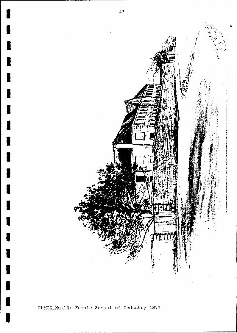
Industry and ultimately the site of the State Library
(Allotment F).
A large percentage of both the primary and secondary
sites was devoted to domestic occupation ranging fro'm the
lower middle class to the professional groups. The earliest
identifiable of these dwellings was in existence by 1816
(Allotments C,D). The others,as well as small commercial
enterprises,range in date from approximately the same time
to the 18508 inclusive. Most had· been demolished by the 1890s.
The latest nineteenth century construction was the "Iron
Church" built on Allotment D in 1857.
During the later years of the nineteenth century
the primary site (Allotments C~D and E) was gradually encroached
upon by additional buildings for parliamentary purposes.
Finally, in the early years 0f this century a tennis court/
bowling green with subsidiary buildings was constructed over
the site. In 1975 the temporary building now on this site
was erected. The secondary sites have become part of the
parliamentary extensions (Allotments Bl-15) and the State
Library site (Allotment F).

1 I 'I I I I I I I I
2.2
a.
b.
c.
7
RECOMMENDATIONS
That during the initial excavation and subsequent
disturbance on site an archaeologist be present to
supervise the same.
That if during the course of excavations any features,
relics or artefacts are unearthed or exposed provision
is made for the supervising archaeologist to take
whatever action is necessary to record and retrieve
this resource. This may take the form of minimal
excavation and/or clearance, photographic recording,
artefact retrieval or any other appropriate
archaeological technique.
That provision be made in the documentation for the
work schedules to allow for the possibility of
archaeological work becoming necessary during the
course of excavation.

i I I I I I I I I I
8
3.0 EARLY LAND GRANTS/DIVISION INTO ALLOTMENTS AND
SUBSEQUENT OWNERSHIP
3.1 EARLY LAND GRANTS/DIVISION INTO ALLOTMENTS.
The earliest land grant issued on this site was
that given to William Bennett by Governor King (1). Shown
on the 1807 James Meehan plan of Sydney (ML Ref. M2.811.17/1807/1)
as Allotment 82 it encompassed in area sections of the later
sites of Richmond Villa, the Domain Terrace and parliamentary
buildings. There is no evidence for any construction having
taken place on this grant (Plan No.2 Allotment A) .
In 1814 Maurice 0·: Connell was granted three roods
and thirty-four and a half perches (about one acre) of land
facing the Domain (2) which encompassed the Bennett grant (3).
In 1823 this grant was transferred to Sir John Wylde the
Judge Advocate (41. wh6,in turn, sold it to W.C.Wentworth in
1831 (!D) (Plan No.2 Allotment B).
In 1835 the·Wentworth allotment was subdivided into
fifteen sub-allotments and these were sold at auction (6)
(Plan No.2 Allotments Bl-1S). Seven, in the eastern section of
the grant, had frontages to the Domain (Plan No.2 Allotments
Bl-7). The southernmost three of these (Plan No.2
Allotments Bl-3) and one other were subsequently withdrawn
for private sale. Allotments Bl-3 were soldre~pectively to
Leslie Duguid (Managing Director of the CBC),A.B.Spark
(Treasurer of the AGL) and N.Carr. In 1849 these three lots
were provisionally purchased by Mortimer lliewis (7).
The remaining three sold at auction went to F.Stephen,
I.D.Nichols and T.H.James. These subsequently formed part of the
Richmond Terrace land (8) (Plan No.2 Allotments B4-7). Of
the subsequent development of the remaining eight sub
allotments (Plan No.2 Allotments B8-1S) there is little
evidence. It is claimed that these were originally owned by
J.Buckley (9), Certainly by the 1880s they were part of
the W.C.Wentworth estate (10).
Of the area of land fronting Macquarie Street and of
primary concern to this report three separate grants,
possibly issued as early as the O'Connel1 grant, are
recognizable. Allotment C (Plan No.2) was given to Sir John

I I I I I I I I I I i I I I I I I I
9
Wylde (11) and later acquireG in 1831 by W.C.Wentworth (12).
Between this date and 1837 eighteen feet was excised along
the northern boundary to form the Domain Terrace roadway (13).
Allotment D (,lan No.2) was originally granted to
Joseph Buckley (14) and Allotment E was issued to a Jemima
Eager (15). Allotment F (Plan No.2) the site of the Female
School of Industry would seem to have been alienated by
Governor Macquarie in c.1809/10 for the purpose of
establishing his Light Horse Barracks.

I I I I I I I I I I -I I I
:1 I I I I I I
10
3.2 SUBSEQUENT OWNERSHIP AND OCCUPATION OF ALLOTMENTS
3.2a ALLOTMENT~'A (Secondary Site)
There is no evidence for any subsequent development
on this grant after the initial issue.
3.2b ALLOTMENTS Bl-3 (Secondary Site)
These three allotments were bought in 1849 by
Mortimer Lewis and upon them in c.1850 he built Richmond
Villa. Lewis only occupied the house for about a year (1)
and thereafter it passed into other hands. It was ultimately
acquired by James Williams on December 19,1863 (2). From ·this
date Williams and his trustees appear to have retained
possession of the house and grounds until its resumption
by the Crown (3). The villa-became the offices for various
parliamentary people and for a considerable period was the
home for the Country Party. It was removed from this site in
the 1970s to become the offices for the ~ociety of
Genealogists in the Rocks (4). The site is now encompassed
by the parliamentary extensions.
Plates: 1
Plans: 5,7,8,9,10,11
3.2c ALLOTMENTS B4-7 (Secondary Site)
Part of this site was sold at the 1835 auction to
Stephen,Nichols and James. The subsequent ownership after
this has not been traced. By 1854 Richmond Terrace had
been built here (Plan No. 7 ). During the nineteenth century
this was privately occupied by people of the professional
class,doctors,lawyers etc. Early in this century, however,
the terraces had been taken over to serve as government
offices (1). The terrace appears to have been demolished
before 1938 and the site has since been encompassed by the
parliamentary extensions.
Plates: 2,3,4,9
Plans: 5,7,8,9,10,11
3.2d ALLOTMENTS B8-15 (Secondary Site, partial primary site)
There is very little docum~ntation for the

I I I I I I I I I I I I I I I I I I I I
11
development of this site. It is claimed that the area was
originally owned by Joseph Buckley (1). By 1880 Campbell
claims that it was owned by the trustees of the Wentworth
estate (2). By 1854 the Domain Terraces had been constructed
(Plan No. 7).
Described in 1911 by "Old Chum",he stated that
there were six houses on one side (the northern section)
and twelve on the other (the southern section facing east) .
This arrangement is seen on the 1860 plan (Plan No. 8 ). He
also states that, in contrast to Richmond Terrace,these
houses were occupied by journeymen, tradesmen, stonemasons,
printers,carpenters,curriers,tailors,shoemakers,labourers
etc (3).
By 1895,of the eighteen cottages~only numbers 1-13
are listed in the Sands Directory and by .1897 only numbers
12 and 13 (4). This was due to the encroachment of the
parliamentary facilities viz.the stables and extensions to the
assembly chamber (5). From 1901 these numbers (12 and 13)
are given as 12 and 14 (6). In 1908 no resident is recorded
and 1909-10 the occupants are stated to be Frank Kent and the
City Tramway Power Substation (7). From 1911 to 1927 only
one name· is given and from 1928 the Domain Terrace
ceased to be listed as a street (8). The further extensions to
Parlia.ment House and the landscaping for the tennis court/
bowling green completely covered this site.
Plates: 2,3
Plans: 5,7~8,9,10,11
3.2e ALLOTMENT C (Primary Site)
This allotment, after its original ownership by
Sir John Wylde,was acquired by W.C.Wentworth in 1831(1).
Between this time and 1837 eighteen feet was excised
along thp northern boundary to form the road that gave
access to the Domain Terraces (2). The earliest directory
reference for a resident is in 1855 for a Mrs Edwards (3).
In 1857 Joel H.Asher,merchant,is listed (4) .. By 1867
William Mathews,coach proprietor, is listed at the address
and his family and business,a livery stable, continued to
occupy the site until 1890(5) •.

I I I I I I I I I I i I I I I I I I ·1 .1
12
From the early 1860s (and possibly the later
1850s) two separate premises were located on Allotment C.
This is consistent for 1864-1890. The Mathews family and
business continuously occupied one, the other had a frequently
changing tenancy (6),however,it was alway used as a domestic
residence.
In 1890 listings cease presumably because the
buildings were demolished. By 1908 thp bowling green/
tennis court and associateddevelopments had covered the
site. In 1975 the temporary parliamentary building was
constructed.
Plates: 2,5(left section),6 (left section),8 (left section),10,12,13
Plans: 3,4,5,6~7~8~9~10~11
3.2f ALLOTMENT D (Primary Site)
Originally granted to Joseph Buckley,its subsequent
ownership is obscure until 1854 when the site is shown as
being unoccupied (Plan No. 7). It appears to have been
the location for a private residence, "Old Chum" states that it
belonged to John Flexman a hay and corn dealer (1).
In 1854 the site was sold to the Free Church of
Scotland for £2060 (2). On this was erected the popularly
known "Iron Church". There is some discrepancy in the
sources with regard to the date of this event,however,when
the building was demolished at Rookwood in 1958 a bottle was ;
found in one of the towers with a hand written document
inside intended as a "time capsule". This clearly states
that the building was imported from Scotland and erected in
Macquarie Street in 1857 (3).
The building was made in the yards of Robertson and
Lister in Glasgow and was one of two similar in size and
appearance to each other, the only exception being that the
Macquarie Street church had two towers to either side the
other church a single central spire. The dimensions of
each were seventy-three feet long and forty-five feet wide
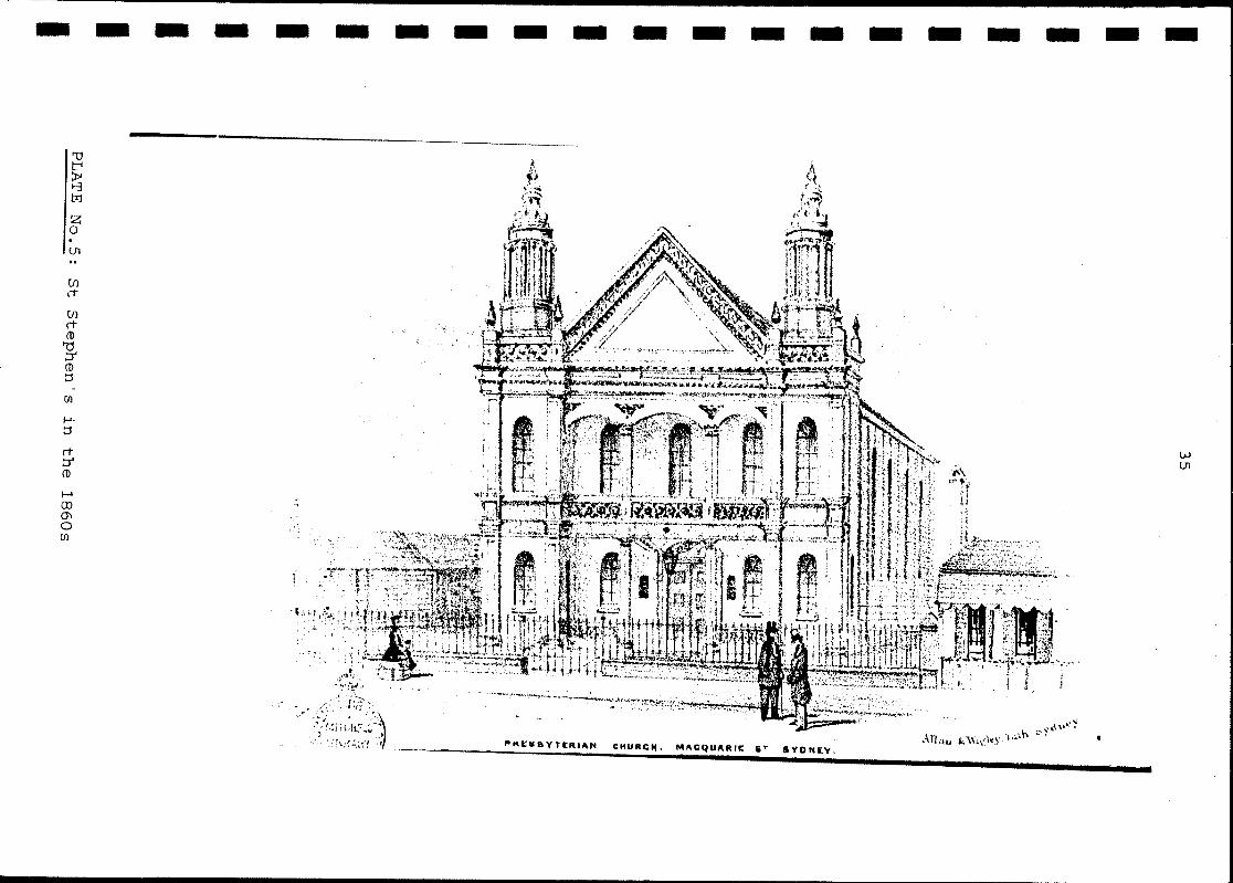
(4). It was dedicated as Saint Stephen's Presbyterian
Church (the second of that name).
In 1875 the building was sold by the Church

I I I I I I I I I I i I I I I I ,I I I I
13
after it acquired another building in Phillip Street (5).
During 1876 the former church was apparently vacant, it is
listed in Sands Directory as the"Late St Stephen's
Presbyterian Church" (6). From 1877 to 1880 it was used by
Samuel Friedman as a tweed clothing factory (7) and from
1881 until its removal in 1899 it served as the lending branch
of the Public Library (8).
From Macquarie Street the church was taken down and
re-erected at Rookwood Asylum (later known as the Lidcombe
State Hospital) where it served as a recreation room, dining
hall and chapel (9).
After its removal the tennis court/bowling green
took over the site and in 1975 the temporary parliamentary
building was erected.
Plates: 2,3,5,6,7,8,9,10
Plans: 3,4,5,6 7,8,9,10,11
3.2g ALLOTMENT E (Primary Site)
Originally owned by Jemima Eager the deeds were
reissued to W.C.Wentworth in 1849 (1). The allotment seems
to have always been, until its incorporation into the
parliamentary site,a private residential block. In 1858-9
Oswald Campbell~an artist, resided here (2) and thereafter
a rapidly changing tenancy (3) un~il 1875 when the
premises first become a boarding house owned by Mrs Fanny
Spencer (4). Apparently unsuccessful, in the following years
until 1880 the residence reverted to private hands (5). In
1880 Miss S.Lennon owned the site and she tUl;:lned the
house into a boarding house,the famous "Rose Cottage". In
1893 this listing ceases and it is likely that at this time
the cottage was demolished. (6)
In 1897 the parliamentary buildings began to
encrQach upon the site,a number of lavatories and offices
being built towards the rear of the allotment (7). The
bowling green/tennis court completely covered the site.
The temporary building was erected in 1975.
Plates: 2,5 (rig-_t section), 6 (right section), 8
Plans: 3,4,5,6,7,8,9,10,11

I I I I I I I I I I I I I I I I I I I I
14
3.2h ALLOTMENT F (Secondary Site)
This allotment, the School of Industry site, appears
to have first been alienated by Governor Macquarie to
establish barracks and stabling for his Light Horse Guard.
This is one of the least known of the Macquarie buildings
and virtually no documentation survives •
In May 1809 Castlereagh authorized Macquarie to construct
accomodation for his regiment (1). It would seem that by July
1810 work had begun and was expected to proceed rapidly (2).
In October 1811 Macquarie reported to Liverpool that lIa
new Range of Barracks for the accomodation of the troops
was completed in the later part of last year ... 1I (3). However,
Commissioner Bigge reported that the Light Horse stables
were not completed until 1812 (4).
There are no extant plans for the building,no
specifications and only two accounts in 1819 and 1820,both
for £20 to Edward Cureton for partial payment lI erecting wall
round Light Horse Barracks ll (5).
The only description of the Barracks was recorded
by Macquarie himself in 1822. He described it as a IIBrick
Built Barrack stuccoed for the Governors Guard of Light
Horse and stabling for 16 horses and Garden enclosed with a
Stone Dwarf Wall ll (6) •
After the departure of Macquarie in 1821 and during
the temporary establigbment of Government House at
Parramatta,the necessity for the Governor's Horse Guard
appears to have diminished until in 1826 the remnant of the .
detachment was transferred and the building was granted
to the Church of England Institution for lithe maintenance
and training of fifty female children of poor parentage
in cooking and general domestic duties under the name of the
Sydney Female School of Industry ll(7).
On the change of occupation certain alterations
had to be carried out. In May 1826 it was stated that
the building was being prepared IIwith every possible
expeditionll (8) and in June it was reported that 11 stonemasons,
bricklayers, carpenters etc etc are as busy as bees ••.• 1I (9).
After the School moved into the premises it was
found to be necessary to make further additional

I I I I I I I I I I
r :
I I I I I I I
15
alterations. The annual report of 1827 states that
" •.. several alterationsboth in the interior and exterior
of the premises have been made which although on first
view may appear to have been of a trifling nature have
nevertheless tended greatly to the comfort and neatness
of the school".(10). There are no extant details for any of these
alterations.
The guidelines of the school were simple:girls were
clothed and boarded and taught basic household duties. They
were not allowed to leave the school unless expelled or a
sit'uation found 'for them (11). In short the school provided
trained servants for those that supported it.
In 1869/70,possibly due to the poor condition of
the buildings, the decision was made to move the School
of 'Industry to a site in Darlinghurst. The Colonial Architect
valued the Macquarie Street site at this time at £14,500 but
claimed that lithe old buildings will not more than pay the
cost of removal 11 (12) .
The School was removed in the 1870s and theusit.e,seems to
have become a small park or garden.
In 1879 the Macquarie Street Resumption Act was
put into effect which gave the State Government the power
to resume the land betweenfue 1843 Chamber and the Bent
Street entrance to the Domain. This was to allow the erection
of new parliamentary buildings (13).
In 1888 the foundation stone for the new buildings
was laid on the old school site (14),however,in the
Depression of 1893 all such schemes were abandoned. There
after the site was not touched again until the construction
of the State Library which opened in 1910.
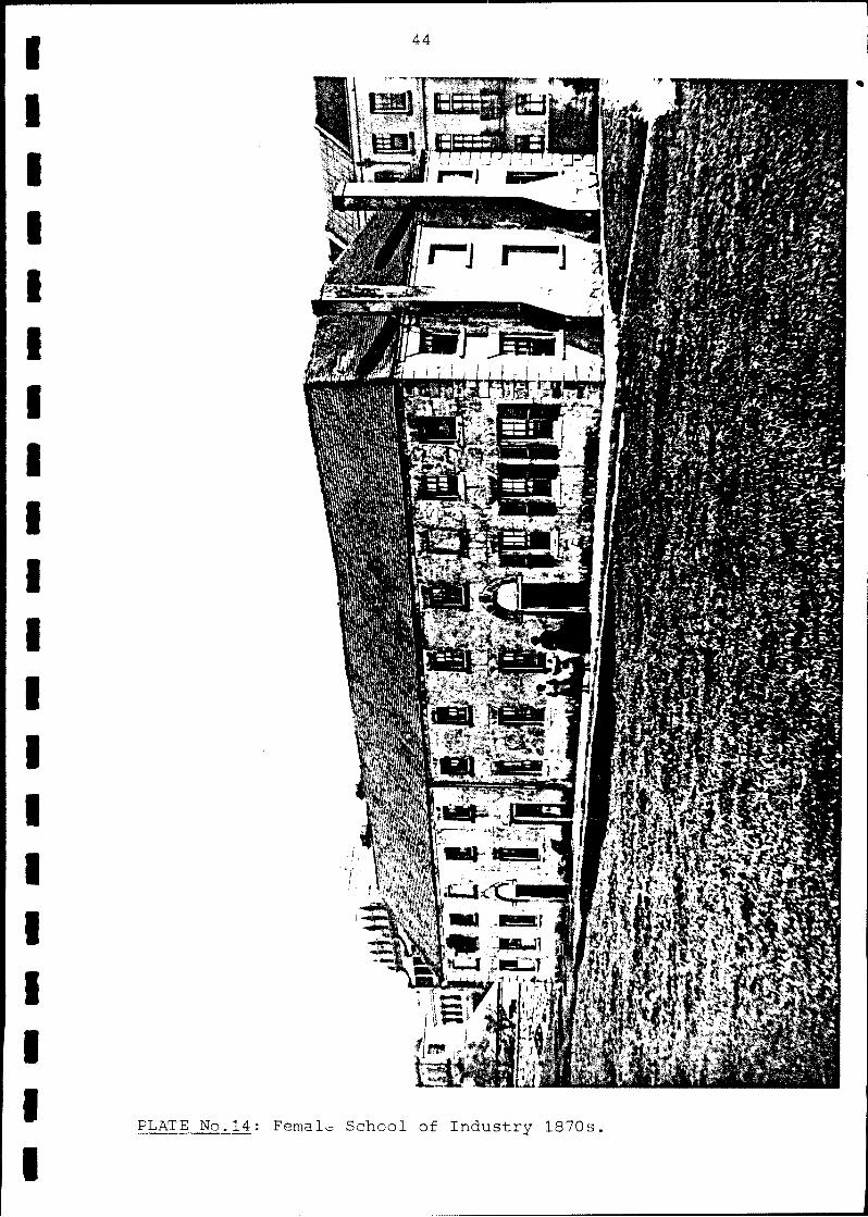
Plates: 2,3,10,11,12,13,14
Plans: 3,4,5,6,7,8

I I I I I I' I I I I i I I I I I \1
I I I
16
4.0 STRUCTURAL DEVELOPMENT OF THE ALLOTMENTS
4.1 ALLOTMENT A (Secondary Site)
There is no evidence to suggest that any structure
was built on this site.
4.2 ALLOTMENTS Bl-3 (Secondary Site)
There is no evidence for any building on the site
earlier than Richmond Villa built c.1850. If not originally
then certainly by 1860 three other buildings were
constructed, two in the extreme south-west corner of the site
and a single small building in the north-west corner. This
arrangement was current in the 1880s. By the turn of the
century these buildings h.ad been demolished and the area
landscaped. By 1929 a covered way led from the Villa to
the main parliamentary complex. During the 1970s Richmond
Villa was removed to its new site and the area is now encompassed
in the parliamentary extensions.
Plates: 1
Plans: 5,7,8,9,10,11
4.3 ALLOTMENTS B4-7 (Secondary Site)
There is no evidence for any construction on this
site before Richmond Terra~e was built in the 1850s. Th~
terrace covered the entire site on an oblique angle with a number
of outbuildings to the rear (west). The number of these
outbuildings had increased by the 1880s. Some of these were
demolished during the early years of this century. The
terrace was demolished before 1,938 and the site is now
encompassed by the parliamentary extensions.
Plates: 2,3,4,9
Plans: 5,7,8,9,10,11
4.4 ALLOTMENTS B8-15 (Secondary Site" partial. primary site)
There is no evidence for any construction on this
site before the Domain Terrace was built in the 1850s. This
occupied the site until the 1890s when parts were demolished
to make way for parliamentary buildings. The remainder
I I I I I I I I I I I I I I I I I I
I
17
was demolished shortly thereafter. Further parliamentary
buildings wpre then built upon it and it is now encompassed
within the parliament house [email protected] natrowly included-in the area
of the new library extensions.
Plates: 2,3
Plans: 5,7,8,9,10,11
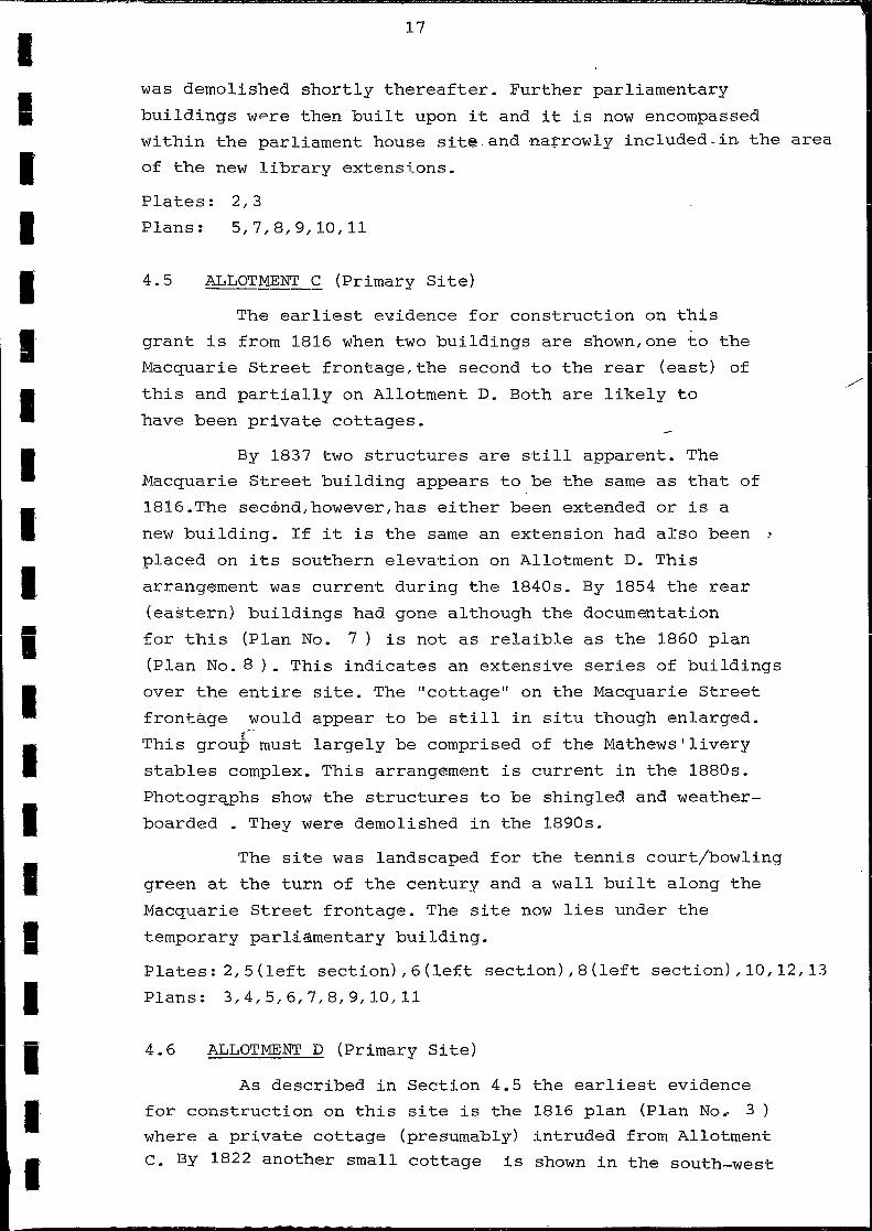
4.5 ALLOTMENT C (Primary Site)
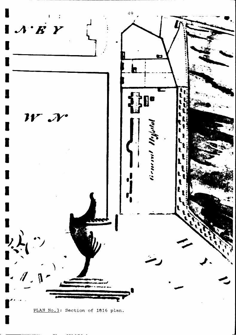
The earliest evidence for construction on this
grant is from 1816 when two buildings are shown, one to the
Macquarie Street frontage, the second to the rear (east) of
this and partially on Allotment D. Both are likely to
have been private cottages.
By 1837 two structures are still apparent. The
Macquarie Street building appears to be the same as that of
1816.The secmnd,however,has either been extended or is a
new building. If it is the same an extension had arso been ]
placed on its southern elevation on Allotment D. This
arrang~ment was current during the 1840s. By 1854 the rear
(eastern) buildings had gone although the documentation
for this (Plan No. 7) is not as relaible as the 1860 plan
(Plan No. 8 ). This indicates an extensive series of buildings
over the entire site. The IIcottage ll on the Macquarie Street
frontage would appear to be still in situ though enlarged.
This grou~must largely be comprised of the Mathews I livery
stables complex. This arrangement is current in the 1880s.
Photogra~hs show the structures to be shingled and weather
boarded • They were demolished in the 1890s.
The site was landscaped for the tennis court/bowling
green at the turn of the century and a wall built along the
Macquarie Street frontage. The site now lies under the
temporary parliamentary building.
Plates: 2,5(left section),6(left section),8(left section),10,12,13
Plans: 3,4,5,6,7,8,9,10,11
4.6 ALLOTMENT D (Primary Site)
As described in Section 4.5 the earliest evidence
for construction on this site is the 1816 plan (Plan No~ 3
where a private cottage (presumably) intruded from Allotment
C. By 1822 another small cottage is shown in the south-west

I I I I I,
I I I I I i I I I I I I I I, I
18
corner of the allotment and by 1837 a large building is
shown covering the entire Macquarie Street frontage of
Allotments D and E. In 1843 this arrangement was still current,
however,by 1854 the site is shown as unoccupied. In 1857
the Iron Church was erected here and occupied the site unti~
1899. After its removal the site became part of the tennis
court/bowling green arrangement and is now under the
temporary parliamentary building.
Plates: 2,3,5,6,7,8,9,10
Plans: 3,4,5,6,7,8,9,10,11
4.7 ALLOTMENT E (Primary Site)
One cottage is shown on this site in 1822 and by
1837 there is part of a large building stretching across
both Allotments D and E with an eastern extension to it on
Allotment E. In 1854 one cottage is shown although by 1860
a similar arrangement to that shown in 1837 is currpnt with
the addition 0,:'5 a small outbuilding in the extreme north
east corner of the site. By 1888a further extension had
been made to the cottage along the parliamentary boundary.
This arrangement was current until it was demolisged in the
1890s. The tennis court/bowling green was constructed on this
site and the temporary parliamentary building was later
built here in 1975.
Plates: 2,5Jright section),6(right section),8
Plans: 3,4,5,6,7,8,9,10,11
4.8 ALLOTMENT F (Secondary Site)
Throughout its entire life as first a barracks
and then a school only two buildings are ever shown, the
main school building on Macquarie Street (although the
entrance was on the far side) and a second small outbuilding
in the extreme south-e'ast corner of the site. Both were
demolished at the same time in the 1870s and the only other
building to occupy the site has been the library.
Plates: 2,3,10,11,12,13,14

I I I I I I I I I I .. I
I I I I I I I I I
19
5.0 ASSESSMENT OF THE ARCHAEOLOGICAL POTENTIAL,ALLOTMENTS A-F
5.1 PREAMBLE
A definitive archaeological assessment of a site
and its potential is dependent on the extent and detail
of available archival material. In all cases on both the
primary and secondary sites this data was absolutely minimal.
The assessment, therefore, of these sites is necessarily
limited. Without details of construction it is impossible
to determine the impact a building will have on a site and in
turn the impact that succeAding structures will have on
both the site and the features which have preceeded it.
It is generally possible, in broad terms,to assess
a given site when the nature of the potential feature is
known by using comparative architectural techniques, however,
in the case of this primary site 90% of the buildings have
only a presumed function due to the poor documentation.
The following assessment, therefore, is necessarily
cautiousand the recommendations also reflect this attitude.
5_2 ALLOTMENTS A,Bl-7
Due to the circumstances of Allotment A there is
unlikley to be any features or evidence left on site.
Allotments Bl-7 are beyond the primary area of concern and
the area has been extensively redeveloped in recent times.
It is extremely unlikley that evidence IDf the extensive
nineteenth century buildings would remain. It is also
unlikley that any subsidiary features relevant to these
would be intrusive into the primary site. The likelihood of
any evidence from this area being recovered during the
future redevelopment is minimal.
5.3 ALLOTMENTS B~-15
The northern section of these allotments is
intrusive into the primary site. The nineteenth century
development of this area was concerned only with the
Domain Terraces and the associated out-buildings. The
extent of this development as well as the subsidiary
features, mainly drainage patterns, water and sewerage lines
and small artefact material (dumps?),presupposes an

I I I I I I I I I I .. I
I I I I I I I I I
20
extensive impact on the site.
It islikely that the later parliamentary
buildings removed or disturbed a considerable amount of
this evidence, however, the probability of evidence of the
subsidiary features remains good. It is considered that
neither the landscaping for the tennis court/bowling green
nor the foundations for the temporary building have had
an extensively damaging impact although they would certainly
have disturbed the upper strata.
It is considered, therefore, that disturbance of the
site may reveal drainage lines and/or small artefact material
associated with the Domain Terrace complex. It is possible,
though less likely, that foundations of later parliamentary buildings
may also be found.
5.4 ALLOTMENT C
This site has had a long and extensive building
history from at least as early as 1816 to the 1890s. The
potential archaeological material is concerned primarily
with lower middle class domestic and small commercial
enterprise which, if intact,would be a unique archaeological
discovery in Macquarie Street to date. However,the
probability of the material remaining in situ is difficult
to determine for the reasons outlined in Section 5.1.
At the minimum it is expected that small artefact
material representative of the site fUnction will be
recovered. With regard to the structural evidence it is
considpreq that evidence may be retained, albeit
disturbed, and this is more lik~ly to occur towards_the
Macqtlarie Street frontage rather than to the rear (east)
of the block due to the les-ser impact that the landscaping
for the tennis court/bowling green and the preparation for the
foundations of the temporary building would have had than
the site preparation required for the later parliamentary
buildings to the east. If structural material remains
in this section of-Allotment C it more likely to be from
these later buildings than the earlier domestic structures.
In addition to this there is a very small
possibility of future excavation unearthing the remains of

I I I I I I I I I I • I
I I I I I I i I I
21
drainage patterns from the Barracks/School from its
earliest phase of occupation.
5.5 ALLOTMENT D
This allotment represents a similar situation to
Allotment C with a similar building span from c.1816 to the
1890s. However,the probability of evidence of the earlier
domestic structures is less likely than that of Allotment
C due to the later construction of Saint Stephen's Church
which is likely to have disturbed the underlying strata.
Any primary structural evidence, therefore, is more likely
to be from this phase rather than the earlier and, similarly
to Allotment C,more likely to occurtowards the Macquarie
Street frontage rather than to the east for the reasons
outlined in Section 5.4.
Small artefact material is again considered likely
though differing in assemblage, being more like~y to be
representative of the later occupation of the site.Drainage
patterns as discussed in Section 5.4 are also possible .
5.6 ALLOTMENT E
This allotment has had an equally long structural
history as those of C and D,in this case ranging from
the 1820s into the 1890s. The potential archaeological
material is similar in nature to that of Allotment C,
concerned with. the lower middle class domestic occupation.
As with Allotment C retained structural evidence
is more likeLy to be towards the Macquarie Street frontage for
the same reasons outlined in Section 5.4 although in this
case the greater probability of sub-surface remains is
centred in the north-western section of this frontage
due to the encroachment of the parliamentary buildings into
the south-western sector during the later 1890s. Any
structural evidence recovered in this area is more likely
to be from this phase rather than the earlier.
Small artefact material and drainage lines as discussed
In Section 5.4 are a probability.
I, I I I I' I' I I, I I .' I·
I I I' I I, I I I I
22
5.7 ALLOTMENT F
This allotment is a secondary site and the only
possibility of it having an' effect on the primary site
is through intrusive drainage patterns/disc~ssed in the
relevant sections. The library now covers the entire site of
the former Barracks/School and it is very unlikely that
any sub-surface evidence of these occupations remains.

I I I I I I I I,
'1 I i I,
I I I I I I I, I
6.0
6.1
a.
1.
2.
3.
4.
5.
6.
7.
8.
9.
?3
SUPPLEMENTARY DOCUMENTATION
FOOTNOTES TO THE TEXT
SECTION 3.1
Campbell,J.F. Notes on the Historic Development of
Macquarie Street South.
R.A.H.S. Jnl 23 1937 Pt 3.,194
Maiden,J.H. History of the Sydaey Botanic Gardens
R.A.H.S. Jnl 14 Pt 1.,32
Campbell,J.F. Op Cit.,198
Ibid., 200
Ibid.
Sydney Morning Herald May 14,1835.,3ff
Campbell,J.F. Loc Cit.
Ibid.
Maiden,J.H. Loc Cit.
10. Campbell,J.F. Op Cit.,202 Plan X
11.
12.
13.
14.
15.
b.
1.
2.
3.
4.
c.
1.
Ibid.
Ibid.
Ibid.,201
Ibig.
Ibig.
SECTION 3.2b
Campbell,J.F. Notes on the Historic Development of
Macquarie Street South.
R.A.H.S. Jnl 23 1937 Pt 3.,200
Personal communication with Mr B.Roser.
SECTION 3.2c
"aId Chum"
The Truth December 27,1911

I I I I I I I I I: I i I I I I I I I I I
24
Old Chum A224.,224
1. Maiden,J.H. History of the Sydney Botanic Gardens
R.A.H.S. Jnl 14 Pt 1.,32
2. Campbell,J.F.Notes on the Historic Development of
Macquarie Street South.
R.A.H.S. Jnl 23 1937 Pt 3.,200
3. "Old Chum"
The Truth December 27,1911
Old Chum A224.,224
4. Rhodes,D. New Library Building A Site History., 1
5. Ibid., 3
6. Ibid.,l
7. Ibid.
8. Ibid.
e. SECTION 3~2e
1. Campbell,J.F. Notes on the Historic Development of
Macquarie Street Soubh.
R.A.H.S. Jnl 23 1937 Pt 3.,201
2. .Ibid.
3. Waugh and Cox Directory of Sydney and Suburbs 1855
4. Sands Directory 1857
5. Ibid.,Macquarie Street Listings 1867-1890
6. Rhodes,D. New Library Building A Site History., 2
f. SECTION 3.2f
1. "Old Chum"
The Truth December 27,1911
Old Chum A224.,224
2. NSW Presbyterian March 27,1935.,228-32
3. ML Doc.293
4. Forde,J.M. News~er Cuttin~Vol.166.,38ff
5. Rhodes,D.New Library-Buildin~A Site History., 2

I I I I I I I I I I • I,
I' I I I I I I I I
6.
7.
8.
9.
f.
1.
2.
3.
4.
5.
6.
7.
g •
1.
2.
3.
4.
5.
6.
25
Sands Directory 1876
Watson,J.H. Old~dney
Ibid
Ibid
SECTION ~
Campbell,J.F. Notes ori the Historic Development of
Macquarie Street South
R.A.H.S. Jnl 23 1937 Pt 3.,201
Sands Directory 1858,
Ibig.,1861-74
Ibid., 1875
Ibid., 1876-79
Ibid., 1880
Rhodes,D. New Library Building A Site History.,Map 4
Castlereagh to Macquarie
May 14,1809
HRA VII.,84
Government and General Order
July 28,1810
HR of NSW XII.,398
Macquarie to Liverpool
October 18,1811
HRA VII.,396
Items built by Government labour.
Item No.2
B.T. 12.,338
Sydn~azette August 28,1819
eydney Gazette June 8,1820
Macquarie to Bathurst
July 27,1822
Enclosure A
HRA~.,686

I I I I I I I I I I .. I
I I I I I I I I I
7.
8.
9.
10.
11.
12.
13.
14.
26
Campbell,J,F. Notes on the Historic Development of
Macquarie Street South.
R.A.H.S. Jnl 23 1937 Pt 3.,198
Sydn~azette May 31~~826
~bi~.,June 7,1826
Annual Report of the Committee of the School of Industry 1827
Col.Sec. Letters In Bundle 4L180~
Sydney Gazette April 8,1826
Col.Arch.to Under Sec. for Public Works
August 1,1870
Col.Sec. Letters In Bundle 4/780.2
Reynolds,P.L. Legislative Architecture in NSW 1788-1974.,33-4

I I I I I
i I
I I I I -I I I I I I I I I I
6.2
a.
b.
27
BIBLIOGRAPHY
BOOK§., REPORTS
Annual Report o~ the Committee of the School
of Industry 1827
Col.Sec. Letters In
Bundle 4/780.2 (S.A. NSW)
Kelly,M. and Crocker,K. Sydn~Takes Shape
Doak Press 1978 (Private)
Rhodes,D. New Library Building A Site History 1983
(Private Report)
Reynolds,F.L. Legislative Architecture in NSW 1788-1976
Pub. Legislative Council 1976 (Private)
Scott,G. Sydney's Highways of History
Georgian House Press (Private)
Watson,J.H. Old Sydney
(ML Q991.1/W)
NEWSPAPER ARTICLES,JOURNAL ARTICLES
Anon. "The Iron Church"
NSW Presbyterian March 27,1935.,228-33
(ML MDQ 285.105/1)
Campbell,J.F. Notes on the Historic Development of
Macquarie Street South.
R.A.H.S. Jnl 23 1937 Pt 3.,194-204
Forde,J.M. Newspaper Cuttings Vol 166
(ML FM4 7955)
Maiden,J.H. History of the Sydney Botanic Gardens
R.A.H.S. Jnl 14 Pt 1
"Old Chum" articles
OJtd Chum A224 (ML)
Sydn~azette August 28,1819
June 8,1820
April 8,1826
May 31, 1826
June 7,1826 (ML)
Sydney Morning Herffild May 14,1835 (ML)

I I I I
!I I I I I, I • I
I I I' I' I I I. I
c.
d.
e.
28
CORRESPONDENCE,MISCELLANEOUS DOCUMENTS
Items of Government Labour
Bonwick Transcripts 12 (ML)
Letter Col.Architect to Under Sec.for Public Works
August 1, 1870
Col.Sec. Letters In Bundle-±i780.2
Governors' Despatches in
HRA VII,X
HR of NSW XII (ML)
Memo re. Removal of Iron Church
.!'1L Do~293
DIRECTORIES -------Sands DirectorY-1857-1932 Macquarie Street Listimgs
Waugh and Cox Directo~of~ney-and Suburbs 1855
(981il/W ML)
PLATES ----
1. PWD File Photograph
2. Hou~son Volume 3 F981.1/H (ML)
3. SPF-Sydney Streets-Macquarie-Panorama (ML)
4. SPF-Sydney Residences-Richmond Terrace (ML)
5. Gill,S.T. Sydney Illustrated (ML)
6. SPF~Sydney Churches-St Stephen's
7. SPF-Sydney Churches-St Stephen's
8. SPF-Sydney Streets-Macquarie
9. SPF-Sydney Streets-Macquarie
(MLY
10. Female School of Industry 1834 Walker SSVI/PUB/FE SCl1
11. Female School of Industry 1842 Rae.J. Macquarie Street
DGSU* Sp Coll Rae 18
12. Female School of Indus:':ry 1873 Elyard,S V*l Sp Coll/Elyardl
13. Female School of Industry SPF
14. Photographic Views of Sydney Vol.3 ML F98.41P
I I I I I I I I I I i I I I I I I I I I
29
f. PLANS
3. ML Plan MS 811.172/1816/1
4. ML M2 811.17/1822/1
5. SA NSW Surveyor Genera: Ske~ch Book Vol.4 Folio 59
6. ML M2 811.17/1843/1
7. ML M2 811.17/1854/1
8. ML M4 811.172/1860/1
9. ML MSer 4 811.17/1
10. PWD
11. PWD

I I I I I I I I I I i' I I I I I I I I I
7.0
7.1
30
GRAPHJiCS ----PLATES TO THE TE)cr'
1. Richmond Villa during removal.
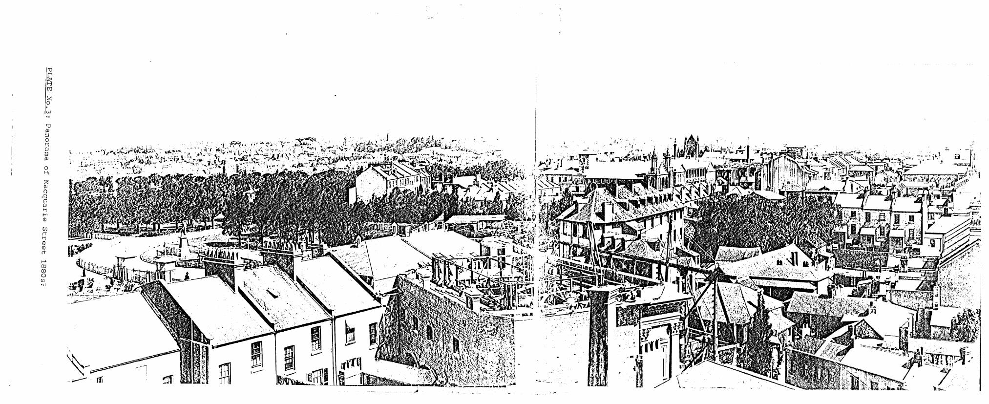
2. P.anorama of Macquarie Street.
3. Panorama of M~cquarie Street.
4. Richmond Terrace before demoili~ion.
5. St Stephen's in the 1860s
,~6': St Stephen' s in the 1870s.
7. St Stephen's during removal.
8. The Iron Church,Rose Cottage etc. c.1864
9. Panorama of Macquarie Street 1871-2
10. Panorama of Macquarie Street 1882-9
11. Female School of Industry 1834
12. Female Scnool of Industry 1842
13. Female School of Industry 1873
14. Female School of Industry 1870s
15. Panorama of the site in 1938

------~-------------
~.
... :... •••••.••• -... iii:::::
cv ......

1'0
I~ tIJ
Z o N
t-' CO CO o CIl '-J
( .':.
w
f-' m m o (fJ
'0

34
PLATE No.4: Richmond Terrace before demolition.
- - - - - - - - - - - - - - - - - - - -'U I:-i ~ f-3 tlj
Z 0
Ul
(f) et
(f) et '¥ (J)
'U ::r' (J) !J
Ul
1-'-!J
et w ::r' U1 (J)
I-' m .<
(J)
0 Ul
""£88YTI:RIAN CHUIIC". MACqUARIE Cl'!" SYONEY.
$

--------------------1'"t:J I~
I~ It " ,0'1
(J)
rt
(J)
rt re '0 ::r' re ::s Ul
1-'-::s rt ::r' re I-' en -..J 0 Ul
I
--...
,
W 0'1

- - -- ----------------'d t"'
~ t:x:!
Z 0
-.J •
"" UJ '. rt
UJ rt CD
'"0 ::r CD ~
(Jl
Q.. s::: t1 w ......
-.J ~ to
t1 CD 3 - 1'1 :
~-.-... 0 ~,! ~ OJ I-'
I i

-------------_ .. _----" ./
"d t'i , :t>' t-'3 tr1
Z 0 · 00
:s: III 0 .a
.~. c III Ii f-'. (I)
~'\ . (j) l' ' , ~ eT .... . Ii
-:~'~ (I) ., . w
(I) 00 eT
I
0 · t-' 00 0\ ,j::..
· ~
~

---------------------I~ I; I~ 'lj PI :::s 0 11 PI 3 PI
0 Hl
:$ PI ()
..Q w ~ ID PI 11 1-'-(])
Ul eT 11 (]) (]) eT
.-. en --:J .-. I N

40
PLATE No.10: Panorama of Macquarie Street c.1882-9.

---------------------
'"lj CD 3 ClJ I-' CD
r.n ()
::t o o I-'
I-' CO w .p..
rr

-
I? If-' IN .. I-:tj CD 3 OJ f-' CD
(j) ()
::r o o f-'
o H1
-
"
- -
rr f '1 ,
r' " C• , • +
- - - - - - -------- - -
•
, ,
(. ~~.",;1
I I I I I I I I I I I I I I I I I I I I
43
"I' !~ p
" l'
PLATE No.13: Female School of Industry 1873
t
• .~ ...... ~~ ~)--
-:.> ~-. ..... ~
c.<-.. -.:.. , ,-;-.:. ~, '
"'Y _, '!>
<
. ,
"
,
44
•
PLATE No.14: Femal~ School of Industry 1870s.

--------------------1'1:l t"'
~ tr1
Z 0
b .. '1:l DJ :::s 0 t-S DJ 3 DJ
0 Hl
rt
*" ::r' U1 re
Ol 1-'-rt re 1-'-:::s
f-' \0 w en

'~------------.--------:-----------------~.~ - ... ~
I I I I I I I I I I i I I I I I I I I I
7.2
46
PLANS TO THE TEXT
1. Definition of Area of Study:Primary and Secondary
2. Definition of Allotments.
3. Section of 1816 plan of the Governor's Demesne.
4. Section of ~lan of 1822.
5. Sketch of the site 1837
6. Section of 1843 plan.
7. Section of 1854 plan.
8. Section of 1860 plan.
9. Section of 188,-, plan.
10. Parliament House 1908.
11. Parliament House c.1929.
Sites.

, i , I I ~ . I
I ;
, : I I I '
r· I '
t I ' I •
a;
I , .
i •
!
.. _. ',.. :... . .. , - - - - - --. /'
PLAN No.1: Definition of Area
of Study
. .. . . . . . . . . Primary Site
Secondary Sites
(Rem~inder of Curtilag
Cl « ~
" . , .. - . . .' . ... ',. '" . '". .... . - : ------NEW SOUTH WALES PARLIAMENT ~USE
.. ............ ~~.~.~ .. ~ .. ~ .. ~ ................ ~ ......................... . . .. . .. .. .. .. .. .. .. .. .. .. .. .. .. .. .. .. .. .. .. .. .. .. .. .. .. .. .. .. .. .. .. .. .. .. .. .. .. .. .. .. .. .. .. .. .. .. .. .. .. .. .. .. .. .. .. .. .. .. .. .. .. .. .. .. .. .. .. .. .. ........................................................................ ........................................................................ ..................................................................... ..................................................................... . .. .. .. . .. . . .. .. .. . . ' ............................................. .. .................................... " .................................. .. .. .. .. .. .. .. .. .. .. .. .. .. .. .. .. .. . .. .. .. .. .. .. .. .. .. .. . . .. .. .. .. . .. .. .. .. .. .. .. . .. . . . .. .. . . . .. . ~rts H-I ~t." ............ .
.::::::::::::;:::r.u ~I '" :::::::::::::: . : : : : : : : : : : : : : : : : : : r~: :o,R: : : : : : : : : : : : : : : .................................... Jt:I ... r.~ .. ti ...................... ..
. :::::::::::::::::::":: . :BtJIl.;. 11\10:::::::: .....--r.::::::::::::::::::::::::::::::::::::::::::::::::::: : ....................................
:&.:.:~~~~:::::::::::
STATE LIBRARY OF NEW SOUTH WALES EXISTING BUILDING
...........
tW LU
~
• • < ,".
, ..... ' ... -.. ~~-. ..:... .. ~"" ... ' ~" - --
HUNTER STREET
LOCATION PLAN IL.rl.JI 501020

-11-0 It"i I~ IZ
I; t:J CD I-h 1-" :J 1-" rt 1-" 0 :J
0 I-h
!J::' I-' I-' 0 rt 3 CD :J rt rn .
- -
• i
l
F
•
. .... . ..
- -, I i i I I i i i i i i i i
1 I I i i i i i i i t . "
'-< -... '-... ... ~.
<!
I I [ I f I I i
...•... ..... ...... . i
•
-
..... '..-.-.----------1'
- - - -
o '~[" ~ . 1_ ..... _
-------------------L~~====~~ ________ L_ __ ~.:
M A c Q . -----.....
('
-. r'" .Ir I
'I , , :
.,~
:' :, " : . · • • • • • •
-.'
.•••• ..1 ,
i
- -..a..-.:. ~ :;:. .=;1., ..,
I ; I I
lU \.~J
I·' . i i
.' i
r
T · :: -r I I ~ • -[ Sy
r'
u
~.. It-==~~~. '-'.rrrr-rnru-o HOUSES OF PARLIAMENT ~ r. _ ._ ... _
l· U~ll.llU[}
IJ r----I..:: __ .. !J
, i ." I
>;: ' . \ " '"
~t:-t.t.~~." ... -l'::3"'...:u-. I IJ· ....... ,-.~t.\"~; 1.'0-, t t ,.,~+1(....."...,.(.:~-.-:-f_~ g- ----- . ,
r·~ .. _= ..... ,'1") ~
IT A It I , .
,. '-r" r···----·/ : f m-··H·~f ~ {f.Wl'f!;· 'm;; l~F.'-·:~ : ... .. 1. . . • Allotment A I I , I I I " Allotment B
1-15 all BAllot ments
-
I . I: .J: 49 , '"
• .A-BY ~.:'. 1 ____ _ J .'
1 ___ -. I I
• IV ~-Y. I I I I I I I
" • r -j !I ~~ . ., .. , . I " ~ ~) .
I ....... ~ 1 ~ ". --- ___ _ ~ '. b- .:._. ___I . , - .. :: ;::. •. - • • q ,: • j: i: I
' J. .• . . n of 1816 plan. 1 3- Sect10 PLAN N~.
I
...
"".
""""-..J
~
.J ..
• ~ ."""""

- -
Ul (f) ()
rt 1-'-o :::s
o Ml
- - -
'.
-), ..
.I:
B Af
. . /-
- 1 - -" .1 I
It '- ,
-/
I~ I:j r
~ -J '4 ..
"
- -
U1 o

--------------------I~ z z o . Ul ?i"' ID et () ::r o HI
et ::r ID
III tj ID III
.1f[gW(#0//$ ""':P#JIt/f ../t'"~,;,../ .
-.N;,4IJ'
'.' '"' ...

- -
(f) (!) () nI-'-o ::J
o t-h
-
----,---
- - -
....
.-. .. • - * t -..
'.
.. j t : .... ~~ .... -~
tt.~ __ "
(A '" r ~ #._.;;;: .. ~.~~:. --
... ". r ~ + . . . ... : .' . " \ .
IJ·
. . : ! r l'
.....' •• 1 .. l" i: I: I ; I , '-A I , 1/ A.-
,I
_._,) ,-
j
I !
I
--D" \ . , " j .
.",-
-
U1 N

-1'0 t-' :r::z z o . --..) .. Ul ro n rt 1-'o ;:l
o t-h
, • •
• •
-11 f
('. -o ;.
• • ~
'--~~.- . : f ! ..
- -'1-
lJl W

- -I'd
I~
I~ lco
(f)
ro ()
rt 1-" o ::s o H1
-
5 T ,
- -•
. , , f· t
R
-w------ - -&1- - - .. -~J
__ ----..... -..,...."'~ ,~,.,,-1.f>\At~:. :.&J .. _.-.....
IID./I'ITA l
, " .... J. ••• J
E E T
,I "Tt'
_, w • W .. ___ aft ___ .. ' ••
. . •
CItOIlNtlj
1'1.- " ••• y :;.... -
. ....
.. . ..
• .• 1
fl
RiJI'4i
., I", I
....... "" J "'I ........ " .. ·,<',.,~H.l ,,41 "'*' ..... ,th.-I.... lJ1
"'"

- -I~ I~
I~ (fl
ID ()
rt 1-'o ::s o H1
- -
r .
r i j I I i I
---.--
I
- - -
M A
- - -- - - -'! If 1........--.
I L(\:
r '
HOUSES Of' PARLIAMENT
'}-f"" •
c Q IT A It I
17'~ ----u •. Il""&_."
-- -- , I
t:
,
--r
I
L I
0') 1
.1lJl 11 11 II L
r

56
!
[
I ~
J.i ,.. I
PLAN No.10: Parliament House 1908
I

I I ~
I1 I I I I I I
57
• .
[ L ~LAN No.ll: Parliament House c.1929