NEW HAMPSHIRE BICYCLE AND PEDESTRIAN HAMPSHIRE BICYCLE AND PEDESTRIAN TRANSPORTATION ADVISORY...
32
Transcript of NEW HAMPSHIRE BICYCLE AND PEDESTRIAN HAMPSHIRE BICYCLE AND PEDESTRIAN TRANSPORTATION ADVISORY...

NEW HAMPSHIRE BICYCLE AND PEDESTRIAN
TRANSPORTATION ADVISORY COMMITTEE (BPTAC)
COUNTING PROGRAM MASTER PLAN
April 2015
Prepared by BPTAC Counting Subcommittee:
Craig Tufts, CNHRPC Matt Waitkins, NRPC Adam Hlasny, SNHPC
Lelia Mellen, National Park Service Dick Lemieux, Advocate/Volunteer

2015 NH BPTAC Counting Subcommittee Bicycle and Pedestrian Counting Program Master Plan
ACKNOWLEDGEMENTS
The NH BPTAC Counting Subcommittee would like to acknowledge and thank all who offered guidance, information, resources or encouragement during the development of the Bicycle and Pedestrian Report. A special thanks also goes to the New Hampshire Charitable Foundation and an anonymous donor, whose contribution made it possible to purchase automated counting equipment. Without this equipment, this plan could not be implemented.
This report was prepared by the NH BPTAC Counting Subcommittee with financial assistance from the New Hampshire Department of Transportation and the Federal Highway Administration. The contents of this report reflect the views of the NH BPTAC Counting Subcommittee which is solely responsible for the facts and accuracy of the data presented herein. The contents do not necessarily reflect the official views of the New Hampshire Department of Transportation or the Federal Highway Administration. This report does not constitute a standard, specification or regulation. This report does not endorse any product or company.
APRIL 2015
2015 NH BPTAC Bicycle and Pedestrian Counting Program Master Plan APRIL 2015
EXECUTIVE SUMMARY
The purpose of this plan is to establish a statewide bicycle and pedestrian counting program in New Hampshire. Transportation agencies have been monitoring motorized traffic in New Hampshire for many years, but there has been little to no data collected on non-motorized travel. This lack of data impairs the ability for planners and engineers to plan and design facilities for all users of the transportation system, including bicycles, pedestrians, transit users, and motor vehicles. A bicycle and pedestrian counting program will help fill this gap in knowledge. This document outlines a path to developing such a program, and also acts as a resource and guide.
The plan:
• Outlines the current status of bicycle and pedestrian counting in NH and elsewhere,
• Identifies the need for bicycle and pedestrian travel data,
• Outlines the components of a bicycle and pedestrian counting program,
• Provides recommendations related to manual and automatic counting methodologies andequipment, and identifies other sources of non-motorized travel data,
• Provides recommendations on choosing count locations and utilizing the most suitablecounting methods and timeframes,
• Identifies how to centralize and access count data,
• Identifies goals and lists objectives and implementation tasks, and
• Provides a list of additional resources for bicycle and pedestrian counting.
The objectives and implementation tasks call for a year one and two “pilot” period, identify a method for updating and calibrating the plan each year, and outline a strategy for further developing the program over subsequent counting seasons.
The plan was developed through an initiative of the New Hampshire Department of Transportation Bicycle and Pedestrian Transportation Advisory Committee (BPTAC). The authors included an array of stakeholders lead by staff from Regional Planning Commissions. This plan and its implementation fulfills a BPTAC commitment to the New Hampshire Charitable Foundation to develop a statewide bicycle and pedestrian counting program.
2015 NH BPTAC Bicycle and Pedestrian Counting Program Master Plan APRIL 2015
TABLE OF CONTENTS
I.INTRODUCTION/BACKGROUND ................................................................................................................................... 1
A. PLAN PURPOSE ............................................................................................................................................. 1
B. BACKGROUND: BICYCLE/PEDESTRIAN COUNTING IN THE US AND IN NH ................................................... 2
C. COMPONENTS OF A BICYCLE-PEDESTRIAN COUNTING PROGRAM IN NH ................................................... 3
II.COUNTING METHODOLOGIES .................................................................................................................................... 6
A. RECOMMENDED MANUAL COUNTING ........................................................................................................ 7
B. RECOMMENDED AUTOMATIC MOVABLE COUNTS ...................................................................................... 9
C. AUTOMATIC PERMANENT COUNTERS ....................................................................................................... 12
D. GPS TRACK DATA (STRAVA) ........................................................................................................................ 13
E. WHERE AND WHEN TO COUNT .................................................................................................................. 14
F. HOW TO SUBMIT AND ACCESS DATA ......................................................................................................... 16
III.PROGRAM GOALS, OBJECTIVES, RECOMMENDATIONS ..................................................................................... 16
REFERENCES AND RESOURCES .................................................................................................................................... 20
APPENDIX A: OTHER COUNTING EQUIPMENT .......................................................................................................... A-1
APPENDIX B: STRAVA DOCUMENTATION AND INFORMATION ................................................................................ B-1
APPENDIX C: COUNT FORMS AND INSTRUCTIONS ................................................................................................... C-1
Page i

2015 NH BPTAC Bicycle and Pedestrian Counting Program Master Plan APRIL 2015
I. INTRODUCTION/BACKGROUND
Transportation agencies have been monitoring motorized traffic for many years in order to analyze patterns, identify deficiencies in the transportation system, evaluate the impacts of projects, and inform future design, planning, and maintenance decisions, and to calculate distribution of federal funds among states. One of the greatest challenges facing bicycle and pedestrian planners seeking to perform comparable studies is the lack of data on usage and demand for non-motorized travel. For example, the New Hampshire Department of Transportation (NHDOT) maintains approximately 63 continuous monitoring sites for motorized traffic. NHDOT also maintains approximately 4,500 short-duration (weekly) counts, 3,800 of which are conducted by the Regional Planning Commissions (RPCs). In comparison, NHDOT historically has maintained no continuous monitoring sites for non-motorized traffic and has rarely conducted bicycle and pedestrian counts on a project-by-project basis when deemed necessary. Additionally, only a few local or regional government entities have monitored non-motorized traffic, and neither the state of New Hampshire or local or regional government entities have established consistent protocols for monitoring or conducting bicycle and pedestrian counts. Non-motorized transportation counts are essential for properly planning, developing, and maintaining a multi-modal transportation system. Planners and officials in the state currently have very little data to guide planning and infrastructure decisions related to non-motorized transportation.
Effective counting and analysis of non-motorized traffic is much different than the established methods of counting motorized traffic. Compared to motorized traffic, non-motorized traffic often has large variation between seasons, by day of the week, by weather, by facility type, and by land-use context. In addition to this, non-motorized traffic is far less channelized (into designated lanes, etc.) than motorized traffic, complicating detection and equal comparisons across facilities. As a result, counting bicycles and pedestrians requires a different approach than the established motorized counting methods. In New Hampshire, it appears that this approach will involve a suite of data types and analysis techniques that when combined will paint a picture of bicycle and pedestrian usage across the State.
A. PLAN PURPOSE
The purpose of this plan is to address the need for a comprehensive statewide strategy for gathering data about bicycle and pedestrian travel in New Hampshire. The strategy will include:
• A standardized methodology and instructions for conducting manual and automatic bicycle andpedestrian counts,
• A centralized bicycle and pedestrian count database,• Evaluation and recommendations of automated bicycle and pedestrian counting devices, and
“Planners and officials in the state currently have very little data to guide planning and infrastructure decisions related to non-motorized transportation.”
1
2015 NH BPTAC Bicycle and Pedestrian Counting Program Master Plan APRIL 2015
• A mechanism for advancing the counting program in sophistication.
This plan outlines a path for the establishment of a coordinated, on-going statewide bicycle and pedestrian counting program in New Hampshire. This also includes establishing standard practices and parameters, familiarization with equipment and how to use it, centralization of data, overall coordination of all parties, and building a foundation for more sophisticated data collection and analysis as more data becomes available. This will require ongoing collaboration between parties.
The strategies outlined in this plan will likely need to be revised in the future as we learn how to best use the new information, identify where additional information is needed, and develop more sophisticated methods of counting and analysis. Some methods and techniques described in this plan are not sufficiently developed at this time to be described in a how-to format, but are identified as having high-potential for future utilization. The references and research section of this plan lists reasearch conducted by others that have much more detail than required for this plan, and will become useful as the program progresses.
B. BACKGROUND: BICYCLE/PEDESTRIAN COUNTING IN THE US AND IN NH The field of counting bicycles and pedestrians in the US, despite being relatively new, has begun to grow rapidly in interest in sophistication the last five to ten years. Non-motorized traffic is highly variable compared to motorized traffic. There can be huge variation between seasons, by day of the week, by weather, by facility type, and by land-use context. In addition to this, non-motorized traffic is far less channelized (into designated lanes, etc) than motorized traffic, complicating detection and equal comparisons across facilities. Non-motorized traffic counting requires a more complex and nuanced approach than the established motorized counting methods.
The National Bicycle-Pedestrian Documentation Project (NBPDP) has been established to address the lack of bike-ped data available nationwide. Co-sponsored by Alta Planning and Design and the Institute of Transportation Engineers (ITE) Pedestrian and Bicycle Council, this nationwide effort provides a consistent model of data collection and ongoing data for use by planners, governments, and bicycle and pedestrian professionals. Individual communities are invited to participate in this project using nationally-accepted best practices and methodology. Count data are added to the national database, which is used to measure behaviors and changes in bicycle and pedestrian travel over time.
The State of Colorado has been a forerunner in implementing statewide bike-ped counting efforts. Starting in the fall of 2009, Colorado DOT (CDOT) installed eight permanent count locations and has rotated approximately 15 short-duration counters throughout the state. While the counting program is still in its infancy, the type of data already collected is providing valuable detailed information regarding bike-ped travel patterns and trends. In 2012, CDOT was “the only state agency that identified a standard [bicycle and pedestrian] reporting format based on the traffic data software package they use for processing other traffic data.”
2

2015 NH BPTAC Bicycle and Pedestrian Counting Program Master Plan APRIL 2015
To date, there has been no unified strategy for counting in New Hampshire. Counts have been done on a local basis in the cities of Concord (started in 2012 and led by the Central NH Regional Planning Commission), and Portsmouth. In April 2014, an automated demo counter was installed on the Hands Across the Merrimack Bridge in Manchester, remaining out for nearly three weeks of data collection. Manual counts were conducted in Manchester in May 2014 as well, using volunteers recruited through the grassroots Bike Manchester advocacy group. The Bike Manchester group plans to conduct counts at many of the same locations in May 2015.
Interest in bicycle and pedestrian counting is growing throughout the state specifically through the Regional Planning Commissions, municipalities, rail trail groups, and others. Data sharing and storage will be an important issue to resolve in the near future as more municipalities and regions begin to count. Uniform data collection and the centralized storage of counts will willow the data to be used for comparison and analysis purposes at the local, regional and state wide level.
Manual bike-ped counts, using the standard form from the NBPDP, have been conducted on a case-by-case basis, as in the instance of a new trail opening. Apart from isolated instances, there have been no efforts to combine/consolidate existing standalone data from around New Hampshire as of November 2014. Few to no automated bicycle or pedestrian counts have been conducted in the State up until the testing of equipment for this plan.
C. COMPONENTS OF A BICYCLE-PEDESTRIAN COUNTING PROGRAM IN NH
There are multiple ways to collect data on bicycle and pedestrian usage, and each of these methods has its own strengths and weaknesses. Individually, these methods have limited applicability, but combined in support of one another, they can yield robust, meaningful information. This plan does not provide detailed guidance on data analysis on how to compare data types (this can be found in research and studies page at the end of the document), but does provide an overview as to how each data type adds value. There are four types of data discussed in this plan that appear to have the highest potential as part of a statewide counting program, three of which require data collection, one of which is purchased from a vendor:
1. Short duration manual counts: Data is collected in person over a short duration (hours to a day)and the data collected can be quite detailed. For example, manual counts can collect data ongender split and helmet use.
2. Medium duration movable automatic (machine) counts: These automatic counters collect data24/7 typically for a week to one month. Shorter or longer durations are possible as needed.The detail of the data depends on the sophistication of the device, but is typically less than whatcan be achieved in a manual count. Data collected continuously for several days can be used to
3

2015 NH BPTAC Bicycle and Pedestrian Counting Program Master Plan APRIL 2015
develop time of day factors to expand shorter duration counts. Counters of this type are available to RPCs on loan.
3. Permanent automatic counts: These counters are similar to medium duration counters, but collect data 24/7 on a permanent basis at one location. Data collected 24/7/365 can be used to develop weekly, monthly, and seasonal factors, as well as weather factors.
4. GPS track data: including Strava Metro: Strava data shows tracks from GPS enabled devices, and is available for all roads and major trails in NH. It represents a sample of users on any given road/trail for any time period. Data is purchased from a private company, typically in one year increments. At this time, Strava data has been purchased by NHDOT for bicycle use only from October 1, 2013 to September 30, 2014. Walking and running data is available but has not been purchased at this time, and is a possibility for the future. This data can be applied in many ways because of its continuous duration and complete areal coverage, but is limited in that it is only a sample of users.
Short duration manual counts (and even medium duration counts) show bicycle and pedestrian use for that snapshot in time. These data can be useful for analyzing individual intersections, and if done in a consistent manner, to track trends over time. The limitation is in that bicycle and pedestrian usage typically varies widely from day to day, month to month, by season, and by weather. Care needs to be taken when making comparisons between short duration counts. It is often most effective for multiple manual counts to be conducted annually at the same time and date in order to make better comparisons. Matching short duration counts with strategically located longer duration automated counts or GPS track data (Strava) can provide some insights on variability and allow for the extrapolation of usage at any given time.
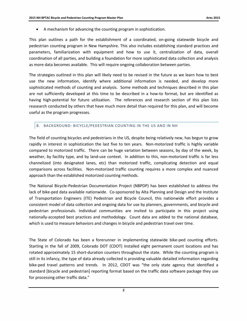
Some of this variability can be accounted for by using medium duration automatic counts to develop usage profiles, which show the typical travel profile over the course of the day. If these patterns can be established with relative confidence, shorter duration manual counts can be expanded to cover longer periods of time. For example, if 15% weekday traffic at a given location is known to consistently occur from 4-6pm, a manual count from 4-6pm a later date could be used to estimate daily traffic. The currently available equipment will enable testing this method on streets, sidewalks, and pathways in New Hampshire. This method is described in detail in the RTB report listed the research and studies page, also here: http://onlinepubs.trb.org/onlinepubs/nchrp/nchrp_rpt_797.pdf.
4
2015 NH BPTAC Bicycle and Pedestrian Counting Program Master Plan APRIL 2015
The Weekday Travel Profile for the Cheshire Rail Trail in Keene
Data was collected during testing of automated equipment.
Permanent installations can tell substantially more about bicycle and pedestrian usage, and can provide baseline data to evaluate shorter duration counts in other locations that have similar usage patterns. Permanent installations would allow for the calculation of average annual daily traffic (AADT), would provide detailed information about the variability in traffic, the effects of the weather, and daily and seasonal differences in traffic patterns. With a large enough sample of permanent counters, it is possible to estimate year-round usage and possibly estimate usage on any given time period for other locations based on a shorter duration count. This method is the foundation for the current automobile traffic counting program in New Hampshire and elsewhere. Due to the higher variability of non-motorized traffic compared to motorized traffic, some additional analysis may be needed. Methods for doing so involve categorizing count locations into similar groups, and are described in the RTB report in the research and studies page, and here: http://onlinepubs.trb.org/onlinepubs/nchrp/nchrp_rpt_797.pdf.
Strava data (GPS tracks) have the potential to be an effective data source in the absence of permanent count installations. This dataset also has the unique characteristic of having coverage for essentially the entire bicycle and pedestrian transportation network in NH. This is a relatively new data source, and will require additional research and analysis to maximize its potential. It is important to recognize that Strava represents only a sample of users. Strava users are a specific demographic that may not be a good representation of the population as a whole, and may not accurately represent bicycle use as a whole. Also, Strava users may not share their trips equally for all roads. For example, trips on popular scenic routes may have higher rates of Strava usage than commuter routes or short trips, thereby creating an unequal comparison. Strava claims that the route choices of Strava users are very similar (within 1-2%) to those of the population as a whole. Analysis techniques can also be applied to help minimize these issues. Considering these limitations, traditional count methods will be a valuable
5
2015 NH BPTAC Bicycle and Pedestrian Counting Program Master Plan APRIL 2015
source of information in verifying and supplementing the Strava data. On the first test case, research by the Counting Subcommittee found the rate of Strava usage by bicycles last season to be near .5%.
In order to develop adjustment factors and more meaningful, detailed data beyond a “snapshot in time” of usage, some baseline use factors need to be established. With the current and foreseeable lack of permanent count installations that typically provide this base of usage, the Strava data presents the most promising opportunity at this time.
This plan, which can be viewed as a pilot counting program, focuses mostly on the collection of data by manual and movable automatic counts. These counts will be a valuable first step in a counting program, and will be the first bicycle and pedestrian usage data collected in a consistent way across regions of the State. These counts will be essential in order to maximize the value of the Strava data.
This plan provides only limited information on how to analyze the data that is collected. The NCHRP Report 797, listed in the research and studies page, contains information on how to analyze data and compare data types. It is beyond the scope of this project to develop detailed standards for data analysis beyond what can be found in existing research. With assistance from the literature and a growing database of bicycle and pedestrian usage, it may become possible to calculate bicycle/pedestrian mode split, average annual daily traffic, weekday versus weekend use, information on peak traffic demand, seasonal variability, rates of helmet usage, rates of legal vs illegal riding (wrong way, sidewalk etc), gender split, or any number of figures. Short duration counts can be expanded to tell a more detailed story than is possible today. With Strava data, it will be possible to not only get before and after bicycle usage at infrastructure upgrades, but it will be possible to draw out how these individual changes in infrastructure alter the overall patterns of travel across an entire network. This plan is only a very early step in the development of a wide range of performance measures and metrics.
II. COUNTING METHODOLOGIES
The Bicycle and Pedestrian Transportation Advisory Committee (BPTAC) bicycle and pedestrian subcommittee researched and narrowed in on the most suitable counting methodologies and equipment for New Hampshire. The subcommittee found that the following elements were essential for the successful development of a bicycle and pedestrian counting program:
• Identify and recommend equipment and techniques that are both functional and affordable,
• Identify equipment and techniques that can count accurately and with an appropriate level ofdetail when needed (distinguish between bicycles and pedestrians, times of day, etc.),
• Establish data standards and formats that ensure the data collected is compatible and allows theinformation collected to be useable for multiple purposes,
• Allow flexibility for the entity doing the counting, and
6

2015 NH BPTAC Bicycle and Pedestrian Counting Program Master Plan APRIL 2015
• Maximize the potential for future growth of the program in sophistication and in number ofcounts.
The subcommittee feels the recommended range of counting techniques outlined in the following sections, and described in section I C, meets these considerations.
The following sections include a recommended manual counting methodology, recommended automated counting equipment types, and also recommends the use of GPS track data. Manual counts can collect the most detailed site specific and user specific data, but are usually limited in time, and require volunteer or staff time. Automated counts will collect longer periods of time with often less-detailed data, and requires the availability and set up of equipment, as well as training on how to use the equipment and access the data. Automated counters can include permanent installations or movable devices. GPS track data has wide coverage but is only a sample of users. The use of these four data types together will produce a more robust and meaningful data set.
A. RECOMMENDED MANUAL COUNTING
The recommended manual count strategy is largely based on recommendations from the National Bicycle and Pedestrian Documentation Project (NBPDP), (http://bikepeddocumentation.org). The instructions that have been distributed to volunteers as well as various count forms can be found in Appendix C. The data is most valuable if multiple counts can “canvas” a community, and also if there are reliable weekday/weekend travel profiles that can be used to expand the count.
WHEN TO COUNT
It is recommended that counts be conducted in May and/or September (first priority) or also July and January (second priority) in coordination with the dates listed on the NBPDP. Counts at other dates are still useful, and flexibility can be made to maximize volunteer help. Counts must be made on a Tuesday, Wednesday, or Thursday, from 4-6pm. If a weekend count is desired, the recommended time is 12-2 on Saturdays. The purpose of selecting these dates is that there are seasonal and daily variations in bicycle and pedestrian use, and collecting at the same times of the year allows for useful comparison. Rough expansion factors have been developed for counts made for the recommended dates and times, which will allow for appropriate adjustment to be made. Until locally derived correction factors can be developed, it is recommended that all counts be conducted during a similar timeframe.
TURN COUNTS
In most cases, it is best to collect as much information as the counter feels he/she is accurately able to collect. It is recommended to conduct the counts as turn counts at an intersection (road to road, road to trail, trail to trail). This strategy is an alternative to a simple volume count, which counts the number of times a bike or pedestrian crosses a line on a single road/path. A turn count at an intersection effectively produces a volume count for each leg of the intersection, captures the dynamics of the
7

2015 NH BPTAC Bicycle and Pedestrian Counting Program Master Plan APRIL 2015
intersection itself, and also provides potentially useful data on the movements of bicycle riders and pedestrians through a community.
At busy intersections, including many downtowns, it may not be possible to collect turn movements for all pedestrians unless multiple counters are used. Because of this, an alternative counting methodology can be used which tracks pedestrian (or bicycle) approaches to the intersection only, instead of tracking the full turn movement. Even using this methodology, the busiest downtown intersections may require two people to get an accurate count. Instructions for these counts are also available in Appendix C. Turn count devices can be used if desired, however consideration needs to be made for the device’s ability to track supplemental information, familiarity of equipment by volunteers, and distribution of equipment.
SUPPLEMENTAL DATA
Manual counts offer a level of detail that is not possible with most automated equipment, and is one of the primary strenghs of such a methodology. When evaluating data collected while testing for this plan, the supplemental data often provided more interesting and insightful information than the volume count itself. In testing for this plan, supplemental information collected for bikes includes gender, helmet use, number under age 16 (estimate) and riding on the sidewalk. For pedestrians, supplemental information included the number under age 16, and occasionally the gender. Wrong-way riding, and crosswalk/push-button usage may also be of interest. Local planners are encouraged to include whatever supplemental information they deem valuable at their location.
Collecting this supplemental data can get difficult at busy intersections, and the amount of supplemental data that can be accurately collected depends on the skill and comfort level of the individual doing the counting and the amount of activity in the location. The planner coordinating the counts should be responsible for strategically assigning volunteers and staff to the appropriate locations. While developing these standards, it was found best to assign busier intersections to staff, interns, or more experienced volunteers.
8
2015 NH BPTAC Bicycle and Pedestrian Counting Program Master Plan APRIL 2015
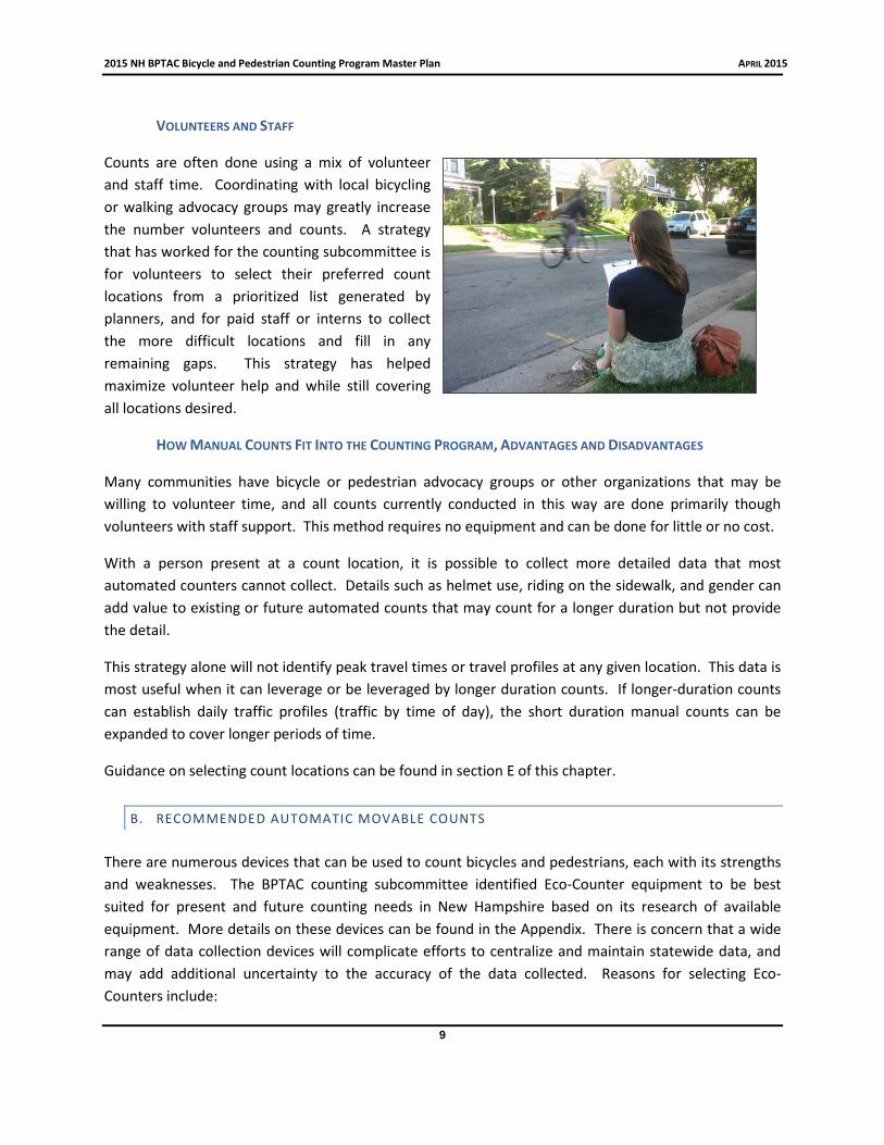
VOLUNTEERS AND STAFF
Counts are often done using a mix of volunteer and staff time. Coordinating with local bicycling or walking advocacy groups may greatly increase the number volunteers and counts. A strategy that has worked for the counting subcommittee is for volunteers to select their preferred count locations from a prioritized list generated by planners, and for paid staff or interns to collect the more difficult locations and fill in any remaining gaps. This strategy has helped maximize volunteer help and while still covering all locations desired.
HOW MANUAL COUNTS FIT INTO THE COUNTING PROGRAM, ADVANTAGES AND DISADVANTAGES
Many communities have bicycle or pedestrian advocacy groups or other organizations that may be willing to volunteer time, and all counts currently conducted in this way are done primarily though volunteers with staff support. This method requires no equipment and can be done for little or no cost.
With a person present at a count location, it is possible to collect more detailed data that most automated counters cannot collect. Details such as helmet use, riding on the sidewalk, and gender can add value to existing or future automated counts that may count for a longer duration but not provide the detail.
This strategy alone will not identify peak travel times or travel profiles at any given location. This data is most useful when it can leverage or be leveraged by longer duration counts. If longer-duration counts can establish daily traffic profiles (traffic by time of day), the short duration manual counts can be expanded to cover longer periods of time.
Guidance on selecting count locations can be found in section E of this chapter.
B. RECOMMENDED AUTOMATIC MOVABLE COUNTS There are numerous devices that can be used to count bicycles and pedestrians, each with its strengths and weaknesses. The BPTAC counting subcommittee identified Eco-Counter equipment to be best suited for present and future counting needs in New Hampshire based on its research of available equipment. More details on these devices can be found in the Appendix. There is concern that a wide range of data collection devices will complicate efforts to centralize and maintain statewide data, and may add additional uncertainty to the accuracy of the data collected. Reasons for selecting Eco-Counters include:
9

2015 NH BPTAC Bicycle and Pedestrian Counting Program Master Plan APRIL 2015
• Highly recommended by multiple DOTs, MPOs etc.
• Appear to be the industry standard worldwide
• Can export data that meets FHWA Traffic Monitoring Guide data format requirements,
• Offer a wide range of equipment types with a wide range of capabilities, allows for growth
• Relatively high accuracy rates
• Offers free software on the cloud to allow easy centralization and access to data
• Software on the cloud is user-friendly and offers analysis at high and low levels
• Ability to create user specific logins with varying administrative privileges, allowing easy access to data
• Offer permanent installations with option to continuously upload data to the online account
• No on-going costs or fees required Disadvantages included:
• Counting units are relatively expensive
• The process of retrieving data from devices and uploading data to the account was relatively time consuming, whereas the optional automated uploading of data required an ongoing fee
• Multiple users of one account may cause operational problems
Alternatives to Eco-Counters are included in Appendix A, along with a brief description of their strengths and weaknesses and an explanation for why they were not selected as the recommended equipment.
The BPTAC has Eco-Counter equipment available for loan by all Regional Planning Commissions. Eco-Counter equipment is also recommended for any RPC purchases of counting equipment. This equipment can be moved from location to location on a weekly basis or as needed.
Note that this plan or the BPTAC does not officially endorse any product or company. COUNTERS AVAILABLE TO RPCS AND MUNICIPALITIES
Three Eco-Counters are available on loan to RPCs and interested municipalities at the discretion of the BPTAC. These counters were purchased with private funds under direction from the BPTAC with the intent that the equipment will be shared. It is recommended that the schedule for sharing the equipment be determined ahead of the counting season to the extent possible. The BPTAC counting subcommittee will help facilitate this process with the RPCs. Counters will be centrally housed at the CNHRPC office when not in use, and it is likely that the equipment’s location and scheduling will be
10

2015 NH BPTAC Bicycle and Pedestrian Counting Program Master Plan APRIL 2015
BPTAC members test a Pyro-Box on the Piscataquog Trail in Manchester
overseen by the BPTAC counting subcommittee. The sharing of the equipment should be a collaborative effort, and the practices and procedures for scheduling and transporting the counters should be adjusted as needed after testing and input from RPCs.
Available automatic counting equipment (as of 2015) includes:
Tubes counter: Two available These counters operate much like typical tube counters that RPCs and DOT use to count motorized vehicles on roadways. This technology is specific to counting bicycles without interference from automobile usage. During research, it was found to be more accurate than other similar tube counters. These counters are bi-directional, meaning they can distinguish between directions. One counter is needed for small roads or on bicycle paths. On busier or wider streets, a counter on each side of the street is required. These counters will only count bicycles.
Pyro-Box: One available This counter uses passive infrared to detect bicycles and pedestrians that cross its path. Its intended use is on sidewalks and shared use paths. It has a 13 foot and is bi-directional (can distinguish between direction). By itself it cannot distinguish between bicycles and pedestrians, but can be combined with a Tubes counter to provide one dataset that separates bicycles and pedestrians. Note that this counter will under-count users who cross the path side by side (known as occlusion). Correction factors can be customized, and rough correction factors are readily available to account for the undercounting, and can be applied in the software provided by Eco-Counter. Detailed information on correction factors can be found in the TRB report 797, cited in the research and studies page. RECOMMENDED COUNTER PURCHASES Eco-Counter equipment is also recommended for any RPC purchases of counting equipment. The BPTAC counting subcommittee strongly encourages collaboration in any purchases that RPCs or others may make. This will help ensure the State as a whole has access to a suite of equipment types that best fits the needs and demands (avoid having too many of one type of counter, for example), to share information on experiences and best practices, and to take advantage of any bulk purchasing. Any equipment purchased could be combined with the shared equipment, and the BPTAC highly endorses and will help facilitate the sharing of any equipment between RPCs, NHDOT, and municipalities. Also,
11

2015 NH BPTAC Bicycle and Pedestrian Counting Program Master Plan APRIL 2015
the collected data can be shared with others around the state using the same software and data formats as from the shared equipment. ACCOMPANYING SOFTWARE With the Eco-Counter purchase comes a user account for the Eco-Visio Software, which is accessed on the cloud. There are no fees associated with this service. The BPTAC counting subcommittee and other testers found this software to be user friendly, offer high and low level analysis, and produce effective graphics. The data can also be downloaded in spreadsheet format for analysis using other tools. The vendor frequently offers webinar training sessions for Eco-Visio.
It is recommended that all data collected by Eco-Counters in the state be uploaded to this user account to allow easy access and centralization of data. Individualized user log-ins can be created with various administrative permissions based on need and security. It is possible for user accounts without administrative privileges to be created for local committees or municipalities as appropriate to allow access and analysis. It is envisioned that groups such as a safe routes to school committees or rail trail organizations could be provided a log-in account with viewing privileges of count data in their respective areas.
It is expected that data will be manually uploaded to the software. There is an option for automatic uploading of data wirelessly, but this service was not recommended due to the associated ongoing fees. If at some point it appears the automated uploading of data is more cost effective, this option can be re-visited. Any permanent count installations would likely be Eco-Counters, and this data would also be uploaded to the software.
HOW MOVABLE AUTOMATIC COUNTERS FIT INTO THE COUNTING PROGRAM Data collected via these counters do not provide the detail offered by manual counts, but offer information of longer duration. This “middle of the road” data can support both the short duration data, as well as permanent counts and Strava data. If daily traffic trends can be established using these medium duration counts, shorter manual count data can be extrapolated to estimate traffic throughout the day on other dates. If bicycle counts are separated from pedestrian counts, this medium timeframe data can be exceptionally valuable in validating the sample of bicycle riders in the Strava data. Strava, having coverage on nearly every road and trail in New Hampshire, can be used to estimate the usage on other roadways in the vicinity of the medium-term count location.
C. AUTOMATIC PERMANENT COUNTERS
Chapter I C explains how permanent count data could fit into a bicycle and pedestrian counting program in New Hampshire. An array of permanent counters would provide a baseline of use for all other data types. There are currently no permanent bicycle or pedestrian counters in New Hampshire, and there are no immediate plans or funding for future installations. One possible scenario for permanent
12

2015 NH BPTAC Bicycle and Pedestrian Counting Program Master Plan APRIL 2015
installations would be to have at least two locations in each Regional Planning Commission region on a range of facility types. It is the only way to get a complete sense of traffic variability on any given facility.
It is possible to have a valuable counting program in the absence of permanent installations, but the data conversion factors will be less reliable. In the event Strava data is not available, the use of shorter duration counts is limited further. In addition to being a planning tool, permanent count installations can be an excellent advocacy tool.
D. GPS TRACK DATA (STRAVA)
GPS track data is one source for long duration counts that covers nearly the entire bicycle and pedestrian network. GPS track data, purchased by NHDOT from Strava Metro, is currently available to NHDOT, all RPCs, and any subcontractors to DOT. Bicycle use data is available from October 1, 2013 to September 30, 2014. Additional timeframes and also walking and running data could potentially be purchased in the future. Strava is a social networking tool directed towards athletes and non-competitive bicycle riders, runners, and walkers. Users track their rides/walks with a GPS enabled device and upload it to the Strava network, where they can share their rides on their social network if they choose. These rides are stripped of their personal information and combined into a dataset that shows every minute a Strava user is on a roadway (or trail) segment or node (intersection) for an entire year. It also can be used to show turn movements through intersections by the minute, allowing direct comparison to manual turn counts and other physical counts. Origin destination tables, commute versus recreational rides, as well as other demographic information is part of the package. This huge amount of data is also packaged into easier to use datasets that can be used for a wide variety of applications. More information on the Strava dataset can be found in Appendix B. It is possible that other sources for similar data will be available in the future, but as of 2015, Strava is the only company identified that packages the data and makes it available for planning purposes. An added benefit is that Strava was founded in New Hampshire, and retains an office in Hanover.
This is a valuable component to a bicycle and pedestrian counting program because of its complete coverage of the road and trail network, and for its complete and detailed coverage over time. The drawback is that it is only a sample of users. The data is detailed down to the minute, even including turn movements at intersections, so it can be matched up directly with physical counts
This map, created by NRPC, shows one potential use for Strava GPS Track Data
13

2015 NH BPTAC Bicycle and Pedestrian Counting Program Master Plan APRIL 2015
allowing for an estimation of usage on any given road or trail at any given time period. It also enables planners to view the system as a whole (an interconnected network) instead of a sampling of points. It would be possible to see how changes in the infrastructure alter the movements (and route choices) of bicycles at a neighborhood or city level.
Walking and running data is also collected by Strava and could be purchased for planning purposes in the future.
Preliminary research by Strava and others found only slight differences in route choices from Strava users vs. non Strava users. Analysis techniques and filters can be applied to minimize some of the biases. Another capability is that commute trips can be filtered from recreational rides. Strava identifies commutes from riders reporting a route as a commute, the name of the ride in their database (a ride named “ride to work” would be identified by Strava as a commute), and by identifying trip patterns (AM rides in one direction, PM rides in the other, over a course of time).
There are many questions that arise when considering the applications for and accuracy of this data, the scope of which goes beyond the intent of this plan. The use of Strava data and other GPS track data is becoming much more widespread, and guidance on best practices for use of the data will only improve. Appendix B has additional information on the Strava dataset.
E. WHERE AND WHEN TO COUNT The process of identifying when and where to count is a collaborative effort, and should be conducted by key stakeholders within each RPC region of New Hampshire. Local, regional, and statewide needs should be considered when deciding when and where to count. It is recommended that the BPTAC counting subcommittee meet with RPC transportation planners and other interested parties to commence this process. At this stage, it appears it is best to select count locations using both a “representative locations” approach, where locations of a range of facility types are collected, and also using “targeted locations” where sites are selected in association with specific issues or areas of interest. The NCHRP Report 797 is an excellent resource to consult when selecting count locations.
LOCATION SELECTION
Factors to be considered in the selection process include:
• Infrastructure changes or new development – “before” and “after” counts
• Data to assist planning a new facility
• Cover a geographical representation of the neighborhoods in a community
o Does the data represent a broad sample of a city, town, or region’s population? Does it take into account patterns of tourist bike/ped traffic?
14

2015 NH BPTAC Bicycle and Pedestrian Counting Program Master Plan APRIL 2015
o Is the motive of the count to collect data at a very specific site (i.e. a dangerous intersection) or to use a general area as an example of a type of neighborhood?
• Cover the major corridors in the community, including downtowns and/or Main Streets
o Local knowledge is helpful
o Strava “heat maps” may help estimate relative volumes of traffic
• For longer duration counts, identify a need for daily traffic profiles to expand on manual counts
• Location of bicycle paths or other major bicycle or pedestrian infrastructure
• Include a range of facility types
• Include a range of urban and rural environments with an emphasis on land uses most conductive to non-motorized transportation WHEN TO COUNT
The best dates for conducting manual counts are during the National Bicycle and Pedestrian Documentation Project recommended dates, with the May and September dates being the highest priority. They represent a sampling of the seasons on dates that can be most readily adjusted using existing expansion factors. As local baseline data and local expansion factors are established, it becomes less important to stick to these dates. Tuesdays, Wednesdays and Thursdays are preferred weekday count days. Weekend counts can be conducted as desired.
When using a medium range automatic counter, if at all possible, it is best to collect at two full weeks of data. This enhances the probability of having a range of weather conditions, enables a larger sample size, provides some insight into daily variability, and may allow for the establishment of typical daily travel profiles.
WHEN TO USE MANUAL VS AUTOMATIC METHODS
A typical manual counting method, recommended in this plan, is to conduct a number of counts during the same time period (preferably on or near NBPDP project dates) scattered around one downtown area, neighborhood, or village. This allows for a more fair comparison between sites in a given area and can paint a picture of what the non-motorized traffic was at that time. During the development of this plan, test counts were done with anywhere from 5 to 15 counts being conducted simultaneously across the community. This was done for Concord, Manchester, and Portsmouth. The number of count locations will vary depending on the availability of counters/volunteers and the size of the community. Minneapolis MN uses this same method with dozens of counts being conducted simultaneously across the metropolitan area.
15

2015 NH BPTAC Bicycle and Pedestrian Counting Program Master Plan APRIL 2015
The manual counts will be short in duration, so it is likely worthwhile using a medium duration counter at one of the manual count locations for a week or more to get daily and weekly usage profiles. It will also give a glimpse into the daily variability in non-motorized traffic and help narrow down the possible range of traffic volumes at other locations in the community. It may also allow any future short-duration counts at that location to be expanded in time. The number and duration of automatic counts will be limited by the availability of counting devices, so their locations should be selected carefully.
In the event that Strava data for the 2015 counting season is purchased, planners will be able to directly compare the travel of the Strava user sample with the actual traffic. Using a combination of 2 hour manual counts and weeklong automated counts, it may be possible to estimate bicycle usage on any of the sampled roadways on that day or possibly any day of the season.
After locations have been selected, a master statewide list (subject to occasional updates) will be developed by the BPTAC and shared with each RPC.
F. HOW TO SUBMIT AND ACCESS DATA Count data and count locations made with Eco-Counters should be uploaded to the State’s online account. This data can be accessed via a user account with varying administrative privileges, with customized login credentials for RPCs, Municipalities, and other groups or committees as needed. Each RPC and DOT will have their own user account with administrative privileges. Only the master account can create additional user accounts, so contact the BPTAC counting subcommittee if you wish to do so.
Manual count data should be entered in spreadsheet format. Contact the BPTAC Counting subcommittee for an Excel spreadsheet template.
At this time, the NHDOT has an RFP out for a new traffic database system. It is likely that this system will be able to collect and store all bicycle and pedestrian count data, but details are not available as of early 2015. This will likely be an ideal centralization point for all bicycle and pedestrian count data. As we learn more about this system, recommendations for submitting and accessing data will be made.
III . PROGRAM GOALS, OBJECTIVES, RECOMMENDATIONS
Goal 1. Collect some of the first bicycle and pedestrian count data in the State
Goal 2. Implement a coordinated system for counting bicycles and pedestrians as described in this plan or updates to this plan
Goal 3. Centralize all bicycle and pedestrian count data that is collected
Goal 4. Make use of available and/or purchase automated equipment
Goal 5. Familiarize RPCs and other stakeholders with automated equipment
16

2015 NH BPTAC Bicycle and Pedestrian Counting Program Master Plan APRIL 2015
Goal 6. Familiarize RPCs and other stakeholders with local manual count programs
Goal 7. Develop a list of count locations in each RPC region
Goal 8. Begin applying data to plans and planning decisions
Goal 9. Become familiar with Strava data, its potential applications, and relationships with physical counts
Goal 10. Begin to develop expansion factors, correction factors, and other formulas that enhance the suite of data types
Goal 11. Plan and build a more sophisticated system of data collection and analysis as data and experience grow
Objective I: Develop and Launch the Pilot Counting Program Using the Methods Recommended in this Plan. The purpose of the first one to two years of the pilot counting program is to collect the first widespread bicycle and pedestrian data in the state, to familiarize all parties with practices and equipment, to begin to investigate variability in traffic and how expansion factors could be applied, and begin to investigate Strava data for possible uses, capabilities, and overall applicability.
• Action Step: Develop a list of count locations for each Regional Planning Commission region. o Count locations should be strategically selected. Guidance on how to select locations for
manual, automatic, and permanent counters is available in section II E. The selection of locations can be made partly through winter or early spring meetings with the counting subcommittee.
• Action Step: Collect Data o Conduct manual turn counts and conduct automated counts using the available equipment
or purchased equipment. The recommended standards and procedures for conducting these counts can be found in sections II A and II B.
o Conduct as many short-duration manual counts as possible during the May and September NBPDP count dates, with July and possibly January dates secondary.
• Action Step: Upload data to the specified database o Manual and Automatic count data should be entered and uploaded to the appropriate
database for future processing, distribution, and use.
• Action Step: Analyze data and incorporate into plans as appropriate. o Some limited guidance on analysis of data can be found throughout this plan, however
planners and others are encouraged to develop and share their own analysis methods.
17

2015 NH BPTAC Bicycle and Pedestrian Counting Program Master Plan APRIL 2015
o Compare count data with Strava data for the specific time and location of the count and report on their relationships.
o Investigate variability (hourly, daily, and seasonally) in non-motorized traffic and begin to consider the potential for expansion factors
o Develop and/or implement methodologies for estimating bicycle usage at various times and locations using relationships between physical counts and Strava.
• Action Step: Evaluate first counting season(s) o The BPTAC counting subcommittee, transportation planners/counting technicians, and
others involved should meet to review first counting season(s). o The BPTAC counting subcommittee should develop a report that summarizes first counting
season(s) and present to BPTAC, NHDOT, RPCs, and other interested parties. o Share any lessons learned that may include adjustments to counting methodologies,
equipment setup tips, developments in data analysis etc. o Compile the list of existing and planned count locations o Make recommendations as to continuing the purchase of Strava data for bicycle use, and
possible expansion to purchase pedestrian data. o Make any recommendations for additional equipment needs or purchases
Objective II: Implement Adjustments to the Counting Program. During the second and third year of counting, methods for collecting and storing data should be fine tuned, more counts should be conducted, and the scope of the program may be expanded based on additional equipment and/or recommendations from previous year’s reports.
• Action Step: Incorporate recommendations from previous year’s evaluation into counting program. o The first one or two counting seasons will provide lessons learned and insight on
improvements. These lessons, reported in the winter months, should be implemented in subsequent years. This may include adjustments to the calendar, count locations, count methodologies, new equipment, etc.
• Action Step: Continue to seek buy-in from stakeholders and participants. o Increase the rate of participation and scope of participation of RPCs and municipalities,
further engage the NHDOT on the program.
• Actions Step: Collect data o Additional counts should be made, preferably at higher quantities. Methods and count
locations should be adjusted based on findings from previous years
• Action Step: Analyze data and incorporate into plans as appropriate o Data should continue to be uploaded to the appropriate database(s) o With growing quantities of data, the use and applicability will continue to grow. Expand on
the analysis and use of existing data.
18
2015 NH BPTAC Bicycle and Pedestrian Counting Program Master Plan APRIL 2015
o With data becoming available, it should become standard procedure to review any bicycleand pedestrian count data as part of any transportation related project.
o Develop and/or refine expansion factors or correction factors
• Action Step: Report on findings as appropriateo Be able to develop New Hampshire specific figures on bicycle and pedestrian usage,
including factors such as peak travel times, seasonal variability, etc.o Report on relationships, applications for, and usage of Strava data.
• Action Step: Continue to evaluate subsequent counting seasonso Continue annual off-season counting report meeting with the BPTAC Counting
Subcommittee, RPCs, DOT, and others involved.o Make recommendations on the continuing purchase of Strava datao Make recommendations on any additional equipment needs or purchaseso Adjust the list of existing and planned count locations as neededo Develop a report that summarizes findings, and update the Counting Plan as needed.
Objective III: Improve on the level of sophistication of the counting program, data, and analysis The purpose of this objective is to move the counting program beyond the pilot stage, where conducting counts and using count data is common practice, and a critical mass of data is accumulated for more significant analysis.
• Action Step: Advance the level of reporting and analysis of data that has been collected
• Action Step: Develop and apply New Hampshire specific and site-specific expansion factors,correction factors, and metrics that are found to be useful
• Action Step: Determine and apply relationships between a suite of data types in order toexpand on the level of detail of bicycle and pedestrian usage across time and across thetransportation network
• Action Step: Add to the data collection suite if needed
• Action Step: Research and implement new data uses and needs
• Action Step: Continue incorporating data into plans and planning decisions. Ensure it isstandard practice to reference pedestrian and bicycle count data in planning decisions.
19

2015 NH BPTAC Bicycle and Pedestrian Counting Program Master Plan APRIL 2015
REFERENCES AND RESOURCES
National Cooperative Highway Research Program. (2014). Guidebook on Pedestrian and Bicycle Volume Data Collection (Report 797). Washington, DC: Ryus, P., Ferguson, E., Lausten, K.M., Schneider, R.J., Proulx, F.R., Hull, T., Miranda-Moreno, L.
Colorado Department of Transportation. (2013). Development of Estimation Methodology for Bicycle and Pedestrian Volumes Based on Existing Counts (Report No. CDOT-2013-18). Nordback, K., Marshall, W.E., Janson, B.N.
Federal Highway Administration. (2013). Traffic Monitoring Guide (Publication No. FHWA-PL-13-015). Washington, DC: U.S. Government Printing Office.
Robert Wood Johnson Foundation. (2013, February). Counting Bicyclists and Pedestrians to Inform Transportation Planning (Active Living Research – Research Brief). Retrieved from http://www.activelivingresearch.org
Institute of Transportation Engineers Journal. (2014, February). Counting Bicyclists with Pneumatic Tube Counters on Shared Roadways. Alexander Hyde-Wright, Brian Graham, AICP, Krista Nordback, PH.D, P.E
Transportation Planning Capacity Building (TPCB) Peer Program. (2013). North Central Texas Council of Governments Peer Exchange on Bicycle and Pedestrian Count Programs, a TPCB Peer Exchange. Arlington, TX
20

2015 NH BPTAC Bicycle and Pedestrian Counting Program Master Plan APRIL 2015
APPENDIX A: OTHER COUNTING EQUIPMENT
JAMAR TUBE COUNTERS
Summary: Many RPCs are familiar with this vendor, and they are developing new pieces of equipment that may be excellent alternatives in the future. During research and testing, the equipment does not appear to be as accurate or versatile as Eco-Counter equipment.
Jamar produces pneumatic tube counters that look and function exactly like the Jamar tube counters currently being used by most RPCs, except they can detect and classify bicycles in mixed traffic. The equipment is relatively inexpensive and readily available to many RPCs, however there are questions about accuracy. The BPTAC counting subcommittee tested a Jamar counter, and found that it could accurately count bicycles on bicycle paths. On street, it appeared that bicycles were under-counted on the side of the street opposite the counter. This was consistent with findings from studies conducted by others. It is possible to likely that it would count bicycles in mixed traffic at a reasonable accuracy on narrow, low-volume streets. Setup requires the use of small diameter tubes and special care to not pinch the tube and restrict the flow of air. The data from the test session was uploaded to Eco-Visio.
Other technologies are being developed by this vendor, and should be monitored as it develops.
The BPTAC counting subcommittee will continue testing this equipment and develop recommendations for use.
More info: See ITE study, “Counting Bicyclists with Pneumatic Tube Counters on Shared Roadways” and TRB report 797.
METROCOUNT
Summary: This technology is relatively inexpensive and readily available any RPCs who already use metro-count products. Metro-count is a competitor to Jamar.
As is the case with the Jamar counter, it uses a pneumatic tube to detect and classify bicycles in the same way it conducts classification counts for cars and trucks. Also similar to the Jamar counter, testing conducted by others finds the accuracy to be questionable. One benefit to the metro-counters over Jamar is that the classification algorithms can be adjusted to better detect bicycles and improve on their performance. Setup requires the use of small diameter tubes and special care to not pinch the tube and restrict the flow of air. Metrocount counters were not tested by the BPTAC counting subcommittee.
More info: See ITE study, “Counting Bicyclists with Pneumatic Tube Counters on Shared Roadways”, and TRB report 797.
MIOVISION
Summary: This video detection equipment is best suited for turn movements at high traffic locations, or for counting at locations where non-motorized traffic is not highly channelized.
A-1

2015 NH BPTAC Bicycle and Pedestrian Counting Program Master Plan APRIL 2015
This technology requires the camera equipment, which is typically set up on a light pole near an intersection. The video is uploaded and processed by Miovision for a fee. The equipment is typically used for motor vehicle turn counts at large intersections, however an extra fee is associated with counting bicycles and pedestrians. While Miovision is used in New Hampshire on a somewhat regular basis, the BPTAC subcommittee could not find any evidence that bicycles or pedestrians were counted using this equipment anywhere in the state. The subcommittee has found Miovision is now allowing the video to be stored and processed by the customer. In theory, and RPC could review the video on its own or using volunteers.
This video technology is recommended for counting bikes at large-multi-lane intersections where data is needed over longer periods of time than a manual count can offer. When this technology is used to count motor vehicle movements, it is recommended that the video be processed to count bicycles and pedestrians.
TRAFFIC SIGNAL DETECTION AND COUNTS
Summary: Options for installing this technology should be investigated as a possibility when traffic signals are being upgrade. Advances in technology and cost reductions should be monitored.
Traffic signal detection technology is increasing in sophistication. It is now possible for some traffic signal technology to detect bicycles and pedestrians. Some of these technologies can also collect continuous turn movement data in addition to operating the traffic signal. One company, FLIR, offered to set up their equipment as a demonstration, however the BPTAC subcommittee was unable to find a willing partner at a suitable location.
TRAFX
Summary: This equipment is relatively inexpensive and may be most useful for counts on rural recreational trails.
Equipment from this vendor was not identified as a recommended product for the New Hampshire Bicycle and Pedestrian Counting Plan. The equipment appears to be best suited for detecting usage on recreational trails. There is limited to no ability to distinguish between bicycles and pedestrians, and no ability for directional data. The equipment is relatively inexpensive, and appear to be well suited for rural recreational trails. TRAFx counters could be an affordable option for local trail groups if they were to purchase their own equipment. Data can be exported into spreadsheets and uploaded into Eco-Visio if needed.
A-2

2015 NH BPTAC Bicycle and Pedestrian Counting Program Master Plan APRIL 2015
APPENDIX B: STRAVA DOCUMENTATION AND INFORMATION
Please contact the NHDOT Bicycle and Pedestrian Section for more information on Strava.
B-1

2015 NH BPTAC Bicycle and Pedestrian Counting Program Master Plan APRIL 2015
APPENDIX C: COUNT FORMS AND COUNT INSTRUCTIONS
Included in this appendix is information for recommended manual counts. Much of this methodology is based on guidance from the National Bicycle and Pedestrian Documentation Project (NBPDP), (http://bikepeddocumentation.org.
Included is a sample “count instruction form” containing instructions on how to conduct a manual count using a count form. Following that is the “standard” count form that can be used in the field to manually count bicycles and pedestrians, and a “high pedestrian volume” count form which is customized to only record origin or destination of the pedestrian in areas where there is too much volume to accurately track movements. It is expected that these forms, count times, and “supplemental information” may be adjusted based on local needs.
C-1

Manual Bicycle and Pedestrian Count Instructions
UGeneral Instructions
Arrive at least 15 minutes ahead of schedule so you have time to get set up and to get properly
oriented
Enter your name, date, location, and start time at the top of your sheet. Start times should
always be on the hour (example: 4:00, 5:00 etc). Label the road names on the count form (if
they aren’t labeled already) and ensure you and the form are properly oriented (N,S,E,W).
UCounting Instructions:
This is a volume count. If somebody passes twice, count them twice.
Count the number of people on the bicycle, not the number of bicycles.
Pedestrians include people in wheelchairs or others using assistive devices, children in
strollers, etc.
People using equipment such as skateboards or rollerblades should be counted as
pedestrians
UHow to Fill Out the Form
Turn count forms are provided with a diagram of an intersection. North and landmarks may
be provided on the sheets to assist with orientation. If not, mark up the form yourself. Be sure
you are oriented properly before you begin counting
There is space provided on the diagrams to count bikes and pedestrians going straight, left, or
right coming from each direction of the intersection. The arrows indicate the movement of
the bike/pedestrian.
Make a tic mark next to the “B” for a bicycle and a “P” for a pedestrian in the appropriate
box. Example: 4 = l l l l , 5 = l l l l or 5 = l l l l l
Use a separate sheet for each hour you count (4-5, 5-6, 6-7 for example). Do your best to
keep track of time, but don’t worry about trying to fix things if you loose track of time. The
total count is more important.
If you are able, on the bottom left, mark a tic for bicycles who wear helmets, bicycles who
ride on the sidewalk, and male and female counts for bicycles only. Also enter information
for bicyclers or pedestrians who appear to be under age 16.
This information is supplemental, so only fill this information out if you feel you are up to it!
The volume counts are more important. (Note: It can be helpful to fill this section out as the
bike/pedestrian approaches, and fill the volume count in once you see where they went.)
UField Notes:
Note if there are any factors that may have affected your count (nearby construction, car
accident, a large public gathering etc)
Optional: Note any other general observations (close calls, accidents, falls, people taking
shortcuts across a parkinglot, etc.)
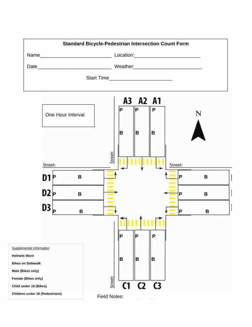
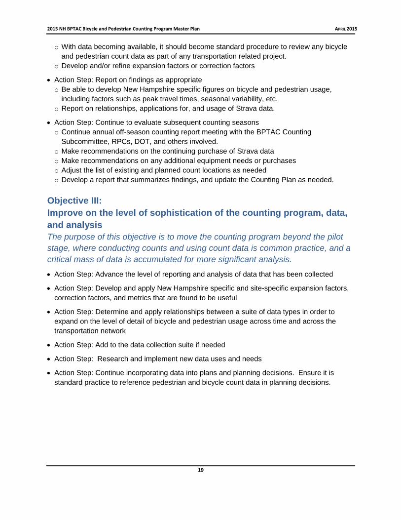
Standard Bicycle-Pedestrian Intersection Count Form
Name__________________________ Location:________________________
Date___________________________ Weather_________________________
Start Time_______________________
Field Notes:
Supplemental Information
Helmets Worn
Bikes on Sidewalk
Male (Bikes only)
Female (Bikes only)
Child under 16 (Bikes)
Children under 16 (Pedestrians)
One Hour Interval
P B
P B
P B
P B
P B
P B
P P P
B B B
P P P
B B B
BM BM BM
BF BF BF
BM BM BM
BF BF BF
BM BF
BM BF
BM
BF
BM BF
BM BF
BM
BF
.
Standard Bicycle-Pedestrian Intersection Count Form
Name__________________________ Location:________________________
Date___________________________ Weather_________________________
Start Time_______________________
Supplemental Information
Helmets Worn
Bikes on Sidewalk
Male (bikes only)
Female (bikes only)
Child under 16 (pedestrians)
Field Notes:
PF
P
F
PM PM
P
M
P
M
PM
P
M
P
M
PM
PF
PF PF
P
F
P
F
P
F