New Enfield Local Plan: Capacity Study
64
New Enfield Local Plan: Capacity Study Site Identification November 2020
Transcript of New Enfield Local Plan: Capacity Study

New Enfield Local Plan: Capacity Study
Site Identification November 2020

AECOM 2
Quality information
Prepared by Checked by Approved by
Tim Fearn
Senior Planner
Stephanie Brewer
Associate Planner
Anthony Whitaker
Principal Planner
Jesse Honey
Associate Director
Jesse Honey
Associate Director
Revision History
Revision Revision date Details Authorized Name Position
V1 August 2020 For client review Yes Jesse Honey Associate Director
V2 October 2020 Post client review Yes Jesse Honey Associate Director
V3 November 2020 Post second client
review
Yes Jesse Honey Associate Director
Prepared for:
London Borough of Enfield Council
Prepared by:
AECOM Limited
Aldgate Tower
2 Leman Street
London E1 8FA
United Kingdom
aecom.com
© 2020 AECOM Limited. All Rights Reserved.
This document has been prepared by AECOM Infrastructure & Environment UK Limited (“AECOM”) in
accordance with its contract with London Borough of Enfield (the “Client”) and in accordance with generally
accepted consultancy principles and the established budget. Any information provided by third parties and
referred to herein has not been checked or verified by AECOM, unless otherwise expressly stated in the
document. AECOM shall have no liability to any third party that makes use of or relies upon this document.
Caveats and notices regards the preparation of this report:
This report has been prepared during the UK COVID-19 lockdown and subsequent time of easing
measures. While the full implications of this on the content of this report are not yet known, there may
well be medium and long-term implications for government, mayoral and/or borough policies and the
relative funding priorities as currently set out in this report.
At the time of writing, the draft London Plan was available as an ‘Intend to Publish’ version which was
submitted by the Greater London Authority to the Secretary of State for approval on 9 December 2019.
On 13 March 2020, the Secretary of State issued a direction pursuant to s.337(6) of the Greater London
Act 1999. The direction prevents publication of the London Plan until a range of matters are addressed to
the satisfaction of the Secretary of State to achieve consistency with national policy. On 24 April 2020 the
Mayor wrote to the Secretary of State seeking to resolve the issues that have been raised by the
Secretary of State through discussion by their officials, so as to enable the London Plan to be adopted. It
remains open to the Mayor - should he conclude that inadequate progress is being made with the
Secretary of State - (i) to challenge the direction by bringing a claim for judicial review; or (ii) to abandon
the plan.
At the time of writing, national government also conducted an ongoing consultation on the Planning
White Paper “Planning for the Future”, published in August 2020, as well as a consultation on Changes
to the current planning system (Consultation on changes to planning policy and regulations), also
published in August 2020. The government also announced in the same month, that from 1 September
2020, extensive changes to the Use Class Order 1987 would come into effect. While it is evident that
there will be significant implications for strategy and plan making in Enfield, many of these will be
unclear until the government publishes further information after the conclusion of the current

AECOM 3
consultation periods, and until the Mayor has published his intentions for the future of the London Plan,
in light of these recent proposals and changes.
Table of Contents
List of acronyms and abbreviations used in text ...................................................................... 4
Introduction .............................................................................................................................. 5
Planning Practice Guidance (PPG) Context ............................................................................ 5
Timescales ............................................................................................................................... 6
Capacity Sources ..................................................................................................................... 8
Site Verification and Numbering Scheme ................................................................................ 9
SIFT 1: Identify location and rule out double-counting ........................................................... 14
Enfield Planning Applications ................................................................................................................................ 14
Call for Sites returns submitted by Landowners or Site Promoters ....................................................................... 18
Sites submitted by LBE through Call for Sites returns & internal consultation ...................................................... 18
Public sector land including GLA and TfL sites surplus or likely to become surplus over Plan period ................... 19
Sites currently at Pre-application Stage ................................................................... Error! Bookmark not defined.
Developer briefs or Developer Masterplans .......................................................................................................... 19
SHLAA .................................................................................................................................................................. 19
Development Plan Allocations and Opportunity Sites ........................................................................................... 20
Ares of search identified through the Enfield Industrial Intensification Study and the Phase 2 Green Belt/MOL
review .................................................................................................................................................................... 20
Call for Sites submission by Enfield Road Watch and CPRE and the “Space to Build Enfield” report .................. 21
Neighbourhood Plan Allocations ........................................................................................................................... 21
London Development Database (LDD), Enfield Housing Trajectory, Brownfield Land Register (BLR) and Annual
Monitoring Report (AMR) ...................................................................................................................................... 21
SIFT 2: Filtering out completed, started and superseded consents ....................................... 22
SIFT 3: Establishing Availability ............................................................................................. 22
SIFT 4: Application of Size Threshold .................................................................................... 25
Next steps – GIS development (Module 3) and Site Suitability (Module 4) ........................... 26
Appendix A: Comparison of site sources with the PPG list of types of sources and potential data sources ............................................................................................................ 62
Tables
Table 1: Timeline for Site Availability from Different Site Sources ............................................ 6 Table 2: Residential capacity sources reviewed ..................................................................... 8 Table 3: Enfield Ward Names and Abbreviations ................................................................... 11 Table 4: Hierarchy of Source Names and Abbreviations ........................................................ 12 Table 5: Enfield planning application codes ........................................................................... 14 Table 6: Number of Available, Unique Sites, Listed by Source .............................................. 26 Table 7: Potential Sites Identified ........................................................................................... 28

AECOM 4
List of acronyms and abbreviations used in text
Acronym Meaning
AAP Area Action Plan
CPRE Campaign to Protect Rural England
dLP Draft London Plan
DMD Development Management Document
ELR Employment Land Review
ERW Enfield Road Watch
GLA Greater London Authority
Ha. Hectares
HELAA Housing and Economic Land Availability Assessment
LBE London Borough of Enfield
LP London Plan
LPA Local Planning Authority
LSIS Locally Significant Industrial Site
MOL Metropolitan Open Land
NLWP North London Waste Plan
NPPF National Planning Policy Framework
PPG Planning Practice Guidance
SAC Special Area of Conservation
SFRA Strategic Flood Risk Assessment
SIL Strategic Industrial Location
SHLAA Strategic Housing Land Availability Assessment
SHMA Strategic Housing Market Assessment

AECOM 5
Introduction
1. Following the initial review of policy and evidence in Module 1, in the second Module of the Capacity Study, AECOM examined all relevant potential sources of housing land capacity in Enfield and identified sites appropriate to include in the Study at the time of writing. The different modules of the Capacity Study should be read together to convey the full process of the study.
2. This report explains all sources of sites that were identified and the process by which a long list of sites available for development at the time of the study was filtered. The output of the filtering process confirmed those sites appropriate to assess for development suitability. These sites were listed in Table 7 at the end of this chapter.
3. Enfield Council’s intention was to identify as many potential sources of capacity as possible which could realistically be relied upon to help meet the identified housing need in the borough over the plan period. In so doing, the Council needed to ensure that the resulting information was robust and defensible at Examination in Public, supporting the production of a sound Local Plan in line with Planning Practice Guidance (PPG)1.
Planning Practice Guidance (PPG) Context
4. The site availability assessment stage of a Capacity Study, Strategic Housing Land Availability Assessment (SHLAA) or Housing and Economic Land Availability Assessment (HELAA) should have regard to the PPG in order to be a robust and defensible evidence base to inform housing supply figures.2
5. The PPG text on Housing and Economic Land Availability Assessment (paragraph 010) states that “when carrying out a desktop review, plan-makers need to be proactive in identifying as wide a range of sites and broad locations for development as possible (including those existing sites that could be improved, intensified or changed). Identified sites, which have particular constraints (such as Green Belt), need to be included in the assessment for the sake of comprehensiveness but these constraints need to be set out clearly, including where they severely restrict development. An important part of the desktop review, however, is to identify sites and their constraints, rather than simply to rule out sites outright which are known to have constraints.”
6. The purpose was to maximise the pool of land to accommodate the nation’s growing population. At present, housing provision and delivery remains a national priority. This was evident in the publication of ‘The Housing White Paper-Fixing our broken housing market’ published in 20173 and the review of the National Planning Policy Framework (NPPF) updated in 2018 and 20194.
7. The White Paper made it clear that it is the government’s aim to encourage more house building and outlines a number of proposals to tackle the problem, including proposed changes to the planning system and the strengthening of the role of local authorities to build more homes. This includes the proposal for a standard method to calculate the objectively assessed housing need in each local authority area.
8. The White Paper identifies the three main obstacles to delivery as the insufficient number of homes planned for by local authorities, the slow pace of house building, and the over-reliance on a small number of large volume house builders within the construction industry.
1 Please refer to caveats on page 2 of this report for commentary on the preparation of this report at the time of #Planningreforms. 2 Paragraph: 010 Reference ID: 3-010-20190722 3 Available at https://www.gov.uk/government/publications/fixing-our-broken-housing-market 4 Available at: https://www.gov.uk/government/publications/national-planning-policy-framework--2

AECOM 6
9. The Council is directly responsible for ensuring that there is a comprehensive strategy in place so that enough housing is being planned for and delivered through an up-to-date Local Plan.
Timescales
10. Like all other modules in this Capacity Study, the result of this exercise was a snapshot in time, based on the evidence available at the time of writing. The Capacity Study base date is 6th March 2020 (the date of the “snapshot in time”), and the team looked back five years in the London Borough of Enfield (LBE) planning register database to 6th March 2015 and into other relevant sources, for sites that had not been developed (i.e. refusals and unimplemented planning permissions) to identify potential development sites likely to come forward over the plan period.
11. Determining a clear and specific study period gives added confidence in data quality and study conclusions and was the best way to avoid the confusion and inconsistency of multiple sites having different assessment windows, given that site suitability, availability and achievability changes over time as sites gain planning permission and are built out.
12. A five-year assessment window was selected within which pre-existing evidence for sites that have the potential to be relevant for the study was captured. Unless otherwise stated, sites were therefore included in the study if they were submitted to the Council or validated as a planning application:
• after 6 March 2015; and
• before 6 March 2020 (this coincided with the deadline of the most recent borough Call for Sites).
13. PPG does not specify a study period for housing land availability assessments and only required “proportionate” evidence. A five-year study period was chosen to capture all possible sites that could reasonably be expected to still be available for development, in line with AECOM’s and Enfield Development Management experience.
14. It was agreed, based on common practice within other SHLAAs and capacity studies, that sites which were demonstrated to be available within the five year period prior to the base date (6 March 2020), but have not been subsequently developed, could reasonably be assumed to still be available in the absence of evidence to the contrary. Refining this, on the basis of local knowledge and experience, the AECOM team additionally consulted extensively with the Council’s Development Management team. Striking a proportionate balance between the need for exhaustive assessment and realistic prospects of continued availability, Enfield Development Management advised the following time windows for each type of site source, within which a site could be assumed as available:
Table 1: Timeline for Site Availability from Different Site Sources
Dataset
Time period from date of validation within which it can still be reasonably assumed the site is available for development*
Undetermined Planning Applications (PA) 4 years
PAs granted but unimplemented Full 5-year study period
PAs withdrawn 2 years
PAs refused 2 years
Pre-applications 2 years Notes: *assuming no further planning activity has taken place in relation to the site.
15. Guided by the Council’s local experience, therefore, it was assumed that applications validated, granted, withdrawn, refused or submitted for pre-application discussions before these dates and which have not subsequently been superseded by a new planning

AECOM 7
application, appeal or other planning activity on the site (including a Call for Sites submission), were no longer available for development at the time of writing. For such sites, the Council’s Development Management team indicated that it was reasonable to assume an owner or developer would by the time of writing have undertaken further efforts to promote the site for development if it were still available.
16. Sites where the most recent permission has been fully implemented within the last five years were also not included in the assessment as they have a particularly low likelihood of coming forward as available for further development within the plan period, except in cases where more recent information has come forward (such as a new pre-application or Call for Sites submission). However, unimplemented residual capacity on started developments was included in the assessment, as a commitment assumed to be completed during the plan period. Pre-applications, applications or consents within the five-year window on sites benefitting from a subsequent consent were discounted as being superseded by a new consent.
17. Sites validated for planning consent or submitted to the Call for Sites after 6th March 2020 were not taken into account, given that, like all such studies, the Capacity Study was a snapshot in time and therefore has to apply a cut-off date to enable consistent site assessment to commence. However, in line with standard planning procedure, this forms no impediment to any developer applying for planning permission from Enfield in the normal way and/or making a representation at subsequent stages of Local Plan preparation after this cut-off date. Enfield Council will also continue to monitor housing land availability throughout the plan-making process. To aid this monitoring process, AECOM recommend that following the conclusion of this Capacity Study, Enfield Council should produce an annual update after submitting their Housing Flows Reconciliation Return to MHCLG, as this will allow the latest monitoring data to be incorporated into the capacity study to ensure figures are consistent, and ensure that a consistent base date is used henceforth (1st April each year). This will minimise additional work as it ties in with a process the local planning authority is already obliged to undertake.

AECOM 8
Capacity Sources
18. Capacity sources vary by site information provided. While it was helpful for the purposes of the assessment where more information was provided, no source of sites was discounted outright, as long as it was possible to identify a site’s location based on the information provided. PPG and AECOM experience on SHLAAs supporting now adopted plans were used as guidance to determine which sources should be consulted.
19. The majority of sites were provided to AECOM in data spreadsheets and/ or GIS layers, or in published documents such as reports or strategies. Sources of sites were then verified or supplemented through internal consultation with relevant LBE teams such as Planning Policy, Development Management, Regeneration, Housing, Property and Parking. Due to this Module of the study taking place during the first months of the national Covid-19 lockdown in 2020, planned workshops were replaced with e-mail, video-call and telephone discussions, but otherwise methodology and conclusions were unaffected.
Table 2: Residential capacity sources reviewed 5
Residential capacity sources reviewed in Enfield Capacity Study
Enfield Planning Applications (from databases covering 1948 to 6 March 2020)
Sites currently at pre-application stage
The returns from Enfield’s 2019 - 2020 Call for Sites6 and Call for Small Sites including:
- Additional consultation with relevant LBE stakeholders regarding Council estates with capacity for intensification and Council owned land either surplus or likely to become surplus over Plan period and
- Call for Sites Submission by Enfield Road Watch and CPRE and their “Space to Build Enfield” report (January 2019)7
Public sector land8, including that owned by GLA and TfL, either surplus or likely to become surplus over Plan period, in addition to that identified through the Call for Sites (identified through direct consultation with ‘GLA family’)
Existing Development Plan Allocations and Opportunity Sites not yet completed
Sites with development briefs and/or developer masterplans
The most recent London Strategic Housing Land Availability Assessment (SHLAA) 20179
Areas of search identified in the Enfield Industrial Intensification Study
The GLA’s London Development Database10
Enfield Annual Monitoring Reports11
5 A comparison of site sources with the PPG list of types of sources and potential data sources was included in Appendix A 6 https://new.enfield.gov.uk/services/planning/local-plan/#11 7 https://www.london.gov.uk/sites/default/files/ad_84_space_to_build_enfield_report_final.pdf 8 https://www.london.gov.uk/what-we-do/housing-and-land/land-and-development/public-land 9 https://www.london.gov.uk/what-we-do/planning/london-plan/new-london-plan/strategic-housing-land-availability-assessment 10 https://www.london.gov.uk/what-we-do/planning/london-plan/london-development-database 11 https://new.enfield.gov.uk/services/planning/local-plan/#5

AECOM 9
Enfield Housing Trajectory12
Enfield Brownfield Land Register13
Sites identified through Neighbourhood Plans in Enfield14
20. Surplus employment sites with opportunities for intensification of uses including residential were also included in this Housing Capacity Study, where they came forward as available from one of the sources listed above.
21. Given, however, that Enfield was designated as needing to provide additional industrial floorspace capacity of 48-52ha based on the findings of the Enfield Employment Land Review 2018 (ELR) and in the evidence base of the Draft London Plan, the majority, if not all, of additional capacity found on industrial land is likely to be required for employment uses. This does not mean that such sites were ruled out of this Module, but that it is at the discretion of Enfield policy to include or exclude them in the total residential or employment capacity identified.
22. Close coordination between the Capacity Study, the emerging Enfield Industrial Intensification Study (also undertaken by AECOM) and the Phase 2 Green Belt /MOL Review (undertaken by LUC but overseen by AECOM) nevertheless ensured that sites or areas of search which were considered to have both industrial and housing capacity, or where a site/area was, at the time of writing, in one use with suitability for the other, were flagged and assessed as appropriate in either or both of the studies, with double-counting avoided. It is worth noting that both the Industrial Intensification study and the Green Belt/MOL Review considered wider locations amounting to ‘broad areas of search’ in PPG terms, rather than smaller individual ‘sites’, and that most of these areas were not available for mixed use or residential development at the time of writing (i.e. did not in the main overlap with identified ‘sites’). Therefore, there was limited overlap between the studies in terms of sites available to be included in the capacity study Suitability Assessment.
23. For non-industrial employment sites with housing capacity, the Capacity Study assumed that these were coming forward either through Permitted Development Rights (captured in this Module as part of the Planning Applications and Prior Approvals list) or through the Call for Sites, also captured above.
Site Verification and Numbering Scheme
24. For each site from each capacity source the following steps were followed:
• AECOM performed a primary verification process to ensure its boundary was correctly mapped and that it did not overlap with other sites either from the same source or from alternative sources (to avoid double-counting) (Sift 1);
• Subsequently, a second exercise discounted any completed15 and superseded consents (Sift 2);
• Next, AECOM determined whether sites could be counted as available for development (Sift 3);
12 https://new.enfield.gov.uk/services/planning/annual-monitoring-report-and-housing-trajectory-2019-planning.pdf 13 https://new.enfield.gov.uk/services/planning/local-plan/#9 14 https://new.enfield.gov.uk/services/planning/neighbourhood-planning/ 15 Unimplemented residual capacity on started developments was included in the assessment as a commitment assumed to be completed during the plan period; however, started developments have not been assessed to the same level of detail as other sites where delivery was less certain.

AECOM 10
• Finally, the consultant team applied a minimum site size threshold of 0.05 hectares / 5 homes (Sift 4) with sites smaller than 0.05 hectares being considered as part of the calculation of the windfall allowance (in Module 6), unless they delivered 5 or more additional homes (for an explanation of this threshold and further detail on these sifts, please see below).
25. If a site remained within the pool after these sifting stages, it progressed to the Capacity Assessment (Suitability Testing).
26. To aid site identification, each site was given a unique identifying code. The letters at the start of this code denoted which of the 21 Enfield wards the site is located in. Therefore, the site number for any site in Bowes Ward, for example, would start with “BO”.
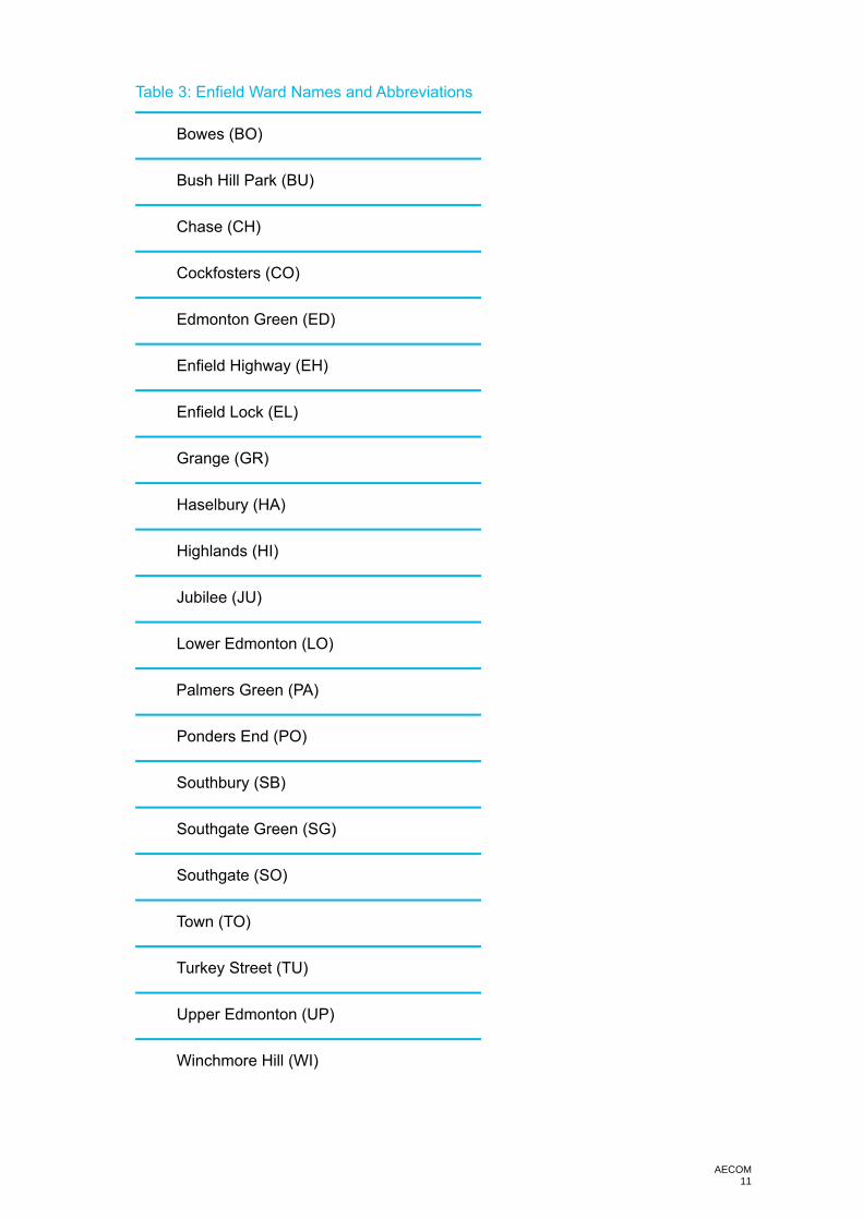
AECOM 11
Table 3: Enfield Ward Names and Abbreviations
Bowes (BO)
Bush Hill Park (BU)
Chase (CH)
Cockfosters (CO)
Edmonton Green (ED)
Enfield Highway (EH)
Enfield Lock (EL)
Grange (GR)
Haselbury (HA)
Highlands (HI)
Jubilee (JU)
Lower Edmonton (LO)
Palmers Green (PA)
Ponders End (PO)
Southbury (SB)
Southgate Green (SG)
Southgate (SO)
Town (TO)
Turkey Street (TU)
Upper Edmonton (UP)
Winchmore Hill (WI)

AECOM 12
27. As well as identifying the ward within which each site is located, the letters at the start of the code also denoted the site’s source. For example, the code for a site that is an (unimplemented) Planning Application located in Bowes ward would start with “BOP”.
Table 4: Hierarchy of Source Names and Abbreviations
Source Abbreviation
Enfield Planning Applications P
Landowner or developer returns from Enfield’s 2019 - 2020 Call for Sites and Call for Small Sites (including additional consultation with relevant LBE internal stakeholders regarding Council estates with capacity for intensification and Council owned land either surplus or likely to become surplus over Plan period)
C
Public sector land including that owned by GLA and TfL, either surplus or likely to become surplus over Plan period, in addition to land identified through the Call for Sites (identified through direct consultation with ‘GLA family’)
G
Sites currently at pre-application stage A
Sites with development briefs and/or developer masterplans M
The most recent London SHLAA 2017 S
Existing Development Plan Allocations and Opportunity Sites not yet completed D
Areas of search identified in the Enfield Industrial Intensification Study and Phase 2 Green Belt/MOL Review N
Call for Sites Submission by Enfield Road Watch & CPRE and “Space to Build Enfield” report16 E
The GLA’s London Development Database (LDD) (no unique sites)17 n/a
Enfield Annual Monitoring Reports (no unique sites) n/a
Enfield Housing Trajectory (no unique sites) n/a
Enfield Brownfield Land Register (no unique sites) n/a
Sites identified through adopted or emerging Neighbourhood Plans in Enfield (no sites) n/a
17 The LDD, which monitors site progress and completions, is a monitoring tool used to check the current status of sites from the other sources rather than itself a source of sites. However, it appears in this list for the sake of completeness and to demonstrate that sites were double-checked and referenced against as many sources as possible.

AECOM 13
28. The reason there was no abbreviation given for certain sources on the list was because these sources either did not yield any sites or had already been populated from other sources above them in the hierarchy (such as the applications database) and therefore yielded no unique sites.
29. Because the sources in Table 4 were deliberately arranged as a hierarchy, if a site was featured in more than one source, the unique identifier generally showed it as belonging to the source higher up on the list. For example, if a site in Bowes Ward appeared in the Enfield Road Watch Call for Sites submission as well as in the Planning Applications database, the site was identified with a prefix of “BOP” rather than “BOE”, therefore associating it with the Planning Applications layer even though it appears in both.
30. There were only few exceptions to this hierarchy, for example where a site had come forward from two sources which both credibly evidence its availability, the most recent site information may be used (e.g. if a permission was from 2015 but lapsed and was not implemented, and a 2019 Call for Sites form was received for the same site area with a different proposal, then the more recent Call for Sites form was taken to supersede the lapsed consent; In such a case it was a reasonable assumption that the lapsed permission was undeliverable, and the new Call for Sites form better reflects the landowner’s current intentions).
31. The hierarchical ranking of site sources reflected the quality and level of detail associated with each, with higher-quality / more detailed data generally appearing higher in the list and thus generally able to supersede a lesser level of information further down. The ranking also reflected the likelihood of the source bringing forward sites unique to that source, which were available for development at the time of writing.
32. The numbers following the letters in the identifier restarted at 1 for each “ward+source” category (i.e. there are sites BOP1, BOP2, BOP3 etc but also BOE1, BOE2, BOE3 etc). Site numbers were not always consecutive because during the data cleansing stages, some sites were discounted to avoid double-counting or for other reasons such as to remove smaller sites which were considered under Windfall in Module 6.

AECOM 14
SIFT 1: Identify location and rule out double-counting
33. There was inevitably a degree of overlap within and between all sources of supply considered. As such, it was important to ‘cleanse’ the data AECOM had received, to ensure that each site has a correct, unique and identifiable site boundary and that no sites were double-counted, either in part or as a whole. A robust assessment of capacity could only progress once there was a pool of clearly identifiable and non-overlapping sites.
34. At a minimum, a site needed to be clearly identifiable, preferably through a red line boundary on a map. This is because it is very difficult to assess a site in a consistent and transparent manner as required by the PPG where it cannot be determined exactly what lies inside or outside the site boundary (e.g. land subject to flood risk etc). Nevertheless, to ensure as inclusive an approach as possible, sites were included even if submitted without a red line boundary, as long as site boundaries and location could be reasonably inferred from the submission18.
35. A desktop assessment stage first reviewed and cross-referenced the site sources listed in Table 4, followed by extensive internal LBE consultation with relevant teams to verify and supplement information, which was then followed by Council sign-off of the Module 2 outputs.
Enfield Planning Applications
36. The Enfield Planning Applications Database is the most comprehensive and largest source of sites in the borough. It includes all planning consents, refusals, withdrawn applications, discharges of conditions, certificates of lawful use, prior approvals, permissions in principle and a number of other application types (see Table 5 below) from the introduction of the modern planning system in 1948 to the present day, both for residential and non-residential applications.
37. In line with the agreed study period (refer paragraph 12), the team filtered out all applications from this source that were validated before 6th March 2015. This left all relevant applications (residential and non-residential, regardless of development status) on this layer validated between 6 March 2015 and 6 March 2020.
38. Next, the team removed any applications identified with non-residential application codes which did not yield net additional residential capacity (for example advertising, householder applications such as loft extensions, Tree Protection Orders, Development Consent Orders and other application types). Table 5 summarises the applications codes and identifies those which were retained for further analysis.
Table 5: Enfield planning application codes
Code Meaning
Removed? Yes (Y) or No (N) Rationale
106Rev Discharge of conditions Y Only 3 cases, all discharge of conditions applications but no net additional dwellings
ADV Advertisement Y Includes some discharge of conditions applications but no net additional dwellings
ARCHIV Archive Y Archived planning applications 1948-1986
BTN British Telecom Notification Y No net additional dwellings
CAAD Retention Y Only 6 cases, all archive (1948-1986)
CAC Extension Y All archive (1948-1986)
18 Only the submissions from one source (Enfield Road Watch - ERW) were submitted without mapping.

AECOM 15
Code Meaning
Removed? Yes (Y) or No (N) Rationale
CEA Extension Y All archive (1948-1986)
CEU Discharge of conditions Y No net additional dwellings
CND Discharge of conditions Y No net additional dwellings
CONAP Modification Y Modification to an existing building, no net additional dwellings
DCO Development Consent Order Y Not residential
DEM Demolition Notification Y No net additional dwellings
EA Environmental Impact Assessment Y Not residential
EL Electricity Act Y Not residential
EP Electricity Pipeline Y Not residential
EUC Established Use Certificate Y Certificates only issued prior to 1992
FUL Full Application N This category needs to be included19.
HAZ Hazardous Substance Application Y Not residential
HOU Householder Application Y No net additional dwellings
LBC Listed Building Consent Y
Listed building consents are never submitted alone, they are always accompanied by a planning application, which was captured separately
LBD Listed Building Consent - Demolition Y No net additional dwellings
LBEPRE Pre-applications n/a
Data not accessible by any party outside LBE; however, pre-applications were captured through a separate list provided to the consultant team by LBE
NMA Non-material Amendment Y No net additional dwellings
OA Other Authority Application N Could include residential dwellings
OUT Outline Application N Net additional dwellings
P18PA Prior Approval Part 18 Y No net additional dwellings
PAAG Prior Approval Agricultural Land Y No net additional dwellings
PAB Class PA Prior Approval (B to C3) N Net additional dwellings
PADE Prior Approval of Demolition Y No net additional dwellings
PAMEDE
Prior Approval of Method of Demolition Y No net additional dwellings
PAT Prior Approval Telecoms Y No net additional dwellings
PD Permitted Development N
Could include net additional dwellings, although none on Enfield planning register do
PIA Class IA Prior Approval N Net additional dwellings
19 Note that the Enfield Permissions layer does not record dwelling completions, but the LDD layer does. Therefore, the LDD layer was cross-referenced to identify and exclude fully completed development since 2004 (when the LDD started). All full applications before 6 March 2015 can in any case be excluded as out of the study period for the purposes of the Capacity Study. All FUL coded applications from before the study period were, however, retained for use as a secondary source (backstop) to cross-reference the LDD data.

AECOM 16
Code Meaning
Removed? Yes (Y) or No (N) Rationale
PIP Permission in Principle N Net additional dwellings
PND Class D Temp change Y No net additional dwellings
PNPUB Prior Not. Of Demolition Community Asset Y
Demolition of building, no net additional dwellings
PRC Class C change of use Prior Approval Y No net additional dwellings
PREAPP
Refs do not appear in public access N
Pre-applications; These were captured through a separate list provided to the team by LBE
PREDCO
Refs do not appear in public access Y
Pre-application for DCO applications; no net additional dwellings through this code in Enfield
PREHER
Refs do not appear in public access N
Pre-applications; These were captured through a separate list provided to the team by LBE
PRH Class A HH - Prior Approval Y No net additional dwellings
PRJ Class J Prior Approval N Net additional dwellings
PRK Class T change of Use Prior Approval Y No net additional dwellings
PRM Class R change of use Prior Approval Y No net additional dwellings
PRP Class P change of use Prior Approval N Net additional dwellings
PRV Prior Approval - Class J renewables Y No net additional dwellings
RAH Review of Affordable Housing Y No net additional dwellings
RE3 Development by others N
Includes applications for net additional dwellings – incl. multiple types of applications for schools/ offices/ community assets/ improvements etc.
RE4 Development by LA N
Includes applications for net additional dwellings – incl. multiple types of applications for schools/ offices/ community assets/ improvements etc.
RES Reserved matters/ non material amendment. Y No net additional dwellings
RM Reserved matters Y No net additional dwellings
S11 Section 11 Prior Approval Y No net additional dwellings (infrastructure)
S53 (actual code DET)
Section 53 Determination Y
This refers to Section 53 of the Town and Country Planning Act 1971, superseded by other legislation- it was a precursor of Certificate of Lawful Development. As such, no net additional dwellings
SCOP Scoping request Y No net additional dwellings
SO Screening Opinion Y No net additional dwellings
TCA Works to trees in conservation area Y No net additional dwellings

AECOM 17
Code Meaning
Removed? Yes (Y) or No (N) Rationale
TPO Tree Preservation Orders Y No net additional dwellings
VAR Variation of Condition Y No net additional dwellings
39. The subsequent filtering process went through the following additional stages:
• Removing all duplicate entries, where more than one unimplemented permission existed for the same site boundary, always retaining the information from the application with the most recent date;
• Dividing remaining sites by status into those which had been granted permission (consents) and all other applications (including refusals, withdrawn applications, etc.) (see individual treatment of categories below);
• cross-referencing consents against the Council’s 2019 return to the LDD (which captures any consent resulting in at least one net additional dwelling up to 31 March 2019) to discount all consented sites that did not result in at least one net additional dwelling. This rules out any consents outside the scope of this study (such as, for example, retail, office, industrial or other commercial developments, schools, doctors’ surgeries etc) as well as residential applications which did not result in additional development e.g. replacement dwellings (for any applications resulting in a net loss of dwellings, this was included as a minus figure); and
• Manually checking all other remaining non-consented sites (including refusals, dismissed appeals and withdrawn applications) against the Enfield planning applications website to filter out any further non-residential sites.
40. For any applications which were marked as validated but which had not yet been determined by the Council, and for any pre-application sites, it was important that the study did not pre-empt or pre-judge LBE consent or refusal. As such, while such sites were included in the assessment, it is important to point out that assessment of applications undetermined at the time of writing or pre-applications does not constitute a permission in principle or any kind of binding Council decision on an individual site, but rather was for the purposes of determining general land availability on a borough-wide, high-level basis only.
41. For refusals, when checking for duplicates, there were often multiple refusals for a single site, which also, in some cases, overlapped with permissions. The following process was observed for refusals in the assessment timeframe, to remove duplicates and ensure that only appropriate applications were considered:
• Firstly, refusals were divided into those that were unique applications for their site and those which overlapped with others; and
• Where a refusal had been followed by a non-refusal or a newer undetermined application on the same site (already captured), the refusal was filtered out.
42. The remaining refusals were then subject to a site-by-site sorting exercise, which sorted refusals into three pools:
• Applications seeking no net additional dwelling(s) (therefore outside study scope);
• Applications for net additional dwellings but which were refused due to the site being unsuitable in principle for residential development (thus included as an available site for the purposes of study Module 2 but to be marked as already having failed the suitability for residential development test in study Module 4); and

AECOM 18
• Applications for net additional dwellings but which were refused for reasons other than in-principle unsuitability for residential development, such as, for example, design features of the specific development (thus progressing to the suitability assessment in Module 4).
Call for Sites returns submitted by Landowners or Site Promoters
43. The Council commenced a Call for Sites in 2019 to coincide with their public consultation on Enfield’s Regulation 18 Issues and Options Plan. This Call for Sites was kept open and extended to encourage submission regardless of site size (i.e. any sites that could provide at least one net additional dwelling which maximises the potential for new housing on brownfield sites). The final Call for Sites deadline for the purposes of this study was 6 March 2020.
44. Returns were subsequently divided into a) those made by landowners and site promoters and b) those made by third parties.
45. All Call for Sites returns by landowners and site promoters were mapped based on the red line boundary provided and cross-referenced against other sources to avoid double-counting. All were counted as available.
46. Those sites submitted by third parties (ERW and CPRE) were treated as a separate source and were discussed in more detail below.
Sites submitted by LBE through Call for Sites returns & internal consultation
47. The Council is a significant landowner in the borough and provided AECOM with data on LBE landownership. However, not all land owned by the Council is or will be available for residential development, for example if it is in active alternative use.
48. Capacity from this source comprised opportunities such as estate regeneration and infill, surface car parks, surplus highways land, surplus school/education land (where, for example, potential for co-location of existing facilities exists), and other council-owned land and buildings surplus to LBE’s requirement during the plan period.
49. In order to ascertain which Council sites were likely to be available for residential development, the Council’s planning team held an internal consultation, commencing in parallel with the final weeks of the Call for Sites exercise, communicating with LBE teams which manage land assets owned by the Council. Teams were asked to identify Council owned sites available for residential development within their operational sphere (so for example, the estates team were consulted about estate renewal programmes, the education team were consulted about school sites, etc).
50. The Council’s planning team followed this engagement up with internal communications and meetings. LBE Call for Sites returns and the results of this internal consultation were provided to AECOM.
51. All sites identified by and discussed with these LBE stakeholders were confirmed as available.
52. As part of these discussions, AECOM also aimed to identify any sites available for development from other sources known to the Council which had not been captured already for any reason. Discussions included the categories of sites by development type that are identified in the PPG.
53. The internal Council conversations also helped to glean further relevant site information the Council holds on sites from other sources, such as current status regarding availability, ownership, planning history and known delivery barriers on sites from a variety of sources,

AECOM 19
which would influence whether the site was available immediately and, if not, when it was likely to become available within the Local Plan period.
Public sector land including GLA and TfL sites surplus or likely to become surplus over Plan period
54. The Greater London Authority (GLA) initially provided AECOM with a list of points to identify sites owned by the “GLA family”. This included:
• GLA assets;
• LFB (London Fire Brigade) assets;
• LLDC (London Legacy Development Cooperation) assets;
• MPS (Metropolitan Police Service) assets; and
• TfL (Transport for London) assets.
55. Firstly, the layer was cross-referenced against all other site sources (including planning applications and the Call for Sites returns) to avoid double-counting of sites.
56. For the remaining sites, Enfield Council and AECOM engaged with the GLA family to determine more detail on and availability of these sites for development. Those sites which were identified by the GLA family as available for development during the plan period were marked as available and taken forward for further assessment.
Developer briefs or Developer Masterplans
57. A further source was sites with development briefs and/or developer masterplans which were provided to AECOM by the Council based on existing masterplan documents and other information made available to them through official processes such as pre-application discussions and the Call for Sites process.
58. Information was gathered from the Council’s planning team and other relevant LBE teams, which included Enfield’s Development Management, Strategic Property Services, Housing, Meridian Water and Regeneration teams. For this purpose, other sources of sites (including Applications, Pre-applications, SHLAA and Call for Sites returns) were mapped and used as a starting point to ascertain if any significant development sites with developer briefs or masterplans had not been captured by the analysis thus far.
SHLAA
59. The next source considered by the study was the most recent London-wide Strategic Housing Land Availability Assessment (SHLAA) of 2017.
60. This was a useful source. However, because it was carried out by a strategic body at a strategic level, and a considerable length of time has passed since it was prepared, it was, at the time of writing, less detailed, less up-to-date, and less compliant with PPG, especially on the subject of site availability.
61. To cleanse the London SHLAA data, the team cross-referenced the 2017 SHLAA sites with any sources higher up in the hierarchy of site sources and discounted as duplicates any sites that overlap.
62. Subsequently, together with the Council and the GLA, the team revisited the SHLAA conclusions in the light of developments since publication, including to a) filter out completions, b) take account of applications and permissions since publication, and c) add any additional information or detail available at the time of writing, especially on availability.

AECOM 20
63. Sites which were submitted via the London SHLAA Call for Sites were marked as available for the purposes of the Capacity Study, since their submission was evidence of availability within the last five years. Any remaining sites which were not submitted to the London SHLAA Call for Sites, were first compared with availability evidence from higher tier sources (Table 4). Where there was still uncertainty over availability, the GLA and Enfield Council were asked to re-examine the availability judgments in the SHLAA based on any more recent information available to them, resulting in the removal of sites which were no longer considered by the Council to be available for residential development.
Development Plan Allocations and Opportunity Sites
64. AECOM engaged with the Council to identify existing Development Plan allocations and Opportunity Sites which had not yet been completed. The Council confirmed that at the time of writing, there were no site allocations from adopted development plan documents that had not yet been implemented. There were, however, a number of Opportunity Sites identified in Area Action Plan documents (AAPs). AAPs examined included the North Circular AAP, North East Enfield AAP and Edmonton Leeside AAP. AECOM then completed the following steps for all sites from this category:
• Compared identified sites with all other previously considered categories, and discounted sites if they overlapped wholly with site boundaries from one of the other sources further up the hierarchy, to avoid double counting; and
• Discounted any sites where there was no evidence of availability for residential development within the last five years.20
Ares of search identified through the Enfield Industrial Intensification Study and the Phase 2 Green Belt/MOL review
65. The Enfield Industrial Intensification Study analysed Enfield’s existing industrial land and identified opportunities for intensification of SIL, LSIS and other industrial locations within the borough. The study identified a number of broad locations with the potential for mixed use development, including residential. Some of these areas of search corresponded with sites identified through other sources in the Capacity Study which were higher up the site hierarchy, and they were therefore captured in the list of available sites at the end of this report.
66. A separate evidence base study, the Phase 2 Green Belt/MOL review, identified further areas of search that may be also suitable for residential and/or mixed-use development.
67. As determining site availability was within the scope of neither the Industrial Intensification Study nor the Phase 2 Green Belt/MOL review, the remaining areas of search were considered to be unavailable in the absence of evidence to the contrary and were thus excluded from further assessment in the Capacity Study. However, this does not exclude the possibility that they may represent possible options for growth should availability be established in the future, for example through a change in local planning policy. As standalone sources, therefore, neither the Industrial Intensification Study nor the Phase 2 Green Belt/MOL review yielded any further unique, available, sites for suitability assessment.
20 See Sift 3 section below.

AECOM 21
Call for Sites submission by Enfield Road Watch and CPRE and the “Space to Build Enfield” report
68. Enfield Road Watch (ERW) and the Campaign to Protect Rural England (CPRE) submitted an extensive and helpful Call for Sites return in their capacity as interested third parties seeking to maximise brownfield development in the borough. Their submission was based on the evidence of their report “Space to Build in Enfield” (January 2019), and listed 513 sites.
69. However, while including aerial photographs and descriptions, the submission did not include completed Call for Sites forms, red line boundaries for sites nor evidence of site availability. No maps were provided when requested by LBE from the submitting parties21. Therefore, it was not possible to map polygons of sites without a reliable site boundary or other relevant landowner-provided data.
70. For all sites from this source, the submitting parties (ERW and CPRE) were also asked for evidence of availability, which they stated they were unable to provide22. Therefore, for sites from this source which were within the ownership of LB Enfield or the GLA family, availability was additionally checked by the consultant team.
71. In order to where possible update as many sites as possible with more accurate red-line boundaries from other sources, AECOM then completed the following steps for all sites submitted by ERW and CPRE:
• Discounted those sites that were located outside of the Enfield borough boundary;
• Compared remaining sites with all other previously considered categories, and discounted ERW sites if they overlapped with polygons from one of these other sources, to avoid double counting; and
• Discounted any sites where there was no evidence of availability for residential development within the last five years.23
Neighbourhood Plan Allocations
72. At the time of writing, Enfield included one neighbourhood planning area in Hadley Wood, designated in 2015. A further neighbourhood planning area in Angel Edmonton had been approved in 2016 but has since been withdrawn.
73. The Neighbourhood Plan for Hadley Wood (2019-2036) was in draft stage in 2020, with the latest Draft Plan published in December 201924. However, it did not identify any specific sites for development or propose any specific site allocations.
London Development Database (LDD), Enfield Housing Trajectory, Brownfield Land Register (BLR) and Annual Monitoring Report (AMR)
74. The Council confirmed that these site sources contained no unique sites. This was because all sites they included were already captured in other layers (primarily the planning applications layer) provided by Enfield Council. Whilst the LDD, AMR, BLR and housing trajectory did not contain unique sites, they did capture additional information on the status of consented sites from the planning application database, including whether they were under construction or completed. This was useful in supplementing information on sites gathered from other sources.
24 http://www.hadleywood.org.uk/uploads/1/4/5/7/14571008/2018_hw_ndp_draft_revised_plan__2_.pdf

AECOM 22
SIFT 2: Filtering out completed, started and superseded consents
75. The team next cross-referenced the remaining sites from all sources with all sites marked as either “started”, “superseded” and “completed” on the LDD. This information was not available from any other data source provided to AECOM. It is important to note that the LDD is not a site source in its own right, but rather a tool to monitor the development progress of sites across all other sources.
76. All those sites that were marked on the LDD as either “started”, “superseded” and “completed” were not taken forward for further analysis in this assessment, for the following reasons:
• Superseded: These were duplicate consents, superseded by subsequent planning applications, and were picked up by analysis of the subsequent relevant consent;
• Completed: It was assumed, reasonably, that sites consented and fully completed within the last five years had no further capacity for development in the plan period, and that even if they did, this was picked up through the Windfall analysis;
• Started: Sites under construction were not assessed in detail in this Capacity Study, as they were already at an advanced stage of delivery. Also, units already completed as part of started developments were not counted in the capacity assessment because the capacity that they offered has already been taken up/accounted for as of the study baseline date. However, in line with the PPG approach, residual capacity on started sites was included in the total capacity estimate for the borough. Residual capacity was also included from sites which were recently permitted and commenced but which were considered by the Council to be ‘stalled’; as well as unimplemented residual capacity on started sites. Stalled sites and residual capacity on started sites was identified in cooperation with the Council’s planning team, by examining a list of all sites marked as started, in line with the latest information available from the Council at the time of writing, including up to date housing flow data.
SIFT 3: Establishing Availability
77. One important aspect of the capacity assessment process was to determine whether a site could be considered available for development during the Plan period, based on the best available evidence (see PPG text below). Even the most suitable sites, if lacking any landowner indication of development availability or development intention, could not be reasonably expected to contribute to housing supply.
78. The PPG avoids being overly prescriptive, which allows Local Planning Authorities (LPAs) to decide how to demonstrate sites are suitable, available and achievable in a way that is proportionate and appropriate to the local situation. To establish availability, the assessment needed to determine whether, at the time of writing, a site was in the hands of a landowner or developer who was willing to sell or develop over the plan period, to ensure the site is a realistic source.
PPG Paragraph: 019 Reference ID: 3-019-20190722 What factors can be considered when assessing availability? A site can be considered available for development, when, on the best information available (confirmed by the call for sites and information from land owners and legal searches where appropriate), there is confidence that there are no legal or ownership impediments to development. For example, land controlled by a developer or landowner who has expressed an intention to develop may be considered available. The existence of planning permission can be a good indication of the availability of sites. Sites meeting the definition of deliverable should be considered available unless evidence indicates otherwise. Sites without permission can be considered available within the first five

AECOM 23
years, further guidance to this is contained in the 5 year housing land supply guidance. Consideration can also be given to the delivery record of the developers or landowners putting forward sites, and whether the planning background of a site shows a history of unimplemented permissions. Revision date: 22 07 2019
79. While whether a site is available or not may appear to be a straightforward yes/no assessment, in practice the situation is more complex. For some sites, availability was clearer than for others. The following site statuses, where the site was not completed or superseded by a completed site, were considered to demonstrate evidence of availability, sufficient for them to be counted in the study:
• Sites submitted for planning application or pre-application in the last 5 years;
• Sites submitted to the London SHLAA Call for Sites;
• Sites submitted to the Council’s Call for Sites by either a) a landowner or site promoter, or b) by a third party with evidence of availability from a landowner or site promoter;
• Publicly-owned land identified in consultation with the Council or the GLA family as likely to be available for development within the plan period; and
• Sites for which a Development Brief or Developer Masterplan has been drafted.
80. Establishing availability was more difficult where a site was submitted or suggested by a third party that was not the owner, developer or site promoter, without providing evidence of availability, or in cases where the owner, developer or site promoter was not willing or able to state publicly that the site was available for development, at the time of writing.
81. Sites where it was not possible to determine availability in a proportionate way included for example:
• Call for Sites submissions by third parties where no evidence of availability was included, and
• London SHLAA sites which did not originate from the SHLAA Call for Sites, rather being submitted by the Council to the GLA (in 2016-17 when there was evidence or reasonable expectation of availability at the time) but for which the Council judged there was as of 2020 no longer evidence or reasonable expectation of availability.
82. For such sites, submitting parties (primarily ERW and the Council) were asked to provide some basic evidence of availability, where it exists. This could include, for example, a development management discussion between the Council and a landowner or developer indicating availability for development25. It could also include an email or a brief, or a signed letter from the landowner, developer or site promoter, to confirm that the red-lined site was available for development, with the landowner’s contact details.
83. Council officers (particularly from the Development Management team) were also asked for evidence of recent landowner engagement to ascertain likelihood of any sites submitted by third parties not accompanied by availability evidence coming forward for redevelopment (particularly sites likely to be in the control of a single owner and/or operator such as supermarkets or hospitals, where the landowner may have had informal discussions with the Council around re-development possibilities).
84. Where such availability information could not be ascertained, either from the Council or from the submitting party, AECOM again had regard to the PPG, which states that the assessment needs to be ‘thorough but proportionate’ (Paragraph: 004 Reference ID: 3-004-20190722), as well as standard practice in SHLAAs and capacity studies. In line with
25 Please note that sites where discussions with the Council were covered by a Non-Disclosure Agreement (NDA) or other such confidentiality terms were not included in the study

AECOM 24
this, sites were only counted as available for the purposes of this study where it was possible in a proportionate way to ascertain evidence to this effect (i.e. through Call for Sites; desktop searches of applications, pre-applications etc; conversations with relevant Council teams, other public sector landowners and third party site submitters).
85. Offsetting this approach to a degree, however, windfall development rates were projected forward based on past trends to account for the sites with no evidence of availability at the time of assessment but which nevertheless regularly come forward for development during the Plan period (except for its first five years, in line with the PPG approach).
86. It was important to avoid double-counting through overlap between assessment sites and windfall. AECOM was careful to ensure this did not take place by clearly designating and differentiating each source of capacity to minimise or, where possible to do so, eliminate overlap. In some instances, where sites were partially overlapped by those further up the hierarchy (for example a Planning Application fell within the boundary of a larger site included in a Call for Sites submission) the boundary of the lower-tier site was adjusted to reflect the remaining available site area.26
87. Through internal consultation with Council teams such as Property, Education etc and by encouraging LBE submissions to Call for Sites, the team determined what land in Council ownership could be stated as available for residential development over the Plan period, over and above any already known sites in this category.
26 This pool of partially overlapping sites (approximately 10-15 in number) mostly comprises larger SHLAA sites and Call for Sites submissions which have smaller planning applications overlapping with them.

AECOM 25
SIFT 4: Application of Size Threshold
88. PPG Paragraph: 009 Reference ID: 3-009-20190722 states that in capacity studies, SHLAAs and HELAAs “Plan-makers will need to assess a range of different site sizes from small-scale sites to opportunities for large-scale developments such as village and town extensions and new settlements where appropriate. It may be appropriate to consider all sites and broad locations capable of delivering 5 or more dwellings, or economic development on sites of 0.25 hectares (or 500 square metres of floor space) and above”.
89. The Enfield Capacity Study included a lower site size threshold of 0.05 ha / a minimum of 5 additional homes. This threshold was selected as a balance between maximising the number of previously developed sites and small sites identified for assessment, while also keeping the assessment proportionate (in line with PPG Paragraph 004 Reference ID: 3-004-20190722). This meant that if a site was either 0.05 hectares or more of size or provided 5 or more additional homes (i.e. if either or both criteria were met) it was considered. The capacity contribution from sites smaller than 0.05 hectares which provide fewer than 5 additional homes was considered through Windfall.

AECOM 26
Next steps – GIS development (Module 3) and Site Suitability (Module 4)
90. The process of site identification and the first three sifts described above resulted in a total of 591 available, unique sites from the following sources:
Table 6: Number of Available, Unique Sites, Listed by Source
Source Number of Sites
Enfield Planning Applications, of which 282
Unimplemented 171
Undetermined applications 49
Refusals 51
Withdrawn 6
Started sites with unimplemented residual capacity 5
Landowner / developer returns to Call for Sites and Call for Small Sites (including surplus LBE land)
137
Call for Sites Submission by Enfield Road Watch & CPRE 48
Surplus public sector land incl. owned by GLA and TfL (in addition to land identified through the Call for Sites)
2
Sites currently at pre-application stage 66
Sites with development briefs / developer masterplans 1
Development Plan allocations / opportunity sites 20
Sites in the most recent London SHLAA 2017 35
TOTAL 591
91. All of these sites were listed in Table 7 below.
92. The subsequent study modules were:
• GIS development (Module 3), whereby all of the sites in Table 7 were digitally mapped and their boundaries verified, and
• Site Suitability (Module 4), which determined whether sites identified in Modules 2 and 3 were suitable in planning terms for residential development.
93. Module 3 ran concurrently with Module 2. Module 3 did not have a report output. The deliverable associated with Module 3 was the map and GIS database of all sites to be assessed in the subsequent Suitability Assessment undertaken by the Council.
94. Table 7 below represents a full list of all available sites ahead of the suitability filtering process. As such, it should be noted that many sites within it were not and potentially may never be suitable for residential development. Nevertheless, it was important that all available, potential sources of housing supply were set out in a single location ahead of suitability filtering to give stakeholders confidence that the approach was fully inclusive.

AECOM 27
The suitability assessment discounted sites if not suitable for residential development, with detailed reasons given in each case. This provided a clear audit trail to make the study defensible, thorough and accurate.

AECOM 28
Table 7: Potential Sites Identified
Site Ref. Site Name/Address Postcode27 Ward Site area (Ha.)
Site Source Source Reference (if applicable)
BOP13 Ridgeon Court 75 Palmerston Road London
N22 8QT Bowes Ward 0.19 Planning Applications 17/04956/FUL
BOP31 Land To Rear Of Haywood Court 1 - 7 Oak Lane London
N11 2BE Bowes Ward 0.12 Planning Applications 19/03816/FUL
BOC1 Tewkesbury Terrace Bowes Ward 0.05 Call for Sites LP1158
BOC2 1-7 Bowes Road N13 4UX Bowes Ward 0.15 Call for Sites LP554 Site A (1-7 Bowes Road)
BOC3 151 - 161 Green Lanes N13 4SP Bowes Ward 0.09 Call for Sites LP554 Site C (151-161 Green Lanes)
BOC5 Tottenhall Rd N13 6DJ Bowes Ward 0.55 Call for Sites Not applicable
BOA Bowes Ward Pre-Applications (all sites) Bowes Ward 0.63 Pre-Applications Not applicable
BOS2 Open Space N13 6AF Bowes Ward 1.18 SHLAA 2017 17100290
BOD1 Birchwood Court Bowes Ward 0.07 Allocations/Opportunity Sites North Circular AAP (Site 20)
BOE1 Beale Close – a lot of land allocated for car parking.
Bowes Ward 0.14 Enfield Road Watch/CPRE Not applicable
BUP6 Bury Lodge Depot Bury Street West London
N9 9LA Bush Hill Park Ward 2.01 Planning Applications 17/00344/RE4
BUP8 Capitol House 794 Green Lanes London
N21 2SH Bush Hill Park Ward 0.27 Planning Applications 17/01864/FUL
BUP11 432 Church Street London
N9 9HT Bush Hill Park Ward 0.17 Planning Applications 17/02894/FUL
BUP18 Land At The Rear Of 29-39 Elm Park Road London
N21 2HP Bush Hill Park Ward 0.07 Planning Applications 18/02582/FUL
27 Postcodes included where supplied

AECOM 29
Site Ref. Site Name/Address Postcode27 Ward Site area (Ha.)
Site Source Source Reference (if applicable)
BUP22 1-24 River Bank London
N21 2AA Bush Hill Park Ward 0.87 Planning Applications 18/04450/FUL
BUP25 Cemetery House Church Street London
N9 9HP Bush Hill Park Ward 0.25 Planning Applications 18/04864/FUL
BUP32 24 Queen Annes Place Enfield
EN1 2PT Bush Hill Park Ward 0.07 Planning Applications 19/04328/FUL
BUP9 8 Oakwood Parade Queen Annes Place Enfield
EN1 2PX Bush Hill Park Ward 0.04 Planning Applications 17/02566/FUL
BUP12 Pennsylvania Court 54 Elm Park Road
N21 2HS Bush Hill Park Ward 0.04 Planning Applications 17/03970/FUL
BUC1 Bush Hill Station Car Park St Mark's Road, Enfield
EN1 1BA Bush Hill Park Ward 0.20 Call for Sites LP608_4
BUC2 The Oak, 144 Firs Lane N21 2PJ Bush Hill Park Ward 0.17 Call for Sites LP1099
BUC3 Firs Farm Car Park, Firs Lane, Winchmore Hill
N21 2PJ Bush Hill Park Ward 0.27 Call for Sites LP1140
BUC4 Rear of 27-57 Firs Park Avenue (odds) N21 2PR Bush Hill Park Ward 0.14 Call for Sites LP1163
BUC7 Rear of 98-110 First Avenue (evens) EN1 1BP Bush Hill Park Ward 0.11 Call for Sites LP1166
BUC5 Rear of 10-24 Ash Grove (evens) and 2-16 Bideford Gardens (evens)
EN1 2LB Bush Hill Park Ward 0.19 Call for Sites LP1167
BUC6 Rear of 3-15 Bideford Gardens (odds) EN1 2RP Bush Hill Park Ward 0.12 Call for Sites LP1168
BUC8 Hyde Park Avenue N21 2PP Bush Hill Park Ward 0.22 Call for Sites Not applicable
BUS1 Express Dairies Bush Hill Park Ward 0.38 SHLAA 2017 17100207
BUE32 Esso and neighbouring block plus car park on Ayley Croft
Bush Hill Park Ward 0.29 Enfield Road Watch/CPRE Not applicable
CHP1 Stable View Burnt Farm Ride Crews Hill
EN2 9DY Chase Ward 0.10 Planning Applications 20/00372/FUL

AECOM 30
Site Ref. Site Name/Address Postcode27 Ward Site area (Ha.)
Site Source Source Reference (if applicable)
CHP2 The Stables Warmerdam Nursey Cattlegate Road
EN2 9DJ Chase Ward 0.06 Planning Applications 15/01011/FUL
CHP4 263 Bullsmoor Lane Enfield
EN1 4SF Chase Ward 0.13 Planning Applications 17/05227/FUL
CHP5 Kingswood Nurseries Bullsmoor Lane Enfield
EN1 4SF Chase Ward 0.69 Planning Applications 17/05528/FUL
CHP9 Land Adjacent To 37 Browning Road Enfield
EN2 0EJ Chase Ward 0.06 Planning Applications 18/01950/FUL
CHP10 3 Bulls Cross Enfield
EN2 9HE Chase Ward 0.13 Planning Applications 18/02987/FUL
CHP12 New Cottage 501 The Ridgeway Enfield
EN6 5QT Chase Ward 0.35 Planning Applications 18/03396/FUL
CHP14 1 And 2 North Lodge Cottages The Ridgeway EN6 5QU
Chase Ward 0.19 Planning Applications 18/03608/FUL
CHP15 Capel Manor College Bullsmoor Lane Enfield
EN1 4RQ Chase Ward 16.21 Planning Applications 18/04863/OUT
CHP19
Barn Whitewebbs Farm Whitewebbs Road Enfield
EN2 9HR Chase Ward 0.35 Planning Applications 19/01655/FUL
CHP20 7B Golf Ride Enfield
EN2 9DA Chase Ward 0.15 Planning Applications 19/01724/FUL
CHP22 Longbourn Forty Hill Enfield
EN2 9EU Chase Ward 0.85 Planning Applications 19/02826/FUL
CHP23 Celbic Hall 71-77 Lancaster Road Enfield
EN2 0DW Chase Ward 0.07 Planning Applications 19/03265/FUL
CHP7 94 Linwood Crescent Enfield
EN1 4UR Chase Ward 0.05 Planning Applications 18/00421/FUL
CHP26 2 Tudor Crescent Enfield
EN2 0TU Chase Ward 0.05 Planning Applications 19/03564/FUL

AECOM 31
Site Ref. Site Name/Address Postcode27 Ward Site area (Ha.)
Site Source Source Reference (if applicable)
CHC3 Burton Farm Ride Chase Ward 41.45 Call for Sites LP107
CHC7 Crews Hill Golf Club EN2 8AZ Chase Ward 43.97 Call for Sites LP1142
CHC9 Whitewebbs Rd EN2 9HW Chase Ward 3.17 Call for Sites LP148
CHC19 Theobalds Park Road Nursery EN2 9BH Chase Ward 0.51 Call for Sites LP651
CHC1 Warmerdams Nursery, Cattlegate Road, Enfield
EN2 9DX Chase Ward 3.04 Call for Sites LP031
CHC2 Wolden Garden Centre, Cattlegate Road, Crews Hill, Enfield
EN2 9DX Chase Ward 1.19 Call for Sites LP056
CHC5 Land opposite Enfield Crematorium (aka The Dell). Great Cambridge Road
EN1 4DS Chase Ward 4.07 Call for Sites LP1138
CHC6 East Lodge, Botany Bay EN2 8AS Chase Ward 4.27 Call for Sites LP1141
CHC8 Anglo Aquatic Plant Co, Strayfield Road, Enfield
EN2 9JE Chase Ward 2.65 Call for Sites LP1148
CHC10 Site at Oak Farm and Homestead Nursery, Cattlegate Road, Enfield
EN2 Chase Ward 2.62 Call for Sites LP179
CHC11 Land to the rear of Jesus Christ Church, Parcel 1
Chase Ward 1.70 Call for Sites LP472 – Parcel 1
CHC12 Land to the south of Forty Hill C of E school, Forty Hill, Parcel 2
Chase Ward 2.15 Call for Sites LP472 – Parcel 2
CHC13 Land to the south of Jesus Church, Parcel 3 Chase Ward 0.95 Call for Sites LP472 – Parcel 3
CHC14 Land north of Goat Lane Chase Ward 0.46 Call for Sites LP637
CHC15 Land to the North of Crews Hill Station EN2 Chase Ward 12.30 Call for Sites LP639
CHC17 Towneley Nurseries, Theobalds Park EN2 9DH Chase Ward 1.70 Call for Sites LP645
CHC18 Brown’s Garden Village, Theobalds Park Rd, Enfield
EN2 9DG Chase Ward 0.94 Call for Sites LP649

AECOM 32
Site Ref. Site Name/Address Postcode27 Ward Site area (Ha.)
Site Source Source Reference (if applicable)
CHC21 Land at Crews Hill, Theobalds Park Road, Enfield
EN2 9BQ Chase Ward 7.06 Call for Sites LP715
CHC24 Ivinghoe Close (1-24) EN1 3HS Chase Ward 0.12 Call for Sites Not applicable
CHC25 Meyer Green Garages EN1 4NG Chase Ward 0.10 Call for Sites Not applicable
CHC26 Brigadier Hill Garages, 1-21 Wetherby Road, Enfield
EN2 0NJ Chase Ward 0.06 Call for Sites Not applicable
CHC27 Chapel Street EN2 6QF Chase Ward 0.06 Call for Sites Not applicable
CHS8 Garden Centre In Cattlegate Road EN2 9DR Chase Ward 2.00 SHLAA 2017 17100152
CHS16 Land At Waterworld, Bullsmoor Lane /Great Cambridge Road
Chase Ward 3.27 SHLAA 2017 17100254
CHE11 Parking lot /garages behind houses on Brigadier Hill
Chase Ward 0.10 Enfield Road Watch/CPRE Not applicable
COP2 397 Cockfosters Road Barnet
EN4 0JS Cockfosters Ward 0.24 Planning Applications 20/00353/FUL
COP3 68 Reservoir Road London
N14 4AX Cockfosters Ward 0.86 Planning Applications 20/00541/FUL
COP5 39 Lancaster Avenue Barnet
EN4 0ER Cockfosters Ward 0.09 Planning Applications 15/03385/FUL
COP6 95 Green Road New Southgate London
N14 4AP Cockfosters Ward 0.05 Planning Applications 15/04669/FUL
COP7 20 And Rear Of 18 -22 Waggon Road Barnet
EN4 0HL Cockfosters Ward 0.34 Planning Applications 15/04916/FUL
COP8 39 Lower Kenwood Avenue Enfield
EN2 7LT Cockfosters Ward 0.07 Planning Applications 16/00460/FUL
COP10 Blackhorse Tower, Holbrook House And Churchwood House 116 Cockfosters Road
EN4 0DY Cockfosters Ward 1.25 Planning Applications 16/04133/FUL
COP11 16 Parkgate Crescent Barnet
EN4 0NP Cockfosters Ward 0.09 Planning Applications 16/04631/FUL

AECOM 33
Site Ref. Site Name/Address Postcode27 Ward Site area (Ha.)
Site Source Source Reference (if applicable)
COP12 73A Camlet Way Barnet
EN4 0NL Cockfosters Ward 0.10 Planning Applications 16/05149/FUL
COP13 13 And 15 Greenbrook Avenue Enfield North Barnet
EN4 0LS Cockfosters Ward 0.15 Planning Applications 17/00354/FUL
COP14 383 Cockfosters Road Barnet
EN4 0JS Cockfosters Ward 0.28 Planning Applications 17/00459/FUL
COP15 30 Fairgreen Enfield North Barnet
EN4 0QS Cockfosters Ward 0.11 Planning Applications 17/01544/FUL
COP16 21 Fairgreen Enfield North Barnet
EN4 0QS Cockfosters Ward 0.09 Planning Applications 17/01608/FUL
COP18 Marie Elana Westpole Avenue Barnet
EN4 0BD Cockfosters Ward 0.05 Planning Applications 17/01951/FUL
COP19 31 Camlet Way Barnet
EN4 0LJ Cockfosters Ward 0.26 Planning Applications 17/02071/FUL
COP20 381 Cockfosters Road Barnet
EN4 0JS Cockfosters Ward 0.28 Planning Applications 17/02323/FUL
COP21 40 Camlet Way Barnet
EN4 0LJ Cockfosters Ward 0.19 Planning Applications 17/02699/FUL
COP22 23 Camlet Way Barnet
EN4 0LH Cockfosters Ward 0.36 Planning Applications 17/03044/FUL
COP23 80 Waggon Road Barnet
EN4 0PP Cockfosters Ward 0.16 Planning Applications 17/03363/FUL
COP24 51 Lancaster Avenue Barnet
EN4 0ER Cockfosters Ward 0.13 Planning Applications 17/04014/FUL
COP26 22 Beech Hill Barnet
EN4 0JP Cockfosters Ward 0.33 Planning Applications 17/04634/FUL
COP28 31 Beech Hill Barnet
EN4 0JN Cockfosters Ward 0.23 Planning Applications 17/05534/FUL
COP29 56 Camlet Way Barnet
EN4 0NS Cockfosters Ward 0.12 Planning Applications 18/00174/FUL
COP30 19 And 21 Parkgate Avenue Barnet
EN4 0NN Cockfosters Ward 0.19 Planning Applications 18/00577/FUL

AECOM 34
Site Ref. Site Name/Address Postcode27 Ward Site area (Ha.)
Site Source Source Reference (if applicable)
COP31 32 Waggon Road And Land Rear Of 30 Waggon Road Barnet
EN4 0HL Cockfosters Ward 0.38 Planning Applications 18/00646/FUL
COP32 14 Lancaster Avenue Barnet
EN4 0EX Cockfosters Ward 0.12 Planning Applications 18/00927/FUL
COP35 10 Fairgreen Enfield North Barnet
EN4 0QS Cockfosters Ward 0.10 Planning Applications 18/01916/FUL
COP37 58 Camlet Way Barnet
EN4 0NS Cockfosters Ward 0.10 Planning Applications 18/02901/FUL
COP39 42 Beech Hill Barnet
EN4 0JP Cockfosters Ward 0.29 Planning Applications 18/03088/FUL
COP40
Rear Of 22 Covert Way Enfield North Barnet
EN4 0LT Cockfosters Ward 0.10 Planning Applications 18/03217/FUL
COP44 37 Lancaster Avenue Barnet
EN4 0ER Cockfosters Ward 0.09 Planning Applications 18/03660/FUL
COP45 6 Kingwell Road Enfield North Barnet
EN4 0HY Cockfosters Ward 0.08 Planning Applications 18/03918/FUL
COP47 40 Beech Hill Barnet
EN4 0JP Cockfosters Ward 0.05 Planning Applications 18/04582/FUL
COP48 23 Beech Hill Avenue Barnet
EN4 0LW Cockfosters Ward 0.23 Planning Applications 18/04756/FUL
COP49 Alexandra Court London
N14 4RE Cockfosters Ward 0.27 Planning Applications 19/00733/FUL
COP50 66 Beech Hill Barnet
EN4 0JJ Cockfosters Ward 0.26 Planning Applications 19/01081/FUL
COP51 2 Beech Hill Avenue Barnet
EN4 0LW Cockfosters Ward 0.14 Planning Applications 19/01176/FUL
COP52 23 De Bohun Avenue N14 4PU Cockfosters Ward 0.09 Planning Applications 19/01383/FUL
COP54 90 Camlet Way Barnet
EN4 0NX Cockfosters Ward 0.17 Planning Applications 19/01638/FUL

AECOM 35
Site Ref. Site Name/Address Postcode27 Ward Site area (Ha.)
Site Source Source Reference (if applicable)
COP55 14 Beech Hill Avenue Barnet
EN4 0LN Cockfosters Ward 0.43 Planning Applications 19/01757/FUL
COP56 69 Lancaster Avenue Barnet
EN4 0ER Cockfosters Ward 0.13 Planning Applications 19/02068/FUL
COP57 41 Kingwell Road Enfield North Barnet
EN4 0HZ Cockfosters Ward 0.09 Planning Applications 19/02145/FUL
COP58 Oakwood Methodist Church Westpole Avenue Barnet
EN4 0BD Cockfosters Ward 0.24 Planning Applications 19/02276/FUL
COP59 21 Broadgates Avenue Barnet
EN4 0NU Cockfosters Ward 0.08 Planning Applications 19/02318/FUL
COP61 117 Avenue Road London
N14 4DN Cockfosters Ward 0.08 Planning Applications 19/02727/FUL
COP62 39A Camlet Way Barnet
EN4 0LJ Cockfosters Ward 0.23 Planning Applications 19/02830/FUL
COP63 66 Kingwell Road Enfield North Barnet
EN4 0HY Cockfosters Ward 0.11 Planning Applications 19/03566/FUL
COP64 11 Newmans Way Barnet
EN4 0LP Cockfosters Ward 0.09 Planning Applications 19/03625/FUL
COP66 45 De Bohun Avenue London
N14 4PU Cockfosters Ward 0.06 Planning Applications 19/03744/FUL
COP67 3 Beech Hill Avenue Barnet
EN4 0LW Cockfosters Ward 0.15 Planning Applications 19/03879/FUL
COP68 3 And 4 Walmar Close Enfield
EN4 0LA Cockfosters Ward 0.22 Planning Applications 19/03885/FUL
COP69 15 Newmans Way Barnet
EN4 0LP Cockfosters Ward 0.09 Planning Applications 20/00102/FUL
COP70 64 Beech Hill Barnet
EN4 0JJ Cockfosters Ward 0.27 Planning Applications 20/00251/OUT
COP72 Former Middlesex University Trent Park Bramley Road
N14 4YZ Cockfosters Ward 22.48 Planning Applications 16/04324/FUL
COP71 New Avenue Estate, London
N14 Cockfosters Ward 4.26 Planning Applications 16/01578/FUL

AECOM 36
Site Ref. Site Name/Address Postcode27 Ward Site area (Ha.)
Site Source Source Reference (if applicable)
COC8 Land between Camlet Way and Crescent West, Hadley
Cockfosters Ward 11.05 Call for Sites LP465
COC1 Saracens ARFC, Green Rd N14 Cockfosters Ward 0.33 Call for Sites LP1120
COC2 Rear of 1-91 Westpole Avenue EN4 0AY Cockfosters Ward 0.42 Call for Sites LP1177
COC3 Rear of 3-43 The Fairway EN4 0QW Cockfosters Ward 0.17 Call for Sites LP1178
COC4 Rear of 2-12 Addison Avenue N14 4AE Cockfosters Ward 0.08 Call for Sites LP1179
COC5 Rear of 35-49 Addison Avenue N14 4AL Cockfosters Ward 0.09 Call for Sites LP1180
COC6 Rear of 51-57 Addison Avenue N14 4AJ Cockfosters Ward 0.06 Call for Sites LP1181
COC7 Rear of 17-39 Hood Avenue N14 4QH Cockfosters Ward 0.08 Call for Sites LP1182
COC11 Oakwood Station Car Park, Bramley Road, London
N14 4UT Cockfosters Ward 0.32 Call for Sites LP608_5
COC10 Cockfosters Terminus Railway Depot, Bramley Road, London
N14 4HX Cockfosters Ward 16.57 Call for Sites LP608_6
COC12 The Poplars N14 4HH Cockfosters Ward 0.08 Call for Sites Not applicable
COC9b Cockfosters Station Car Park (Parcel b) Cockfosters Road, Barnet
Cockfosters Ward 0.22 Call for Sites LP608_1
COC9a Cockfosters Station Car Park (Parcel a) Cockfosters Road, Barnet
Cockfosters Ward 1.15 Call for Sites LP608_1
COS2 357 Cockfosters Road EN4 0JT Cockfosters Ward 0.41 SHLAA 2017 17100009
COS16 Cockfosters Station Cockfosters Ward 0.42 SHLAA 2017 17100116
EDP2 2A / 2B Park Avenue Edmonton London
N18 2UH Edmonton Green Ward
0.08 Planning Applications 15/02002/FUL

AECOM 37
Site Ref. Site Name/Address Postcode27 Ward Site area (Ha.)
Site Source Source Reference (if applicable)
EDP16
Deimel Fabric Co Ltd Park Avenue London N18 2UH
N18 2UH Edmonton Green Ward
0.10 Planning Applications 17/04615/FUL
EDP17
Edmonton Methodist Church 300 Fore Street London N9 0PN
N9 0PN Edmonton Green Ward
0.18 Planning Applications 17/05384/FUL
EDP21 Aberdeen Parade Angel Road London
N18 2EB Edmonton Green Ward
0.13 Planning Applications 18/02237/FUL
EDP9
Garages Adjacent To 43,47-53 And Rear Of 17-32 Gatward Green London
N9 9AW Edmonton Green Ward
0.34 Planning Applications 16/04185/RE4
EDP10
Maldon Road Car Park And Newstead House 19 Maldon Road London
N9 9QW Edmonton Green Ward
0.26 Planning Applications 16/04184/RE4
EDP11 361-363 Fore Street London
N9 0NR Edmonton Green Ward
0.07 Planning Applications 17/02209/FUL
EDP36 66 Church Street Edmonton
N9 9PA Edmonton Green Ward
0.11 Planning Applications 19/03522/FUL
EDP7 244 Fore Street London
N18 2QD Edmonton Green Ward
0.02 Planning Applications 16/02472/FUL
EDP27 1, 2 And 2A Bridge Road London
N9 0NN Edmonton Green Ward
0.05 Planning Applications 19/00688/FUL
EDP30 12 Victoria Road London
N18 2UF Edmonton Green Ward
0.04 Planning Applications 19/02011/FUL
EDC1 The Shires Estate, Cavendish Road N18 2HT Edmonton Green Ward
7.57 Call for Sites LP1109
EDC2 Edmonton Green Town Centre Edmonton Green Ward
10.00 Call for Sites LP1137
EDC3 Land to the South of William Girling Reservoir
Edmonton Green Ward
13.24 Call for Sites LP1146

AECOM 38
Site Ref. Site Name/Address Postcode27 Ward Site area (Ha.)
Site Source Source Reference (if applicable)
EDE11 Family Centre at 5, Lacey Close Edmonton Green Ward
0.06 Enfield Road Watch/CPRE Not applicable
EDE13 Surface car park on Jeremy’s Green Edmonton Green Ward
0.08 Enfield Road Watch/CPRE Not applicable
EDE19 Over grown plot and car park at Jeremy’s Green
Edmonton Green Ward
0.05 Enfield Road Watch/CPRE Not applicable
EDE34a Car parking space around and behind the Crown & Anchor
Edmonton Green Ward
0.09 Enfield Road Watch/CPRE Not applicable
EDE34b Building on Fore St Edmonton Green Ward
See EDE34a
Enfield Road Watch/CPRE Not applicable
EDE41 Garages at the end of Jeremy’s Green Edmonton Green Ward
0.06 Enfield Road Watch/CPRE Not applicable
EHC4 Ingersoll Road, EN3 5PU Enfield Highway 0.05 Call for Sites Not applicable
EHP7 Cambridge House End Of Walcot Road
EN3 7PU Enfield Highway Ward 0.56 Planning Applications 15/02117/PRJ
EHP30
Units 2 To 3 Sovereign Business Centre 33 Stockingswater Lane Enfield
EN3 7JX Enfield Highway Ward 0.07 Planning Applications 18/04041/PRJ
EHP34 241 Green Street Enfield
EN3 7SJ Enfield Highway Ward 0.45 Planning Applications 18/04935/FUL
EHP14 Commercial Premises 179 Hertford Road Enfield
EN3 5JH Enfield Highway Ward 0.18 Planning Applications 17/02599/FUL
EHP15 48 Orchardleigh Avenue Enfield
EN3 5BE Enfield Highway Ward 0.08 Planning Applications 17/05371/FUL
EHP33 Rear Of 44-46 Green Street Enfield
EN3 7HQ Enfield Highway Ward 0.07 Planning Applications 18/04861/FUL
EHP36 220-222 Hertford Road Enfield
EN3 5BH Enfield Highway Ward 0.06 Planning Applications 19/00090/FUL
EHP39 2 Lansbury Road Enfield
EN3 5NB Enfield Highway Ward 0.06 Planning Applications 19/00471/FUL

AECOM 39
Site Ref. Site Name/Address Postcode27 Ward Site area (Ha.)
Site Source Source Reference (if applicable)
EHP40 19 Nursery Gardens Enfield
EN3 5NG Enfield Highway Ward 0.05 Planning Applications 19/00646/FUL
EHP42 10 Cedar Avenue Enfield
EN3 7JB Enfield Highway Ward 0.08 Planning Applications 19/00988/OUT
EHP43 419-421 Hertford Road Enfield
EN3 5PT Enfield Highway Ward 0.06 Planning Applications 19/01716/FUL
EHP50 427-429 Hertford Road Enfield
EN3 5PT Enfield Highway Ward 0.08 Planning Applications 19/03360/FUL
EHP6
Unit 6 Sovereign Business Centre 33 Stockingswater Lane Enfield
EN3 7JX Enfield Highway Ward 0.03 Planning Applications 20/00533/PRJ
EHP20 76 Ashford Crescent Enfield
EN3 7HX Enfield Highway Ward 0.04 Planning Applications 18/01905/FUL
EHP60
Unit 7 Sovereign Business Centre 33 Stockingswater Lane Enfield
EN3 7JX Enfield Highway Ward 0.04 Planning Applications 20/00284/PAB
EHC1 Site next to Brimsdown Station Mollison Ave EN3 Enfield Highway Ward 4.37 Call for Sites LP1144
EHS49 1-32 Anemone Court EN3 7TQ Enfield Highway Ward 0.51 SHLAA 2017 17100191
EHS38 Millmarsh Lane, Leaside Business Centre Enfield Highway Ward 21.23 SHLAA 2017 17100279
ELP12 Social Club 97 Ordnance Road Enfield
EN3 6AG Enfield Lock Ward 0.16 Planning Applications 17/02541/FUL
ELP37 59 Mandeville Road Enfield
EN3 6SL Enfield Lock Ward 0.06 Planning Applications 19/03022/FUL
ELP44 45 Rotherfield Road Enfield
EN3 6AN Enfield Lock Ward 0.07 Planning Applications 19/04347/FUL
ELP4 1 Raynton Road Enfield
EN3 6BP Enfield Lock Ward 0.03 Planning Applications 20/00379/FUL
ELP38 2 Ashton Road Enfield
EN3 6DQ Enfield Lock Ward 0.04 Planning Applications 19/03024/FUL

AECOM 40
Site Ref. Site Name/Address Postcode27 Ward Site area (Ha.)
Site Source Source Reference (if applicable)
ELC2 Canal & River Trust, Enfield Lock, Ordnance Road, Enfield
EN3 6JG Enfield Lock Ward 1.76 Call for Sites LP553
ELC3 Ramney Marsh Mollison Avenue Enfield Lock Ward 12.01 Call for Sites LP606
ELC4 Ferndale Road Garages EN3 6DH Enfield Lock Ward 0.08 Call for Sites Not applicable
ELC6b Ramney Drive West EN3 6DU Enfield Lock Ward 0.06 Call for Sites Not applicable
ELC6c Ramney Drive South EN3 6HA Enfield Lock Ward 0.08 Call for Sites Not applicable
ELE5 Space behind housing at Ordnance Rd/Hertford Rd junction (south side)
Enfield Lock Ward 0.08 Enfield Road Watch/CPRE Not applicable
ELE10 Car parking and garages at South West end of Raynton Rd (25 x 25m)
Enfield Lock Ward 0.14 Enfield Road Watch/CPRE Not applicable
ELE15 Parking behind Ramney Drive X 1 long thin site
Enfield Lock Ward 0.05 Enfield Road Watch/CPRE Not applicable
ELE16b Parking behind Ferndale Road long thin sites (South)
Enfield Lock Ward See
ELE16b Enfield Road Watch/CPRE Not applicable
GRP8 2 Hartland Close London
N21 2BG Grange Ward 0.16 Planning Applications 16/05330/FUL
GRP45 28 Deepdene Court London
N21 2NH Grange Ward 0.08 Planning Applications 19/03604/FUL
GRP2 18 Bazile Road London
N21 1HB Grange Ward 0.07 Planning Applications 15/01851/FUL
GRP5 1 Old Park Grove Enfield
EN2 6PW Grange Ward 0.12 Planning Applications 16/03477/FUL
GRP6 1 – 2 Clock Parade London Road Enfield
EN2 6JG Grange Ward 0.06 Planning Applications 16/04313/PRJ
GRP7
Unit 3-6 Clock Parade London Road Enfield
EN2 6JG Grange Ward 0.10 Planning Applications 16/04769/FUL
GRP10 55 Cheyne Walk London
N21 1DD Grange Ward 0.06 Planning Applications 17/00635/FUL

AECOM 41
Site Ref. Site Name/Address Postcode27 Ward Site area (Ha.)
Site Source Source Reference (if applicable)
GRP11
Land To Rear Of Springview Care Home, Fronting The Coppice 8-10 Crescent Road Enfield
EN2 7BL Grange Ward 0.23 Planning Applications 17/01821/FUL
GRP12 Garages Adjacent To Wansbeck Court Waverley Road Enfield
EN2 7BS Grange Ward 0.14 Planning Applications 17/02072/FUL
GRP14 8 Maxim Road London
N21 1EX Grange Ward 0.08 Planning Applications 17/04016/FUL
GRP20 Parking Adjacent To Tiptree Drive Enfield
EN2 6TY Grange Ward 0.10 Planning Applications 18/01379/FUL
GRP21 6 Crescent Road Enfield
EN2 7BL Grange Ward 0.06 Planning Applications 18/01481/FUL
GRP25 46 Eversley Park Road London
N21 1JS Grange Ward 0.06 Planning Applications 18/03179/FUL
GRP26 Salisbury Court 69 London Road Enfield
EN2 6ER Grange Ward 0.14 Planning Applications 18/03391/FUL
GRP28 27 Eversley Crescent London
N21 1EL Grange Ward 0.31 Planning Applications 18/04771/FUL
GRP30 1 Onslow Gardens London
N21 1EA Grange Ward 0.06 Planning Applications 19/00004/FUL
GRP31 Land End, 18 And Bush Hill Cottage, 20 Bush Hill London
N21 2BX Grange Ward 0.54 Planning Applications 19/00017/FUL
GRP33 144 Wades Hill London
N21 1EH Grange Ward 0.09 Planning Applications 19/00277/FUL
GRP35 151 Green Dragon Lane N21 1EN Grange Ward 0.16 Planning Applications 19/01329/FUL
GRP41 1A Bazile Road London
N21 1HD Grange Ward 0.11 Planning Applications 19/02728/FUL
GRP43 110 Bush Hill London
N21 2BS Grange Ward 0.14 Planning Applications 19/03008/FUL
GRP46 38 Uplands Way London
N21 1DT Grange Ward 0.08 Planning Applications 19/03769/FUL

AECOM 42
Site Ref. Site Name/Address Postcode27 Ward Site area (Ha.)
Site Source Source Reference (if applicable)
GRP47 124 Old Park Ridings London
N21 2EP Grange Ward 0.16 Planning Applications 19/04133/FUL
GRP48 Broyle Gate 17 Quakers Walk London
N21 2DE Grange Ward 0.13 Planning Applications 19/04269/FUL
GRP49 109 Park Avenue Enfield
EN1 2BD Grange Ward 0.16 Planning Applications 20/00117/FUL
GRP50 2A Green Dragon Lane London
N21 2LD Grange Ward 0.09 Planning Applications 20/00235/FUL
GRP22 Commercial Premises 40 Church Street Enfield
EN2 6AZ Grange Ward 0.03 Planning Applications 18/01511/FUL
GRP1 34 - 38 Church Street Enfield
EN2 6BA Grange Ward 0.04 Planning Applications 20/00304/FUL
GRP3 1-12 St Onge Parade Genotin Road Enfield
EN1 1YU Grange Ward 0.05 Planning Applications 15/02059/FUL
GRC1 St Anne’s Catholic High School for Girls, Enfield
EN2 6EL Grange Ward 1.76 Call for Sites LP1105
GRC2 126 Wades Hill, Winchmore Hill, London N21 1EH Grange Ward 0.31 Call for Sites LP1114
GRC3 100 Church St, Enfield EN2 6BQ Grange Ward 0.28 Call for Sites LP1117
GRC4 Ross House, Shirley Street, Enfield EN2 6SB Grange Ward 0.21 Call for Sites LP1118
GRC5 103 Old Park Ridings N21 2EJ Grange Ward 0.10 Call for Sites LP1124
GRC6 Rear of 5-27 Walsingham Road (odds) EN2 6EX Grange Ward 0.21 Call for Sites LP1164
GRC7 Rear of 29-65 Uvedale Road (odds) EN2 6HB Grange Ward 0.15 Call for Sites LP1165
GRC8 917-939 Green Lanes N21 2PB Grange Ward 0.11 Call for Sites LP1176
GRC9 3-49 The Orchard N21 2DJ Grange Ward 0.28 Call for Sites LP1187

AECOM 43
Site Ref. Site Name/Address Postcode27 Ward Site area (Ha.)
Site Source Source Reference (if applicable)
GRC10 10-44 The Orchard N21 2DH Grange Ward 0.33 Call for Sites LP1188
GRC11 11 Bush Hill N21 2DB Grange Ward 0.06 Call for Sites LP1123
GRC12 Palace Gardens Shopping Centre Enfield, EN2 6SN Grange Ward 3.73 Call for Sites LP603
GRC13 Enfield Town Station, Southbury Road, Enfield
EN1 1YX Grange Ward 0.87 Call for Sites LP608_3
GRC14 Oxford Garden Garages N21 2AN Grange Ward 0.07 Call for Sites Not applicable
GRC15 Roseneath Walk EN1 2AH Grange Ward 0.06 Call for Sites Not applicable
GRS1 52 Sydney Road Grange Ward 0.37 SHLAA 2017 17100015
GRS8 Convent, London Road Grange Ward 0.34 SHLAA 2017 17100267
GRS7 1-6 Clock Parade Grange Ward 0.34 SHLAA 2017 17100003
GRD7 Genotin Road Corner Grange Ward 0.13 Allocations/Opportunity Sites Enfield Town Master Plan (Site 7)
GRD6 London Road Island Grange Ward 0.81 Allocations/Opportunity Sites Enfield Town Master Plan (site 9)
GRD4 BT Exchange, Cecil Road Grange Ward 0.26 Allocations/Opportunity Sites Enfield Town Master Plan (Site 11)
GRD3 Gladbeck Way Car Park Grange Ward 0.25 Allocations/Opportunity Sites Enfield Town Master Plan (Site 23)
GRD2 Land to the Rear of Magistrate’s Court Grange Ward 0.08 Allocations/Opportunity Sites Enfield Town Master Plan (Site 20)
GRD1 Magistrate’s Court Building Grange Ward 0.14 Allocations/Opportunity Sites Enfield Town Master Plan (Site 19)
GRE9 Garages at Oxford Gardens (by the sports club pitches)
Grange Ward 0.07 Enfield Road Watch/CPRE Not applicable
GRE20 Sydney Road car park Grange Ward 0.14 Enfield Road Watch/CPRE Not applicable

AECOM 44
Site Ref. Site Name/Address Postcode27 Ward Site area (Ha.)
Site Source Source Reference (if applicable)
GRE21 Multi storey car park incorporating Lidl – Sydney Road
Grange Ward 0.65 Enfield Road Watch/CPRE Not applicable
GRE28a Garages at Waverley Road Grange Ward 0.13 Enfield Road Watch/CPRE Not applicable
GRE28b Garages at Waverley Road Grange Ward See
GRE28a Enfield Road Watch/CPRE Not applicable
HAP3 27 Latymer Road London
N9 9PF Haselbury Ward 0.05 Planning Applications 16/00097/FUL
HAP8 73A Church Street London
N9 9PY Haselbury Ward 0.11 Planning Applications 18/01282/FUL
HAP9 254 Church Street London
N9 9HQ Haselbury Ward 0.11 Planning Applications 18/02422/FUL
HAE5 Car parking space at Wyldefield Gardens Haselbury Ward 0.05 Enfield Road Watch/CPRE Not applicable
HAE6 Garages and adjacent space at Cedars Court
Haselbury Ward 0.07 Enfield Road Watch/CPRE Not applicable
HIP1 128 The Ridgeway Enfield
EN2 8JN Highlands Ward 0.06 Planning Applications 20/00149/FUL
HIP5 1-64 Hansart Way Enfield
EN2 8NB Highlands Ward 0.59 Planning Applications 17/00549/FUL
HIP6 41 The Ridgeway Enfield
EN2 8PD Highlands Ward 0.09 Planning Applications 17/01604/FUL
HIP9 Comfort Hotel 52 Rowantree Road
EN2 8PW Highlands Ward 0.16 Planning Applications 17/02775/FUL
HIP10 13 Oak Avenue Enfield
EN2 8LB Highlands Ward 0.07 Planning Applications 17/03711/FUL
HIP15 Garages Rear Of 7 Bycullah Road Enfield
EN2 8EG Highlands Ward 0.08 Planning Applications 18/01323/FUL
HIP16 70A And 72 The Ridgeway Enfield
EN2 8JB Highlands Ward 0.18 Planning Applications 18/01539/FUL
HIP18 1 Chasewood Avenue Enfield
EN2 8PT Highlands Ward 0.13 Planning Applications 18/02638/FUL

AECOM 45
Site Ref. Site Name/Address Postcode27 Ward Site area (Ha.)
Site Source Source Reference (if applicable)
HIP19 9 Ridgemount Gardens Enfield
EN2 8QL Highlands Ward 0.07 Planning Applications 18/02706/FUL
HIP20 20, 22, 24 And 26 Drapers Road Enfield
EN2 8LU Highlands Ward 0.18 Planning Applications 18/03845/FUL
HIP24 The Oaks 8 Bycullah Road Enfield
EN2 8EQ Highlands Ward 0.32 Planning Applications 19/00590/FUL
HIP26 1-44 Avalon Close EN2 8LR Highlands Ward 0.41 Planning Applications 19/00901/FUL
HIP27 79 Windmill Hill Enfield
EN2 7AF Highlands Ward 0.39 Planning Applications 19/01044/FUL
HIP29 22 Worlds End Lane London
N21 1PP Highlands Ward 0.06 Planning Applications 19/01588/FUL
HIP30 11 Hadley Road Enfield
EN2 8JT Highlands Ward 0.06 Planning Applications 19/02143/FUL
HIP32 51 The Ridgeway Enfield
EN2 8PF Highlands Ward 0.07 Planning Applications 19/02373/FUL
HIP33 3 Uplands Park Road Enfield
EN2 7PU Highlands Ward 0.12 Planning Applications 19/02954/FUL
HIP34 Butterfield House 25 Bycullah Road Enfield
EN2 8EZ Highlands Ward 0.12 Planning Applications 19/03767/FUL
HIP35 Chase Farm Hospital The Ridgeway
EN2 8JL Highlands Ward 15.75 Planning Applications 15/04547/FUL
HIC10 Land opposite Jolly Farmers EN2 Highlands Ward 1.70 Call for Sites LP642
HIC11 Vicarage Farm, Land between Hadley Road & Enfied Rd
EN2 Highlands Ward 140.56 Call for Sites LP707
HIC5 Rectory Farm EN2 8AB Highlands Ward 5.87 Call for Sites LP1143
HIC6 Bramley Road, London N14 4UW Highlands Ward 5.63 Call for Sites LP1153
HIC7 Royal Chace Hotel 162 The Ridgeway, Enfield
EN2 8AR Highlands Ward 1.77 Call for Sites LP464

AECOM 46
Site Ref. Site Name/Address Postcode27 Ward Site area (Ha.)
Site Source Source Reference (if applicable)
HIC8 Land west of The Ridgeway and Fairview Road, Gordon Hill, Enfield
Highlands Ward 4.19 Call for Sites LP488
HIC9 Land south of Enfield Road Highlands Ward 13.28 Call for Sites LP623
HIC1a Chase Farm Hospital Highlands Ward 0.23 Call for Sites Not applicable
HIE12a Crofton Way – Garages sites Highlands Ward 0.15 Enfield Road Watch/CPRE Not applicable
HIE17 Banbury Close, site adjacent to railway, behind blocks
Highlands Ward 0.12 Enfield Road Watch/CPRE Not applicable
HIE21b 2 x garages sites north and south of Bycullah Road (north end of)
Highlands Ward 0.14 Enfield Road Watch/CPRE Not applicable
SOE30 Garage site at Rushey Hill Highlands Ward 0.07 Enfield Road Watch/CPRE Not applicable
JUP8 Sunbridge Nursing Home 108 Hickory Close London
N9 7PZ Jubilee Ward 0.05 Planning Applications 18/02838/FUL
JUP11 2B Mottingham Road London
N9 8DY Jubilee Ward 0.08 Planning Applications 18/04792/PRJ
JUP13 329 Hertford Road London
N9 7ET Jubilee Ward 0.09 Planning Applications 19/00278/FUL
JUP14 26 Woodstock Crescent London
N9 7LY Jubilee Ward 0.14 Planning Applications 19/00525/FUL
JUP10 1 Hadleigh Road Edmonton London
N9 7BU Jubilee Ward 0.03 Planning Applications 18/04532/FUL
JUS5 Land At Lincoln Road And Great Cambridge Road
Jubilee Ward 0.41 SHLAA 2017 17100145
JUS9 Land At Rear Of 93-125 St. Edmunds Road N9 7PS Jubilee Ward 0.48 SHLAA 2017 17100253
JUE5 Car parking space and garages at Elmsworth Close
Jubilee Ward 0.10 Enfield Road Watch/CPRE Not applicable
JUE6 Car parks at St Joseph’s Road Jubilee Ward 0.11 Enfield Road Watch/CPRE Not applicable

AECOM 47
Site Ref. Site Name/Address Postcode27 Ward Site area (Ha.)
Site Source Source Reference (if applicable)
LOP9 St Edmunds Church 115 Hertford Road
N9 7EN Lower Edmonton Ward
0.48 Planning Applications 18/00490/FUL
LOP17 Vacant Land To The Rear Of 120 Bury Street London
N9 7JR Lower Edmonton Ward
0.07 Planning Applications 18/03132/FUL
LOP20 434 Montagu Road London
N9 0ER Lower Edmonton Ward
0.31 Planning Applications 19/00043/FUL
LOP23 185 Town Road Edmonton London
N9 0HL Lower Edmonton Ward
0.06 Planning Applications 19/02273/PRJ
LOP31 185 Town Road London
N9 0HL Lower Edmonton Ward
0.07 Planning Applications 19/03757/PRJ
LOP18 William Court 190 Hertford Road
N9 7HH Lower Edmonton Ward
0.06 Planning Applications 18/03680/FUL
LOP1 300 Hertford Road London
N9 7HD Lower Edmonton Ward
0.02 Planning Applications 16/00992/FUL
LOP2 1 Kingsmead Avenue London
N9 8QS Lower Edmonton Ward
0.02 Planning Applications 16/01438/FUL
LOP8 Land Adjacent To 1 Lowden Road London
N9 8RL Lower Edmonton Ward
0.04 Planning Applications 17/04699/PRP
LOC1 Chiswick Road Estate Lower Edmonton Ward
2.37 Call for Sites LP1108
LOC2 Land at Picketts Lock N9 0AS Lower Edmonton Ward
6.50 Call for Sites LP675
LOC3 Logan Rd N9 0LP Lower Edmonton Ward
0.07 Call for Sites Not applicable
LOE5 Brownfield close, car parking space N9 0HA Lower Edmonton Ward
0.10 Enfield Road Watch/CPRE Not applicable
PAP8 371 - 375 North Circular Road London
N13 5JJ Palmers Green Ward 0.09 Planning Applications 18/00480/FUL
PAP5 Public House 413 Green Lanes London
N13 4JD Palmers Green Ward 0.24 Planning Applications 17/03634/FUL

AECOM 48
Site Ref. Site Name/Address Postcode27 Ward Site area (Ha.)
Site Source Source Reference (if applicable)
PAP17 Honeysuckle House 1A Oakthorpe Road London
N13 5HY Palmers Green Ward 0.38 Planning Applications 18/03659/FUL
PAP18 196-198 Green Lanes London
N13 5UE Palmers Green Ward 0.09 Planning Applications 18/03790/FUL
PAP21 Land At Rear Of 265-267 Green Lanes London
N13 4XE Palmers Green Ward 0.06 Planning Applications 18/04261/FUL
PAP23 Garages Devonshire Close London
N13 4QT Palmers Green Ward 0.05 Planning Applications 18/04667/PIP
PAP25 Exchange Garages Trade Close London
N13 5UD Palmers Green Ward 0.09 Planning Applications 18/04953/FUL
PAP38 Public House 295 Green Lanes London
N13 4XS Palmers Green Ward 0.10 Planning Applications 20/00203/FUL
PAP3 Equitis House 23 - 25 Aldermans Hill
N13 4YD Palmers Green Ward 0.01 Planning Applications 17/01456/FUL
PAP4 273 Green Lanes London
N13 4XE Palmers Green Ward 0.05 Planning Applications 17/01882/PRJ
PAP20 327-329 Green Lanes London
N13 4TY Palmers Green Ward 0.03 Planning Applications 18/04077/FUL
PAC2 377 North Circular Road N13 5UU Palmers Green Ward 0.20 Call for Sites LP1128
PAC3 173-185 Green Lanes Palmers Green Ward 0.14 Call for Sites LP1160
PAC5 2-22 Ecclesbourne Gardens N13 5JB Palmers Green Ward 0.09 Call for Sites LP1173
PAC4 Rear of 16-64 Devonshire Road (evens) N13 4QX Palmers Green Ward 0.15 Call for Sites LP1169
PAC6 255-275 Green Lanes N13 4XE Palmers Green Ward 0.16 Call for Sites LP1174
PAC7 178-208 Green Lanes N13 5EU Palmers Green Ward 0.13 Call for Sites LP1175

AECOM 49
Site Ref. Site Name/Address Postcode27 Ward Site area (Ha.)
Site Source Source Reference (if applicable)
PAC8 Travis Perkins Palmers Green, Bridge Drive, Broomfield Lane
N13 4EU Palmers Green Ward 0.62 Call for Sites LP656
PGG1 Unit 3 C & D, Regents Avenue Industrial Estate
Palmers Green Ward 0.33 Public Sector Land Not applicable
PAS10 Green Lanes And North Circular Palmers Green Ward 0.26 SHLAA 2017 17100432
PAD1 Southgate Town Hall Palmers Green Ward 0.62 Allocations/Opportunity Sites North Circular AAP (Site 14)
PAD2 Green Lanes north Palmers Green Ward 0.08 Allocations/Opportunity Sites North Circular AAP (Site 15)
PAE4 Car park / garages off Lodge Drive which run down the west side of the car park
Palmers Green Ward 0.70 Enfield Road Watch/CPRE Not applicable
POC6 Land at former Wessex Hall Building EN3 7TU Ponders End 0.38 Call for Sites Not applicable
POC8 Kennedy Avenue Enfield EN3 4PB Ponders End 0.09 Call for Sites Not applicable
POC9 South Place Garages EN3 4LA Ponders End 0.06 Call for Sites Not applicable
POP7 1-40 Robin Hall Gardiner Close Enfield
EN3 4LP Ponders End Ward 0.80 Planning Applications 16/05682/FUL
POP19 Public House 1 High Street
EN3 4EJ Ponders End Ward 0.12 Planning Applications 19/00111/OUT
POP1 382 Southbury Road Enfield
EN3 4JJ Ponders End Ward 0.05 Planning Applications 18/02919/FUL
POP9 Thanet House 101 Nags Head Road Enfield
EN3 7AB Ponders End Ward 0.12 Planning Applications 17/02116/FUL
POP16 26A Derby Road Enfield
EN3 4AW Ponders End Ward 0.10 Planning Applications 18/03939/FUL
POP24 206 Nags Head Road Enfield
EN3 7AS Ponders End Ward 0.08 Planning Applications 19/01360/FUL
POP30 265 High Street Enfield
EN3 4DW Ponders End Ward 0.14 Planning Applications 19/01976/FUL

AECOM 50
Site Ref. Site Name/Address Postcode27 Ward Site area (Ha.)
Site Source Source Reference (if applicable)
POP36 The Goat 250 High Street Enfield
EN3 4HB Ponders End Ward 0.10 Planning Applications 19/03748/FUL
POP6 52 Alexandra Road Enfield
EN3 7EH Ponders End Ward 0.01 Planning Applications 16/03766/PRJ
POP2 5 Woodcote Close Enfield
EN3 4NZ Ponders End Ward 0.02 Planning Applications 20/00558/FUL
POP28 Lincoln House Lincoln Road Enfield
EN3 4AH Ponders End Ward 0.05 Planning Applications 19/01706/PRJ
POP37 8-8A Colmore Road Enfield
EN3 7AL Ponders End Ward 0.05 Planning Applications 19/04148/FUL
POP39 Alma Estate EN3 Ponders End Ward 7.79 Planning Applications 15/02039/OUT
POP40
Former Middlesex University Campus (Electric Quarter), No's 188-230 (Even) (Excluding No.228), Ponders End High Street And Ponders End Library And Associated Parking Area, College Court, Enfield
EN3 Ponders End Ward 5.12 Planning Applications P12-02677PLA
POC4 Redburn Industrial Estate, Woodall Road, Enfield
EN3 4LE Ponders End Ward 0.76 Call for Sites LP567
POC5 Navigation Park - Carpark Ponders End, Enfield
EN3 4TA Ponders End Ward 0.79 Call for Sites LP694
POC1 Car Park High Street Ponders End Ward 0.25 Call for Sites LP1134
POC2 Alma Open Space EN3 7BB Ponders End Ward 2.64 Call for Sites LP1139
POC3 Gilda Avenue EN3 7UJ Ponders End Ward 0.27 Call for Sites LP550
POA Ponders End Ward Pre-Applications (all sites)
Ponders End Ward 4.01 Pre-Applications Not applicable
POS43 Peerglow Estate EN3 4SA Ponders End Ward 0.68 SHLAA 2017 17100163
POS29 Lincoln Road Ponders End Ward 0.26 SHLAA 2017 17100262

AECOM 51
Site Ref. Site Name/Address Postcode27 Ward Site area (Ha.)
Site Source Source Reference (if applicable)
POS45 Queensway Ponders End Ward 1.03 SHLAA 2017 17100334
POS44 Hertford Road High Street Ponders End Ward 0.34 SHLAA 2017 17100234
POE4b John Wilkes House and related car parking / curtilage
Ponders End Ward No area provided
Enfield Road Watch/CPRE Not applicable
POE17a Redburn Trading Estate Ponders End Ward No area provided
Enfield Road Watch/CPRE Not applicable
SGP35 Ladderswood Estate N11 South Green Ward 3.42 Planning Applications P12-02202PLA
SBP13 38 Crown Road, Enfield EN1 1TH Southbury Ward 0.61 Planning Applications 18/02070/PRJ
SBP15 59-61 Main Avenue, Enfield EN1 1DS Southbury Ward 0.08 Planning Applications 18/03466/FUL
SBP20 2A Cecil Avenue Enfield
EN1 1PR Southbury Ward 0.05 Planning Applications 18/04316/FUL
SBP28 Sub Station Brickfield House 284 Southbury Road Enfield
EN1 1GG Southbury Ward 0.03 Planning Applications 19/03484/FUL
SBC2 Main Avenue Site Southbury Ward 4.49 Call for Sites LP1107
SBC3 Verve House Baird Road EN1 1SJ Southbury Ward 0.26 Call for Sites LP1121
SBC4 Southbury Road Superstore Area EN1 1NW Southbury Ward 1.74 Call for Sites LP1131
SBC5 Moorfield Health Centre, 2 Moorfield Road EN3 5TU Southbury Ward 0.3 Call for Sites LP463
SBC6 46 Crown Rd, Enfield EN1 1TH Southbury Ward 0.78 Call for Sites LP656_1
SBC7 Colosseum Retail Park EN1 3FD Southbury Ward 4.35 Call for Sites LP659
SBC8 Ayley Croft, Enfield EN1 1XU Southbury Ward 0.05 Call for Sites Not applicable

AECOM 52
Site Ref. Site Name/Address Postcode27 Ward Site area (Ha.)
Site Source Source Reference (if applicable)
SBC9 St Martins Close Garages EN1 4HU Southbury Ward 0.08 Call for Sites Not applicable
SBS34 Chalkmill Drive, Crown Road Southbury Ward 1.83 SHLAA 2017 17100126
SBS27 Southbury Station Southbury Ward 0.36 SHLAA 2017 17100360
SBS34a Enfield Town Railway Station/Delivery Office a
Southbury Ward 2.9 SHLAA 2017 17100204
SBS34b Enfield Town Railway Station/Delivery Office b
Southbury Ward 0.09 SHLAA 2017 17100204
SBE16 Site at Service Road Southbury Ward 0.12 Enfield Road Watch/CPRE Not applicable
SBE17 Behind the building at (the north end of) Southbury Avenue
Southbury Ward 0.06 Enfield Road Watch/CPRE Not applicable
SBE24 Car parking / garages at Moorfield Road Southbury Ward 0.13 Enfield Road Watch/CPRE Not applicable
SBE25 Car parking at Lytchet Way Southbury Ward 0.06 Enfield Road Watch/CPRE Not applicable
SBE26 Space behind block at corner of Carterhatch Lane / A10
Southbury Ward 0.07 Enfield Road Watch/CPRE Not applicable
SGP13 188-200 Bowes Road, London N11 2JH Southgate Green Ward
0.48 Planning Applications 18/00388/OUT
SGP4 134 Aldermans Hill, London N13 4QD Southgate Green Ward
0.07 Planning Applications 15/04875/FUL
SGP6 Land Rear Of 36-38 Friern Barnet Road New Southgate London
N11 1NA Southgate Green Ward
0.05 Planning Applications 16/03581/FUL
SGP11 Cambrai Court, 130 Aldermans Hill, London N13 4QH Southgate Green Ward
0.15 Planning Applications 18/00293/FUL
SGP21 118 Waterfall Road, London N14 7JN Southgate Green Ward
0.06 Planning Applications 18/02840/FUL
SGP22 Garages, Bowes Road, London N13 4NP Southgate Green Ward
0.07 Planning Applications 18/03557/FUL

AECOM 53
Site Ref. Site Name/Address Postcode27 Ward Site area (Ha.)
Site Source Source Reference (if applicable)
SGP27 152-152A Fox Lane, London N13 4BA Southgate Green Ward
0.08 Planning Applications 19/02087/FUL
SGP28 Church Hall, Grove Road, London N11 1LX Southgate Green Ward
0.06 Planning Applications 19/02230/FUL
SGP33 Coppice Wood Lodge, 10 Grove Road, Southgate
N11 1LX Southgate Green Ward
0.39 Planning Applications 19/03406/FUL
SGP34 Land And Garage Site To The Rear Of 114 Station Road, New Southgate, Southgate
N11 1QE Southgate Green Ward
0.08 Planning Applications 19/04270/FUL
SGP8 Rear Of 126-128 High Road, London N11 1PG Southgate Green Ward
0.02 Planning Applications 17/04378/FUL
SGP23 Rear Of 126-128 High Road, London N11 1PG Southgate Green Ward
0.02 Planning Applications 18/04426/FUL
SGC1 Site between North Circular Road and Station Road
N11 1QJ Southgate Green Ward
1.13 Call for Sites LP1145
SGC2 Land at Ritz Parade Southgate Green Ward
0.65 Call for Sites LP1159
SGC6 Arnos Grove Sidings N11 1QD Southgate Green Ward
2.28 Call for Sites LP608_7
SGC3 Rear of 301-321 Bowes Road N11 1BD Southgate Green Ward
0.12 Call for Sites LP1170
SGC4 Arnos Grove Station Car Park Southgate Green Ward
1.08 Call for Sites LP608_2
SGC5 19 Station Road, New Southgate N11 1QJ Southgate Green Ward
0.23 Call for Sites LP656_2
SGC8 Highview Gardens N11 1SE Southgate Green Ward
0.33 Call for Sites Not applicable
SGS1 1-5 Lynton Court, 80 - 98 Bowes Road Southgate Green Ward
0.85 SHLAA 2017 17100002
SGS3 Arnos Grove Station Southgate Green Ward
1.42 SHLAA 2017 17100055
SGS12 Land Adjacent To New Southgate Station Southgate Green Ward
0.44 SHLAA 2017 17100289
SGS13 Land Adj To New Southgate Station, Station Road
Southgate Green Ward
0.6 SHLAA 2017 17100369

AECOM 54
Site Ref. Site Name/Address Postcode27 Ward Site area (Ha.)
Site Source Source Reference (if applicable)
SGS14 Station Road, New Southgate Southgate Green Ward
2.59 SHLAA 2017 17100370
SGD9 Bowes Road sites Southgate Green Ward
1.56 Allocations/Opportunity Sites North Circular AAP (Site 14)
SGD11 Arnos Grove Local Centre and Arnos Grove Station
Southgate Green Ward
2.3 Allocations/Opportunity Sites New Southgate Master Plan & North Circular AAP (Site 6)
SGD5 Arnos Pool, Bowes Road Library and Arnos Grove Medical Centre
Southgate Green Ward
0.6 Allocations/Opportunity Sites North Circular AAP (Site 8)
SGD6a Telford Road Sites – a Southgate Green Ward
0.03 Allocations/Opportunity Sites North Circular AAP (Site 9)
SGD6b Telford Road Sites – b Southgate Green Ward
0.12 Allocations/Opportunity Sites North Circular AAP (Site 9)
SGD6c Telford Road Sites – c Southgate Green Ward
0.08 Allocations/Opportunity Sites North Circular AAP (Site 9)
SGD7 Telford Road/Bowes Road corner Southgate Green Ward
0.74 Allocations/Opportunity Sites North Circular AAP (Site 10)
SGD8 Bowes Road/Wilmer Way Sites Southgate Green Ward
0.95 Allocations/Opportunity Sites North Circular AAP (Site 11)
SGD10 Bowes Road Library and Clinic and Arnos Pool
Southgate Green Ward
0.42 Allocations/Opportunity Sites New Southgate Master Plan (Site 7)
SGE9 Garage site at the corner of Seafield Road and Wilmer Way
Southgate Green Ward
0.09 Enfield Road Watch/CPRE Not applicable
SOP41 105 The Vale, London N14 6BB Southgate Ward 0.05 Planning Applications 19/03819/FUL
SOP2 Land Adj To 22 Old Farm Avenue, London N14 5QP Southgate Ward 0.06 Planning Applications 15/02340/FUL
SOP3 Ever Ready House 93 Burleigh Gardens
N14 5AJ Southgate Ward 0.22 Planning Applications 15/03227/PRJ
SOP10 117 Winchmore Hill Road, London N14 6AN Southgate Ward 0.05 Planning Applications 17/02548/FUL
SOP14 Rookwood Lodge, 57 Blagdens Lane, New Southgate
N14 6DB Southgate Ward 0.11 Planning Applications 17/04807/FUL

AECOM 55
Site Ref. Site Name/Address Postcode27 Ward Site area (Ha.)
Site Source Source Reference (if applicable)
SOP16 Bramford Court, High Street N14 6DH Southgate Ward 0.35 Planning Applications 17/05114/FUL
SOP17 12 The Close, London N14 6DN Southgate Ward 0.06 Planning Applications 18/00057/FUL
SOP19 Burleigh Parade 2-16 Burleigh Gardens London
N14 5AD Southgate Ward 0.15 Planning Applications 18/00755/FUL
SOP20 Rear Of Ashleigh Court And 2 Avenue Road London
N14 4EJ Southgate Ward 0.14 Planning Applications 18/00787/FUL
SOP28 Land Rear Of 184 Chase Side London
N14 5HN Southgate Ward 0.05 Planning Applications 18/04262/FUL
SOP30 Land To The Rear Of 133 Chase Road London
N14 4JP Southgate Ward 0.1 Planning Applications 19/00011/FUL
SOP31 Chase House, 305 Chase Road N14 6JS Southgate Ward 0.1 Planning Applications 19/00591/FUL
SOP34 Hobart Court, 51 The Bourne N14 6EX Southgate Ward 0.18 Planning Applications 19/01614/FUL
SOP35 Southgate Office Village 286 Chase Road London
N14 6HF Southgate Ward 0.55 Planning Applications 19/01941/FUL
SOP7 7 Park Road, London N14 6HB Southgate Ward 0.02 Planning Applications 16/05351/FUL
SOP1 Car Park Tudor Way London
N14 6PS Southgate Ward 0.04 Planning Applications 20/00382/FUL
SOC1 Rear of 158-174 Chase Road N14 4LH Southgate Ward 0.12 Call for Sites LP1183
SOC2 Rear of 3-19 Fountains Crescent N14 6BG Southgate Ward 0.06 Call for Sites LP1185
SOC3 Rear of 6 unnumbered houses, The Vale N14 6HT Southgate Ward 0.05 Call for Sites LP1186
SOC4 Rear of 180-216 Chase Road N14 4LH Southgate Ward 0.2 Call for Sites LP1189_1

AECOM 56
Site Ref. Site Name/Address Postcode27 Ward Site area (Ha.)
Site Source Source Reference (if applicable)
SOC5 Rear of 9-31 Mayfair Terrace N14 6HU Southgate Ward 0.15 Call for Sites LP1189_2
SOC6 Rear of 6-34 Mayfair Terrace N14 6HJ Southgate Ward 0.11 Call for Sites LP1190
SOC7 24-54 Chelmsford Road N14 5PT Southgate Ward 0.16 Call for Sites LP1191
SOC10 Ivy Road, Enfield N14 4LP Southgate Ward 0.11 Call for Sites Not applicable
SOC11 Ivy Road site 2 N14 4LP Southgate Ward 0.1 Call for Sites Not applicable
SOC8a Barnet and Southgate College (Parcel a) N14 6BS Southgate Ward 0.91 Call for Sites LP681
SOC8b Barnet and Southgate College (Parcel b) N14 6BS Southgate Ward 0.18 Call for Sites LP681
SOG1 Southgate Station - Plan 6 Southgate Ward 0.31 Public Sector Land Not applicable
SOS19 Chase Road Southgate Ward 0.36 SHLAA 2017 17100102
SOS11 Southgate N14 6AD Southgate Ward 0.45 SHLAA 2017 17100291
SOS12 Oakwood Station Southgate Ward 6.59 SHLAA 2017 17100318
SOE9 Asda site – Chase Side Southgate Ward 1.34 Enfield Road Watch/CPRE Not applicable
TOP9 1 Bodiam Close And 1 -3 Pevensey Avenue, Enfield
EN1 3HZ Town Ward 0.09 Planning Applications 16/03643/FUL
TOP11 Garages Gordon Hill Enfield
EN2 0QP Town Ward 0.1 Planning Applications 16/05402/FUL
TOP13 Car Park Chapel Street Enfield
EN2 6QF Town Ward 0.08 Planning Applications 17/02767/FUL
TOP14 Bridge House 1 Forty Hill Enfield
EN2 9HT Town Ward 0.35 Planning Applications 17/03925/FUL

AECOM 57
Site Ref. Site Name/Address Postcode27 Ward Site area (Ha.)
Site Source Source Reference (if applicable)
TOP32 Public House 223 Baker Street Enfield
EN1 3LA Town Ward 0.09 Planning Applications 19/00517/PIP
TOP44 20 – 24 Southbury Road, Enfield EN1 1SA Town Ward 0.06 Planning Applications 19/03712/FUL
TOP46 Refuge House 9 – 10 River Front Enfield
EN1 3SZ Town Ward 0.12 Planning Applications 19/04354/PRJ
TOP16 63 Church Street, Enfield EN2 6AN Town Ward 0.02 Planning Applications 17/04440/FUL
TOP27 2 – 6 Silver Street, Enfield EN1 3EE Town Ward 0.02 Planning Applications 18/03393/PRJ
TOP42 Vacant Land Wilford Close Enfield
EN2 6AJ Town Ward 0.04 Planning Applications 19/03493/FUL
TOS1 9-85 Parsonage Lane Town Ward 0.36 SHLAA 2017 17100023
TOS12 Civic Centre, London Borough Of Enfield Town Ward 0.76 SHLAA 2017 17100111
TOD3 Portculis Lodge Town Ward 0.33 Allocations/Opportunity Sites Enfield Town Master Plan (Site 16)
TOD1 Market Square Town Ward 0.15 Allocations/Opportunity Sites Enfield Town Master Plan (Site 13)
TOE20 Garages and hard standing around housing at Parsonage Lane
Town Ward 0.11 Enfield Road Watch/CPRE Not applicable
TOE29 Garages at the corner of the Jewish Cemetery
Town Ward 0.06 Enfield Road Watch/CPRE Not applicable
TUP6 Social Club 398 Hertford Road Enfield
EN3 5QS Turkey Street Ward 0.1 Planning Applications 17/04248/FUL
TUP10 Land Adjacent To 842 Hertford Road, Enfield EN3 6UE Turkey Street Ward 0.05 Planning Applications 17/05423/FUL
TUP15 1 Brookside Gardens, Enfield EN1 4QG Turkey Street Ward 0.07 Planning Applications 18/01165/FUL
TUP23 113 Bullsmoor Lane, Enfield EN3 6TQ Turkey Street Ward 0.07 Planning Applications 18/04453/FUL

AECOM 58
Site Ref. Site Name/Address Postcode27 Ward Site area (Ha.)
Site Source Source Reference (if applicable)
TUP31 16-20 Turkey Street, Enfield EN3 5TR Turkey Street Ward 0.13 Planning Applications 19/01641/FUL
TUP39 97 – 99 Bullsmoor Lane, Enfield EN3 6TQ Turkey Street Ward 0.08 Planning Applications 19/03444/FUL
TUP5 Rear Of 638 Hertford Road, Enfield EN3 5TD Turkey Street Ward 0.03 Planning Applications 16/05917/FUL
TUC1 7 Elsinge Road EN1 4PG Turkey Street Ward 0.12 Call for Sites LP1101
TUC2 550-560 Hertford Road EN3 5ST Turkey Street Ward 0.09 Call for Sites LP695
TUC5 Elsinge Road, Elsinge Road (1-19) EN1 4PE Turkey Street Ward 0.23 Call for Sites Not applicable
TUC6a Dendbridge Close (Next to Scouts Hut ) EN1 4PL Turkey Street Ward 0.55 Call for Sites Not applicable
TUC6b Dendbridge Close (Next to Scouts Hut ) EN1 4PN Turkey Street Ward 0.17 Call for Sites Not applicable
TUC7 Kempe Hall, Kempe Rd EN1 4QS Turkey Street Ward 0.21 Call for Sites Not applicable
TUC8 Mason Rd Car Park, Masons Rd EN1 4QT Turkey Street Ward 0.3 Call for Sites Not applicable
TUC9a Stoneleigh 1 – Stoneleigh Ave EN1 4HL Turkey Street Ward 0.07 Call for Sites Not applicable
TUC9c Stoneleigh 3 – Stoneleigh Ave EN1 4HH Turkey Street Ward 0.05 Call for Sites Not applicable
TUC9d Stoneleigh 4 – Stoneleigh Ave EN1 4HG Turkey Street Ward 0.08 Call for Sites Not applicable
TUC9e Stoneleigh 5 – Northumberland Ave EN1 4HF Turkey Street Ward 0.11 Call for Sites Not applicable
TUS5 Lidl Store And Parking, Hertford Road Turkey Street Ward 0.75 SHLAA 2017 17100172
TUE6a Possible reconfiguring of carparking space on Bullsmoor Way estate (north)
Turkey Street Ward 0.05 Enfield Road Watch/CPRE Not applicable
TUE6b Possible reconfiguring of carparking space on Bullsmoor Way estate (east)
Turkey Street Ward See TUE6b
Enfield Road Watch/CPRE Not applicable

AECOM 59
Site Ref. Site Name/Address Postcode27 Ward Site area (Ha.)
Site Source Source Reference (if applicable)
TUE6c Possible reconfiguring of carparking space on Bullsmoor Way estate (west)
Turkey Street Ward See TUE6c
Enfield Road Watch/CPRE Not applicable
TUE12a Consolidate car parks on Dendridge Close/Auckland Close
Turkey Street Ward 0.31 Enfield Road Watch/CPRE Not applicable
TUE13 Turkey Street Car Park Turkey Street Ward 0.08 Enfield Road Watch/CPRE Not applicable
UPP24 Meridian Water Orbital Business Park (and Adjoining Land Including Land South Of Argon Road And Land Known As Ikea Clear And Gas Holder Leeside Road) 5 Argon Road, London
N18 3BZ Upper Edmonton Ward
11.9 Planning Applications 19/02718/RE3
UPP4 8 Bull Lane Edmonton
N18 1TQ Upper Edmonton Ward
0.09 Planning Applications 15/03793/PRJ
UPP5 78A Pretoria Road North London
N18 1SP Upper Edmonton Ward
0.1 Planning Applications 15/05399/PRP
UPP7 Dover House 28 Bolton Road, London
N18 1HR Upper Edmonton Ward
0.29 Planning Applications 17/02962/RE4
UPP8 79 Fore Street, London N18 2TW Upper Edmonton Ward
0.1 Planning Applications 17/05524/FUL
UPP9 Public House 50-56 Fore Street London
N18 2SS Upper Edmonton Ward
0.19 Planning Applications UPP9
UPP1 1A Empire Parade Great Cambridge Road London
N18 1AA Upper Edmonton Ward
0.0028 Planning Applications UPP1
UPP2 219 College Close, London N18 2XS Upper Edmonton Ward
0.03 Planning Applications UPP2
UPP25 5 Dysons Road, London N18 2DQ Upper Edmonton Ward
0.04 Planning Applications UPP25
UPP33 Vacant Land Adjacent To 14 Albany Road And Rear Of 6 Leopold Road, London
N18 2DX Upper Edmonton Ward
0.05 Planning Applications UPP33
UPP32 Meridian Water Willoughby Lane And Meridian Way London
N18 Upper Edmonton Ward
8.13 Planning Applications UPP32
28 Site area is 0.0025 ha., which appears as 0.00 ha. due to rounding.

AECOM 60
Site Ref. Site Name/Address Postcode27 Ward Site area (Ha.)
Site Source Source Reference (if applicable)
UPC6 Meridian Water Area Upper Edmonton Ward
66.39 Call for Sites UPC6
UPM1 Joyce Avenue & Snells Park Estate Upper Edmonton Ward
9.94 Masterplan/Development Briefs UPM1
UPS15 Commercial Road Upper Edmonton Ward
0.26 SHLAA 2017 UPS15
UPS21 Upton Road And Raynham Road Upper Edmonton Ward
1.92 SHLAA 2017 UPS21
UPE4 Parking at Nuffield Close (parking could be on the Close)
Upper Edmonton Ward
0.06 Enfield Road Watch/CPRE UPE4
UPE5 Trafalgar Place car park Upper Edmonton Ward
0.08 Enfield Road Watch/CPRE UPE5
WIP46 Reardon Court 26 Cosgrove Close London
N21 3BH Winchmore Hill Ward 0.74 Planning Applications WIP46
WIP1 40 Hillfield Park Winchmore Hill London
N21 3QH Winchmore Hill Ward 0.07 Planning Applications WIP1
WIP2 4 Branscombe Gardens London
N21 3BN Winchmore Hill Ward 0.13 Planning Applications WIP2
WIP3 19 And 19A Broad Walk, London N21 3DA Winchmore Hill Ward 0.41 Planning Applications 15/05723/FUL
WIP5 Land Between St Paul’s Vicarage And 6 Denleigh Gardens, Church Hill, London
N21 1JA Winchmore Hill Ward 0.19 Planning Applications 16/03819/FUL
WIP10 Police Station, 687 Green Lanes, London N21 3RS Winchmore Hill Ward 0.13 Planning Applications 17/03314/FUL
WIP17 Land To East Of 95 Vicars Moor Lane, London
N21 1BL Winchmore Hill Ward 0.22 Planning Applications 18/02191/FUL
WIP24 Dumayne House, 1 Fox Lane N13 4AB Winchmore Hill Ward 0.14 Planning Applications 18/03573/FUL
WIP27 38 Houndsden Road, London N21 1LT Winchmore Hill Ward 0.09 Planning Applications 18/04302/FUL
WIP28 30 Bourne Hill, London N13 4LH Winchmore Hill Ward 0.06 Planning Applications 18/04438/FUL

AECOM 61
Site Ref. Site Name/Address Postcode27 Ward Site area (Ha.)
Site Source Source Reference (if applicable)
WIP32 465-469 Green Lanes, London N13 4BS Winchmore Hill Ward 0.24 Planning Applications 19/00201/FUL
WIP35 Land Rear Of 455 – 463 Green Lanes, London
N13 4BS Winchmore Hill Ward 0.07 Planning Applications 19/01138/FUL
WIP39 36 Station Road Winchmore Hill London
N21 3RB Winchmore Hill Ward 0.06 Planning Applications 19/01544/FUL
WIP40 St Monica’s Hall 521 Green Lanes London
N13 4DH Winchmore Hill Ward 0.14 Planning Applications 19/01988/FUL
WIP41 62 Carpenter Gardens, London N21 3HG Winchmore Hill Ward 0.21 Planning Applications 19/02736/FUL
WIP45 3 Church Hill, London N21 1LS Winchmore Hill Ward 0.06 Planning Applications 19/03580/FUL
WIP47 Land At Hoppers Road, Winchmore Hill, Enfield
N21 3JR Winchmore Hill Ward 0.07 Planning Applications 19/03824/FUL
WIP49 76 Broad Walk, London N21 3BJ Winchmore Hill Ward 0.18 Planning Applications 19/04287/FUL
WIP26 765 Green Lanes, London N21 3SA Winchmore Hill Ward 0.02 Planning Applications 18/03667/FUL
WIC1 1a-17 Cranley Gardens N13 4LT Winchmore Hill Ward 0.07 Call for Sites LP1172
WIE17 Garages at Arundel Gardens Winchmore Hill Ward 0.06 Enfield Road Watch/CPRE Not applicable
WIE23 Car park / garages (with Scout Hut at the end) at Wilson Street
Winchmore Hill Ward 0.26 Enfield Road Watch/CPRE Not applicable

AECOM 62
Appendix A: Comparison of site sources with the PPG list of types of sources and potential data sources
PPG list of types of site PPG list of potential data sources Enfield Capacity Study – Capacity Sources reviewed
Existing housing and economic
development allocations and site
development briefs not yet with
planning permission
Local and neighbourhood plans
Planning applications records
Development Briefs
Sites identified through Neighbourhood Plans in Enfield
Existing Development Plan Allocations and Opportunity Sites not yet completed
Sites with development briefs and/or developer masterplan
The most recent London Strategic Housing Land Availability Assessment (SHLAA) 2017
Sites currently at pre-application stage
Planning Permissions for housing
and economic development that
are unimplemented or under
construction
Planning application records
Development starts and
completions records
Enfield Planning Applications (6 March 2015 to 6 March 2020)
The GLA’s London Development Database
Enfield Annual Monitoring Reports
Enfield Housing Trajectory
Planning applications that have
been refused or withdrawn
Planning application records Enfield Planning Applications (6 March 2015 to 6 March 2020)
Land in the local authority’s
ownership
Local authority records The LBE-submitted returns from Enfield’s 2019 - 2020 Call for Sites and Call for Small Sites
(including additional consultation with LBE Housing and Property regarding Council estates with
capacity for intensification and other Council owned land either surplus or likely to become surplus
over Plan period)
Surplus and likely to become
surplus public sector land
National register of public sector
land
Engagement with strategic plans
of other public sector bodies such
as county councils, central
government, National Health
Service, police, fire services,
utilities services, statutory
undertakers
Public sector land including that owned by GLA and TfL, either surplus or likely to become surplus
over Plan period, in addition to that identified through the Call for Sites (identified through direct
communications with ‘GLA family’)
Sites with permission in principle,
and identified brownfield land
Brownfield land registers (parts 1
and 2)
National Land Use Database29
Enfield Brownfield Land Register
Enfield Planning Applications (6 March 2015 to 6 March 2020) which include PiP
29 The National Land Use Database (NLUD; https://data.gov.uk/dataset/69a6c3ad-c635-4a61-a523-606d853905c0/planning-national-land-use-database-of-previously-developed-land ) stopped being updated in 2007 with the most recent dataset available being 2010. The team were therefore unable to identify relevant information from this source for the study. More relevant, similar data was found in the call for sites, new planning applications, the brownfield land register and other sources consulted.

AECOM 63
PPG list of types of site PPG list of potential data sources Enfield Capacity Study – Capacity Sources reviewed
Valuation Office database30
Active engagement with sector
Call for Sites Submission by Enfield Road Watch and CPRE and their “Space to Build Enfield” report
Active engagement with LBE Property, Development Management, Meridian Water etc
Vacant and derelict land and
buildings (including empty homes,
redundant and disused
agricultural buildings, potential
permitted development changes,
e.g. offices to residential)
Local authority empty property
register
English Housing Survey
National Land Use Database
Commercial property databases
(eg estate agents and property
agents)
Valuation Office database
Active engagement with sector
Brownfield land registers
Sites from all categories can fall into this category:
Enfield Planning Applications (1948 to 6 March 2020)
The returns from Enfield’s 2019 - 2020 Call for Sites and Call for Small Sites (including additional
consultation with relevant LBE stakeholders regarding Council estates with capacity for
intensification and Council owned land either surplus or likely to become surplus over Plan period)
Public sector land, including that owned by GLA and TfL, either surplus or likely to become surplus
over Plan period, in addition to that identified through the Call for Sites (identified through direct
consultation with ‘GLA family’)
Sites currently at pre-application stage
Existing Development Plan Allocations and Opportunity Sites not yet completed
Sites with development briefs and/or developer masterplans
The most recent London Strategic Housing Land Availability Assessment (SHLAA) 2017
Call for Sites Submission by Enfield Road Watch and CPRE and their “Space to Build Enfield” report
The GLA’s London Development Database
Enfield Annual Monitoring Reports
Enfield Housing Trajectory
Enfield Brownfield Land Register
Sites identified through Neighbourhood Plans in Enfield
30 Valuation Office data does not contain significant relevant information on availability or suitability of land, but focuses on attributes such as property type, number of rooms etc. It can therefore be a useful source of
property attributes where needed, but did not yield any unique sites for assessment, available for development. Furthermore, it is important to note that the data is treated as “personal data” and is restricted by the VOA
to those that need to use it.

AECOM 64
PPG list of types of site PPG list of potential data sources Enfield Capacity Study – Capacity Sources reviewed
Additional opportunities for un-
established uses (e.g. making
productive use of under-utilised
facilities such as garage blocks)
Ordnance Survey maps
Aerial photography
Planning applications
Site surveys
Sites from all categories can fall into this category (see above)
Business requirements and
aspirations
Enquiries received by local
planning authority
Active engagement with sector
N/A as this study considers only land for housing; the PPG includes methodology for housing and
economic land assessment together
Sites in rural locations Local and neighbourhood plans
Planning applications
Ordnance Survey maps
Aerial photography
Site surveys
Sites identified through Neighbourhood Plans in Enfield
The returns from Enfield’s 2019 - 2020 Call for Sites and Call for Small Sites (including additional
consultation with LBE Housing and Property regarding Council estates with capacity for
intensification and Council owned land either surplus or likely to become surplus over Plan period)
Planning applications 2015-2020
Call for Sites Submission by Enfield Road Watch and CPRE and their “Space to Build Enfield” report
Large scale redevelopment and
redesign of existing residential or
economic areas
Sites in adjoining villages and
rural exceptions sites
Potential urban extensions and
new free-standing settlements