St John’s, Carrington — The New Organ demonstrated by Paul ...

1
NEW CARRINGTONGMSF MASTERPLAN
September 2020

2
Limitations
This document has been prepared by AECOM Limited (“AECOM”) in accordance with its contract with Locality (the “Client”) and in accordance with generally accepted consultancy principles, the budget for fees and the terms of reference agreed between AECOM and the Client. Any informa-tion provided by third parties and referred to herein has not been checked or verified by AECOM, unless otherwise expressly stated in the docu-ment. AECOM shall have no liability to any third party that makes use of or relies upon this document.
Copyright© This Report is the copyright of AECOM UK Limited. Any unauthorised reproduction or usage by any person other than the addressee is strictly prohibited.
Quality information
Document name Ref Prepared for Prepared by Date Reviewed by
New Carrington GMSF Site Framework
60629007 Trafford Council Wei DENG, AECOM
June, 2020 Richard Green, AECOM
Revision history
Revision Revision date Details Authorised Name Position
DRAFT 08/07/2020 Checks LW Lee Wood Regional Director
Final Draft 7/07/2020 Checks RG Richard Green
Director
Final 25/09/2020 Checks RG Richard Green
Director

3
CONTENTS:
IntroductionVision and ObjectivesBaseline Constraints and OpportunitiesDesign Principles ProposalsConclusion
4810405675
Page010203040506

4
1 Introduction
1.1 BackgroundGreater Manchester’s Plan for Homes, Jobs, and the Environment (the GMSF) is about providing the right homes, in the right places, for people across the city region. It’s about creating jobs and improving infrastructure to ensure the future prosperity of Greater Manchester.
The first complete draft of the GMSF was published in October 2016; many comments were received on these initial plans, with the main issues focusing on the proposed development allocations on land currently within the Green Belt.
In response a revised version of the GMSF was published for consultation in January 2019 and closed on 18th March 2019. The GMSF aims to make the most of Greater Manchester’s brownfield sites first and reduce the impact on Green Belt.
Across Greater Manchester as a whole there will be a real focus on the delivery of affordable housing with the aim of delivering at least 50,000 new affordable homes. A priority for Trafford Council is to build high quality homes to meet housing need in Trafford.
Once adopted, the GMSF will become part of the statutory development plan for each of the 10 Greater Manchester authorities, including Trafford. However, the GMSF will not cover everything and Trafford will still need to produce a Local Plan which will provide further detail to cover local issues and demonstrate how the framework will be delivered on the ground.
In this context the New Carrington Strategic Site represents one of the largest single allocation sites in GMSF and therefore has a significant role to play. It provides a key opportunity in both Trafford and Greater Manchester for comprehensive development. The total allocation covers 1,153 Hectares (2,849 acres) of land, part of which was formerly utilised for petrochemical plant and continues to be in use for various industrial, storage, office, sports training and agricultural land. A part of the allocation is presently designated Green Belt.
Trafford Council have worked closely with major stakeholders including; HIMOR, Manchester United, National Trust, Redrow and United Utilities, to create a masterplan that builds on component masterplans and assessment work undertaken by the major stakeholders and the Council. The masterplan is based on an ambitious and sustainable vision for New Carrington that will deliver holistic regeneration for Partington, Carrington and Sale West. The allocation comprises significant housing, industry and warehousing, manufacturing, new community facilities and green infrastructure, in addition to strategic road infrastructure improvements. Carrington has the potential to meet significant Greater Manchester wide housing and employment needs, in a sustainable location, on a part previously developed site, which will also deliver localised regeneration and place making benefits.
1.1 Wider Carrington GMSF Boundary

5
1.2 Purpose of the masterplanThe primary purpose of this document and the masterplan is to support the delivery of the strategic development site allocation in the GMSF.
This masterplan report summarises background analysis, design and engagement that has been undertaken to deliver a detailed masterplan that will ultimately be approved by the Council. The principle objective of this exercise is to bring forward a coherent Masterplan for New Carrington which identifies residential and employment development quantums, alongside transport, social and green infrastructure requirements. Additionally, given that a significant area of the allocation is currently designated as Green Belt, the masterplan forms part of the evidence base to support the overall “exceptional circumstances” case for removing land from the Green Belt.
Alongside this principal objective are a series of 12 supporting objectives:
1. Shape development parcels through consideration of site constraints and the outcomes of a range of strategic evidence base documents; covering transport, flooding, green infrastructure and heritage assets;
2. Determine the appropriate development yield for the New Carrington allocation;
3. Provide evidence relating to phasing and delivery rates;
4. Provide a high-level Infrastructure Delivery Plan, informed by the development phasing and other evidence base documents;
5. Inform the GMSF Allocation policy and red line boundary in the next version of the GMSF;
6. Setting important design consistency parameters that will help to secure high quality design;
7. Defining new neighbourhoods and character areas with a sense of place and ensuring integration across development parcels;
8. Contributing to improved linkages and accessibility for existing communities which the infrastructure can help to deliver;
9. Protecting ecological interests alongside securing sustainable development;
10. Safeguarding designated and non-designated heritage assets and their setting;
11. Reflect the NPPF, emerging thematic GMSF policies and other relevant local and national planning policy requirements; and
12. Ensure that the development is integrated with existing proposals and planning permissions in the Carrington, Partington and Sale West areas.
Going forward a key objective of the masterplan is to provide a framework and high level parameters for further more detailed masterplanning if the allocation is endorsed through GMSF.
The New Carrington allocation presents a unique opportunity to contribute to the needs, of both Trafford and Greater Manchester, in accordance with draft policy GM Strat 11, New Carrington.

6
1.3 Evidence Base DocumentsA range of evidence has been consulted in preparation of this report, including the following key documents:
• GMSF New Carrington Transport Locality Assessment (2020);
• Greater Manchester Green Infrastructure Opportunities (2020);
• New Carrington Historic Environment Assessment (2020);
• Greater Manchester Green Belt Assessment (2016)
• Greater Manchester Green Belt Harm Assessment (2020); and
• Trafford Housing Needs Assessment (HNA) (2019).
7Figure 1.1: Study Area Location Plan

8
2.2 1
2 Vision and Objectives
The New Carrington vision is to transform Carrington, Sale West and South Partington into a sustainable and attractive, mixed use residential and employment neighbourhood achieved through a holistic revitalisation strategy. The development will incorporate new residential communities, industry, warehousing, manufacturing, community facilities, and strategic green and road infrastructure improvements. The development will be characterised by strategic green infrastructure across the site, enhancing and capitalising on existing assets.
The vision will be realised through the transformation of the existing industrial brownfield land in Carrington, the release of some of the Green Belt land and enhancement of the natural environment within the New Carrington allocation.
New strategic and local infrastructure, a forward-looking landscape strategy and urban design principles will act as a catalyst for the revitalisation of New Carrington alongside integration with existing settlements of Sale West, Carrington and Partington. The vision reflects an overall desire to achieve a realistic and deliverable comprehensive masterplan, to meet significant Trafford and Greater Manchester wide housing and employment needs.

9
Figure 2.1: Study Area Location Plan

10
3 Baseline Constraints and Opportunities
3.3 1
3.1 Surrounding AreaThe GMSF is the City-Region’s overarching development plan, which seeks to meet the residential and employment needs of the City Region up to 2035. The proposed development of new homes and employment space at New Carrington will make a major contribution towards meeting Greater Manchester’s and Trafford’s objectively assessed housing and employment floorspace needs and ambitions.
Trafford Council’s own adopted 2012 Core Strategy Vision sets out the strategic importance of the regeneration of Carrington. There is a clear alignment between the proposed development and strategic and place orientated policies in the Core Strategy. In particular, the site’s appropriateness for delivering much needed housing land and for general industrial, storage and distribution uses is identified.
In addition to the opportunity to redevelop the Carrington site, Partington and Sale West form two of Trafford’s three Priority Regeneration Areas. The proposed development therefore presents an opportunity to address long-standing socio-economic issues in this part of Trafford. Areas of Carrington, Partington and Sale West are characterised by higher than average levels of deprivation, economic inactivity and unemployment, while residents also experience isolation given poor transport connectivity.
Carrington and Partington suffer from relative isolation from the wider urban area of Greater Manchester. New Carrington provides the opportunity to make strategic highway interventions, for both the car and bus; significant upgrades to public transport; and enhancements for pedestrians, cyclists and horse riders.
Walking and cycling are key modes to be enhanced in order to encourage more sustainable transport trips to and from New Carrington. Enhanced walking and cycling routes to public transport nodes will assist in the promotion of these modes alongside improvements to encourage greater walking and cycling use for commuting and leisure.
The delivery of significant new employment sites and housing as part of the vision for New Carrington, including new or improved levels of accessibility linking Carrington to neighbouring areas, will play a positive role in addressing local socio-economic challenges and shaping a positive new economic future for the area.
Thousands of new jobs, across a wide range of sectors and skill-levels, will be accessible to local people. This is particularly important for those residents who have experienced long-term unemployment and economic inactivity, and who, in some cases, have suffered from being relatively isolated, as a result of poor accessibility, to employment opportunities arising across Greater Manchester in recent decades.
In summary, New Carrington will play a fundamental role in delivering new housing and employment in Trafford and in the City Region over the next 15-20 years, as well as enhancing local and strategic transport infrastructure and connectivity. Given the employment opportunities that will arise at Carrington, the proposed development and investment will be critical to ensuring that all communities, particularly those in most need, benefit from the opportunities that will arise as result of what is one of the UK’s largest regeneration sites.

11
Figure 3.1: Surrounding Area

12
3.2 An Overview of the SiteNew Carrington covers a substantial area (1,153 Ha) of west Trafford and is influenced by its proximity to the Manchester Ship Canal and the existing Carrington, Partington and Sale West communities. The principal road connection through the area is A6144 that links Sale to Partington via Carrington village. Partington lies to the west of the allocation, Sale to the east and Urmston to the north.
The allocation area includes the former Shell Carrington industrial estate and other industrial / former industrial areas. It also extends to the south and east of Partington, and along the Sale West boundary. The allocation area is made up of two distinct development parcels, the area around Carrington and Partington, which makes up the most significant development parcel, and the area adjacent to Sale West.
A large proportion of the New Carrington allocation falls within the Green Belt and a key function of the masterplan is to identify areas proposed to be released from the Green Belt. A key strategic decision in this context is the identification of a retained Green Belt link between the Dunham Massey Estate and the Mersey Valley, this extends through the allocation between Carrington / Partington and Sale West.
The delivery of key transport infrastructure such as the proposed Carrington Relief Road (CRR), public transport corridors and active travel links will be important considerations for New Carrington. It should also deliver green infrastructure enhancements, protect and enhance the landscape, heritage assets and deliver a net gain in biodiversity.
Parts of the northern and western boundaries of the allocation area are defined by two major watercourses; the River Mersey to the north and the Manchester Ship Canal to the west. The allocation area’s eastern boundary is defined by the existing residential built-up area of Sale. Numerous Public Rights of Ways, and a section of the Trans Pennine Trail, run through the allocation area, providing access to Sale, Carrington and Partington.
The New Carrington allocation area is generally flat, with ground level fluctuating between 17m Above Ordnance Datum (AOD) to 22m AOD. Much of the north-western half is brownfield industrial and employment land; incorporating a large hard standing area in the north-west. This area is to be retained largely as a consolidation of LyondellBasell operations areas and future employment areas. Several mature woodland areas along Isherwood Road provide visual screening to Public Rights of Way users and residents in the western Sale fringe. Manchester United’s training complex sits within the Green Belt area between Carrington and Sale.

13
Figure 3.2: Wider Carrington GMSF Boundary

14
3.3 LandownershipThere are 11 major landowners/promoters within the GM45 allocation boundary, listed alphabetically below and illustrated in Figure 3.3 opposite:
• Air Products Limited;
• Burford Carrington Limited
• HIMOR;
• LyondelBasell Industries N.V);
• Manchester United Football Club;
• National Grid;
• National Trust;
• Peel Developments;
• Redrow;
• Trafford Council;
• United Utilities.
The majority landowners (HIMOR, Manchester United Football Club, National Trust, Redrow, Trafford Council and United Utilities) have been directly engaged as part of the evolution of the masterplan proposals illustrated in this document. The landowners are supportive of the principle of the New Carrington site.

15Figure 3.3: Wider Carrington GMSF Boundary
16
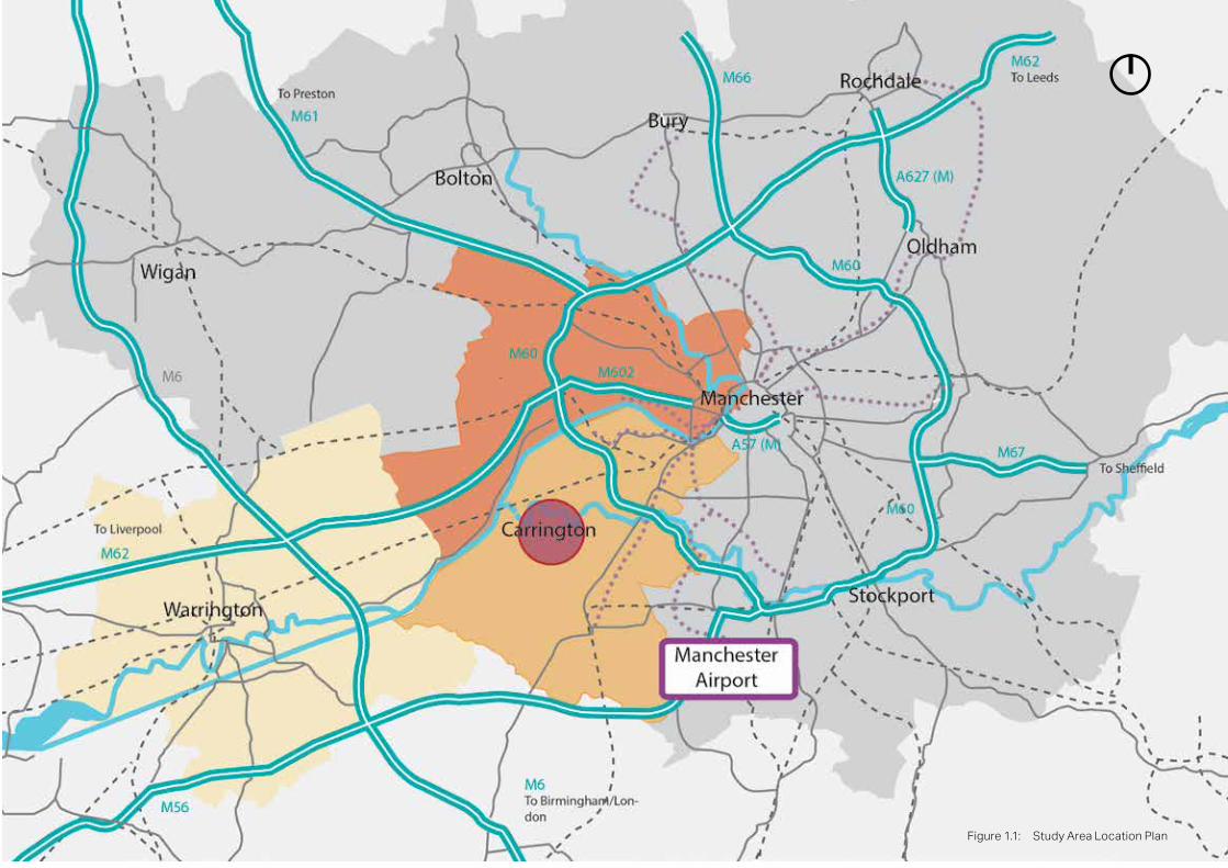
of the routes require access and surface improvements as highlighted within the Greater Manchester Green Infrastructure Opportunities (2020) report.and the Trans Pennine Trail.
3.4 Transport ConnectivityAs noted previously Carrington and Partington suffer from relative isolation from the wider urban area of Greater Manchester. New Carrington provides the opportunity to make strategic highway interventions, for both the car and bus; significant upgrades to public transport; and enhancements for pedestrians, cyclists and horse riders resulting in a much more sustainable community for established and new residents.
A summary of existing transport modes and potential interventions associated with the masterplan is provided below.
Pedestrian Routes
The New Carrington area benefits from several existing long-distance Public Rights of Way providing pedestrian access from the surrounding areas and particularly to Partington and Sale. These routes are also well connected with existing cycle routes and the Trans Pennine Trail.
Building on these established routes with a series of direct, overlooked pedestrian connections will be an important characteristic of the individual parcel layouts that come together to form the overall masterplan. One key benefit of New Carrington to pedestrians is the relatively flat landscape making it easy to move around on foot.
Cycle Routes
The National Cycle Route 62 (Trans Pennine Trail) passes through the New Carrington area and interconnects with Route 82. In the future these established cycle routes will also interconnect with the proposed Bee Network (a proposed joined-up cycling and walking network that connects all of the communities in Greater Manchester, making it easier for people to get around without using a car). Cycle Route 62 passes through the eastern part of the allocation area and provides a major opportunity to create a high-quality cycle network which connects into national routes. In addition, the wider Bee Network creates an opportunity for integration and parity with wider GM initiatives. (See Figure 3.4)
There are also several TfGM cycle routes running through the site and Partington. These are well linked with the wider regional network of cycle routes and create opportunities for creation of the pleasant recreational non-vehicular network. Some
Figure 3.4: Movement opportunities
Mayor’s Cycling and Walking Challenge Fund (MCF) - Trafford Greenway (2019)
The MCF aims to kick start the delivery of the GM Cycling and Walking Commissioner’s Made to Move report and continue Greater Manchester’s journey to becoming a city region where walking and cycling are the natural choices for shorter journeys, as set out in our Greater Manchester Transport Strategy 2040.
One of the proposed schemes is the Trafford Greenway (formerly the Cheshire Lines Greenway), which will bring a disused section of the former Cheshire rail line, between Timperley and Irlam back into use as a Greenway. This project would reopen the Cadishead/Partington viaduct for pedestrians and cycles bringing significant journey time benefits and delivering an 8.6km length of the Bee Network, providing new safe, high quality pedestrian and cycle connections to Irlam Train Station and the Timperley Metrolink stop.

17
In response, the masterplan provides a sustainable movement corridor which has potential to incorporate the Trafford Greenway.
Bus and road transport connections
The New Carrington Site is located between two major motorways (M62 and M60) which provide strategic regional and national connections. A series of lower-tier routes link the site with the surrounding areas of Sale, Irlam, Urmston, Partington and Warburton as well as other regions of Great Manchester. The wider area has an established public transport network, with bus routes travelling through and around the allocation area, providing a variety of choice; The Metrolink Altrincham line lies approximately 2.5 km to the east.
Investment and intervention in strategic movement infrastructure associated with New Carrington provides the opportunity to improve on the relative isolation that Carrington and Partington experience in relation to the wider urban area of Greater Manchester. (See Figure 3.5). Enhanced walking, cycling, horse riding and bus services alongside other supporting highway interventions will be needed to address the primary allocation objectives.
At a site level, New Carrington already benefits from bus routes running through the site, see Figure 3.5; with several bus stops serving both western and northern parts of the area. These routes provide direct access to Partington and Sale. However, there is insufficient frequency and connections to the regional centre involve long journeys on infrequent routes resulting in Carrington and Partington being relatively isolated from the existing public transport network.
The ‘Bus Opportunities GMSF Sites’ study explored a number of bus opportunities that could support travel to and from Sale West and the wider Carrington area. It suggested improvements in bus accessibility to proposed development sites to the west of Sale, improving access to Altrincham, Sale (including Metrolink stops) and improved accessibility to the Regional Centre.
Figure 3.5: Public Transport Movement Plan
18
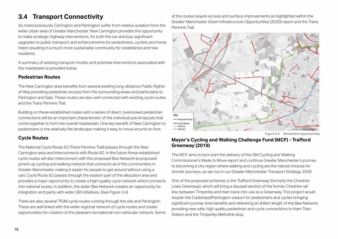
GMSF New Carrington Transport Locality Assessment (2020)
Trafford Council commissioned Amey and Systra to prepare a GMSF New Carrington Transport Locality Assessment Report in 2020.
The aim of the study was to identify and test interventions that will assist in delivering the New Carrington allocation and address the concerns highlighted in the 2019 GMSF public consultation. These public concerns related to:
1. The poor infrastructure condition, pollution and congestion currently experienced on the roads through Carrington and M60 network;
2. The insufficient public transport service and connections (Bus, Train & Metrolink) available in the area; and
3. The fragmented varying standard of active travel infrastructure connections in the local area, including the restrictive connections across the Manchester Ship Canal to the west of the site.
The report concludes that improvements in sustainable and attractive transportation development can be achieved by providing more public transport and active travel modes. A conceptual diagram of key required infrastructure is suggested in the report is illustrated in Figure 3.6. The principal components of this approach are:
• Blue Route (Carrington Relief Road (CRR) - a proposed primary route between the Carrington Spur (to the M60) and Manchester Road. This route has been identified as an important key connection required to help deliver the site and create residual capacity on the A6144 Manchester Road. Various options are being considered for the final alignment of this route.
• Green Routes - potential key links that extend southwards from the CRR are highlighted as two separate branches: the western link connection is as an extension of Isherwood Road and the second further east along the Carrington Relief Road is a potential route to connect to Sale West.
• Light Blue Routes - could connect to Warburton Lane and Manchester Road, providing a local route around the Partington urban area that could ease congestion.
• Yellow Routes - connect to the Green Route crossing the disused rail line and providing an additional upgraded connection.
Figure 3.6: Conceptual Proposed Public Transport and Active Travel Routes

19
Summary of proposed New Carrington Transport Connectivity Considerations
• Enhance existing and identify new formal or informal cycle/pedestrian routes to create an integrated well-connected new recreational green network.
• Ensure that established cycle routes interconnect with proposed Bee Network schemes and Trafford Greenway.
• Significant investment in further public transport (quality and frequency) and active travel measures, including the CRR that offer opportunities to reduce traffic impact.
• New strategic routes to incorporate corridors that can accommodate bus lanes and cycle routes.
The need for a new strategic connection between Carrington and the Carrington Spur has been a long-held aspiration for the area. The adopted Trafford Core Strategy Local Plan Policies Map (2012) includes an alignment of the CRR as part of a Highway Improvements designation (Policy T8) and the New Carrington Locality Assessment continues to support the need for this route to support existing development proposals, as well as the wider New Carrington GMSF site.
The GMSF New Carrington Transport Locality Assessment also incorporated a public transport study that identified the services, frequency and new infrastructure required to serve the allocation. These measures focused on permeability through the New Carrington site, bus priority locations to improve journey time reliability and the connections to other bus hubs and local Train/ Metrolink stations. High standard connections to the Trafford Greenway offer opportunities for attractive ‘linked travel trips’ to Irlam Train Station and the Altrincham Metrolink line.
The masterplan recognises the requirements of integrating public transport corridors which can accommodate bus lanes and cycle routes. This permeable bus network will provide connections between neighbourhood and local centres and residential parcels which would encourage the use of sustainable transport measures.
The assessment suggests that high quality off-road walk and cycle connections should be a key design consideration in the masterplan and delivery of the GMA45 allocation. Segregated footway, cycleway, and equestrian connections will be provided throughout the site that will connect into the Trafford Greenway, the National Cycle Networks (62, 82) and support the Bee Cycle network across the local area. The proposed opening of a viaduct crossing for pedestrians and cyclists will significantly enhance the route for users as currently the routes between Carrington/ Partington and Cadishead are heavily trafficked and of a lower quality due to limited links across the canal. These high-grade connections between land uses, settlements and public transport hubs offer a real opportunity for active travel modal shifts.
20
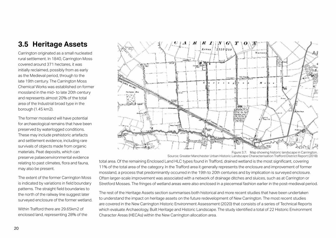
3.5 Heritage AssetsCarrington originated as a small nucleated rural settlement. In 1840, Carrington Moss covered around 371 hectares, it was initially reclaimed, possibly from as early as the Medieval period, through to the late 19th century. The Carrington Moss Chemical Works was established on former mossland in the mid- to late 20th century and represents almost 20% of the total area of the Industrial broad type in the borough (1.45 km2).
The former mossland will have potential for archaeological remains that have been preserved by waterlogged conditions. These may include prehistoric artefacts and settlement evidence, including rare survivals of objects made from organic materials. Peat deposits, which can preserve palaeoenvironmental evidence relating to past climates, flora and fauna, may also be present.
The extent of the former Carrington Moss is indicated by variations in field boundary patterns. The straight field boundaries to the north of the railway line suggest later surveyed enclosure of the former wetland.
Within Trafford there are 29.65km2 of enclosed land, representing 28% of the
Figure 3.7: Map showing historic landscape in Carrington. Source: Greater Manchester Urban Historic Landscape Characterisation Trafford District Report (2018)
total area. Of the remaining Enclosed Land HLC types found in Trafford, drained wetland is the most significant, covering 11% of the total area of the category. In the Trafford area it generally represents the enclosure and improvement of former mossland, a process that predominantly occurred in the 19th to 20th centuries and by implication is surveyed enclosure. Often larger-scale improvement was associated with a network of drainage ditches and sluices, such as at Carrington or Stretford Mosses. The fringes of wetland areas were also enclosed in a piecemeal fashion earlier in the post-medieval period.
The rest of the Heritage Assets section summarises both historical and more recent studies that have been undertaken to understand the impact on heritage assets on the future redevelopment of New Carrington. The most recent studies are covered in the New Carrington Historic Environment Assessment (2020) that consists of a series of Technical Reports which evaluate Archaeology, Built Heritage and Historic Landscape. The study identified a total of 22 Historic Environment Character Areas (HECAs) within the New Carrington allocation area.

21
Archaeology
The assessment has shown that there is potential for remains of high/very high local/regional significance within the allocation area, especially relating to the prehistoric period. The main areas for consideration are the former Carrington Moss; the skirtland around it with freely draining soils and sands and gravels; drift geology; and areas close to the River Mersey and Red Brook. There are also potentially significant remains relating to the former tramways along the Moss, as well as Warburton Deer Park to the west of Warburton Lane and Medieval remains within Carrington Village.
The aim of the New Carrington Historic Environment Assessment (2020) study was to identify areas where archaeological deposits have been subject to disturbance or where they survive relatively undisturbed. The areas with high / very high sensitivity are listed below alongside their sensitivity level:
1. Warburton Park, very high sensitivity;
2. Carrington Moss, high sensitivity;
3. Coroners Wood, very high sensitivity;
4. Enclosed land south of the Moss, high sensitivity;
5. The Church of St George – high sensitivity
6. Enclosed area south of the Moss – high sensitivity. The conclusion of the associated analysis is that those areas with very-high or high sensitivity and in some cases medium sensitivity should be subject to a programme of archaeological works to be carried out pre-application. This will allow for any especially significant archaeological remains to be preserved in situ through sympathetic planning.
In addition, it is recommended that several areas should be subject to programme of work at an early stage to clarify the full extent, depth and survival of peat.
Figure 3.8: Map of Archaeological Sensitivity across Carrington Site. Source: Greater Manchester Spatial Framework Historic Environment Assessment Headline Report (2020)

22
Figure 3.9: Map showing the location of identified built heritage across the Site
Built Heritage
The New Carrington Historic Environment Assessment (2020) looks at the designated and protected buildings and structures within and adjacent to the New Carrington area. One Grade II* and three Grade II structures have been identified within the New Carrington boundary alongside three designated heritage assets. Twenty two undesignated buildings and structures have been identified within the New Carrington area as having a degree of heritage significance.
Each of the historic assets listed in the study includes an assessment of its significance and the potential impact of the proposed development. This New Carrington masterplan should consider the proximity and setting of the historic assets, potential measures to enhance and protect these assets as well as the design aspects of proposed development, such as typology, density and use.
Enhancement and protection of the designated built heritage is recommended. Steps to preserve non-designated built heritage should also be taken.

23
Historic Landscape
The New Carrington Historic Environment Assessment (2020) analysis of the historic landscape involved a rapid assessment on the field boundaries, hedgerows and other visual remnants relating to the historic land use of the area. This also included the late 19th century tram network constructed to transport nightsoil from Carrington Wharf to Carrington Moss, which was itself constructed along a network of banks and lanes, with associated ditches, related to the draining of the Moss in the late 19th century.
The largest areas of sensitivity are located in the south-western part of the site and are within a close proximity to Warburton Deer Park:
Warburton Deer Park - The north-eastern portion of the former medieval Warburton deer park falls within the New Carrington allocation area. The assessment determined that there are several surviving features within the landscape that are likely to be associated with the medieval former Deer Park. There are also likely to be hitherto unknown buried archaeological remains surviving that are associated with the Park.
The Historic Environment Assessment concludes that park has the potential to be of national significance and could be worthy of the Scheduled Monument status. However, further research is needed.
Summary of proposed New Carrington Heritage Asset Considerations
• Preserve surviving field boundaries within development parcels wherever possible;
• The Carrington Rides and other transport related remains and the former Cheshire Lines Railway should be preserved and utilised as part of the transport network;
• Carry out a programme of archaeological work at an early stage to understand the significance of Warburton Deer Park and areas of Carrington Moss;
• Retain the historic woodlands in conjunction with associated ecological studies;
• Retain designated built heritage assets with consideration given to their wider settings make a positive contribution to the significance of these heritage assets; and
• Provide a landscape buffer to Warburton Deer Park to separate development from the area and reduce the density of adjacent development.

24
3.6 Landscape The New Carrington allocation area landscape is identified within five Landscape Character Types (LCT) from the Trafford Landscape Strategy: Mossland; Settled Sandlands; River Meadowlands; the Urban River Valley; and Sinderland Brook Valley. Each of these Types has a series of characteristics and different levels of sensitivity that are summarised below and illustrated in Figures 3.10 and 3.11:
The Mossland - a large scale landscape, predominantly flat in form, dominated by arable farmland. Fields are largely rectilinear in shape defined by tracks or ‘rides’ surrounding fields with scrub-like vegetation and woodland plantation associated with field boundaries and ditches. Although a lack of built development is characteristic of the Mossland, and open views towards the rural areas to the south are also typical, these are not evident at present due to the dense screening provided by plantation woodland at field boundaries and vegetation associated with the disused railway line which encloses the Mossland to the south.
The Settled Sandlands - a more medium scale landscape, dominated by agricultural fields defined by hedgerows and prominent hedgerow trees. Dispersed farmsteads linked by narrow country lanes are typical of the Sandlands, with farm buildings having a noticeably traditional vernacular style. As well as the small, isolated blocks of woodland, there are also linear woodland tracts extending along watercourses and disused railway lines within the Sandlands which are a dominant feature within the landscape.
The River Meadowlands – an area associated with the corridor of the River Mersey, with the River appearing slightly sunken in the otherwise flat landscape thereby not forming a dominant visual feature in the surrounding area. The landscape is pastoral with some wet grassland areas and fields that are semi-regular, enclosed by hedgerows and post and wire fences. The floodplain offers views across it, but views north and south are generally restricted by the rising ground beyond the floodplain. Built form is limited to the occasional building and adjacent settlement edges.
The Urban River Valley – an area dominated by the Manchester Ship Canal and the canalised part of the River Mersey, with views of each limited by surrounding built up areas and industry. The River Valley contains a dense communication network with motorways, roads and railways which have a number of river crossings. Field pattern and field boundaries are lacking, and built features are indistinguishable.
Sinderland Brook Valley - defines the southern border of the New Carrington allocation area and accommodates a well-used pedestrian route that follows the northern bank of the Brook past Woodheys Park towards Carrington Moss. The route then joins Woodcote Road and continues along a track towards Firsway. It links with the ‘Public Footpath Number 23’ sign after Woodhouse Farm and continues towards the Sinderland Brook Estate. The final section heads along an old disused railway track and across Woodcote Road to Woodheys Clough.
To the south of the New Carrington allocation area, lies National Trust Dunham Massey Estate; a walled parkland that is made up of c.3000 acres of predominantly lowland farmland.
Figure 3.10: Carrington Landscape Panorama

25
Figure 3.11: Carrington Landscape Panorama
Greater Manchester Green Infrastructure Opportunities (2020)
This document provides a comprehensive assessment of the current Green Infrastructure (GI) and sets out a series of opportunities/proposals to enhance it.
The document reviews the current baseline in relation to the following topics and provides a list of beneficial use proposals and potential GI enhancements:
• Access;
• Sport and Recreation;
• Biodiversity and Wildlife Corridors; and
• Landscape and Visual.
Summary of proposed New Carrington Landscape Considerations
• In conjunction with heritage assets provide a landscape buffer to areas south of the New Carrington allocation area;
• Provide suitable mitigation to landscape visual impacts; and
• Integrate non-vehicular connectivity as part of a holistic, accessible landscape solution.
It identifies a need for better non-vehicular connectivity and particularly multi-use trails across the area. The document identifies opportunities to improve accessibility to publicly inaccessible areas. With regards to recreation, the document identifies potential private recreational assets and opportunities at Flixton Sewage Works. Furthermore, it identifies the opportunity to create new wetland areas, together with other enhancements to the adjacent River Mersey SBI. The document also promotes the creation of Green Buffers and Green wedges.
The findings of this report formed a basis for the Green Infrastructure, Green Belt and Biodiversity improvements within the masterplan through a series of interventions listed in section 4.2 Green Belt Study.

26
3.7 EcologyThis section of the document focuses on a review of the existing ecological characteristics of the New Carrington allocation area through consideration of existing habitats, ground conditions and hydrogeology, contamination, construction considerations and recommendations for future investigations.
The masterplan identifies a series of habitat creation proposals that are listed below:
• Retention and enhancement of habitats within the Shell Pool Nature Reserve SBI;
• Woodland screen planting to define the eastern edge of Carrington;
• Woodland screen planting to be established along new vehicular routes;
• Wetland Enhancement – an open wetland mosaic to accommodate breeding and overwintering farmland birds;
• Linear parkland to be established along the interface between the existing edge of Sale and new residential settlement expansion to the west;
• Retention and enhancement of Birch Moss Covert SBI; and
• Enhancement of habitats along Sinderland Brook and disused railway corridor.
Due to the existing condition and nature of habitats, hydrology and land available, large scale restoration of raised bog will not be possible. However, the New Carrington allocation area masterplan incorporates a Green Infrastructure proposal that provides the potential to create habitat linkages between raised bogs and to create other habitats typical of mossland fringes.
Most of the original mossland habitat is now arable farmland, but some former mossland remnants continue as wet woodland. Wetland and wet woodland habitats consistent with those previously found on and around Carrington Moss can be created to link existing mossland remnants together. Prior modification of the land for agriculture poses constraints on the extent and type of habitats that can be restored. However, these modifications will contribute towards the overall green infrastructure strategy, and as part of a strategy to deliver Biodiversity Net Gain.
Designated Sites
There are a number of European designated sites (SACs and Ramsar) within 10km of the New Carrington allocation area and Core Strategy Policy SL5 requires a Habitats Regulations Assessment of any proposed development. There is one Site of Special Scientific Interest (SSSI) (Brookheys Covert) together with 12 Sites of Biological Interest (SBI) within the site.
Development which impacts protected sites should be avoided and any impacts which do occur will need suitable mitigation.
Habitats
The site comprises a number of habitats including: arable, improved grassland, semi-improved grassland, woodland, hedgerows, mature trees, standing water, running water and mosaic habitats (comprising semi-improved grassland, tall ruderal and encroaching scrub).
There are three areas of ancient woodland within the allocation, which are also designated. There are a number of wildlife corridors within and adjacent to the site, including the River Mersey, Manchester Ship Canal, Sinderland Brook and the disused railway line. These corridors should be retained and enhanced, Figure 3.12 ‘Carrington Ecology Constraints and Opportunities Plan’ the illustrates how this could be achieved.
A number of hedgerows are spread across the site, some of which were considered to be mature and therefore a Greater Manchester Biodiversity Action Plan (BAP) habitat. Where practicable hedges should be retained and the woodland that the hedgerows connect to should be maintained as wildlife corridors.
There is also several protected species recorded in the area:
• The extensive areas of woodland, as well as hedgerows, ditches, river and ponds, together with low levels of artificial lighting could provide suitable foraging habitat for a range of bat species. The farm buildings within the site could also provide potential for roosting bats, as could the numerous mature trees within the site (which are mostly confined to woodland areas or along hedgerows);

27
Figure 3.12: Carrington Ecology Constraints and Opportunities Plan. Source: Tyler Grange
• The site offers suitable sett building habitat within areas of woodland, embankments, hedgerows and areas of dense scrub;
• The large open arable fields with hedgerows and grassy margins on site offers suitable habitat for brown hare;
• There are a number of ponds and other suitable waterbodies (such as wet ditches) on site and within 250m of the site that could support breeding Great Crested Newts (GCN). Suitable GCN terrestrial habitat is also present on site, e.g. woodland and scrub;
• Habitats on site such as woodland, hedgerow, scrub, marshy grassland and parkland habitat provide suitable habitat for breeding and wintering birds;
• The ditches and waterbodies present on site provide suitable habitat for breeding and foraging water vole; and
• The woodland, scrub, hedgerows and ditch margins present on site provide suitable habitat for a number of reptile species, including slow worm, common lizard and grass snake.
Summary of proposed New Carrington Landscape Considerations
• Retain and enhance habitats within SBI’s;
• Utilise woodland screen planting to define the eastern edge of development and along new vehicular routes;
• Create an open wetland mosaic to accommodate breeding and overwintering farmland birds;
• Create a linear parkland along the interface between the existing edge of Sale and new residential settlement expansion to the west; and
• Enhance habitats along Sinderland Brook and disused railway corridor.

28
3.8 Green BeltThe Greater Manchester Green Belt forms part of the wider North West Green Belt covering land in Merseyside, Cheshire and Lancashire. This was originally designated in 1984 with a series of amendments, through Local Plans, so that it amounts to 59,350 hectares (in 2015) and equated to 47% of the total land area of Greater Manchester.
In releasing sites from the Green Belt, sites should be chosen that are in the most sustainable locations and that would provide the most economic, environmental and social benefits. It has been established that to deliver the scale of growth required to meet the needs of Greater Manchester, for employment and housing, release of land from the Green Belt will be required (Draft Greater Manchester Spatial Framework January 2019). It should also be stressed that release of Green Belt land is critical to the overall viability of the New Carrington allocation area masterplan.
The draft GMSF proposes new Green Belt boundaries which retain a strategic Green Belt gap between Sale and Carrington. They provide a careful balance between the need to accommodate new development and retaining the role and purpose of the Green Belt, in this location.
Whilst it is clear that some areas of current open countryside will be developed, the proposed new Green Belt boundaries either utilise existing strong and defensible features (such as roads or belts of trees) or they can be created through the provision of strategic Green Infrastructure and highway interventions. The extent of encroachment upon the countryside is therefore minimised and hence the New Carrington proposals do not represent “sprawl of large built up areas”. A further purpose of Green Belt is to ensure that neighbouring towns do not merge. The strategic Green Belt gap between Sale and Carrington is maintained within the allocation, which retains the integrity of the Green Belt in this regard.
The GM Green Belt Harm Assessment (2020) document analyses the potential harm to the Green Belt resulting from the proposed New Carrington release of land.
A substantial part of the New Carrington allocation area does not fall within the Green Belt. However, the eastern and northern parts occupy a sizable area of Green Belt resulting in different levels of harm ranging from Low to Very High.
The document provides an understanding on the extent of the potential harm if all land was released which relates to a range of sensitivities across the New Carrington allocation area, with Sale West being particularly high.
The document suggests that measures to strengthen the retained Green Belt will be needed to avoid significantly weakening the settlement gap in this area. (see Figures 3.13 and 3.14 for comparison)
Summary of proposed New Carrington Green Belt Considerations
• Create a strategic Green Belt Gap between Carrington and Sale West;
• Create strong, defensible Green Belt boundaries; and
• Ensure that development of the New Carrington allocation does not represent sprawl of built-up areas.

29
Figure 3.13: Currently adopted Green Belt Figure 3.14: 2020 Proposed Green Belt

30
3.9 Biodiversity Net Gain
Biodiversity Net Gain is an approach to development that leaves biodiversity in a better state than before. It encourages developers to provide an increase in natural habitat and ecological features over and above that being affected. The New Carrington masterplan is seeking to achieve a biodiversity net gain across the allocation area. Initial calculations, in the absence of detailed design, show that biodiversity net gain is achievable within the allocation and retained land. Further testing of this and each phase will be undertaken as the masterplan evolves in later stages.
In this context the Green Belt wedge will help to integrate the development into the wider landscape and connect habitats. Existing woodland and open landscape will form a connected green infrastructure network extending from the River Mersey through to Dunham Massey. This will protect existing habitats and can help to form buffers around key ecological areas, provide attractive new open spaces, opportunities to walk and cycle and for people to enjoy close contact with the natural environment. The network of habitats is intended to ‘future proof’ the overall allocation through creation of links across the landscape that add to the resilience of retained habitats.
The masterplan aims to preserve landscape features and deliver net gain in biodiversity. This will be achieved by delivering ecological enhancements within Green Infrastructure areas such as ecologically valuable SuDS systems, new hedgerows and tree planting and the creation of new habitats through measures to support wildlife. The masterplan provides an opportunity to increase the diversity and resilience of tree cover, particularly in relation to climate change, pests and disease.
Protecting and enhancing these existing habitats along with the Green Infrastructure proposed will support biodiversity net gain.
Specific Guidance and Principles
CIRIA, CIEEM, and IEMA have developed the first UK principles on good practice to achieve Biodiversity Net Gain. This includes: ‘Biodiversity Net Gain–Good practice principles for development’ (2016), and ‘Biodiversity Net Gain – A practical
guide’ (2019). These principles provide a framework that helps improve the UK’s biodiversity by contributing to strategic priorities to conserve and enhance nature while progressing with sustainable development. The document ‘Biodiversity Net Gain: Proposed Guidance for Greater Manchester’ (2019) suggests that Biodiversity Net Gain should be implemented in a way that applies the 10 good practice principles, together. It is the intention that development within the allocation area adopts with these best practice principles; the following guidelines to achieve Biodiversity are suggested at this stage:
Principle 1. Apply the Mitigation Hierarchy
The masterplan will keep the existing natural environment where possible to first avoid and then minimise impacts on biodiversity. Only as a last resort, compensate for losses that cannot be avoided. The Trafford Local Plan Core Strategy R2-Natural Environment (2012) clarifies a list of ecological assets to be protected, including designations (SSSI, SBI, etc.) and woodland, hedgerows, trees and watercourses. The masterplan has integrated such existing ecological features into the design;
Principle 2. Avoid losing biodiversity that cannot be offset by gains elsewhere
The design will avoid impacts on irreplaceable biodiversity as these impacts cannot be offset to achieve No Net Loss or Net Gain. The scheme will encourage keep and enhance fragments of original habitat which can link together, restored and managed to recreate some valuable local ecosystems;
Principle 3. Be inclusive and equitable
The New Carrington project team has engaged stakeholders early. As the masterplan moves through further phases of detail it will be equally important to continue to liaise with both the Greater Manchester Ecology Unit and Natural England around detailed environmental and landscape strategies;
Principle 4. Address risks
The masterplan has addressed the key areas where mitigating difficulty, uncertainty, and other risks to achieving Net Gain (such as Sinderland Brood corridor, Carrington Ride, and Brackish SBI) are more challenging. Further detailed design studies will need to be undertaken to consider any changes to these areas as the project(s) evolve;

31
Principle 5. Make a measurable Net Gain contribution
The masterplan supports an approach to achieve a measurable, overall gain for biodiversity. For the allocation area the masterplan suggests considering the minimum level of Biodiversity Net Gain being achieved when the biodiversity units for the habitats impacted by the development are 5% or more after the development;
Principle 6. Achieve the best outcomes for biodiversity
The design integrates areas that can enhance connectivity and support local nature conservation priorities into a Green Infrastructure. To achieve the best outcome, the masterplan encourages enhancing existing or creating new habitat, and improving ecological connectivity by creating more, bigger, better, and joined areas for biodiversity. The design also suggests delivering compensation that is ecologically equivalent in type, amount, and condition. Compensating for losses of one type of biodiversity by providing a different type that delivers greater benefits for nature conservation is also encouraged.
Principle 7. Be additional
The scheme is aiming to deliver Biodiversity Net Gain in addition to existing conservation activities. This will ensure achieving nature conservation outcomes that demonstrably exceed existing obligations;
Principle 8. Create a Net Gain legacy
The masterplan requires a legacy strategy to ensure Net Gain generates long-term benefits. The scheme supports that any Biodiversity Net Gain projects will need to design the net gain for the long-term with funding identified for a minimum of 25 years for habitats with moderate and high target distinctiveness. A management plan should set out the management required for a minimum of 25 years with clear objectives for the site.
Principle 9: Optimise sustainability
This masterplan supports prioritizing Biodiversity Net Gain and, where possible, optimise the wider environmental benefits for a sustainable society and economy. It also provides a basis for future habitat enhancement or creation which should be designed so that the ecosystem services provided by the area are optimised to meet local needs; and
Principle 10: Be transparent
A five-stage approach for carrying out Biodiversity Net Gain is suggested in Biodiversity Net Gain: Proposed Guidance for Greater Manchester (2019), i.e. Feasibility and scoping; Impact assessment; Design; Constructions; and Maintenance and monitoring.
This masterplan supports applying this approach to the allocation area; all data and reports should be provided to the Greater Manchester Ecology Unit who will keep a record of all biodiversity compensation and mitigation sites. In addition engaging stakeholders to share the findings of any Biodiversity Net Gain project is encouraged throughout the project stages.

32
3.10 Flood Risk / Surface Water The majority of the New Carrington allocation area sits outside the Environment Agency’s Moderate and High Flood Risk areas (Flood Zones 2 and 3). However, there are some low-lying areas adjacent to the Sinderland Brook and north of Manchester Road (River Mersey), that are at higher risk of flooding.
Consequently, there are no proposals to develop within these locations. To prevent increasing flood risk elsewhere, the proposals will need to restrict surface water runoff and the new drainage systems will need to be designed for the future impact of changing weather patterns due to climate change and to improve drainage routing within the allocation where practical. Considering the scale of the New Carrington allocation and the long build out period a Foul and Surface Water Management Strategy will be required for the site.
Flood Risk
Generally, the allocation area is relatively flat. The northern area slopes gradually northwards towards the River Mersey and the southern portion drains south-westerly towards the Sinderland Brook.
Areas of high flood risk in the vicinity (i.e. north of the River Mersey at Flixton and around the two existing electrical substations at Carrington) are either outside of the allocation area or not within an area proposed for development.
The allocation area will need to be developed in such a way as to not increase flood risk elsewhere. The allocation will therefore need to, as far as possible, replicate the existing drainage catchments and outfall routes. Ground levels will need to tie in with existing levels at site boundaries. Within the allocation area, levels shall be re-profiled to create a localised topography to promote falls for surface water drainage to be achieved by gravity where possible.
Surface Water Drainage
Surface water runoff from developable areas that are currently either greenfield or brownfield land will need to follow good practice by incorporating the use of Sustainable Drainage (SuDS) measures and not draining into the combined sewer network. The new drainage system may comprise swales, traditional buried sewers and incorporate attenuation.
Downstream attenuation areas, wetlands and parklands – these will need to be designed to complement the existing natural areas, maximising the ecological and amenity value of providing blue/green space. The Greenfield runoff rate (QBAR) should be determined as 3.6 l/s/ha using ICP SUDS (Interim Code of Practice for Sustainable Drainage Systems) methodology.
Summary of proposed New Carrington Flood Risk and Surface Water Considerations
• No development to take place in areas that are at a higher risk of flooding;
• Development should not increase the risk of flooding within or outside the allocation area and where possible should replicate existing drainage catchments and outfall routes;
• Surface water drainage design will need to follow good practice by incorporating the use of Sustainable Drainage (SuDS) measures and not draining into the combined sewer network; and
• A Foul and Surface Water Management Strategy will be required for the site.

33Figure 3.15: Flood Risk and Water courses
(source: ARUP)

34
3.11 Utilities and Easements / COMAH Several public utilities, pipelines and private services are located in or close to the New Carrington allocation area. Some have associated easements and no-build zones, are strategic in nature and consequently are difficult to relocate. A phased strategy to either retain, abandon or divert these assets should be developed as appropriate. Where required, the masterplan should be tailored to maintain key strategic routes to avoid disruption and associated works that in several instances would be un-economic to deliver or have long programme implications. The allocation will require new utility infrastructure to be provided for electricity, gas, water, sewers and high-speed broadband communications which will include local network provision and some strategic offsite network reinforcement.
Managing Risk from Hazardous Installations
The extent and nature of development that is deliverable in New Carrington will be affected by some installations in the vicinity that are considered by their owners as being potentially hazardous to their neighbours. The effect of these on future residential and commercial developments have been considered in the masterplan. The hazardous installations that have been considered include:
• Gas storage within the Lyondell Basell facility;
• Gas storage within the Air Products facility;
• Gas storage by National Grid in their Partington facility;
• Oil Products pipelines; and
• Gas Distribution pipelines.
Each owner of a hazardous installation has agreed Consultation Zones with the HSE, after assessing the risks and likely effects of major accidents at the installation or pipeline. The Consultation Zones (sometimes called COMAH zones) affecting the allocation area have been consolidated into a plan and this has been used in
conjunction with the “PADHI” land use planning methodology guidance, from the HSE, to determine the deliverable development extent. (Figure 3.16)
Generally, housing is precluded from the Inner Zone (edged orange) on the plan and it is highly restricted within the Middle Zone (edged yellow). Employment uses can be developed within the Inner and Middle Zones, however the size and configuration of employment units is restricted.
The nature and extent of the COMAH Zones therefore have a significant impact on the disposition of uses within the allocation area.
Summary of proposed New Carrington Utilities and Easement Considerations
• Integrate new movement and strategic green space with major utility corridors wherever possible; and
• Observe the limitations on development within the Inner and Middle COMAH Zones.

35
Figure 3.16: Carrington Constraints Plan

36
3.12 Ground ConditionsThe New Carrington allocation area includes the former Shell Carrington Industrial Estate and other industrial land uses. Prioritising development across these areas provides an opportunity to bring previously developed land back into beneficial use. However, in doing so new development will need to ensure that any contamination risks are appropriately remediated and do not give rise to the pollution of any watercourse or groundwater and/or present risks to human health. The area is particularly sensitive for the water environment given its location above a Principal Aquifer and nearby surface waters (including the River Mersey and Sinderland Brook).
Historical industrial land makes up approximately a quarter of the allocation. Much of the remainder of the allocation has not previously been developed and is today used for agriculture. Carrington Moss was once used for the disposal of sewage waste (nightsoil), originating from Manchester. In addition, there are several smaller landfills within the allocation and around the periphery. These landfills vary in their composition and include industrial and domestic wastes.
Contaminated soil and groundwater associated with past industry and landfilling will require assessment and potentially mitigation to reduce the environmental impact of these legacy activities. Initial investigation and assessment indicate the ground contamination can be treated to enable commercial and residential development. Design of earthworks and structures may need to mitigate risks posed by soil contaminants and ground gases where assessment indicates a risk. Localised groundwater remediation is also likely to be required in certain areas.
Artesian groundwater conditions will need to be considered where piling into the sandstone bedrock. Carrington Moss is a former peat bog and initial investigation indicates a maximum thickness of peat of 3m, which thins towards its perimeter. The impacts of settlement and ground gases associated with the peat will need to be considered within the design of new structures.
Summary of proposed New Carrington Ground Conditions Considerations
• Give priority to development of brownfield land;
• Ensure sensitivities around the wider water environment are given full consideration; and
• Undertake required assessment and mitigation associated with contaminated soil and groundwater associated with past industry and landfilling.

37Figure 3.17: Ground Condition Plan (source: ARUP

38
3.13 Social Infrastructure Existing social infrastructure surrounding the New Carrington allocation area is illustrated in Figure 3.18. It shows numerous schools in and several hospitals around the area in Sale, Urmston and Partington. However, the extent of new development will require the need to provide additional social infrastructure.
Whilst on a strategic level the allocation area is surrounded by well-established settlements, only small parts of the site fall within catchment of established schools and hospitals in Partington and Sale. Reinforcement of social infrastructure provision as a part of the development is therefore required.
The Trafford Housing Needs Assessment (HNA) (2020)
The Trafford Housing Needs Assessment (HNA) (2020) provides part of the evidence in informing the future housing and strategic policies in Trafford, complements the Greater Manchester Strategic Housing Market Assessment and supports the development of the new Trafford Local Plan.
The HNA provides an overview of the current Housing Market Context by looking at house prices, dwelling stock and household profiles, demographic drivers and economic drivers.
Analysis concludes there is an ongoing need for all types and sizes of dwelling with strongest need for 3-bedroom houses, continued need for 4 or more-bedroom houses and smaller 1 and 2-bedroom houses. There is also a need for bungalows/level access accommodation and flats/apartments.
There is evidence to support a programme of accommodation delivery to help meet the needs of older people and those with disabilities. Diversity of options available to older people wanting to move to more appropriate accommodation is needed.
The assessment indicates the growing population and good economic factor to support the development in New Carrington.
Figure 3.18: New Carrington GMSF Infrastructure Analysis Plan
Summary of proposed New Carrington Social Infrastructure Considerations
• Reinforce the social infrastructure provision across the allocation area; and
• Provide a range of new house types with a predominance of 3 bedroom houses.

39Figure 3.18: New Carrington GMSF Infrastructure Analysis Plan

40
4 Design Principles4.1 Development ObjectivesThe The New Carrington vision is to transform Carrington, Sale West and Partington into sustainable and attractive, mixed use residential and employment neighbourhoods achieved through a holistic revitalisation strategy. The development will incorporate new residential communities, industry, warehousing, manufacturing, community facilities, and strategic green and road infrastructure improvements. The development will be characterised by strategic green infrastructure across the New Carrington allocation area, enhancing and capitalising on existing assets.
It is envisaged that this vision will be realised through the following measures and activities:
• Regeneration of declining previously developed land in Carrington;
• Delivery of market facing employment and housing land, together with supporting services as a catalyst for the renaissance of New Carrington allocation area;
• Release Green Belt land for urban extensions to both Partington and Sale West to deliver new residential communities and facilities;
• Delivery of critical infrastructure to enhance connectivity and linkage, between existing and new communities and employment areas; and
• Creation of an enhanced landscape and environment through a cohesive green infrastructure strategy.
4.4 1

41
Strategic Influences The process of evolution from the previous masterplanning exercises has been formulated around a review of existing and emerging policies, an updated evidence base (as summarised in Section 3) and review with major stakeholders. The key strategic influences include:
• Align with the nine strategic objectives defined in the GMSF around:
• Meeting housing needs;
◊ Creating neighbourhoods of choice;
◊ Ensuring a thriving and productive economy;
◊ Maximising the potential arising from national assets;
◊ Reducing inequalities and improving prosperity;
◊ Promotion of sustainable movement;
◊ Ensuring a more resilient carbon neutral solutions;
◊ Improving the quality of the natural environment and access to green space; and
◊ Ensuring access to physical and social infrastructure.
• The desire to transform the previously developed land in Carrington to a sustainable place for both working and living;
• Creation of a sense of place through integration of development within the New Carrington allocation area with existing communities;
• Delivery of necessary infrastructure to connect and support existing and new communities; and
• Integration of landowner’s and promoter’s ambitions and with the vision into a realistic and deliverable masterplan, to meet significant Greater Manchester wide housing and employment needs.

42
The OpportunitiesThe masterplan will introduce a critical mass of additional employment development in Carrington, and a series of residential urban extensions to Carrington, Partington and Sale West. It also considers the landscape strategy for the whole allocation site, together with the link roads connecting the new land uses and associated facilities. The key opportunities and as indicated in Figure 4.1 will include:
1. Transformation of previously developed areas in Carrington into a new and attractive place for living;
2. Strengthen and extend existing employment areas in Carrington;
3. Deliver new communities in Sale West, south and east Partington areas;
4. A new district core for neighbourhoods in Partington, including new community services such as education, retail, commercial, health and social facilitates;
5. A new strategic permeable access and road network;
6. Enhanced sustainable transport corridor providing improved connections for the existing communities of Sale and Partington;
7. Enhanced Green Belt and green infrastructure, incorporating an integrated network of opportunities for access to the countryside for established and new communities; and
8. Enhanced habitat areas.

43
Wider Carrington GMSF site masterplan
Tra ord Metropolitan Borough Council
Conceptual Movement Plan
22/06/20 Revised to latest parcels
60629007
Existing community
Proposed community
Employment area
Proposed local centre
Existing link road
Potential enhanced / new link road
Potential public transport corridor
04003
07/05/20
SalePartington
Cadishead
N
Irlam
Flixton
To Lymm To Altrincham
Carrington residential areas
Carrington Employment areas
Sale West residential areas
MUFC Training Ground
Partington residential areas
Local Centre
Manchester Ship Canal
River Mersey
Manchester Rd
Carrington Spur
Figure 4.1: Carrington Opportunity Plan
1
23
34
5
6
8
7

44
4.2 Green BeltThe proposed new Green Belt boundaries will retain a strategic Green Belt gap between Sale and Carrington. They provide a careful balance between the need to accommodate new development and retaining the role and purpose of the Green Belt, in this location.
Whilst it is clear that some areas of current open countryside will be developed, the proposed new Green Belt boundaries either utilise existing strong and defensible features (such as roads or belts of trees) or they can be created through the provision of strategic Green Infrastructure and highway interventions.
In line with guidance within the National Planning Policy Framework (NPPF 2019) (paragraph 138), the New Carrington proposal can also deliver “offsets through compensatory improvements to the environmental quality and accessibility of remaining Green Belt land”. The size of the allocation area allows for significant areas of Green Belt land to be retained and deliver parallel environmental quality and accessibility enhancements.
War
burto
n Lan
e
Partington
Urmston
Carrington
Manchester Ship Canal
Sinderland Brook
Retained Green Belt
Released Green Belt
Additional Green Belt
M62
Railway line
Manchester Rd
Moss Ln
Sale West
Isherwood Road
Figure 4.2: Green Belt Comparison Plan
45
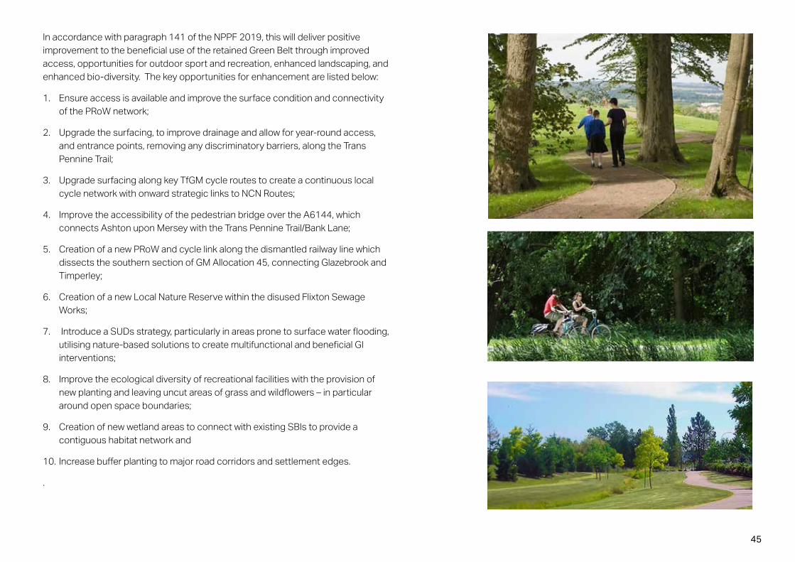
In accordance with paragraph 141 of the NPPF 2019, this will deliver positive improvement to the beneficial use of the retained Green Belt through improved access, opportunities for outdoor sport and recreation, enhanced landscaping, and enhanced bio-diversity. The key opportunities for enhancement are listed below:
1. Ensure access is available and improve the surface condition and connectivity of the PRoW network;
2. Upgrade the surfacing, to improve drainage and allow for year-round access, and entrance points, removing any discriminatory barriers, along the Trans Pennine Trail;
3. Upgrade surfacing along key TfGM cycle routes to create a continuous local cycle network with onward strategic links to NCN Routes;
4. Improve the accessibility of the pedestrian bridge over the A6144, which connects Ashton upon Mersey with the Trans Pennine Trail/Bank Lane;
5. Creation of a new PRoW and cycle link along the dismantled railway line which dissects the southern section of GM Allocation 45, connecting Glazebrook and Timperley;
6. Creation of a new Local Nature Reserve within the disused Flixton Sewage Works;
7. Introduce a SUDs strategy, particularly in areas prone to surface water flooding, utilising nature-based solutions to create multifunctional and beneficial GI interventions;
8. Improve the ecological diversity of recreational facilities with the provision of new planting and leaving uncut areas of grass and wildflowers – in particular around open space boundaries;
9. Creation of new wetland areas to connect with existing SBIs to provide a contiguous habitat network and
10. Increase buffer planting to major road corridors and settlement edges.
.

46
4.3 Green Infrastructure/Green CorridorsA Green infrastructure (GI) framework has been developed, through the retention of existing green assets, wherever appropriate, and the introduction of new open spaces throughout the allocation area. The Green Infrastructure plan (Figure 4.4) sets out the location and extent of strategic open spaces proposed and helps to illustrate the contextual relationship between open space, development and the existing communities.
The north-south green wedge will reinforce the linkages between National Trust’s ‘Dunham Massey Estate and the River Mersey Green Belt corridors.
New north/south tree planting should be proposed to create a meaningful green corridor for nature and wildlife to move around the landscape more freely up to the River Mersey. Creating walking and cycling links that join up with other key features such as the Mersey to the north, Trans Pennine Trail and Bridgewater Canal and south into Cheshire will ensure communities have genuine access to green spaces.
A strategic west-east Green Infrastructure route ‘Sinderland Brook / Red Brook Corridor (see Figure 4.4), running alongside the Sinderland Brook, will connect Sale and Manchester Ship Canal Frontage Park. This route could also provide links to the River Mersey, via a north-south strategic GI route along the disused railway line corridor.
A series of Landscape Gateways will be created at the entrances to the strategic Green Infrastructure routes, incorporating way-finding and interpretation boards that will encourage local people to use these important green amenities.
The Trans Pennine Trail, running through the Sale West area, will be enhanced into a strategic GI route, which will act as a recreational spine for a permeable pedestrian/cycle network for Sale West. Another strategic GI route is proposed between Carrington Village and Sale West, along the proposed Carrington Relief Road, which will enhance the connection between future communities and encourage people enjoy retained countryside. Significant GI areas in Sale West will be retained and protected from development despite being removed from Green Belt. Access improvements to these areas a will provide important linkages between the development parcels.

47
Sale west gateway
Partington south gateway
Retained Green Belt
TPT
Corri
dor
Phase 1 central green
Sinderland / Red Brook corridor
AON training complex
Sale south gatewayPartington
Sale
Urmston
Carrington
Manchester Ship Canal
M62
Railway line
GreenAmenityFocus
Figure 4.3: Green Infrastructure Plan
GMSF allocation boundary
KEY
Proposed strategic green link
Development area
Open space
Public transport corridor
Proposed HS2 corridor
Proposed landscape gateway
Trans Pennine Trail
Sinderland / Red Brook corridor
Retained and enhanced Green Belt

48
4.4 LandscapeThe following should be read in conjunction with the Environment Strategy Plan (Fig. 4.5) produced to illustrate the locations of the recommendations identified below.
1. Sinderland / Red Brook creates a green corridor through the southern part of the area, which will be retained and enhanced to form a defined settlement edge and backdrop to lower density development south of the brook. Enhancement of the Brook would break up the settlement into distinct character areas, providing recreational, biodiversity enhancement and habitat creation opportunities through the strengthening of one of the key Green Infrastructure links within the area. The Existing Ancient Woodland will be retained and enhanced through incorporation into the Green Infrastructure enhancements along the Brook.
2. The green corridor between Sale and Carrington should be retained and defended through the creation of new key green edges, containing development and limiting its influence over the intervening fields between the two settlements.
3. The disused railway lines running across the landscape currently form key Green Infrastructure links and wooded backdrops within several views. These corridors should be retained and enhanced, and where utilisation of the disused railway line would result in vegetation loss, new vehicular routes should seek to replace these corridors with new woodland planting a key feature in order to retain the key Green Infrastructure link the existing disused railway provides.
4. Public recreational routes along the ‘Rides’ and Trans Pennine Trail should be retained within any future development layout and improved upon with surfacing enhancements, vegetation management, and links provided to new recreational routes.
5. Development around Sinderland / Red Brook should seek to ensure it relates to the character of the landscape within the area and south of Sinderland Lane through the consideration of the visual impact of development and the incorporation of offsets. Lower density communities with rural characters will be more appropriate to these areas.
6. Areas of the landscape adjacent to settlement edges are already influenced by urban built form and can be developed within the containment of existing and proposed Green Infrastructure corridors.
7. The existing brownfield land at Carrington Business Park and the former chemical works can be utilised to create new development areas within the containment provided by the existing built uses adjacent, and with a new Green Infrastructure corridor created to the east.
8. Development offsets should be considered from the River Mersey to ensure any ecological mitigation measures required can be incorporated, to retain the integrity of the River corridor and to allow the potential for extension of wetland areas along the River.
The New Carrington allocation area will facilitate the retention of the established water courses and vegetation where possible. Strengthening the vegetated corridors will create a firm and defensible green infrastructure framework between the urban areas and open countryside. Retention of existing landscape and water features presents several opportunities to create a unique scheme that is responsive to the site and knits into the adjacent areas, providing a strong sense of place and character.

49
Figure 4.4: Environment Strategy Plan. Source: Tyler Grange

50
4.5 Blue Infrastructure Blue infrastructure has been an important design development consideration for the New Carrington masterplan. The overall approach has been to ensure that existing water bodies, including Red Brook, Sinderland Brook, Shell Pool reserve, are integrated into a well-connected blue and green network which connects to the Manchester Ship Canal and River Mersey. At a development parcel level this overarching infrastructure will then connect to individual development parcel SUD’s proposals.
Sinderland /Red Brook corridor is a key blue infrastructure asset which provide multiple environmental enhancement functions. Within this corridor, the aspiration is to increase wet woodland and woodland areas, with opportunities for a visitor hub with information points, bike hire facilities, outdoor classrooms/nature workshops, catering outlets, and play trails through woodlands. Pedestrian and cycle connectivity should connect along length of the Brook (while protecting the SSSI and SBI).
Figure 4.5: Blue Infrastructure Plan
GMSF allocation boundary
KEY
Proposed strategic green link
Development area
Open space
Sinderland Brook and Board Oak Farm corridor
EA Flood Risk Zone 2
EA Flood Risk Zone 3
Retained and enhanced Green Belt

51
4.6 Play and sport facilities There are several existing sports facilities located within the site namely the Manchester United AON Training Complex, Bury Football Club Training Centre, Sale Sharks Rugby Club Training Ground and North Cheshire equestrian Centre. Further masterplanning work will look to engage with these sports users to ensure the local environment is protected and enhanced. Creation of a relocated Rugby Club within the Carrington Village open space proposals aligns with the Council’s over-arching strategy for sports provision.
A series of Local Equipped Areas for Play (LEAP) and Local Areas for Play (LAP) as well as a Neighbourhood Equipped Area of Play (NEAP) will be required across the proposed residential area to achieve good levels of accessibility. All development will be required to provide a range of types and sizes of open space in accordance with the Council’s open space standard and outdoor sports policy.
In addition, several centrally located multifunctional green space has been positioned next to the Village Cores which would include an informal football pitch and Multi Use Games Area (MUGA).
Figure 4.6: Indicative Play and Sports Plan
Existing private formal sports facility
Proposed formal sports facility
Proposed informal sports facility
Proposed strategic play areas (NEAP)
1200m / 15mimutes walking distance circle

52
4.7 Strategic movement network and hierarchy SA series of north/south and east west strategic non-vehicular routes will be created alongside the enhanced ride network in order to create a well-connected new recreational green network. (See Figure 4.9). These routes will be established to ensure that cycle routes interconnect with the proposed Bee Network and Trafford Greenway.
Strategic roads, including the proposed Carrington Relief Road, have been identified in black on the movement plan (Figure 4.9). These routes will enable primary vehicular movement throughout both the residential and employment areas, connecting into the existing transport network. The strategic roads will play a key role in achieving effective integration between proposed and existing communities and enhance the provision of sustainable transport, including corridors that can accommodate bus priority measures and cycle routes.
Other movement through the site is defined by a grid of routes shown in white which will provide a comprehensive movement network that will interconnect the development and give priority to pedestrians and cyclists.
Details of the internal access and movement within the development parcels will be developed at later stages. However, key routes include:
• Strategic non-vehicular routes integrated into the Green Infrastructure network to encourage sustainable transport;
• Carrington Relief Road: connecting Carrington village and Sale;
Figure 4.7: Potential Carriageway Section
• Link roads:
◊ Southern link – connecting the A6144 Warburton Lane and the A6144 Manchester Road (via either Moss Lane or Broadway), crossing the Red Brook and providing a local route around the Partington urban area.
◊ Eastern link – connecting development parcels in the East Partington area to Isherwood Road, crossing the rail line and linking through the employment parcels.
◊ Sale West link – from the Carrington Relief Road and extending south through the Sale West development parcel and linking to Firs Way.
Measures to discourage ‘rat-running’, specifically in the rural lanes to the south of the New Carrington allocation area will need to be incorporated at highway design development concept stage. Horizontal deviation and width restriction measures plus introduction of additional landscape features should all be considered.

53
Figure 4.8: Movement and Highway Network PlanGMSF allocation boundaryKEY
Green infrastructure
Green Belt
Sustainable transport corridor
Proposed road network
Carrington Relief Road
Proposed HS2 route
Development area
Strategic non-vehicular route
War
burto
n Lan
e
Firs W
ay
Sale
Carrington
Manchester Ship Canal
Sinderland Brook
Railway line
Carrington Relief Road
Opportunities to improve Bollin Way to improve connections between this site and Partington
TPT
Corri
dor
Manchester Rd
Moss Ln
Broadway
Carrington Greenway
Sale West Link Road
Isherwood Road
Eastern Link Road
Note: All routes are indicative and will be subject to further consideration.
Link road options
Southern Link Road

54
4.8 New Local CentresThe considerable scale of new housing and employment development proposed at New Carrington will require, through both planning obligations and market demand, a range of social-infrastructure facilities to serve the new community. This will include schools, health care and convenience retail within three proposed Village Cores that are indicated on the plan (Figure 4.10). Two smaller scale Neighbourhood Centres will be located in Carrington Village and Sale West, whilst a larger scale Local Centre is proposed within the Partington East area. These village cores will act as attractive, mixed use community hubs, which provide gateway entrances into the wider Carrington development areas and form community destinations for the whole development. These spaces will be defined by landmark buildings comprising small commercial units with residential dwellings above.
Larger apartment buildings will provide corner articulation at key junctions and perform as focal buildings, aiding legibility. The majority of buildings within these areas will be three storey, and up to four storeys in particular identified locations.
Figure 4.9: Local Centres Plan
GMSF allocation boundary
KEY
Development area
Green Infrastructure
1200m / 15mimutes walking distance circle
Existing Partington Local Centre
Proposed Local Centre
Proposed Neighbourhood Centre
Sustainable transport corridor
Public Rights of Way
‘Rides’ within Carrington
This reflects the overall identity of the “Village Core” as the focus of activity that is easily recognised by passers-by on strategic roads. It also reflects the larger street scale, providing a comfortable sense of enclosure for pedestrians. Formal landscaping will include proposed tree planting and predominantly hard landscape spaces around the new buildings.
Green Belt

55
4.9 Sustainability
The overall approach taken to the design of the proposals for New Carrington masterplan integrates sustainability into the design process with the aim of achieving sustainable development. Sustainability is not treated as a separate subject but is part of a holistic design process that runs throughout all aspects of the scheme, including design and layout of buildings and landscape, the components of the masterplan, transport strategy and phasing.
In summary, the aspects of sustainability addressed throughout the design process include:
• The reuse of previously developed land (efficient use of land);
• Approach to density, local centres and transport (to reduce emissions from private transport);
• Managing surface water drainage, developing outside of flood zones 2 and 3 and ensuring supply capacity;
• Ecology and landscape are being integrated within the masterplan with the overall objective of achieving biodiversity net gain;
• Heritage and culture - opportunities to incorporate landscape elements, including former Carrington Moss and Rides features;
• Amenity, recreation and public open space of different types to serve a diverse new community;
• A transport strategy that seeks to provide bus routes throughout the site;
• Built form and public realm that creates an attractive new neighbourhood with a unique identity;
• Employment opportunities on site co-located with other key community uses as part of a whole masterplan vision;
• Conveniently located Neighbourhood Centres that provide goods and services to serve people’s daily needs;
• A diverse housing offer that caters for local need with a mix of types and tenures for an age diverse community;
• Space for community groups and activities within a hub that helps to foster a sense of community;
• Providing for Education and skills in the form of a primary school and potential apprenticeships linked to the construction industry (subject to future discussions);
• Promoting Active by Design principles that encourage walking, cycling and a connection with nature;
• Encouraging the use of sustainable sources of construction materials and minimising construction waste in line with achieving a BREEAM excellent rating;
• Encouraging developers to consider meeting the government’s forthcoming Future Homes Standard for residential buildings in 2020 and beyond;
• Designing a future-proof development which responds to climate change (e.g. solar-shading and cross ventilation, not single aspect dwellings);
• Utilising modern methods of construction where viable in order to accelerate the speed of housing delivery; and
• Within the ‘Neighbourhood Hub’ - utilise ‘green roof’ technologies to improve water run-off rates and encourage bio-diversity and soften plant impact.

56
5.1 Indicative Masterplan The New Carrington masterplan (Figure 5.1) responds to the design and place-making issues discussed previously and takes its cue from the surrounding area’s physical and visual context. Whilst the design is not seeking to solve all technical issues at a detail level, it forms an important part of the site allocation evidence by demonstrating an approach to the outline proposals which enables the creation of approximately 5,000 dwellings and up to 380,000 sqm employment (B1/B2/B8), together with creation of road infrastructure, public open space, landscaping and ecological works, and cycle and pedestrian circulation. It identifies potential development parcels and relationship with open space which are guided by the principles and parameters set out earlier in this document.
The masterplan aims to create attractive neighbourhoods with housing provided at a mixed density range that is both sustainable and deliverable, and employment units that are responsive to market demands.
5 Proposals
Precedent images

57
Figure 5.1: New Carrington masterplan
Local centre

58
5.2 Carrington Relief Road (CRR)The Carrington Relief Road will form a new, primary route between Partington and the Banky Lane termination of the Carrington Spur link to Junction 8 of the M60. The new route will serve as a link to proposed secondary north-south routes which will serve the wider New Carrington site.
The route will also provide an opportunity to improve public transport and active travel links through the area, as well as providing congestion relief to the existing A6144 Manchester Road.
The final route alignment has not yet been determined, but the high level indicative route follows the existing private “A1 Road” on the former shell petrochemical site, connecting with the A6144 to the north of the Common Lane Junction and extending to Isherwood Road to the east. The route then extends east to meet the Carrington Spur at Banky Lane
The overall length of the road is approximately 4km and the corridor will provide green infrastructure including landscape mitigation measures, and provision for walking, cycling and bus infrastructure.
Figure 5.2: Indicative Carrington Relief Road (Source: ARUP)

59
5.3 Other link roads and Non-vehicular routesA series of primary vehicular movement corridors that connect new development to the existing road system are illustrated in Figure 5.3. These routes are indicative at this stage, but indicate the key vehicular movement corridors.
As suggested in the ‘Bus Opportunities GMSF Sites study report’ (2019), improving bus accessibility to New Carrington, Altrincham, and Sale should be encouraged. New strategic roads with average 25 metres width are proposed in this masterplan to accommodate new bus routes. A network of new and enhanced routes will be provided throughout the allocation area with an emphasis on providing a sustainable network of non-vehicular connections that will build on enhancements to the existing ‘Ride Network’ as the foundation.
From a public transport perspective, the biggest issue to address is the unattractiveness of public transport from Carrington and Partington in relation to the private car. The consequential ambition is that that the proposed New Carrington development will provide genuinely attractive alternatives to the private car for journeys to significant trip attractors. This is likely to include significant investment in bus priority (potentially including bus gates, dedicated bus lanes or busways and priority and signalised junctions) in order that the bus is not delayed by congestion on the key roads, together with increases in frequency to ‘turn-up-and-go’ levels, and a routeing strategy around Partington and Carrington which better served the existing and proposed settlement.
Interventions will allow bus services to get past traffic at key bottlenecks, and also provide connections to rapid transit services to Manchester City Centre, the most significant trip attractor. Overall, the interventions will enable a significant improvement to the accessibility of the wider New Carrington / Partington area.
Figure 5.3: Indicative Movement Network
War
burto
n Lan
e
Firs W
ay
Sale
Carrington
Manchester Ship Canal
Sinderland Brook
M62
Railway line
Carrington Relief Road
TPT
Corri
dor
Manchester RdMoss Ln
Broadway
Carrington Greenway
Sale West Link Road
Isherwood Road
A key design consideration throughout the evolution of the Site masterplan is ensuring a balanced approach to a sustainable access and movement strategy that appreciates the importance of pedestrians, cyclists and public transport. Accommodating this creates a network of lower order streets and shared surfaces facilitating overlooked and interconnected pedestrian and cycle routes throughout the Development.
The key principles for movement design include:
• Carefully design the location of the link roads and ensure they provide convenient access to the areas of development;
• Create a permeable vehicular route network throughout the site; and
• Ensure the location and orientation of tertiary roads are parallel to landform contour lines where possible in order to minimise the requirement for earthwork formation.
Note: All routes are indicative and will be subject to further consideration.
GMSF allocation boundaryKEY
Green infrastructure
Sustainable transport corridor
Proposed road network
Proposed HS2 corridor
Carrington Rides
Public Rights of Way
Development area
Strategic non-vehicular route
GMSF allocation boundaryKEY
Green infrastructure
Sustainable transport corridor
Proposed road network
Proposed HS2 corridor
Carrington Rides
Public Rights of Way
Development area
Strategic non-vehicular route
Green Belt
Southern Link Road
Eastern Link Road

60
5.4 Land useThe distribution of land uses at New Carrington is illustrated in Figure 5.4. This plan provides an over-arching spatial framework that will help to structure and distribute the amount and extent of future development activity. It illustrates the extent of proposed development parcels, and land use relative to retained green infrastructure, key access arrangements, and the established movement framework.
The key proposed land uses are summarised below:
• Employment Use – The majority of employment uses are located within Carrington, to south of the CRR, on either side of Manchester Road. These development parcels will provide up to 152.8 ha of B1/B2/ B8 employment development;
• Neighbourhood and Local Centres – Two Neighbourhood Centres will be located in Carrington village and Sale West. A Local Centre will be delivered in Partington East, to provide community facilities for new residents;
• Residential Use – Development within residential parcels will provide approximately 5,000 new homes across a total area of approximately 179.7 hectares;
• Open Space - Proposals are focused on providing a permeable network which links into wider green infrastructure beyond the allocation area boundary. Approximately 118.6 hectares of open space will be provided; where possible, there should be an interactive relationship between development and open space; and
• Strategic Routes – A network of new strategic routes, incorporating provision for pedestrians, cyclists and landscape screening alongside the formal carriageway will be provided as part of the masterplan. The total area of land required to accommodate these routes is up to 21.6 hectares. The routes will include an upgraded A1 road (Carrington Relief Road) connecting Sale and Carrington Village, together with a series of lower order roads providing a permeable access network to future development parcels.
Several areas within the allocation will be unaffected by development. These include some employment and residential areas in Carrington (171.9 ha) and untouched established spaces wrapping around employment areas (101.9 ha). The majority of Manchester Road and Isherwood Road will be retained (12 ha). The Green Belt Gap between Carrington and Sale (394.6 ha).
Table 5.1 below confirms the total area of proposed land uses that are achieved within the New Carrington allocation boundary.
Table 5.1: New Carrington land use table
Type Land use Area (ha) Comment
Strategic roads 21.6 20-30m wide, average 25mResidential parcels 170.6Local Centre /Neighbourhood Centres 9.1
Employment parcels 152.8Open Space 118.6
Total 1153.1 GMSF boundary
Proposed
60629007_04_008 New Carrington Masterplan - Land Use
Total 179.7 ha, Including potential4 ha for 2 primary schools

61
Figure 5.4: New Carrington masterplan land use planGMSF allocation boundary
KEY
Existing key road
Proposed key road
Existing employment and residential areas
Proposed residential areas
Existing natural areas
Existing Green Belt retained
Proposed open space
Proposed village centre
Proposed employment areas
Land Use Plan
04010
1 / 10,000 @ A1
N
25/06/20
Proposed Neighbourhood and Local Centres

62
5.5 Appropriate building densities The Proposed Development will deliver of approximately 5,000 dwellings within New Carrington, at densities varying between 25 to 55 dwellings per hectare (net). It is intended that the density will reflect the varied context currently expressed in the area. Mixed density will avoid homogeneity and provides an opportunity for development to respond to the varied topography and landscaping of the Site, and create key focal points around the local / neighbourhood centres. There is opportunity to develop the Site to reflect the characters of Carrington, Sale and Partington. This could be achieved with lower density development to the south of Partington to reduce impact on the Green Belt and protect landscape character. A higher density to the Sale West to reflect the existing built form of the well-established urban areas in Sale, whilst seeking to retain the areas of open countryside to its west. An urban extension to Partington, higher density new parcels to the east of Partington would be appropriate and reflect the local character of the local context.
The scale of the buildings in the proposed Employment Area will be larger than residential units. Therefore, the placemaking principles for this area will be different from those applied to residential villages. The scheme suggests restricting the employment building heights for areas in close proximity to residential parcels.
Precedent images

63
Figure 5.5: Building Density Plan
Lower density parcels (Average 25 DPH)
Medium density parcels (Average 30 - 39 DPH)
Medium to high density parcels (Average 40 DPH)
Higher density parcels (Over 55 DPH)
Employment area
Carrington employment Areas
Partington East
Warburton Lane
Carrington Village
Sale West
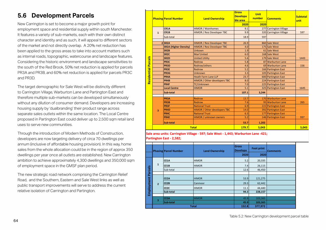
64Table 5.2: New Carrington development parcel table
5.6 Development Parcels New Carrington is set to become a major growth point for employment space and residential supply within south Manchester. It features a variety of sub-markets, each with their own distinct character and identity and as such, it will appeal to different sectors of the market and not directly overlap. A 20% net reduction has been applied to the gross areas to take into account matters such as internal roads, topographic, watercourse and landscape features. Considering the historic environment and landscape sensitivities to the south of the Red Brook, 50% net reduction is applied for parcels PR3A and PR3B, and 60% net reduction is applied for parcels PR3C and PR3D.
The target demographic for Sale West will be distinctly different to Carrington Village, Warburton Lane and Partington East and therefore multiple sub-markets can be developed simultaneously without any dilution of consumer demand. Developers are increasing housing supply by ‘dualbranding’ their product range across separate sales outlets within the same location. The Local Centre proposed in Partington East could deliver up to 2,500 sqm retail land uses to serve new communities.
Through the introduction of Modern Methods of Construction, developers are now targeting delivery of circa 70 dwellings per annum (inclusive of affordable housing provision). In this way, home sales from the whole allocation could be in the region of approx 350 dwellings per year once all outlets are established. New Carrington ambition to achieve approximately 4,300 dwellings and 350,000 sqm of employment space in the GMSF plan period.
The new strategic road network comprising the Carrington Relief Road, and the Southern, Eastern and Sale West links as well as public transport improvements will serve to address the current relative isolation of Carrington and Partington.
2020 2020CR1A HIMOR / Wainhomes 9.1 277 Carrington VillageCR1B HIMOR / Resi Developer TBC 9.9 320 Carrington Village
Sub-total 18.9 597
2 SR2A HIMOR / Resi Developer TBC 26.9 860 Sale WestSR2A (Higher Density) HIMOR / Resi Developer TBC 4.0 175 Sale WestSR2B Unkown 1.9 61 Sale WestSR2C Man'United 6.0 168 Sale WestSR2D United Utility 5.6 179 Sale WestPR3C Redrow 5.8 87 Warburton LanePR3D Redrow/others 4.6 69 Warburton LanePR3E Redrow 5.2 166 Partington EastPR3G Unknown 3.3 105 Partington EastPR4A Heath Farm Lane LLP 23.7 600 Partington EastPR4B HIMOR / Other developers TBC 8.0 224 Partington EastPR4F TC/Unknown 7.0 225 Partington EastLocal Centre HIMOR 5.1 325 Partington East
Sub-total 107.1 3,244
PR3A Redrow 13.7 170 Warburton LanePR3B Redrow 7.6 95 Warburton LanePR3F National Trust 6.9 222 Partington EastPR4D HIMOR / Other developers TBC 14.0 392 Partington EastPR4C National Trust 6.3 177 Partington EastPR4E HIMOR / unknown owners 5.2 146 Partington East
Sub-total 53.7 1,202
179.7 5,043 5,043
2020 2020
CE1A HIMOR 5.2 20,335
CE1B HIMOR 7.4 26,115Sub-total 12.6 46,450
CE2A HIMOR 53.9 121,275
CE2B Canmoor 29.3 62,442
CE2C HIMOR 11.1 44,440Sub-total 94.3 228,157
CE3A HIMOR 45.9 103,365Sub-total 45.9 103,365
152.8 377,972
Sale area units: Carrington Village - 597; Sale West - 1,443; Warburton Lane -421;Partington East - 2,582;
597
1443
265
Total
Resi
dent
ial P
arce
ls
Subtotalunit
Comments
1
3
156
1645
937
Total
CommentsPhasing Parcel Number Land OwnershipGrossDevelopa
Foot printEm
ploy
men
t Par
cels
1
2
3
60629007_04_006 New Carrington Masterplan - Area Schedule2020 MP Rev I
Phasing Parcel Number Land Ownership
GrossDevelopable area
Unitnumber

65
KEY
Carrington Village
Sale West
Partington East
Warburton Lane
Carrington Employment Area
Figure 5.6: Infrastructure Delivery Strategy

66
5.7 Carrington Character Areas and Landscape IdentityThe fundamental approach that has been adopted when developing the design and character for New Carrington has been about creating successful ‘places’ for people. Building layout and style, hard and soft landscape, highway design and use of materials should all work together within the development to create a cohesive overriding character. These elements must also take account of local context to ensure that the design will fit harmoniously into its surroundings. To assist this, a number of character areas have been defined within the overall masterplan approach, these areas are illustrated in Figure 5.7. Subtle differences in materials, colour, detailing, landscape, streetscape and built form should enable each area to have its own identity and sense of place, whilst still creating a cohesive whole.
The different approaches to character have been developed to create subtle changes in aesthetic and spatial arrangement through the development which will fit comfortably into the surrounding area, enhance legibility, and sense of place within different parts of the development. The boundaries to the character areas should not be seen as hard; sometimes it may be appropriate for them to blend into one another, or at other times the design may be enhanced by a distinct change of character.
The following section provides a summary of the character areas distinguishing features; however, the guidance is not intended to be exhaustive or wholly prescriptive. It is intended to set out the character that is envisaged, and which should be taken forward as the individual schemes are developed through further masterplanning and planning application stages.
Carrington Village
The proposed Carrington Village area will provide medium density family housing incorporating a higher proportion of smaller housing units at the neighbourhood centre. A mixture of housing types will be applied to different phases of the area, creating a diverse and characterful environment. This area’s identity will be principally defined by its natural features creating a ‘green neighbourhood’.
Existing woodland and trees will be retained and enhanced and the proposed landscaping will use large tree species and semi-rural landscape treatments to reflect the existing ‘rural’ context. Proposed areas of open space will accommodate a new rugby pitch, training pitch and a clubhouse.
The landscape in this area will provide a focus for community-based leisure activities in a formal to semi-formal landscaped setting, apart from the linear space along River Mersey which should be kept as rural character landscape.
Key principles include:
• A formal/semi-formal urban landscape environment; the accessible open spaces should be well overlooked by surrounding uses and easily identified from the adjacent strategic route;
• Areas in the Neighbourhood Centre for formal seating and hard landscaped areas; and
• Soft landscape network for informal recreation.

67
Sale
Urmston
Carrington employment Areas
Partington East
Warburton Lane
Green Belt
Carrington Village
Sale West
Manchester Ship Canal
M62
Railway line
GMSF allocation boundary
KEY
Development area
Open space
Figure 5.7: Character Areas Plan

68
Sale West
The Sale West area will comprise slightly higher density, more urban housing forms and the primary amenity open space reflecting the relationship with existing communities, namely Sale West and Ashton upon Mersey. A Neighbourhood Centre to the south of the new development area will provide additional social facilities and serve both new and existing communities. It will be important that the streets, cycle routes and footpaths are well defined and follow clear desire lines around the Neighbourhood Centre and connect to the existing community to the east.
Formal to semi-formal landscaping will be used throughout the character area to create areas of amenity and interest and to ensure connectivity to the wider community. Existing ditches will be integrated into a proposed SuDS system. The development also provides opportunities to create clear and strong frontages to Green Belt along development edges. Sale West will also incorporate significant GI areas within the parcels which are not available for development, and where there is an opportunity to improve existing habitats and improve permeability with new footpaths. The area will provide an enhanced informal open space resource for new and existing community.
Key principles include:
• Landscape that will operate as a transitional buffer between Sale and the retained Green Belt. It will encourage sustainable travel and maximize opportunities for ecological enhancement;
• Soft landscape network and areas for informal recreation for new and existing residents;
• Significant green infrastructure areas around development parcels, which will be improved and made more accessible: and
• These natural greenways should look to enhance existing landscape features/watercourses and create visual buffers to protect sensitive views and development edges.
Warburton Lane
The proposed Warburton Lane area is located to the southern edge of Partington and will be focused on lower density family housing. Development within this area will need to be designed in a sensitive way which mitigates the impact on any potential heritage assets - both built heritage and archaeological. These development parcels, particularly those to the west of Warburton Lane, will need to provide linkages to the existing Partington urban area to ensure that they are sustainably integrated into the wider New Carrington development. Rural and natural landscape features of the area will define the visual setting and help to create a ‘Rural neighbourhood’. Existing watercourses, i.e. Red Brook, will be retained and integrated into a proposed landscaping corridor running through the area. Large tree species and rural landscape treatments will reflect the existing ‘rural’ character and will be applied along this watercourse.
Key principles include:
• Sinderland / Red Brook valley will serve as a landscape spine and to be reinforced as a wetland corridor for habitats;
• Generous field margins to encourage tree belts and wildflower meadows, to create an effective Green Belt boundary;
• Maintaining or restoring existing wildlife habitats, e.g., watercourses, woodland, ponds, and flower-rich grassland; and
• Establish and maintain native species hedgerows and trees as field boundaries.

69
Carrington Employment
A range of employment buildings and open spaces will be created in this character area through a formally arranged layout that responds to existing visual and contextual considerations, creates legible streets and spaces and attractive buildings that respond positively to the landscape; incorporating accessible linkages to residential areas and local centres. Amenity open spaces will be used within the employment area and will provide leisure space for workers and users of the area.
Several Business Gateways will perform as formal entry points into Carrington from Partington and Sale. The junction of Manchester Road and the A1 Road will be articulated by a significant landmark building of greater height and presence. The use of semi-rural and rural style landscape environments will respond to existing visual and contextual considerations and would be relatively low maintenance for long term landscape management. Associated green spaces will create an attractive place to work which will promote sustainable travel and expand opportunities for ecological enhancement.,
Key principles include:
• Enhanced existing woodland and natural vegetation areas;
• Screening landscape buffers will be established between residential and employment areas; and
• Open spaces that will provide connections for pedestrians, cyclists, and wildlife, which form effective links between ecological habitats, development areas, and diverse types of green infrastructure.
Partington East
Proposals for the Character Area Partington East include higher density development near the existing centre, the creation of links to the sustainable transport corridor and informally arranged streets and lanes in a space which will form an attractive and integrated extension to Partington. Recognising its position on the Site and settlement edge, buildings will be sensitively located around a loose structure to create a countryside character. The northern part of the area is currently well screened with mature vegetation, and this screening will be retained to create a sense of seclusion and rurality. The Red Brook valley running along the southern boundary will help to strengthen the landscaped nature of this border and create a clear limit to the extent of development. The creation of additional woodland belts along existing field boundaries are proposed which would be in keeping with local landscape character and would help to further screen and integrate the area.
In response to the open countryside which exists beyond the Site, proposed residential buildings along the eastern fringe will be orientated towards the eastern and southern boundaries with large landscaping gaps separating development parcels.
Key principles include:
• Broad-leaved semi-natural woodland will be maintained and consolidated into Green Infrastructure;
• Corridors will inevitably vary in width and where sections widen, there are opportunities to create features such as ponds and meadows to further enhance biodiversity;
• There are also opportunities to promote usage through the inclusion of seating and trim trails; and
• Promote permeability for pedestrians, cyclists, and local wildlife, creating an informal green network that connects the villages and other green spaces/corridors.
Green Belt
The retained and reinforced Green Belt Gap will act as a defensible separating backbone between Sale, Carrington and Partington. It will consist of enhanced recreational routes and sports facilitates. The characteristics of open countryside and natural environment will be maintained and enhanced.

70
5.8 Development PhasingThe New Carrington masterplan encompasses land within several ownerships as noted in section 3.3. Figure 5.8 illustrates the three primary phases that have been considered, the components of which are summarised below:
Phase 1: The Phase 1 development parcels (CR1A and CR1B) have the benefit of current planning permissions for both housing and employment; as approved on 1st May 2020 (LPA ref: 99245/OUT/19).
The first phase of the employment space (within parcel CE1A) is now being implemented by HIMOR. The remainder of the employment land (CE1B) will be built out following the successful completion and letting of the initial employment site (CE1A).
Phase 2: The Phase 2 development parcels comprise residential development at Sale West (SR2A, 2B, 2C and 2D ), land off Warburton lane, Partington (PR3C and D), and land at Heath Farm, Partington East (PR3E and 3G, PR4A and 4B), as well as employment development at the former Shell Plant (CE2A and B); and former National Grid site (CE2C ). This phase will also include the Carrington Relief Road and the Sale West Link Road plus several key link routes to connect parcels to the south and east of Partington.
The Land Off Common Lane (CE2C) is an approved outline application for employment land use (LPA ref: 88779/OUT/16). It was designed to deliver up to 43,874sqm (473,000sqft) B1, B2 and B8 employment footprint. This scheme was rescinded as part of the new Carrington Phase 1 application (LPA ref: 99245/OUT/19).
Phase 3: Development parcels comprise residential development at the final phase of at Warburton Lane, Partington (PR3A and B); and land north of Sinderland Brook (PR3F, PR4C, PR4D, and PR4E); as well as a new Local Centre (LC) and further employment land within the former Shell Plant (CE5). Each of these land parcels follow on naturally from the development of the earlier Phase 2 land parcels.

71
Figure 5.8: Phasing Plan

72
The delivery schedule
An indicative phasing schedule has been developed for the New Carrington allocation which sets out the proposed phasing and delivery rate for the identified development parcels. The New Carrington allocation will delivery approximately 4,300 dwellings in the GMSF plan period to 2037 and around 5,000 dwellings in total, alongside approximately 350,000 sqm employment floorspace.
The phasing schedule (Table 5.3) recognises the distinctive character areas: Carrington Village, Partington East, Warburton Lane and Sale West, which will be the focus of the residential development. Each character area is distinctive and will serve a different housing market, allowing multiple residential sites to deliver alongside each other across the allocation area and maximising the delivery rate in the GMSF plan period.
The delivery rate has been informed by discussions with the landowner steering group, consideration of average delivery rates for developments of this type, as well as the positive impact affordable housing can have on delivery rates.
The phasing of development will also need to be considered alongside the delivery of infrastructure and a high level infrastructure phasing schedule has been prepared as part of the New Carrington Locality Assessment. Table 5.4 sets out the indicative strategic transport infrastructure interventions which will be required to support the New Carrington development, alongside a high level phasing forecast. The development and infrastructure phasing will be developed further as part of future Masterplanning for the New Carrington allocation.
1 2 3 4 5 6 7 8 9 10 11 12 13 14 15 16 17 18 19 20 21 25
Site Land interest Units
Grossdevelopablearea (ha)
Density(dph) PA delivery
SalesMarketArea Years Pace PA 2020/21 2021/22 2022/23 2023/24 2024/25 2025/26 2026/27 2027/28 2028/29 2029/30 2030/31 2031/32 2032/33 2033/34 2034/35 2035/36 2036/37 2037/38 2038/39 2039/40 2040/41
TOTAL PLANPERIOD
TOTAL POSTPLAN PERIOD TOTAL UNITS
CR1A HIMOR / Wainhomes 277 9.1 31 35 1 7.9 35 35 35 35 35 35 35 35 32 277 0 277CR1B HIMOR / Resi Developer TBC 320 9.9 33 35 2 4.6 70 40 80 80 80 40 320 0 320
Phase 2 SR2A HIMOR / Resi Developer TBC 860 26.9 40 35 2 12.3 70 40 50 56 60 60 60 60 60 60 60 60 50 50 50 50 34 726 134 860SR2A (Higher Density) HIMOR / Resi Developer TBC 175 4.0 55 35 1 5.0 35 40 40 40 40 15 175 0 175SR2B Unknown 61 1.9 40 35 2 0.9 70 35 26 61 0 61SR2C Man'United 168 6.0 35 35 2 2.4 70 21 35 35 28 35 14 119 49 168SR2D United Utilities 179 5.6 40 35 2 2.6 70 39 35 35 35 35 179 0 179PR4A Heath Farm Lane LLP 600 23.7 32 35 2 8.6 70 70 78 35 35 70 70 70 70 35 35 32 600 0 600PR4F TC/Unknown 225 7.0 40 35 70 70 50 225 0 225PR4B HIMOR / Other developers TBC 224 8.0 35 35 2 3.2 70 35 35 35 35 35 35 14 224 0 224PR3G Unknown 105 3.3 40 35 35 35 105 0 105DC HIMOR / Other developers TBC 325 5.1 71 35 2 4.6 70 50 70 80 50 50 25 325 0 325PR3C Redrow 87 5.8 25 35 1 2.5 35 35 35 17 87 0 87PR3D Redrow 69 4.6 25 35 2 1.0 70 35 34 69 0 69PR3E TC/Unknown 166 5.2 40 35 35 35 35 26 166 0 166
Phase 3 PR3F National Trust 222 6.9 40 35 40 40 40 35 32 155 67 222PR4D HIMOR / Other developers TBC 392 14.0 35 35 2 5.6 70 35 70 70 70 70 51 26 245 147 392PR3B Redrow 95 7.6 25 35 1 2.7 35 35 35 25 95 0 95PR4E HIMOR 146 5.2 35 70 35 41 105 41 146PR4C National Trust 177 6.3 35 35 2 2.5 70 70 70 37 70 107 177PR3A Redrow 170 13.7 25 35 2 2.4 70 30 70 70 0 170 170
5,043 Units 0 35 145 193 229 270 271 287 328 344 305 310 282 286 360 365 318 301 214 130 70 4,328 715 5,043Outlets 0 1 4 5 8 8 8 8 8 8 8 8 8 8 8 8 8 7 8 7 4Average 0 35 36 39 29 34 34 36 41 43 38 39 35 36 45 46 40 43 27 19 18
Running Total 0 35 180 373 602 872 1143 1430 1758 2102 2407 2717 2999 3285 3645 4010 4328 4629 4843 4973 5043Note:
The GMSF process is targetted to be submitted to government inspector Spring 2021: Exa,ination in public Summer/Autum 2021; Adopted (without Call-in Spring-Summer 2022 if not delayed (updated Nov 2019) It will set out the housing and employment land across Greater Manchester for the next 20 years.
1 2 3 4 5 6 7 8 9 10 11 12 13 14 15 16 17 18 19 20 21
SitePA delivery(m2) Outlets Years
Pace PA(m2) 2020/21 2021/22 2022/23 2023/24 2024/25 2025/26 2026/27 2027/28 2028/29 2029/30 2030/31 2031/32 2032/33 2033/34 2034/35 2035/36 2036/37 2037/38 2039/40 2040/41 2041/42 Plan Period Post PP Total
CE1A HIMOR 10,168 1 2.00 10,168 10,168 10,168 20,335 - 20,335CE1B HIMOR 13,058 1 2.00 13,058 13,058 13,058 26,115 - 26,115
CE2A HIMOR 20,213 1 6.00 20,213 20,213 20,213 20,213 20,213 20,213 20,213 121,275 - 121,275CE2B Canmoor 20,814 1 3.00 20,814 20,814 20,814 20,814 62,442 - 62,442CE2C HIMOR 14,813 1 3.00 14,813 14,813 14,813 14,813 44,440 - 44,440
HIMORPhase 3 CE3A 14,766 1 7.00 14,766 11,520 11,520 11,520 11,520 11,520 11,520 11,520 11,520 11,205 92,160 11,205 103,365
Units 23,225 23,225 41,026 41,026 55,840 35,026 35,026 20,213 - 11,520 11,520 11,520 11,520 11,520 11,520 11,520 11,520 11,205 - - 366,767 11,205 377,972Outlets 1 1 3 2 3 2 2 2 1 1 1 1 1 1 1 - -Average 23,225 23,225 13,675 20,513 18,613 17,513 17,513 10,106 - 11,520 11,520 11,520 11,520 11,520 11,520
Note:
The GMSF process is targetted to be submitted to government inspector Spring 2021: Exa,ination in public Summer/Autum 2021; Adopted (without Call-in Spring-Summer 2022 if not delayed (updated Nov 2019) It will set out the housing and employment land across Greater Manchester for the next 20 years.
377,972
Carrington Delivery Programme (Employment)
Phase 1
Sub Total
103,365
228,157
Phase 2
Sub Total
Sub Total
Wider Carrington Delivery Programme Rev F
Phase 1
103,365
Potential Footprint20,33526,11546,450
121,27562,44244,440

73
1 2 3 4 5 6 7 8 9 10 11 12 13 14 15 16 17 18 19 20 21 25
Site Land interest Units
Grossdevelopablearea (ha)
Density(dph) PA delivery
SalesMarketArea Years Pace PA 2020/21 2021/22 2022/23 2023/24 2024/25 2025/26 2026/27 2027/28 2028/29 2029/30 2030/31 2031/32 2032/33 2033/34 2034/35 2035/36 2036/37 2037/38 2038/39 2039/40 2040/41
TOTAL PLANPERIOD
TOTAL POSTPLAN PERIOD TOTAL UNITS
CR1A HIMOR / Wainhomes 277 9.1 31 35 1 7.9 35 35 35 35 35 35 35 35 32 277 0 277CR1B HIMOR / Resi Developer TBC 320 9.9 33 35 2 4.6 70 40 80 80 80 40 320 0 320
Phase 2 SR2A HIMOR / Resi Developer TBC 860 26.9 40 35 2 12.3 70 40 50 56 60 60 60 60 60 60 60 60 50 50 50 50 34 726 134 860SR2A (Higher Density) HIMOR / Resi Developer TBC 175 4.0 55 35 1 5.0 35 40 40 40 40 15 175 0 175SR2B Unknown 61 1.9 40 35 2 0.9 70 35 26 61 0 61SR2C Man'United 168 6.0 35 35 2 2.4 70 21 35 35 28 35 14 119 49 168SR2D United Utilities 179 5.6 40 35 2 2.6 70 39 35 35 35 35 179 0 179PR4A Heath Farm Lane LLP 600 23.7 32 35 2 8.6 70 70 78 35 35 70 70 70 70 35 35 32 600 0 600PR4F TC/Unknown 225 7.0 40 35 70 70 50 225 0 225PR4B HIMOR / Other developers TBC 224 8.0 35 35 2 3.2 70 35 35 35 35 35 35 14 224 0 224PR3G Unknown 105 3.3 40 35 35 35 105 0 105DC HIMOR / Other developers TBC 325 5.1 71 35 2 4.6 70 50 70 80 50 50 25 325 0 325PR3C Redrow 87 5.8 25 35 1 2.5 35 35 35 17 87 0 87PR3D Redrow 69 4.6 25 35 2 1.0 70 35 34 69 0 69PR3E TC/Unknown 166 5.2 40 35 35 35 35 26 166 0 166
Phase 3 PR3F National Trust 222 6.9 40 35 40 40 40 35 32 155 67 222PR4D HIMOR / Other developers TBC 392 14.0 35 35 2 5.6 70 35 70 70 70 70 51 26 245 147 392PR3B Redrow 95 7.6 25 35 1 2.7 35 35 35 25 95 0 95PR4E HIMOR 146 5.2 35 70 35 41 105 41 146PR4C National Trust 177 6.3 35 35 2 2.5 70 70 70 37 70 107 177PR3A Redrow 170 13.7 25 35 2 2.4 70 30 70 70 0 170 170
5,043 Units 0 35 145 193 229 270 271 287 328 344 305 310 282 286 360 365 318 301 214 130 70 4,328 715 5,043Outlets 0 1 4 5 8 8 8 8 8 8 8 8 8 8 8 8 8 7 8 7 4Average 0 35 36 39 29 34 34 36 41 43 38 39 35 36 45 46 40 43 27 19 18
Running Total 0 35 180 373 602 872 1143 1430 1758 2102 2407 2717 2999 3285 3645 4010 4328 4629 4843 4973 5043Note:
The GMSF process is targetted to be submitted to government inspector Spring 2021: Exa,ination in public Summer/Autum 2021; Adopted (without Call-in Spring-Summer 2022 if not delayed (updated Nov 2019) It will set out the housing and employment land across Greater Manchester for the next 20 years.
1 2 3 4 5 6 7 8 9 10 11 12 13 14 15 16 17 18 19 20 21
SitePA delivery(m2) Outlets Years
Pace PA(m2) 2020/21 2021/22 2022/23 2023/24 2024/25 2025/26 2026/27 2027/28 2028/29 2029/30 2030/31 2031/32 2032/33 2033/34 2034/35 2035/36 2036/37 2037/38 2039/40 2040/41 2041/42 Plan Period Post PP Total
CE1A HIMOR 10,168 1 2.00 10,168 10,168 10,168 20,335 - 20,335CE1B HIMOR 13,058 1 2.00 13,058 13,058 13,058 26,115 - 26,115
CE2A HIMOR 20,213 1 6.00 20,213 20,213 20,213 20,213 20,213 20,213 20,213 121,275 - 121,275CE2B Canmoor 20,814 1 3.00 20,814 20,814 20,814 20,814 62,442 - 62,442CE2C HIMOR 14,813 1 3.00 14,813 14,813 14,813 14,813 44,440 - 44,440
HIMORPhase 3 CE3A 14,766 1 7.00 14,766 11,520 11,520 11,520 11,520 11,520 11,520 11,520 11,520 11,205 92,160 11,205 103,365
Units 23,225 23,225 41,026 41,026 55,840 35,026 35,026 20,213 - 11,520 11,520 11,520 11,520 11,520 11,520 11,520 11,520 11,205 - - 366,767 11,205 377,972Outlets 1 1 3 2 3 2 2 2 1 1 1 1 1 1 1 - -Average 23,225 23,225 13,675 20,513 18,613 17,513 17,513 10,106 - 11,520 11,520 11,520 11,520 11,520 11,520
Note:
The GMSF process is targetted to be submitted to government inspector Spring 2021: Exa,ination in public Summer/Autum 2021; Adopted (without Call-in Spring-Summer 2022 if not delayed (updated Nov 2019) It will set out the housing and employment land across Greater Manchester for the next 20 years.
377,972
Carrington Delivery Programme (Employment)
Phase 1
Sub Total
103,365
228,157
Phase 2
Sub Total
Sub Total
Wider Carrington Delivery Programme Rev F
Phase 1
103,365
Potential Footprint20,33526,11546,450
121,27562,44244,440
Table 5.3: New Carrington delivery programme
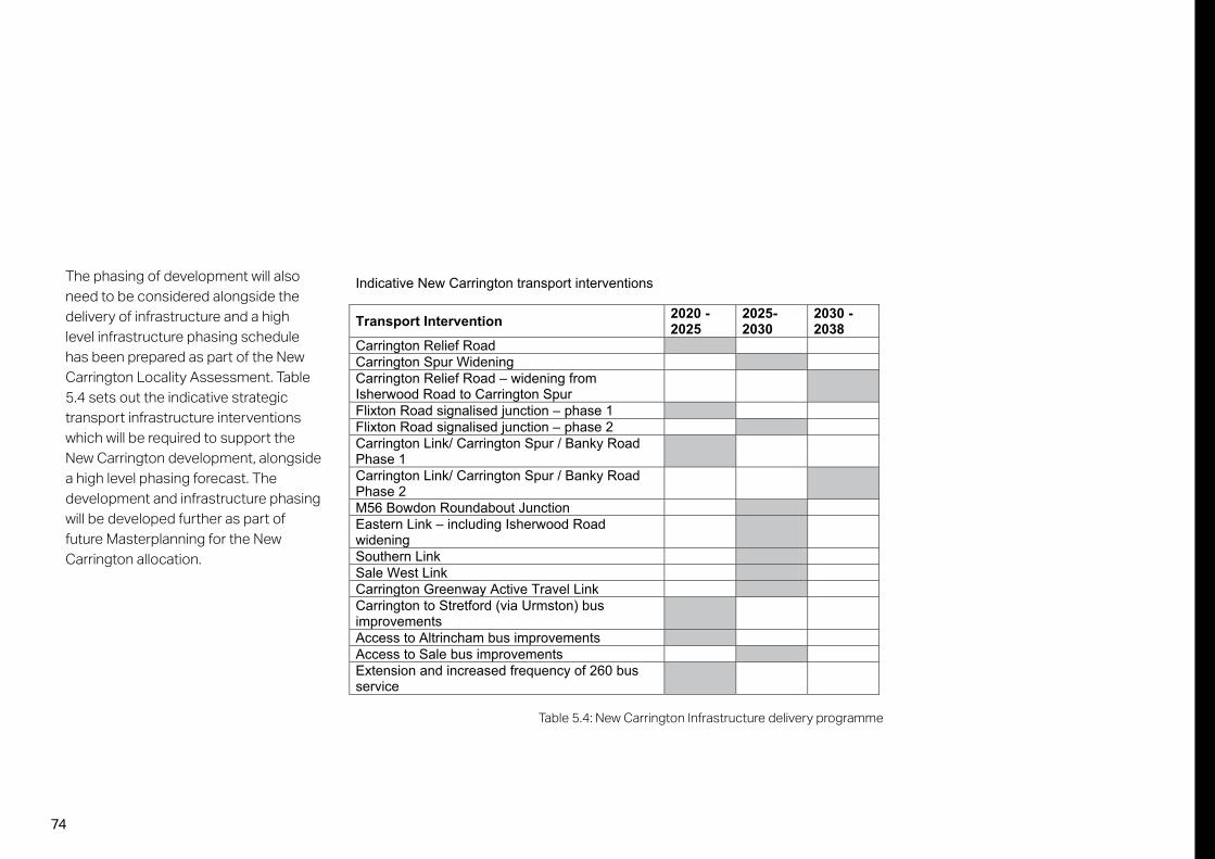
74
The phasing of development will also need to be considered alongside the delivery of infrastructure and a high level infrastructure phasing schedule has been prepared as part of the New Carrington Locality Assessment. Table 5.4 sets out the indicative strategic transport infrastructure interventions which will be required to support the New Carrington development, alongside a high level phasing forecast. The development and infrastructure phasing will be developed further as part of future Masterplanning for the New Carrington allocation.
Indicative New Carrington transport interventions
Transport Intervention 2020 - 2025
2025-2030
2030 - 2038
Carrington Relief Road Carrington Spur Widening Carrington Relief Road – widening from Isherwood Road to Carrington Spur
Flixton Road signalised junction – phase 1 Flixton Road signalised junction – phase 2 Carrington Link/ Carrington Spur / Banky Road Phase 1
Carrington Link/ Carrington Spur / Banky Road Phase 2
M56 Bowdon Roundabout Junction Eastern Link – including Isherwood Road widening
Southern Link Sale West Link Carrington Greenway Active Travel Link Carrington to Stretford (via Urmston) bus improvements
Access to Altrincham bus improvements Access to Sale bus improvements Extension and increased frequency of 260 bus service
Table 5.4: New Carrington Infrastructure delivery programme

75
6 ConclusionThe masterplan sets out a high-level framework for New Carrington that represents one of the largest single allocation sites in the GMSF. It therefore has a key role to play in delivering on the primary GMSF aims of providing the right homes in the right places and creating jobs and infrastructure that will ensure the future prosperity of Greater Manchester; and at the same time providing a key opportunity for comprehensive development in Trafford. This masterplan report demonstrates that the New Carrington Allocation site is deliverable and sustainable. It also forms part of the evidence base to support the overall ‘exceptional circumstances’ case for removing land from Green Belt.
In this context the masterplan has been prepared in parallel with a range of evidence-based studies including Transport Locality Assessments, Green Infrastructure Opportunities, Historic Environment Assessment, Green Belt and Green Belt Harm Assessments and Housing Needs Assessments. These studies have been carried out at both Greater Manchester and Trafford levels; the masterplan has been shaped and informed by the studies.
The New Carrington allocation site falls within the ownership of a number of major landowners and promoters. The majority of the major landowners were directly engaged as part of the masterplan evolution andthe landowners are supportive of the principle of the New Carrington site.
A strategic vision and associated objectives underpin the masterplan which envisages transformational change in Carrington, Sale West and South Partington. This will be achieved through a sustainable mixed-use residential and employment neighbourhood which is integrated with existing communities, and incorporates holistic investment in strategic connections and green infrastructure improvements that enhance and capitalise on existing assets.
Significant areas of the site are within the Green Belt and releasing this land for development would result in different levels of harm. The masterplan has examined the extent of the potential harm if all land was released which relates to a range of sensitivities across the New Carrington allocation site, with Sale West being particularly high. To minimise the harm, the masterplan suggests a series
of measures that will be required to strengthen the retained Green Belt. These include creating strong defensible Green Belt boundaries and providing a strategic Green Belt gap between Carrington and Sale West. This will help to ensure that development of the New Carrington allocation does not represent sprawl of built-up areas.
The masterplan illustrates the opportunity to introduce a series of residential urban extensions to Carrington, Partington and Sale West in conjunction with a critical mass of additional employment development in Carrington. It has been developed alongside a landscape strategy (incorporating enhanced Green Belt, green infrastructure, habitat areas and a network of opportunities for access to the countryside) for the whole allocation site, together with the link roads connecting the new land uses and associated facilities. In addition the masterplan incorporates a new district core for neighbourhoods in Partington, including new community services such as education, retail, commercial, health and social facilitates; new strategic permeable foot/cycle and road network; and an enhanced sustainable transport corridor providing improved connections for the existing communities of Sale and Partington.
As with any masterplan of the scale anticipated for New Carrington it will be essential for development to be phased in conjunction with infrastructure delivery; this will be considered further as part of more detailed Masterplanning, which is a requirement of the New Carrington allocation policy.
The New Carrington allocation will now go forward as part of the Regulation 19 GMSF consultation. This is proposed to commence early November 2020 for 8 weeks. The Publication Stage is a formal consultation on the joint DPD which will then be submitted to the Secretary of State for examination in public in the summer of 2021. Subject to the Examination programme adoption of the GMSF is likely to follow in 2022.

76
About AECOM AECOM is built to deliver a better world. We design, build, finance and operate critical infrastructure assets for governments, businesses and organisations. As a fully integrated firm, we connect knowledge and experience across our global network of experts to help clients solve their most complex challenges. From high-performance buildings and infrastructure, to resilient communities and environments, to stable and secure nations, our work is transformative, differentiated and vital. A Fortune 500 firm, AECOM had revenue of approximately $20.2 billion during fiscal year 2018. See how we deliver what others can only imagine at aecom.com and @AECOM.

77