Nevada Office of the Governor
49
Transcript of Nevada Office of the Governor


Nevada Office of the Governor
June 2, 2016 1
BIOLOGICAL AND MINERAL VALIDATION FOR THE NEVADA PROPOSED
ALTERNATIVE MINERAL WITHDRAWAL AREA
BACKGROUND
On September 25, 2015, Secretary of Interior Sally Jewell segregated and proposed withdrawal of more
than 2.7 million acres in BLM-designated Sagebrush Focal Areas (SFA) in Nevada from the 1872 Mining
Act. An Environmental Impact Statement (EIS) is currently being prepared by the Bureau of Land
Management (BLM) to analyze the environmental and economic effects of the SFA Mineral Withdrawal
on the entire ten million acres proposed for withdrawal west-wide.
On January 15, 2016 during the EIS public scoping period, Nevada Governor Brian Sandoval responded to
the withdrawal notice by pointing out that mineral withdrawal would not address the highest and most
severe risks to the greater sage-grouse and emphasized that no amount of mineral withdrawal was
justified or appropriate at this time. Realizing that the BLM would likely proceed with the withdrawal,
Nevada offered an alternative mineral withdrawal boundary (Nevada Alternative) that proposed to:
Exclude areas with High Mineral Potential, areas with active mineral exploration activity and
historic and known mineral resources within the SFA Mineral Withdrawal Area, and
Add areas with exceedingly better sage-grouse habitat and connectivity with documented sage-
grouse populations.
During subsequent meetings between Governor Sandoval and Secretary Jewell, Secretary Jewell
requested additional information to support Nevada’s proposed alternative. Governor Sandoval tasked
the Nevada Department of Wildlife (NDOW) and the Nevada Division of Minerals (NDOM) to work
together to gather the information and compile existing data and records, which are summarized below,
to further describe and justify the recommendations for Nevada’s proposal. The Nevada Alternative
documents the net benefit to greater sage-grouse and is supported by both NDOW and NDOM. In
addition, the Nevada Alternative protects valid existing claims and exploration activity into the
foreseeable future which is also supported by NDOW and NDOM. (Note: valid existing rights for existing
active claims in the SFA are losing capital investment. The risk of bankruptcy for small exploration
companies during the two year segregation period is based on the uncertainty of the future withdrawal.)
APPROACH
Each state agency evaluated the sage-grouse and mineral resources in both the SFA Mineral Withdrawal
Area and the Nevada Alternative Withdrawal Area. The Nevada Alternative Withdrawal Area was
delineated through a two-part process. NDOM looked at current, historic, and potential mineral resources
in the SFA Withdrawal Area to identify areas with high mineral potential and known mineral resources
and activity. NDOW looked at current data and modeled habitat values to identify areas with low
biological value for sage-grouse that do not significantly contribute to sage-grouse conservation and
searched for additional areas that the BLM could propose for withdrawal in the Mineral Withdrawal Area
that would increase conservation for the bird.

Nevada Office of the Governor
June 2, 2016 2
Assessment of Areas with High Mineral Potential
The process used to evaluate the SFA Mineral Withdrawal Area for high mineral potential was led by
NDOM in coordination with the Nevada Bureau of Mines and Geology (NBMG), a unit of the University of
Nevada, Reno. Maps of high mineral potential were constructed based on the following criteria:
1. Historic occurrences of metals, industrial minerals and gemstones from NBMG archives, which
are compiled as GIS layer files. This information is largely derived from historic NBMG and United
States Geological Survey (USGS) reports and data sets (MAS/MILS/MRDS).
2. Metallic, non-metallic and industrial mineral deposits active in the past, from NBMG archives
which are available as GIS layer files. This information is largely derived from historic NBMG and
USGS reports.
3. Plans of Operation and Notices of Intent for exploration and mining projects from the BLM LR
2000 online database.
4. Plans of Operation for exploration and mining projects from the U.S. Forest Service (USFS) NEPA
Projects website.
5. Townships with drill projects from 2004 through 2014, from NBMG annual Mineral Industry
Reports (NBMG Special Publications MI-2004 through MI-2014).
6. Active unpatented mining claims, data from BLM LR 2000 data. Assessment year 2016 data was
used to develop the maps.
7. Discussions with exploration and mining entities active in the area as well as publically available
SEDAR and EDGAR filings and company websites
Once the high mineral potential data was mapped at the township scale, NDOW map layers for acting and
pending sage-grouse leks were overlaid on the minerals map and the boundaries of the high mineral
potential areas were adjusted to avoid conflicts with lek sites, high breeding densities, and apparent
habitat connectivity.
MINERAL POTENTIAL RESULTS
These data and records were the basis for delineation of 12 areas with high mineral potential shown on
Map 1. Current and historic exploration and mining activity characteristics of each of the 12 areas with
High Mineral Potential are summarized in Table 1, and detailed in Attachment A.

Nevada Office of the Governor
June 2, 2016 3
Table 1. Summary and history of claims and exploration projects in High Mineral Potential Areas.
Areas of HighMineral
Potential
Size of AreasWith HighMineral
Potential(square miles)
Year thatoldest activeclaims were
staked
Number ofActive Claims in
Areas of HighMineral
Potential
Claim FeesPaid to BLM
to RetainActive
Claims Since1993
Number(and acres)of CurrentNotices of
Intent
Number(and acres)of Current
Plan ofOperations
Possible MineralDevelopmentnext 20 years
Notes
Burner/Scraper 4.27 2002 33 $50,492 1(3.56 acres)
0 Underground gold-silver mine
Total permitted disturbance from 25historic notices (1983-2010) wasapprox. 56 acres.
Charleston 34.16 1949 302 $424,581 0 3(3.28 acres)
Underground gold-silver mine, open-pit gold mine,barite quarry
Polymetallic district with muchhistoric production. Two advancedgold exploration projects and oneplacer gold operation.
Contact 120.26 1994 539 $503,630 0 0 Open-pit coppermine,underground gold-silver mine
240 claims were staked forgold/silver in 2014-2015.Over 280,000 feet of copperexploration drilling since 1967.
Delano 49.87 2001 152 $158,152 1(2.24 acres)
1(100 acres)
Undergroundtungsten mine,undergroundsilver/gold mine
Historic lead-silver-tungsten districtcontinuously mined 1918-1980.Known deposit of tungsten.
Jarbidge 12.66 1994 76 $103,918 0 1(3 acres)
Underground goldmine
356,000 ounces of gold and 1.67million ounces of silver producedfrom 1909-1961 from undergroundworkings.
Kings Valley 90.47 1955 1,709 $2,714,777 0 2(325 acres)
Quarry mining forlithium clays withconcurrentreclamation
325 acres permitted through plansof operation by Western Lithium(Lithium Americas).

Nevada Office of the Governor
June 2, 2016 4
Areas of HighMineral
Potential
Size of AreasWith HighMineral
Potential(square miles)
Year thatoldest activeclaims were
staked
Number ofActive Claims in
Areas of HighMineral
Potential
Claim FeesPaid to BLM
to RetainActive
Claims Since1993
Number(and acres)of CurrentNotices of
Intent
Number(and acres)of Current
Plan ofOperations
Possible MineralDevelopmentnext 20 years
Notes
Mountain City 43.88 1880 448 $683,093 0 1(100 acres)
Two small open-pitgold mines withon-site processing
Active gold mine 1988-1990produced 35,000 ounces. Twoknown gold deposits.
National 8.75 1995 105 $219,428 0 1(1.03 acres)
Underground goldmine with off-siteprocessing
Current Plan of Operations fromUSFS for 1.03 acres of disturbance
Opalite 38.06 1994 61 $58,943 0 0 Lithium clay andbentonite clayquarry
Known gallium deposit. Gallium isused in microelectronic components
Paradise Valley 2.75 2002 3 $1,041 0 0 Underground goldmine with off-siteprocessing
Historic gold and silver productiondating back to 1868.
SnakeMountains
42.62 2003 703 $544,214 1(4.65 acres)
1(193 acres)
Barite quarryexpansion; majoropen-pit gold mine
Existing 193-acre Plan of Operationfor operating barite mine extendsinto PMWA unknown amount, onemajor gold exploration project of636 claims.
White Rock 36.6 2004 155 $206,763 1(2.77 acres)
1(6.7 acres)
Small open-pit goldmine
Northern edge of emerging goldtrend, two active explorationprojects.
TOTAL 484.35 42861 $5,669,032
1 Approximate number of active (2016 assessment year) lode, placer and millsite claims as downloaded from the BLM LR 2000 data system resolved to thequarter-section level, within the proposed mineral withdrawal area.

Nevada Office of the Governor
June 2, 2016 5
FORSEEABLE FUTURE MINERAL DEVELOPMENT IN THE SFA MINERAL WITHDRAWAL AREA
In nearly all cases, mineral exploration will not or will infrequently lead to discoveries that support
development of new mines. Exploration is an iterative process that generally leads to refinement and
improved understanding of mineralogy and geology which leads to next-stage exploration.
NDOM developed the pyramid shown in Figure 1 to display the processes and activities in mineral
exploration and development from claims to actual mining on public lands. Using the same methodology,
Figure 2 was developed for the SFA Mineral Withdrawal Area which may be used to predict that the
number of mines in the foreseeable future in the SFA would be approximately one every ten years.
Figure 1. Annual number of mining claims, drilling projects, plans of operation, and new mine projects based on
the ten-year averages between 2006 and 2015 in Nevada. (Notice of Intent and Plan of Operation are defined in
Attachment A.)
Sources: BLM LR 2000 data systemUSFS NEPA Project web siteNBMG Annual Industry ReportsJohn Muntean, NBMG Stat Economic GeologistDavid Davis, NBMG State Industrial Minerals GeologistNDOM annual reports and files.

Nevada Office of the Governor
June 2, 2016 6
Figure 2. Annual number of mining claims, drilling projects, plans of operation, and new mine projects in the SFA
Mineral Withdrawal Area based on the statewide ratios from ten-year averages between 2006 and 2015 in
Nevada. (Notice of Intent and Plan of Operation are defined in Attachment A.)
Sources: BLM LR 2000 data systemUSFS NEPA Project web siteNBMG Annual Industry ReportsJohn Muntean, NBMG Stat Economic GeologistDavid Davis, NBMG State Industrial Minerals GeologistNDOM annual reports and files.

Nevada Office of the Governor
June 2, 2016 7
Assessment of Habitat and Use by Greater Sage-Grouse
NDOW identified areas that could be excluded from the SFA Withdrawal Area based on low quality habitat
and low value to sage-grouse while concurrently finding areas for expanding withdrawal boundaries to
include high value habitat that were not included in the proposed SFA Mineral Withdrawal Area. NDOW
conducted quantitative analyses of the SFA using habitat management categories developed by USGS for
Nevada that incorporate a habitat suitability index (HSI) and lek density metrics with actual spatial use to
generalize Priority Habitat Management Areas (PHMA a.k.a. ‘core’), General Habitat Management Areas
(GHMA a.k.a. ‘priority’), Other Habitat Management Areas (OHMA ) and non-habitat. Available telemetry
information, lek locations and attendance data, breeding bird density, and the Space Use Index (SUI),2
were also used to characterize the areas with low to high habitat value. NDOW specifically evaluated each
of the areas of High Mineral Potential as well as the areas they proposed for exclusion and addition using
these parameters.
The SUI is an analytical tool developed by USGS for Nevada that is not available for adjacent states. SUI
values were plotted to create a heat map of northern Nevada that illustrates current sage-grouse use of
the SFA and the Nevada Alternative Mineral Withdrawal Areas as shown in Map 4. By more accurately
reflecting habitat usage and bird distribution, the NDOW evaluation more effectively addressed the
species conservation needs and the BLM and U.S. Fish and Wildlife Service (FWS) objective to enhance
the overall level of conservation benefit for greater sage-grouse populations in Nevada.
ANALYSIS OF INDIRECT IMPACTS
Indirect impacts of excluding the High Mineral Potential Areas from mineral withdrawal were evaluated
using protocols approved for the Nevada Conservation Credit System. The indirect impact area for a ‘small
mine’ was evaluated in a 3-km buffer area around each High Mineral Potential Area. The indirect impacts
of a ‘large mine’ was evaluated in a 6-km buffer area around each High Mineral Potential Area. A very
conservative estimate of the indirect effects of a mineral exploration project would be approximated by
using the 3-km buffer area. The number of leks and the acres of PHMA and GHMA habitat were summed
up for the High Mineral Potential Areas and the 3-km and 6-km buffer areas around each of them.
2 The space use index raster (SUI) raster is relative spatial metric of male greater sage-grouse density based on location data of
breeding sites combined with a non-linear distance index metric that represents space use in relation to lek sites. The indexcombines lek location and male counts on leks averaged over the most recent 5-year period and ranges from a low value of 0.0to a high value of 1.0 (Coates, et al. 2016).

Nevada Office of the Governor
June 2, 2016 8
HABITAT ASSESSMENT RESULTS
High Mineral Potential Areas
NDOW evaluated each of the 12 High Mineral Potential Areas to ascertain their importance to sage-
grouse. A summary of lek occurrences, acres of PHMA and GHMA, and SUI is provided in Table 2. No leks
occur in eight out of the 12 areas. One lek occurs in the Opalite area; two leks occur in the Mountain City
and White Rock Areas. Within the 3-km indirect impact buffer area, there are no leks in three out of the
12 areas; and five or fewer leks in ten out of the 12 areas, and six additional leks in Oregon. Within a 6-
km indirect impact buffer area, there are fewer than five leks in nine out of 12 areas and 20 additional
leks in Oregon. The SUI was low, less than 0.15, in six out of 12 areas and moderately low, 0.16 to 0.23,
in five out of 12 areas. Kings Valley had the highest number of leks at 13, and the highest SUI of all 12
areas. SUI was 0.45 in Kings Valley which would be considered of high importance to sage-grouse.
NDOW Exclusion Areas
NDOW identified four areas in the SFA Withdrawal Area as having low habitat value for sage-grouse due
to existing fragmentation of the landscape with private land ownership, existing wildfire or ground
disturbance activity, and areas with little or no known use by sage-grouse, i.e. low SUI. The location of
these areas are shown on Map 2 and Map 4 and the habitat characteristics for these areas are summarized
in Table 3. The justification for NDOW’s recommendation for exclusion of each of these areas from the
SFA Mineral Withdrawal Area is described below.
Jarbidge Exclusion Area
The Jarbidge historic mine district is approximately 14,370 acres north of the town of Jarbidge that
includes areas of dense, high elevation spruce and fir forest. The primary reason for recommending
exclusion from the SFA Mineral Withdrawal Area was due to high fragmentation by large, private land
parcels and nearby non-habitat (e.g., rugged mountain landscapes). There are no leks located in the
Jarbidge area and only one lek found within the 6-km buffer area. The mean SUI is 0.05, or extremely low,
in the historic mine district; 0.06, extremely low, in the 3-km buffer, and 0.09, extremely low, in the 6-km
buffer area. Of the total 14,370 acres, only 1,120 acres (8 percent) are mapped as PHMA; 771 acres (5
percent) are mapped as GHMA; and 12,479 acres (87 percent) are mapped as Other Habitat and non-
habitat.
Owyhee Desert Exclusion Area
The Owyhee Desert exclusion area is 44,190 acres with no PHMA; 25,699 acres (58 percent) of non-
habitat; and 18,491 acres (42 percent) of Other Habitat. These low value habitats and an SUI of 0.05, which
is extremely low, and the fact that this area only supports six leks within a 6-km buffer (none within 3-km)
justified a recommendation to remove SFA protections in favor of mineral withdrawal additions
elsewhere.
Bilk Creek Mountains Exclusion Area
This area is on the west side of the same-named mountain range and is comprised of 13,515 acres of
Other Habitat and 568 acres of non-habitat. The steep slopes and rapid transition to salt-desert shrub

Nevada Office of the Governor
June 2, 2016 9
make this area of limited value to sage-grouse. Only one lek was found within the 6-km buffer area, and
the mean SUI is only 0.06, extremely low.
Delano Mountains Exclusion Area
The Delano Mountains is approximately 244,867 acres in northeastern Nevada with generally low
densities of sage-grouse and sage-grouse breeding with an extremely low SUI of 0.07. There is a total of 5
leks within the 3-km buffer area and 2 additional leks within the 6-km buffer. Of the 244,867 acres, 49,757
acres (20 percent) are PHMA; 86,248 acres (35 percent) is GHMA, 74,506 acres (30 percent) is Other
Habitat, and 34,356 acres (14 percent) are non-habitat. This area is also highly fragmented with private
land parcels in the eastern third.
NDOW Habitat Additions
NDOW also identified two large areas of contiguous habitat with the SFA Withdrawal Area that could be
exchanged for the 12 High Mineral Potential Areas and areas of limited value to greater sage-grouse.
These are areas of high lek density adjacent to the SFA that were analyzed using the same criteria
previously described to evaluate their value to sage-grouse. The results are summarized in Table 4. The
recommended additions to the Mineral Withdrawal Area are shown on Map 2 and Map 4 and are
described below.
Hardscrabble Addition Area
The Hardscrabble addition to the withdrawal area is northeast of Paradise Valley, Nevada, east of the
Santa Rosa Range, and west of the Little Humboldt River. It would provide additional protection for 15
active or pending leks within the 105,390 acres of PHMA habitat. The mean SUI of 0.41 is a strong
indication of the importance of this area in terms of actual sage-grouse use, and the area is contiguous
with existing designated SFA lands.
East Fork Beaver Creek Addition Area.
The East Fork Beaver Creek addition to the withdrawal area is south of and contiguous with existing SFA
lands east of the Independence Mountains and west of Mary’s River. Expanding the withdrawal area here
adds an additional 34 active and pending leks and 288,422 acres of PHMA habitat that would be given
stronger protection. This area is important in terms of bird use with a mean SUI of 0.43 for the area.
Connectivity between this area and areas to the north would be protected from mineral entry.
HABITAT CONNECTIVITY BETWEEN NEVADA AND ADJACENT STATES
Nevada Department of Wildlife compiled existing information on sage-grouse migration and connectivity
between Nevada, Oregon, Idaho, and Utah. Information obtained from radio-marked grouse indicates
connectivity across the border with each of the three states adjacent to the Nevada SFAs. The following
movement patterns and seasonal habitat usage have been documented relative to the Nevada SFA.
In Utah, research has been conducted with radio telemetry showing some evidence of collared birds using
seasonal habitats in Nevada. Over a 15 month period, (between May 2005 and August 2006) four birds
were documented crossing state lines. One male sage-grouse moved 69 km (41 miles) from southwest
Idaho, through Box Elder County, Utah and into northeastern Nevada. Two sage-grouse hens that

Nevada Office of the Governor
June 2, 2016 10
summered in Utah moved 4 km (2.4 miles) and 20 km (12 miles), respectively, to winter in eastern Nevada.
Another male followed the same path, but continued into winter habitats in eastern Nevada, a distance
of 44 km (26 miles) (Reinhart et al. 2013). A recent study by Utah State University (Dahlgren et al. 2016)
was published on research that was conducted between 1998 and 2013 at intervals along 185 miles of
the Nevada-Utah state line between Box Elder County and Iron County to the south near St. George, Utah.
The majority of this study area is well outside the SFA, but they documented some movement by Utah
birds using seasonal habitats in Nevada.
The Lone Willow Population Management Unit (PMU), which includes Kings Valley, the Montana
Mountains, Bilk Creek Mountains and Double H Mountains, is one of the most densely populated sage-
grouse PMUs in Nevada, particularly the Montana Mountains portions of the PMU. Even though the Lone
Willow PMU, a Nevada-specific management boundary, terminates on the Nevada-Oregon border, the
sage-grouse population is well connected with habitats in Oregon, particularly in the Trout Creek
Mountains. Along the Nevada-Oregon border in the Montana Mountain-Trout Creek complex, movement
of birds from Nevada to Oregon was observed during a 2001-2005 study to document the effects of
harvest. Movement of birds from Oregon to Nevada was also documented following the 2012 Holloway
Fire, further demonstrating connectivity between the states. The Montana Mountain-Trout Creek
complex is considered one of the most densely populated sage-grouse habitats and is of extreme
importance to both states, portions of which are within the upper 25 percent breeding density category
on the national ranking scale (Doherty et al. 2010).

Nevada Office of the Governor
June 2, 2016 11
Table 2. Sage-grouse habitat and lek characteristics in the High Mineral Potential Areas.
Area(acres)
Number of Active andPending Leks
Mean Space UseIndex(0-1)
PHMA(acres)
GHMA(acres)
High MineralPotential AreaName
MineralArea
3-kmBuffer
6-kmBuffer
MineralArea
3-kmBuffer
6-kmBuffer
MineralArea
3-kmBuffer
6-kmBuffer
MineralArea
3-kmBuffer
6-kmBuffer
MineralArea
3-kmBuffer
6-kmBuffer
Burner/Scraper2,734 4,132 4,456 0 0 0 0.08 0.07 0.07 793 793 793 1,808 3,205 3,529
Charleston21,959 56,527 87,642 0 3 3 0.11 0.16 0.22 11,526 37,269 67,811 4,421 9,332 9,757
Contact76,973 164,477 262,604 0 9 17 0.16 0.20 0.23 37,951 92,760 172,146 26,036 42,572 48,091
Delano31,921 79,194 130,361 0 2 3 0.07 0.09 0.09 7,251 23,583 46,686 10,261 20,764 29,407
Jarbidge8,154 13,003 23,557 0 0 1 0.06 0.07 0.10 1,120 2,773 8,155 770 1,610 3,672
Kings Valley NVKings Valley OR 57,875
123,1053,871
181,49215,346
NV 13 NV 34OR 5
NV 47OR 14 0.45 0.45 0.41 57,875 122,936 174,933 - 169 3,030
Mountain City28,138 66,714 94,418 2 5 5 0.19 0.21 0.22 24,613 57,636 84,057 2,811 7,390 7,544
National5,607 16,876 36,052 0 0 2 0.16 0.21 0.27 1,222 8,324 22,623 4,384 8,552 13,429
Opalite NVOpalite OR 24,359
50,5585,527
87,36118,522
NV 1 NV 5OR 1
NV 7OR 6
0.20 0.24 0.2522,395 44,566 70,245 774 2,562 5,495
Paradise Valley1,765 9,707 23,106 0 1 2 0.33 0.38 0.36 1,765 8,597 18,581 - 1,110 4,375
SnakeMountains 27,279 55,066 89,905 0 2 5 0.23 0.28 0.31 27,279 55,060 89,898 - - -
White Rock NVWhite Rock UT 23,732
53,0416,691
86,61613,254
NV 2 NV 3UT (?)
NV 4UT (?) 0.11 0.10 0.09 10,891 21,450 30,312 12,828 29,825 47,815
TOTAL 310,496 692,400 1,107,570 204,681 475,747 786,240 64,093 127,091 176,144

Nevada Office of the Governor
June 2, 2016 12
Table 3. Sage-grouse habitat and lek characteristics in Nevada Department of Wildlife proposed exclusion areas from the SFA Mineral
Withdrawal Area
Table 4. Sage-grouse habitat and lek characteristics in Nevada Department of Wildlife proposed addition areas to the Mineral Withdrawal
Area.
Area Name
Area(acres)
Number ofActive and
Pending LeksMean Space Use Index
(0-1)PHMA(acres)
GHMA(acres)
Hardscrabble 105,390 15 0.41 105,390 0
East Fork Beaver Creek 288,422 34 0.43 288,422 0
TOTAL 393,812 49 393,812 0
Area (acres) Number of Active andPending Leks
Mean Space Use Index(0-1)
PHMA (acres) GHMA (acres)
High MineralPotential AreaName
MineralArea
3-kmBuffer
6-kmBuffer
MineralArea
3-kmBuffer
6-kmBuffer
MineralArea
3-kmBuffer
6-kmBuffer
MineralArea
3-kmBuffer
6-kmBuffer
MineralArea
3-kmBuffer
6-kmBuffer
Jarbidge14,370 20,044 35,689 0 0 1 0.05 0.06 0.09 1,120 2,885 114,480 0 771 4,532
OwyheeDesert 44,190 99,999 162,407 0 0 6 0.05 0.09 0.13 0 37,662 195,212 0 0 12,853
Bilk CreekMountains 14,620 38,571 63,609 0 0 1 0.06 0.10 0.15 0 23,322 123,718 0 537 691
DelanoMountains 244,867 318,379 394,527 5 5 7 0.07 0.07 0.09 49,757 84,429 505,247 0 86,248 119,097
TOTAL 318,047 476,993 656,232 51,877 148298 938,657 0 87,556 137,173
Nevada Office of the Governor
June 2, 2016 13
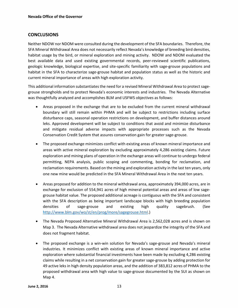
CONCLUSIONS
Neither NDOW nor NDOM were consulted during the development of the SFA boundaries. Therefore, the
SFA Mineral Withdrawal Area does not necessarily reflect Nevada’s knowledge of breeding bird densities,
habitat usage by the bird, or mineral exploration and mining activity. NDOW and NDOM evaluated the
best available data and used existing governmental records, peer-reviewed scientific publications,
geologic knowledge, biological expertise, and site-specific familiarity with sage-grouse populations and
habitat in the SFA to characterize sage-grouse habitat and population status as well as the historic and
current mineral importance of areas with high exploration activity.
This additional information substantiates the need for a revised Mineral Withdrawal Area to protect sage-
grouse strongholds and to protect Nevada’s economic interests and industries. The Nevada Alternative
was thoughtfully analyzed and accomplishes BLM and USFWS objectives as follows:
Areas proposed in the exchange that are to be excluded from the current mineral withdrawal
boundary will still remain within PHMA and will be subject to restrictions including surface
disturbance caps, seasonal operation restrictions on development, and buffer distances around
leks. Approved development will be subject to conditions that avoid and minimize disturbance
and mitigate residual adverse impacts with appropriate processes such as the Nevada
Conservation Credit System that assures conservation gain for greater sage-grouse.
The proposed exchange minimizes conflict with existing areas of known mineral importance and
areas with active mineral exploration by excluding approximately 4,286 existing claims. Future
exploration and mining plans of operation in the exchange areas will continue to undergo federal
permitting, NEPA analysis, public scoping and commenting, bonding for reclamation, and
reclamation requirements. Based on the mining and exploration activity in the last ten years, only
one new mine would be predicted in the SFA Mineral Withdrawal Area in the next ten years.
Areas proposed for addition to the mineral withdrawal area, approximately 394,000 acres, are in
exchange for exclusion of 554,941 acres of high mineral potential areas and areas of low sage-
grouse habitat value. The proposed additional acreage is contiguous with the SFA and consistent
with the SFA description as being important landscape blocks with high breeding population
densities of sage-grouse and existing high quality sagebrush. (See
http://www.blm.gov/wo/st/en/prog/more/sagegrouse.html.)
The Nevada Proposed Alternative Mineral Withdrawal Area is 2,562,028 acres and is shown on
Map 3. The Nevada Alternative withdrawal area does not jeopardize the integrity of the SFA and
does not fragment habitat.
The proposed exchange is a win-win solution for Nevada’s sage-grouse and Nevada’s mineral
industries. It minimizes conflict with existing areas of known mineral importance and active
exploration where substantial financial investments have been made by excluding 4,286 existing
claims while resulting in a net conservation gain for greater sage-grouse by adding protection for
49 active leks in high density population areas, and the addition of 383,812 acres of PHMA to the
proposed withdrawal area with high value to sage-grouse documented by the SUI as shown on
Map 4.

Nevada Office of the Governor
June 2, 2016 14
ATTACHMENT A
CURRENT AND HISTORIC MINERAL POTENTIAL
IN THE PROPOSED SFA MINERAL WITHDRAWAL AREA
Terminology
Notice of Intent - Submission by an operator to the BLM proposing exploration
activities having no more than 5.0 acres of cumulative surface disturbance. This
includes access roads, drill pads, and sumps. The operator must post a satisfactory
bond to cover the cost of reclamation required in the approved notice of intent.
Plan of Operations - Submission by an operator to the USFS proposing any level of exploration or mining
activity regardless of amount of proposed surface disturbance. This includes access roads, drill pads, and
sumps. The operator must post a satisfactory bond to cover the cost of reclamation required in the
approved Plan of Operation for surface disturbance.
Plan of Operations, BLM Administered Lands – Submission by an operator to the BLM proposing more
than 5.0 acres of exploration or mining activity. The operator must post a satisfactory bond to cover the
cost of reclamation required in the approved Plan of Operation.
Mineral Enrichment – Description of various mineral commodities found in a given area with some
generalization regarding their level of extraction.
Producer – locations with documented mine production for given mineral commodity.
Prospect – locations with documented exploration involving excavation or drilling for a given
mineral commodity usually with reported concentration amounts (i.e. grade).
Occurrence – locations with documented presence of a given mineral commodity, usually having
concentrations above normal background as determined from geochemical analysis (i.e. assays).
Historic Exploration and Production – A summary of historical accountings by commodity.
Typical units of measurement for precious metals (e.g. gold, silver) are in (troy) ounces, while base
metals (e.g. copper, lead, tungsten) are in pounds.
Concentration values are expressed as ounces (of precious metal) per ton of unprocessed mined
or mineralized material or as a percentage (of the commodity) within the unprocessed mined or
mineralized material.
It is extremely common for an area with some level of enrichment to experience multiple episodes
of claim staking followed by exploration, usually coinciding with increases in commodity prices.
The degree of exploration (and cost) increases as projects move from surface mapping to
geochemical sampling to initial drilling to geophysical surveys to extensive drilling to modeling
for mine feasibility.

Nevada Office of the Governor
June 2, 2016 15
Current Active Claims within SFA – An approximate accounting for each Mineral Potential Area of the
current (BLM Assessment Year 2016) active claims within the proposed mineral withdrawal area resolved
to the quarter section as obtained from the Bureau of Land Management’s Land and Mineral Legacy
Rehost 2000 System (http://www.blm.gov/lr2000/).
The BLM LR2000 System includes information regarding claims on lands managed by both BLM
and USFS.
The amount of assessment fees paid to the BLM approximates the total amount claimants have
paid in location and annual assessment fees since 1993, when the fee was introduced, in order to
retain the claim from the year of location through the 2016 assessment year.
No Small Miner Exemptions (of the annual assessment fee) are assumed.
Current Exploration and Production – A summary of known current activity by commodity by current
active claimants.
Information sourced from publically available company technical reports, websites and regulatory
filings (SEDAR - http://www.sedar.com/ and EDGAR - http://www.sec.gov/edgar.shtml)

Nevada Office of the Governor
June 2, 2016 16
Burner/Scraper Springs Area
This Area consists of about 4.3 square miles within the proposed mineral withdrawal area and is located
50 miles north-northeast of the town of Battle Mountain, Nevada. The Burner/Scraper Springs Area
includes portions of the historic Burner and Scraper Springs Mining Districts. The Burner District has silver,
lead, zinc, and arsenic commodities documented as present (NBMG Report 47). The Scraper Springs
District has zunyite, barite, and silver commodities documented as present (NBMG Report47). The
Burner/Scraper Springs Area sits geographically along the northern extension of the prolific Carlin Gold
Trend. Recent exploration in this district has focused on the potential for an underground gold-silver
deposit, however, it has also been suggested that geochemical and alteration zoning patterns
documented are similar to those found at the Mount Hope molybdenum deposit in Eureka County,
Nevada (Cantor, 2012).
1. Mineral Enrichment - (Source – US Geological Survey MAS/MILS/MRDS datasets, Nevada Bureauof Mines and Geology Report 47, Cantor 2012)
a. Gold-Silver – 2 prospects
b. Aluminum – 1 occurrence
2. Historic Exploration and Production - (Source - NBMG Report 47; Lincoln, 1982; Cantor, 2012)
a. Gold-Silver
i. The Burner District was discovered in 1883 where production of silver-lead ore
from the Mint Mine (located 1.3 miles north of the Burner Area) totaled
approximately $30,000 in revenue until 1893 when operations were shut down.
ii. US Steel first explored the Scraper Springs Area for gold and silver in 1983.
iii. In 1984, Freeport drilled 10 holes, for a cumulative 4,000 feet in which they
intercepted elevated gold and silver values.
iv. In 1987, Hecla drilled 7 holes, for a cumulative 2,145 feet in which they
intercepted elevated gold and silver values.
v. From 1989-1991,Cordex conducted extensive exploration including geologic
mapping, rock and soil sampling, geophysical surveys, and drilled 40 holes for a
cumulative 21,475 feet.
vi. From 1994-1997, Western States Minerals completed geologic mapping, rock and
soil sampling, and drilled 13 holes for a cumulative 8,535 feet. Two drill holes
intercepted significant mineralization SS-1 (140 feet of 0.017 ounce per ton gold)
and SS-6 (25 feet of 0.020 ounce per ton gold).
vii. In 2003, Cordex performed additional mapping, extensive soil sampling, and
geophysical surveys and drilled 12 holes for a cumulative 8,380 feet.
viii. In 2008, Newmont and Cordex under a joint venture agreement remapped the
geology and alteration, conducted soil sampling, and drilled 3 holes.
b. Aluminum
i. A widespread occurrence of aluminum (in the form of zunyite) was first
discovered in the Scraper Springs Area in 1979 and was documented in USGS

Nevada Office of the Governor
June 2, 2016 17
Open-File Report 79-764. The vein of zunyite is approximately 1,200 feet long
and 10-60 feet wide.
c. Total permitted disturbance from 24 historic notices (1983-2010) was approximately 57
acres. Reclamation completed and all historic notices were closed by the BLM.
3. Current active claims within SFA (Source - BLM LR2000)
a. Approximately 33 active claims (all lode claims)
b. Three unique claimants – in descending order of claims, Altan Rio (US) Inc. (16), Genesis
Gold Corp. (16), and Gregory Kuzma (1).
c. Claimants have paid a total of approximately $50,492 to BLM in assessment fees to hold
these active claims (oldest active claims were staked in 2002).
4. Current Exploration and Production
a. Gold-Silver (Source – Altan Nevada Minerals’ website)
i. Current exploration in the Area is being done by Altan Nevada Minerals Limited.
Altan Nevada’s North Star project is located mostly in the southern half of the
Burner/Scraper springs area closest to the Scraper Springs historic mining district.
Altan Nevada compiled geophysical and geochemical data in order to target the
2014 drilling project which included one hole drilled to a depth of 1,833 feet by
then joint-venture partner Teck, a large diversified global mining company. The
hole encountered what was interpreted to be rocks similar to those which host
ore deposits on the Carlin Trend.
ii. The only current active notice in the Area is for Altan’s Burner Hills project and is
permitted for 3.56 acres of disturbance.

Nevada Office of the Governor
June 2, 2016 18
Charleston Area
The Charleston Area consists of two discontiguous areas in northern Elko County: 1) a small approximately
6 square mile region, within the proposed mineral withdrawal area, of primarily USFS-managed lands
which lies 15 miles south-southwest of Jarbidge along the Bruneau River in the historic Charleston Mining
District, and 2) approximately 28 square miles, within the proposed mineral withdrawal area, of primarily
USFS-managed lands northeast of Wild Horse Reservoir in the historic Island Mountain Mining District.
Current activity in the Charleston Area includes several small intermittent placer operations and two
advanced gold exploration projects.
1. Mineral Enrichment - (Source - US Geological Survey MAS/MILS/MRDS datasets, Nevada StateMine Inspector Annual Directory, Nevada Bureau of Mines and Geology Bulletin 106)
a. Gold – 32 past producers
b. Silver – 26 past producers
c. Copper – 19 past producers
d. Lead – 12 past producers
e. Antimony and Zinc – 8 past producers (each)
f. Barite and Tungsten – 2 past producers (each)
g. Molybdenum – 1 past producer
h. Uranium – 2 occurrences
2. Historic Exploration and Production - (Source – Nevada Bureau of Mines and Geology Bulletin
106)
a. Gold – Placer gold first discovered in the 1870s, with approximately 40,000 ounces
produced through 1901. 3,397 ounces of recorded production from 1908-1983.
i. The Prunty property, located in the eastern portion of the Charleston Area, was
drilled by Remington Gold in 1984 and Tenneco Minerals in 1986, for a cumulative
amount of 6,217 feet. (Source – Humboldt Mining website presentation)
ii. The Island Mountain property, located in the northwest portion of the Charleston
Area, has had significant drilling, having been drilled by Cordex in 1982, and in the
1990s by Western States Minerals, Kennecott, Aur Resources, and BHP. In 1998,
Gateway Gold purchased the property from BHP and added claims followed by
drilling campaigns in 2003 and 2004. In 2009, Golden Predator then drilled more
than 10,000 cumulative feet on 4 targets. (Source NBMG Mineral Industry
Reports)
b. Silver – Minor production, as by-product from 1912-1983 - ~124,000 ounces.
c. Copper – Minor production, largely as by-product from 1903-1983 - ~18,000 pounds.
d. Lead – Majority of production from two mines, 1954-1985 – ~24,000 pounds.
e. Antimony – Majority of production from two mines, 1907-1969 - ~55,000 pounds.
f. Barite – A small amount of barite was produced from two mines in the 1980s.
g. Because the Charleston Area is within lands managed by the USFS, a definitive listing of
Plans of Operation is not readily available online.

Nevada Office of the Governor
June 2, 2016 19
3. Current active claims within SFA (Source - BLM LR2000)
a. Approximately 302 active claims (299 lode claims, 3 placer claims)
b. 16 unique claimants – in descending order of claims, Robert Robison (109), Arnevut
Resources/Tuvera Exploration (78), Corus Acquisition Corp. (32), Rancho Grande Inc. (20
lode, 1 placer), North Exploration LLC (8), 4 claimants with 7 claims each, 7 claimants with
6 or fewer claims each.
c. Claimants have paid a total of $424,581 to BLM in assessment fees to hold these active
claims (oldest active claims were staked in 1949).
4. Current Exploration and Production
a. Gold/Silver
i. Robert Robison has 109 active claims at the Charleston/Prunty project. In 2010,
under a lease agreement Humboldt Mining Co. drilled 5 exploration holes with a
high-grade intercept of 0.205 ounces per ton gold over 22.6 feet. In 2011, they
conducted a geophysical survey of the project area and identified additional
drilling targets. (Sources – Humboldt Mining website)
ii. Following approval from the USFS in 2012, Arnevut Resources drilled 32
exploration holes in 2012 and 2013, bringing the total drilled to date to 348 holes
for a cumulative total of nearly 200,000 feet. Tuvera Exploration (the successor
to Arnevut Resources) has a 2016 National Instrument 43-101 report indicating a
gold resource of 32,200 ounces of gold indicated and 385,000 ounces of gold
inferred, at an average grade of 0.018 and 0.015 ounces per ton, respectively.
(Source – 2016 NI 43-101 draft report obtained from Tuvera Exploration upon
request)
iii. There are 3 Plans of Operation approved for gold exploration by USFS within the
Charleston Area, all approved in 2012; 2 lode, 1 placer. The amount of permitted
disturbance could not be ascertained but is estimated from the descriptions of
work plans to be approximately 3.28 acres. (Source – USFS website)
b. Barite
i. National Oilwell Varco has active 7 claims originally staked in 2005 at their 76
Creek project located immediately south of the Prunty gold project; exploration
activity is unknown.

Nevada Office of the Governor
June 2, 2016 20
Contact
The Contact Area consists of approximately 120 square miles, within the proposed mineral withdrawal
area, and lies along Highway 93 in Elko County. Current activity in the Contact Area includes a large, well-
defined copper deposit and significant recent claim staking in pursuit of gold and silver.
1. Mineral Enrichment - (Source - US Geological Survey MAS/MILS/MRDS datasets, Nevada StateMine Inspector Annual Directory, Nevada Bureau of Mines and Geology Bulletin 106)
a. Copper – 79 past producers
b. Silver – 68 past producers
c. Gold – 54 past producers
d. Lead – 22 past producers
e. Molybdenum – 14 past producers
f. Zinc – 5 past producers
g. Tungsten – 1 past producer
h. Uranium – 2 occurrences
2. Historic Exploration and Production - (Source – Nevada Bureau of Mines and Geology Bulletin
106 and Nevada Bureau of Mines and Geology Mineral Industry Reports)
a. Copper – Several copper mines developed in the late 1870s, with recorded production
from 1908 to 1965 of approximately 5.7 million pounds of copper.
i. In the early 1970s, Coralta Mines drilled extensively and identified 8 million tons
of mineralized material containing an average of 2.3% copper.
ii. In 2007 and 2008, International Enexco Ltd. drilled 133 holes on their Contact
project resulting in a resource of 33.6 million tons averaging 0.293% copper. By
2010, the resource was increased to 54 million tons averaging 0.293% copper.
iii. International Enexco added to their property position in 2011 and by the end of
2012 had drilled 82 additional holes. An updated National Instrument 43-101
report in 2013 indicated a significantly increased resource of 141 million tons of
mineralized material averaging 0.22% copper.
iv. In 2014, the Contact project was acquired by a new company subsequently
named CopperBank Resources.
v. From 2000 through 2015, within the SFA there have been 3 notice-level projects
by 2 operators, totaling 10.1 acres of permitted disturbance.
b. Silver – Minor production as by-product from 1908-1965 - ~127,000 ounces.
i. Exploration drilling in 1972 intercepted 25’ of 22.3 ounce per ton silver.
c. Gold – Minor production as by-product from 1908-1965 – 1,222 ounces. Exploration
consisting of mapping, geochemical sampling and drilling renewed in the 1980s and is
ongoing, as evidenced by the large claim block staked by Newmont in 2014 and 2015.
d. Lead – Recorded production from 1916-1965 – 360,000 pounds.
e. From 1985 through 2013, within the SFA, there have been 11 notice-level and 1 plan-level
exploration projects by 11 operators, totaling 41.6 acres of permitted disturbance.

Nevada Office of the Governor
June 2, 2016 21
3. Current active claims within SFA (Source - BLM LR2000)
a. Approximately 539 active claims (531 lode claims, 8 placer claims)
b. 13 unique claimants – in descending order of claims, Newmont (242), Enexco
International , now CopperBank Resources Corp. (224), Resurrection Canyon (44), 4
claimants with 4 claims each, 5 claimants with 1 claim each.
c. Enexco International Inc. first staked claims in 2005 and has added claims through 2013.
d. Claimants have paid a total of $503,630 to BLM in assessment fees to hold these claims
(oldest active claim was staked in 1994).
4. Current Exploration and Production
a. Gold/Silver
i. More than 240 claims staked by Newmont in 2014 and 2015 at the Knoll
Mountain project.
ii. Approximately 2 square miles of active association placer claims, staked in 2008.
b. Copper
i. CopperBank Resources’ Contact Copper project is a mix of public and private land
(consisting of 156 mining patents), and has a 2013 report indicating 141 million
tons of mineralized material averaging 0.22% copper. (Source – NBMG Mineral
Industry Report 2013, pg. 23)
ii. Over 280,000 feet of exploration drilling has occurred on the property since 1967.
iii. CopperBank is awaiting a rebound of copper prices above $2.90/pound for their
Contact deposit and looking to joint-venture two nearby prospects. (Source –
Enexco 43-101 report and CopperBank website)

Nevada Office of the Governor
June 2, 2016 22
Delano
The Delano Area consists of approximately 50 square miles within the proposed mineral withdrawal area
in northeastern Elko County. Current activity includes permitted exploration projects for gold/silver and
tungsten.
1. Mineral Enrichment - (Source - US Geological Survey MAS/MILS/MRDS datasets, Nevada StateMine Inspector Annual Directory, Nevada Bureau of Mines and Geology Bulletin 106)
a. Silver and Lead – 13 past producers (each)
b. Gold – 11 past producers
c. Copper – 10 past producers
d. Zinc – 4 past producers
e. Tin – 1 past producer, 7 prospects
f. Antimony, Fluorite, Molybdenum, Tungsten– 1 past producer (each)
2. Historic Exploration and Production - (Source – Nevada Bureau of Mines and Geology Bulletin
106)
a. Two main ore types: lead-silver replacement bodies and silver-copper-tungsten bearing
quartz veins. With 6 mine regions, the historic Delano Mining District saw nearly
continuous production from 1918 through 1980.
b. Significant claim staking, mapping, sampling, and drilling by Noranda Exploration Inc. in
the 1980s with a 1990 internal report of 240,000 tons of mineralized material averaging
6.43 ounces per ton silver, 5.6% lead, and 3.8% zinc.
c. Silver – First discovered in 1872; production from 1918-1970 - 1.5M ounces.
d. Lead – Production from 1918-1970 – 22.1M pounds
e. Gold – Minor production as by-product from 1918-1970 – 333 ounces. Exploration
consisting of mapping, geochemical sampling and drilling renewed in the 1980s and is
ongoing. From 1982 through 2015, within the SFA, there have been 8 notice-level and 1
plan-level exploration projects by 6 operators, totaling 21 acres of permitted disturbance.
f. Copper – Production from 1918-1970 – 167,639 pounds
g. Zinc – Production 1918 and 1942-1970 – 1.39 million pounds
h. Tungsten – First explored for in 1969 by Arizona Land and Cattle Co., resulted in Indian
Springs deposit reported to contain 17.4 million tons of mineralized material averaging
0.19% tungsten trioxide. A 1970 reference in the 1985 US Bureau of Mines Information
Circular 9035 reports 13.9 million tons averaging 0.27% tungsten trioxide.
i. Indian Springs project most recently controlled by Utah International (BHP
Minerals) with minor mining in the 1980s; their ore reserve estimate was 30.8
million tons averaging 0.17% tungsten trioxide.
ii. In 2006 and 2007, Galway Resources drilled 38 holes and performed metallurgical
testing. Incorporating BHP’s drill results, Galway provided an indicated resource
estimate, using a total of 299 drill holes, of more than 37 million pounds of
tungsten, valued in 2007 as worth $481 million.

Nevada Office of the Governor
June 2, 2016 23
iii. From 1985 through 2015 there have been 2 notice-level and 1 plan-level
exploration projects by 2 operators, totaling over 100 acres of permitted
disturbance.
3. Current active claims within SFA (Source - BLM LR2000)
a. Approximately 152 active claims (all lode claims)
b. 4 unique claimants – in descending order of claims, Western Pacific Resources (120),
Montana Gold Subsidiary (16), Geological Services Inc. (15), and Kirk Baker (1).
c. Western Pacific staked 20 claims in 2009 and added 100 to claim block in 2011.
d. Claimants have paid a total of $158,152 to BLM in assessment fees to hold these claims
(oldest active claim was staked in 2001).
4. Current Exploration and Production
a. Silver/Gold
i. Surface sampling has occurred at Western Pacific Resources’ Rock Springs
silver/gold project; currently seeking a joint-venture partner. (Source Western
Pacific Resources’ website)
ii. Montana Gold Mining Company Inc. completed Phase 1 of an exploration
program at their Golden Trail project under authorized notice (NVN-82700), with
plans for a modest Phase 2 as described in their technical report. (Source –
Montana Gold Mining website)
b. Tungsten
i. Galway Resources (US) Inc./Grant Gerber have an authorized Plan of Operations
(NVN-83013) with 100 acres of permitted disturbance.

Nevada Office of the Governor
June 2, 2016 24
Jarbidge
The Jarbidge Area consists of about 13 square miles within the proposed mineral withdrawal area and is
located near the town of Jarbidge, located about 75 miles north-northeast of Elko, and represents the
northern quarter of the historic Jarbidge Mining District. Current activity in the Jarbidge Area includes
one permitted gold exploration project.
1. Mineral Enrichment - (Source - US Geological Survey MAS/MILS/MRDS datasets, Nevada StateMine Inspector Annual Directory, Nevada Bureau of Mines and Geology Bulletin 106, USGSBulletins 497 and 741)
a. Gold – 17 past producers
b. Silver – 14 past producers
c. Barite, Copper, Lead, Selenium, Tungsten – 1 past producer each
2. Historic Exploration and Production - (Source - Nevada Bureau of Mines and Geology Bulletin
106, US Geological Survey Bulletins 497 and 741)
a. Gold and silver – Gold was discovered in 1909, with approximately 356,000 ounces of gold
and 1.67 million ounces of silver in recorded production from 1909-1961, all from
underground workings.
i. By 1923, there were nearly 800 claims in the district and workings had extended
to depths of about 900 feet.
ii. From 1980-1982, Freeport McMoran explored for a disseminated (open-pit) gold
deposit and drilled 6 holes. Subsequent to Freeport, Moly Corp drilled an
additional 13 holes.
3. Current active claims within SFA (Source - BLM LR2000)
a. Approximately 76 active claims (all lode claims)
b. Three unique claimants – in descending order of claims, John D. Bernt (67), Esther A. Boyle
(6), and Harvey Bellm (3).
c. Claimants have paid approximately $103,918 to BLM in assessment fees to hold these
active claims (oldest active claims were staked in 1994).
4. Current Exploration and Production
a. Gold/Silver
i. As part of an exploration program evaluating a high-grade underground vein
target similar to that at the underground Midas mine, Atna Resources drilled 24
holes in 2007 on John Bernt’s claims and private property. (Source Atna
Resources website)
ii. John Bernt leased his claims to Quantum Minerals LLC who then submitted a
proposal to the USFS to drill 40 exploration drill holes on June 24, 2014 and
received approval on August 20, 2015. Total permitted disturbance is 3 acres.
(Source USFS NEPA website)

Nevada Office of the Governor
June 2, 2016 25
iii. Approximately 30 of the proposed drill holes are located within the proposed
mineral withdrawal area. (Source – correspondence from Quantum to the
Nevada Sagebrush Ecosystem Council, made public at the June 12, 2015 meeting.)

Nevada Office of the Governor
June 2, 2016 26
Kings Valley
The Kings Valley Area consists of about 90 square miles within the proposed mineral withdrawal area
located in the Montana Mountains about 20 miles west northwest of the town of Orovada, Nevada. The
Kings Valley Area contains a large portion of the historic Disaster Mining District and is situated within the
extensive 500 square-mile McDermitt Volcanic Caldera Complex. Current activity consists of a surface
quarry for specialty clay (hectorite) and final regulatory approval for the largest near surface lithium
deposit in the United States.
1. Mineral Enrichment - (Source - US Geological Survey MAS/MILS/MRDS datasets)a. Gold and Silver – 2 past producers
b. Uranium – 1 past producer, 7 prospects, 6 occurrences
c. Lithium – 2 past producers
d. Mercury – 2 past producers and 3 occurrences
e. Specialty Clays – 1 current producers, 1 past producer, 2 prospects
f. Arsenic, Barite, Manganese, Molybdenum, and Zeolites – 1 past producer (each)
2. Historic Exploration and Production - (Source – Nevada Bureau of Mines and Geology Report 47
and Open File Report 85-3, US Geological Survey Report 874-A, Noble et al., Economic Geology
Volume 83, 1988)
a. Gold/Silver - Gold production from placer workings documented as early as the 1870s.
There has been intermittent gold-silver exploration in the Kings Valley area, with an
increase during the 1980s to early 1990s.
b. Uranium - Uranium was first discovered in the area in 1952 followed by a preliminary
examination on parts of the area in June of 1954 for the Defense Minerals Exploration
Administration to evaluate the uranium occurrences by the United States Geological
Survey.
i. In 1954, Platora Uranium Corporation sank an inclined shaft to a depth of 200
feet and shipments of ore were taken from the workings. It wasn’t until the 1970s
that this district started to receive significant attention for uranium exploration.
ii. In 1975-1991 Chevron USA explored the Kings Valley area for uranium in the
sediments of the McDermitt Caldera. In 1978, Chevron also began exploring for
lithium enrichments.
c. Lithium - Following research and results published in US Geological Survey Report 78-926
indicating high lithium concentrations occurring within the tuffaceous moat-filling
sedimentary rocks of the caldera complex, Chevron drilled over 223 holes resulting in a
resource estimate in 1985 of 2.3 million tons averaging 0.33% lithium.
d. Mercury - There have been a number of mercury deposits and occurrences documented
on or near ring fracture zones of the large McDermitt Caldera Complex, the most
significant of which is the Cordero mine to the northeast in the nearby Opalite district.
e. Historically there has been 151 acres permitted for disturbance in the Kings Valley area.

Nevada Office of the Governor
June 2, 2016 27
3. Current active claims within SFA (Source - BLM LR2000)
a. Approximately 1,709 active claims (1,677 lode claims & 32 placer claims)
b. Nine unique claimants – in descending order of claims, K V Project LLC (931 lode), Lithium
Nevada Corp (600 lode), American Colloid Co. (77 lode, 32 placer), True Brit Nevada LLC
(26 lode), James V. Lebret (12 lode), Locke Jacobs (10 lode), Grace E. Lebret (9 lode),
Platero West Inc. (7 lode), and 5555 Gold Inc. (5 placer).
c. Claimants have paid approximately $2,714,777 to BLM in assessment fees to hold these
active claims (oldest active claims were staked in 1955).
4. Current Exploration and Production
a. Lithium – (Source – Western Lithium’s 2008 and 2014 National Instrument 43-101
Reports, Nevada Bureau of Mines and Geology Major Mines of Nevada 2014)
i. In 2005 Western Energy Development Corporation leased claims in the area and
staked more claims to cover the prospective area for lithium. Western Energy
Development Corporation then leased the claims to Western Lithium Corporation
in 2007.
ii. From 2007-2008, Western Lithium drilled 45 holes for a cumulative 21,852 feet,
resulting in the identification of five regions of significant lithium mineralization
and an indicated resource in just one region of 53 million tons of mineralized
material averaging 0.27% lithium.
iii. Subsequent additional drilling resulted in an updated resource for the Stage 1
Lens of 237 million tons averaging 0.29% lithium, for a total of 3.7 million tons of
contained lithium carbonate equivalent. For reference, the only current lithium
producer in the US, Albemarle’s Rockwood Lithium mine in Nevada, produced
less than 5,000 tons of lithium compounds in 2014.
iv. The 2014 report contains an economic analysis of the open pit mine plan using 2
scenarios. With 2,300 ton/day processed for approximately 20 years, the life-of-
mine capital expenditures range from $263 million to $450 million.
b. Currently there are 325 acres permitted for disturbance in the Kings Valley Area. Of the
permitted acres, 250 are permitted through Western Lithium’s plan of operations.

Nevada Office of the Governor
June 2, 2016 28
Mountain City
The Mountain City Area consists of about 44 square miles within the proposed mineral withdrawal area
and is located near the town of Mountain City, Nevada. The Mountain City Area includes portions of the
historic Mountain City and Aura Mining Districts. Current activity in the Mountain City Area includes
one permitted gold exploration project.
1. Mineral Enrichment - (Source - US Geological Survey MAS/MILS/MRDS datasets)a. Gold – 13 past producers, 10 prospects, and 7 occurrences
b. Silver – 12 past producers, 9 prospects, and 3 occurrences
c. Copper – 8 past producers, 5 prospects, and 3 occurrences
d. Molybdenum – 2 past producers and 1 occurrence
e. Lead – 1 past producer, 4 prospects, and 7 occurrences
f. Tungsten – 2 past producers
g. Zinc – 3 past producers, 4 prospects, and 1 occurrence
2. Historic Exploration and Production - (Source – Nevada Bureau of Mines and Geology Bulletins
54 and 106, Mineral Industry Reports 1995-2011, Mountain City District Report 1983, Open-File
Report 83-9, Report 47; US Geological Survey Report 76-56, Western Mining History Website;
Christensen et al.; 2015 Lincoln, 1982)
a. Gold/Silver Production in the two mining districts
i. The Mountain City/Aura historic Mining Districts were discovered in 1869.
ii. By 1870, there were 10 producing mines in the Aura Mining District. It is
estimated that from 1870-1937 gold and silver produced from the Aura District
totaled approximately $6 million (67,265 ounces of gold and 4,293,056 ounces of
silver).
iii. From 1869-1949, production in the Mountain City Mining District it is estimated
to have totaled $2 million (11,077 ounces of gold and 1,472,134 ounces of silver).
b. Gold/Silver exploration in the Mountain City Area
i. In 1982, minor silver production was reported from the Silver King Mine
ii. In 1983, Pemberton Exploration drilled at least six drill holes which discovered
the Cobb Creek prospect. Further exploration during the 1980s delineated a
resource of 173,000 ounces of gold at an average grade of 0.045 ounce per ton
gold.
iii. From 1984-1990, Homestake conducted extensive exploration resulting in a small
open pit (Wood Gulch) that produced 35,000 ounces of gold. Reserves at the
time were reported as being 500,000 tons at an average grade of 0.098 ounce per
ton gold. Homestake also developed a preliminary resource estimate for a nearby
project referred to as Doby George containing 3.7 million tons grading 0.06 ounce
per ton gold.
iv. From 1993-1997 various companies held the claims ending with Western
Exploration LLC.
Nevada Office of the Governor
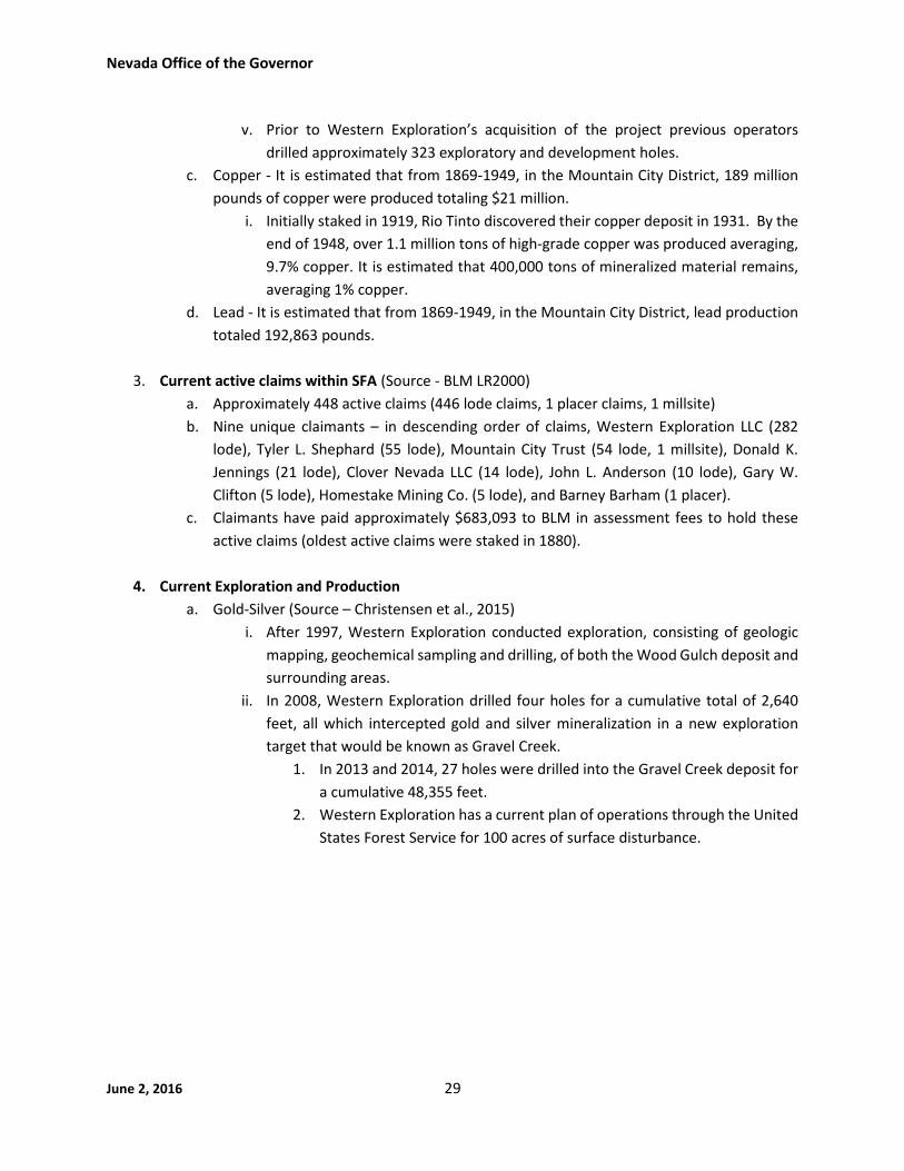
June 2, 2016 29
v. Prior to Western Exploration’s acquisition of the project previous operators
drilled approximately 323 exploratory and development holes.
c. Copper - It is estimated that from 1869-1949, in the Mountain City District, 189 million
pounds of copper were produced totaling $21 million.
i. Initially staked in 1919, Rio Tinto discovered their copper deposit in 1931. By the
end of 1948, over 1.1 million tons of high-grade copper was produced averaging,
9.7% copper. It is estimated that 400,000 tons of mineralized material remains,
averaging 1% copper.
d. Lead - It is estimated that from 1869-1949, in the Mountain City District, lead production
totaled 192,863 pounds.
3. Current active claims within SFA (Source - BLM LR2000)
a. Approximately 448 active claims (446 lode claims, 1 placer claims, 1 millsite)
b. Nine unique claimants – in descending order of claims, Western Exploration LLC (282
lode), Tyler L. Shephard (55 lode), Mountain City Trust (54 lode, 1 millsite), Donald K.
Jennings (21 lode), Clover Nevada LLC (14 lode), John L. Anderson (10 lode), Gary W.
Clifton (5 lode), Homestake Mining Co. (5 lode), and Barney Barham (1 placer).
c. Claimants have paid approximately $683,093 to BLM in assessment fees to hold these
active claims (oldest active claims were staked in 1880).
4. Current Exploration and Production
a. Gold-Silver (Source – Christensen et al., 2015)
i. After 1997, Western Exploration conducted exploration, consisting of geologic
mapping, geochemical sampling and drilling, of both the Wood Gulch deposit and
surrounding areas.
ii. In 2008, Western Exploration drilled four holes for a cumulative total of 2,640
feet, all which intercepted gold and silver mineralization in a new exploration
target that would be known as Gravel Creek.
1. In 2013 and 2014, 27 holes were drilled into the Gravel Creek deposit for
a cumulative 48,355 feet.
2. Western Exploration has a current plan of operations through the United
States Forest Service for 100 acres of surface disturbance.

Nevada Office of the Governor
June 2, 2016 30
National
The National Area consists of approximately 9 square miles within the proposed mineral withdrawal area
on lands managed by the USFS in the Santa Rosa Range of Humboldt County. The National Area is located
approximately 18 miles southeast of the town of McDermitt and current activity includes a permitted
exploration project for gold and silver.
1. Mineral Enrichment - (Source - US Geological Survey MAS/MILS/MRDS datasets, Nevada StateMine Inspector Annual Directory, Nevada Bureau of Mines and Geology Bulletin 59)
a. Mercury – 3 past producers
b. Gold, Silver, Copper, Arsenic, Antimony – 2 past producers each
2. Historic Exploration and Production - (Source – Nevada Bureau of Mines and Geology Bulletin 41
and 59, Open File Report 1985-03, Mineral Industry Reports 1990-2006; US Bureau of Mines
Information Circulars 6902 and 6995, US Geological Survey Bulletin 601)
a. The National Area is in the southeastern portion of the historic National Mining District
and immediately south of the bonanza-grade underground National Mine gold complex,
responsible for most of the production from the district which totaled nearly $4 million
from 1909-1959. Two mines are responsible for the bulk of production within the
National Area: the Buckskin National Mine and the McCormick group/Buckskin Peak
Mine.
b. Gold/Silver – The Buckskin National mine began production in 1912 and saw intermittent
production through the 1930s with the development of approximately 6,500 feet of
underground workings by 1937.
i. Asarco conducted extensive exploration work in the 1980s, including more than
3,300 feet of drilling.
ii. By 1990, Queenstake Resources announced that after spending $1 million over
the previous 6 years on mapping, sampling, geophysics, and drilling they had
identified a reserve of 138,000 tons of high-grade material averaging 0.36 ounces
per ton gold and 3.4 ounces per ton silver.
iii. Cameco drilled on Queenstake’s property in 1992. Royaledge Resources acquired
the claims in 1997 with plans to continue drilling.
iv. In 2004, Romarco Minerals acquired the property and completed mapping and
sampling while submitting a plan to USFS for drilling. In 2005 and 2006, Romarco
drilled 7 holes.
c. Mercury – The McCormick group/Buckskin Peak Mine produced approximately 150 flasks
of mercury from 1929-1943 from over 1,000 feet of underground workings.
i. USGS Bulletin 922-E (1940) details the geology and workings present at the time
and concluded that total reserves may be as much as 2,000-3,000 flasks of
mercury, equivalent to 150,000 to 225,000 pounds of mercury.
3. Current active claims within SFA (Source - BLM LR2000)

Nevada Office of the Governor
June 2, 2016 31
a. Approximately 105 active claims (all lode claims)
b. 4 unique claimants – in descending order of claims, Paragon Precious Metals (61),
National Mines Co. Ltd. (31), Buckskin National Mine (10), and John Russell Bell (3).
c. Claimants have paid approximately $219,428 to BLM in assessment fees to hold these
claims (oldest active claim was staked in 1995).
d.
4. Current Exploration and Production
a. Gold/Silver
i. On September 12, 2013, Volcanic Gold and Silver LLC received approval from the
USFS to conduct exploration and drilling operations at their Buckskin National
property (a joint-venture agreement with Paragon) for their Plan of Operations
(#10-12-04). Plans include 21 drill sites and a total of 1.13 acres of permitted
disturbance (source - USFS Decision Memo – 9/12/2013).
ii. A 2015 company report on the Buckskin-National project proposed a $1.2M
budget for continued exploration, including geophysical surveys and 10,000 feet
of drilling (source - 3/31/2015 Mine Development Associates’ Technical Report).

Nevada Office of the Governor
June 2, 2016 32
Opalite
The Opalite Area consists of about 38 square miles within 7-12 miles of the town of McDermitt, Nevada.
The Opalite Area lies completely within the historic Opalite Mining District and in the most northeastern
extent of the large 500 square mile McDermitt Volcanic Caldera Complex. The Opalite Mining District is
primarily known for its historic mercury production however, uranium, lithium, specialty clay, gallium, and
dimension stone are both historic and current exploration targets in the Opalite Mining District.
1. Mineral Enrichment - (Source - US Geological Survey MAS/MILS/MRDS datasets, Nevada StateMine Inspector Annual Directory, Nevada Bureau of Mines and Geology Report 47; US GeologicalSurvey 59; Gold Canyon Resources’ technical report and resource estimation for the CorderoGallium Project Humboldt County, NV)
a. Mercury – 3 past producers, 1 occurrence
b. Lithium – 1 past producers
c. Uranium – 1 past producer, 1 occurrence, & 1 prospect
d. Gallium – 1 occurrence
2. Historic Exploration and Production - (Source - Nevada Bureau of Mines and Geology Report 47,
1979 Mineral Industry Report; US Geological Survey Bulletin 59, 2209-C and Mineral Commodity
Summaries; Cordero Gold-Silver Project Technical Report, February 2014, Bureau of Land
Management LR 2000 database)
a. Mercury – Mercury was first discovered in 1929 and historic production of mercury
totaled over 550 thousand flasks, equivalent to 41 million pounds of mercury.
i. From the 1930s to the 1970s over 115,000 flasks were produced from the
underground Cordero mine.
ii. From 1975 through 1989, about 170,000 flasks of mercury were mined from the
McDermitt open pit and a resource of about 200,000 flasks of mercury remains.
b. Uranium – Exploration efforts in the Opalite Area began in the 1970’s conducted by
several companies including Placer Amex, Inc., Cordex, Chevron Resources, Energy
Reserves Group Inc., and Shell Oil.
c. Bentonite – American Colloid Co. held an approved notice for the exploration of bentonite
from 1984-2013 with a permitted disturbance of 1.6 acres (NVN-63895).
d. Lithium – Anomalously high values of lithium in montmorillonite clays (hectorite) are
known to exist throughout the McDermitt Caldera Complex. Lithium NV Corp. has 42
active claims within the Opalite Area located 10 miles northeast of Western Lithium’s
Kings Valley lithium project.
e. Historic plans and notices in the Opalite Mining District totaled 231 acres of permitted
disturbance with a much smaller but undetermined amount within the Opalite Area.
3. Current active claims within SFA (Source - BLM LR2000)
a. Approximately 61 active claims (56 lode, 5 placer)

Nevada Office of the Governor
June 2, 2016 33
b. Five unique claimants – in descending order of claims, Lithium Nevada Corp (42), Tech
Industries Ltd (8), Cordero Mine Inc. (5), American Colloid Co (5 placer), and Gold Canyon
Resources USA Inc. (1).
c. Claimants have paid approximately $58,943 to BLM in assessment fees to hold these
active claims (oldest active claims were staked in 1994).
4. Current Exploration and Production
a. Gold/Silver (Source - Cordero Gold-Silver Project Technical Report)
i. Cordero Gold/Silver Predator is the current claimant exploring for gold and silver
in the Opalite Area.
ii. The first exploration for precious metals in the Opalite Mining District was done
by the USGS in the late 1970s focusing around the McDermitt Pit. Since then,
intermittent exploration activities including drill hole and rock chip sampling has
taken place.
iii. Geochemical and geological data collected to date have been interpreted to have
signatures similar to and stronger than those documented over known gold and
silver deposits with similar geology such as the Buckskin-National Ivanhoe
deposit.
b. Gallium (A soft metallic element used in a variety of microelectronic components)
i. In 2001, Gold Canyon Resources acquired rights to explore for gallium on several
claims covering the Cordero mine area. Gallium exploration efforts included
extensive rock chip sampling along with 20,405 feet of reverse circulation drilling
resulting in a resource estimate of 6.5 million tons grading 1.14 ounce per ton
gallium, 7.4 million ounces of gallium. (Source – Gold Canyon Resources Technical
Report)
ii. US Geological Survey Bulletin 2209C suggests the McDermitt mercury deposit as
being a potential source of the gallium.

Nevada Office of the Governor
June 2, 2016 34
Paradise Valley
The Paradise Valley Area consists of about 3 square miles within the proposed mineral withdrawal area
on lands managed by the US Forest Service and is located 7 miles north-northeast of the town of Paradise
Valley, Nevada. The Paradise Valley Area is completely contained in the historic Paradise Valley historic
Mining District. There are active claims but no current approved Plan of Operation.
1. Mineral Enrichment - (Source - US Geological Survey MAS/MILS/MRDS datasets)a. Gold – 1 past producer and 1 occurrenceb. Silver – 2 past producers, 2 prospects and 2 occurrencesc. Arsenic – 2 past producers, 1 prospect, and 1 occurrenced. Copper – 1 past producer, 2 prospects, and 2 occurrencese. Iron – 1 past producerf. Lead – 1 prospect and 1 occurrenceg. Antimony – 1 prospect and 1 occurrenceh. Zinc – 1 past producer
2. Historic Exploration and Production - (Source – Nevada Bureau of Mines and Geology Report 47;
Lincoln, 1982; US Geological Survey Bulletin 601)
a. Silver-Gold
i. The Paradise Valley Mining District was created after silver was discovered in
1868.
ii. Production of silver and gold from the Silver Butte Mine and the Wild Goose Vein
(both located within the Paradise Area) were mined from 1879-1891.
iii. Further production from the mines for silver and gold from placer deposits took
place from 1909-1915.
iv. Early production has been reported to be no more than $3,000,000.
v. Claims have been staked by various entities in the area since 1975.
vi. Historical Plans of Operation are not readily available.
3. Current active claims within SFA (Source - BLM LR2000)
a. Approximately 3 active claims (all lode claims)
b. One unique claimants – Braun Eric Steven
c. Claimant has paid approximately $1,041 to BLM in assessment fees to hold these active
claims (oldest active claims were staked in 2002).
4. Current Exploration and Production
a. Current exploration activity is unknown.
b. There are no current permits for disturbance in the area.

Nevada Office of the Governor
June 2, 2016 35
Snake Mountains
The Snake Mountains Area consists of approximately 43 square miles within the proposed mineral
withdrawal area within central Elko County. The Snake Mountains Area is contained within the larger
historic Snake Mountains Mining District. Current activity includes an active barite mine and several barite
and gold exploration projects.
1. Mineral Enrichment - (Source - US Geological Survey MAS/MILS/MRDS datasets, Nevada StateMine Inspector Annual Directory, Nevada Bureau of Mines and Geology Bulletin 106)
a. Barite – 5 producers, 2 prospects, 9 occurrences
b. Gold – 2 prospects
2. Historic Exploration and Production - (Source - Nevada Bureau of Mines and Geology Bulletin
106)
a. Barite – First recognized in 1955, there was significant exploration in the 1970s, with
major production from several deposits in the 1980s and over 1 million tons of barite
mined from open pits from 1974 through 1986.
i. From 1981 through 2003, within the Snake Mountains Area, there were 7 notice-
level exploration projects by six operators, totaling 26.7 acres of permitted
disturbance.
ii. One plan of operations was approved in 1981 and approved for 140 acres of
disturbance. This was modified in 2006 and permitted disturbance increased to
193 acres (current operating barite mine).
b. Gold – Exploration consisting of geochemical sampling and drilling began in the 1980s.
i. From 1981 through 2008, within the Snake Mountains Area, there were 4 notice-
level exploration projects by 4 operators, totaling 14 acres of permitted
disturbance.
ii. In 2008, Piedmont Mining (a joint-venture agreement with Carlin Gold)
completed a drilling program at its Willow Project; results not reported.
3. Current active claims within SFA (Source - BLM LR2000)
a. Approximately 703 active claims (683 lode, 20 millsite)
b. 6 unique claimants – in descending order of claims, Newmont (595), Carlin Gold (41),
Halliburton (26), National Oilwell Varco (20 millsite claims), Fremont Minerals (20), Matt
Barrington (1).
c. Newmont staked 575 claims in 2013 and added 20 to claim block in 2015.
d. Claimants have paid a total of $544,214 to BLM in assessment fees to hold these claims
(oldest active claim staked in 2003).
4. Current Exploration and Production
a. Barite

Nevada Office of the Governor
June 2, 2016 36
i. National Oilwell Varco operates the Big Ledge open pit barite mine, located one
mile outside of the proposed mineral withdrawal boundary, with its Plan of
Operations, jig plant and millsite claims extending into the proposed mineral
withdrawal boundary. In 2014, they reported production of 97,000 tons barite.
National Oilwell Varco employs 24 people at their operations in Elko County.
ii. One approved notice (NVN-85818) for Spirit Minerals’ Stormy Project also
adjacent to, but outside of MWA.
b. Gold
i. Carlin Gold – active Notice NVN-86781, Willow Creek Project, $15,822
reclamation bond, approved for 4.65 acres of exploration drill roads.

Nevada Office of the Governor
June 2, 2016 37
White Rock
The White Rock Area consists of approximately 37 square miles within the proposed mineral withdrawal
area and is located in the northeastern corner of Nevada approximately 30 miles north-northeast of the
town of Montello. The White Rock Area has mainly been explored for gold and silver potential but is not
within any historic mining district. However, it is surrounded on three sides by the Goose Creek, Delano,
and Tecoma historic mining districts all of which have had historic mineral production. Current
exploration efforts in the White Rock area consist of initial exploration and advanced stage gold-silver
projects with recent drilling. There are two permitted gold exploration projects in the area; one permitted
under a plan of operations and one permitted under a notice of intent. The White Rock area lies at the
northern edge of the emerging Long Canyon Trend which hosts Newmont’s multi-million ounce Long
Canyon gold deposit. Newmont’s anticipates having 260 full time employees for the projected eight year
life of the Long Canyon Mine when production starts in 2017.
5. Mineral Enrichment - (Source – Nevada Bureau of Mines and Geology Mineral Industry Report2007 and 2011)
a. Gold – 2 occurrences
b. Silver – 2 occurrences
6. Historic Exploration and Production
a. Gold/Silver-First discovered in 1982 at the White Rock project. There is a reported
resource estimate of 100,000 ounces of gold. (Source – Nevada Bureau of Mines and
Geology Mineral Industry Report 2007 and Golden Odyssey Press Release January 4,
2007).
i. Amax Gold defined a resource of 100,000 ounces of gold, in the 1980s using an
unspecified number of historic drill holes (Source – Nevada Bureau of Mines and
Geology Mineral Industry Report 2007 and Golden Odyssey Press Release January
4, 2007).
ii. In 2007, Golden Odyssey twinned some of the historic drill holes to test their
validity. Results agreed with gold values reported in historic drilling used to
generate the Amax resource estimate.
iii. Other companies including Mount Isa Mines and Kennecott have been reported
to have done further exploration in the White Rock Area (Source – Golden
Odyssey Press Release January 4, 2007, BLM LR2000).
iv. Historic plans of operations and notices of intents total 54.8 acres since 1984.
Plans make up 29.2 acres of the proposed disturbance and notices of intents
make up the remaining 25.55 acres.
7. Current active claims within SFA (Source - BLM LR2000)
a. Approximately 155 active lode claims
b. 4 unique claimants – in descending order of claims, Gregory J. Kuzma (87), Pilot Gold (USA)
Inc. (40), Schmidt Family Mining Partnership LLC (21), and Donald K. Jennings (7).

Nevada Office of the Governor
June 2, 2016 38
c. Claimants have paid a total of $206,763 to BLM in assessment fees to hold these active
claims (oldest active claims were staked in 2004).
8. Current Exploration and Production
a. Gold/Silver
i. One of Pilot Gold’s exploration projects, Viper, is located in the White Rock Area
with drilling completed as recently as 2011 which included a cumulative 11,037
feet in 18 drill holes. The Viper target is 1 mile long in a north-south direction and
2,300 feet long in an east-west direction. Assay intercepts and alteration suites
reported from drilling are important as they share similarities with classic
sediment-hosted replacement deposits elsewhere in Nevada. The best reported
drill intercept was 0.03 ounce per ton gold and 0.57 ounce per ton silver over 110
feet from surface. These values are generally consistent with what would be
encountered in a modern open pit mine.
1. Exploration expenditures on the Viper Project to date total approximately
$1 million.
The Viper Project is permitted for 2.77 acres of disturbance.
ii. Miranda Gold Corp. has the Angel Wing project within the White Rock Area and
is operating under an active plan of operations that is permitted for 6.7 acres of
disturbance. Miranda acquired the Angel Wing Project through a joint venture in
2007 and up to 2014 had been actively conducting exploration, including but not
limited to geologic mapping, geophysical surveys, soil and rock sampling, and
drilling.
1. Exploration expenditures on the Angel Wing project to date total
approximately $1.2 million dollars.
The Angel wing project is permitted for 6.7 acres of disturbance.

Nevada Office of the Governor
June 2, 2016 39
Literature CitedCoates, P. S., M. L. Casazza, M. A. Ricca, B. E. Brussee, E. J. Blomberg, K. B. Gustafson, C. T. Overton, D. M.
Davis, L. E. Niell, S. P. Espinosa, S. C. Gardner, and D. J. Delehanty. 2016. Integrating spatially explicitindices of abundance and habitat quality: an applied example for greater sage-grouse management. Journal
of Applied Ecology 53:83–95.
Dahlgren, David K., T.A. Messmer, B.A. Crabb, R.T. Larsen, T.A. Black, S. N. Frey, E.T. Thacker, R.J. Baxter,J.D. Robinson. 2016. Seasonal movements of Greater sage-grouse populations in Utah: implicationsfor species conservation. Wildlife Society Bulletin; DOI: 10.1002/wsb.643
Doherty, Kevin E., J.D. Tack, J.S. Evans, and D.E. Naugle. 2010. Mapping breeding densities of greater sage-grouse: a tool for range-wide conservation planning. Bureau of Land Management Completion Report.Interagency Agreement #L10PG00911.
Reinhart, Jan S., T.A. Messmer, T.A. Black. 2013. Inter-seasonal movements in tri-state greater sage-grouse: implications for state-centric conservation plan. Human-Wildlife Interaction 7(2):172-181.
References For High Mineral Potential Areas
Nevada Bureau of Mines and Geology Annual Mineral Industry Reports (source of locations of drillprojects, drill footage and intercept information):
Muntean, J. L., Davis, D. A., 2016, The Nevada mineral industry 2014: Nevada Bureau of Mines and GeologySpecial Publication MI-2014, (draft)
Davis, D. A., and Muntean, J. L., 2015, The Nevada mineral industry 2013: Nevada Bureau of Mines andGeology Special Publication MI-2013.
Davis, D. A., and Muntean, J. L., 2014, The Nevada mineral industry 2012: Nevada Bureau of Mines andGeology Special Publication MI-2012.
Davis, D. A., and Muntean, J. L., 2013, The Nevada mineral industry 2011: Nevada Bureau of Mines andGeology Special Publication MI-2011.
Muntean, J. L., 2011, The Nevada mineral industry 2010: Nevada Bureau of Mines and Geology SpecialPublication MI-2010.
Muntean, J. L., 2010, The Nevada mineral industry 2009: Nevada Bureau of Mines and Geology SpecialPublication MI-2009.
Muntean, J. L., 2009, The Nevada mineral industry 2008: Nevada Bureau of Mines and Geology SpecialPublication MI-2008.
Muntean, J. L., 2008, The Nevada mineral industry 2007: Nevada Bureau of Mines and Geology SpecialPublication MI-2007.
Muntean, J. L., 2007, The Nevada mineral industry 2006: Nevada Bureau of Mines and Geology SpecialPublication MI-2007.
Muntean, J. L., 2006, The Nevada mineral industry 2005: Nevada Bureau of Mines and Geology SpecialPublication MI-2005.
Tingley, J.V. and Castor, S.B., 2005, The Nevada Mineral Industry 2004: Nevada Bureau of Mines andGeology Special Publication MI-2004.
Tingley, J.V. and Castor, S.B., 2004, The Nevada Mineral Industry 2003: Nevada Bureau of Mines andGeology Special Publication MI-2003.

Nevada Office of the Governor
June 2, 2016 40
Tingley, J.V. and Castor, S.B., 2003, The Nevada Mineral Industry 2002: Nevada Bureau of Mines andGeology Special Publication MI-2002.
Tingley, J.V., Castor, S.B. and Davis, D.A., 2002, The Nevada Mineral Industry 2001: Nevada Bureau ofMines and Geology Special Publication MI-2001.
Tingley, J.V., LaPointe, D.D. and Castor, S.B., 2001, The Nevada Mineral Industry 2000: Nevada Bureau ofMines and Geology Special Publication MI-2000.
Tingley, J.V., LaPointe, D.D. and Castor, S.B., 2000, The Nevada Mineral Industry 1999: Nevada Bureau ofMines and Geology Special Publication MI-1999.
Tingley, J.V., LaPointe, D.D., Bonham, H.F. and Castor, S.B., 1999, The Nevada Mineral Industry 1998:Nevada Bureau of Mines and Geology Special Publication MI-1998.
Tingley, J.V., LaPointe, D.D., Bonham, H.F. and Castor, S.B., 1998, The Nevada Mineral Industry 1997:Nevada Bureau of Mines and Geology Special Publication MI-1997.
Tingley, J.V., LaPointe, D.D., Hess, R.H., Bonham, H.F. and Castor, S.B., 1997, The Nevada Mineral Industry1996: Nevada Bureau of Mines and Geology Special Publication MI-1996.
Tingley, J.V., LaPointe, D.D., Hess, R.H., Bonham, H.F. and Castor, S.B., 1996, The Nevada Mineral Industry1995: Nevada Bureau of Mines and Geology Special Publication MI-1995.
Nevada Bureau of Mines and Geology Bulletins and Open-file Reports:
Bailey, E.H. and Phoenix, D.A., 1944, Quicksilver Deposits in Nevada, University of Nevada Bulletin Volume38, No. 5, Geology and Mining Series No. 41.
Bentz, J.L., Tingley, J.V., Smith, P.L. and Garside, L.J., 1983, A Mineral Inventory of the Elko Resource Area,Elko District, Nevada, NBMG Open-File Report 1983-09.
Bonham, H. F. and Papke, K., 1969, Geology and mineral deposits of Washoe and Storey Counties, Nevada:Nevada Bureau of Mines and Geology Bulletin 70.
Bonham, H.F., Garside, L.J., Jones, R.B., Papke, K.G., Quade, J., and Tingley, J.V., 1985, A Mineral Inventoryof the Paradise-Denio and Sonoma-Gerlach Resource Areas, Winnemucca District, Nevada, NBMGOpen File Report 1985-03.Coats, R. R., 1987, Geology of Elko County, Nevada: Nevada Bureau of Minesand Geology Bulletin 101, 112 p.
Granger, A.E., Bell, M.M., Simmons, G.C., and Lee, F., 1957, Geology and Mineral Resources of Elko County,Nevada, Nevada Bureau of Mines, Bulletin 54.
LaPointe, D.D., Tingley, J.V., and Jones. R.B., 1991, Mineral resources of Elko County, Nevada: NevadaBureau of Mines and Geology Bulletin 106.
Singer, D.A., ed., An analysis of Nevada's metal-bearing mineral resources: NBMG Open-File Report 96-2.(last statewide mineral assessment of Nevada, completed by the U.S. Geological Survey)
Wilden, R., 1964, Geology and Mineral Deposits of Humboldt County, Nevada: Nevada Bureau of Minesand Geology Bulletin 59.
Nevada Bureau of Mines and Geology Maps (open files and peer-reviewed, source of active mines andmineral deposits):
Davis, D. A., Tingley, J. V., and Muntean, J. L., 2006, Gold and silver resources of Nevada: Nevada Bureauof Mines and Geology Map 149.
Henry, C.D., Castor, S.B., Starkel, W.A., Ellis, B.S., Wolff, J.A., McIntosh, W.C. and Heizler, M.T., 2016,Preliminary Geologic Map of the McDermitt Caldera, Humboldt County Nevada and Harney andMalheur Counties, Oregon, NBMG Open-file Report 16-1, scale 1:70,000.

Nevada Office of the Governor
June 2, 2016 41
Muntean, J. L. and Davis, D. A., 2014, Nevada active mines and energy producers: Nevada Bureau of Minesand Geology Open-File Report 14-1, scale 1:1,000,000
Tingley, J. V., 1993, Mining districts of Nevada, 1:1,000,000, NBMG Report 47.
Nevada Bureau of Mines and Geology websites and compact discs (source of information and locationon drill projects):
Muntean, J. L., and Johnson, G., 2013, 43-101 report map service for mineral properties:http://gisweb.unr.edu/report_43101_1/ (updated through Spring 2015)
University of Nevada, Reno Student Theses:
Cantor, B.M., 2012, Petrography and Field Mapping of Eocene Intrusions and Adjacent Breccia Zones atthe Scraper Springs Prospect, Elko County, Nevada, Thesis for Master of Science in Geology.
Bureau of Land Management LR2000 database (source of claim data and permits/plans):
http://www.blm.gov/lr2000/
U.S. Bureau of Mines:
McMahan, A.B. and Pierce, P.A., 1981, Zunyite Resource in Elko County, Nevada, draft report.Buckskin Peak Mine, 1943, Preliminary Examination Report, sourced from NBMG Mining District Files,
number 33500007.
U.S. Department of Agriculture Forest Service, Humboldt Toiyabe National Forest (source of currentpermitted projects):
http://data.ecosystem-management.org/nepaweb/project_list.php?forest=110417USDA Forest Service, Humboldt-Toiyabe National Forest Mountain City Ranger District, Elko County,
Nevada, 2014, Wood Gulch Exploration Project Environmental Assessment.
U.S. Geological Survey Digital Data Series (source of information for claim number data for 1976-2010):
Causey, J. D., 2007, Mining claim activity on federal land in the United States: U.S. Geological Survey DataSeries 290, v. 1.1, http://pubs.usgs.gov/ds/2007/290/ (number of claims were section, updated byUSGS through 2010)
Crafford, A.E.J., 2007, Geologic Map of Nevada: U.S. Geological Survey Data Series 249, 1 CD-ROM, 46 p.,1 plate. (Compiled digital geologic map of Nevada using 1:250.000 county report maps with some newinterpretation)
U.S. Geological Survey, 2005, Mineral Resources Data System. Edition: 20160107,http://mrdata.usgs.gov/mrds/ (locations of mineral deposits)
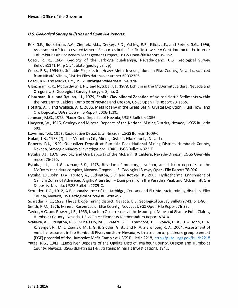
Nevada Office of the Governor
June 2, 2016 42
U.S. Geological Survey Bulletins and Open File Reports:
Box, S.E., Bookstrom, A.A., Zientek, M.L., Derkey, P.D., Ashley, R.P., Elliot, J.E., and Peters, S.G., 1996,Assessment of Undiscovered Mineral Resources in the Pacific Northwest: A Contribution to the InteriorColumbia Basin Ecosystem Management Project, USGS Open-file Report 95-682.
Coats, R. R., 1964, Geology of the Jarbidge quadrangle, Nevada-Idaho, U.S. Geological SurveyBulletin1141-M, p 1-24, plate (geologic map).
Coats, R.R., 1964(?), Suitable Projects for Heavy-Metal Investigations in Elko County, Nevada., sourcedfrom NBMG Mining District Files database number 60002303.
Coats, R.R. and Marks, L.Y., 1982, Jarbidge Wilderness, Nevada.Glanzman, R. K., McCarthy Jr. J. H., and Rytuba, J. J., 1978, Lithium in the McDermitt caldera, Nevada and
Oregon: U.S. Geological Survey Energy v. 3, no. 3.Glanzman, R.K. and Rytuba, J.J., 1979, Zeolite-Clay Mineral Zonation of Volcaniclastic Sediments within
the McDermitt Caldera Complex of Nevada and Oregon, USGS Open File Report 79-1668.Hofstra, A.H. and Wallace, A.R., 2006, Metallogeny of the Great Basin: Crustal Evolution, Fluid Flow, and
Ore Deposits, USGS Open-file Report 2006-1280.Johnson, M.G., 1973, Placer Gold Deposits of Nevada, USGS Bulletin 1356.Lindgren, W., 1915, Geology and Mineral Deposits of the National Mining District, Nevada, USGS Bulletin
601.Lovering, T.G., 1952, Radioactive Deposits of Nevada, USGS Bulletin 1009-C.Nolan, T.B., 1933 (?), The Mountain City Mining District, Elko County, Nevada.Roberts, R.J., 1940, Quicksilver Deposit at Buckskin Peak National Mining District, Humboldt County,
Nevada, Strategic Minerals Investigations, 1940, USGS Bulletin 922-E.Rytuba, J.J., 1976, Geology and Ore Deposits of the McDermitt Caldera, Nevada-Oregon, USGS Open-file
report 76-535.Rytuba, J.J., and Glanzman, R.K., 1978, Relation of mercury, uranium, and lithium deposits to the
McDermitt caldera complex, Nevada-Oregon: U.S. Geological Survey Open- File Report 78-926.Rytuba, J.J., John, D.A., Foster, A., Ludington, S.D. and Kotlyar, B., 2003, Hydrothermal Enrichment of
Gallium Zones of Advanced Argillic Alteration – Examples from the Paradise Peak and McDermitt OreDeposits, Nevada, USGS Bulletin 2209-C.
Schrader, F.C., 1912, A Reconnaissance of the Jarbidge, Contact and Elk Mountain mining districts, ElkoCounty, Nevada, US Geological Survey Bulletin 497.
Schrader, F. C., 1923, The Jarbidge mining district, Nevada: U.S. Geological Survey Bulletin 741, p. 1-86.Smith, R.M., 1976, Mineral Resources of Elko County, Nevada, USGS Open-File Report 76-56.Taylor, A.O. and Powers, J.F., 1955, Uranium Occurrences at the Moonlight Mine and Granite Point Claims,
Humboldt County, Nevada, USGS Trace Elements Memorandum Report 874-A.Wallace, A., Ludington, R. S., Mihalasky, M. J., Peters, S. G., Theodore, T. G. Ponce, D. A., D. A. John, D. A.
R. Berger, R., M. L. Zientek, M. L, G. B. Sidder, G. B., and R. A. Zierenberg R. A., 2004, Assessment ofmetallic resources in the Humboldt River, northern Nevada, with a section on platinum-group-element(PGE) potential of the Humboldt Mafic Complex: USGS Bulletin 2218, http://pubs.usgs.gov/bul/b2218
Yates, R.G., 1941, Quicksilver Deposits of the Opalite District, Malheur County, Oregon and HumboldtCounty, Nevada, USGS Bulletin 931-N, Strategic Minerals Investigations, 1941.

Nevada Office of the Governor
June 2, 2016 43
Peer-reviewed Publications:
Buckley, E.R., 1911, Geology of the Jarbidge Mining District, Nevada, Mining and Engineering World,December 16, 1911, pages 1209-1212.
Christensen, O. D., Cleary, J. G., Anderson, A. L. and Fimiani, C., Geology and Discovery History of theGravel Creek silver-gold deposit, Elko County, Nevada: in Pennell, W. M. and Garside, L. J., eds., NewConcepts and Discoveries: Geological Society of Nevada Symposium Proceedings, May 2015, Sparks,Nevada, p. 861-884.
Hetherington, M.J. and Cheny, E.S., 1985, Origin of the Opalite Breccia at the McDermitt Mercury Mine,Nevada, Economic Geology, Volume 80, pp. 1981-1987.
Noble, D.C., McCormack, J.K., McKee, E.H., Silberman, M.L., and Wallace, A.B., 1988, Time ofMineralization in the Evolution of the McDermitt Caldera Complex, Nevada-Oregon, and the Relationof Middle Miocene Mineralization in the Northern Great Basin to Coeval Regional Basaltic MagmaticActivity, Economic Geology Volume 83, pp.859-863.
Scott, W.A., 1910, Jarbidge Nevada, Mining and Scientific Press, April 30, 1910, pages 613 and 614.Smith, A.M., 1957, Resources Report Elko County, Nevada, prepared for the Office of George W. Malone,
US Senate.Sweetser, N.W., 1910, Geology of the Jarbidge Mining District, December 31, 1910, pages 871 and 872.Vikre, P. G., 2007, Sinter-Vein Correlations at Buckskin Mountain, National District, Humboldt County,
Nevada, Economic Geology, v. 102, p. 193-224.Vikre, P.G., 1987, Paleohydrology of Buckskin Mountain, National district, Humboldt County, Nevada:
Economic Geology v. 882, p. 934-950.Vikre, P.G., 1985, Precious metal vein system in the National district, Humboldt County, Nevada: Economic
Geology, v. 80, p. 360-393.
Company Website, Press Releases, Financial Regulatory Filings and Technical Reports:
Altan Nevada Minerals Ltd., press release, October 6, 2014, Altan Nevada Announces Partner CommencesDrilling at the North Star Gold Project.
Altan Nevada Minerals Ltd., press release, May 21, 2015, Altan Nevada Announces Encouraging Results atNorth Star Gold Project in Nevada, Partner Withdraws.
Altan Nevada website – www.altnev.com/projects/north-star/Atna Resources Ltd., website, Jarbidge Project webpage, www.atna.com/Arnevut Resources Inc., press release, March 3, 2011, Orocan Enters Letter of Intent to Purchase All of the
Shares of Arnevut Resources Inc.Arnevut Resources Inc., SEDAR filing ARI_123112, 2013, Management’s Discussion and Analysis for the
Year Ended December 31, 2012.Baker, D.J., Stanley, W.R. and Dickerson, R.B., 1990, Geology of the Wood Gulch Mine Area and the Doby
Prospect, Northern Independence Range, Elko County, Nevada, Homestake Mining Company.Black, Z.J., Lane, T.A., Iasillo, E., 3L Resources, 2012, NI 43-101 Technical Report on the Contact Copper
Project, Nevada, USA, prepared for International Enexco, Ltd.Capps, R.C., 2012, NI 43-101 Technical Report, Golden Trail Project, Elko County, Nevada, prepared for
Montana Gold Mining Company, Inc.Carew, T.J., 2006, NI 43-101 Technical Report and Resource Estimation for the Cordero Gallium Project,
Humboldt County, Nevada, prepared for Gold Canyon Resources, Inc.Carper, A.C., 1920, Report on Buckskin National Gold Mining Co., National, Humboldt County, Nevada,
sourced from NBMG Mining District Files, number 33500010.

Nevada Office of the Governor
June 2, 2016 44
Childs, J.F., 2007, NI 43-101 Cordero Gold-Silver Project Technical Report, Opalite Mining District,Humboldt County, Nevada, prepared for Tech Industries LLC.
Choquette, J., Black, Z.J., Lane, T.A., Malhotra, D., Hard Rock Consulting, LLC, 2013, amended 2016, NI 43-101 Pre-feasibility Study on the Contact Copper Project, prepared for International Enexco, Ltd.
Crew, T.J., Lips, E.C., Rossi, M.E., Scharnhorst, V.J. and Spiller, D.E., Tetra Tech, 2014, Updated NI 43-101Technical Report Kings Valley Property, Humboldt County, Nevada, prepared for Western Lithium USACorp.
CopperBank website presentation, March 2016, www.copperbankcorp.comEggleston, T. and Hertel, M., 2008, NI 43-101 Technical Report Kings Valley Lithium Nevada, USA, prepared
for Western Lithium Canada Corp.Enviroscientists, Inc., 2013, Plan of Operations/Nevada Reclamation Permit Application for Miranda USA
Inc. Angel Wing Exploration Project, Elko County, Nevada.Galway Resources, press release, August 6, 2007, Galway Resources provides an update on the Indian
Springs open-pittable tungsten project, http://www.prnewswire.com/news/galway+resources+ltdGilbert, D.C., 1935, Report on the Silver Butte Mining Company, Paradise Mining District, Humboldt
County, Nevada, sourced from the NBMG Mining District Files, number 35400001.Gold Canyon Resources, Inc., February 11, 2008 press release.Golden Odyssey Mining Inc., January 4, 2007 press release, Golden Odyssey Acquire White Rock Project
in Northeastern Nevada, http://www.marketwired.com/press-release/Golden-Odyssey-Acquires-White-Rock-Project-in-Northeastern-Nevada-629396.htm
Golden Odyssey Mining Inc., October 23, 2007 press release, Golden Odyssey Announces Positive Resultsfor the First Twin Hole at Its White Rock Project, Elko County, Nevada,
Hatch, R.M., January 12, 2016 Comment letter to Neil Kornze, Director, US Bureau of Land Management.Hot Creek Property Final Report, 1984, author unknown, sourced from NBMG Mining District Files,
number 44900008.Lane, T.A., Crowl, W.J., Hulse, D.E., Moritz, R.D., Willoughby, W.W., Gustavson Associates, 2010, NI 43-
101 Technical Report, Pre-feasibility Study Update for the Contact Copper Project, Elko County,Nevada, prepared for International Enexco, Ltd.
Miranda Gold website, http://www.mirandagold.com/s/Home.aspMarmota Energy, August 6, 2012 press release, Significant Gold Results from Angel Wing Gold Project –
Nevada, USA, Marmota Energy website, http://www.marmotaenergy.com.au/site/Moran, A.V., SRK Consulting, 2011, NI 43-101 Technical Report Star Lake Gold Exploration Project, Elko
and Humboldt counties, Nevada, USA, prepared for VLM Ventures Ltd.Pilot Gold Inc., September 8, 2011 press release, Pilot Gold Announces New Bulk Tonnage Style Gold
Discovery at the Viper Project, Elko County, Nevada, Pilot Gold Website, http://pilotgold.com/Price, T., 1879, Paradise Valley Mine, Nevada, sourced from NBMG Mining District Files, number
35400014.Quantum Minerals, LLC, June 6, 2015 letter to J.J. Goicochea, Chair, Sagebrush Ecosystem Council,
Jarbidge Exploration Project.Ramelius Resources Ltd., 2014 Annual Report and August 29, 2012 press release, Angel Wing Gold Project
Update – Nevada USA, Ramelius Resources website, http://www.rameliusresources.com.au/Robison, R.R., 2011, Humboldt Mining Company Report on 2010 Drilling Activities.Silver Predator website, http://www.silverpredator.com/cordero.htmlTimberline Resources Corp., January 13, 2011 press release, Timberline Expands in Nevada with
Acquisition of White Rock Project, filing on EDGAR,http://www.sec.gov/Archives/edgar/data/1288750/000105291811000011/ex99.htm

Nevada Office of the Governor
June 2, 2016 45
Tingley, J.V., 1968, Buckskin Peak Mercury Prospect, National Mining District, Humboldt County, Nevada,Union Pacific Railroad, sourced from NBMG Mining District Files, number 33500022.
Tuvera Exploration Inc., 2016, NI 43-101 Report (draft), Exploration Update and New resource Estimates,Island Mountain Gold Property, Elko, County, NV.
Weiss, S.I. and Ristorcelli, S.J., Mine Development Associates, 2015, Technical Report on the Buckskin-National Project, Humboldt County, Nevada, prepared for Volcanic Gold and Silver, LLC.
Western Pacific Resources Corp., 2016, website, Rock Springs project summary page,
http://www.westernpacificresources.com/s/RockSprings.asp

Snake Mountains (Barite-Gold)
White Rock (Gold-Silver)Delano (Copper-Gold-Silver)
Contact (Copper-Gold-Silver)Jarbidge (Gold-Silver)
Charleston (Gold-Silver-Barite)
Mountain City (Gold-Silver-Copper)
Burner-Scraper Springs (Gold-Silver)
Paradise Valley (Silver-Gold)
National (Gold-Silver-Mercury)
Opalite (Mercury-Lithium-Gallium)
Kings Valley (Lithium)
R31E R43ER32E R42ER39E R40E R42ER30E R33ER63E
R38ER64E
R37ER62E
R35ER59ER56E R57ER55E R58E R65E
R54ER36ER60E R61E R66E R67E R68E
R34E
R69ER45E R46E R47E R48E R52ER49E R51ER50E R53E
R19E R21ER20E R22E R23ER18E
R27ER26E R28ER25ER24E
R44ER70E
R54E
R23E
£¤93
£¤95
Snake Mountains (Barite-Gold)
White Rock (Gold-Silver)
Delano (Copper-Gold-Silver)
Contact (Copper-Gold-Silver)Jarbidge (Gold-Silver)
Charleston (Gold-Silver-Barite)
Mountain City (Gold-Silver-Copper)
Burner-Scraper Springs (Gold-Silver)
Paradise Valley (Gold-Silver)
National (Gold-Silver-Mercury)
Opalite (Mercury-Lithium-Gallium)
Kings Valley (Lithium)
R31E R43ER32E R42ER39E R40E R42ER30E R33ER63E
R38ER64E
R37ER62E
R35ER59ER56E R57ER55E R58E R65E
R54ER36ER60E R61E R66E R67E R68E
R34E
R69ER45E R46E R47E R48E R52ER49E R51ER50E R53E
R19E R21ER20E R22E R23ER18E
R27ER26E R28ER25ER24E
R44ER70E
R54E
R23E
£¤93
£¤95
0 10 205Miles
0 20 4010Kilometers
® Map Prepared by:Lucia M. Patterson
Nevada Division of MineralsNAD 1983 UTM Zone 11
T46N
T45N
T44N
T43N
T42N
T41N
T40N
T39N
T38N
T46N
T45N
T44N
T43N
T42N
T41N
T40N
T39N
T38N
Map 2. NDOW & NDOM Recommended Additions to and Exclusions from the Mineral Withdrawal Area
Map 1. BLM Proposed Mineral Withdrawal Areas and Areas with High Mineral Potential in Northern Nevada
Township & RangeMajor HighwayMajor Road
Areas with high mineral potential assessed by the NevadaBureau of Mines and Geology (NBMG). Assessments were based on the evaluation of existing data sources including known mining districts, PoO-NOI information from BLM LR2000, and permitting data from NBMG's Annual Nevada Mineral Industryreports.
Areas with high mineral potential assessed by the NevadaBureau of Mines and Geology (NBMG). Assessments were based on the evaluation of existing data sources including known mining districts, PoO-NOI information from BLM LR2000, and permitting data from NBMG's Annual Nevada Mineral Industryreports.
LegendNDOW Addition (Priority (Core) Habitat)
NDOW Removal (Limited Habitat)
NDOM/NBMG Areas to be Excluded from Mineral Withdrawal
SFA BoundaryDate: 4/22/2016
R31E R43ER32E R42ER39E R40E R42ER30E R33ER63E
R38ER64E
R37ER62E
R35ER59ER56E R57ER55E R58E R65E
R54ER36ER60E R61E R66E R67E R68E
R34E
R69ER45E R46E R47E R48E R52ER49E R51ER50E R53E
R19E R21ER20E R22E R23ER18E
R27ER26E R28ER25ER24E
R44ER70E
R54E
R23E
£¤93
£¤95
Map 3. Nevada Proposed Mineral Withdrawal Area
T46N
T45N
T44N
T43N
T42N
T41N
T40N
T39N
T38N
Areas of High Mineral Potential Acreage SummaryOriginal SFA-Mineral Withdrawal BoundaryNDOW Addition (Priority (Core) Habitat)NDOW Removal (Limited Habitat)NDOM/NBMG Removal (Areas With High Mineral Potential)Proposed Nevada Mineral Withdrawal Area
2,730,045 Acres+ 394,082 Acres- 317,270 Acres- 237,671 Acres2,569,272 Acres
Bilk Creek Mountains
Hardscrabble
Owyhee Desert
Jarbidge
East Fork Beaver Creek
Delano Mountains

!(
!(
!(
!(
!(
!(
!(
!(
!(
!(
!(
!(!(
!(
!(
!(
!(
!(
!( !(
!(
!(
!(
!(
!(
!(
!(
!(
!(
!(
!(
!(
!(
!(
!(
!(
!(
!(
!(
!(
!(
!(
!(
!(
!(
!(
!(
!(
!(
!(
!(
!(
!(
!(
!(
!(
!(
!(
!(
!(
!(
!(
!(
!(
!(
!(
!(
!(
!(
!(
!(
!(
!(
!(
!(
!(
!(
!(
!(
!(
!(
!(
!(
!(
!(
!(
!(
!(
!(
!(
!(
!(
!(
!(
!(
!(
!(
!(
!(
!(
!(
!(
!(
!(
!(
!(
!(
!(
!(
!(
!(
!(
!(
!(
!( !(
!(
!(
!(
!(
!(
!(
!(
!(
!(
!(
!(
!(
!(
!(
!(
!(
!(
!(
!(
!(
!(
!(
!(
!(
!(
!(
!(
!(
!(
!(
!(
!(
!(
!(
!(
!(!(
!(
!(
!(
!(
!(
!(
!(
!(
!(
!(
!(
!(
!(
!(
!(
!(
!(
!(
!(
!(
!(
!(
!(
!(
!(
!(
!(
!(
!(
!(
!(
!(
!(
!(
!(
!(
!(
!(
!(
!(
!(
!(
!(
!(
!(
!(
!(
!(
!(
!(
!(
!(
!(
!(
!(
!(!(
!(
!(
!(
!(
!(
!(
!(
!(
!(
!(
!(
!(
!(
!(
!(
!(
!(
!(
!(
!(
!(
!(
!(
!(
!(
!(
!(
!(
!(
!(!(
!(
!(!(
!(
!(
!(
!(
!(
!(
!(
!(
!(!(
!(
!(
!(
!(
!(
!(
!(
!(
!(
!(
!(
!(
!(
!(
!(
!(
!(
!(
!(
!(
!(
!(
!(
!(
!(
!(
!(
!(
!(
!(
!(
!(
!(
!(
!(!(
!(
!(
!(
!(
!(
!(
!(
!(
!(
!(
!(
!(
!(
!(
!(
!(
!(
!(
!(
!(
!(
!(
!(
!(
!(
!(
!(
!(
!(
!(
!(
!(
!(
!(
!(!(
!(
!(
!(
!(
!(
!(
!(
!(
!(
!(
!(
!(
!(
!(
!(
!(
!(
!(
!(
!(
!(
!(
!(
!(
!(
!(
!(
!(
!(
!(
!(
!(
!(
!(
!(
!(
!(
!(
!(
!(
!(
!(
!(
!(
!(
!(
!(
!(
!(
!(
!(
!(
!(
!(
!(
!(
!(
!(
!(
!(!(!(
!(
!(
!(
!(
!(
!(
!(
!(
!(
!(!(
!(
!(
!(
!(
!(
!(
!(
!(
!(
!(
!(
!(
!(
!( !(!(
!(
!(
!(
!(
!(
!(
!(
!(
!(
!(
!(
!(
!(
!(
!(
!(
!(
!(
!(
!(!(
!(
!(
!(
!(
!(
!(
!(
!(
!(
!(
!(
!(
!(
!(
!(
!(
!(
!(
!(
!(
!(
!(
!(
!(
!(
!(
!(
!(
Sage-Grouse Focal Areas (Sept. 2015)
NDOM Mineral Withrawal Areas (Apr. 2016)
NDOW Priority Habitat Addition
NDOW Limited Habitat Removal
Active Greater Sage-Grouse Lek SitesMost Recent Annual Peak Male Count
!( <35
!( 35 - 100
!( 100 - 200
Greater Sage-Grouse Space Use Index (USGS)High : 0.991552 Low : 0
0 5 10 15 20 25MilesF
No warranty is made by the State of Nevada as to the accuracy, reliability, or completeness of these data for individual use or aggregate use with other data.4/27/2016
Projection: UTM Zone 11 North, NAD83
Map 4. Active sage-grouse leks, space use index, and proposed modifications to the SFA Mineral Withdrawal Area.