NEUSE RIVER BASIN S - Environmental education · 2015-07-24 · The Neuse River Basin, whose other...
8
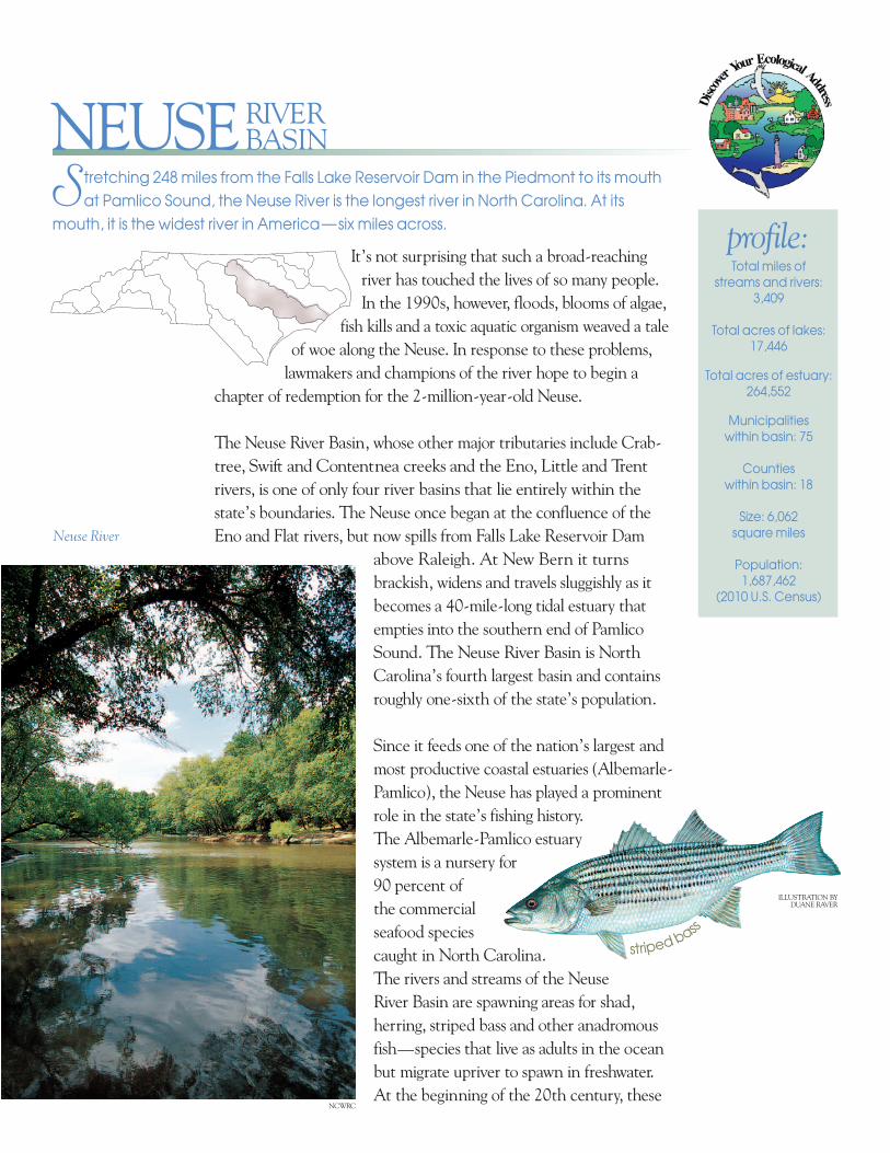
It’s not surprising that such a broad-reaching river has touched the lives of so many people. In the 1990s, however, floods, blooms of algae, fish kills and a toxic aquatic organism weaved a tale of woe along the Neuse. In response to these problems, lawmakers and champions of the river hope to begin a chapter of redemption for the 2-million-year-old Neuse. The Neuse River Basin, whose other major tributaries include Crab- tree, Swift and Contentnea creeks and the Eno, Little and Trent rivers, is one of only four river basins that lie entirely within the state’s boundaries. The Neuse once began at the confluence of the Eno and Flat rivers, but now spills from Falls Lake Reservoir Dam above Raleigh. At New Bern it turns brackish, widens and travels sluggishly as it becomes a 40-mile-long tidal estuary that empties into the southern end of Pamlico Sound. The Neuse River Basin is North Carolina’s fourth largest basin and contains roughly one-sixth of the state’s population. Since it feeds one of the nation’s largest and most productive coastal estuaries (Albemarle- Pamlico), the Neuse has played a prominent role in the state’s fishing history. The Albemarle-Pamlico estuary system is a nursery for 90 percent of the commercial seafood species caught in North Carolina. The rivers and streams of the Neuse River Basin are spawning areas for shad, herring, striped bass and other anadromous fish—species that live as adults in the ocean but migrate upriver to spawn in freshwater. At the beginning of the 20th century, these S tretching 248 miles from the Falls Lake Reservoir Dam in the Piedmont to its mouth at Pamlico Sound, the Neuse River is the longest river in North Carolina. At its mouth, it is the widest river in America — six miles across. Total miles of streams and rivers: 3,409 Total acres of lakes: 17,446 Total acres of estuary: 264,552 Municipalities within basin: 75 Counties within basin: 18 Size: 6,062 square miles Population: 1,687,462 (2010 U.S. Census) profile: RIVER BASIN NEUSE Neuse River s t ri p e d b a s s ILLUSTRATION BY DUANE RAVER NCWRC
-
Upload
hoanghuong -
Category
Documents
-
view
216 -
download
1
Transcript of NEUSE RIVER BASIN S - Environmental education · 2015-07-24 · The Neuse River Basin, whose other...
It’s not surprising that such a broad-reaching river has touched the lives of so many people. In the 1990s, however, floods, blooms of algae,
fish kills and a toxic aquatic organism weaved a taleof woe along the Neuse. In response to these problems, lawmakers and champions of the river hope to begin a
chapter of redemption for the 2-million-year-old Neuse.
The Neuse River Basin, whose other major tributaries include Crab -tree, Swift and Contentnea creeks and the Eno, Little and Trentrivers, is one of only four river basins that lie entirely within the state’s bound aries. The Neuse once began at the confluence of theEno and Flat rivers, but now spills from Falls Lake Reservoir Dam
above Raleigh. At New Bern it turnsbrackish, widens and travels sluggishly as itbecomes a 40-mile-long tidal estuary thatempties into the southern end of PamlicoSound. The Neuse River Basin is NorthCarolina’s fourth largest basin and con tainsroughly one-sixth of the state’s population.
Since it feeds one of the nation’s largest andmost productive coastal estuaries (Albemarle-Pamlico), the Neuse has played a prominentrole in the state’s fishing history.The Albemarle-Pamlico estuarysystem is a nursery for90 percent of the com mercialseafood speciescaught in North Caro lina.The rivers and streams of the NeuseRiver Basin are spawning areas for shad,herring, striped bass and other anadromousfish—species that live as adults in the oceanbut migrate upriver to spawn in freshwater. At the beginning of the 20th century, these
Stretching 248 miles from the Falls Lake Reservoir Dam in the Piedmont to its mouthat Pamlico Sound, the Neuse River is the longest river in North Carolina. At its
mouth, it is the widest river in America—six miles across.
Total miles of streams and rivers:
3,409
Total acres of lakes:17,446
Total acres of estuary:264,552
Municipalities within basin: 75
Counties within basin: 18
Size: 6,062 square miles
Population: 1,687,462
(2010 U.S. Census)
profile:
RIVERBASINNEUSE
Neuse River
stripedbass
ILLUSTRATION BYDUANE RAVER
NCWRC
spring migrations on the Neuse River produced more catches of shad than any other river inthe state. Other important recreational and commercial species include catfish, bass, flounder,blue crabs, shrimp and oysters.
The Neuse River Basin is home to many species of freshwater mussels and two rare aquatic snailspecies. Two of these mussels, the dwarf wedgemussel and Tar River spinymussel, are federallylisted as endangered. The Neuse River Basin is also home to many Aquatic Significant NaturalHeritage Areas. These are areas deemed ecologically significant by the N.C. Natural HeritageProgram because they represent the waters that are of most importance to North Carolina’sbiodiversity and have a significant amount of rare species present.
The Eno River contains the only known North Carolina population of the rare panhandle peb -blesnail. Another significant animal resident is the Neuse River waterdog (Necturus lewisi), anaquatic salamander that is found nowhere else in the world outside the Neuse and Tar-Pamlico
river basins. Also called the Carolina mud puppy,this large salamander grows to 11 inches long. Arare fish, the Carolina madtom, lives only in theNeuse and Tar-Pamlico basins. Other rare fishes in the basin include the Roanoke bass, Carolinadarter and shortnose sturgeon, a federally listedendangered species. Other federally listed basinresidents include the leatherback sea turtle, Kemp’sRidley sea turtle, West Indian manatee and red-cockaded woodpecker.
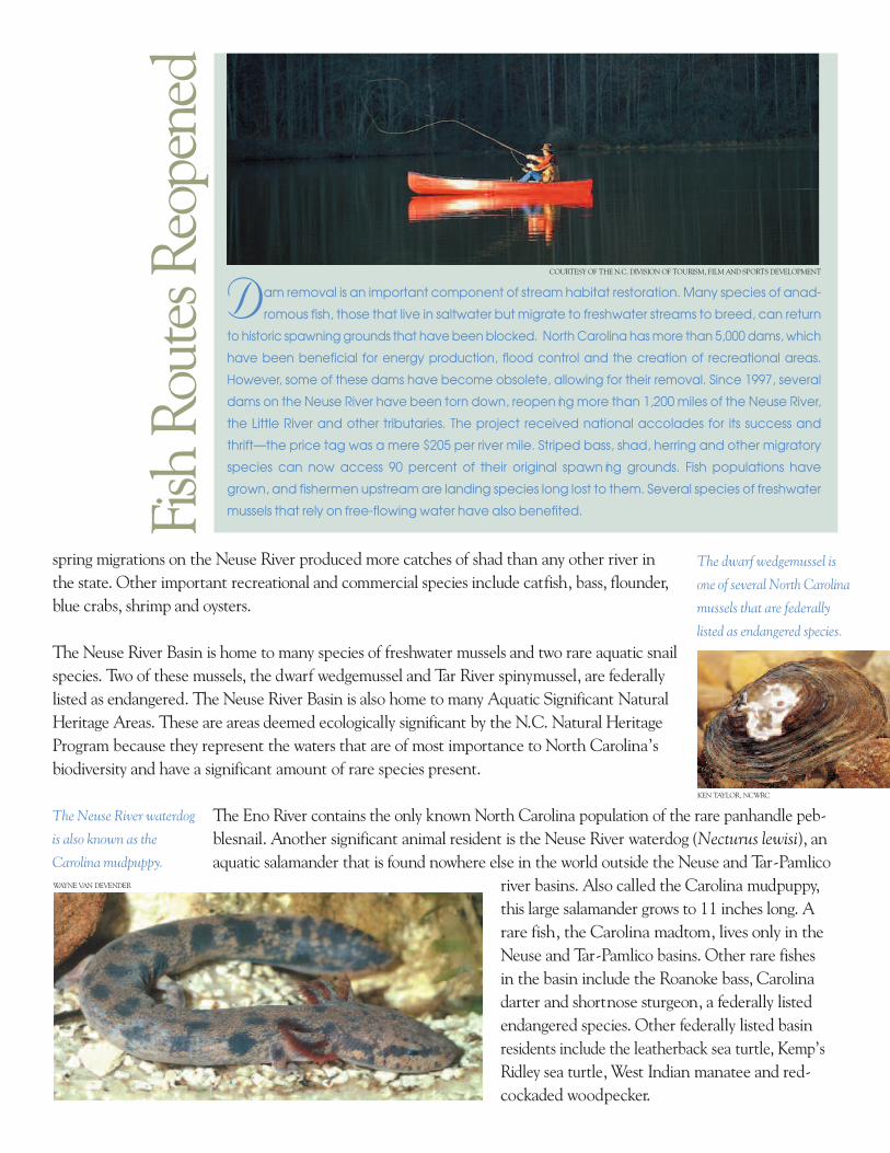
Dam removal is an important component of stream habitat restoration. Many species of anad -
romous fish, those that live in saltwater but migrate to freshwater streams to breed, can return
to historic spawning grounds that have been blocked. North Carolina has more than 5,000 dams, which
have been beneficial for energy production, flood control and the creation of recreational areas.
However, some of these dams have become obsolete, allowing for their removal. Since 1997, several
dams on the Neuse River have been torn down, reopen ing more than 1,200 miles of the Neuse River,
the Little River and other tributaries. The project received national accolades for its success and
thrift—the price tag was a mere $205 per river mile. Striped bass, shad, herring and other migratory
species can now access 90 percent of their original spawn ing grounds. Fish populations have
grown, and fishermen upstream are landing species long lost to them. Several species of freshwater
mussels that rely on free-flowing water have also benefited.
The Neuse River waterdog
is also known as the
Carolina mudpuppy.
The dwarf wedgemussel is
one of several North Carolina
mussels that are federally
listed as endangered species.
KEN TAYLOR, NCWRC
WAYNE VAN DEVENDER
COURTESY OF THE N.C. DIVISION OF TOURISM, FILM AND SPORTS DEVELOPMENT
Fish Routes Reopened
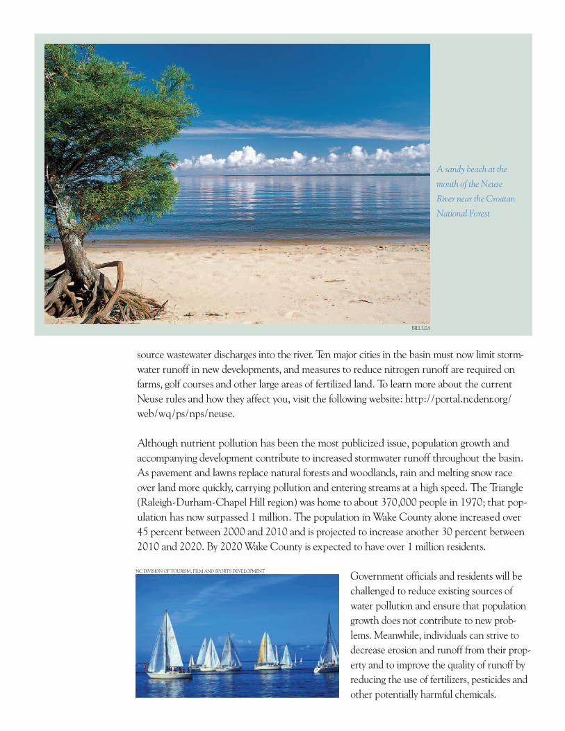
The Neuse River Basin also boasts an unusual geological formation. In Lenoir County, the Neusehas carved a 100-foot canyon—a unique feature on a coastal plain river. The towering bluff ofsedimentary rock is the showpiece of Cliffs of the Neuse State Park southeast of Goldsboro.
A big threat to water quality in the lower Neuse River are large quantities of nutrients, espe -cially nitrogen, contributed primarily from nonpoint sources. Nonpoint pollution comes from a large, diffuse area. Fertilizers and animal waste—washed from lawns, urban developed areas,farm fields and animal operations, particularly swine operations —contribute 60 percent of the nitrogen and phosphorus overload. Thesame nutrients found in those wastes can be beneficial to aquatic lifein small amounts, but too many nutrients can contribute to excessgrowth of aquatic plants (such as algae) and low levels of dissolved oxygen.Aquatic animals need dissolved oxygen to survive. To a significantlylesser degree, water quality in the Neuse River Basin is being affected bypoint source pollution from the more than 400 sites that are allowed (bystate permit) to discharge treated wastewater into streams and rivers.
The situation on the lower Neuse and other eastern North Carolina rivers spurred the statelegislature in 1997 to enact a statewide moratorium on the creation of new hog farms soresearchers can investigate their effect on water quality and examine alternative tech nologies to better handle their waste. The crisis also prompted significant new state laws and regulationsin 1998 intended to reduce nitrogen inputs to the Neuse by 30 percent within five years. The“Neuse rules” are among the first compre hensive management strategies in the country toinclude mandatory measures for both point and nonpoint sources of nutrients. The rulesrequire property owners to protect 50-foot strips of land covered with trees, shrubs and othervegetation—known as riparian buffers—along streams, rivers, lakes and estuaries. Deep-rooted plants prevent soil erosion and filter out nutrients in runoff that would otherwise flowinto streams. Further, certain industries and municipalities must jointly reduce their point
The streaked, layered face of the towering rock cliff
at Cliffs of the Neuse State Park (left) tells the
geological story of the river basin; Lake Johnson
Greenway, Raleigh (above)
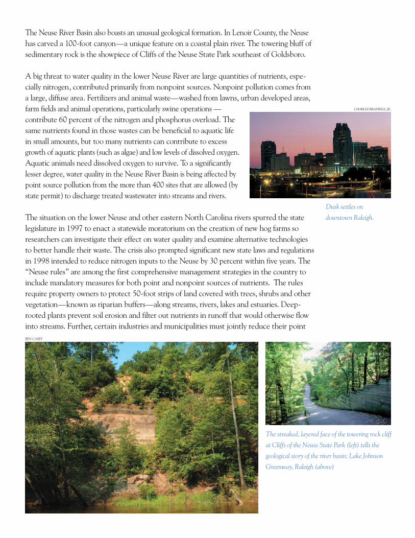
Dusk settles on
downtown Raleigh.
BEN CASEY
CHARLES BRASWELL JR.
source wastewater discharges into the river. Ten major cities in the basin must now limit storm -water runoff in new developments, and measures to reduce nitrogen runoff are required onfarms, golf courses and other large areas of fertilized land. To learn more about the currentNeuse rules and how they affect you, visit the following website: http://portal.ncdenr.org/web/wq/ps/nps/neuse.
Although nutrient pollution has been the most publicized issue, population growth andaccompanying development contribute to increased stormwater runoff throughout the basin.As pavement and lawns replace natural forests and wood lands, rain and melting snow raceover land more quickly, carrying pollution and entering streams at a high speed. The Triangle(Raleigh-Durham-Chapel Hill region) was home to about 370,000 people in 1970; that pop -u lation has now surpassed 1 million. The population in Wake County alone increased over 45 percent between 2000 and 2010 and is projected to increase another 30 percent between2010 and 2020. By 2020 Wake County is expected to have over 1 million residents.
Government officials and residents will bechallenged to reduce existing sources ofwater pollution and ensure that populationgrowth does not contribute to new prob -lems. Meanwhile, individuals can strive todecrease erosion and runoff from their prop -erty and to improve the quality of runoff byreducing the use of fertilizers, pesticides andother potentially harmful chemicals.
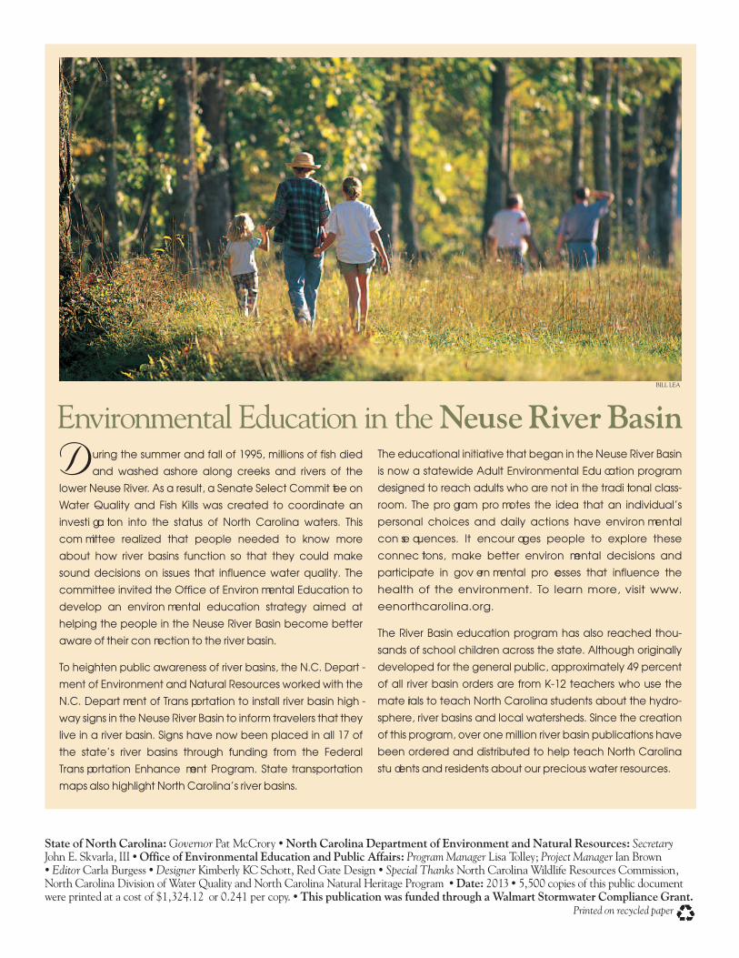
BILL LEA
A sandy beach at the
mouth of the Neuse
River near the Croatan
National Forest
NC DIVISION OF TOURISM, FILM AND SPORTS DEVELOPMENT
During the summer and fall of 1995, millions of fish died
and washed ashore along creeks and rivers of the
lower Neuse River. As a result, a Senate Select Commit tee on
Water Quality and Fish Kills was created to coordinate an
investi ga tion into the status of North Carolina waters. This
com mittee realized that people needed to know more
about how river basins function so that they could make
sound decisions on issues that influence water quality. The
committee invited the Office of Environ mental Education to
develop an environ mental education strategy aimed at
helping the people in the Neuse River Basin become better
aware of their con nection to the river basin.
To heighten public awareness of river basins, the N.C. Depart -
ment of Environment and Natural Resources worked with the
N.C. Depart ment of Trans portation to install river basin high -
way signs in the Neuse River Basin to inform travelers that they
live in a river basin. Signs have now been placed in all 17 of
the state’s river basins through funding from the Federal
Trans portation Enhance ment Program. State transportation
maps also highlight North Carolina’s river basins.
The educational initiative that began in the Neuse River Basin
is now a statewide Adult Environmental Edu cation program
designed to reach adults who are not in the tradi tional class -
room. The pro gram pro motes the idea that an individual’s
personal choices and daily actions have environ mental
con se quences. It encour ages people to explore these
connec tions, make better environ mental decisions and
participate in gov ern mental pro cesses that influence the
health of the environment. To learn more, visit www.
eenorthcarolina.org.
The River Basin education program has also reached thou -
sands of school children across the state. Although originally
developed for the general public, approximately 49 percent
of all river basin orders are from K-12 teachers who use the
mate rials to teach North Carolina students about the hydro -
sphere, river basins and local watersheds. Since the creation
of this program, over one million river basin publications have
been ordered and distributed to help teach North Carolina
stu dents and residents about our precious water resources.
Environmental Education in the Neuse River BasinBILL LEA
State of North Carolina: Governor Pat McCrory • North Carolina Department of Environment and Natural Resources: Secretary John E. Skvarla, III • Office of Environmental Education and Public Affairs: Program Manager Lisa Tolley; Project Manager Ian Brown• EditorCarla Burgess • Designer Kimberly KC Schott, Red Gate Design • Special ThanksNorth Carolina Wildlife Resources Commission,North Carolina Division of Water Quality and North Carolina Natural Heritage Program • Date: 2013 • 5,500 copies of this public documentwere printed at a cost of $1,324.12 or 0.241 per copy. • This publication was funded through a Walmart Stormwater Compliance Grant.
Printed on recycled paper
Durham
Cary Raleigh
Garner
Smithfield
Wilson
Goldsboro
Kinston
New Bern
Havelock
Snow Hill
Bayboro
Trenton
WakeForestFalls Lake
CatfishLake
Long
Lake
Lake Ellis Simon
GreatLake
LittleLake
N e u s e
R i v e r
N e u s eR i v
e r
PERSON
ORANGEDURHAM
WAKE
GRANVILLE
JOHNSTON
WILSON
WAYNE
GREENE
LENOIR
JONES
CRAVEN
PITT
PAMLICO
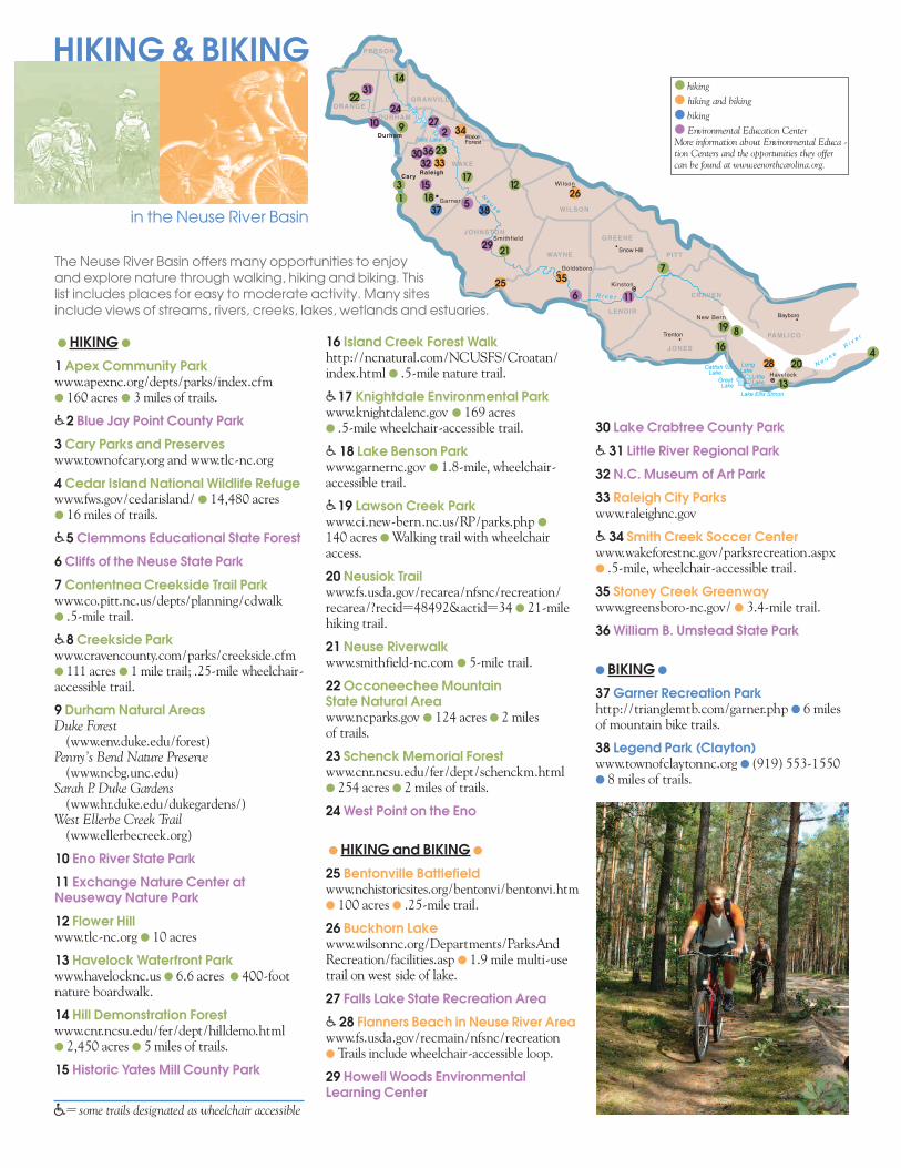
HIKING & BIKING
in the Neuse River Basin
16 Island Creek Forest Walkhttp://ncnatural.com/NCUSFS/Croatan/index.html l .5-mile nature trail.
�17 Knightdale Environmental Parkwww.knightdalenc.gov l 169 acres l .5-mile wheelchair-accessible trail.
� 18 Lake Benson Parkwww.garnernc.gov l 1.8-mile, wheelchair-accessible trail.
�19 Lawson Creek Parkwww.ci.new-bern.nc.us/RP/parks.php l
140 acres lWalking trail with wheelchairaccess.
20 Neusiok Trailwww.fs.usda.gov/recarea/nfsnc/recreation/recarea/?recid=48492&actid=34 l 21-milehiking trail.
21 Neuse Riverwalkwww.smithfield-nc.com l 5-mile trail.
22 Occoneechee Mountain State Natural Area www.ncparks.gov l 124 acres l 2 miles of trails.
23 Schenck Memorial Forestwww.cnr.ncsu.edu/fer/dept/schenckm.htmll 254 acres l 2 miles of trails.
24 West Point on the Eno
l HIKING and BIKING l
25 Bentonville Battlefieldwww.nchistoricsites.org/bentonvi/bentonvi.html 100 acres l .25-mile trail.
26 Buckhorn Lakewww.wilsonnc.org/Departments/ParksAndRecreation/facilities.asp l 1.9 mile multi-usetrail on west side of lake.
27 Falls Lake State Recreation Area
� 28 Flanners Beach in Neuse River Areawww.fs.usda.gov/recmain/nfsnc/recreationl Trails include wheelchair-accessible loop.
29 Howell Woods EnvironmentalLearning Center
l HIKING l
1 Apex Community Parkwww.apexnc.org/depts/parks/index.cfml 160 acres l 3 miles of trails.
�2 Blue Jay Point County Park3 Cary Parks and Preserveswww.townofcary.org and www.tlc-nc.org
4 Cedar Island National Wildlife Refugewww.fws.gov/cedarisland/ l 14,480 acresl 16 miles of trails.
�5 Clemmons Educational State Forest6 Cliffs of the Neuse State Park
7 Contentnea Creekside Trail Park www.co.pitt.nc.us/depts/planning/cdwalkl .5-mile trail.
�8 Creekside Parkwww.cravencounty.com/parks/creekside.cfml 111 acres l 1 mile trail; .25-mile wheelchair-accessible trail.
9 Durham Natural AreasDuke Forest(www.env.duke.edu/forest)
Penny’s Bend Nature Preserve(www.ncbg.unc.edu)
Sarah P. Duke Gardens(www.hr.duke.edu/dukegardens/)
West Ellerbe Creek Trail(www.ellerbecreek.org)
10 Eno River State Park
11 Exchange Nature Center atNeuseway Nature Park
12 Flower Hillwww.tlc-nc.org l 10 acres
13 Havelock Waterfront Park www.havelocknc.us l 6.6 acres l 400-footnature boardwalk.
14 Hill Demonstration Forestwww.cnr.ncsu.edu/fer/dept/hilldemo.htmll 2,450 acres l 5 miles of trails.
15 Historic Yates Mill County Park
30 Lake Crabtree County Park
� 31 Little River Regional Park32 N.C. Museum of Art Park
33 Raleigh City Parkswww.raleighnc.gov
� 34 Smith Creek Soccer Centerwww.wakeforestnc.gov/parksrecreation.aspxl .5-mile, wheelchair-accessible trail.
35 Stoney Creek Greenwaywww.greensboro-nc.gov/ l 3.4-mile trail.
36 William B. Umstead State Park
l BIKING l
37 Garner Recreation Parkhttp://trianglemtb.com/garner.php l 6 milesof mountain bike trails.
38 Legend Park (Clayton)www.townofclaytonnc.org l (919) 553-1550l 8 miles of trails.
The Neuse River Basin offers many opportunities to enjoy and explore nature through walking, hiking and biking. This list includes places for easy to moderate activity. Many sitesinclude views of streams, rivers, creeks, lakes, wetlands and estuaries.
l hiking
l hiking and biking
l biking
l Environmental Education CenterMore information about Environmental Educa -tion Centers and the opportunities they offercan be found at www.eenorthcarolina.org.
�= some trails designated as wheelchair accessible
1
2
3
4
5
6
7
8
910
11
12
13
14
15
16
17
19
20
22
23
24
25
26
27
28
29
18
30
31
32 33
34
35
36
37 38
21
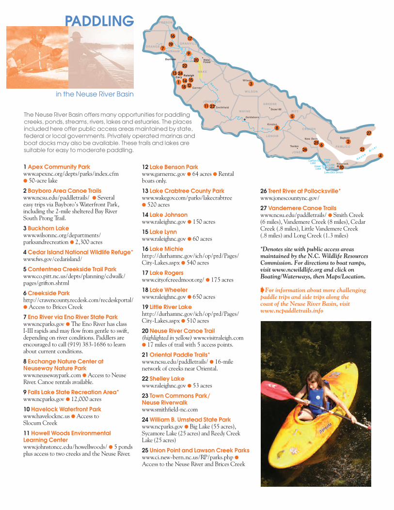
12 Lake Benson Parkwww.garnernc.gov l 64 acres l Rental boats only.
13 Lake Crabtree County Parkwww.wakegov.com/parks/lakecrabtreel 520 acres
14 Lake Johnsonwww.raleighnc.gov l 150 acres
15 Lake Lynnwww.raleighnc.gov l 60 acres
16 Lake Michiehttp://durhamnc.gov/ich/op/prd/Pages/City-Lakes.aspx l 540 acres
17 Lake Rogerswww.cityofcreedmoor.org/ l 175 acres
18 Lake Wheelerwww.raleighnc.gov l 650 acres
19 Little River Lakehttp://durhamnc.gov/ich/op/prd/Pages/City-Lakes.aspx l 510 acres
20 Neuse River Canoe Trail (highlighted in yellow)www.visitraleigh.coml 17 miles of trail with 5 access points.
21 Oriental Paddle Trails*www.ncsu.edu/paddletrails/ l 16-milenetwork of creeks near Oriental.
22 Shelley Lakewww.raleighnc.gov l 53 acres
23 Town Commons Park/Neuse Riverwalkwww.smithfield-nc.com
24 William B. Umstead State Parkwww.ncparks.gov l Big Lake (55 acres),Sycamore Lake (25 acres) and Reedy Creek Lake (25 acres)
25 Union Point and Lawson Creek Parkswww.ci.new-bern.nc.us/RP/parks.php l
Access to the Neuse River and Brices Creek
1 Apex Community Parkwww.apexnc.org/depts/parks/index.cfml 50-acre lake
2 Bayboro Area Canoe Trailswww.ncsu.edu/paddletrails/ l Several easy trips via Bayboro’s Waterfront Park,including the 2-mile sheltered Bay River South Prong Trail.
3 Buckhorn Lakewww.wilsonnc.org/departments/parksandrecreation l 2,300 acres
4 Cedar Island National Wildlife Refuge*www.fws.gov/cedarisland/
5 Contentnea Creekside Trail Parkwww.co.pitt.nc.us/depts/planning/cdwalk/pages/grifton.shtml
6 Creekside Parkhttp://cravencounty.recdesk.com/recdeskportal/lAccess to Brices Creek
7 Eno River via Eno River State Parkwww.ncparks.gov l The Eno River has class I-III rapids and may flow from gentle to swift,depending on river conditions. Paddlers areencouraged to call (919) 383-1686 to learnabout current conditions.
8 Exchange Nature Center atNeuseway Nature Parkwww.neusewaypark.com lAccess to NeuseRiver. Canoe rentals available.
9 Falls Lake State Recreation Area*www.ncparks.gov l 12,000 acres
10 Havelock Waterfront Park www.havelocknc.us lAccess to Slocum Creek
11 Howell Woods EnvironmentalLearning Centerwww.johnstoncc.edu/howellwoods/ l 5 pondsplus access to two creeks and the Neuse River.
The Neuse River Basin offers many opportunities for paddling creeks, ponds, streams, rivers, lakes and estuaries. The places included here offer public access areas maintained by state, federal or local governments. Privately operated marinas and boat docks may also be available. These trails and lakes are suitable for easy to moderate paddling.
PADDLING
in the Neuse River Basin
Durham
Cary Raleigh
Garner
Smithfield
Wilson
Goldsboro
Kinston
New Bern
Havelock
Snow Hill
Bayboro
Trenton
WakeForest
PERSON
ORANGEDURHAM
GRANVILLE
JOHNSTON
WILSON
WAYNE
GREENE
LENOIR
JONES
CRAVEN
PITT
PAMLICO
WAKE
Falls Lake
N e u s e
R i v e r
CatfishLake
Long
Lake
Lake Ellis Simon
GreatLake
LittleLake
N e u s eR i v
e r
26 Trent River at Pollocksville*www.jonescountync.gov/
27 Vandemere Canoe Trailswww.ncsu.edu/paddletrails/ l Smith Creek (6 miles), Vandemere Creek (8 miles), CedarCreek (.8 miles), Little Vandemere Creek (.8 miles) and Long Creek (1.3 miles)
*Denotes site with public access areasmaintained by the N.C. Wildlife ResourcesCommission. For directions to boat ramps,visit www.ncwildlife.org and click onBoating/Waterways, then Maps/Location.
BFor information about more challengingpaddle trips and side trips along the coast of the Neuse River Basin, visitwww.ncpaddletrails.info
1
2
3
4
5
6
7
8
9
10
11
12
13
14 15
16 17
18
19
20
21
22
23
24
2526
27
WHERE SHOULD I GO?
?
What makes the Neuse River Basin special? See for yourself. Visit these EnvironmentalEducation Centers to discover more about your ecological address:l Arboretum at Johnston Community Collegel Bass Lake Park and Retreat Centerl Blue Jay Point Center for EnvironmentalEducation
l Chestnut Ridge Camp and Retreat Centerl Centennial Campus Center for Wildlife Education
l Center for Environmental Farming Systems at Cherry Research Farm
l Clemmons Educational State Forestl Cliffs of the Neuse State Parkl Crowder District Parkl Don Lee Centerl Durant Nature Parkl Eno River State Parkl Falls Lake State Recreation Areal Falls Lake Visitor Assistance Centerl Hatcher’s Bridge Tree Farml Historic Yates Mill County Parkl Howell Woods Environmental Learning Center
l Imagination StationFor more information about Environmental Education Centers in North Carolina, check out the Office of Environmental Education and Public Affairs’ website atwww.eenorthcarolina.org.
You can gain a sense of community pride by learning more and helping to protect streams, riversand lakes in the Catawba River Basin. The contacts listed below can help you do just that.To find out about local river organizations and conservation groups, contact your local soiland water conservation district. To find out about how you can get involved in local water -way and other litter cleanups, contact North Carolina Big Sweep.
Clean Water Management Trust Fundwww.cwmtf.net/
Division of Water Quality, Stormwater and Runoff Pollutionwww.ncstormwater.org/
Neuse River Basinwide Plan*http://portal.ncdenr.org/web/wq/ps/bpu/basin/neuse
Neuse River Education Teamwww.usawaterquality.org/themes/npm/success/NET.html
l Lake Crabtree County Parkl Little River Regional Parkl Museum of Life and Sciencel Neuseway Nature Park- Exchange Nature Center
l North Carolina Museum of Art Museum Parkl North Carolina Museum of Natural Sciencesl North Carolina Solar Centerl Prairie Ridge Ecostation for Wildlife and Learning
l Sarah P. Duke Gardensl Schoolhouse of Wonderl Stevens Nature Center at Hemlock Bluffs Nature Preserve
l Walnut Creek Wetland Centerl West Point on the Eno Parkl Weyerhaeuser’s Cool Springs Environmental Education Center
l William B. Umstead State Parkl Wilson Botanical Gardensl White Deer Park
Estuaries are often called
“nurseries” because they
provide shelter and food
for larval and juvenile fish
and shellfish.
BILL LEA
*Basinwide water quality planning is a nonregulatory, watershed-based approach to restoring and protecting thequality of North Carolina’s surface waters. The N.C. Division of Water Quality welcomes community input.
To order additional brochures on any of North Carolina’s 17 river basins, a general river basin booklet or a poster, fill out theonline order form at www.eenorthcarolina.org.t
North Carolina Association of Soil & Water Conservation Districtswww.ncaswcd.org
North Carolina Big Sweepwww.ncbigsweep.org/
North Carolina Stream Watchwww.ncwater.org/Education_and_Technical_Assistance/Stream_Watch
North Carolina Water Science Centerhttp://nc.water.usgs.gov/
HOWCANI HELP