Network Information Book Train Order Control Turrawan (exc ... · Turrawan (exc) to North Star...
52
Division / Business Unit: Enterprise Services Function: Operations Document Type: Guideline © Australian Rail Track Corporation Limited (ARTC) Disclaimer This document has been prepared by ARTC for internal use and may not be relied on by any other party without ARTC‟s prior written consent. Use of this document shall be subject to the terms of the relevant contract with ARTC. ARTC and its employees shall have no liability to unauthorised users of the information for any loss, damage, cost or expense incurred or arising by reason of an unauthorised user using or relying upon the information in this document, whether caused by error, negligence, omission or misrepresentation in this document. This document is uncontrolled when printed. Authorised users of this document should visit ARTC‟s intranet or extranet (www.artc.com.au) to access the latest version of this document. CONFIDENTIAL Page 1 of 52 Network Information Book Train Order Control Turrawan (exc) to North Star (inc) & Camurra West OGW-30-23 Applicability Hunter Valley Publication Requirement Internal / External Primary Source Local Appendices North Volume 4 Route Access Standard – Intrastate Network Section Pages I6 & Heavy Haul Network Section Pages H3 Document Status Version # Date Reviewed Prepared by Reviewed by Endorsed Approved 2.0 15 Sep 17 AGIBB Configuration Management Administrator Manager Standards Acting GM Technical Standards 17/11/17 Amendment Record Amendment Version # Date Reviewed Clause Description of Amendment 1.0 23 Mar 2016 First release of document 1.1 31 May 2016 2.0 Update of km references in text and diagrams relating to PTOS 2.0 15 Sep 2017 1.6, 1.14 Moree location updated to include Moree East siding and Fitzroy
Transcript of Network Information Book Train Order Control Turrawan (exc ... · Turrawan (exc) to North Star...

Division / Business Unit: Enterprise Services
Function: Operations
Document Type: Guideline
© Australian Rail Track Corporation Limited (ARTC)
Disclaimer
This document has been prepared by ARTC for internal use and may not be relied on by any other party without ARTC‟s prior written consent. Use of this document shall be subject
to the terms of the relevant contract with ARTC.
ARTC and its employees shall have no liability to unauthorised users of the information for any loss, damage, cost or expense incurred or arising by reason of an unauthorised user
using or relying upon the information in this document, whether caused by error, negligence, omission or misrepresentation in this document.
This document is uncontrolled when printed.
Authorised users of this document should visit ARTC‟s intranet or extranet (www.artc.com.au) to access the latest version of this document.
CONFIDENTIAL Page 1 of 52
Network Information Book
Train Order Control
Turrawan (exc) to North Star (inc) &
Camurra West
OGW-30-23
Applicability
Hunter Valley
Publication Requirement
Internal / External
Primary Source
Local Appendices North Volume 4
Route Access Standard – Intrastate Network Section Pages I6 & Heavy Haul Network Section Pages H3
Document Status
Version # Date Reviewed Prepared by Reviewed by Endorsed Approved
2.0 15 Sep 17 AGIBB Configuration
Management
Administrator
Manager
Standards
Acting GM Technical
Standards
17/11/17
Amendment Record
Amendment
Version #
Date Reviewed Clause Description of Amendment
1.0 23 Mar 2016 First release of document
1.1 31 May 2016 2.0 Update of km references in text and diagrams relating to PTOS
2.0 15 Sep 2017 1.6, 1.14 Moree location updated to include Moree East siding and Fitzroy

Turrawan (exc) to North Star (inc) & Camurra West
OGW-30-23
Table of Contents
This document is uncontrolled when printed. Version Number: 2.0 Date Reviewed: 15 Sep 17 Page 2 of 52
2.10, 2.16 Street Narrabri level crossing updated. Milguy loop length and
North Star LPA & TOA information added.

Turrawan (exc) to North Star (inc) & Camurra West
OGW-30-23
Table of Contents
This document is uncontrolled when printed. Version Number: 2.0 Date Reviewed: 15 Sep 17 Page 3 of 52
Table of Contents
Table of Contents ............................................................................................................................................. 3
1 General Information ............................................................................................................................... 5
1.1 Board Extent................................................................................................................................... 5
1.2 Safe Working System ..................................................................................................................... 5
1.3 Applicable Rules ............................................................................................................................ 5
1.4 Adjacent Train Control Centres ...................................................................................................... 5
1.5 Section Operating Equipment / Notes ............................................................................................ 5
1.5.1 Motorised Point Machines .............................................................................................................. 5
1.5.2 Interlockings and Sidings ................................................................................................................ 6
1.5.3 Unfenced lines ................................................................................................................................ 6
1.6 Level Crossings .............................................................................................................................. 7
1.7 Maximum Permitted Speeds and Permanent Speed Restrictions ............................................... 11
1.8 Maximum Train Length ................................................................................................................ 11
1.9 Structure Clearances ................................................................................................................... 11
1.10 Communications .......................................................................................................................... 12
1.11 Wayside Monitoring Systems ....................................................................................................... 13
1.12 Ruling Gradients .......................................................................................................................... 13
1.13 Curve and Gradient Data ............................................................................................................. 13
1.14 Drawing Legend ........................................................................................................................... 14
2 Locations and Sections Information .................................................................................................. 15
2.1 Turrawan (exclusive) .................................................................................................................... 15
2.2 Narrabri Junction (NBJ) ................................................................................................................ 17
2.3 Narrabri (NBI) ............................................................................................................................... 20
2.4 Narrabri North............................................................................................................................... 23
2.5 Edgeroi (EBG) .............................................................................................................................. 25
2.6 Bellata (BLT) ................................................................................................................................ 27
2.7 Penny‟s Road (EWB) ................................................................................................................... 30
2.8 Gurley (GUR) ............................................................................................................................... 32
2.9 Moree South (MRS) ..................................................................................................................... 35
2.10 Moree (MRE) ................................................................................................................................ 39
2.11 Camurra (CMR) ............................................................................................................................ 42
2.12 Camurra West (CCW) .................................................................................................................. 44

Turrawan (exc) to North Star (inc) & Camurra West
OGW-30-23
Table of Contents
This document is uncontrolled when printed. Version Number: 2.0 Date Reviewed: 15 Sep 17 Page 4 of 52
2.13 Milguy (MIY) ................................................................................................................................. 45
2.14 Crooble (CRO) ............................................................................................................................. 47
2.15 Croppa Creek (CRP) .................................................................................................................... 49
2.16 North Star (NTS) .......................................................................................................................... 51

Turrawan (exc) to North Star (inc) & Camurra West
OGW-30-23
General Information
This document is uncontrolled when printed. Version Number: 2.0 Date Reviewed: 15 Sep 17 Page 5 of 52
1 General Information
1.1 Board Extent
Turrawan 547.694 to North Star 760.460km
This area is controlled by Network Controller NCCN TOCO.
Contact Numbers:
Phone: 02 4902 7916
Train Transit Manager: 02 4902 9410
Emergency: 02 4902 7976
1.2 Safe Working System
Phoenix Train Order System
Operator‟s Key – Sidings Narrabri Junction to North Star
Work on Track in sidings and North Star yard require a manual TOA.
1.3 Applicable Rules
The Network Rules and Procedures apply to the sections covered by this Information Book.
1.4 Adjacent Train Control Centres
John Holland Rail – North West Control Phone: 02 4028 9501
ARTC North ph 02 4902 7902 Emergency 02 4902 7962
1.5 Section Operating Equipment / Notes
1.5.1 Motorised Point Machines
There are no motorised points in this territory.

Turrawan (exc) to North Star (inc) & Camurra West
OGW-30-23
General Information
This document is uncontrolled when printed. Version Number: 2.0 Date Reviewed: 15 Sep 17 Page 6 of 52
1.5.2 Interlockings and Sidings
Km Interlocking, Station, Platform or Siding Length of Passenger Platform
in Metres
565.009 Narrabri Junction
569.240 Narrabri Main, 194
572.840 Narrabri North
593.561 Edgeroi Through Road, 35
615.468 Bellata Main, 88
623.979 Pennys Road
635.414 Gurley Main, 9
661.888 Moree South (includes Saleyard, Louis Dreyfus
Commodities, Silo, Wheat & Vegetable sidings)
665.600 Moree Main, 116
676.895 Camurra
679.040 Camurra West
706.830 Milguy
717.906 Crooble
733.599 Croppa Creek
758.571 North Star
1.5.3 Unfenced lines
The maximum speeds over the following unfenced lines will be as shown in the Weekly Speed
Notice, the Train Operating Conditions Manual, or other printed notices.
Line Unfenced from Unfenced to
Werris Creek – Camurra West Narrabri (Newell Highway)
569.849km
Camurra West 679.040km
Camurra – North Star Camurra 677.030km North Star End 760.480km
When it becomes necessary to run trains during darkness on these lines, the electric headlight on
the locomotive must be operative and used by the Driver as shown in the Network Rules and
Procedures for use of headlights.
Drivers must keep a sharp lookout for any person or anything crossing the line, and observe
strictly the instructions in the working timetable in regard to permanent speed restrictions.
Drivers are reminded of the risk of accidents on unfenced lines.
Whenever cattle are seen on or near the line, the speed of the train must be reduced and, if
necessary to avoid an accident, the train must be stopped.
All cases of injury to animals must be reported to the Network Control Officer.

Turrawan (exc) to North Star (inc) & Camurra West
OGW-30-23
General Information
This document is uncontrolled when printed. Version Number: 2.0 Date Reviewed: 15 Sep 17 Page 7 of 52
1.6 Level Crossings
LXM
Number
Road Name Line Segment KM Traffic
Type
Access Control Type
3051 Narrabri Junction
Lxing
Werris Creek -
Mungindi
557.324 Private Stop Signs
3052 Narrabri Junction
Lxing
Werris Creek -
Mungindi
561.802 Private Stop Signs
537 Old Turrawan Road
Narrabri Junction
Werris Creek -
Mungindi
564.940 Public Primary Flashing
Lights
538 Fraser Street
Narrabri Junction
Werris Creek -
Mungindi
565.575 Public Stop Signs
539 McKenzie Street
Narrabri
Werris Creek -
Mungindi
566.915 Public Stop Signs
1904 McKenzie Street
Narrabri
Werris Creek -
Mungindi
566.970 Public Pedestrian Maze
540 Fitzroy Street
Narrabri
Werris Creek -
Mungindi
568.850 Public Half Boom Flashing
Lights Axle Counter
541 Doyle Street Werris Creek -
Mungindi
569.850 Public Stop Signs
542 Stock Route Werris Creek -
Mungindi
570.360 Public Stop Signs
3053 Narrabri Lxing Werris Creek -
Mungindi
573.850 Private Stop Signs
3054 Narrabri Lxing Werris Creek -
Mungindi
575.920 Private Stop Signs
3055 Narrabri Lxing
Werris Creek -
Mungindi
578.080 Private Stop Signs
3056 Narrabri Lxing
Werris Creek -
Mungindi
580.444 Private Stop Signs
3057 Edgeroi Lxing
Werris Creek -
Mungindi
582.887 Private Stop Signs
3058 Edgeroi Lxing
Werris Creek -
Mungindi
586.100 Private Stop Signs
3059 Edgeroi Lxing
Werris Creek -
Mungindi
588.600 Private Stop Signs
3060 Edgeroi Lxing
Tarlee Access
Werris Creek -
Mungindi
589.700 Private Stop Signs
543 Bald Hill Road
Edgeroi
Werris Creek -
Mungindi
593.420 Public Stop Signs on
2 Tracks
3061 Edgeroi Lxing Werris Creek -
Mungindi
595.050 Private Stop Signs
1827 Moree Road
Edgeroi
Werris Creek -
Mungindi
596.630 Public Stop Signs
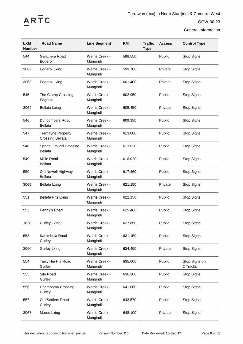
Turrawan (exc) to North Star (inc) & Camurra West
OGW-30-23
General Information
This document is uncontrolled when printed. Version Number: 2.0 Date Reviewed: 15 Sep 17 Page 8 of 52
LXM
Number
Road Name Line Segment KM Traffic
Type
Access Control Type
544 Galathera Road
Edgeroi
Werris Creek -
Mungindi
598.550 Public Stop Signs
3062 Edgeroi Lxing Werris Creek -
Mungindi
599.700 Private Stop Signs
3063 Edgeroi Lxing Werris Creek -
Mungindi
601.400 Private Stop Signs
545 The Clump Crossing
Edgeroi
Werris Creek -
Mungindi
602.950 Public Stop Signs
3064 Bellata Lxing Werris Creek -
Mungindi
605.450 Private Stop Signs
546 Duncombers Road
Bellata
Werris Creek -
Mungindi
609.350 Public Stop Signs
547 Tremayne Property
Crossing Bellata
Werris Creek -
Mungindi
613.080 Public Stop Signs
548 Sports Ground Crossing
Bellata
Werris Creek -
Mungindi
613.630 Public Stop Signs
549 Millie Road
Bellata
Werris Creek -
Mungindi
616.020 Public Stop Signs
550 Old Newell Highway
Bellata
Werris Creek -
Mungindi
617.460 Public Stop Signs
3065 Bellata Lxing
Werris Creek -
Mungindi
621.150 Private Stop Signs
551 Bellata Pits Lxing Werris Creek -
Mungindi
622.150 Public Stop Signs
552 Penny‟s Road Werris Creek -
Mungindi
625.460 Public Stop Signs
1828 Gurley Lxing
Werris Creek -
Mungindi
627.850 Public Stop Signs
553 Kanimbula Road
Gurley
Werris Creek -
Mungindi
631.150 Public Stop Signs
3066 Gurley Lxing
Werris Creek -
Mungindi
634.490 Private Stop Signs
554 Terry Hie Hie Road
Gurley
Werris Creek -
Mungindi
635.600 Public Stop Signs on
2 Tracks
555 Silo Road
Gurley
Werris Creek -
Mungindi
636.300 Public Stop Signs
556 Coomooma Crossing
Gurley
Werris Creek -
Mungindi
641.060 Public Stop Signs
557 Old Settlers Road
Gurley
Werris Creek -
Mungindi
643.570 Public Stop Signs
3067 Moree Lxing
Werris Creek -
Mungindi
648.100 Private Stop Signs

Turrawan (exc) to North Star (inc) & Camurra West
OGW-30-23
General Information
This document is uncontrolled when printed. Version Number: 2.0 Date Reviewed: 15 Sep 17 Page 9 of 52
LXM
Number
Road Name Line Segment KM Traffic
Type
Access Control Type
1829 Moree Lxing
Werris Creek -
Mungindi
649.350 Public Stop Signs
558 Tapscott Road
Moree
Werris Creek -
Mungindi
658.027 Public Half Boom Flashing
Lights
559 Burrington Road
Moree
Werris Creek -
Mungindi
659.800 Public Half Boom Flashing
Lights
560 Bullus Drive
Moree
Werris Creek -
Mungindi
664.333 Public Half Boom Flashing
Lights
561 Alice Street
Moree
Werris Creek -
Mungindi
665.846 Public Half Boom Flashing
Lights
3068 Tycannah Street
Werris Creek -
Mungindi
666.731 Private Stop Signs
562 Gwydirfield Road
Moree
Werris Creek -
Mungindi
669.900 Public Stop Signs
3069 Moree Lxing
Werris Creek -
Mungindi
671.015 Private Stop Signs
3070 Moree Lxing Werris Creek -
Mungindi
672.600 Private Stop Signs
3071 Camurra Lxing
Werris Creek -
Mungindi
674.450 Private Stop Signs
563 The Rocks Lxing
Camurra
Werris Creek -
Mungindi
675.805 Public Stop Signs
564 Pallamallawa Road
Camurra
Werris Creek -
Mungindi
676.630 Public Stop Signs
143 Newell Highway
Camurra
Werris Creek -
Mungindi
677.745 Public Primary Flashing
Lights
3149 Camurra Lxing
Camurra -
Boggabilla
679.200 Private Stop Signs
3150 Camurra Lxing
Camurra -
Boggabilla
680.720 Private Stop Signs
3151 Camurra Lxing
Camurra -
Boggabilla
682.850 Private Stop Signs
3152 Camurra Lxing
Camurra -
Boggabilla
684.920 Private Stop Signs
1841 Camurra Lxing
Camurra -
Boggabilla
686.420 Public Stop Signs
1842 Camurra Lxing
Camurra -
Boggabilla
686.480 Public Stop Signs
3153 Camurra Lxing
Camurra -
Boggabilla
689.505 Private Stop Signs
3154 Camurra Lxing
Camurra -
Boggabilla
692.800 Private Stop Signs

Turrawan (exc) to North Star (inc) & Camurra West
OGW-30-23
General Information
This document is uncontrolled when printed. Version Number: 2.0 Date Reviewed: 15 Sep 17 Page 10 of 52
LXM
Number
Road Name Line Segment KM Traffic
Type
Access Control Type
909 Wongabinda Road
Camurra
Camurra -
Boggabilla
693.970 Public Give Way Signs
910 Pallamallawa Road
Milguy
Camurra -
Boggabilla
700.930 Public Give Way Signs
3155 Milguy Lxing
Camurra -
Boggabilla
701.875 Private Stop Signs
3156 Milguy Lxing
Camurra -
Boggabilla
704.690 Private Stop Signs
3157 Milguy Lxing
Camurra -
Boggabilla
705.300 Private Stop Signs
911 Milguy Lxing Camurra -
Boggabilla
706.560 Public Stop Signs
3158 Milguy Lxing
Camurra -
Boggabilla
708.755 Private Stop Signs
912 Crooble Lxing Camurra -
Boggabilla
710.950 Public Stop Signs
3159 Crooble Lxing
Camurra -
Boggabilla
711.710 Private Stop Signs
3160 Crooble Lxing
Camurra -
Boggabilla
716.360 Private Stop Signs
913 Crooble Lxing Camurra -
Boggabilla
717.045 Public Stop Signs
914 Crooble Lxing
Camurra -
Boggabilla
717.630 Public Stop Signs
915 Crooble Lxing Camurra -
Boggabilla
718.835 Public Give Way Sign Up
Stop Sign Down
3161 Crooble Lxing
Camurra -
Boggabilla
721.145 Private Give Way Signs
916 Yamboon Road
Crooble
Camurra -
Boggabilla
724.890 Public Stop Signs
3162 Crooble Lxing
Camurra -
Boggabilla
727.430 Private Stop Signs
3163 Crooble Lxing
Camurra -
Boggabilla
728.980 Private Stop Signs
917 Moree Road
Crooble
Camurra -
Boggabilla
730.320 Public Give Way Signs
3164 Croppa Creek Lxing
Camurra -
Boggabilla
732.555 Private Stop Signs
918 Croppa Creek Lxing Camurra -
Boggabilla
733.920 Public Give Way Signs
919 Croppa Creek Lxing Camurra -
Boggabilla
736.435 Public Stop Signs

Turrawan (exc) to North Star (inc) & Camurra West
OGW-30-23
General Information
This document is uncontrolled when printed. Version Number: 2.0 Date Reviewed: 15 Sep 17 Page 11 of 52
LXM
Number
Road Name Line Segment KM Traffic
Type
Access Control Type
920 Croppa Ck Lxing
Murgo
Camurra -
Boggabilla
739.315 Public Stop Signs
921 North Star Lxing Camurra -
Boggabilla
742.835 Public Stop Signs
3165 North Star Lxing
Camurra -
Boggabilla
744.965 Private Stop Signs
3166 North Star Lxing
Camurra -
Boggabilla
747.055 Private Stop Signs
2401 North Star Lxing
Camurra -
Boggabilla
749.250 Private Stop Signs
3167 North Star Lxing
Camurra -
Boggabilla
750.095 Private Stop Signs
3168 North Star Lxing
Camurra -
Boggabilla
752.730 Private Stop Signs
922 North Star Lxing Camurra -
Boggabilla
755.565 Public Give Way Signs
3169 North Star Lxing
Camurra -
Boggabilla
756.410 Private Stop Signs
923 North Star Lxing Camurra -
Boggabilla
758.240 Public Stop Signs
1.7 Maximum Permitted Speeds and Permanent Speed Restrictions
Refer the Route Access Standard - Heavy Haul Network Section Pages H3 for all speed
information.
1.8 Maximum Train Length
The maximum train length is as per Planning approval.
1.9 Structure Clearances
Refer Route Access Standards for Rolling Stock Outlines.
Turrawan (exc) to North Star (inc) & Camurra West
OGW-30-23
General Information
This document is uncontrolled when printed. Version Number: 2.0 Date Reviewed: 15 Sep 17 Page 12 of 52
1.10 Communications
The National Train Communications System (NTCS) is the Primary communications system for
the ARTC controlled rail network and is mandatory for all operators to operate their locomotives
using a NTCS ICE (In-Cabin Equipment) Unit as the primary communications device.
A standard ICE unit is installed with the following components
Telstra NextG™ transceiver
Iridium satellite transceiver
UHF Radio
GPS
The ICE unit primary communications is via the Telstra NextG™ and backup communications is
provided via the Iridium Satellite network. The ICE unit will automatically call the appropriate
Network Control Centre (Broadmeadow or Junee) based on GPS location when the routine and
emergency buttons are pressed.
The UHF radio is used for the Local train Radio - Train to Train and train to track Side
communications.
UHF Local Train Radio (LTR) frequency details
Channel Name WB
Frequency: 450.050 MHz (UHF),
Bandwidth: 12.5 KHz,
EIRP: 41W (remote/low density areas), 8.3W (medium & high density areas)
Tx CTCSS: 173.8 Hz
Rx CTCSS: NA
Selcall: disabled
Channel Name Mountain Radio (WB)
Frequency: 450.050 MHz (UHF),
Bandwidth: 12.5 KHz,
EIRP: 41W (remote/low density areas), 8.3W (medium & high density areas)
Tx CTCSS: 103.5 Hz
Rx CTCSS: NA
Selcall: disabled
Alternate Communication for this section is by mobile or satellite phones.

Turrawan (exc) to North Star (inc) & Camurra West
OGW-30-23
General Information
This document is uncontrolled when printed. Version Number: 2.0 Date Reviewed: 15 Sep 17 Page 13 of 52
1.11 Wayside Monitoring Systems
There are no wayside monitoring systems in place in this section.
1.12 Ruling Gradients
Down 1 in 52
Up 1 in 87
1.13 Curve and Gradient Data
For all Curve and Gradient data, refer to the ARTC Internet.
https://extranet.artc.com.au/eng_network-config_cd.html

Turrawan (exc) to North Star (inc) & Camurra West
OGW-30-23
General Information
This document is uncontrolled when printed. Version Number: 2.0 Date Reviewed: 15 Sep 17 Page 14 of 52
1.14 Drawing Legend
Standard gauge
track
Passive
Protection Level
Crossing
Dual gauge track
Active Protection
Level Crossing –
Flashing Lights
Broad gauge
track
Active Protection
Level Crossing –
Lights and Boom
Crossover
Pedestrian
Crossing
Derail
Bridge or
Overpass
Points
Underpass
Advisory Sign or
Location Sign
River/Creek or
Significant river
bridge or Viaduct
75
80
20
4.6
63
Km
(D
M)
X80
X80
115NOR125XPT
NOR
XPT
Speed sign Station
Passenger Platform
Station or
Platform
Light Indicators
Dwarf Signals
LED Signals
74
.59
2 k
m
6
6D
10
9.1
28
km
4
Signal number
reference

Turrawan (exc) to North Star (inc) & Camurra West
OGW-30-23
Locations and Sections Information
This document is uncontrolled when printed. Version Number: 2.0 Date Reviewed: 15 Sep 17 Page 15 of 52
2 Locations and Sections Information
2.1 Turrawan (exclusive)
Train control north of Turrawan is by Train Order Working.
Train control south of and inclusive of Turrawan is by Rail Vehicle Detection controlled from
Network Control Centre North.
Begin Train Order Working and End Train Order Working signs are located at TN 4 home signal
(548.694km).
Turrawan (exc) to North Star (inc) & Camurra West
OGW-30-23
Locations and Sections Information
This document is uncontrolled when printed. Version Number: 2.0 Date Reviewed: 15 Sep 17 Page 16 of 52

Turrawan (exc) to North Star (inc) & Camurra West
OGW-30-23
Locations and Sections Information
This document is uncontrolled when printed. Version Number: 2.0 Date Reviewed: 15 Sep 17 Page 17 of 52
2.2 Narrabri Junction (NBJ)
General Arrangements
Narrabri Junction is a Train Order Siding Location.
The junction consists of the Main Line, South Triangle Loop, North Triangle Loop and the wheat
sub-terminal sidings. The South and North Triangle loops beyond the “End Train Order Working”
Sign and the wheat sidings are outside of Train Order Territory.
John Holland Rail CRN Yard working is in operation beyond the “End Train Order Working” signs
on the South and North Triangle loops. Trains and track vehicles must not depart the mainline
into Narrabri West without authority from JHR North-West Control.
Narrabri Junction and Narrabri are discreet Train Order Locations separated by back to back
Yard Limit signs.
There is no section between each location.
Yard Limits
A YARD LIMIT sign is located at 563.226km to indicate the Narrabri Junction yard limit in the
down direction.
A YARD LIMIT sign is located at 567.160km to indicate the Narrabri Junction yard limit in the up
direction.
Shunting Limits
A SHUNT LIMIT sign is provided at 566.261km to indicate the Narrabri Junction shunting limit in
the down direction.
A SHUNT LIMIT sign is provided at 563.726km to indicate the Narrabri Junction shunting limit in
the up direction
Operation of Points
All interlocked points at Narrabri Junction are operated and controlled from ground frames that
are released by Operator‟s Key.
Ground Frames
Frame D
Frame D is located on the Down side of the main line adjacent to the points and provides access
to the South Triangle loop.
Frame D is unlocked by a key from the bottom lock on Duplex lock D, which is mounted on a post
adjacent to frame D. The top lock of Duplex lock D is unlocked by Operator‟s key.
Frame A
Frame A is located on the Down side of the main line adjacent to the points and provides access
to the Wheat sidings and the North Triangle loop.
Frame A is unlocked by a key from the bottom lock on Duplex lock A, which is mounted on a post
adjacent to frame A. The top lock of Duplex lock A is unlocked by Operator‟s key.
Yard Working Notice Boards
Notice boards, inscribed "Yard working STOP" on both sides, are provided on the Down side of
the North triangle loop next to the catchpoints for frame A.

Turrawan (exc) to North Star (inc) & Camurra West
OGW-30-23
Locations and Sections Information
This document is uncontrolled when printed. Version Number: 2.0 Date Reviewed: 15 Sep 17 Page 18 of 52
Old Turrawan Road Level Crossing
Type F flashing lights and bells are provided at Old Turrawan Road level crossing at 564.940km.
The warning equipment is automatically controlled by track circuit for Down and Up trains on the
main line, and manually controlled by the operation of duplex locks.
Main Line Indicators
Main Line Indicators (MLIs) are located on the Sydney (“X” MLI) and the country (“Y” MLI)
approaches to the level crossing. During normal operation both “X” MLI and “Y” MLI will display
Yellow indications to approaching trains. A train approaching in one direction will place the MLI
for the opposite direction at Stop.
To clear the MLI for movements through the Old Turrawan Road level crossing after shunting
operations are completed, the set button in the “MLI Set / Cancel pushbutton box” located near
the MLI, needs to be pressed and held for one second. This will activate the level crossing
warning equipment and after 15 seconds cause the MLI to clear.
Duplex Locks
Duplex locks D and A enable the warning equipment at the Old Turrawan Road level crossing to
be cancelled for trains shunting the South Triangle loop, the North Triangle loop, and the wheat
siding.
The Duplex Lock for each ground frame holds the Annett key used to release the frame captive
until released by an Operator‟s key. This will place the MLI to stop and after 120 seconds cancel
the operation of the level crossing warning equipment.
Warning: To avoid delays to road traffic, if practical, the duplex lock should activate at least 120
seconds prior to the arrival of the shunting train”.
Shunting Narrabri Junction from Narrabri West Yard
It will be permissible for a train to shunt between Narrabri West yard and Narrabri Junction on the
authority of a shunt order for Narrabri Junction.
Authority must be obtained from the John Holland Rail CRN Network Controller for any
movement to / from Narrabri West yard.

Turrawan (exc) to North Star (inc) & Camurra West
OGW-30-23
Locations and Sections Information
This document is uncontrolled when printed. Version Number: 2.0 Date Reviewed: 15 Sep 17 Page 19 of 52

Turrawan (exc) to North Star (inc) & Camurra West
OGW-30-23
Locations and Sections Information
This document is uncontrolled when printed. Version Number: 2.0 Date Reviewed: 15 Sep 17 Page 20 of 52
2.3 Narrabri (NBI)
General Arrangements
Narrabri is a Train Order Siding Location.
Narrabri Junction, Narrabri and Narrabri North are discreet Train Order Locations separated by
back to back Yard Limit Signs. There is no section between each location.
A manned passenger station is located on the main line
Loop length 435 metres
Yard Limits
A YARD LIMIT sign is located at 567.160km to indicate the Narrabri yard limit in the down
direction.
A YARD LIMIT sign is located at 571.299km to indicate the Narrabri yard limit in the up direction.
Shunting Limits
A SHUNT LIMIT sign is provided at 570.520km to indicate the Narrabri shunting limit in the down
direction.
A SHUNT LIMIT sign is provided at 568.200km to indicate the Narrabri shunting limit in the up
direction
Operation of Points and Signals
All interlocked points are operated from ground frames.
Ground Frames
Frame B
Frame B is located on the Up side of the main line adjacent to the points and provides access to
the Loop line.
Frame B is unlocked by a key from Duplex Lock B.
Frame E
Frame E is located on the Down side of the main line adjacent to the points and provides access
to the Goods siding.
Frame E is unlocked by a key from Duplex Lock E.
Frame F
Frame F is located on the Up side of the main line adjacent to the points and provides access to
the Loop line.
Frame F is unlocked by a key from Duplex Lock F.
Frame H
Frame H is located on the Down side of the main line adjacent to the points and provides access
to the Goods siding.
Frame H is unlocked by Operator Key.

Turrawan (exc) to North Star (inc) & Camurra West
OGW-30-23
Locations and Sections Information
This document is uncontrolled when printed. Version Number: 2.0 Date Reviewed: 15 Sep 17 Page 21 of 52
Main Line Indicators
Main Line Indicator (X MLI) is located on the country approach to the level crossing. For traffic
travelling in the UP direction the X MLI will display a STOP indication for 15 minutes prior to the
scheduled arrival and 1 hour after the scheduled departure of the daily passenger train.
During this time, trains will be required to Clear X MLI via the pushbuttons provided on Narrabri
platform prior to proceeding across Fitzroy Street level crossing.
At all other times, the X MLI will display a Pulsating White aspect indicating the level crossing will
activate on approach.
All trains stopping at Narrabri Yard will be required to cancel the X MLI via the pushbuttons
provided, or via the Duplex Locks B or F. The level crossing warning equipment will cancel after
120 seconds.
Duplex Locks
Duplex Locks B and F enable the warning equipment at Fitzroy Street level crossing to be
cancelled for shunting trains.
The Duplex Lock for each ground frame holds the Annett key used to release the frame captive
until released by an Operator‟s key. This will place X MLI to STOP and after 120 seconds cancel
the operation of the level crossing warning equipment.
Fitzroy Street Level Crossing
Type F flashing lights and bells are provided at Fitzroy Street level crossing at 568.850km.
The warning equipment is activated via axle counter train detection equipment for down and up
trains on the main line, and manually controlled by the operation of duplex locks.

Turrawan (exc) to North Star (inc) & Camurra West
OGW-30-23
Locations and Sections Information
This document is uncontrolled when printed. Version Number: 2.0 Date Reviewed: 15 Sep 17 Page 22 of 52

Turrawan (exc) to North Star (inc) & Camurra West
OGW-30-23
Locations and Sections Information
This document is uncontrolled when printed. Version Number: 2.0 Date Reviewed: 15 Sep 17 Page 23 of 52
2.4 Narrabri North
General Arrangements
Narrabri North is a Train Order Siding location.
Narrabri North has a single siding also known as Auscott siding or North-West Commodities or
Christakos Cotton siding. This siding is clear of Train Order Territory.
Narrabri North and Narrabri are discreet Train Order Locations separated by back to back Yard
Limit signs. There is no section between each location.
Yard Limits
A YARD LIMIT sign is located at 571.299km to indicate the Narrabri North yard limit in the down
direction.
A YARD LIMIT sign is located at 574.144km to indicate the Narrabri North yard limit in the up
direction.
Shunting Limits
A SHUNT LIMIT sign is provided at 573.631km to indicate the Narrabri North shunting limit in the
down direction.
A SHUNT LIMIT sign is provided at 572.044km to indicate the Narrabri North shunting limit in the
up direction
Ground Frames
Frame A is located on the Down side of the main line adjacent to the points and provides access
to the North West Commodities siding.
Frame A is released by an Operator‟s key.

Turrawan (exc) to North Star (inc) & Camurra West
OGW-30-23
Locations and Sections Information
This document is uncontrolled when printed. Version Number: 2.0 Date Reviewed: 15 Sep 17 Page 24 of 52

Turrawan (exc) to North Star (inc) & Camurra West
OGW-30-23
Locations and Sections Information
This document is uncontrolled when printed. Version Number: 2.0 Date Reviewed: 15 Sep 17 Page 25 of 52
2.5 Edgeroi (EBG)
General Arrangements
Edgeroi is a Train Order Siding location. All sidings at Edgeroi are clear of Train Order Territory.
A passenger platform is located on the platform road, clear of the main line.
Platform Road 316 metres
Wheat Siding: 421 metres
Silo Road: 240 metres
Yard Limits
A YARD LIMIT sign is located at 591.729km to indicate the Edgeroi yard limit in the down
direction.
A YARD LIMIT sign is located at 595.151km to indicate the Edgeroi yard limit in the up direction.
Shunting Limits
A SHUNT LIMIT sign is provided at 594.652km to indicate the Edgeroi shunting limit in the down
direction.
A SHUNT LIMIT sign is provided at 592.255km to indicate the Edgeroi shunting limit in the up
direction
Ground Frames
Frame E
Frame E is located on the Up side of the main line adjacent to the points and provides access to
the wheat siding.
No. 1 lever in frame E is unlocked by an Operator‟s key.
Frame F
Frame F is located on the Up side of the main line adjacent to the points and provides access to
the through road.
No. 1 lever in frame F is unlocked by an Operator‟s key.
Frame B
Frame B is located on the Down side of the main line adjacent to the points and provides access
to the through road and the wheat siding.
No. 1 lever in frame B is unlocked by an Operator‟s key.
Bald Hill Road Level Crossing 593.420km
Conditional level crossing speed signage is installed at 593.350km in the down direction and
593.490km in the up direction. Additional signage adjacent to these signs restricts the standing of
rail traffic between these signs and reads as follows;
“Trains or Wagons are not to Stand Between this Sign and the Level Crossing.”
EXCEPTION: Rail traffic is permitted to stand between the signs as long as the rail traffic
is across the level crossing.
Turrawan (exc) to North Star (inc) & Camurra West
OGW-30-23
Locations and Sections Information
This document is uncontrolled when printed. Version Number: 2.0 Date Reviewed: 15 Sep 17 Page 26 of 52

Turrawan (exc) to North Star (inc) & Camurra West
OGW-30-23
Locations and Sections Information
This document is uncontrolled when printed. Version Number: 2.0 Date Reviewed: 15 Sep 17 Page 27 of 52
2.6 Bellata (BLT)
General Arrangements
Bellata is a Train Order Siding location. All sidings at Bellata are clear of Train Order Territory.
Passenger station is located on the main line.
Loop length: 636 metres
Yard Limits
A YARD LIMIT sign is located at 613.533km to indicate the Bellata yard limit in the down
direction.
A YARD LIMIT sign is located at 617.453km to indicate the Bellata yard limit in the up direction.
Shunting Limits
A SHUNT LIMIT sign is provided at 616.733km to indicate the Bellata shunting limit in the down
direction.
A SHUNT LIMIT sign is provided at 614.212km to indicate the Bellata shunting limit in the up
direction
Ground Frames
Frame H
Frame H is located on the Up side of the main line adjacent to the points and provides access to
the Wheat siding.
No. 1 lever in frame H is unlocked by an Operator‟s key.
Frame B
Frame B is located on the Up side of the main line adjacent to the points and provides access to
the loop line.
No. 1 lever in frame B is unlocked by an Operator‟s key.
Frame G
Frame G is located on the Down side of the loop line adjacent to the points and provides access
to the shunting neck.
No. 1 lever in frame G is unlocked by an Operator‟s key.
Frame C
Frame C is located on the Up side of the main line adjacent to the points and provides access to
the loop line.
No. 1 lever in frame C is unlocked by an Operator‟s key.
Special Arrangements for Working Trains
Trains must not be allowed to foul the Millie Road public level crossing at 616.000 km for
extended periods.
Up trains requiring to stand for extended periods must, where possible, be drawn forward clear of
the crossing.

Turrawan (exc) to North Star (inc) & Camurra West
OGW-30-23
Locations and Sections Information
This document is uncontrolled when printed. Version Number: 2.0 Date Reviewed: 15 Sep 17 Page 28 of 52
When it is necessary for a train or a rail vehicle to cross the roadway, the Network Rules and
Procedures for shunting over level crossings must be carried out.

Turrawan (exc) to North Star (inc) & Camurra West
OGW-30-23
Locations and Sections Information
This document is uncontrolled when printed. Version Number: 2.0 Date Reviewed: 15 Sep 17 Page 29 of 52
Turrawan (exc) to North Star (inc) & Camurra West
OGW-30-23
Locations and Sections Information
This document is uncontrolled when printed. Version Number: 2.0 Date Reviewed: 15 Sep 17 Page 30 of 52
2.7 Penny’s Road (EWB)
General Arrangements
Penny‟s Road is a Train Order Siding location.
The AWB balloon loop and siding are clear of Train Order Territory.
Yard Limits
A YARD LIMIT sign is located at 622.679km to indicate the Penny‟s Road yard limit in the down
direction.
A YARD LIMIT sign is located at 625.279km to indicate the Penny‟s Road yard limit in the up
direction.
Shunting Limits
A SHUNT LIMIT sign is provided at 624.775km to indicate the Penny‟s Road shunting limit in the
down direction.
A SHUNT LIMIT sign is provided at 623.181km to indicate the Penny‟s Road shunting limit in the
up direction
Ground Frames
Frame A
No 1 lever in Frame A is unlocked by an Operator‟s key.

Turrawan (exc) to North Star (inc) & Camurra West
OGW-30-23
Locations and Sections Information
This document is uncontrolled when printed. Version Number: 2.0 Date Reviewed: 15 Sep 17 Page 31 of 52
Turrawan (exc) to North Star (inc) & Camurra West
OGW-30-23
Locations and Sections Information
This document is uncontrolled when printed. Version Number: 2.0 Date Reviewed: 15 Sep 17 Page 32 of 52
2.8 Gurley (GUR)
General Arrangements
Gurley is a Train Order Siding location.
All sidings at Gurley are clear of Train Order Territory.
A passenger platform is located on the main line
Loop length 653 metres (440m clear of level crossing)
Silo siding length 368 metres
Yard Limits
A YARD LIMIT sign is located at 633.769km to indicate the Gurley yard limit in the down
direction.
A YARD LIMIT sign is located at 637.556km to indicate the Gurley yard limit in the up direction.
Shunting Limits
A SHUNT LIMIT sign is provided at 637.057km to indicate the Gurley shunting limit in the down
direction.
A SHUNT LIMIT sign is provided at 634.246km to indicate the Gurley shunting limit in the up
direction
Ground Frames
Frame B
Frame B is located on the Down side of the main line adjacent to the points and provides access
to the Loop line.
Frame B is unlocked by an Operator‟s key.
Frame E
Frame E is located on the Down side of the main line adjacent to the crossovers and provides
access to the Loop line and the Silo siding.
Frame E is unlocked by an Operator‟s key.
Frame F
Frame F is located on the Down side of the main line adjacent to the points and provides access
to the Silo siding.
Frame F is unlocked by an Operator‟s key.
Terry Hie Hie Road Level Crossing 635.600km
Trains must not be allowed to foul the Terry Hie Hie Road level crossing for extended periods of
time.
Conditional level crossing speed signage is installed at 635.530km in the down direction and
635.670km in the up direction. Additional signage adjacent to these signs restricts the standing of
rail traffic between these signs and reads as follows;
“TRAINS OR WAGONS ARE NOT TO STAND BETWEEN THIS SIGN AND THE LEVEL
CROSSING.”

Turrawan (exc) to North Star (inc) & Camurra West
OGW-30-23
Locations and Sections Information
This document is uncontrolled when printed. Version Number: 2.0 Date Reviewed: 15 Sep 17 Page 33 of 52
EXCEPTION: Rail traffic is permitted to stand between the signs as long as the rail traffic is
across the level crossing.

Turrawan (exc) to North Star (inc) & Camurra West
OGW-30-23
Locations and Sections Information
This document is uncontrolled when printed. Version Number: 2.0 Date Reviewed: 15 Sep 17 Page 34 of 52
Turrawan (exc) to North Star (inc) & Camurra West
OGW-30-23
Locations and Sections Information
This document is uncontrolled when printed. Version Number: 2.0 Date Reviewed: 15 Sep 17 Page 35 of 52
2.9 Moree South (MRS)
General Arrangements
Moree South is a Train Order siding location with multiple sidings known as Stockyard, Louis
Dreyfus Commodities, Silo and Wheat sidings.
Moree South and Moree are discreet Train Order Locations separated by back to back Yard Limit
signs. There is no section between each location.
Yard Limits
A YARD LIMIT sign is located at 656.788km to indicate the Moree South yard limit in the down
direction.
A YARD LIMIT sign is located at 664.599km to indicate the Moree South yard limit in the up
direction.
Shunting Limits
A SHUNT LIMIT sign is provided at 664.501km to indicate the Moree South shunting limit in the
down direction.
A SHUNT LIMIT sign is provided at 658.047km to indicate the Moree South shunting limit in the
up direction
Tapscott Road Level crossing 658.027km
Type F flashing lights with bells and half boom barriers are provided at Tapscott Road level
crossing at 658.027km.
The warning equipment is automatically controlled by axle counters for Up and Down trains on
the main line and manually controlled by duplex locks for rail traffic shunting Moree Saleyard
siding and Louis Dreyfus Commodities Siding.
Duplex Lock D
Duplex Lock D is provided on the Main Line near frame D to enable the operation of the warning
equipment at Tapscott Road level crossing to be cancelled for rail traffic shunting the Moree
Saleyard siding.
The top lock of Duplex lock D is unlocked by the Operator‟s key
When the Operator‟s key is turned in the top lock, this will cancel the level crossing warning
equipment and release the key from the bottom lock.
Duplex Lock A
Duplex Lock A (Louis Dreyfus Commodities Siding) is provided on the Main Line near frame A to
enable the operation of the warning equipment at Tapscott Road level crossing to be cancelled
for rail traffic shunting the Louis Dreyfus Commodities siding.
The top lock of Duplex lock A is unlocked by the Operator‟s key.
When the Operator‟s key is turned in the top lock, this will cancel the level crossing warning
equipment and release the key from the bottom lock.
WARNING To avoid delays to road traffic, the operator’s key must not be removed from the
duplex lock until all shunting movements have been completed and the rail traffic is
ready to depart.

Turrawan (exc) to North Star (inc) & Camurra West
OGW-30-23
Locations and Sections Information
This document is uncontrolled when printed. Version Number: 2.0 Date Reviewed: 15 Sep 17 Page 36 of 52
Main Line Indicator
A Main Line Indicator (MLI) is provided in the up direction for the Tapscott Road level crossing.
“Y” MLI is facing to up directional rail traffic and is located on the Country side of the level
crossing. The MLI displays a pulsating white indication when warning equipment at a level
crossing is in working order and a red indication when at STOP.
The warning equipment is automatically controlled by track circuits for up and down directional
rail traffic on the main line. Provided Y MLI is clear, approaching rail traffic will activate the
operation of the level crossing.
The MLI can be placed at stop by either of two methods;
1. Through the use of the Set/Cancel Button located on Y MLI. With rail traffic stopped on the
approach track to the MLI, if the Cancel button is pressed for one second the MLI will be
placed at STOP. Placing the MLI at STOP will cancel the operation of the level crossing after
240 seconds.
2. Through the operation of the duplex lock at Frame D or Frame A will cause Y MLI to return to
the STOP position. If rail traffic occupies either of the approach tracks within 240 seconds of
the MLI being placed at STOP the level crossing warning equipment will operate but will
cease operation after the 240 seconds has elapsed.
The MLI may be cleared provided Duplex locks D and A are restored to the Normal position and
the route in the departing direction is clear. To clear the MLI, the “Set” button located on the MLI
must be pressed for one second. This will commence the operation of the level crossing warning
equipment and once the half boom barriers are fully descended the MLI will display a pulsating
white indication.
Ground Frames
Frame D (Saleyards Siding)
Frame D is located on the Down side of the main line adjacent to the points and provides access
to the Moree Saleyards siding.
Frame D is unlocked by key from Duplex Lock D.
Frames A and B (Louis Dreyfus Commodities Siding)
Frames A and B are located on the Down side of the main line adjacent to the points and provide
access to the Louis Dreyfus Commodities siding.
Frame A is unlocked by key from Duplex Lock A.
Duplex lock for frame B is unlocked by Operator‟s key, top lock releases fortress key for frame B.
Frames A, B, C, D and E (Silo and Vegetable Siding)
Frames A, B, C, D and E are located on the down side of the main line adjacent to the points and
provide access to the Silo siding and Vegetable siding.
Frames A and B are unlocked by Operator‟s Key.
Duplex locks for C, D and E, top lock released by Operator‟s Key, bottom locks releases keys for
frames C. D and E.

Turrawan (exc) to North Star (inc) & Camurra West
OGW-30-23
Locations and Sections Information
This document is uncontrolled when printed. Version Number: 2.0 Date Reviewed: 15 Sep 17 Page 37 of 52
Burrington Road Level Crossing 659.800km
Type F flashing lights with bells and half boom barriers are provided at Burrington Road level
crossing at 659.800km.
The warning equipment is automatically controlled by axle counters for Up and Down trains on
the main line.
Shunter‟s Push Button (MLI Set / Cancel) are located on down side adjacent to “X” MLI and on
the up country side of level crossing to enable the warning equipment at Burrington Road level
crossing to be cancelled for trains shunting Louis Dreyfus Commodities siding.
If the movement is not proceeded with, the warning indications must be cancelled by pressing the
“Cancel” in either of the Shunter‟s Push Button (MLI Set / Cancel) units located on down side
adjacent to “X” MLI and on the up country side of level crossing.
The shunter‟s push button units must be kept closed and secured by an SL lock when not in use.
Bulluss Drive Level Crossing 664.333km
Type F flashing lights with bells and half boom barriers are provided at Bulluss Drive level
crossing at 664.333 km.
The warning equipment is automatically controlled by track circuits for Up and Down trains on the
main line.
Shunter‟s Push Button (MLI Set / Cancel) are located adjacent to “A” MLI and “B” MLI and
adjacent to Frame E for “A” MLI and Frame K for “B” MLI to enable the warning equipment at
Bulluss Drive level crossing to be cancelled for trains shunting Moree South Vegetable Oil siding
and Moree Loop siding No 1 and Loop siding No 2.
If the movement is not proceeded with, the warning indications must be cancelled by pressing the
“Cancel” in either of the Shunter‟s Push Button (MLI Set / Cancel) units.
The shunter push button units must be kept closed and secured by an SL lock when not in use.

Turrawan (exc) to North Star (inc) & Camurra West
OGW-30-23
Locations and Sections Information
This document is uncontrolled when printed. Version Number: 2.0 Date Reviewed: 15 Sep 17 Page 38 of 52

Turrawan (exc) to North Star (inc) & Camurra West
OGW-30-23
Locations and Sections Information
This document is uncontrolled when printed. Version Number: 2.0 Date Reviewed: 15 Sep 17 Page 39 of 52
2.10 Moree (MRE)
General Arrangements
Moree is a Train Order siding location.
Passenger station is located on the main line.
Loop line surrounds the island platform and there is a second up siding beside loco.
NSW Trains Explorer NP43 / 44 stables in a compound off No.2 up siding.
Moree and Moree South are discreet Train Order Locations separated by back to back Yard Limit
signs. There is no section between each location.
Yard Limits
A YARD LIMIT sign is located at 664.599km to indicate the Moree yard limit in the down direction.
A YARD LIMIT sign is located at 667.154km to indicate the Moree yard limit in the up direction.
Shunting Limits
A SHUNT LIMIT sign is provided at 666.613km to indicate the Moree shunting limit in the down
direction.
A SHUNT LIMIT sign is provided at 664.698km to indicate the Moree shunting limit in the up
direction
Operation of Points
All interlocked points at Moree station are operated from ground frames which are released by
Operator Keys.
Ground Frames
Frames K and F
Frame K is located on the up side of the main line adjacent to the points and provides access to
No. 1 Up siding (loop).
Frame F is located on the up side of the main line adjacent to the points and provides access to
No. 1 Up siding (loop).
Duplex lock F top lock, released by Operator‟s Key, bottom lock releases key for frame F.
Frame H
Frame H is located on the up side of the main line adjacent to the points and provides access to
No. 2 Up siding.
Duplex lock H top lock released by Operator‟s Key, bottom lock releases key for frame H.
Alice Street Level Crossing 665.846km
Type F flashing lights with bells and half booms are provided at Alice Street level crossing at
665.846km.
The warning equipment is automatically controlled by axle counters for Up and Down trains on
the main line.

Turrawan (exc) to North Star (inc) & Camurra West
OGW-30-23
Locations and Sections Information
This document is uncontrolled when printed. Version Number: 2.0 Date Reviewed: 15 Sep 17 Page 40 of 52
Shunter‟s Push Button (MLI Set / Cancel) are located adjacent to “C” MLI and “D” MLI and
adjacent to Frame H to enable the warning equipment at Alice Street level crossing to be
cancelled for trains shunting Moree Main and Loop siding No 1 and Loop siding No 2.
If the movement is not proceeded with, the warning indications must be cancelled by pressing the
“Cancel” in either of the Shunter‟s Push Button (MLI Set / Cancel) units.
The shunter push button units must be kept closed and secured by an SL lock when not in use.
2.10.1 Moree East Siding
Up Rail Traffic from Moree East Siding
Up direction rail traffic from Moree East Siding is required to stop at the STOP sign located at
667.131km, rail traffic must not pass this STOP sign unless authorised by the ARTC NCCN
Network Controller.
Shunting Operations from Moree East Siding
The shunting operations from the Moree East siding to Moree location in the Up direction are to
use „No. 1 Loop Siding‟ at Moree.
Trains lengths that exceed the „No. 1 Loop Siding‟ track length, will require the train crew to
operate the Alice Street level crossing via the “Shunters Push Button” provided at “C” MLI prior to
proceeding past “C” MLI and be in possession of an authority issued by the Network Controller.
On the train clearing the level crossing, the level crossing active operation must be cancelled by
the train crew via the “Shunters Push Button”.

Turrawan (exc) to North Star (inc) & Camurra West
OGW-30-23
Locations and Sections Information
This document is uncontrolled when printed. Version Number: 2.0 Date Reviewed: 15 Sep 17 Page 41 of 52

Turrawan (exc) to North Star (inc) & Camurra West
OGW-30-23
Locations and Sections Information
This document is uncontrolled when printed. Version Number: 2.0 Date Reviewed: 15 Sep 17 Page 42 of 52
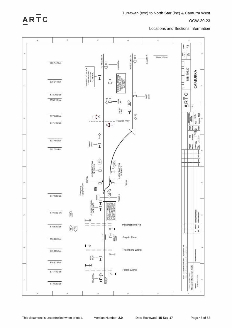
2.11 Camurra (CMR)
General Arrangements
Camurra is a Train Order block junction location, to ARTC North Star line, main line and Country
Regional Network (CRN) John Holland Rail (JHR) on the Weemelah line.
Camurra West is the interface point between the ARTC and JHR train order systems. The
interface point will be the Begin\End Network Control Boundary Location Signs located at
679.040kms.
NOTE: Rail Traffic must not depart onto the branch line without permission from the JHR
Network Controller
Yard Limits
A YARD LIMIT sign is located at 675.575km to indicate the Camurra yard limit in the down
direction.
A YARD LIMIT sign is located at 678.362km to indicate the Camurra yard limit in the up direction
from North Star.
A YARD LIMIT sign is located at 678.219km to indicate the Camurra yard limit in the up direction
from Weemelah.
Shunting Limits
A SHUNT LIMIT sign is provided at 677.884km to indicate the Camurra shunting limit in the down
direction towards North Star.
A SHUNT LIMIT sign is provided at 677.355km to indicate the Camurra shunting limit in the down
direction towards Weemelah.
A SHUNT LIMIT sign is provided at 676.281km to indicate the Camurra shunting limit in the up
direction
Operation of Points
Frame A interlocked points at Camurra are operated from the ground frame which is released by
Operator‟s Key.
Frame A points are interlocked with derail devices for trains travelling in the Up direction from
JHR CRN Weemelah line and ARTC North Star line.
Frame A is provided with a special locking arrangement so that the points may be left locked in
either the NORMAL or the REVERSE position to permit a train to be dispatched into the section
without having to restore the points to the normal position.
Newell Highway Level Crossing (677.745km)
Type F flashing lights with bells is provided at Newell Highway level crossing at 677.745km.
The warning equipment is automatically controlled by axle counters for Up and Down trains on
the main line.
Turrawan (exc) to North Star (inc) & Camurra West
OGW-30-23
Locations and Sections Information
This document is uncontrolled when printed. Version Number: 2.0 Date Reviewed: 15 Sep 17 Page 43 of 52

Turrawan (exc) to North Star (inc) & Camurra West
OGW-30-23
Locations and Sections Information
This document is uncontrolled when printed. Version Number: 2.0 Date Reviewed: 15 Sep 17 Page 44 of 52
2.12 Camurra West (CCW)
General Arrangements
Camurra West is a Train Order Block Location which is the interface point between ARTC and
JHR, location is at 679.040km on the Weemelah branch.
The End ARTC Control / Begin CRN Control sign facing towards down direction trains at
679.040km is the limit of authorities issued by the ARTC Network Controller.
The End CRN Control / Begin ARTC Control signs at 679.040km facing towards Up trains is the
limit of authorities issued by the JHR Network Controller.
Yard Limits
A YARD LIMIT sign is located at 678.219km to indicate the Camurra yard limit in the up direction
from Weemelah.
Begin/End ARTC/CRN Control signs are located at 679.040km.
Shunting Limits
There are no Shunting limits at Camurra West
Down Rail Traffic
Down trains are issued an authority by the ARTC Network Controller to the “End ARTC Control
sign”, trains cannot pass this point until they are in possession of an authority issued by the JHR
Network Controller to continue. The authority issued by ARTC cannot be fulfilled until the whole of
train has passed the End ARTC Control sign.
Up Rail Traffic
Up trains are issued an authority by the JHR Network Controller to the “End JHR Control sign”,
trains cannot pass this point until they are in possession of an authority issued by the ARTC
Network Controller to continue. The authority issued by JHR cannot be fulfilled until the whole of
train has passed the End JHR Control sign.

Turrawan (exc) to North Star (inc) & Camurra West
OGW-30-23
Locations and Sections Information
This document is uncontrolled when printed. Version Number: 2.0 Date Reviewed: 15 Sep 17 Page 45 of 52
2.13 Milguy (MIY)
General Arrangements
Milguy is a Train Order Siding location.
All sidings at Milguy are clear of Train Order Territory.
Loop Length is 1275m
Yard Limits
A YARD LIMIT sign is located at 705.296km to indicate the Milguy yard limit in the down direction.
A YARD LIMIT sign is located at 709.351km to indicate the Milguy yard limit in the up direction.
Shunting Limits
A SHUNT LIMIT sign is provided at 708.871km to indicate the Milguy shunting limit in the down
direction.
A SHUNT LIMIT sign is provided at 705.809km to indicate the Milguy shunting limit in the up
direction.
Ground Frames
Frames A and B
Frames A and B are located on the Up side of the main line adjacent to the points, and provide
access to the Silo siding.
Frames A and B are unlocked by Operator‟s key.
Telephone
A Telstra telephone is located on the Down side of the main line on a post adjacent to frame A.

Turrawan (exc) to North Star (inc) & Camurra West
OGW-30-23
Locations and Sections Information
This document is uncontrolled when printed. Version Number: 2.0 Date Reviewed: 15 Sep 17 Page 46 of 52

Turrawan (exc) to North Star (inc) & Camurra West
OGW-30-23
Locations and Sections Information
This document is uncontrolled when printed. Version Number: 2.0 Date Reviewed: 15 Sep 17 Page 47 of 52
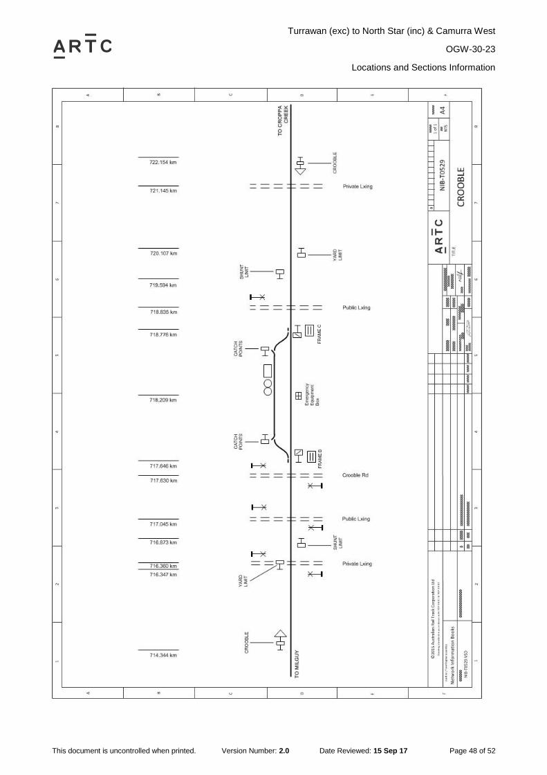
2.14 Crooble (CRO)
General Arrangements
Crooble is a Train Order Siding location.
All sidings at Crooble are clear of Train Order Territory.
Yard Limits
A YARD LIMIT sign is located at 716.347km to indicate the Crooble yard limit in the down
direction.
A YARD LIMIT sign is located at 720.107km to indicate the Crooble yard limit in the up direction.
Shunting Limits
A SHUNT LIMIT sign is provided at 719.594km to indicate the Crooble shunting limit in the down
direction.
A SHUNT LIMIT sign is provided at 716.873km to indicate the Crooble shunting limit in the up
direction.
Ground Frames
Frames B and C
Frames B and C are located on the Up side of the main line adjacent to the points, and provide
access to the Silo road.
Frames B and C are unlocked by Operator‟s key.
Turrawan (exc) to North Star (inc) & Camurra West
OGW-30-23
Locations and Sections Information
This document is uncontrolled when printed. Version Number: 2.0 Date Reviewed: 15 Sep 17 Page 48 of 52

Turrawan (exc) to North Star (inc) & Camurra West
OGW-30-23
Locations and Sections Information
This document is uncontrolled when printed. Version Number: 2.0 Date Reviewed: 15 Sep 17 Page 49 of 52
2.15 Croppa Creek (CRP)
General Arrangements
Croppa Creek is a Train Order Siding location.
All sidings at Croppa Creek are clear of Train Order Territory.
Yard Limits
A YARD LIMIT sign is located at 731.479km to indicate the Croppa Creek yard limit in the down
direction.
A YARD LIMIT sign is located at 735.005km to indicate the Croppa Creek yard limit in the up
direction.
Shunting Limits
A SHUNT LIMIT sign is provided at 734.502km to indicate the Croppa Creek shunting limit in the
down direction.
A SHUNT LIMIT sign is provided at 731.997km to indicate the Croppa Creek shunting limit in the
up direction
Ground Frames
Frames B and D
Frames B and D are located on the Up side of the main line adjacent to the points and provide
access to the Silo road.
Frames B and D are unlocked by Operator‟s key.
Telephone
A Telstra telephone is located on the Down side of the main line on a post adjacent to frame D.

Turrawan (exc) to North Star (inc) & Camurra West
OGW-30-23
Locations and Sections Information
This document is uncontrolled when printed. Version Number: 2.0 Date Reviewed: 15 Sep 17 Page 50 of 52

Turrawan (exc) to North Star (inc) & Camurra West
OGW-30-23
Locations and Sections Information
This document is uncontrolled when printed. Version Number: 2.0 Date Reviewed: 15 Sep 17 Page 51 of 52
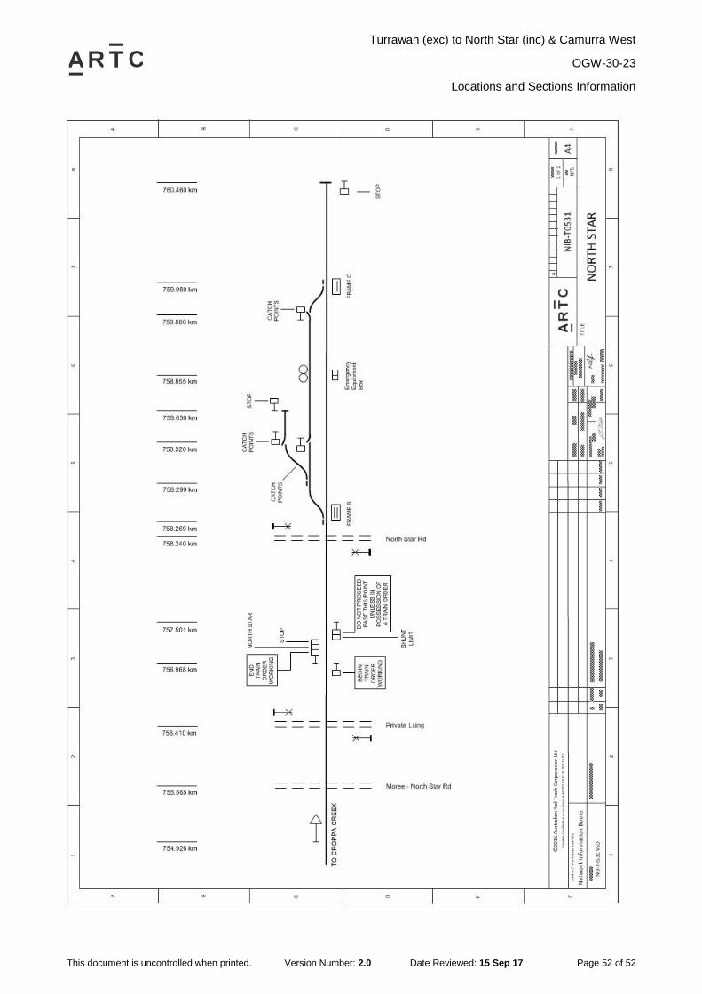
2.16 North Star (NTS)
General Arrangements
North Star is a Terminal Train Order location, clear of train order territory.
Train Order Territory finishes at the End TOW sign at 756.968km.
Trains work under yard working within North Star.
Track work needing a Track Occupancy Authority must obtain a manual TOA for the yard.
TOA & LPA Permissive Yards
Safeworking Arrangements
Where the location of a proposed Track Occupancy Authority (TOA) for a fixed worksite or a track
vehicle movement or a Local Possession Authority (LPA) includes or extends into an Unattended
Location where Permissive Yard Limits exist, the section either side of the Unattended Location
must also be included within the limits of the TOA or LPA.
This requirement is to ensure that rail traffic cannot approach the Permissive Yard Limit of an
Unattended Location, and will apply where signals exist to define the Yard Limit of the Location.
Exceptions
This requirement will not apply to a worksite within an Unattended Location where the points can
be secured to prevent access to the portion of track within the TOA or LPA limits. Where a
worksite is located within or a track vehicle journey extends into an Unattended Junction Location
where one or both branch lines are terminal lines and the Network Controller confirms that there
is no rail traffic on those lines it will not be necessary to obtain a TOA or LPA for the adjacent
sections on the terminal line or lines.
Yard Limits
A STOP/END TRAIN ORDER WORKING sign is located at 756.968km to indicate the North Star
yard limit in the down direction.
A STOP sign and block is located at 760.460km to indicate the North Star yard limit in the up
direction.
Shunting Limits
A SHUNT LIMIT sign is provided at 757.501km to indicate the North Star shunting limit in the up
direction.
Ground Frames
Frame B
Frame B is located on the Up side of the main line adjacent to the points and provides access to
the Silo siding and the Sleeper siding.
Frame B is unlocked by Operator‟s key.
Frame C
Frame C is located on the Up side of the main line adjacent to the points and provides access to
the Silo siding.
Frame C is unlocked by Operator‟s key.
Turrawan (exc) to North Star (inc) & Camurra West
OGW-30-23
Locations and Sections Information
This document is uncontrolled when printed. Version Number: 2.0 Date Reviewed: 15 Sep 17 Page 52 of 52