Nepal disaster report 2009
208
NEPAL DISASTER REPORT 2009 The Hazardscape andVulnerability GOVERNMENT OF NEPAL Ministry of Home Affairs
description
Nepal Disaster Report 2010:The hazardscape and vulnerabilities is an indication of Nepal’s resolve to tackle the challenges posed by natural disasters. For a country facing the difficulties of socioeconomicdevelopment, efforts to address the risks of disasters are necessary because disasters undermine social and economicwell-being. By highlighting challenges and presenting the way forward, this report shows the growing sense of urgency andthe need for seriousness in reducing disaster risks in Nepal.This report explains about the landsacpe of hazards in Nepal. This report is published by DPNet Nepal in Collaboration with MOHA GON, UNDP and Oxfam GB Nepal.
Transcript of Nepal disaster report 2009
N e p a lD i s a s t e r
r e p o r t 2 0 0 9The Hazardscape and Vulnerability
Government of nepal Ministry of Home Affairs
Nepal Disaster Report: The Hazardscape and Vulnerability
Ministry of Home Affairs (MoHA) and Nepal Disaster Preparedness Network-
Nepal. (DPNet)
published byMinistry of Home Affairs, Government of Nepal and Disaster Preparedness
Network- Nepal with support from European Commission through its Humanitarian
Aid department, United Nations Development Nepal and Oxfam Nepal
Any part of this publication may be cited, copied, translated into other languages
or adapted to meet local needs without prior permission from Ministry of Home
Affairs (MoHA) and Nepal Disaster Preparedness Network-Nepal, (DPNet)
provided that the source is clearly stated.
ISBN: 9937-2-1301-1
Printed in Nepal by: Jagadamba Press
Design and layout by: WordScape, +977 1 5526699
�
Content
PrefaceList of TablesList of BoxesList of FiguresAcronyms
Chapter 1: Nepal in the Himalaya-Ganga 1 Physical context 5 Climate and rainfall 11 A disaster hot spot 15 Climate change scenario 25 Objectives of the report 28 Approach to NDR 28
Chapter 2: Disaster Risk Reduction: Conceptual Foundation 31 Disaster cycle 36
Chapter 3: Floods and Flood Management 48 Floods: national context 52 Causes of floods in Nepal 54 Floods in the Bagmati and other rivers, 1993 58 Koshi inundation, 2008 58 Flood in Western Nepal, 2008 59 Recognition of the problem 60 Flood management in Nepal 62 Glacier lake outburst floods (GLOF) 64 Ways forward 68
Chapter 4: Landslides 71 Causes of landslides 75 Mitigation/prevention efforts 85 Rescue and relief 89 Ways forward 90
N E P A L
D I S A S T E R
R E P O R T
��
Chapter 5: Drought 93 Droughts in Nepal 95 Ways forward 101
Chapter 6: Earthquakes 104 Causes 104 Magnitude and Intensity 107 Earthquakes in Nepal 108 Research on active faults in Nepal 110 Losses due to earthquakes 114 Management of earthquake disasters 116 Ways forward 122
Chapter 7: Fire Disasters 125 Losses due to fire disasters 125 Recent fire disasters 126 Management of fires Hazard 128 Forest fires 132 Ways forward 133
Chapter 8: Other Disasters 135 Road and air accidents 136 Key lessons 143 Health-related disasters 144 Ways forward 150
Chapter 9: Legislation and institutions 151 Natural Calamity Relief Act, 1982 153 Local Self-Governance Act, 1999 155 Channelling funds 156 Deficiencies in disaster management institutions 160 Ways forward 161
Chapter 10: Conclusions 167 Bibliographical references 171
���
list of Figures
Figure 1.1: Nepal in Himalaya Ganga System 2Figure 1.2: Physiographic sub divisions of Nepal 5Figure 1.3: In Mid-Western Nepal, the northernedge of the Ganga plain (the Tarai) in the forefront and the Chure Range in the background 7 Figure 1.4: The rugged topography of the Chure range in Western Nepal 8Figure 1.5: Main structural features and geologic divisions of the Himalaya 8Figure 1.6: Northward movement of Indian plate across the Tethys Sea. 9Figure 1.7: A north-south topographic profile across eastern Nepal between Rajbiraj town in the south to Mount Everest in the north. 9Figure 1.8: Geological map of Nepal 11Figure 1.9: Distribution of the highest 24-hour rainfall events (higher than 100 mm) across Nepal. 12Figure 1.10: Global distribution of highest risk disaster hotspots by hazard type measured in terms of total economic loss risks. 19Figure 2.1: Interrelationship among flood hazard, vulnerability and risk 33Figure 2.2: Disaster cycle 37Figure 3.1a: Death caused by various disasters (1983-2005) in % 50Figure 3.1B: Eastimated loss due to disasters 92001-2007) in NRs 51Figure 4.1: The components of a landslide morphology 71
N E P A L
D I S A S T E R
R E P O R T
��
Figure 4.2: Diagrammatic illustration of all types of Landslides. 72Figure 4.3: A rotational slide on the right bank of Bhote Koshi River, Kodari Highway 73Figure 4.4: Principal failures of a soil slide-debris flow 74Figure 4.5: Debris flow at Matatirtha, Kathmandu Valley 76Figure 4.6: Debris flow at Bagarchhap, Manang District, Nepal 77Figure 4.7: Rainfall threshold for peak sediment load in Khudi Khola 80Figure 4.8: Landslide hazard map of Nepal 83Figure 4.9: Structural mitigation measures pursued by DWIDP 86Figure 4.10: Non-structural mitigation measures 87Figure 6.1: Details used to describe the location of an earthquake 106Figure 6.2: Plate boundaries and the global distribution of earthquake zones in the world 107Figure 6.3: The seismic gaps in the Himalaya 109Figure 6.4: The distribution of active faults in Nepal 111Figure 6.5: The lake which once covered Kathmandu Valley 111Figure 6.6: A north-south geological cross- section of Kathmandu Valley showing the nature of sediment deposits 111Figure 8.1: Accidents by region 137
�
list of tables
table 1.1a: Matrix of Development Indicators 4table 1.1b: Matrix of development indicators 4table 1.2: Geomorphic and climatological characteristics of Nepal 6table 1.3: Social characteristics of Nepal 6table 1.4: Selected extreme rainfall events 13table 1.5a: Disaster Losses in Nepal during 1971-2006 (37 years) 15table 1.5b: Loss of lives due to various disasters in Nepal from 1983 to 2005 (22 years) 16table 1.5c: Disaster wise estimated losses (2001-2007) NRs x 106 16table 1.5d: Global deaths resulting as a consequence of natural hazards, 1988-2007 19table 2.1: Perspectives on disaster management 36table 3.1: Maor floods in human history 51table 3.2: Recent floods in Nepal 53table 4.1: Classification of landslides (Varnes 1978) 72table 4.2: Landslides in 2007 and related death and damage 84table 4.3: Status of old landslides treated with mitigation measures 87table 5.1: Drought scenario in Nepal 98table 6.1: Frequency of earthquakes and their effects based on the Richter scale 108table 6.2: Major earthquakes of last 25 years 114table 6.3: Losses from earthquakes 115table 8.1: Impacts of road accidents 137table 8.2: Impact of accidents in the last six months of 2008 140table 8.3: Worldwide aircraft accidents (from 1945 to 20 May 2007) 141table 8.4: Aircraft accident in Nepal 142table 8.5: Disease morbidity in Nepal 144table 8.6: Dermatoses in Bara District 146
N E P A L
D I S A S T E R
R E P O R T
��
list of Boxes
Box 1.1: Administrative divisions 10Box 1.2: Types of natural and human-induced
hazards in Nepal 17Box 1.3: Economic loss caused by disaster 21Box 2.1: Nepal’s DesInventar database 38Box 2.2: Disaster and poverty 42Box 3.1: Border inundation 53Box 3.2: Flood forecasting/early warning system 55Box 3.3: Role of local hazard maps in flood
disaster mitigation 56Box 3.4: GLOF Mitigation 64Box 3.5: Regional flood issues 66Box 4.1: Landslides Relief in Bajura District 89Box 5.1: Types of drought 94Box 5.2: Recent drought in Nepal 95Box 5.3: Food crisis in the Far-West 99Box 5.4: Enhancing the resilience of the
agricultural sector 102Box 6.1: Kathmandu Valley earthquake damage
scenario 112Box 6.2: Retrofitting schools to resist earthquakes 115Box 6.3: Vibrating table to demonstrate earthquake
resistant and earthquake vulnerable construction 119Box 7.1: Community-based disaster management 132Box 8.1: Mobile phone hazard during driving 136Box 8.2: Psychological consequences of disaster 138Box 8.3: Safety lapses at public gatherings 140Box 8.4: Addressing the needs of persons with
disabilities in DRR activities 147Box 9.1: Multi-stakeholder forum 152Box 9.2: HFA and Nepal 154

���
Box 9.3: Mainstreaming disaster risk reduction into development 162
Box 9.4: Civil society proposes disaster management policy 164
Box 9.5: National Network of Disaster-Affected Communities (N-DAC) 166
Box 10.1: Disaster knowledge and education 168Box 10.2: Disseminating DRR materials in vernacular 169
N E P A L
D I S A S T E R
R E P O R T
����
Chief editor
Mr. Ajaya Dixit
editorial team Mr. Ajaya Dixit Mr. Bishnu Kharel Dr. Ghulam Sherani Prof. Dr. Jiba Raj Pokharel Mr. Ram Chandra Neupane Dr. Ramesh Man Tuladhar Mr. Shyam Sundar Jnavaly Mr Thir Bahadur GC
list of Contributors Mr. Ajaya Chandra Lal Mr. Ajaya Dixit Prof. Dr. Bishal Nath Upreti Mr. Bishnu Prasad Kharel Mr. Daya Ram Pokharel Mr. Deeb Raj Rai Mr. Dhruba Devekota Prof. Dinesh Raj Panta Mr. Dipendra Purush Dhakal Ms. Jwala Panday Prof. Dr. Jiba Raj Pokharel Mr. Kanchan Dixit Mr. Krishna P. Kafle Mr. Madav P. Thakur Dr. Meen Bahadur Poudel Chhetri Mr. Murari Binod Pokharel Mr. Pawan Bhattarai Mr. Punya Sagar Marahatta Mr. Ram Chandra Neupane Mr. Ramesh K. Maharjan Dr. Ramesh Man Tuladhar Ms. Samjhana Lamichhane Mr. Shyam Sundar Jnavaly Ms. Sudha Shrestha Mr. Sudip Kumar Shrestha Mr. Tirtha Raj Onta Mr. Umesh Pradhan
�X
preface
Nepal Disaster Report: The hazardscape and vulnerabilities is an indication of Nepal’s resolve to tackle the challenges posed by natural disasters. For a country facing the difficulties of socio-economic development, efforts to address the risks of disasters are necessary because disasters undermine social and economic well-being. By highlighting challenges and presenting the way forward, this report shows the growing sense of urgency and the need for seriousness in reducing disaster risks in Nepal.
The preparation of the report highlights the concerns of disaster mitigation and by presenting the hazardscape and vulnerabilities of its people, attempts to provide a glimpse of the challenges facing the country. Because it is the first of its kind, the report has not been able to comprehensively capture the country’s entire disaster risk management terrain. It recognises the need to evolve a more nuanced approach for the second Nepal Disaster Report.
The preparation of this report brought together various individuals engaged in disaster risk reduction activities. Those involved in preparation of this report recognise that both this product and the process used to prepare it are merely instruments to achieve the goal of building resilient households and communities. The key to achieve this goal is to implement learning from past efforts in disaster risk reduction.
As awareness of disaster risk reduction grows, so too do expectations of people who seek solutions to the problems they face, minimise risks and protect their lives. The Government of Nepal (GoN) is cognisant of its responsibility and will endeavor to translate the ideas presented here into practice. We need to collectively confront the challenge that disasters pose to our future.
N E P A L
D I S A S T E R
R E P O R T
X
acronyms
apF: Armed Police ForceapN: Asia-Pacific Networkari: Acute Respiratory InfectionCBo: Community Based OrganizationCDaF: Central Disaster Aid FundCDrC: Central Disaster Relief CommitteeCDs: Center for Disaster StudiesDao: District Administration OfficeDDC: District Development CommitteeDHM: Department of Hydrology and Meteo rologyDis: Digital Information SystemDMC: Disaster Management CommitteesDMG: Department of Mines and GeologyDMsp: Disaster Mitigation Support ProgrammeDoi: Department of IrrigationDpNet: Disaster Preparedness NetworkDptC: Disaster Prevention Technical CenterDrM: Disaster Risk ManagementDrr: Disaster Risk ReductionDsCWM: Department of Soil Conservation and Watershed ManagementDWiDp: Department of Water Induced Disaster Prevention eU: European UnioneWs: Early Warning SystemFao: Food and Agriculture Organization FeCoFUN: Federation of Community Forest Users Ne-palFeDWasaN: Federation of Drinking Water and Sanitation NepalGBM: Ganga-Brahmaputra-MeghnaGHi: Geo Hazards InternationalGis: Geographic Information SystemGps: Global Positioning SystemHFa: Hyogo Framework for Action
X�
HKH: Hindu Kush HimalayaiaHs: International Association of Hydro- logical SciencesiasC: Inter Agency Standing Committee iCao: International Civil Aviation OrganizationiCiMoD: International Centre for Integrated Mountain DevelopmentiDNDr: International Decade for Natural Disaster ReductioniFrC: International Federation of Red Cross and Red Crescent SocietiesiNGo: International Non-Governmental OrganizationiNps: Integrated Nepal Power SystemiNsaraG: International Search and Rescue Advisory Group ipCC: Intergovernmental Panel on Climate ChangeisDr: International Strategy for Disaster Reduction JiCa: Japan International Cooperation AgencylareD: Latin American Research Education and Development lrMp: Land Resource Mapping ProjectlsGa: Local Self Governance ActMDGs: Millennium Development GoalsMoaC: Ministry of Agriculture and CooperativesMoHa: Ministry of Home AffairsMoWr: Ministry of Water ResourcesNa: Nepal ArmyNaCeUN: National Association of Community Electricity Users - NepalNast: Nepal Academy of Science and TechnologyNCDM: Nepal Center for Disaster ManagementNCra: Natural Calamity Relief ActNDaC: National Network of Disaster Affected CommunityNDC: National Development Council
NDMp: National Disaster Management PolicyNea: Nepal Electricity AuthorityNeC: Nepal Engineering CollegeNFiWUaN: National Federation of Irrigation Water User’s Association NepalNGo: Non-governmental OrganisationNp: Nepal PoliceNpC: National Planning CommissionNrCs: Nepal Red Cross SocietyNset: National Society for Earthquake Technology oCHa: Office for the Co-ordination of Humanitarian AffairsoeCD: Organisation for Economic Co-operation and DevelopmentoFDa: Office of U.S. Foreign Disaster Assistance pMaF: Prime Minister’s Disaster Relief Aid FundsaM: South Asian Monsoonsar: Search and RescueUNCHs: United Nations Center for Human SettlementsUNCrD: United Nations Center for Regional DevelopmentUNDMs: United Nations Disaster Management SecretariatUNDp: United Nations Development ProgrammeUNiCeF: United Nations Children’s Fund UsaiD: United States Agency for International DevelopmentVDC: Village Development CommitteeWeC: Water and Energy CommissionWeCs: Water and Energy Commission SecretariatWFp: World Food ProgrammeWHo: World Health OrganizationWMo: World Meteorological OrganizationWra: Water Resource ActWWF: World Wildlife Fund
Foreword
Nepal is a country with a high risk of the occurrence of hazards’ impacts and disasters, is very well known and documented. The risk of the occurrence of disasters is high, the resources to mitigate and minimise the risk are few, but there is always something that can be done to reduce disaster risks. As a matter of fact, disaster risk reduction is not just a question of resources, but it is a question of will and most importantly the coordinated efforts of all the concerned organisations and agencies to prevent, mitigate and respond to the threats and impacts of hazards. There is always something that can be done in order to reduce the risk of disasters.
In recent years, many significant efforts have been carried out to identify the disaster risk reduction activities in Nepal in order to optimize the outcomes of implementation followed by positive impact. The Government of Nepal, international community, I/NGOs and all organisations interested and involved, as well as communities and individuals, worked together to design the National Strategy for Disaster Risk Management in Nepal, which includes key concerted activities that need to be implemented in the country to reduce risk and prevent disasters.
At the same time, during this year of 2009, more coordinated efforts were made by the Government of Nepal, the United Nations Development Programme and the UN System, the International Federation of Red Cross and Red Crescent Societies, the World Bank, the Asian Development Bank and the donor community, under the framework of the UN International Strategy for Risk Reduction that identified five key groups of disaster risk reduction activities that can, and should, be implemented in the short and medium terms in order to have a significant
8 January 2010
reduction of disaster risk in the country. These efforts showed again that disaster management and risk reduction are, by definition, multidisciplinary activities that must be developed, implemented and evaluated in a coordinated manner by all stakeholders involved in this process.
The Government of Nepal is glad to present this document “The Nepal Disaster Report: The Hazardscape and Vulnerability”, as an important step in disaster risk management in Nepal. This document describes the main hazards the country is prone to, their characteristics and some disaster risk reduction activities that should be implemented to reduce their occurrence and/or their effects. This document intends to provide disaster managers with information to identify specific disaster risk reduction activities for specific hazards and in specific disaster prone areas. Identification of hazards, assessment
of vulnerability and risks and evaluation of response capacity are the first activities to be conducted if we want to focus disaster management and optimize its results.
It is the objective of this report to help disaster managers to reduce risk at all levels mainly national, district and local, by being used in the design and implementation of disaster management programmes, plans and specific activities always within the framework of the National Strategy, the Five Flagship Programmes and the Hyogo Framework for Action (HFA); all disaster management activities should be compatible and be part of the overall ongoing disaster management process in Nepal. This will lead not to scattered activities or duplication of efforts, but to a continuous and effective reduction of risk in the country.
This report would be useful for researchers, students and the general public to know more about hazards, disasters and risk reduction to understand better their behavior, effects, consequences and how risk can be reduced at all levels and by all segments of our society.
The Government of Nepal, in general, and the Ministry of Home Affairs, in particular, finds this contribution is useful and hopes to help improve our knowledge and understanding of hazards and disaster management. The Nepal Disaster Report 2009 is the first of its kind and of others that will be produced in the future to continue enhancing the understanding of hazards and the ways to prevent disasters through risk reduction and disaster management. It is only through the knowledge of hazards, its characteristics, effects and consequences that paves the way on how the effective disaster management can be brought into practice in an adequate manner.
The knowledge of hazards and their root causes will definitely provide us better prospects to design the operative early warning systems. The understanding of their effects will give us the opportunity to build less vulnerable structures, and the description of their consequences will allow us to mainstream disaster risk reduction into the development agenda.
Disaster management and risk reduction, again, are only possible if all individuals and organisations work together towards a common goal: to have a safer and disaster free Nepal.
Let’s do it together.
(Dr. Govind Prasad Kusum)SecretaryMinistry of Home AffairsGovernment of Nepal
N E P A L
D I S A S T E R
R E P O R T
X��
The Ministry of Home Affairs (MoHA), Government of Nepal wishes to thank the United Nations Development Programme in Nepal, for the assistance provided to produce this report. At the same time, the MoHA would like to thank the European Commission for Humanitarian Aid Department for its financial support to conduct this study.
The MoHA offers its thank to Mr. Ajaya Dixit of NWCF Nepal for finalizing this report with high professionalism and technical standards. We also acknowledge the contributions made by DP-NET and its member organisations including the OXFAM for their support in collecting information and publishing of the report.
The MoHA hopes that this report would be a helpful document in developing strategies and programmes to reduce the disaster risk and its effects in Nepal.
acknowledgement

�
Nepal in the
Him
alaya-Ganga
Disaster R
isk Reduction:
Floods and Flood M
anagement
LandslidesD
roughtEarthquakes
Fire disastersO
ther disastersLegislation and D
RR
institutions
Meeting D
RR
challenges
Chapter-1
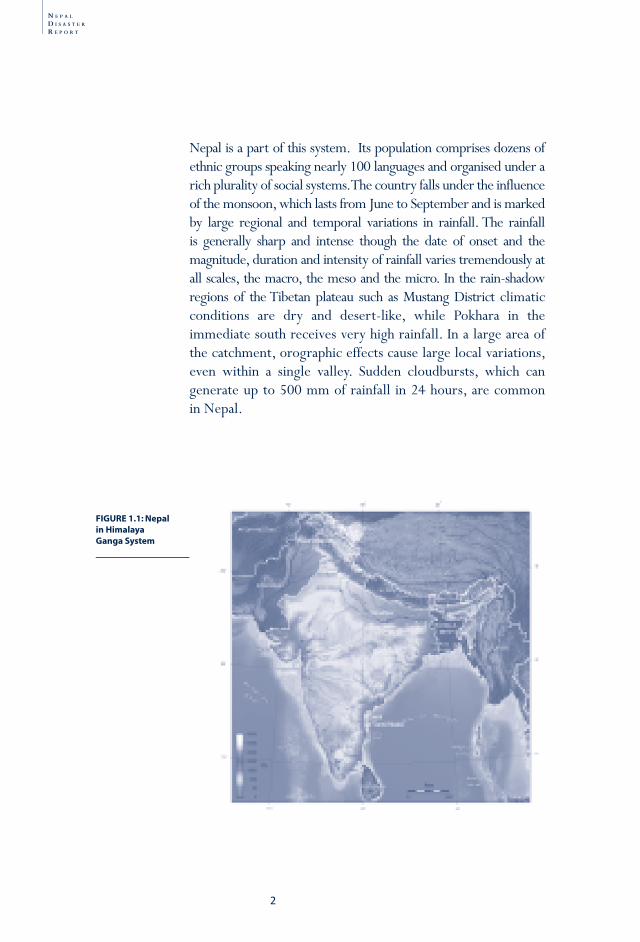
The Himalaya-Ganga system is a generic name given to the unique highland-lowland interactive system of South Asia including the flora and fauna it supports (Figure 1.1). As the crow flies, this system extends about 160-200 kilometres from north to south, spanning six geological and climatic belts varying in altitude from above 8,000 to just about 60 metres above mean sea level at Kechana in Jhapa District in east Nepal. They are the Tibetan plateau, the high Himalaya, the midland hills, the Mahabharat lekh (Range), the Chure (the Siwalik range) and the Tarai. This region is home to the highest mountain range on Earth—the Himalaya—and is the source of rivers such as the Ganga, the Indus, and the Brahmaputra, rivers which are both a boon and a bane to the millions living in the region.
Nepal in the Himalaya-Ganga
N E P A L
D I S A S T E R
R E P O R T
2
FIGURE 1.1: Nepal in Himalaya Ganga System
Nepal is a part of this system. Its population comprises dozens of ethnic groups speaking nearly 100 languages and organised under a rich plurality of social systems. The country falls under the influence of the monsoon, which lasts from June to September and is marked by large regional and temporal variations in rainfall. The rainfall is generally sharp and intense though the date of onset and the magnitude, duration and intensity of rainfall varies tremendously at all scales, the macro, the meso and the micro. In the rain-shadow regions of the Tibetan plateau such as Mustang District climatic conditions are dry and desert-like, while Pokhara in the immediate south receives very high rainfall. In a large area of the catchment, orographic effects cause large local variations, even within a single valley. Sudden cloudbursts, which can generate up to 500 mm of rainfall in 24 hours, are common in Nepal.
�
Nepal in the
Him
alaya-Ganga
Disaster R
isk Reduction:
Floods and Flood M
anagement
LandslidesD
roughtEarthquakes
Fire disastersO
ther disastersLegislation and D
RR
institutions
Meeting D
RR
challenges
Because it varies so drastically in altitude and precipitation, Nepal has a remarkable range of climates, ranging from tropical to alpine ecosystems. Within its 147,181 square kilometres, Nepal nurtures about 118 ecosystems, 75 types of vegetation and 35 types of forests. These ecosystems support 635 species of butterflies, 185 species of fresh water fish, 43 species of amphibians, 100 species of reptiles, 860 species of birds and 181 species of mammals (Bhuju et al., 2007).
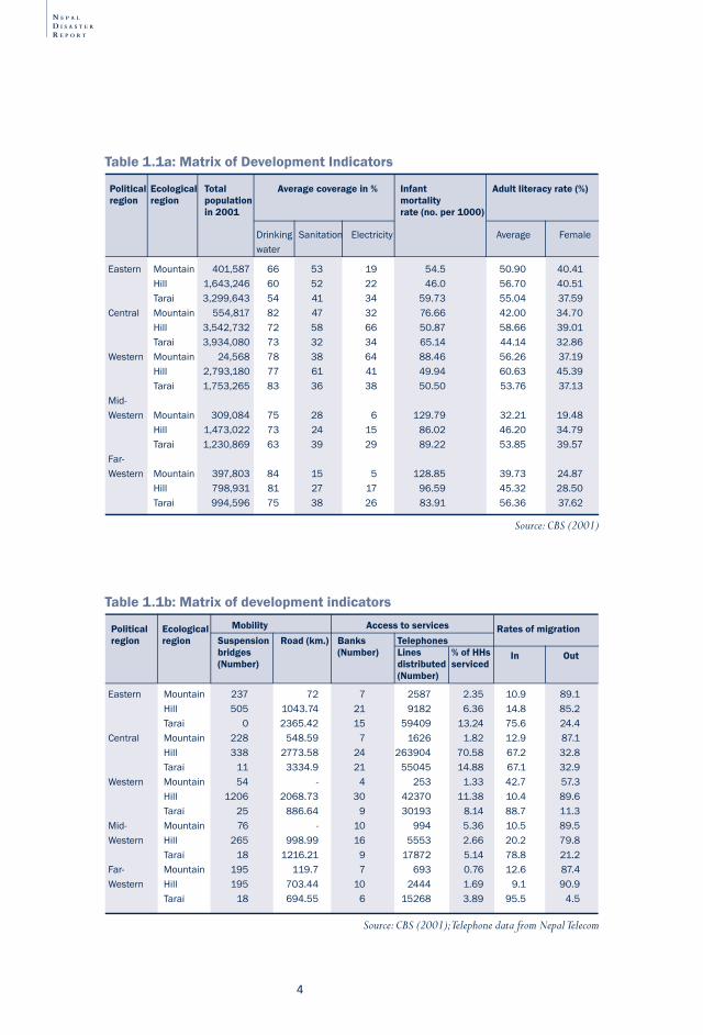
After the Rana regime fell in the 1950s and contact with the outside world increased, Nepal began to take steps to provide its population with basic services such as drinking water systems, irrigation canals, hydropower projects, mobility through road networks and suspension trail bridges, health, telephone communication, banking service and education facilities. Many of these development efforts have emphasised sustainability: they strove to reduce poverty, increase food security, and promote soil conservation, manage forests through community participation, and mitigate disaster risks. Success, however, has been limited (see tables 1.1a and 1.1b) because majority of the population still remain to be provided with these services. The challenges associated with providing services and improving natural resource management are exacerbated by the lack of institutional capacity and financial resources within Nepal. The country’s complex geo-physical context only complicates matters.
N E P A L
D I S A S T E R
R E P O R T
4
Table 1.1b: Matrix of development indicators
Political Ecological Rates of migrationregion region Suspension Road (km.) Banks Telephones bridges (Number) Lines % of HHs (Number) distributed serviced (Number)
Eastern Mountain 237 72 7 2587 2.35 10.9 89.1 Hill 505 1043.74 21 9182 6.36 14.8 85.2 Tarai 0 2365.42 15 59409 13.24 75.6 24.4Central Mountain 228 548.59 7 1626 1.82 12.9 87.1 Hill 338 2773.58 24 263904 70.58 67.2 32.8 Tarai 11 3334.9 21 55045 14.88 67.1 32.9Western Mountain 54 - 4 253 1.33 42.7 57.3 Hill 1206 2068.73 30 42370 11.38 10.4 89.6 Tarai 25 886.64 9 30193 8.14 88.7 11.3Mid- Mountain 76 - 10 994 5.36 10.5 89.5Western Hill 265 998.99 16 5553 2.66 20.2 79.8 Tarai 18 1216.21 9 17872 5.14 78.8 21.2Far- Mountain 195 119.7 7 693 0.76 12.6 87.4Western Hill 195 703.44 10 2444 1.69 9.1 90.9 Tarai 18 694.55 6 15268 3.89 95.5 4.5
Source: CBS (2001); Telephone data from Nepal Telecom
Mobility Access to services
In Out
Drinking Sanitation Electricitywater
Average Female
Table 1.1a: Matrix of Development Indicators
Political Ecological Total Average coverage in % Infant Adult literacy rate (%) region region population mortality in 2001 rate (no. per 1000)
Eastern Mountain 401,587 66 53 19 54.5 50.90 40.41 Hill 1,643,246 60 52 22 46.0 56.70 40.51 Tarai 3,299,643 54 41 34 59.73 55.04 37.59Central Mountain 554,817 82 47 32 76.66 42.00 34.70 Hill 3,542,732 72 58 66 50.87 58.66 39.01 Tarai 3,934,080 73 32 34 65.14 44.14 32.86Western Mountain 24,568 78 38 64 88.46 56.26 37.19 Hill 2,793,180 77 61 41 49.94 60.63 45.39 Tarai 1,753,265 83 36 38 50.50 53.76 37.13Mid-Western Mountain 309,084 75 28 6 129.79 32.21 19.48 Hill 1,473,022 73 24 15 86.02 46.20 34.79 Tarai 1,230,869 63 39 29 89.22 53.85 39.57Far-Western Mountain 397,803 84 15 5 128.85 39.73 24.87 Hill 798,931 81 27 17 96.59 45.32 28.50 Tarai 994,596 75 38 26 83.91 56.36 37.62
Source: CBS (2001)
�
Nepal in the
Him
alaya-Ganga
Disaster R
isk Reduction:
Floods and Flood M
anagement
LandslidesD
roughtEarthquakes
Fire disastersO
ther disastersLegislation and D
RR
institutions
Meeting D
RR
challenges
physical context
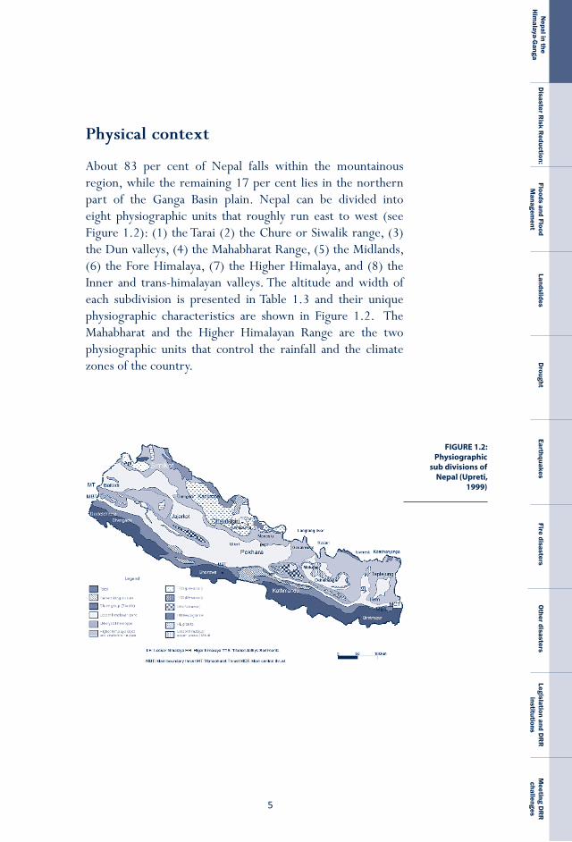
About 83 per cent of Nepal falls within the mountainous region, while the remaining 17 per cent lies in the northern part of the Ganga Basin plain. Nepal can be divided into eight physiographic units that roughly run east to west (see Figure 1.2): (1) the Tarai (2) the Chure or Siwalik range, (3) the Dun valleys, (4) the Mahabharat Range, (5) the Midlands, (6) the Fore Himalaya, (7) the Higher Himalaya, and (8) the Inner and trans-himalayan valleys. The altitude and width of each subdivision is presented in Table 1.3 and their unique physiographic characteristics are shown in Figure 1.2. The Mahabharat and the Higher Himalayan Range are the two physiographic units that control the rainfall and the climate zones of the country.
FIGURE 1.2: Physiographic
sub divisions of Nepal (Upreti,
1999)
N E P A L
D I S A S T E R
R E P O R T
6
Eastern Mountain 3 401,587 38 209,705 1.9 Hill 8 1,643,246 153 470,656 3.5 Tarai 5 3,299,643 454 549,214 6.0Central Mountain 3 554,817 88 131,326 4.2 Hill 9 3,542,732 300 441,167 8.0 Tarai 7 3,934,080 422 553,045 6.0Western Mountain 2 24,568 4 564 43.6 Hill 11 2,793,180 152 387,327 7.2 Tarai 3 1,753,265 333 308,707 5.7Mid- Mountain 5 309,084 14 68,769 4.5western Hill 7 1,473,022 107 199,545 7.4 Tarai 3 1,230,869 168 264,218 4.7Far- Mountain 3 397,803 50 108,013 3.7western Hill 4 798,931 118 167,668 4.8 Tarai 2 994,596 205 201,707 4.9Total
Political Ecological No. of districts Total Population Cultivated Population density region region population density land under per ha of cultivated (2001) (ppl./sq km) permanent land (person/ha) crops (ha)
Source: CBS, 2001
Table 1.3: Social characteristics of Nepal
1 Tarai 20-50 100-200 20–25 1100-3500 Tropicaltress, ShoreaRobustaforest)2 ChureRange 10-50 200-1300 3 Dunvalleys 5-30 200-300 4 MahabharatRange 10-35 1000-3000 10–20 275-2300 KhoteSalla(Pinus roxbughii), Deodar(Cedrusdeodara), GobreSalla(Pinus wallichiana).5 Midlands 40-60 200-2000 6 ForeHimalaya 20-70 2000-5000 <10 150-200 Rhodedrondrron,alpine meadows7 HigherHimalaya 10-60 >5000 8 InnerandTrans- Himalayanvalleys 30-100 2500-4000
Region Width (km) Altitude (m) Mean Precipitation (mm) Broad vegetation temp (°C)
Table 1.2: Geomorphic and climatological characteristics of Nepal
Source: For geomorphic units, Upreti (1999); other data, CBS (2001)
The characteristics of the social systems of the Nepalis who live in this highland-lowland composite are summarised in Table 1.3.
�
Nepal in the
Him
alaya-Ganga
Disaster R
isk Reduction:
Floods and Flood M
anagement
LandslidesD
roughtEarthquakes
Fire disastersO
ther disastersLegislation and D
RR
institutions
Meeting D
RR
challenges
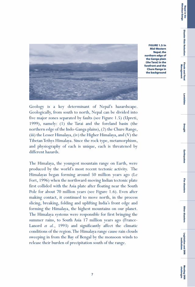
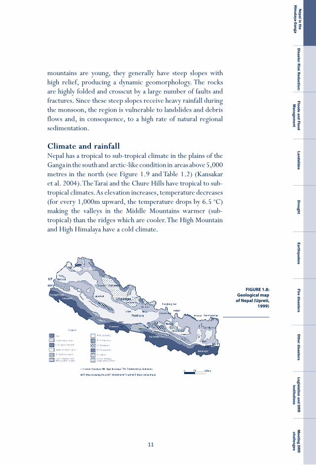
Geology is a key determinant of Nepal’s hazardscape. Geologically, from south to north, Nepal can be divided into five major zones separated by faults (see Figure 1.5) (Upreti, 1999), namely: (1) the Tarai and the foreland basin (the northern edge of the Indo-Ganga plains), (2) the Chure Range, (iii) the Lesser Himalaya, (iv) the Higher Himalaya, and (V) the Tibetan Tethys Himalaya. Since the rock type, metamorphism, and physiography of each is unique, each is threatened by different hazards.
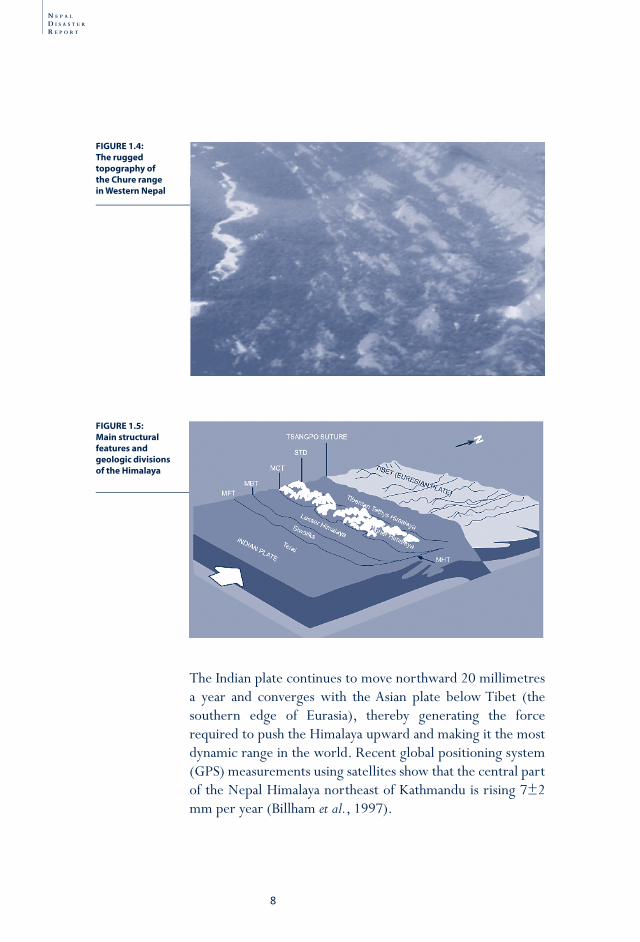
The Himalaya, the youngest mountain range on Earth, were produced by the world’s most recent tectonic activity. The Himalayas began forming around 50 million years ago (Le Fort, 1996) when the northward-moving Indian tectonic plate first collided with the Asia plate after floating near the South Pole for about 70 million years (see Figure 1.6). Even after making contact, it continued to move north, in the process slicing, breaking, folding and uplifting India’s front edge and forming the Himalaya, the highest mountains on our planet. The Himalaya systems were responsible for first bringing the summer rains, to South Asia 17 million years ago (France-Lanord et al., 1993) and significantly affect the climatic conditions of the region. The Himalaya range cause rain clouds sweeping in from the Bay of Bengal by the monsoon winds to release their burden of precipitation south of the range.
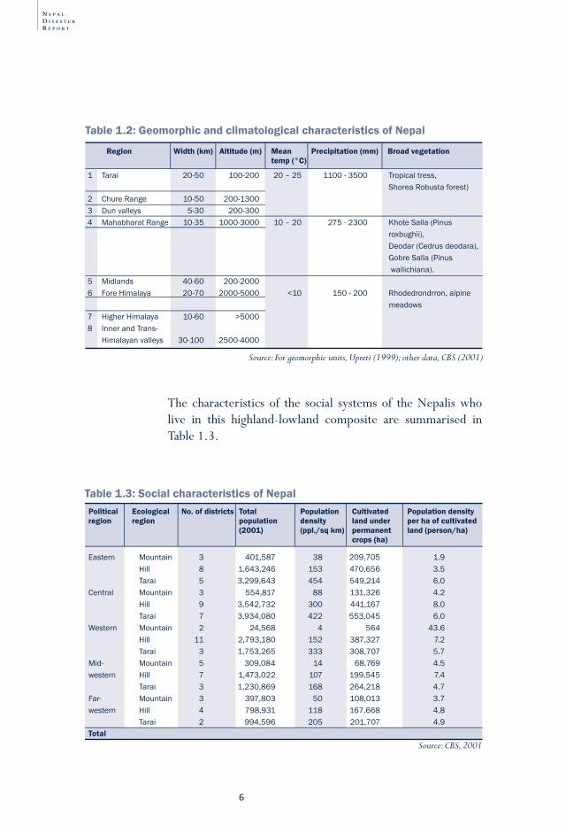
FIGURE 1.3: In Mid-Western
Nepal, the northern edge of
the Ganga plain (the Tarai) in the
forefront and the Chure Range in
the background
N E P A L
D I S A S T E R
R E P O R T
8
The Indian plate continues to move northward 20 millimetres a year and converges with the Asian plate below Tibet (the southern edge of Eurasia), thereby generating the force required to push the Himalaya upward and making it the most dynamic range in the world. Recent global positioning system (GPS) measurements using satellites show that the central part of the Nepal Himalaya northeast of Kathmandu is rising 7±2 mm per year (Billham et al., 1997).
FIGURE 1.4: The rugged topography of the Chure range in Western Nepal
FIGURE 1.5: Main structural features and geologic divisions of the Himalaya
�
Nepal in the
Him
alaya-Ganga
Disaster R
isk Reduction:
Floods and Flood M
anagement
LandslidesD
roughtEarthquakes
Fire disastersO
ther disastersLegislation and D
RR
institutions
Meeting D
RR
challenges
FIGURE 1.6: Northward
movement of Indian plate
across the Tethys Sea.
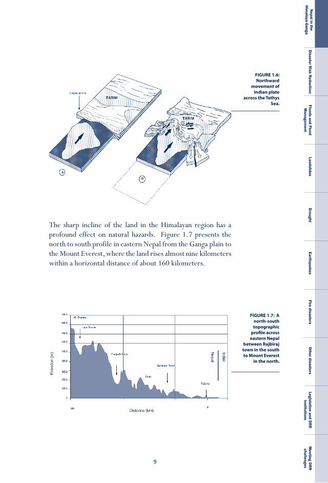
The sharp incline of the land in the Himalayan region has a profound effect on natural hazards. Figure 1.7 presents the north to south profile in eastern Nepal from the Ganga plain to the Mount Everest, where the land rises almost nine kilometers within a horizontal distance of about 160 kilometers.
FIGURE 1.7: A north-south topographic
profile across eastern Nepal
between Rajbiraj town in the south to Mount Everest
in the north.
N E P A L
D I S A S T E R
R E P O R T
�0
The architecture of the Himalaya is formed by five thrusts in the upper crust of the Indian plate which are the Main Central Thrust (MCT); the Main Boundary Thrust (MBT); and the Main Frontal Thrust (MFT), and a normal fault, the South Tibetan Detachment System (STDS). This system forms the base of the Tethyan sedimentary series of the Himalaya. All three faults merge along the Main Himalayan Thrust (MHT) below the mountain ranges. The continuous convergence of the Indian and Asian plates stores energy in the region over a period of time and their sudden release causes earthquakes. Since the
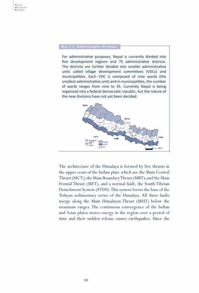
For administrati ve purposes, Nepal is currently divided into fi ve development regions and 75 administrati ve districts. The districts are further divided into smaller administrati ve units called village development committ ees (VDCs) and municipaliti es. Each VDC is composed of nine wards (the smallest administrati ve unit) and in municipaliti es, the number of wards ranges from nine to 35. Currently Nepal is being organised into a federal democrati c republic, but the nature of the new divisions have not yet been decided.
Box 1.1: administrative divisions
��
Nepal in the
Him
alaya-Ganga
Disaster R
isk Reduction:
Floods and Flood M
anagement
LandslidesD
roughtEarthquakes
Fire disastersO
ther disastersLegislation and D
RR
institutions
Meeting D
RR
challenges
FIGURE 1.8: Geological map
of Nepal (Upreti, 1999)
mountains are young, they generally have steep slopes with high relief, producing a dynamic geomorphology. The rocks are highly folded and crosscut by a large number of faults and fractures. Since these steep slopes receive heavy rainfall during the monsoon, the region is vulnerable to landslides and debris flows and, in consequence, to a high rate of natural regional sedimentation.
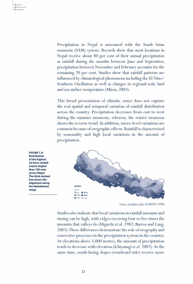
Climate and rainfallNepal has a tropical to sub-tropical climate in the plains of the Ganga in the south and arctic-like condition in areas above 5,000 metres in the north (see Figure 1.9 and Table 1.2) (Kansakar et al. 2004). The Tarai and the Chure Hills have tropical to sub-tropical climates. As elevation increases, temperature decreases (for every 1,000m upward, the temperature drops by 6.5°oC) making the valleys in the Middle Mountains warmer (sub-tropical) than the ridges which are cooler. The High Mountain and High Himalaya have a cold climate.
N E P A L
D I S A S T E R
R E P O R T
�2
Precipitation in Nepal is associated with the South Asian monsoon (SAM) system. Records show that most locations in Nepal receive about 80 per cent of their annual precipitation as rainfall during the months between June and September; precipitation between November and February accounts for the remaining 20 per cent. Studies show that rainfall patterns are influenced by climatological phenomena including the El Nino/Southern Oscillation as well as changes in regional-scale land and sea surface temperature (Mirza, 2003).
This broad presentation of climatic zones does not capture the real spatial and temporal variation of rainfall distribution across the country. Precipitation decreases from east to west during the summer monsoon, whereas, the winter monsoon shows the reverse trend. In addition, micro-level variations are common because of orographic effects. Rainfall is characterised by seasonality and high local variations in the amount of precipitation.
Studies also indicate that local variations in rainfall amounts and timing can be high, with ridges receiving four to five times the amounts that valleys do (Higuchi et al. 1982; Barros and Lang, 2003). These differences demonstrate the role of orography and convective processes in the precipitation system in the country. At elevations above 3,000 metres, the amount of precipitation tends to decrease with elevation (Ichiyanagi et al. 2007). At the same time, south-facing slopes (windward side) receive more
FIGURE 1.9: Distribution of the highest 24-hour rainfall events (higher than 100 mm) across NepalThe thick dashed line shows the alignment along the Mahabharat range
Source: modifi ed after ICIMOD (1996)
��
Nepal in the
Him
alaya-Ganga
Disaster R
isk Reduction:
Floods and Flood M
anagement
LandslidesD
roughtEarthquakes
Fire disastersO
ther disastersLegislation and D
RR
institutions
Meeting D
RR
challenges
rainfall than north-facing (leeward side) slopes, as the latter are in rain-shadow regions. Barros and Lang (2003) found that monsoon rainfall events were generally concentrated during mornings and nights with the peak occurring at night. The location and density of meteorological stations across are inadequate for capturing the spatial and temporal variations of micro-climates in the country. For example, there are very few stations on hilltops; almost all are located in lower valleys.
1880 18September 1,048(2days) Nagina,UttarPradesh GarhwalIndia *1902 26-27September 770 Dharmapur India **1915 11-13June 720 Nagibabad India **1924 September 770(3days) India India *1931 24June-8July 4,798 Cherrapunji India **1950 12June 546 TeestaValley India **1954 24-30July 500(heavy 22-25August rainfallfor4days) Affectedabout 15,000km2of SunKoshiRiver Nepal ***1959 7September 409 Tansen Nepal *** 10October 473 Anarmanibirta 1960 29July 503 Musikot Nepal ***1968 3-5October 1,044 Padamchen(Darjeeling) India ** 5-6October 465 25August 505 Gumthang Nepal ***1969 5August 1,001 Labha-Phaperkheti India ** 5August 742 Aligarh-Gorubathan India **1972 17May 4,032 TeestaValley India **1974 28July 405 Barahakshetra Nepal ***1977 10June 460 TeestaValley India **1978 20May 1,800 TeestaValley India ** 15July 322 HariharpurGadhi Nepal *** 15July 301 TigerTops Nepal *** 16July 304 RamauliBairiya Nepal *** 19July 376 Hetauda Nepal ***1979 2-6October 900(3-daypointfall) UpperArunBasin&Num Nepal ***1980 12September 431 Bajura Nepal ****1981 28September 350 Garakot Nepal *** 28September 381 Khanchikot Nepal *** 29September 342 Chapkot Nepal *** 29September 446 Baluwa Nepal **** 30September 420 ManeBanjayang Nepal ****
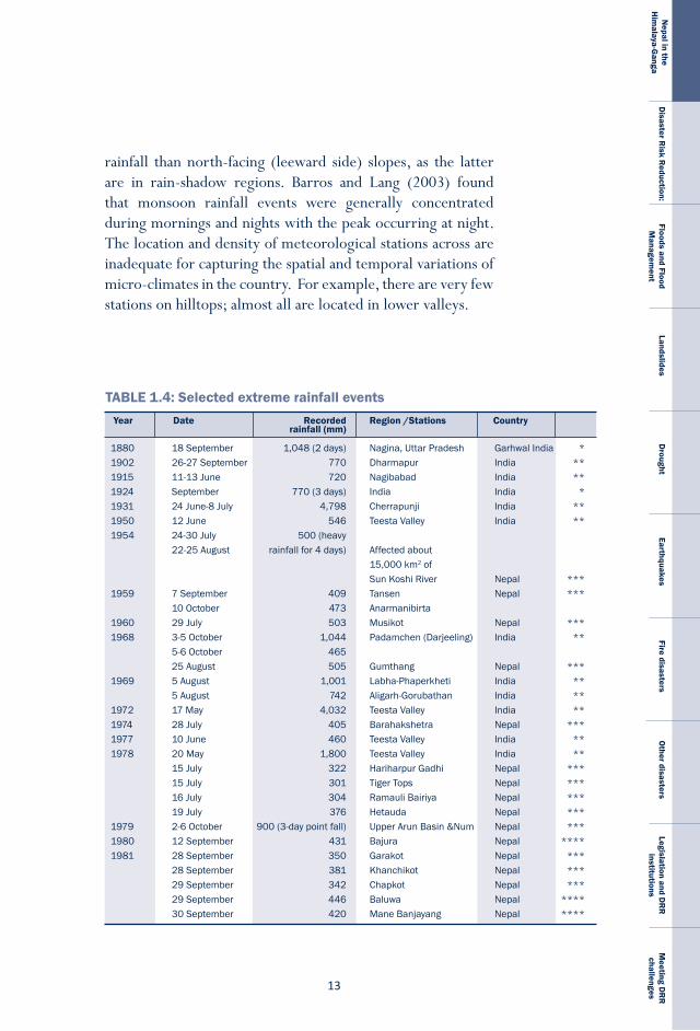
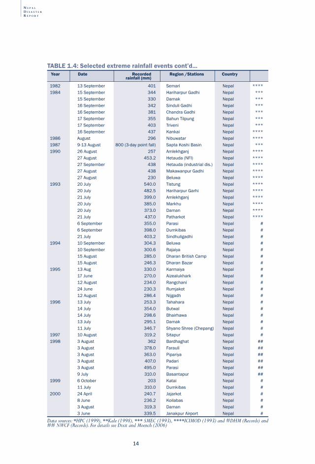
TABLE 1.4: Selected extreme rainfall eventsYear Date Recorded Region /Stations Country rainfall (mm)
N E P A L
D I S A S T E R
R E P O R T
�4
Year Date Recorded Region /Stations Country rainfall (mm)
1982 13September 401 Semari Nepal ****1984 15September 344 HariharpurGadhi Nepal *** 15September 330 Damak Nepal *** 16September 342 SinduliGadhi Nepal *** 16September 381 ChandraGadhi Nepal *** 17September 355 BahunTilpung Nepal *** 17September 403 Triveni Nepal *** 16September 437 Kankai Nepal ****1986 August 296 Nibuwatar Nepal ****1987 9-13August 800(3-daypointfall) SaptaKoshiBasin Nepal ***1990 26August 257 Amlekhganj Nepal **** 27August 453.2 Hetauda(NFI) Nepal **** 27September 438 Hetauda(industrialdis.) Nepal **** 27August 438 MakawanpurGadhi Nepal **** 27August 230 Beluwa Nepal ****1993 20July 540.0 Tistung Nepal **** 20July 482.5 HariharpurGarhi Nepal **** 21July 399.0 Amlekhganj Nepal **** 20July 385.0 Markhu Nepal **** 20July 373.0 Daman Nepal **** 21July 437.0 Patharkot Nepal **** 6September 355.0 Parasi Nepal # 6September 398.0 Dumkibas Nepal # 21July 403.2 Sindhuligadhi Nepal #1994 10September 304.3 Beluwa Nepal # 10September 300.6 Rajaiya Nepal # 15August 285.0 DharanBritishCamp Nepal # 15August 246.3 DharanBazar Nepal #1995 13Aug 330.0 Karmaiya Nepal # 17June 270.0 Aizealukhark Nepal # 12August 234.0 Rangchani Nepal # 24June 230.3 Rumjakot Nepal # 12August 286.4 Nijgadh Nepal #1996 13July 253.3 Tahahara Nepal # 14July 354.0 Butwal Nepal # 14July 298.6 Bhairhawa Nepal # 13July 295.1 Damak Nepal # 11July 346.7 ShyanoShree(Chepang) Nepal #1997 10August 319.2 Sitapur Nepal #1998 3August 362 Bardhaghat Nepal ## 3August 378.0 Farauli Nepal ## 3August 363.0 Pipariya Nepal ## 3August 407.0 Padari Nepal ## 3August 495.0 Parasi Nepal ## 9July 310.0 Basantapur Nepal ##1999 6October 203 Katai Nepal # 11July 310.0 Dumkibas Nepal #2000 24April 240.7 Jajarkot Nepal # 8June 236.2 Koilabas Nepal # 3August 319.3 Daman Nepal # 3June 339.5 JanakpurAirport Nepal #
Data sources: *HPC (1999), **Kale (1998), *** SMEC (1993), ****ICIMOD (1993) and #DHM (Records) and ## NWCF (Records). For details see Dixit and Moench (2006)
TABLE 1.4: Selected extreme rainfall events cont’d...
��
Nepal in the
Him
alaya-Ganga
Disaster R
isk Reduction:
Floods and Flood M
anagement
LandslidesD
roughtEarthquakes
Fire disastersO
ther disastersLegislation and D
RR
institutions
Meeting D
RR
challenges
Because the Chure and the Mahabharat ranges are the first mountain barriers northward-moving monsoon clouds coming from the Bay of Bengal encounter, these areas get heavy precipitation (Figure 1.9). As the stream of monsoon clouds enters the interior of Nepal, part follows a westerly course and part follows river valleys in a northerly course. It takes nearly one month for the monsoon to cross the country and reach the western border of Nepal. In the winter, the westerlies move from west to east. In both cases, the intensity of rainfall varies with space and time. The annual precipitation in the Mahabharat region is around 2,500-3,000 millimetres and cloudbursts that bring up to 500 millimetres of rain in 24 hours are common (see Table 1.4). Such cloudbursts, which occur at intervals of about eight to ten years, bring disasters such as landslides and floods and result in deaths and damage to property and infrastructure.
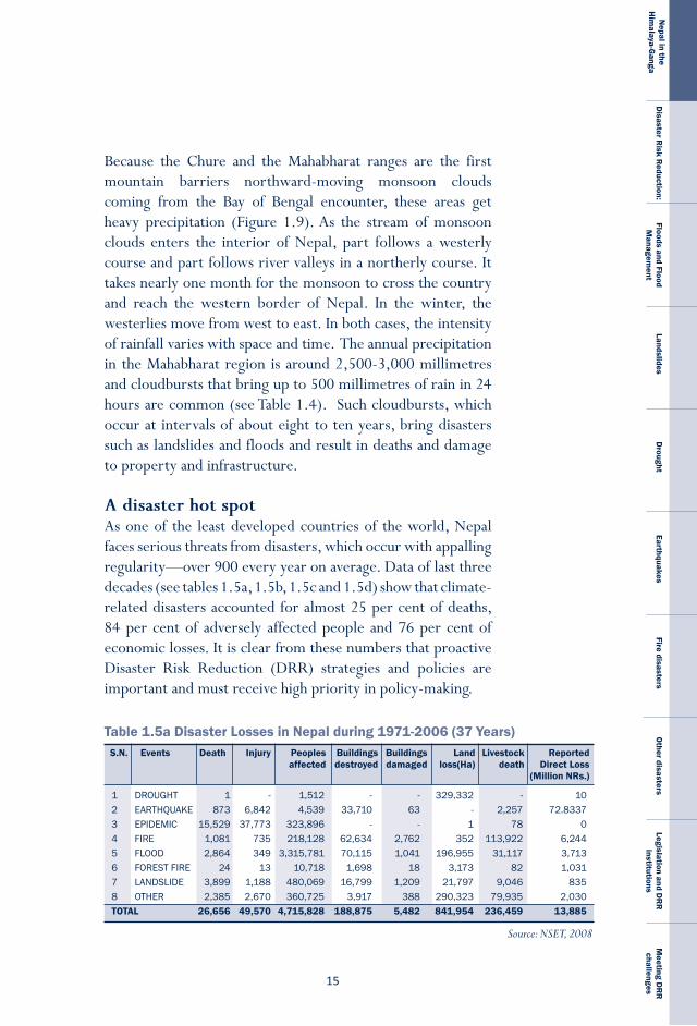
a disaster hot spotAs one of the least developed countries of the world, Nepal faces serious threats from disasters, which occur with appalling regularity—over 900 every year on average. Data of last three decades (see tables 1.5a, 1.5b, 1.5c and 1.5d) show that climate-related disasters accounted for almost 25 per cent of deaths, 84 per cent of adversely affected people and 76 per cent of economic losses. It is clear from these numbers that proactive Disaster Risk Reduction (DRR) strategies and policies are important and must receive high priority in policy-making.
Table 1.5a Disaster Losses in Nepal during 1971-2006 (37 Years)
1 DROUGHT 1 - 1,512 - - 329,332 - 102 EARTHQUAKE 873 6,842 4,539 33,710 63 - 2,257 72.83373 EPIDEMIC 15,529 37,773 323,896 - - 1 78 04 FIRE 1,081 735 218,128 62,634 2,762 352 113,922 6,2445 FLOOD 2,864 349 3,315,781 70,115 1,041 196,955 31,117 3,7136 FORESTFIRE 24 13 10,718 1,698 18 3,173 82 1,0317 LANDSLIDE 3,899 1,188 480,069 16,799 1,209 21,797 9,046 8358 OTHER 2,385 2,670 360,725 3,917 388 290,323 79,935 2,030TOTAL 26,656 49,570 4,715,828 188,875 5,482 841,954 236,459 13,885
S.N. Events Death Injury Peoples Buildings Buildings Land Livestock Reported affected destroyed damaged loss(Ha) death Direct Loss (Million NRs.)
Source: NSET, 2008
N E P A L
D I S A S T E R
R E P O R T
�6
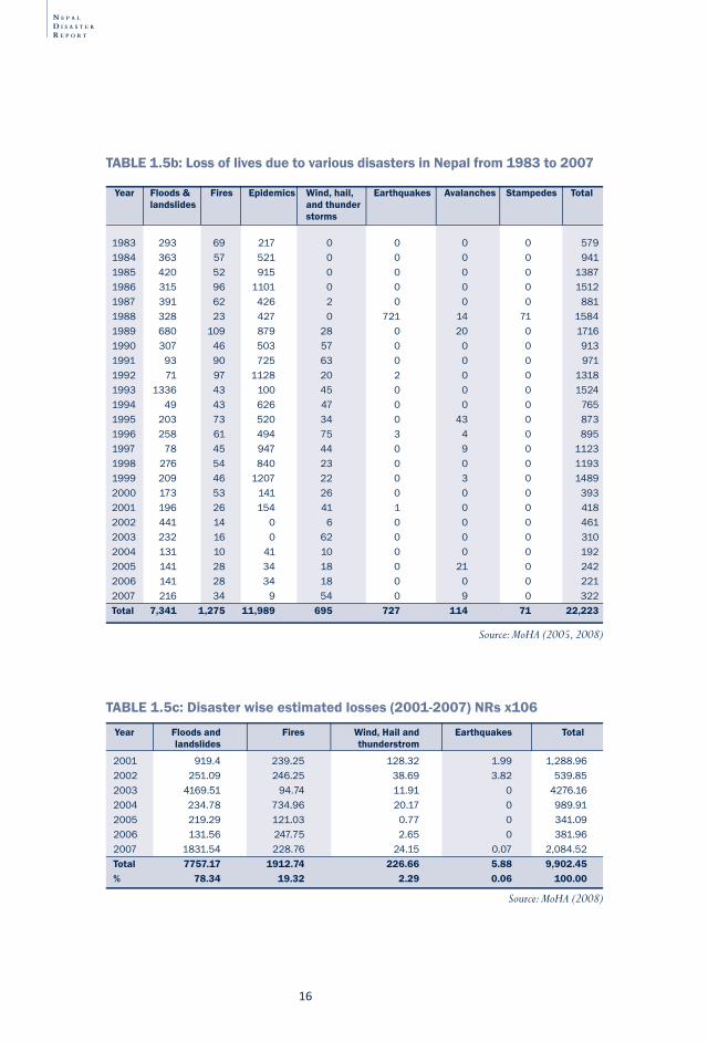
1983 293 69 217 0 0 0 0 5791984 363 57 521 0 0 0 0 9411985 420 52 915 0 0 0 0 13871986 315 96 1101 0 0 0 0 15121987 391 62 426 2 0 0 0 8811988 328 23 427 0 721 14 71 15841989 680 109 879 28 0 20 0 17161990 307 46 503 57 0 0 0 9131991 93 90 725 63 0 0 0 9711992 71 97 1128 20 2 0 0 13181993 1336 43 100 45 0 0 0 15241994 49 43 626 47 0 0 0 7651995 203 73 520 34 0 43 0 8731996 258 61 494 75 3 4 0 8951997 78 45 947 44 0 9 0 11231998 276 54 840 23 0 0 0 11931999 209 46 1207 22 0 3 0 14892000 173 53 141 26 0 0 0 3932001 196 26 154 41 1 0 0 4182002 441 14 0 6 0 0 0 4612003 232 16 0 62 0 0 0 3102004 131 10 41 10 0 0 0 1922005 141 28 34 18 0 21 0 2422006 141 28 34 18 0 0 0 2212007 216 34 9 54 0 9 0 322Total 7,341 1,275 11,989 695 727 114 71 22,223
Year Floods & Fires Epidemics Wind, hail, Earthquakes Avalanches Stampedes Total landslides and thunder storms
Source: MoHA (2005, 2008)
2001 919.4 239.25 128.32 1.99 1,288.962002 251.09 246.25 38.69 3.82 539.852003 4169.51 94.74 11.91 0 4276.162004 234.78 734.96 20.17 0 989.912005 219.29 121.03 0.77 0 341.092006 131.56 247.75 2.65 0 381.962007 1831.54 228.76 24.15 0.07 2,084.52Total 7757.17 1912.74 226.66 5.88 9,902.45% 78.34 19.32 2.29 0.06 100.00
Year Floods and Fires Wind, Hail and Earthquakes Total landslides thunderstrom
TABLE 1.5c: Disaster wise estimated losses (2001-2007) NRs x106
Source: MoHA (2008)
TABLE 1.5b: Loss of lives due to various disasters in Nepal from 1983 to 2007
��
Nepal in the
Him
alaya-Ganga
Disaster R
isk Reduction:
Floods and Flood M
anagement
LandslidesD
roughtEarthquakes
Fire disastersO
ther disastersLegislation and D
RR
institutions
Meeting D
RR
challenges
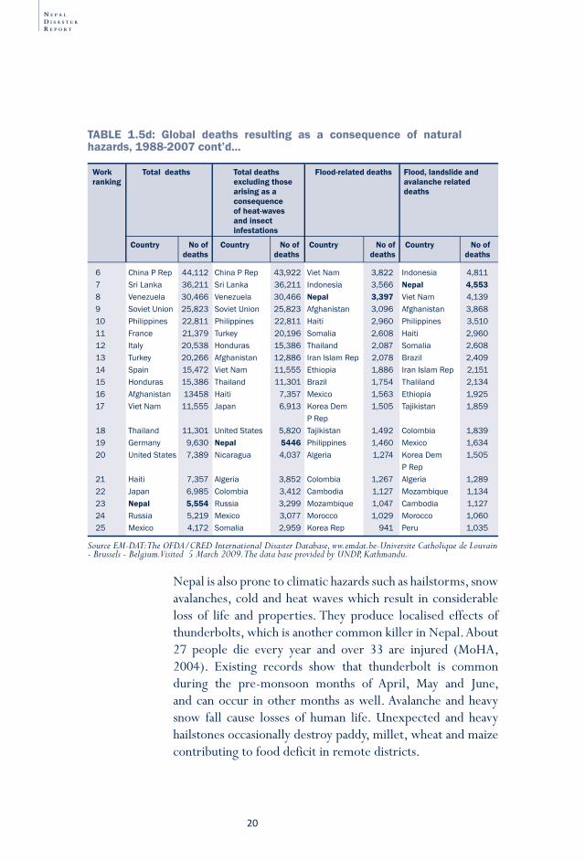
Nepal is a disaster hot spot due to the vulnerability of the population and the regular and frequent occurrence of different natural hazards. It is the country’s social context—its low level of development and institutional dysfunctions—that particularly intensify the impacts of disasters. By global standards, Nepal ranked 23rd (See Table 1.5d) in the world in terms of the total natural hazard-related deaths in two decades from 1988 to 2007 with total deaths reaching above 7,000 (IFRC, 2007). It is in seventh position for deaths resulting as a consequence of floods, landslides and avalanches combined, and in eighth position for flood-related deaths alone. A UN Report (2008) shows that of the 75 districts in the country, 49 are prone to floods and/or landslides, 23 to wildfires, and one to windstorms. A total of 64 out of 75 districts are prone to disasters of some type. Globally Nepal ranks very high in terms of relative vulnerability to earthquakes and water related disasters respectively. Given its small size and how few people live here in comparison to the other countries featuring in the top slots, these rankings are particularly high and underscore the high annual human toll of disasters such as floods, even during ‘normal’ years.
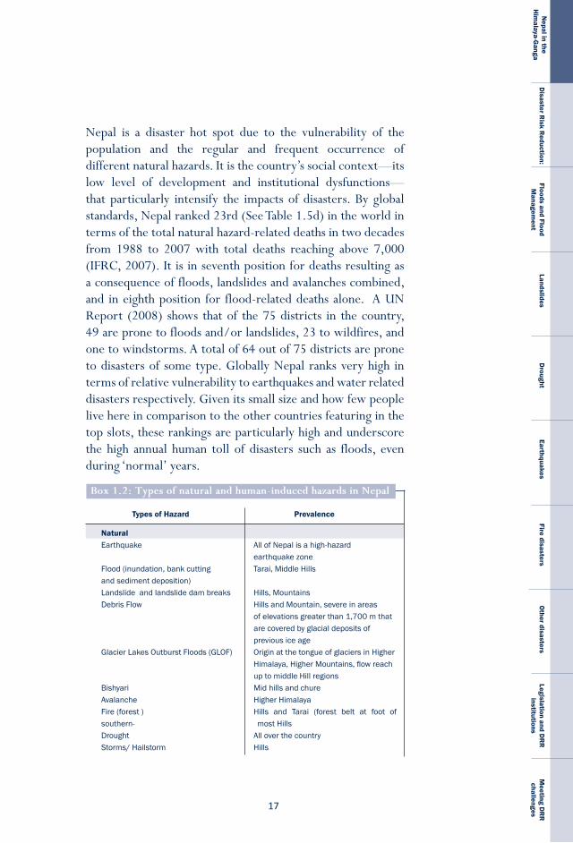
NaturalEarthquake AllofNepalisahigh-hazard earthquakezoneFlood(inundation,bankcutting Tarai,MiddleHillsandsedimentdeposition)Landslideandlandslidedambreaks Hills,MountainsDebrisFlow HillsandMountain,severeinareas ofelevationsgreaterthan1,700mthat arecoveredbyglacialdepositsof previousiceageGlacierLakesOutburstFloods(GLOF) OriginatthetongueofglaciersinHigher Himalaya,HigherMountains,flowreach uptomiddleHillregionsBishyari MidhillsandchureAvalanche HigherHimalayaFire(forest) Hills and Tarai (forest belt at foot ofsouthern- mostHillsDrought AlloverthecountryStorms/Hailstorm Hills
Types of Hazard Prevalence
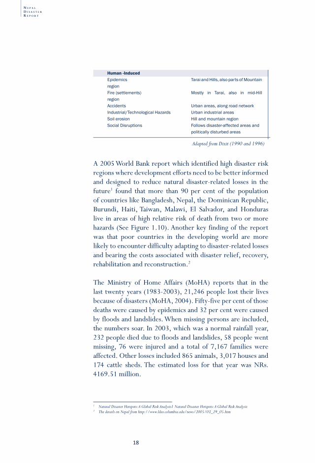
Box 1.2: types of natural and human-induced hazards in Nepal
N E P A L
D I S A S T E R
R E P O R T
�8
Adapted from Dixit (1990 and 1996)
Human -InducedEpidemics TaraiandHills,alsopartsofMountainregionFire(settlements) Mostly in Tarai, also in mid-HillregionAccidents Urbanareas,alongroadnetworkIndustrial/TechnologicalHazards UrbanindustrialareasSoilerosion HillandmountainregionSocialDisruptions Followsdisaster-affectedareasand politicallydisturbedareas
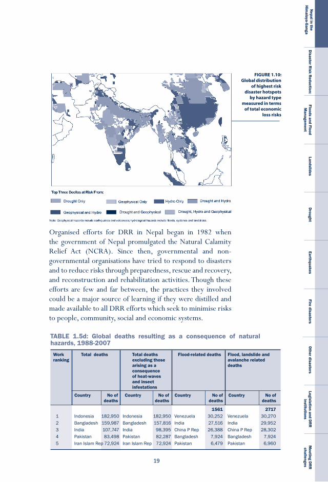
A 2005 World Bank report which identified high disaster risk regions where development efforts need to be better informed and designed to reduce natural disaster-related losses in the future1 found that more than 90 per cent of the population of countries like Bangladesh, Nepal, the Dominican Republic, Burundi, Haiti, Taiwan, Malawi, El Salvador, and Honduras live in areas of high relative risk of death from two or more hazards (See Figure 1.10). Another key finding of the report was that poor countries in the developing world are more likely to encounter difficulty adapting to disaster-related losses and bearing the costs associated with disaster relief, recovery, rehabilitation and reconstruction.2
The Ministry of Home Affairs (MoHA) reports that in the last twenty years (1983-2003), 21,246 people lost their lives because of disasters (MoHA, 2004). Fifty-five per cent of those deaths were caused by epidemics and 32 per cent were caused by floods and landslides. When missing persons are included, the numbers soar. In 2003, which was a normal rainfall year, 232 people died due to floods and landslides, 58 people went missing, 76 were injured and a total of 7,167 families were affected. Other losses included 865 animals, 3,017 houses and 174 cattle sheds. The estimated loss for that year was NRs. 4169.51 million.
1 Natural Disaster Hotspots: A Global Risk Analysis1 Natural Disaster Hotspots: A Global Risk Analysis2 The details on Nepal from http://www.ldeo.columbia.edu/news/2005/03_29_05.htm
��
Nepal in the
Him
alaya-Ganga
Disaster R
isk Reduction:
Floods and Flood M
anagement
LandslidesD
roughtEarthquakes
Fire disastersO
ther disastersLegislation and D
RR
institutions
Meeting D
RR
challenges
FIGURE 1.10: Global distribution
of highest risk disaster hotspots
by hazard type measured in terms
of total economic loss risks
Organised efforts for DRR in Nepal began in 1982 when the government of Nepal promulgated the Natural Calamity Relief Act (NCRA). Since then, governmental and non-governmental organisations have tried to respond to disasters and to reduce risks through preparedness, rescue and recovery, and reconstruction and rehabilitation activities. Though these efforts are few and far between, the practices they involved could be a major source of learning if they were distilled and made available to all DRR efforts which seek to minimise risks to people, community, social and economic systems.
Work Total deaths Total deaths Flood-related deaths Flood, landslide and ranking excluding those avalanche related arising as a deaths consequence of heat-waves and insect infestations
Country No of Country No of Country No of Country No of deaths deaths deaths deaths
1561 27171 Indonesia 182,950 Indonesia 182,950 Venezuela 30,252 Venezuela 30,2702 Bangladesh 159,987 Bangladesh 157,816 India 27,516 India 29,9523 India 107,747 India 98,395 ChinaPRep 26,388 ChinaPRep 28,3024 Pakistan 83,498 Pakistan 82,287 Bangladesh 7,924 Bangladesh 7,9245 IranIslamRep72,924 IranIslamRep 72,924 Pakistan 6,479 Pakistan 6,960
TABLE 1.5d: Global deaths resulting as a consequence of natural hazards, 1988-2007
N E P A L
D I S A S T E R
R E P O R T
20
Work Total deaths Total deaths Flood-related deaths Flood, landslide and ranking excluding those avalanche related arising as a deaths consequence of heat-waves and insect infestations
Country No of Country No of Country No of Country No of deaths deaths deaths deaths
6 ChinaPRep 44,112 ChinaPRep 43,922 VietNam 3,822 Indonesia 4,8117 SriLanka 36,211 SriLanka 36,211 Indonesia 3,566 Nepal 4,5538 Venezuela 30,466 Venezuela 30,466 Nepal 3,397 VietNam 4,1399 SovietUnion 25,823 SovietUnion 25,823 Afghanistan 3,096 Afghanistan 3,86810 Philippines 22,811 Philippines 22,811 Haiti 2,960 Philippines 3,51011 France 21,379 Turkey 20,196 Somalia 2,608 Haiti 2,96012 Italy 20,538 Honduras 15,386 Thailand 2,087 Somalia 2,60813 Turkey 20,266 Afghanistan 12,886 IranIslamRep 2,078 Brazil 2,40914 Spain 15,472 VietNam 11,555 Ethiopia 1,886 IranIslamRep 2,15115 Honduras 15,386 Thailand 11,301 Brazil 1,754 Thaliland 2,13416 Afghanistan 13458 Haiti 7,357 Mexico 1,563 Ethiopia 1,92517 VietNam 11,555 Japan 6,913 KoreaDem 1,505 Tajikistan 1,859 PRep18 Thailand 11,301 UnitedStates 5,820 Tajikistan 1,492 Colombia 1,83919 Germany 9,630 Nepal 5446 Philippines 1,460 Mexico 1,63420 UnitedStates 7,389 Nicaragua 4,037 Algeria 1,274 KoreaDem 1,505 PRep21 Haiti 7,357 Algeria 3,852 Colombia 1,267 Algeria 1,28922 Japan 6,985 Colombia 3,412 Cambodia 1,127 Mozambique 1,13423 Nepal 5,554 Russia 3,299 Mozambique 1,047 Cambodia 1,12724 Russia 5,219 Mexico 3,077 Morocco 1,029 Morocco 1,06025 Mexico 4,172 Somalia 2,959 KoreaRep 941 Peru 1,035
Source EM-DAT: The OFDA/CRED International Disaster Database, ww.emdat.be-Universite Catholique de Louvain - Brussels - Belgium. Visited 5 March 2009. The data base provided by UNDP, Kathmandu.
Nepal is also prone to climatic hazards such as hailstorms, snow avalanches, cold and heat waves which result in considerable loss of life and properties. They produce localised effects of thunderbolts, which is another common killer in Nepal. About 27 people die every year and over 33 are injured (MoHA, 2004). Existing records show that thunderbolt is common during the pre-monsoon months of April, May and June, and can occur in other months as well. Avalanche and heavy snow fall cause losses of human life. Unexpected and heavy hailstones occasionally destroy paddy, millet, wheat and maize contributing to food deficit in remote districts.
TABLE 1.5d: Global deaths resulting as a consequence of natural hazards, 1988-2007 cont’d...
2�
Nepal in the
Him
alaya-Ganga
Disaster R
isk Reduction:
Floods and Flood M
anagement
LandslidesD
roughtEarthquakes
Fire disastersO
ther disastersLegislation and D
RR
institutions
Meeting D
RR
challenges
Because 33.8 per cent of Nepal’s GDP is generated by agriculture, much of which is dependent on rainfall rather than irrigation, the country’s economic wellbeing is highly sensitive to major and periodic droughts (World Bank, 2008). Floods and landslides take their toll every year too, resulting in losses of human life, crops and infrastructure. Nepal is ranked high in the world in degree of disaster-affectedness (see Table 1.5 a, b, c and d): despite its small population and land area, it records a high annual human death toll caused by floods, even during normal rainfall years. These rankings are a clear indication of the need for effective DRR strategies. The country’s macro-economy appears to be more affected by drought than by other natural hazards. The explanation for this apparent elasticity in the face of other hazards is complex. One reason is that the regularity of the occurrence of floods and landslides makes it impossible to directly quantify the benefits of year in which floods and landslides do not occur at all. A second reason is that the nutrients brought by flooding actually increase agricultural productivity.
A third reason has to do with Nepal’s decade-long violent conflict, which posed substantial methodological challenges to assessing the economic costs of disasters. Damage to physical structures during the conflict, particularly administrative buildings and communication infrastructures, totalled about NRs. five billion. A 2004 study by the National Peace Campaign put the total cost of the conflict over the period from 1996 to 2003 alone at $66.2 billion, while a Department for International Development (DFID) study estimated the cost to be 8 to 10 per cent of GDP�. Though the human losses during the insurgency were significant, we posit that it is the extent of physical losses which are more instructive in terms of assessing the costs of disasters though the conflict caused such great losses that those associated with disaster become trivial in comparison4.
The fourth reason that the true economic impact of disasters remains buried is the nature of the Nepali economy: it is dominated by the informal sector and weakly linked to formal
Box 1.3 economic loss caused by disaster
3 The National Peace Campaign and DFID documents are both cited in Ra and Singh (2005).4 The conflict from 1996 to 2006 resulted in about 11,300 deaths, considerable internal displacement, disruptions
to the delivery of essential services, including health and education, and a decline in new investment (NPC, 2007; NSET, 2008).
N E P A L
D I S A S T E R
R E P O R T
22
insti tuti ons. For this reason, much income, including that from informal border trade in rice and other commoditi es and infl ows of remitt ances, goes unreported. This unoffi cial income not only makes it diffi cult to assess the impact of disaster using offi cial data alone but also cushions the impact of disasters on the formal economy, in parti cular by reducing pressure on the formal balance of trade and on foreign exchange reserves.
Although some of the above reasons do in fact minimise the impact of disasters on Nepal’s macro-economy, there is plenty of evidence to suggest that, collecti vely, disasters are debilitati ng the economy of the country. Disasters aff ect the development of human capital via their impact on educati on and health. The direct losses (human and economic) associated with disaster can also lead to a wide array of indirect and secondary eff ects. Direct losses include physical damage to capital assets, including buildings, infrastructure, industrial plants, standing crops, grain stores, livestock and social infrastructure, as well as the loss of human life and mental and physical wellbeing. Indirect and secondary eff ects are disrupti ons in the fl ow of goods and services stemming from direct losses, including reduced output, loss of earnings and loss of employment. The secondary eff ects of a disaster have both short- and long-term socio-economic consequences for GDP growth, fi scal and monetary performance, the balance of payments, foreign reserves, indebtedness, and the scale and incidence of poverty. Despite this evidence that disasters do have devastati ng economic impacts, there have been relati vely litt le macro-economic or fi nancial analyses in Nepal. Unfortunately, this dearth of study limits the ability of the government to act upon its stated commitment to disaster risk reducti on.
Also lacking are suffi cient scenario-based analyses of the potenti al economic consequences of disasters. Two scenarios of note are the likely outcomes of an high magnitude and intensity earthquake striking Kathmandu Valley (see Box 6.1) and a more recent study that has att empted to synthesise existi ng scienti fi c and socio-economic informati on about the impacts of climate change in Nepal Himalaya (NCVST, 2009). The NCVST study att empted to assess the patt ern of vulnerability climate change will expose citi zens to by considering past climate hazards such as cloudbursts, fl oods and drought as
2�
Nepal in the
Him
alaya-Ganga
Disaster R
isk Reduction:
Floods and Flood M
anagement
LandslidesD
roughtEarthquakes
Fire disastersO
ther disastersLegislation and D
RR
institutions
Meeting D
RR
challenges
signature events. Drought is critical because while Nepal’s agricultural performance is tied to climatic factors, this linkage is poorly articulated in the country’s policy processes. Delayed or inadequate rainfall has a pervasive impact in Nepal, but one which is difficult to quantify in monetary terms. The damages associated with drought are mostly limited to crops and livestock, and can be severe when livestock become less productive as fodder supplies decline. As the sale of milk is a major income-generating activity, families forced to sell livestock because they who cannot feed them, suffer a drastic decline in household income.
Obviously rain-fed crops suffer in a drought, but, depending on soil moisture condition, base flow in streams, water levels in ponds and other storage bodies, and the level of the groundwater table, irrigated crops can also be severely impacted. The lack of timely rains can delay planting and also result in pest outbreaks. In contrast, earthquakes have little impact on standing crops, excluding localised losses occurring as a consequence of landslips and landslides. However, they can cause widespread destruction of infrastructure and productive assets, including agricultural infrastructure and networks that facilitate the distribution of agricultural inputs and produce. Floods, for their part, can cause extensive physical damage both to infrastructure and to agriculture, particularly if floodwaters recede slowly, leading to water-logging and resulting in the deposition of unproductive sediment on fields and in irrigation canals. Floods are also associated with increased incidences of pestilence and blight, both of which reduce crop yields. Crop losses, in turn, can increase the volume of food that needs to be imported and have serious implications on the balance of payments and stock of foreign exchange reserves. To the disproportionate detriment of poor families, prices may be forced up if the country’s perennial shortages of food staples are exacerbated by disruptions to the transport network.�
The inundation due to breach of the 2008 Koshi embankment offers insights into the challenges involved in quantifying losses in monetary terms. The direct losses arising as a consequence of the breach included damage to about 5,000 ha of agricultural land and to a total of 17 km along different stretches of the East-West Highway. In addition, thousands of livelihoods were
5 The frequent closure of highways by different groups making political demands further hampers mobility and the supply of essential goods and agriculture produce. Such strikes compound existing food insecurity.
N E P A L
D I S A S T E R
R E P O R T
24
lost, the educati on system was thrown into chaos and general wellbeing suff ered. The damage to the highway prevented farmers from moving agricultural produce from the Eastern Tarai to any point west of the Koshi River, reducing sales and undermining livelihoods. There was considerable loss of producti ve assets such as agricultural tools, machinery, housing, household assets and livestock.
The 2008 Koshi fl ood was reported to have had a signifi cant infl ati onary impact on the prices of commoditi es, parti cularly those of onions, potatoes and fi rewood (IASC, 2008). Following the embankment breach, the prices of perishable food items such as bananas and vegetables fell sharply in regions east of the Koshi River. At the same ti me, prices increased in markets in western Nepal because the fl ooding had severely disrupted the movement of goods along the East-West Highway (IASC, 2008; WFP, 2008).
In additi on, the inundati on caused by 2008 breach damaged underground opti cal fi bres, phone lines and pylons, disrupti ng telecommunicati ons (ADB, 2008c; IASC, 2008; Pathak, 2008). The damage wreaked on high-voltage electricity transmission pylons disrupted the India’s supply of electricity to the Integrated Nepal Power System (INPS) and increased the durati on of power cuts in Nepal. The costs of disrupted communicati ons and the lack of electricity were high but they have not been systemati cally assessed. Arriving at a precise assessment of the full cost of the losses caused by the 2008 Koshi embankment breach and, indeed, of any other fl ood or any other disaster, including droughts, is diffi cult.
Unless it develops eff ecti ve DRR strategies, Nepal will not achieve its development goals. Such strategies including assessing the cost of losses and doing that entails overcoming both conceptual and methodological challenges. Despite the diffi culti es, it is necessary to have such assessments in order to make future investments eff ecti vely contribute to the development of Nepal’s social, economic and human capital. Now that the violent confl ict has ended it is expected that there will be greater investments in and higher infl ows of foreign aid to Nepal (NPC, 2007). How such resources can be used to make Nepal and the Nepali people more resilient in the face of climate-related and other forms of hazards should be a key considerati on.
2�
Nepal in the
Him
alaya-Ganga
Disaster R
isk Reduction:
Floods and Flood M
anagement
LandslidesD
roughtEarthquakes
Fire disastersO
ther disastersLegislation and D
RR
institutions
Meeting D
RR
challenges
Climate change scenarioNepal’s vulnerability to climate-related disasters is likely to be exacerbated by the increase in the intensity and frequency of weather hazards induced by anthropogenic climate change (IPCC, 2007). As one of the countries in the world sensitive to the effects of climate change, Nepal must act fast and needs support of the international community. The country’s maximum mean temperature shows steady decadal rise (MoPE, 1999). Analysis of maximum temperature data from 49 stations of the country for the period 1971-94 reveal warning trends after 1977 ranging from 0.06°oC to 0.12°oC per year in most of the Middle Mountain and Himalayan regions, while the Chure and Tarai (Southern plains) regions show warning trends of less than 0.03°oC per year (Shrestha et al., 1999). In the same period, the global average for surface temperature increased by 0.6±0.2°oC in the last century. The trend in Nepal suggests that the IPCC projection is too conservative and that landlocked areas will warm at a rate faster than the global average.
A recent analysis of climate change scenario (NCVST, 2009) in Nepal broadly concurs to the above findings and presents following key insights:
l Global Circulation Models (GCM) projections indicate an increase in temperature over Nepal of 0.5-2.0 °oC, with a multi-model mean of 1.4 °oC, by the 2030s, rising to 3.0-6.3 °oC, with a multi-model mean of 4.7 °oC, by the 2090s. There is very little differentiation in projected multi-model mean temperature changes in different regions (East, Central, West) of Nepal.
l GCM outputs suggest that extremely hot days (the hottest 5% of days in the period 1970-1999) are projected to increase by up to 55% by the 2060s and 70% by the 2090s
l GCM outputs suggest that extremely hot nights (the hottest 5% of nights in the period 1970-1999) are projected to increase by up to 77% by the 2060s and 93% by the 2090s
l GCMs project a wide range of precipitation changes, especially in the monsoon: -14 to +40% by the 2030s increasing -52 to 135% by the 2090s.
N E P A L
D I S A S T E R
R E P O R T
26
The monsoon precipitation pattern is changing too, with fewer days of rain and more high-intensity rainfall events. Both trends have resulted in an increase in the magnitude and frequency of water-induced disasters like landslides, debris flow, and floods. With global warming happening faster than previously anticipated, it is crucial that Nepal accord priority to adaptation to climate change, especially as the country’s poor will be disproportionately affected. In fact, since a number of international development partners are already exploring ways to support Nepal in adapting to such impacts, national interest in adaptation and DRR has increased. This challenge is made more complex because making climate change projections will be difficult and a great deal of uncertainty exists in the projection given the limitations of GCMs, RCMs and observational datasets for the region. As a result any projections must be interpreted and used cautiously (NCVST, 2009), which however should not be construed a barrier to assessing vulnerability and assessing options for adaptation and in implementing DRR activities.
The United Nation’s Intergovernmental Panel on Climate Change (IPCC) warned last year that glaciers in the Nepal Himalaya are receding faster than in any other part of the world: “If the Earth continues to warm at its present rate, the likelihood of them disappearing by the year 2035 or sooner is very high.” Himalayan glaciers are retreating at rates ranging from 10 to 60 metres per year. Many small glaciers (<0.2 sq. km.) have already disappeared and vertical retreats of as much as 100 metres have been recorded during the last fifty years. Almost 20 per cent of the glaciated areas in Nepal (above 5,000 metres) are expected to be snow- and glacier-free if the air temperature increases by 1°oC and a 2°oC rise which could result in the loss of almost 40 per cent of the total area under snow. Three and four degree could result in the loss of about 58 and 70 per cent of areas covered in snow and glaciers respectively. The resultant changes in regional water resources are projected to have negative impacts on hydropower generation, irrigation, and drinking water supply.
2�
Nepal in the
Him
alaya-Ganga
Disaster R
isk Reduction:
Floods and Flood M
anagement
LandslidesD
roughtEarthquakes
Fire disastersO
ther disastersLegislation and D
RR
institutions
Meeting D
RR
challenges
The glaciers in Asia have been retreating and thinning over the past 30 years but losses have accelerated in the last decade. The Himalayan region has the largest concentration of glaciers outside the polar caps. With glacier coverage of about 34,000 sq. km, the region is aptly called the “Water Tower of Asia”; it provides around 8.6x10⁶ cubic metres of water annually. The approximately 15,000 glaciers in the Himalaya occupy about 17 per cent of its area and another 30-40 per cent of its area experience seasonal snowfall (Vohra, 1978). This snow and ice feeds seven of Asia’s great rivers: the Ganga, Indus, Brahmaputra, Salween, Mekong, Yangtze and Huang Ho, which provide water to more than 1.3 billion people (WWF, 2005). The rapid melting of these glaciers and snowfields will alter the regional hydrological system significantly as melt water draining from them regulates the hydrology of the Indian sub-continent. Snow melt releases water during the dry season and helps maintain flows in the rivers during non-monsoon months though it contributes only about 10 per cent of total runoff (Sharma, 1977). Jianchu et al. (2007) and Barnett et al. (2005) suggest that snowmelt from the Himalaya provides about 9% of Ganga’s River flow.
The recently observed changes in climate have already also had impacts on biodiversity and ecosystems; they are responsible for changes in the distribution and population sizes of species as well as in the timings of reproduction and migration and have increased the frequency of pest and disease outbreaks. As has been observed in other parts of the world, the vegetation regime in Nepal is expected to push northward. If warming continues at the present rate for the next couple of decades, plant species will not be able to migrate in time to adjust and may become extinct. Indeed, several plants and animals are already threatened and there has also been a noticeable loss in bio-diversity in Nepal. Agricultural species may be at particular risk as the intensity and frequency of drought continues to rise; studies indicate that crop yields have declined.
N E P A L
D I S A S T E R
R E P O R T
28
Climate change, in addition, with temperature rises can accelerate drying of biomasses which in turn will increase the incidences of forest fires across the nation. On the other hand, depletion of water resource triggered by climatic anomalies will continue to exacerbate the water-related diseases such as cholera and diarhoea. These epidemics will occur frequently and lead to more avoidable death without taking measures for mitigation.
objectives of the reportThis report aims to present some of the lessons learnt from DRR activities in Nepal. Its objectives are twofold: 1) To present information related to disasters in Nepal in a
single volume and2) To analyse the historical and institutional contexts that help
turn hazards into disasters.
approach to NDrPreparing the report involved the participation of several institutions and individuals who have worked in disaster risk management in Nepal and an editorial committee coordinated by the MoHA was formed to facilitate its publication. Members in the committee include representatives of Disaster Preparedness Network-Nepal (DPNet-N), Eco-Nepal, United Nations Development Programme (UNDP), Oxfam GB Nepal and Action Aid Nepal and Ajaya Dixit of Nepal Water Conservation Foundation provided conceptual and editorial support. The committee commissioned papers on the science of hazards, earthquakes, fires, floods, landslides, droughts and legislation. The papers were presented in a half day seminar and later reviewed, commented upon and synthesised.
2�
Nepal in the
Him
alaya-Ganga
Disaster R
isk Reduction:
Floods and Flood M
anagement
LandslidesD
roughtEarthquakes
Fire disastersO
ther disastersLegislation and D
RR
institutions
Meeting D
RR
challenges
DRR activities must focus on two core issues: improving the indicators listed in tables 1.1(a) and (b) and building the institutional capacity needed to deal with, manage and reduce the impact of disasters. These efforts must recognise the complex physical environment of the country and will require learning from of past efforts.
The next chapter presents conceptual foundation of DRR activities. In the subsequent chapters flood, landslide, drought, earthquakes, fire and anthropogenic disasters like accidents and epidemic are presented. Chapter 9 discussed the country’s legislation and institutions related to DRR. In chapter 10 conclusions are drawn.

N E P A L
D I S A S T E R
R E P O R T
�0
��
Nepal in the
Him
alaya-Ganga
Disaster R
isk Reduction:
Floods and Flood M
anagement
LandslidesD
roughtEarthquakes
Fire disastersO
ther disastersLegislation and D
RR
institutions
Meeting D
RR
challenges
Chapter-2
the increase in damage and loss from disasters globally poses serious challenges to human society. Data from 6,384 events which occurred from 1974 to 2003 show that climate-related hazards such as windstorms, droughts, extreme temperatures, floods and wave surges account for almost 75 per cent of global disasters (Hoyois and Guha-sapir, 2004). Disasters result in the loss of human life and damage to social and economic systems, and it is the poor and marginal communities which are most severely impacted. in fact, the losses and depletion of assets that occur due to disasters are a major reason for chronic poverty. Disasters also disrupt basic ecosystem processes and serve as breeding grounds for disease. recurrent disasters undermine the ability of communities, regions and nations to meet many basic development goals. the Hyogo Framework for action (HFa) recognises this inter-linkage and appropriately suggests that Drr is essential if the UN’s Millennium Development Goals (isDr, 2005) are to be met.
Disaster Risk Reduction: Conceptual Foundation
N E P A L
D I S A S T E R
R E P O R T
�2
Most academic or policy-related studies of disasters focus on the significance of naturally triggered events independently of human activities (Blaikie et al., 1994). The magnitude of a hazardous event, the probability of its occurrence, and the extent of its impact vary, but in some cases this data can be estimated within a certain margin of error. This natural science approach suggests that disasters are departures from normal social operations and that recovery from a disaster means returning normalcy. Policy-makers, donors, relief and development agencies usually subscribe to this view and treat disasters as isolated events that break the continuity of normal life. Their support is guided under the assumption that emergency assistance in the form of relief mitigates the hardship caused by a hazard and attempts to restore the status quo. Thus, every year, government, donor, and even non-governmental organisations find themselves providing similar relief measures and very little efforts are made to change the reasons a particular population is vulnerable.
This top-down approach to disaster mitigation has been used since the Industrial Revolution and more particularly since the 1950s. It fails to involve those affected by a disaster in implementing strategies which can help minimise the impact of a hazard before it even occurs. As a result, its ‘solutions’ do not promote adaptation. Instead, they involve taking and monitoring physical measures and rely on structural methods that involve large engineering works and modification of stock and flows. Under this paradigm, a ‘natural hazard’ is virtually synonymous with a ‘natural disaster,’ though, in fact, the latter can be averted or at least mitigated.
A growing body of research suggests that natural disasters are not the same as natural hazards; instead, they are created by the coincidence of hazards and socio-economic factors which render individuals and families vulnerable. This perspective acknowledges the normalcy of natural hazards and focuses on reducing vulnerability to these recurrent events. This vulnerability guided approach focuses on the various ways in which social systems make people susceptible to natural hazards and strives to eliminate them. Vulnerability is defined as the capacity of a
��
Nepal in the
Him
alaya-Ganga
Disaster R
isk Reduction:
Floods and Flood M
anagement
LandslidesD
roughtEarthquakes
Fire disastersO
ther disastersLegislation and D
RR
institutions
Meeting D
RR
challenges
In many developing countries, the day-to-day life of the majority of the population is no different from the conditions which prevail in the developed world only during a disaster. People are vulnerable even during normal times, not because they are ignorant about hazards or because their perception of risk is erroneous. They are vulnerable because they have little freedom to choose how and where they live. Instead, social and political contexts decide for them. Low-income and asset-poor families, for example often have no choice but to settle in flood plains because of prevailing agrarian relations and because the economic and political processes make it impossible for them to own land in safe places. They are vulnerable because they are marginalised and excluded. Such individuals, families and communities find it difficult to rebuild their livelihoods after being exposed to a natural hazard.
Consideration of social and political contexts demonstrates conclusively that disaster is the outcome of both vulnerability
person or a group to anticipate, cope with, resist, and recover from the impact of a natural hazard (Blaikie et al., 1994) and is a dynamic condition. The interrelationship between vulnerability, hazards and disasters is shown in Figure 2.1.
Figure 2.1: Interrelationship
among flood hazard,
vulnerability and risk
source: Etkin (1999)
N E P A L
D I S A S T E R
R E P O R T
�4
6 The defi nition is taken from http://www.unisdr.org/eng/terminology/terminology-2009-eng.html accessed on 3rd October 2009.
and hazard. A hazard is the probability in a given period of time that an extreme natural phenomena will affect a given area (UNCHS, 1981), while vulnerability is the probability that any physical, structural or socio-economic system will be damaged, destroyed or lost because of a natural hazard. According to International Strategy for disaster Reduction (ISDR) vulnerability is the characteristics and circumstances of a community, system or asset that make it susceptible to the damaging effects of a hazard defined as a dangerous phenomenon, substance, human activity or condition that may cause loss of life, injury or other health impacts, property damage, loss of livelihoods and services, social and economic disruption, or environmental damage.6 Since vulnerability depends on social, economic and political contexts, it is dynamic and can be reduced by strengthening resilience. It is the magnitude of a natural hazard and the degree of vulnerability which together determine the level of risk that there will be a disaster, which can be defined as the loss of and damage to people and properties and the interruption of normal activities.
Economic, social, and political structures and the interrelationships among them during normal times determine the vulnerability of various sections of population to disasters. These factors determine who has access to resources of various types, including material benefits, social clout and decision-making power. Evidence from a number of case studies points to the fact that the poor and dispossessed, who live at the margins of any society’s social, economic and political spaces, suffer the most from disasters. Because they have little access to basic resources such as land, food and shelter, health and education, their resilience to disasters is low. In short, disasters reflect the unresolved problems of society during normal times, problems which affect the way people are impacted by hazards. According to Blaikie et al., (1994) vulnerability is determined by three factors: l root causes such as limited access to power, structures and
resources; political ideologies; and economic systems,
��
Nepal in the
Him
alaya-Ganga
Disaster R
isk Reduction:
Floods and Flood M
anagement
LandslidesD
roughtEarthquakes
Fire disastersO
ther disastersLegislation and D
RR
institutions
Meeting D
RR
challenges
7 Disaster and Vulnerability in South Asia Programme for Duryog Nivaran: A South Asian Initiative on Disaster Mitigation. ITDG, Sri Lanka, 1995.
l dynamic pressures such as the lack of institutions, training, and skills as well as macro-forces such as urbanization and population growth, and
l unsafe conditions, including dangers in the physical environment, local economy, social relations and public actions and institutions.
Conducting an analysis of social factors will expose these conditions of vulnerability and identify the root causes of why some people are repeatedly harmed by hazards. Successful responses to disaster mitigation need to consider the how and why behind who is hit by hazards in addition to trying to understand the characteristics of hazards. Only then can their impact on society be mitigated.
Because disasters are by nature disruptive, they provide a unique avenue into identifying social relationships that are hidden during normal times. They are forensic moments that provide opportunities to change existing relationships by creating new arrangements. The vulnerability of marginalised groups which are repeatedly affected by disasters can be reduced when these old relationships are transformed. It is for this reasons that the development initiatives undertaken between disasters, especially those that rework power structures, play a vital role in mitigating the harmful effects of hazards. Strategies must strive to reform those relationships and institutional arrangements that worsen societal vulnerabilities so that they will instead foster resilience. Communities, families and individuals affected by disasters must be involved in all stages of such initiatives, from decision-making to implementation.
In recent years, disaster risk reduction activities have undergone a fundamental change: disaster risk reduction is now considered as an integral part of development in normal times. The differences between the conventional and the alternative approach are summarised in Table 2.1.7
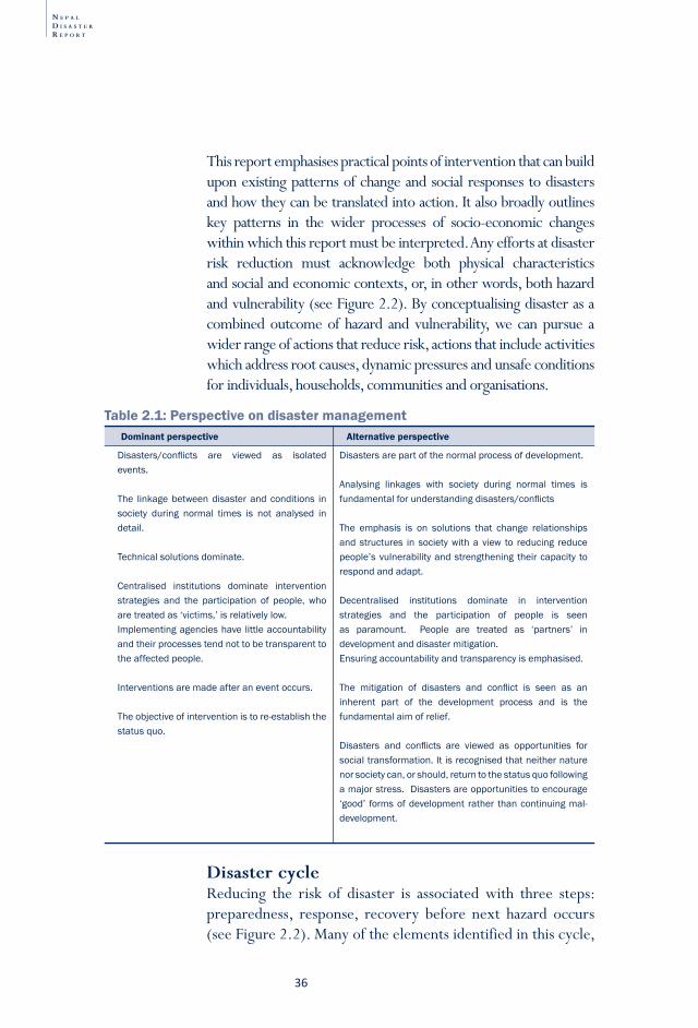
N E P A L
D I S A S T E R
R E P O R T
�6
Disasters/conflicts are viewed as isolatedevents.
The linkage between disaster and conditions insociety during normal times is not analysed indetail.
Technicalsolutionsdominate.
Centralised institutions dominate interventionstrategies and the participation of people, whoaretreatedas‘victims,’isrelativelylow.Implementingagencieshavelittleaccountabilityandtheirprocessestendnottobetransparenttotheaffectedpeople.
Interventionsaremadeafteraneventoccurs.
Theobjectiveofinterventionistore-establishthestatusquo.
Disastersarepartofthenormalprocessofdevelopment.
Analysing linkages with society during normal times isfundamentalforunderstandingdisasters/conflicts
The emphasis is on solutions that change relationshipsandstructures in societywitha view to reducing reducepeople’svulnerabilityandstrengthening theircapacity torespondandadapt.
Decentralised institutions dominate in interventionstrategies and the participation of people is seenas paramount. People are treated as ‘partners’ indevelopmentanddisastermitigation.Ensuringaccountabilityandtransparencyisemphasised.
The mitigation of disasters and conflict is seen as aninherent part of the development process and is thefundamentalaimofrelief.
Disasters and conflicts are viewed as opportunities forsocialtransformation.Itisrecognisedthatneithernaturenorsocietycan,orshould,returntothestatusquofollowingamajorstress.Disastersareopportunitiestoencourage‘good’ formsofdevelopmentrather thancontinuingmal-development.
Dominant perspective Alternative perspective
Table 2.1: Perspective on disaster management
This report emphasises practical points of intervention that can build upon existing patterns of change and social responses to disasters and how they can be translated into action. It also broadly outlines key patterns in the wider processes of socio-economic changes within which this report must be interpreted. Any efforts at disaster risk reduction must acknowledge both physical characteristics and social and economic contexts, or, in other words, both hazard and vulnerability (see Figure 2.2). By conceptualising disaster as a combined outcome of hazard and vulnerability, we can pursue a wider range of actions that reduce risk, actions that include activities which address root causes, dynamic pressures and unsafe conditions for individuals, households, communities and organisations.
Disaster cycle Reducing the risk of disaster is associated with three steps: preparedness, response, recovery before next hazard occurs (see Figure 2.2). Many of the elements identified in this cycle,
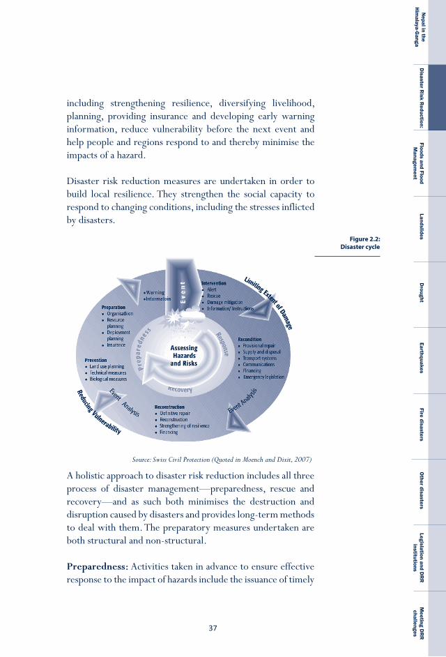
��
Nepal in the
Him
alaya-Ganga
Disaster R
isk Reduction:
Floods and Flood M
anagement
LandslidesD
roughtEarthquakes
Fire disastersO
ther disastersLegislation and D
RR
institutions
Meeting D
RR
challenges
Figure 2.2: Disaster cycle
Source: Swiss Civil Protection (Quoted in Moench and Dixit, 2007)
including strengthening resilience, diversifying livelihood, planning, providing insurance and developing early warning information, reduce vulnerability before the next event and help people and regions respond to and thereby minimise the impacts of a hazard.
Disaster risk reduction measures are undertaken in order to build local resilience. They strengthen the social capacity to respond to changing conditions, including the stresses inflicted by disasters.
A holistic approach to disaster risk reduction includes all three process of disaster management—preparedness, rescue and recovery—and as such both minimises the destruction and disruption caused by disasters and provides long-term methods to deal with them. The preparatory measures undertaken are both structural and non-structural.
preparedness: Activities taken in advance to ensure effective response to the impact of hazards include the issuance of timely
N E P A L
D I S A S T E R
R E P O R T
�8
and effective early warnings and the temporary evacuation of people and property. Social and technical feasibility as well as cost and benefit considerations determine which preventive measures needs to be implemented in areas frequently affected by disasters. By building awareness and promoting education about risk reduction and by changing attitudes and behavior, a culture of prevention can be nurtured.
relief: The provision of interventions during or immediately after a disaster to help save the lives and meet the basic subsistence needs of those affected is known as rescue and relief. Its duration can be immediate, short, or protracted.
recovery: Recovery involves taking decisions and actions after a disaster in order to restore the pre-disaster living conditions of the community, while at the same time encouraging and facilitating those adjustments needed to reduce future risks. Recovery (rehabilitation and reconstruction) provides an opportunity to develop and apply disaster risk reduction measures.
Nepal Society for Earthquake Technology (NSET) has established a disaster informati on management system called DesInventar with funding from UNDP and approval from the government. This computer-based database, which was developed by LA RED in Lati n America in 1994, helps inventory the occurrence of large as well as small disasters and hazards. It analyses data, characterises the att ributes of disasters and presents the results in geo-referenced maps and charts. Data on disasters which occurred between 1970 and 2007 have already been processed. This data includes the characteristi cs and eff ects of hazards, notably their types, locati ons, eff ects (in terms of numbers of casualti es as well as damage to physical objects), and losses.
Another advantage is that it can be adapted to the local context of disasters. In fact, special att enti on is paid to registering small, “everyday” disasters that are usually invisible at the nati onal or global scale. Since the informati on is geo-referenced, the data, as well as its interpretati on and analysis, are expressed
Box 2.1 Nepal’s Desinventar database
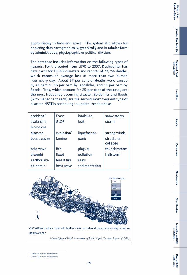
��
Nepal in the
Him
alaya-Ganga
Disaster R
isk Reduction:
Floods and Flood M
anagement
LandslidesD
roughtEarthquakes
Fire disastersO
ther disastersLegislation and D
RR
institutions
Meeting D
RR
challenges
accident 8 Frost landslide snow storm
avalanche GLOF leak storm
biological
disaster explosion� liquefaction strong winds
boat capsize famine panic structural collapse
cold wave fire plague thunderstorm
drought flood pollution hailstorm
earthquake forest fire rains
epidemic heat wave sedimentation
8 Caused by natural phenomenon9 Caused by natural phenomenon
VDC-Wise distribution of deaths due to natural disasters as depicted in DesInventar
Adapted from Global Assessment of Risks Nepal Country Report (2009)
appropriately in time and space, The system also allows for depicting data cartographically, graphically and in tabular form by administrative, physiographic or political division.
The database includes information on the following types of hazards. For the period from 1970 to 2007, DesInventar has data cards for 15,388 disasters and reports of 27,256 deaths, which means an average loss of more than two human lives every day. About 57 per cent of deaths were caused by epidemics, 15 per cent by landslides, and 11 per cent by floods. Fires, which account for 25 per cent of the total, are the most frequently occurring disaster. Epidemics and floods (with 18 per cent each) are the second most frequent type of disaster. NSET is continuing to update the database.
N E P A L
D I S A S T E R
R E P O R T
40
Actions that help the population respond to the impacts of disasters and adapt to climate change have received considerable attention in recent times. These conditions help us understand vulnerability in all disasters, including epidemics and man-made disasters like oil spills and factory explosions, and to implement measures to minimise that vulnerability. Studies in South Asia indicate that the vulnerability and social impacts associated with climate-related disasters are influenced by at least eight conditions (Moench and Dixit, 2004), as listed below.
1. The nature of livelihood systems within a region, in particular the extent to which individuals and households are able to diversify income strategies and incorporate non-farm components, many of which are less vulnerable to disruption via natural disasters than agriculture is;
2. The ability of people to migrate or commute in order to access agricultural or non- agricultural sources of income outside of areas affected by drought or flooding;
3. The ability of information, goods and services to flow into and out of affected areas;
4. The differential social capital and institutional checks and balances that households have access to, including education, community institutions such as self-help groups, formal institutions such as government departments and banks, non-government organisations, the media; and social networks;
5. Existing patterns of differential vulnerability created by gender, income and social position;
6. The nature of physical infrastructure (roads, houses, water supply systems, etc.), in particular:
a. the degree to which such infrastructure is vulnerable to being disrupted by floods and droughts; and
b. the extent to which such infrastructure allows people to maintain their livelihoods during times of drought and flooding by serving as a point of refuge, helping to protect assets, and facilitating the
movement of goods, services and people;
4�
Nepal in the
Him
alaya-Ganga
Disaster R
isk Reduction:
Floods and Flood M
anagement
LandslidesD
roughtEarthquakes
Fire disastersO
ther disastersLegislation and D
RR
institutions
Meeting D
RR
challenges
7. The ability of households to obtain secure sources of drinking water for domestic uses (whether such water supply security is developed through local sources, long-distance transport through water markets or rural supply schemes); and
8. Natural resource conditions, particularly the degree to which ground and surface water systems are disrupted. Specific indicators include:
a. long-term declines in water level and sources, which serve as a major warning signal that irrigated agricultural systems are increasingly vulnerable to droughts; b. the increased presence of structures (such as roads, bridges, embankments for railways and flood control) that interfere with the existing patterns of natural drainage, which serves as an indicator of the greater likelihood of flooding.
A comparison of tables 1.1(a) and (b) with the eight outcomes listed above makes it clear that Nepal’s population is vulnerable to disasters. Disasters adversely affect Nepal’s entire economy but the poor and vulnerable suffer the most because they have limited options for rebuilding their livelihoods after a disaster. The poor have few assets, limited access to formal financial institutions and limited opportunities to diversify their livelihoods. They are forced to reduce their consumption of food, take their children out of school, and sell livestock. Although such steps can provide immediate help to the poorer households, it will have a negative effect on their future. DRR efforts need to be mainstreamed in order to change this overall context. This is a challenge that Nepal must tackle with utmost priority.
N E P A L
D I S A S T E R
R E P O R T
42
Box 2.2: Disaster and poverty
10 Koirala, K.R., 2009: Nepal’s Poverty Level Down to 24.8 per cent. Asian Tribune www.Asiantribune.com/?q=node/16787 retrieved on October 1, 2009.
11 http://www.mdgmonitor.org/country_progress.cfm?c=NPL&cd= retrieved on 8 October, 2009
Nepal’s progress in reducing the level of absolute poverty from 42 per cent in 1996/97 to 24.8 per cent�0 in 2008/09 (a drop of almost 18 per cent in just 12 years) has more to do with the increase in the fl ow of remitt ances than with any targeted measures which the government adopted in its fi ve-year plans, one of whose aims was to reduce the proporti on of the populati on living below the poverty line by increasing local employment opportuniti es (NPC, 2007). It unlikely that Nepal can expect progress in poverty reducti on if the country does not address natural hazard vulnerability, parti cularly as the impacts of climate change grow more serious. According to the MoHA (2008), the high levels of structural, non-structural, social and insti tuti onal vulnerabiliti es of Nepal to various natural and human-induced hazards will severely impede its ability to achieve its millennium development goals (MDGs).
According to the UN MDG monitoring initi ati ve, Nepal is on track to achieve only one of its eight MDG goals, that relati ng to reducing child mortality.�� Most of the remaining goals can be achieved only if Nepali insti tuti ons become more robust than they are at present or if the goals themselves are lowered. As things stand, disasters will probably undermine the likelihood of achieving four goals in parti cular: reducing poverty, reducing hunger, improving child health and att aining universal educati on. The GoN and the UNDP (2008) recognise that it is the poor people of Nepal who will be disproporti onately aff ected by natural hazards, as their livelihoods are largely dependent on climate-sensiti ve natural resources and their capaciti es to cope with extreme climati c events are very weak. The fact that so many Nepalis rely on natural resource-dependent livelihoods to survive poses a serious challenge for human development though evidence that non-climate-dependent alternati ves such as service sector livelihoods are being embraced is encouraging (NCVST, 2009). Even in this changing livelihood picture, however, weather vagaries and the impacts of more frequently occurring climate change-induced disasters will conti nue to wreak devastati on and undermine wellbeing.
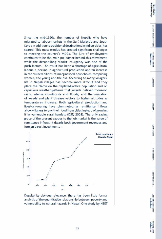
4�
Nepal in the
Him
alaya-Ganga
Disaster R
isk Reduction:
Floods and Flood M
anagement
LandslidesD
roughtEarthquakes
Fire disastersO
ther disastersLegislation and D
RR
institutions
Meeting D
RR
challenges
Since the mid-1990s, the number of Nepalis who have migrated to labour markets in the Gulf, Malaysia and South Korea in addition to traditional destinations in Indian cities, has soared. This mass exodus has created significant challenges to meeting the country’s MDGs. The lure of employment continues to be the main pull factor behind this movement, while the decade-long Maoist insurgency was one of the push factors. The result has been a shortage of agricultural labour, a decline in agricultural production and an increase in the vulnerabilities of marginalised households comprising women, the young and the old. According to many villagers, life in Nepali villages has become more difficult and they place the blame on the depleted active population and on capricious weather patterns that include delayed monsoon rains, intense cloudbursts and floods, and the migration of weeds and plant disease vectors to higher altitudes as temperatures increase. Both agricultural production and livestock-rearing have plummeted as remittance inflows allow villagers to buy their food from cities instead of growing it in vulnerable rural hamlets (DST, 2008). The only saving grace of the present exodus to the job market is the value of remittance inflows: it dwarfs both government revenues and foreign direct investments .
Despite its obvious relevance, there has been little formal analysis of the quantitative relationship between poverty and vulnerability to natural hazards in Nepal. One study by NSET
Total remittance flows to Nepal
N E P A L
D I S A S T E R
R E P O R T
44
(2008) somewhat counter-intuiti vely suggests that there is a negati ve correlati on between the incidence of fl ood disasters and levels of poverty: geographical areas aff ected by fl oods have lower poverty rates. Since these fi ndings cannot be substanti ated in the face of widespread qualitati ve evidence, the authors of the study recommend further investi gati on. In contrast, a more recent study, also of fl oods in the Tarai and poverty, suggests that the impact of climate-related shocks will have a devastati ng eff ect on Nepal’s social and economic development. In parti cular, the predicted increase in the number and intensity of fl ood disasters will prevent many Nepali households in the Tarai from rising above the poverty line (NCVST, 2009). This 2009 study also suggests that even under median climate change projecti ons, the fl ood impact on each household in the Tarai will double and that the number of households aff ected by fl oods directly will increase by 40 per cent. Its anomalous fi ndings on fl oods notwithstanding, the 2008 NSET study does indicate a similarly positi ve correlati on between the incidence of landslides (a climate hazard-related phenomenon) and poverty: rates of poverty are higher in areas where more people have been impacted by landslides.
The above fi ndings underscore the need for more disaggregated analyses, especially as the character of Nepali households, the nature of poverty and the infl uence of various insti tuti ons are changing. In the last decade, the market, for example, has emerged as a dominant insti tuti on for providing goods and services in many Nepali setti ngs. The NCVST report (2009), quoti ng the household budget survey of Nepal Rastra Bank, suggests that in 2005/2006 a Nepali average household spent 61 per cent of its total expenditure on goods and services. Three decades earlier, in 1973/1974, the same fi gure was just 33.2 per cent.
The emergence of the market as a mechanism for distributi ng services once provided by the government or obtained from the natural environment has made local inhabitants increasingly reliant on imported goods and services. This shift has infl icted greater hardship upon the poor-, low- and fi xed- income households, who traditi onally relied on ecosystem and government services. These groups are in a bind: they can neither control price fl uctuati ons in the market nor fall back on traditi onal, informal means of accessing goods and
4�
Nepal in the
Him
alaya-Ganga
Disaster R
isk Reduction:
Floods and Flood M
anagement
LandslidesD
roughtEarthquakes
Fire disastersO
ther disastersLegislation and D
RR
institutions
Meeting D
RR
challenges
services because either the government has withdrawn from its basic responsibility or ecosystem services have degraded. To make matters worse, unscrupulous speculators and middlemen extract a windfall from economic turmoil by hoarding goods, charging exorbitant prices, and defrauding middle-class and poor customers.
These emerging dynamics require that we redefine poverty, though arriving at such a definition will probably not be easy. In their conceptual schema, most international agencies define poverty as a complex phenomenon caused, among other things, by deprivation of wellbeing, lack of material assets or income, low levels of health provision, poor or no education, and food insecurity (UNESC, 2001; UNDP, 2007). In practice, however, this rich definition is reduced to a simple economic measure—a one-dollar-per-day threshold. Below this income level, it is considered that a household lives in absolute poverty and is unable to meet the minimum levels of food, energy, and shelter needed for basic survival (World Bank, 2007). The one-dollar indicator certainly does have value in its ability to quantify and assess progress towards increasing income as one of many aspects minimising poverty, but it is insufficient.
The near-universal tendency to see such a simplistic measure as the sole measure of poverty is problematic not only because it ignores fluctuations in exchange and inflation rates (which, because of economic globalisation, are important even at the local level), but also because the approach does not capture the diversity of deprivations poverty entails. An attempt made to address the limitations of the one dollar-per-day measure in reflecting regional and local contexts led to the creation of an additional income threshold—two dollars a day. With this addition, we can make a distinction in the severity of poverty, but the fundamental flaw in the prevailing paradigm of measuring poverty in only monetary term remains.
The sought after new definition of poverty needs to capture not only income but also the many other factors contributing
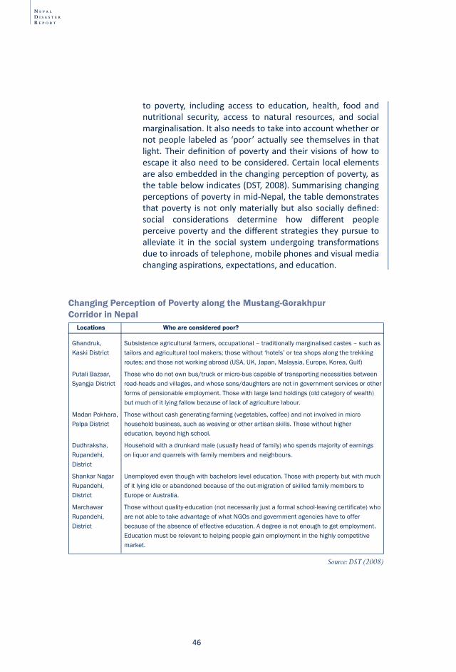
N E P A L
D I S A S T E R
R E P O R T
46
to poverty, including access to educati on, health, food and nutriti onal security, access to natural resources, and social marginalisati on. It also needs to take into account whether or not people labeled as ‘poor’ actually see themselves in that light. Their defi niti on of poverty and their visions of how to escape it also need to be considered. Certain local elements are also embedded in the changing percepti on of poverty, as the table below indicates (DST, 2008). Summarising changing percepti ons of poverty in mid-Nepal, the table demonstrates that poverty is not only materially but also socially defi ned: social considerati ons determine how diff erent people perceive poverty and the diff erent strategies they pursue to alleviate it in the social system undergoing transformati ons due to inroads of telephone, mobile phones and visual media changing aspirati ons, expectati ons, and educati on.
Ghandruk, Subsistenceagriculturalfarmers,occupational–traditionallymarginalisedcastes–suchasKaskiDistrict tailorsandagriculturaltoolmakers;thosewithout‘hotels’orteashopsalongthetrekking routes;andthosenotworkingabroad(USA,UK,Japan,Malaysia,Europe,Korea,Gulf)
PutaliBazaar, Thosewhodonotownbus/truckormicro-buscapableoftransportingnecessitiesbetweenSyangjaDistrict road-headsandvillages,andwhosesons/daughtersarenotingovernmentservicesorother formsofpensionableemployment.Thosewithlargelandholdings(oldcategoryofwealth) butmuchofitlyingfallowbecauseoflackofagriculturelabour.
MadanPokhara, Thosewithoutcashgeneratingfarming(vegetables,coffee)andnotinvolvedinmicroPalpaDistrict householdbusiness,suchasweavingorotherartisanskills.Thosewithouthigher education,beyondhighschool.
Dudhraksha, Householdwithadrunkardmale(usuallyheadoffamily)whospendsmajorityofearningsRupandehi, onliquorandquarrelswithfamilymembersandneighbours.District
ShankarNagar Unemployedeventhoughwithbachelorsleveleducation.ThosewithpropertybutwithmuchRupandehi, ofitlyingidleorabandonedbecauseoftheout-migrationofskilledfamilymemberstoDistrict EuropeorAustralia.
Marchawar Thosewithoutquality-education(notnecessarilyjustaformalschool-leavingcertificate)whoRupandehi, arenotabletotakeadvantageofwhatNGOsandgovernmentagencieshavetoofferDistrict becauseoftheabsenceofeffectiveeducation.Adegreeisnotenoughtogetemployment. Educationmustberelevanttohelpingpeoplegainemploymentinthehighlycompetitive market.
Locations Who are considered poor?
Changing Perception of Poverty along the Mustang-Gorakhpur Corridor in Nepal
Source: DST (2008)
4�
Nepal in the
Him
alaya-Ganga
Disaster R
isk Reduction:
Floods and Flood M
anagement
LandslidesD
roughtEarthquakes
Fire disastersO
ther disastersLegislation and D
RR
institutions
Meeting D
RR
challenges
The process of disentangling the links between disaster and poverty is fraught with both conceptual and methodological challenges. Definitions of, approaches to, and measurements of poverty need to consider the wide range of factors that contribute to poverty and to people’s experience of it, and, perhaps even more importantly, those factors that enable or create barriers to the efforts of individuals and households to move out of poverty. Whether poverty results from disaster or from some other sources, these conceptual and methodological challenges remain. Since it is the poor who are vulnerable to disasters, it is their definition of poverty which will be helpful in formulating effective disaster risk reduction strategies.

N E P A L
D I S A S T E R
R E P O R T
48
4�
Nepal in the
Him
alaya-Ganga
Disaster R
isk Reduction:
Floods and Flood M
anagement
LandslidesD
roughtEarthquakes
Fire disastersO
ther disastersLegislation and D
RR
institutions
Meeting D
RR
challenges
Chapter-3
“The task is not just to preserve water resources to sustain life, but also to reduce the capacity of water to take life away. …we can and must reduce the number and impact of disasters by building sustainable communities that have the long-term capacity to live with risk.” Kofi Annan, United Nations Secretary-General (8 October 2003)
The Himalaya-Ganga River Basin system is home to some of the poorest people in the world, in part because of its climate and hydrology. Many Nepalis, Indians and Bangladeshis who live here have been reduced to abject poverty because of regular flooding during the monsoon season from June to September and drought-like conditions throughout the rest of the year (Bandhyopadhyaya, 1999). This annual flood-drought pattern exhibits great micro-level variations in its nature and impact but across the region people regularly face the devastation of torrential downpours, landslides and floods as well as of low water tables and dried up springs.
Floods and Flood Management
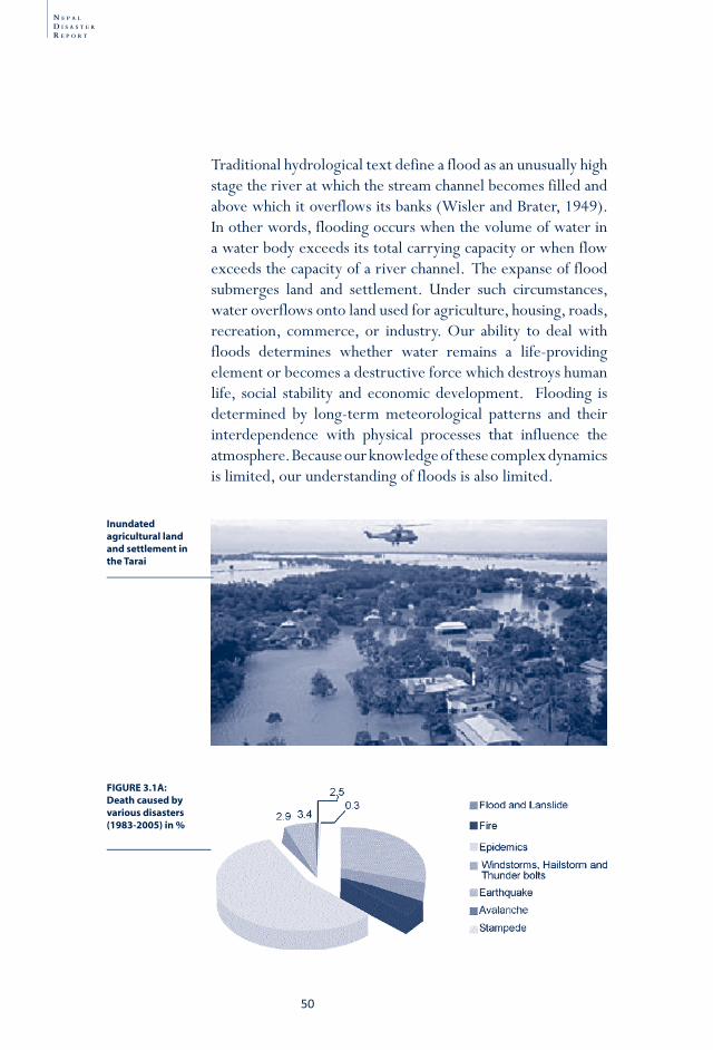
N E P A L
D I S A S T E R
R E P O R T
�0
Inundated agricultural land and settlement in the Tarai
FIGURE 3.1A: Death caused by various disasters (1983-2005) in %
Traditional hydrological text define a flood as an unusually high stage the river at which the stream channel becomes filled and above which it overflows its banks (Wisler and Brater, 1949). In other words, flooding occurs when the volume of water in a water body exceeds its total carrying capacity or when flow exceeds the capacity of a river channel. The expanse of flood submerges land and settlement. Under such circumstances, water overflows onto land used for agriculture, housing, roads, recreation, commerce, or industry. Our ability to deal with floods determines whether water remains a life-providing element or becomes a destructive force which destroys human life, social stability and economic development. Flooding is determined by long-term meteorological patterns and their interdependence with physical processes that influence the atmosphere. Because our knowledge of these complex dynamics is limited, our understanding of floods is also limited.
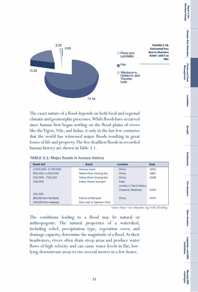
��
Nepal in the
Him
alaya-Ganga
Disaster R
isk Reduction:
Floods and Flood M
anagement
LandslidesD
roughtEarthquakes
Fire disastersO
ther disastersLegislation and D
RR
institutions
Meeting D
RR
challenges
FIGURE 3.1B: Estimated loss
due to disasters 92001-2007) in
NRs
The exact nature of a flood depends on both local and regional climatic and geomorphic processes. While floods have occurred since human first began settling on the flood plains of rivers like the Tigris, Nile, and Indus, it only in the last few centuries that the world has witnessed major floods resulting in great losses of life and property. The five deadliest floods in recorded human history are shown in Table 3.1.
The conditions leading to a flood may be natural or anthropogenic. The natural properties of a watershed, including relief, precipitation type, vegetation cover, and drainage capacity, determine the magnitude of a flood. At their headwaters, rivers often drain steep areas and produce water flows of high velocity and can cause water levels in flat, low-lying downstream areas to rise several metres in a few hours.
TABLE 3.1: Major floods in human historyDeath toll Event Location Date
2,500,000–3,700,000 Variousrivers China 1931900,000–2,000,000 YellowRiver(HuangHe) China 1887500,000–700,000 YellowRiver(HuangHe) China 1938230,000 IndianOceantsunami India (mostlyinTamilNadu), Thailand,Maldives 2004231,000(86,000fromtheflood; FailureofBanqiao China 1975145,000fromdisease) DamduetoTyphoonNina
Source: http//en.wikipedia.org/wiki/flooding
N E P A L
D I S A S T E R
R E P O R T
�2
Anthropogenic factors which have contributed to an increase in flooding include rapid population growth and the settlement of the flat, low-lying areas most susceptible to flooding. The increase in built-up and impervious areas also intensifies the likelihood of floods because natural drainage is blocked and rainfall runoff increases. Anthropogenic-induced climate change, by altering the regional hydrological cycle and increasing the frequency and intensity of extreme rainfall events also has a hand, and has the felling of trees in small and moderate watersheds (Hofer and Messereli, 2006). In recent years, economic losses due to flooding have increased in both developed as well as developing countries.
Despite the devastation they cause, floods are also beneficial: they replenish freshwater bodies, augment wetland areas, and recharge groundwater. In addition, frequently occurring small floods deposit alluvial soil on floodplains, increasing their fertility.
Floods: national contextNepal’s more than 6,000 rivers and rivulets, with a total of 45,000 km in length, support irrigated agriculture and other livelihoods, but also wreak havoc in valleys and in the Tarai when they overflow. The river drainage density of 0.3 km/km2 is an indication of how close the drainage channels are (Shankar, 1985) and susceptible to floods. Flooding in Nepal damages crops and property and often results in epidemics; the poor are the most vulnerable. The major events of floods in Nepal are listed in table 3.2.
The records of the MoHA do not differentiate between the loss of life and property caused by landslides and that caused by floods, so it is difficult to accurately estimate flood loss alone though we do know that large-scale floods occur in the Tarai and affect large numbers of people every year. The Bhabar region is prone to the flash flooding of the ephemeral rivers that originate in the Chure Range, rivers which frequently change their course and transfer sediments, causing their bed levels to rise constantly. As they flow south towards the Tarai
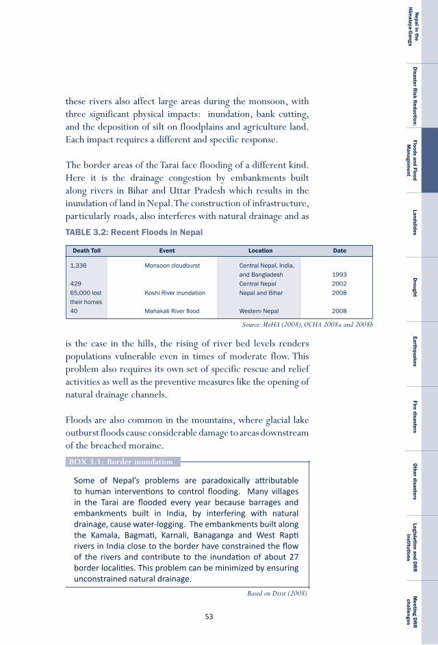
��
Nepal in the
Him
alaya-Ganga
Disaster R
isk Reduction:
Floods and Flood M
anagement
LandslidesD
roughtEarthquakes
Fire disastersO
ther disastersLegislation and D
RR
institutions
Meeting D
RR
challenges
Source: MoHA (2008), OCHA 2008a and 2008b
Death Toll Event Location Date
TABLE 3.2: Recent Floods in Nepal
1,336 Monsooncloudburst CentralNepal,India, andBangladesh 1993429 CentralNepal 200265,000lost KoshiRiverinundation NepalandBihar 2008theirhomes40 MahakaliRiverflood WesternNepal 2008
Some of Nepal’s problems are paradoxically attributable to human interventions to control flooding. Many villages in the Tarai are flooded every year because barrages and embankments built in India, by interfering with natural drainage, cause water-logging. The embankments built along the Kamala, Bagmati, Karnali, Banaganga and West Rapti rivers in India close to the border have constrained the flow of the rivers and contribute to the inundation of about 27 border localities. This problem can be minimized by ensuring unconstrained natural drainage.
BoX 3.1: Border inundation
these rivers also affect large areas during the monsoon, with three significant physical impacts: inundation, bank cutting, and the deposition of silt on floodplains and agriculture land. Each impact requires a different and specific response.
The border areas of the Tarai face flooding of a different kind. Here it is the drainage congestion by embankments built along rivers in Bihar and Uttar Pradesh which results in the inundation of land in Nepal. The construction of infrastructure, particularly roads, also interferes with natural drainage and as
is the case in the hills, the rising of river bed levels renders populations vulnerable even in times of moderate flow. This problem also requires its own set of specific rescue and relief activities as well as the preventive measures like the opening of natural drainage channels.
Floods are also common in the mountains, where glacial lake outburst floods cause considerable damage to areas downstream of the breached moraine.
Based on Dixit (2008)

N E P A L
D I S A S T E R
R E P O R T
�4
Causes of floods in Nepal
In Nepal, floods are a natural phenomenon during the monsoon. The impacts they cause depend on both natural conditions and the characteristics of the population; together these factors determine the scale of loss. The major causes of flooding in Nepal are listed below.
a) rainfall variability Flooding results from the unequal distribution of rainfall in time and space. More than 80 per cent of the rainfall in the country occurs during the monsoon from June to September. The average annual rainfall is 1,627 mm (Alford, 1992). Torrential rainfall and cloudbursts that bring over 400 mm rainfall in a single day are common in the Mahabharat Range (see Table 1.4) and often cause heavy floods. Rainfall intensity during a single hour is equally high, with over 40 millimetres common in the lower Mahabharat and Chure ranges. In 1989, Pokhara recorded a tremendous 88 millimetres in one hour, and Bhusal et al. (1993) report that the 45 millimetre/hour rainfall on 29 September, 1993 triggered massive landslides and debris flows in South Central Nepal.
b) topography The slopes of Nepal’s hills and mountains range from steep to very steep (more than 30 per cent), while the Tarai is flat (less than 10 per cent). Because of this gradient change, in the uplands rivers flow at very high velocities and possess a high capacity to transport sediment, but when they enter the Tarai and slow down, all this material—stones, gravel, sand and silt—is deposited as an alluvial fan. Because such deposition increases the level of the river bed, it increases the probability of flooding even during moderate rainfall.

��
Nepal in the
Him
alaya-Ganga
Disaster R
isk Reduction:
Floods and Flood M
anagement
LandslidesD
roughtEarthquakes
Fire disastersO
ther disastersLegislation and D
RR
institutions
Meeting D
RR
challenges
Many localities lack the flood forecasting and early warning mechanisms which could save lives and protect property. National-level efforts to acquire high science also need to make it accessible to local communities and households. Practical Action Nepal has piloted a community-based local flood warning system in the Rapti River basin in Chitwan District. It consists of towers equipped with sirens that the community blows when the river rises above a predetermined level. When people downstream hear the warning of a flood, they can take appropriate measures, including evacuation if necessary.
Some effort is also being made to broadcast locally-collected rainfall data via regular FM news broadcasts. The data is collected daily in schools as part of a science education programme designed to institutionalise civic science-based initiatives and then provided to FM stations in the vicinity. The data is used to generate simple rainfall runoff models useful for forewarning downstream areas about impending floods and enabling local populations to take appropriate measures to save their assets. The aims of the programme are three: to expand the coverage of secondary rain gauge stations across the nation, to help students acquire knowledge about rainfall measurements and to institutionalise locally-based warning systems. Once the mechanism is insitutionalised it can also be used to predict droughts and other likely changes attributable to the complex impacts of climate change.
BoX 3.2: Flood forecasting/early warning system
c) Deforestation/decreasing vegetative coverBecause vegetation intercepts precipitation, it reduces runoff and thereby the possibility of soil erosion. Since farming reduces vegetative cover, it has contributed to the occurrence of local floods. Humans also alter the naturally existing conditions in the watershed through the construction of hydraulic structures, urbanisation, deforestation and quarrying. In comparison with urban watersheds, rural watersheds, exhibit greater interception of rainfall, greater infiltration (because the pervious area is large), less surface runoff, and slower drainage. The many impervious surfaces such as roofs, streets
N E P A L
D I S A S T E R
R E P O R T
�6
Disaster is the outcome of the intersecti on of hazard and vulnerability: a natural event such as a fl ood only becomes as disaster if it adversely impacts humans and their interests. Improving our responses to natural hazards will require further assessment of this intersecti on, especially at the local level, where geographic conditi ons give events like fl oods, droughts, landslides and earthquakes unique characteristi cs. In Nepal eff orts to assess local hazards include the preparati on of village-level hazard maps which both identi fy the nature of those hazards and link them to the vulnerability of the local populati on. These maps help design measures to support vulnerable households so that they are bett er prepared to respond to disasters.
BoX 3.3: role of local hazard maps in flood disaster mitigation
and paved zones in a city channel water and thereby accelerate runoff; they also impede surface drainage and contribute to localised flooding. Upadhaya (2007) attributes the flooding of the Dhobi Khola of Kathmandu to increasing urbanisation because it increases peak flow and surface runoff, but reduces base flow.
The role vegetation plays in flooding must be considered with caution. While urbanisation and deforestation may increase the frequency of floods in small and medium watersheds, these processes have less effect on the scale of a river basin during the mid-monsoon, when the soil has reached its saturation point and can store no more water. In addition, the Theory of Himalayan Degradation (THD) advanced in the 1970s has been disproved. This theory argued that the deforestation in th e mountain slopes of Nepal contributed to the flooding of the plains of Bihar and Bangladesh, but later research in the fields of hydrology, geomorphology, sedimentation, forestry and soil science indicated that flood disaster is the result of many factors. Interdisciplinary studies like those of Thomspson et al. (1986) and Ives and Messereli (1989) also suggested that there is no direct link between large-scale downstream flooding and deforestation.
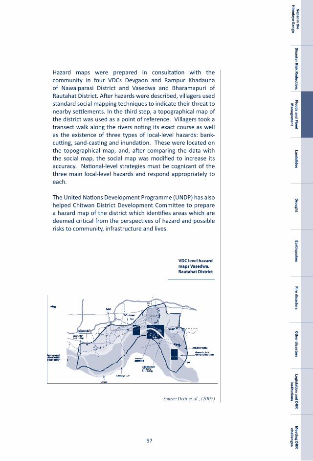
��
Nepal in the
Him
alaya-Ganga
Disaster R
isk Reduction:
Floods and Flood M
anagement
LandslidesD
roughtEarthquakes
Fire disastersO
ther disastersLegislation and D
RR
institutions
Meeting D
RR
challenges
VDC level hazard maps Vasedwa, Rautahat District
Source: Dixit et.al., (2007)
Hazard maps were prepared in consultation with the community in four VDCs Devgaon and Rampur Khadauna of Nawalparasi District and Vasedwa and Bharamapuri of Rautahat District. After hazards were described, villagers used standard social mapping techniques to indicate their threat to nearby settlements. In the third step, a topographical map of the district was used as a point of reference. Villagers took a transect walk along the rivers noting its exact course as well as the existence of three types of local-level hazards: bank-cutting, sand-casting and inundation. These were located on the topographical map, and, after comparing the data with the social map, the social map was modified to increase its accuracy. National-level strategies must be cognizant of the three main local-level hazards and respond appropriately to each.
The United Nations Development Programme (UNDP) has also helped Chitwan District Development Committee to prepare a hazard map of the district which identifies areas which are deemed critical from the perspectives of hazard and possible risks to community, infrastructure and lives.
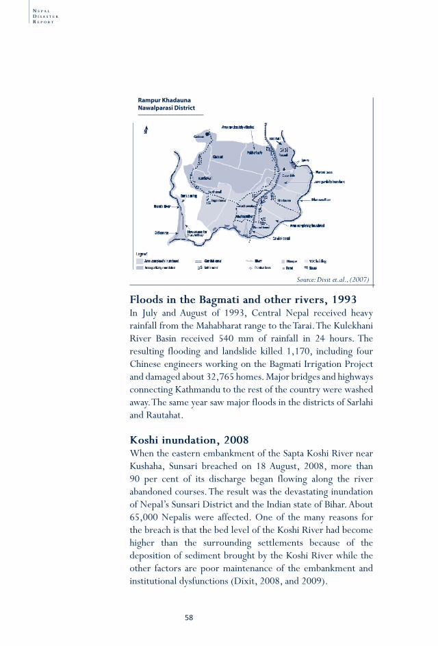
N E P A L
D I S A S T E R
R E P O R T
�8
Floods in the Bagmati and other rivers, 1993In July and August of 1993, Central Nepal received heavy rainfall from the Mahabharat range to the Tarai. The Kulekhani River Basin received 540 mm of rainfall in 24 hours. The resulting flooding and landslide killed 1,170, including four Chinese engineers working on the Bagmati Irrigation Project and damaged about 32,765 homes. Major bridges and highways connecting Kathmandu to the rest of the country were washed away. The same year saw major floods in the districts of Sarlahi and Rautahat.
Koshi inundation, 2008When the eastern embankment of the Sapta Koshi River near Kushaha, Sunsari breached on 18 August, 2008, more than 90 per cent of its discharge began flowing along the river abandoned courses. The result was the devastating inundation of Nepal’s Sunsari District and the Indian state of Bihar. About 65,000 Nepalis were affected. One of the many reasons for the breach is that the bed level of the Koshi River had become higher than the surrounding settlements because of the deposition of sediment brought by the Koshi River while the other factors are poor maintenance of the embankment and institutional dysfunctions (Dixit, 2008, and 2009).
Rampur Khadauna Nawalparasi District
Source: Dixit et.al., (2007)
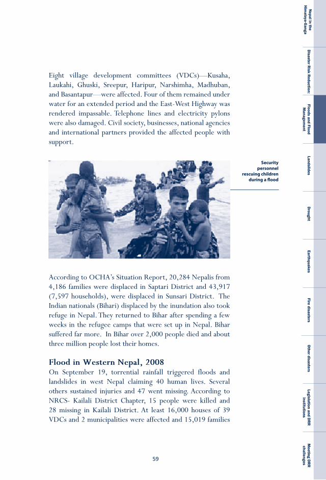
��
Nepal in the
Him
alaya-Ganga
Disaster R
isk Reduction:
Floods and Flood M
anagement
LandslidesD
roughtEarthquakes
Fire disastersO
ther disastersLegislation and D
RR
institutions
Meeting D
RR
challenges
Eight village development committees (VDCs)—Kusaha, Laukahi, Ghuski, Sreepur, Haripur, Narshimha, Madhuban, and Basantapur—were affected. Four of them remained under water for an extended period and the East-West Highway was rendered impassable. Telephone lines and electricity pylons were also damaged. Civil society, businesses, national agencies and international partners provided the affected people with support.
Security personnel
rescuing children during a flood
According to OCHA’s Situation Report, 20,284 Nepalis from 4,186 families were displaced in Saptari District and 43,917 (7,597 households), were displaced in Sunsari District. The Indian nationals (Bihari) displaced by the inundation also took refuge in Nepal. They returned to Bihar after spending a few weeks in the refugee camps that were set up in Nepal. Bihar suffered far more. In Bihar over 2,000 people died and about three million people lost their homes.
Flood in Western Nepal, 2008 On September 19, torrential rainfall triggered floods and landslides in west Nepal claiming 40 human lives. Several others sustained injuries and 47 went missing. According to NRCS- Kailali District Chapter, 15 people were killed and 28 missing in Kailali District. At least 16,000 houses of 39 VDCs and 2 municipalities were affected and 15,019 families
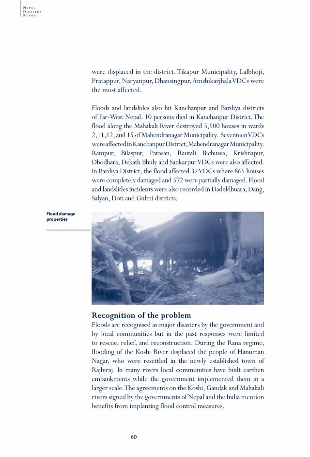
N E P A L
D I S A S T E R
R E P O R T
60
were displaced in the district. Tikapur Municipality, Lalbhoji, Pratappur, Naryanpur, Dhansingpur, Amshikarjhala VDCs were the most affected.
Floods and landslides also hit Kanchanpur and Bardiya districts of Far-West Nepal. 10 persons died in Kanchanpur District. The flood along the Mahakali River destroyed 5,500 houses in wards 2,11,12, and 15 of Mahendranagar Municipality. Seventeen VDCs were affected in Kanchanpur District, Mahendranagar Municipality. Rampur, Bilaspur, Parasan, Rautali Bichuwa, Krishnapur, Dhodhara, Dekath Bhuly and Sankarpur VDCs were also affected. In Bardiya District, the flood affected 32 VDCs where 865 houses were completely damaged and 572 were partially damaged. Flood and landslides incidents were also recorded in Dadeldhuara, Dang, Salyan, Doti and Gulmi districts.
recognition of the problemFloods are recognised as major disasters by the government and by local communities but in the past responses were limited to rescue, relief, and reconstruction. During the Rana regime, flooding of the Koshi River displaced the people of Hanuman Nagar, who were resettled in the newly established town of Rajbiraj. In many rivers local communities have built earthen embankments while the government implemented them in a larger scale. The agreements on the Koshi, Gandak and Mahakali rivers signed by the governments of Nepal and the India mention benefits from implanting flood control measures.
Flood damage properties
6�
Nepal in the
Him
alaya-Ganga
Disaster R
isk Reduction:
Floods and Flood M
anagement
LandslidesD
roughtEarthquakes
Fire disastersO
ther disastersLegislation and D
RR
institutions
Meeting D
RR
challenges
Institutionalised efforts on flood mitigation started after the Department of Irrigation was established in the 1950s. The Water-Induced Disaster Prevention Center (renamed the Department of Water-Induced Disaster Prevention (DWIDP) on 7 February, 2000) was established with support from Japan International Cooperation Agency (JICA) to enhance the country’s flood and landslide management capacity. Within its seven divisions and five sub-divisions the DWIDP undertakes river training and slope stabilisation works as well as supervises rehabilitation and management.
The department implements both non-structural and structural measures. Structural measures include the construction of spurs, dykes, embankments and other flood protection works, while non-structural measures include emergency protection and rehabilitation works, Global Information System (GIS) development, the maintenance of linkages with other agencies and dialogue with India on inundation in Nepal’s border regions. Non-structural measures also include training, seminars and workshops, education and curricula development and publication. The DWIDP is involved in institution building, research, the provision of insurance, and the development of early warning system. Guided by the National Water Strategy of 2002, the DWIDP is developing water-induced disaster management policies and strategies.
Its long-term strategies include bio-engineering, catchment treatment and watershed management. By seeking to involve local communities in non-engineered structural mitigation measures, the department uses proven local knowledge and local materials. The DWIDP, district development committees and other agencies also distribute gabion wire boxes to communities for local-level flood mitigation. The DWIDP also works with the NRCS, locally based NGOs and other agencies in implementing non-structural aspects of flood mitigation.
The need to provide financial support to flood disaster victims was officially recognised with the enactment of the NCRA
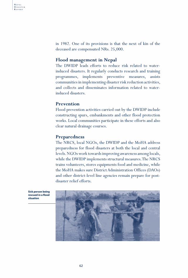
N E P A L
D I S A S T E R
R E P O R T
62
in 1982. One of its provisions is that the next of kin of the deceased are compensated NRs. 25,000.
Flood management in NepalThe DWIDP leads efforts to reduce risk related to water-induced disasters. It regularly conducts research and training programmes, implements preventive measures, assists communities in implementing disaster risk reduction activities, and collects and disseminates information related to water-induced disasters.
preventionFlood prevention activities carried out by the DWIDP include constructing spurs, embankments and other flood protection works. Local communities participate in these efforts and also clear natural drainage courses.
preparednessThe NRCS, local NGOs, the DWIDP and the MoHA address preparedness for flood disasters at both the local and central levels. NGOs work towards improving awareness among locals, while the DWIDP implements structural measures. The NRCS trains volunteers, stores equipments food and medicine, while the MoHA makes sure District Administration Offices (DAOs) and other district-level line agencies remain prepare for post-disaster relief efforts.
Sick person being rescued in a fl ood situation
6�
Nepal in the
Him
alaya-Ganga
Disaster R
isk Reduction:
Floods and Flood M
anagement
LandslidesD
roughtEarthquakes
Fire disastersO
ther disastersLegislation and D
RR
institutions
Meeting D
RR
challenges
The MoHA holds a meeting of the Central Disaster Relief Committee before every disaster season. For floods, this meeting is held every June. District disaster relief committees then hold meetings to alert local-level organisations. At the community level, places to take shelter and local volunteers are identified. In last few years, local FM radio stations also inform people about possible floods and warn them to take preventive measures.
rescue and relief Rescue and relief operations are coordinated by the MoHA at the central level and by district administrative offices at the local level. The Nepal Police (NP), the Armed Police Force (APF) and the Nepal Army (NA) work during and after floods to rescue people living in affected areas, but it is the NRCS which takes the leading role by mobilising its volunteers at the local level and drawing on resources from national and international donors.
Relief is provided by the government of Nepal with the help of I/NGO such as the NRCS. After assessing the situation, the NRCS provides both food and non-food items and medical services to the affected. Local and national institutions also provide food and clothes. For its part, the government provides modest compensation to those who lose family members or property or who are injured.
reconstruction and rehabilitationIn general, rescue and relief activities mark the end of disaster management in Nepal, but there are a few examples of reconstruction and rehabilitation efforts. In July 2003, for example, NRCS Mahottari provided 47 houses worth NRs. 5.8 million to the flood victims of Sundarpur and Shripur VDCs of the district. In the same year, houses worth millions were also provided to flood victims in Rautahat and Sarlahi districts.1 Agencies such as Oxfam GB has provided support to built flood resistant houses in Rampur Khadauna of Nawalparasi District.
N E P A L
D I S A S T E R
R E P O R T
64
Glacier lake outburst floods (GloF)Glaciers were formed in the Himalaya between the 15th and 19th century, during the Little Ice Age (Yamada, 1993). A glacier lake originates from a glacier and usually forms at its terminus. According to ICIMOD (2007), the Nepal Himalaya has more than 2,323 glacier lakes with areas larger than 0.03 sq. km. As a glacier melts, melt-water is stored within the lateral and end moraines creating a glacier lake. They can be dammed variously by moraines, glacier ice or ice cores and moraines and will continue to grow as the ice melts. The Imja, for example, “was just a small pond in the 1960s” but in recent, it has radius of 1 km and stores 2.9 million cubic metres of water (Watanabe et al. 1994).
Glacial lake outburst fl oods (GLOF) are a common hazard in Nepal’s high mountains, at elevati ons greater than 3,500 masl. The downstream impact of such a breach is catastrophic. The Koshi River Basin, the Gandaki River Basin, the Karnali River Basin and the Mahakali River Basin contain 1,062, 338, 907 and 16 lakes respecti vely. Dudh Koshi Sub-Basin, the largest basin in Nepal, is also the most densely glaciated region of the country (Bajracharya et al., 2004). It contains twelve of the 27 potenti ally dangerous glacial lakes identi fi ed by ICIMOD and UNEP (UNEP 2001).
The damage associated with GLOF is substanti al. In 1984, Dig Tsho (“Tsho” means lake in Tibetan) was breached when a large avalanche slid into it. Two hours aft erward, the fl ood reached a peak of discharge of 1,500 m3/s. The event transported four million cubic metres of sediment down the Dud Koshi River. It destroyed a hydroelectricity project, 14 bridges, 30 houses and farmland worth four million U.S. dollars. Three years earlier, the breach of Zhangzangbo Lake killed four people and damaged the China-Nepal Friendship Bridge on the northern border as well as seven other bridges, a hydropower plant, Arniko Highway and 51 houses. In 1985 a large avalanche triggered GLOF at Dig Tsho. A third devastati ng GLOF was that of the Tam Pokhari in 1998. Two were killed, six bridges were destroyed and arable land was washed away. Losses were esti mated at 150 million rupees.*
BoX 3.4: GloF mitigation
6�
Nepal in the
Him
alaya-Ganga
Disaster R
isk Reduction:
Floods and Flood M
anagement
LandslidesD
roughtEarthquakes
Fire disastersO
ther disastersLegislation and D
RR
institutions
Meeting D
RR
challenges
A moraine, which comprises unconsolidated and unsorted material, is easily disturbed by a slight interruption; it can also be over-topped by lake water. Either event can lead to the sudden release of the stored melt-water, resulting in a catastrophic flood called a glacier lake outburst flood (GLOF). GLOFs can devastate the cultivated land, infrastructure, and settlements along the banks of the affected river up to several kilometres downstream of the breach. The surge of water gouges the river bed as well as its banks. The landslides thus triggered result in the loss of agricultural land, threatening livelihoods, and, by transporting massive volumes of sediment downstream, damage downstream infrastructure and, through deposition, farmland.
ICIMOD’s 2001 inventory of glaciers, glacial lakes, and GLOFs counted 3,252 glaciers and 2,323 glacial lakes, 20 of which are highly vulnerable to flooding. In the past 30 years, there have been seven major GLOF events in the region: Taraco (1953), Gelhaipoci (1964), Longda (1964), Zhangzangbo (1964), Ayico (1968), Nare Drangka (1977), Phucan (1980), Zhangzangbo
Notes12 Tuladhar, G. B. 2003: Disaster Management in Nepal: Issues and Challenges, Proceedings of one-day international
seminar on disaster mitigation in Nepal, Nepal Engineering College in association with Ehime University, Japan.
In 1997, the Tsho Rolpa in Dolakha District reached a critical stage.** To mitigate the chances of its breaching, a spillway was constructed by Nepal’s Department of Hydrology and Meteorology (DHM) with support from the Dutch government. This temporary solution, which involved constructing a trapezoidal channel with a bottom 6.4 m wide and a 14-35 m3/s flow capacity to drain the water, is expected to lower the water level by three meters in two years and thereby reduce the risk of breach of the lake.**
* Dixit, A. 2003 Basic Water Science. Nepal Water Conservation foundation
** Impacts of Climate Change on Himalayan Glaciers and Glacial Lakes “case studies on GLOF and Associated Hazards in Nepal and Bhutan” by ICIMOD and UNEP
N E P A L
D I S A S T E R
R E P O R T
66
(1981), Jinco (1985), Dig Tsho (1985), Kaligandaki (1987), Chubung (1991), and Tam Pokhari (1998).
Nepal’s most active glaciers are in the east. Most of the GLOF events we know about occurred in Nepal’s Koshi Basin or in China’s Pumqu Basin (China). They include the 1964 and 1981 GLOFs in Bhote Koshi-Sun Koshi River, the 1964 GLOF in the Arun River and the 1980 GLOF in the Tamor River (Mool, 1995). On 4 August, 1985, the Dig Tsho moraine-dammed lake in front of the Langmoche glacier over-topped and breached, severely damaging the Namche Small Hydel Project and numerous bridges and trails. Several people were killed and losses estimated at US$ 1.5 million (Ives, 1986; Mool, 1995).
preparedness A detailed study of Tsho Rolpa Lake has revealed that a GLOF could cause damage as much as 100 kilometres downstream. The government established a telemetric system consisting of 19 early warning units in 17 villages along the Tama Koshi River in response to the concerns the media expressed in the summer of 1997 (Tuladhar, 2003)12, but pilfering during the Maoist rebellion has rendered the system dysfunctional.
In 2000 the Internati onal Centre for Integrated Mountain Development (ICIMOD) and the World Meteorological Organizati on (WMO) jointly initi ated a project to promote regional cooperati on in fl ood disaster miti gati on with the overall goal of reducti on in fl ood vulnerability in the Hindu Kush Himalaya (HKH) region with specifi c reference to the Ganga-Brahmaputra-Meghna (GBM) and Indus river basins. The initi ati ve aimed to provide the operati onal concepts and tools for improving integrated river basin management, specifi cally by managing fl oods and thus contributi ng to minimising the loss of lives and property, reducing poverty, and accelerati ng economic development in shared river basins aff ected by recurring fl oods. The project involved Establishing a regional fl ood informati on system for the
HKH region Regional sharing of informati on to provide warning to
potenti ally aff ected areas and to save lives
BoX 3.5: regional flood issues
6�
Nepal in the
Him
alaya-Ganga
Disaster R
isk Reduction:
Floods and Flood M
anagement
LandslidesD
roughtEarthquakes
Fire disastersO
ther disastersLegislation and D
RR
institutions
Meeting D
RR
challenges
Source: Regional Cooperation for Flood Disaster Mitigation in the Hindu Kush-Himalayan Region, ICIMOD
Regional sharing of technologies, resources, and scientific knowledge to better provide each country with adequate ways and means of collecting and disseminating data and information
Capacity building of the national collaborating institutions
A series of meetings were held between 2001 and 2005, attended by high level government representatives, directors of national hydrological and meteorological services, technical experts from the region, and representatives of international organisations, in which a framework was developed and agreed for a system for the exchange of information and data to support flood forecasting in the HKH region and associated downstream areas
The preparatory phase of the project culminated in a demonstration and testing phase which was successfully conducted from June to September 2005. Partners shared near real-time data from selected hydro-meteorological stations from 10 June 2005 onwards. Most partners shared data through the web interface available on the project website, while options were also available for submitting data through FTP and email.
A road map has been proposed to establish a regional flood information system. River level/flow, rainfall and related information will be observed at specific sites and transmitted in near real-time using agreed and reliable means of telecommunication to the National Hydrological and Meteorological Services to be used for flood forecasting and information purposes. The successful implementation of the second phase will establish a fully functional data information dissemination system for floods within selected pilot basins within the Ganga-Brahmaputra-Meghna and Indus River basins. Setting up these systems is expected to provide a considerable extension of the lead-time for flood warning in the some selected pilot basins.
For reducing losses people must be provided with sufficient advance warning to be able to take other preparedness and response measures. Timely and accurate flood information based on real-time hydro-meteorological observations across boundaries helps achieve this objective.
N E P A L
D I S A S T E R
R E P O R T
68
Ways forwardFlood management is a multifaceted task which requires various interventions at different levels and at different times. The entire cycle of management, including prevention, mitigation, preparedness, rescue and relief, rehabilitation and reconstruction should be given due attention at both the local and central levels. To manage floods effectively requires installing early warning measures, opening drainage for flood water to pass. According to Dixit (2009) approaches to flood mitigation that improving drainage, houses on stilts, raising the plinths of houses, etc with other systems (transport, financial, communication, etc) that contribute toward building social resiliency could be an effective strategy for DRR. We must also focus on reducing vulnerability to disasters in general including floods and the robustness of the following systems contribute to risk reduction (Moench and Dixit 2004): (1) Communications (including the presence of diversified media and accessibility to information about weather in general and hazards in particular); (2) Transportation (including during extreme events); (3) Finance (including access to banking, credit and insurance products for risk spreading before, during and following extreme events); (4) Economic diversification (access to a range of economic and livelihood options); (5) Education basic language and other skills necessary to understand risks, shift livelihood strategies as necessary, etc); (6) Organisation and representation (the rights to organise and to have access and voice concerns through diverse public, private and civil society organisations); and (7) Knowledge generation, planning and learning (the social and scientific basis to learn from experience, proactively identify hazards, analyse risk and develop response strategies that are tailored to local conditions).
6�
Nepal in the
Him
alaya-Ganga
Disaster R
isk Reduction:
Floods and Flood M
anagement
LandslidesD
roughtEarthquakes
Fire disastersO
ther disastersLegislation and D
RR
institutions
Meeting D
RR
challenges
Improving public awareness about behavioural changes which reduce risks and build resilience is also necessary. Information can be disseminated through educational institutions, information centres, radio television broadcast and printed media with the support of the Government, civil society networks and local communities. The most vulnerable, including the poor, women, pregnant, the elderly, people with disabilities and children must be specially targeted. The existing flood management policy needs adjusted so that it emphasises preparedness and community-based approaches. A village-level pool of physical and human resources assigned to deal with floods should also be created at the village level. Other preventive strategies to adopt include land-use planning, the diversion of flood water through bypasses, the prevention of construction in flood-prone areas, and the maintenance of drainage systems.
Effective flood disaster reduction also needs to focus on mapping, maintaining databases, develop scenarios and prepare plan for emergencies. Facilitating rescue and relief operation requires training local volunteers and providing safe drinking water facilities and storage facilities for food and medicine. A local-level evacuation plan should be prepared in collaboration with the flood management committee. For rehabilitation and reconstruction, flood funds should be created at the local, district and national levels. Flood-prone VDCs should allocate funds and each household should be asked to contribute proportionate to its economic status. Central and district governments should allocate funds for these tasks in their annual budgets.
Building resilience is the most effective way of reducing the risk associated with floods. The government should help conduct vulnerability analyses in flood-prone areas and prepare hazard maps. The information must be made available to local people so that they know the extent of the threat they face and assess safe areas. It is possible that pooling land by constructing embankments could be a self-financing mechanism, but this

N E P A L
D I S A S T E R
R E P O R T
�0
concept needs to be tested as embankments can lead to social and environmental externalities. Building low embankments around villages can in some cases provide immediate benefits by protecting valuable assets, including land, homes and livestock. While at the local level bio-engineering works and early warning systems should be installed, non-structural measures like community insurance of crops and cattle initiated, floods are also regional phenomenon that needs regional-level attention.
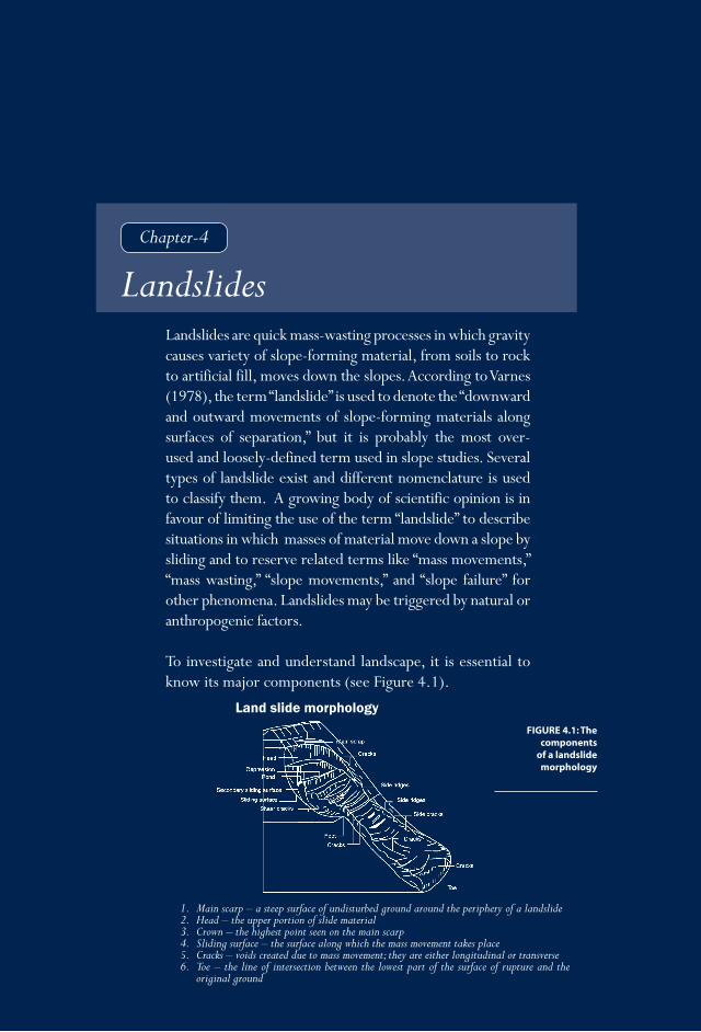
��
Nepal in the
Him
alaya-Ganga
Disaster R
isk Reduction:
Floods and Flood M
anagement
LandslidesD
roughtEarthquakes
Fire disastersO
ther disastersLegislation and D
RR
institutions
Meeting D
RR
challenges
Chapter-4
Landslides are quick mass-wasting processes in which gravity causes variety of slope-forming material, from soils to rock to artificial fill, moves down the slopes. According to Varnes (1978), the term “landslide” is used to denote the “downward and outward movements of slope-forming materials along surfaces of separation,” but it is probably the most over-used and loosely-defined term used in slope studies. Several types of landslide exist and different nomenclature is used to classify them. A growing body of scientific opinion is in favour of limiting the use of the term “landslide” to describe situations in which masses of material move down a slope by sliding and to reserve related terms like “mass movements,” “mass wasting,” “slope movements,” and “slope failure” for other phenomena. Landslides may be triggered by natural or anthropogenic factors.
To investigate and understand landscape, it is essential to know its major components (see Figure 4.1).
Landslides
FIGURE 4.1: The components
of a landslide morphology
Land slide morphology
1. Main scarp – a steep surface of undisturbed ground around the periphery of a landslide2. Head – the upper portion of slide material3. Crown – the highest point seen on the main scarp4. Sliding surface – the surface along which the mass movement takes place5. Cracks – voids created due to mass movement; they are either longitudinal or transverse6. Toe – the line of intersection between the lowest part of the surface of rupture and the
original ground

N E P A L
D I S A S T E R
R E P O R T
�2
Varnes classification of landslides (1978) is shown in Table 4.1. The International Association of Engineering Geology (IAEG) (1990) also suggested using the same nomenclature for general use (see Figure 4.2). The different types of movement are divided into five main groups: falls, topples, slides, spreads, and flows. A sixth group, complex slope movements, includes combinations of two or more types of movement. Slide material is divided into two classes—rock and soil—and soil is further subdivided into debris and earth based on the particle size (Varnes, 1978). A short description of various landslide types is given below.
Type of movement Type of material
Bedrock Soil
Coarse FineFalls Rockfall Debrisfall EarthfallTopples Rocktopple Debristopple EarthtoppleSlides Rotation Rockslump Debrisslump Earthslump Translation Fewunits Rockblockslide Debrisblockslide Earthslide Manyunits Rockslide Debrisslide EarthblockslideLateralspread Rockspread DebrisSpread EarthspreadFlows Rockflow Debrisflow Earthflow (deepcreep)Complex Acombinationoftwoormoreprincipaltypesofmovement
(soilcreep)
Table 4.1: Classifi cation of landslides (Varnes, 1978)
FIGURE 4.2: Diagrammatic illustration of all types of Landslides.
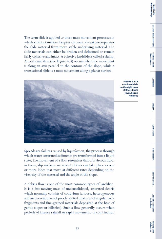
��
Nepal in the
Him
alaya-Ganga
Disaster R
isk Reduction:
Floods and Flood M
anagement
LandslidesD
roughtEarthquakes
Fire disastersO
ther disastersLegislation and D
RR
institutions
Meeting D
RR
challenges
The term slide is applied to those mass movement processes in which a distinct surface of rupture or zone of weakness separates the slide material from more stable underlying material. The slide materials can either be broken and deformed or remain fairly cohesive and intact. A cohesive landslide is called a slump. A rotational slide (see Figure 4.3) occurs when the movement is along an axis parallel to the contour of the slope, while a translational slide is a mass movement along a planar surface.
Spreads are failures caused by liquefaction, the process through which water-saturated sediments are transformed into a liquid state. The movement of a flow resembles that of a viscous fluid; in them, slip surfaces are absent. Flows can take place as one or more lobes that move at different rates depending on the viscosity of the material and the angle of the slope.
A debris flow is one of the most common types of landslide. It is a fast-moving mass of unconsolidated, saturated debris which normally consists of colluvium (a loose, heterogeneous and incoherent mass of poorly sorted mixtures of angular rock fragments and fine-grained materials deposited at the base of gentle slopes or hillsides). Such a flow generally occurs when periods of intense rainfall or rapid snowmelt or a combination
FIGURE 4.3: A rotational slide
on the right bank of Bhote Koshi
River, Kodari Highway
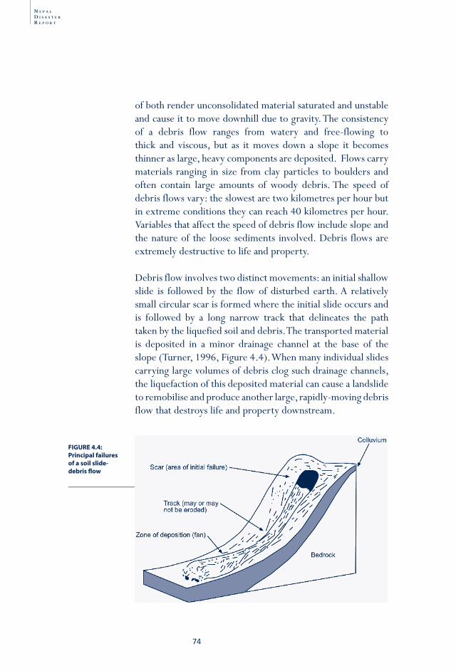
N E P A L
D I S A S T E R
R E P O R T
�4
of both render unconsolidated material saturated and unstable and cause it to move downhill due to gravity. The consistency of a debris flow ranges from watery and free-flowing to thick and viscous, but as it moves down a slope it becomes thinner as large, heavy components are deposited. Flows carry materials ranging in size from clay particles to boulders and often contain large amounts of woody debris. The speed of debris flows vary: the slowest are two kilometres per hour but in extreme conditions they can reach 40 kilometres per hour. Variables that affect the speed of debris flow include slope and the nature of the loose sediments involved. Debris flows are extremely destructive to life and property.
Debris flow involves two distinct movements: an initial shallow slide is followed by the flow of disturbed earth. A relatively small circular scar is formed where the initial slide occurs and is followed by a long narrow track that delineates the path taken by the liquefied soil and debris. The transported material is deposited in a minor drainage channel at the base of the slope (Turner, 1996, Figure 4.4). When many individual slides carrying large volumes of debris clog such drainage channels, the liquefaction of this deposited material can cause a landslide to remobilise and produce another large, rapidly-moving debris flow that destroys life and property downstream.
FIGURE 4.4: Principal failures of a soil slide-debris fl ow
��
Nepal in the
Him
alaya-Ganga
Disaster R
isk Reduction:
Floods and Flood M
anagement
LandslidesD
roughtEarthquakes
Fire disastersO
ther disastersLegislation and D
RR
institutions
Meeting D
RR
challenges
The Himalayan terrain, with its steep slopes and high relief, intense monsoon rainfall and frequent cloudbursts provides the ideal conditions for debris flows. Every year, many Nepalis die because of debris flows. Debris flows in Larcha, near Kodari, Sindhupalchock District in 1996; Bagarchap near Chame, Manang District; Phedigaon in the Palung Valley of Makawanpur District in 1993; and in Matatirtha in Kathmandu District in 2000 (see Figure 4.5) are recent debris flows which resulted in the loss of lives and properties.
Causes of landslidesBoth natural and anthropogenic factors contribute to landslides. Natural factors may be subdivided into inherent and external factors. Inherent factors include geological formation and structure, slope, aspect, land use, land cover and groundwater conditions. External factors include seismic waves and rainfall. Anthropogenic factors include human interventions like deforestation, improper land use, unplanned construction, and unplanned mining. To assess the risk of landslides requires a careful study of the range of historical and current factors which may be important in triggering the event. Factors which are enduring and inherent in the constituent rock and soil are usually the primary causes of failure. The most basic cause is gravity, but there are several other factors that play crucial roles as well, including rock and soil types; the strength, folding, faulting, jointing, foliation, and bedding of the rock structure (Hoek and Bray, 1981), and soil depth, porosity and permeability. Factors that are either variable or very short-lived are considered secondary causes. These include the presence or absence of gullies, streams, and rivers, seismicity, intensity of precipitation, land use, natural slope conditions, rock and soil weathering conditions, and groundwater conditions. The most common types of mass movements encountered in the Himalaya are slope failure in location in excess of 30 degree slopes rockslides, rocks fall, rock toppling, and failures along the wedge.
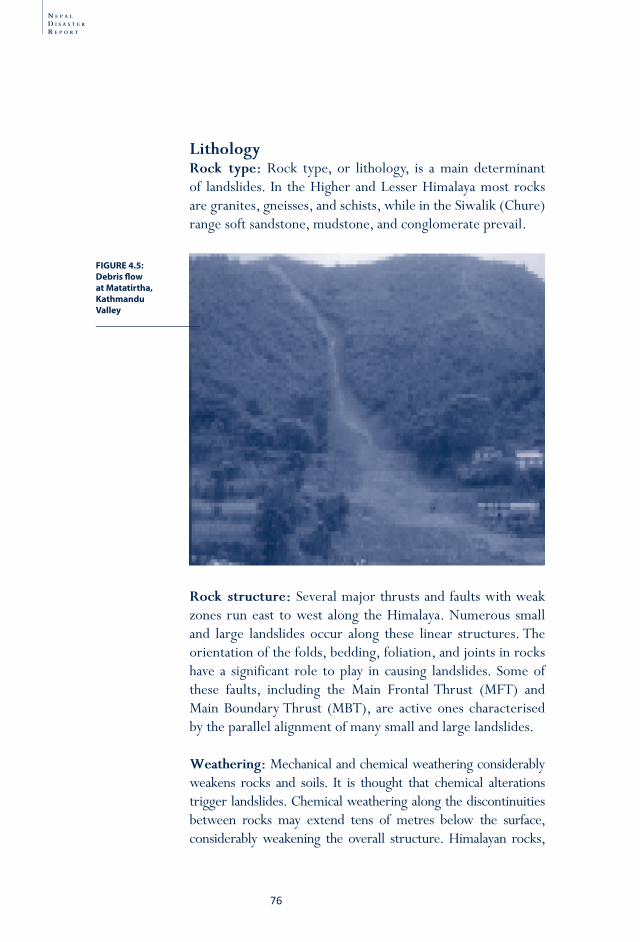
N E P A L
D I S A S T E R
R E P O R T
�6
lithologyrock type: Rock type, or lithology, is a main determinant of landslides. In the Higher and Lesser Himalaya most rocks are granites, gneisses, and schists, while in the Siwalik (Chure) range soft sandstone, mudstone, and conglomerate prevail.
rock structure: Several major thrusts and faults with weak zones run east to west along the Himalaya. Numerous small and large landslides occur along these linear structures. The orientation of the folds, bedding, foliation, and joints in rocks have a significant role to play in causing landslides. Some of these faults, including the Main Frontal Thrust (MFT) and Main Boundary Thrust (MBT), are active ones characterised by the parallel alignment of many small and large landslides.
Weathering: Mechanical and chemical weathering considerably weakens rocks and soils. It is thought that chemical alterations trigger landslides. Chemical weathering along the discontinuities between rocks may extend tens of metres below the surface, considerably weakening the overall structure. Himalayan rocks,
FIGURE 4.5: Debris fl ow at Matatirtha, Kathmandu Valley
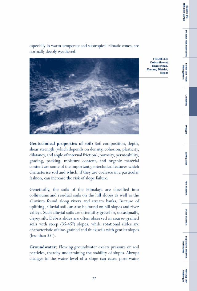
��
Nepal in the
Him
alaya-Ganga
Disaster R
isk Reduction:
Floods and Flood M
anagement
LandslidesD
roughtEarthquakes
Fire disastersO
ther disastersLegislation and D
RR
institutions
Meeting D
RR
challenges
especially in warm-temperate and subtropical climatic zones, are normally deeply weathered.
Geotechnical properties of soil: Soil composition, depth, shear strength (which depends on density, cohesion, plasticity, dilatancy, and angle of internal friction), porosity, permeability, grading, packing, moisture content, and organic material content are some of the important geotechnical features which characterise soil and which, if they are coalesce in a particular fashion, can increase the risk of slope failure.
Genetically, the soils of the Himalaya are classified into colluviums and residual soils on the hill slopes as well as the alluvium found along rivers and stream banks. Because of uplifting, alluvial soil can also be found on hill slopes and river valleys. Such alluvial soils are often silty gravel or, occasionally, clayey silt. Debris slides are often observed in coarse-grained soils with steep (35-45º) slopes, while rotational slides are characteristic of fine-grained and thick soils with gentler slopes (less than 35º).
Groundwater: Flowing groundwater exerts pressure on soil particles, thereby undermining the stability of slopes. Abrupt changes in the water level of a slope can cause pore-water
FIGURE 4.6: Debris flow at
Bagarchhap, Manang District,
Nepal

N E P A L
D I S A S T E R
R E P O R T
�8
pressure to increase so much that sandy soils are liquefied. Groundwater can also wash out soluble cementing substances and weaken inter-granular bonds; both of these processes reduce the mechanical strength of the ground and make landslides more likely. In soils of fine sand and silt, flowing groundwater flushes out fine particles and reduces slope strength by forming cavities.
Natural slope: A change in slope gradient, whether caused by natural or man-made processes, can cause a landslide. Natural processes include the uplift of mountains by tectonic forces, river undercutting at the toe of the slope, or bank scouring by debris flow. Excavation, blasting, cultivation, and the removal of vegetation are the main ways humans change slope gradients. In the Nepal Himalaya, slope gradients of 30 to 40 degrees are most likely to result in failure (Dixit 1994 a, b; Deoja et al. 1991; DPTC/TU 1994 a, b), but landslides can occur on gentler slopes as well.
Vegetation: Vegetation also plays a vital role in determining slope stability and soil erosion processes. While the erosivity of rainfall does increase during the monsoon so does the ability of the vegetation to protect the topsoil; the net result is reduced rates of surface erosion as the monsoon progresses. However, the probability of mass wasting increases during the monsoon because the subsoil becomes saturated with moisture (Galay, 1987). In general vegetation cover increases the strength of soil because the mechanical and biological effects of its root network stabilise slopes. Vegetation dries out slopes by absorbing groundwater. If a landslide occurs deeper than roots penetrate, however, the stabilising effect of vegetation will be rendered moot.
precipitation: Depending on climatic conditions, topography, the geological characteristics of a slope, porosity, and the permeability of rocks and soils, rainfall can have a considerable
��
Nepal in the
Him
alaya-Ganga
Disaster R
isk Reduction:
Floods and Flood M
anagement
LandslidesD
roughtEarthquakes
Fire disastersO
ther disastersLegislation and D
RR
institutions
Meeting D
RR
challenges
impact on the frequency of landslides. Variations in soil depth and the nature and frequency of discontinuities in the rock also play a role. Specifically, rain- and melt-water penetrate joints and produce hydrostatic stress in rocks. In soils, rain increases pore-water pressure and consequently decreases shear resistance. The many authors who have studied the relationship between the amount of rainfall and the frequency of landslide events conclude that recurrent slope movements occur during periods of high rainfall (Záruba and Mencl, 1982).
In Nepal, the number of landslide events peaks in the monsoon season, when they are triggered by high rainfall. According to NSET all parts of the hills and mountains are exposed to landslides during the monsoon period. The weak geo-tectonic characteristics of the Himalaya make it vulnerable to both heavy rainfall and earthquakes (NSET, 2008), which themselves can trigger a landslide. Detailed studies on the relationship between rainfall and landslide events have been conducted in the eastern Himalaya, in Darjeeling, India. Froehlich et al. (1990) observed that in areas devoted to tea plantation, short-distance overland flow and slope wash begins when rainfall exceeds 50 millimetres and falls with an intensity of 0.5 millimetres per minute. Shallow slides or slumps on steep slope segments begin to occur, mainly along undercut sections of roads or rivers, when over 130-150 millimetres fall in 24 hours or when over 200-240 millimetres fall over a three-day period. This example is also applicable in hills of Nepal. While rainfall amount is important to trigger a landslide other climatological factor is the intensity of rainfall. In 1993, cloudburst high intensity rainfall (70 mm/hour) was responsible for widespread slopes failure in the Kulekhani catchment (Dixit, 2003). In Kabilas VDC of Chitwan District many large scale landslide were caused when the intensity reached 80 mm/hour.
Gabet et al. (2004) studied the relationship between landslides and rainfall in Khudi Khola catchments along the Marsyangdi
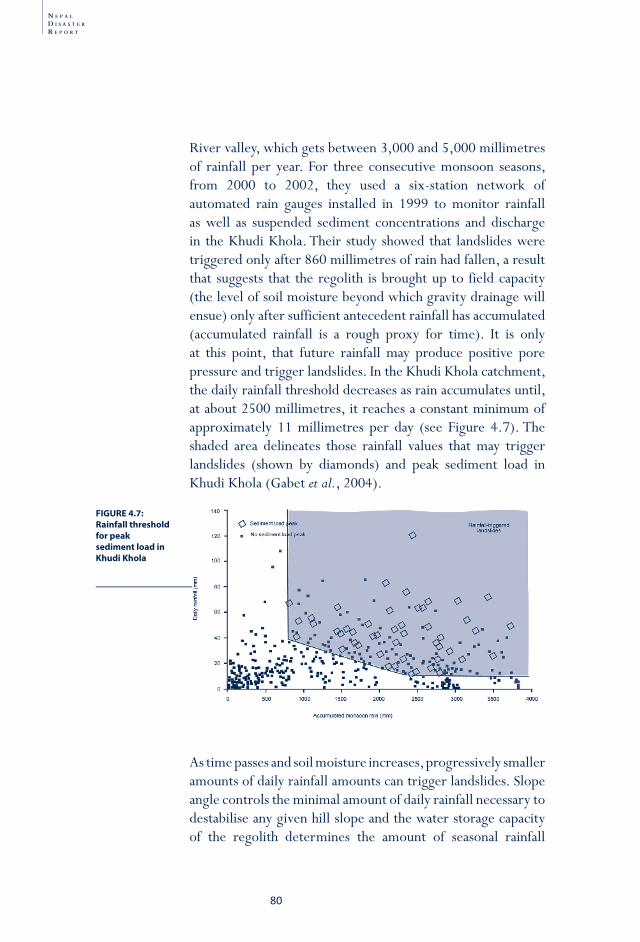
N E P A L
D I S A S T E R
R E P O R T
80
River valley, which gets between 3,000 and 5,000 millimetres of rainfall per year. For three consecutive monsoon seasons, from 2000 to 2002, they used a six-station network of automated rain gauges installed in 1999 to monitor rainfall as well as suspended sediment concentrations and discharge in the Khudi Khola. Their study showed that landslides were triggered only after 860 millimetres of rain had fallen, a result that suggests that the regolith is brought up to field capacity (the level of soil moisture beyond which gravity drainage will ensue) only after sufficient antecedent rainfall has accumulated (accumulated rainfall is a rough proxy for time). It is only at this point, that future rainfall may produce positive pore pressure and trigger landslides. In the Khudi Khola catchment, the daily rainfall threshold decreases as rain accumulates until, at about 2500 millimetres, it reaches a constant minimum of approximately 11 millimetres per day (see Figure 4.7). The shaded area delineates those rainfall values that may trigger landslides (shown by diamonds) and peak sediment load in Khudi Khola (Gabet et al., 2004).
As time passes and soil moisture increases, progressively smaller amounts of daily rainfall amounts can trigger landslides. Slope angle controls the minimal amount of daily rainfall necessary to destabilise any given hill slope and the water storage capacity of the regolith determines the amount of seasonal rainfall
FIGURE 4.7: Rainfall threshold for peak sediment load in Khudi Khola
8�
Nepal in the
Him
alaya-Ganga
Disaster R
isk Reduction:
Floods and Flood M
anagement
LandslidesD
roughtEarthquakes
Fire disastersO
ther disastersLegislation and D
RR
institutions
Meeting D
RR
challenges
needed to trigger a failure. Measured values of mean annual precipitation in Nepal range from a low of approximately 250 millimetres in stations north of the Himalaya to a high of over 3000 millimetres in stations in the south. According to Alford (1992) the mean annual precipitation for 114 stations is 1,627 millimetres and it is not uncommon for 10 per cent of the total annual precipitation to occur in a single day and for 50 per cent of the total to occur on ten days spanning the entire rainy season. Such uneven distribution plays an important role in triggering landslides.
Using DHM data to plot the 24-hour precipitation equalling or exceeding 100 mm during the period from 1981 to 1990 indicates that there are pockets of intense rainfall in Ilam, in the upper reaches of Arun Valley, in the upper reaches of the Trishuli and Indrawati rivers, and in Pokhara (see Figure 1.9). All those places which recorded 10 to 20 events over the decade studied were located along the east-west axis of the Mahabharat-Chure range (Upreti and Dhital, 1996).
landslides in NepalThe 1993 mass movement disaster (a landslide combined with a flood) was a turning point in terms of loss of life and property (it was the second-most devastating natural disaster after the 1934 earthquake) and helped improve public awareness about natural disasters. More than 2000 landslides, ranging in size from a few to a few thousand square metres, were triggered along highways and mountain slopes. Numerous dormant paleo-landslides were reactivated. The cloudburst, landslide and flood disaster affected 42,995 ha of arable land, numerous irrigation systems, highways, bridges and other infrastructure was damaged. The total loss was estimated to be about NRs. 5 billion (Chhetri and Bhattarai, 2001). Altogether 1,170 people died and almost half a million were affected.
N E P A L
D I S A S T E R
R E P O R T
82
The large volumes of soil eroded in at least three major watersheds—the Bagmati in the east, the Trishuli in the north, and the Rapti in the south—generated such huge sediment loads that the beds of many rivers rose. The unprecedented volumes of sediment deposited in the reservoir of the Khulekani plant lowered its economic life significantly. When impoundment began in 1981, the reservoir had a total storage capacity of 83 million cubic metres. Surveys by the Department of Soil Conservation and Watershed Management (DSCWM) and the Nepal Electricity Authority (NEA) showed that from 1981 to 1995, a total of 21.8 million cubic metres of sediment (Sthapit, 1995), which is equivalent to an average of 1.56 million cubic metres annually, were deposited in the reservoir. In fact bulk of this mass came in pulses such as that brought down by the 1993 events and lowered the economic life from 100 years to 30 years (Gyawali and Dixit. 2001 and Dixit, 2003). Yet data on sediment load for many rivers is not available.
The DoMG’s inventory of landslides in the Lesser Himalaya between 1985 and 1990 found that most landslides occurred on hill slopes of 21 to 30 degrees and 31 to 40 degrees (Karmacharya et.al. 1995). Earlier Dixit (1995) has prepared a landslide hazard map for Nepal which shows the mid hills were more susceptible to landslide (see figure 4.8). According to Brabb’s 1984 study (as mentioned in Bhattarai et.al. 2002), landslide density in the Nepal Himalaya ranges from 0.2 per linear kilometre on stable land to 2.8 per linear kilometre on susceptible areas fully exposed to human influence. Bhattarai and friends report that roughly 12,000 landslides/slope failures occur every year (Bhattarai et.al. 2002). Nepal’s geophysical and climatic conditions are responsible for many landslides in the country.
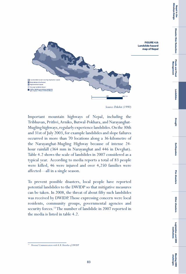
8�
Nepal in the
Him
alaya-Ganga
Disaster R
isk Reduction:
Floods and Flood M
anagement
LandslidesD
roughtEarthquakes
Fire disastersO
ther disastersLegislation and D
RR
institutions
Meeting D
RR
challenges
13 Personal Communication with K.B. Shrestha of DWIDP
FIGURE 4.8: Landslide hazard
map of Nepal
Source: Dikshit (1990)
Important mountain highways of Nepal, including the Tribhuvan, Prithvi, Arniko, Butwal-Pokhara, and Narayanghat-Mugling highways, regularly experience landslides. On the 30th and 31st of July 2003, for example landslides and slope failures occurred in more than 70 locations along a 36-kilometre of the Narayanghat-Mugling Highway because of intense 24-hour rainfall (364 mm in Narayanghat and 446 in Devghat). Table 4.2 shows the scale of landslides in 2007 considered as a typical year. According to media reports a total of 83 people were killed, 46 were injured and over 4,250 families were affected—all in a single season.
To prevent possible disasters, local people have reported potential landslides to the DWIDP so that mitigative measures can be taken. In 2008, the threat of about fifty such landslides was received by DWIDP. Those expressing concern were local residents, community groups, governmental agencies and security forces.13 The number of landslide in 2007 reported in the media is listed in table 4.2.
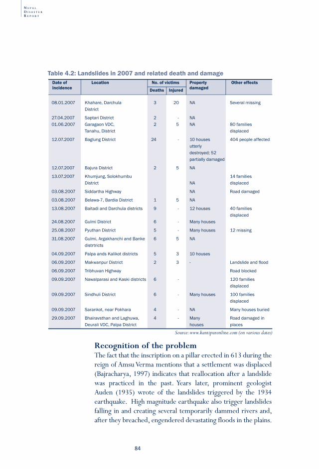
N E P A L
D I S A S T E R
R E P O R T
84
recognition of the problemThe fact that the inscription on a pillar erected in 613 during the reign of Amsu Verma mentions that a settlement was displaced (Bajracharya, 1997) indicates that reallocation after a landslide was practiced in the past. Years later, prominent geologist Auden (1935) wrote of the landslides triggered by the 1934 earthquake. High magnitude earthquake also trigger landslides falling in and creating several temporarily dammed rivers and, after they breached, engendered devastating floods in the plains.
08.01.2007 Khahare,Darchula 3 20 NA Severalmissing District
27.04.2007 SaptariDistrict 2 - NA01.06.2007 GaragaonVDC, 2 5 NA 80families Tanahu,District displaced
12.07.2007 BaglungDistrict 24 - 10houses 404peopleaffected utterly destroyed;52 partiallydamaged
12.07.2007 BajuraDistrict 2 5 NA
13.07.2007 Khumjung,Solokhumbu 14families District NA displaced
03.08.2007 SiddarthaHighway NA Roaddamaged
03.08.2007 Belawa-7,BardiaDistrict 1 5 NA
13.08.2007 BaitadiandDarchuladistricts 9 - 12houses 40families displaced24.08.2007 GulmiDistrict 6 - Manyhouses
25.08.2007 PyuthanDistrict 5 - Manyhouses 12missing
31.08.2007 Gulmi,ArgakhanchiandBanke 6 5 NA distrtricts
04.09.2007 PalpaandsKalikotdistricts 5 3 10houses
06.09.2007 MakwanpurDistrict 2 3 - Landslideandflood
06.09.2007 TribhuvanHighway Roadblocked
09.09.2007 NawalparasiandKaskidistricts 6 - 120families displaced
09.09.2007 SindhuliDistrict 6 - Manyhouses 100families displaced
09.09.2007 Sarankot,nearPokhara 4 - NA Manyhousesburied
29.09.2007 BhairavsthanandLaghuwa, 4 - Many Roaddamagedin DeuraliVDC,PalpaDistrict houses places
Date of Location No. of victims Property Other effects incidence damagedDeaths Injured
Source: www.kantipuronline.com (on various dates)
Table 4.2: Landslides in 2007 and related death and damage
8�
Nepal in the
Him
alaya-Ganga
Disaster R
isk Reduction:
Floods and Flood M
anagement
LandslidesD
roughtEarthquakes
Fire disastersO
ther disastersLegislation and D
RR
institutions
Meeting D
RR
challenges
Every monsoon, Nepal’s hills and mountains see the occurrence of thousands of new and reactivated landslides. The majority are not even reported because they are so remote.
When such a dam breaches—and it is only a matter of time—massive floods, called bishyari, occur. Dixit (2006) highlights two such events in Trishuli River in 1962 and 1964 which significantly added to sediment load in the river. On 3 August, 1985 the Trishuli River was blocked near Dhunche for 12 hours reducing total discharge from 350 to 93 cubic meters per second. When the dam broke, discharge reached 2,010 cubic meters per second and caused massive flood damage downstream (Paryawaran 2007).
Since upstream landslides often spawn floods downstream, the two types of disasters are reported together. The effects of floods are more visible than those of landslides which are responsible for high human losses while floods cause high infrastructural losses affecting larger population. As a point of comparison, the devastating Koshi flood of 2008 affected over 65,000 Nepalis though it killed only three, while a landslide in Bajura in Far-Western Nepal in the same year killed 21 people Co Action Nepal, 2008). This dual reportage has created a “flood-landslide disaster reporting culture” in Nepal.
Policy-makers agree on the importance of implementing preventive measures in minimising landslides. Even people who live on mountain slopes are aware that they are vulnerable to landslides during the monsoon. Unfortunately, they have few alternatives to living with the risks they do and are unable to act in ways which reduce their vulnerability.
Mitigation/prevention efforts Depending on an area’s geo-morphological and -tectonic contexts as well as the distribution of rainfall, landslide can be a common hazard, and one that may easily transform into a disaster. Those affected may be hurt or forced to leave their
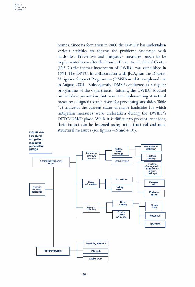
N E P A L
D I S A S T E R
R E P O R T
86
FIGURE 4.9: Structural mitigation measures pursued by DWIDP
homes. Since its formation in 2000 the DWIDP has undertaken various activities to address the problems associated with landslides. Preventive and mitigative measures began to be implemented soon after the Disaster Prevention Technical Center (DPTC) the former incarnation of DWIDP was established in 1991. The DPTC, in collaboration with JICA, ran the Disaster Mitigation Support Programme (DMSP) until it was phased out in August 2004. Subsequently, DMSP conducted as a regular programme of the department. Initially, the DWIDP focused on landslide prevention, but now it is implementing structural measures designed to train rivers for preventing landslides. Table 4.3 indicates the current status of major landslides for which mitigation measures were undertaken during the DWIDP’s DPTC/DMSP phase. While it is difficult to prevent landslides, their impact can be lessened using both structural and non-structural measures (see figures 4.9 and 4.10).
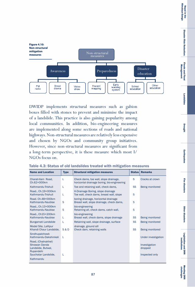
8�
Nepal in the
Him
alaya-Ganga
Disaster R
isk Reduction:
Floods and Flood M
anagement
LandslidesD
roughtEarthquakes
Fire disastersO
ther disastersLegislation and D
RR
institutions
Meeting D
RR
challenges
Table 4.3: Status of old landslides treated with mitigation measures
Charali-IlamRoad, L Checkdams,toewall,slopedrainage, S CracksatcrownCh.62+000km horizontaldrainageboring,bio-engineering Kathmandu-Trishuli L Toeandretainingwall,checkdams, SS BeingmonitoredRoad.,Ch.19+000km H-DrainageBoring,slopedrainageKathmandu-Trishuli L Toewall,checkdams,breastwall,slope SRoad.Ch.48+000km boringdrainage,horizontaldrainageKathmandu-Naubise S Breastwall,slopedrainage,checkdams, SRoad.,Ch.13+000km bio-engineeringKathmandu-Naubise S Retainingall,checkdams,catchwall, SRoad.,Ch15+200km bio-engineeringKathmandu-Naubise L Breastwall,checkdams,slopedrainage SS BeingmonitoredBungamatiLandslide L Retainingwall,slopedrainage,surface SS BeingmonitoredModelSite,Lalitpur drainage,groundsillKhandiChaurLandslide, S&D Checkdam,retainingwalls SS BeingmonitoredSindhupalchowkKathmandu-Dakshinkali L UnderinvestigationRoad,(Chalnakhel)ShrawanDanda InvestigationLandslide,Butwal, droppedRupandehiSyuchatarLandslide, L InspectedonlyKathmandu
Name and Location Type Structural mitigation measures Status Remarks
DWIDP implements structural measures such as gabion boxes filled with stones to prevent and minimise the impact of a landslide. This practice is also gaining popularity among local communities. In addition, bio-engineering measures are implemented along some sections of roads and national highways. Non-structural measures are relatively less expensive and chosen by NGOs and community group initiatives. However, since non-structural measures are significant from a long-term perspective, it is these measure which most I/NGOs focus on.
Figure 4.10: Non-structural mitigation measures
Disaster education
Awareness Preparedness
Non-structural measures
N E P A L
D I S A S T E R
R E P O R T
88
Table 4.3: Status of old landslides treated with mitigation measures cont’d...Name and Location Type Structural mitigation measures Status Remarks
BamtiLandslide, S&DRamechhapAttarpurLandslide, S Retainingwall SSindhupalchowkTilaharLandslide, S Checkdams,retainingwall SParbatChamphaPaniLandslide, S Retainingwall,checkdams SSyangjaBhotangLandslide, L Retainingwall,slopedrainage SSindhupalchowkDahachowkSaboModel L&D Checkdams,retainingwall,earthworks, SiteKathmandu bio-engineeringGirubariSaboModel L&D Checkdams,retainingwall,slopedrainage, SS BeingmonitoredSite,Nawalparasi bio-engineeringMatatirthaRehab S&D Checkdams,toewall,bio-engineering SModelSiteKathmanduPipaltar,Trishuli SE Concreteblocks,checkdams,bio-engineeringNarayanghat-Mugling S,D,&L Checkdams,sabodams,retainingwalls, S NeedsmaintenanceHighway surfacedrainage,horizontaldrainageboring
Type: S-slope failure; L-landslide; D-debris flow; SE-soil erosionStatus: S–stabilised; SS–semi-stabilised
The DWIDP has implemented as many structural and some non-structural measures as it has been able to give the institutional and budgetary constraints which handicap it. With JICA, it has implemented structural measures along the Narayanghat-Mugling Highway that have been able to keep the road route open during the monsoon. The department also introduced a road information and early warning system for the inhabitants of Kabilas VDC when it conducted a study on disaster risk management for the same highway in 2008. The study found that the potential frequency of road closure disaster declined 54 per cent and potential annual economic losses declined 66 per cent after these measures were implemented (Unpublished report, DWIDP, 2008). The DWIDP responds to demands made at the district and community levels.
preparednessAs part of the DMSP, the DWIDP installed a landslide early warning system (EWS) at the Dahachowk Sabo Model Site in the outskirts of Kathmandu Valley a few years ago. A participatory hazard map and evacuation plan was prepared at the same time and a demonstration evacuation drill conducted
8�
Nepal in the
Him
alaya-Ganga
Disaster R
isk Reduction:
Floods and Flood M
anagement
LandslidesD
roughtEarthquakes
Fire disastersO
ther disastersLegislation and D
RR
institutions
Meeting D
RR
challenges
On 26 August 2008, a massive landslide killed 25 people of Jugad VDC, Bajura District; it also injured dozens and damaged over 1095 houses. Those affected complained that the rescue and relief operations managed by the chairman of the Bajura District Disaster Relief Committee were far from satisfactory. Some of the problems identified are as follows:
1) 250 of those who received relief were from Jukot VDC which was not affected by the landslide.
2) Other unaffected people were also included as victims.3) Those who suffer losses in the landslide were not included
in the list of relief recipients.
BoX 4.1: landslides relief in Bajura District
to demonstrate its usefulness and relevance. The EWS system did not come into operation because undetectable problem in the remote controlled integrated circuit of the equipment.
rescue and reliefLocal communities carry out immediate post-disaster rescue operations when a landslide disaster occurs. Later, a team of members of the NA, the NP and the APF also join the rescue operation. Operations are conducted by the concerned district disaster relief committee under the chairmanship of the chief district officers, who follows the directives of the National Disaster Relief Committee chaired by the Home Minister.
For rescue and relief operations to be successful, post-disaster operations need to be site-specific. Efforts can be hampered by a number of factors including difficulty in accessing the site, poor communication between the site and the sources of relief, and obstacles to moving people, whether volunteers to provide help or the displaced to rehabilitation sites are available. Financial and other resources can be a limitation, as can the fact that the area affected by a landslide is small and there is very little public attention to such localised events. Rescue and relief operations should address the specific needs of the affected people otherwise such initiative will lose credibility (see Box 4.1). Mechanisms must be developed to avoid situation as depicted in Box 4.1.
N E P A L
D I S A S T E R
R E P O R T
�0
4) The list of the relief recipients was prepared based on a politi cally- moti vated post-disaster assessment of the VDCs of Bajura.
5) The VDC secretary responsible for the aff ected VDCs did not visit the disaster site; instead he stayed in the district headquarters and off ered advice only to those who came to him.
6) The district chairman of the NRCS expressed concern that the real victi ms of the disaster did not get relief but that non-deserving did.
7) Inhabitants of Jugad VDC, the real suff erers staged a protest outside the district administrati on offi ce.
Much more needs to be done to improve relief and rescue eff orts in the country. Oft en there are more volunteers than suff erers and their excessive numbers create unnecessary logisti cal diffi culti es. Without well thought-out plans, such outpourings of support put undue burden on rescue and relief operati ons.
recovery and reconstructionPost-landslide disaster recovery and reconstruction efforts made by governmental departments are slow for several reasons, including limited time to mobilise resources, the lack of suitable places for rehabilitation, and the difficulty in achieving consensus among different interests. Local communities are helpful and generous during emergencies. For instance, following the Nepane landslide disaster, the local community did a commendable job helping the affected families. Some of the affected families even managed to improve their standard of living after the disaster. Post-landslide disaster recovery and reconstruction in Butwal, in contrast, was unsatisfactory.
Ways forwardLandslide is one of the causes of human toll in Nepal. It also directly affects properties, infrastructure and results in indirect losses as damaged roads and irrigation systems cease to function. In 1990 Dikshit (1990) has suggested two focus areas to reduce landslide hazards in Nepal. The first focus he
��
Nepal in the
Him
alaya-Ganga
Disaster R
isk Reduction:
Floods and Flood M
anagement
LandslidesD
roughtEarthquakes
Fire disastersO
ther disastersLegislation and D
RR
institutions
Meeting D
RR
challenges
has suggested related to on acquisition and management of information on landslides. It also involved analysis of both the natural and anthropogenic causes that lead to landslide. The assessment must include the degree of hazards, their mapping, and evaluation of the social, political and technological methods for preventing landslides. Tinchai (1990) makes similar suggestion to meet the need for reducing losses from the landslides:• Identification of landslide hazard areas; compilation of
landslides inventories and landslide mapping.• Rehabilitation of lands subjected to landslides and
development of regulations controlling unstable terrain.• Specific standards of design and construction of physical
control measures in the public and private sectors.• Formulating land-use regulations in hazardous mountain
areas.• Strong support from research in the context of the mechanics
of the landslide process, transport and deposition, mitigation measures, and warning systems.
• Provision of a central clearing-house for collection and distribution of publications and guidelines to professional, agencies, and local governments.
• Development of a national landslide-loss reduction programme and the identification of a central organization for management of the programme.
The second focus area should concentrate on providing the synthesised information to end users to ensure that it is utilised at village, district and regional levels for minimising landslide hazards. The information, for example, can be used in planning and designing infrastructure projects, develop appropriate land use regulations, codes and in formulating management plans for disaster rescue. Initiative on landslides prevention must promote interaction among geologists, hydrologists and those involved in DRR activities for meaningful risk management.

N E P A L
D I S A S T E R
R E P O R T
�2
��
Nepal in the
Him
alaya-Ganga
Disaster R
isk Reduction:
Floods and Flood M
anagement
LandslidesD
roughtEarthquakes
Fire disastersO
ther disastersLegislation and D
RR
institutions
Meeting D
RR
challenges
Chapter-5
Drought is a weather-related disaster that can affect vast regions, even an entire nation, for long periods of time. It diminishes food production, can reduce life expectancy, and hampers economic growth. The Oxford Dictionary defines drought broadly as “dryness, lack of moisture, thirst, continuously dry weather, lack of rain,” while the OECD (1994) specifies that the dryness is in comparison to normal levels, claiming that droughts entail a temporary reduction in water or moisture availability to significantly below the normal or expected amount for a specified period. The World Meteorological Organisation (1975, p.13) is more precise in one way but its classification also suggests how much variability exists in defining exactly what constitutes a drought:
(a) rainfall less than 2.5 mm in 48 hours;(b) rainfall half of normal or less for a week;(c) 10 days with rainfall not exceeding 5.0 mm;(d) 15 days with no rain; (e) 21 days or more with rainfall less than 30 per
cent of normal;
Drought
N E P A L
D I S A S T E R
R E P O R T
�4
Further, complicating matter is the fact that there are also different varieties of drought. Glantz (1987) distinguishes between meteorological, hydrological, agricultural and social drought. Environmental damage may also lead to ecological drought as the productivity of an ecosystem fails as a consequence of low rainfall. A general definition of meteorological drought is ‘a reduction in rainfall supply compared with a specified average condition over some specified period’ (Hulme, 1995). Agricultural drought is defined as a reduction in moisture availability below the optimum level required by a crop during different stages of its growth cycle, resulting in impaired growth and reduced yields. Because hydrological drought pertains to the impact of a reduction in precipitation on surface or sub-surface water, it may lag behind periods of agricultural or meteorological drought (Wilhite, 1993). Meteorological drought may have an adverse impact on irrigated crops, some forms of non-agricultural production, including hydro-electric power generation, and drinking water supplies for humans. Social drought relates to the direct and indirect impacts of droughts on human activities.
Drought is recognised by its multiple impacts. The key indicators of drought include precipitation, temperature, soil moisture, groundwater levels, snow pack, stream flow, reservoir and
Meteorological drought : Inadequate or poorly distributed rainfallHydrological drought : Reduced stream fl ow and inadequate fi lling of reservoirsSoil moisture drought : Inadequate soil moisture, parti cularly in rain-fed areasAgricultural drought : Low soil moisture levels and crop failuresSocio-economic drought : Reducti ons in the availability of food and income Ecological drought : Failure of the producti vity of a natural ecosystem
BoX 5.1: types of drought
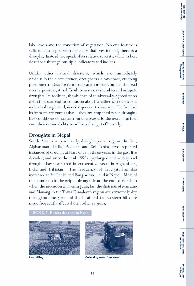
��
Nepal in the
Him
alaya-Ganga
Disaster R
isk Reduction:
Floods and Flood M
anagement
LandslidesD
roughtEarthquakes
Fire disastersO
ther disastersLegislation and D
RR
institutions
Meeting D
RR
challenges
lake levels and the condition of vegetation. No one feature is sufficient to signal with certainty that, yes indeed, there is a drought. Instead, we speak of its relative severity, which is best described through multiple indicators and indices.
Unlike other natural disasters, which are immediately obvious in their occurrence, drought is a slow-onset, creeping phenomena. Because its impacts are non-structural and spread over large areas, it is difficult to assess, respond to and mitigate droughts. In addition, the absence of a universally-agreed upon definition can lead to confusion about whether or not there is indeed a drought and, in consequence, to inaction. The fact that its impacts are cumulative—they are amplified when drought-like conditions continue from one season to the next—further complicates our ability to address drought effectively.
Droughts in NepalSouth Asia is a perennially drought-prone region. In fact, Afghanistan, India, Pakistan and Sri Lanka have reported instances of drought at least once in three years in the past five decades, and since the mid-1990s, prolonged and widespread droughts have occurred in consecutive years in Afghanistan, India and Pakistan. The frequency of droughts has also increased in Sri Lanka and Bangladesh—and in Nepal. Most of the country is in the grip of drought from the end of March to when the monsoon arrives in June, but the districts of Mustang and Manang in the Trans-Himalayan region are extremely dry throughout the year and the Tarai and the western hills are more frequently affected than other regions.
BoX 5.2: recent drought in Nepal
Land tilling Collecting water from a well
N E P A L
D I S A S T E R
R E P O R T
�6
Defi cient rainfall in the winter of 2008 resulted in a severe drop in crop producti on right across the country. Wheat and barley producti on declined 14 and 17 percent respecti vely. In some districts of Mid- and Far-Western Nepal which received less than half of average rainfall from November 2008 to February 2009 report that crops yields declined by more than half.
A joint assessment by the Ministry of Agriculture and Cooperati ves (MoAC), the UN Food and Agriculture Organizati on (FAO) and the UN World Food Programme (WFP) suggested that about 2 million people were at high risk of food insecurity as a result of poor harvests and 3.5 million more were vulnerable. Their report esti mated that 40 of Nepal’s 75 districts were food defi cit because of the drought and expressed concern about the nutriti on situati on throughout Nepal. In these 40 food-defi cit districts, half of children under the age of fi ve are stunted, 39 percent of children are underweight and 13 percent are severely malnourished.
According to an arti cle published in Clear Source on 31 May, 2009, WFP declared it would increase its support to NRs. 1.5 million and 2.2 million recipients, an additi onal 700,000 persons, in the coming weeks. Besides providing food, WFP also helps drought-aff ected communiti es build up assets through a variety of projects like Food for Work and Food for Training. FAO plans to help local communiti es expand irrigati on networks and distribute seeds for the next harvest.
People have been coping with the drought by selling their assets, migrati ng for work and, in some cases, even skipping meals. Farmers depend upon winter crop producti on to ti de them over unti l the main crop is harvested in September and October.* The situati on threatens to conti nue to be serious, however. Average rainfall in the Far-West in April 2009 was 80% less than normal and temperatures are predicted to increase. Already Nepal’s average temperature has increased by 1.8ºC in the last 32 years and is increasing by 0.06 ºC annually.** A second worry is the increasing use of bio-fuel produced from edible crops, a trend which pushes up prices and disproporti onately aff ects the poor.
��
Nepal in the
Him
alaya-Ganga
Disaster R
isk Reduction:
Floods and Flood M
anagement
LandslidesD
roughtEarthquakes
Fire disastersO
ther disastersLegislation and D
RR
institutions
Meeting D
RR
challenges
Drought results in crop failures and famine, both during the monsoon season and during the rest of the year, when winter crops are sown. In fact, Nepal’s Ministry of Agriculture and Cooperatives (MoAC) has identified drought as the greatest risk to agriculture (MoAC, 2006), particularly as year-round irrigation facilities supply only 38% of arable land; the rest is rain-fed. Whether or not drought conditions prevail is based on two factors: the amount of rainfall brought by the westerlies during the winter and the timing of the advent of the monsoon. For every day the monsoon is delayed, crops are adversely affected, even if winter precipitation has been good, because soil moisture drops below the minimal level needed for crop maturation. If it is available, irrigation with canals or groundwater can provide a buffer, warding off crop failure. Drinking water supplies are also adversely affected, and many families have to walk long hours or sacrifice hygiene and sanitation.
In Nepal, about 5,000 families living in pockets in the hills and the Tarai (the nation’s breadbasket, where 25 per cent of the total 1.2 million acres of arable land are found) are affected by drought each year (LRMP, 1986). When drought conditions prevail, cereal production declines significantly, compounding the country’s existing problems with hunger. According to NPC (2007), 39.9 per cent of the populations do not consume minimum daily calories recommended by WHO, whilst UNICEF (2006) depicts 50 per cent of children under five were stunted, of which 20 per cent were severely affected.
To reduce the risk of disaster, the capacity of communities to adapt to drought should be enhanced This focus in turn will require a thorough investigation into the nature of drought and its probable immediate impacts as well as its long-term outcomes and people’s current coping strategies.
* www.wfp.org/news/news-release/winter-drought-worsens-food-insecurity-nepal** www.Moac.gov.np/publications/journal/9malla Nepal-World Bank Supports Nepal responses to rising food prices. Retrieved from www.worldbank.org.np Southasia.oneworld.net/todaysheadlines/Nepal-needs-urgent-food-help-says-un
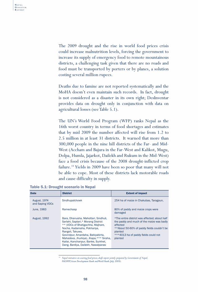
N E P A L
D I S A S T E R
R E P O R T
�8
14 Nepal initiative on soaring food prices, draft report jointly prepared by Government of Nepal, FAO, WFP, Asian Development Bank and World Bank (July 2008).
Table 5.1: Drought scenario in Nepal
August,1974 Sindhupalchowk 254haofmaizeinChakubas,Taragaun, andSapingVDCs
June,1983 Ramechaap 80%ofpaddyandmaizecropswere damaged
August,1992 Bara,Dhanusha,Mahottari,Sindhuli, *Theentiredistrictwasaffected;abouthalf Sarlahi,Saptari,*MorangDistrict thepaddyandmuchofthemaizewasbadly **(VDCsofBhatigachha,Majhare, affected Nocha,Kadamaha,Pokhariya, **About50-60%ofpaddyfieldscouldn’tbe Rangeli,Takuwa, planted Govindpur,Amardaha,Babiyabirta, ***4013haofpaddyfieldscouldnot Mahadeva,Jhurkiya),Jhapa,***Siraha, planted Kailai,Kanchanpur,Banke,Surkhet, Dang,Bardiya,Dailekh,Nawalparasi
Date District Extent of impact
The 2009 drought and the rise in world food prices crisis could increase malnutrition levels, forcing the government to increase its supply of emergency food to remote mountainous districts, a challenging task given that there are no roads and food must be transported by porters or by planes, a solution costing several million rupees.
Deaths due to famine are not reported systematically and the MoHA doesn’t even maintain such records. In fact, drought is not considered as a disaster in its own right; DesInventar provides data on drought only in conjunction with data on agricultural losses (see Table 5.1).
The UN’s World Food Program (WFP) ranks Nepal as the 16th worst country in terms of food shortages and estimates that by mid 2009 the number affected will rise from 1.2 to 2.5 million in at least 31 districts. It warned that more than 300,000 people in the nine hill districts of the Far- and Mid-West (Accham and Bajura in the Far-West and Kalikot, Mugu, Dolpa, Humla, Jajarkot, Dailekh and Rukum in the Mid-West) face a food crisis because of the 2008 drought-inflicted crop failure.14 Yields in 2009 have been so poor that many will not be able to cope. Most of these districts lack motorable roads and cause difficulty in supply.
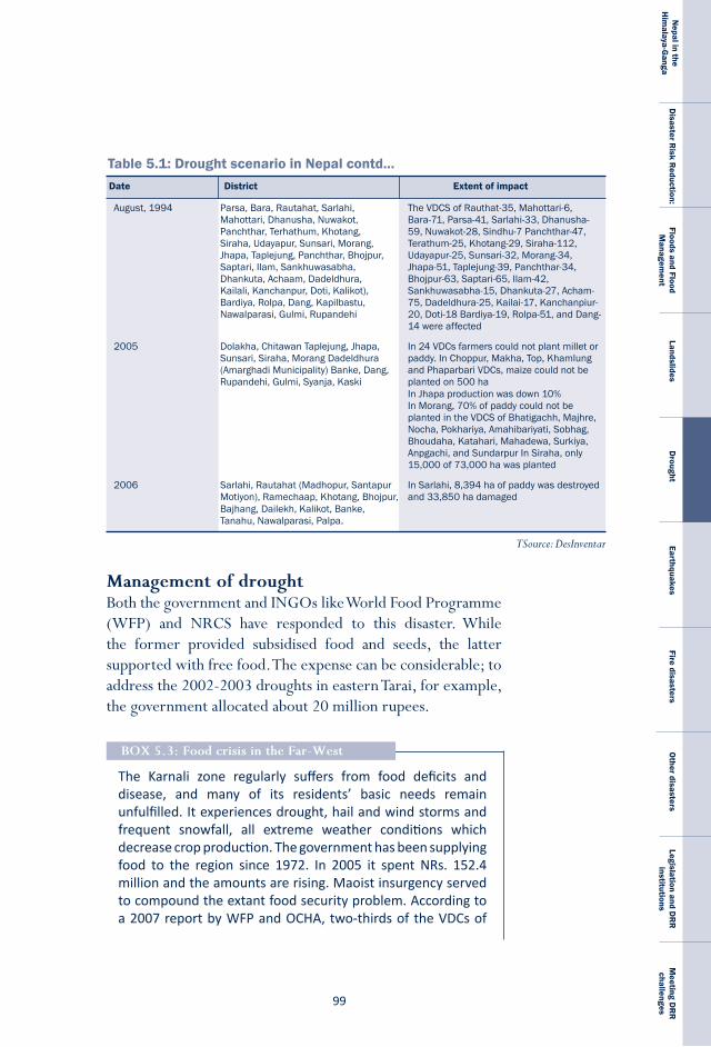
��
Nepal in the
Him
alaya-Ganga
Disaster R
isk Reduction:
Floods and Flood M
anagement
LandslidesD
roughtEarthquakes
Fire disastersO
ther disastersLegislation and D
RR
institutions
Meeting D
RR
challenges
The Karnali zone regularly suffers from food deficits and disease, and many of its residents’ basic needs remain unfulfilled. It experiences drought, hail and wind storms and frequent snowfall, all extreme weather conditions which decrease crop production. The government has been supplying food to the region since 1972. In 2005 it spent NRs. 152.4 million and the amounts are rising. Maoist insurgency served to compound the extant food security problem. According to a 2007 report by WFP and OCHA, two-thirds of the VDCs of
BoX 5.3: Food crisis in the Far-West
Table 5.1: Drought scenario in Nepal contd...Date District Extent of impact
TSource: DesInventar
August,1994 Parsa,Bara,Rautahat,Sarlahi, TheVDCSofRauthat-35,Mahottari-6, Mahottari,Dhanusha,Nuwakot, Bara-71,Parsa-41,Sarlahi-33,Dhanusha- Panchthar,Terhathum,Khotang, 59,Nuwakot-28,Sindhu-7Panchthar-47, Siraha,Udayapur,Sunsari,Morang, Terathum-25,Khotang-29,Siraha-112, Jhapa,Taplejung,Panchthar,Bhojpur, Udayapur-25,Sunsari-32,Morang-34, Saptari,Ilam,Sankhuwasabha, Jhapa-51,Taplejung-39,Panchthar-34, Dhankuta,Achaam,Dadeldhura, Bhojpur-63,Saptari-65,Ilam-42, Kailali,Kanchanpur,Doti,Kalikot), Sankhuwasabha-15,Dhankuta-27,Acham- Bardiya,Rolpa,Dang,Kapilbastu, 75,Dadeldhura-25,Kailai-17,Kanchanpiur- Nawalparasi,Gulmi,Rupandehi 20,Doti-18Bardiya-19,Rolpa-51,andDang- 14wereaffected
2005 Dolakha,ChitawanTaplejung,Jhapa, In24VDCsfarmerscouldnotplantmilletor Sunsari,Siraha,MorangDadeldhura paddy.InChoppur,Makha,Top,Khamlung (AmarghadiMunicipality)Banke,Dang, andPhaparbariVDCs,maizecouldnotbe Rupandehi,Gulmi,Syanja,Kaski plantedon500ha InJhapaproductionwasdown10% InMorang,70%ofpaddycouldnotbe plantedintheVDCSofBhatigachh,Majhre, Nocha,Pokhariya,Amahibariyati,Sobhag, Bhoudaha,Katahari,Mahadewa,Surkiya, Anpgachi,andSundarpurInSiraha,only 15,000of73,000hawasplanted
2006 Sarlahi,Rautahat(Madhopur,Santapur InSarlahi,8,394haofpaddywasdestroyed Motiyon),Ramechaap,Khotang,Bhojpur, and33,850hadamaged Bajhang,Dailekh,Kalikot,Banke, Tanahu,Nawalparasi,Palpa.
Management of drought Both the government and INGOs like World Food Programme (WFP) and NRCS have responded to this disaster. While the former provided subsidised food and seeds, the latter supported with free food. The expense can be considerable; to address the 2002-2003 droughts in eastern Tarai, for example, the government allocated about 20 million rupees.
N E P A L
D I S A S T E R
R E P O R T
�00
Karnali zone suff ered and the prices of food stuff increased by about 30 percent. An earlier report (Mainali, 2002) on the Far-Western region esti mated the number of food-defi cit 0.8 million people and gave the reason as a 60 percent reducti on in crop producti on due to poor weather and confl ict.
Even aft er a peace treaty was signed in 2006, the food crisis conti nued, this ti me due to drought conditi ons, which caused declines in crop producti on of up to 70% in some areas*. Food prices also soared. When the price of pulses increased by up to 35%, many poor families found that they were unable to aff ord an important source of protein. A household survey conducted by WFP in 2008 in the districts of Jumla, Dolpa and Mugu revealed that half of all households experienced shortages in rice, wheat and millet. Acute malnutriti on among children under fi ve is above 26% in some communiti es. To avert a crisis, in 2006 WFP planned an interventi on providing immediate help. However, as is oft en the case, delivery was complicated by poor road access in western Nepal and the high cost of transportati on. In additi on, the occasional inappropriate distributi on of food created a problem.
The Nati onal Food Corporati on has committ ed to supply about 10,000 metric tonnes of food annually to 30 districts (NPC, 2008). For its part, the central government has included the noti on of the right to food in the Interim Consti tuti on and the Consti tuent Assembly will likely adopt the same concept in the new consti tuti on slated to be rati fi ed in May 2010. The government has also developed a special programme in its Interim Nati onal Plan (2007/08-2009/10) for the development and socio-economic empowerment of the Karnali region (NPC, 2008).*
* Adhikari, J., 2008: Food crisis in Karnali: A historical and politico-economic perspective.
In 1997-1998, after a technical team was formed to assess the drought-induced crop losses and recommended distributing 142.5, 16.5 and 52 metric tonnes of wheat, pulses, and maize respectively at a 50 per cent subsidy. Affected families also received 175 kg of vegetable seeds, 611.7 and 2.4 metric tonnes
�0�
Nepal in the
Him
alaya-Ganga
Disaster R
isk Reduction:
Floods and Flood M
anagement
LandslidesD
roughtEarthquakes
Fire disastersO
ther disastersLegislation and D
RR
institutions
Meeting D
RR
challenges
of wheat and pulse seeds respectively with nominal technical assistance. In eleven districts of the Eastern hills a total of 1,166 shallow tube wells and 97 sprinkles were installed and six groundwater sources were renovated. In addition, some INGOs published and distributed materials about the drought through the local bodies. For example, the monthly magazine Paryawaran, which Action Aid Nepal helps distribute to 3,915 VDCs across the country has published articles increasing awareness about drought.
Following strategies help minimise impact of drought.land-use: Planned crop rotation can help minimise erosion and enables farmers to plant less water-dependent crops in dry years.rainwater harvesting: Rainwater from roofs or other suitable catchments can be collected and stored.Drought monitoring: Recording rainfall amounts and comparing it with water usage can help prevent man-made droughtrecycled water: Wastewater can be put to use in non-drinking purposes after recycling.irrigation: Canals can be built and river water redirected to provide irrigation in drought-prone areasWater rationing: Water use, particularly outdoor water use, can be regulated by minimising the watering of outdoor plants, the washing of motor vehicles or other outdoor hard surfaces (including roofs and paths), and the filling up swimming pools as well as by installing water conservation devices such as specially-designed shower heads, taps, and dual flush toilets.
Ways forwardIn order to effectively reduce the impact of droughts, the government and other stakeholders must address the various factors that exacerbate the situation and adopt a multi-sectoral approach. The following aspects need to be pursued.
N E P A L
D I S A S T E R
R E P O R T
�02
Many Nepali farmers have almost no access to meteorological forecasti ng; instead, they rely on traditi onal knowledge to judge the ti ming of monsoon rainfall. Recently, however, an initi ati ve to enhance capacity in the agricultural sector to adapt to climate change was launched with funding from the Food and Agricultural Organisati on (FAO). A pilot programme including demonstrati ons of soil conservati on techniques and the culti vati on of drought-resistant wheat and potato and fl ood-resistant paddy varieti es is being implemented in three VDCs in each of four districts, two in eastern Nepal and two in western. At the district level, the programme aims to improve seed storage systems in fl ood-prone areas. Other acti viti es include documenti ng existi ng local knowledge on climate risk management and enhancing early warning systems in partnership with the DHM by upgrading meteorological stati ons and improving rainfall forecasts for parti cular agro-meteorological zones. Another objecti ve is to introduce seasonal agricultural advisories for farmers.
BoX 5.4: enhancing the resilience of the agricultural sector
Building institutional capacity: The government should help build drought management capacity of local government. Local governments can play a critical role in drought management, particularly in the mobilisation of local resources. The Department of Agriculture (DoA) should provide the necessary support on drought mitigation. At the same time community groups, the private sector and civil society groups should be involved. A comprehensive drought mitigation plan must be developed along with a system to take action, monitor, and evaluate.
risk assessment and planning: Decision-makers and administrators should have access to funds and manpower they need to address drought conditions. Those directly affected should be fully informed of the actions they should take and the assistance they can expect in the event of a drought. It is important to make them aware of the financial and other assistance that will be available (or unavailable) to them so that they plan accordingly.
�0�
Nepal in the
Him
alaya-Ganga
Disaster R
isk Reduction:
Floods and Flood M
anagement
LandslidesD
roughtEarthquakes
Fire disastersO
ther disastersLegislation and D
RR
institutions
Meeting D
RR
challenges
Data collection networks: The government, in collaboration with the MoAC and the DHM, should increase the number of data collection centers which collect data on precipitation, wind speed, and agricultural yields. The government should enlist the help of academic institutions like the Tribhuvan and Kathmandu universities in meeting research needs related to drought monitoring and early warning systems.
information, communication and public awareness: The public should be kept informed of current and forecast conditions and the required responses by providing accurate and timely information through print and electronic media. Farmers in particular should have access to information regarding on- and off-farm risks. Education on disaster management and training in farm management should also be initiated. Research and awareness programmes should identify those geographic regions and farming communities that are most at risk.
Funding: Since the annual cost of drought reduction programmes is far less than the annual cost of post-disaster recovery and rehabilitation, it is necessary to allocate sufficient funds from the budget to implement drought mitigation plans.

N E P A L
D I S A S T E R
R E P O R T
�04
�0�
Nepal in the
Him
alaya-Ganga
Disaster R
isk Reduction:
Floods and Flood M
anagement
LandslidesD
roughtEarthquakes
Fire disastersO
ther disastersLegislation and D
RR
institutions
Meeting D
RR
challenges
Chapter-6
Earthquakes can bring widespread devastation to or even completely paralyse a country or a region for an extended period of time. The violent shaking of the earth’s crust which results from the sudden release of tectonic stress along a fault line or volcanic activity can destroy buildings and other infrastructure. It can take years for a country to recover from the damage to its infrastructure and economy. The associated trauma and suffering of survivors may also be enduring.
Iran, Afghanistan, China, Pakistan, India, Nepal, Bhutan, Bangladesh, Burma, Indonesia, the Philippines, Japan and other countries lie in very high risk zones in either the Alpine-Himalayan or Circum-Pacific seismic belts. It is because the Himalaya are still active mountains, with the Indian plate pushing against the Eurasian plate and causing the deformation and uplift of rock, that the Himalayan region is one of the most seismically active parts on Earth.
Causes of an earthquake The shaking of the earth’s crust is caused by the seismic waves that emanate from the earth’s interior when, through the constant movement of the earth, deformed rocks under strain release large amounts
Earthquakes
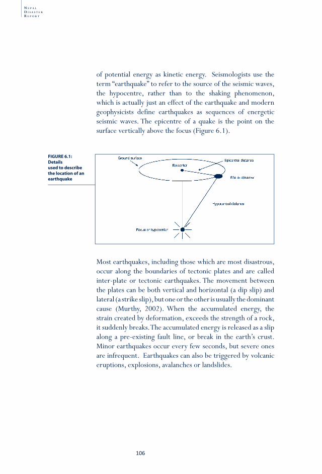
N E P A L
D I S A S T E R
R E P O R T
�06
of potential energy as kinetic energy. Seismologists use the term “earthquake” to refer to the source of the seismic waves, the hypocentre, rather than to the shaking phenomenon, which is actually just an effect of the earthquake and modern geophysicists define earthquakes as sequences of energetic seismic waves. The epicentre of a quake is the point on the surface vertically above the focus (Figure 6.1).
Most earthquakes, including those which are most disastrous, occur along the boundaries of tectonic plates and are called inter-plate or tectonic earthquakes. The movement between the plates can be both vertical and horizontal (a dip slip) and lateral (a strike slip), but one or the other is usually the dominant cause (Murthy, 2002). When the accumulated energy, the strain created by deformation, exceeds the strength of a rock, it suddenly breaks. The accumulated energy is released as a slip along a pre-existing fault line, or break in the earth’s crust. Minor earthquakes occur every few seconds, but severe ones are infrequent. Earthquakes can also be triggered by volcanic eruptions, explosions, avalanches or landslides.
FIGURE 6.1: Detailsused to describe the location of an earthquake
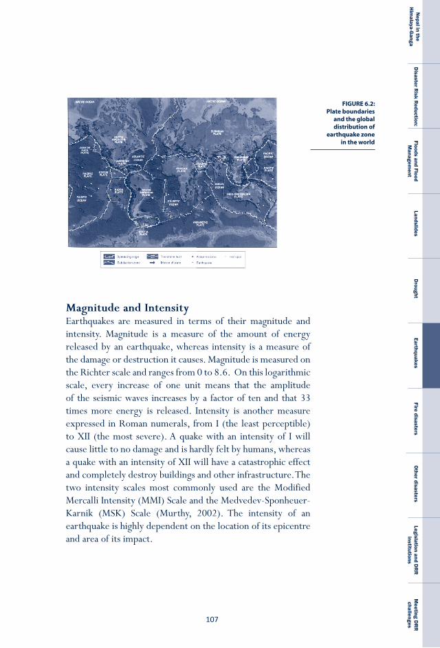
�0�
Nepal in the
Him
alaya-Ganga
Disaster R
isk Reduction:
Floods and Flood M
anagement
LandslidesD
roughtEarthquakes
Fire disastersO
ther disastersLegislation and D
RR
institutions
Meeting D
RR
challenges
FIGURE 6.2: Plate boundaries
and the global distribution of
earthquake zone in the world
Magnitude and intensityEarthquakes are measured in terms of their magnitude and intensity. Magnitude is a measure of the amount of energy released by an earthquake, whereas intensity is a measure of the damage or destruction it causes. Magnitude is measured on the Richter scale and ranges from 0 to 8.6. On this logarithmic scale, every increase of one unit means that the amplitude of the seismic waves increases by a factor of ten and that 33 times more energy is released. Intensity is another measure expressed in Roman numerals, from I (the least perceptible) to XII (the most severe). A quake with an intensity of I will cause little to no damage and is hardly felt by humans, whereas a quake with an intensity of XII will have a catastrophic effect and completely destroy buildings and other infrastructure. The two intensity scales most commonly used are the Modified Mercalli Intensity (MMI) Scale and the Medvedev-Sponheuer-Karnik (MSK) Scale (Murthy, 2002). The intensity of an earthquake is highly dependent on the location of its epicentre and area of its impact.
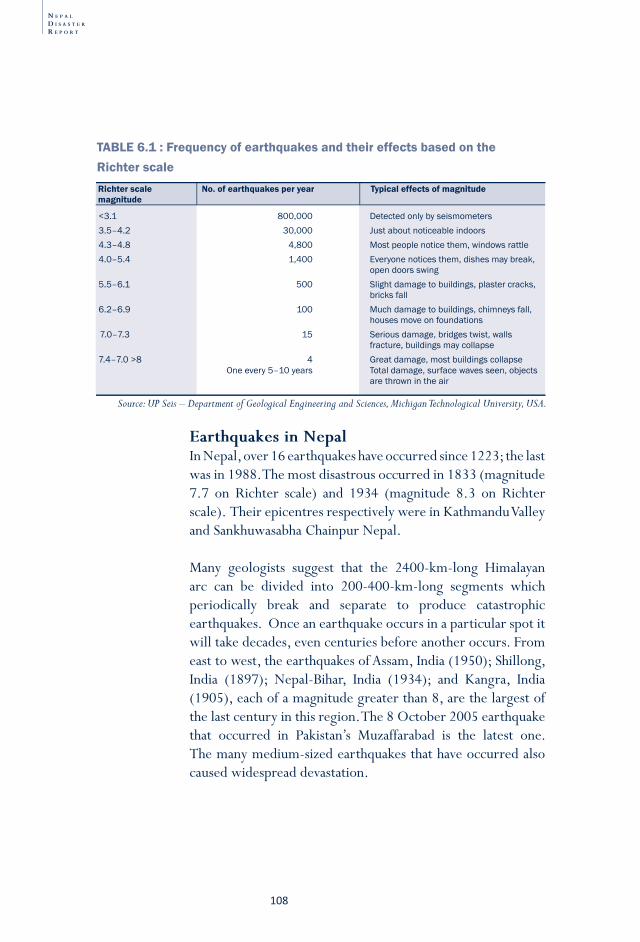
N E P A L
D I S A S T E R
R E P O R T
�08
TABLE 6.1 : Frequency of earthquakes and their effects based on the Richter scale
<3.1 800,000 Detectedonlybyseismometers3.5–4.2 30,000 Justaboutnoticeableindoors4.3–4.8 4,800 Mostpeoplenoticethem,windowsrattle4.0–5.4 1,400 Everyonenoticesthem,dishesmaybreak, opendoorsswing5.5–6.1 500 Slightdamagetobuildings,plastercracks, bricksfall6.2–6.9 100 Muchdamagetobuildings,chimneysfall, housesmoveonfoundations7.0–7.3 15 Seriousdamage,bridgestwist,walls fracture,buildingsmaycollapse7.4–7.0>8 4 Greatdamage,mostbuildingscollapse Oneevery5–10years Totaldamage,surfacewavesseen,objects arethrownintheair
Richter scale No. of earthquakes per year Typical effects of magnitudemagnitude
Source: UP Seis – Department of Geological Engineering and Sciences, Michigan Technological University, USA.
earthquakes in NepalIn Nepal, over 16 earthquakes have occurred since 1223; the last was in 1988. The most disastrous occurred in 1833 (magnitude 7.7 on Richter scale) and 1934 (magnitude 8.3 on Richter scale). Their epicentres respectively were in Kathmandu Valley and Sankhuwasabha Chainpur Nepal.
Many geologists suggest that the 2400-km-long Himalayan arc can be divided into 200-400-km-long segments which periodically break and separate to produce catastrophic earthquakes. Once an earthquake occurs in a particular spot it will take decades, even centuries before another occurs. From east to west, the earthquakes of Assam, India (1950); Shillong, India (1897); Nepal-Bihar, India (1934); and Kangra, India (1905), each of a magnitude greater than 8, are the largest of the last century in this region. The 8 October 2005 earthquake that occurred in Pakistan’s Muzaffarabad is the latest one. The many medium-sized earthquakes that have occurred also caused widespread devastation.
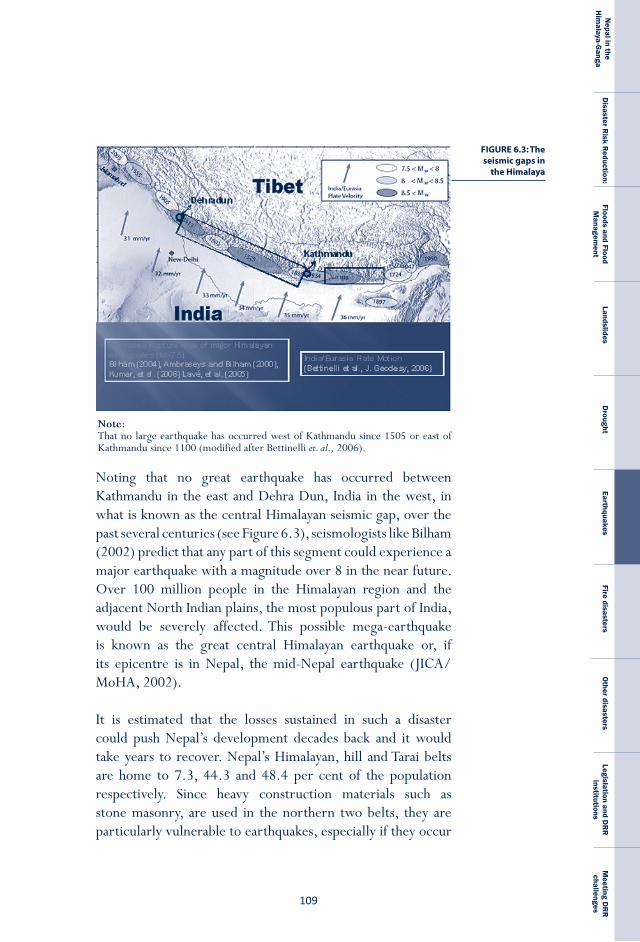
�0�
Nepal in the
Him
alaya-Ganga
Disaster R
isk Reduction:
Floods and Flood M
anagement
LandslidesD
roughtEarthquakes
Fire disastersO
ther disastersLegislation and D
RR
institutions
Meeting D
RR
challenges
Note: That no large earthquake has occurred west of Kathmandu since 1505 or east of Kathmandu since 1100 (modified after Bettinelli et. al., 2006).
FIGURE 6.3: The seismic gaps in
the Himalaya
Noting that no great earthquake has occurred between Kathmandu in the east and Dehra Dun, India in the west, in what is known as the central Himalayan seismic gap, over the past several centuries (see Figure 6.3), seismologists like Bilham (2002) predict that any part of this segment could experience a major earthquake with a magnitude over 8 in the near future. Over 100 million people in the Himalayan region and the adjacent North Indian plains, the most populous part of India, would be severely affected. This possible mega-earthquake is known as the great central Himalayan earthquake or, if its epicentre is in Nepal, the mid-Nepal earthquake (JICA/MoHA, 2002).
It is estimated that the losses sustained in such a disaster could push Nepal’s development decades back and it would take years to recover. Nepal’s Himalayan, hill and Tarai belts are home to 7.3, 44.3 and 48.4 per cent of the population respectively. Since heavy construction materials such as stone masonry, are used in the northern two belts, they are particularly vulnerable to earthquakes, especially if they occur
N E P A L
D I S A S T E R
R E P O R T
��0
at night. Because earthquake-resistant components are not used, buildings in urban Tarai are also vulnerable. Rural Tarai is relatively less vulnerable to damage as most houses are made of light materials such as timber and bamboo and thatched roofs.
research on active faults in Nepal Though the Himalaya are one of the most seismically active regions on the planet, historical records of all but the great earthquakes of the last two centuries are few and research on active faults in Nepal began only very recently. The practice of trenching along such faults to understand their history is still in its infancy though a few successful efforts in Nepal and India produced important results which will help build a database for assessing earthquake hazard in this region. The distribution of active faults in Nepal shown in Figure 6.4 clearly shows that most are located along the southern faces of the mountains.
Recent trenching of the main frontal thrust (MFT) in Nepal and India shows that none of the great earthquakes ruptured any surface and that those earthquakes in Nepal (Nakata et al., 1998; Upreti et al., 2000; Yule, et al., 2006) and India (Kumar, et al., 2001; Feldl and Bilham, 2006) which did rupture the surface exhibited very large displacements of the magnitude of 15 to 20 metres along the fault. This evidence indicates that the Himalaya experienced mega-earthquakes in the past with magnitudes even greater than 8.6, the largest in the last two centuries. The earthquake responsible for a 17-metre displacement in Western Nepal can be correlated with the 1505 earthquake and a gap in the east with a 1100 quake. Because these seismic gaps have matured enough to sustain future ruptures and produce new large earthquakes, Nepal is in a very high risk zone. To better understand the nature of that risk and work toward its mitigation, more trenching of active faults is required.
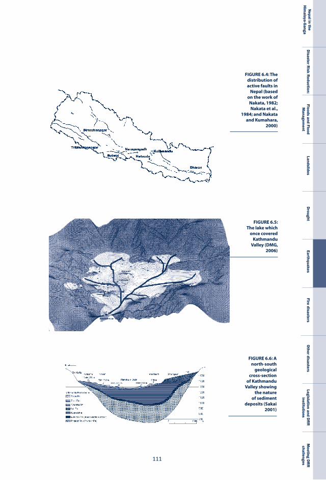
���
Nepal in the
Him
alaya-Ganga
Disaster R
isk Reduction:
Floods and Flood M
anagement
LandslidesD
roughtEarthquakes
Fire disastersO
ther disastersLegislation and D
RR
institutions
Meeting D
RR
challenges
FIGURE 6.4: The distribution of active faults in
Nepal (based on the work of Nakata, 1982; Nakata et al.,
1984; and Nakata and Kumahara,
2000)
FIGURE 6.5: The lake which
once covered Kathmandu
Valley (DMG, 2006)
FIGURE 6.6: A north-south
geological cross-section
of Kathmandu Valley showing
the nature of sediment
deposits (Sakai 2001)
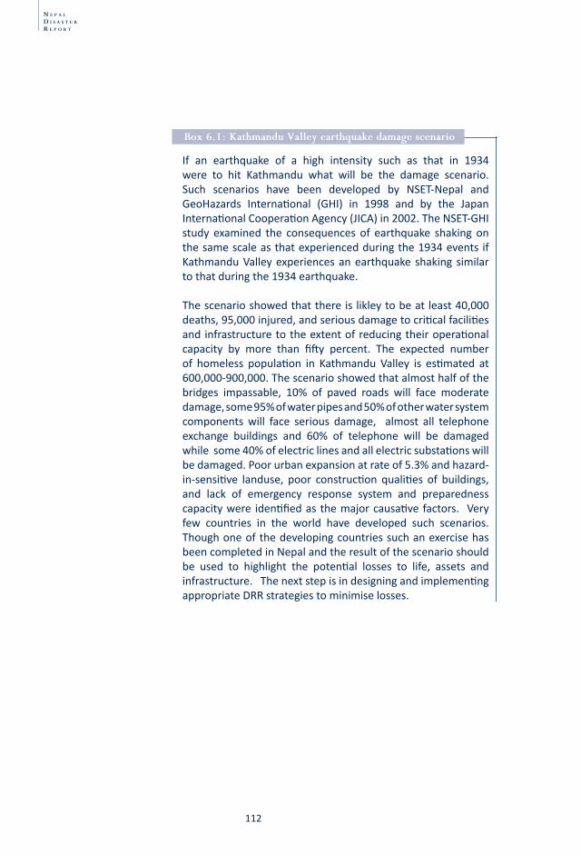
N E P A L
D I S A S T E R
R E P O R T
��2
If an earthquake of a high intensity such as that in 1934 were to hit Kathmandu what will be the damage scenario. Such scenarios have been developed by NSET-Nepal and GeoHazards Internati onal (GHI) in 1998 and by the Japan Internati onal Cooperati on Agency (JICA) in 2002. The NSET-GHI study examined the consequences of earthquake shaking on the same scale as that experienced during the 1934 events if Kathmandu Valley experiences an earthquake shaking similar to that during the 1934 earthquake.
The scenario showed that there is likley to be at least 40,000 deaths, 95,000 injured, and serious damage to criti cal faciliti es and infrastructure to the extent of reducing their operati onal capacity by more than fi ft y percent. The expected number of homeless populati on in Kathmandu Valley is esti mated at 600,000-900,000. The scenario showed that almost half of the bridges impassable, 10% of paved roads will face moderate damage, some 95% of water pipes and 50% of other water system components will face serious damage, almost all telephone exchange buildings and 60% of telephone will be damaged while some 40% of electric lines and all electric substati ons will be damaged. Poor urban expansion at rate of 5.3% and hazard-in-sensiti ve landuse, poor constructi on qualiti es of buildings, and lack of emergency response system and preparedness capacity were identi fi ed as the major causati ve factors. Very few countries in the world have developed such scenarios. Though one of the developing countries such an exercise has been completed in Nepal and the result of the scenario should be used to highlight the potenti al losses to life, assets and infrastructure. The next step is in designing and implementi ng appropriate DRR strategies to minimise losses.
Box 6.1: Kathmandu Valley earthquake damage scenario
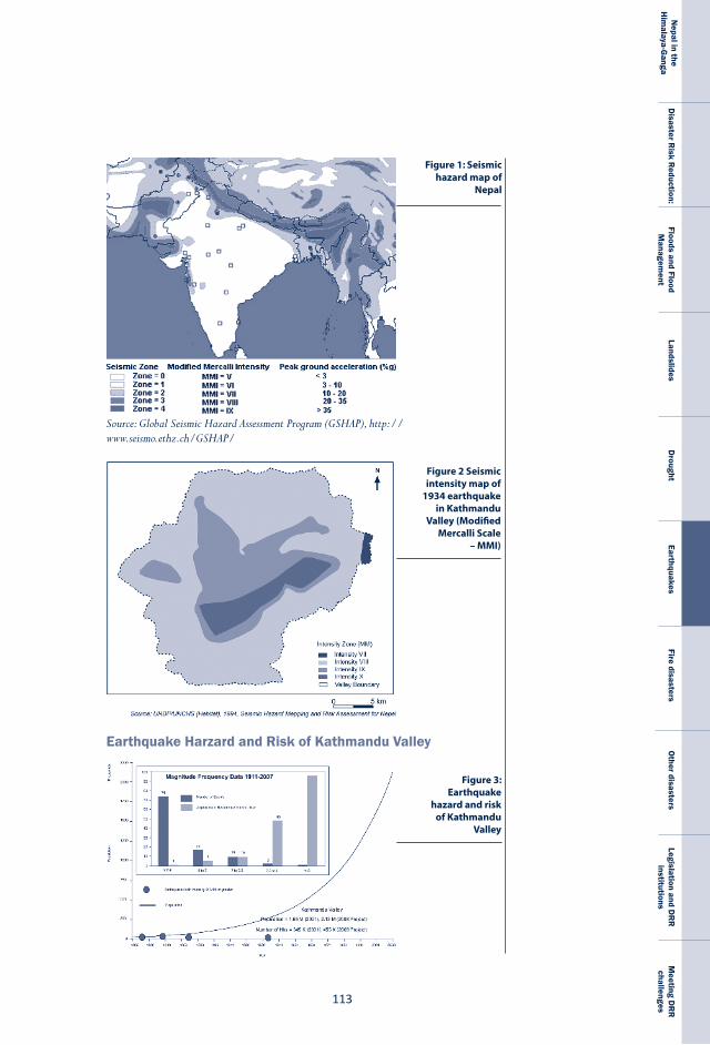
���
Nepal in the
Him
alaya-Ganga
Disaster R
isk Reduction:
Floods and Flood M
anagement
LandslidesD
roughtEarthquakes
Fire disastersO
ther disastersLegislation and D
RR
institutions
Meeting D
RR
challenges
Figure 1: Seismic hazard map of
Nepal
Source: Global Seismic Hazard Assessment Program (GSHAP), http://www.seismo.ethz.ch/GSHAP/
Figure 2 Seismic intensity map of
1934 earthquake in Kathmandu
Valley (Modified Mercalli Scale
– MMI)
Figure 3: Earthquake
hazard and risk of Kathmandu
Valley
Earthquake Harzard and Risk of Kathmandu Valley
N E P A L
D I S A S T E R
R E P O R T
��4
Table 6.2: Major earthquakes of last 25 years
SichuanProvince,China 12May,2008 7.9Java,Indonesia 27May,2006 6.3Muzaffarabad,Pakistan 8October,2005 7.6Indonesia 26December,2004 9.3Gujarat,India 26January,2001 7.9ChamoliIndia 29March,1999 6.8Chi-Chi,Taiwan 9September,1999 7.8Izmit,Turkey 17August,1999 7.6DuzceIran 12November,1999 7.1Athens,Greece 7September,1999 5.9Kobe,Japan 17January,1995 7.2
Location Date Magnitude
The 2002 JICA study explored the consequences of a magnitude 8 earthquake, generati ng somewhat more conservati ve, but nevertheless severe, loss esti mates. The study indicated that 21% of the building stock could be heavily damaged with a potenti al death toll of 1.3% of the valley’s populati on and a 3.8% rate of serious injury. In the last decade Kathmandu has seen even more haphazard urban growth but these scenarios do not refl ect this expansion. When the study was made public in 1998 there was some ‘shock’ expressed but did not generate desired impact on policy and decision-makers. Such results must be innovati vely used to add value to formulati ng risk reducti on polices.
losses due to earthquakesThe losses incurred due to earthquakes vary with their magnitude. Table 6.2 lists the most devastating earthquakes of the last 25 years.
Earthquakes cannot be prevented, but we do know where potentially hazardous zones lie and we can prepare ourselves to mitigate the risks by utilising the tools available to us. These tools include recent advances in technology and lessons learnt from previous events.
The earthquakes that have occurred in the Himalayan region have killed a large number of people. In fact, earthquakes in the Hindukush-Himalaya-Tibet region and its periphery (mainland
���
Nepal in the
Him
alaya-Ganga
Disaster R
isk Reduction:
Floods and Flood M
anagement
LandslidesD
roughtEarthquakes
Fire disastersO
ther disastersLegislation and D
RR
institutions
Meeting D
RR
challenges
China) have killed more people than quakes in any other part of the world because this region includes densely populated countries that house over two billion people, or one-third of the earth’s total population.
The 1934 earthquake in Nepal killed 8,519 people, while the 6.5 magnitude 1988 quake killed 721. The 1998 earthquake resulted in huge infrastructural losses and required eight per cent of the total GDP for rehabilitation (Upreti, 2005). The record of earthquakes in Nepal since 1223 suggests that a large earthquake occurs every seventy-five to hundred years and that moderate ones occur every fifty years. Table 6.3 highlights the losses they incurred.
Across the world, disasters render schoolchildren vulnerable. The 2005 earthquake in Muzaffarabad, Pakistan, for example, saw the greatest number of casualties among students because school buildings were not earthquake-resistant or poorly built. In the disaster most of the dead were school- and college-going youth in the age group of 5-24 years (Moench and Dixit, 2007). Since the earthquake of 1986, and especially in the 1990s, GoN has made provisions to retrofit school buildings so that they are able to withstand the impacts of earthquakes. Measures implemented include strengthening windows, walls, columns and floors to minimise collapse. Kathmandu-based NEST-N has allocated 200 million rupees to assist in the retrofitting of 30 schools around the Kathmandu Valley and across the country.
BoX 6.2: retrofitting schools to resist earthquakes
24December,1223 Numeroushumancasualties Damagetohomesandtemples7June,1255 One-thirdofthepopulationof Damagestohomesandtemples.People Kathmanduwasaffected.Themany livedoutsideforafortnighttoamonthand deathsincludedthatofreigningking aftershockswerefeltforfourmonths. AbhayaMallaeightdaysafterthequake.1260 Numeroushumancasualtiesanda Massivedamagetohomesandtemples famineafterwards14September,1344 Numeroushumancasualties,including Damagetohomesandtemples thedeathofreigningkingAriMallain Deopatanonedayafterthequake
Date Deaths Damages
Table 6.3: Losses from earthquakes
N E P A L
D I S A S T E R
R E P O R T
��6
Management of earthquake disasters The DoMG studies earthquakes in Nepal and has completed an earthquake hazard mapping exercise for the entire country. It also organises awareness campaigns and trains high school teachers on earthquake safety so that they can pass on this knowledge to the younger generation.
Date Deaths Damages
Table 6.3: Losses from earthquakes contd...
1408 Numeroushumancasualties Damagetohomesandtemples.,including Patan’sMachendranathtemple1681 Numeroushumancasualties Residentialbuildingsdamaged1767 Nodeathsrecorded Norecordofdamage4June,1808 Severalpeopleandanimalsperished Housescollapsed1810 Manyliveswerelostparticularly Buildingsandtemplesweredamaged inBhaktapur1823 Nodeathsrecorded Somedamagetohouses1833;magnitude7.7 414peoplediedinthevicinityof Nearly4,040housesinKathmandu, KathmanduValley Bhaktapur,PatanandBanepadestroyed andatotalof18,000buildingsdamaged throughoutthecountry.1834 Norecordavailable Manybuildingscollapsed1837 Norecordofdeath NodamageinNepalrecordedbutgreatly affectedPatnaandotherpartsofBihar, India.1869 Norecordofdeath Norecordavailable1897 Norecordavailable Norecordavailable1917/1918) Norecordofanydeaths Norecordofanydamage1934;magnitude8.3, 8,519peopledied,4,296in Over200,000buildingsandtemplesintensityX;epicentre KathmanduValley. damaged,nearly81,000ofwhichwereinEasternNepal completelydestroyed.InKathmandualone 55,000buildingswereaffected,12,397of whichwerecompletelydestroyed).1936 Norecordavailable Noreliablerecordavailable1954 Norecordavailable Noreliablerecordavailable1966 24peopledied 1,300housescollapsed1980;magnitude6.5; 178peopledied 40000housescollapsedepicentreintheFar-West1988;magnitude6.5; 721peopledied 66,382buildingscollapsedorseriouslyepicentreinthe damagedSoutheast1993;epicentrenear 40%ofbuildingswereaffectedJajarkot
Sources: UNDP/UNCHS, 1993; Pandey and Molnar, 1988; Bilham et al., 1995; Pant, 2002
���
Nepal in the
Him
alaya-Ganga
Disaster R
isk Reduction:
Floods and Flood M
anagement
LandslidesD
roughtEarthquakes
Fire disastersO
ther disastersLegislation and D
RR
institutions
Meeting D
RR
challenges
The response to earthquakes in Nepal includes mitigation, prevention, preparedness, rescue and relief, and reconstruction and rehabilitation measures
Mitigation Mitigation, the implementation of advanced measures to reduce or eliminate the risks of earthquake disasters, includes both structural and non-structural measures and involves both the government and civil society actors. A book written by Brahma Shamsher after the earthquake of 1934 suggests measures to make earthquake safe buildings (Rana, 1934). The book mentions proper site selection, quality materials, proper construction, height of the structure, geometrical configuration or plan form, and lightness of the upper storey as key elements. This suggestion evolved during the post earthquake reconstruction and recovery of 1934 earthquake is useful to develop earthquake safe construction practices in Nepal.
One of the initiatives undertaken to prevent damages from earthquake is the retrofitting of school buildings in Kathmandu Valley, facilitated by NSET-N. Under this initiative, local masons were given trainings and this effort has shown a positive impact on improving awareness. Workshops and art competitions organised in schools have also helped improve awareness regarding earthquake safety. Center for Disaster Studies (CDS) at Institute of Engineering (IoE) has designed and developed techniques for retrofitting of stone masonry buildings in rural Nepal. Successful demonstrations have been conducted in Kathmandu, Sindhuli, Sindhupalchowk, Kaski and Kabhrepalanchowk districts. This method uses locally available materials, like bamboo and timber, and local technology for retrofitting.
prevention and preparednessThe use of seismic resistant technology is one of the major ways to prevent earthquake disasters. Development and enforcement of building codes and improved community
N E P A L
D I S A S T E R
R E P O R T
��8
awareness are other approaches that fall under this category. Kathmandu Metropolitan city is the largest municipality among Nepal’s 58 municipalities recognises the need of preparedness. Most municipalities that lie in the mid-mountain and Tarai regions of the country still need to recognise the need for better preparedness.
Preventive measures were adopted early in Nepal. Studies reveal that the Newari architecture of Kathmandu took measures to respond to earthquakes and used local technology to reduce vulnerabilities. Traditional buildings in Jumla are designed, developed and constructed to be earthquake resistant. They have horizontal and transverse timber members on the stone masonry walls.
Every February the NSET-N and MoHA organise Earthquake Safety Day to remember the devastation caused by 1934 earthquake. On the occasion, the government and NGOs conduct activities such as earthquake safety exhibitions, drills and seminars. Participants include the MoHA, the Ministry of Physical Planning and Works (MoPPW), and municipalities, as well as professional societies like the Nepal Engineers’ Association, the Society of Consulting Architects and Engineering Firms, and the Society of Structural Engineers Nepal. NGOs like NSET-N and the NRCS also highlight the risks of earthquakes. The monthly magazine Paryawaran, which is supported by Action Aid Nepal, includes articles which describe earthquake disasters and the specific measures that can be taken in their aftermath to minimise damages. In coordination with governmental agencies and I/NGOs, NSET-N organises seminars, workshops, and trainings to increase awareness. It also supports the retrofitting of existing buildings. The educational establishments such as the IoE and Nepal Engineering College (NEC) mobilise academic resources in order to improve awareness.
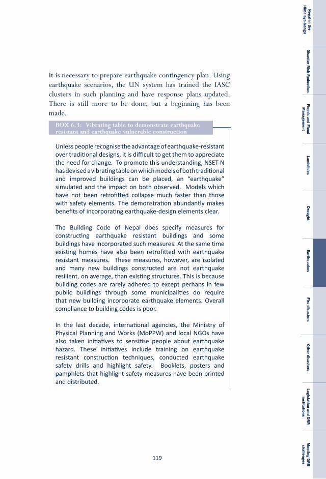
���
Nepal in the
Him
alaya-Ganga
Disaster R
isk Reduction:
Floods and Flood M
anagement
LandslidesD
roughtEarthquakes
Fire disastersO
ther disastersLegislation and D
RR
institutions
Meeting D
RR
challenges
It is necessary to prepare earthquake contingency plan. Using earthquake scenarios, the UN system has trained the IASC clusters in such planning and have response plans updated. There is still more to be done, but a beginning has been made.
Unless people recognise the advantage of earthquake-resistant over traditional designs, it is difficult to get them to appreciate the need for change. To promote this understanding, NSET-N has devised a vibrating table on which models of both traditional and improved buildings can be placed, an “earthquake” simulated and the impact on both observed. Models which have not been retrofitted collapse much faster than those with safety elements. The demonstration abundantly makes benefits of incorporating earthquake-design elements clear.
The Building Code of Nepal does specify measures for constructing earthquake resistant buildings and some buildings have incorporated such measures. At the same time existing homes have also been retrofitted with earthquake resistant measures. These measures, however, are isolated and many new buildings constructed are not earthquake resilient, on average, than existing structures. This is because building codes are rarely adhered to except perhaps in few public buildings through some municipalities do require that new building incorporate earthquake elements. Overall compliance to building codes is poor.
In the last decade, international agencies, the Ministry of Physical Planning and Works (MoPPW) and local NGOs have also taken initiatives to sensitise people about earthquake hazard. These initiatives include training on earthquake resistant construction techniques, conducted earthquake safety drills and highlight safety. Booklets, posters and pamphlets that highlight safety measures have been printed and distributed.
BoX 6.3: Vibrating table to demonstrate earthquake resistant and earthquake vulnerable construction
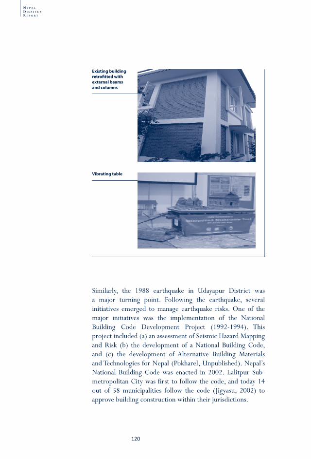
N E P A L
D I S A S T E R
R E P O R T
�20
Similarly, the 1988 earthquake in Udayapur District was a major turning point. Following the earthquake, several initiatives emerged to manage earthquake risks. One of the major initiatives was the implementation of the National Building Code Development Project (1992-1994). This project included (a) an assessment of Seismic Hazard Mapping and Risk (b) the development of a National Building Code, and (c) the development of Alternative Building Materials and Technologies for Nepal (Pokharel, Unpublished). Nepal’s National Building Code was enacted in 2002. Lalitpur Sub-metropolitan City was first to follow the code, and today 14 out of 58 municipalities follow the code (Jigyasu, 2002) to approve building construction within their jurisdictions.
Existing building retrofi tted with external beams and columns
Vibrating table
�2�
Nepal in the
Him
alaya-Ganga
Disaster R
isk Reduction:
Floods and Flood M
anagement
LandslidesD
roughtEarthquakes
Fire disastersO
ther disastersLegislation and D
RR
institutions
Meeting D
RR
challenges
rescue The DoMG is the central agency, which monitors earthquake in the country. Information on earthquakes exceeding 3 on the Richter scale is related to the MoHA and the Information and Communication Ministry. This information is then broadcast on the state and privately owned radio and television stations. Rescue operations begin immediately after news of damage arrives. The government provides support at national and district levels. In general, the local government (VDCs and Municipalities) is responsible for coordinating rescue operations. Security forces, health workers, fire brigade, NRCS and community-based organisations are also mobilised.
The NRCS is actively involved in rescue operations. It maintains a country-wide network for rescue support and trains volunteers as well. Kathmandu Metropolitan and Lalitpur Sub metropolitan city have also mobilised community based organisations to work for disaster management by establishing community based disaster management committees (DMCs). These committees are the first line of defence. In most cases, such committees lack technical and managerial knowledge to function during a disaster. Building their capacity is a major challenge. The DMC of Ward 17 clustered in the year 2001 is extensively working in the area of community based disaster management. The main partners in this initiative are NSET-N and Rotary Club. The committee has representation from different professional backgrounds: housewives to disaster management experts. Local politicians, ward members, youth volunteers, school children are also members of the committee. Local youth clubs, NRCS, schools, Rotary club, Nepal Scout, Community based committees, local unit of Nepal Police are the institutional members. A community meeting to sensitize and motivate community members to form DMCs. NSET-N is disseminating the knowledge gathered from its experience. The United Nations Centre for Regional Development (UNCRD) also conducts volunteer trainings and supports search and rescue efforts.
N E P A L
D I S A S T E R
R E P O R T
�22
In April 2009, International Search and rescue Advisory Group (INSARAG) carried out the largest exercise for search and rescue in South Asia in Nepal. More than 250 participants from 19 countries including SAR teams from several countries in Asia and the pacific participated. Organised jointly by UN OCHA and the MoHA, many NGOs and UN agencies participated in the exercise. Such efforts help build local capacity while helping improve overall understanding of the risk that earthquake entails.
reconstruction and recoveryFollowing the earthquake of 1934, the government carried out rehabilitation and reconstruction efforts in Kathmandu. Guidelines were developed to construct earthquake safe buildings. The government took similar initiatives after the 1988 Udayapur earthquake to recover from the damages in a short time. The victims were provided with financial support to recover from their losses. Agencies such as the World Bank (WB) and Asian Development Bank (ADB) also played key roles in the process. Support was also provided by agencies of United Nation System such as the WFP and the UNDP which assist in during disaster particularly earthquakes.
Ways forwardLosses due to earthquakes are exacerbated by the following factors:• The use of temporary and/or poor quality building
materials • The fact that earthquake-resistant technologies are not used
in masonry buildings or in buildings of rural areas• The lack of sufficient building codes, by-laws and basic design
parameters • The lack of enforcement of existing laws • The faulty locations of services such as stairs and corridors in
buildings • The lack of response planning and community mobilisation.
�2�
Nepal in the
Him
alaya-Ganga
Disaster R
isk Reduction:
Floods and Flood M
anagement
LandslidesD
roughtEarthquakes
Fire disastersO
ther disastersLegislation and D
RR
institutions
Meeting D
RR
challenges
• The lack of awareness at the household and community levels
• Poor implementation of precautions and lack of preparedness measures
To minimise the impact of future earthquakes two things need to be done. First, NGOs and research institutions should conduct awareness programmes including earthquake drills, street plays, concerts, and radio and television programmes in order to improve people’s understanding of the consequences of earthquakes. They should be designed to encourage people to change their behaviour during and after an event. The second major step to take is to implement and enforce compliance with building codes as it is estimated that 90 per cent of the buildings in Nepal are poorly designed and built.
New buildings must adhere to strict safety codes and existing buildings need to be retrofitted. Construction practices need to be improved and top-grade construction materials used. Building construction should follow universally agreed upon principles and specify the roles and responsibilities of clients, consultants and contractors. Because local governments play a vital role in enforcing policies, laws and regulations, they must be strengthened through capacity-building exercises and improvements of working procedures. Moreover, settlements should be planned so that emergency vehicles and other support can reach disaster sites without hindrance. The road networks in existing settlements and cities need to be substantially upgraded. An important activity would be the preparation of a comprehensive earthquake response plan for Nepal.

N E P A L
D I S A S T E R
R E P O R T
�24
�2�
Nepal in the
Him
alaya-Ganga
Disaster R
isk Reduction:
Floods and Flood M
anagement
LandslidesD
roughtEarthquakes
Fire disastersO
ther disastersLegislation and D
RR
institutions
Meeting D
RR
challenges
Chapter-7
Fire is a recurring disaster in Nepal: every year, particularly during the dry season from February to May, a large number of incidents of fire are reported, mostly in the Tarai, where about three-quarters of houses are built with thatched roofs. Historically, fires have even devastated administrative centres. The Licchavi capital of Bishalnagar in Kathmandu was gutted by fire in the seventh century and in 1970 Singha Durbar, the Secretariat of Nepal Government, was engulfed by fire, forcing the then Prime Minister to resign on moral grounds.
losses due to fire disastersThe DesInventar database has documented losses due to fire since 1970. Although the number of deaths by fire is lower than that of other disasters—just 50 deaths per year on average in the last two decades (1,175 between 1983 and 2003)—the average annual loss of property is high, nearly NRs. 245 million (MoHA, 2006). The average however does obscure the loss in a decade. In the last 10 years from 1993 to 2003, 959 people were reported killed and about 60,243 houses were destroyed. In 2003 alone, 16 people were killed and 23 were injured and 1,162 families were affected by fire. About 233 animals were lost and 1,274 houses and 144 cattle sheds were destroyed. The estimated loss was NRs. 734 million. Two main reasons for the outbreaks of fire are the improper use of fire for cooking and other domestic purposes and the lack of adequate fire safety measures. For the population in the rural areas, living in closely clustered thatched houses, fire is a major hazard.
Fire disasters
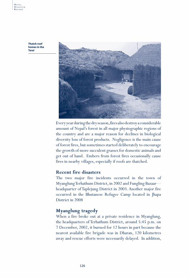
N E P A L
D I S A S T E R
R E P O R T
�26
Every year during the dry season, fires also destroy a considerable amount of Nepal’s forest in all major physiographic regions of the country and are a major reason for declines in biological diversity loss of forest products. Negligence is the main cause of forest fires, but sometimes started deliberately to encourage the growth of more succulent grasses for domestic animals and get out of hand. Embers from forest fires occasionally cause fires in nearby villages, especially if roofs are thatched.
recent fire disasters The two major fire incidents occurred in the town of Myanglung Terhathum District, in 2002 and Fungling Bazaar—headquarter of Taplejung District in 2003. Another major fire occurred in the Bhutanese Refugee Camp located in Jhapa District in 2008
Myanglung tragedy When a fire broke out at a private residence in Myanglung, the headquarters of Terhathum District, around 5:45 p.m. on 7 December, 2002, it burned for 12 hours in part because the nearest available fire brigade was in Dharan, 120 kilometres away and rescue efforts were necessarily delayed. In addition,
Thatch roof homes in the Tarai
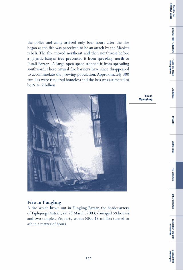
�2�
Nepal in the
Him
alaya-Ganga
Disaster R
isk Reduction:
Floods and Flood M
anagement
LandslidesD
roughtEarthquakes
Fire disastersO
ther disastersLegislation and D
RR
institutions
Meeting D
RR
challenges
the police and army arrived only four hours after the fire began as the fire was perceived to be an attack by the Maoists rebels. The fire moved northeast and then northwest before a gigantic banyan tree prevented it from spreading north to Putali Bazaar. A large open space stopped it from spreading southward. These natural fire barriers have since disappeared to accommodate the growing population. Approximately 300 families were rendered homeless and the loss was estimated to be NRs. 2 billion.
Fire in FunglingA fire which broke out in Fungling Bazaar, the headquarters of Taplejung District, on 28 March, 2003, damaged 59 houses and two temples. Property worth NRs. 18 million turned to ash in a matter of hours.
Fire in Myanglung
N E P A L
D I S A S T E R
R E P O R T
�28
Fire in Kapilbastu On 17 February, 2005, anti-Maoist vigilantes deliberately started a fire in Kapilbastu which damaged 3,000 houses in 26 villages, killing 22 and displacing 2,500 families and hundreds of cattle and poultry. Property worth more than NRs. 5 million was destroyed. The arson was a response to the Maoist rebel’s abduction of two villagers from Ganeshpur on 16 February.
Fire in GoldhapA huge fire occurred in Goldhap, a Bhutanese refugee camp in Jhapa District in Eastern Nepal on 1 March, 2008. Though there were no casualties, some 1,700 houses were reduced to ash.
Management of fires Hazard As is the case with other disasters, the reduction of fires entails prevention, preparedness, mitigation, response, relief and recovery efforts.
Mitigation Fire mitigation work is carried out by various organisations, including the government, the NRCS and I/NGOs. The MoHA conveys messages by state-owned radio and television stations about precautions needed to avoid the accidental lighting of fires, like keeping matches out of the reach of children. Right across the country, the NRCS distributes fire awareness posters to villages through NGOs, NRCS district chapters, volunteers, youth and CBOs. The monthly magazine Paryawaran also features articles describing the damage fires can cause as well as preventive and rehabilitative measures.
prevention Thatched roofs are being replaced with clay tiles and houses built of bricks or concrete rather than bamboo as remittances flow into the country. In Kapilbastu, Nawalparasi, Mahottari, Jhapa and Kathmandu districts the NCDM, in collaboration
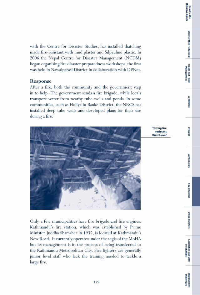
�2�
Nepal in the
Him
alaya-Ganga
Disaster R
isk Reduction:
Floods and Flood M
anagement
LandslidesD
roughtEarthquakes
Fire disastersO
ther disastersLegislation and D
RR
institutions
Meeting D
RR
challenges
with the Centre for Disaster Studies, has installed thatching made fire-resistant with mud plaster and Silpauline plastic. In 2006 the Nepal Centre for Disaster Management (NCDM) began organising fire disaster preparedness workshops; the first was held in Nawalparasi District in collaboration with DPNet.
response After a fire, both the community and the government step in to help. The government sends a fire brigade, while locals transport water from nearby tube wells and ponds. In some communities, such as Holiya in Banke District, the NRCS has installed deep tube wells and developed plans for their use during a fire.
Only a few municipalities have fire brigade and fire engines. Kathmandu’s fire station, which was established by Prime Minister Juddha Shamsher in 1935, is located at Kathmandu’s New Road. It currently operates under the aegis of the MoHA but its management is in the process of being transferred to the Kathmandu Metropolitan City. Fire fighters are generally junior level staff who lack the training needed to tackle a large fire.
Testing fire resistant
thatch roof
N E P A L
D I S A S T E R
R E P O R T
��0
reliefBoth the government and the NRCS provide relief to fire victims. The NRCS provides non-food items after assessing need. INGOs also make donations. For example, Save the Children stores non-food items with NRCS in Dhangadhi, Nepalgunj and other places. The government compensates victims NRs. 25,000 for each death and up to NRs. 10,000 for damage to property after an assessment is carried out. After a fire broke out in Terhathum NRCS provided people with food, shelter and medical assistance and the Central Natural Disaster Relief Committee gave each family NRs. 4,000 for immediate relief.
recoveryThe government carried out a rehabilitation and reconstruction programme in Myanglung following the 2002 fire. It established an office and town development committee to facilitate land pooling. Masons were trained to construct earthquake- and fire-resistant buildings. To demonstrate the techniques at this training, models were designed and built.
In Fungling, guided land development and land-pooling programmes were launched at the cost of NRs. 500,000 in the fiscal year 2005/06. Few people (8.7%) in Fungling were dissatisfied with the arrangements of land distribution because they were relocated at the ends of the settlement, but all the people of Myanglung were satisfied with the construction of a road and drainage system.
In both places, houses were made of reinforced concrete rather than the traditional stone masonry. Prior to the fire, 85 per cent were made of stone; after, the percentage reduced to just five per cent. The proportion of reinforced concrete houses increased from five to 60 per cent. There is not enough open land in the land-pooling area, only about 1.9 per cent because landowners contributed very little to property development.
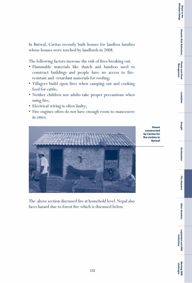
���
Nepal in the
Him
alaya-Ganga
Disaster R
isk Reduction:
Floods and Flood M
anagement
LandslidesD
roughtEarthquakes
Fire disastersO
ther disastersLegislation and D
RR
institutions
Meeting D
RR
challenges
In Butwal, Caritas recently built houses for landless families whose houses were torched by landlords in 2008.
The following factors increase the risk of fires breaking out. • Flammable materials like thatch and bamboo used to
construct buildings and people have no access to fire-resistant and -retardant materials for roofing;
• Villagers build open fires when camping out and cooking feed for cattle;
• Neither children nor adults take proper precautions when using fire;
• Electrical wiring is often faulty;• Fire engines often do not have enough room to manoeuvre
in cities.
The above section discussed fire at household level. Nepal also faces hazard due to forest fire which is discussed below.
House constructed
by Caritas for fire victims in
Butwal

N E P A L
D I S A S T E R
R E P O R T
��2
BoX 7.1: Community-based disaster management
Various INGOs, including Oxfam-GB Nepal, the NRCS, Acti on Aid Nepal, Practi cal Acti on Nepal, CARE Nepal, Mercy Corps and Lutheran World Federati on, as well as their local partners, have been involved in community-based DRR interventi ons in Nepal for well over a decade. These programmes receive support from bilateral donors. Similar input is also provided by UNDP. Their eff orts have resulted in the identi fi cati on of a range of community-level interventi ons that are eff ecti ve in responding to fl ood, drought, landslide, earthquake and fi re risks. In fl ood- and drought-prone areas of the Tarai, the following tasks should be carried out:
Forest firesFires are a natural and inherent component of the disturbance regime in most natural forests. Forest fires have both advantages and disadvantages depending on the intensity, timing, and frequency of fire and interactions with other disturbing agents (Burslem, 2004). Forest fires in Nepal frequently occur and cause several damages such as loss of timber, biodiversity, increased soil loss and higher sedimentation every year. Human induced forest fires can also cause losses of livestock and sometime that of human lives. Forest fires can play a vital role in removing dry organic matter present on the soil surface and also diversify the forest ecosystem (Moore, 2008).
The two major anthropogenic causes of forest fires in Nepal are the negligence of livestock herders and the forceful occupation of the forestland for purposes like farming and private ownership. Forest fires closer to human settlement can expand to houses that can have serious adverse implications. Forest fires do have ecological significances as well. One of the serious issues emerging with forest fires is emission of greenhouse gas, CO
2, sequestered in trees contributing in
warming of climate.
���
Nepal in the
Him
alaya-Ganga
Disaster R
isk Reduction:
Floods and Flood M
anagement
LandslidesD
roughtEarthquakes
Fire disastersO
ther disastersLegislation and D
RR
institutions
Meeting D
RR
challenges
• Form community and village disaster management committees,• Develop community, village and district disaster plans and
institutionalise district- and national -level pre-monsoon preparedness and post-monsoon review meetings.
• Develop community preparedness and response plans, conduct related training, and provide equipment.
• Construct or repair flood-resistant shelters,• Provide access to flood-resistant seed storage facilities,• Provide access to improved seed varieties that, depending on the
prevailing situation, are either drought-resistant or both flood-resistant and early- maturing,
• Carry out community structural mitigation measures, including the construction of protection walls (integrated with the strategic planting of vegetation) and spurs, the improvement of drainage systems and the installation of culverts in roads, and the raising of tube wells and latrines.
• Promote livelihood diversification, • Develop people-centred early warning systems. • Promote safe hygiene behaviours and practices.• Raise awareness about DRR concepts and approaches through
schools and at the community level, and• Develop tools and methodologies for strengthening women’s
leadership in DRR
Though community based interventions are generally undertaken on a project-basis, and often cover a limited geographical area, they also produce usable knowledge, replicable lessons and practical insights useful for policy advocacy. Efforts in advocacy should draw on the DRR success stories of other countries as well.
Ways forwardTo reduce the impact of fire, public awareness programmes need to be developed in both rural and urban areas. Such programmes should be conducted before the start of the fire season in January. The use of flammable building materials like thatch should be discouraged and flame-retardant and –resistant materials used.
N E P A L
D I S A S T E R
R E P O R T
��4
In urban areas, building codes, particularly those pertaining to wiring and fire escapes should be strictly followed. Houses should be planned so that they do not impede the movement of people during fire and allow emergency vehicles to reach fire sites without hindrance. Nepal also needs to beef up its fire brigade system.
To prevent forest fires from spreading, fire corridors should be created and cattle grazers should be educated about fire hazards.
���
Nepal in the
Him
alaya-Ganga
Disaster R
isk Reduction:
Floods and Flood M
anagement
LandslidesD
roughtEarthquakes
Fire disastersO
ther disastersLegislation and D
RR
institutions
Meeting D
RR
challenges
Chapter-8
In addition to the natural disasters discussed in previous chapters, Nepal is also struck by human-induced disasters, both technological and health-related. In this chapter we will present road accidents, aircraft accidents and health related disasters.
road and air accidents A technological disaster is a sudden and unpredictable event resulting in human injury and possibly death as well as property damage which results from a technological failure. The impact of such a disaster is hard to pinpoint because it affects multiple sectors and the cost of human life cannot be estimated in monetary terms. Death brings emotional pain and may result in the loss of an income earner. Too often, the cost of health care or funeral rites, the loss of a primary breadwinner or income due to disability pushes a family towards poverty. The mental stress associated with such impacts can lead to psychological disorders or depression, which are in themselves costly. Injured and disabled victims can become a burden to family and friends.
Other disasters
N E P A L
D I S A S T E R
R E P O R T
��6
Road accidents and air crashes are two types of technological disasters that regularly affect Nepalis. Because we are growing increasingly dependent on cars and two-wheelers in our daily lives, understanding the causes of such disasters so that we can take measures to minimise them is important.
road accidentsAcross the globe, motor vehicle accidents are the most common. In a 2004 report WHO declared that road accidents were the second largest leading cause of death among young people aged 15 to 29 years and the third largest leading cause of death among people aged 30 to 44 years. The same report estimated that road accidents result in the death of an estimated 1.2 million people worldwide each year. Some of the main causes of road accidents include leniency in the issuance of driving licenses; driving while drunk, fatigued, or stressed, competition among drivers, poor maintenance of vehicles and lax vehicle regulation, speeding, overloading of vehicles and negligence. The other causes of accidents are non-compliance with traffic rules, pedestrian carelessness, and reckless motorcycle riding.
15 See eJMA: preventing traffi c accidents by mobile phones
The use of mobile phones while driving, because it distracts drivers, has been responsible for numerous accidents across the world, including in Nepal. There is ample evidence that mobile phone use actually increases the risk of crashes. A study conducted in New Zealand esti mates that mobile phones account for 0.5% of all reported accidents.�� Though the number is small, use of mobile phones during driving can cause loss of human lives and needs to be prevented. To that end regulati on must be framed and enforced.
BoX 8.1: Mobile phone hazard during driving
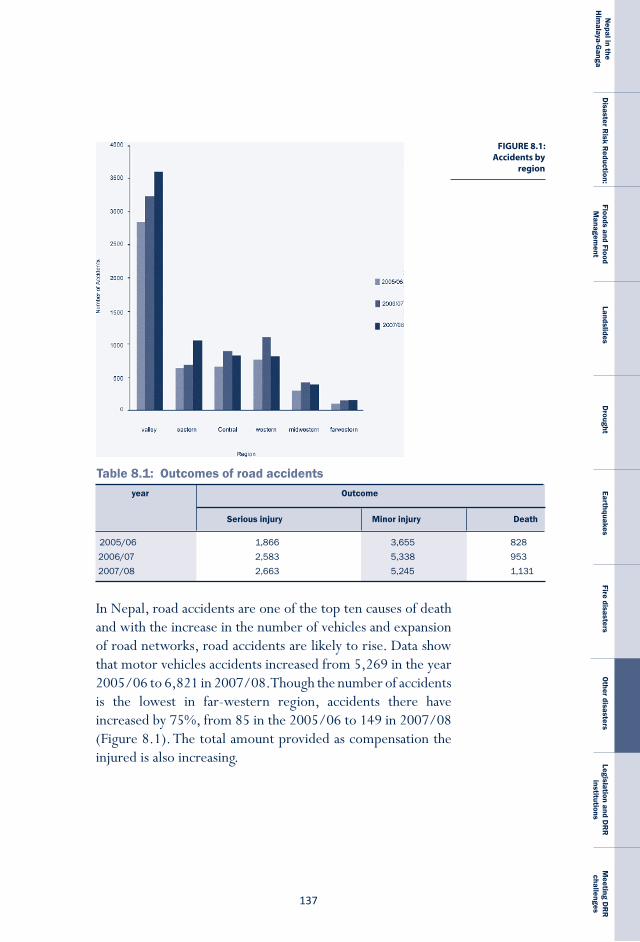
���
Nepal in the
Him
alaya-Ganga
Disaster R
isk Reduction:
Floods and Flood M
anagement
LandslidesD
roughtEarthquakes
Fire disastersO
ther disastersLegislation and D
RR
institutions
Meeting D
RR
challenges
2005/06 1,866 3,655 8282006/07 2,583 5,338 9532007/08 2,663 5,245 1,131
Serious injury Minor injury Death
year Outcome
Table 8.1: Outcomes of road accidents
FIGURE 8.1: Accidents by
region
In Nepal, road accidents are one of the top ten causes of death and with the increase in the number of vehicles and expansion of road networks, road accidents are likely to rise. Data show that motor vehicles accidents increased from 5,269 in the year 2005/06 to 6,821 in 2007/08. Though the number of accidents is the lowest in far-western region, accidents there have increased by 75%, from 85 in the 2005/06 to 149 in 2007/08 (Figure 8.1). The total amount provided as compensation the injured is also increasing.
N E P A L
D I S A S T E R
R E P O R T
��8
Box 8.2: psychological consequences
Mental trauma goes hand in hand with disaster as community life is upset and questi ons about safety, social organisati on and the meaning of life come to the fore. Symptoms of trauma include fl ashbacks, diffi culty remembering, avoidance of sti muli, blunti ng of responses, high levels of arousal level and obsessive ruminati ons*. Too oft en, however, the help provided to the aff ected overlooks the psychosocial consequences to the individual, the family, and the community. Women, children and the elderly are parti cularly vulnerable. A study conducted aft er the 2008 Koshi fl ood in Nepal demonstrates the need for psychosocial support: people, especially children, women, pregnant women and lactati ng mothers, are anxious about shelter, food, water, sanitati on and their own security and that of their family members. The lack of space in shelters was cause for parti cular concern. To address these worries, there is a need for counseling and family interventi on services, whether they consist of off ering emoti onal support, conducti ng relaxati on exercises, providing psychological educati on, or various other methods.
Maintaining good health is diffi cult during fl oods. Newborn babies suff er from dehydrati on and malnutriti on because of lack of their mothers’ breast milk. Young children suff er from purulent conjuncti viti s, a communicable disease which oft en reaches epidemic proporti ons. Because of the lack of nutriti ous food, safe water, proper sanitati on and overcrowding, disease is rife, parti cularly cough and cold among older people, malnutriti on among lactati ng and pregnant mothers and mosquito- and water-borne diseases like diarrhea among the general populati on. Snakebite is also common.** Dead bodies also need to be bett er handled so that their decompositi on does not become a threat.
There is also a need to manage multi -sectoral and multi -level community interventi ons to address immediate, mid- and long-term needs in a socially and culturally sensiti ve fashion. The planning for these acti viti es should be based on evidence for their need. Aft er a disaster occurs, the military, health workers, public health service workers including both state and local employees and volunteers should be mobilised to help. The Ministry of Health has, in fact, already devised a health sector emergency and disaster response plan to address the aft ermath of disasters and provide the aff ected with basic needs; unfortunately, it neglects psychosocial relief.***
���
Nepal in the
Him
alaya-Ganga
Disaster R
isk Reduction:
Floods and Flood M
anagement
LandslidesD
roughtEarthquakes
Fire disastersO
ther disastersLegislation and D
RR
institutions
Meeting D
RR
challenges
Another need is to develop policies, plans, and implementation strategies for providing psychosocial support in post-disaster situations. These policies must take cognizance of geographical variations as well as be culturally acceptable, socioeconomically sustainable and politically unaligned.****
* Choudhury, W.A., Quraishi F.A., Haque Z. Mental health and psychosocial aspects of disaster preparedness in Bangladesh 2006: National Institute of Mental Health & Research, Dhaka, Bangladesh. [email protected]. Int Rev Psychiatry, 18(6), 529-35.** Choudhury, W.A., Quraishi F.A., Haque Z. Mental health and psychosocial aspects of disaster preparedness in Bangladesh 2006: National Institute of Mental Health & Research, Dhaka, Bangladesh. [email protected]. Int Rev Psychiatry, 18(6), 529-35.*** Benedek, D.M., Fullerton, C. and Ursano, R.J., 2007: First responders: Mental health consequences of natural and human-made disasters for public health and public safety workers. Annual Review of Public Health. 28, 55-68.****Acharya, L., Upadhya,K.D., Kortmann, F., 2006:. Western Hospital, Pokhara, Nepal. Mental health and psychosocial support aspects in disaster preparedness: Nepal. Int Rev Psychiatry. 18(6), 587-92.
Minor injury, the most common result of road accidents, increased almost 50% in just three years, from 3,655 in the 2005/06 to 5,245 in the year 2007/08.16 The incidence of serious injury and death has also increased during the same period, from 1,866 to 2,663 (see Table 8.1). The year 2007/08 saw the greatest number of deaths, 1,131.
Given that Kathmandu Valley has the highest number of two-wheelers and automobiles it is no surprise that it has the most road accidents and that the number has increased since 2005/06. The number of accidents in the first nine months of the 2008/09 ranged from a high of 257 in February/March 2009 to a low of 153 in July/August 2008 (see Table 8.2). In terms of injury and death, however, November/December was the worst month. Altogether the period saw 1,790 cases of minor injury, 516 off serious injury and 107 fatalities (see Table 8.2).17 Compared to 2007/2008, the number of death in the first nine months of 2008 reached 1,790.
16 Data on accidents are recorded as per Nepal’s fiscal year which begins in the month of Shrawan and ends on Ashar of the next year. This corresponds to two consecutive Gregorian Calendar years. Therefore the data presented above mention 2005/2006 which is BS 2062.
17 The data is provided by Traffic Headquarters, Naxal
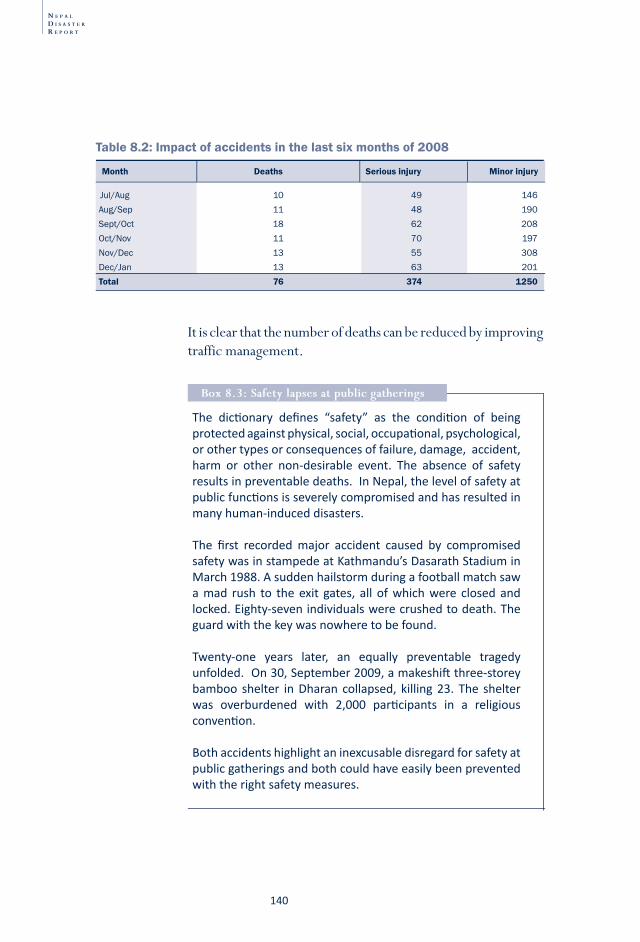
N E P A L
D I S A S T E R
R E P O R T
�40
Table 8.2: Impact of accidents in the last six months of 2008
Jul/Aug 10 49 146Aug/Sep 11 48 190Sept/Oct 18 62 208Oct/Nov 11 70 197Nov/Dec 13 55 308Dec/Jan 13 63 201Total 76 374 1250
Month Deaths Serious injury Minor injury
The dicti onary defi nes “safety” as the conditi on of being protected against physical, social, occupati onal, psychological, or other types or consequences of failure, damage, accident, harm or other non-desirable event. The absence of safety results in preventable deaths. In Nepal, the level of safety at public functi ons is severely compromised and has resulted in many human-induced disasters.
The fi rst recorded major accident caused by compromised safety was in stampede at Kathmandu’s Dasarath Stadium in March 1988. A sudden hailstorm during a football match saw a mad rush to the exit gates, all of which were closed and locked. Eighty-seven individuals were crushed to death. The guard with the key was nowhere to be found.
Twenty-one years later, an equally preventable tragedy unfolded. On 30, September 2009, a makeshift three-storey bamboo shelter in Dharan collapsed, killing 23. The shelter was overburdened with 2,000 parti cipants in a religious conventi on.
Both accidents highlight an inexcusable disregard for safety at public gatherings and both could have easily been prevented with the right safety measures.
Box 8.3: safety lapses at public gatherings
It is clear that the number of deaths can be reduced by improving traffic management.
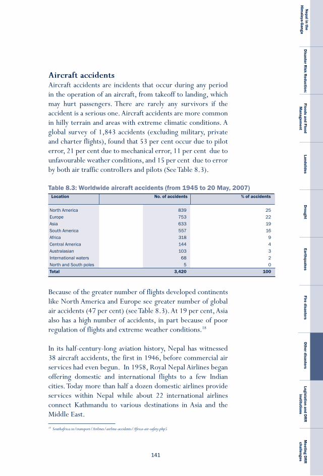
�4�
Nepal in the
Him
alaya-Ganga
Disaster R
isk Reduction:
Floods and Flood M
anagement
LandslidesD
roughtEarthquakes
Fire disastersO
ther disastersLegislation and D
RR
institutions
Meeting D
RR
challenges
aircraft accidentsAircraft accidents are incidents that occur during any period in the operation of an aircraft, from takeoff to landing, which may hurt passengers. There are rarely any survivors if the accident is a serious one. Aircraft accidents are more common in hilly terrain and areas with extreme climatic conditions. A global survey of 1,843 accidents (excluding military, private and charter flights), found that 53 per cent occur due to pilot error, 21 per cent due to mechanical error, 11 per cent due to unfavourable weather conditions, and 15 per cent due to error by both air traffic controllers and pilots (See Table 8.3).
Because of the greater number of flights developed continents like North America and Europe see greater number of global air accidents (47 per cent) (see Table 8.3). At 19 per cent, Asia also has a high number of accidents, in part because of poor regulation of flights and extreme weather conditions.18
In its half-century-long aviation history, Nepal has witnessed 38 aircraft accidents, the first in 1946, before commercial air services had even begun. In 1958, Royal Nepal Airlines began offering domestic and international flights to a few Indian cities. Today more than half a dozen domestic airlines provide services within Nepal while about 22 international airlines connect Kathmandu to various destinations in Asia and the Middle East.
NorthAmerica 839 25Europe 753 22Asia 633 19SouthAmerica 557 16Africa 318 9CentralAmerica 144 4Australasian 103 3Internationalwaters 68 2NorthandSouthpoles 5 0Total 3,420 100
Location No. of accidents % of accidents
Table 8.3: Worldwide aircraft accidents (from 1945 to 20 May, 2007)
18 Southafrica.to/transport/Airlines/airline-accidents/Africa-air-safety.php5
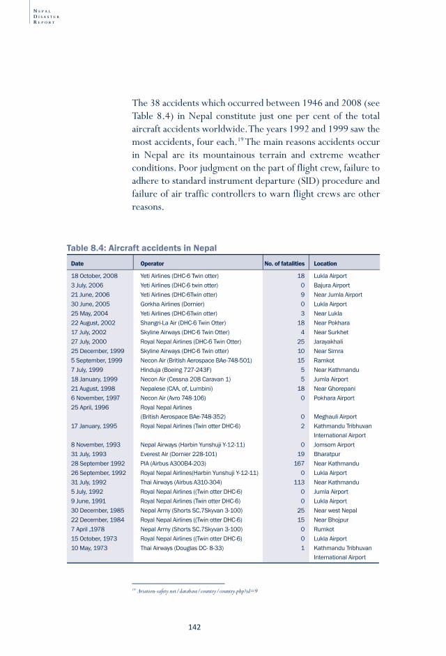
N E P A L
D I S A S T E R
R E P O R T
�42
18October,2008 YetiAirlines(DHC-6Twinotter) 18 LuklaAirport3July,2006 YetiAirlines(DHC-6twinotter) 0 BajuraAirport21June,2006 YetiAirlines(DHC-6Twinotter) 9 NearJumlaAirport30June,2005 GorkhaAirlines(Dornier) 0 LuklaAirport25May,2004 YetiAirlines(DHC-6Twinotter) 3 NearLukla22August,2002 Shangri-LaAir(DHC-6TwinOtter) 18 NearPokhara17July,2002 SkylineAirways(DHC-6TwinOtter) 4 NearSurkhet27July,2000 RoyalNepalAirlines(DHC-6TwinOtter) 25 Jarayakhali25December,1999 SkylineAirways(DHC-6Twinotter) 10 NearSimra5September,1999 NeconAir(BritishAerospaceBAe-748-501) 15 Ramkot7July,1999 Hinduja(Boeing727-243F) 5 NearKathmandu18January,1999 NeconAir(Cessna208Caravan1) 5 JumlaAirport21August,1998 Nepalese(CAA,of,Lumbini) 18 NearGhorepani6November,1997 NeconAir(Avro748-106) 0 PokharaAirport25April,1996 RoyalNepalAirlines (BritishAerospaceBAe-748-352) 0 MeghauliAirport17January,1995 RoyalNepalAirlines(TwinotterDHC-6) 2 KathmanduTribhuvan InternationalAirport8November,1993 NepalAirways(HarbinYunshujiY-12-11) 0 JomsomAirport31July,1993 EverestAir(Dornier228-101) 19 Bharatpur28September1992 PIA(AirbusA300B4-203) 167 NearKathmandu26September,1992 RoyalNepalAirlines(HarbinYunshujiY-12-11) 0 LuklaAirport31July,1992 ThaiAirways(AirbusA310-304) 113 NearKathmandu5July,1992 RoyalNepalAirlines((TwinotterDHC-6) 0 JumlaAirport9June,1991 RoyalNepalAirlines(TwinotterDHC-6) 0 LuklaAirport30December,1985 NepalArmy(ShortsSC.7Skyvan3-100) 25 NearwestNepal22December,1984 RoyalNepalAirlines((TwinotterDHC-6) 15 NearBhojpur7April,1978 NepalArmy(ShortsSC.7Skyvan3-100) 0 Rumkot15October,1973 RoyalNepalAirlines((TwinotterDHC-6) 0 LuklaAirport10May,1973 ThaiAirways(DouglasDC-8-33) 1 KathmanduTribhuvan InternationalAirport
Date Operator No. of fatalities Location
Table 8.4: Aircraft accidents in Nepal
The 38 accidents which occurred between 1946 and 2008 (see Table 8.4) in Nepal constitute just one per cent of the total aircraft accidents worldwide. The years 1992 and 1999 saw the most accidents, four each.19 The main reasons accidents occur in Nepal are its mountainous terrain and extreme weather conditions. Poor judgment on the part of flight crew, failure to adhere to standard instrument departure (SID) procedure and failure of air traffic controllers to warn flight crews are other reasons.
19 Aviation-safety.net/database/country/country.php?id=9
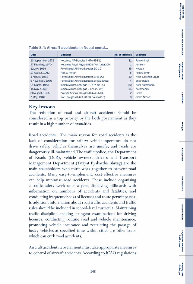
�4�
Nepal in the
Him
alaya-Ganga
Disaster R
isk Reduction:
Floods and Flood M
anagement
LandslidesD
roughtEarthquakes
Fire disastersO
ther disastersLegislation and D
RR
institutions
Meeting D
RR
challenges
Key lessons The reduction of road and aircraft accidents should be considered as a top priority by the both government as they result in a high number of casualties.
Road accidents: The main reason for road accidents is the lack of consideration for safety: vehicle operators do not drive safely, vehicles themselves are unsafe, and roads are dangerously ill-maintained. The traffic police, the Department of Roads (DoR), vehicle owners, drivers and Transport Management Department (Yatayat Byabastha Bhivag) are the main stakeholders who must work together to prevent road accidents. Many easy-to-implement, cost-effective measures can help minimise road accidents. These include organising a traffic safety week once a year, displaying billboards with information on numbers of accidents and fatalities, and conducting frequent checks of licenses and route permit passes. In addition, information about road traffic accidents and traffic rules should be included in school-level curricula. Maintaining traffic discipline, making stringent examinations for driving licenses, conducting routine road and vehicle maintenance, promoting vehicle insurance and restricting the passage of heavy vehicles at specified time within cities are other steps which can curb road accidents.
Aircraft accident: Government must take appropriate measures to control of aircraft accidents. According to ICAO regulations
13September,1972 NepaleseAF(DouglasC-47A-45-DL) 31 Paanchkhal27February,1970 NepaleseRoyalFlight(DHC-6Twinotter100) 1 Jomsom12July,1969 RoyalNepalAirlines(DouglasDC-3D) 35 Hetuda27August,1962 PilatusPorter 5 PorshaDhuri1August,1962 RoyalNepalAirlines(DouglasC-47-DL) 10 NearTulachanDhuri5November,1960 RoyalNepalAirlines(DouglasC-47A-80-DL) 4 Bhairahawa24March,1958 IndianAirlines(DouglasC-47A-85-DL) 20 NearKathmandu15May,1956 IndianAirlines(DouglasC-47A-20-DK) 15 Kathmandu30August,1955 KalingaAirlines(DouglasC-47A-25-Dk) 2 Simra7May,1946 RAF(DouglasC-47A-20-DKDakotaC.3) 0 SimraAirport
Date Operator No. of fatalities Location
Table 8.4: Aircraft accidents in Nepal contd...
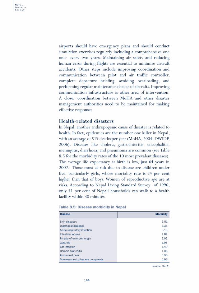
N E P A L
D I S A S T E R
R E P O R T
�44
Skindiseases 5.51Diarrhoealdiseases 3.35Acuterespiratoryinfection 3.13Intestinalworms 2.82Pyrexiaofunknownorigin 2.02Gastritis 1.95Earinfection 1.40Chronicbronchitis 1.06Abdominalpain 0.96Soreeyesandothereyecomplaints 0.93
Disease Morbidity
Table 8.5: Disease morbidity in Nepal
Source: MoHA
airports should have emergency plans and should conduct simulation exercises regularly including a comprehensive one once every two years. Maintaining air safety and reducing human error during flights are essential to minimise aircraft accidents. Other steps include improving coordination and communication between pilot and air traffic controller, complete departure briefing, avoiding overloading, and performing regular maintenance checks of aircrafts. Improving communication infrastructure is other area of intervention. A closer coordination between MoHA and other disaster management authorities need to be maintained for making effective responses.
Health-related disastersIn Nepal, another anthropogenic cause of disaster is related to health. In fact, epidemics are the number one killer in Nepal, with an average of 519 deaths per year (MoHA, 2004; DWIDP, 2006). Diseases like cholera, gastroenteritis, encephalitis, meningitis, diarrhoea, and pneumonia are common (see Table 8.5 for the morbidity rates of the 10 most prevalent diseases). The average life expectancy at birth is low, just 64 years in 2007. Those most at risk due to disease are children under five, particularly girls, whose mortality rate is 24 per cent higher than that of boys. Women of reproductive age are at risks. According to Nepal Living Standard Survey of 1996, only 41 per cent of Nepali households can walk to a health facility within 30 minutes.
�4�
Nepal in the
Him
alaya-Ganga
Disaster R
isk Reduction:
Floods and Flood M
anagement
LandslidesD
roughtEarthquakes
Fire disastersO
ther disastersLegislation and D
RR
institutions
Meeting D
RR
challenges
20 An Introduction to Health in Nepal: Nepal Net is an electronic networking for sustainable development in Nepal http://www.panasia.org.sg/nepalnet.health/medicine/health.html)
The other common diseases are scabies dermatitis. Skin and diarrhoeal diseases are common because water is often contaminated or does not suffice for basic hygiene. The other ailment are acute respiratory infections (ARIs) associated with the indoor air pollution due to cooking over open fire herths. Epidemics of contagious diseases have two peaks: during the months of May and June, before the rainy season begins and in August, the height of the monsoon. Unsafe drinking water and poor sanitation are the main causes of water-borne diseases in Nepal. Water-borne diseases continue to take lives in Nepal. In fact, over 80 per cent of all illness is attributed to inadequate access to clean water supplies, poor sanitation and poor hygiene practices. According to the Ministry of Health, diarrhoeal diseases account for a morbidity rate of 3.35 per cent, which is second to morbidity caused by skin diseases (5.51 per cent), another category of illness associated with dirty water, and poor hygiene and sanitation (NCVST, 2009) . About 28,000 children die each year from diarrhoeal diseases in the country. According to official estimates, 89 per cent of the nation’s population had access to clean drinking water in 2008 and only 30 per cent to proper sanitation facilities.20 The unsafe disposal of excreta close to water sources contaminates them through different routes and can cause diarrhoeal outbreaks in communities dependent on them. Many past epidemics can be attributed to contaminated drinking water but such outbreaks result in many deaths because of poor medical infrastructure and inadequate human and financial resources. Nepal’s health services, particularly those in rural areas, are inadequate and need to be substantially improved.
More than 70 per cent of Nepalis cook using wood; most use traditional (open-fire) stoves which release large amounts of toxic gases like sulphur dioxide, nitrous oxides and carbon monoxide as well as particulates less than 2.5 millimetres in diameter. Exposure to such harmful contaminants is much greater indoor than it would be outdoors (Godish, 2004) and result in the high prevalence of ARIs among Nepalis,
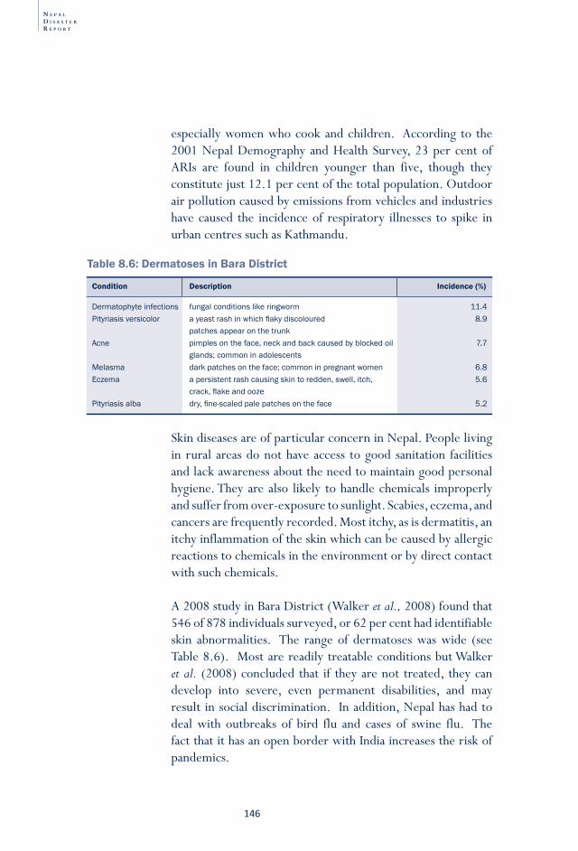
N E P A L
D I S A S T E R
R E P O R T
�46
especially women who cook and children. According to the 2001 Nepal Demography and Health Survey, 23 per cent of ARIs are found in children younger than five, though they constitute just 12.1 per cent of the total population. Outdoor air pollution caused by emissions from vehicles and industries have caused the incidence of respiratory illnesses to spike in urban centres such as Kathmandu.
Table 8.6: Dermatoses in Bara District
Dermatophyteinfections fungalconditionslikeringworm 11.4Pityriasisversicolor ayeastrashinwhichflakydiscoloured 8.9 patchesappearonthetrunkAcne pimplesontheface,neckandbackcausedbyblockedoil 7.7 glands;commoninadolescentsMelasma darkpatchesontheface;commoninpregnantwomen 6.8Eczema apersistentrashcausingskintoredden,swell,itch, 5.6 crack,flakeandoozePityriasisalba dry,fine-scaledpalepatchesontheface 5.2
Condition Description Incidence (%)
Skin diseases are of particular concern in Nepal. People living in rural areas do not have access to good sanitation facilities and lack awareness about the need to maintain good personal hygiene. They are also likely to handle chemicals improperly and suffer from over-exposure to sunlight. Scabies, eczema, and cancers are frequently recorded. Most itchy, as is dermatitis, an itchy inflammation of the skin which can be caused by allergic reactions to chemicals in the environment or by direct contact with such chemicals.
A 2008 study in Bara District (Walker et al., 2008) found that 546 of 878 individuals surveyed, or 62 per cent had identifiable skin abnormalities. The range of dermatoses was wide (see Table 8.6). Most are readily treatable conditions but Walker et al. (2008) concluded that if they are not treated, they can develop into severe, even permanent disabilities, and may result in social discrimination. In addition, Nepal has had to deal with outbreaks of bird flu and cases of swine flu. The fact that it has an open border with India increases the risk of pandemics.
�4�
Nepal in the
Him
alaya-Ganga
Disaster R
isk Reduction:
Floods and Flood M
anagement
LandslidesD
roughtEarthquakes
Fire disastersO
ther disastersLegislation and D
RR
institutions
Meeting D
RR
challenges
Though persons with disabilities (PwDs) are often the group most adversely affected by disaster, they often remain unidentified and unregistered and therefore excluded from many emergency response measures. Unless first responders make special provisions for them, including efforts to increase their mobility and their access to aid and assistance, PwDs will continue to be systematically deprived of evacuation, rescue, relief, shelter, water and sanitation and other key services. The absence of channels to communicate messages about the possible impacts of disasters to PwDs serves to increase their vulnerability. In fact, many experience long-term physical and psychological problems because they receive too little help in overcoming the trauma of disaster.
During the 2008 Koshi flood, many PwDs suffered. A few lucky ones lived with host families but most struggled to cope in tented camps that had no specially-designed toilet or bathing facilities. They also found it difficult to access water from tube wells because pumps were too high and the area around them very muddy. The health services available within the camps did not provide special services for PwDs.
To address this pitiable situation and to prevent needless loss, the government and other relief agencies must address the specific needs of PwDs. At heart, this involves two steps: involving PwDs in planning and mainstreaming the concerns of PwDs in all DRR activities, including awareness and training; early warning; immediate response; search, rescue and evacuation; and reconstruction and mitigation. There is no one better than PwDs themselves to assess the risks they face and to propose measures to counter them, and if the groundwork for an effective effort is laid ahead of time, every initiative will meet success.
awareness and trainingImproving awareness among PwDs and sensitising DRR professionals to include PwD’s concerns requires special attention. The goals of training include the following: • Sensitise volunteers and members of DMCs about the
specific needs of PwDs
Box 8.4: addressing the needs of persons with disabilities in Drr activities
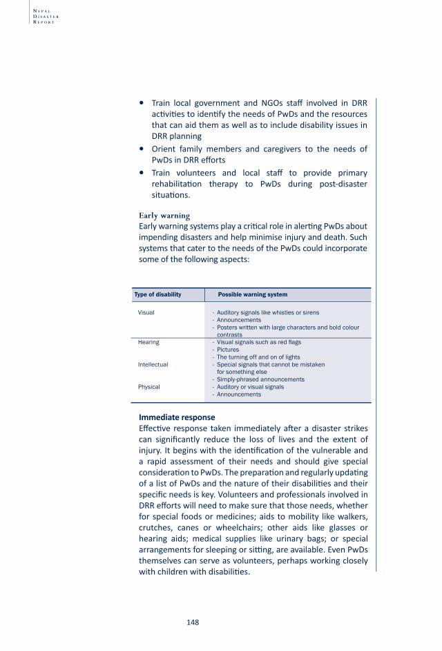
N E P A L
D I S A S T E R
R E P O R T
�48
• Train local government and NGOs staff involved in DRR acti viti es to identi fy the needs of PwDs and the resources that can aid them as well as to include disability issues in DRR planning
• Orient family members and caregivers to the needs of PwDs in DRR eff orts
• Train volunteers and local staff to provide primary rehabilitati on therapy to PwDs during post-disaster situati ons.
early warningEarly warning systems play a criti cal role in alerti ng PwDs about impending disasters and help minimise injury and death. Such systems that cater to the needs of the PwDs could incorporate some of the following aspects:
Visual - Auditorysignalslikewhistlesorsirens - Announcements - Posterswrittenwithlargecharactersandboldcolour contrastsHearing - Visualsignalssuchasredflags - Pictures - TheturningoffandonoflightsIntellectual - Specialsignalsthatcannotbemistaken forsomethingelse - Simply-phrasedannouncementsPhysical - Auditoryorvisualsignals - Announcements
Type of disability Possible warning system
ImmediateresponseEff ecti ve response taken immediately aft er a disaster strikes can signifi cantly reduce the loss of lives and the extent of injury. It begins with the identi fi cati on of the vulnerable and a rapid assessment of their needs and should give special considerati on to PwDs. The preparati on and regularly updati ng of a list of PwDs and the nature of their disabiliti es and their specifi c needs is key. Volunteers and professionals involved in DRR eff orts will need to make sure that those needs, whether for special foods or medicines; aids to mobility like walkers, crutches, canes or wheelchairs; other aids like glasses or hearing aids; medical supplies like urinary bags; or special arrangements for sleeping or sitti ng, are available. Even PwDs themselves can serve as volunteers, perhaps working closely with children with disabiliti es.
�4�
Nepal in the
Him
alaya-Ganga
Disaster R
isk Reduction:
Floods and Flood M
anagement
LandslidesD
roughtEarthquakes
Fire disastersO
ther disastersLegislation and D
RR
institutions
Meeting D
RR
challenges
Search, rescue and evacuationSearch, rescue and evacuation efforts require the use of special procedures to safely and quickly evacuate PwDs. Doing so requires including PwDs in disaster management committees, where they can inform those who respond to disasters about any special techniques needed to assist them to safety. Plans also need to be made so that no PwD is separated from the enabling equipment or medication he/she relies on. Similarly, it is important that provisions be made to locate a PwD’s regular caregiver or family member who appreciates his/her needs. PwDs should be evacuated to a pre-determined location outfitted with PwD-accessible drinking water and sanitation facilities.
Reconstruction and mitigationReconstruction and mitigation efforts should focus on creating a PwD-friendly environment. In this endeavour, PwDs can contribute ideas about the design needed to make drinking water and sanitation services, shelters and rehabilitation centres, and health care and hospital services most accessible to them. For their part, DRR institutions and practitioner should work to increase awareness, remove barriers, develop mainstreaming tools, provide support and training, and bring about changes in the functioning and monitoring of their own work.
Involving PwDs in DRR will make them more resilient to disasters as it will ensure that their particular needs are identified and addressed. Since mainstreaming the needs of PwDs into disaster risk management is a process rather than an end goal, learning and sharing experiences are crucial to its success. The more PwDs are involved in the process, the more society will come to change its attitudes toward the abilities and contributions of PwDs.
N E P A L
D I S A S T E R
R E P O R T
��0
Ways forwardTreating disease in Nepal effectively is handicapped by geography and poor infrastructure as well as by the poor distribution not only of medicine and medical supplies but also of nutritious food. Because health facilities are inadequate and even manageable diseases acquire epidemic proportion. Promoting health services and creating awareness should be a top priority of the government. However, increasing the number of health service centres alone will not solve the health problems of the country; outreach must also be expanded. Access in rural areas needs to be improved, by providing rural areas with immediate response units, and ensuring the presence of appropriate health staff and where feasible provide ambulance services.
Providing basic measures such as safe drinking water and proper sanitation facilities can help minimise water related diseases, as can promoting good personal hygiene. To reduce deaths due to human-induced factors will require sustained action in these areas. Dealing with health and hygiene related risks effectively requires understanding and appropriately responding to the socio-economic vulnerabilities that exacerbate such risks. Improving public awareness is a critical step in the process.
���
Nepal in the
Him
alaya-Ganga
Disaster R
isk Reduction:
Floods and Flood M
anagement
LandslidesD
roughtEarthquakes
Fire disastersO
ther disastersLegislation and D
RR
institutions
Meeting D
RR
challenges
Chapter-9
Floods, landslides, fires, avalanches and epidemics that kill dozens and destroy property worth billions of rupees have a negative impact on Nepal’s development agenda. Numerous factors render Nepal vulnerable to various natural and human-induced disasters, including its rugged yet fragile geophysical terrain, active tectonic processes, high relief and steep slopes and variable climate. Unplanned settlements, increasing populations, poor economic condition and low literacy rate are other factors contributing to exacerbate vulnerability. The ongoing political transition adds a new layer of stress. Disasters are made all the more devastating by the poor governance of government agencies, weak coordination among government agencies and other stakeholders, the ambiguous job descriptions of various agencies, low managerial skills and the lack of financial resources. Poor levels of awareness and the lack of technological skill further exacerbate adversity, as does the low capacity for conducting hazard mapping, vulnerability assessments and risk analysis.
LegisLation and dRR institutions
N E P A L
D I S A S T E R
R E P O R T
��2
DRR is not a problem that can be handled by a single agency or single discipline; on the contrary, DRR requires the eff orts of many agencies, a broad interdisciplinary understanding including both science and social science, and the considerati on of a wide range of issues, from behaviour to development, society to economy. A stakeholder’s platf orm named Disaster Preparedness Network (DPNet) was established at the premises of the Nepal Red Cross Society in 2003 to address these issues. It has a variety of members, including DRR programme staff , policymakers, INGOs which support local groups in miti gati ng disasters, and groups involved in disaster research, analysis and advocacy. This network is a forum where diff erent actors and stakeholders come together to discuss the issues and challenges faced by the DRR sector in Nepal.
BoX 9.1: Multi-stakeholder forum
In the past, Nepal’s approach to disaster was reactive, with rescue and relief as its key objective. Over time, however, various government departments, such as irrigation, water and power, as well as local government and I/NGOs have begun including approaches to minimise disaster impacts as a part of their mandates. Still, response to disaster has remained top heavy. These apex agencies have been entrusted with all that is related to disaster management, including the establishment of regional and local disaster management agencies. Unfortunately, their performance at the grassroots level is poor, and communities believe that they are left to fend for themselves. The challenge ahead is for central-level agencies to ensure that mechanisms exist to provide resources to the affected. They also need to change their orientation: though they do recognise certain elements of risk reduction, their thrust is still post-disaster relief. Another challenges is to avoid overlapping distribution of relief materials at local level.
The following sections present the institutional context of disaster management and include a consideration of relevant legislation and institutions.
���
Nepal in the
Him
alaya-Ganga
Disaster R
isk Reduction:
Floods and Flood M
anagement
LandslidesD
roughtEarthquakes
Fire disastersO
ther disastersLegislation and D
RR
institutions
Meeting D
RR
challenges
Natural Calamity relief act, 1982 Though the government has made both national- and international-level commitments to reduce the risk of disasters in the country, in actuality disaster management receives attention only after a drastic incident occurs. It was the earthquake of 1980 and the growing concerns of national and international partners that set the stage for the emergence of a legal system to handle disaster management activities. The NCRA of 1982 gave importance to post disaster activities such as rescue and relief. It also provided for the establishment of the Central Disaster Relief Committee (CDRC) under the Ministry of Home Affairs. It was amended in 1989 and again in 1992. The latter change broadened the scope of the act to include man-made calamities such as industrial accidents as well as the preparedness and rehabilitation aspects of disaster management.
It wasn’t until almost two decades later that local-level disaster-related responsibilities were assigned through the Local Self Governance Act (LSGA) of 1999. In addition, acts governing the Nepal Army, the Nepal Civil Police and the Armed Police Force assigned their personnel the duty to work closely with the MoHA and other government, non-government partners and local people during a disaster.
In 1994, after the United Nations declared the need for disaster reduction efforts, Nepal drafted the National Action Plan for Disaster Mitigation and established the National Committee for the International Decade for Natural Disaster Reduction (IDNDR) chaired by the home minister. The committee struggled in part because a lack of coordination in implementing the plan and the plan was modified the following year. The government approved the new plan in 1996, renaming it the National Action Plan for Disaster Management in Nepal.
The plan included plans for disaster preparedness, response, reconstruction and rehabilitation arrangement, and mitigation.21
21 See Rana (1996)
N E P A L
D I S A S T E R
R E P O R T
��4
It prioritised activities, delineated the responsibilities of various agencies, and stipulated time frames for monitoring and evaluation. Because it has no institutional basis, however, monitoring is and knowledge only meagrely applied.
The NCRA can be operationalised before and during a calamity to prevent or mitigate its effect as well as after a disaster to provide relief and rehabilitation. It envisages the formation of a hierarchy of committees for dealing with natural disasters. At the centre is the Natural Calamities Central Relief Committee, which consists of the home, physical planning and health ministers as well as the secretaries of the finance, defence, home, foreign affairs, construction and transport, water resources, communication, forest and environment, labour and social welfare, and supply ministries. The committee also includes the secretary of the National Planning Commission and representatives from the NA, NP and AFP, NRCS, Nepal Scouts, DoMG, DHM, Social Welfare National Co-ordination Council and representatives from affected districts. The central committee’s main responsibilities are two: it implements policies and programmes related to disaster relief, prepares specific relief assistance for disaster victims in cash and in kind. It defines its own working procedure and can form relief and treatment and supply, shelter and rehabilitation sub-committees as well as regional, district, and local committees.
Nepal’s signing of the Hyogo Framework for Acti on in 2005 set the stage for its considering DRR on a holisti c basis. This step was necessary as Nepal is vulnerable to the increasingly variable and intense impacts of climate change and likely to see a rise in the incidence of climate-related disasters. The Nepali government has pursued the following acti viti es in DRR.
Box 9.2: HFa and Nepal
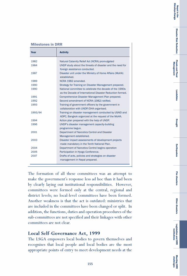
���
Nepal in the
Him
alaya-Ganga
Disaster R
isk Reduction:
Floods and Flood M
anagement
LandslidesD
roughtEarthquakes
Fire disastersO
ther disastersLegislation and D
RR
institutions
Meeting D
RR
challenges
1982 NaturalCalamityReliefAct(NCRA)promulgated1984 UNDPstudyaboutthethreatsofdisasterandtheneedfor
foreignassistanceconducted.1987 DisasterunitundertheMinistryofHomeAffairs(MoHA)
established.1989 NCRA1982amended.1990 StrategyforTrainingonDisasterManagementprepared.1990 Nationalcommitteetocelebratethedecadeofthe1990s
astheDecadeofInternationalDisasterReductionformed.1991 ComprehensiveDisasterManagementPlanprepared.1992 SecondamendmentofNCRA(1982)ratified.1993 Trainingofgovernmentofficersbythegovernmentin
collaborationwithUNDP/DHAorganised.1993/94 TrainingondisastermanagementconductedbyUSAIDand
ADPC,BangkokorganizedattherequestoftheMoHA.1994 ActionplanpreparedwiththehelpofUNDP.1996 UNDP’sdisastermanagementcapacity-building
programmebegun.2001 DepartmentofNarcoticsControlandDisaster
Managementestablished.2003 Disasterimpactassessmentsofdevelopmentprojects
mademandatoryintheTenthNationalPlan.2004 DepartmentofNarcoticsControlbeginsoperation2005 ParticipationinHyogoConference.2007 Draftsofacts,policiesandstrategiesondisaster
managementinNepalprepared.
Year Activity
Milestones in DRR
The formation of all these committees was an attempt to make the government’s response less ad hoc than it had been by clearly laying out institutional responsibilities. However, committees were formed only at the central, regional and district levels; no local-level committees have been formed. Another weakness is that the act is outdated: ministries that are included in the committees have been changed or split. In addition, the functions, duties and operation procedures of the sub-committees are not specified and their linkages with other committees are not clear.
local self-Governance act, 1999 The LSGA empowers local bodies to govern themselves and recognises that local people and local bodies are the most appropriate points of entry to meet development needs at the
N E P A L
D I S A S T E R
R E P O R T
��6
district, municipal and village levels. It aims to involve people in local-level activities by according full responsibility and authority to DDCs, municipalities and VDCs. Empowering these institutions is expected to enhance local leadership and its capability to make appropriate decisions about matters affecting the day-to-day needs of local people. Among its provisions is the local management of disaster-related works. Unfortunately, the duties and responsibilities of each of the three local bodies—DDCs, municipalities and VDCs—is, however, stated in only general terms.
Channelling fundsAs provisioned for by the NCRA, a Central Disaster Aid Fund (CDAF) was established under the control of the CDRC to provide disaster victims with assistance. Funds come from three main sources• Cash and kind contributions from the government of
Nepal;• Contributions from the Prime Minister’s Disaster Relief Aid
Fund (PMAF); and • Assistance received from foreign countries, agencies and
individuals;
In theory, the government should be able to channel disaster relief funds in succession from the regional to the district and finally to the local level, but in fact local-level funding is not operational yet.
To supplement the CDAF’s efforts, the PMAF was established in 1993 following the calamitous floods and landslides of that year’s monsoon. As the PMAF is larger than the CDAF, this fund is used not just for rescue and relief but also for rehabilitation and reconstruction.
Governmental agencies involved in DrrFormal governmental organisations work as support and implementing agencies at both the local and national level. Support agencies provide post facto financial, material and
���
Nepal in the
Him
alaya-Ganga
Disaster R
isk Reduction:
Floods and Flood M
anagement
LandslidesD
roughtEarthquakes
Fire disastersO
ther disastersLegislation and D
RR
institutions
Meeting D
RR
challenges
technical assistance, while implementing agencies carry out field-based programmes. For the most part, these agencies have worked independently, collecting materials and funds and distributing them directly to affected communities. Actions are ad hoc and efforts to create a panel of institutions have lacked commitment to cooperate and coordinate. The current approach is dominated by the centre and local governments and CBOs have received little attention.
Central-level organisations formulate policy, plan and development; the highest of them is the NPC, whose plans and programmes are approved by the National Development Council (NDC), a body headed by the Prime Minister and represented by all sectors. Since it was created to discuss and secure consensus on national development issues, the council has a political orientation. The NPC’s duties include allocating resources, reviewing the progress of its plans, and monitoring and evaluating departmental performance. Though the concept of central planning is being questioned, this hierarchic mode persists.
Ministry of Home affairs: The MoHA is the central agency for disaster management: it formulates and implements national policies as well as carries out immediate rescue and relief work through the Department of Narcotics Control and Natural Disaster Management and its network. The main function of the department is to carry out disaster management activities in coordination with concerned agencies in an dynamic and efficient manner.
Ministry of Water resources: The Ministry of Water Resources (MoWR) is the agency responsible for planning, policy-making and implementation related to the country’s water resources projects. It receives support and advice from the Water and Energy Commission (WEC) and its secretariat (WECS). The WEC and the WECS were established on 4 January, 1999 to provide better services to the government and have been entrusted with a variety of tasks. The Water
N E P A L
D I S A S T E R
R E P O R T
��8
Resource Act (WRA, 1992) accords ownership of all water to the state and prioritises the use of water while at the same time stipulating that the adverse effects of construction and the management of water resources must be minimised.
Water and energy Commission secretariat: The WECS is a multidisciplinary institution which is engaged in the coordinated development of water and energy and which supports the government in formulating water-related policy and strategy. It carries out studies, surveys and investigations and offers its opinion on issues relating to the development of the nation’s water and energy resources.
Department of Water-induced Disaster prevention: Flood control used to be a section under the Department of Irrigation (DoI). With support from JICA, the DoI built gabion boxes and embankments along streams that threatened villages or urban settlements. In 2000, this unit became the independent DWIDP. It has set three targets:
• Identify potential disaster zones and stock emergency relief material in all five development regions by 2007;
• Establish early warning systems all over the country and put in place infrastructure for mitigating predictable disasters by 2017; and
• Reduce social and economic losses to the levels experienced in developed countries.22
the DWiDp’s main activities are as follows:• Prepare and implement a water-induced disaster management
policy and plan, • Carry out hazard mapping and zoning,• Strengthen the disaster networking and information system,• Establish a disaster rehabilitation system,• Carry out a disaster-related public awareness programme at
the community level, • Prepare and implement a flood plain action plan,
22 National Water Plan (2003)
���
Nepal in the
Him
alaya-Ganga
Disaster R
isk Reduction:
Floods and Flood M
anagement
LandslidesD
roughtEarthquakes
Fire disastersO
ther disastersLegislation and D
RR
institutions
Meeting D
RR
challenges
• Strengthen institutional set-up and capacity,• Implement disaster reduction measures and,• Develop a disaster database, GIS and Disaster Information
System (DIS).
Department of irrigation: The DoI under the MoWR used to be responsible for flood mitigation and river control works but now it deals only with disasters related to government-built irrigation systems. The extent of its current flood control efforts is constructing small dykes to save irrigation systems.
Department of Hydrology and Meteorology: The DHM plays a critical role from the perspective of water resource planning and development by maintaining a network of climatic and river flow gauging stations. The lack of sophisticated instruments for collecting hydro-climatic data and insufficient budget are its main problems. In 1997, it moved from the control of the MoWR to that of the Ministry of Science and Technology. It coordinated the project that lowered the water level of Tsho Rolpa to minimise the likelihood it would breach.
Department of soil Conservation and Watershed Management: This department is one of the main divisions of the Ministry of Forest and Soil Conservation. By improving land use and increasing agricultural productivity through the conservation, utilisation and management of upper watershed resources, it helps community meet their basic needs. In its effort to manage land and water, it integrates diverse activities related to forestry, agriculture, livestock, water, and land use. Its focus is on mobilising local communities by forming user groups and on raising their awareness.
international agencies Many donor agencies practice disaster mitigation within sectoral development programmes. In the aftermath of the 1993 cloudburst and floods, the UNDP, or, more precisely, the UN Disaster Management Secretariat (UNDMS), coordinated the distribution of relief materials from international donors
N E P A L
D I S A S T E R
R E P O R T
�60
to the affected people. In fact it is the UNDMS which is most responsible for coordinating the international response to disasters, including floods. During emergencies, it acts as an information clearing house, receiving and disseminating situation reports, needs assessments, donor pledges, and other pertinent information in order to facilitate a coordinated response. The Japanese government supports the DWIDP and the Office of Foreign Disaster Administration (OFDA), which operates under the aegis of USAID, has supported disaster mitigation activities since 1999. The EU also provides support.
Many INGOs, including Oxfam-GB Nepal, the NRCS, Inter Agency Sectoral Committee (IASC), Action Aid-Nepal, Practical Action Nepal, CARE Nepal, Mercy Corps and Lutheran World Federation and their local partners have been involved in community-based DRR interventions in Nepal for well over a decade. They also help in preparing and implementing cluster plans. Some local organisations are involved in research, training and policy analysis while others study the intersection between DRR and climate change.
Deficiencies in disaster management institutions The government needs to address the challenges to and gaps in its ability to manage disaster, whether in terms of risk identification, damage assessment, monitoring, early warning, public awareness, preparedness, mitigation, or rehabilitation and reconstruction. Analysis of past disasters and past response provide many lessons and the government must incorporate them into post-disaster recovery and rehabilitation processes and use the opportunities for developing the capacity to reduce disaster risk in the long-term. It must work to reduce risk by sharing knowledge and lessons learned. Action in these two areas will help the government improve its legal instruments and policy frameworks. The country has gained some considerable experience in terms of risk management, vulnerability reduction, and increasing preparedness and
�6�
Nepal in the
Him
alaya-Ganga
Disaster R
isk Reduction:
Floods and Flood M
anagement
LandslidesD
roughtEarthquakes
Fire disastersO
ther disastersLegislation and D
RR
institutions
Meeting D
RR
challenges
response capabilities at the community level but these experiences have not been shared, analysed or used to update policies. The main limitations of Nepal’s disaster management system as spelled out in the NCRA follow.
• Because the government has not yet formulated rules and regulations to back up the act, there are no standing orders, procedures or codes for those who respond to disaster.
• The definition of disaster the act had adopted is too narrow: it does not include aircraft crashes, bus accidents, heat waves, or animal attacks.
• The act does not clearly state the roles and responsibilities of disaster management related organisations. The act is focused more on rescue and relief efforts than on preparedness, rehabilitation and reconstruction.
• The Relief and Treatment and Supply, Shelter and Rehabilitation sub-committees are dormant and no local disaster relief committees have been formed.
• The act has no provision for compensation for volunteers and emergency workers in case of serious injury, fatal disease or death.
• The act fails to mention the need for research and development.
• The Tenth Plan (2003-2007) does not adequately address disaster management. The provisions of the LSGA are similarly inadequate: it does not clearly spell out the roles of local bodies in disaster management.
Ways forwardThe above sections elaborated the trajectory of institutional development in Nepal with regard to disaster risk management. Most of the disaster-related institutions were emerged in the wake of large events. With each new disaster, one sees a tendency to establish new organisation and propensity toward centralised functioning and funding.
At the same time it was realised that NCRA dealt with the post disaster situation and needed to be replaced with policies that
N E P A L
D I S A S T E R
R E P O R T
�62
help avert disaster and mitigate their impact. The enunciation of LSGA (1999) did provide for the devolution of the power to plan and formulate policies to local bodies including disaster risk reduction. Past experience in the local governance of irrigation, forest and drinking water system show that effective disaster risk reduction is an achievable goal at the local government level.
Though institutions have been allocated the responsibility for disaster mitigation, there are two main shortcomings in their activities: inadequate policy formulation and poor implementation. There is a need for incorporating DRR measures into post-disaster recovery and rehabilitation processes and for using the recovery phase to develop the capacity to reduce risk. Knowledge and lessons learned need to be shared across the board. At the same time, rules and regulations to back up the disaster management act (NCRA is still in vague) should be formulated. In addition, standing orders, codes, guidelines and manuals should be prepared.
Since the late 1990s, both governments and donors have increasingly recognised the need to mainstream DRR into mainstream development process. Earlier, development eff orts did not consider reducing vulnerability to natural hazards as an important goal; instead, they oft en inadvertently created new forms of vulnerability or exacerbated existi ng ones. Today, in contrast, eff orts are being made to incorporate the objecti ve of minimising the risks caused by disaster into plans and legislati on and insti tuti onal mechanisms to minimise risk. In additi on, budgetary allocati ons are made to plan, design and implement, monitor and evaluate DRR programmes.
To make DRR eff ecti ve, it is necessary to analyse how a potenti al hazard could undermine the performance of policies, programmes and projects as well as how these policies themselves could exacerbate vulnerability. Such analysis should lead to the adopti on of measures which
BoX 9.3: Mainstreaming disaster risk reduction into development
�6�
Nepal in the
Him
alaya-Ganga
Disaster R
isk Reduction:
Floods and Flood M
anagement
LandslidesD
roughtEarthquakes
Fire disastersO
ther disastersLegislation and D
RR
institutions
Meeting D
RR
challenges
reduce vulnerability and treat risk reduction as an integral part of the development process, not merely a reactive response. It should also ensure that interventions made to respond to local needs are sustainable.
The impact of climate change must also be taken into account so that DRR interventions constitute a ‘no-regrets’ minimum level of measures designed to minimise climate-related risks.
In particular, the following issues require attention:• The government should ensure that DRR becomes both
a national and local priority and should provide a strong, multi-sectoral institutional basis for its implementation.
• The dormant Relief and Treatment and Supply, Shelter and Rehabilitation sub-committee should be re-activated and made permanent. Similar committees should be established at the district level.
• A separate, multi-sectoral disaster management agency should be established to facilitate policy coordination and action on DRR.
• Disaster management efforts within each sectoral ministry must be strengthened.
• DRR activities should be effectively integrated into development policies and all levels of planning and programming with a focus on prevention, mitigation, preparedness and vulnerability reduction.
• To promote the effective implementation of disaster reduction policies, awareness of their importance needs to be increased. In this endeavour, the engagement of the media is vital, as are sustained public education campaigns and public consultations. The ultimate objective of such activities is to build community resilience.
• Policies specifying the role of NGOs, local communities, and the private sector should be made.
• Community participation in disaster risk reduction and management should be encouraged and enhanced through the formulation and implementation of specific policies, the promotion of networking, the strategic management
N E P A L
D I S A S T E R
R E P O R T
�64
of volunteer resources, the delegation of roles and responsibilities, and the provision of the necessary authority and resources.
• The government should construct warehouses in strategic locations and train concerned officials in warehouse management and the supply of relief materials.
• Emergency relief supplies and rescue equipment should be stockpiled in strategic locations so that they can be mobilised in case of an emergency. Personnel should also be allocated.
• Evacuation plan exercises and other drills should be conducted periodically.
• Indigenous knowledge should be used as it is simple, adaptable, easy to understand and cost effective.
• Good practices and lessons learned must be shared in order to ensure that DRR contributes to the achievement of sustainable development goal and to identify gaps and challenges.
• Disaster management courses should be incorporated at schools and universities.
• Efforts needs to be made to ensure that data on disaster loss are consistent and MoHA must function as the central repository of database on disasters in Nepal.
• Transparency and accountability should be maintained in mobilizing existing funds and materials as key elements of the contingency plan.
In 2006, a nongovernmental initi ati ve has taken on the task of proposing a comprehensive policy to address the challenges of DRR in Nepal by draft ing the Nati onal Disaster Management Policy (NDMP) and the Nati onal Disaster Management Act (NDMA) aft er conducti ng extensive nati onal and local consultati ons with major stakeholders, including communiti es aff ected by disasters. Both were submitt ed to the MoHA and the NPC for considerati on in the same year. In 2008, with support from UNDP a Nati onal Strategy on DRR has been prepared. This too has been submitt ed to the MoHA for approval and adopti on. All three documents propose tackling DRR using the strategies of preparedness and miti gati on as
Box 9.4: Civil society proposes disaster management policy
�6�
Nepal in the
Him
alaya-Ganga
Disaster R
isk Reduction:
Floods and Flood M
anagement
LandslidesD
roughtEarthquakes
Fire disastersO
ther disastersLegislation and D
RR
institutions
Meeting D
RR
challenges
In short, to minimise the risk caused by disasters, Nepal should adopt and implement proactive policies rather than pursue a reactive approach. Such initiatives will help create an atmosphere conducive to the rebuilding of livelihoods by the affected and will support the planning of physical and socio-economic reconstruction. This approach will help also build community resilience and reduce vulnerability to future disasters. An integrated policy that encompasses agencies at all levels—central, regional, district and local—as well as other government and non-governmental organisations can provide the uniformity of action needed to minimise disaster risk. Nepal must refine its disaster management approach. Political
well as effective rescue and relief operations and espouse a livelihood- and rights-based approach.
They recommend that technological innovations be used to address the particular needs of the poor and vulnerable and that DRR be mainstreamed in regular development at all levels of governance. In addition, they emphasise the need for planning, programming and monitoring and link DRR with development, rehabilitation and reconstruction. The allocation of adequate financial resources and the development of human resources and capacity are other major issues these policy instruments address.
The documents propose the establishment of an autonomous central-level disaster management council (DMC) chaired by the Prime Minister and administered by a full-time executive director. The council is to comprise a committee each on preparedness, rescue and relief, and reconstruction and rehabilitation chaired respectively by the ministers of Local Development, Home Affairs and Physical Planning and Public Works. The executive director of the DMC would serve as the member secretary of all three committees as well as of the DMC. At the district level, a similar institutional mechanism with the chief district officer serving as chair has been proposed. The chairs of the proposed municipality- and village-level DMCs are to be city mayors or the chairs of each of Nepal’s village development committees. At all levels, representatives of civil society organisations will also be involved in the governance of disaster risk management activities.
N E P A L
D I S A S T E R
R E P O R T
�66
I/NGOs and NGOs involved in DRR acti viti es recently established the Nati onal Network of Disaster-Aff ected Communiti es (N-DAC) in Nepal. Its offi cials are representati ves of community-based disaster management committ ees from across the country. At its fi rst conference, which was held on 10-11 June, 2009, about 100 parti cipants from 30 districts gathered to accomplish the following objecti ves:
1. Highlight and ensure the rights of disaster-aff ected people,
2. Begin a programme for raising awareness, 3. Address the issues of disaster victi ms and ensure their
rights in the new consti tuti on, 4. Improve awareness about the link between development
and disasters, 5. Integrate disaster management in development
programmes, 6. Emphasise preparedness, and7. Advocate the draft ing of a new DRR act.
Eff ecti ve DRR rests on the principle of democrati c governance and recognises the right of the disaster-aff ected to organise and to engage in the policy process. In Nepal, the users of forests, drinking water, irrigati on and community electricity have been organised into federati ons—the Federati on of Forest Users Nepal (FECOFUN), the Federati on of Drinking Water and Sanitati on (FEDWASAN), the Nati onal Federati on of Irrigati on Water Users Associati on Nepal (NIFUWAN) and the Nati onal Community Electricity Users Nepal (NACEUN)—in order to facilitate their politi cal parti cipati on. Now N-DAC joins the ranks of nati onal-level organisati ons with a voice in policy-making.
Box 9.5: National Network of Disaster-affected Communities (N-DaC)
commitment to prioritising disaster management programmes is essential. Besides remedying these shortcomings, the government needs to develop proactive policies which emphasise disaster preparedness and management and enact laws that focus on preventive measures rather than on curative support.
�6�
Nepal in the
Him
alaya-Ganga
Disaster R
isk Reduction:
Floods and Flood M
anagement
LandslidesD
roughtEarthquakes
Fire disastersO
ther disastersLegislation and D
RR
institutions
Meeting D
RR
challenges
Chapter-10
Nepal needs more effective strategies to reduce the risks it faces due to natural and human-induced disasters though the nature of disaster itself poses major challenges. Some disasters, like flooding during the monsoon recur regularly, but exhibit both spatial and temporal variations. Other disasters, like earthquakes, occur only intermittently and at long intervals. For this reason, the lessons of one disaster often do not remain in either human or institutional memory. Other challenges Nepal must address have to do with building the institutions and local capacity needed to minimise the impacts of disasters. The mechanisms put in place today to respond to DRR challenges will help build more resilient communities in the future.
For any given DRR activity to be effective, specific risks need to be targeted and emphasised. Success in responses to disasters depend on factors like access to safe drinking water, reliable communication, transport and mobility, access to finances, social support, and risk-minimising strategies. Government agencies at both the national and sub-national levels must coordinate the support they provide; synergies are crucial in helping the affected to rebuild their livelihoods. Equally important is that agencies internalise the learning they derive from their evaluation of the success of specific interventions, especially as
Meeting DRR challenges
N E P A L
D I S A S T E R
R E P O R T
�68
The growing concern about DRR in Nepal has spawned a few educati onal initi ati ves. Since 2003 NEC in Changunarayan, and Ehime University in Kobe Japan have held six conferences to discuss understanding of natural hazards. In additi on, NEC and the IoE have a master’s-level course that covers DRR in a holisti c manner, considering hazards, vulnerability and risk. These initi ati ves can lead to the emergence of a new corps of professionals who can bett er respond to the complex issue of DRR as well as generate new knowledge to facilitate eff ecti ve DRR acti viti es in the country.
BoX 10.1: Disaster knowledge and education
Human-induced climate change impacts are likely to increase the severity of flood and drought disasters at both the national and the regional level but their impact will not be uniform. Different sections of Nepali society living in various hydro-ecological regions of the country will face different impacts, and each needs to be addressed separately. As if devising diverse national strategies weren’t enough of a challenge, Nepal will also have to work closely with its neighbours. Since important rivers originating in Nepal support the livelihoods and ecosystems of the millions who live downstream in Uttar Pradesh, Bihar, West Bengal and Bangladesh, what we do in Nepal to build resilience can have a trans-boundary impact. In particular, as precipitation patterns become more erratic due to climate change, we can expect alterations in regional hydrology and, as a result, in low, base and higher peak flows as well as increased sedimentation rates. Adapting effectively to these changes requires innovative approaches through tinkering of existing institutions.
The ongoing political transition in Nepal poses a hurdle to effective DRR. The outcome of attempts to transform the centralised state into a federal republic will, depending on
climate change threatens to complicate the situation. The government cannot act alone: DRR strategies need to be developed and maintained through private and community-based approaches.
�6�
Nepal in the
Him
alaya-Ganga
Disaster R
isk Reduction:
Floods and Flood M
anagement
LandslidesD
roughtEarthquakes
Fire disastersO
ther disastersLegislation and D
RR
institutions
Meeting D
RR
challenges
In 1998 ECO-Nepal began regularly publishing Paryawaran a monthly magazine that dealt with environment, ecology and development. The magazine also covers issues related with disasters risk reduction. With financial support from Action Aid- Nepal, Oxfam GB Nepal, ICIMOD, Nepal Academy of Science and Technology (NAST), Caritas-Nepal, Lutheran World Federation-Nepal, Paryawaran regularly includes materials on earthquake, landslides and floods and their impacts on ecology, environment and livelihoods. The magazine reaches Nepal’s almost all VDCs. In addition, many organisations prepare and distribute brochures, booklets and posters on earthquake prevention. The local print media is a regular source of disaster events. The news of disasters is also carried by visual and audio media. FM radio stations in Nepal offer a practical opportunity to disseminate information related to disasters mitigation in local languages.
BoX 10.2: Disseminating Drr materials in vernacular
how central and federal jurisdiction are defined, have major implications for DRR activities. Complicating that decision is the fact that the government has not been able to provide basic services like drinking water, sanitation, health, education, transportation and energy to the majority of the population. As many studies demonstrate, it is only through access to such basic services that citizens can build their capacity to adapt to climate-related and other disasters. A third challenge is that most DRR activities in Nepal are performed in isolation. Initiatives such as the DPNet platform are needed to bring the many institutions involved into constructive synergy.
This report has discussed the Nepali hazardscape, highlighted the vulnerability of the country as a whole and of its citizens and presented some of Nepal’s DRR efforts in a single volume. In doing so, it hopes to provide the foundation needed to produce a comprehensive report on disaster in Nepal in the future. Nepal needs to pursue strategies that strengthen local capacities to respond to disaster risks through multi-sector activities which draw on interdisciplinary approaches.

N E P A L
D I S A S T E R
R E P O R T
��0
���
Bibliographical references
Alexander, D., 1997: The Study of Natural Disasters 1977-1997: Some Reflections on a Changing Field of Knowledge, Disasters, Vol. 21, No. 4, pp. 284 – 304, Pub Med..
Alford, D., 1992: Hydrological Aspects of the Himalayan Region, ICIMOD Occasional Paper No. 18, pp. 68, ICIMOD, Kathmandu.
APN, 2005: Enhancement of National Capacities in the Application of Simulation Models for the Assessment of Climate Change and its Impacts on Water Resources and Food and Agricultural Production, Asia-Pacific Network (APN) for Global Change Research.
Auden, J. B., 1935: Traverses in the Himalaya, Survey India, Rec.
Bajracharya, B., Shrestha, A. B., Rajbhandari, L., 2007: Glacial Lake Outburst Floods in the Sagarmatha Region: Hazard Assessment Using GIS and Hydrodynamic Modelling, Mountain Research and Development, Vol. 27, pp. 336–344, Kathmandu.
Bajracharya, D. B., 1997: Lichhavikal Ka Abhilekh, Centre for Nepal and Asian Studies, pp. 249, Kirtipur, Kathmandu.
Bandopadhayaya, J., 1999: Need for A Realistic View Seminar, pp. 52-61.
Barros, A. P. and Lang, T. J., 2003: Monitoring the Monsoon in the Himalayas: Observations in Central Nepal, Monthly Weather Review, Vol. 131, pp. 1408-1427, June, 2001.
Bettinelli, P., Avouac, J. P., Flouzat, M., Jouanne, F., Bollinger, L., Willis, P. and Chitrakar, G. R., 2006: Plate Motion of India and Inter-seismic Strain in The Nepal Himalaya From GPS and DORIS Measurements, Geodesy, J. (ed.), pp. 1-23.
Bhattarai, D. and Chhetri P. M. B., 2001: Mitigation and Management of Flood iin Nepal, Ministry of Home Affairs, HMG/Nepal.
Bhattarai, D., Tsunaki, R. and Mishra, A. N., 2002: Water and Risk, In Proceedings of Asia High Summit, 6-10 May, ICIMOD, Kathmandu.
N E P A L
D I S A S T E R
R E P O R T
��2
Bhuju, U. R., Shakay, P. R., Basnet, T. B. and Shrestha, S., 2007: Nepal Bio-diversity Resource Book, Protected Areas, Ramsar Sites and World Heritage Sites, ICIMOD, MoEST, UNEP, Kathmandu.
Bilham, R., Bodin, P. and Jackson, M., 1995: Entertaining a Great Earthquake in Western Nepal: Historic Activity and Geodetic Tests for the Development of Strain, J. Geol Soc. Nepal, Vol. 11, pp. 73-88.
Bilham, R., Gaur, V. K., and Molnar, P., 2001: Earthquakes: Himalayan Seismic Hazard, Science 24, Vol. 293, No. 5534, pp. 1442 – 1444, August.
Bilham, R., Larson, K. and Freymueller, J., 1997: GPS Measurements of Present day Convergence Rates in the Nepal Himalaya, Nature, Vol. 336, pp. 61-64
Blaikie, P., Cannon, T., Davis, I., and Wisner, B., 1994: At Risk Natural Hazards, People’s Vulnerability, and Disasters, Routledge, London.
Brabb, E. E., 1984: Innovative Approach to Landslide Hazard and Risk Mapping, Proceedings of the 4th International Symposium on Landslides, Vol. 1, pp. 307-324, Toronto, Canada.
Burbank, D. W., Beck, R. A., and Mulder, T., 1996: The Himalayan Foreland Basin In: The Tectonic Evolution of Asia, Yin, A. and Harrison, M. (eds.), pp. 149-188, Cambridge University Press, New York.
Burslem, D. F., 2004: Natural Disturbance in Forest Environments, In Encyclopaedia of Forest Sciences, Burley, J., Evans, J. and Youngquist, J. A. (eds.), Elsevier Academic Press.
Clean Air Partnership, 2007: Cities Preparing for Climate Change- A Study of Six Urban Regions, May, 75 Elizabeth Street, Toronto, Ontario M5G 1P4, Canada.
Co Action Nepal, 2008: Disaster Situation Report, Nepal 2008, Prepared by Deepak Acharya, Bhakar Aryal, D. R. Neupane, Kathmandu.
Cotecchia, V., 1978: Systematic Reconnaissance Mapping and Registration of Slope Movements, Bulletin Institutional Association Engineering Geo-logical, No. 17, pp. 5-37.
de Ville de, C., Marti, R. Z., and Osorio, C., 2006: Disease Control Priorities in Developing Countries, 2nd Edition, Chapter 61, P. 1147-1162, Natural Disaster Mitigation and Relief.
���
Deoja, B., Dhital, M., Thapa, B., and Wagner, A. (Principal eds.), 1991: Mountain Risk Engineering Handbook, pp. 875, ICIMOD, Kathmandu.
Desakota Study Team, 2008: Re-imagining the Rural-urban Continuum: Understanding The Role Ecosystem Services Play in The Livelihoods of The Poor in Desakota Regions Undergoing Rapid Change, Research Gap Analysis for the ESPA Programme of NERC/DFID/ESRC of the UK, Kathmandu, Institute for Social and Environmental Transition, Kathmandu.
Dhital, M. R., Khanal, N., and Thapa, K. B., 1993: The Role of Extreme Weather Events, Mass Movements, and Land Use Changes in Increasing Natural Hazards, A Report of the Preliminary Field Assessment and Workshop on Causes of Recent Damage Incurred in South-Central Nepal, pp. 123+, 19-20 July, ICIMOD.
DHM, 1988: Climatological Records of Nepal, 1985-1986, HMG Nepal, Ministry of Water Resources, Department of Hydrology and Meteorology, pp. 232, Kathmandu.
DHM, 1992: Precipitation Records of Nepal, 1987-1990, HMG Nepal, Ministry of Water Resources, Department of Hydrology and Meteorology, pp. 253, Kathmandu.
DIHM, 1984: Climatological Records of Nepal, 1981-1982, HMG Nepal, Ministry of Water Resources, Department of Irrigation, Hydrology, and Meteorology, pp. 174, Kathmandu.
DIHM, 1986: Climatological Records of Nepal, 1983-1984, HMG Nepal, Ministry of Water Resources, Department of Irrigation, Hydrology, and Meteorology, pp. 187, Kathmandu.
Dikshit, A. M., 1990: Landslide Hazards in Nepal – Causes and Assessment, Water Nepal, Vol. 2, No. 1, pp. 9-12, April, Nepal Water Conservation Foundation, Kathmandu.
Dixit, A. M., 1994a: Report on the Landslide Inventory Survey in a Part of Bajhang District, pp. 23, Unpublished Report Submitted to the Department of Mines and Geology, His Majesty of Government, Kathmandu.
Dixit, A. M., 1994b: Report on the Landslide Inventory Survey in Bajhang-Baitadi-Darchula Area, pp. 20, Unpublished Report Submitted to the Department of Mines and Geology, HMG, Kathmandu.
N E P A L
D I S A S T E R
R E P O R T
��4
Dixit, A. M., 1996: Disaster Management in Nepal, a Country Paper Prepare for UNCHS (HABITAT) and Presented to the Workshop Experiences in Disaster Management in Asia, November, Kalutara, Srilanka.
Dixit, A., 1999: Reconceptualising Mitigation, In Symposium on Flood Control and Management, pp. 22-29, Seminar, June, Malvika Singh.
Dixit, A., 2003: Floods and Vulnerability: Need to Rethink Flood Management, In Natural Hazards, Journal of the International Society for the Prevention and Mitigation of Natural Hazards, Special Issue On Flood Problem and Management in South Asia, M. Q and Dixit, A. (eds.), pp. 155-179, Kluwer Academic Publishers, The Netherlands.
Dixit, A., 2006: Floods in South Asia, Water Nepal, Vol. 12, No. 1-2, pp. 207-226, Nepal Water Conservation Foundation, Kathmandu.
Dixit, A. and Moench, M., 2006: Hydrologic Variability: Implications for Local Management in Nepal, Water Nepal, Vol. 12, No. 1/2, pp. 227-260, Nepal Water Conservation Foundation, Kathmandu.
Dixit, A., 2008: A Preventable Breach, Himal South Asia, Vol. 21, No. 10-11, Kathmandu.
Dixit, A., 2008: Dui Chheemeki Ko Jalyatra (In Nepali), ActionAid and Nepal Water Conservation Foundation, Kathmandu.
Dixit A. 2009: Koshi Embankment Breach in Nepal: Need for a Paradigm Shift in Responding to Floods, Economic and Political Weekly, Mumbai.
Dixit, A., Upadhya, M., Pokhrel, A., Dixit, K. M., Rai, D. R. and Devkota, M., 2007: Flood Disaster Impacts and Responses in Nepal Tarai’s Marginalised Basins, In Working with the Winds of Change, Toward Strategies for Responding to the Risks Associated with Climate Change and other Hazards, Moench, M. and Dixit, A. (eds.), Chapter 6, pp. 119-158, Pro-Vention Consortium, Institute for Social and Environmental Transition-International and Institute for Social and Environmental Transition-Nepal.
DMG, 2000: Nepal Ma Bhukampa Ra Suraksha Ka Kehi Upaya Haru (in Nepali), Bulletin of Nepal Geological Society, Department of Mines and Geology, Kathmandu.
DPTC/TU, 1994a: Preliminary Survey of Debris Flows and Landslides in the Palung Khola and the Manahari Khola, Makwanpur District, Central Nepal,
���
Unpublished Report Submitted to the Water Induced Disaster Prevention Technical Centre (DPTC) and Central Department of Geology, Tribhuvan University (TU), pp. 132, the Everest Geo-engineering Consultants, Pvt. Ltd., Kathmandu.
DPTC/TU, 1994b: Preliminary Survey of Debris Flows and Landslides in Agra Khola, Belkhu Khola, and Malekhu Khola, Unpublished Report Submitted to the Water Induced Disaster Prevention Technical Centre (DPTC) and the Central Department of Geology, Tribhuvan University (TU), pp. 85+, the Water Resources Consultants,
DSC, 1994: Siltation Survey of Kulekhani Reservoir-December 1993, HMG/N Ministry of Forest and Soil Conservation, Department of Soil Conservation, Kathmandu.
DST, 2008: Re-imagining the Rural-Urban Continuum: Understanding the role Ecosystem Services Play in the Livelihoods of the Poor in Desakota Regions Undergoing Rapid Change, Research Gap Analysis prepared by the Desakota Study Team (DST) for the Ecosystem Services for Poverty Alleviation (ESPA) Programme of Natural Environment Research Council (NERC), Department for International Development (DFID) and Economic and Social Research Council (ESRC) of the United Kingdom, Published by Institute for Social and Environmental Transition-Nepal (ISET-N), Kathmandu, Nepal.
Dulal, G. P., 2003: Devastation Caused by Flood and Landslide, pp. 27, Paryabaran A Publication of ECO Nepal, Kathmandu.
DWIDP, 2006: Disaster Review 2005, Annual Report, pp. 28, Government of Nepal, Ministry of Water Resources, Department of Water Induced Disaster Prevention (DWIDP), Kathmandu,
Einstein, H. H., 1988: Landslide Risk Assessment Procedure, In Proceedings of the Fifth International Symposium on Landslides, 10-15 July, Lausanne.
Emergency Management Standard (EMS), USA, (2007). Web site: www.emaponline.org.
Feldl, N. and Bilham, R., 2006: Great Himalayan Earthquakes and the Tibetan Plateau, Nature, Vol. 444, No. 9, pp. 165-170.
N E P A L
D I S A S T E R
R E P O R T
��6
France-Lanord, C., Derry, L.A., and Michard, A., 1993: Evolution of the Himalaya since Miocene Time: Isotopic and Sedimentologic Evidence from the Bengal Fan, in Trelor, P.J., and Searle, M., (eds.), Himalayan Tectonics, Geological Society, pp. 603-621, Special Publication, London.
Froehlich, W., Gil, E., Kasza I., and Starkel, L., 1990: Thresholds is the Transformation of Slopes and River Channels in the Darjeeling Himalaya, India, Mountain Research and Development, Vol. 10, No. 4, pp. 301-312.
Gabet, E. J., Burbank, D. W., Putkonen, J. K., Pratt-Sitaula, B. A., and Ojha, T., 2004: Rainfall Thresholds for Landsliding in the Himalayas of Nepal, Geomorphology, Vol. 63, No. 3-4, pp. 131-143.
Galay, V., 1987: Erosion and Sedimentation in the Nepal Himalaya, pp. 10, ICIMOD, Kathmandu.
Godish, T., 2004: Air Quality, 4th Edition, Lewis Publisher.
GoN, 1996: National Action Plan on Disaster Management in Nepal, Government of Nepal, Ministry of Home Affairs, Kathmandu.
GoN, 1999: Local Self Governance Act, 2055 BS, Government of Nepal, Kathmandu.
GoN and UNDP, 2008: UNDP Project Document- UNDP-GEF Enabling Activities Project: National Adaptation Programme of Action to Climate Change, PIMS no. 3958. Kathmandu: Government of Nepal and United Nations Development Programme.
Granger, K., T. Jones, M. Leiba, and Scott, G., 1999: Community Risk in Cairns: A Multi-hazard Risk Assessment, AGSO (Australian Geological Survey Organisation), Cities Project, Department of Industry, Science and Resources, Australia.
Gyawali, D. and Dixit, A., 2001: Water and Science: Hydrological Uncertainties, Developmental Aspirations and Uningrained Scientific Culture, Futures, Vol. 33, No. 2001, pp. 689-708, Pergamon, USA.
Higuchi, K., Ageta, Y. and Yasunari, T., 1982: Characteristics of Precipitation During the Monsoon Season in High Mountain Areas of the Nepal Himalaya, Hydrological Aspects of Alpine and High Mountain Areas, July, International Association of Hydrological Sciences, (IAHS), Publ. No. 138.
���
Himal Khabar Patrika, 17th February- 13 March
HLG, 2002: Review of the Natural Disasters in Australia: Reforming Mitigation, Relief and Recovery, A Report to the Council of Australian Governments (COAG), High Level Officials’ Group (HLG) Representing Commonwealth, State and Territory Governments and the Australian Local Government Association.
Hoek, E. and Bray, J. W., 1981: Rock Slope Engineering, Institute of Mining and Metallurgy, London.
Hofer, T. and Messerli, B., 2006: Flood in Bangladesh History, Dynamics and Rethinking the Role of the Himalayas, United Nations University.
Hoyois, P. and Guha-Sapir, D., 2004: Disaster Caused by Flood: Preliminary Data for A 30 Year Assessment of Their Occurrence and Human Impact, Health and Flood Risk Workshop, A Strategic Assessment of Adaptation Processes and Policies, University of East Anglia, Norwich, International Workshop organised by the Tyndall Centre for Climate Change Research.
http//en.wikipedia.org/wiki/floodinghttp//en.wikipedia.org/wiki/floodinghttp//en.wikipedia.org/wiki/floodinghttp//en.wikipedia.org/wiki/flooding, Accessed on December 4, 2008http//www.eird.org, Basic terms of disaster risk reduction, ISDR updated 31-03-04http://www.ema.gov.au/agd/EMA/emaInter net.ns f/Page/C o m m u n i t i e s _ N a t u r a l _ D i s a s t e r s _ Po l i c y _ a n d _ R e s e a r c h _ COAG_Report on_Natural_Disasters_in_Australia_High_Level_Group_ Recommendationshttp://www.strim.eu/files/STRiM_bibliography.pdf
IASC, 2008: Preliminary Results of the Multi-Agency Koshi River Flood Impact, Kathmandu: Emergency Preparedness and Response Cluster System, Inter-Agency Standing Committee, September.
ICIMOD, 1996: Database of Key Indicators of Sustainable Mountain Development in Nepal, Mountain Environment and Resources Information Service (MENRIS), pp. 85, ISBN 92-9115-516-0, Kathmandu.
ICIMOD, 2007: Disaster Preparedness for Natural Hazards, Current Status in Nepal, International Center for Integrated Mountain Development (ICIMOD), Kathmandu.
N E P A L
D I S A S T E R
R E P O R T
��8
IFRC, 1998: World Disaster Report, International Federation of Red Cross and Red Crescent Societies, Geneva, Switzerland.
IFRC, 2000: World Disasters Report 2000: Focus on Public Health, International Federation of Red Cross and Red Crescent Societies, Geneva, IAEG Commission on Landslides (Secretary, D. M. Cruden), 1990: Suggested Nomenclature for Landslides, Bull., International Association of Engineering Geology, No. 41, pp. 13-17.
IFRC, 2002: World Disaster Report, International Federation of Red Cross and Red Crescent Societies, Geneva.
IFRC, 2004: World Disaster Report, Focus on Ethics in Aid, International Federation of Red Cross and Red Crescent Societies, pp. 239, Geneva, Switzerland.
IFRC, 2007: World Disasters Report, Focus on Discrimination, International Federation of Red Cross and Red Crescent Societies, Geneva, Switzerland.
IFRC, 2008: Preliminary Emergency Appeal n°MDRNP002, GLIDE FL-2008-000104-NPL, 29 August, International Federation of Red Cross and Red Crescent Society.
IGNOU, 2007: Understanding of Man Made Disaster, MP02 Course Manual, Indira Gandhi National Open University, New Delhi.
IGNOU, 2007: Understanding of Natural Disaster, MP01 Course Manual, Indira Gandhi National Open University, New Delhi.
IPCC, 2007: Climate Change 2007: Synthesis Report.
ISDR, 2005: Hyogo Framework for Acton 2005-2015: Building the Resilience of Nations and Communities to Disasters, World Conference on Disaster Reduction, Kobe, Hyogo, Japan, International Strategy for Disaster Reduction.
Ives, J. D. and Messerli, B., 1989: The Himalayan Dilemma, Routledge, London.
Ives, J. D., 1986: Glacial Lake Outburst Floods and Risk Engineering in the Himalaya, ICIMOD Occasional Paper No. 5, pp. 42, Kathmandu.
���
Iyer, R. R., 2008: Kosi Floods 2008: Some Reflections, Himal, 1-15 September, Kathmandu
JICA, DWIDP, DoR, 2008: The Study on Disaster Risk Management for Narayanghat-Mugling Highway, Unpublished Report.
Jigyasu, R., 2002: Reducing Earthquake Vulnerability Through Local Knowledge and Capacity: A Case Study of Rural Communities of India and Nepal, Faculty of Architecture and Fine Arts, Trondheim, Norwegian University of Science and Technology.
Kansakar, S., Hannah, D., Gerrard, J., Rees, G., 2004: Spatial Patterns in the Precipitation Regime of Nepal, International Journal of Climatology, Vol. 24, pp. 1645-1659.
Kantipur Daily of different dates
Karki, M. B., Undated: Nepal’s Experience in Climate Change Issues, 14th Asia Pacific Seminar on Climate Change, Sydney, Australia.
Karmacharya, S. L., Koirala, A. and Shrestha, V. B., 1995: Landslide Characteristics in Some Parts of Nepal, In: Proceedings of International Seminar on Water Induced Disasters, DPTC-JICA, pp. 172-176, Kathmandu.
Kumar, S., Wesnousky, G., Rockwell, T. K., Ragona, D., Thakur, V. C., and Seitz, G. G., 2001: Earthquake Recurrence and Rupture Dynamics of Himalayan Frontal Thrust, Science, Vol. 294, pp. 2328-2331, India.
Le Fort, 1996: The Himalayan Evolution In Yin, A., Harrison, T. M. (eds.), The Tectonics of Asia, pp. 95-109, Cambridge University Press, New York.
LRMP, 1986: Agriculture/Forestry Report, Land Resource Mapping Project, HMG/Nepal.
Mainali, M., 2002: Voices from Bajura (English Transcript from TV Documenting), Unpublished,
Marahatta, P. S., (Unpublished): Community Based Disaster Management in Kathmandu:The Study of Disaster Management Committee Ward17, Kathmandu Metropolitan City, Kathmandu.
N E P A L
D I S A S T E R
R E P O R T
�80
MG/DANIDA TISC, 2002: Vegetation Map of Western Development Region, Nepal.
Ministry of Health, 2003: Health Sector Emergency Preparedness and Disaster Response Plan, Nepal, pp. 19, Department of Health Services, Epidemiology and Disease Control Division, Kathmandu
Mirza, M. Q., 2003: Three Recent Extreme Floods in Bangladesh: A Hydro-Meteorological Analysis, In Flood Problem and Management in South Asia, Mirza, M. Q. and Dixit, A. (eds.), pp. 35-64, Kulwer Academic Publishers, 3300 AZ Dordrecht, The Netherlands.
MoAC, 2006: Agriculture and Environment, Deserts and Desertification: Don’t Desert Drylands, Government of Nepal, Ministry of Agriculture and Cooperatives, Gender Equity and Environment Division, Agri-Environment and Biodiversity Section, Kathmandu.
Moench, M. and Dixit, A. (eds.), 2004: Adaptive Capacity and Livelihood Resilience, Adaptive Strategies for Responding to Floods and Droughts in South Asia, June, The Institute for Social and Environmental Transition, International, Boulder, Colorado, USA and the Institute for Social and Environmental Transition, Nepal.
Moench, M. and Dixit, A., 2006: When Management Fails: Evolutionary Perspectives and Adaptive Frameworks for Responding to Water Problems, Water Nepal, Vol. 12, No. 1/2, pp. 143-205, Aug 2004- Mar 2006, Nepal Water Conservation Foundation, Kathmandu.
Moench, M., Caspari, E. and Dixit, A. (eds.), 1999: Rethinking the Mosaic, Investigation into Local Water Management, Nepal Water Conservation Foundation and the Institute for Social and Environmental Transition, Kathmandu and Boulder.
MoHA, 1994: Disaster Management in Nepal – A Profile (1994), Government of Nepal, Ministry of Home Affairs, Kathmandu.
MoHA, 1996: National Action Plan on Disaster Management in Nepal (1996), GoN, Ministry of Home Affairs, Kathmandu.
MoHA, 2004: Disaster Scenario of Nepal (2000-2003), pp. 157, HMG/N Ministry of Home Affairs (MoHA), Sigh Darbar, Kathmandu.
MoHA, 2005: Disaster Scenario of Nepal (2000-2003), July, Kathmandu.
�8�
MoHA, 2005: Year Wise Disaster Scenario Till 2005, Disaster Management Section (Loss of Lives and Properties by Disasters), Ministry of Home Affairs, Kathmandu.
MoHA, 2008: Year Wise Disaster Scenario Till 2007, Disaster Management Section (Loss of Lives and Properties by Disasters), Ministry of Home Affairs, Kathmandu.
MoHA, 2008b: National Strategy for Disaster Risk Management in Nepal, Final draft. Kathmandu: Ministry of Home Affairs, United Nations Development Programme, Disaster Preparedness European Commission Humanitarian Aid Department (DipECHO) and National Society for Earthquake Technology, March.
Mool, P. K., 1995: Glacier Lake Outburst Flood in Nepal, Jour Nepal, Geol. Soc., Vol.11, Special Issue, pp. 273-280, Kathmandu.
Mool, P. K., Bajracharya, S. R, and Joshi, S. P., 2001: Inventory of Glaciers, Glacial Lakes and Glacial Lake Outburst Floods, Monitoring and Early Warning Systems in the Hindu Kush-Himalayan Region Nepal, ICIMOD, Kathmandu.
Moore, P. D., 2008: Tropical Forests, Facts on File Inc., Infobase Publishing, USA.
MOPE, 2004: Initial National Communication to the Conference of the Parties of the United Nations Framework Convention on Climate Change, UNDP, HMG, Kathmandu.
Murthy, C. V. R., 2002: What Causes Earthquakes? Learning Earthquake Design and Construction, 1 April.
Nakata, T. and Kumahara, Y., 2002: Active Faulting Across the Himalaya and its Significance in the Collision Tectonics, pp. 7-16, Memoire of Hiroshima University.
Nakata, T., 1982: A Photogrametric Study on Active Faults in the Nepal Himalayas, Journal of Nepal Geological Society, Kathmandu.
Nakata, T., Yagi, H., Okumura, K., Upreti, B. N., Rockwell, T. K., Virid, N. S., Maemoku, H. and Kumahara, Y., 1998: First Successful Paleoseismic Trench Study on Active Faults in the Himalaya, Fall Meeting, American Geophysical Union, San Francisco.
N E P A L
D I S A S T E R
R E P O R T
�82
NCA, 1982: Natural Calamity Act, Government of Nepal, Kathmandu.
NCVST, 2009: Vulnerability Through the Eyes of Vulnerable: Climate Change Induced Uncertainties and Nepal’s Development Predicaments, Institute for Social and Environmental Transition-Nepal (ISET-N, Kathmandu) and Institute for Social and Environmental Transition (ISET, Boulder, Colorado) for Nepal Climate Vulnerability Study Team (NCVST) Kathmandu.
Nelson, D., Laban, P. Shrestha, B. D. and Kandel, G. P., 1980: A Reconnaissance Inventory of the Major Ecological Land Units and Their Watershed Condition in Nepal, pp. 292, Unpublished Report of the Ministry of Forest, Department of Soil Conservation and Watershed Management, Integrated Watershed Management Torrent Control and Land Use Development Project/FAO/UNDP.
NPC, 2003: The Tenth 5-year Plan, National Planning Commission, Government of Nepal, Kathmandu
NPC, 2007: Three Year Interim Plan (2007/08-2009/10), National Planning Commission Government of Nepal, Kathmandu.
NSET, 2008: National Strategy for Disaster Risk Management in Nepal, Final Draft, Government of Nepal, UNDP- Nepal, European Commission, National Society for Earthquake Technology, Kathmandu.
NSET, 2008b:ISDR Global Assessment Report on Poverty and Disaster Risk 2009: Global Assessment of Risk - Nepal Country Report, Final draft, Report Prepared for United Nations Development Programme – Nepal, Kathmandu, National Society for Earthquake Technology, September, Kathmandu
OCHA, 2008a: Mid and Far Western Floods and Landslides, Office for the Coordination of Humanitarian Affairs (OCHA) Situation Report, No. 2, 25 September, Kathmandu.
OCHA, 2008b: Koshi River Floods in Sunsari and Saptari, Office for the Coordination of Humanitarian Affairs (OCHA) Situation Report, No. 5, 24 August, Kathmandu.
OECD, 1994: Guidelines On Disaster Mitigation, Organisation for Economic Cooperation and Development, Paris, France.
�8�
Pandey, M. R. and Molnar, P., 1989: Rupture Zones of Great Earthquakes in the Himalayan Region, Journal of Earth System Science, Vol. 98, No. 1, pp. 61-70.
Pandey, M. R., Tandukar, R. P., Avouac, J. P., Vergne, J. and Heritier, Th., 1999: Seismotectonics of the Nepal Himalaya from a Local Seismic Network, Jour., Asian Earth Sciences, Vol. 17, pp. 703-712.
Pant, M. R., 2002: A Step Towards a Historic Seismicity of Nepal, Adarsa: A Supplement to Purnima, The Journal of the Samsodhana-Mandala, pp. 29-54, Punit Publication, Kathmandu.
Paryawaran, Issue No 76, Published by Eco Nepal.
Pathak, B., 2008: The Koshi Deluge: A History of Disaster for Nepal. Available at http://neilsnepal.wordpress.com/2008/09/13/the-koshi-deluge-a-history-of-disaster-for-nepal/
Pelling, M. (ed.), 2003: Natural Disasters and Development in a Globalising World, Routledge, Taylor and Francis Group, London and New York.
Pokharel, J. B., 2007: Solution for the Problem of Inundation, The Resound, Kathamandu Engineering College, Kathmandu.
Pokharel, J. R., (unpublished), Evaluation of Disaster Management Policies and Practices in Nepal, Kathmandu.
Pokharel, J. R., (unpublished): Disaster Management Policies and Practices in Nepal, Kathmandu.
Poudel, K., 2004: Cost of Disaster, Spot Light, July 30 - August 05.
Pradhan, P., 1989: Pattern of Irrigation Organisation in Nepal: A Comparative Study of 21 Farmer-Managed Irrigation Systems, IIMI, Colombo.
Prasad, K., 2005: Manual on Community Approach to Flood Management in India, WMO, GWP.
RANA, B. S., 1934: Nepalko Mahabhukampa (1990), Brahma Shumsher Rana, Kathmandu, Nepal.

N E P A L
D I S A S T E R
R E P O R T
�84
Sungsup, R. and Singh, B., 2005: Measuring the Economic Costs of Conflict: The Effect of Declining Development Expenditures on Nepal’s Economic Growth, NRM Working Paper No. 2, Nepal Resident Mission, Asian Development Bank, June, Kathmandu.
Robert T. Stafford Disaster Relief and Emergency Assistance Act, 2007: Public Law 93-288, as Amended, 42 U.S.C. 5121-5207, and Related Authorities, United States Code Title 42, The Public Health and Welfare Chapter 68, Disaster Relief pp. 112, FEMA 592,
Robertson, C. E., and Redmond, A. D., 1994: The Management of Major Trauma, pp. 208, Oxford University Press.
SAARC Workshop, 2008: Climate Change and Disasters: Emerging Trends and Future Strategies, 21-22 August, Kathmandu.
Sakai, H, Fujii, R., Kuwahara, Y., Upreti, B. N. and Shrestha, S. D., 2001: Core Drilling of the Basin-fill Sediments in the Kathmandu Valley for Paleoclimatic Study: Preliminary Results, Jour., Nepal Geol., Society, Vol. 25, pp. 9-18.
Shanker, K., 1985: Water Resources, In Majupuria, T. C. (ed.), Nepal: Nature’s Paradise, pp. 25-31, White Lotus Co., Bangkok.
Sharma, C. K., 1977: River Systems of Nepal, pp. 214, Sangeeta Sharma, Bishalnagar, Kathmandu.
Sharma, C. K., 1988: Natural Hazards and Man Made Impacts in the Nepal Himalaya, Printed at Printing Support Pvt Ltd., Kathmandu.
Shrestha, A., Wake, C., Mayewski, P., and Dibb, J., 1999: Maximum Temperature Trends in the Himalaya and Its Vicinity: An Analysis Based On Temperature Records from Nepal for the Period 1971-94, Journal of Climate, Vol. 12, pp. 2775-2787.
Shrestha, N. S., 2005: Assessment of Government Intervention in A Fire Hit Town, An Unpublished Master of Science thesis in Urban Planning, Supervised by the Author, Department of Architecture and Urban Planning, Institute of Engineering, Tribhuvan University, Pulchowk, Lalitpur.
Shrestha, S. H., 2004: Economic Geography of Nepal, Educational Publishing House.
�8�
Sthapit, K. M., 1995: Sedimentation-A Great Threat to Hydro-Power Generation in Nepal, WECS Bulletin, Vol. 6, No. 1 and 2, pp. 17-26, Water and Energy Commission Secretariat, Kathmandu.
Thompson, M., Warburton, M. and Hatley, T., 1986: Uncertainty on a Himalayan Scale, An Institutional Theory of Environmental Perception and a Strategic Framework for the Sustainable Development of the Himalaya, London.
Tianchi, Li., 1990: Landslide Management in the Mountain Areas of China, ICIMOD Occasional Paper No. 15, October, Kathmandu.
Tuladhar, R. M, 2005: Landslide Relayed Warning System and Participatory Evacuation.
Turner, A. K., 1996: Colluvium and Talus, In Landslide: Investigation and Mitigation, Turner, A. K. and Schuster, R. (eds.), Special Report, 247, Transportation Research Board, National Research Council, National Academy Press, Washington.
UN DHA, 1992: Internationally Agreed Glossary of Basic Terms Related to Disaster Management, United Nations Department of Humanitarian Affairs, Geneva.
UN International Strategy for Disaster Reduction (UN ISDR), 2004: Website: http://www.unisdr.org/eng/library/lib-terminology-eng%20home.htm
UN, 2008: Key Findings Nepal Needs Analysis Framework, United Nations Office for the Coordination of Humanitarian Affairs (UN OCHA), UN House, Kathmandu.
UNCHS, 1981: Settlement Planning for Disasters, Nairobi.
UNICEF, 2006: Situation of Children and Women in Nepal, United Nation’s Children Fund, UN House, Kathmandu.
United Nations Disaster Management Training Programme (UNDMPT), 1992. http://www.who.int/mip/2003/other_documents/en/WorkingDefinitions.pdf
N E P A L
D I S A S T E R
R E P O R T
�86
Upadhyaya, S., 2007: Study of Urban Flooding In Metropolitan Kathmandu, A Thesis Submitted The Central Department of Hydrology and Meteorology (Unpublished), September, Kirtipur, Kathmandu
Upreti, B. N. and Dhital, M. R., 1996: Landslide Studies and Management in Nepal, pp. 87, International Centre for Integrated Mountain Development (ICIMOD), Kathmandu.
Upreti, B. N. and Le Fort, P., 1999: Lesser Himalayan Crystalline Nappes of Nepal: Problems of Their Origin, Geol. Soc. Am. Bulletin, Special Issue. No.328, pp. 225-238.
Upreti, B. N., 1999: An Overview of the Stratigraphy and Tectonics of the Nepal Himalaya, J. Asian Earth Sci., 17, pp. 741-753,
Upreti, B. N., 2001: Physiography and Geology of the Nepal Himalaya and Its Bearing On The Landslide Problem, International Centre for Integrated Mountain Development, ICIMOD, Special Publication, pp. 31-49, Kathmandu.
Upreti, B. N., 2006: The Nexus between Natural Disaster and Development: Key Policy Issues in Meeting the Millenium Development Goals and Poverty Alleviation, Economic Policy Network, Policy Paper 27, Government of Nepal.
Upreti, B. N., Nakata, T., Kumahra, Y., Yagi, H., Okumura, K., Rockwell, T. K., Virdi, N. S., and Maemoku, H., 2000: The Latest Active Faulting in Southeast Nepal, Proceedings of the Hokudan International Symposium and School in Active Faulting, 17-26 January, pp. 533-536.
Varnes, D. J., 1978: Slope Movements, Types and Processes in Landslides, Analysis and Control, In Schuster R. L. and Krizek, R. J. (eds.), Special Report No. 176, TRB, National Academy of Sciences, Washington.
Varnes, D. J., 1984: Landslide Hazard Zonation: A Review of Principles and Practice, Natural Hazards 3, pp. 63, UNESCO.
Vohra, C. P., 1781: Glacier Resources of The Himalaya and Their Importance to Environment Studies, Pro. Nat. Sem. On Resources Development and Environment in Himalayan Region, DST, pp. 441-460.
�8�
Walker, S. L., Shah, M., Hubbard, V. G., Pradhan, H. M. and Ghimire, M., 2008: Skin Disease is Common in Rural Nepal: Results of a Point Prevalence Study, British Journal of Dermatology, Vol. 158, No. 2, pp. 334-338.
Watanable, T, Ives, I. D., and Hamond, J. E., 1994: Rapid Growth of a Glacial Lake in Khumbu Himal, Himalaya, Prospects for Catastrophic Flood, Mountain Research and Development, Vol. 14, No. 4, pp. 329-340, (Website: http://www.fema.gov/pdf/about/stafford act.pdf)
WFP, 2008: Nepal Staple Food Market Review and Outlook for 2009, United Nations World Food Programme Food Security Monitoring and Analysis System, Food Security Monitoring and Analysis Unit, United Nations World Food Programme, Lalitpur.
WHO (World Health Organisation) Report, 2002.
Wilhite, D. A., 1993: Drought Assessment, Management, and Planning: Theory and Case Studies, Kluwer Academic Publishers, USA.
Winrock International, 2007: Revised Draft- Nepal Country Environmental Analysis: Part 1: Environmental Sector Review, February, Winrock International, Kathmandu.
Wisler, C. O. and Brater, E. F., 1959: Floods, In Hydrology, Chapter 11, pp. 319-353, John Wiley and Sons, New York, Chichester, Brisbane, Toronto.
WMO, 1975: Drought - Lectures Presented at The Twenty Sixth Session of The WMO Executive Committee, Special Environment Report No. 5, WMO, Geneva.
WMO, 2004: Global Water Partnership, World Meteorological Organisation, Integrated Flood Management Concept Paper.
World Bank, 2008: Climate Resilient Cities, The International Bank for Reconstruction and Development and World Bank, June, 1818 H Street, N.W. Washington, D.C.
WWF, 2005: An Overview of Glaciers, Glacier Retreat and Subsequent Impacts in Nepal, India and China, March, WWF Nepal Programme, Kathmandu.
N E P A L
D I S A S T E R
R E P O R T
�88
Yamada, T., 1993: Glacier Lakes and Their Outburst Floods in The Nepal Himalaya, pp. 37, Published by the Water and Energy Commission Secretariat (WES), Kathmandu.
Yokohama Strategy, 1994: The Yokohama Strategy for a Safer World: Guidelines for Natural Disaster Prevention, Preparedness and Mitigation and its Plan of Action, adopted in 1994.
Yoshida, M., 2005: Natural Disasters, Their Mitigation, and Importance of Technology Transfer, In: Natural Disaster Mitigation and Issues on Technology Transfer in South and Southeast Asia, Yoshida. M., Upreti, B. N., Bhattarai, T. N. and Dhakal, S. (eds.), Proceedings of the JICA Regional Seminar, pp. 1-7, Kathmandu, 2004,
Yule, D., Lavé, J., Sapkota, S. N., Tiwari, D., Kafle, B., Pandey, M. R., Dawson, S., Madden, C., and Attal, M., 2006: Large Surface Ruptures of the Main Frontal Thrust in East-central and Western Nepal: Evidence for an Unprecedented Type of Himalayan Earthquake.? Abstract Volume, International Workshop on Seismology, Seismotectonics and Seismic Hazard in the Himalayan Region, 28-29, pp., 13-14, November, Kathmandu.
Záruba, Q. and Mencl, V., 1982: Landslides and Their Control, pp. 324, Elsevier Scientific Publications Company, Development in Geotechnical Engineering, 31, II ed.

�8�

N E P A L
D I S A S T E R
R E P O R T
��0
United Nations Development programmePost Office Box 107PulchowkKathmandu, Nepal
tel. 977-1-5523200email. [email protected]. http://www.undp.org.np