Geochemistry of Neoproterozoic Limestones of the Shahabad ...
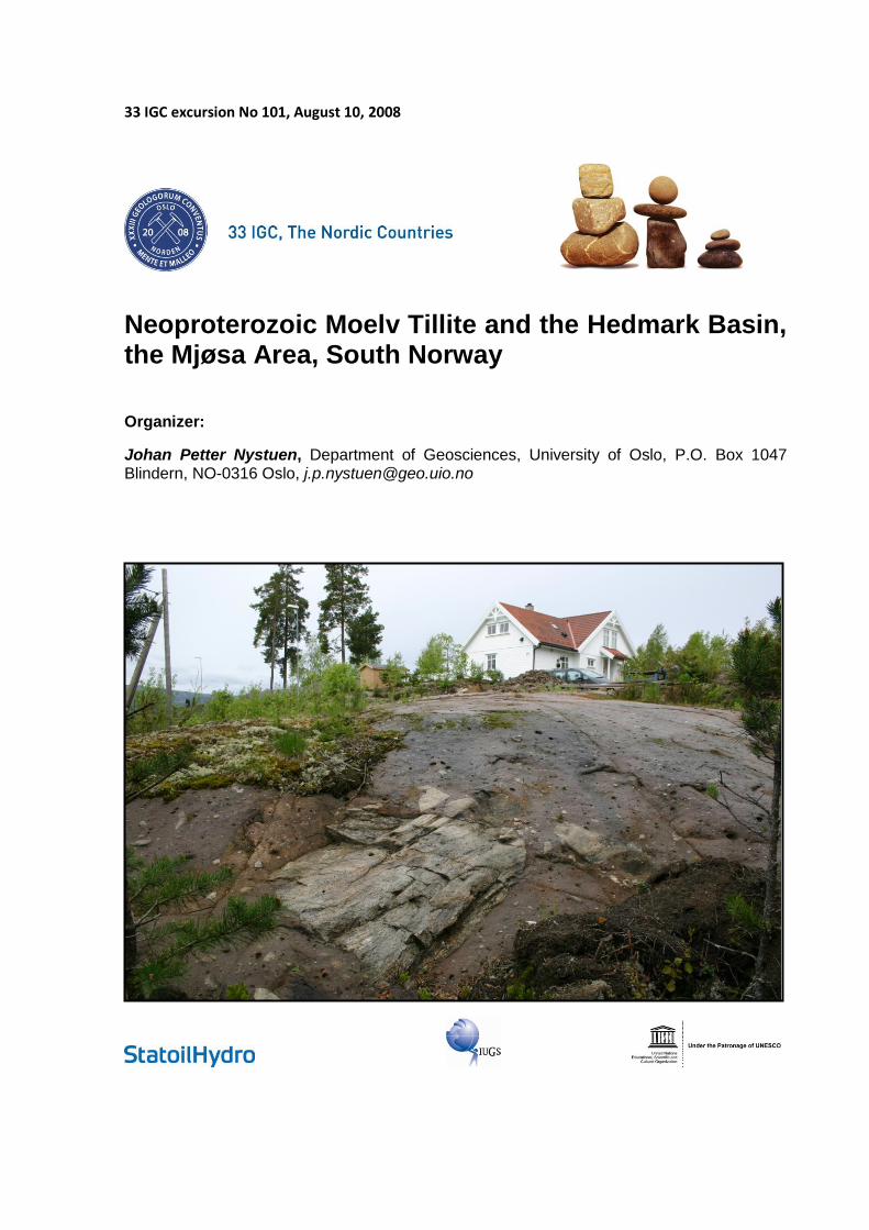
33 IGC excursion No 101, August 10, 2008
Neoproterozoic Moelv Tillite and the Hedmark Basin, the Mjøsa Area, South Norway
Organizer:
Johan Petter Nystuen, Department of Geosciences, University of Oslo, P.O. Box 1047 Blindern, NO-0316 Oslo, [email protected]

Picture on front page shows the diamictite of the Moelv Formation in Bruvollhagan, the town
of Moelv
3
TABLE OF CONTENTS
Abstract ...................................................................................................................... 4
Logistics..................................................................................................................... 4
Date and location ................................................................................................................................ 4
Travel arrangements ........................................................................................................................... 4
Field logistics ....................................................................................................................................... 4
General Introduction ................................................................................................. 5
Regional Geology ...................................................................................................... 7
Neoproterozoic basins in South Norway ............................................................................................. 7
Regional exent and age constraints of the Moelv glacial event ........................................................ 17
Excursion Route and Road Log ............................................................................. 19
Excursion Stops ...................................................................................................... 25
STOP 1 (optional): The Vangsås Formation, the Ringsaker Quartzite Member, Sollerud, between
Hamar and Brumunddal .................................................................................................................... 25
STOP 2 (optional): The Vangsås Formation, the Ringsaker Quartzite Member and overlying „Holmia
series‟, Steinsodden at Lake Mjøsa, the farm Stein, Ringsaker ....................................................... 30
STOP 3 (a,b and c): The Ring Formation and the Moelv tillite, Highway 213, town of Moelv .......... 32
STOP 4 (a, b, c, d and e): The Moelv tillite, Vardal Sandstone Member and the Ring Formation at
the Moelv Brygge and along the Lake Mjøsa shore line, town of Moelv ........................................... 34
STOP 5 (a, b and c) Bruvollhagan: Ring Formation and the Moelv tillite.......................................... 39
STOP 6 (optional): Upper part of the Biri Formation and lower part of the Ring Formation,
Kjosberget, road section in Highway 213, Ring ................................................................................ 44
STOP 7: Uppermost part of the Brøttum Formation and lower part of the Biskopåsen Formation,
Havik, Highway 213 ........................................................................................................................... 45
STOP 8: Brøttum Formation, Maihaugen, Lillehammer .................................................................... 49
STOP 9 (optional): Brøttum Formation, Lysgårdsbakken, Lillehammer ........................................... 53
STOP 10: Biri Formation, Kremmerodden, south of Biri, west side of Mjøsa ................................... 54
Conclusion ............................................................................................................... 56
References ............................................................................................................... 56

4
Abstract The Neoproterozoic Hedmark Group was deposited in a rift basin at the western margin of continent Baltica and was thrust at least 150 km to the southeast within the Osen-Røa Nappe Complex during the Caledonian orogeny in Silurian-Devonian. The Hedmark Basin hosts the glacial Moelv Formation that also crops out in autochtonous position, deposited directly on the crystalline basement. The Moelv Formation, the „Moelv tillite‟, is visited in its type area at the northern part of the Lake Mjøsa. The formation is developed as a polymict and unstratified diamictite deposited upon a coarse-grained arkose or pebble conglomerate of the Ring Formation. The diamictite is interpreted to represent basal till facies and the underlying Ring Formation subaquous fan delta deposits. Clasts in the tillite include granites, gneis, quartzite and vein quartz derived from the Precambrian basement and limestone from underlying Biri Formation. The Moelv Formation is correlated to the youngest of two glacial formations in Finnmark and may correspond in age to the Gaskiers glacial event (about 590 Ma). Pre-glacial deposits of the Hedmark Basin include in the type area deep-marine turbidite fan successions in the more than 4000 m thick Brøttum Formation, deep-marine gravel fans in the Biskopåsen Formation, limestones and shale in the Biri Formation and the fan deltas of the Ring Formation. Post-glacial deposits comprise siltstone facies in the Ekre Formation and deltaic to fluvial and shallow marine facies in the Vangsås Formation. Except for the poorly exposed Ekre Formation, all of these formations will be demonstrated on the excursion.
Logistics
Date and location Timing: Sunday, 10 August, 2008
Start location: Oslo S (Hotel Opera, Central Railway Station in dowtown Oslo)
End location: Oslo S (Hotel Opera, Central Railway Station in downtown Oslo)
Travel arrangements
Travel throughout the excursion will be by coach. Departure will be 09:00 sharp, on Sunday, 10 August, from the main entrance of the Thon Hotel Opera, Central Railway Station, Oslo. Arrival back in Oslo will be around 18:00 (6 pm).
Field logistics Most stops are along roads, but shorter and very easy hikes will be made along forest paths. Leather walking boots are not needed, but are recommended. High visibility vests will we given to all participants when moving along road sections. Lunch will be served in Moelv.
This one-day excursion starts from Oslo S, follows the Highway E6 northwards to the northern Lake Mjøsa area and here local roads to localitites to be visited in the Ringsaker, Lillehammer and Biri districts, before returning to Oslo in the afternoon.

5
General Introduction The aim of this one-day excursion is to demonstrate outcrops of the Neoproterozic glacial Moelv Formation in its type section within the northern Mjøsa area and to show main features of the stratigraphic setting of the glacial unit in the Hedmark Group (Fig. 1).
Since the recognition of its glacial character by Holtedahl (1922) the reddish-brown and grey-coloured diamictite formation in the town of Moelv and other areas in the Sparagmite Region was termed the Moelv tillite (Bjørlykke & Nystuen 1981; Nystuen 1985). The Moelv tillite, or Moelv Formation, has traditionally been correlated with the Mortensnes Formation in Eastern Finnmark, the youngest of the two Neoproterozoic tillites in Scandinavia (e.g. Siedlecka et al. 2004). Neoproterozoic glacial formations supposed to be correlatives to the Moelv and Mortensnes formations occur in various Neoproterozoic basin successions in Scandinavia, in eastern Greenland and Svalbard, glacial deposits thought to be related to late Cryogenian or/and Ediacaran glaciations in Baltica and Laurentia (Nystuen et al. 2008) (Fig. 2). Within this regional framework, the Moelv Formation is of crucial interests as regards way of origin, its setting in a rift basin, extent and palaeogeographic position in context of the current discussion of the global palaeoclimate of Neoproterozoic glaciations. The intention of the excursion is to put the classical outcrops of the Moelv Formation into this broad aspect of Neoproterozoic geology and palaeoenvironment.
Fig. 1. Geological map of the Sparagmite
Region and the northern part of the Lake Mjøsa area. From (Nystuen 1987).

6
Fig. 2. Neoproterozoic glacial formations (mauve colour) within basin successions of northern and north-western Baltica, represented by BSR = Barents Sea Region (East Finnmark, northern Norway), TVR = Tanafjorden-Varangerfjorden Region (East Finnmark), RB = Risbäck Basin (central western Sweden), TB = Tossåsfjället Basin (central western Sweden) and HBW = western Hedmark Basin with the Moelv Formation (Mo), in eastern and northeastern Laurentia by CEG (EBS) = central East Greenland (Eleonore Bay Supergroup) and NA-NY = Nord-Austlandet and Ny Frisland in Svalbard. Nystuen et al. (2008).

7
Regional Geology
Neoproterozoic basins in South Norway
The excursion area is located in the northernmost part of the Oslo Region and the southernmost part of the Sparagmite Region (Fig. 1). The name „Sparagmite Region‟ is derived from the dominating rock types in the central eastern part of South Norway, the sparagmites. The term was introduced by Esmark (1829) on arkoses and feldspathic sandstones, derived from the Greek word sparagma that means fragment. In the case of the sandstones of the Sparagmite Region the fragments are feldspar and quartz, mineral grains supplied from mid-Proterozoic to early Neoproterozoic (Tonian) granites and granitic gneisses. Major sandstone units were originally given names as „grey sparagmite‟, „red sparagmite‟ and „light sparagmite‟. The term „sparagmite basin‟ was given to the depositional basin of the most prominent of the sparagmite successions, originally supposed to be an autochthonous basin bordered by present major N-S running faults (Schiøtz 1902; see Nystuen 1981). Later studies have shown that the „sparagmites‟ occur in three major Caledonian nappe complexes, the Osen-Røa, the Kvitvola and Valdres nappe complexes, all representing three different basin successions thrust from the western margin of continent Baltica during the Caledonian orogeny in Silurian-Devonian time (Nystuen et al. 2008).
Formal lithostratigraphy was introduced on the Neoproterozoic successions during the 1960‟s to 1980‟s (for overview see Kumpulainen & Nystuen 1985; Nystuen 1987). The term „sparagmite basin‟ was replaced by formal basin names, termed after the group names of the sedimentary successions in the Caledonian nappe complexes, the Hedmark Basin from the Hedmark Group in the Osen-Røa Nappe Complex, the Engerdal Basin from the Engerdal Group in the Kvitvola Nappe Complex and the Valdres Basin in the Valdres Nappe Complex. Allocthonous Neoproterozoic basins in the Swedish Caledonides were named according to the same principle. The glacial formation in the Valdres basin is also named the Moelv Formation, whereas the equivalent unit in the Engerdal Basin is the Koppang Formation (Nystuen 1980). In Sweden, the Långmarkberg and the Lillfjället formations are equivalents to the Moelv Formation in the Risbäck and Tossåsfjället basins, respectively (Kumpulainen & Nystuen 1985; Nystuen et al. 2008), Fig. 2. The excursion is entirelly devoted formations and localities within the Hedmark Group in its type area.
Geological setting and stratigraphy of the Hedmark Group
The type area for the Neoproterozoic-Cambrian Hedmark Group is located at the northern end of the Lake Mjøsa, about 130-180 km north of the City of Oslo (Fig. 3). The bedrock of the area is mostly covered by Pleistocene till, glaciofluvial sediments and post-glacial alluvial deposits. Till soils originated from crystalline bedrocks, conglomerate, sandstone and thick limestone units and glaciofluvial terraces and deltas are dominantly forested areas with some scattered small farms on the most easily cultivated areas in south and west-facing hillsides. Areas of shale and interchanging shale and thin-bedded limestone are commonly covered by fine-grained and calcareous till soils and form the large and old agricultural districts on the eastern and western sides of the Lake Mjøsa, the Hedemarken and Toten districts, respectively.

8
Outcrops mostly occur along the shoreline of the Lake Mjøsa and in road and railway sections, besides in steep hill sides. The Hedmark Group is alltogether at least 6000 metres thick and comprises sedimentary facies from various depositional environments, including deep-marine turbidite sandstone and mudstone, black organic-rich marine shale, shallow-marine carbonate rocks, deep-marine coarse-clastic fan deposits, fan delta sandstone and conglomerate, glacial diamictite and laminated beds with ice-dropped stones, marine or/and lacustrine deltaic sand-, silt and mudstone, alluvial fan conglomerates and fluvial and shallow-marine sandstone and mudstone. In addition, locally thin tholeiitic basalt flows are present. The Hedmark Group is characterized by considerable lateral facies variation and reveals formation boundaries being clearly time transgressive. This is distinctly demonstrated by the glacial Moelv Formation that rests on crystalline bedrock outside the basin as well as on various basin formations comprising alluvial sandstone, terrestrial basalt, platform carbonates, fand delta beds and deep-marine mudstone.
The great variability of facies reflects the rift-basin nature of the Hedmark Basin. The basin was formed together with a series of other rift-basins and shelf basins along the western Baltoscandian margin of continent Baltica subsequent to the splitting of Rodinia for about 750 Ma ago (Fig. 4).
Fig. 3. Geological map of the Mjøsa area
and southernmost part of the Sparagmite
Region. The excursion route runs through
the Precambrian granite area southeast of
the Lake Mjøsa through Stange (St),
Akersvika east of Hamar, Jessnes (J),
Brumunddal (B), Moelv (M), Biskopåsen
(Bis), Brøttum (Br), Lillehammer and Biri
(Bi). From Nystuen (1999).

9
From facies trends and palinspastic restoration of internal tectonic compression it can be inferred that the Hedmark rift basin system was about 2-300 km wide in the east-west direction with main axis orientated NNW-SSE in a length of some hundreds of kilometers. The basin was connected to a marine seaway, at least during major times of its infill history. Mountain ridges or hills probably bordered the margins of the basin. The basin was, together with slices of the crystalline basement, thrust minimum 150 km towards the SE when Baltica and Laurentia collided and the Scandinavian Caledonides were formed at the end of the Silurian. However, the thrust distance may have been in the order of 3-400 km for the Hedmark Basin rocks in the Osen-Røa Nappe Complex and still longer for the Engerdal and Valdres basins in the overlying Kvitvola and Valdres nappe complexes, respectively (Nystuen 1981; Bockelie & Nystuen 1985; Kumpulainen & Nystuen 1985).
The Osen-Røa Nappe Complex forms the lowest nappe unit of the Scandinavian Caledonides in the Sparagmite Region in South Norway, within the eastern fold and thrust belt of the mountain chain. The Osen-Røa Thrust (ORT), the sole thrust of the nappe complex, is located within and above the Cambrian Alum Shale at the erosional front of the nappe complex. The ORT continues southward beneath the decollement thrust unit of Cambro-Silurian strata of the fold and thrust belt in the Oslo Region (Figs. 1 and 3), see also geological map sheet HAMAR (Nordgulen 1999).
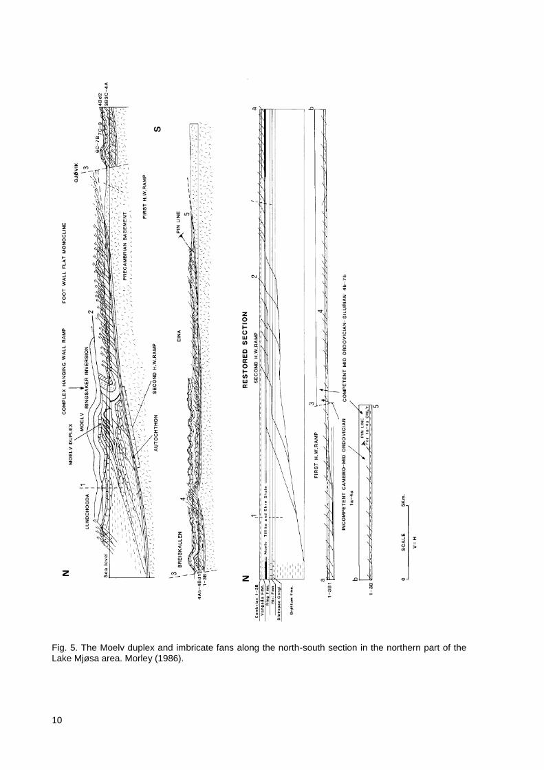
The tectonic architecture of the Osen-Røa Nappe Complex is characterized by a series of small and large individual thrust sheets, commonly organized in duplexes and imbricate fans at different scales (Nystuen 1983; Bockelie & Nystuen 1985; Morley 1986). Shale beds acted as prominent detachment surfaces and flat thrusts with ramps cutting stratigraphically up and southwards through the thicker sandstone units during the Caledonian in-sequence-thrusting. Crystalline basement rocks, some of which with primary depositional contacts of Hedmark Group sandstones, Moelv tillite, and Cambrian sandstone and shale, occur in the northern part of the nappe complex, in several areas in the shape of “Precambrian basement windows”. In the classical type section area for the Hedmark Group at Mjøsa, the formations of the group occur within the „Moelv window‟ between local thrust sheets (Vogt 1953; A. Bjørlykke 1973; Høy & A. Bjørlykke 1980), the Moelv duplex (Morley 1986), as well as in thrust sheets in front of and structurally underneath the duplex structure, and in thrust sheets above the roof thrust of the duplex (Fig. 5). Out-of-sequence thrusting took place during the latest stage of the Caledonian movements, particularly in the northern part of the Sparagmite Region (Nystuen 1983).
Fig. 4. Palaeogeographic reconstruction showing late Neoproterozoic (Cryogenian-Ediacaran) basins in restored positions on the Baltoscandian margin. From Nystuen (1987).
10
Fig. 5. The Moelv duplex and imbricate fans along the north-south section in the northern part of the Lake Mjøsa area. Morley (1986).

11
The tectonic structures in the fold and thrust belt are cut by post-Caledonian regional normal faults. These faults were active during formation of the Permian Oslo Rift. Faults related to the Oslo Rift delineate grabens and horsts also in the northern Mjøsa area. The northernmost outcrop of Permian romb porphyry lavas in the Oslo Rift is located in Brumunddalen east of Lake Mjøsa, preserved within a half graben. Some Permian dolerite dykes also occur within the Lake Mjøsa area.
The type stratigraphy of the Hedmark Group was defined from exposures along the eastern and western side of the Lake Mjøsa (Skjeseth 1963; Bjørlykke et al. 1967). Additional formations have been defined from other parts of the outcrop area of the Hedmark Group (Englund 1973a; Sæther and Nystuen 1981; Nystuen and Ilebekk 1981; Nystuen 1982), some of the most prominent lithostratigraphic units are shown in Fig. 6.
Fig. 6. Lithostratigraphy of the Hedmark. In the western part of the basin the pre-glacial successions are marine, whereas in the eastern part of the basin corresponding units are dominantly continental alluvial sandstones and conglomerates. (Nystuen 2008).
The Imsdalen Fault (IMF) in the central part of the Sparagmite Region (Fig. 7) is a prominent structural boundary between the western and eastern part of the Hedmark Basin. This fault is considered being of syndepositional origin with considerable down-dip and strike-slip components and a complex Caledonian reactivation history (Sæther & Nystuen 1981). The depositional development of the Hedmark Group is quite different on stratigraphical levels beneath the Moelv tillite in the western and eastern part of the Hedmark Basin (Fig. 6). A brief otline of the stratigraphy and basin infill history is given below and major stages in the development of the Hedmark Basin shown in Fig. 8.

12
Basin infill history
The lower part of the Hedmark Group is in the western part of the basin dominated by the more than 4000 metres thick Brøttum Formation, a deep-marine turbidite sandstone succession and associated black shale. Acritarchs from shale beds, likely in the middel part of the formation, are late Riphean to early Vendian (Vidal & Nystuen 1990a) and represent the oldest fossils found in South Norway. Late Riphean-early Vendian, in the traditional Russian chronostratigraphic scheme of late Proterozoic and Neoproterozoic, corresponds to late Cryogenian or early Ediacaran. The Brøttum Formation was formed in a series of deep-marine fans and fan complexes along the initital western marine rift basin and is dominated by grey fine- to coarse-grained turbidite sandstone (sensu lato) formed as lobes, channel infills, channel-levee complexes and sheet-like outer fan beds separated by inter-levee and basin floor organic-rich shale (up to 3 % TOC) and mudstone. Distributary canyon infill facies with mass transport complex (MTC) is identified in the Imsdalen submarine fan complex in the northern part of the western basin (Stalsberg 2004). The Lillehammer submarine fan complex (Skaten 2006) will be visited during the excursion.
In the Ringebu area in the valley Gudbrandsdalen north of the town of Lillehammer, the Brøttum Formation is underlain by the Elstad Formation, a coarse-grained fluvial sandstone. The contact between the two formations is tectonically complex, with the Elstad Formation occuring in a duplex structure; the original depositional stratigraphic relation between these two formations is uncertain (Englund 1973a).
Fig. 8. Major stages in the development of the Hedmark Basin, the block diagrams are seen from
north towards south. a) Formation of the western rift segment with deposition of the Brøttum
Formation and possible older formations, b) basin extension to the east with deposition of the
Rendalen Formation, c) regional transgression and deposition of the calcareous Biri Formation; basalt
flows belong to a previous rift event, d) Ediacaran glaciation and deposition of the Moelv Formation,
e) post-glacial time with deposition of the Ekre Formation and the lower member of the Vangsås
Formation, the Vardal Sandstone Member, and f) transgression in early Cambrian and depostion of
the Ringsaker Quartzite Member of the Vangsås Formation. (Nystuen 2008).
Fig. 7. Simplified geological map of the central Sparagmite Region showing outcrop pattern of the most prominent formations in the Hedmark Group. Imsdalen Fault (IMF) is a major syndepositional fault separating the western and eastern part of the Hedmark Basin. Rendalen (RF), Engerdalen (EF) and Osen (OF) faults are post-Caledonian (Permian). Nystuen (2008).

13

14
The lowermost part of the Hedmark Group is in the eastern part of the basin represented by the light red-coloured and fine- to medium-grained fluvial Storskarven Formation. The formation is identified with thrust contact towards underlying basement rocks of the Atnsjøen window (Nystuen and Ilebekk 1981). The Storskarven Formation is succeeded by the Rendalen Formation, the overall dominating formation of the Hedmark Group in the eastern part of the Hedmark Basin (Figs. 6 and 7). The Rendalen Formation is at least 4000 metres thick and consists of fluvial sandstone and several alluvial conglomerate members. The sandstone is typically red-coloured, coarse-grained and arkosic in composition, lain down in mobile braided streams (Nystuen 1982). The westward extent of the fluvial formation is abruptly cut by the Imsdalen Fault, with the marine Brøttum turbidite sandstones cropping out on the western side of the fault.
The deposition of the Storskarven Formation may reflect a pre-rift stage or very early rift stage, whereas the coarse-clastic and feldspar-rich Rendalen Formation is supposed to represent a major rift stage, like the marine Brøttum Formation in the west. The rifting in the west may have started earlier than in the east (Fig. 8), but this is very uncertain, as also is the original structural relationship between the pre-glacial western and eastern segments of the Hedmark rift basin system (Nystuen 1987). The wide alluvial plains of the Rendalen Formation sands were in the western part of its outcrop area capped by fine- to medium-grained quartz-arenic shallow-marine sand that gave rise to the Atna Formation (Sæther and Nystuen 1981).
A phase of basalt volcanism took place in the Hedmark Basin at the end of the depositional time of the Brøttum and Rendalen/Atna formations and prior to both the Biri and Moelv formations. Tholeiitic basalts are preserved in the Svarttjørnkampen Basalt in the northern part of the basin on top of the Rendalen and Atna formations (Sæther and Nystuen 1981). The lava flow unit is 5-30 metres thick. Sand from the Atna deposits has been enrolled into the lower part of the basalt flow, thus showing that the basalt was formed during the sediment infill history of the basin (Furnes et al. 1983). Boulders and pebbles of the same type of tholeiitic basalt are present in conglomerates in the Biskopåsen Formation, just above the Brøttum Formation in the Mjøsa type section, showing that volcanism may have taken place during several events. The basalt effusions likely happened as fissure eruptions, probably along major fault systems along the western margin of the basin or/and within intrabasinal faults. This volcanic episode is interpreted to represent the stage of maximum rifting in the Hedmark Basin (Nystuen 1987, 1999).
The western segment of the Hedmark Basin was after the event of basalt eruptions followed by a stage characterized by deposition of coarse-clastic deep-marine fans. The fans are today mainly present as descrete conglomerate bodies that all are referred to the Biskopåsen Formation. The Biskopåsen fan in the type section at Mjøsa is about 400 metres thick and the original size of the boulder and pebble-dominated channel facies has been calculated to about 80 km2 (Holme 2002). The lowermost part of the Biskopåsen fan is in its apex area characterised by a canyon cut into the Brøttum Formation, filled in by a mass transport complex (MTC), a polymict breccia with blocks up to a size of 2-3 meters. The canyon infill is a mixture of well-rounded extrabasinal basement stones (granites, porphyries and quartzites) and subangular to subrounded rock types derived by erosion and collapse of basin margin and basin platform environments (basalt, calcareous sandstone, limestone, phosphorite) (Nystuen 1999; Holme 2002). The first Precambrian fossil ever found in Norway (Papillomembrana) is from this locality (Spjeldnæs 1967). Deep-marine conglomerate fans like the type fan at Biskopåsen is present at Rena, Gausdal and Fåvang. Their clast population indicates several different sources and drainage areas. The well-rounded extrabasinal pebbles and cobbles show that initial fluvial transport and intermittent deposition in fan deltas must have taken place before submarine gravitational transport into basin floor fans. The water depth during deposition may have been some few hundreds of metres.

15
The Biskopåsen conglomerate fans, and also the Brøttum Formation in places where the conglomerate fans are lacking, were succeeded by black shale, shale-sandstone interbeds and limestone in the Biri Formation. The Biri Formation also caps basalt and the Rendalen and Atna formations in the eastern part of the basin, thus indicating that this stage was represented by a general rise in relative sea level and flooding of continental lowland areas surrounding the basin and adjacent parts of the Baltic craton. Thick organic-rich black shales (TOC up to 3%) of the Bjørånes Shale Member succeed the fluvial Rendalen Formation in central part of the western basin segment and indicates that local deep sub-basins may have been formed.
Carbonate and carbonate-shale formations occur in corresponding pre-glacial stratigraphical levels in several of the Neoproterozoic basins of western Baltica and also eastern Laurentia (Siedlecka et al. 2004; Pease et al. 2008; Nystuen et al. 2008) (Fig. 2). In the Hedmark Basin the carbonate facies occur on top of and laterally associated with marine black shale or shale-sandstone successions and are thought to represent shallow-marine marginal carbonate platforms and associated shallow-marine clacareous sandstone beds and slope and basinward deep-marine black organic-rich shale and greenish-grey siltstone and shale depleted of organic matter. The carbonate rock includes a series of subfacies, such as laminated micritic limestone, organic-rich laminated limestone, ooid grainstone, stromatolitic limestone, heterolithic laminated shale-calcareous sandstone, cross-stratified calcareous sandstone, intraformational limestone breccia and others (Bjørlykke et al. 1976; Tucker 1983; Nystuen 1982). The limestone is interpreted to have been formed during transgressive events primarily as aragonite mud and with the organic-rich shale and mixed shale-limestone beds deposited in anoxic environments (Tucker 1983).
The preglacial sedimentary history ended by a new phase of coarse-clastic deposition that gave rise to the Ring Formation in the western marine segment of the Hedmark Basin. The Ring Formation, like the Biskopåsen Formation, occurs in several discrete bodies of sandstone, granule and pebble conglomerate along the margins of the western marine bay segment. The coarse-grained beds pass basinwards into fine-grained sandstones, siltstone and shale and thus interchange laterally with the upper part dark grey shales of the Biri Formation. In the type area at Moelv, the Ring Formation is about 450 metres thick and consists of stacked, coarse-clastic several metres thick marine channel and lobe infill successions separated by interchannel fine-grained sandstone and siltstone (Kunz 2002). Bjørlykke et al. (1976) suggested that the Ring Formation includes both fluvial and marine facies of fan deltas, whereas Nystuen (1987, 1999) and Kunz (2002) interpreted the whole formation in the preserved rock record as steeply dipping marine clinoforms of prograding fan deltas, deposited by gravity flow processes. The regressive and upward shallowing and coarsening delta successions of the Ring Formation are all in their most proximal settings bounded by an erosional unconformity beneath the glacial Moelv Formation.
The unconformity below the Moelv Formation, as can be seen in the Moelv type area, is a regional unconformity within most parts of the Hedmark Group and also in the cratonic settings adjacent the basin. Diamictite of the Moelv Formation rests upon the unconformity, thus overlying directly proximal fan delta deposits of the Ring Formation, shallow-marine limestone of the Biri Formation, basalt flows of the Svarttjørnkampen Formation, fluvial sandstone of the Rendalen Formation, as well as crystalline basement rocks outside the basin. Striated basement surface is recorded below Moelv diamictite in authochtonous setting (Nystuen 1976a) and sandstone wedge below the diamictite in underlying Rendalen Formation sandstone has been interpreted as fossil ice wedge (Nystuen 1976b). In the marine and deepest part in the western basin segment, there is conformable contact between grey mudstone of the Biri Formation and laminated siltstone with scattered outsize stones of the Moelv Formation (Bjørlykke et al. 1976; Bjørlykke and Nystuen 1981; Nystuen 1976a, 1982, 1985, 1987; Nystuen et al. 2008) (Fig. 8d).

16
The Moelv Formation varies in thickness from some few decimetres to 160 m; most common thickness is in the range of 5-20 m. The main lithology is a reddish-brown or greenish-grey unsorted and unstratified diamictite with clasts in the size range from granules to blocks exceeding one meter. The diamictite is polymict, and in the basinal setting the clasts assemblage includes lithologies derived from basment rocks (granite, porhyry, gabbro, sandstone, quartzite, quartz) and from underlying basin rocks (limestone, shale, sand, basalt) (Bjørlykke et al. 1976; Nystuen 1976a; Nystuen and Sæther 1976; Bjørlykke and Nystuen 1981). Stratified clasts occur (Bjørlykke 1974; Nystuen and Sæther 1976).The formation also includes stratified diamictite and laminated sand- and siltstone with outsize stones in successions of increased thickness relative to the general thickness of the formation. Generally, the diamictite lithology passes towards the top into a thin laminated siltstone with outsize stones. This facies is further replaced by siltstone beds in overlying post-glacial Ekre Shale.
The structureless diamictite of the Moelv Formation is interpreted as basal till deposits, laminated mudstone with outsize stones as marine facies with ice-dropped stones, and the thick bodies including structureless diamictite, stratified diamictite, sandstone and laminated beds with ice-dropped stones as ice-margin deposits (Bjørlykke and Nystuen 1981; Nystuen 1976a, 1985).
The glacial event in the Hedmark Basin was succeeded by the deposition of the Ekre Formation. This unit is dominantly a finely laminated red and green siltstone of thickness varying from about 2 to 200 metres. In the upper part the siltstone is interbedded with sandstone beds, forming an upward coarsening and thickening succession representing advancing delta facies of the overlying Vangsås Formation (Bjørlykke et al. 1976; Nystuen 1982; Dreyer 1988). In other areas this upper boundary is an erosional unconformity beneath fluvial sandstone beds of the Vangsås Formation (Nystuen 1982). The Ekre Formation has about the same regional distribution as the Moelv Formation, and it also occurs in the Valdres Basin. It is supposed to be a postglacial marine deposits, though marine indicators, as palynomorphs (acritarchs) has so far not been recorded in the formation. Englund (1973b) suggested, from geochemical studies on Ekre shales, that the water body of the basin had been oxygen-rich and well-aerated, marine or lacustrine. Vidal & Nystuen (1990a) interpreted the lack of organic matter due to destruction of organic remains in oxygen-rich marine water.
The Vangsås Formation (10-1000 m) is the uppermost formation in the Hedmark Group. It consists of the lower Vardal Sandstone Member and the upper Ringsaker Quartzite Member. The Ringsaker Quartzite Member also occurs deposited directly on the crystalline basement outside the basin, preserved in thrust sheets and tectonic windows in the Osen-Røa Nappe Complex and autochthonously beneath the nappe complex.
In the excursion area the Vardal Sandstone Member consists of fine- to medium-grained delta sandstone and overlying coarse-grained, feldspathic and trough cross-bedded braided-stream sandstone (Bjørlykke et al. 1976; Dreyer 1988). In the northern and eastern part of the Hedmark Basin this member attains its greatest thickness and includes, besides deltaic facies and braided-stream sandstone, also marine thick-bedded turbidite sandstone, debris-flow conglomerates and black shale (Nystuen 1982, 1987). Acritarch specimens of the Fimbriaglomerella minuta in samples from the lower part of the Vardal Sandstone Member in the Lake Mjøsa point to an early Cambrian age (Vidal & Nystuen 1990b).
The Ringsaker Quartzite Member (3-200 m) is a well-bedded quartz-arenite with some intercalations of thin greyish-green shale beds and laminae. Some of the shale beds have yielded marine microfossils of earlieste Cambrian age (Vidal and Nystuen 1990b). Beds dominated by quartz and quartzite granules and pebbles occur at several stratigraphical levels, particularly in the northern and eastern part of the basin. These beds are commonly some few centimetres to decimetres thick, but form locally bedsets up to about 10 m.

17
Skolithos and Diplocraterion trace fossils are present in the upper part of the Ringsaker Member at the Lake Mjøsa (Skjeseth 1963). The uppermost bed of the member are several places phosphorized and may also be upward bounded by a granule or pebble lag, indicating hiatus beneath overlying Lower Cambrian shale beds. Mineralization by galena occurs in several areas within the Ringsaker Quartzite Member, a phenomenon that is common in this sandstone and equivalent quartzite units along the eastern Caledonian nappe front in Scandinavia.
The Vangsås Formation represents the final infill of the Hedmark Basin (Fig. 8f). The up to 1000 m thick marine to fluvial Vardal succession in the east, including turbidite sandstones, debris flow deposits and black shales probably represents the latest stage of extensional tectonics (Nystuen 1987). In other areas of the basin the Vardal Sandstone Member forms a regressive depositional phase, ending with very wide braid plains towards the end of the Ediacaran (Vidal & Nystuen 1990b). The Ringsaker Quartzite Member is equivalent to similar Lower Cambrian quartz-arenite formations framing the Baltica and represents the stage of early Cambrian marine flooding of the continent. The Ringsaker Member, representing shoreface and littoral sand deposits, was likely formed by a series of regressive events, separated by rapid transgressions leaving rise to mudstone beds, all during a main period of eustatic sea level rise in the beginng of Palaeozoikum. Traditionally, in the Lake Mjøsa area, the Precambrian-Cambrian boundary has been picked at the top of the Ringsaker Quartzite Member (e.g. Skjeseth 1963), but microfossils in shale beds show that this major chronostratigraphic boundary is located in lower part of the Vangsås Formation (Vidal & Nystuen 1990b).
The Ringsaker Quartzite Member is overlain by greyish green shale carrying macro- and microfossils of the Lower Cambrian „Holmia stage‟ (Skjeseth 1963; Ahlberg et al. 1986; Mozydlowska & Vidal 1986; Vidal & Nystuen 1990b). This unit is then in the Lake Mjøsa area followed by Cambrian Alum Shale and a succession of Ordovician shale and limestone formations (Skjeseth 1963).
Regional exent and age constraints of the Moelv glacial event
As previously mentioned in the Introduction, the Moelv Formation has its equivalents in South Norway in the Valdres Basin of the Valdres Nappe Complex (Loescke & Nickelsen 1968; Nickelsen 1974) and in the Engerdalen Basin of the Kvitvola Nappe Complex (Nystuen 1980). The Moelv tillite in the Valdres Basin is present as an about 2 m thick diamictite, deposited on basement or on alluvial conglomerate and fluvial arkosic sandstone. In the Engerdalen Basin, the Koppang Formation is an up to 15 m thick diamictite that rests with primary erosional contact on a dolomite formation, a correlative to the Biri Formation in the Hedmark Basin. The carbonate unit also contains sedimentary magnesite with chert beds, thus indicating warm water conditions (Nystuen 1969, 1980). The Moelv Formation and its correlatives in South Norway and in Sweden, the Långmarkberg Formation in the Risbäck Basin of the Lower Allochton and the Lillfjället Formation in the Tossåsfjället Basin of the Middle Allochthon (Kumpulainen & Nystuen 1985, Nystuen et al. 2008) have all been correlated with the Mortensnes Formation, the youngest glacial formation in eastern Finnmark (Fig. 2).
Presuming that these correlations are correct, palinspastic reconstruction of the stacked nappe successions in the Scandinavian Caledonides is in favour of that the „Moelv glacial event‟ must have been represented by glacial ice covering large parts of the western Baltica. However, recent unpublished provenance data from the Moelv Formation indicate that the clast debris reflects the local or semiregional bedrock types to the basin (Lamminen personal communication July 2008). In the eastern part of the Hedmark Basin bedrock provinces of the Fennoscandian shield to the east and northeast predominates among the clasts and provenance ages of the Moelv Formation, whereas in the western part of the basin clasts and provenance ages reflect bedrock provinces in the southwest or west. This may imply that

18
glaciers accumulated in mountains adjacent to the rift basin and were drained locally from these, not from a continental ice sheet supplying till debris far from the east in Baltica.
The age of the „Moelv glacial event‟ is poorly constrained. A Rb/Sr whole rock age of 612 ± 18 Ma on the Ekre Shale was given by Welin (in Rankama 1973). The Lillfjället Formation in Sweden is penetrated by the Ottfjället dolerite dykes that are correlated with the Sarek Dyke Swarm in northern Sweden with an age of c. 610 Ma (Svenningsen 2001). Bingen et al. (2005) published detrital U/Pb zircon ages of 677 ± 15 Ma and 620 ± 14 Ma from the Rendalen Formation at a stratigraphical level some hundreds meters below the Moelv tillite and constrained the tillite to be younger that the 620 Ma zircon age; they suggested the detrital zircons of this age to have been sourced from an imaginary granite related to the 616 ± 3 Ma Egersund dolerite magmatism in southwestern Norway (Bingen et al. 1998). Further studies of zircon ages from the Rendalen Formation and other formations in the Hedmark Group have so far not verified the 620 Ma detrital zircon age population in the Hedmark Group. Hannah et al. (2007) obtained ages on black shale samples from the Biri Formation of about 560 Ma and 300 Ma by the Re/Os method. None of these ages give any reasonable constrain for the Moelv glacial event.
From its stratigraphic position not so far below the Ediacaran-Cambrian boundary within the Vangsås Formation, the Moelv Formation, and its equivalents in Scandinavia, may likely correlate chronostratigraphically with the about 580-590 Ma Gaskiers glaciation in Avalonia (Thompson & Bowring 2000; Myrow & Kaufman 1999; Bowring et al. 2003), as also suggested by Bingen et al. (2005) and Nystuen et al. (2008). However, this age still needs to be documented from the Hedmark Basin. The Svarttjørnkampen Basalt, directly underlying the Moelv Formation, has so far failed to yield reliable isotopic ages (e.g. Furnes et al. 1983); however, the work to obtain U/Pb isotopic ages out of this Neoproterozoic volcanic rock is still continuing at the University of Oslo.

19
Excursion Route and Road Log From the City of Oslo the excursion route follows the European highway E6 northwards to Hamar and Brumunddal to Moelv. From Moelv the excursion enters Highway 213 (previous E6) and potentially some local roads to Lillehammer on the eastern side of the Lake Mjøsa. From Lillehammer we return back to Moelv along E6 on the west side of the Lake of Mjøsa, and then again following E6 back to Oslo. Geological localities to be visited are located in the Moelv area and along the road loop Moelv-Lillehammer-Moelv (Fig. 9). An outline of geology, landscape and cultural history along the excursion route is given below.
Fig. 9. The excursion route from Oslo to Stange, Hamar, Brumunddal, Moelv, Brøttum, Lillehammer and Biri.
The City of Oslo is situated within the late Palaeozoic Oslo Rift. The inner part of the Oslofjord is bordered by a major fault to the east, bounding crystalline Precambrian rocks on the plateau east of the City from folded Cambro-Silurian strata forming the bedrock of islands in the inner fjord basin and of the City itself. The medival Oslo, presently named “Gamlebyen”, the old town, was founded by king Harald Sigurdsson „The strongruler‟ in 1050. Oslo was located at the foot of the hill Ekeberg at the eastern side of the river Akerselva. Ekeberg is a prominent land mark just east of the harbour and the new Opera House. The origin of the name Oslo is uncertain, but is probably the combination of the Norse word for god, áss, and lo, meaning „open place in a forest‟ (cf. Waterloo). The hill Ekeberg is bounded by Permian faults to the west and to the north. Branches of this fault system run to the NW and bound a small horst of Precambrian gneisses and autochthonous Cambrian shales in the central harbour area. The Akershus Fortress and Castle is built on top of this horst (Aker, a very old indoeuropean word, litterary meaning field (cf. acre), was the name of a large farm in the Oslo area, hús (house) means in this respect a fortress). The construction of the Akershus fortress started in the 1290s under the king Håkon V. Magnusson (1299-1319) who also founded the fortresses Båhus in the southeast Norway at boundary to Sweden and Vardøhus in easternmost Finnmark, facing the Barents Sea and Russia. This was a peak time of expansion of the kingdom of Norway. The Akershus fortress has experienced a lot of historical events and is to day applied for military administration and the castle of the fortress for official celebrations of various types. The building stones used in the Akershus fortress comprise a representative collection of rocks of the Oslo area and
20
neighbouring districts of eastern Norway. The old Oslo burned several times, and presently there are mostly ruins of churches and a monastry left of the medival town. After the fire in 1624, king Christian IV (1588-1648) decided to rebuilt the town west of Akerselva close to the Akershus fortress. The new town was named Christiana (Kristiania). From 1925 the capitol of Norway again got its old name Oslo.
The bedrock in the hills west and north of the City consists of Permian plutonic and volcanic rocks. Prominent escarpments at the skyline in the district west of the city are formed by undercutting of massive basalt and rhomb porphyry lava flows resting upon uppermost Carboniferous to lowermost Permian shale, sandstone and conglomerate. Towards the south of Oslo, the peninsula of Nesodden is a horst of Precambrian bedrock bounded by faults to the east and west.
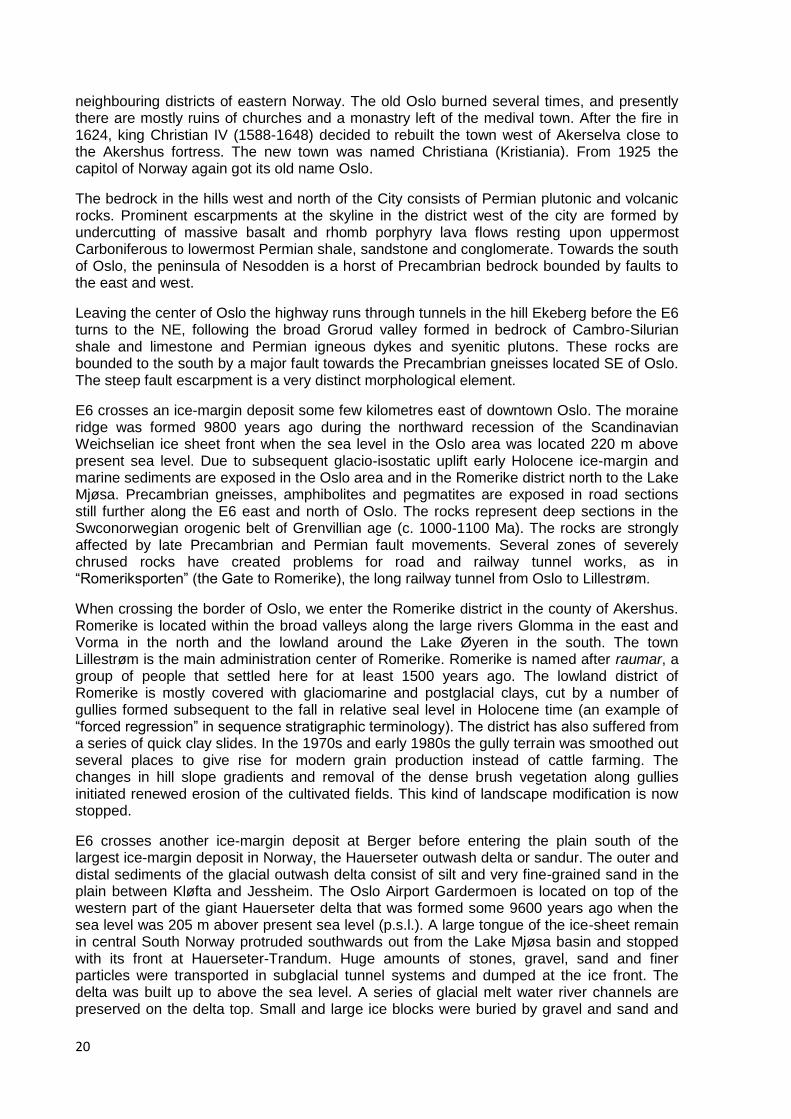
Leaving the center of Oslo the highway runs through tunnels in the hill Ekeberg before the E6 turns to the NE, following the broad Grorud valley formed in bedrock of Cambro-Silurian shale and limestone and Permian igneous dykes and syenitic plutons. These rocks are bounded to the south by a major fault towards the Precambrian gneisses located SE of Oslo. The steep fault escarpment is a very distinct morphological element.
E6 crosses an ice-margin deposit some few kilometres east of downtown Oslo. The moraine ridge was formed 9800 years ago during the northward recession of the Scandinavian Weichselian ice sheet front when the sea level in the Oslo area was located 220 m above present sea level. Due to subsequent glacio-isostatic uplift early Holocene ice-margin and marine sediments are exposed in the Oslo area and in the Romerike district north to the Lake Mjøsa. Precambrian gneisses, amphibolites and pegmatites are exposed in road sections still further along the E6 east and north of Oslo. The rocks represent deep sections in the Swconorwegian orogenic belt of Grenvillian age (c. 1000-1100 Ma). The rocks are strongly affected by late Precambrian and Permian fault movements. Several zones of severely chrused rocks have created problems for road and railway tunnel works, as in “Romeriksporten” (the Gate to Romerike), the long railway tunnel from Oslo to Lillestrøm.
When crossing the border of Oslo, we enter the Romerike district in the county of Akershus. Romerike is located within the broad valleys along the large rivers Glomma in the east and Vorma in the north and the lowland around the Lake Øyeren in the south. The town Lillestrøm is the main administration center of Romerike. Romerike is named after raumar, a group of people that settled here for at least 1500 years ago. The lowland district of Romerike is mostly covered with glaciomarine and postglacial clays, cut by a number of gullies formed subsequent to the fall in relative seal level in Holocene time (an example of “forced regression” in sequence stratigraphic terminology). The district has also suffered from a series of quick clay slides. In the 1970s and early 1980s the gully terrain was smoothed out several places to give rise for modern grain production instead of cattle farming. The changes in hill slope gradients and removal of the dense brush vegetation along gullies initiated renewed erosion of the cultivated fields. This kind of landscape modification is now stopped.
E6 crosses another ice-margin deposit at Berger before entering the plain south of the largest ice-margin deposit in Norway, the Hauerseter outwash delta or sandur. The outer and distal sediments of the glacial outwash delta consist of silt and very fine-grained sand in the plain between Kløfta and Jessheim. The Oslo Airport Gardermoen is located on top of the western part of the giant Hauerseter delta that was formed some 9600 years ago when the sea level was 205 m abover present sea level (p.s.l.). A large tongue of the ice-sheet remain in central South Norway protruded southwards out from the Lake Mjøsa basin and stopped with its front at Hauerseter-Trandum. Huge amounts of stones, gravel, sand and finer particles were transported in subglacial tunnel systems and dumped at the ice front. The delta was built up to above the sea level. A series of glacial melt water river channels are preserved on the delta top. Small and large ice blocks were buried by gravel and sand and
21
have by melting given rise to a series of kettle holes. The fine material that settled in the “Romerike fjord” in front of the ice sheet forms today the cultivated soils of Romerike. The Hauserseter ice margin deposit represents important gravel, sand and groundwater recources. Presently a new 4 lane road of E6 is being built across the Hauerseter delta, exposing both the original glacifluviomarine sediments and later aeoline sand dunes, formed by early Holocene wind reworking of the delta top sediments.
In the area between Dal and the Eidsvoll tunnel at Minnesund the E6 Highway has been cut into the Romerike gneiss complex (ca. 1600 Ma).The gneiss complex is of sedimentary and volcanic origin with granitic and gabbroic intrusions, all rocks strongly deformed and metamorphosed during the Sveconorwegian orogeny about 950-1000 Ma ago (Nordgulen 1999; Bingen et al. 2008). At the old E6 road, located some couple of kilometres east of the present E6, in the municipality of Eidsvoll, the Norwegian Constitution (Grunnlov) was signed May 17th 1814 in the main building of Eidsvoll Jernverk (ironwork). The “Constitution Day” is celebrated each year the 17th of May by the “Children‟s Parade” in cities, towns and small places in Norway; a type of celebration introduced by the poet Henrik Wergeland (1808-1845), himself brought up in Eidsvoll from 1817 to 1825.
The E6 crosses the Lake Mjøsa at its outlet at Minnesund. Here another ice-margin delta accumulated about 9400 years ago up to a marine limit of about 192 m above p.s.l. At that time the last ice sheet remain in the central part of southeastern Norway occupied the Mjøsa basin and had its front at the innermost part of the „Romerike fjord‟ at Minnesund. Some marine water inundated the Mjøsa basin and formed the base level for a series of small river deltas on both sides of the Lake Mjøsa basin. Mjøsa is another Norse or even older name, meaining „the glittering lake‟. The Lake Mjøsa is the largest lake in Norway, 366 km2 and 117 km long from Minnesund in south to Lillehammer in the north. The lake occurs along a major fluvial drainage system in eastern Norway, formed in consequent of the Cenozoic uplifts of Scandinavia. The lake basin has been formed by glacial erosion during repeated Pleistocene glaciations along a series of branching N-S running Permian faults and zones of bedrock weakness. The lake is the third deepest lake in Europe with a maximum recorded depth of 452 m. With a normal water level of 123 m, the deepest part of Mjøsa is thus situated 329 m below sea level. 13 fish species are so far recorded in the lake, but the deepest depths are far from being explored. Hamar, Lillehammer and Gjøvik are towns located at Lake Mjøsa. The island Helgøya (the „Holy Island‟, old Norse gods were worshipped here) in the center of the lake is the larges island in a lake in Norway. Before modern roads and railways were built in the last part of the 19th century, ships traficced commersially the Lake Mjøsa. Commercial boats were active up to the 1960s. Still, the wheel-driven boat „Skibladner‟, built 1854-1856, is in trafic during the summer season. This is the oldest wheel-driven boat in the World operating regularly. The ship is named after Skíðblaðnir, the boat of Frøy, the god of fertility in the Norse mythology. (Skíðblaðnir could sail as well on land as on the sea, had space for all the Norse gods, and after sailing, Frøy could fold the boat together like a cloth and put it in a bag).
Permian granites and synites are exposed in the highest hills west of the southern part of Lake Mjøsa. The plutonic rocks have intruded Precambrian gneisses and overlying Cambro-Silurian shales and limestones that crop out in the lower part of the eastern slopes of the hills in the Feiring agricultrual district. The Permian igneous activity has given rise to mineralization with formation of iron ores that previously were mined. The abandoned emeral mine at the farm Byrud just north of Minnesund is also located in this contact zone of the Permian plutons.
E6 runs through Precambrian bedrocks all the way from Minnesund to Stange about 10 kilometers south of Hamar. Along the Lake Mjøsa, in the southern part of this segement of the excursion route, exposures along the road are within the Solør complex of highly deformed gneisses of supracrustal origin, as well as migmatites. The age of the complex is supposed to be in the range of 1600-1800 Ma. The Solør complex and the somewhat

22
younger Romerike complex are both penetrated by Sveconorwegian mylonite zones. These zones of extreme shearing can be traced from the Lake Mjøsa southwards to Scania in Sweden and represent some of the most major geological boundaries within the Fennoscandian shield. In this part of the excursion route, the Precambrian bedrock is composed of a massive, pinkish and light grey grano- and monzodiorite (Odal granite), including some mafic xenoliths. The granitic rock is likely about 1670 Ma (TIB-age) (Nordgulen 1999). In the outcrop area of the Odal granite a new E6 is presently being built across the Kolomoen forest area. Topography, type of till debris and vegetation in this granitic bedrock area is characteristic for most Precambrian granitic terrain in southeastern Norway. The till typically consists of large blocks and boulders plucked by the inland ice sheet directly up from the local granitic bedrock. Pine, spruce and birch are characteristic trees. This type of forest is a typical biotope for the large mooses (elg).
The surface of the Precambrian bedrock topography south of Hamar coincides approximately with a palaeotopographic surface of late Neoproterozoic-Cambrian age. This surface, traditionally called the „sub-Cambrian peneplain‟, is a prominent morphological feature beneath autochthonous upper Neoproterozoic-lower Palaeozoic sedimentary cover rocks in Scandinavia. Crossing the boundary between the Precambrian granite and Cambro-Silurian shales and limestones we leave the forested Kolomoen area and enters the agricultural district of Hedemarken in the municipality of Stange. This major geological boundary coincides with a dramatic change in landscape and natural conditions for human life. The Hedemarken district is named after another group of peoples, the heidnir, that settled in this mark („forested area‟) in prehistoric time at the eastern side of the Lake Mjøsa and started cultivating the fertile till soil on the Cambro-Silurian bedrock. The Toten district on the western side of the Lake (Toten, „the flourishing district‟) has the same type of soil, and both of these two rural districts have been farmlands at least since the bronze age.
The Cambro-Silurian sedimentary succession of the Lake Mjøsa district belongs to the Caledonian decollement thrust unit of the Oslo Region, or the southern part of the Osen-Røa Nappe Complex, except of a thin autochthonous cover of Cambrian sandstone and shale. The sole thrust of the decollement is here a flat thrust within the Cambrian Alum Shale, an organic-rich black shale. Eroded synclines of Ordovician limestone formations form hills and ridges, the largest of them woodland, surrounded by farmland on the Cambrian and Ordovician shales. Vangsåsen, the forested hills at the skyline north of the town Hamar is the type area of the Vangsås Formation. The E6 crosses the bay Åkersvika at Hamar, at the interscetion with highway 25 heading the town Elverum 30 km to the east. Forested hills along the northern boundaries of the town Hamar are located along broad synclines in the about 100 m thick middle Ordovician Mjøsa Limestone Formation.
From about the year 400 the large farm Åker, located just at the northern side of Åkersvika at the E6/Hw3 intersection (Åker same as „Aker‟, field) was the site of chieftains or local kings ruling the Mjøsa district. Åker was also the site of the regional ting (the institution for law and justice, Hæidsævisthing, now applied in the name „Eidsivating‟ on the regional Court with jury in eastern Norway). Names of neighbouring farms Torshov and Vidarshov indiate that the Åker also was a main site for worship of Norse gods. An old viking ship and a lot of other goods have been found buried at Åker. Since about 1000 a market place (kaupang) had existed at a headland at the eastern side of Lake Mjøsa. A ridge bounded by steep slopes of the Ordovician Stein Formation (Orthoceras limestone) protrudes here as a point into the lake. A steepsided rock or knoll is in the old Norse language and the present Norwegian called a hammer or hamar (same ethymology as in the tool hammer).
The town of Hamar was founded here at the Hamar kaupang in 1252 when a bishopship was established for the central east Norway by Nikolaus Breakspear, later pope in Rome. (At the same time, 1252/53, Breakspear installed in Nidaros the first archebishop appointed to Norway, Jon Birgisson. The first bishop of Hamar, Arnalder, had first been appointed bishop of Greenland and started building a Cathedral there in Gardar before he returned to his new

23
position in Hamar). The Hamar Cathedral was built of local limestone. The Cathedral was destroyed by Swedish troops in 1567 (during one of the many wars between the kingdoms Denmark-Norway and Sweden). Hamar was abandoned as town in 1587, but reestablished at its present site in 1849. The town has today about 30 000 inhabitants and is a center of public administration, education, communication and trade in the inland of eastern South Norway. The first female bishop in Norway, and the second in the Lutheran Church in the World, Rosemarie Köhn, was bishop in Hamar 1993-2006. The modern viking ship in Hamar, Vikingskipet, is lying „upside down‟ and was the speed skating arena during the Olympic Winter Games in 1994.
At the town Brumunddal north of Hamar the excursion route crosses a major Permian fault. The Brumunddal Fault is a transfer fault zone between a N-S running master fault of the Oslo Rift in the west, the Randsfjord-Hunselva Fault and another master N-S oriented fault in the northeastern part of the Oslo Rift, the Rendalen Fault. The hanging wall to the northwest of the Brumunddal Fault consists of Cambro-Silurian rocks on top of the Hedmark Group that are succeeded by Permian rhomb porphyry lavas and the red-coloured aeolian Brumunddal Sandstone Formation. The hill Bjørgeberget is shaped by steep escarpments along the erosional edges of the lava flows, thus forming the same morphological feature as the lava plateau west of Oslo. The industry town Brumunddal is the administration center for the large municipality Ringsaker (1280 km2, population of 32 000). The popular poet, writer and ballad-singer Alf Prøysen (1914-1970) was born and grown up in Ringsaker.
The district of Ringsaker has many large farms with old histories, some of the farms have been owned by the same family for several hundreds of years. The Hedemarken district was the last part of Norway that was „christianized‟ with violency by king Olav Haraldsson („the Saint‟) when he beated five kings from the central inland of eastern Norway in a battle in Ringsaker 1021. Two of the kings were the brothers Ring and Rørek Dagsson from Hedemarken. Ring was forced to leave Norway, and king Olav blinded Rørek and later exiled him to Iceland where he died and was buried as the only king in Iceland. The Ringsaker Church, built by local stones, as the Cathedral in Hamar, was finished about 1250, consecrated Saint Olav. (King Olav was killed in a battle at Steinkjer 29th of July 1030 and was declared a saint after his death; until the Reformation in 1537, when the Catholic Church was exchanged with the Lutheran Church in Norway, people from all parts of Europe pilgrimaged to the Cathedral in Nidaros where the reamins of Saint Olav was kept in a coffin).
One of the large farms in Ringsaker is Stein (meaning rock). This large farm was a main site of power in this district in the Saga time. It obtained particular pivileges as a trade center in Eastern Norway in 1753. The old farm was destroyed by fire in 1897. The farm Stein is located at a ridge of the Ordovician Stein Formation, the orthoceras limestone, named after this farm (Skjeseth 1963). An islet in the Lake Mjøsa at the farm Stein, Steinsholmen, consists of the limestone formation. A small fortress or castell was built here by king Håkon IV Håkonsson (ruled 1217-1263) in 1234 in his fight with the bishop in Hamar about the ownership to the island Helgøya. Later the fortress was as a prison for central East Norway, before it was demolished.
(Håkon Håkonsson was one of the most powerful medival kings in Norway. He was born 1204 during a civil war and was as one of the candidates to the kingdom searced for by baglerne, one party in the war. Håkon was saved by two soldiers belonging to the birkebeiner party. Torstein Skjevla and Skjervald Skrukka carried the royal kid on skis across the mountain plateau from Lillehammer to Østerdalen in the east during some very cold days early in January 1206, and further in safety to Nidaros. To the memory of this historic event, the ski race „Birkebeinerrennet‟ is being arranged every winter since 1931, crossing the same mountain plateau, however, in opposite direction, from Rena in Østerdalen in the east to Lillehammer in the west. Håkon Håkonsson increased the powerty of the Norwegian kingdom and managed to get Iceland (1262) and Greenland (1261) under Norwegian authorithy. In his

24
struggle to obtain power in Iceland, he got the Icelandic chief and famous poet and writer Snorri Sturluson killed 23rd September 1241).
At Steinsodden, a point in the Lake Mjøsa at the farm Stein, the boundary between the Hedmark Group and the overlying Cambro-Silurian succession is exposed. The boundary, being overturned to the south, has been termed the „Ringsaker inversion‟ (Fig. 5) and represents the southern boundary of the type section of the Hedmark Group in the Moelv area. From here, Hedmark Group formations form the bedrock along the excursion route to Lillehammer. Fig. 10 shows a simplified section through the complex fold and thrust structure, including the Moelv duplex from Steinsodden in the south to Brøttum in the north.
Fig. 10. Simplified section through the fold and thrust structures along the eastern side of lake Mjøsa, from Brøttum in the WNW to Ringsaker Church in the south. From Nystuen (1999).
Moelv is an industry town and the type area for the Moelv tillite and the overlying Ekre Shale. The tillite is exposed along the shore of the Lake Mjøsa and in several local road sections and gardens of private houses in Moelv. The Ring Formation is also well exposed in Moelv. In an old tannery building in Moelv („Garveriet‟) the Hedmark Geologiforening (the Geological Society of Hedmark) has made a geological exhibition with emphasis on the local geology of Ringsaker. Outside the building the geological sociey in cooperation with local municipal authorities has made a simplified small scale reconstruction of the castell at Steinsholmen, by the use of „Ringsaker stones‟, with the oldest at the base of the castell and the youngest, the Brumunddal sandstone at the top.
North of Moelv road sections in highway 213 display the Biri, Ring, Biskopåsen and Brøttum formations. Kjosberget, the westernmost extension of Lundehøgda, is the type section of the Ring Formation (Kunz 2002). Stratotype for Biskopåsen Formation is located in the steep western slopes of the Biskopåsen („the Bishops hill‟) (Holme 2002). In the Brøttum area (Brøttum, the „home of broken up, cultivated soil‟), still further north, sandstones of the Bøttum Formation is folded into vertical and slightly overturned position in an imbricate fan. Though this is the type area for this turbidite formation, road sections in the town Lillehammer present much better preserved successions of the Brøttum Formation.
Lillehammer (population 26 000) became a town in 1842. The name Lillehammer means „the small hammer‟. The town has the main administriation for the Oppland county and is a center for education and other public services besides trade for the local districts, particularly for the main Gudbrandsdalen valley north of Lillehammer. The author Sigrid Undset, who gained the Nobel Price in literature, lived in Lillehammer. The town also has hosted several painters. The town is a popular tourist goal, not at least in winter time with a number of large ski resorts in neigbouring mountain areas. Lillehammer arranged the 17th Winter Olympic Games in 1994. The town has a famous outdoor museum, Maihaugen, in which a series of old farm buildings and a stave church from the district are displayed. The Brøttum Formation is very well exposed in road sections close to this museum. Unfortunately (for geologists at least)

25
the steep road section has now been covered with a steel curtain for the safety of people walking along the road. The Brøttum Formation is in the Lillehammer area folded into very broad syn- and anticlines that generally is cut by steeply inclined thrust faults. Lillehammer is the type area for the „Lillehammer submarine fan complex‟.
Turning to the western side of the Lake Mjøsa at Lillehammer, we again enter the highway E6 for the return to the south, passing the districts of Vingrom and Biri. The origin of the name Biri is uncertain but is supposed to mean the „winter layer of bear‟. In the Biri district we will visit the locality Kremmerodden to see the Biri Formation before crossing the Lake Mjøs again, back to the east side of the lake at Moelv.
The Mjøsa Bridge at Moelv is in part founded upon an ice-margin deposit, forming a subaquous moraine ridge across the lake. The deposit is dated to ca. 9100 years b.p. and represents the youngest site of the northward recessing front of the Weichselian ice sheet in south-eastern Norway. From this time the ice sheet collapsed into several valley glaciers that very soon ended as „dead ice‟ before the final disappearence of the Weichselian ice masses in Scandinavia. From Moelv we will follow E6 back to Oslo.
Excursion Stops In addition to the main stops, some optional localities are described. The final choice of localitites to be visited will be made from weather conditions and water level of Lake Mjøsa, as for some localites high water level in the lake make the access difficult or the most of the exposures of interest may be flooded. Position of localities are referred to the UTM coordinates of the geological map sheets HAMAR 1916 IV (Høy & A. Bjørlykke 1980), GJØVIK 1816 I (A. Bjørlykke 1973) and LILLEHAMMER 1817 II (Englund 1978). All maps are available from Norges geologiske undersøkelse (Geological Survey of Norway), Trondheim. These map sheets are in the scale 1: 50 000 (Serie M 711). It should be noted that the UTM coordinates on the geological map sheets do not correspond to the WGS84 (EUREF89) UTM coordinates that are applied on recent topographic maps in the M711 series and applied by most users of GPS equipment. WGS84 coordinates are thus also given for the excurison localites in this guide. All UTM coordinates refer to Grid Zone 32 V. The 1: 250 000 map sheets HAMAR (Nordgulen 1999) and LILLEHAMMER (Siedlecka et al. 1987) is referred to for a greater overview of the geology along the excursion route.
STOP 1 (optional): The Vangsås Formation, the Ringsaker Quartzite Member, Sollerud, between Hamar and Brumunddal Location: Sollerud. Geological map sheet HAMAR 606800 6749200. WGS84 coordinates: 0606733 6749001. Following the E6, turn to the right at crossroad „Vegkryss Furnes‟ 6 km north of the E6/Hw3 intersection at Åkersvika, then turn left over the bridge crossing E6 to the southern side of E6, then again to the right and follow local road north- and westwards to „Furnes kirke‟, from the church here local road to Jessnes and then again to the right along „Kongevegen‟ headed Brumunddal. The Jessnes-Brumunddal road crosses the E6 in tunnel. 50 m north of the road tunnel the geological locality is within road sections along the Jessnes-Brumunddal road and along the private road to the farm Sollerud, at the intersection between the two roads.
To see along the roads to Sollerud: Along the local roads from E6 to Sollerud there is a nice view of the agricultural district in eastern Ringsaker. Folded lower Ordovician orthoceras limestone and Cambrian Alum Shale and lower-middle Ordovician shale with carbonate nodules and thin sandstone beds are exposed in road sections in E6 and the local roads. Quartzites and sandstones of the Vangsås Formation are the bedrock of the hills Furnesåsen and Høsbjørgberget (marked by a large white hotel building) to the north. The forested hills

26
Frøbergsberget and Furuberget south and southeast of Furnes Church are located along synclines of the middle Ordovician Mjøsa Limestone. The Lake Mjøsa, the island Helgøya and the peninsula Nes can be seen to the south and southwest with the Helgøya and the Skreia mountain at the skyline to the south, with Permian syenites and granites (Fig. 11). Moving northwestwards to Sollerud along Kongeveien a branch of Lake Mjøsa, Furnesfjorden, separates the mainland in the east from the Nes peninsula to the west. Forested areas are synclinal hills of the Mjøsa Limestone and the Solbergåsen, a horst of Precambrian granites and gneises, crossing the Nes peninsula. The town Brumunddal can be seen in the inner part of Furnesfjorden and with the hill Bjørgeberget in the background (Fig. 12).
Fig. 11. View along the road to Jessnes and the Sollerud locality at Stop 1. Lake Mjøsa with the Skreia mountain in the background to the left (Permian syenites and granites) and Helgøya with Cambro-Silurian rocks in the central part. Fields in the foreground are located on Middle Ordocvician shales.
27
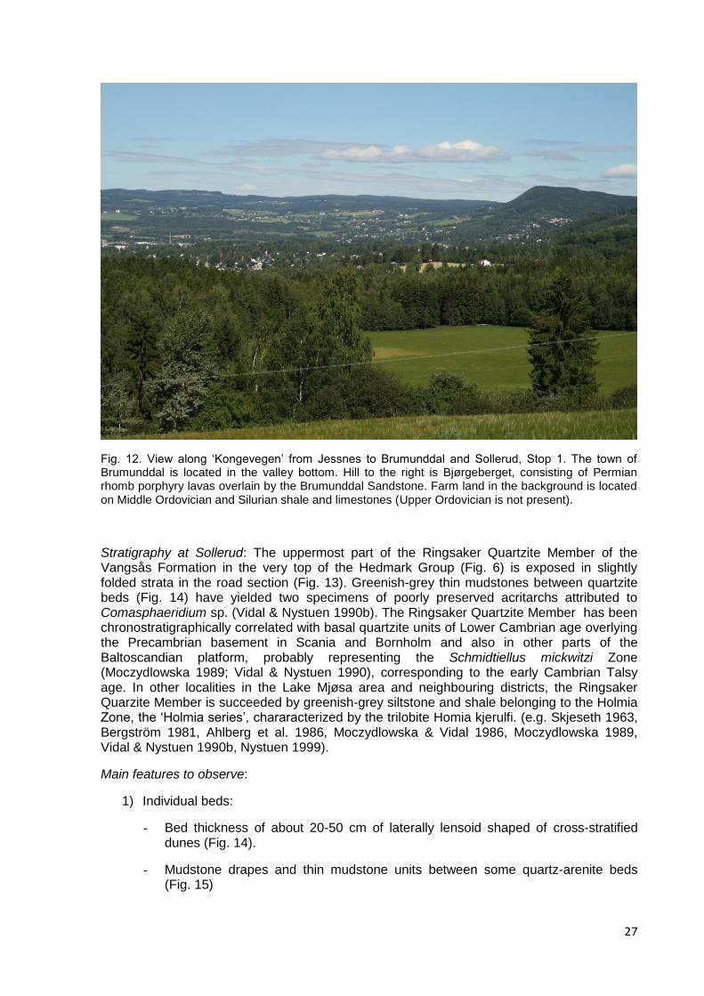
Fig. 12. View along „Kongevegen‟ from Jessnes to Brumunddal and Sollerud, Stop 1. The town of Brumunddal is located in the valley bottom. Hill to the right is Bjørgeberget, consisting of Permian rhomb porphyry lavas overlain by the Brumunddal Sandstone. Farm land in the background is located on Middle Ordovician and Silurian shale and limestones (Upper Ordovician is not present).
Stratigraphy at Sollerud: The uppermost part of the Ringsaker Quartzite Member of the Vangsås Formation in the very top of the Hedmark Group (Fig. 6) is exposed in slightly folded strata in the road section (Fig. 13). Greenish-grey thin mudstones between quartzite beds (Fig. 14) have yielded two specimens of poorly preserved acritarchs attributed to Comasphaeridium sp. (Vidal & Nystuen 1990b). The Ringsaker Quartzite Member has been chronostratigraphically correlated with basal quartzite units of Lower Cambrian age overlying the Precambrian basement in Scania and Bornholm and also in other parts of the Baltoscandian platform, probably representing the Schmidtiellus mickwitzi Zone (Moczydlowska 1989; Vidal & Nystuen 1990), corresponding to the early Cambrian Talsy age. In other localities in the Lake Mjøsa area and neighbouring districts, the Ringsaker Quarzite Member is succeeded by greenish-grey siltstone and shale belonging to the Holmia Zone, the „Holmia series‟, chararacterized by the trilobite Homia kjerulfi. (e.g. Skjeseth 1963, Bergström 1981, Ahlberg et al. 1986, Moczydlowska & Vidal 1986, Moczydlowska 1989, Vidal & Nystuen 1990b, Nystuen 1999).
Main features to observe:
1) Individual beds:
- Bed thickness of about 20-50 cm of laterally lensoid shaped of cross-stratified dunes (Fig. 14).
- Mudstone drapes and thin mudstone units between some quartz-arenite beds (Fig. 15)
28
- Mineral composition and grain size distribution
2) Upper boundary:
- Unconformity surface developed as „pipe rock facies‟ with Skolithos and Diplocaterion trace fossil, best exposures close to the bridge of the E6 (Skjeseth, 1963). Good samples get regulary removed by fossil collectors
- Phosphatic nodules close to the unconformity, may also have been removed by collectors
- Mudstone chips and granule and small pebbles at the unconformity
Interpetation and problems for discussion and future studies:
- Depositional environment and palaeowater depth, shoreface, mixed wave and tidally influenced sandy tidal flat
- Sequence stratigraphy, origin of upper boundary of the member: condensed interval of maximum flooding surface or/and subaerial unconformity/transgressive revinement surface, system tract
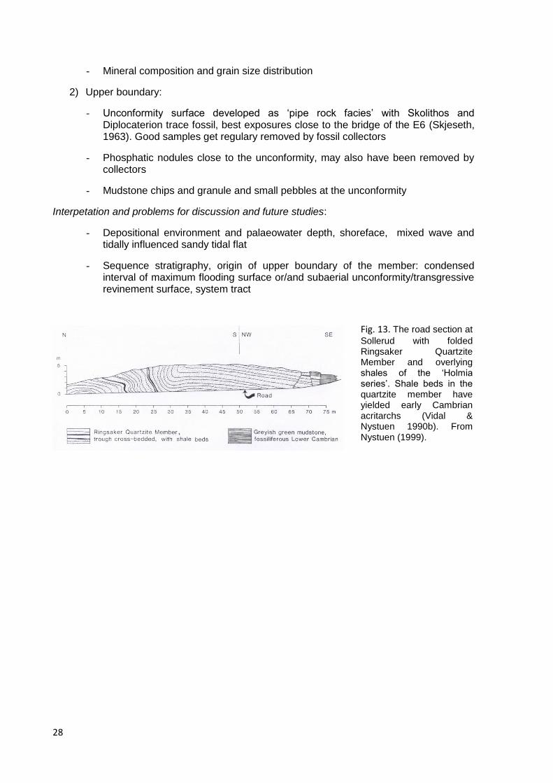
Fig. 13. The road section at
Sollerud with folded Ringsaker Quartzite Member and overlying shales of the „Holmia series‟. Shale beds in the quartzite member have yielded early Cambrian acritarchs (Vidal & Nystuen 1990b). From Nystuen (1999).

29
Fig. 14. Ringsaker Quartzite Member at Sollerud, Stop 1. Cross-bedded quartz-arenite beds.
Fig. 15. The Ringsaker Quartzite Member at Sollerud. Shale bed seen in the middle of the picture has yielded early Cambrian acritarchs (Vidal & Nystuen 1990b).

30
STOP 2 (optional): The Vangsås Formation, the Ringsaker Quartzite Member and overlying ‘Holmia series’, Steinsodden at Lake Mjøsa, the farm Stein, Ringsaker Location: Steinsodden. Geological map sheet GJØVIK 591900 6754200. WGS84 coordinates 0591816 6753989. Alternative route 1: Follow E6 westwards from Brumunddal to crossroad „Moelv vegkryss‟ just east of the town Moelv, enter the Highway 213 headed Stavsjø (southeast) to Evjevika after some few hundred meters. Park at „Mjøsa Pizzeria og Restaurant‟ or to the east of a shop selling cars. This route from Moelv crosses Rudshøgda, a local center for industry and trade and transport. „Prøysenstua‟, the home place of the author and trubadur Alf Prøysen, is a small grey house on top of a small hill on the southern side of E6. Farms to the north are located on Cambrian and Ordovician shales. The orthoceras limestone, the Stein Formation, outcrops in a marked hill, through wich the E6 crosses in tunnel. Alternative route 2: Follow E6 from Brumunddal to crossroad „Økulsrud vegkryss‟, 5 km west of the café „By the Way‟ at E6 in Brumunddal, local road westward headed Gaupen (crosses E6 on bridge), joining Highway 213 at the western side of the summit of the hill, passing Ringsaker Church and the farm Stein and to Evjevika (Korgerstuguvika) and the parking place here at „Mjøsa Pizzeria og Restaurant‟ and the car shop. This route runs through some of the most piqtoresque farm districts of Hedemarken and Ringsaker. Nice view from the summit of the road towards the west, south and east.
Path from „Mjøsa Pizzeria og Restaurant‟ at Evjevika to Steinsodden, about 1200 m (15-20 minutes). Steinsodden is a maked point at the eastern side of the northern narrow branch of Lake Mjøsa. Steinsodden should be visited at low water level in Lake Mjøsa, of safety reasons and also because large parts of the outcrop are below lake level at high water level.
Stratigraphy at Steinsodden: The uppermost part of the Ringsaker Quartzite Member of the Vangsås Formation and the overlying very fine-grained sandstones and siltstones of the „Holmia series‟. The lithostratigraphical boundary at this classical locality has traditionally been considered the Precambrian („Eocambrian‟)/Cambrian boundary (e.g. Skjeseth 1963) but is now, according to acritarch studies, interpreted to be close the chronostratigraphic boundary between the Lower Cambrian Schmidtiellus (below) and Holmia (above) biozones and with the age of the Ringsaker Member corresponding to the early Cambrian Talsy age (Vidal & Nystuen 1990b), see also STOP 1.
Main features to observe:
1) Structural position:
- Overturned position of strata towards the south (the socalled „Ringsaker inversion‟), separating bedrocks belonging mainly to the Neoproterozoic Hedmark Group to the north from Cambro-Silurian successions to the south (Fig. 16). The structural line of overturned strata is one of several corresponding structures within a large imbricate fan of the Osen-Røa Nappe Complex in the area (A. Bjørlykke 1973, Høy & A. Bjørlykke 1980). At Steinsodden the contact between the Ringsaker Quartzite Member and the „Holmia series‟ beds above appear little tectonically disturbed; in other localities thrust movements have disturbed the pirmart depositional features at the contact.
2) Individual beds:
- Bed thickness of about 10-50 cm of the Ringsaker Quartzite Member

31
- Dominating medium to coarse grain size in the quartzarenite of the Ringsaker Member
- Individual sandstone beds of the Ringsaker Member are lensoid and cross-stratified
- Locally some vertical burrows are present close to the top of the Ringsaker Quartzite Member
3) Upper boundary of the Ringsaker Quartzite Member:
- The boundary is a marked lithological surface with coarse-grained sand or thin granule-pebble lag bed at the boundary
4) Succession above the Ringsaker Quartzite Member:
- The succession directly above the Ringsaker Member, has been termed the Bråstad sandstone and shale (Skjeseth 1963) and consists in lower part of very fine- to fine-grained greenish grey sandstone (Bråstad sandstone) that passes upwards ito 25-30 m thick, thin-bedded greenish-grey siltstone and shale (Bråstad shale)
- Individual beds in the Bråstad sandstone and shale unit are ripple-cross laminated and parallell laminated
- The Bråstad sandstone and shale is succeeded by Cambrian Alum Shale further to the south along the beach of Lake Mjøsa.
Interpetation and problems for discussion and future studies:
- The geological significance of the unconformity between the Ringsaker Quartzite Member and the overlying „Holmia series‟ of the Bråstad sandstone and shale unit, minor hiatus of marine ravinement or subaerial unconformity succeeded by transgression (and ravinement)?
- What is the regional significance of the boundary in terms of the transgressive history of the continent Baltica?
- The overall rise in sea level during early Cambrian, likely eustatic, has created changes in rate of accommodation versus rate of sedimentation (A/S). How has this change in allogenic control on sedimentation affected the energy distribution in the shallow sea, transport of siliciclastic detritus and ecological conditions for living organisms on the sea bottom and within the water masses in the epicontinental sea (temperature, salinity, oxygenation, nutrient conditions, waves and currents).

32
Fig. 16. Steinsodden, STOP 2. At low lake level in Mjøsa (as in this picture), the boundary between the Ringsaker Quartzite Member (to the left of the person) and the stratigraphically overlying „Holmia series‟ fine-grained sandstone and siltstone (right side of the person) is well exposed. This is the classical „Ringsaker inversion‟ with strata overturned to the south (to the right).
STOP 3 (a,b and c): The Ring Formation and the Moelv tillite, Highway 213, town of Moelv Location: Road section in Hw213 and in backyard of the supermarket ‘Mjøsa SPAR’. Geological map sheet GJØVIK 592300 6755800. WGS84 coordinates 0592255 6755613. The road sections are located at the north side of the highway, along walking and bicycle path south and north of the supermarket, about 500 m north-west of the crossroad „Moelv vegkryss‟ between E6 and Hw213.
Stratigraphy: Upper part of the Vendian (Ediacaran) Ring Formation and the lower part of the Ediacaran Moelv Formation. The boundary between the two formations is exposed at STOP 3b (see below).
Structural position: The formations outcrop within an assymetrical anticline (the Bruvollhagan anticline) with strata dipping north at an angle of about 30o at the northern side of the anticline (STOP 3a) and close to vertical at the south side (southern end of STOP 3b and in 3c). The anticline is located in the southern part of the Moelv duplex (A. Bjørlykke 1973) and forms a prominent ridge trending ENE from STOP 3. The STOP 5a-c in Bruvollhagan are located within the same anticline as the strata to be seen at STOP 3.
33
STOP 3a in road sections north of the supermarket ‘Mjøsa SPAR’
WGS84 coordinates 0592241 6755707. Location: Follow the path for pedestrians and bycyclists towards west and the center of the town Moelv. Main features to observe: Lithology of the Ring Formation, Log 12 of Kunz (2002)
- 1-3 m thick beds of conglomeratic arkose with poorly defined amalgamated bed contacts are organized in depositional units from about 1 m to at least 6 m in thickness; some of these coars-grained units are separated by thin beds and bedsets of greenish-grey laminated siltstone and interchanging siltstone-thin sandsone units (up to about 1 m thick)
- Parallell stratification is characterised by thin beds and laminae with rounded quartz-pebbles
- Some laminae are calcaeous and cemented by poikilotopic carbonate
STOP 3b in the backyard of the supermarket ‘Mjøsa SPAR’
WGS84 coordinates 0592289 6755581. Location: The back yard is located at the south side of the shop building, sections cut into the hill. Main features to observe: Axis of the Bruvollhagan anticline and the contact beteween the Ring Formation and the Moelv tillite (Fig. 17). The upper part of the Ring Formation is here exposed with thin-bedded sand- and siltstone beds overlain by a structureless to poorly stratified pebble conglomerate, dipping north of the anticlinal axis and vertically at the south side of the axis, cut by a series small thrusts and fractures.
- The lithological boundary between the Ring Formation (to the north) and the overlying Moelv tillite above (to the south) appears tectonically undisturbed (though folded to vertical position). The Ring Formation is a monomict quartz- and qaurtzite conglomerate whereas the Moelv Formation is polymict diamictitet.

34
Fig. 17. STOP 3b. Section in the central axis of the Bruvollhagan anticline, viewing eastwards. The crest of the anticline can be seen in the central part of the picture (in shadow) with the pebble conglomerate in top of the Ring Formation to the right and (left of the red water bowl) and the overlying diamictite of the Moelv Formation at the margin of the picture to the right.
STOP 3c in road sections south of the supermarket ‘Mjøsa SPAR’
WGS84 coordinates 0592246 6755555. Location: Follow the path for pedestrians and byciclists southwards from the supermarket „Mjøsa SPAR‟ to the tunnel underneath Highway 213 Main features to observe: Lithology of the Moelv Formation in road sections south of the supermarket „Mjøsa SPAR‟.
- The Moelv Formation is developed as a greenish-grey structureless diamictite with silty-sandy matrix
- Clasts are varying in size from granules up to about 40 cm in diameter and are angular to subrounded and consist of granite, gneiss, quartzite and carbonate rocks.
STOP 4 (a, b, c, d and e): The Moelv tillite, Vardal Sandstone Member and the Ring Formation at the Moelv Brygge and along the Lake Mjøsa shore line, town of Moelv Location: From Moelv brygge at the Lake Mjøsa and about 1.2 km northwards along the shoreline (and road sections in E6) there are access to several outcrops along forest paths. Details of the Moelv duplex structure can be studied in road sections along E6 at the western end of a tunnel, but due to heavy trafic the sections here are not reccommended for excursions (except for just few persons at times of small trafic).

35
From E6 on the the Highway 213 towards the town Moelv. Two road options. Road option 1: take road to the left (south) from Hw213 vis á vis STOP 3 at the supermarket „Mjøsbrua SPAR‟ to „Moelv brygge‟ and „Strand Brænderi‟, the road turns abruptly to left and passes under E6 (height 3.8 m) to the marina at Lake Mjøsa and from there to Moelv brygge (parking place, no fee). Road option 2: Follow Hw213 towards the town of Moelv and turn left at the crossroad at the southern side of the railway bridge before entering the central street of the town. Turn left once again just after having left the Hw213 and follow this local road down to the marina and Moelv brygge at Lake Mjøsa.
Stratigraphy: The section presents the Ring Formation with overlying Moelv tillite and also parts of overlying Ekre Formation and the Vardal Sandstone Member of the Vangsås Formation.
Structural position: The outcrops are located within three indivdual thrust sheets of the Moelv duplex (A. Bjørlykke 1973; Morley 1986). By this reason the formations are tectonically repeated along the sections. The shale of the Ekre Formation is tectonically strongly squeezed or soil-covered (except in the road section along E6) and parts of the Vardal Sandstone Member are also tectonically cut out of the succession. All strata dip to the north within the individual thrust sheets, and the beds young to the north. This major locality is here subdivided in STOPS 4a, 4b, 4c, 4d and 4e, numbered from south to north.
STOP 4a: Moelv brygge (pier). Moelv tillite
Geological map sheet GJØVIK 591500 6755700. WGS84 coordinates 0591385 6755552. Main features to observe: Lithology of the Moelv tillite at the north side of the Moelv brygge (pier). The Moelv Formation is protected by Law in this locality, and hammers should not be used.
- The greenish-grey (brown on weathered surfaces) diamictie is unstratified with silty-sandy reddish brown matrix.
- The diamictite contains angular to subrounded clasts of granite, gneiss, quartzite, large pinkish alkali feldspar (up to c. 3 cm large pebbles) and limestone up to a maximun diameter of about 30-40 cm (granite).
- The clasts are randomly distributed and apparently no preferred orientation of clasts is recorded in this locality.
STOP 4b: Forest and bicycle path c. 100 m north of Moelv brygge. Vardal Sandstone Member
Geological map sheet GJØVIK. WGS84 coordinates 0591382 6755639 Main features to observe: The Moelv tillite at Moelv brygge is to the north succeeded by strongly tectonized siltstone of the Ekre Formation. The siltstone is here coverd by soil in a shallow depression in the terrain, but is exposed in the E6 road section to the north. Reddish-brown feldspathic sandstone beds belonging to the Vardal Sandstone Member crops out on both side of the path. The beds are about 0.5-1 m thick and cross-stratified, but are here mostly covered by lichen. The Vardal Sandstone Member of this facies is interpreted as deposits form braided streams.
STOP 4c: The ‘Tillite Quarry’ c. 480 m north of Moelv brygge (along path). Ring Formation and Moelv tillite
Geological map sheet GJØVIK.

36
WGS84 coordinates 0591339 6755808.
Location and background of the ‘Tillite Quarry’: Follow the path northwards from Moelv brygge and below Mjøsbrua, bridge crossing Lake Mjøsa, follow the path close to the northern side of E6 up to small quarry just at the side of E6 about 50 metres from the bridge (Fig. 18). The quarry was made by Statens Vegvesen, the public road authority, for the purpose of geological excursions, as a substitution for a former, excellently exposed glacially polished outcrop of the contact between the Ring Formation and the Moelv tillite, now covered by road masses of E6 at the eastern end of the Mjøsabrua. J.P. Nystuen submitted a proposal for protection by Law of this exposure to the Department of Environment in the early 1970s. When the new E6 was planned (previous E6 followed the present Hw213), the Ring/Moelv formation contact happened to be located exactly at the midline of the new road where the E6 should cross the lake by bridge! Instead of insisting that the road position should be changed, this particular small „Tillite Quarry‟ was accepted. The quarry is a frequently visited site for people interested in the Neoproterozoic glaciation in South Norway.
Please, do not use hammer in the Tillite Quarry!
Main features to observe:
- There is a distinct lithological contact between the gravelly sandstone of the Ring Formation below and the diamictite of the Moelv Formation above. The strata are dipping north.
- The contact, considered to be an original depositional contact, is in the quarry slightly disturbed due to tectonic movements (but not at the former exposure, now underneath E6!).
- The lithology of the Ring Formation is a very coarse-grained to conglomeratic arkose, poorly stratified with pebbles of quartz and quartzite.
- The diamictite of the Moelv Formation has an overall finer-grained matrix than the underlying Ring Formation, except just above the contact where the matrix of the diamictite is enriched in very coarse sand grains and granule particles that may have been derived from underlying formation. Clasts in the Moelv Formation are angular to subrounded and the assemblage is polymict with granite, gneiss, quartzite, quartz and limestone as typical lithologies.
- Conglomerate beds have lower erosive boundaries and may carry greenish-grey mudstone clasts in the lower parts above the erosional lower boundary; some „floating‟ mudstone flakes up to about 20 cm in diameter are also present in the upper part of some beds.
- Some few discontiunous greenish-grey mudstone beds are present in the succession.
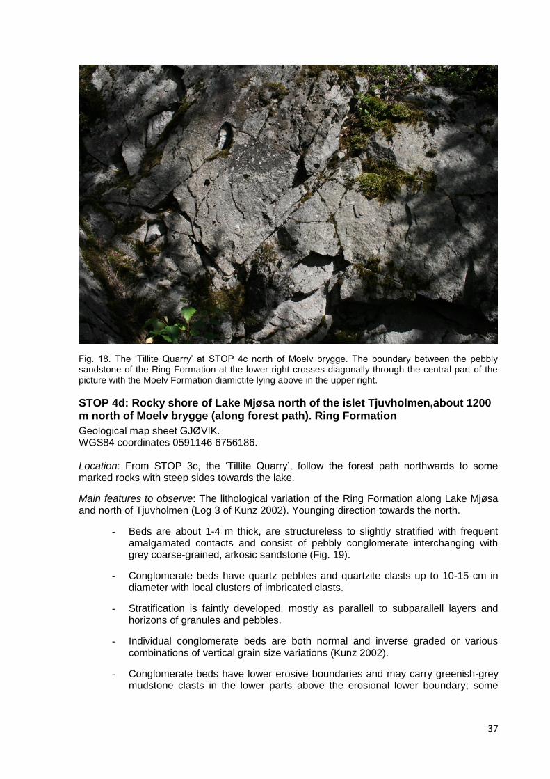
37
Fig. 18. The „Tillite Quarry‟ at STOP 4c north of Moelv brygge. The boundary between the pebbly sandstone of the Ring Formation at the lower right crosses diagonally through the central part of the picture with the Moelv Formation diamictite lying above in the upper right.
STOP 4d: Rocky shore of Lake Mjøsa north of the islet Tjuvholmen,about 1200 m north of Moelv brygge (along forest path). Ring Formation
Geological map sheet GJØVIK. WGS84 coordinates 0591146 6756186. Location: From STOP 3c, the „Tillite Quarry‟, follow the forest path northwards to some marked rocks with steep sides towards the lake.
Main features to observe: The lithological variation of the Ring Formation along Lake Mjøsa and north of Tjuvholmen (Log 3 of Kunz 2002). Younging direction towards the north.
- Beds are about 1-4 m thick, are structureless to slightly stratified with frequent amalgamated contacts and consist of pebbly conglomerate interchanging with grey coarse-grained, arkosic sandstone (Fig. 19).
- Conglomerate beds have quartz pebbles and quartzite clasts up to 10-15 cm in diameter with local clusters of imbricated clasts.
- Stratification is faintly developed, mostly as parallell to subparallell layers and horizons of granules and pebbles.
- Individual conglomerate beds are both normal and inverse graded or various combinations of vertical grain size variations (Kunz 2002).
- Conglomerate beds have lower erosive boundaries and may carry greenish-grey mudstone clasts in the lower parts above the erosional lower boundary; some

38
„floating‟ mudstone flakes up about 20 cm in diameter are also present in the upper part of some beds.
- Some few discontiunous greenish-grey mudstone beds are present in the succession.
Fig. 19. The pebbly conglomerate unit in the upper part of the Ring Formation at Lake Mjøsa, north of Mjøsbrua, Moelv, STOP 4d. The conglomerate is poorly stratified to structureless.
STOP 4e: Shore of Lake Mjøsa in a small bay at the northern side of the rocky knob of STOP 4d, about 1250 m (along path) from north of Moelv brygge. The boundary between the Ring Formation and the Moelv tillite
Geological map sheet GJØVIK. WGS84 coordinates 0591179 6756216. Location: From STOP 4d, follow a path at the northern side of the steep rock knob with the conglomeratic Ring Formation down to the lake in the small bay at the northern side of this rock.
Main features to observe: The northern exposed boundary between the Ring Formation (to the south) and the Moelv Formation (to the north). This is a very small outcrop, only exposed during low water in the Lake Mjøsa.
- The boundary is a lithologically marked unconformity between the conglomeratic Ring Formation below (to the south) and the diamictite of the Moelv tillite above (to the north) (Fig. 20). The Ring Formation conglomerate is monomict with dominantly quartz and quartzite pebbles whereas the Moelv Formation diamictite is polymict and unsorted. The matrix of the Moelv diamictite is in the lower part coarse-grained and pebbly.
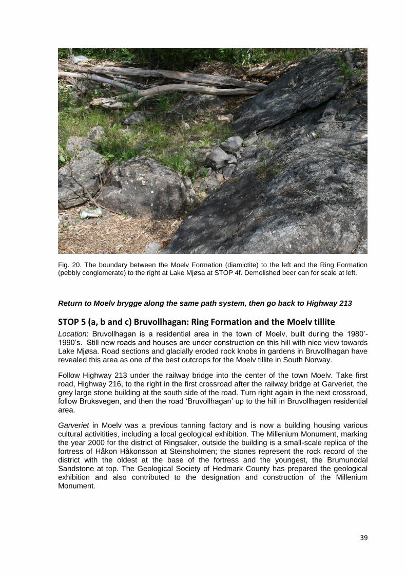
39
Fig. 20. The boundary between the Moelv Formation (diamictite) to the left and the Ring Formation (pebbly conglomerate) to the right at Lake Mjøsa at STOP 4f. Demolished beer can for scale at left.
Return to Moelv brygge along the same path system, then go back to Highway 213
STOP 5 (a, b and c) Bruvollhagan: Ring Formation and the Moelv tillite Location: Bruvollhagan is a residential area in the town of Moelv, built during the 1980‟-1990‟s. Still new roads and houses are under construction on this hill with nice view towards Lake Mjøsa. Road sections and glacially eroded rock knobs in gardens in Bruvollhagan have revealed this area as one of the best outcrops for the Moelv tillite in South Norway.
Follow Highway 213 under the railway bridge into the center of the town Moelv. Take first road, Highway 216, to the right in the first crossroad after the railway bridge at Garveriet, the grey large stone building at the south side of the road. Turn right again in the next crossroad, follow Bruksvegen, and then the road „Bruvollhagan‟ up to the hill in Bruvollhagen residential area.
Garveriet in Moelv was a previous tanning factory and is now a building housing various cultural activitities, including a local geological exhibition. The Millenium Monument, marking the year 2000 for the district of Ringsaker, outside the building is a small-scale replica of the fortress of Håkon Håkonsson at Steinsholmen; the stones represent the rock record of the district with the oldest at the base of the fortress and the youngest, the Brumunddal Sandstone at top. The Geological Society of Hedmark County has prepared the geological exhibition and also contributed to the designation and construction of the Millenium Monument.
40
STOP 5a (optional): ‘Bruvollsvingen’ in the road ‘Bruvollhagan’. Ring Formation.
Geological Map sheet GJØVIK. WGS84 coordinates 0592539 6756187. Location: Following the road „Bruksvegen‟ from Highway 216, cross the river Moelva and then turn into the road „Bruvollhagan‟ to the right at a sharp bend, informally called the „Bruvollsvingen‟, about 200 m from Moelva. The Ring Formation is exposed in road sections along Bruksvegen up to „Bruvollsvingen‟ in one nearly continously exposed succession.
Main features to observe: The Ring Formation is exposed in the road section with beds dipping north at the limb of the Bruvollhagan anticline. The beds are continuous along strike with the strata in STOP 3a at Highway 213 and is together with the exposed beds in Bruksvegen logged in a thickness of 130 m, logs „Bruksvegen‟ and „Bruvollsvingen‟ of Kunz (2002).
- Succession of well stratified grey, medium- to coarse-grained sandstone beds, pebbly sandstone and thin siltstone beds and laminae.
- Beds are normal graded, inverse graded and non-graded.
- Lower bed contacts are erosional and grey mudstone chips are present as clasts at the base of some sandstone beds.
- The succession is terminated by a very thick unit of structureless to poorly stratified pebbly conglomerate (to be seen in STOP 5b).
- The succession in Bruksvegen and Bruvollsvingen is interpreted by Kunz (2002) to mainly represent gravity flow deposits in channels and chutes of a subaquous delta.
STOP 5b: Section in the road Ekreskogen in Bruvollhagan residential area. Ring Formation.
Geological Map sheet GJØVIK. WGS84 coordinates 0592579 6755804. Location: Following the road „Bruvollhagan‟ uphill to the crossroad between the roads „Ekreringen‟ and „Ekreskogen‟, follow „Ekreskogen‟ to the west close to the crest of the hill for about 30 m.
Main features to observe:
- The uppermost part of the Ring Formation, the strucureless to poorly stratified quartz and quartzite pebble conglomerate (Fig. 21).
- The conglomerate corresponds to the pebble conglomerate at top of the Ring Formation and below the Moelv tillite at STOP 3b.
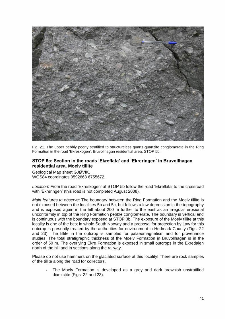
41
Fig. 21. The upper pebbly poorly stratified to structureless quartz-quartzite conglomerate in the Ring Formation in the road „Ekreskogen‟, Bruvollhagan residential area, STOP 5b.
STOP 5c: Section in the roads ‘Ekreflata’ and ‘Ekreringen’ in Bruvollhagan residential area. Moelv tillite
Geological Map sheet GJØVIK. WGS84 coordinates 0592663 6755672. Location: From the road „Ekreskogen‟ at STOP 5b follow the road „Ekreflata‟ to the crossroad with „Ekreringen‟ (this road is not completed August 2008).
Main features to observe: The boundary between the Ring Formation and the Moelv tillite is not exposed between the localities 5b and 5c, but follows a low depression in the topography and is exposed again in the hill about 200 m further to the east as an irregular erosional unconformity in top of the Ring Formation pebble conglomerate. The boundary is vertical and is continuous with the boundary exposed at STOP 3b. The exposure of the Moelv tillite at this locality is one of the best in whole South Norway and a proposal for protection by Law for this outcrop is presently treated by the authorities for environment in Hedmark County (Figs. 22 and 23). The tillite in the outcrop is sampled for palaeomagnetism and for provenance studies. The total stratigraphic thickness of the Moelv Formation in Bruvollhagan is in the order of 50 m. The overlying Ekre Formation is exposed in small outcrops in the Ekredalen north of the hill and in sections along the railway.
Please do not use hammers on the glaciated surface at this locality! There are rock samples of the tillite along the road for collectors.
- The Moelv Formation is developed as a grey and dark brownish unstratified diamictite (Figs. 22 and 23).

42
- The Moelv diamictite is unsorted with clasts up to about 1.5 m in diameter (gneiss). Clasts are dominantly angular to subangular and comprise several types of granite, gneiss, porphyries, quartzites, quartz and grey limestone.
- There is no obvious preferred orientation or fabric of the clast (has not been measured)
- The matrix of the diamictite is unsorted, consisting of a mixture of sand, silt and clay fractions.
Fig. 22. The Moelv Formation at the Ekreskogen road in Bruvollhagan residential area (STOP 5b). This rock surface is shaped by the late Pleistocene Weichselian ice sheet and exposes diamictite of a glacial diamictite of the late Cryogenian or early Ediacaran glacial event.

43
Fig. 23. Detail of the diamictite of the Moelv Formation in STOP 5b in Bruvollhagan. Clasts of granite, gneis and quartzite with holes after weathered limestone clasts.
Summary of the Ring and Moelv formations in the Moelv type area
The Ring and the Moelv formations are exposed within severeal imbricated thrust sheets in the Moelv duplex. Main features of the succession and the boundary relations:
- The Ring Formation is an overall upward-coarsening succession of coarse-grained arkosic sandstone beds terminating at top with a structureless and poorly stratified monomict quartz and quartzite pebble conglomerate.
- The upper pebble conglomerate unit of the Ring Formation varies in thickness from 2-3 m (STOP 3b) to at least 100 m (STOP 4d).
- The Ring Formation is bounded stratigraphically upwards by an erosional unconformity on top of the pebble conglomerate and beneath the Moelv Formation.
- The Moelv Formation is developed as a polymict unstratified diamictite (tillite) with recorded maximum clast size of about 1.5 m.
- The textural composition of the basal part of the diamictite of the Moelv Formation indicates that the upper part of the Ring Formation may have been unconsolidated, or poorly consolidated when the glacial diamictite was deposited.
- The Ring Formation in this locality is interpreted to have been formed subaquously by gravity flow mechanism as the proximal parts of an advancing fan delta, organized as vertically stacked major channel infills, forming a slightly upward coarsening succession or a succession without any significant vertical change in grain size (Kunz 2002). Alternative interpretations should be discussed.

44
- Points to be discussed can include: Was the glacial erosion submarine and close to the buoyancy limit of the glacier ice? Or above upper limit of the sea level? May the diamictite represent a marine (or subaerial) debris flow of collapsed till debris settled at the front of a glacier ice sheet? Does the Moelv Formation represent just one event of glacial advance-retreat, or several? What was the direction of glacial flow? Was the glacier ice a continental ice sheet or just mountain glaciers surrounding the depositional basins?
STOP 6 (optional): Upper part of the Biri Formation and lower part of the Ring Formation, Kjosberget, road section in Highway 213, Ring Locality: Kjosberget. Map sheet GJØVIK 590100 6760100. WGS84 coordinates 0599937 6760004. Location: Road section in Highway 213 („Turistvegen‟) at the western end of the mountain ridge Kjosberget, the district of Ring, 4.2 km north of Moelv railway station, 500 m north of Ring railway station and 300 m WNW of the farm Rise. The Ring Formation is logged in a thickness of 398 m in western part of the hill Kjosberget (Kunz 2002). This section is the hypostratotype of the formation.
Stratigraphy: Acritarchs in the upper part of the Biri Formation and in mudstone in lower part of the Ring Formation indicate Vendian age, possibly early Vendian sensu Vidal & Siedlecka (1983) and Vidal & Nystuen (1990a). This may correspond to early Ediacaran.
Structural geology: The boundary between the Biri and the Ring formations are at the western end of the hill Kjosberget located in the bend of a large synclinal structure, Lundehøgda syncline. Towards the south and the north the Biri Formation crops out within adjacent anticlinal structures, bounded upwards by the at least 400 m thick conglomeratic Ring Formation in the hills Lundehøgda to the east and Kjosberget to the west (Kjosberget being the western extension of Lundehøgda). The uppermost partof the Ring Formation in Lundehøgda, above the 398 m thick logged interval (Kunz 2002), consists of a thick pebble conglomerate (clasts of quartz, quartzite and red potasium feldspar). The Moelv, Ekre and Vangsås formations crop out in the central part of the Lundehøgda syncline. Thrusts within soft shales in the Biri Formation, beneath the Lundehøgda syncline, form the roof thrust of the Moelv duplex (Høy & A. Bjørlykke 1980; Morley 1986).
Main features to observe:
- The Biri Formation is in the agricultural district of Ring mainly a dark grey to black, carbonaceous and calcareous shale, mostly covered by cultivated clay-rich till soils derived from the immediate underlying bedrock.
- The uppermost part of the Biri Formation is developed as grey, finely laminated mudstone, coarsening upwards into siltstone and fine-grainede thin sandstone beds, poorly exposed along the northern side of Highway 213.
- The lower beds referred to the Ring Formation are conglomeratic with marked erosional contacts towards underlying grey mudstone/siltstone/fine-grained sandstone of the Biri Formation.
- The Ring Formation consists of thick-bedded conglomerate with quartz pebbles filling broad channel entrenchements, grading upwards into coarse-grained gravelly arkosic sandstone. The composite channel infill unit is about 10 m thick.
- Irregular clasts of greenish-grey mudstone occurs in the lower part of conglomerate beds that are commonly normal graded, often with amalgamated

45
contacts between graded beds, with erosional remnants of discontinuous grey mudstone laminae or thin beds between the coarse-grained and conglomeratic beds.
- Several similar channel infill units are stacked vertically in the 400 m thick Kjosberget type section, forming several upward composite successions ending on top of grey mudstone or heterolithic mudstone/fine-grained sandstone units (Kunz 2002).
Interpetation and problems for discussion and future studies:
The Ring Formation in the Kjosberget type section is interpreted to represent stacks of submarine channels, channel-lobe complexes, chutes infill units and channel levee facies, all belonging to an overall prograding and upward coarsening fan delta (Nystuen 1999; Kunz 2002). After having visited other sections of the Ring Formation in the Moelv area, the depositional environment and controlling factors can be discussed (tectonic, climatic), besides the dynamics of the submarine fan system.
STOP 7: Uppermost part of the Brøttum Formation and lower part of the Biskopåsen Formation, Havik, Highway 213 Location: Havik. Geological map sheet GJØVIK Road sections, Highway 213, 9 km north of Moelv railway station. Parking for busses along Highway 213 at Havik, WGS84 coordinates 0586739 6762879. Private cars can park along the road to the farm Havik Øvre, WGS84 coordinates 0586739 6762879.
Stratigraphy: Road sections along Highway 213 from the departure to the farm Havik (WGS coordinates 0586739 6762879) and southwards for about 470 metres reveal exposures in the uppermost part of the Bøttum Formation (STOP 7a), the boundary between the Brøttum Formation and the overlying Biskopåsen Formation (STOP 7b) and about 100 m of the lower part of this formation further to the south. It should be noted that the geological map sheet GJØVIK (A. Bjørlykke 1973) shows Biri Formation interfingering with conglomerate bodies of the Biskopåsen Formation. This has been remapped and reinterpreted by Holme (2002). She documented that the Biskopåsen Formation rests directly on turbidite sandstone and shale of the Brøttum Formation, not upon the Biri Formation, as previously stated by A. Bjørlykke (1973) and Nystuen (1999).
Phosphorite clasts in the conglomerate at the base of the Biskopåsen Formation have yielded microfossils (Manum 1967) and the enigmatic fossil Papillomembrana compta (Spjeldnæs 1963; Vidal 1990). Shale beds within the Biskopåsen Formation at other localities have given acritarchs indicating Vendian age (Vidal & Nystuen 1990a).
Structural geology: The upper part of the Brøttum Formation and the overlying Biskopåsen and Biri formations are folded together in a broad syncline in the hill Biskopåsen (Fig. 10). The syncline is broken by several thrust faults, particularly towards the south where conglomerate strata in the Biskopåsen Formation dip vertically at the southern limb of a tightly compressed anticline bounding the Biskopåsen anticline to the south (Holme 2002). Stratigraphic up is towards the south in the locality of STOP 7.
STOP 7a: Road section along Highway 213 at Havik for about 160 m from southbound Buss stop
Geological Map sheet GJØVIK. Main features to observe:

46
The Brøttum Formation is exposed along Highway 213 in alltogether 129 m of stratigraphic thickness (Log 1 of Holme 2002). Turbidite sandstone beds, varying in thickness from some few centimetres to about 2 metres, interchange with dark grey mudstone and black shale. The sandstone beds vary in grain size from very fine sand in the thinnest beds to very coarse sand in the thickest beds.
STOP 7b: Road section along Highway 213 at Havik, 260 m south of crossraod to the farm Havik Øvre
Geological map sheet GJØVIK. WGS coordinates 0586812 6762641. Main features to observe:
- Lower boundary. The lower boundary of the Biskopåsen Formation is a marked erosional unconformity with conglomerate beds resting directly upon thin beds of fine- to medium-grained turbidite sandstone and mudstone of the Brøttum Formation. The boundary is close to vetical here in the road section (Fig. 24).
- Lithology of lower part. The lower 10-20 m of the Biskopåsen Formation has the character of a non-sorted and unstratified to poorly stratified breccia with clasts up to a diameter of 2-3 metres (Fig. 24). The polymict breccia contains angular to rounded pebbles, cobbles and boulders of extrabasinal and intrabasinal origin (Holme 2002). The extrabasinal clasts comprise various types of quartzite (60% of total clast content), hydrothermal quartz (20%), granite, foliated granite and meta-rhyolites (felsites). The extrabasinal clasts are generally subrounded to rounded and range in size from 1-2 cm up to about 40 cm. Clasts of extrabasinal origin include basalt (greenstone) (c. 1%), siltstone, sandstone, calcareous sandstone, limestone and phosphorite. Clasts of this assemblage vary in size from small pebbles to boulders 2-3 m in diameter (calcareous sandstone) and are typically angular to subangular. Calcareous sedimentary rocks comprise about 2% of the total clast content. Siltstone, sandstone and phosphorite clasts make about 5%.
- Lithology of upper part. The disorganized lower part of the Biskopåsen Formation passes upwards into a stratified higher part consisting of c. 0.1 to 3 m thick lensoid conglomerate beds interchanging with grey structureless medium- to coarse-grained sandstone beds (Fig. 25). Conglomerate and sandstone beds grade into each other, and sandstone of same type as in the sandstone beds occur as sand matrix in all conglomerate facies of the Biskopåsen Formation.
- Clasts. Clasts in the stratified conglomerate bed facies are dominated by clasts of extrabasinal origin, hydrothermal quartz, quartzite, meta-rhyolite and granite. The clasts are commonly 2-15 cm and subrounded to rounded.The conglomerate beds in the Biskopåsen Formation are clast-supported as well as matrix-supported, and clasts may be imbricated with a(p)a(i)-imbrication (Holme 2002).
- Faults. The Biskopåsen Formation is in the Highway 213 road section cut by faults belonging to several stages of the Caledonian thrust history. The latest Caledonian faults are low-angle faults, dipping north, cutting the steeply dipping bedding of the conglomerate formation.

47
Fig. 24. The lower breccia (mass transport complex) of the Biskopåsen Formation in the road section of Highway 213 at Havik, STOP 7b. The person for scale is standing directly on the boundary between the Brøttum Formation turbidite sandstone to the left and the canyon fill conglomerate of the Biskopåsen submarine fan to the right. Largest clast (up to the right) is a calcareous sandstone about 2-3 meter in diameter.
Fig. 25. The uppermost part of the lower breccia (mass transport complex) and the lower part of overlying channelized conglomerate fan of the Biskopåsen Formation. Road section in Highway 213, Havik, STOP 7b. Dark boulder clasts consist of basalt and white clasts of quartz and quartzite pebbles.
48
Interpetation and problems for discussion and future studies
- The succession demonstrated in this locality at Havik along Highway 213 represents a submarine fan complex in the upper part of the Brøttum Formation, cut by a submarine unconformity and overlain by the Biskopåsen conglomerate fan or fan complex (Nystuen 1987, 1999; Holme 2002).
- The lower chaotic breccia in the Biskopåsen Formation is interpreted to represent the infill of a submarine canyon or major channel cut into the Brøttum Formation, introducing the establishment of the Biskopåsen fan (Nystuen 1987, 1999; Vidal & Nystuen 1990a; Holme 2002). The disorganized basal breccia facies may represent a mass transport complex (MTC).
- The angular to subrounded intrabasinal clasts indicate that a submarine canyon cut into a narrow shallow-marine platform with consolidated calcareous sediments, mudstone, shale with phosphotite nodules and basalt flows along the margin of the Hedmark Basin. The canyon likely was connected to a fluvial system that carried the more rounded clasts into the feeder system, likely intermittently deposited as a fan delta in the head of the submarine canyon.
- The upper stratified part of the Biskopåsen Formation is interpreted to a 80 km2 large submarine fan complex formed by deposition of gravelly debris and sand by debris flows and turbidity currents in channels, channel-lobes and sheets (Nystuen 1999; Holme 2002). Siltstone beds within the formation splits the fan complex in 2 individual fans (Holme 2002).
- The Biskopåsen fan formation is generally considered to represent a major stage of rifting (e.g. Kumpulainen & Nystuen 1985, Nystuen 1987; Siedlecka et al. 2004). A provenance study by zircon age determination of granite and rhyolite clasts is in progress. Constraining of hinterland drainage areas for various fans of the Biskopåsen Formation is imporant in the discussion of triggering mechanisms for its origin. A climatic factor (melt water from mountain glaciers or increased precipitation) can not be excluded.
Brøttum Formation, Lillehammer area: The Lillehammer Submarine Fan Complex
Structural geology: The Brøttum Formation is the dominating formation in western part of the Hedmark Basin both by thickness and extent. Due to complex thrust geometry in the original type area at Brøttum, a series of road sections in the town of Lillehammer are chosen as reference sections. The Brøttum Formation is folded into a several kilometers broad anticline in the town of Lillehammer. In the northern part of the town, north of Maihaugen, the strata dip slightly towards the north. The axial plane of the Lillehammer anticline is cut by a trust fault, dipping steeply to the north. On the southern side of this fault, the beds are orientated vertically close to the major thrust fault; the dip of the beds decreases southward. In her Master Thesis, Skaten (2006) correlated several road sections at the southern side of the master thrust fault and demonstrated that the Brøttum Formation in this area is developed as a large submarine fan, the Lillehammer submarine fan complex. The fan complex is about 1500 m thick and starts from a thick unit of basin floor black shale and continues upwards through several lobes (or smaller fans) and channel-levee complexes to very thick and coarse-grained fan sandstone body formed by stacked braided-channel infill turibidite sandstones.
The Lillehammer submarine fan complex will be visited in road secions at Maihaugen (STOP 8), close to the center of the town and will also be seen during an optional sight-seeing in Lillehammer area, with a visit to the jumping hill Lysgårdsbakken, the Olympic arena of the 17th Winter Olympic Games in 1994, STOP 9.

49
STOP 8: Brøttum Formation, Maihaugen, Lillehammer Location: Maihaugvegen and Messenlivegen, Lillehammer. Geological map sheet LILLEHAMMER 579450 6776150. WGS84 coordinates 0579412 6775934.
Road sections: Most of the sections are now covered with steel curtains due to falling stones from the road cut.
Stratigraphy: Shale beds from this locality have yielded several sporomorph species, such as that with spherical cellular aggregates attributed to Sphaerocongreus sp., probably representing cyanobacteria. The age is likely late Riphean (Cryogenian) (Vidal & Nystuen 1990a).
Main features to observe:
1) Strata orientation and thickness
- The strata dip vertically, run E-W and young to the south (Fig. 26). Exposed thickness is about 160 m; 130 m shown in the log of Fig. 27.
2) Individual sandstone beds
- Sandstone beds vary in thickness from some few cm to 8 m.
- Grain size generally increases with increasing bed thickness, from very fine sand in the thinnest beds to very coarse sand to granule in the thickes beds.
- Most beds are normal graded; some few beds are inverse-to-normal graded.
- Individual sandstone beds have erosional contact to underlying shale beds and amalgamated boundaries to underlying sandstone beds; remnants of thin shale beds (Fig. 28) can be present along amalgamated contacts. Shale clasts may occur in sandstone beds directly above amalagamated contacts and above eroded shale units as well as in all levels within individual sandstone beds.
- Individual normal graded sandstone beds show vertical succession of Bouma divisions, massive Ta, parallell stratified or laminated Tb, current ripple laminated Tc and upper parallell laminated Td mudstone that may grade into black clay-rich shale (Fig. 29). Most beds are structureless or massive Ta, or massive to laminated Tab.
3) Mudstone and shale units
- Grey shale occurs in some centimeters thick mudstone units between sandstone beds, at some levels partly eroded beneath overlying sandstone bed.
- Grey silty shale interchanging with thin beds and laminae of very fine-grained sandstone occur in up to about 10 m thick units.
- Carbon-rich and pyritic black shale (TOC 1-3%) are present in a 8 m thick unit, with some few thin beds and laminae of very fine-grained sandstone.
4) Vertical stacking pattern
- The strata in the Maihaugvegen section forms alltogether an upward coarsening succession to about 72 m (Fig. 27), overlain by a unit dominated by mudstone and black shale in the Messenlivegen section, 72-116 m. From 116 m a new

50
large-scale upward coarsening starts. Within the upward coarsening succession there are several smaller-order upward fining units. The mudstone-shale unit also contains an upward coarsening to upward fining unit of dominantly thin sandstone beds (Figs. 27 and 28).
5) Diagenesis
- Sandstones and shale of the Brøttum Formation in the Lillehammer area are very hard rocks due to compaction and diagenesis. Quartz overgrowths of quartz grains are seldom observed in thin sections; quartz cementation has likely taken place by the formation of microcrystalline quartz aggregates in the sandstone matrix as well as in mudstone and shale. Diagenetic alteration also includes albitization of microcline, chloritization and phengitization of clastic biotite and muscovite and production amorphous carbonaceous matter by terminal breakdown of original kerogen or hydrocarbons. The diagenesis represents a burial depth corresponding to about 250-280 oC (Morad 1988).
Fig. 26. Part of the road section in Maihaugvegen, Lillehammer, STOP 8. The vertical succession of turbidite beds young to the right (south).

51
Fig. 28. Detail of the turbidite succession in Maihaugvegen. Stratigraphic up to right. Maren Kristin Møllerup Skaten made her Master Thesis on the Lillehammer submarine fan complex and has also logged the Maihaugvegen-Messenlivegen section (Skaten 2006).
Fig. 27. Sedimentary log from the Maihaugvegen-Messenlivegen road section, STOP 8, Lillhammer. Sample numbers represent shale samples that have given acritarchs (Vidal & Nystuen 1990a).

52
Fig. 29. Detail of one sandstone bed from the Maihaugvegen section (rotated back to horizontal position) showing the Bouma sequence Tabcd in the Brøttum Formation.
Interpretation and discussion
Individual sandstone beds of the Maihaugen-Messenlivegen road section are interpreted as marine turbidite beds (Vidal & Nystuen 1990a). Thick sandstone beds and related upward fining motifs are interpreted to represent channel and channel-leveé deposits and the upward coarsening and upward coarsening-to-upward fining motifs as channelized and unchannelized lobes. Mudstone dominated units associated with thin sandstone beds and laminae represent the distal overbank environment, and the organic-rich black shale basin-floor environment (Nystuen 1999).
Skaten (2006) put the Maihaugvegen lobe and its overlying basin-floor successions and the next lobe into a model of the Lillehammer submarine fan complex of the Lillehammer area.
The depositonal environment of the Brøttum, Biskopåsen and Biri formationa in the southwestern part of the Hedmark Basin is summarized in Figure 30.

53
Fig. 30. Depositional model for the Brøttum, Biskopåsen and Biri formations based on obervations from their type area at northern part of the Lake Mjøsa. Vidal & Nystuen (1990a).
There are numerous problems to be studied in the future as regards the Brøttum Formation, among others:
- Delineation of the Lillehammer submarine fan complex towards other fan systems in the western part of the Hedmark Basin.
- Provenance and direction of transport and deposition of various fans or fan complexes.
- Better age constraining on onset and duration of the submarine fan sedimentation in the Brøttum Formation; rate of sedimentation.
- Better constraining on factors controling the sedimentation of the huge volume of coarse-clastic detritus.
- Formation of organic material in black shales, maturation and petroleum history of the Hedmark Basin.
- Burial history and diagenesis.
STOP 9 (optional): Brøttum Formation, Lysgårdsbakken, Lillehammer Location: Lysgårdsbakken, jumping hill, Olympic arena 1994, Lillehammer. Geological map sheet LILLEHAMMER 580250 6778150. From STOP 8 at Maihaugvegen/Messenlivegen we follow local roads around the town of Lillehammer to the east and north, passing the main entrence to the Maihaugen outdoor museum, crossing the master thrust fault cutting through the axial zone of the Lillehammer

54
anticline at the southern side of river Mesna, turning up to the top of the hill at Lysgårdsbakken and from here further to the north and down to the center of the town. Road sections in the Brøttum Formation.
Overview of the Lillehammer area. The medals of the Olympic Winter Games 1994 were made by sandstone from the Brøttum Formation quarried from the site of the jumping hill. The disks of the turbidite sandstone were framed by gold, silver and bronze (can be seen in the Olympic Museum in Lillehammer).
Main features to observe:
- The whole area seen from Lysgårdsbakken has bedrock consisting of the Brøttum Formation.
- Brøttum Formation turbidite sandstone beds dipping slight to the north in road sections up to the hill.
- In the jumping hill, behind the tower, slump facies with contorted sandstone beds in shale matrix; supposed to represent leveé facies.
- Overlying the slumped beds there are non-disturbed, horizontal sandstone-shale beds.
STOP 10: Biri Formation, Kremmerodden, south of Biri, west side of Mjøsa Location: Kremmerodden. Geological map sheet GJØVIK 589000 6758500. WGS84 coordinates 0588965 6758269. Access to Kremmerodden is from the local road running throug the center of the small town in Biri. Exposures at the point Kremmerodden and in road sections of the local road and along E6. Parking at the rest area on the east side of E6. The road section along E6 should not be visited by any large excursion group, by safety reasons. The road section can be inspected from the bridge.
Stratigraphy: Vendian (early Ediacaran) according to acritarch stratigraphy (Vidal & Nystuen 1990a).
Main features to observe:
- At the south side of the point Kremmerodden, limestone has been quarried in finely lamined micritic limestone with interchanging grey shale and thin calcareous sandstone beds (Fig. 31).
- In the high road section along the local road on western side of E6 (covered by steel curtain) and also in road sections along E6 just at the bridge laminated micritic limestone is broken up to form an intraformational breccia („Kremmerodden breccia‟). The limestone slabs vary in length from some few centimetres to about 1-2 m (Fig. 32).
- Black organic-rich shale (TOC 3%) is exposed below the limestone breccia along the local road (covered by steel curtain).

55
Fig. 31. Laminated limestone in the Biri Formation, Kremmerodden, STOP 10.
Fig. 32. The „Kremmerodden breccia‟, the intraformational conglomerate in the Biri Formation at Kremmerodden, STOP 10. The locality is below the bridge crossing E6.

56
Interpretation and points of discussion:
- The Biri Formation was formed prior to the glacial event of the Moelv Formation. Carbonate facies are supposed to have formed carbonate platforms along the margin of the marine Hedmark Basin, also before the formation of the Biskopåsen conglomerate fans (e.g. Bjørlykke et al. 1976; Vidal & Nystuen 1990a).
- The various facies of the Biri Formation have been discussed by Bjørlykke et al. (1976), Nystuen (1982) and Tucker (1983) in term of depositional subenvironments: shallow-marine platform, platform slope, basin slope, basin-floor, or combinations of these envrionments.
- The intraformational limestone breccia facies have been interpreted as tidal channel infills (Bjørlykke et al. 1976), but formation as carbonate platform slope breccia (not this locality) (Nystuen 1982) and catastrophic tsunami breccia beds (Nystuen 1999) has also been suggested.
The Biri Formation is from Kremmerodden and southwards to Mjøsbrua thrust above the Vangsås Formation which here at the western side of the Lake Mjøsa belongs to the Moelv duplex. The thrust sheet, the „Biri nappe‟, corresponds to the thrust unit with the uppermost part of the Biri Formation and overlying units in the Lundehøgda syncline on the eastern side of Lake Mjøsa (Vogt 1953).
Return to Oslo
Conclusion The type area of the Neoproterozoic Hedmark Group at the norhern districts of the Lake Mjsøa reveals the late Cryogenian or early Ediacaran glacial Moelv Formation in a rift basin setting. The formation is developed as structureless diamictite and with laminated drop-stone facies at top towards the overlying Ekre Formation. The lower boundary towards the coarse-grained fan delta facies of the Ring Formation is erosional; however, the substatum sediments may have been unconsolidated or poorly consolidated. The clast compositon of the Moelv Formation is in its type area characterized by material derived from southwest or west. The source areas of the glaciers may have been mountain ridges bounding the western Baltoscandian basins of continent Baltica. The glaciation likely corresponds to the Gaskiers glaciation of about 590 Ma.
References Ahlberg, P., Bergström, J, & Johansson, J., 1986. Lower Cambrian olenellid trilobites from the Baltic
Faunal Province. Geologiske Föreningen i Stockholm Förhandlingar, 108, 39-56. Bergström, J., 1981. Lower Cambrain shelly faunas and biostratigraohy in Scandinavia. In: M.E.
Taylor (Ed.), Short Papers for the Second International Symposium on the Cambrian System 1981. United States Geological Survey, Open-File Report, 81-743, 22-25.
Bingen, B., Demaiffe, D. & van Breemen, O., 1998. The 616 Ma old Egersund basalt dike swarm, SW Norway, in the context of late-Neoproterozoic opening of the Iapetus Ocean: Norsk geologisk tidsskrift, 79, pp. 69-86.
Bingen, B., Griffin, W.L., Torsvik, T.H. & Saeed, A., 2005. Timing of Late Neoproterozoic glaciation on Baltica constrained by detrital zircon in the Hedmark Group, south-east Norway. Terra Nova, 17, 250-258.
Bingen, B., Nordgulen, Ø. & Viola, G. 2008. A four-phase model for the Sveconorwegian orogony, SW Scandinavia. Norwegian Journal of Geology, 88, 43-72.
Bjørlykke, A., 1973. GJØVIK, berggrunnskart 1816 I – M. 1:50 000, Norges geologiske undersøkelse. Bjørlykke, K., 1974. Glacial striations on clast form the Moelv Tillite of the Late Precambrian of
Southern Norway. American Journal of Science, 274, 443-448. Bjørlykke, K., Elvsborg, A. & Høy, 1976. Late Precambrian sedimentation in the central sparagmite
basin of South Norway. Norsk geologisk tidsskrift, 56, 233-290.

57
Bjørlykke, K., Englund, J.-O. & Kirkhusmo, L., 1967. Latest Precambrian and Eocambrian stratigraphy of Norway. Norges geologiske undersøkelse, 251, 5-17.
Bjørlykke, K. & Nystuen, J.P. 1981. Late Precambrian tillites of South Norway. In: Hambrey, M.J. and Harland, W.B. (Eds.): Earth’s Pre-Pleistocene Glacial Record. Cambridge University Press, 624-628.
Bockelie, J.F. & Nystuen, J.P. The southeastern part of the Scandinavian Caledonides. In: Gee, D.G. and Sturt, B.A. (Eds.), The Caledonide Orogen – Scandinavia and Related Areas. John Wiley and Sons Ltd., Chichester, 69-88.
Bowring, S.A., Myrow, P.M., Landing, E., Ramezani, J. and Grotzinger, J., 2003. Geochronological constraints on terminal Neoproterozoic events and the rize of metazoans. Geophysical Research Abstract, 5, 13219.
Dreyer, T., 1988. Late Proterozoic (Vendian) to Early Cambrian sedimentation in the Hedmark Group, southwestern part of the Sparagmite Region, southern Norway. Norges geologiske undersøkelse, 412, 1-27.
Englund, J.-O., 1973a. Stratigraphy and structure of the Ringebu-Vinstra district, Gudbrandsdalen; with a short analysis of the western part of the sparagmite region in Southern Norway. Norges geologiske undersøkelse, 293, 1-58.
Englund, J.-O., 1973b. Geochemistry and mineralogy of pelitic rocks from the Hedmark Group and the Cambro-Ordovician sequence, southern Norway. Norges geologiske undersøkelse, 286, 1-60.
Englund, J.-O., 1978. LILLEHAMMER, berggrunnsgeologisk kart 1817 II - M. 1:50 000, Norges geolgiske undersøkelse.
Esmark, J., 1829. Reise fra Christiania til Trondhjem. Christiania (Oslo), 81 pp. Furnes, H., Nystuen, J.P., Brunfelt, A.O. & Solheim, S., 1983. Geochemistry of Upper Riphean-
Vendian basalts associated with the ‟sparagmites‟ of southern Norway. Geological Magazine, 120, 349-361.
Hannah, J.L., Yang, G., Bingen, B., Stein, H.J., and Zimmerman, A., 2007. ~560 Ma and ~300 Ma Re-Os ages constrain Neoproterozoic glaciation and record Variscan hydrocarbon migration on extension of Oslo rift. Goldschmidt Conference Abstracts 2007, A378.
Holme, A.C.A.E.F., 2002. The Biskopåsen Formation: a conglomeratic turbidite system in the Hedmark rift basin. Cand. Scient. Thesis, Department of Geology, University of Oslo, 175 pp, Appendices and Map.
Holtedahl, O., 1922. A tillite-like conglomerate in the “Eo-Cambrian” Sparagmite of Southern Norway. American Journal of Science, 4, 165-173.
Høy, T. & Bjørlykke, A., 1980. HAMAR, berggrunnsgeologisk kart 1916 IV – M. 1:50 000, Norges geolgiske undersøkelse.
Kumpulainen, R. & Nystuen, J.P., 1985. Late Proterozoic basin evolution and sedimentation in the westernmost part of Baltoscandia. In: Gee, D.G. and Sturt, B.A. (Eds.), The Caledonide Orogen – Scandinavia and Related Areas. John Wiley and Sons Ltd., Chichester, 213-232.
Kunz, A., 2002. Coarse-clastic submarine fan development in a rift basin. Neoproterozoic Ring Formation, South Norway. Cand. Scient. Thesis, Department of Geology, University of Oslo,196 pp, Appendices 1-4.
Loeschke, J. & Nickelsen, R.P. 1968. On the age and tectonic position of the Valdres Sparagmite in Slidre (Southern Norway). Neues Jahrbuch für Geologie und Paläontologie, 131, 337-367.
Manum, S., 1967. Microfossils from Late Precambrian sediments around Lake Mjøsa, southern Norway. Norges geologiske undersøkelse, 251, 45-52.
Moczydlowska, M., 1989. Upper Proterozoic and Lower Cambrian acritarchs from Poland – micropalaeontology, biostratigraphy and thermal study. Lund Publications in Geology, 75, 1-30.
Moczydlowska, M. & Vidal, G., 1986. Lower Cambrain acritarch zonation in southern Scandinavia and south-eastern Poland. Geologiska Föreningen i Stockholm Förhandlingar, 108, 201-223.
Morad, S., 1988. Albitized microcline grains of post-depositional and probable detrital origin in Brøttum Formation sandstones (Upper Proterozoic), Sparagmite Region of southern Norway. Geological Magazine, 125, 229-239.
Morley, C.K., 1986. The Caledonian thrust front and palinspastic restorations in the southern Norwegian Caledonides. Journal of Structural Geology, 8, 753-765.
Myrow, P.M. and Kaufman, A.J., 1999. A newly discovered cap carbonate above Varanger-age glacial deposits in Newfoundland, Canada. Journal of Sedimentary Research, 69, 784-793.
Nickelsen, P.R., 1974. Geology of the Røssjøkollan – Dokkvatn area, Oppland. Norges geologiske undersøkelse, 314, 53-100.
Nordgulen, Ø. 1999. Geologisk kart over Norge, berggrunnskart HAMAR, M 1.250 000. Norges geologiske undersøkelse.

58
Nystuen, J.P., 1969. On the paragenesis of chert and carbonate minerals in chert-bearing magnesitic dolomite from the Kvitvola nappe, Southern Norway. Norges geologiske undersøkelse, 258, 66-78.
Nystuen, J.P. 1976a. Facies and sedimentation of the Late Precambrian Moelv Tillite on The eastern part of the Sparagmite Region, southern Norway. Norges geologiske undersøkelse, 329, 1-70.
Nystuen, J.P. 1976b. Late Precambrian Moelv Tillite deposited on a discontinuity surface associated with a fossil ice wedge, Rendalen, southern Norway. Norsk geologisk tidsskrift, 56, 29-56.
Nystuen, J.P. 1980. Stratigraphy of the Upper Proterozoic Engerdalen Group, Kvitvola Nappe, southeastern Scandinavian Caledonides. Geologiska Föreningen i Stockholm Förhandlingar, 102, 551-560.
Nystuen, J.P. 1981. The Late Precambrian “Sparagmites” of southern Norway: A major Caledonian allochthon – The Osen-Røa Nappe Complex. American Journal of Science, 281, 69-94.
Nystuen, J.P., 1982. Late Proterozoic basin evolution on the Baltoscandian Craton: the Hedmark Group, southern Norway. Norges geologiske undersøkelse, 375, 1-74.
Nystuen, J.P., 1983. Nappe and thrust structures in the Sparagmite Region, southern Norway. Norges geologiske undersøkelse, 380, 67-83.
Nystuen, J.P., 1985. Facies and preservation of glaciogenic sequences from the Varanger Ice Age in Scandinavia and other parts of the North Atlantic region. Palaeogeography, Palaeoclimatology, Palaeoecology, 51, 209-229.
Nystuen, J.P. 1987. Synthesis of the tectonic and sedimentological evolution of the late Proterozoic-early Cambrian Hedmark Basin, the Caledonian Thrust Belt, southern Norway. Norsk geologisk tidsskrift, 67, 395-418.
Nystuen, J.P. 1999. Late Proterozoic to Cambrian of the Hedmark Basin, Sparagmite Region, southern Norway. IAS 19
th Regional European Meeting of Sedimentology, Excursion guide,
Excursion B4, 123-144. Nystuen, J.P., 2008. Break-up of the Precambrian continent. Late Precambrian, from Precambrian to
Palaeozoic; 850-542 million years. Chapter 4 in; I.B. Ramberg, I. Bryhni, A. Nøttvedt & K. Rangns (Eds.), The Making of a Land. Geology of Norway, The Norwegian Geological Association, Oslo, 120-147.
Nystuen, J.P. and Ilebekk, S., 1981. Stratigraphy and Caledonian structures in the area between the Atnsjøen and Spekedalen windows, Sparagmite Region, southern Norway. Norsk geologisk tidsskrift, 61, 17-24.
Nystuen, J.P. and Sæther, T., 1979. Clast studies in the Late Precambrian Moelv Tillite and Osdal Conglomerate, Sparagmite Region, south Norway. Norsk geologisk tidsskrift, 59, 239-251.
Nystuen, J.P., Andresen, A., Kumpulainen, R. and Siedlecka, A., 2008. Neoproterozoic basin evolution in Fennoscandia, East Greenland and Svalbard. Episodes, 31(1), 35-43.
Pease, V., Daly, J.S., Elming, S.-Å., Kumpulainen, R., Moczydłowska, M.,Puchkov, V., Roberts, D., Saintot, A., and Stephenson, R., 2008, Baltica in the Cryogenian, 850-630 Ma. Precambrian Research, 160, pp. 46-65 doi:10.1016/j.precamres.2007.04.015.
Rankama, K., 1973., The late Precambrian glaciation, with particular reference to the Southern Hemisphere. Journal of Proceedings of Royal Society of New South Wales, 106, 89-97.
Sæther, T. & Nystuen, J.P., 1981. Tectonic framework, stratigraphy, sedimentation and volcanism of the late Precambrian Hedmark Group, Østerdalen, south Norway. Norsk geologisk tidsskrift, 61, 193-211.
Schiøtz, O.E., 1902. Den sydøstlige del af Sparagmit-Kvarts-Fjeldet. Norges geologiske undersøkelse, 35, 135 pp.
Siedlecka, A., Nystuen, J.P., Englund, J.O. & Hossack, J., 1987. LILLEHAMMER – berggrunnskart (bedrock map) M. 1:250 000. Norges geologiske undersøkelse.
Siedlecka, A., Roberts, D., Nystuen, J.P. & Olovyanishnikov, V.G., 2004. Northeastern and northwestern margins of Baltica in Neoproterozoic time: evidence from the Timanian and Caledonian Orogens. In: D.G. Gee and V. Pease (Eds.), The Neoproterozoic Timanide Orogen of Eastern Baltica. Geological Society, London, Memoirs, 30, 169-190.
Skaten, M.K.M., 2006. The Lillehammer Submarine Fan Complex. Master Thesis in Geosciences, Petroleum Geology and Geophysics, Department of Geosciences, Faculty of Mathematics and Natural Sciences, University of Oslo, 108 pp, Appendices 1-4.
Skjeseth, S., 1963. Contrubution to the geology of the Mjøsa districts and the classical sparagmite area in southern Norway. Norges geologiske undersøkelse, 220, 1-126.
Spjeldnæs, N., 1963. A new fossil (Papillomembrana sp.) from the Upper Precambrian of Norway. Nature, 200, 63-64.

59
Spjeldnæs, N., 1967. Fossils from pebbles in the Biskopåsen Formation in southern Norway. Norsk geolgisk tidsskrift, 251, 53-82.
Stalsberg, M., 2004. Coarse-clastic turbidite sedimentation: the Neoproterozoic Imsdalen Submarine Fan Complex, Hedmark Basin, South Norway. Cand. Scient. Thesis, Sedimentology and Petroluem Geology, Department of Geosciences, University of Oslo, 163 pp.
Svenningsen, O.M., 2001. Onset of seafloor spreading in the Iapetus Ocean at 608 Ma: precise age of the Sarek Dyke Swarm, northern Swedish Caledonides. Precambrian Research, 110, 241-254.
Thompson, M.D. & Bowring, S.A., 2000. Age of the Squantum “tillite”, Boston basin, Massachusetts: u-Pb zircon constraints on terminal Neoproterozoic glaciation. American Journal of Science, 300, 630-655.
Tucker, M.E., 1983. Sedimentation of organic-rich limestones in the late Precambrian of southern Norway. Precambrian Research, 22, 295-315.
Vidal , G., 1990. Giant acanthomorph acritarchs from the Upper Proterozoic in southern Norway. Palaeontology, 33 (2).
Vidal, G. & Nystuen, J.P., 1990a. Micropaleontology, depositional environment, and biostratigraphy of the Upper Proterozoic Hedmark Group, southern Norway. American Journal of Science, 290-A, 170-211.
Vidal, G. & Nystuen, J.P., 1990b. Lower Cambrian acritarchs and the Proterozoic-Cambrian boundary in southern Norway. Norsk geologisk tidsskrift, 70, 191-222.
Vidal , G. & Siedlecka, A., 1983. Planktonic, acid-resistant microfossils from the Upper Proterozoic strata of the Barents Sea region of Varanger Peninsula, East Finnmark, Northern Norway. Norges geologiske undersøkelse, 382, 45-79.
Vogt, T., 1953. Biridekket og Moelv-vinduet ved Mjøsa. Det Kongelige Norske Videnskabers Selskabs forhandlinger, Trondheim, XXV No. 27, 131-138.