
NELSON BAY RIVER Scale 1 : 12 500 0 100 200 300 400 500
1
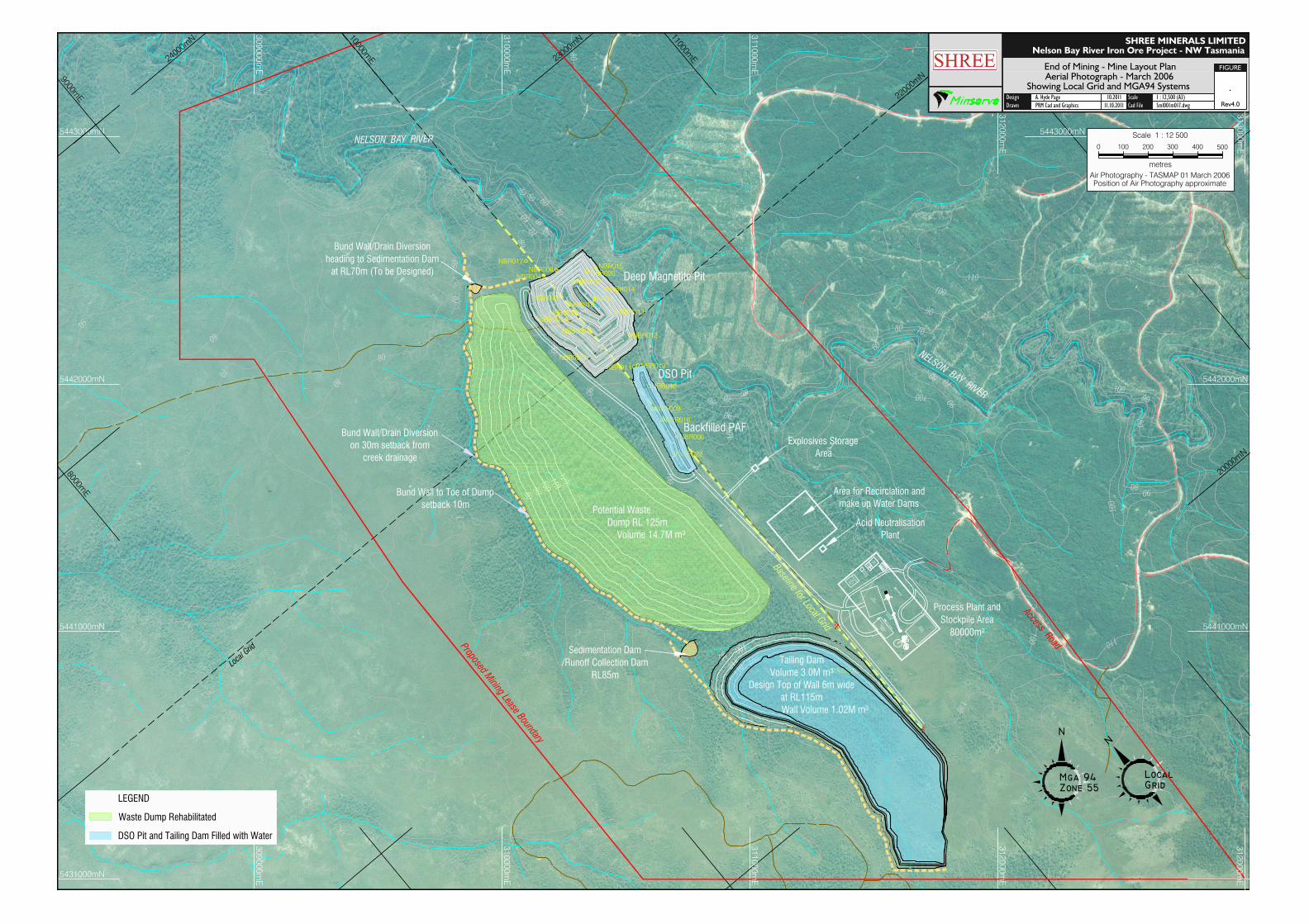
5443000mN 5442000mN 5441000mN 309000mE 310000mE 311000mE 312000mE NELSON BAY RIVER NELSON BAY RIVER 9000mE 11000mE 8000mE 24000mN 22000mN 20000mN Baseline for Local Grid Local Grid 5442000mN 5441000mN 309000mE 310000mE Access Road Bund Wall/Drain Diversion on 30m setback from creek drainage Area for Recirclation and make up Water Dams Deep Magnetite Pit DSO Pit Design Drawn FIGURE Scale Cad File A. Hyde Page PRM Cad and Graphics 11.10.2011 10.2011 1 : 12,500 (A3) Sml001m017.dwg Rev4.0 SHREE MINERALS LIMITED . Aerial Photograph - March 2006 Nelson Bay River Iron Ore Project - NW Tasmania Showing Local Grid and MGA94 Systems End of Mining - Mine Layout Plan Sedimentation Dam /Runoff Collection Dam RL85m Bund Wall/Drain Diversion heading to Sedimentation Dam at RL70m (To be Designed) Bund Wall to Toe of Dump setback 10m 5431000mN metres Scale 1 : 12 500 500 400 300 200 100 0 Air Photography - TASMAP 01 March 2006 Position of Air Photography approximate 5443000mN 313000mE Proposed Mining Lease Boundary 311000mE 312000mE 312000mE 10000mE 23000mN Process Plant and Stockpile Area Pò Explosives Storage Area Acid Neutralisation Plant MINE OFFICE BATH HOUSE ROM STOCKPILE MINE VEHICLE PARKING PRODUCT STOCKPILE GENERATORS SEWERAGE TREATMENT FUEL STORAGE REFUELING CRUSHING AND PROCESSING AND WORK SHOP STORAGE AREA LEGEND Waste Dump Rehabilitated DSO Pit and Tailing Dam Filled with Water
Transcript of NELSON BAY RIVER Scale 1 : 12 500 0 100 200 300 400 500
5443000mN
5442000mN
5441000mN
309000mE
310000mE
311000mE
312000mE
NELSON BAY RIVER
NELSON BAY RIVER
9000mE
11000mE
8000mE
24000mN
22000mN
20000mN
Baseline for Local Grid
Local Grid
5442000mN
5441000mN
309000mE
310000mE
Access Road
Bund Wall/Drain Diversionon 30m setback from
creek drainage
Area for Recirclation andmake up Water Dams
Deep Magnetite Pit
DSO Pit
DesignDrawn
FIGURE
ScaleCad File
A. Hyde PagePRM Cad and Graphics 11.10.2011
10.2011 1 : 12,500 (A3)Sml001m017.dwg Rev4.0
SHREE MINERALS LIMITED
.Aerial Photograph - March 2006
Nelson Bay River Iron Ore Project - NW Tasmania
Showing Local Grid and MGA94 Systems
End of Mining - Mine Layout Plan
Sedimentation Dam/Runoff Collection Dam
RL85m
Bund Wall/Drain Diversionheading to Sedimentation Dam
at RL70m (To be Designed)
Bund Wall to Toe of Dumpsetback 10m
5431000mN
metres
Scale 1 : 12 500
5004003002001000
Air Photography - TASMAP 01 March 2006Position of Air Photography approximate
5443000mN
313000mE
Proposed Mining Lease Boundary
311000mE
312000mE
312000mE
10000mE 23000mN
Process Plant andStockpile Area80000m²
Explosives StorageArea
Acid NeutralisationPlant
MINEOFFICEBATHHOUSE
ROM
STOCKPILE
MINE VEHICLE
PARKING
PRODUCT
STOCKPILE
GENERATORS
SEWERAGE
TREATMENT
FUEL STORAGE
REFUELING
CRUSHING AND
PROCESSING
ANDWORK SHOP
STORAGE
AREA
LEGEND
Waste Dump Rehabilitated
DSO Pit and Tailing Dam Filled with Water