NEIGHBOURHOOD DEVELOPMENT PLAN
37
1. HEADING NEIGHBOURHOOD DEVELOPMENT PLAN • 2020 - 2027 • REFERENDUM VERSION CHURCH FENTON
Transcript of NEIGHBOURHOOD DEVELOPMENT PLAN

1. HEADING
NEIGHBOURHOOD DEVELOPMENT PLAN
• 2020 - 2027 •
REFERENDUM VERSION
CHURCH FENTON

PAGE 3
CONTENTS
FOREWORD ________________________________________________________________________ 4
1.0 INTRODUCTION _______________________________________________________________ 5
1.1 Background to the Neighbourhood Development Plan ______________________________5
1.2 Consultation and engagement __________________________________________________5
1.3 The Neighbourhood Planning process ____________________________________________5
2.0 A BRIEF HISTORY AND CHURCH FENTON TODAY ___________________________________ 8
3.0 VISION AND OBJECTIVES ______________________________________________________ 10
3.1 The Vision for Church Fenton to 2027: ___________________________________________10
3.2 Objectives _________________________________________________________________10
4.0 POLICIES ____________________________________________________________________ 11
4.1 Housing (H) ________________________________________________________________12
4.2. Amenities and Services (AS) ___________________________________________________22
4.3 Business and Economy (BE) ___________________________________________________26
4.4 Environment and Green Spaces (EGS) ___________________________________________28
4.5 Conservation and Heritage (CH) ________________________________________________38
4.6 Flooding (F) ________________________________________________________________42
4.7 New Rail Infrastructure (NR) ___________________________________________________46
5.0 Monitoring and Review of the Plan _____________________________________________ 50
POLICIES MAPS ____________________________________________________________________ 52
APPENDICES
Appendix 1 Local Green Space Assessment ______________________________________ 54
Appendix 2 Non-designated Local Heritage Assets Assessment _____________________ 55
Appendix 3 Parish Community Facilities Assessment ______________________________ 56
Appendix 4 Sustainable Community Assessment _________________________________ 59
Appendix 5 Business Survey Summary __________________________________________ 65
Appendix 6 Church Fenton Green Spaces Maps ___________________________________ 67
• CHURCH FENTON NEIGHBOURHOOD DEVELOPMENT PLAN 2020 - 2027 •PAGE 2 • CHURCH FENTON NEIGHBOURHOOD DEVELOPMENT PLAN 2020 - 2027 •

PAGE 4 PAGE 5
1.0 INTRODUCTION
• CHURCH FENTON NEIGHBOURHOOD DEVELOPMENT PLAN 2020 - 2027 •
FOREWORD
Dear Resident,
We are pleased to present the Church Fenton Neighbourhood Plan. This has been
promoted by the Parish Council and has been prepared by a group of Parish
Councillors and village residents with valuable assistance from our neighbourhood
planning consultant, David Gluck, staff and Councillors at Selby District Council.
Over the recent years Church Fenton has experienced significant development and
whilst we have a very active Parish Council who work with Selby District Council
to minimise large scale development, we have seen many new homes being built,
many more than neighbouring villages. Whilst all residents of Church Fenton, new
and old, are a vital part of our village life, we, as a Parish Council, felt that our Village
Design Statement was not being referred to when Selby District considered planning
applications and realised the most proactive approach was to set about creating our
Neighbourhood Plan.
This is very much a community-led Neighbourhood Plan. It is based on what you
have told us over recent months, either in conversations at drop-ins, working group
meetings or via the questionnaires we have been sending out. It therefore reflects
your needs and aspirations for our future village development and community
cohesion; some of which, we are delighted to report, have been realised during the
process of the Neighbourhood Plan creation – namely, Church Fenton Community
Shop and the White Horse pub purchase & reopening with the incredible efforts of
the Church Fenton community.
Church Fenton is steeped in history, the first recorded mention of Fenton as a
settlement was in 963 when King Edgar gave a grant of land to Aeslac of Sherburn.
He in turn probably gave this to St Peter’s of York, as by 1030 it is included in the
Archbishop’s estate. This history is reflected by the significance & importance of
St Mary the Virgin Church (construction of which started circa 1230AD) which is
recognised and valued as much today as it was then.
In Church Fenton there are many examples of how close knit and supportive our
community can be. It is a special place that we feel fortunate to be part of and as
our research has proven most of us agree that it should be kept that way whilst
recognising the need for change to meet the growing needs of our present and
future residents.
The vision described in our Neighbourhood Plan is to protect the history & character
of our village, maintain our much-valued green space & offer a safe, attractive place
in which to live.
Cllr Sarah Chester, Chair of Church Fenton Parish Council
Cllr Samantha Charlston, Chair of Church Fenton Neighbourhood Plan working group
1.1 Background to the Neighbourhood Development Plan
The Localism Act 2011 gave Parish Councils the power
to develop Neighbourhood Development Plans
(NDP). The Church Fenton Parish Council led steering
group started work on their NDP in 2017. Once ‘made’,
this NDP will form part of the statutory Development
Plan for Selby District Council and will be used by the
District Council to help make decisions on planning
matters that affect Church Fenton.
This Plan is seeking to develop a set of policies,
practical actions, and longer term aspirations
for the community, all framed within a strategic
vision for Church Fenton. These will ensure that as
development takes place in the parish, it is in line
with the community’s aspirations and views – i.e.
putting our community in control of our future.
Examples will include, the provision of affordable
homes, increased community ownership of key
assets (village shop, village pub, village hall) and
improvements to much loved and valued facilities,
such as play areas, green spaces and rights of way.
1.2. Consultation and engagement
Church Fenton Parish Council began engagement
with parishioners early in 2017, our working group
was formed in February 2017 followed by the
creation of our website (www.planchurchfenton.org.
uk) in the same month. During March of 2017, our
working group divided the tasks between ourselves
and between April and December 2017 we met
frequently to progress our work. This work mainly
consisted of sending residents questionnaires
relating to:
• Housing needs
• Local green space
• Business needs
The collation of the results and researching
specific facts about our village was all undertaken
by the group.
On 17th December 2017, we were delighted
to present the progress we had made to our
community, and despite being a cold, wet Sunday
afternoon we were inundated with interested
residents keen to find out how we had progressed.
During 2018 the work continued and informal
comments were received from Selby District Council
alongside their screening opinion on the need for a
Strategic Environmental Assessment, which allowed
us to undertake the Regulation 14 ‘pre-submission’
consultation.
We would like to take this opportunity to mention
our working group which became a little smaller
as we progressed on our plan, mainly as a result
of some fantastic community led initiatives
taking much needed resource, namely Church
Fenton Community Shop Ltd and Church Fenton
Community Hub CBS as the White Horse lessee.
Evidence in itself that Church Fenton is already
realising our vision and ambition.
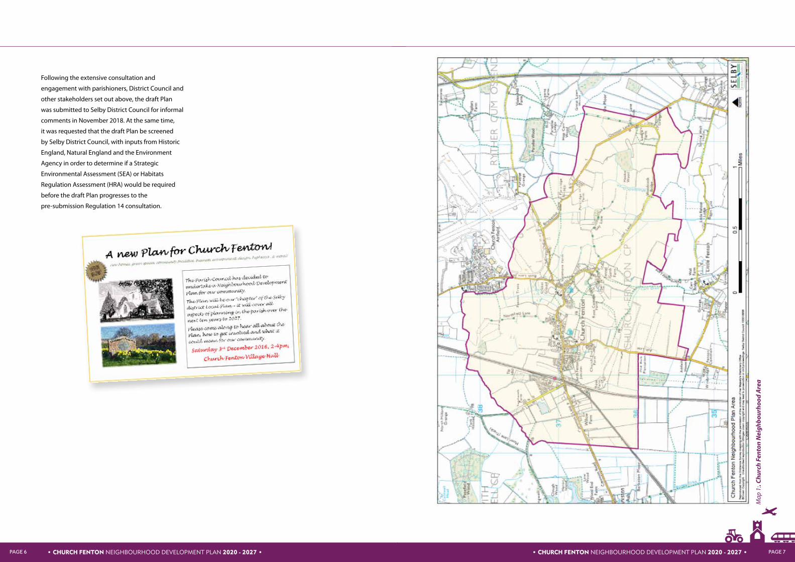
1.3 The Neighbourhood Planning process
On 11th August 2016, Church Fenton Parish Council
submitted a formal application for designation of
the parish as a Neighbourhood Area to Selby District
Council. This application was consulted on by Selby
District Council between 23rd September 2016 and
4th November 2016 and subsequently approved.
The Neighbourhood Area encompasses the whole
of the parish of Church Fenton (see map 1 overleaf ).
The pIan period is 2020 to 2027.
The Parish Council subsequently established
a Working Group to drive the Plan forward.
Following early discussions about collaboration
with neighbours Ulleskelf, it was decided to pursue
an independent Plan but to liaise closely due in
particular to the shared interest in the former RAF
Church Fenton and its future development.
• CHURCH FENTON NEIGHBOURHOOD DEVELOPMENT PLAN 2020 - 2027 •
• CHURCH FENTON NEIGHBOURHOOD DEVELOPMENT PLAN 2020 - 2027 •PAGE 6 PAGE 7
Following the extensive consultation and
engagement with parishioners, District Council and
other stakeholders set out above, the draft Plan
was submitted to Selby District Council for informal
comments in November 2018. At the same time,
it was requested that the draft Plan be screened
by Selby District Council, with inputs from Historic
England, Natural England and the Environment
Agency in order to determine if a Strategic
Environmental Assessment (SEA) or Habitats
Regulation Assessment (HRA) would be required
before the draft Plan progresses to the
pre-submission Regulation 14 consultation.
Map
1:.
Chu
rch
Fent
on N
eigh
bour
hood
Are
a
• CHURCH FENTON NEIGHBOURHOOD DEVELOPMENT PLAN 2020 - 2027 •

• CHURCH FENTON NEIGHBOURHOOD DEVELOPMENT PLAN 2020 - 2027 •PAGE 8 PAGE 9
2.0 A BRIEF HISTORY AND CHURCH FENTON TODAY
The first documentary evidence of Fenton is in 963AD
when King Edgar made a grant of twenty Hides to
Aeslac of Sherburn-in-Elmet. Little evidence remains of the
earlier origins of the village, although in 800AD an archive
source records:
“East of the high ground at Sherburn the land was wooded
with huge oaks and tiny British settlements. Houses were
made of poles covered by skins or leaves. The land was low
lying, often below sea level. Tracks that existed were limited
to ridges of high ground.”
We can perhaps assume that the village main street
probably reflects one such ancient path.
The name Church Fenton has evolved over the years,
starting as Fentune in 963 to Fentun in the Doomsday book
of 1086. Kirk Fenton is first mentioned in 1338 signifying
the establishment of a church in the village. ‘Ton’ or ‘tun’
suggests a community within an enclosure, reclaimed from
the ‘fen’ which is an old English word for a marsh.
It is likely that the origins of the village were agricultural,
although in 1400 records show that many villagers were
employed at the Huddleston stone quarry at a time when
the stone was being used to build York Cathedral. In 1458
the village had a population of 42 married couples, 26
single adults, 1 tradesman (blacksmith). There appears to
be no mention of children. Major drainage works opened
up the majority of the land for agriculture between 1600
and 1800 and the Moated House of the Lord of the Manor
used to stand on the site of Manor Farm.
Railways first appeared in the area with the Leeds and
Selby line which opened in 1834. The York and North
Midland was formed in York in 1835 and began planning a
link to London. The first plan showed the railway passing
through Kirkby Wharfe and North Milford. However,
objections from the Grimston Estate led to a revised plan
on the current route through Ulleskelf to Altofts near
Normanton to connect with the Leeds to Derby railway.
Originally the railway crossed Common Road on a level
crossing, with a station on the site now occupied by
the present railway bridge. In 1847 a new line was built
to Harrogate for which a new station was built with
workshops and an engine shed. In 1854 the York and North
Midland was bought by the NER. The line from Leeds
arrived in 1869 and in 1904 additional tracks were built to
York which required the building of a new (third) station.
The station employed a station master, porters, shunters,
office staff, signal men, plate layers and a telegraph
messenger. In 1990 the platform buildings and awnings
were demolished.
RAF Church Fenton was opened on 1st April 1937, while
it was still being constructed. It was built as a result of the
RAF’s massive pre-war expansion programme, in response
to Hitler’s move to increase the strength of the German
armed forces. The base was designed as a fighter base
from the outset, with the task of protecting the industrial
regions of Leeds, Bradford, Sheffield and Humberside.
From the start of the Second World War, until August 1940,
Church Fenton was a sector station in 13 Group, being
home to both defensive and offensive squadrons. Because
of Church Fenton’s remoteness from southern England,
it had a limited part to play in the Battle of Britain, being
used as a base for battle-scarred fighter squadrons to rest
and work back up to operational status. Its main job was
being part of the defensive network of fighter airfields
that protected the industrial cities of northern England
from attack by German bombers. Throughout the war the
airfield was home to many squadrons and aircraft types,
such as Spitfires, Hurricanes and Mosquitoes amongst
many other. As with all of the RAF, inevitably a number
of Church Fenton aircrew paid the ultimate price in the
defence of Britain.
Following the end of the war, the station retained its role
as a front-line fighter station in the defence of northern
England. In April 1946, the station became one of the first
in the country to operate jet aircraft, these were the Gloster
Meteors of 263 Squadron, and later 257 Squadron. In July
1959, the station ceased being a front line home defence
station, and its role changed to that of pilot training.
Today, Church Fenton has a solid, friendly community spirit,
having its own primary school and nursery, Jigsaws day
care and out of school club. There are two churches and
a post office/general store; coupled with this are a public
house and an Indian restaurant within the mainline railway
station. Village life has much to offer with football, cricket
and bowls clubs, and for children rainbows, brownies, cubs
2011 Census statistics for Church Fenton
l 23 % (325) were aged under 18
l 9% (125) were aged 18 to 29
l 25 % (354) were aged 30 to 44
l 20% (280) were aged 45 to 59
l 15% (211) were aged 60 to 74
l 7% (97) were aged 75 or over
l 99.3% (1392) of the population described
their ethnic group as white
l 48% (285) of dwellings are detached houses
or bungalows
l 25% (149) of dwellings are semi-detached
houses or bungalows
l 20% (121) of dwellings are terraced houses or
bungalows (including end-terrace)
l 7% (40) of dwellings are flats, maisonettes or
apartments
l There are 896 cars or vans in Church Fenton
l 76% (758) of residents aged 16-74 are
employed
and scouts and a toddler group. The Village Hall is well used
and is a meeting venue for a variety of local community
groups and a place for regular evening entertainment.
To conclude, Church Fenton has had a steady slowly
rising population for over two hundred years. There have
been temporary spikes of population related to specific
activities but the underlying trend has been for very slow
steady growth. This trend broke down more recently due
to relatively large-scale house building causing a rapid
expansion to the village’s permanent
population numbers.
Demographics
In 1801 Church Fenton was a hamlet with a
population of only 220. The population changed very
little over the period with the exception of the peaks
of temporary increase attributed to in-migration of
railway workers between 1841 and 1851, then again
in 1861 to 1901 when the rail network was extended.
By 2011 the population was 1,392 after a steep rise
over the previous 10 years. This rise was linked to the
building of large numbers of houses as the village
became an increasingly popular place to live – and
commute to work from. The effect of building the
Sandwath estate, along with several other smaller
developments in the village resulting in a steep
increase in housing stock.
• CHURCH FENTON NEIGHBOURHOOD DEVELOPMENT PLAN 2020 - 2027 •

• CHURCH FENTON NEIGHBOURHOOD DEVELOPMENT PLAN 2020 - 2027 •PAGE 10 PAGE 11
4.0 POLICIES3.0 VISION AND OBJECTIVES
3.1 The Vision for Church Fenton to 2027:
The Parish Council created the following draft vision, which
was consulted on during public events:
Our Vision is for Church Fenton to be a
place that meets the needs of its residents
in terms of homes, jobs, play and recreation
and education and learning. The village
needs to be a place that retains its character
and essence as a village, whilst growing
sustainably to support the wide range of
facilities we enjoy now and wish to see
develop in the future.
3.2 Objectives
The following objectives have been
developed to ensure the Vision is delivered.
For Church Fenton to realise its Vision by
2027, the key objectives are as follows (not
listed in priority order):
l To have a proper mix of homes which meets
the needs of the community
l To maintain and improve services and
facilities
l To improve our green environment
l To recognise and conserve our heritage
l To maintain and develop a ‘small business
economy’
l To avoid urbanisation and maintain a high
quality village setting
l To work closely with our neighbours
particularly with regard to potential future
development on the airbase
l To enable organic growth that is small in
nature, for example self-build homes
l To improve broadband connection speeds
l To manage and improve road safety and car
parking
l To minimise the impact of HS2 and other rail
infrastructure projects on the community
and landscape.
This section of the Plan sets out the detailed policies, the
justification for these and how policies will contribute
towards the objectives set out for achieving the Plan’s
Vision. In summary, the policies are organised into seven
themes and are:
• CHURCH FENTON NEIGHBOURHOOD DEVELOPMENT PLAN 2020 - 2027 •
THEME POLICY
Housing (H) H1: Type, size and scale
H2: Design principles
H3: Location of new development
Amenities and Services (AS) AS1: Valuing community facilities
AS2: New community facilities
Business and Economy (BE) BE1: Supporting the small business economy
BE2: Farm diversification
Environment and Green Spaces (EGS) EGS1: Local Green Spaces
EGS2: Protecting biodiversity and habitats
EGS3: Green infrastructure and corridors
Conservation and Heritage (CH) CH1: Non-designated local heritage assets
CH2: Development in the historic core
Flooding (F) F1: Development that does not add to flood risk
New railway infrastructure (NR) NR1: Design, community and the landscape

PAGE 13• CHURCH FENTON NEIGHBOURHOOD DEVELOPMENT PLAN 2020 - 2027 •PAGE 12
4.1 HOUSING (H)
POLICIES SUMMARISED
Purpose: to ensure our community has access to homes appropriate to their needs.
H1: Type, size and scale
H2: Design principles
H3: Location of new development
OBJECTIVES ADDRESSED
l To have a proper mix of homes which meets the needs of the community
l To improve our green environment
l To recognise and conserve our heritage
l To avoid urbanisation and maintain a high quality village setting
l To enable organic growth that is small in nature, for example self-build homes.
l To manage and improve road safety, traffic and car parking
SUPPORTING EVIDENCE BASE DOCUMENTS
Village Design Statement; Strategic Housing Market Assessment; Housing Needs Survey; Historic Core Assessment
In the period November 2008 – November 2018, there
were 41 dwellings (40 net) completed, with outstanding
permissions for a further 78 dwellings in the parish. Selby
District Council’s Core Strategy set out projected growth
for Designated Service Villages (DSV) across the district
and including Church Fenton as being 2000 from 2011-
2027. When considering the options for delivering this
growth across the 18 DSVs, the District Council considered
3 options: first, to disperse growth proportionate to
settlement size; second, to distribute growth based on
services and accessibility; and third to only grow those
villages not located in Green Belt. The result of these 3
options for Church Fenton were:
Option 1 – 29 new homes
Option 2 – 24 new homes
Option 3 – 39 new homes
It is clear from this that Church Fenton as a parish has
already seen more than its required growth to contribute
to Local Plan targets (see Table 1). As a result, the
Parish Council and community have been very clear in
consultations for the Neighbourhood Plan that new growth
should be predicated on a very specific set of criteria. These
are set out in the policies that follow.
4.1.1 H1: Type, size and scale
Issues and evidence
Church Fenton currently has a wide choice of
type, tenure, style and size of housing. However,
in recent years, new homes built or planned
have predominantly been larger in size and more
expensive in cost. In November 2018, of 34 available
homes for sale, the highest priced property in the
parish was a 5-bed detached house at £600,000: the
lowest price was £140,000 for a one-bedroom flat.
Only four properties were available for rent ranging
from £475-£900 pcm . Of the homes for sale, the
following types/numbers were available:
l Detached - 19
l Semi-detached - 9
l Terrace - 3
l Flat - 1
l Bungalow - 2
The 2018 parish-wide housing survey indicated that
27% (21) of respondents wanted no development in
the parish. 21% (15) preferred to see single homes
on small areas of land, 28% (22) preferred small
development of 1-4 houses, 21% (16) preferred
Policy H1: Type, size and scale
New housing developments should be:
a) Appropriate to the size of Church Fenton and
its position in the local settlement hierarchy.
b) Integrated with their immediate neighbouring
properties and landscape in terms of:
i. Design of new homes
ii. Design of the overall development
iii. Car parking arrangements
iv. Appropriate landscaping, greenspace and
green infrastructure
developments of 5-10 houses and 4% (3) preferred
developments of 10 or more houses.
The preferred types of houses were:
l Apartments/flats – 2% (2)
l 1-2 bedroom starter homes 30% (27)
l 3-4 bedroom medium family homes 26% (23)
l Large family home 12% (11)
l Small retirement homes/bungalows 30% (27)
Of the 58 respondents, 79% (46) thought
affordable homes to buy should be included in new
developments and 45% (26) thought social housing
for rent should be included in new developments.
Community led housing has been identified as a
new mechanism for delivering affordable homes
not associated with substantial quantities of new
dwellings, enabling smaller developments to be
progressed where the opportunity arises. Community-
led is an ethos which resonates strongly in the parish
with its recent history of community initiatives. The
second part of Policy H1 addresses this important
issue. Community-led housing schemes will
traditionally be led by a local community group such
as the Parish Council or Community Land Trust’
v. Non-vehicular links, including new public
rights of way linking the development to
other parts of the village and the surrounding
countryside, where practicable.
c) Provide for a mix of housing type and size in
accord with the Selby Local Plan and reflecting
demand and needs identified through the most
recently available housing needs analysis for
Church Fenton parish.
Development proposals for community-
led housing schemes will be particularly
supported.
• CHURCH FENTON NEIGHBOURHOOD DEVELOPMENT PLAN 2020 - 2027 •

PAGE 15• CHURCH FENTON NEIGHBOURHOOD DEVELOPMENT PLAN 2020 - 2027 •PAGE 14
Year Annual housing planning applications in Church Fenton parish 2004-2019
2004 CO/2004/0227 – Reserved matters application for 83 buildings on land at Triesse Vulcan Works, Sandwath Lane.
2005 2005/0093/OUT – Outline application for erection of 2, 3 bedroomed dwelling houses following the demolition of the parish centre, Church Street.
2007 2007/0926/OUT – Erection of One dwelling, North View, Main Street.
2008 2008/0147/FUL – Erection of a 2storey dwelling and 2 single storey dwellings at Lavorrick, Church Street
2008/1060/FUL – Erection of a detached dwelling with garage at Vulcan Works, Sandwath Lane
2008/0267/FUL – Conversion of existing barn into new dwelling at Shepherds Barn, Church Street
2008/1017/FUL – Erection of 7 terraced dwellings Biggin Lane Garage, Nanny Lane
2009 2008/1060/FUL – Erection of a detached dwelling with garage at Vulcan Works, Sandwath Lane
2010 2010/0063/FUL – Erection of 6 dwellings following demolition of public house, Junction Hotel, Station Road
2010/0405/FUL – Erection of a dwelling, Vulcan Works, Sandwath Lane.
2011 2011/0767/COU – Change of use of redundant farm buildings to form two dwellings, Hall Farm, Hall Lane
2012 2012/0903/OUT – Residential development following demolition of existing farm buildings, Hall Farm, Hall Lane.
2013 2013/0088/FUL – Erection of 2 dwellings at land at Church Fenton Station, Station Road This was changed to 3 dwellings (2015/0207/FUL).
2014 2014/0207/OUT – Erection of a detached dwelling following demolition of existing outbuilding Ashley Bank, Hall Lane
2014/0551/ FUL – 2 dwellings following demolition of existing buildings and removal of builders yard, Joiners Workshop, Sandwath Lane
2014/0631/OUT – 9 residential dwelling buildings on vacant land at Dorts Crescent, Church Fenton.
2015 2015/0148/FUL – proposed new dwelling on land east of Ashley Bank, Hall Lane
2015/0318/FUL – 39 dwellings at RAF Church Fenton, Busk Lane
2015/0760/OUT – 25 dwellings at The Laurels, Main Street
2015/0908/FUL – Dwelling and garage for essential rural worker, Hall Lane Stables, Hall Lane
2015/1220/FUL – Proposed erection of a detached dwelling on land adjacent to 1 Fern Cottages, Nanny Lane
2016 2016/0457/OUT – Erection of 9 dwellings Bridge Close / Church Fenton Hall
2016/0505/OUT – Erection of 5 new dwelling houses, land adjacent to Station Mews,
2016/0716/FUL – Erection of detached bungalow and garage, land adjacent to 6 Northfield Lane
2016/1384/FUL – Proposed erection of 1 dwelling, Old Forge Cottage, Main Street
2017 2017/0084/FUL – Proposed erection of 1.5 storey 3 bedroom dwelling, Willow Garth, Station Road
2017/0887/FUL – Erection of 2 dwellings following demolition of existing buildings and removal of builders yard, Joiners Workshop, Sandwath Lane
2018 2018/0009/OUT – Outline application for the erection of a detached dwelling, Land north of Station Road
2018/0938/FUL – Conversion of an agricultural barn into a residential dwelling, Farm buildings to the east and south of Old Farmhouse, Oxmoor Lane
2018/0522/FUL – Proposed erection of detached dwelling, Wyke Holme, Main Street
2018/0935/FUL – Proposed erection of 1 dwelling, Brownfield site. Leeds East Airport
2018/1281/OUT – residential development, Maple Cottage, Nanny Lane
2019 2019/0108/FUL – Conversion of redundant agricultural buildings to provide two residential units, The Orchards, Church Street.
4.1.2 H2: Design principles
Issues and evidence
The Church Fenton Village Design Statement
(February 2012) describes Church Fenton as follows:
“the village is essentially a “T”-shaped layout at the
junction of three roads. Common Lane extends
westward to Barkston Ash, which Main Street
extends eastward to Ryther/Cawood/Biggin. Lastly,
Ash Lane leads due south to Sherburn-in Elmet.
Most of the village’s services and facilities are
located here, including the railway station, shop,
school and pub.
Along the roads, farms and houses have developed
on both sides to form an elongated village. Main
Street is the longest of these ribbons, and over
the years has doubled the length of the village.
The linear nature of the village is of fundamental
importance when designing new development as
the vast majority of the housing stock has views
across open countryside to the rear, with rear
gardens. Backfilling would ruin this aspect and
should therefore be avoided.
Some compact estates have been developed in the
west that bulk out the village, and a 21st Century
volume house builder’s estate has introduced more
built form on the opposite side of the railway lines,
deep in to the open countryside. Despite these
additions, the linear character remains very strong.”.
Policy H2 sets out a series of design principles for
new residential development. They take account of
the wider approach in the Village Design Statement.
Where it is practicable to do so proposals should
demonstrate how they would respond to the
relevant recommendations in that Statement.
Map 2: Character Areas of Church Fenton
PAGE 15• CHURCH FENTON NEIGHBOURHOOD DEVELOPMENT PLAN 2020 - 2027 •

PAGE 17• CHURCH FENTON NEIGHBOURHOOD DEVELOPMENT PLAN 2020 - 2027 •PAGE 16
The Village Design Statement defines the following
three Character Areas (text extracted from Village
Design Statement):
Character Area 1: The village centre
This area has developed one house at a time with an
overall palette of brick and pan tile/slate materials,
but each house is unique. The houses face the street
to form attractive rows, set behind a front garden of
varying length. Mature planting and trees creates a
“chocolate box” street scene and a traditional North
Yorkshire village appearance.
Most of the village facilities are also located here,
including the railway station, school, shop/post
office and pub. Occasional infill plots have realised
newer house designs, but an adherence to the
materials and plot layout ensure that these blend in
and continue the character rather than spoil it.
l Houses have been built one at a time in a ribbon
layout
l Each house is unique
l Houses mostly feature gardens to the front and long
thin plots
l Size of the front garden varies due to the
meandering nature of the road
l Mix of houses – little or no repetition
l Low-density environment
l Mature planting creates a very green street scene
l Narrow carriageway
l Roof interest and the variation in the height of the
eaves
l Red/brown brick or cream render
l Generally rectangular footprint and elevations
l Houses parallel with the road so eaves face the front
l Simple cottage style
l Occasional bungalow
l Further out of the centre houses are larger and more
elaborately designed and detailed
l Red pan tile or natural slate
l Mixture of fencing, brick walls and hedges
l Windows have a vertical emphasis, white timber and
multiple panes
l Doors are simple timber, or elaborate finely
detailed doors with elaborate porch features with
carved wooden surrounds. Although mostly white,
variation features dark earth colours.
Character Area 2: The East End
A gap in the built form occupied by agricultural
fields, football pitch and cricket field separates this
area from the village centre. Built either side of three
roads, houses here follow the one-at-a-time layout,
but are larger and set in larger plots than houses in
the village centre. The architectural style changes
slightly too, moving away from the cottage style to a
more villa style with more variation and detailing.
l One-at-a-time ribbon layout
l Individual “villa-style” (unlike cottages in Village
Centre)
l Houses set back from the road
l Boundary treatments mainly brick walls and
hedgerows
l Hand clamped bricks (dark brown-red) or render
l Windows depend on the property size, large
properties have grand designs with brick headers
and thick stone cills, small properties feature simple
designs with no surround features
l Doors are plain timber with a single window at the
top
l Larger houses feature porches or brick surrounds
with elaborate detail.
Policy H2: Design principles
New housing developments should comply with
the following design principles:
a) The type of housing should be distinctive in
design, and with appropriately-sized gardens.
b) New housing should reflect the best design
elements as found in the historic core of the
village, including:
i. Respecting the overall palette of traditional
designs and the character of the local area as set
out in the Village Design Statement.
ii. Respecting the height, position, size and
massing of existing buildings.
iii. Ensuring boundary treatments are in keeping
with the tradition of the village and primarily
involve hedgerows formed by native species.
iv. The density’ of new developments should
reflect that of their immediate surroundings.
c) Modern architectural detailing, including
environmental systems (i.e. systems built into
the home designed to save energy, reduce waste,
prevent pollution, cut carbon emissions or
enhance biodiversity), can be accommodated in
new development but should be carefully sited
and designed to blend in with village character,
avoiding street front elevations wherever
practicable.
d) New housing should be designed to
incorporate the best of sustainability principles
in design and construction and demonstrate how
the design has been influenced by the need to
plan positively to reduce crime and the fear of
crime.
Character Area 3: 20th Century estates
There has always been steady development over
the years but always on a piecemeal scale until
recently when large estates were developed. These
demonstrate a “national” style with little regard
for local character. The estates range from around
10 dwellings to over 70 dwellings. The principal
difference in these estates is the introduction of
standardised house types and more uniformity in
the designs. All built at the same time, these houses
do not demonstrate the intricacies of the older part
of the village, and also introduce new colour shades
in the mass-produced bricks in place of the hand
made and low volume darker shades.
There are several smaller post-war estates that have
been built throughout the village. These break
the traditional one-at-a-time growth pattern and
introduce uniformity and standardisation. Further,
they often introduce materials, house types and
details that are alien to the Church Fenton style.
Although none of the developments should be
considered repugnant, the diversion away from
the Church Fenton style of development should
be avoided in the future, and a return to the local
character ensured.
The 2018 housing needs survey indicated that 87%
(49) of respondents felt it was very important that
the design of new buildings are sympathetic to the
character of the village. 11% (6) thought it was quite
important and 2% (1) thought it not very important.
• CHURCH FENTON NEIGHBOURHOOD DEVELOPMENT PLAN 2020 - 2027 •

Church Fenton Airbase
A key location for potential new housing in
the locality is the land on the Church Fenton
Airbase. Although the majority of the Airbase
is located within the adjoining Ulleskelf parish
boundary, it will impact the residents of Church
Fenton directly as it is in their direct vicinity, in
particular any development to the north of the
Neighbourhood Area, near to Busk Lane.
The adopted Selby District Council’s Core Strategy
contains policies with particular implications
for Church Fenton Airbase and/or its immediate
environs , including:
l Church Fenton Airbase is identified as a
‘secondary village with defined development
limits’, within which limited amounts of
residential development may be absorbed where
it will enhance or maintain the vitality of rural
communities, (SP2) and may have the potential to
become Rural Housing Exception site, (SP10).
l Protects and enhances the ‘Regional Green
Infrastructure Corridor’ which runs up to and
abuts the west side of Busk Lane and includes the
residential development west of Busk Lane. Also
provides for measures to mitigate or minimise
the consequences of any development within the
corridor (SP12).
This Plan seeks to ensure that any development on
the Church Fenton Airbase takes into consideration
the design principles and other policies set out in
this Plan.
In July 2018, Makin Enterprises submitted a hybrid
planning application to Selby District Council.
Although the development is in the neighbouring
parish of Ulleskelf, it is important to note this
potentially significant new development in this Plan.
The planning application includes:
l A new 6,000 square metre (approximately)
creative, digital or media business headquarters
within a new ‘Create Yorkshire’ creative industries
employment park of creative, digital and media-
related uses.
l Permanent use of the existing Hangars for
commercial film-making and formalisation of this
part of the site as a ‘Studio’ area with associated
stages, stores, workshops, backlot and parking.
l Upgrades to the site access onto Busk Lane.
l Landscaping of the creative hub area and a
landscape framework for the Create Yorkshire
campus.
l Makin Enterprises consider that up to 1,800
permanent jobs could eventually be provided on
the site by this proposal.
PAGE 19• CHURCH FENTON NEIGHBOURHOOD DEVELOPMENT PLAN 2020 - 2027 •PAGE 18
4.1.3 H3: Location of new development
Issues and evidence
The housing survey asked for suggestions for
suitable locations of new developments. The
following places were suggested more than once:
✔ Close to HS2 infill
✔ Infill/garden grabbing
✔ Near Nanny Lane bungalows
✔ Airbase/Leeds East Airport (Ulleskelf parish)
✔ Brownfield sites
The housing survey also asked for suggestions for
unsuitable locations of new developments. The
following places were suggested more than once:
✘ RAF base
✘ Land with facilities on e.g. White Horse
✘ Flood zones/drainage gap
✘ Close to HS2 development
✘ Maintain linear village (respect strategic countryside
gap)
✘ Avoid historic settings and views e.g. St Mary’s and
the village centre
✘ Greenfield/agricultural land/Green Belt
✘ Near train station – parking issues
Policy H3 sets out the Plan’s response to these
issues and the wider matter of the location of new
residential development. It sets out a series of five
development principles. The combined effect of
the five principles will be that conversions, the
development of replacement dwellings, the re-
development of brown-field sites and appropriate
scale development on green-field sites will
represent the bulk of new development in the
period up to 2027.
• CHURCH FENTON NEIGHBOURHOOD DEVELOPMENT PLAN 2020 - 2027 •

Policy H3: Location of new housing development
All new housing development proposals should:
a) Respect the integrity of the linear structure and
open aspects of the village.
b) Avoid Green Belt, strategic countryside gap
and other areas identified in the Policies Map as
valuable for the green infrastructure roles they
perform.
c) Apply sequential, risk-based testing to potential
development locations to avoid the flood zone
areas 2 and 3.
d) Be capable of being accommodated in
a safe and satisfactory way within the local
highway network and which would not have an
unacceptable residential amenity on residential
properties in the immediate locality.
e) Respect and maintain key views as identified
on map 3, in order to maintain the character and
appearance of the village, with particular attention
paid to the views of St. Mary’s Church.
COMMUNITY ACTIONS
l To support improvement to existing and
establishment of new footpaths to link all
residential dwellings in parish via safe footpaths.
l To publish a circular for recreational walks
along Gay Lane.
l To promote utilities improvement, especially
the drains network.
PAGE 21• CHURCH FENTON NEIGHBOURHOOD DEVELOPMENT PLAN 2020 - 2027 •PAGE 20
Key views
Church Fenton is located in a flat landscape and is
a low-lying village, with the exception of its historic
Grade 1 listed church. Key views from publicly-
accessible places of this feature have been analysed
by the Neighbourhood Plan group and are noted in
the map 3 below and development should seek to
avoid disrupting these views wherever practicable
Map 3: Key views of St Mary’s Church, Church Fenton
Reproduced from the Ordnance Survey mapping with the permission of the controller of Her Majesty’s Stationary Office.
©Crown Copyright. Unauthorised reproduction infringes crown copyright and may lead to prosecution or civil proceedings.
Selby District Council 100018656
A view of the church from point 3 of the map below
• CHURCH FENTON NEIGHBOURHOOD DEVELOPMENT PLAN 2020 - 2027 •

PAGE 23• CHURCH FENTON NEIGHBOURHOOD DEVELOPMENT PLAN 2020 - 2027 •PAGE 22
4.2 AMENITIES AND SERVICES (AS)
POLICIES SUMMARISED
Purpose: To sustain and improve upon community facilities.
AS1: Valuing community facilities
AS2: New community facilities
OBJECTIVES ADDRESSED
l To maintain and improve services and facilities
l To improve our green environment
l To improve broadband connection speeds
l To manage and improve road safety, traffic and car parking
SUPPORTING EVIDENCE BASE DOCUMENTS
Observations, Surveys, Parish Plan.
4.2.1 AS1: Valuing Community Faciilities
Issues and evidence
The residents of Church Fenton greatly value the
services that are provided by the existing local
facilities. The following community facilities have
been identified through consultation and this Plan
will seek to protect and, where practicable, expand
these assets.
The community has, in recent years, developed a
positive approach towards maintaining facilities
through community ownership as demonstrated
by the Village Shop and most recently the White
Horse pub, both having been secured for the future
of the community by the Parish Council. These
enhance the sense of community and one which is
increasingly self-reliant and prepared to support its
‘third sector’ in all its forms.
In addition to those facilities identified in the policy,
the community enjoys a range of additional private
services, including:
l Garages
l Taxis
l Rail
l Bus
l Broadband
l Stables
Policy AS1: Valuing community facilities
The Plan identifies the following facilities as
important community facilities. Development
proposals affecting the important community
facilities should ensure that the facility is
maintained or improved for community benefit.
l St Mary the Virgin
l Methodist Church
l Kirk Fenton Primary School
l Jigsaws Childcare
l Village Hall
l Methodist Church Hall
l Main Street Playing Field
l Sandwath Playing Area
l Cricket Club and Ground
l Bowling Club
l Station Farm Guest House
l White Horse Pub and Restaurant
l Fenton Flyer Pub
l Village Shop & Post Office
l Fishing Lake
Development proposals which would result in the
loss of an important community facility will not be
supported unless:
a) The facility is replaced by equivalent or better
provision in terms of quantity and quality in a
suitable location in the community, if a sufficient
level of need is identified ; or
b) The facility can be clearly shown to be unviable,
in which case alternative uses can be considered.
4.2.2 AS2: New Community Faciilities
Issues and evidence
Through consultation, the following issues have
been identified as priorities for the community in
relation to developing new/enhanced community
facilities:
Pubs and Restaurants – following the closure of
the White Horse, there is now one operational public
house, the Fenton Flyer, and an Asian restaurant at
the Railway Station. The White Horse has recently
been purchased by the community and work is
underway to restore it as a viable pub/restaurant.
Car Parking Requirements – especially near the
centre of the village where none exists and the
school, nursery and shop are sited. Again, parking
around the station is a problem and a planned entry
to new housing will reduce this.
Better broadband coverage – broadband reception
is very patchy and deters home workers, as
well as affecting general leisure and education
opportunities.
Hard play surface - for Netball and other formal and
informal sports.
• CHURCH FENTON NEIGHBOURHOOD DEVELOPMENT PLAN 2020 - 2027 •

PAGE 25• CHURCH FENTON NEIGHBOURHOOD DEVELOPMENT PLAN 2020 - 2027 •PAGE 24
Policy AS2: New community facilities
Development proposals for community facilities
currently not provided in the parish will be
supported. This includes the expansion of an
existing facility.
COMMUNITY ACTIONS
l For the Parish Council to continue to offer small
grants to support local clubs.
l To improve the availability of mobile/outreach
services by:
a) encouraging the use of facilities available at the
community shop, especially the Post office, and
Prescription collection.
b) access other spaces to provide spaces for hire/
rent by small businesses.
l To support the potential opening of a café and
to support the reopening of the White Horse pub
with a restaurant in Church Fenton.
l Jigsaws Childcare has a limited lease on
land used at school for temporary buildings. It is
expected in the future that school will require the
land to expand (due to expanding village) leaving
Church Fenton without a nursery in walking
distance of school (or even in the village). Support
the purchase of Jigsaws Childcare premises to give
greater outdoor provision and parking on site. This
will help maintain links to school (Kirk Fenton CE
Primary School).
l To offer support for families and older people
through investment in the community shop and
combatting loneliness via volunteering (less
isolation at home) also through the ability to walk
to local shop and see people in the community.
l Increasing the number of local jobs, including
supporting the White Horse reopening to provide
wider range of low skills work / student/ first job
employment opportunities.
l Improving regular transport links to allow
residents to access essential facilities in other
locations.
l Support a “20mph is plenty” campaign through
the village.
Any proposed facility, new or extended, should not
disrupt other aspects of community life, in particular,
residential amenity. Particular needs include the
following and proposals coming forward in relation to
these will be welcomed:
l Public Car Park
l Superfast Broadband coverage
l Hard play surface
In addition, the upgrade and growth of Kirk Fenton
CE Primary School, its buildings and grounds, will be
supported where proposals provide for the ongoing
sustainability of the facility and contribute to the
improvement of the school’s learning environment.
However, the school playing fields will be protected
from development except for that which is deemed
essential for expansion of the school’s capacity and
where it has been demonstrated that the space
required for development is surplus to requirements
or that the new use is for sport and recreational
provision which provides benefits in excess of the
loss of the current use.
• CHURCH FENTON NEIGHBOURHOOD DEVELOPMENT PLAN 2020 - 2027 •

• CHURCH FENTON NEIGHBOURHOOD DEVELOPMENT PLAN 2020 - 2027 •PAGE 26
4.3 BUSINESS AND ECONOMY (BE)
POLICIES SUMMARISED
Purpose: To help Church Fenton thrive economically and deliver local employment opportunities for residents.
BE1: Supporting the small economy
BE2: Farm diversification
OBJECTIVES ADDRESSED
l To maintain and improve services and facilities
l To develop a ‘small economy’
l To avoid urbanisation and maintain a high quality village setting
l To work closely with our neighbours particularly with regard to potential future development on the airbase
l To improve broadband connection speeds
l To manage and improve road safety, traffic and car parking
SUPPORTING EVIDENCE BASE DOCUMENTS
SDC Business Rates Data; BT, Surveys (business and residents)
4.3.1 BE1: Supporting the small economy
Issues and evidence
The housing survey indicated that residents support
some growth in the local economy. 50% (25) said
there were not any sites in the village suitable for
industrial/commercial development, however 36%
(18) thought there were. Of the suggested sites, 12
respondents support the development of Leeds East
Airport into a technical hub and film production to
bring in high quality jobs.
Other popular sites were the White Horse (5) and
near the railway line/station & HS2 (5).
The following is the complete response to the
question in the housing survey: “Which of the
following would you consider suitable commercial
activity for this Parish? (please tick to indicate YES)”
l Retail food/drink 34
l Retail (other) 12
l Warehouse distribution 2
l Light industrial 11
l Heavy industrial 0
l Offices 13
l Homeworking 18
l None 8
l Other – high tech units 1
l Post office 2
l N/A 5
Policy BE1: Supporting the small economy
Development of existing small businesses
and new businesses will be supported where
the scale of the proposed development is
appropriate to the location.
Policy BE2: Farm diversification
Development proposals for the diversification
of farms will be supported where this enables
production from the land to continue and where:
a) They do not result in unacceptable effects upon
the landscape or the ecological significance of the
buildings concerned;
b) They do not result in an unacceptable level of
heavy goods vehicles on rural roads; and.
c) They would result in sustained or increased local
employment.
4.3.2 BE2: Farm Diversification
Issues and evidence
Church Fenton is a rural community still with
working farms across the parish. These farms
and smallholdings provide maintenance of the
landscape within which the village is set and from
where it derives much of its charm and character.
Where there are derelict farm buildings, on brown
field sites, we would encourage a sympathetic
change of use to residential dwellings – similar to
the barn conversions on Hall Lane i.e. Thythe Barn
circa 1995 & The Coach House circa 2014.
Policy BE1 of the Plan sets out a supporting context
for business development in the neighbourhood
area. In relation to the need for development
proposals to be appropriate to their locations
particular consideration should be given to the
effects upon residential amenity of an increase in
traffic movements, the use of heavy goods vehicles,
or other environmental impacts such as noise, light,
odour or pollution.
COMMUNITY ACTIONS
l To improve the available and effective
telecommunication and internet access by:
a) Supporting more broadband suppliers in the
village
b) Supporting fibre optic broadband being
available to all houses in the village.
l To improve mobile phone reception in the
village and key locations e.g. village hall
PAGE 27• CHURCH FENTON NEIGHBOURHOOD DEVELOPMENT PLAN 2020 - 2027 •

• CHURCH FENTON NEIGHBOURHOOD DEVELOPMENT PLAN 2020 - 2027 •PAGE 28 PAGE 29
4.4 ENVIRONMENT AND GREEN SPACES (EGS)
POLICIES SUMMARISED
Purpose: To develop a greener village and higher quality surrounding countryside.
EGS1: Local Green Spaces
EGS2: Protecting biodiversity and habitats
EGS3: Green infrastructure and corridors
OBJECTIVES ADDRESSED
l To maintain and improve services and facilities
l To develop a ‘small economy’
l To avoid urbanisation and maintain a high quality village setting
SUPPORTING EVIDENCE BASE DOCUMENTS
Selby Landscape Assessment; SDC Local Plan Evidence Base; Community Surveys; Design Statement
The Selby District Landscape Assessment (1999)
describes Church Fenton as being located within
Selby District’s West Selby Plain. This landscape
assessment covers the area eastwards from the
foot of the West Selby Magnesian limestone ridge,
between the river floodplains of the Aire valley to
the south and the River Wharfe/Ouse corridor to the
north. The area is largely low-lying farmland with
good quality drained soils, which has led to the area
being intensively cultivated for arable crops. There
are few sites of ecological interest in the West Selby
Plain due to the intensive farming. Within the open
farmland is the former WWII Church Fenton airbase,
which has recently been transformed into a ‘creative
hub’ and film studios.
4.4.1 EGS1: Local Green Spaces
Issues and evidence
The National Planning Policy Framework (NPPF)
introduced a new concept of a Local Green Space
designation3. This is a discretionary designation to
be made by inclusion within a local development
plan or Neighbourhood Development Plan.
The designation should only be used where the
land is not extensive, is local in character and
reasonably close to the community; and, where it
is demonstrably special, for example because of
its beauty, historic significance, recreational value
(including as a playing field), tranquillity or richness
of its wildlife4.
Policies within the local development plan or
neighbourhood development plan for managing
development within a Local Green Space should be
consistent with the policies protecting green belts
within the NPPF.
Accessible Natural Greenspace Standard
recommends that everyone, wherever they live,
should have accessible natural greenspace:
l of at least 2 hectares in size, no more than 300
metres (5 minutes’ walk) from home;
l at least one accessible 20 hectare site within two
kilometre of home;
³ Paragraph 76, National Planning Policy Framework, Department for Communities and Local Government, March 2012
4 Paragraph 77, National Planning Policy Framework, Department for Communities and Local Government, March 2012
l one accessible 100 hectare site within five
kilometres of home; and
l one accessible 500 hectare site within ten kilometres
of home; plus
l a minimum of one hectare of statutory Local Nature
Reserves per thousand population.
The community greatly value the accessible green
spaces within Church Fenton. The steering group
consulted with the community by sending out a
Local Green Space questionnaire. The results of
this questionnaire plus the local knowledge of
the steering group has led to the identification
of a number of Local Green Spaces within the
Neighbourhood Area. This Plan seeks to protect and
enhance these areas and prevent the unnecessary
development of the countryside.
Details of proposed Local Green Spaces are set out
in Appendix 1 and maps in Appendix 6, following
the key guidance set out in the National Planning
Policy Framework that such areas should only be
designated:
l where the green space is in reasonably close
proximity to the community it serves;
l where the green area is demonstrably special to
a local community and holds a particular local
significance, for example because of its beauty,
historic significance, recreational value (including as
a playing field), tranquillity or richness of its wildlife;
and
l where the green area concerned is local in character
and is not an extensive tract of land.
The following map illustrates the location and
extent of Local Green Spaces.
• CHURCH FENTON NEIGHBOURHOOD DEVELOPMENT PLAN 2020 - 2027 •

• CHURCH FENTON NEIGHBOURHOOD DEVELOPMENT PLAN 2020 - 2027 •PAGE 30
Main Street
Main Street
Brackenhill Lane
Station Road
Oak
woo
d Cl
ose
Church Street
Sandwath Lane
Rose Lane
Busk Lane
Broad Lane
Hall Lane
North
�eld Lane
St Mary’s Church
WhiteHorse
CommunityShop
Fenton Flyer
Cricket pitch
SunarBangla
RailwayStation
KirkFentonSchool
SandwathDrive
BowlingGreen
St Mary’sChurch
Playground
VillageGreen
Cricket Ground
Church Field
PAGE 31
Map 4: Church Fenton Local Green Spaces
1
2
3
4
5
6 7
• CHURCH FENTON NEIGHBOURHOOD DEVELOPMENT PLAN 2020 - 2027 •

• CHURCH FENTON NEIGHBOURHOOD DEVELOPMENT PLAN 2020 - 2027 •PAGE 32 PAGE 33
where nitrate from agricultural land is causing, or
could cause, pollution of the water environment.
In these zones Action Programmes of compulsory
measures apply. These measures include a
requirement for farmers to limit their applications
of livestock manures and, in some circumstances,
to observe closed periods for the application of
organic manure to agricultural land.
A 2009-2010 bird breeding survey identified an
arable assemblage of 3-4 breeding species of
nationally important declining farmland birds
including yellow wagtail, tree sparrow, grey
partridge and corn bunting .
From baseline survey data in the Selby District
Species Action Plan 2004 there is no indication of
any important species being present in the parish.
Species surveyed include otters, water voles, great
crested newts, tansy beetles, dingy skipper butterfly,
pillwort, cylindrical whorl snails, aquatic beetle, bats
and clearwing moths.
However, since then there have been two European
Protected Species Applications granted for the
destruction of habitats pertaining to common
pipistrelle bats and great crested newts suggesting
these at least are present.
The North and East Yorkshire Ecological Data Centre
note that there are important local populations
of Great Crested Newt in and around the village.
The pasture of Nanny Lane is also noted as a Site
of Importance for Nature Conservation (SINC),
designated for its species-rich grassland.
Policy EGS1: Local Green Spaces
The following areas are designated as Local
Green Spaces.
l Church Fenton Cricket Ground
l Main Street Playground
l Church Fenton Bowling Green
l Village Green
l Sandwath Drive play area and greenspace
l St Mary’s House (to the immediate South of
the Church)
l Church Field
Development on these Local Green Spaces
will not be supported other than in very
special circumstances.
Policy EGS2: Protecting biodiversity and habitats
Development proposals should seek to
provide opportunities to enhance and
support wildlife and/or biodiversity on
development sites. This includes:
a) preserving or creating wildlife habitats,
including trees, verges, walls, hedgerows,
ponds.
b) providing wildlife friendly features in open
spaces.
4.4.2 EGS2: Protecting biodiversity and habitats
Issues and evidence
Church Fenton is surrounded by open countryside
and arable farmed fields with hedgerows and small
pockets of deciduous woodland. These natural
environments support an abundant and diverse
range of nature and wildlife. This Plan is committed
to ensuring the future of Church Fenton’s
biodiversity assets and ecological networks will be
protected.
According to the National Forest Inventory 2015, the
parish contains five separate mostly broadleaved
woodlands. The total wooded area is 8 ha which
represents 1% land area coverage within the parish.
The nearest SSSI, Kirby Wharfe, is outside the parish
and is approximately 1.6 miles north of the village.
Most of the parish is in a nitrogen vulnerable zone
(NVZ). NVZs were set up under Council Directive
91/676/EEC and have been established in areas
4.4.3 EGS3: Green infrastructure and corridors
Issues and evidence
Corridors are habitats that are typically long relative
to their width, and they connect fragmented
patches of habitat. Corridors work by increasing
connectivity between patches that are isolated by
human habitat fragmentation, caused primarily by
urbanization, agriculture, and forestry. Plants and
animals can use corridors for both dispersal and
migration. By linking populations throughout the
landscape, there is a lower chance for extinction and
greater support for species richness.
Selby District Council has recognised a Strategic
Countryside Gap in Church Fenton and this is an
allocation in the Local Plan where development is
restricted. The 2015 study stated that the village is
divided into two parts, east and west, by an area of
open countryside. The Strategic Countryside Gap
maintains the open space between Church Fenton
east and west and prevents these two parts of the
settlement from merging. The generally open nature of
this gap and the lack of development in this area means
that the two parts of Church Fenton could be perceived
as two separate settlements. The Gap is allocated
through the Selby Local Plan and development is
restricted in this location where it is considered to have
an adverse effect on its open character. Development
proposals within the Church Fenton Strategic
Countryside Gap should also comply with Policy SG1 of
the Selby District Local Plan (2005).
Development proposals within the Church Fenton
Strategic Countryside Gap should also comply with
Policy SG1 of the Selby District Local Plan 2005.
Running north from the Gap lie the Fenton Trans,
an area of land that is situated mainly between
the former RAF camp extending south to near the
cricket field. It was predominantly fen / marsh land.
There is a section that extends adjacent to the
football field that is also lower lying that may have
been classed as being in the Trans originally.
The area is bisected by Carr Dyke; which starts to
the North of the Trans and runs South towards Little
Fenton. It eventually reaches the Ouse at Selby via
other drains.
The original extent of the Trans may have been
much larger but what most locals refer to as the
Trans is probably more than 20 acres. Roughly
speaking it can be divided into 3 main areas: A
North Western area which is rough grassland that
has been cultivated at times. This would have value
to birds, mammals and invertebrates; a North
Eastern area at the other side of Carr Dyke. This area
has suffered degradation and its value as a wildlife
area has diminished due to imported soil covering
the original wet meadow/grazing land many
years ago. Some modern grazing exists adjacent
to Busk lane but it’s value for wildlife is marginal
regards diversity; thirdly an area south of these that
composes of dryish fen habitat with a few small
ponds. This area is valuable for many plant and
animal species. Some hay cutting took place in the
past along with willow cultivation.7 Selby District Council A Study of the Green Belt, Strategic Countryside Gaps, Safeguarded Land and Development Limits for Plan Selby Strategic Countryside Gaps 2015
• CHURCH FENTON NEIGHBOURHOOD DEVELOPMENT PLAN 2020 - 2027 •

PAGE 35
A private fishing pond sits in the centre of the Trans
which will be beneficial to birds and amphibians.
It is one of the very few ponds still existing in the
village; which lacks greatly in wildlife habitat.
In 2010 study by Natural England looked at green
infrastructure corridors for Yorkshire and the
Humber. It determined that the north west of the
Neighbourhood Area, (which includes part of the
village) is encompassed by the regionally important
River Wharfe Corridor (R17). The River Wharfe
Corridor covers a large area but Church Fenton
reflects the character of floodplain pasture and
intensive arable farming. Natural England noted the
following in relation to this strategic regional green
corridor:
8 http://webarchive.nationalarchives.gov.uk/20140605112209/http://www.naturalengland.org.uk/regions/yorkshire_and_the_humber/ourwork/yandhgreeninfrastructuremappingproject.aspx
Function Indicator (Selby district)
Openspace Grimston Parkland. Patefield Wood and Carr Wood, Scarthingwell. The Park, Nun Appleton. Riparian footpaths intermittently along the river banks.
Biodiversity Tadcaster Mere SSSI. Kirkby Wharfe SSSI. Bolton Percy Ings SSSI. Nesfield Woods. Middleton Woods SEGI. River Wharfe SEGI. Multiple BAP habitats including Rivers, Deciduous Woodland, Lowland Meadow, Upland Hay Meadow, Coastal and Floodplain Grazing Marsh, Reedbed, Lowland Calcareous Grassland and Fen. Large areas of ancient woodland. Various UKBAP species such as otter, brown trout, salmon and european eel.
Landscape The Wharfe corridor is characterised by floodplain pasture, mixed upland pasture and wooded incline with medium sensitivity to change. Views across and along the river valley.
Products from the land Agricultural land throughout the corridor.
Flood risk Many areas along the corridor are prone to flooding. By controlling run off in catchment, the severity of flooding could be reduced. Potential for wetland creation/restoration to retain flood water and reduce flooding down the catchment.
Climate Change Several areas of woodland which could be managed for fuel and/or carbon sequestration in several locations along the corridor. Some areas where peat restoration could provide carbon sequestration. Opportunities to link green and grey infrastructure with potential hydro power on weirs along the corridor.
Access National Cycle Network Route 66. Wetherby to Thorp Arch Railway Path. Network of other footpaths and bridleways.
Recreation Wetherby Golf Course. Playing fields at Wetherby and Ulleskelf. Cricket Grounds at Church Fenton. Promoted access routes. Fishing along the river banks.
Cultural Wetherby Bridge SM. Kyme Castle SM. Tadcaster Motte & Bailey Castle SM. Mote Hill SM. Nun Appleton Hall and Parkland. Conservation Areas.
Tourism Tadcaster Breweries.
Poor Quality Environ-ments
Sand and gravel extraction currently underway within the corridor will offer future opportunities to reuse sites to create new sites which could be used for wildlife, recreation or flood management.
Economic Growth Proximity to markets of Leeds and principal town of Wetherby offers opportunities for farm diversification e.g. conversion of farm buildings to domestic and business premises and energy crops. Church Fenton airbase.
• CHURCH FENTON NEIGHBOURHOOD DEVELOPMENT PLAN 2020 - 2027 •PAGE 34
The Strategic Countryside Green Gap and the River
Wharfe Corridor are marked on the Green Corridors
Map on the next page.
R17 – Wharfe
“The regionally significant Wharfe corridor starts in
the heart of the Yorkshire Dales National Park and
runs to the north of Leeds joining the Ouse corridor
to the south of York. The upper part of the corridor
is at the heart of the Yorkshire Dales National
Park. The whole of the corridor is rich in terms of
cultural heritage, wildlife and recreational assets. It
includes a number of settlements that are the focus
for tourist activity, notably Burnsall, Grassington,
Kettlewell and Ilkley in addition to other key sites
such as Bolton Abbey and Kilnsey Crag. The corridor
demonstrates much agricultural use – developing
from low intensity grazing in the north of the
corridor to more intensive arable to the south. It
continues eastwards to Cawood where it meets the
Ouse. The valley provides a landscape setting for
the towns and villages along its length including
Grassington, Ilkley, Otley and Tadcaster.”
• CHURCH FENTON NEIGHBOURHOOD DEVELOPMENT PLAN 2020 - 2027 •

PAGE 37• CHURCH FENTON NEIGHBOURHOOD DEVELOPMENT PLAN 2020 - 2027 •PAGE 36
Map
5: C
hurc
h Fe
nton
Gre
en c
orri
dors
Policy EGS3: Green infrastructure and corridors
The Plan identifies River Wharfe regional
corridor and Church Fenton Strategic
Countryside Gap (as shown on Maps 5, 10
and 11) as green corridors. Development
proposals within or adjacent to the identified
green corridors should incorporate sensitive
green infrastructure appropriate to their
scale, nature and location, including:
l New accessible public green spaces for
formal and informal recreation. New green
space should seek to address identified deficits
in the area and/or vicinity of the development.
l The retention of hedges, trees and landscape
features.
l The retention of existing street trees and
those ‘off street’ which form part of the street
scene and provision of new trees wherever
practicable. Existing trees in the street scene
should be conserved and replaced on a like for
like (numerical and locational) basis should
felling be deemed inevitable.
l The provision of corridors for wildlife to
move through, around or across a development
site.
COMMUNITY ACTIONS
l Consideration to be given for a new Green
Corridor to be identified if and when HS2 is fully
planned.
• CHURCH FENTON NEIGHBOURHOOD DEVELOPMENT PLAN 2020 - 2027 •

• CHURCH FENTON NEIGHBOURHOOD DEVELOPMENT PLAN 2020 - 2027 •PAGE 38
4.5.2 CH2: Development in the historic core
Issues and evidence
In May 2018, the Neighbourhood Plan group
commissioned Selby District Council to produce an
Historical Environmental Appraisal of Church Fenton,
based upon the three Character Areas identified in
the Village Design Statement. The report identifies
the positive buildings and important green spaces
in Church Fenton. The majority of these positive
buildings are found in Character Area 1 The Village
Centre and Character Area 2 The East End (as defined
in Village Design Statement).
The village was historically built around the Church
of St Mary the Virgin. The Church is Grade I listed
and mainly 13th Century with some 14th and 15th
PAGE 39
4.5 CONSERVATION AND HERITAGE (CH)
POLICIES SUMMARISED
Purpose: To maintain the heritage of the village and the integrity of the built environment.
CH1: Non-designated local heritage assets
CH2: Development in the historic core
OBJECTIVES ADDRESSED
l To improve our green environment
l To recognise and conserve our heritage
l To avoid urbanisation and maintain a high quality village setting
l• To enable organic growth that is small in nature, for example self-build homes
l To manage and improve road safety, traffic and car parking
SUPPORTING EVIDENCE BASE DOCUMENTS
Historic England, Historic Maps And Histories Of The Village; SDC Historic Environment Appraisal, Village Design Statement
4.5.1 CH1: Non-designated local heritage assets
Issues and evidence
Church Fenton has the following buildings and sites,
which are of special architectural or historic interest
and which have already been listed to protect them
from development:
l Village Cross, Church Street, Grade II Listed
l Church of St Mary the Virgin, Church Street, Grade I
Listed
l The Old Vicarage, Main Street, Grade II Listed
l Ingledene, Main Street, Grade II Listed
l The Croft, Church Street, Grade II Listed
l Shaft of cross approximately 2 metres to south of
south transept of St Mary’s Church, Church Street,
Grade II Listed
l World War II airfield defences at RAF Church Fenton,
Scheduled Ancient Monument (SAM)
With the exception of the World War II airfield
defences, all the other Listed buildings are located
centrally within Church Fenton.
However, there are a number of other buildings that
are of notable local importance but which are not
listed that have been identified and assessed using
Historic England guidance. This Plan will protect
them as non-designated local heritage assets.
They are:
l Church End Farm, Church Street
l Orchard Cottage, Church Street
l Former Church Fenton Primary School, Church
Street and the associated Schoolmasters House
l 1-6 Church Street ‘Chicory Row’
l The White Horse Public House, Main Street
l Methodist Chapel, Main Street
These and other potential assets were considered by
the Neighbourhood Plan group utilising guidance
from Historic England. The summary information for
each can be found in Appendix 2.
Policy CH1: Non-designated local heritage assets
The Plan identifies the following buildings as
non-designated heritage assets:
l Church End Farm, Church Street
l Orchard Cottage, Church Street
l Former Church Fenton Primary School and
Schoolmasters House, Church Street
l 1–6 Church Street ‘Chicory Row’
l The White Horse Public House, Main Street
l Methodist Chapel, Main Street
The effect of development proposals on the
significance of the identified non-designated
heritage assets should be taken into account
in determining the application. In weighing
applications that directly or indirectly affect
non-designated heritage assets, a balanced
judgement will be required having regard to the
scale of any harm or loss and the significance of
the heritage asset.
Century additions and alterations including the
tower. It is built in the local Magnesian Limestone
from the nearby Huddleston quarry and has a stone
slate roof.
Policy CH2 comments about development
proposals within the historic core of the village. It
aims to ensure that any new development in this
part of the village respects its existing character
and takes account of local vernacular details and
building traditions. Where development affects
listed buildings, or their setting, a heritage impact
assessment should be prepared to accompany
planning applications to assess what impact such
developments may have upon the significance of
the designated heritage assets.
• CHURCH FENTON NEIGHBOURHOOD DEVELOPMENT PLAN 2020 - 2027 •

• CHURCH FENTON NEIGHBOURHOOD DEVELOPMENT PLAN 2020 - 2027 •PAGE 40 PAGE 41
Policy CH2: Development in the historic core
Development proposals within the historic
core (as identified on the Policies Map) or
which would affect its character should
respond to and integrate with its built
environment. In particular development
proposals should have regard to:
a) ensuring the heights of new buildings relate
to, and avoid overlooking and dominating,
adjacent properties;
b) ensuring that proposals for extensions and
alterations will be designed to respect and
complement the original building in scale,
massing, form, materials and detailing;
c) reflecting and respecting nearby buildings
within the historic core with regard to materials,
textures, shapes, colours and proportions
including doors, windows, plus height, pitch and
ridge of roof;
d) achieving high quality design that respects
the scale, massing, form and character of
existing buildings in the immediate locality of
the site concerned.
Development proposals which respect the
character and appearance of the historic core
and, where practicable improve the local
character and design quality of Church Fenton,
will be supported.
Map
6: C
hurc
h Fe
nton
non
-des
igna
ted
loca
l her
itag
e as
sets
and
his
tori
c co
re.
COMMUNITY ACTIONS
l To establish a Conservation Area in the core of
the village.
l To review the Village Design Statement at an
early stage.
Rep
rodu
ced
from
the
Ord
nanc
e Su
rvey
map
ping
with
the
perm
issi
on o
f the
con
trolle
r of H
er M
ajes
ty's
Sta
tiona
ry O
ffice
.©
Cro
wn
Cop
yrig
ht.
Una
utho
rised
repr
oduc
tion
infri
nges
cro
wn
copy
right
and
may
lead
to p
rose
cutio
n or
civ
il pr
ocee
ding
s. S
elby
Dis
trict
Cou
ncil
1000
1865
6N
00.
50.
25M
ile
Key
Non
-Des
igna
ted
Loca
l Her
itage
Ass
ets
His
toric
Cor
e
Rai
lway
Stn
Nan
ny L
ane
Mai
n St
reet
Nor
thfie
ld
St M
ary'
s
Chu
rch
Stre
et
Chu
rch
End
Farm
• CHURCH FENTON NEIGHBOURHOOD DEVELOPMENT PLAN 2020 - 2027 •

PAGE 43• CHURCH FENTON NEIGHBOURHOOD DEVELOPMENT PLAN 2020 - 2027 •PAGE 42
4.6 FLOODING (F)
POLICIES SUMMARISED
Purpose: To future proof the village against the effects of climate change in relation to pluvial or fluvial flooding.
F1: Development that does not add to flood risk
OBJECTIVES ADDRESSED
l To maintain and improve services and facilities
l To improve our green environment
l To avoid urbanisation and maintain a high quality village setting
SUPPORTING EVIDENCE BASE DOCUMENTS
Environment Agency; SDC Local Plan Evidence Base
4.6.1 F1: Development that does not add to flood risk
Issues and evidence
The Environment Agency’s flood map shows
the extent of the potential flooding in the
Neighbourhood Area. A large part of the northern
area, which is mostly in Flood Zone 29, is protected
from flooding by flood defences. However, there
are also large areas, mostly to the north of the
village that are also in Flood Zone 2, which are not
protected by flood defences.
To the eastern outskirts of the village is an area of
flood zone 2 that cuts across the Neighbourhood
Area. This is designated in this Plan as a local green
corridor and as a Strategic Green Gap in the Selby
district Local Plan. This Neighbourhood Plan seeks
to ensure that new developments do not add to the
overall level of flood risk in the parish and promotes
a number of measures to prevent this occurring,
while enabling sustainable growth to take place.
HS2 currently propose to re-sculpt the land around
the village to the north and west to create new flood
retention areas. It is important that these plans do
not increase the flood risk to the village.
9 Flood Zone 2 is a natural flood plain area that could be affected by flooding from rivers and/or the sea. The area shown on the Flood Map (light blue) indicates the extent of a flood with a 1% (1 in 100) chance of happening each year and/or indicates the greatest recorded historic flood. M
ap 7
: Chu
rch
Fent
on p
aris
h flo
od z
ones
, Env
iron
men
t Age
ncy
2018
• CHURCH FENTON NEIGHBOURHOOD DEVELOPMENT PLAN 2020 - 2027 •

• CHURCH FENTON NEIGHBOURHOOD DEVELOPMENT PLAN 2020 •PAGE 44 PAGE 45
Map
8: C
hurc
h Fe
nton
vill
age
flood
zon
es, S
cott
Wils
on fo
r Sel
by D
istr
ict C
ounc
il 20
08
Selectedpoint
Floodzone
3
Floodzone
3:areas
benefittingfromflood
defences
Floodzone
2
Floodzone
1
Flooddefence
Mainriver
Floodstoragearea
Floo
dmap
forp
lann
ing
Yourreference
Location(easting/northing)
Scale
Created
Page2of2
©Environm
entAgencycopyrightand/ordatabaserights2018.Allrightsreserved.©
CrownCopyrightanddatabase
right2018.O
rdnanceSurveylicence
number100024198.
Chu
rch
Fent
on
4513
88/4
3692
5
1:25
00
17 N
ov 2
020
19:4
9 60m
4020
0
Policy F1: Development that does not add to flood risk
As appropriate to their scale, nature and
location development proposals should take
account of the following principles to ensure
their sustainability and to reduce the risk of
flooding:
a) New development beyond that permitted
should apply sequential, risk-based testing to
potential development locations to avoid the
flood zone areas 2 and 3.
b) The use of appropriate surface water
management techniques for the site concerned.
c) Permeable surfaces and soakaways for
hardstanding areas should be incorporated to
all new developments wherever practicable.
d) The use of Sustainable Drainage Systems
provided they are appropriate to the intended
location and include arrangements for their long-
term maintenance.
e) Proposals are designed to avoid culverting
and the constriction of watercourses and their
immediate environs.
f) The construction of connections to the nearest
point of adequate capacity where development is
proposed in locations where the existing capacity
in the local sewerage system/or water distribution
network is insufficient.
• CHURCH FENTON NEIGHBOURHOOD DEVELOPMENT PLAN 2020 - 2027 •

PAGE 46 PAGE 47
4.7 NEW RAIL INFRASTRUCTURE (NR)
• CHURCH FENTON NEIGHBOURHOOD DEVELOPMENT PLAN 2020 - 2027 •
POLICIES SUMMARISED
Purpose: Seek to reduce the adverse environmental impacts of HS2 and other railway infrastructure projects.
NR1: Design, community and the landscape
OBJECTIVES ADDRESSED
l To maintain and improve services and facilities
l To improve our green environment
l To recognise and conserve our heritage
l To avoid urbanisation and maintain a high-quality village setting
l To minimise the impact of railways on the community and landscape.
SUPPORTING EVIDENCE BASE DOCUMENTS
HS2 Plans – Other NDP Groups On HS1/2 Routes
4.7.1 NR1: Design, community and the landscape
Issues and evidence
On 30 November 2015, the government announced
a proposed way forward on Phase Two of HS2 and on
15th November 2016 the government announced
the preferred route for Phase 2b. Detailed maps of
this route have been published and continue to be
updated.
Phase Two forms a ‘Y’ shape from the West Midlands
up towards Manchester and the North West and up
towards Leeds and the North East with proposed
stations in Leeds, the East Midlands and Sheffield
Meadowhall.
It is anticipated that Phase Two of HS2 will begin
operating trains around 2033 as part of the integrated
HS2 network and with the rest of the UK rail network.
The Neighbourhood Area is affected by the line that
extends the route from the Midlands/Leeds towards
York. The line travels through Church Fenton, the
current plan is for the line to follow the current York
line travelling across Church Fenton via a viaduct.
Notwithstanding the merits or otherwise of the HS2
project, if the line is directed through Church Fenton
there are considerable and justifiable concerns about
noise, pollution, flooding, traffic and other disruption
resulting from the construction phase.
It should be noted that at this point the route has not
been finalised, nor have any design features.
Church Fenton Parish Council has consistently stated
its opposition to HS2, as resolved in April 2013 and
again in April 2014.
During the period leading up to and during
construction through the Neighbourhood Area, the
developer and their contractors should seek to limit
adverse environmental impacts upon the community
and its environment. To aid this aspiration, the
developer should prepare a sustainable development
policy setting out defining principles regarding all
aspects of operations and how potential impacts will
be avoided or mitigated.
Map
9: H
S2b
pref
erre
d R
oute
(201
8)
• CHURCH FENTON NEIGHBOURHOOD DEVELOPMENT PLAN 2020 - 2027 •

PAGE 48 PAGE 49
Policy NR1: Design, community and the landscape
a) The design of new rail infrastructure should
contribute to the government’s pursuit of
sustainable development, with reference to the
following elements:
l agriculture, forestry and soils;
l air quality;
l climate change;
l community;
l ecology;
l electromagnetic interference;
l health;
• CHURCH FENTON NEIGHBOURHOOD DEVELOPMENT PLAN 2020 - 2027 •
Key objectives noted in the Sustainability Appraisal
undertaken by Temple-RSK for HS2 are endorsed by
this Neighbourhood Plan:
l To maintain or where possible enhance existing
landscape character; and
l To maintain or where possible enhance existing
townscape character.
HS2 is likely to be highly visible in the landscape. The
community has expressed clear concerns about this
and desire to see the route, if it is to be located in the
Neighbourhood Area, blended into the landscape as
far as is possible.
All means possible should be explored to minimise
visual and noise pollution. Additional infrastructure
known to be associated with the engineering works
could include:
l Electrical substations.
l Passing places – i.e. extra loops of track that allow
maintenance trains to be placed alongside mainline so
trains can pass, and to push broken down trains into.
l Noise baffles – at up to 3m high.
The following table sets out, in the view of
consultants employed by HS2 , the major potential
impacts on the stretch of the line impacting upon the
Neighbourhood Area:
Route Description/ Impact Overall Landscape/ Townscape Impacts Visual Impacts
Garforth to Church Fenton (HSL17B)
From Barkston Ash to Church Fenton the route would initially be on embankment up to 11m high parallel to an existing embanked railway. It would then diverge northwards on 5m high embankment across Barkston Moor to bypass the vil-lage of Church Fenton on a 2.2km long viaduct. The viaduct would commence at Common Lane, rising gradually from 5m high (west of Church Fenton) to 13m high (north of Church Fenton) where it would cross the East Coast Mainline (ECML) and descend onto embankment on the east side of the ECML.
This relatively flat landscape is characterised by medium to large regular fields of arable farmland, with few hedgerow trees or woodland, long uninterrupted views, and sparse settlement. Just east of the A1(M) the Magnesian limestone escarpment provides more varied landform and a more wooded character associated with country estates.
Towards Church Fenton the flat, low-lying landscape has a patchwork of arable fields. It is large scale and open, with rectilinear fields often enclosed by dykes or ditches and a general absence of hedgerows. Transport infrastructure, including both railways and a military airfield, is an existing influence.
Around Church Fenton the main landscape change would be the introduction of the lengthy new viaduct. This would alter the flat, open levels character of the landscape west and north of Church Fenton and have a direct impact on an attractive area of woodland and wetland near Sandwath Farm. The setting of the village is already affected by several railway lines but none is on viaduct. In this large scale landscape the effect on character is considered moderate.
At Church Fenton, the open landscape is of high visual sensitivity. The route would be well away from the village centre, which would be little affected. However there would be visual impacts on the north-western outskirts of the village, where residents on north side of Sandwath Drive would have views of the HS2 line on 8-10m high viaduct from 100-200m with some intervening tree cover. This is considered a moderate impact.
Moderate adverse (-) Moderate adverse (-) Moderate adverse (-)
l historic environment;
l land quality;
l landscape and visual;
l major accidents and disasters;
l socio-economics;
l sound, noise and vibration;
l traffic and transport;
l waste and material resources; and
l water resources and flood risk.
b) The design of all visible elements of the built and
landscaped environment should be sympathetic to
their local context, the environment and setting in
respect of the local community.
• CHURCH FENTON NEIGHBOURHOOD DEVELOPMENT PLAN 2020 - 2027 •

5.1 The preparation of the neighbourhood plan has taken
place within the strategic context provided by the
Selby District Core Strategy that was itself adopted in
November 2013. It has also sought to take account of
changes in national policy since that time.
5.2 The Parish Council recognises that the plan-making
process is dynamic and that development does
not always proceed at the pace that was originally
intended. In other cases, development may come
forward which was not predicted at the time that
development plans were adopted or made as
appropriate. In this context, the Parish Council
will monitor the effectiveness or otherwise of the
implementation of the policies in the Plan. In addition,
it will review the community actions on a regular
basis together with progress on its commitment
to progress specific actions (such as the potential
designation of a conservation area). On a day-to-day
basis the Parish Council will use the Plan’s policies as
part of their task on commenting on new planning
applications within the Plan period.
• CHURCH FENTON NEIGHBOURHOOD DEVELOPMENT PLAN 2020 - 2027 •PAGE 50 PAGE 51
5.0 MONITORING AND REVIEW OF THE PLAN
5.3 The Parish Council will liaise with the current
working group and other parishioners to review the
wider effectiveness of the Plan. Where monitoring
of the Plan indicates that development is not
proceeding as anticipated, the Parish Council will
consider undertaking a full or partial review of the
Plan as appropriate. The Parish Council will assess
the need or otherwise for a formal review of the Plan
on a biennial basis including, but not limited to, the
delivery of new housing, climate control action, and
infrastructure requirements. Within this context it is
acknowledged that the District Council is preparing
a revised development plan that will establish the
overall growth strategy up to 2040. As such the Parish
Council will use the first available opportunity within
the biennial cycle to assess the implications of the
eventual adoption of the emerging Local Plan and any
associated need for a full or a partial review of policies
in a made neighbourhood plan.
• CHURCH FENTON NEIGHBOURHOOD DEVELOPMENT PLAN 2020 - 2027 •

2
4
1
5
3
Rep
rodu
ced
from
the
Ord
nanc
e Su
rvey
map
ping
with
the
perm
issi
on o
f the
con
trolle
r of H
er M
ajes
ty's
Sta
tiona
ry O
ffice
.©
Cro
wn
Cop
yrig
ht.
Una
utho
rised
repr
oduc
tion
infri
nges
cro
wn
copy
right
and
may
lead
to p
rose
cutio
n or
civ
il pr
ocee
ding
s. S
elby
Dis
trict
Cou
ncil
1000
1865
6N
01
0.5
Mile
Key
Nei
ghbo
urho
od P
lan
Boun
dary
Non
-Des
igna
ted
Loca
l Her
itage
Ass
ets
Valu
ed C
omm
unity
Ass
ets
His
toric
Cor
e
Chu
rch
Fent
on S
trate
gic
Cou
ntry
side
Gap
Riv
er W
harfe
Reg
iona
l Cor
ridor
Loca
l Gre
en S
pace
s
Key
View
s
PAGE 52 PAGE 53• CHURCH FENTON NEIGHBOURHOOD DEVELOPMENT PLAN 2020 •
Map
10:
Pol
icie
s M
ap 1
(Nei
ghbo
urho
od A
rea)
Map
11:
Pol
icie
s M
ap 2
(Bui
lt u
p ar
ea)
POLICIES MAPS
5
2
4
1
3
Rep
rodu
ced
from
the
Ord
nanc
e Su
rvey
map
ping
with
the
perm
issi
on o
f the
con
trolle
r of H
er M
ajes
ty's
Sta
tiona
ry O
ffice
.©
Cro
wn
Cop
yrig
ht.
Una
utho
rised
repr
oduc
tion
infri
nges
cro
wn
copy
right
and
may
lead
to p
rose
cutio
n or
civ
il pr
ocee
ding
s. S
elby
Dis
trict
Cou
ncil
1000
1865
6N
01
0.5
Mile
Key
Nei
ghbo
urho
od P
lan
Boun
dary
Non
-Des
igna
ted
Loca
l Her
itage
Ass
ets
Valu
ed C
omm
unity
Ass
ets
His
toric
Cor
e
Chu
rch
Fent
on S
trate
gic
Cou
ntry
side
Gap
Riv
er W
harfe
Reg
iona
l Cor
ridor
Loca
l Gre
en S
pace
s
Key
View
s
• CHURCH FENTON NEIGHBOURHOOD DEVELOPMENT PLAN 2020 - 2027 •

PAGE 55• CHURCH FENTON NEIGHBOURHOOD DEVELOPMENT PLAN 2020 - 2027 •PAGE 54
APPENDIX 1 LOCAL GREEN SPACE ASSESSMENT
Map ref
Site name / location
Characteristics of the site
Proximity to community
Local significance? Area in Hectares
Land owner/ maintenance
1 Church Fenton Cricket Pitch
Sports field Adjacent to the built-up area at the east end of the village
The cricket pitch is adjacent to the football pitch but it is under separate ownership. The site is well used by Church Fenton Cricket Club having two senior teams, a social team and five junior teams. The site is not open to the general public.
0.8 Parish Council owned and leased to CFCC
2 Main Street play ground
Green playing field and skatepark
Heart of the village
Well used park where children of all ages can come and play, run around, get exercise, play sport and socialise.
0.4 Parish Council
3 Church Fenton Bowling Green
Bowling green Edge of west end of the village
Established in 1986 and made up of 70 members from a mix of ages. The outdoor green is used by members from around Easter to mid-September. The site is not open to the general public.
1.5 Privately owned by CFBC
4 Village Green Small green space Heart of the village
Small amenity green space with Village Cross. A small but significant part of the fabric of the historic core of the village.
0.06 Parish Council
5 Sandwath Drive play area and greenspace
Amenity greenspace and playground
Estate on edge of village
Small amenity greenspace and play area for local residents in housing estate peripheral to other village amenities. No other nearby facilities.
0.3 Not known
6 St Mary’s Church environs.
Green space including graveyard surrounding Grade 1 church
Southern end of the village
The setting of the church is extremely beautiful and makes the perfect backdrop to the lovely 13th Century building. It has a timeless unchanged quality that is restful and ideal for relaxation, tranquillity and rejuvenation. Used for walking, strolling, sitting and taking in the view.
0.6 Church of England
7 Church Field Field adjoining church land with RoW
Southern end of village
Well used field for walking. Provides important green space for the historic centre of the village.
0.5 Private owners
APPENDIX 2 NON-DESIGNATED LOCAL HERITAGE ASSETS ASSESSMENT
Asset name Location Description Why is the feature of interest and significance? What evidence exists to support the proposed selection?
Church End Farm Church Street Historic cluster of farm buildings.
Forms the southern end of the village: Good survival of barns and farmhouse facing north along Church Street. Front of farmhouse appears 18th/19th Century but older, possibly medieval building to the rear.
Orchard Cottage Church Street 16th century. Modified. Outbuildings.
Notable structures in the curtilage of the Cottage include barn and stable block. Site contains a water well and 2 large fishponds.
Former Church Fenton Primary School & Schoolmasters House
Church Street 19th century schoolbuilding and school masters house.
The original village school and associated building. Very prominent on Church Street.
1-6 Church Street ‘Chicory Row’ Cottages. Early 19th Century cottages with alleged connections to Irish settler and chicory agriculture in the local area. Previously labelled Roman Terrace on 1847 OS map.
The White Horse Public House
Main Street Public House and restaurant currently being restored following purchase by the parish council.
Shown on 1847 OS map and recorded in Civil War accounts from the 17th Century. Extended in Georgian and Victorian periods.
Methodist Chapel Main Street Chapel Late 19th Century Chapel providing an interesting focal point within the street scene and reflects religious and cultural changes to the village at that time.
This Framework provides users with a guide to the criteria
used to assess whether a building, structure, settlement,
archaeological site, landscape or landscape feature can be
regarded as a non-designated heritage feature in order to
develop policy to protect and/or enhance.
• CHURCH FENTON NEIGHBOURHOOD DEVELOPMENT PLAN 2020 - 2027 • PAGE 55

PAGE 57• CHURCH FENTON NEIGHBOURHOOD DEVELOPMENT PLAN 2020 •PAGE 56
APPENDIX 3 PARISH COMMUNITY FACILITIES ASSESSMENT
Saint Mary the Virgin Parish Church
Dating back to the 13th century services are held at 10am every Sunday and at 6pm on the 2nd and 4th Sundays in the
month.
Methodist Church
Original Chapel built early 19th century services are held every Sunday.
Kirk Fenton Parochial C of E VC Primary School
Primary School with student age range of 3-11. At the Ofsted on 8th Jan. 2015 the school had 220 pupils and was rated as
Good.
Jigsaws Childcare
Primarily, an all year round nursery for 2-4 year olds also plus before and after school care. At the Ofsted on the 17th Feb.
2017 jigsaws had 52 places and was rated Good.
Village Hall
The village hall was booked 181 times last year, sometimes for a whole day. A variety of users hired the hall with the art
club, bee-keepers, WI, parish council, yoga club, war gamers, over 60’s, dance and zumba classes, and willow weaving
being the main users. It is also used many times for parties both adult and children. Other uses range from a Polling
Station to wedding reception and funeral tea venue.
Methodist Church Hall
The church hall is used four nights during term time by the Scouting organisation (i.e. Beavers, Cubs and Scouts.) A
community cafe is held on the 4th Thursday in the month. It is also used regularly by various other organisations often in
fund raising for charities.
Main Street Playing Field
The land and play equipment are owned by the Parish Council.
Sandwath Playing Area
The land and play equipment are owned by the Parish Council.
Cricket Club and Ground
The cricket club has been in existence from at least 1895. It has over 70 members and runs 2 senior teams, a Thursday
social side and 5 junior teams at under 18’s, 15’s, 13’s, 11’s and 9’s. The ground is owned by the Parish Council, the pavilion
and changing facilities shared with the football club.
Football Club
Church Fenton FC has been in existence for many years and runs 2 adult teams in the Premier Division of the York Football
League. The ground is rented from a local landowner, and the pavilion and changing facilities are shared with the cricket
club.
Bowling Club
The club is a flat green bowling club with two short indoor mats. It was formed in 1986 and runs 2 men’s teams and 1
ladies’ team, also 2 mixed teams and 2 short mat teams. It has around 70 members.
Sunar Bangla Restaurant
Indian restaurant open Tuesday to Sunday evenings.
Station Farm Guest House
3 star B & B with 3 rooms.
White Horse Pub and Restaurant
Purchased by the Parish Council in June 2018 who also provided the major finance for the refurbishment. It has been
leased to Church Fenton Community Hub Ltd who will obtain a tenant to run the enterprise and it is hoped to re-open
during 2019.
Fenton Flyer Pub
Serving a large selection of cask beers with home-made pizza nights.
Church Fenton Railway Station
Four Platform unmanned station.
Village Shop and Post Office
Re-opened 11th June 2017 as a Community shop, and purchased by the Parish Council in August 2018 who have leased
it to Church Fenton Community Shop Ltd. It is planned to incorporate a post office, café and other amenities for the
community.
Allotments
Various sized allotments for rental.
Fishing Lake
Leeds & District Amalgamated Society of Anglers private fishing for members.
Wildlife Habitat Protection Trust
Willow Farm site.
Old Park Plantation
Although not in the parish (on the border), this is used regularly by the school and Scout Association from the village.
Hall Lane Stables
Within 30 acres there is an indoor School, outdoor Arena and 21 stables with separate tack, feed and rug rooms.
• CHURCH FENTON NEIGHBOURHOOD DEVELOPMENT PLAN 2020 - 2027 •

Broadband Common Road Station Road Nanny Lane
Access %
Next Generation 8 4 100
Superfast 0 61 0
Ultra Fast 0 0 0
Download Speeds (Mbps)
Minimum 2.3 1.2 0.9
Average 7.5 27.7 5.5
Maximum 8.1 80.0 25.0
Property % unable to receive
2 Mbps 0 0 0
5 Mbps 0 3 45
10 Mbps 100 39 88
Superfast access: 30 Mbps – 300 Mbps
Source: Ofcom
PAGE 59• CHURCH FENTON NEIGHBOURHOOD DEVELOPMENT PLAN 2020 - 2027 •PAGE 58
Rail Monday - Saturday Sun
Number of trains to York (from Leeds} 19 15
Number of trains to Leeds 19 15
Number of Trains to Selby/Hull 11 3
Number of trains to York (from Selby/Hull) 12 4
Number of trains to Sheffield 2 2
Number of trains to York (from Sheffield) 2 2
Buses week/days Sat Sun
Number of buses to Sherburn + 4 5 -
Number of buses to Tadcaster + 4 4 -
Number of buses to Selby # 1 - -
Number of buses to Tadcaster # 1 - -
+ Excluding Bank Holidays
# Only Mondays including Bank Holidays
APPENDIX 4 SUSTAINABLE COMMUNITY ASSESSMENT
Is our community well run?
Yes/no Commentary Proposed NDP Actions
Quality-mark Parish Council No Something the PC could consider None
Training and support for Parish
and Town Councils, equipping
them to: promote social inclusion;
take account of their well being
duty; and take account of current
and future needs.
Yes Ongoing support to Clerk and Cllrs None
Opportunities for all residents
to shape policy and delivery of
services.
Yes Open public discussion at all PC meetings (30 mins on
agenda)
All invited (repeatedly) to be involved in the NHP working
group
None
Representative people and
bodies are accessible and reflect
community views and the
diversity of needs within them.
Yes Clubs supported.
CF Lottery regular funding given to Football, Cricket,
Bowling & PTA with funding option for grants for voluntary
run organisations in the village.
PC also have grant option for parishioners to apply for fund
to support clubs.
None
Active community groups. Yes Football, Cricket, Bowling, Netball, Church, Guiding
(Rainbows, Brownies, Guides) Scouts (Beavers & Cubs)
Community Shop volunteer group. NCT mums Coffee
afternoon fund raisers at Methodist. Church Groups
None
Wider voluntary sector active and
involved in the community.
Yes All above are volunteer run. None
Up to date Parish Plan. No No PP but a VDS. None
Village Design Statement
supported and adopted in LDF.
Yes Design policies being incorporated into NDP. Design policy section.
Historic Core definition leading
towards Conservation Area.
Identification of non designated
local heritage assets.
• CHURCH FENTON NEIGHBOURHOOD DEVELOPMENT PLAN 2020 - 2027 •

PAGE 61• CHURCH FENTON NEIGHBOURHOOD DEVELOPMENT PLAN 2020 - 2027 •PAGE 60
Is our community well connected?
Yes/no Commentary Proposed NDP Actions
Availability of mobile / outreach
services.
No Recently / last few years lost the following:
Prescription delivery to village
Dr remote surgery weekly
Mobile Library
Fish & Chip van
Post Office / ATM facility
2 out of 3 pubs currently closed (1 permanently)
We would support an increase in
services using existing facility at
the community shop especially
Post office and Prescription
collection
Converting redundant space to
meeting rooms etc to provide
premises for small businesses e.g.
hairdresser / alternative therapy
etc
Potential of café or support
reopening of 1 x pub with
restaurant
Widely available and effective
telecommunication and internet
access through broadband
provision.
Yes Could improve as limited provider (BT only for fibre optic)
and coverage does not include all parish
We would support and welcome
more competition and fibre optic
to all houses
Adequate mobile telephone
reception.
Yes Could improve as some providers have limited coverage
e.g. village hall no reception / limited reception
None
Services provided through ICT. No – None
Adequate public and community
transport.
No Bus service reduced esp school bus to TGS (although
replaced TGS service at twice the price due to lack of NYCC
funding)
Regular bus to SiE & Tadcaster.
Train service to Leeds and York frequency have increased.
Flagged as a concern to residents
with outcome of housing survey.
Car parking could be addressed.
Road and Public Rights of Way
network in good condition and
well maintained.
No RoW public footpaths not cleared in all instances
Footpaths in need of repair e.g main street (no work since
before 1985 on main street footpath)
Footpath to Brackenhill Lane required for safe walking to
school
Raw Lane (Ulleskelf ) often closed through flooding – big
impact on traffic within Church Fenton
Public Footpath circular would be good along Gay Lane.
Footpath on Church Street to get to residential dwellings
without using road.
Support improvement to existing
and establishment of new
footpaths to link all residential
dwellings in parish via safe
footpath.
Circular for recreational walks
Gay Lane
Is our community well served?
Yes/no Commentary Proposed NDP Actions
Childcare services accessible in
the community.
Yes Jigsaws nursery. Limited lease on land used at school for
temporary buildings. Expected in future school will require
the land to expand (due to expending village) leaving CF
without nursery in walking distance of school (or even in
the village).
Support in purchase of premises
to give greater outdoor provision
and parking on site. Help
maintain links to school (Kirk
Fenton Primary)
High quality primary education
opportunities available in the
community.
Yes Kirk Fenton Primary School – rated GOOD by Ofsted Protect site from development
High quality secondary education
opportunities for young people
accessible.
Yes SHS & TGS both rated GOOD by Ofsted. Resident of Church
Fenton pay for private bus to transport to TGS – funding
from NYCC reduced September 2017
None
Lifelong learning opportunities
for adults.
No WEA could provide services None
Access to library services No Mobile library service ceased several years ago None
Access to primary health care
through static / peripatetic
services.
No Local Doctors surgery peripatetic weekly – lost in 2017.
Travel to SiE or Tad essential to see Doctor
None
Affordable and consistent
support for families and older
people.
Yes Through investment in shop and combatting loneliness via
volunteering (less isolation at home) also through ability
to walk to local shop and see people in community area
Guiding association
Church activities
Lunch drop in café weekly at Methodist
Support in supporting the White
Horse and keep other community
assets open
Range of affordable community,
voluntary and private services
that serve the rural population.
Yes Sports facilities
Child recreational parks
Church
Village shop volunteering
(Majority free at point of use)
Support community facilities
Access to local food shopping Yes Local village shop Support as key community facility
Access to local Post Office
services
No Recently (May 2017) lost this facility Village shop pursuing re-
establishment of Post Office
facility in village
• CHURCH FENTON NEIGHBOURHOOD DEVELOPMENT PLAN 2020 - 2027 •

PAGE 63• CHURCH FENTON NEIGHBOURHOOD DEVELOPMENT PLAN 2020 - 2027 •PAGE 62
Is our community thriving?
Yes/no Commentary Proposed NDP Actions
Range of jobs and volunteering
opportunities.
Yes Village community shop, sports/ recreational clubs,
Parish Council for volunteer work
Support the White Horse reopening
to provide wider range of low skills
work / student 1st job employment
opportunities
Adequate access to training
opportunities
No – None
Sufficient supply of land and
buildings for employment and
business growth.
No Jigsaws Childcare on limited lease Support in any way can to provide
longer term solution (land or building)
Support for local businesses to set
up and grow.
No – None
Broadband sufficient to connect
local business to markets and
suppliers.
Yes Limited to certain parts of the village but all the
village have access to broadband and internet
facilities
Support for new home connectivity
Economically viable/attractive
town and village centres.
Not really One village shop and one pub at present More to do to reopen White Horse if
possible and regular transport will bring
people into the village to support our
shop
Local culture, heritage and
traditions maintained and
cherished.
Yes but
work to do
in this area
Christmas eve carols around the tree Work to take place to establish
conservation area in core of the village
Is our community well designed and built?
Yes/no Commentary Proposed NDP Actions
Provides a range of housing,
including affordable housing
to create a balanced housing
market.
No Lack of affordable (to buy / shared ownership) larger
homes; lots of families in 2 or 3 bed homes that have
outgrown but not able to buy larger homes and stay in the
village
Villagers want to downsize to smaller homes (with gardens)
but availability limited.
Larger housing estates are not providing the mix of housing
required for the village
Pepperpot these homes in
the village to avoid ‘areas of
affordable houses’ therefore
allowing them to integrate with
the rest of the village
Housing with adequate parking
on their land (i.e. avoid another
Chapel Close where cars are
parked on the road due to lack of
parking and overdevelopment of
the site)
Housing in keeping with the style
of church Fenton (i.e. not three
storey)
Mix and design of housing
reflects local character.
Yes Recent developments are not in keeping refer to VDS for
more detail on developments that should not be replicated
in the village
Housing survey reinforces this
belief
Homes and building use
sustainable construction material
and techniques.
Yes/no Older housing stock is traditional but modern
developments will have accorded with regulations.
Ensure new homes are built to
most up to date regulations.
Access to recreational open
space – linked into wider green
infrastructure.
Yes Providing not lost through over development of village in
particular current concern land south of St Mary’s church
Maintain green areas as per the
green space survey
Well-designed civic space
enabling places for people to
congregate.
Yes Village hall, church x2, cricket / sports club and bowling
club pavilions
Pubs (ideally 2)
Community Shop / meeting place
Support provided to reopening,
establishing and maintaining
these facilities
Utilities are sufficient for the
resident population and able to
accommodate growth.
No Declining – need maintaining and improving (as per
housing survey)
Promote utilities improvement
especially drains network –
houses flooding due to lack of
adequate drainage system (foul
water flooding)
• CHURCH FENTON NEIGHBOURHOOD DEVELOPMENT PLAN 2020 - 2027 •

PAGE 65• CHURCH FENTON NEIGHBOURHOOD DEVELOPMENT PLAN 2020 - 2027 •PAGE 64
Is our community environmentally sensitive?
Yes/no Commentary Proposed NDP Actions
New development respects and
enhances local character.
No Recent examples of new housing which is 3 storey
and out of keeping with the village vernacular.
Design policy for new homes
Provides residents and businesses
with access to renewable energy.
No No local renewable energy schemes None
Locally accessible recycling
facilities.
No No local recycling facilities in the village None
Provides high quality green
space/green infrastructure.
Yes Greenspaces are available and well maintained Define Local Green Spaces and protect
Protects and enhances habitats
and biodiversity.
No Few if any sites defined and protected. Identify potential sites for allocation
Heritage buildings conserved and
protected.
No/Yes No Conservation Area. Some listed buildings
protected
Identify new heritage assets to protect
Maintains quality of agricultural
land.
Yes Green Belt protects as does flood zones! Identify green corridors for protection
Green Belt protected through
local policy and practice.
Yes Green Belt to west of railway None
Your company & location
Company name if Church fenton Based yes
Do you work for a larger company and work from home yes 5
Your home or Church Fenton-based company postcode LS24 9RQ, 9WE, 9FR, 9RW & 9RJ
Nature of Business
Manufacturing
Healthcare
Service Sector
IT Consultant
Workplace Healthy Lifestyles
Nature of Business
Full time 0
Part time 3
No employees 2
Sites in the village could be developed for industry
White Horse Pub (develop upstairs, if not use for residential, to be meeting rooms) 2
Maintain Fenton Flyer 1
Maintain Indian Restaurant 1
School 1
Jigsaws 1
Maintain farming industry 1
Support farm diversification to maintain rural village 1
LEA/Media Hub & benefits 3
Don’t know 1
Community shop (develop extra part of building for meeting rooms/office space) 1
Redundant Farm Buildings into commercial units 1
Brownfield sites near station 1
Specific sites we should not develop
Fields behind houses on Main St from Nanny Lane to St Mary’s Church. As a regular walker this feels like a unique
characteristic we should protect. I know there is currently planning permissions for that space
Behind the church, this area needs to be protected as an area of natural beauty and protect the old church
2
Any green belt areas 1
Green field sites, anywhere, with a risk of flooding, any green areas eg playing fields, footpaths, playgrounds 1
APPENDIX 5 BUSINESS SURVEY SUMMARY
• CHURCH FENTON NEIGHBOURHOOD DEVELOPMENT PLAN 2020 - 2027 •

PAGE 67• CHURCH FENTON NEIGHBOURHOOD DEVELOPMENT PLAN 2020 - 2027 •PAGE 66
What do you consider the main barriers to growth for business in the Parish?
Broadband/Mobile communication 4
Lack of premises to expand to 2
Poor transport links 2
Planning Policies 2
Lack of affordable premises 1
Have you got any specific ideas as to how the Neighbourhood Plan could be used to encourage businesses and business growth?
Supporting the premises purchase of the shop 1
Supporting the purchase of the White Horse 1
A nursery building to allow these businesses to grow and bring employment to the village 1
The working economy is changing with more people working full time or part time from home. We need housing
with space or working from home without having to use a precious bedroom
1
Access to meeting rooms without having to go to hotels in Leeds/York to meet clients or run workshops 1
Plan for discreet buildings that blend into the countryside and do not look industrialised, is farm buildings that
could incorporate non farm related businesses
1
Train station service/frequency of trains 1
Train station parking 1
A statement could be included stating the type of business growth the village wants. HS2 will cut through at least
two businesses: Van & Car North Yorkshire, and the millinery business next door. So we will lose businesses/services
rather than build them in the next few years
1
no 1
APPENDIX 6 GREEN SPACES MAPS
Church Fenton Local Green Spaces 1 (Cricket Ground)
Church Fenton Local Green Space 2 (Playground)
LGS 1
Reproduced from the Ordnance Survey mapping with the permission of the controller of Her Majesty's Stationary Office.©Crown Copyright. Unauthorised reproduction infringes crown copyright and may lead to prosecution or civil proceedings. Selby District Council 100018656 N0 10050
Metres
LGS 2
Reproduced from the Ordnance Survey mapping with the permission of the controller of Her Majesty's Stationary Office.©Crown Copyright. Unauthorised reproduction infringes crown copyright and may lead to prosecution or civil proceedings. Selby District Council 100018656 N0 10050
Metres
• CHURCH FENTON NEIGHBOURHOOD DEVELOPMENT PLAN 2020 - 2027 •

PAGE 69• CHURCH FENTON NEIGHBOURHOOD DEVELOPMENT PLAN 2020 - 2027 •PAGE 68
Church Fenton Local Green Space 3 (Bowling Green)
Church Fenton Local Green Space 4 (Village Green)
Church Fenton Local Green Space 5 (Sandwath Drive)
Church Fenton Local Green Space 6 (St Mary’s Church environs)
LGS 3
Reproduced from the Ordnance Survey mapping with the permission of the controller of Her Majesty's Stationary Office.©Crown Copyright. Unauthorised reproduction infringes crown copyright and may lead to prosecution or civil proceedings. Selby District Council 100018656 N0 10050
Metres
LGS 4
Reproduced from the Ordnance Survey mapping with the permission of the controller of Her Majesty's Stationary Office.©Crown Copyright. Unauthorised reproduction infringes crown copyright and may lead to prosecution or civil proceedings. Selby District Council 100018656 N0 10050
Metres
LGS 5
Reproduced from the Ordnance Survey mapping with the permission of the controller of Her Majesty's Stationary Office.©Crown Copyright. Unauthorised reproduction infringes crown copyright and may lead to prosecution or civil proceedings. Selby District Council 100018656 N0 10050
Metres
LGS 7
LGS 6
Reproduced from the Ordnance Survey mapping with the permission of the controller of Her Majesty's Stationary Office.©Crown Copyright. Unauthorised reproduction infringes crown copyright and may lead to prosecution or civil proceedings. Selby District Council 100018656 N0 10050
Metres
• CHURCH FENTON NEIGHBOURHOOD DEVELOPMENT PLAN 2020 - 2027 • PAGE 69

Church Fenton Local Green Space 7 (Church Field)
PAGE 71• CHURCH FENTON NEIGHBOURHOOD DEVELOPMENT PLAN 2020 - 2027 •PAGE 70
NOTES
LGS 7
LGS 6
Reproduced from the Ordnance Survey mapping with the permission of the controller of Her Majesty's Stationary Office.©Crown Copyright. Unauthorised reproduction infringes crown copyright and may lead to prosecution or civil proceedings. Selby District Council 100018656 N0 10050
Metres
• CHURCH FENTON NEIGHBOURHOOD DEVELOPMENT PLAN 2020 - 2027 • PAGE 71

PAGE 72
• CHURCH FENTON NEIGHBOURHOOD DEVELOPMENT PLAN 2020 - 2027 •
PRODUCED BY CHURCH FENTON PARISH COUNCIL