Neighbourhood Development Plan – Parish of Capel 2016 - 2033 · 1.10 This entire document forms...
26
Consultation Draft (Revised) October 2016 Neighbourhood Development Plan – Parish of Capel 2016 - 2033 Capel NDP Page 1 Capel NDP Page 1
Transcript of Neighbourhood Development Plan – Parish of Capel 2016 - 2033 · 1.10 This entire document forms...

Consultation Draft (Revised) October 2016
Neighbourhood Development Plan – Parish of Capel 2016 - 2033
Capel NDP Page 1Capel NDP Page 1

Capel NDP Page 2Capel NDP Page 2
Section 1 - Introduction Pages 3 – 9 Section 2 - About Capel Parish Pages 11 – 20
• Capel Today • Housing • Working and Shopping • Office • Agriculture • Community • Getting Around • Leisure and Wellbeing • Environment, Sustainability and
Design Quality • People and Vehicles
Section 3 - The Future Vision for Capel Parish Pages 21 - 26
• Constraints and Opportunities • Vision Statement and Core Objectives • Development opportunities
Section 4 - Neighbourhood Plan Policies Pages 27 - 66
• Introduction to Policies • Housing • Working and Shopping • Getting Around • Community, Leisure and Wellbeing • Environment, Sustainability and
Design • Delivery • Summary of Policies
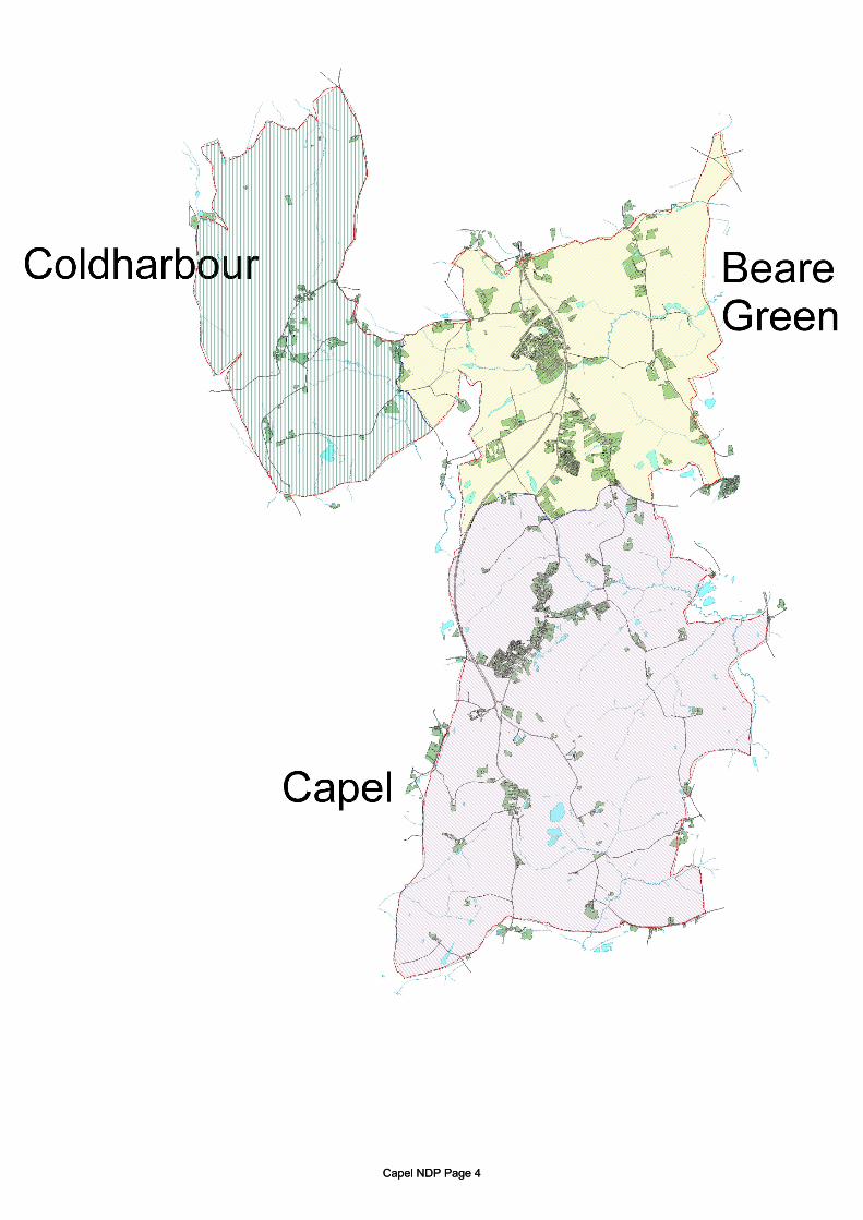
Section 5 - Allocated Sites Pages 67 - 108 Section 6 - The Villages: Pages 109 -160 Beare Green
• About Beare Green • Beare Green Policies
Capel
• About Capel • Capel Policies
Coldharbour
• About Coldharbour • Coldharbour Policies
Section 7 – Supplementary Documents Pages 161 - 169
• List of Policies • Glossary of Terms • Evidence Base Summary
Documents not included in the Plan Landscape and Visual Sensitivity Report Housing and Community Survey Report Mole Valley Core Strategy Statement of Community Involvement SEA Screening Report
CONTENTS
Capel NDP Page 3Capel NDP Page 3
Capel NDP Page 4Capel NDP Page 4

MISSION STATEMENT To work with the community to deliver an appropriate and sustainable Neighbourhood Development Plan that will meet the immediate needs of the Parish of Capel and the expectations of future generations whilst respecting the individual characteristics of the three Wards.
SECTION 1 INTRODUCTION
Capel NDP Page 5Capel NDP Page 5
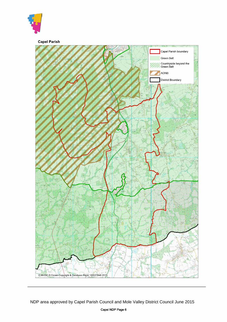
NDP area approved by Capel Parish Council and Mole Valley District Council June 2015
Capel NDP Page 6Capel NDP Page 6

INTRODUCTION 1.1 The Capel Parish Neighbourhood Development Plan (NDP) is a new type of planning
document. The purpose of the Plan is to give local people more say about what goes on in their area. It forms part of the new approach to planning set out in the Localism Act 2011 (the Localism Act) that came into force in April 2012.
1.2 The NDP provides a vision for the future of the Parish and sets out clear planning policies to
realise that vision. 1.3 The NDP has been developed through extensive consultation with the people of Capel Parish
and others with an interest in the Parish. 1.4 An overview of the consultation is also contained in a ‘Consultation Statement’. This fully
accords with the requirements of the Localism Act and Regulation 14 of the Neighbourhood Planning (General) Regulations 2012 [SI No. 637/2012]. Where appropriate, the NDP has been amended in response to consultation comments.
Details of this consultation are recorded in a series of reports which may be downloaded from the NDP website.
How the Neighbourhood Plan fits into the Planning System 1.5 Although the intention is for local people to decide what goes on in their neighbourhoods,
the Localism Act sets out some important basic requirements. One of these is that all Neighbourhood Plans must be in line with higher level planning policy, contained in:
• The National Planning Policy Framework (NPPF) and • Local policy - the Mole Valley District Council’s Core Strategy.
This Core Strategy requires Mole Valley District Council (MVDC) to deliver 3760 dwellings between 2006 and 2026. By March 2015, some 1970 dwellings had been built in Mole Valley. Additionally, MVDC are required to identify a supply of housing for an immediate 5 year surplus (815 dwellings) and have a deliverable supply of 1,126 dwellings (this is subject to an update). The new Local Development Scheme (LDS) for Mole Valley District Council was agreed on 22nd March 2016. It is anticipated an examination will take place of the new Local Plan in spring 2018 with adoption later that year.
Capel NDP Page 7Capel NDP Page 7

This timescale is important for the NDP. It will enable its early implementation and the opportunity of making representations regarding modifications to the Green Belt boundary in relation to its proposals.
1.6 The Localism Act allows the NDP to provide more than this number of houses and amount of employment land, but it does not allow the Plan to provide for less.
1.7 The NDP gives local people the power to decide where new housing and employment should go, and how the Parish should change. Without the NDP, Mole Valley District Council would make, and impose, these decisions on behalf of the people of the Parish.
1.8 Although deciding where new housing and new employment should go is an important part of the NDP, it is about much more than this. The Plan is a strategy for the Parish as a whole. It looks at a wide range of issues, including:
• how new employment should support villages• whether new community facilities are needed and where they should go• how walking and cycling around the Parish should be improved• what open space new housing should contribute to the Parish• encouraging Capel to become a ‘greener’ community
1.9 This Plan is divided into the following sections:
• Section 2: Background to the Parish of Capel- A brief description of the Parish - The issues that have influenced the vision
• Section 3: The Future- The Vision Statement and Core Objectives - The future vision for the Parish of Capel
• Section 4: Neighbourhood Plan Policies- Policies to support the overall vision.
• Section 5: The Allocation Policies- Site-specific policies for the allocated sites.
• Section 6: The Villages of the Parish- Brief history and description of each ward
• Section 7: Supplementary Documents
1.10 This entire document forms the Neighbourhood Development Plan for the Parish of Capel under the Localism Act, whereas Sections 4 and 5 form the Policies of the NDP.
1.11 The large amount of background information that has helped to produce the NDP is known as the evidence base. A document, Capel Neighbourhood Plan: Evidence Base Schedule, is included at the end of this document. This provides an overview as well as explaining the options that were considered during the production of the NDP.
Capel NDP Page 8Capel NDP Page 8
1.12 An aim of the NDP is to enhance the natural resources and the environment in the Parish by
having specific regard to its air, water and soil. 1.13 A further aim is to promote a sustainable Parish community, which will be:
• Active • Environmentally sensitive • Well designed and built • Thriving • Fair for everyone
Capel NDP Page 9Capel NDP Page 9

Capel NDP Page 10Capel NDP Page 10

Figure 1 - Plan showing key places in the Parish of Capel
Church
School
Railway Station
Community Centre
Playing Fields
SECTION 2
PARISH OF CAPEL
Capel NDP Page 11Capel NDP Page 11
ABOUT CAPEL PARISH
2.1 Understanding the Parish is the starting point for producing a good Neighbourhood Plan. This is because the Capel Neighbourhood Plan is an opportunity to plan the Parish’s future. What are the problems that the Plan could address? What are the opportunities the Plan could make the most of?
The Parish Today 2.2 A wide range of issues have been considered in producing the Plan. These can be grouped
under five themes: • Housing• Working and shopping• Getting around• Leisure and wellbeing• Environment, sustainability and design quality
2.3 An overview of these five themes is set out below. This overview includes information from background reports along with issues raised by local people at the various consultation events. A more in-depth summary of the background reports is available in the Evidence Base Summary that accompanies this Plan. A full report of issues raised during consultation is set out in the separate consultation reports, with an overview provided in the ‘Consultation Statement.’
Housing 2.4 The Parish of Capel has a population of around 3,500 people.
A review of available housing data shows that there is: • A high level of home ownership and correspondingly low proportions
of social and private rented housing• A wide choice of properties with the exception of flats• A high supply of 3 and 4-bedroom properties
2.5 Consultation with local people has revealed concerns about the affordability of housing in Capel, particularly for young people and families. People are also concerned about there being a range of housing types available – the perception is that many new developments are skewed towards larger dwellings.
Working and Shopping 2.6 The Parish is generally an affluent area. However, there are areas of the population who live
in areas identified as ‘concentrated’ social housing in Beare Green and Capel.
2.7 There are high levels of commuting out from the villages through a combination of transport methods. To the north and south public transport (rail and bus services) facilitates access to
Capel NDP Page 12Capel NDP Page 12
Dorking and Horsham. Rail transport via these two towns provides indirect links to Gatwick and Crawley, two significant employment centres.
2.8 What facilities are provided within the Parish of Capel? 2.8.1 Shopping
The facilities in Beare Green and Capel meet the local needs of the communities, albeit in a limited and basic way. In Coldharbour, a local shop, linked to the village pub, is due to open in 2016 which will benefit the village.
2.8.2 Offices/Businesses
A number of local businesses with a particular emphasis of work/home activities exist in the Parish. Local rural community “sustainable best practice” will ensure that any new development contributes to the economic vitality of the area.
2.8.3 Agriculture
The three villages are set within an agricultural environment, including land occupied by the Forestry Commission.
2.8.4 Getting Around
Walking is an important mode of transport - being just as essential as the motor car and public transport. Bus stops are usually accessed on foot. About 80% of rail travellers arrive at or leave Holmwood railway station (at Beare Green) on foot, with a lower percentage at Ockley (used by Capel residents) due to its more remote location.
2.9 The National Planning Policy Framework (NPPF) March 2012, Paragraph 30 promotes
sustainable transport. This NDP also embraces the objectives set out in paragraph 39 (page 11) of the NPPF concerning the availability and opportunities for public transport, local car ownership and the need to reduce high vehicle emissions.
2.10 The village cores of Capel and Beare Green generally provide easy and safe walking on
pavements, as they are fairly flat and compact. Coldharbour is much more undulating and has no pavements. All parts of the Parish connect well with the adjacent countryside through a network of rural roads, footpaths and bridleways
2.11 These same characteristics also make Capel Parish suitable for cycling - with the exception of
the A24 dual carriageway. There are few cycle routes, with most cyclists using streets to get around. Incorporating traffic calming measures into the Capel village environment, and suitable improvements for traversing the A24 at appropriate points are both desirable and strategic aims.
Capel NDP Page 13Capel NDP Page 13

2.12 The evidence shows a perception that bus services and access to them appears to be relatively poor. This must be balanced against the fact that this is a rural area and the current service through Beare Green and Capel Village runs approximately hourly during the day, seven days per week. The railway stations serving the Parish are Holmwood at Beare Green and Ockley near Capel. Poor cycle and bus access to the stations are identified as problems by local people, as are car parking facilities for commuters.
Leisure and Wellbeing 2.13 An assessment of community facilities within the Parish is available as part of the Evidence
Base. The survey of facilities included an overall satisfaction in the provision of sports, play and shopping facilities (see 2.15).
2.14 Capel village has a very active community life, represented by many different groups and organisations. The perception identified at public consultations is that most of the existing community facilities are of small to medium capacity.
2.15 The Housing and Community Survey and consultations identified the need to consider and review:
(i) Recreation facilities (ii) Play facilities (iii) Shopping (iv) Community facilities (v) GP Services (vi) School capacity
The satisfaction responses for these aspects are as follows: (i) Recreation/sports facilities
Beare Green 63% Satisfied Capel 67% Coldharbour 65%
(ii) Play facilities • Beare Green 76% Satisfied • Capel 68% • Coldharbour 85%
(iii) Shopping • Beare Green 68% Satisfied • Capel 81% • Coldharbour 30%
Capel NDP Page 14Capel NDP Page 14

(iv) Community Facilities (Village Halls) All three villages benefit from community facilities, the extended village hall at Beare Green incorporating a ‘local’ library. All three are used and managed by community groups.
(v) GP Services
In recent years the Leith Hill Practice has consolidated in Capel providing a range of medical services, including a pharmacy. A satellite surgery is located at South Holmwood (outside the Parish of Capel) but is lacking in space, car parking and is away from the main population centre within the Parish at Beare Green and lacks good public communication connections. Proposals for a new surgery in Beare Green will be considered when a planning application for residential development on site BG02 is allocated for that purpose in an approved Neighbourhood Development Plan.
(vi) School Capacity
The Scott Broadwood Schools in Capel and Ockley are linked. They meet the sustainable numbers required for the community. The Weald Church of England Primary School in Beare Green provides schooling for pupils aged between 4 and 11 years. It has a wide catchment area but priority should be given to children living in the parish. The Neighbourhood Plan will seek to ensure the protection of the school playing fields at The Weald from redevelopment. Education infrastructure will be supported by the Policy Framework to reflect the competing objectives set out in the National Planning Policy Framework (NPPF) in particular, Paragraph 74 (the Safeguarding of Playing Fields from development). All three schools have capacity to meet the present and projected future needs of the community.
Capel NDP Page 15Capel NDP Page 15
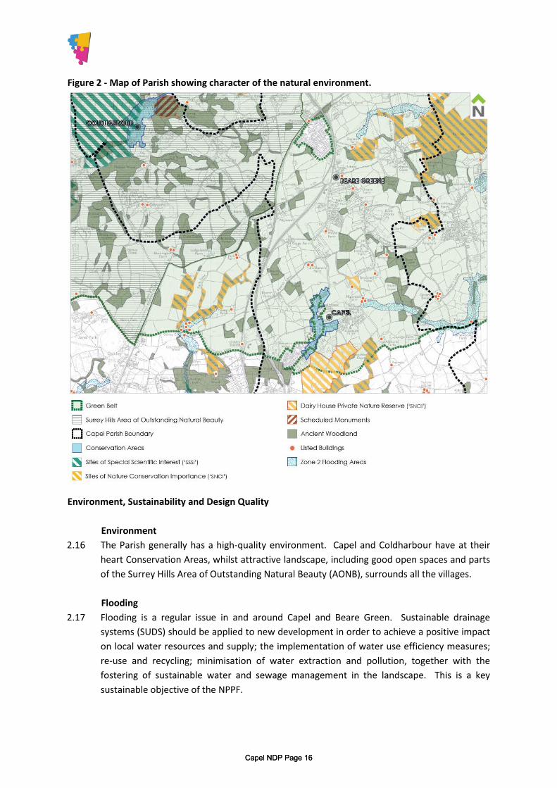
Figure 2 - Map of Parish showing character of the natural environment.
Environment, Sustainability and Design Quality
Environment 2.16 The Parish generally has a high-quality environment. Capel and Coldharbour have at their
heart Conservation Areas, whilst attractive landscape, including good open spaces and parts of the Surrey Hills Area of Outstanding Natural Beauty (AONB), surrounds all the villages.
Flooding 2.17 Flooding is a regular issue in and around Capel and Beare Green. Sustainable drainage
systems (SUDS) should be applied to new development in order to achieve a positive impact on local water resources and supply; the implementation of water use efficiency measures; re-use and recycling; minimisation of water extraction and pollution, together with the fostering of sustainable water and sewage management in the landscape. This is a key sustainable objective of the NPPF.
Capel NDP Page 16Capel NDP Page 16

Open Space 2.18 Capel and Coldharbour benefit from having recreation land and playing fields within the
villages. Beare Green also has an area for sport and recreation but is separated from the village environment being located east of the A.24. These areas are identified in the respective village settlement plans. The proposal for designating site BG01 (Land off Highlands Road, Beare Green) as recreation land and playing field being closely related to the village community is therefore seen as a priority.
Historic Landscape 2.19 Leith Hill is an historically important landscape. It is also designated as an AONB. To the
south of Capel, a number of Sites of Special Scientific Interest (SSSI) exist. The landscape character has regard to a complex topography of ridges and valleys, woodland, including Ancient Woodland (woodland that has existed continuously since 1600 or before) and rural lanes all contributing to the landscape and, particularly in Coldharbour, a sense of tranquillity. (See Figure 2.)
Character and Heritage 2.20 The villages comprise a number of broad character areas that make up the built
environment of the Parish. These are based on an analysis of the Parish. Its heritage is emphasised by Conservation Areas, Listed Buildings, and the distinctiveness of the three villages, lanes, landscape, arable and pastoral fields, hedges, trees and woodlands. Capel and Coldharbour Conservation Areas
2.21 These “character areas” make a significant contribution to the Parish as a whole. The areas were reviewed as part of the Landscape and Sensitivity Assessment (the CSA Report – April 2016). The only recommendation by CSA is to extend the Coldharbour Conservation Area to include Anstiebury Fort. Surrey County Council Heritage Conservation support the inclusion of the Fort within the Coldharbour Conservation Area which will improve its protection as a scheduled Monument. It is also recommended by Surrey County Council to examine the wider context of the site to establish “view corridors both to and from the Monument, to protect and enhance its rural character in the future.” (September 2016).
Landscape (General) 2.22 Land to the west of the A24 and north/west of the A29 rises towards the Surrey Hills AONB
and is the highest point in Surrey. However, to the east the landscape is more variable, although Capel village is well contained visually to the south/east by rising land and the designated Private Nature Reserve (reference: Landscape Sensitivity Report by CSA)
Capel NDP Page 17Capel NDP Page 17

Housing 2.23 Main comments raised by local people during the consultation include:
• A limit to the number of new homes on any one site• New housing needs to be integrated on smaller sites• New homes should be spread over several sites, not in one big
development• A lack of affordable homes to buy or rent• A shortage of smaller homes (3 bedrooms and fewer)
Objective: Integrate new housing with a range of accommodation including bungalows. Objective: Provide a greater range of affordable housing. Objective: Provide a range of different housing types across all tenures.
Working and Shopping 2.24 Main comments raised by local people during the consultation include:
• Retaining shops in the village• A shortage of good quality new employment space• New employment sites should include a mix of uses
Objective: Support village shops Objective: Provide new employment.
Getting Around 2.25 Main comments raised by local people during the consultation include:
• More footpaths/cycleways needed to extend and link into thecountryside
• Create new bridleways• Create cycle routes to Ockley and Holmwood railway stations• Improving connections between the villages and the surrounding towns• Planning public transport services should work together• The impact of more traffic from new homes• Parking in the villages• Management of traffic speeds in the villages
Objective: Connect new housing with good pedestrian, cycle and bus connections Objective: Improve existing pedestrian and cycle corrections Objective: Improve connections to surrounding destinations Objective: Plan public transport to better meet users’ needs Objective: Ensure car parking within Beare Green supports the viability of the railway. Objective: Manage tourism issues in Coldharbour.
Capel NDP Page 18Capel NDP Page 18

People and Vehicles/Streets and Surfaces 2.26 The streets in Coldharbour and Capel have an intimate character lacking definition of its
“Public Realm”. In Capel, high levels of traffic movement and on-street parking detract from its intimacy. In Beare Green, the narrow streets are also dominated by on-road parking although the impact is less given the more “urban” nature of that part of the village.
2.27 Children need the area to be safe and accessible, as do people with restricted mobility. The constraints are shaped by existing development along The Street, existing routes and movement patterns.
2.28 The Neighbourhood Plan seeks to provide solutions to these identified problems but will have regard to:
• The existing qualities of the streets • Vehicular movement, including public transport; school transport, commercial and
public service vehicles • Constraints and opportunities • Access provision for cars, pedestrians, cyclists, horse-riders, people with
disabilities • Rights of Way
2.29 The objective will be to reinforce ‘a sense of place’ to add to and enhance the amenity of the
village through ‘street remodelling’ with a strong visual boundary. 2.30 The new features to be incorporated will include:
• Priority vehicle hierarchy • Dropped kerbs/at grade • Discreet parking • Avenue-style planting to create a boulevard along The Street
The aim will be to provide speed constraint features with a target maximum of 20 mph. The driver perception will aim to achieve an appropriate speed through strong visual elements rather than signage and artificial clutter. The restricted forward visibility is designed to generate caution. The target speed limit should therefore be self-enforcing.
Objective and Policy
2.31 To maximise enjoyment of the intrinsic qualities of the “public realm” throughout the Parish and achieve an improved environment for pedestrians and horse riders whenever they encounter motor vehicles.
Capel NDP Page 19Capel NDP Page 19

Capel NDP Page 20Capel NDP Page 20

INTRODUCTION
The Plan outlines the future vision for the parish having regard to:
• Constraints and Opportunities• Provision• Key objectives
SECTION 3
The Future Vision of the Parish of Capel
Capel NDP Page 21Capel NDP Page 21

CONSTRAINTS AND OPPORTUNITIES
Leith Hill and the Surrey Hills AONB
3.1 These comprise areas of high landscape value/quality and lie within the Green Belt. No inappropriate development should take place in these areas (reference CSA Landscape and Visual Sensitivity Report – April 2016).
Walking Zone
3.2 This is the starting point for considering locations for sustainable development but should not be thought as definitive. A “twenty-minute walk” criterion could be applied on a general basis (reference paragraphs 2.9-2.11).
Bus Routes/Trains
3.3 The bus services are operated by Metro Bus (www.metrobus.co.uk) and Buses4U (www.buses4u.co.uk). The railway stations are also identified on the map in figure 1.
‘A’ Roads
3.4 The A24 forms a strong edge to Beare Green Village to the east and definition to the setting of Capel Village to the west. Local people in Beare Green are concerned about the impact of the A24. It is not only difficult to cross, but the pedestrian and cycle links (east/west) are unattractive and are perceived to ‘form’ a barrier. The Weald School, village green and public house are all to the east of the A24.
The A29 Bognor Road also provides vehicular definition and is a key link to Coldharbour village from within the Parish, alternative routes being via Dorking.
Capel NDP Page 22Capel NDP Page 22

DEVELOPMENT OPPORTUNITIES
Introduction
3.5 It is important to understand the technical opportunities and problems in and around the Parish that may affect the location of new development. This provided the basis for making informed choices about where new development could be located. The sites have been considered for housing, employment and recreation by the Neighbourhood Development Plan Steering Group and the Parish Council.
3.6 Section 5 of the Plan allocates land for development. For each of the sites the information provided includes:-
• A plan showing the overall extent of the land allocated including open space and
landscape buffers as well as the built development. • An explanation of the ‘Key Considerations’ affecting the site including specific policy
requirements including pedestrian, cycle and vehicular provisions • NDP Policy requirements including the number of dwellings and any other allocations
and land uses 3.7 Clearly defining residential density and publicly accessible open space.
Residential Density
3.8 With the removal of Planning Policy Statements, there is no longer a national definition of how residential density is calculated.
Net dwelling density is calculated by including only those site areas which will be developed for housing and directly associated uses, including access roads within the site, private garden space, car parking areas, incidental open space and landscaping and children’s play areas, where these are provided.
3.9 Gross dwelling density is calculated on the basis of gross site area, which includes buffer
planting, roads serving not only the development but the wider area (e.g. distributor roads) and open space that serves not only the development but the wider population.
3.10 Sites have issues of visual impact that will need to be mitigated by the way in which the
development is designed. This must be reflected in the initial design work undertaken by developers in their master planning, a design brief and proposals for public consultation.
Capel NDP Page 23Capel NDP Page 23
Publicly Accessible Open Space
3.11 The Neighbourhood Plan identifies those areas of land within sites that should remain undeveloped as open space on the basis of visual impact and relationship to existing landscape. For example, the existing hedgerows form the boundary between the area allocated for residential development and the area allocated for open space.
3.12 The Neighbourhood Plan policy requirement is to define the areas of open space as being ‘publicly accessible.’ This means that developers are required to provide public access through these open spaces as a policy requirement.
3.13 Public Open Space required by NDP Policy in the form of equipped playgrounds and informal play space must be provided within designated areas for housing defined as residential development so that they are easily accessible to residents.
3.14 Open Space and recreation provision and protection should have regard to the National Planning Policy Guidance and Framework (NPPG and NPPF) and the Fields in Trust (NPFA) publication ‘More than the 6 Acre Standard – November 2015).’
3.15 In Beare Green policy objectives will seek to provide statutory Green Spaces.
Potential Development Areas
3.16 Key objectives
• to improve the quality of new homes• improve design and environmental standards• deliver more affordable and low cost market housing• provide housing appropriate for families and those with disabilities• provide for the delivery of sustainable development objectives• deliver community benefits, including employment• have regard to accessing public transport and other community facilities• provide community space• cut carbon emissions• a design approach to deliver high quality, well designed housing
3.17.1 Beare Green Sites
BG01 Land off Highland Road (recreation space only) BG02 Land North of Breakspear Farm BG03 Cluster of buildings at Breakspear Farm BG04 Surrey Hills Hotel
Capel NDP Page 24Capel NDP Page 24
3.17.2 Capel Sites CA01 Capel House Farm, The Street CA02 Land at Brook Cottage, Wolves Hill CA03 Land at Old Kiln Farm, Coles Lane
CA04 ‘Hurst’ Vicarage Lane 3.17.3 There are no sites allocated in Coldharbour for development opportunities 3.18 The allocated sites are expanded upon in Section 5 of the Neighbourhood Development Plan
what each site is allocated for and the Policy.
3.19 Design requirements are expanded upon in Section 6 of the Neighbourhood Development Plan ‘The Villages.’ This will include details of a restrained palette of materials with subtle changes in composition, to strengthen the identity of areas and having regard to the prevailing local character are including Section 6 The Villages:-
• facing brickwork • render • tile hanging • roof tiles • boarding • fenestration • features (chimneys, porches, enclosures) • roofs (dormer windows/Velux windows).
Capel NDP Page 25Capel NDP Page 25

Capel NDP Page 26Capel NDP Page 26