Serving People – Preserving Heritage Catherine Desmond, Archaeologist,
Upload
truongdungCategory
view
226download
0
NEGATIVE ARCHAEOLOGICAL INVENTORY REPORT FOR
APN 114-140-06-00 and 140-57-00 LOCATED IN SUNSHINE SUMMIT, CALIFORNIA
PDS2016-AD-16-034
Lead Agency:
County of San Diego Planning & Development Services
5510 Overland Avenue San Diego, CA 92123
Preparer:
Richard Carrico Recuerdos Research
PO Box 387 Warner Springs, CA 92086
Project Proponent:
David Lowe Sierra Roble Winery
PO Box 21 Warner Springs, CA 92086
October 5, 2018
SDC PDS RCVD 03-22-19 AD16-034

National Archaeological Data Base Information Authors: Richard Carrico Firm: Recuerdos Research Report Date: October 5, 2018 Report Title: Archaeological Inventory Report for APN 114-140-06-00 and 114-
140-57-00, Located in Sunshine Summit/Warner Springs, California Type of Study: Intensive Pedestrian and Archival Research Prehistoric/Pre-Contact Resources: None Updated Sites: N/A Historic Resources: None USGS Quad: Warner Springs Acreage: 13.6 acres Key Words: Sunshine Summit, Warner Springs, Negative Survey, Sierra Roble Vineyard.

EXECUTIVE SUMMARY
This report provides the results of an archaeological inventory and survey for an
approximately 13.6-acre parcel located in Warner Springs, California (APN 114-140-06-00
and 114-140-57-00). The property, with the exception of a small portion on the west that is
crossed by an SDG&E easement and contains some native vegetation, and a portion to the
south, is currently in use as a vineyard for the Sierra Roble Winery. The records search, field
survey, and preparation of this letter report were performed in accordance with the California
Environmental Quality Act and guidelines of the County of San Diego as one element of
approval of a proposed agricultural administrative permit for the study area.
Results of the field study were negative; no archaeological or historical resources were
recorded at the South Coastal Information Center or as a result of the field survey. There are
five known resources to the east and south east of the project.
The proposed project has not and will not impact or adversely affect any recorded or known
cultural resources within the portions of the parcels currently in use as vineyards or proposed
for vineyard expansion. If, however, the section of the parcel on the extreme western portion
crossed by the SDG&E easement and the currently uncleared portion to the south are, in the
future, cleared, then post-grading review has been recommended by the Native American
monitor to ensure that unobserved, buried resources in the semi-undisturbed western portion
of the project are not impacted without some level of study.

1.0 INTRODUCTION AND SUMMARY
This letter report provides the results of an archaeological inventory and survey for an
approximately 13.6-acre parcel located in Sunshine Summit/Warner Springs, California (APN
114-140-57-00 and 114-140-06-00). Parcel 114-140-06-00 has been previously cleared of native
vegetation and is currently in use as a vineyard. A portion of 114-140-57-00 has been cleared and
planted with the southern portion still in native vegetation.
The records search, field survey, and preparation of this letter report were performed in accordance
with the California Environmental Quality Act and guidelines of the County of San Diego as one
element of approval of an agricultural use permit for the non-permitted portion of the vineyard.
Results of the study were negative; no archaeological or historical resources were recorded at the
South Coastal Information Center or as a result of the field survey. There are known resources
within the one mile study area to the east and south of the current project across Highway 79 and
to the south. Continued use of the parcels for agricultural purposes and as a vineyard will not
impact or adversely affect any recorded or known cultural resources. In the event that the western
portion of the parcel near the SDG&E easement and the southern section is cleared, a post-grading
review of the cleared ground surface has been recommended by the Native American monitor to
ensure that unobserved, buried historic resources and Native American resources are not impacted
without some level of study.
2.0 PROJECT LOCATION
The project is located in the community of Sunshine Summit north of Warner Springs, California
immediately west of Highway 79 and (Figure 1). As shown on the Warner Springs 7.5 USGS
quadrangle, the parcel is situated within Township 9 South Range 2 East; in the southwest quarter
of section 36 at an approximate elevation of 3200 feet above mean sea level (msl) (Figure 2).

3.0 ARCHIVAL RESEARCH/RECORDS SEARCH
A self-search records search for a one mile radius was conducted at the South Coastal information
Center on September 28, 2017 (Attachment A: Records Search Request). Results of the search
were negative; no archaeological or historical resources were previously recorded on the subject
parcel (Attachment B: Verification of Records Search). Confidential Appendix A, which is
provided as a separate document, provides a map depicting the recorded resources beyond the area
of potential effect. A listing of the five recorded sites within a one-mile radius of the Sierra Roble
project is provided below on Table 1. The nearest resource (SDI-18141) is 800 feet to the southeast.
TABLE 1
CULTURAL RESOURCES WITHIN A ONE MILE RADIUS OF PROJECT SITE
Site
No.
SDI-
Type Report/Recorder
18173 Bedrock milling features w/debitage
& ceramics
J Underwood et al 2006.
Proposed Vista Irrigation District
Expansion
18141 Probably village site w/extensive
bedrock milling, ceramics, lithics.
J Underwood et al 2006
Proposed Vista Irrigation District
Expansion
9849H Cement slab foundation & two flakes
with modern historic glass and cans
D Hanna & J Cook 1984. SERE Camp FY
1986 U. S. Navy Family Housing
00428 Extensive bedrock milling with slicks
and mortars. Pestles noted
D. L. True 1958 (Site Survey Record Only)
18157 Historic site with cans, glass, metal.
Mainly glass food and condiment jars.
J Underwood et al 2006
Proposed Vista Irrigation District
Expansion
The County of San Diego will serve as the Lead Agency and will be ultimately responsible for
conducting a Sacred Lands review through the Native American Heritage Commission as well as
consultation with the local tribes.

FIGURE 1
Depicting Existing Vineyard and Natural Vegetation to the South
That is a Part of the Proposed Action

FIGURE 2
Project Site As Depicted On the Warner Springs
7.5 Minute USGS Quadrangle

The project is subject to AB-52 consultation. County staff is engaged in tribal outreach with the
Pala Band of Mission Indians and the San Luis Rey Band of Mission Indians (Attachment C).
Native American consultation will be an on-going effort throughout the environmental review
process. To date, no tribal cultural resources have been identified within the project site.
Several archaeological and historical sites have been recorded to the east of the current project site.
An extensive and concentrated assemblage of artifacts with bedrock milling features is located east
of the project site and probably comprises a precontact village location.
A review of historic maps and reports do not indicate any significant historic land use associated
directly with the parcel. Current Highway 79 and earlier unpaved roads within and beyond the
current route served as a major transportation link between the eastern desert and communities to
the north including Temecula. The road has been heavily modified and is not within the area of
potential effect.
4.0 SETTING
The subject parcel is within a set of rolling hills that generally trend east west with small drainages
cutting through the hills. Elevation in the parcel varies from 3278 feet above mean sea level (msl)
on the western highest point to 3200 feet above msl on the east. The proposed action is to gain a
permit from the County of San Diego for the expansion of the vineyard and winery from Boutique
Winery status to Small Winery status. The cross hatched area depicted in Figure 3 shows the Area
of Potential Effect (APE). Figure 4 shows the existing vineyard including the portion that is not
currently permitted and will be a portion of the Small Winery permit. Figure 5 depicts the existing
permitted vineyard from the west.
The soils within the parcel are crumbly brown to dark orange loam with small angular granitic
bedrock fragments and nodules in relatively shallow in the subsoils. The small outcrops beyond
the area of potential effect are not suitable for milling or food processing. The entire subject parcel
has been cleared for installation of the current vineyards. Vegetation beyond the current study
area (which is limited to the vineyards) on the south and west include red shank, yucca, buckwheat,
and other members of the Coastal Sage Scrub community.
SUBJECT PARCEL

FIGURE 3
Project Site as Depicted Engineering Plot Plan
Area of Potential Effect (APE) Depicted with Cross Hatches
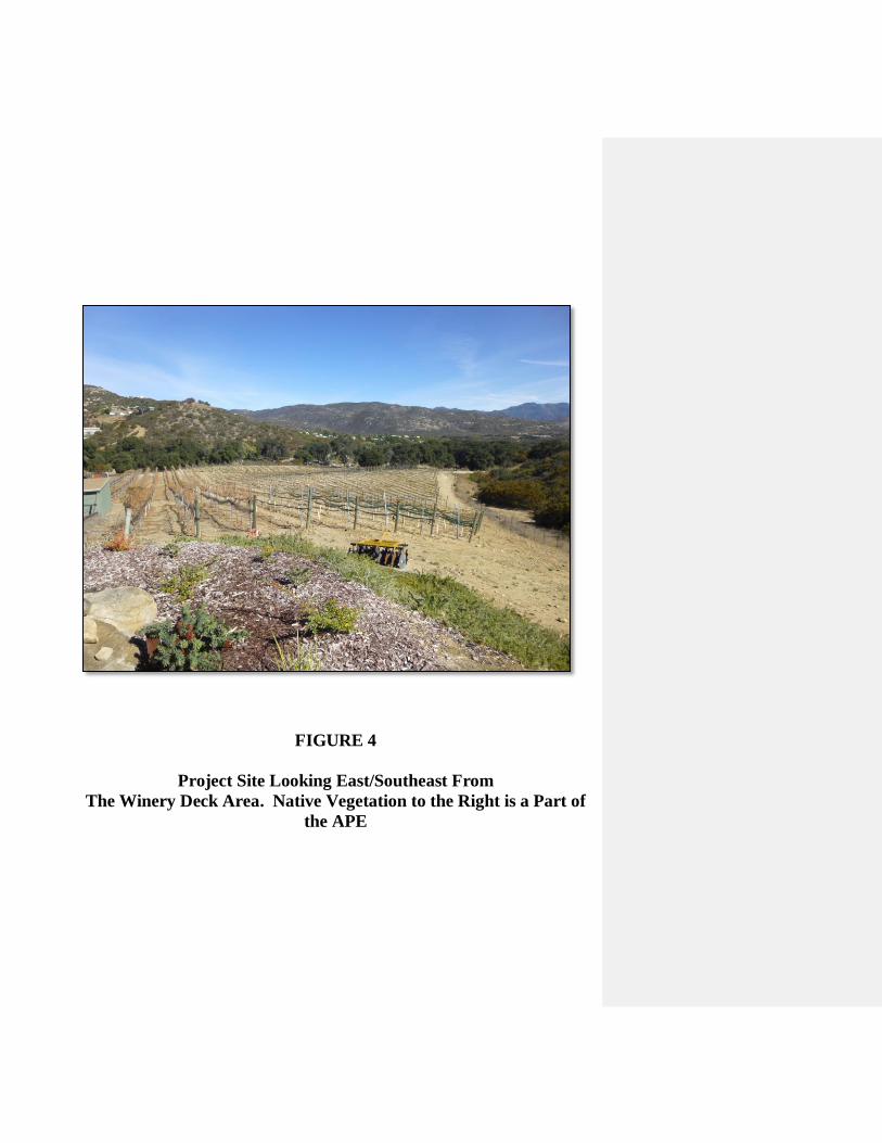
FIGURE 4
Project Site Looking East/Southeast From
The Winery Deck Area. Native Vegetation to the Right is a Part of
the APE

FIGURE 5
Project Site Looking East From
the Cleared SDG&E Easement Towards the Vineyard and Winery.
Native Vegetation that is a Part of the APE is to the Right
(Southward). Note the Rocky Soils within the Easement

5.0 FIELD SURVEY
The field survey was conducted on October 11, 2017 by Richard L. Carrico acting as the Principal
Investigator and on October 16, 2017 by Richard Carrico with P. J. Stoneburner of the Los Coyotes
Indian Reservation under contract to Save Sacred Sites as the Native American Monitor. The
survey was conducted by transecting the acreage in east to west transects spaced at 3 meter
intervals. Ground visibility was excellent given that the majority of the survey area is currently in
use as a vineyard. As an estimate, more than 95% of the ground surface was visible within the
vineyard and approximately 60% within the vegetated section to the south. The entire APE was
intensively surveyed.
6.0 RESULTS OF THE SURVEY
Results of the field survey were negative; no archaeological or historical resources were noted
within the parcel. The acreage has been cleared in all but a small portion to the west and
tilled/brushed over for most of the parcel allowing for a thorough examination of surface soils, and
in many cases subsoils. Precontact sites tend to be associated with major water sources and useable
bedrock; resources that are lacking within the parcel.
Native American Consultation
No information has been obtained through Native American consultation with the Pala Band of
Mission Indians or communication with the Native American monitor during fieldwork that tribal
cultural resources are known to exist within the project area that current serve religious or other
community practices. A review of the notes of John P. Harrington for the general area did not
reveal any specific placenames or recorded places of importance although nearby Puerta la Cruz,
Warner Springs, Dead Man’s Hole and Oak Grove were all noted as important. During the current
archaeological evaluation, no artifacts or remains were identified or recovered that could be
reasonably associated with cultural or religious practices. The cultural survey was negative for
resources.

7.0 MANAGEMENT RECOMMENDATIONS
The absence of cultural resources within the subject parcel leads to a finding of no adverse effect
and of no impacts to known significant cultural resources as result of approval of the existing
vineyards within the parcel.
The Native American monitor has requested that if grading or clearing is conducted in the future
for the small remnant of native plants and soils in the extreme western portion of the overall parcel
near the SDG&E easement and within the southern section, that post-clearing review be conducted.
The review shall include a qualified archaeologist and a knowledgeable Luiseño or Cupeño
monitor. All review/monitoring efforts and reporting shall follow the County of San Diego
guidelines to include the authority to halt and investigate potentially important resources (if any)
encountered during grading.

8.0 SOURCES CONSULTED
Aerial Photograph
1928 San Diego County Tax Factor 1928 Aerial Photograph. Cartographic Services, San
Diego County Operations Center.
1946 United States Department of Agriculture 1946 Aerial Photograph. On line at
historicalaerials.com.
1953 United States Department of Agriculture 1953 Aerial Photograph. On line at
historicalaerials.com.
1964 United States Department of Agriculture 1964 Aerial Photograph. On line at
historicalaerials.com.
1968 United States Department of Agriculture 1968 Aerial Photograph. On line at
historicalaerials.com.
Alexander, W.E.
1912 San Diego County Plat Book. San Diego History Center Archives
General Land Office
1876 Plat Map of Township 9 South South, Range 2 East, San Bernardino Meridian.
1891 Copy of Plat Map on file Cartographic Services, San Diego County Operations Center,
and at http://www.glorecords.blm.gov.
Harrington, John P.
1925 Field notes of J. P. Harrington. Volume 3, Reel 119 and 169.

USGS (United States Geological Service)
1948 Warner Springs Quadrangle.
1975 Warner Springs 7.5’ Quadrangle.

ATTACHMENT A
REQUEST TO PERFORM A SELF SEARCH AT THE
SOUTH COASTAL INFORMATION CENTER


Record Search within One Mile Radius
Of the Project Center

ATTACHMENT B
VERIFICATION OF A SELF SEARCH AT THE SOUTH
COASTAL INFORMATION CENTER


ATTACHMENT C
CONSULTATION DOCUMENTS PROVIDED BY THE
COUNTY OF SAN DIEGO
TO BE PROVIDED
Commented [NK1]: Place in confidential appendix

CONFIDENTIAL APPENDIX A:
CULTURAL RESOURCES WITHIN A ONE MILE
RADIUS OF THE PROPOSED PROJECT
(Provided Under Separate Cover: Not for Public Review)


![A lexical analysis of the [č] - [š] alternation in Luiseño](https://static.fdocuments.in/doc/165x107/626fa523e1c0b71830187551/a-lexical-analysis-of-the-c-alternation-in-luiseo.jpg)