Near-surface geophysical imaging at the archaeological ... · The Reflexw program was designed for...
4
Evolving Geophysics Through Innovation 232 Near-surface geophysical imaging at the archaeological site of Maax Na, Belize, Central America Julie A. Aitken, Robert R. Stewart, and Nicholas Kaprowski, University of Calgary Abstract During the last several years, the University of Calgary has conducted a number of near-surface geophysical methods at the ancient Maya site of Maax Na in Belize, Central America. The use of these non-invasive techniques for archaeology in particular has been steadily increasing as the technology behind the instrumentation and processing capabilities have improved. Archaeologists are now more receptive to the use of these techniques because of their perceived benefits in terms of time efficiency and cost saving. The geophysical surveys acquired to date have included ground-penetrating radar (GPR), a 3C-3D seismic micro-survey, and tomographic surveys. In 2004, a total station land survey was also undertaken to determine spatial and topographic coordinates of one of the plaza areas. The archaeologists use these subsurface images to focus excavation activity and to predict the depth to buried features. The GPR method provides coherent and interpretable images of the subsurface of the plaza due to good signal penetration. The GPR lines have highlighted a number of interesting anomalies, one of which was excavated in 2004. No buried artifacts were unearthed. The seismic micro-survey refraction analysis and reflection data also produced a compelling image of the near surface. Recorded radar velocities ranged from 0.058 -.140 m/ns and appears to be dependent on the saturation level of the near-surface. The antenna frequency of the radar unit is 250 MHz with an associated bandwidth of 125-375MHz. The seismic velocities measured 180- 1060 m/s and the frequency bandwidth was approximately 10-300 Hz. Comparisons between identical lines extracted from the GPR 3-D survey and the 3C-3D seismic micro-survey serve to illustrate the potential of combining the two methods to resolve and image deeper into the subsurface. The resolution of GPR records in the near surface is superior to that of the seismic in the depth range of 0.7 -1.75 m but the depth of penetration of the seismic is greater than the GPR. Ultimately, a combination of the two would be advantageous to archaeologists in their quest to understand the past. Introduction The Maya are considered to be one of the great Mesoamerican civilizations and were experts in mathematics, astrology and engineering. Their culture flourished in Central America during the Classic Period (AD 300-900), when they constructed beautiful elaborate temples and pyramids in tribute to their gods and rulers. These monumental structures, encompassed by large plazas, were precisely placed and mathematically aligned with astronomical events. Maax Na is one of 800+ Maya archaeological sites situated in Belize alone. The site was discovered in 1995 by a group of surveyors. Subsequent excavation and mapping at Maax Na have revealed hundreds of intact structures within and around the site centre, now considered to be ceremonial in nature (King, 2004). Maax Na is situated in the Corozal Basin and consists of a thick sequence of marine carbonates, primarily limestone. The geology of the near-surface layering of the plaza consists of rich soils and humus underlain by man-made layers of a repeated sequence of limestone plaster, and limestone detrital, stacked above the limestone bedrock. The abundant soft-limestone beds were easily manipulated and cut into blocks or reduced by burning to produce lime for plaster (Sharer, 1994). The resultant white plaster proved to be impermable and very durable and was used fo top the plaza surface and as a top coat to their temples and pyramids, which were then brightly painted. The plaster also served to cover any imperfections in workmanship. The University of Calgary was invited to participate in the Maax Na Archaeological Project in 2001, and has been acquiring a number of near-surface geophysical surveys each field season. Research at the University of Calgary is focussed on improving the near- surface images, identifying and locating buried features, and investigating the potential of merging the GPR and seismic micro- surveys to obtain a more complete and deeper image of the subsurface. The 2002-2004 field seasons have involved surveying several 2-D lines and three 3-D grids across the plaza using both GPR and surface seismic, a seismic tomographic survey circumnavigating a pyramid and a total station land survey. This report will focus mainly on the results from the GPR survey and on a comparison between the GPR and the 3C-3D seismic micro-survey. Ground-Penetrating Radar Ground-penetrating radar involves the propagation of electro-magnetic waves into the ground and the recording of their returns. The term ‘ground penetrating radar’ (GPR) refers to a technique designed primarily to detect “the location of objects or interfaces buried beneath the earth’s surface or located within a visually opaque structure” (Daniels, 2004). The GPR record represents a series of reflections caused by impedence differences in one or more electro-magnetic properties namely dielectric permittivity, magnetic susceptibility and electrical conductivity. The recorded signal is generally measured in nanoseconds.
Transcript of Near-surface geophysical imaging at the archaeological ... · The Reflexw program was designed for...
Evolving Geophysics Through Innovation 232
Near-surface geophysical imaging at the archaeological site of Maax Na, Belize, Central America Julie A. Aitken, Robert R. Stewart, and Nicholas Kaprowski, University of Calgary
Abstract During the last several years, the University of Calgary has conducted a number of near-surface geophysical methods at the ancient Maya site of Maax Na in Belize, Central America. The use of these non-invasive techniques for archaeology in particular has been steadily increasing as the technology behind the instrumentation and processing capabilities have improved. Archaeologists are now more receptive to the use of these techniques because of their perceived benefits in terms of time efficiency and cost saving.
The geophysical surveys acquired to date have included ground-penetrating radar (GPR), a 3C-3D seismic micro-survey, and tomographic surveys. In 2004, a total station land survey was also undertaken to determine spatial and topographic coordinates of one of the plaza areas. The archaeologists use these subsurface images to focus excavation activity and to predict the depth to buried features.
The GPR method provides coherent and interpretable images of the subsurface of the plaza due to good signal penetration. The GPR lines have highlighted a number of interesting anomalies, one of which was excavated in 2004. No buried artifacts were unearthed. The seismic micro-survey refraction analysis and reflection data also produced a compelling image of the near surface.
Recorded radar velocities ranged from 0.058 -.140 m/ns and appears to be dependent on the saturation level of the near-surface. The antenna frequency of the radar unit is 250 MHz with an associated bandwidth of 125-375MHz. The seismic velocities measured 180-1060 m/s and the frequency bandwidth was approximately 10-300 Hz.
Comparisons between identical lines extracted from the GPR 3-D survey and the 3C-3D seismic micro-survey serve to illustrate the potential of combining the two methods to resolve and image deeper into the subsurface. The resolution of GPR records in the near surface is superior to that of the seismic in the depth range of 0.7 -1.75 m but the depth of penetration of the seismic is greater than the GPR. Ultimately, a combination of the two would be advantageous to archaeologists in their quest to understand the past.
Introduction The Maya are considered to be one of the great Mesoamerican civilizations and were experts in mathematics, astrology and engineering. Their culture flourished in Central America during the Classic Period (AD 300-900), when they constructed beautiful elaborate temples and pyramids in tribute to their gods and rulers. These monumental structures, encompassed by large plazas, were precisely placed and mathematically aligned with astronomical events.
Maax Na is one of 800+ Maya archaeological sites situated in Belize alone. The site was discovered in 1995 by a group of surveyors. Subsequent excavation and mapping at Maax Na have revealed hundreds of intact structures within and around the site centre, now considered to be ceremonial in nature (King, 2004).
Maax Na is situated in the Corozal Basin and consists of a thick sequence of marine carbonates, primarily limestone. The geology of the near-surface layering of the plaza consists of rich soils and humus underlain by man-made layers of a repeated sequence of limestone plaster, and limestone detrital, stacked above the limestone bedrock. The abundant soft-limestone beds were easily manipulated and cut into blocks or reduced by burning to produce lime for plaster (Sharer, 1994). The resultant white plaster proved to be impermable and very durable and was used fo top the plaza surface and as a top coat to their temples and pyramids, which were then brightly painted. The plaster also served to cover any imperfections in workmanship.
The University of Calgary was invited to participate in the Maax Na Archaeological Project in 2001, and has been acquiring a number of near-surface geophysical surveys each field season. Research at the University of Calgary is focussed on improving the near-surface images, identifying and locating buried features, and investigating the potential of merging the GPR and seismic micro-surveys to obtain a more complete and deeper image of the subsurface. The 2002-2004 field seasons have involved surveying several 2-D lines and three 3-D grids across the plaza using both GPR and surface seismic, a seismic tomographic survey circumnavigating a pyramid and a total station land survey. This report will focus mainly on the results from the GPR survey and on a comparison between the GPR and the 3C-3D seismic micro-survey.
Ground-Penetrating Radar Ground-penetrating radar involves the propagation of electro-magnetic waves into the ground and the recording of their returns. The term ‘ground penetrating radar’ (GPR) refers to a technique designed primarily to detect “the location of objects or interfaces buried beneath the earth’s surface or located within a visually opaque structure” (Daniels, 2004). The GPR record represents a series of reflections caused by impedence differences in one or more electro-magnetic properties namely dielectric permittivity, magnetic susceptibility and electrical conductivity. The recorded signal is generally measured in nanoseconds.
Evolving Geophysics Through Innovation 233
The success of GPR surveys is tied directly to the composition and saturation of near-surface materials. The saturation level results in vast changes in dielectric permittivity which translates into varying measurements in velocity.
A number of 2-D lines and 3-D grids have been surveyed at Maax Na. In 2003, a GPR 3-D survey and 3C-3D seismic micro-survey were acquired over the same 3-D grid. The 2004 survey featured reshooting a number of 2-D lines and extending them to the edges of the plaza for a total number of 21 lines, as well as a small 5m x 5m 3-D grid shot in orthogonal directions across what the archaeologists consider to be a ceremonial altar. Surficial conditions such as tree roots, depressions and large rocks necessitated some deviations in the survey.
The GPR equipment consisted of a Noggin 250 and Smart Cart system manufactured by Sensors and Software Ltd. One disadvantage of this instrumentation is that a common mid-point velocity survey cannot be conducted because the distance between the transmitter and receiver is fixed. As a result, velocities are measured by fitting hyperbolic curves to point diffractors. The antenna has a frequency of 250 MHz with an associated bandwidth of about 125-375 MHz. Spatial sampling (station interval) for all the GPR lines was set at 5 cm with temporal sampling (sample rate) at 0.4 ns. The 3-D surveys were acquired in a forward reverse set-up with line intervals set at 50 cm. Velocity measurements over the last several years have varied greatly due to the surfical and climatic conditions at the site. In years of drought, velocites have varied between 1.22-1.40 m/ns and in rainy periods, the velocities ranged from 0.058 -1.06 m/ns.
Processing The GPR processing was accomplished using the Reflexw software package. The Reflexw program was designed for processing and interpretation of seismic, acoustic or electromagnetic reflection, refraction and transmission data (Sandmeier, 2004). The advantage of using this program is that many of the options available to the seismic processor including 2-D and 3-D processing capabilities are available. The processing flow consisted of the application of gain, dewow filtering, a running average filter, and a diffraction stack migration.
Challenges in processing were encountered due to calibration problems, and with the presence of skipped traces. Skipped traces are the result of the unit moving too fast for the collection of data, resulting in a series of repeated traces.
The merging and interpolation of the 3-D grids, and migration algorithms are still currently being tested using F-K migration, pre-stack migration, and inversion. This is primarily where the research will be focussed over the next year.
3C-3D Seismic Micro-Survey The 3C-3D seismic micro-survey consisted of 60 channels using a split-spread configuration. The geophones were single-component omni-phones with a removable spike, allowing vertical or horizontal orientations of the sensor (Kaprowski and Stewart, 2004). A seismic signal was generated by a single blow of a 2.5 kg hammer to an aluminum cylinder. A trigger was attached to the handle of the hammer. Shot spacing was set at 50 cm with the receiver locations remaining stationary at 1 m spacing. The full shot spread was run three separate times for each orientation and a total of 225 shots were recorded.
The processing was accomplished using ProMAX software. Mapping was generated from the near surface refraction seismic using the Hampson and Russell’s Generalized Linear Inversion Software package (GLI3D). Even though the micro-seismic survey was conducted on a small subset of the total station survey grid, it validates a gradual dip to the south east. Promisng images were also achieved from the reflection data.
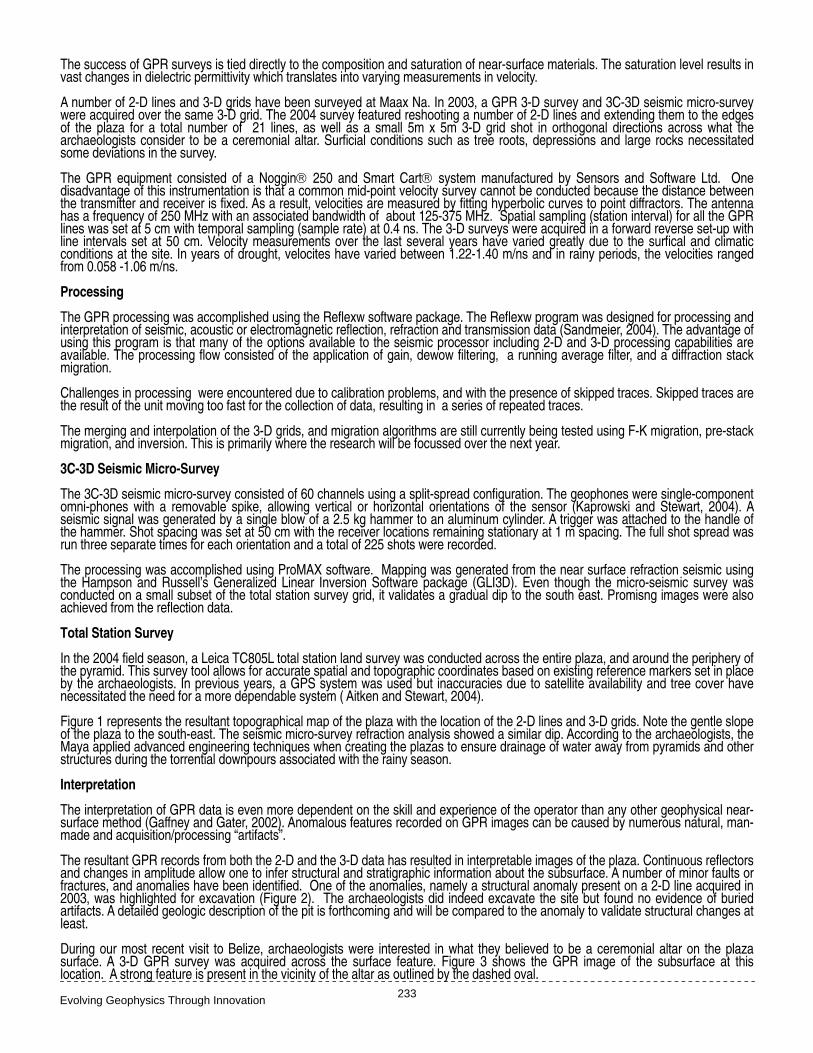
Total Station Survey In the 2004 field season, a Leica TC805L total station land survey was conducted across the entire plaza, and around the periphery of the pyramid. This survey tool allows for accurate spatial and topographic coordinates based on existing reference markers set in place by the archaeologists. In previous years, a GPS system was used but inaccuracies due to satellite availability and tree cover have necessitated the need for a more dependable system ( Aitken and Stewart, 2004).
Figure 1 represents the resultant topographical map of the plaza with the location of the 2-D lines and 3-D grids. Note the gentle slope of the plaza to the south-east. The seismic micro-survey refraction analysis showed a similar dip. According to the archaeologists, the Maya applied advanced engineering techniques when creating the plazas to ensure drainage of water away from pyramids and other structures during the torrential downpours associated with the rainy season.
Interpretation
The interpretation of GPR data is even more dependent on the skill and experience of the operator than any other geophysical near-surface method (Gaffney and Gater, 2002). Anomalous features recorded on GPR images can be caused by numerous natural, man-made and acquisition/processing “artifacts”.
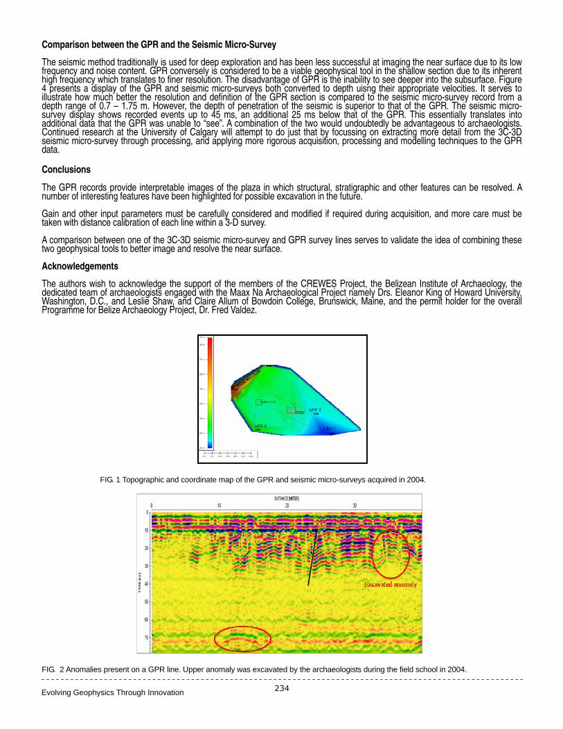
The resultant GPR records from both the 2-D and the 3-D data has resulted in interpretable images of the plaza. Continuous reflectors and changes in amplitude allow one to infer structural and stratigraphic information about the subsurface. A number of minor faults or fractures, and anomalies have been identified. One of the anomalies, namely a structural anomaly present on a 2-D line acquired in 2003, was highlighted for excavation (Figure 2). The archaeologists did indeed excavate the site but found no evidence of buried artifacts. A detailed geologic description of the pit is forthcoming and will be compared to the anomaly to validate structural changes at least.
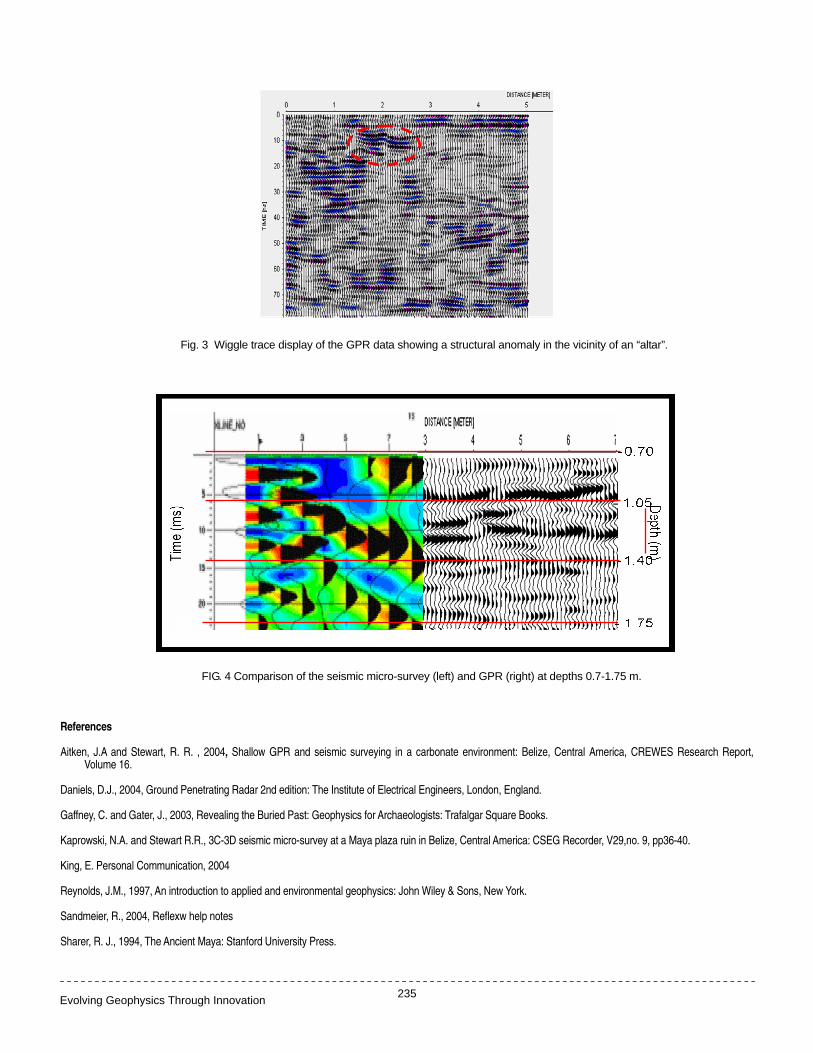
During our most recent visit to Belize, archaeologists were interested in what they believed to be a ceremonial altar on the plaza surface. A 3-D GPR survey was acquired across the surface feature. Figure 3 shows the GPR image of the subsurface at this location. A strong feature is present in the vicinity of the altar as outlined by the dashed oval.
Evolving Geophysics Through Innovation 234
Comparison between the GPR and the Seismic Micro-Survey The seismic method traditionally is used for deep exploration and has been less successful at imaging the near surface due to its low frequency and noise content. GPR conversely is considered to be a viable geophysical tool in the shallow section due to its inherent high frequency which translates to finer resolution. The disadvantage of GPR is the inability to see deeper into the subsurface. Figure 4 presents a display of the GPR and seismic micro-surveys both converted to depth uisng their appropriate velocities. It serves to illustrate how much better the resolution and definition of the GPR section is compared to the seismic micro-survey record from a depth range of 0.7 – 1.75 m. However, the depth of penetration of the seismic is superior to that of the GPR. The seismic micro-survey display shows recorded events up to 45 ms, an additional 25 ms below that of the GPR. This essentially translates into additional data that the GPR was unable to “see”. A combination of the two would undoubtedly be advantageous to archaeologists. Continued research at the University of Calgary will attempt to do just that by focussing on extracting more detail from the 3C-3D seismic micro-survey through processing, and applying more rigorous acquisition, processing and modelling techniques to the GPR data.
Conclusions The GPR records provide interpretable images of the plaza in which structural, stratigraphic and other features can be resolved. A number of interesting features have been highlighted for possible excavation in the future.
Gain and other input parameters must be carefully considered and modified if required during acquisition, and more care must be taken with distance calibration of each line within a 3-D survey.
A comparison between one of the 3C-3D seismic micro-survey and GPR survey lines serves to validate the idea of combining these two geophysical tools to better image and resolve the near surface.
Acknowledgements The authors wish to acknowledge the support of the members of the CREWES Project, the Belizean Institute of Archaeology, the dedicated team of archaeologists engaged with the Maax Na Archaeological Project namely Drs. Eleanor King of Howard University, Washington, D.C., and Leslie Shaw, and Claire Allum of Bowdoin College, Brunswick, Maine, and the permit holder for the overall Programme for Belize Archaeology Project, Dr. Fred Valdez.
FIG. 1 Topographic and coordinate map of the GPR and seismic micro-surveys acquired in 2004.
FIG. 2 Anomalies present on a GPR line. Upper anomaly was excavated by the archaeologists during the field school in 2004.
Evolving Geophysics Through Innovation 235
Fig. 3 Wiggle trace display of the GPR data showing a structural anomaly in the vicinity of an “altar”.
FIG. 4 Comparison of the seismic micro-survey (left) and GPR (right) at depths 0.7-1.75 m.
References Aitken, J.A and Stewart, R. R. , 2004, Shallow GPR and seismic surveying in a carbonate environment: Belize, Central America, CREWES Research Report,
Volume 16.
Daniels, D.J., 2004, Ground Penetrating Radar 2nd edition: The Institute of Electrical Engineers, London, England.
Gaffney, C. and Gater, J., 2003, Revealing the Buried Past: Geophysics for Archaeologists: Trafalgar Square Books.
Kaprowski, N.A. and Stewart R.R., 3C-3D seismic micro-survey at a Maya plaza ruin in Belize, Central America: CSEG Recorder, V29,no. 9, pp36-40.
King, E. Personal Communication, 2004
Reynolds, J.M., 1997, An introduction to applied and environmental geophysics: John Wiley & Sons, New York.
Sandmeier, R., 2004, Reflexw help notes
Sharer, R. J., 1994, The Ancient Maya: Stanford University Press.