NCRST – Environment (NCRST-E) focuses research on the goal of providing cost effective corridor...
4
NCRST – Environment (NCRST-E) focuses research on the goal of providing cost effective corridor assessment and planning tools. The NCRST-E research partners apply remote sensing imagery of increased spatial, radiometric, and temporal resolution to the analysis of transportation impacts on the environment, both natural and man-made. Transportation, Development, and Transportation, Development, and Land Cover Change Land Cover Change For the Mississippi Gulf Coast I- 10 and Coastal Corridor and for an area in the Appalachian Region, the NCRST-E’s land cover classification and change detections efforts are producing significant results and will assist current corridor planning efforts in Mississippi for the CSX railroad and I-10. Technology outreach between researchers, “on-the-ground” practitioners, and regulators is critical to the development of enhanced approaches for wetland identification. Cost-effective, acceptable approaches for the use of remotely sensed data in wetlands identification, mapping, and mitigation planning will provide improved screening and selection of transportation alignments. Wetland Assessment Wetland Assessment in Transportation in Transportation Projects Projects Needs, Air Quality, and Needs, Air Quality, and GeoLibraries GeoLibraries NCRST-E’s research, technology application, and education programs respond to the evaluated environmental assessment geospatial information needs of transportation stakeholders. Needs assessment studies, evaluations of air quality related to transportation, and all other investigation point to the need for improved data resources for transportation assessment. Digital GeoSpatial Data Libraries (GeoLibraries) are a high priority area of research and development for NCRST-E echnology Application Projects echnology Application Projects NCRST-E efforts are linked to technology application projects (TAPs) that demonstrate how information products derived from remote sensing and related technology can be used by transportation professionals. Partne Partne rs rs TRANSPORTATION TRANSPORTATION ASSESSMENT ASSESSMENT http://www.ncrste.msstate.edu
-
Upload
margaretmargaret-lamb -
Category
Documents
-
view
214 -
download
0
Transcript of NCRST – Environment (NCRST-E) focuses research on the goal of providing cost effective corridor...

NCRST – Environment (NCRST-E) focuses research on the goal of providing cost effective corridor assessment and planning tools. The NCRST-E research partners apply remote sensing imagery of increased spatial, radiometric, and temporal resolution to the analysis of transportation impacts on the environment, both natural and man-made.
Transportation, Development, and Transportation, Development, and Land Cover Change Land Cover Change For the Mississippi Gulf Coast I-10 and Coastal Corridor and for an area in the Appalachian Region, the NCRST-E’s land cover classification and change detections efforts are producing significant results and will assist current corridor planning efforts in Mississippi for the CSX railroad and I-10.
Technology outreach between researchers, “on-the-ground” practitioners, and regulators is critical to the development of enhanced approaches for wetland identification. Cost-effective, acceptable approaches for the use of remotely sensed data in wetlands identification, mapping, and mitigation planning will provide improved screening and selection of transportation alignments.
Wetland Assessment Wetland Assessment in Transportation in Transportation ProjectsProjects
Needs, Air Quality, and Needs, Air Quality, and GeoLibrariesGeoLibrariesNCRST-E’s research, technology application, and education programs respond to the evaluated environmental assessment geospatial information needs of transportation stakeholders. Needs assessment studies, evaluations of air quality related to transportation, and all other investigation point to the need for improved data resources for transportation assessment. Digital GeoSpatial Data Libraries (GeoLibraries) are a high priority area of research and development for NCRST-E
Technology Application ProjectsTechnology Application ProjectsNCRST-E efforts are linked to technology application projects (TAPs) that demonstrate how information products derived from remote sensing and related technology can be used by transportation professionals.
PartnePartners rs
TRANSPORTATIONTRANSPORTATIONASSESSMENTASSESSMENT
http://www.ncrste.msstate.edu

TRANSPORTATIONTRANSPORTATIONINFRASTRUCTUREINFRASTRUCTURE
Data modeling
Access management
Pavement assessment
Roads
Comms tower location
Bridges
Airports
Centerline geometry
Cut & fill calculation
Hydrological modeling
Intersection safety
Bridge location
Bridge clearance
Flight path obstructions
Digital airport layout
Asset inventory & location
University of Wisconsin-Madison
University of Florida
• LIDAR produces dense and precise elevation models (± 30 cm)
• This is useful for
• Digital Airport Layout Plans (DALPs)
• 3-D Airport Approach Plans (3DALP)
• examining obstructions to airport approaches
• Integration with digital photography extends the capability of the technology
3D Airport Planning
Technology Application Partners
• TetraTech Inc
• Orbital Imaging Corporation
• Florida Department of Transportation
• University of Massachusetts
University of Wisconsin-Madison
Bridge Location
• National Bridge Inventory
(FHWA Mandate) requires
accurate bridge locations
• BridgeView — an ArcView®
extension to view linearly
referenced location overlaid on
imagery or photography
• Variable resolution image
overlays
• Can be extended to other
infrastructure items: terminals,
etc.
University of Wisconsin-Madison
• Network analysis identifies critical
infrastructure elements
• Monitoring and communications
equipment optimally located by
viewshed analysis and modeling
• Simulated evacuation evaluates
adequacy of infrastructure capacity
University of California, Santa Barbara
Critical Infrastructure Protection
0
50
100
150
200
400 900 1400 1900 2400
W avelength (nm)
Re
fle
cta
nc
e (
50
0=
50
%)
Lot3(Asphalt)
050
100150200250300350400450500
400 900 1400 1900 2400
W avelength (nm)
Re
fle
cta
nc
e (
50
0=
50
%)
Roof5(Vons1)
Roof6(Vons2)
0
50
100
150
200
400 900 1400 1900 2400
Wavelength (nm)
Re
fle
cta
nc
e (
50
0=
50
%)
Road2(CalleReal)
Road7(Fairview)
• Roads distinguished from other
urban materials in hyperspectral
imagery — and concrete easily
distinguished from asphalt. Linear
filters trace road centerlines. Most
applicable to extensive remote
areas where field methods are
infeasible.
• GPS methods offer an alternative
for urban areas, and a cost
benchmark.
• Data model (UNETRANS) offers
quick-start database development.University of California, Santa Barbara; Iowa State
University
Pavement Composition and Centerline Extraction
Ask about ourlearning
resources
Evacuation capacity
http://www.ncgia.ucsb.edu/ncrst
Protecting the nation’s transportation infrastructure against terrorist attacks has become a top priority, and will be an evolving industry as advanced technology enables more sophisticated, real-time,
continuous monitoring.
Protecting the Aviation Infrastructure
LiDAR, high-resolution satellite, and airborne imagery provide current spatial information on airport facilities and help to identify obstructions in the surroundingairspace. These technologies enhance airfield protection, security, and safety by allowing airport managers to visualize a broad range of spatial information in three dimensions.
Safety has always been an important issue for pipeline operators. Pipelines are one of the vulnerable critical infrastructures that can be monitored and protected using chemical detectors and remote sensing technology.
Protecting the Pipeline Infrastructure
National Consortium on Remote Sensing in Transportation Safety, Hazards, and Disaster
Assessment
Protecting the Nation’s Critical Infrastructure
TRANSPORTATIONTRANSPORTATIONHAZARDSHAZARDS
http://www.trans-dash.org
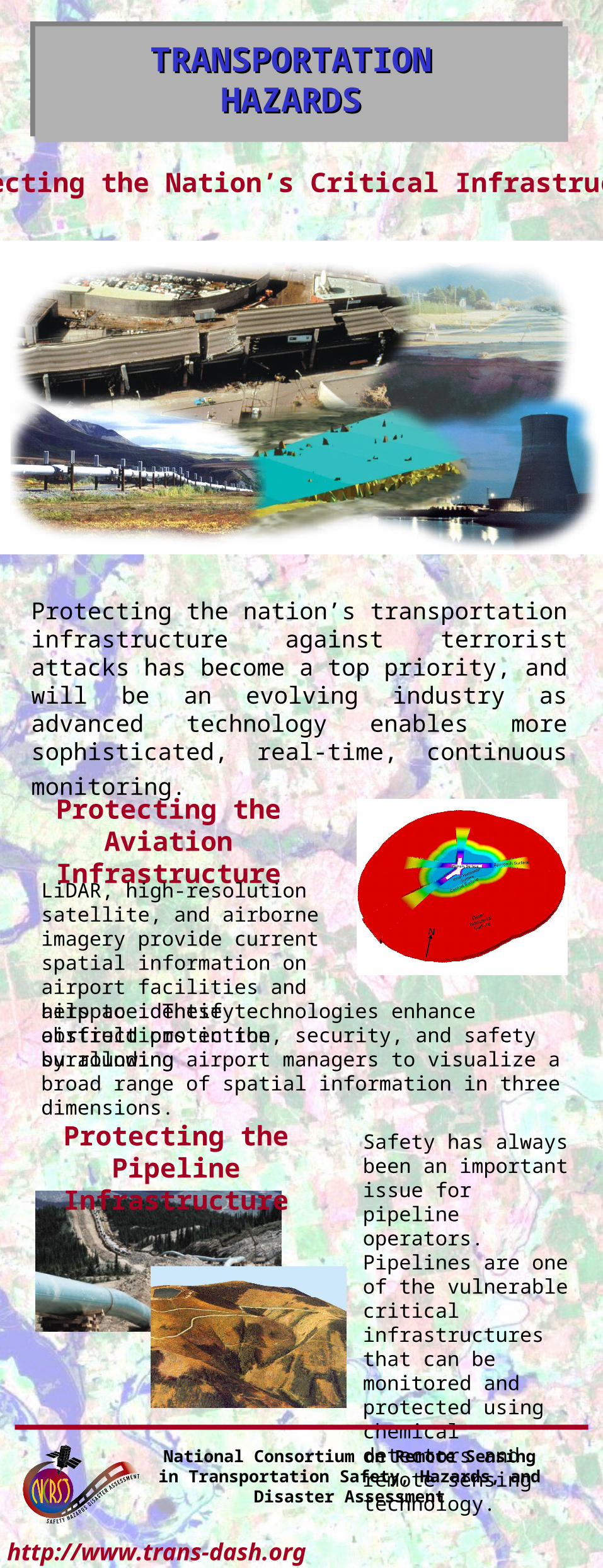
Traffic management
Traffic parameter estimation
Image processing
http://www.ncrst.org/ncrst-f
RMS relative error in AADT estimatesagainst network coverage cycle time in yrs
RMS relative error in VMT estimatesagainst network coverage cycle time in yrs
Adding vehicle counts from satellite imagery to ground counts improves the quality of ADDT & VMT estimates while requiring fewer on-ground personnel.
Vehicle matching
Original frame
Detection of vehicles
Distance measurement Frame 950 warped &
overlain on frame 930
Velocity calculated from combined frames
NCRST – Flows focuses research on applying remote sensing technology to improve the efficiency of regional traffic flow, intermodal freight, and passage at border crossings & beyond.
Aerial view of the study network Network representation
Intersection 1
Intersection 3
Intersection 2
A mounted video camera is used to test a procedure to automatically detect & match vehicles.
Effective real-time/near-real-time traffic management depends on the accuracy of current traffic flow information. Remote sensing can aid in the detection & estimation of queue formation, platoon progression & turning fractions.
Distance & speed are calculated from helicopters using video cameras. Use of spectral signatures to automatically track vehicles makes the calculations possible.
LIDAR data is proving to be a useful addition to our sensor capabilities producing minute variations in surface elevations.
LIDAR data
Ikonos 1 m Ikonos 4 m
+ =Fused Ikonos imagery
Aerial photo for comparisonUA parking garage
Satellite sensor fusion helps in managing parking ramp utilization.
TRANSPORTATIONTRANSPORTATIONFLOWSFLOWS