Navigation Risk Assessment Beatrice Offshore Wind …marine.gov.scot/datafiles/lot/BOWL/ES/ES Volume...
196
Anatec Aberdeen Office Cambridge Office Address: 36 Upperkirkgate, Aberdeen, AB10 1BA, Scotland, UK 16 Ward Way, Witchford, Ely, Cambs, CB6 2JR, UK Tel: 01224 633711 01353 661200 Fax: 0709 2367306 0709 2367306 Email: [email protected] [email protected] Navigation Risk Assessment Beatrice Offshore Wind Farm (Technical Note) Prepared by: Anatec Limited Presented to: Beatrice Offshore Wind Farm Limited Date: 15 th February 2012
-
Upload
phunghuong -
Category
Documents
-
view
223 -
download
0
Transcript of Navigation Risk Assessment Beatrice Offshore Wind …marine.gov.scot/datafiles/lot/BOWL/ES/ES Volume...

Anatec Aberdeen Office Cambridge Office Address: 36 Upperkirkgate, Aberdeen, AB10 1BA, Scotland, UK 16 Ward Way, Witchford, Ely, Cambs, CB6 2JR, UK Tel: 01224 633711 01353 661200 Fax: 0709 2367306 0709 2367306 Email: [email protected] [email protected]
Navigation Risk Assessment
Beatrice Offshore Wind Farm
(Technical Note)
Prepared by: Anatec Limited
Presented to: Beatrice Offshore Wind Farm Limited
Date: 15th February 2012

Project: A2456
Client: BOWL
Title: Beatrice Offshore Wind Farm – Navigation Risk Assessment www.anatec.com
Date: 15.02.2012 Page: 1 Doc: S18 Shipping and Navigation Annex NRA Report 150212
TABLE OF CONTENTS
1. INTRODUCTION............................................................................................................ 1
1.1 BACKGROUND ............................................................................................................. 1 1.2 SCOPE OF THE ASSESSMENT AND METHODOLOGY ...................................................... 1 1.3 ABBREVIATIONS ......................................................................................................... 3
2. REGULATIONS AND GUIDANCE ............................................................................. 6
2.1 INTRODUCTION ........................................................................................................... 6 2.2 MCA MARINE GUIDANCE NOTICE 371 ....................................................................... 6 2.3 MCA WIND FARM: “SHIPPING ROUTE” TEMPLATE .................................................... 6 2.4 DECC METHODOLOGY ............................................................................................... 9 2.5 AIDS TO NAVIGATION ............................................................................................... 10
3. MARINE NAVIGATIONAL MARKINGS ................................................................ 11
3.1 INTRODUCTION ......................................................................................................... 11 3.2 CONSTRUCTION/DECOMMISSIONING ......................................................................... 11 3.3 MARKING OF INDIVIDUAL STRUCTURES ................................................................... 11 3.4 PROPOSED MARKINGS .............................................................................................. 11 3.5 AIR CLEARANCE ....................................................................................................... 12 3.6 SUPERINTENDENCE AND MANAGEMENT ................................................................... 12
4. CONSULTATION ......................................................................................................... 13
4.1 INTRODUCTION ......................................................................................................... 13 4.2 MARINE COASTGUARD AGENCY AND DEPARTMENT FOR TRANSPORT ...................... 13 4.3 CHAMBER OF SHIPPING ............................................................................................. 14 4.4 NORTHERN LIGHTHOUSE BOARD .............................................................................. 14 4.5 ROYAL YACHT ASSOCIATION AND CRUISING ASSOCIATION ..................................... 15 4.6 HAZARD REVIEW WORKSHOP ................................................................................... 16 4.7 OIL AND GAS CONSULTATION .................................................................................. 17
5. EXISTING ENVIRONMENT ...................................................................................... 19
5.1 INTRODUCTION ......................................................................................................... 19 5.2 GEOGRAPHICAL SCOPE ............................................................................................. 19 5.3 PORT FACILITIES/SERVICES ...................................................................................... 21 5.4 NAVIGATIONAL AIDS ................................................................................................ 25 5.5 SAILING DIRECTIONS ................................................................................................ 27 5.6 WRECKS.................................................................................................................... 29 5.7 OIL & GAS INFRASTRUCTURE ................................................................................... 30 5.8 OTHER WIND FARM DEVELOPMENTS ....................................................................... 32 5.9 EXERCISE AREAS ...................................................................................................... 33 5.10 METOCEAN DATA ..................................................................................................... 34
6. MARITIME INCIDENTS............................................................................................. 38

Project: A2456
Client: BOWL
Title: Beatrice Offshore Wind Farm – Navigation Risk Assessment www.anatec.com
Date: 15.02.2012 Page: 2 Doc: S18 Shipping and Navigation Annex NRA Report 150212
6.1 INTRODUCTION ......................................................................................................... 38 6.2 MAIB ....................................................................................................................... 38 6.3 RNLI ........................................................................................................................ 42 6.4 CONCLUSIONS ........................................................................................................... 45
7. MARITIME TRAFFIC SURVEYS ............................................................................. 46
7.1 INTRODUCTION ......................................................................................................... 46 7.2 SURVEY DETAILS ...................................................................................................... 46 7.3 SURVEY ANALYSIS ................................................................................................... 49 7.4 BEATRICE SITE-SPECIFIC REVIEW............................................................................. 61 7.5 ANCHORED VESSELS ................................................................................................. 70 7.6 DETAILED ANALYSIS OF MAIN SHIPPING LANE ........................................................ 71
8. IMPACT ON COMMERCIAL SHIPPING NAVIGATION .................................... 74
8.1 PASSING SHIPS .......................................................................................................... 74
9. RECREATIONAL VESSEL ACTIVITY ................................................................... 76
9.1 INTRODUCTION ......................................................................................................... 76 9.2 RYA DATA ............................................................................................................... 76 9.3 SURVEY DATA .......................................................................................................... 79 9.4 IMPACT ASSESSMENT ................................................................................................ 80
10. FISHING VESSEL ACTIVITY ............................................................................... 81
10.1 INTRODUCTION ......................................................................................................... 81 10.2 SURVEY TRACKS ....................................................................................................... 81 10.3 COMMERCIAL FISHERIES STUDY ............................................................................... 85 10.4 IMPACT ASSESSMENT ................................................................................................ 86
11. FORMAL SAFETY ASSESSMENT ....................................................................... 87
11.1 INTRODUCTION ......................................................................................................... 87 11.2 HAZARD IDENTIFICATION ......................................................................................... 88 11.3 KEY FINDINGS .......................................................................................................... 88 11.4 RISK AND MITIGATION MEASURES ........................................................................... 89 11.5 RISK ANALYSIS ......................................................................................................... 94 11.6 RISK CONTROL MEASURES ....................................................................................... 94
12. RISK ASSESSMENT ................................................................................................ 95
12.1 INTRODUCTION ......................................................................................................... 95 12.2 WITHOUT WIND FARM RISK ..................................................................................... 95 12.3 WITH WIND FARM RISK (BASE CASE) ...................................................................... 99 12.4 CABLE INTERACTION – ANCHOR AND TRAWL ........................................................ 105 12.5 FUTURE CASE LEVEL OF RISK ................................................................................. 106 12.6 RISK RESULTS SUMMARY ....................................................................................... 109 12.7 CONSEQUENCES ...................................................................................................... 110
13. CONSTRUCTION AND DECOMMISIONING IMPACTS ............................... 112
Project: A2456
Client: BOWL
Title: Beatrice Offshore Wind Farm – Navigation Risk Assessment www.anatec.com
Date: 15.02.2012 Page: 3 Doc: S18 Shipping and Navigation Annex NRA Report 150212
13.1 INTRODUCTION ....................................................................................................... 112 13.2 HAZARDS DURING CONSTRUCTION/DECOMMISSIONING ......................................... 112 13.3 RISK CONTROL/MITIGATION DURING CONSTRUCTION/DECOMMISSIONING ............ 113
14. IMPACT ON MARINE RADAR SYSTEMS........................................................ 114
14.1 INTRODUCTION ....................................................................................................... 114 14.2 BEATRICE DEMONSTRATOR TURBINE PROJECT RADAR IMPACTS STUDY ............... 115 14.3 IMPACT ON COLLISION RISK ................................................................................... 115
15. CUMULATIVE AND IN-COMBINATION EFFECTS ...................................... 120
15.1 INTRODUCTION ....................................................................................................... 120 15.2 DEVELOPMENTS CONSIDERED IN THE CUMULATIVE AND IN-COMBINATION
ASSESSMENT ....................................................................................................................... 120 15.3 PREDICTED IMPACTS ............................................................................................... 121 15.4 WIND FARM DEVELOPMENTS ................................................................................. 123 15.5 OIL AND GAS DEVELOPMENTS ................................................................................ 124 15.6 OTHER DEVELOPMENTS .......................................................................................... 124
16. SAFETY ZONES ..................................................................................................... 125
16.1 GUIDANCE ON APPLICATIONS FOR SAFETY ZONES ................................................. 125 16.2 CONSTRUCTION/DECOMMISSIONING & MAJOR MAINTENANCE PHASES ................. 125 16.3 OPERATIONAL PHASE ............................................................................................. 126 16.4 SUMMARY ............................................................................................................... 127
17. SEARCH AND RESCUE (SAR) ............................................................................ 128
17.1 INTRODUCTION ....................................................................................................... 128 17.2 SAR RESOURCES .................................................................................................... 128 17.3 WIND FARM SAR MATTERS ................................................................................... 133 17.4 SAR ROUTEING ...................................................................................................... 133
18. ADDITIONAL NAVIGATION ISSUES ............................................................... 134
18.1 INTRODUCTION ....................................................................................................... 134 18.2 VISUAL NAVIGATION AND COLLISION AVOIDANCE ................................................ 134 18.3 POTENTIAL EFFECTS ON WAVES AND TIDAL CURRENTS ......................................... 134 18.4 IMPACTS OF STRUCTURES ON WIND MASKING/TURBULENCE OR SHEER ................ 134 18.5 SEDIMENTATION/SCOURING IMPACTING NAVIGABLE WATER DEPTHS IN AREA..... 135 18.6 STRUCTURES AND GENERATORS AFFECTING SONAR SYSTEMS IN AREA ................. 135 18.7 ELECTROMAGNETIC INTERFERENCE ON NAVIGATION EQUIPMENT ......................... 135 18.8 IMPACTS ON COMMUNICATIONS AND POSITION FIXING .......................................... 135 18.9 NOISE IMPACT ......................................................................................................... 136
19. RISK MITIGATION MEASURES & MONITORING ....................................... 138
19.1 MITIGATION ............................................................................................................ 138 19.2 FUTURE MONITORING ............................................................................................. 139
20. CONCLUSIONS ...................................................................................................... 140

Project: A2456
Client: BOWL
Title: Beatrice Offshore Wind Farm – Navigation Risk Assessment www.anatec.com
Date: 15.02.2012 Page: 4 Doc: S18 Shipping and Navigation Annex NRA Report 150212
APPPENDIX 1 HAZARD WORKSHOP METHODOLOGY & RESULTS............ 141
HAZARD LOG METHODOLOGY ............................................................................................ 143 RESULTS .............................................................................................................................. 147
APPPENDIX 2 CONSEQUENCES ASSESSMENT ................................................... 151
RISK TO PEOPLE ................................................................................................................... 151 RISK TO ENVIRONMENT ....................................................................................................... 154 ALL INCIDENTS .................................................................................................................... 155 COLLISION INCIDENTS ......................................................................................................... 159 CONTACT INCIDENTS ........................................................................................................... 163 INTRODUCTION .................................................................................................................... 166 COLLRISK MODEL ............................................................................................................ 166 FATALITY PROBABILITY ...................................................................................................... 169 FATALITY RISK DUE TO THE PROPOSED BEATRICE OFFSHORE WIND FARM ........................ 170 SIGNIFICANCE OF INCREASE IN FATALITY RISK – PROPOSED BEATRICE OFFSHORE WIND
FARM ................................................................................................................................... 173 POLLUTION RISK - HISTORICAL ANALYSIS .......................................................................... 174 POLLUTION RISK – PROPOSED BEATRICE OFFSHORE WIND FARM ...................................... 175 SIGNIFICANCE OF INCREASE IN POLLUTION RISK – PROPOSED BEATRICE OFFSHORE WIND
FARM ................................................................................................................................... 176 SUMMARY ........................................................................................................................... 177
APPPENDIX 3 MARINE GUIDANCE NOTE 371 CHECKLIST ............................ 178
MGN 371 COMPLIANCE CHECKLIST ................................................................................... 179
REFERENCES ..................................................................................................................... 190
Project: A2456
Client: BOWL
Title: Beatrice Offshore Wind Farm – Navigation Risk Assessment www.anatec.com
Date: 15.02.2012 Page: 1 Doc: S18 Shipping and Navigation Annex NRA Report 150212
1. INTRODUCTION
1.1 Background The report presents information on the Beatrice Offshore Wind Farm relative to the baseline navigational activity and features for the area. Following this, an assessment of the impact of the proposed development on shipping and navigation is presented.
1.2 Scope of the Assessment and Methodology The assessment methodology principally followed the Department of Energy and Climate Change (DECC) Risk Assessment Methodology (Ref. i) and the Maritime and Coastguard Agency’s (MCA) Marine Guidance Notice 371 (MGN 371) (Ref. ii). An overview of the general methodology applied in the assessment is presented in Figure 1.1. (More information on the regulations and guidance being addressed is presented in Section 2.)

Project: A2456
Client: BOWL
Title: Beatrice Offshore Wind Farm – Navigation Risk Assessment www.anatec.com
Date: 15.02.2012 Page: 2 Doc: S18 Shipping and Navigation Annex NRA Report 150212
Radar/AIS Maritime Survey
and Analysis
Background Data Gathering
Hazard Ranking
Review and/or Detailed RiskAssessment
Identification of Risk Reduction
Measures
Cost Benefit Analysis
ALARP Assessment
NOT ALARP
Lower RiskScenarios
Higher RiskScenarios
ALARP Statement
ALARP
Consultation with Stakeholders
Generic Hazard Lists
Hazard Identification
Rule ComplianceGood Practice
Mitigation Measure Log
Hazard Log
Figure 1.1 Overview of Methodology for Navigation Assessment
The main part of the assessment considers the impact of the surface structures associated with the operational phase of the wind farm on the following maritime activities:
Commercial Shipping Fishing Recreational Sailing
In addition to these activities, consideration is given to the following: Impacts of Structures on Marine Radar

Project: A2456
Client: BOWL
Title: Beatrice Offshore Wind Farm – Navigation Risk Assessment www.anatec.com
Date: 15.02.2012 Page: 3 Doc: S18 Shipping and Navigation Annex NRA Report 150212
Impact of Subsea cables Impacts associated with Construction / Decommissioning phases Cumulative Impacts with other nearby developments
1.3 Abbreviations The following abbreviations are used in this report: AHB - Aberdeen Harbour Board AIS - Automatic Identification System ALARP - As Low as Reasonably Practicable ALB - All-Weather Lifeboat ARPA - Automatic Radar Plotting Aid ARRC - Autonomous Rescue and Recovery Craft AtoN - Aid to Navigation BATNEC - Best Available Technology Not at Excessive Cost BERR - Department for Business Enterprise & Regulatory Reform BMAPA - British Marine Aggregate Producers Association BOWF - Beatrice Offshore Wind Farm BOWL - Beatrice Offshore Windfarm Limited BWEA - British Wind Energy Association CA - Cruising Association CAA - Civil Aviation Authority CAST - Coastguard Agreement on Salvage and Towage CBA - Cost Benefit Analysis CIADD - Cumulative Impact Assessment Discussion Document CNIS - Channel Navigation Information Service COLREGS - International Regulations for Preventing Collisions at Sea CPA - Closest Point of Approach DECC - Department of Energy and Climate Change DEFRA - Department for Environment, Food and Rural Affairs DfT - Department for Transport DSC - Digital Selective Calling DTI - Department of Trade and Industry DW - Deep Water DWT - Dead Weight Tonnes DZ - Danger Zone ECDIS - Electronic Chart Display and Information System EIA - Environmental Impact Assessment ERCoP - Emergency Response Cooperation Plan ERRV - Emergency Response and Rescue Vessel ES - Environmental Statement ETV - Emergency Towing Vessel FN - Frequency-Number FSA - Formal Safety Assessment GPS - Global Positioning System
Project: A2456
Client: BOWL
Title: Beatrice Offshore Wind Farm – Navigation Risk Assessment www.anatec.com
Date: 15.02.2012 Page: 4 Doc: S18 Shipping and Navigation Annex NRA Report 150212
GRP - Glass Reinforced Plastic GT - Gross Tonnes HAT - Highest Astronomical Tide HF - High Frequency HIE - Highlands and Islands Enterprise HSC - High Speed Craft HSE - Health and Safety Executive HVDC - High Voltage Direct Current HW - High Water IALA - International Association of Marine Aids to Navigation and Lighthouses ILB - Inshore Lifeboat ICES - International Council for the Exploration of the Seas ICST - The International Classification of Ships by Type IMO - International Maritime Organisation ITOPF - International Tanker Owners Pollution Federation Limited km - Kilometre LNG - Liquid Nitrogen Gas LORAN - Long Range Navigation MAIB - Marine Accident Investigation Branch MBS - Maritime Buoyage System MCA - Maritime and Coastguard Agency MDA - Managed Danger Area MEHRA - Marine Environmental High Risk Area MFA - Marine and Fisheries Agency MFOWDG - Moray Firth Offshore Wind Developers Group MGN - Marine Guidance Notice MHWN - Mean High Water Neaps MHWS - Mean High Water Springs MLWN - Mean Low Water Neaps MLWS - Mean Low Water Springs MOC - Marine Operations Centre MODU - Mobile Offshore Drilling Unit MORL - Moray Offshore Renewables Limited MRCC - Maritime Rescue Co-ordination Centre MRSC - Maritime Rescue Sub-Centre MSL - Mean Sea Level MW - Mega-Watt nm - Nautical Miles NUC - Not Under Command NUI - Normally Unattended Installation OREI - Offshore Renewable Energy Installations OWF - Offshore Wind Farm PLL - Potential Loss of Life PLN - Port Letter Number
Project: A2456
Client: BOWL
Title: Beatrice Offshore Wind Farm – Navigation Risk Assessment www.anatec.com
Date: 15.02.2012 Page: 5 Doc: S18 Shipping and Navigation Annex NRA Report 150212
PPE - Personal Protective Equipment RAF - Royal Air Force RCM - Risk Control Measure REZ - Renewable Energy Zone RIB - Rigid Inflatable Boat RNLI - Royal National Lifeboat Institution Ro-Ro - Roll-on, Roll-off RYA - Royal Yachting Association SAR - Search and Rescue SEA - Strategic Environmental Assessment SFF - Scottish Fishermen’s Federation SHETL - Scottish Hydro Electric Transmission Limited SPS - Significant Peripheral Structure SRR - Search and Rescue Region TSS - Traffic Separation Scheme UHF - Ultra High Frequency UKCS - United Kingdom Continental Shelf UKHO - United Kingdom Hydrographic Office VHF - Very High Frequency VMS - Vessel Monitoring Service VTS - Vessel Traffic Services

Project: A2456
Client: BOWL
Title: Beatrice Offshore Wind Farm – Navigation Risk Assessment www.anatec.com
Date: 15.02.2012 Page: 6 Doc: S18 Shipping and Navigation Annex NRA Report 150212
2. REGULATIONS AND GUIDANCE
2.1 Introduction This section briefly summarises the key regulations and guidance relevant when considering the navigation safety issues associated with offshore wind farm developments in the UK.
2.2 MCA Marine Guidance Notice 371 This guidance notice (Ref. ii) highlights issues that need to be taken into consideration when assessing the impact on navigational safety from offshore renewable energy developments, proposed for United Kingdom internal waters, territorial sea or Renewable Energy Zones. There are six annexes containing recommendations (1-4) and regulatory extract (5) as follows:
Annex 1: Considerations on site position, structures and safety zones. Annex 2: Navigation, collision avoidance and communications. Annex 3: MCA shipping template, assessing wind farm boundary distances from shipping routes. Annex 4: Safety and mitigation measures recommended for OREI during
construction, operation and decommissioning. Annex 5: Standards and procedures for generator shutdown and other operational
requirements in the event of a search and rescue, counter pollution or salvage incident in or around an OREI. A checklist referencing the sections in this report which address MCA requirements is presented in Appendix C.
2.3 MCA Wind Farm: “Shipping Route” Template A trial performed by the Maritime & Coastguard Agency at the North Hoyle Offshore Wind Farm (Ref. iii) indicated that turbines provide erroneous returns to radar transceivers. Multiple side echoes may be generated that have the potential to mask real targets. This has been validated by more recent trials carried out by the industry on the Kentish Flats Wind Farm in the Thames estuary (Ref. iv). The onset range from the turbines of these returns is about 1.5nm, with a progressive deterioration in the radar picture as the turbines are closed to about 500 metres. Adjustment of the radar controls can filter out some of these unwanted radar returns but comes at the cost of potentially losing small radar cross sectional targets such as buoys or small craft. The MCA’s Wind farm Shipping Route Template (Annex 3 of Ref. ii), reproduced in Figure 2.1, indicates that turbines within 0.5nm of a route will be Very High Risk. Close scrutiny and potentially mitigation will be needed between 0.5nm and 5nm to ensure risks are ALARP, particularly between 0.5nm and 2nm which is considered Medium to High Risk. Beyond 2nm is Low Risk although an adjacent wind farm or Traffic Separation Scheme (TSS) introduces cumulative effects which have to be scrutinised.
Project: A2456
Client: BOWL
Title: Beatrice Offshore Wind Farm – Navigation Risk Assessment www.anatec.com
Date: 15.02.2012 Page: 7 Doc: S18 Shipping and Navigation Annex NRA Report 150212
The template is not a prescriptive tool but needs intelligent application to explore where the distance should be measured from, e.g., route centre, 90% traffic level, nearest ship, etc. The potential boundaries are illustrated in Figure 2.2. Marine traffic survey information collected for the Moray Firth area has been analysed in this study to inform such boundaries and investigate influencing factors such as route bias, vessel type, size, cargo, etc.

Project: A2456
Client: BOWL
Title: Beatrice Offshore Wind Farm – Navigation Risk Assessment www.anatec.com
Date: 15.02.2012 Page: 8 Doc: S18 Shipping and Navigation Annex NRA Report 150212
Figure 2.1 Wind Farm “Shipping Route” Template (Ref. ii)

Project: A2456
Client: BOWL
Title: Beatrice Offshore Wind Farm – Navigation Risk Assessment www.anatec.com
Date: 15.02.2012 Page: 9 Doc: S18 Shipping and Navigation Annex NRA Report 150212
Figure 2.2 Interactive Boundaries (require Interpretative Flexibility, where:
A = Turbine boundary to the shipping route median or centre line B = Turbine boundary to nearest shipping route edge C = Turbine boundary to nearest shipping 90% traffic level* D = Turbine boundary to further shipping 90% traffic level* E = Turbine boundary to further shipping route edge (* = or another % to be determined)
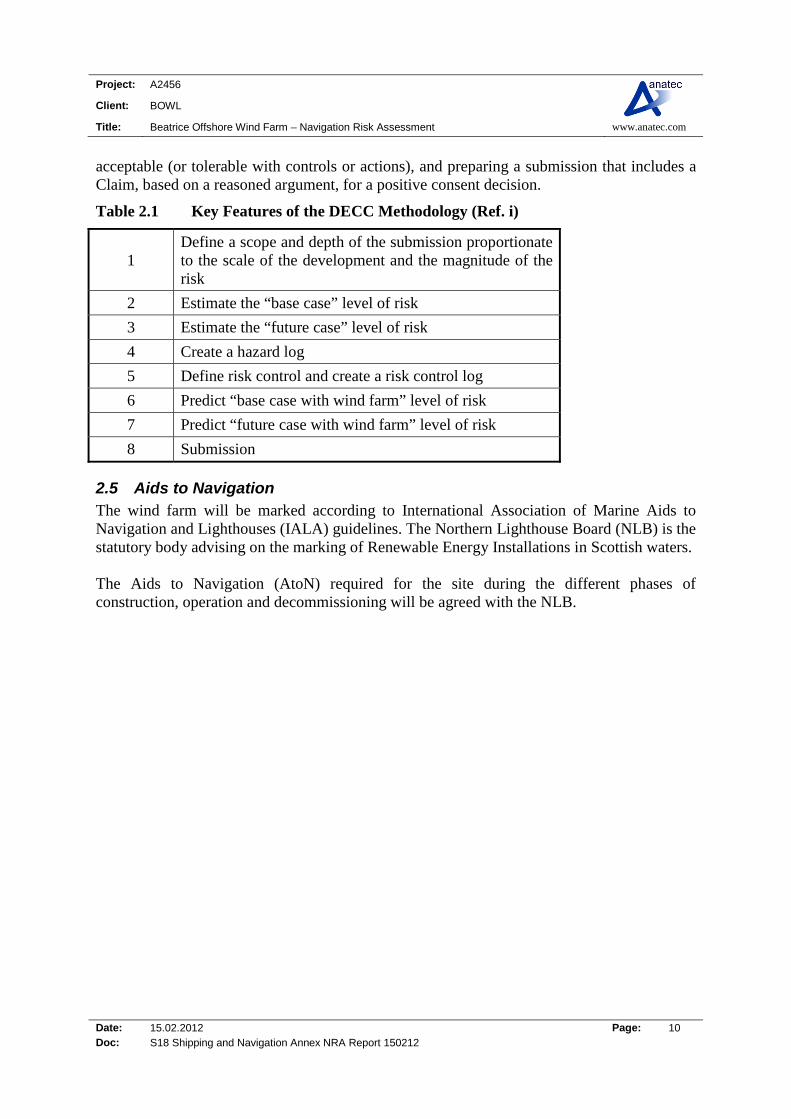
2.4 DECC Methodology Department of Energy and Climate Change (DECC) produced a Methodology for Assessing the Marine Navigational Safety Risks of Offshore Wind Farms in association with the MCA and the DfT (Ref. i). Its purpose is to be used as a template by Developers in preparing their navigation risk assessments, and for Government departments to help in the assessment of these. The Methodology is centred around risk controls and the feedback from risk controls into risk assessment. It requires a submission that shows that sufficient risk controls are, or will be, in place for the assessed risk to be judged as broadly acceptable or tolerable with further controls or actions. The key features of the Marine Safety Navigational Risk Assessment Methodology are risk assessment (supported by appropriate techniques and tools), creating a hazard log, defining the risk controls (in a Risk Control Log) required to achieve a level of risk that is broadly
Project: A2456
Client: BOWL
Title: Beatrice Offshore Wind Farm – Navigation Risk Assessment www.anatec.com
Date: 15.02.2012 Page: 10 Doc: S18 Shipping and Navigation Annex NRA Report 150212
acceptable (or tolerable with controls or actions), and preparing a submission that includes a Claim, based on a reasoned argument, for a positive consent decision.
Table 2.1 Key Features of the DECC Methodology (Ref. i)
1 Define a scope and depth of the submission proportionate to the scale of the development and the magnitude of the risk
2 Estimate the “base case” level of risk
3 Estimate the “future case” level of risk
4 Create a hazard log
5 Define risk control and create a risk control log
6 Predict “base case with wind farm” level of risk
7 Predict “future case with wind farm” level of risk
8 Submission
2.5 Aids to Navigation The wind farm will be marked according to International Association of Marine Aids to Navigation and Lighthouses (IALA) guidelines. The Northern Lighthouse Board (NLB) is the statutory body advising on the marking of Renewable Energy Installations in Scottish waters. The Aids to Navigation (AtoN) required for the site during the different phases of construction, operation and decommissioning will be agreed with the NLB.

Project: A2456
Client: BOWL
Title: Beatrice Offshore Wind Farm – Navigation Risk Assessment www.anatec.com
Date: 15.02.2012 Page: 11 Doc: S18 Shipping and Navigation Annex NRA Report 150212
3. MARINE NAVIGATIONAL MARKINGS
3.1 Introduction Throughout the project marine navigational marking will be provided in accordance with the Northern Lighthouse Board requirements, which will comply with IALA Recommendation 0-139 on the Marking of Offshore Wind Farms and the additional requirements of MCA MGN 371 (Ref. ii). NLB have advised that final marking and lighting recommendations will be made in a formal response through section 36 of the Scottish Electricity Act 1989 (consents for renewable energy projects) and the Marine (Scotland) Act 2010. All navigational marking and lighting of the site or its associated marine infrastructure will require the Statutory Sanction of the Northern Lighthouse Board prior to deployment.
3.2 Construction/Decommissioning During the construction / decommissioning of an offshore wind farm, working areas will be established and marked in accordance with the IALA Maritime Buoyage System (MBS). In addition to this, where advised by NLB, additional temporary marking will be applied. Notices to Mariners, Radio Navigational Warnings-NAVTEX and/or broadcast warnings as well as Notices to Airmen will be promulgated in advance of and during construction / decommissioning of any individual structure/farm.
3.3 Marking of Individual Structures The tower of every wind generator will be painted yellow all around from between 3.9m above the of LAT to 18.9m above LAT1. As per the MCA requirements, each of the structures will be marked with clearly visible unique identification characteristics at a location that is easily and readily serviceable. The identifications characteristics will each be illuminated by a low-intensity light, so that the sign is visible from a vessel thus enabling the structure to be detected at a suitable distance to avoid a collision with it. This will be such that under normal conditions of visibility and all known tidal conditions, they are clearly readable by an observer (with naked eye), stationed 3 metres above sea levels, and at a distance of at least 150 metres from the turbine. The light will be either hooded or baffled so as to avoid unnecessary light pollution or confusion with navigation marks.
3.4 Proposed Markings The markings for the Beatrice Site will be agreed in consultation with NLB once the final turbine layout has been selected. Based on IALA guidelines it is likely that the lighting of Beatrice Offshore Wind Farm will be:
1 RYA requirements are referenced to Highest Astronomical Tide (HAT). These have been converted to LAT for ease of use and are approximate values based on Beatrice Offshore Wind Farm data collected.
Project: A2456
Client: BOWL
Title: Beatrice Offshore Wind Farm – Navigation Risk Assessment www.anatec.com
Date: 15.02.2012 Page: 12 Doc: S18 Shipping and Navigation Annex NRA Report 150212
All corner towers will be marked as Significant Peripheral Structures (SPS) and where
necessary, depending on spacing, intermediate towers on each of the north, west, east and south facing boundaries will be marked as Intermediate Structures (IPS).
In all the layouts, towers designated as SPS are to exhibit Flashing Yellow 5 second (Fl Y
5s) lights of 5nm nominal range and omnidirectional fog signals with a character of 1 blast of 2 seconds duration every 30 seconds and an IALA usual range of 2nm. Towers designated as IPS are to exhibit Fl Y 2.5s lights of 2nm nominal range.
All the lights are to be visible to shipping through 360 degrees and if more than 1 lantern
is required on a tower to meet the all-round visibility requirement, then all the lanterns on that tower should be synchronised.
All the lights are to be exhibited at the same height at least 12 metres above Highest
Astronomical Tide (HAT) and below the arc the turbine blades. All the lights are to be exhibited at least at night and when the visibility is reduced to 2nm
or less. Fog signals are to be sounded at least when the visibility is 2nm or less. All the structures in the boundary of the turbine towers are to be coloured yellow from at
least HAT to the height of the lights (the equivalent height on the unlighted structures). Any lighting required for aeronautical purposes is to be shielded / arranged such that it is
not visible to shipping. If this cannot be achieved, then the requirement will be considered as having been met if the aviation light is reduced to 10% of its peak intensity when the visibility is more than 5km.
3.5 Air Clearance The air clearance between turbine rotors and sea level conditions at Mean High Water Springs (MHWS) will be not less than 22m, as recommended by the MCA.
3.6 Superintendence and Management BOWL will ensure that they have a reliable maintenance and casualty response regime in place such that the required availability targets are met.
Project: A2456
Client: BOWL
Title: Beatrice Offshore Wind Farm – Navigation Risk Assessment www.anatec.com
Date: 15.02.2012 Page: 13 Doc: S18 Shipping and Navigation Annex NRA Report 150212
4. CONSULTATION
4.1 Introduction Consultation on navigational issues has been carried out for stakeholders during the project. This section summarises the key consultation meetings. It is noted that given the proximity of the Beatrice development to the Moray Round 3 Zone a number of joint consultation meetings were carried out. During the Offshore Operators meeting and Hazard Review Workshop, a number of navigational and non-navigational concerns (i.e. engineering and emergency response issues) were raised. At the time of preparing this report there is on-going consultation through BOWL and Moray Offshore Renewables Limited (MORL) to ensure comments are addressed with relevant stakeholders.
4.2 Marine Coastguard Agency and Department for Transport Two meetings were held at Department for Transport (DfT) offices in London on 23rd September 2010 and 6th September 2011. The objective of the first meeting was to consult and discuss the plans for the Beatrice Offshore Wind Farm and Moray Round 3 Zone projects in relation to the potential impacts on the safe navigation of shipping. The second meeting discussed progress made to date on the projects in relation to identifying the potential impacts on the safe navigation of shipping. A summary of the initial meeting is provided below:
In terms of Beatrice Offshore Wind Farm, the main issue was to address possible cumulative issues for the two projects, combined with the oil and gas developments in the area.
Marine Coastguard Agency (MCA) stated that analysis required should include 90% lanes, encounters, and collision risks.
MCA/DFT also stated their preference for phase construction safety zones and operational safety zones to be based on experience gained during the construction phase. Justification would require to be made for operational safety zones. The cable route(s) require to be included within the NRA and the development should consider Search & Rescue issues in the area.
In addition, Marine Environmental High Risk Areas (MEHRAs) should be assessed and relative proximity to the site.
A summary of the second meeting is provided below:
MCA suggested consulting with users on the tanker route going to Wick. MCA asked why three met masts were required for the Beatrice wind farm.
Project: A2456
Client: BOWL
Title: Beatrice Offshore Wind Farm – Navigation Risk Assessment www.anatec.com
Date: 15.02.2012 Page: 14 Doc: S18 Shipping and Navigation Annex NRA Report 150212
They stated that they would like to see the MGN checklist completed together with the applications with the relevant sections where the different issues are addressed cross referenced to the Navigation Risk Assessment report.
MCA did not see any ‘show stoppers’ from a shipping and navigation perspective of the Beatrice and Eastern Development Areas of the MORL Zone.
4.3 Chamber of Shipping Two meetings were held at the Chamber of Shipping (CoS) in London on 24th September 2010 and 5th of September 2011. The objective of the first meeting was to consult and discuss based on the initial plans for the Beatrice Offshore Wind Farm and Moray Round 3 Zone projects in relation to the potential impacts on shipping. The second meeting discussed progress made to date on the projects in relation to identifying the potential impacts on shipping in the area. A summary of the initial meeting is provided below:
In terms of Beatrice Offshore Wind Farm no issues were raised and CoS stated that the Safety of Navigation Committee within the Chamber would review any proposed applications.
A summary of the second meeting is provided below:
CoS questioned the consenting route being followed by the projects and if they were going to issue Preliminary Environmental Reports.
Chamber asked if any consultation would take place with vessels anchoring in the vicinity of the proposed export cable route.
It was stated that the given the distance between the sites and the coastline they would not be concerned reading the amount of sea room between the sites and the coast.
4.4 Northern Lighthouse Board A meeting was held at EDP Renewables offices in Edinburgh on 17th September 2010. The objective of the meeting was to consult and discuss the plans for the Beatrice Offshore Wind Farm and Moray Round 3 projects in relation to the potential impacts on the safe navigation of shipping.
The Beatrice Offshore Wind Farm was considered not to be in area of high shipping. However, NLB stated that over lifetime of these projects, given the number of turbines drifting vessel collisions may well be an issue.
NLB stated that they would like to see the cable route considered in the Navigational Risk Assessment. NLB also requested the Rochdale envelope approach assuming the maximum number of turbines.

Project: A2456
Client: BOWL
Title: Beatrice Offshore Wind Farm – Navigation Risk Assessment www.anatec.com
Date: 15.02.2012 Page: 15 Doc: S18 Shipping and Navigation Annex NRA Report 150212
4.5 Royal Yacht Association and Cruising Association Two meetings were held at Cruising Association (CA) House in London on 24th September 2010 and 6th September 2011. The objective of the first meeting was to consult and discuss the plans for the Beatrice Offshore Wind Farm and Moray Round 3 Zone projects in relation to the potential impacts on the safe navigation of shipping. The second meeting discussed progress made to date on the projects in relation to identifying the potential impacts on recreational sailing in the area. The main notes from the first meeting are provided below:
Both Royal Yacht Association (RYA) and CA stated they would like to consider the two developments as one large area as opposed to separate project areas.
RYA/CA stated that yachts can get pushed into the area by the tide when sailing up towards the Pentland Firth, i.e. sailing vessels on the outer routes in the area;
It was acknowledged that the area wasn’t particularly busy from a recreational sailing perspective with medium use cruising routes through the general area;
RYA/CA noted that the activity is very weather dependent and the busiest routes are mainly coastal - along the Moray and Caithness coastlines. In addition, very few vessels go North to the Pentland Firth having come through the Caledonian Canal;
On entering Peterhead in the Summer there could be 10 vessels there at the same time, heading for the Pentland Firth Area (circumnavigation of the UK);
Need to check the visibility conditions in the area in relation to the North Sea Haar; RYA/CA would like to see a VHF repeater installed at the site as MCA coverage
tends to be patchy further offshore. Additionally, they would like a weather station to transmit data on VHF to assist vessels in the area;
Both parties would be interested in the shaping of the sites as they prefer squares and rectangles which are easily distinguishable as well as the alignment between the different sites. Also it was recognised that they would like to see cables buried, particularly near port approaches.
A summary of the second meeting is provided below:
RYA/CA were concerned that different types of turbines could be used in adjacent sites and that the sites may not be aligned and the fact they may not be regular grid patterns. However, the consultees understood the reasons why the developers could not guarantee that this would be the case.
RYA/CA stated that complaints were being received as the recreational vessels found it difficult to make out the numbering/names of the turbines.
It was acknowledged that the area wasn’t particularly busy from a recreational sailing perspective with medium cruising routes through the area. In addition, it was noted that activity is very weather dependent and the busiest routes are coastal along the Morayshire coast and the coast of Caithness.
Project: A2456
Client: BOWL
Title: Beatrice Offshore Wind Farm – Navigation Risk Assessment www.anatec.com
Date: 15.02.2012 Page: 16 Doc: S18 Shipping and Navigation Annex NRA Report 150212
RA/CA would like a weather station to transmit data on VHF to assist vessels in the area. This would be very useful in term of wind direction and speed.
Both parties would like to see cables buried, particularly near port approaches. This is not considered an issue where water depths are less than 10m.
It was stated that as the projects move forward with multiple surveys, met masts etc., that they establish an email distribution list such as the one being operated by the North Irish Sea developers for the Walney and Ormonde developments.
4.6 Hazard Review Workshop A hazard review workshop held in Inverness on the 6th July 2011 (see Appendix A for further details). The purpose of the workshop was to identify and review the potential navigational hazards associated with joint developments at Beatrice Offshore Wind Farm and the nearby Moray Firth Round 3 Zone Eastern Development area. Further details on the workshop are provided in Section 11; however the key notes from the meeting are as follows:
A question was raised as to whether there will be any anchorage zones around the cable route. It was noted that it is not good practice to anchor in the vicinity of cables and that where feasible the cables will be buried as well as being marked on hydrographic charts.
It was asked what the maximum height of the turbines above sea level could be. (The maximum tip height above sea level is approximately 198m).
It was pointed out that shuttle tankers associated with the Athena Field visit Cromarty Firth and may pass in the vicinity of the development. It was also pointed out that Ithaca Energy is looking at the possibility of bringing in Liquid Nitrogen Gas (LNG) regasification vessels to do transfer operations at the Nigg Terminal.
Fishing will be allowed within the turbines; however a question was also raised as to how the fisheries liaison will be carried out, and whether guard vessels will be used during the construction of the developments. It was stated that liaison will be carried out with the groups having been set up and it is not yet known if guard vessels will be used.
It was pointed out that vessels sometimes have the cable layer switched off in Electronic Chart Display and Information Systems (ECDIS) which has led to them anchoring over pipelines and cable routes.
During severe weather in the North Sea, vessels may anchor for shelter off the Moray coast. This includes shuttle tankers, supply vessels, survey and cable laying vessels.
It was stated that Mobile Offshore Drilling Units (MODU’s) under tow into Cromarty Firth need to be considered. The Hutton Tension Leg Platform (TLP) went astray when under tow from Murmansk to Nigg.
It was pointed out that the Beatrice Alpha platform already has a radar scanner fitted. Generally, it was considered that the sea room between the coast and the proposed
Beatrice wind farm is sufficient for ship to ship collision not to be a major issue for displaced traffic. It was also noted that yachts are more likely to use the inshore route.

Project: A2456
Client: BOWL
Title: Beatrice Offshore Wind Farm – Navigation Risk Assessment www.anatec.com
Date: 15.02.2012 Page: 17 Doc: S18 Shipping and Navigation Annex NRA Report 150212
In terms of ship-to-ship collision it was noted that potential collisions between traffic routeing around the wind farm and vessels exiting the wind farm (such as a maintenance vessel) could be an issue. Radar interference could also be an issue in this situation.
It was noted that the Beatrice safety case will need to be updated due to the addition of the wind farms in the area.
4.7 Oil and Gas Consultation A meeting was held in Aberdeen on the 7th July 2011 to identify and review the potential navigational issues associated with the proposed Beatrice Offshore Wind Farm and Moray Firth Round 3 Zone developments in relation to adjacent offshore oil and gas operations. Key notes recorded at the meeting are provided below:
Talisman asked if AIS marking was to be used on any of the proposed wind farm sites. It was noted that this is not currently a requirement, but it is something which would be discussed with NLB as the projects are being considered for marking. AIS would not be used on individual turbines, if they are to be used as Aids to Navigation (AtoN) on the sites.
Wood Group pointed out that both companies may wish to consider boat access platforms on the Substations. They are used on the Jacky platform and work well, with the Wind Cats able to access the platform in up to 2.4m wave heights. The Wind Cats approach the Jacky platform from Buckie, so access will not be an issue for them as a result of the developments.
A key issue is the access to the Jacky platform from helicopters, for both search and rescue as well as when a rig is working over the platform. Access will also be required to bring the rig in, with around 3 support vessels. Turbines 0.5nm from the installation could be too close and this will need to be discussed in more detail with Ithaca. Discussions on this issue between BOWL and Ithaca Energy are on-going.
Recent rig operations at Jacky could be reviewed to assess what the likely requirements would be for bringing a rig in.
It was also pointed out that Jacky could be decommissioned in 2014/15, but this is largely dependent on what else happens in the area, future possible tie-ins and the Polly development. The Polly location is approximately 2nm to the south east of the Beatrice field.
Access will also be required for bringing heavy lift vessels to decommission the installation. In addition, the decommissioning of the Beatrice Field could be an issue for Talisman.
There is also the possibility of tanker offloading in the area. There are no current plans, but it remains a potential future option.
Generally, there were no concerns expressed regarding the development of Beatrice Offshore Wind Farm from an offshore vessel access perspective and no major change in routeing in the area is expected as a result of the developments.
Project: A2456
Client: BOWL
Title: Beatrice Offshore Wind Farm – Navigation Risk Assessment www.anatec.com
Date: 15.02.2012 Page: 18 Doc: S18 Shipping and Navigation Annex NRA Report 150212
MCA noted the importance of working with the offshore operators and the MCA on Emergency Response Plans, and to note that helicopter SAR operations may not always be possible within the site and the SAR operations may be surface only.
A question was raised as to how the wind farms would react in the event of an environmental incident in the Moray Firth, such as a Deepwater Horizon oil spill type incident. The potential impact of the developments on oil spill response plans was also raised. There would need to be some form of collaboration on this. (As noted above, on-going consultation is planned to ensure all issues are addressed between stakeholders with a collaborative approach planned between the two developers, BOWL and MORL).
The MCA are happy to assist with the formulation of any emergency response plans for the area.
Project: A2456
Client: BOWL
Title: Beatrice Offshore Wind Farm – Navigation Risk Assessment www.anatec.com
Date: 15.02.2012 Page: 19 Doc: S18 Shipping and Navigation Annex NRA Report 150212
5. EXISTING ENVIRONMENT
5.1 Introduction This section presents the following baseline information relating to navigation in the Moray Firth area:
Ports Oil & Gas Infrastructure
Navigational Aids Exercise Areas
Sailing Directions Metocean data
Wrecks
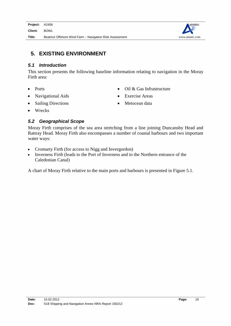
5.2 Geographical Scope Moray Firth comprises of the sea area stretching from a line joining Duncansby Head and Rattray Head. Moray Firth also encompasses a number of coastal harbours and two important water ways: Cromarty Firth (for access to Nigg and Invergordon) Inverness Firth (leads to the Port of Inverness and to the Northern entrance of the
Caledonian Canal) A chart of Moray Firth relative to the main ports and harbours is presented in Figure 5.1.
Project: A2456
Client: BOWL
Title: Beatrice Offshore Wind Farm – Navigation Risk Assessment www.anatec.com
Date: 15.02.2012 Page: 20 Doc: S18 Shipping and Navigation Annex NRA Report 150212
Figure 5.1 Overview of Moray Firth Ports and Harbours

Project: A2456
Client: BOWL
Title: Beatrice Offshore Wind Farm – Navigation Risk Assessment www.anatec.com
Date: 15.02.2012 Page: 21 Doc: S18 Shipping and Navigation Annex NRA Report 150212
5.3 Port Facilities/Services As shown in Figure 6.1, Wick Harbour is the nearest port to the Beatrice Offshore Wind Farm which handles commercial vessels, located approximately 9.5nm north east of the area.
Figure 5.2 Overview Image of Wick Harbour
The following sub-sections give details on port approaches and facilities at Wick Harbour.
5.3.1 Port Information Wick Harbour consists of three basins: The Inner Harbour - the main fishing and leisure berthing area and gives access to a 70
berth Marina. The Lifeboat berth is adjacent to the Royal Navy Lifeboat Institution (RNLI) Station.
The Outer Harbour - is used for temporary berthing, fuelling, smaller cargo vessels and
leisure berthing. The River Harbour - is the main commercial quay, in regular use, and larger vessels
wishing to use this area should consult the local information board or the Harbourmaster about shipping movements.
5.3.2 Wick Port Approaches Admiralty Chart 1462 gives details on approaches into Wick; however the following description gives information on approaches to the Outer and River Harbours. The Outer Harbour is identified from the South Pier Sector Light flashing Green/White/Red every 3 seconds. Leading lights into the Outer Basin are two fixed Red lights in line, 20 metres apart, near the end of South Pier, (not visible until the entrance is accessed).
Project: A2456
Client: BOWL
Title: Beatrice Offshore Wind Farm – Navigation Risk Assessment www.anatec.com
Date: 15.02.2012 Page: 22 Doc: S18 Shipping and Navigation Annex NRA Report 150212
The River Harbour and Harbour Bridge is marked by a White/Red/Green 4 second light. Entrance between the North and South River Piers is marked by double Red and Green vertical fixed lights. Port Closed Signal - A black ball is hoisted by day, or a fixed Green light shown by night, on a prominent mast at the South Head.
5.3.3 Limiting Conditions The maximum length of vessels is 85m. (Vessels over 85m must consult the Harbour master for restrictions). Details of the limiting conditions of the harbour are given below: Total quays = 1,366 metres. Depth alongside-Inner/Outer = 1.71m River Basin = 4.2m It is noted that there is a sandbar outside the River Basin which has a charted depth of 2.6m (March 2010).
5.3.4 Pilotage & Tugs Pilotage is compulsory in Wick Harbour for vessels over 90 gross tonnes (GT), except fishing vessels and yachts. Pilots normally board about 4.5 cables (830m) north east of South Head from a dark hulled motor boat with yellow super-structure on which the word ‘PILOTS’ is painted in black. No tugs are available at Wick or nearby Scrabster; however JP Knight (Caledonian) operates four tugs that work out of Cromarty Firth (approximately 46nm south west of Beatrice Offshore Wind Farm). An example image of a tug operated by JP Knight is shown in Figure 5.3.

Project: A2456
Client: BOWL
Title: Beatrice Offshore Wind Farm – Navigation Risk Assessment www.anatec.com
Date: 15.02.2012 Page: 23 Doc: S18 Shipping and Navigation Annex NRA Report 150212
Figure 5.3 Tug Vessel Kintore
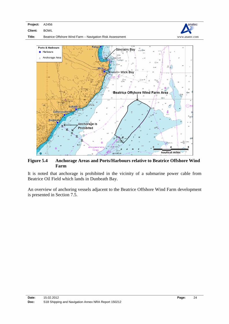
5.3.5 Anchorage Within Wick Bay there is an outer anchorage, which offers a sheltered haven on a sandy bottom during winds from south to south west through north to north east. In addition, in calmer weather conditions Sinclair’s Bay gives a location for anchorage, however it is not safe if sea state and weather is rough. The best anchorage is in the southern part of the bay in a depth of 16m, during winds from the south west and south east.
Project: A2456
Client: BOWL
Title: Beatrice Offshore Wind Farm – Navigation Risk Assessment www.anatec.com
Date: 15.02.2012 Page: 24 Doc: S18 Shipping and Navigation Annex NRA Report 150212
Figure 5.4 Anchorage Areas and Ports/Harbours relative to Beatrice Offshore Wind Farm
It is noted that anchorage is prohibited in the vicinity of a submarine power cable from Beatrice Oil Field which lands in Dunbeath Bay. An overview of anchoring vessels adjacent to the Beatrice Offshore Wind Farm development is presented in Section 7.5.
Project: A2456
Client: BOWL
Title: Beatrice Offshore Wind Farm – Navigation Risk Assessment www.anatec.com
Date: 15.02.2012 Page: 25 Doc: S18 Shipping and Navigation Annex NRA Report 150212
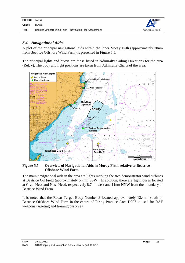
5.4 Navigational Aids A plot of the principal navigational aids within the inner Moray Firth (approximately 30nm from Beatrice Offshore Wind Farm) is presented in Figure 5.5. The principal lights and buoys are those listed in Admiralty Sailing Directions for the area (Ref. v). The buoy and light positions are taken from Admiralty Charts of the area.
Figure 5.5 Overview of Navigational Aids in Moray Firth relative to Beatrice Offshore Wind Farm
The main navigational aids in the area are lights marking the two demonstrator wind turbines at Beatrice Oil Field (approximately 5.7nm SSW). In addition, there are lighthouses located at Clyth Ness and Noss Head, respectively 8.7nm west and 11nm NNW from the boundary of Beatrice Wind Farm. It is noted that the Radar Target Buoy Number 3 located approximately 12.4nm south of Beatrice Offshore Wind Farm in the centre of Firing Practice Area D807 is used for RAF weapons targeting and training purposes.
Project: A2456
Client: BOWL
Title: Beatrice Offshore Wind Farm – Navigation Risk Assessment www.anatec.com
Date: 15.02.2012 Page: 26 Doc: S18 Shipping and Navigation Annex NRA Report 150212
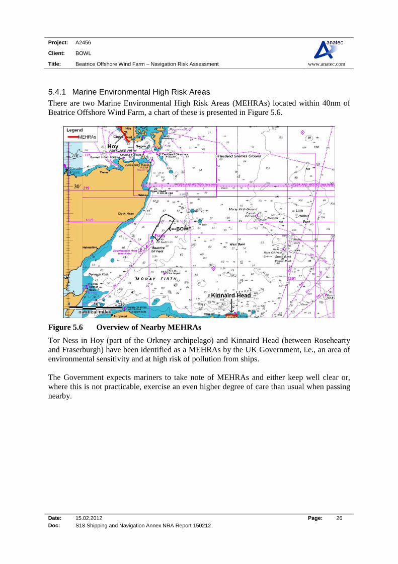
5.4.1 Marine Environmental High Risk Areas There are two Marine Environmental High Risk Areas (MEHRAs) located within 40nm of Beatrice Offshore Wind Farm, a chart of these is presented in Figure 5.6.
Figure 5.6 Overview of Nearby MEHRAs
Tor Ness in Hoy (part of the Orkney archipelago) and Kinnaird Head (between Rosehearty and Fraserburgh) have been identified as a MEHRAs by the UK Government, i.e., an area of environmental sensitivity and at high risk of pollution from ships. The Government expects mariners to take note of MEHRAs and either keep well clear or, where this is not practicable, exercise an even higher degree of care than usual when passing nearby.

Project: A2456
Client: BOWL
Title: Beatrice Offshore Wind Farm – Navigation Risk Assessment www.anatec.com
Date: 15.02.2012 Page: 27 Doc: S18 Shipping and Navigation Annex NRA Report 150212
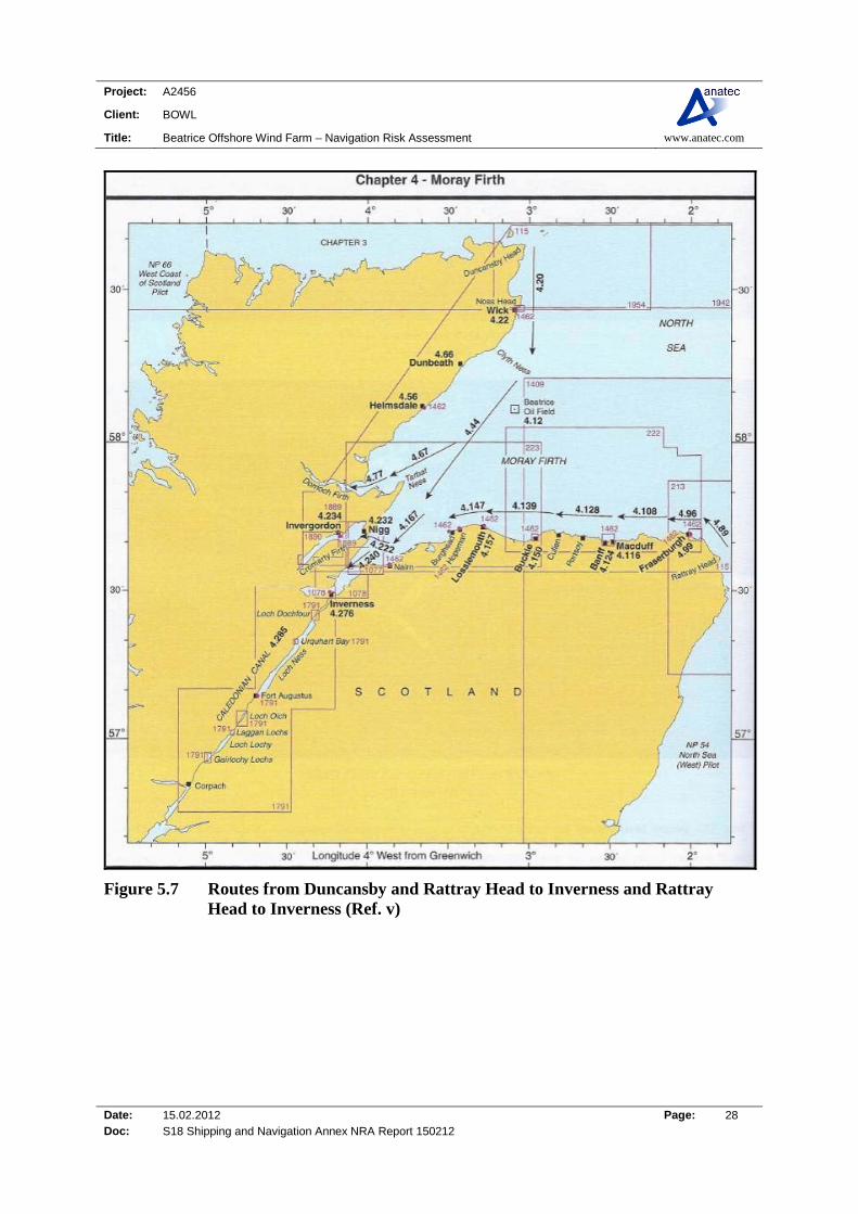
5.5 Sailing Directions Sailing directions for the area are presented in the North Coast of Scotland Pilot (Ref. v). A plot of the routes for vessels bound from Rattray Head and Duncansby Head to Inverness is presented in Figure 5.7. The arrows are not accurate if superimposed on a chart but they illustrate the general passages used by ships. A description of the route passing the wind farm area from Duncansby Head to Tarbat Ness is given below.
(4.20) From a position 2.25 East of Duncansby Head (58° 39’ N, 3° 01’ W) on the alignment (328°) of Swona Light (58° 44’ N, 3° 04’ W) and Cantick Head light (3.5 miles NNW) the coastal passage leads South passing East of the Stacks of Duncansby (8 cables South), a group of detached rock pinnacles lying close under the cliffs; the rugged top of the highest stack, which is also the outermost, can be seen projecting above the adjacent land. Then, East of Fast Geo Head (2 miles South) which is fringed by dangerous rocks. Then, East of Skirza Head (2.75 miles South), an abrupt cliff, 30m high, with several caves in its base. Then, East of Noss Head (10 miles South). Then, East of Wick Bay (12.5 miles South), noting dangerous wrecks lying respectively 8 cables North east and 2.5 cables South east of South Head; a harbour signal station stands on the South Head (7.5 cables SSW of North Head), and the ruins of Castle of Old Wick, a prominent square tower,, stand on the cliff edge about 5 cables farther SSW. Thence: East of Clyth Ness (58° 19’ N, 3° 13’ W) on which stands a light (white tower, red band, 13m in height). The headland is fringed by a detached and partly drying rock ledge.
(4.44) The route from Clyth Ness to Tarbat Ness leads South west for 32 miles passing North west of the Beatrice Oil Field and associated development area.
Project: A2456
Client: BOWL
Title: Beatrice Offshore Wind Farm – Navigation Risk Assessment www.anatec.com
Date: 15.02.2012 Page: 28 Doc: S18 Shipping and Navigation Annex NRA Report 150212
Figure 5.7 Routes from Duncansby and Rattray Head to Inverness and Rattray Head to Inverness (Ref. v)

Project: A2456
Client: BOWL
Title: Beatrice Offshore Wind Farm – Navigation Risk Assessment www.anatec.com
Date: 15.02.2012 Page: 29 Doc: S18 Shipping and Navigation Annex NRA Report 150212
5.6 Wrecks Based on the admiralty charts of the area no wrecks are marked within the Beatrice Wind Farm boundary, as show in Figure 5.8.
Figure 5.8 Charted Wrecks within 10nm of Beatrice Offshore Wind Farm
There are a small number of wrecks located east of the wind farm (the closest is approximately 0.3nm from the wind farm boundary). There is also a protected military wreck 8.6nm east of Beatrice Offshore Wind Farm.
Project: A2456
Client: BOWL
Title: Beatrice Offshore Wind Farm – Navigation Risk Assessment www.anatec.com
Date: 15.02.2012 Page: 30 Doc: S18 Shipping and Navigation Annex NRA Report 150212
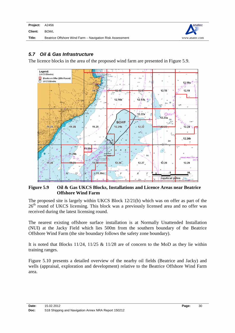
5.7 Oil & Gas Infrastructure The licence blocks in the area of the proposed wind farm are presented in Figure 5.9.
Figure 5.9 Oil & Gas UKCS Blocks, Installations and Licence Areas near Beatrice Offshore Wind Farm
The proposed site is largely within UKCS Block 12/21(b) which was on offer as part of the 26th round of UKCS licensing. This block was a previously licensed area and no offer was received during the latest licensing round. The nearest existing offshore surface installation is at Normally Unattended Installation (NUI) at the Jacky Field which lies 500m from the southern boundary of the Beatrice Offshore Wind Farm (the site boundary follows the safety zone boundary). It is noted that Blocks 11/24, 11/25 & 11/28 are of concern to the MoD as they lie within training ranges. Figure 5.10 presents a detailed overview of the nearby oil fields (Beatrice and Jacky) and wells (appraisal, exploration and development) relative to the Beatrice Offshore Wind Farm area.
Project: A2456
Client: BOWL
Title: Beatrice Offshore Wind Farm – Navigation Risk Assessment www.anatec.com
Date: 15.02.2012 Page: 31 Doc: S18 Shipping and Navigation Annex NRA Report 150212
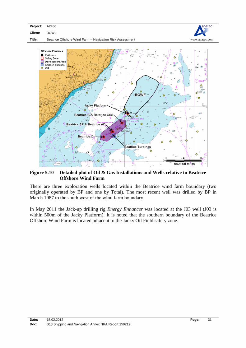
Figure 5.10 Detailed plot of Oil & Gas Installations and Wells relative to Beatrice Offshore Wind Farm
There are three exploration wells located within the Beatrice wind farm boundary (two originally operated by BP and one by Total). The most recent well was drilled by BP in March 1987 to the south west of the wind farm boundary. In May 2011 the Jack-up drilling rig Energy Enhancer was located at the J03 well (J03 is within 500m of the Jacky Platform). It is noted that the southern boundary of the Beatrice Offshore Wind Farm is located adjacent to the Jacky Oil Field safety zone.

Project: A2456
Client: BOWL
Title: Beatrice Offshore Wind Farm – Navigation Risk Assessment www.anatec.com
Date: 15.02.2012 Page: 32 Doc: S18 Shipping and Navigation Annex NRA Report 150212
5.8 Other Wind Farm Developments As well as the two Demonstrator Turbines located on the south eastern edge of the Beatrice Development Area, the Beatrice Offshore Wind Farm development is located along the north western boundary of the Moray Firth Round 3 development Zone, as presented in Figure 5.11.
Figure 5.11 Other Wind Farm in proximity to Beatrice Offshore Wind Farm
Wind farm construction in the zone is likely to phased, however clear plans of the intended developments within this zone were unavailable at the time of preparing this NRA. It is also noted that a Scottish Hydro Electric Transmission Limited (SHETL) interconnector cable from Shetland Islands and associated substation is planned to the east of the Moray Firth Round 3 Zone. This cable is been developed to link possible renewable energy projects in Shetland and northern Scotland to the mainland.

Project: A2456
Client: BOWL
Title: Beatrice Offshore Wind Farm – Navigation Risk Assessment www.anatec.com
Date: 15.02.2012 Page: 33 Doc: S18 Shipping and Navigation Annex NRA Report 150212
5.9 Exercise Areas The entire Moray Firth area is encompassed in the Royal Air Force (RAF) Northern Managed Danger Area (MDA), which is a military practice zone for high altitude RAF training exercises. The main military navigational features relate to the RAF military Practice and Exercise Areas (PEXA’s). Firing Practice Areas D807 and D809 are the closest areas (1nm east and 2.6nm south of Beatrice Offshore Wind Farm) and Tain RAF Bombing Range is located approximately 19nm south west as shown in Figure 5.12.
Figure 5.12 Military Practice Areas relative to Beatrice Offshore Wind Farm
There is a rifle firing range in Wick (Old Wick) which is 7.4nm north west of Beatrice Offshore Wind Farm. No restrictions are placed on the right to transit the Wick (X5819) firing practice area at any time and they operate a clear range procedure with exercises only taking place when the area is clear of shipping. It is noted that there are two spoil grounds located approximately 1.5nm east of Wick harbour (8nm north west of Beatrice Offshore Wind Farm).
Project: A2456
Client: BOWL
Title: Beatrice Offshore Wind Farm – Navigation Risk Assessment www.anatec.com
Date: 15.02.2012 Page: 34 Doc: S18 Shipping and Navigation Annex NRA Report 150212
5.10 Metocean Data
5.10.1 Introduction This section presents Metocean statistics for the area of the Beatrice Offshore wind farm development which have been used as input to the risk assessment. According to the Admiralty Sailing Directions (Ref. v), the west North Sea region enjoys a generally mild climate. Winds blow from between the south and south west most usually, and are often fresh or strong. Gales are more common in the winter months, although they still may occur during the summer. Rainfall is not considerable, and there is little variation throughout the year. Squally showers with winds between north west and north east are often accompanied by snow in winter. It is frequently cloudy throughout the year; however, the winter months are more susceptible to overcast skies. Fog (or haar) occasionally affects the east cost of the UK, particularly in the north. In winter, the coastal areas of the Moray Firth are subject to radiation fog that forms inland and is generally most dense around dawn.
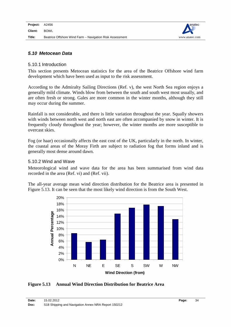
5.10.2 Wind and Wave Meteorological wind and wave data for the area has been summarised from wind data recorded in the area (Ref. vi) and (Ref. vii). The all-year average mean wind direction distribution for the Beatrice area is presented in Figure 5.13. It can be seen that the most likely wind direction is from the South West.
0%
2%
4%
6%
8%
10%
12%
14%
16%
18%
20%
N NE E SE S SW W NW
Wind Direction (from)
An
nu
al P
erce
nta
ge
Figure 5.13 Annual Wind Direction Distribution for Beatrice Area
Project: A2456
Client: BOWL
Title: Beatrice Offshore Wind Farm – Navigation Risk Assessment www.anatec.com
Date: 15.02.2012 Page: 35 Doc: S18 Shipping and Navigation Annex NRA Report 150212
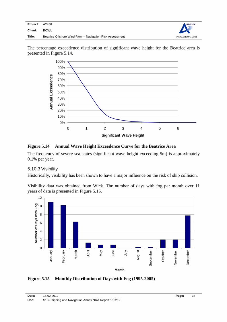
The percentage exceedence distribution of significant wave height for the Beatrice area is presented in Figure 5.14.
0%
10%
20%
30%
40%
50%
60%
70%
80%
90%
100%
0 1 2 3 4 5 6
Significant Wave Height
An
nu
al E
xcee
den
ce
Figure 5.14 Annual Wave Height Exceedence Curve for the Beatrice Area
The frequency of severe sea states (significant wave height exceeding 5m) is approximately 0.1% per year.
5.10.3 Visibility Historically, visibility has been shown to have a major influence on the risk of ship collision. Visibility data was obtained from Wick. The number of days with fog per month over 11 years of data is presented in Figure 5.15.
0
2
4
6
8
10
12
Janu
ary
Fe
brua
ry
Ma
rch
Apr
il
Ma
y
June
July
Aug
ust
Sep
tem
ber
Oct
ober
No
vem
be
r
De
cem
be
r
Nu
mb
er
of
Da
ys w
ith
Fo
g
Month
Figure 5.15 Monthly Distribution of Days with Fog (1995-2005)

Project: A2456
Client: BOWL
Title: Beatrice Offshore Wind Farm – Navigation Risk Assessment www.anatec.com
Date: 15.02.2012 Page: 36 Doc: S18 Shipping and Navigation Annex NRA Report 150212
It can be seen from the above figure that fog is more common between December and March and occurs less frequently from July to September. It is noted that days with fog at Wick are likely to be higher due to geography (land meeting sea and subsequent temperature differences) therefore offshore visibility data was more relevant for ship collision modelling. The annual probability of visibility less than 1km for the UK North Sea is approximately 0.03, i.e., approximately 3% of the year.
5.10.4 Tide A description of the tidal streams in the general area is provided below (Ref. v):
The tide on the North coast of Scotland is predominantly semi-diurnal and progresses east along the North coast and through the Orkney and Shetland Island thence South down the East coast. Ranges are about 3m in the Orkney Islands, 2m in the Shetlands Islands and 4m at the head of the Moray Firth.
Tidal streams are very strong off Duncansby Head and fairly strong off Rattray Head and in the inner part of the firth, they are generally weak elsewhere, both in the Eastern approaches to and within, Moray Firth.
Currents in the North Sea are generally very variable and much affected by existing, and recent, local weather. There is a very weak clockwise circulation around the shore of the Moray Firth. When there is high snow melt in spring, and during and after heavy rain or western gales, temporary but quite appreciable local currents emerge from the Dornoch, Cromarty and Inverness Firths.
Chart Datum and Ordnance Datum for the Beatrice wind farm based on values recorded at Wick are presented Table 5.1.
Table 5.1 Chart Datum and Ordnance Datum Figures from Wick
Tidal Level Height above Chart Datum
HAT 4m
MHWS 3.5m
Mean Sea Level (MSL) (approx.) 2.1m
Mean Low Water Springs (MLWS) 0.7m
LAT 0.1m
Admiralty Chart 115 (Tidal Diamond “F” approximately 3.4nm south west of the Beatrice area, indicates that currents in the area set in a generally WSW direction on the flood and ENE direction on the ebb, with a peak spring tidal rate of 0.5 knots and peak neap rate of 0.3 knots, as shown in Figure 5.16.

Project: A2456
Client: BOWL
Title: Beatrice Offshore Wind Farm – Navigation Risk Assessment www.anatec.com
Date: 15.02.2012 Page: 37 Doc: S18 Shipping and Navigation Annex NRA Report 150212
Figure 5.16 Tidal Stream Data for Beatrice Offshore Wind Farm (Tide Point “E to H and N”)

Project: A2456
Client: BOWL
Title: Beatrice Offshore Wind Farm – Navigation Risk Assessment www.anatec.com
Date: 15.02.2012 Page: 38 Doc: S18 Shipping and Navigation Annex NRA Report 150212
6. MARITIME INCIDENTS
6.1 Introduction This section reviews maritime incidents that have occurred in the vicinity of the proposed Beatrice Offshore Wind Farm in recent years. The analysis is intended to provide a general indication as to whether the area of the proposed development is currently low or high risk in terms of maritime incidents. Data from the following sources has been analysed: Marine Accident Investigation Branch (MAIB) Royal National Lifeboat Institution (RNLI) (It is noted that the same incident may be recorded by both sources.)
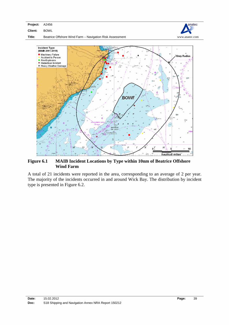
6.2 MAIB All UK-flagged commercial vessels are required to report accidents to the MAIB. Non-UK flagged vessels do not have to report unless they are within a UK port/harbour or within UK 12 mile territorial waters and carrying passengers to or from a UK port (including those in inland waterways). However, the MAIB will record details of significant accidents of which they are notified by bodies such as the Coastguard, or by monitoring news and other information sources for relevant accidents. The Maritime and Coastguard Agency, harbour authorities and inland waterway authorities also have a duty to report accidents to MAIB. The locations1 of accidents, injuries and hazardous incidents reported to MAIB within 10nm of Beatrice Offshore Wind Farm between January 2001 and December 2010 are presented in Figure 6.1, colour-coded by type.
1 MAIB aim for 97% accuracy in reporting the locations of incidents.
Project: A2456
Client: BOWL
Title: Beatrice Offshore Wind Farm – Navigation Risk Assessment www.anatec.com
Date: 15.02.2012 Page: 39 Doc: S18 Shipping and Navigation Annex NRA Report 150212
Figure 6.1 MAIB Incident Locations by Type within 10nm of Beatrice Offshore Wind Farm
A total of 21 incidents were reported in the area, corresponding to an average of 2 per year. The majority of the incidents occurred in and around Wick Bay. The distribution by incident type is presented in Figure 6.2.

Project: A2456
Client: BOWL
Title: Beatrice Offshore Wind Farm – Navigation Risk Assessment www.anatec.com
Date: 15.02.2012 Page: 40 Doc: S18 Shipping and Navigation Annex NRA Report 150212
0
2
4
6
8
10
12
14M
achi
nery
Fai
lure
Acc
iden
t T
oP
erso
n
Haz
ardo
usIn
cide
nt
Fire
/Exp
losi
on
Hea
vy W
eath
erD
amag
e
Cause
Nu
mb
er o
f In
cid
ents
Figure 6.2 MAIB Incidents by Type within 10nm of Beatrice Offshore Wind Farm (2001-2010)
The most common incident type recorded within 10nm of the site boundary was machinery failure, representing 57% of all incidents over the ten year period (approximately half of these were from fishing vessels). The number of incidents recorded per year within 10nm of Beatrice Offshore Wind Farm is presented in Figure 6.3
0
1
2
3
4
5
6
20
01
20
02
20
03
20
04
20
05
20
06
20
07
20
08
20
09
20
10
Year
Nu
mb
er
of
Inc
ide
nts
Figure 6.3 MAIB Incidents by Year within 10nm of Beatrice Offshore Wind Farm (2001-2010)

Project: A2456
Client: BOWL
Title: Beatrice Offshore Wind Farm – Navigation Risk Assessment www.anatec.com
Date: 15.02.2012 Page: 41 Doc: S18 Shipping and Navigation Annex NRA Report 150212
The highest number of incidents within 10nm of Beatrice Offshore Wind Farm was recorded in 2005 with 5 incidents reported. No incidents were recorded during 2008 and 2009. There were no incidents reported within the proposed Beatrice Offshore Wind Farm. The closest incident to the proposed wind farm was a Hazardous Incident approximately 0.5nm from the eastern boundary on 24 May 2005. The incident involved a 21m fishing vessel which was involved in a near miss with another unidentified vessel. The second closest incident involved an Accident to Person on-board a 15m scallop dredger which was emptying clam dredges, when a crew member slipped on the deck and received a blow to the head. The skipper radioed to the coastguard and when the vessel arrived in port the crewman was taken to hospital by a waiting ambulance. The injury turned out to be superficial. It is noted that no ship-to-ship collisions were recorded within 10nm of the wind farm boundary.

Project: A2456
Client: BOWL
Title: Beatrice Offshore Wind Farm – Navigation Risk Assessment www.anatec.com
Date: 15.02.2012 Page: 42 Doc: S18 Shipping and Navigation Annex NRA Report 150212
6.3 RNLI Data on RNLI lifeboat responses within 10nm of the Beatrice Offshore Wind Farm site in the ten-year period between 2001 and 2010 have been analysed. A total of 67 launches were recorded by the RNLI (excluding hoaxes and false alarms). Figure 6.4 presents the geographical location of incidents colour-coded by casualty type. It can be seen that the vast majority occurred near the coast and Wick Bay, with relatively few further out to sea.
Figure 6.4 RNLI Incidents by Casualty Type within 10nm of Beatrice Offshore Wind Farm
One incident was recorded within the Beatrice Offshore Wind Farm boundary over the 10 year period analysed. This incident involved a leak/swamping on-board a sailing yacht in wind force 6 in September 2010. Royal Air Force (RAF) and Wick All-weather Life Boat (ALB) search and rescue (SAR) units were involved assisting the vessel to safety. The overall distribution by casualty type is summarised in Figure 6.5.
Project: A2456
Client: BOWL
Title: Beatrice Offshore Wind Farm – Navigation Risk Assessment www.anatec.com
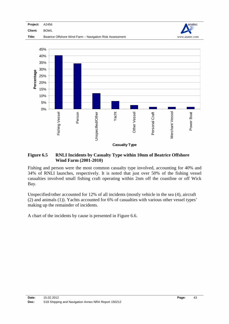
Date: 15.02.2012 Page: 43 Doc: S18 Shipping and Navigation Annex NRA Report 150212
0%
5%
10%
15%
20%
25%
30%
35%
40%
45%
Fis
hing
Ves
sel
Per
son
Uns
peci
fied/
Oth
er
Yac
ht
Oth
er V
esse
l
Per
sona
l Cra
ft
Mer
chan
t Ves
sel
Pow
er B
oat
Casualty Type
Per
cen
tag
e
Figure 6.5 RNLI Incidents by Casualty Type within 10nm of Beatrice Offshore Wind Farm (2001-2010)
Fishing and person were the most common casualty type involved, accounting for 40% and 34% of RNLI launches, respectively. It is noted that just over 50% of the fishing vessel casualties involved small fishing craft operating within 2nm off the coastline or off Wick Bay. Unspecified/other accounted for 12% of all incidents (mostly vehicle in the sea (4), aircraft (2) and animals (1)). Yachts accounted for 6% of casualties with various other vessel types’ making up the remainder of incidents. A chart of the incidents by cause is presented in Figure 6.6.
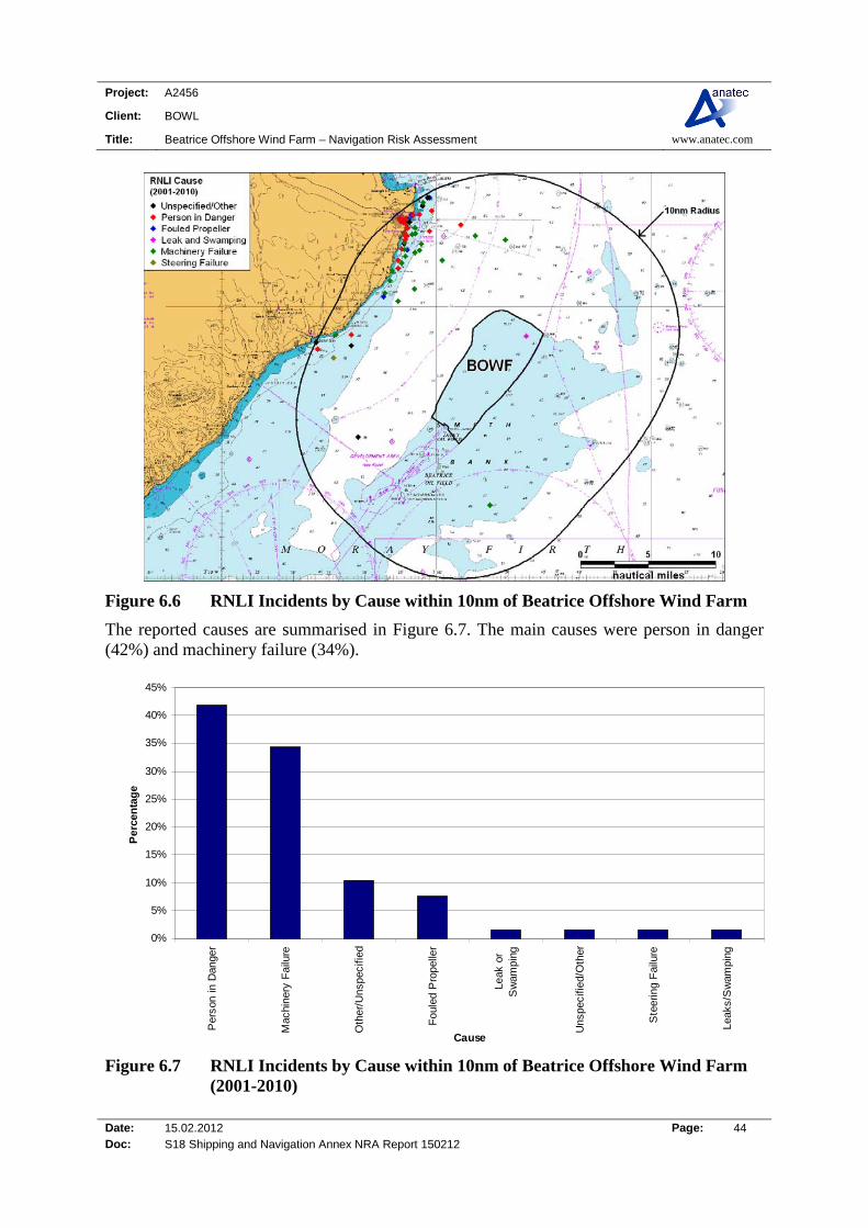
Project: A2456
Client: BOWL
Title: Beatrice Offshore Wind Farm – Navigation Risk Assessment www.anatec.com
Date: 15.02.2012 Page: 44 Doc: S18 Shipping and Navigation Annex NRA Report 150212
Figure 6.6 RNLI Incidents by Cause within 10nm of Beatrice Offshore Wind Farm
The reported causes are summarised in Figure 6.7. The main causes were person in danger (42%) and machinery failure (34%).
0%
5%
10%
15%
20%
25%
30%
35%
40%
45%
Per
son
in D
ange
r
Mac
hine
ry F
ailu
re
Oth
er/U
nspe
cifie
d
Fou
led
Pro
pelle
r
Leak
or
Sw
ampi
ng
Uns
peci
fied/
Oth
er
Ste
erin
g F
ailu
re
Leak
s/S
wam
ping
Cause
Per
cen
tag
e
Figure 6.7 RNLI Incidents by Cause within 10nm of Beatrice Offshore Wind Farm (2001-2010)
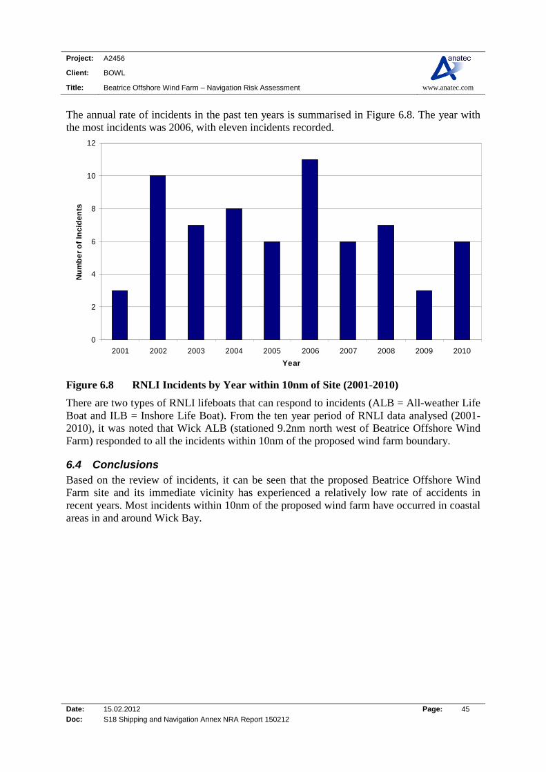
Project: A2456
Client: BOWL
Title: Beatrice Offshore Wind Farm – Navigation Risk Assessment www.anatec.com
Date: 15.02.2012 Page: 45 Doc: S18 Shipping and Navigation Annex NRA Report 150212
The annual rate of incidents in the past ten years is summarised in Figure 6.8. The year with the most incidents was 2006, with eleven incidents recorded.
0
2
4
6
8
10
12
2001 2002 2003 2004 2005 2006 2007 2008 2009 2010
Year
Nu
mb
er
of
Inc
ide
nts
Figure 6.8 RNLI Incidents by Year within 10nm of Site (2001-2010)
There are two types of RNLI lifeboats that can respond to incidents (ALB = All-weather Life Boat and ILB = Inshore Life Boat). From the ten year period of RNLI data analysed (2001-2010), it was noted that Wick ALB (stationed 9.2nm north west of Beatrice Offshore Wind Farm) responded to all the incidents within 10nm of the proposed wind farm boundary.
6.4 Conclusions Based on the review of incidents, it can be seen that the proposed Beatrice Offshore Wind Farm site and its immediate vicinity has experienced a relatively low rate of accidents in recent years. Most incidents within 10nm of the proposed wind farm have occurred in coastal areas in and around Wick Bay.

Project: A2456
Client: BOWL
Title: Beatrice Offshore Wind Farm – Navigation Risk Assessment www.anatec.com
Date: 15.02.2012 Page: 46 Doc: S18 Shipping and Navigation Annex NRA Report 150212
7. MARITIME TRAFFIC SURVEYS
7.1 Introduction This section summarises the results of the maritime traffic surveys carried out in the Moray Firth for the Beatrice offshore Wind farm, using a combination of shore-based AIS, AIS / radar ship data and visual observations.
7.2 Survey Details Two survey vessels recorded shipping data for Beatrice Offshore Wind Farm while working in the Moray Firth. The first survey took place from spring to summer 2010 from the Chartwell geophysical survey vessel with a winter survey taking place from the geotechnical survey vessel Gargano.
7.2.1 Chartwell Survey The Chartwell survey recorded data from 1st April to 31st July 2010. An image of this vessel is presented below.
Figure 7.1 Picture of the Survey Vessel Chartwell
The area of operation of the survey vessel during the shipping traffic survey is presented in Figure 7.2.
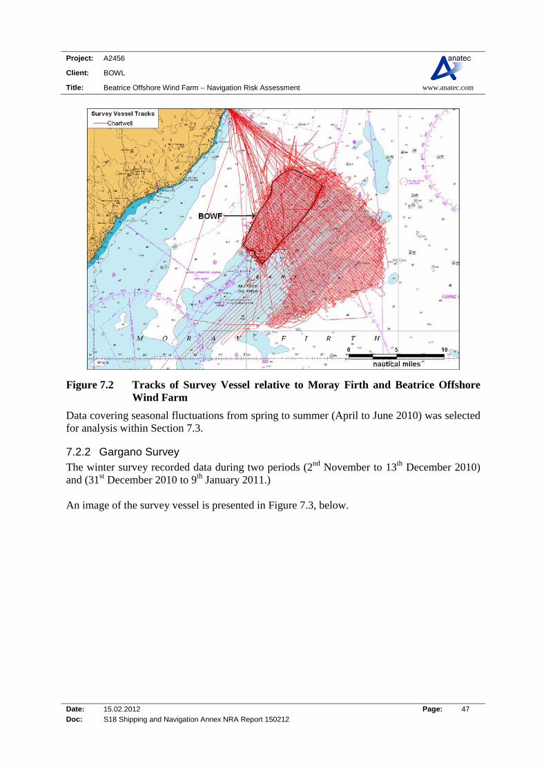
Project: A2456
Client: BOWL
Title: Beatrice Offshore Wind Farm – Navigation Risk Assessment www.anatec.com
Date: 15.02.2012 Page: 47 Doc: S18 Shipping and Navigation Annex NRA Report 150212
Figure 7.2 Tracks of Survey Vessel relative to Moray Firth and Beatrice Offshore Wind Farm
Data covering seasonal fluctuations from spring to summer (April to June 2010) was selected for analysis within Section 7.3.
7.2.2 Gargano Survey The winter survey recorded data during two periods (2nd November to 13th December 2010) and (31st December 2010 to 9th January 2011.) An image of the survey vessel is presented in Figure 7.3, below.

Project: A2456
Client: BOWL
Title: Beatrice Offshore Wind Farm – Navigation Risk Assessment www.anatec.com
Date: 15.02.2012 Page: 48 Doc: S18 Shipping and Navigation Annex NRA Report 150212
Figure 7.3 Picture of the Survey Vessel Gargano
The area of operation of the geotechnical survey vessel during the shipping traffic survey is presented in Figure 7.4.
Figure 7.4 Tracks of Survey Vessel relative to Moray Firth and Beatrice Offshore Wind Farm
Full details of the Gargano survey is presented in the separate report prepared by Anatec (Ref. viii).
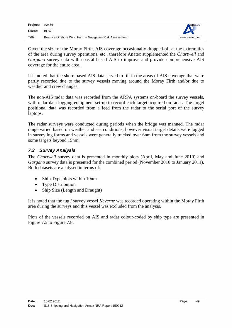
Project: A2456
Client: BOWL
Title: Beatrice Offshore Wind Farm – Navigation Risk Assessment www.anatec.com
Date: 15.02.2012 Page: 49 Doc: S18 Shipping and Navigation Annex NRA Report 150212
Given the size of the Moray Firth, AIS coverage occasionally dropped-off at the extremities of the area during survey operations, etc., therefore Anatec supplemented the Chartwell and Gargano survey data with coastal based AIS to improve and provide comprehensive AIS coverage for the entire area. It is noted that the shore based AIS data served to fill in the areas of AIS coverage that were partly recorded due to the survey vessels moving around the Moray Firth and/or due to weather and crew changes. The non-AIS radar data was recorded from the ARPA systems on-board the survey vessels, with radar data logging equipment set-up to record each target acquired on radar. The target positional data was recorded from a feed from the radar to the serial port of the survey laptops. The radar surveys were conducted during periods when the bridge was manned. The radar range varied based on weather and sea conditions, however visual target details were logged in survey log forms and vessels were generally tracked over 6nm from the survey vessels and some targets beyond 15nm.
7.3 Survey Analysis The Chartwell survey data is presented in monthly plots (April, May and June 2010) and Gargano survey data is presented for the combined period (November 2010 to January 2011). Both datasets are analysed in terms of:
Ship Type plots within 10nm Type Distribution Ship Size (Length and Draught)
It is noted that the tug / survey vessel Keverne was recorded operating within the Moray Firth area during the surveys and this vessel was excluded from the analysis. Plots of the vessels recorded on AIS and radar colour-coded by ship type are presented in Figure 7.5 to Figure 7.8.
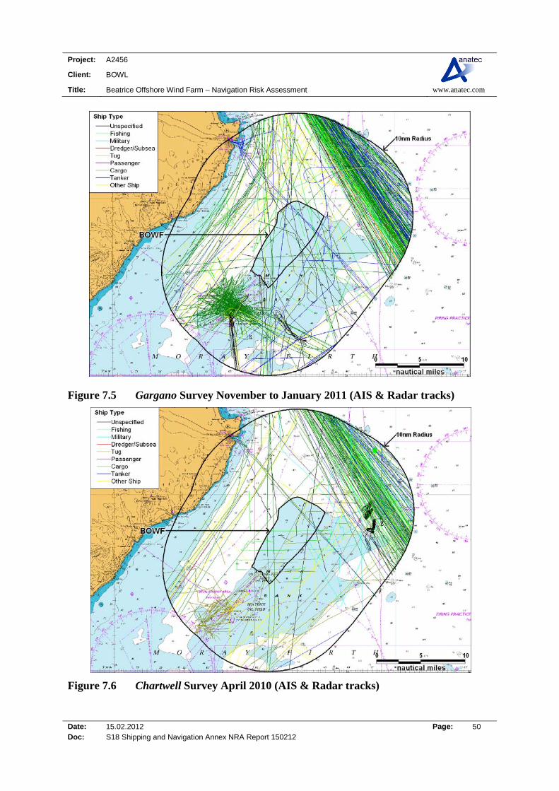
Project: A2456
Client: BOWL
Title: Beatrice Offshore Wind Farm – Navigation Risk Assessment www.anatec.com
Date: 15.02.2012 Page: 50 Doc: S18 Shipping and Navigation Annex NRA Report 150212
Figure 7.5 Gargano Survey November to January 2011 (AIS & Radar tracks)
Figure 7.6 Chartwell Survey April 2010 (AIS & Radar tracks)

Project: A2456
Client: BOWL
Title: Beatrice Offshore Wind Farm – Navigation Risk Assessment www.anatec.com
Date: 15.02.2012 Page: 51 Doc: S18 Shipping and Navigation Annex NRA Report 150212
Figure 7.7 Chartwell Survey May 2010 (AIS & Radar tracks)
Figure 7.8 Chartwell Survey June 2010 (AIS & Radar tracks)

Project: A2456
Client: BOWL
Title: Beatrice Offshore Wind Farm – Navigation Risk Assessment www.anatec.com
Date: 15.02.2012 Page: 52 Doc: S18 Shipping and Navigation Annex NRA Report 150212
The number of vessels within 10nm of the Beatrice Offshore Wind farm averaged 9 to 12 vessels per day. As can be observed from the shipping plots, the majority of vessel tracks were associated with Pentland Firth route and the oil and gas platforms. To put the traffic into a daily context, the tracks recorded on the busiest days recorded from the two survey vessels are presented in Figure 7.9 and Figure 7.10.
Figure 7.9 Chartwell Survey Busiest Day – 12 June 2010 (21 Unique Tracks)
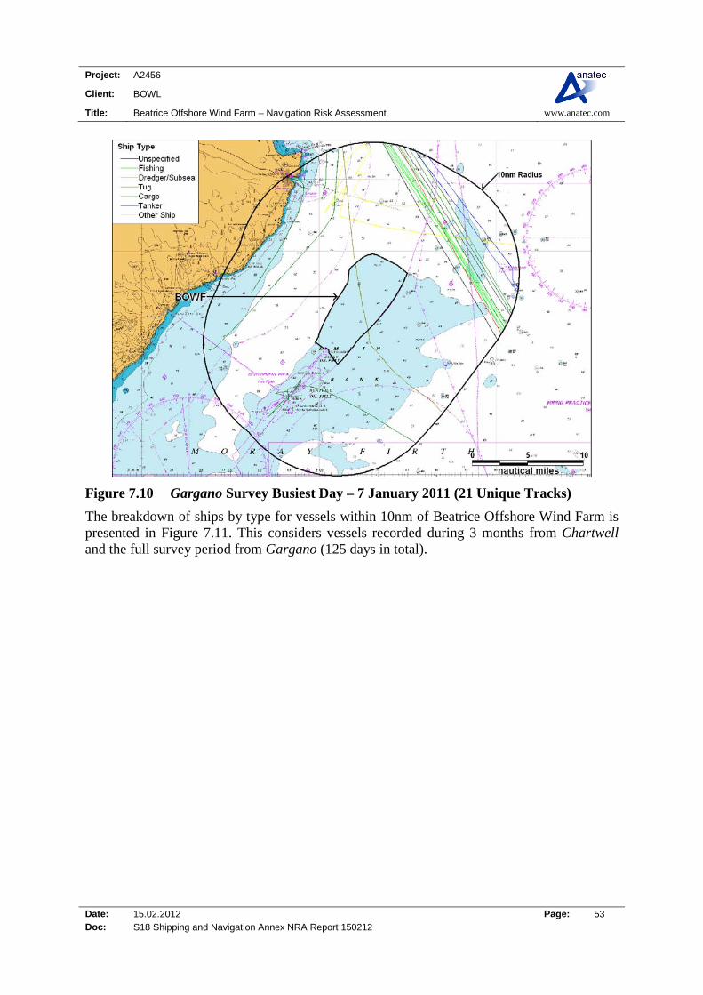
Project: A2456
Client: BOWL
Title: Beatrice Offshore Wind Farm – Navigation Risk Assessment www.anatec.com
Date: 15.02.2012 Page: 53 Doc: S18 Shipping and Navigation Annex NRA Report 150212
Figure 7.10 Gargano Survey Busiest Day – 7 January 2011 (21 Unique Tracks)
The breakdown of ships by type for vessels within 10nm of Beatrice Offshore Wind Farm is presented in Figure 7.11. This considers vessels recorded during 3 months from Chartwell and the full survey period from Gargano (125 days in total).

Project: A2456
Client: BOWL
Title: Beatrice Offshore Wind Farm – Navigation Risk Assessment www.anatec.com
Date: 15.02.2012 Page: 54 Doc: S18 Shipping and Navigation Annex NRA Report 150212
42%
1%
14%1%
11%
2%
<1%
17%
12% Cargo
Dredging/Underwater Ops
Fishing
Military
Other
Passenger
Recreation
Tanker
Tug
Figure 7.11 Vessel Types identified during the Combined Surveys
The most common vessel type recorded during the two surveys were cargo ships (42%) and tankers (17%) with fishing vessels the third most commonly tracked (14%). It is noted that a large percentage of cargo and other vessels were offshore oil and gas industry related. The distribution of vessels by draught (excluding unspecified) for the two combined surveys is presented in Figure 7.12.
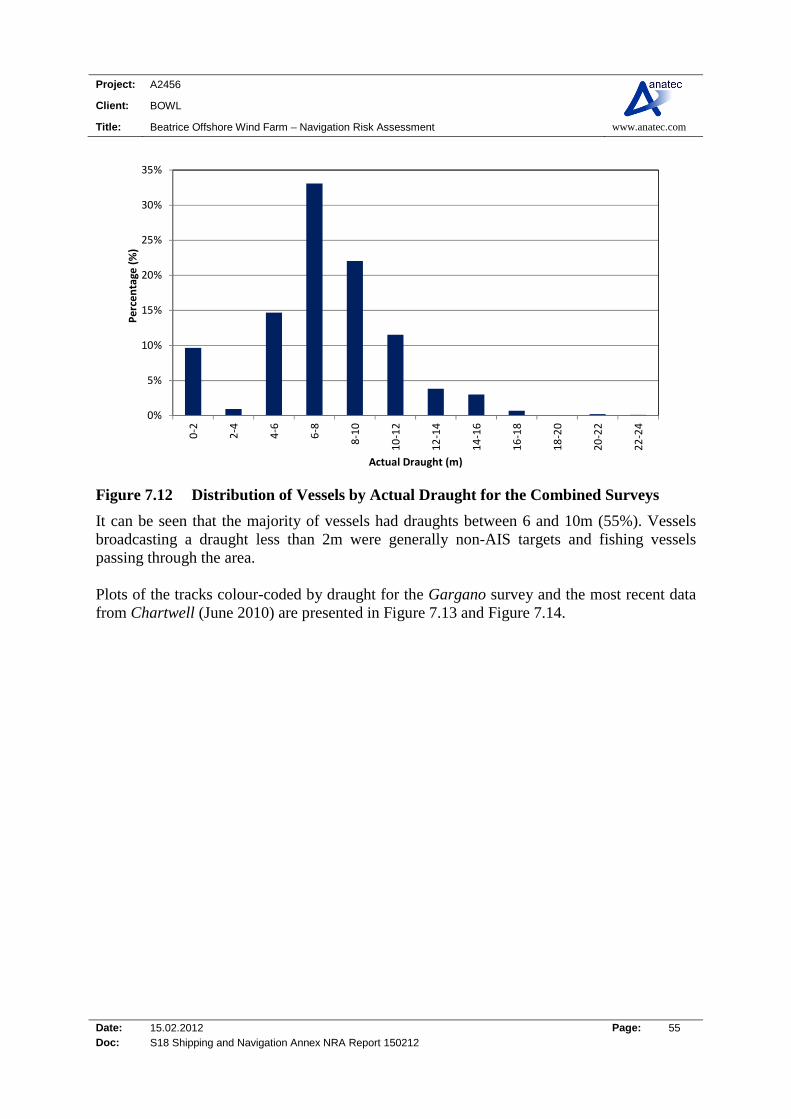
Project: A2456
Client: BOWL
Title: Beatrice Offshore Wind Farm – Navigation Risk Assessment www.anatec.com
Date: 15.02.2012 Page: 55 Doc: S18 Shipping and Navigation Annex NRA Report 150212
0%
5%
10%
15%
20%
25%
30%
35%
0‐2
2‐4
4‐6
6‐8
8‐10
10‐12
12‐14
14‐16
16‐18
18‐20
20‐22
22‐24
Percentage (%)
Actual Draught (m)
Figure 7.12 Distribution of Vessels by Actual Draught for the Combined Surveys
It can be seen that the majority of vessels had draughts between 6 and 10m (55%). Vessels broadcasting a draught less than 2m were generally non-AIS targets and fishing vessels passing through the area. Plots of the tracks colour-coded by draught for the Gargano survey and the most recent data from Chartwell (June 2010) are presented in Figure 7.13 and Figure 7.14.

Project: A2456
Client: BOWL
Title: Beatrice Offshore Wind Farm – Navigation Risk Assessment www.anatec.com
Date: 15.02.2012 Page: 56 Doc: S18 Shipping and Navigation Annex NRA Report 150212
Figure 7.13 Gargano Survey Tracks by Ship Draught
Figure 7.14 Chartwell June 2010 Survey Tracks by Ship Draught
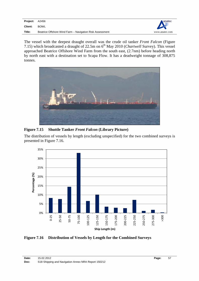
Project: A2456
Client: BOWL
Title: Beatrice Offshore Wind Farm – Navigation Risk Assessment www.anatec.com
Date: 15.02.2012 Page: 57 Doc: S18 Shipping and Navigation Annex NRA Report 150212
The vessel with the deepest draught overall was the crude oil tanker Front Falcon (Figure 7.15) which broadcasted a draught of 22.5m on 6th May 2010 (Chartwell Survey). This vessel approached Beatrice Offshore Wind Farm from the south east, (2.7nm) before heading north by north east with a destination set to Scapa Flow. It has a deadweight tonnage of 308,875 tonnes.
Figure 7.15 Shuttle Tanker Front Falcon (Library Picture)
The distribution of vessels by length (excluding unspecified) for the two combined surveys is presented in Figure 7.16.
0%
5%
10%
15%
20%
25%
30%
35%
0‐25
25‐50
50‐75
75‐100
100‐125
125‐150
150‐175
175‐200
200‐225
225‐250
250‐275
275‐300
>300
Percentage (%)
Ship Length (m)
Figure 7.16 Distribution of Vessels by Length for the Combined Surveys
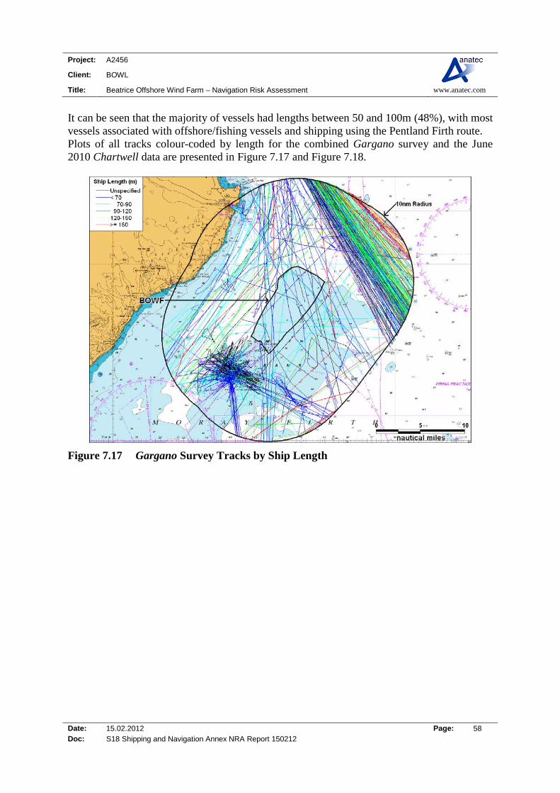
Project: A2456
Client: BOWL
Title: Beatrice Offshore Wind Farm – Navigation Risk Assessment www.anatec.com
Date: 15.02.2012 Page: 58 Doc: S18 Shipping and Navigation Annex NRA Report 150212
It can be seen that the majority of vessels had lengths between 50 and 100m (48%), with most vessels associated with offshore/fishing vessels and shipping using the Pentland Firth route. Plots of all tracks colour-coded by length for the combined Gargano survey and the June 2010 Chartwell data are presented in Figure 7.17 and Figure 7.18.
Figure 7.17 Gargano Survey Tracks by Ship Length

Project: A2456
Client: BOWL
Title: Beatrice Offshore Wind Farm – Navigation Risk Assessment www.anatec.com
Date: 15.02.2012 Page: 59 Doc: S18 Shipping and Navigation Annex NRA Report 150212
Figure 7.18 Chartwell June 2010 Survey Tracks by Ship Length
The longest vessel tracked was the crude oil tanker Front Falcon which is 333m in length, as previously described and shown in Figure 7.15. Figure 7.19 presents the distributions of average speed for each of the two surveys.
0%
5%
10%
15%
20%
25%
0‐2 2‐4 4‐6 6‐8 8‐10 10‐12 12‐14 14‐16 16‐18 >18
Percentage of Traffic (%
)
Average Speed (Knots)
Chartwell ‐ April 2010
Chartwell ‐ May 2010
Chartwell ‐ June 2010
Gargano
Figure 7.19 Average Speed Distributions for Chartwell and Gargano Surveys
Project: A2456
Client: BOWL
Title: Beatrice Offshore Wind Farm – Navigation Risk Assessment www.anatec.com
Date: 15.02.2012 Page: 60 Doc: S18 Shipping and Navigation Annex NRA Report 150212
The average speeds during the two survey periods ranged from 8-14 knots. The relatively high mean speeds recorded within 10nm of Beatrice Offshore Wind Farm can be explained by the large proportion of vessels using the north by north west / south by south east route from Pentland Firth.

Project: A2456
Client: BOWL
Title: Beatrice Offshore Wind Farm – Navigation Risk Assessment www.anatec.com
Date: 15.02.2012 Page: 61 Doc: S18 Shipping and Navigation Annex NRA Report 150212
7.4 Beatrice Site-Specific Review A detailed analysis of the Chartwell AIS and radar data (June 2010, 30 days) combined with the Gargano winter survey tracks (November 2010 to January 2011, 38 days) passing the proposed Beatrice Offshore Wind Farm turbines is presented in Figure 7.20. The turbine layout presented in the following figures (Figure 7.20 to Figure 7.32) is based on the Rochdale Envelope of the maximum number of turbines (277) in the 3.6MW layout.
Figure 7.20 Detailed Plot of the Combined Surveys Tracks Passing the Site (68 Days)
The following figures present plots of vessel tracks passing close to the turbines broken down by the main vessel types as listed below:
Tankers (Figure 7.21) Cargo Vessels (Figure 7.22) Passenger Ships (Figure 7.23) Other Vessels (consisting mainly of offshore cargo and search/rescue ships on AIS)
(Figure 7.24) Fishing Vessels (Figure 7.25) Recreational Vessels (Figure 7.26)

Project: A2456
Client: BOWL
Title: Beatrice Offshore Wind Farm – Navigation Risk Assessment www.anatec.com
Date: 15.02.2012 Page: 62 Doc: S18 Shipping and Navigation Annex NRA Report 150212
Figure 7.21 Plot of Tanker Tracks Passing Close to the Proposed Turbines
Four tankers intersected the proposed Beatrice Offshore Wind Farm turbines: Frigg, Navion Fennia, Vedrey Hallarna and Whitstar. Vedrey Hallarna and Whitstar were recorded headed to/from Wick, with Frigg and Navion Fennia routeing southbound from the Northern Isles.

Project: A2456
Client: BOWL
Title: Beatrice Offshore Wind Farm – Navigation Risk Assessment www.anatec.com
Date: 15.02.2012 Page: 63 Doc: S18 Shipping and Navigation Annex NRA Report 150212
Figure 7.22 Plot of Cargo Tracks Passing Close to the Proposed Turbines
Ten cargo vessels intersected the proposed Beatrice Offshore Wind Farm turbines. The small to medium sized cargo vessels intersecting the proposed turbines are listed below:
Ingelborg Pilot Grampian Talisker Grampian Talisman Mekhanik Tyulenev Konst. Paustovskiy Scott Carrier Shetland Trader Wilson Saar Coronel Swift
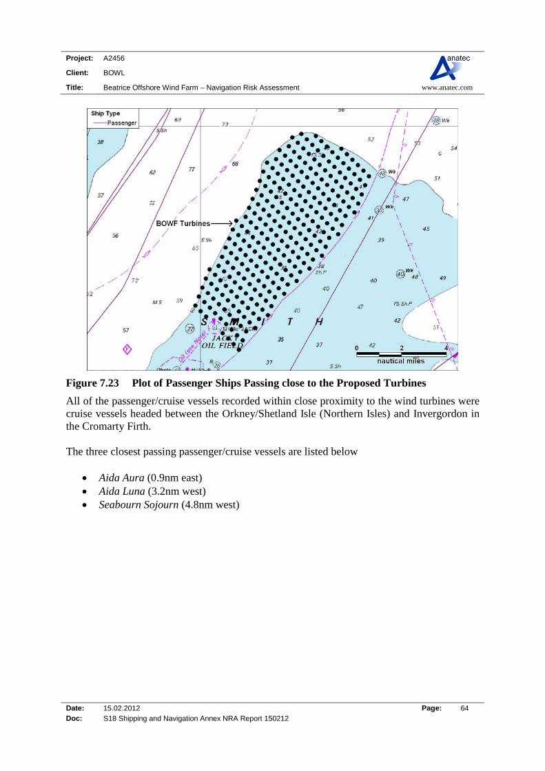
Project: A2456
Client: BOWL
Title: Beatrice Offshore Wind Farm – Navigation Risk Assessment www.anatec.com
Date: 15.02.2012 Page: 64 Doc: S18 Shipping and Navigation Annex NRA Report 150212
Figure 7.23 Plot of Passenger Ships Passing close to the Proposed Turbines
All of the passenger/cruise vessels recorded within close proximity to the wind turbines were cruise vessels headed between the Orkney/Shetland Isle (Northern Isles) and Invergordon in the Cromarty Firth. The three closest passing passenger/cruise vessels are listed below
Aida Aura (0.9nm east) Aida Luna (3.2nm west) Seabourn Sojourn (4.8nm west)

Project: A2456
Client: BOWL
Title: Beatrice Offshore Wind Farm – Navigation Risk Assessment www.anatec.com
Date: 15.02.2012 Page: 65 Doc: S18 Shipping and Navigation Annex NRA Report 150212
Figure 7.24 Plot of Other Vessels passing close to the Proposed Turbines
The large majority of other vessels in the area were offshore oil and gas support vessels. Two vessels passed through the proposed turbine perimeter, offshore vessel Subsea Viking and the NLB light/buoy tender Pharos.

Project: A2456
Client: BOWL
Title: Beatrice Offshore Wind Farm – Navigation Risk Assessment www.anatec.com
Date: 15.02.2012 Page: 66 Doc: S18 Shipping and Navigation Annex NRA Report 150212
Figure 7.25 Plot of Fishing Vessels passing close to the Proposed Turbines
Approximately six fishing vessels were recorded steaming or fishing within the proposed turbines:
WRON 5 SCH 22 WRON 6 SCH 23 Aquarius BF 89 Ocean Reward BCK 83 Two unidentified Fishing vessels (non-AIS)

Project: A2456
Client: BOWL
Title: Beatrice Offshore Wind Farm – Navigation Risk Assessment www.anatec.com
Date: 15.02.2012 Page: 67 Doc: S18 Shipping and Navigation Annex NRA Report 150212
Figure 7.26 Plot of Recreation Vessels passing close to the Proposed Turbines
Two recreational vessels were recorded passing within the proposed turbines, one bound for Wick headed from the south and the second headed from the north towards the inner Moray Firth (Dornoch Firth).

Project: A2456
Client: BOWL
Title: Beatrice Offshore Wind Farm – Navigation Risk Assessment www.anatec.com
Date: 15.02.2012 Page: 68 Doc: S18 Shipping and Navigation Annex NRA Report 150212
Figure 7.27 presents the tracks of all vessels which were identified to pass within the proposed turbine perimeter during the combined 68-day survey period.
Figure 7.27 Tracks passing within Site Perimeter (68 days)
A total of 39 AIS and 15 non-AIS tracks (additional to the main vessels types presented above as a number of unspecified vessels passed through the site) were identified to pass within the proposed turbine perimeter during the 68 days of data presented (Chartwell June 2010 [30 days] and Gargano winter data [38 days]), corresponding to an average of over one vessel every 2 days. The most common types of ship passing through the area were cargo ships, which tended to be small-medium sized coasters headed to ports within the Moray Firth, i.e. Wick, Invergordon and Buckie. The traffic on passage through the site was mainly heading in a north by north east – south by south west direction.

Project: A2456
Client: BOWL
Title: Beatrice Offshore Wind Farm – Navigation Risk Assessment www.anatec.com
Date: 15.02.2012 Page: 69 Doc: S18 Shipping and Navigation Annex NRA Report 150212
Details of the 30 vessels tracked on AIS through the site are given in Table 7.1.
Table 7.1 Details of Vessels Intersecting Beatrice Offshore Wind Farm (where information was available)
Ship Name Type Length (m) Destination Tracks
Vedrey Hallarna Tanker 80 Wick/Immingham 2 Frigg Tanker 81 Invergordon 1
Whitstar Tanker 75 Immingham 1 Navion Fennia Tanker 242 Falmouth 1 Subsea Viking Offshore 103 Invergordon/Foinaven 2
Pharos Buoy Tender 84 Oban 1 Ingelborg Pilot Cargo 63 Rotterdam 1
Wilson Saar Cargo 73 Verdal, Norway 1 Coronel Cargo 87 Buckie 2
Scott Carrier Cargo 82 Buckie 1 Mekhanik Tyulenev Cargo 85 Brevik 1 Konst. Paustovskiy Cargo 89 Szczecin 1
Swift Cargo 58 New Ross, Ireland 1 Shetland Trader Cargo 75 Buckie 1
Grampian Talisker Cargo 82 Aberdeen 1 Grampian Talisman Cargo 73 Flotta 1
Sisu Capella Cargo 92 Invergordon 1 WRON 5 SCH 22 Trawler 56 N/A 2 WRON 6 SCH 23 Trawler 56 N/A 1 Aquarius BF 89 Trawler 21 N/A 1 Ocean Reward
BCK 83 Trawler 18 N/A 2
Queen of Ulster Unspecified 25 N/A 1 Pauline Sailing 14 N/A 1
Forth Constructor Tug 28 Liverpool 1 Shekinah INS155 Trawler 17 N/A 1
Seabeam Survey 17 Wick 1 Georgia Dawn
INS140 Trawler 17 N/A 1
Cattelya E349 Trawler 62 N/A 1
WindCat 15 Crew
Transfer 17 N/A 2
Table 7.1 (above) shows that in terms of AIS-equipped ships, only six vessels passed through the site on more one occasion with the majority of vessels (14) passing once.

Project: A2456
Client: BOWL
Title: Beatrice Offshore Wind Farm – Navigation Risk Assessment www.anatec.com
Date: 15.02.2012 Page: 70 Doc: S18 Shipping and Navigation Annex NRA Report 150212
7.5 Anchored Vessels The positions of vessels at anchor recorded during the combined surveys (Chartwell April to June and Gargano winter) are presented in Figure 7.28.
Figure 7.28 All Anchored Vessels during Surveys (125 days of surveying)
Three commercial vessels were recorded within 10nm of the Beatrice Offshore Wind Farm over the combined survey period. A survey vessel (Seabeam) was recorded 5.6nm NNW of the proposed turbines anchored off Wick Bay, with a cargo vessel (El Bravo) and tanker (Vigdis Knutsen) anchored 9.5nm WSW of Beatrice Offshore Wind Farm off Dunbeath Bay.

Project: A2456
Client: BOWL
Title: Beatrice Offshore Wind Farm – Navigation Risk Assessment www.anatec.com
Date: 15.02.2012 Page: 71 Doc: S18 Shipping and Navigation Annex NRA Report 150212
7.6 Detailed Analysis of Main Shipping Lane The main shipping lane passing the wind farm site is the NNW-SSE lane to/from Pentland Firth; however it is assumed that shipping on this route will not be significantly impacted by developments within the Beatrice Offshore Wind Farm and therefore will not require a deviation to current routeing. The main route passing through the site boundary consists of vessels headed to and from Wick. Vessels using this route during the combined surveys (Chartwell April to July 2010 and Gargano winter 2010/11) have been isolated for analysis, as presented in Figure 7.29.
Figure 7.29 Tracks by Type on NE-SW Shipping Route
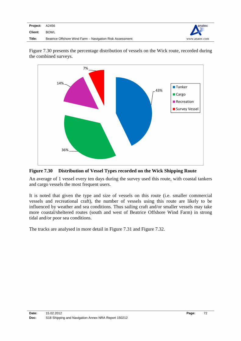
Project: A2456
Client: BOWL
Title: Beatrice Offshore Wind Farm – Navigation Risk Assessment www.anatec.com
Date: 15.02.2012 Page: 72 Doc: S18 Shipping and Navigation Annex NRA Report 150212
Figure 7.30 presents the percentage distribution of vessels on the Wick route, recorded during the combined surveys.
43%
36%
14%
7%
Tanker
Cargo
Recreation
Survey Vessel
Figure 7.30 Distribution of Vessel Types recorded on the Wick Shipping Route
An average of 1 vessel every ten days during the survey used this route, with coastal tankers and cargo vessels the most frequent users. It is noted that given the type and size of vessels on this route (i.e. smaller commercial vessels and recreational craft), the number of vessels using this route are likely to be influenced by weather and sea conditions. Thus sailing craft and/or smaller vessels may take more coastal/sheltered routes (south and west of Beatrice Offshore Wind Farm) in strong tidal and/or poor sea conditions. The tracks are analysed in more detail in Figure 7.31 and Figure 7.32.

Project: A2456
Client: BOWL
Title: Beatrice Offshore Wind Farm – Navigation Risk Assessment www.anatec.com
Date: 15.02.2012 Page: 73 Doc: S18 Shipping and Navigation Annex NRA Report 150212
Figure 7.31 Tracks by Ship Length on NE-SW Route
Figure 7.32 Tracks by Ship Draught on NE-SW Route

Project: A2456
Client: BOWL
Title: Beatrice Offshore Wind Farm – Navigation Risk Assessment www.anatec.com
Date: 15.02.2012 Page: 74 Doc: S18 Shipping and Navigation Annex NRA Report 150212
8. IMPACT ON COMMERCIAL SHIPPING NAVIGATION
8.1 Passing Ships Based on the analysis of the shipping survey data (see Section 7), it is considered that the Beatrice Offshore Wind Farm site will not significantly impact passing ships on the Pentland Firth route as they pass well to the north east of the proposed site (approximately 5nm away). In terms of nearby traffic, the majority of ships also pass clear of the site (i.e., shipping using the coastal route 3-5nm west). The main route that will be impacted is the NE-SW shipping route to/from Wick. Approximately 1 vessel every ten days uses this route (on average), the majority of which are coastal tankers and/or small-medium cargo vessels. The current position of this traffic lane is analysed in Section 7.6. In addition, a small number vessels currently pass close (<200m) from the eastern boundary of the proposed wind farm when headed between the Moray Firth and Northern Norway/Russia. The vessels on this low use route are likely to increase passing distance from the site boundary to the order of 1nm (i.e. during construction/decommissioning or when there is a strong easterly or south easterly gale and/or tidal flow). To highlight that the vast majority of tracks pass outside the Beatrice Offshore Wind Farm site, a Closest Point of Approach (CPA) analysis of the most recent survey data collected in winter 2010/11 was carried out. The CPA distribution for these vessels (excluding vessels passing through the turbine perimeter) is presented in Figure 8.1.
0
10
20
30
40
50
60
70
80
90
100
Number of Tracks
Closest Point of Approach (nm)
Figure 8.1 CPA Distribution for Vessels within 10nm (Winter Survey 38 Days)
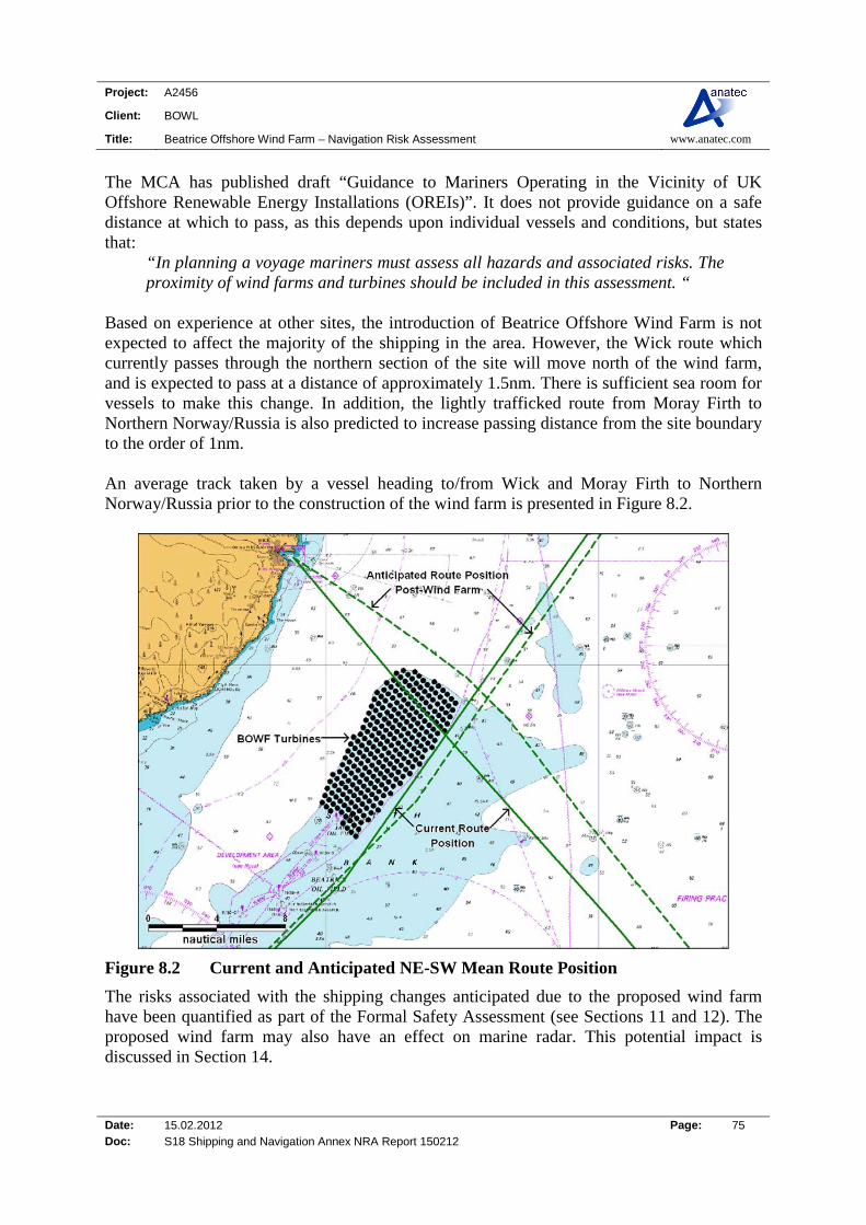
Project: A2456
Client: BOWL
Title: Beatrice Offshore Wind Farm – Navigation Risk Assessment www.anatec.com
Date: 15.02.2012 Page: 75 Doc: S18 Shipping and Navigation Annex NRA Report 150212
The MCA has published draft “Guidance to Mariners Operating in the Vicinity of UK Offshore Renewable Energy Installations (OREIs)”. It does not provide guidance on a safe distance at which to pass, as this depends upon individual vessels and conditions, but states that:
“In planning a voyage mariners must assess all hazards and associated risks. The proximity of wind farms and turbines should be included in this assessment. “
Based on experience at other sites, the introduction of Beatrice Offshore Wind Farm is not expected to affect the majority of the shipping in the area. However, the Wick route which currently passes through the northern section of the site will move north of the wind farm, and is expected to pass at a distance of approximately 1.5nm. There is sufficient sea room for vessels to make this change. In addition, the lightly trafficked route from Moray Firth to Northern Norway/Russia is also predicted to increase passing distance from the site boundary to the order of 1nm. An average track taken by a vessel heading to/from Wick and Moray Firth to Northern Norway/Russia prior to the construction of the wind farm is presented in Figure 8.2.
Figure 8.2 Current and Anticipated NE-SW Mean Route Position
The risks associated with the shipping changes anticipated due to the proposed wind farm have been quantified as part of the Formal Safety Assessment (see Sections 11 and 12). The proposed wind farm may also have an effect on marine radar. This potential impact is discussed in Section 14.
Project: A2456
Client: BOWL
Title: Beatrice Offshore Wind Farm – Navigation Risk Assessment www.anatec.com
Date: 15.02.2012 Page: 76 Doc: S18 Shipping and Navigation Annex NRA Report 150212
9. RECREATIONAL VESSEL ACTIVITY
9.1 Introduction This section reviews recreational vessel activity at the Beatrice Offshore Wind Farm site based on information published by the Royal Yachting Association (RYA) and AIS/radar tracking of recreational vessels during the maritime traffic surveys.
9.2 RYA Data
9.2.1 Introduction The RYA, supported by the CA, have identified recreational cruising routes, general sailing and racing areas around the UK in the Coastal Atlas (Ref. ix). This work was based on extensive consultation and qualitative data collection from RYA and CA members, through the organisations’ specialist and regional committees and through the RYA affiliated clubs. The consultation was also sent to berth holder associations and marinas. The reports note that recreational boating, both under sail and power is highly seasonal and highly diurnal. The division of recreational craft routes into Heavy, Medium and Light Use is therefore based on the following classification:
Heavy Recreational Routes: - Very popular routes on which a minimum of six or more recreational vessels will probably be seen at all times during summer daylight hours. These also include the entrances to harbours, anchorages and places of refuge.
Medium Recreational Routes: - Popular routes on which some recreational craft will be seen at most times during summer daylight hours.
Light Recreational Routes: - Routes known to be in common use but which do not qualify for medium or heavy classification.

Project: A2456
Client: BOWL
Title: Beatrice Offshore Wind Farm – Navigation Risk Assessment www.anatec.com
Date: 15.02.2012 Page: 77 Doc: S18 Shipping and Navigation Annex NRA Report 150212
9.2.2 Moray Firth Recreational Data An overview and detailed plot of the recreational sailing activity and facilities in the Moray Firth and Beatrice Offshore Wind Farm area is presented in Figure 9.1 and Figure 9.2.
Figure 9.1 Overview Recreational Information for the Moray Firth
In terms of facilities, there are a number clubs, training centres and marinas for recreational vessels located on the coast line around Moray, Aberdeenshire, Caithness and Sutherland. There is also a range of facilities located at Inverness which is popular for vessels passing through the Caledonian Canal. The nearest marina is in Wick approximately 9.5nm to the north west and the nearest clubs are located at Lossiemouth and Findochty 28nm south.

Project: A2456
Client: BOWL
Title: Beatrice Offshore Wind Farm – Navigation Risk Assessment www.anatec.com
Date: 15.02.2012 Page: 78 Doc: S18 Shipping and Navigation Annex NRA Report 150212
Figure 9.2 Detailed Recreational Information for the Beatrice Offshore Wind Farm (within 10nm radius)
There is one medium-use route that passes through the Beatrice Offshore Wind Farm, from Wick to Peterhead and a light-use route between the Northern Isle and Moray Firth (Lossiemouth).
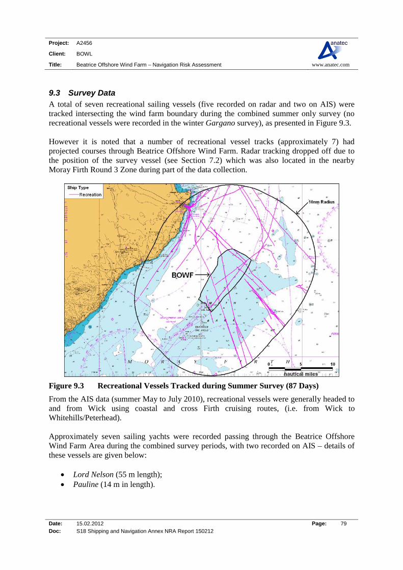
Project: A2456
Client: BOWL
Title: Beatrice Offshore Wind Farm – Navigation Risk Assessment www.anatec.com
Date: 15.02.2012 Page: 79 Doc: S18 Shipping and Navigation Annex NRA Report 150212
9.3 Survey Data A total of seven recreational sailing vessels (five recorded on radar and two on AIS) were tracked intersecting the wind farm boundary during the combined summer only survey (no recreational vessels were recorded in the winter Gargano survey), as presented in Figure 9.3. However it is noted that a number of recreational vessel tracks (approximately 7) had projected courses through Beatrice Offshore Wind Farm. Radar tracking dropped off due to the position of the survey vessel (see Section 7.2) which was also located in the nearby Moray Firth Round 3 Zone during part of the data collection.
Figure 9.3 Recreational Vessels Tracked during Summer Survey (87 Days)
From the AIS data (summer May to July 2010), recreational vessels were generally headed to and from Wick using coastal and cross Firth cruising routes, (i.e. from Wick to Whitehills/Peterhead). Approximately seven sailing yachts were recorded passing through the Beatrice Offshore Wind Farm Area during the combined survey periods, with two recorded on AIS – details of these vessels are given below:
Lord Nelson (55 m length); Pauline (14 m in length).
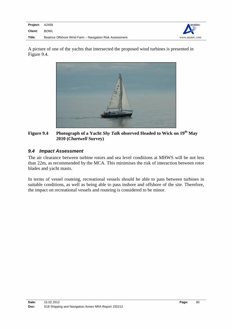
Project: A2456
Client: BOWL
Title: Beatrice Offshore Wind Farm – Navigation Risk Assessment www.anatec.com
Date: 15.02.2012 Page: 80 Doc: S18 Shipping and Navigation Annex NRA Report 150212
A picture of one of the yachts that intersected the proposed wind turbines is presented in Figure 9.4.
Figure 9.4 Photograph of a Yacht Shy Talk observed Headed to Wick on 19th May 2010 (Chartwell Survey)
9.4 Impact Assessment The air clearance between turbine rotors and sea level conditions at MHWS will be not less than 22m, as recommended by the MCA. This minimises the risk of interaction between rotor blades and yacht masts. In terms of vessel routeing, recreational vessels should be able to pass between turbines in suitable conditions, as well as being able to pass inshore and offshore of the site. Therefore, the impact on recreational vessels and routeing is considered to be minor.
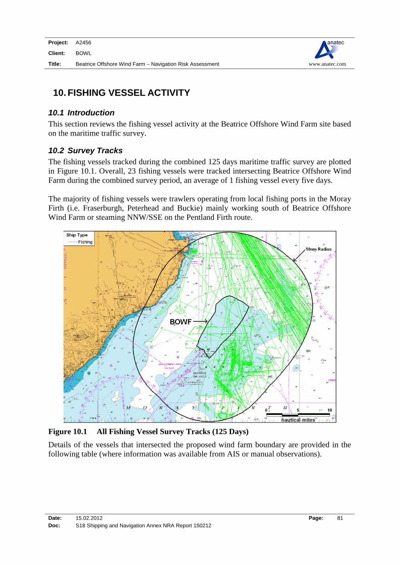
Project: A2456
Client: BOWL
Title: Beatrice Offshore Wind Farm – Navigation Risk Assessment www.anatec.com
Date: 15.02.2012 Page: 81 Doc: S18 Shipping and Navigation Annex NRA Report 150212
10. FISHING VESSEL ACTIVITY
10.1 Introduction This section reviews the fishing vessel activity at the Beatrice Offshore Wind Farm site based on the maritime traffic survey.
10.2 Survey Tracks The fishing vessels tracked during the combined 125 days maritime traffic survey are plotted in Figure 10.1. Overall, 23 fishing vessels were tracked intersecting Beatrice Offshore Wind Farm during the combined survey period, an average of 1 fishing vessel every five days. The majority of fishing vessels were trawlers operating from local fishing ports in the Moray Firth (i.e. Fraserburgh, Peterhead and Buckie) mainly working south of Beatrice Offshore Wind Farm or steaming NNW/SSE on the Pentland Firth route.
Figure 10.1 All Fishing Vessel Survey Tracks (125 Days)
Details of the vessels that intersected the proposed wind farm boundary are provided in the following table (where information was available from AIS or manual observations).
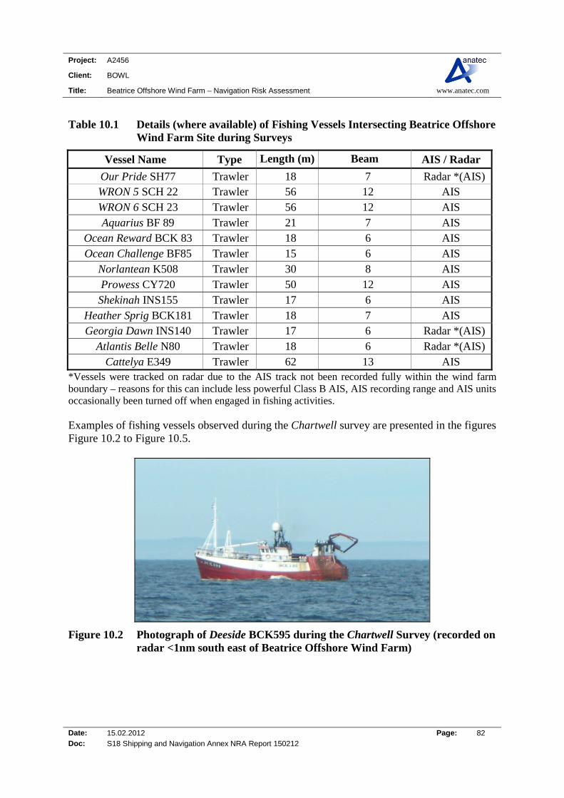
Project: A2456
Client: BOWL
Title: Beatrice Offshore Wind Farm – Navigation Risk Assessment www.anatec.com
Date: 15.02.2012 Page: 82 Doc: S18 Shipping and Navigation Annex NRA Report 150212
Table 10.1 Details (where available) of Fishing Vessels Intersecting Beatrice Offshore Wind Farm Site during Surveys
Vessel Name Type Length (m) Beam AIS / Radar
Our Pride SH77 Trawler 18 7 Radar *(AIS) WRON 5 SCH 22 Trawler 56 12 AIS WRON 6 SCH 23 Trawler 56 12 AIS Aquarius BF 89 Trawler 21 7 AIS
Ocean Reward BCK 83 Trawler 18 6 AIS Ocean Challenge BF85 Trawler 15 6 AIS
Norlantean K508 Trawler 30 8 AIS Prowess CY720 Trawler 50 12 AIS Shekinah INS155 Trawler 17 6 AIS
Heather Sprig BCK181 Trawler 18 7 AIS Georgia Dawn INS140 Trawler 17 6 Radar *(AIS)
Atlantis Belle N80 Trawler 18 6 Radar *(AIS) Cattelya E349 Trawler 62 13 AIS
*Vessels were tracked on radar due to the AIS track not been recorded fully within the wind farm boundary – reasons for this can include less powerful Class B AIS, AIS recording range and AIS units occasionally been turned off when engaged in fishing activities. Examples of fishing vessels observed during the Chartwell survey are presented in the figures Figure 10.2 to Figure 10.5.
Figure 10.2 Photograph of Deeside BCK595 during the Chartwell Survey (recorded on radar <1nm south east of Beatrice Offshore Wind Farm)

Project: A2456
Client: BOWL
Title: Beatrice Offshore Wind Farm – Navigation Risk Assessment www.anatec.com
Date: 15.02.2012 Page: 83 Doc: S18 Shipping and Navigation Annex NRA Report 150212
Figure 10.3 Photograph of Atlantis Belle N80 inside the Beatrice Offshore Wind Farm Boundary during the Chartwell Survey
Figure 10.4 Photograph of Conquest BCK265 during the Chartwell Survey (recorded on radar <0.8nm south east of Beatrice Offshore Wind Farm)
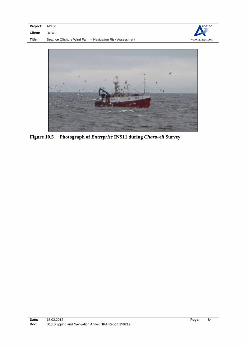
Project: A2456
Client: BOWL
Title: Beatrice Offshore Wind Farm – Navigation Risk Assessment www.anatec.com
Date: 15.02.2012 Page: 84 Doc: S18 Shipping and Navigation Annex NRA Report 150212
Figure 10.5 Photograph of Enterprise INS11 during Chartwell Survey

Project: A2456
Client: BOWL
Title: Beatrice Offshore Wind Farm – Navigation Risk Assessment www.anatec.com
Date: 15.02.2012 Page: 85 Doc: S18 Shipping and Navigation Annex NRA Report 150212
10.3 Commercial Fisheries Study A detailed study of the fishing activity in the vicinity of the Beatrice Offshore Wind Farm has been performed as part of the Environmental Impact Assessment (EIA) (Ref. x). The study used a variety of data sources, principally:
Defra – MFA fisheries statistics
The Scottish Executive Environment and Rural Affairs Department (SEERAD)
International Council for the Exploration of the Sea (ICES)
Fisheries Research Services (FRS)
Scottish Fisheries Protection Agency (SFPA)
Scottish Fishermen’s Federation (SFF)
Figure 10.6 Overview of ICES Rectangles relative to Beatrice Offshore Wind Farm
The Beatrice offshore wind farm site is situated within ICES Rectangle 45E7 and 45E6.

Project: A2456
Client: BOWL
Title: Beatrice Offshore Wind Farm – Navigation Risk Assessment www.anatec.com
Date: 15.02.2012 Page: 86 Doc: S18 Shipping and Navigation Annex NRA Report 150212
10.4 Impact Assessment Based on the current fishing activity in the area, and the assumption that this will continue after the wind farm is built, there will be a limited risk of collision between fishing vessels and turbines (most trawlers were recorded 1 to 7nm SSE of the site). This risk is reviewed in the Hazard Review workshop (Section 11) and Risk Assessment (Section 12). There is also potential to impact on the navigation of vessels to and from fishing grounds, for example, increased steaming distances and times, however from the shipping data the vast majority of steaming vessels were recorded on the Pentland Firth route approximately 5nm north east. This is mainly an issue during the construction and decommissioning phases when there will be a safety zone and hence there may be some increased steaming distances. During operation there should be sufficient spacing between turbines for vessels to steam through the site if the conditions are considered suitable. The risk of interaction between fishing gear and subsea cabling associated with the development is discussed in Section 12.4.

Project: A2456
Client: BOWL
Title: Beatrice Offshore Wind Farm – Navigation Risk Assessment www.anatec.com
Date: 15.02.2012 Page: 87 Doc: S18 Shipping and Navigation Annex NRA Report 150212
11. FORMAL SAFETY ASSESSMENT
11.1 Introduction The IMO Formal Safety Assessment process (Ref. xi) as approved by the IMO in 2002 under SC/Circ.1023/MEPC/Circ392 has been applied within this study. This is a structured and systematic methodology based on risk analysis and cost benefit assessment (if applicable). There are five basic steps within this process:
1. Identification of hazards (a list of all relevant accident scenarios with potential causes and outcomes);
2. Assessment of risks (evaluation of risk factors);
3. Risk control options (devising regulatory measures to control and reduce the identified risks);
4. Cost benefit assessment (determining cost effectiveness of risk control measures); and
5. Recommendations for decision-making (information about the hazards, their associated risks and the cost effectiveness of alternative risk control measures).
Figure 11.1 is a flow diagram of the FSA methodology applied.
Figure 11.1 Overview of Formal Safety Assessment
As indicated within the IMO FSA guidelines and the DECC guidance on risk assessment methodology (Ref. i) for offshore renewable projects, the depth of the assessment should be commensurate with the nature and significance of the problem. Within the assessment of proportionality, consideration was given to both the scale of the development and the magnitude of the risks/navigational impact.

Project: A2456
Client: BOWL
Title: Beatrice Offshore Wind Farm – Navigation Risk Assessment www.anatec.com
Date: 15.02.2012 Page: 88 Doc: S18 Shipping and Navigation Annex NRA Report 150212
From review it was concluded that the Beatrice Offshore Wind Farm project is a large scale development with the potential to impact navigational safety. As a result, the content and methods of the risk assessment were responsive to this and included the following:
- Comprehensive Hazard Log - Risk Ranking - Detailed and quantified Navigational Risk Assessment for selected hazards - Preliminary search and rescue overview - Preliminary emergency response overview - Comprehensive risk control/mitigation measures log
11.2 Hazard Identification A Hazard Review workshop was held in Inverness on 6 July 2011 attended by local stakeholders representing nearby ports and shipping industry, as outlined in Table 11.1, (details of the Hazard Log Assessment and methodology can be found in Appendix B.) Representatives from MCA, British Chamber of Shipping, RYA and CA were also invited but were unable not attend.
Table 11.1 Hazard Review Workshop Attendees
Name Organisation
Ken Gray Cromarty Firth Port Authority
Keith Stratton Moray Council
Duncan Pockett Elgin & Lossiemouth Harbour Company
Andrew Ironside Fraserburgh Harbour
Archie Johnstone Northern Lighthouse Board
Ken MacLean Inverness Harbour
Clare Lavelle Moray Offshore Renewables Ltd
Rosie Scurr Beatrice Offshore Windfarm Ltd
Ali MacDonald Anatec Ltd
Peter Carey Anatec Ltd
11.3 Key Findings The focus of the meeting was on shipping navigational hazards and the key findings from the meeting are summarised below:
A key issue identified for the area is the squid fisheries, which are located south east of Beatrice Offshore Wind Farm. Vessels generally fish for squid for 2-3 months per year, from around July. Approximately 40 vessels fish for squid and these are generally between 12m and 22m in length and hence could be a risk of fishing vessel collision and gear interaction with cabling and substructures.
Project: A2456
Client: BOWL
Title: Beatrice Offshore Wind Farm – Navigation Risk Assessment www.anatec.com
Date: 15.02.2012 Page: 89 Doc: S18 Shipping and Navigation Annex NRA Report 150212
Generally, it was considered that the sea room between the coast and the proposed Beatrice wind farm site is sufficient for ship-to-ship collision not to be a major issue for displaced traffic. It was also noted that yachts are more likely to use the inshore route.
The main identified impact on shipping was for offshore support vessels accessing
Beatrice/Jacky and potential collisions between traffic routeing around the wind farm and vessels exiting the wind farm (such as a maintenance vessel).
In addition, shuttle tankers associated with the Athena Field visiting the Cromarty
Firth may pass in the vicinity of the development and also it was also pointed out that Ithaca Energy is looking at the possibility of bringing in LNG regasification vessels to do transfer operations at the Nigg Terminal.
The standard navigational control measures that have been applied to other sites were
generally considered the most effective in reducing risks at the site, e.g., marking and lighting.
Overall the workshop concluded that with the correct mitigation measures in place the
navigational risks were likely to be Low.
11.4 Risk and Mitigation Measures The risks involved with the development and the associated mitigation measures are summarised in the following table. In all cases, the competency of mariners has been assumed when assigning the risk of each hazard.
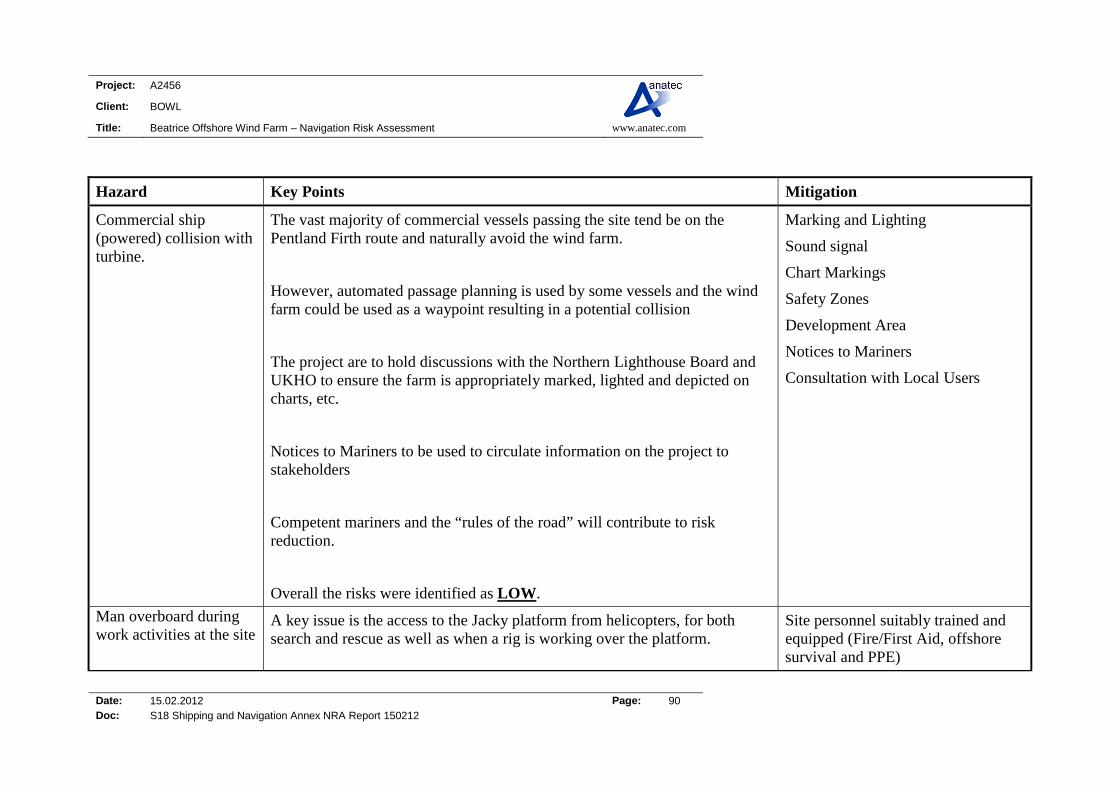
Project: A2456
Client: BOWL
Title: Beatrice Offshore Wind Farm – Navigation Risk Assessment www.anatec.com
Date: 15.02.2012 Page: 90 Doc: S18 Shipping and Navigation Annex NRA Report 150212
Hazard Key Points Mitigation
Commercial ship (powered) collision with turbine.
The vast majority of commercial vessels passing the site tend be on the Pentland Firth route and naturally avoid the wind farm.
However, automated passage planning is used by some vessels and the wind farm could be used as a waypoint resulting in a potential collision
The project are to hold discussions with the Northern Lighthouse Board and UKHO to ensure the farm is appropriately marked, lighted and depicted on charts, etc.
Notices to Mariners to be used to circulate information on the project to stakeholders
Competent mariners and the “rules of the road” will contribute to risk reduction.
Overall the risks were identified as LOW.
Marking and Lighting
Sound signal
Chart Markings
Safety Zones
Development Area
Notices to Mariners
Consultation with Local Users
Man overboard during work activities at the site
A key issue is the access to the Jacky platform from helicopters, for both search and rescue as well as when a rig is working over the platform.
Site personnel suitably trained and equipped (Fire/First Aid, offshore survival and PPE)

Project: A2456
Client: BOWL
Title: Beatrice Offshore Wind Farm – Navigation Risk Assessment www.anatec.com
Date: 15.02.2012 Page: 91 Doc: S18 Shipping and Navigation Annex NRA Report 150212
Hazard Key Points Mitigation
The is great importance in working with the offshore operators and the MCA on Emergency Response Plans, and to note that helicopter SAR operations may not always be possible within the site
Procedures for all vessels working in the wind farm
Emergency response action plans and consideration of joint plans with offshore operators/MCA on SAR operations
Control of work procedures
CDM regulations
Adverse weather working policy/procedures
Deliberate unauthorised boarding of turbine or mooring structure
It was highlighted that the development was considered to be too far offshore for this to be a major issue.
Promulgation of information to local users
Inspection and maintenance
Emergency Response Cooperation Plan
Consultation with Local Users
Vessel anchoring / dragging anchor
Incident rates of vessels dragging anchor were difficult to quantify for the area. However, during severe weather in the North Sea, vessels anchor close to the Moray coast for shelter. Vessel types include shuttle tankers, supply vessels and cable laying vessels.
AIS monitoring of the cable route
Marking and Lighting
Sound signal
Chart Markings (cables)

Project: A2456
Client: BOWL
Title: Beatrice Offshore Wind Farm – Navigation Risk Assessment www.anatec.com
Date: 15.02.2012 Page: 92 Doc: S18 Shipping and Navigation Annex NRA Report 150212
Hazard Key Points Mitigation
Overall risks were identified as LOW as it was considered unlikely that a vessel would drag anchor undetected and drift towards the turbines without starting engines.
Notices to Mariners
Consultation with Local Users
Cable route away from shipping
Appropriate cable protection/burial
Vessel-to vessel-collision due to avoidance of site (includes fishing, recreational and attendant/construction/ maintenance vessels)
An increase in ship-to-ship encounters between vessels routeing around the wind farm and vessels exiting the wind farm.
Radar returns for larger vessels passing 0.7 to 1nm off the wind farm are unlikely to be impacted significantly. However smaller vessels exiting the wind farm have potential to go undetected which could pose difficulty to passing vessels.
It is noted that fishing activity is greater during squid fishing; however this generally occurs south east of the Beatrice wind farm area.
However with competent crew/seamanship it was agreed that the risks of ship to ship collision were still likely to be LOW.
Marking and Lighting
Sound signal
Chart Markings
Safety Zones
Development Area
Notices to Mariners
Consultation with Local Users
Website
Effective Management of Vessels working in site
Consultation with fishing and recreational stakeholders.
Fishing Gear interaction with inter-field or export cabling
Scallop dredgers and nephrop trawlers operate in the area.
AIS monitoring of the cable route
Marking and Lighting

Project: A2456
Client: BOWL
Title: Beatrice Offshore Wind Farm – Navigation Risk Assessment www.anatec.com
Date: 15.02.2012 Page: 93 Doc: S18 Shipping and Navigation Annex NRA Report 150212
Hazard Key Points Mitigation
In addition as noted squid fisheries are located south east of Beatrice Offshore Wind Farm.
Guard vessels will be used during construction period, for identifying small vessels.
Sound signal
Chart Markings (cables)
Cautionary Notices on charts
Notices to fishermen and liaison
Consultation with Local Users
Cable route away from shipping
Appropriate cable protection/burial
Inspection and maintenance procedures
Recreational vessel collides with wind farm structure
Lossiemouth to Wick is a popular route in the area.
Vessels would route to the east and west of the developments dependant on wind speed/direction.
Likely that Port websites could be used to circulate wind farm construction progress and information
Websites
Promulgation of information to local users
Notice to mariners
Minimum blade clearance
Marking and Lighting
Sound signal
Chart Markings (cables)
Cautionary Notices on charts
Project: A2456
Client: BOWL
Title: Beatrice Offshore Wind Farm – Navigation Risk Assessment www.anatec.com
Date: 15.02.2012 Page: 94 Doc: S18 Shipping and Navigation Annex NRA Report 150212
11.5 Risk Analysis Following identification of the key navigational hazards, risk analyses were carried out to investigate selected hazards in more detail. This allowed more attention to be focused upon the high risk areas to identify and evaluate the factors which influence the level of risk with a view to their effective management. Four risk assessments were carried out as per the DECC guidelines:
1. Base case without wind farm level of risk 2. Base case with wind farm level of risk 3. Future case without wind farm level of risk 4. Future case with wind farm level of risk
The following scenarios were investigated in detail, quantitatively or qualitatively.
Without Wind Farm: Vessel-to-vessel collisions
With Wind Farm Vessel-to-vessel collisions Vessel-to-wind farm collisions (powered and drifting) Cable interaction
All the quantified risk assessments were carried out using Anatec’s COLLRISK software which conforms to the DECC methodology as outlined in Annex D3 in the Guidance (Ref. i). In line with this, Anatec makes the declaration that the models used within this work have been validated and are appropriate for the intended use. As required the following have been considered and justified:
- Tuning of parameters - Consistency checks - Behavioural reasonableness - Sensitivity analysis - Comparison with the real world
The results of the detailed risk analyses are presented in Section 12. Where considered appropriate in high risk scenarios, the change in individual and societal risk (based on Potential Loss of Life), as well as the risk of pollution, were calculated and compared to background risk levels in the UK.
11.6 Risk Control Measures A summary of measures is presented in Section 19.

Project: A2456
Client: BOWL
Title: Beatrice Offshore Wind Farm – Navigation Risk Assessment www.anatec.com
Date: 15.02.2012 Page: 95 Doc: S18 Shipping and Navigation Annex NRA Report 150212
12. RISK ASSESSMENT
12.1 Introduction This section assesses the risks identified from the hazard review to require more detailed assessment. This is divided into without wind farm (pre-installation) and with wind farm (post-installation) risks. The base case assessment uses the present day vessel activity level identified from the maritime traffic surveys, consultation and other data sources. The future case assessment makes conservative assumptions on shipping traffic growth over the life of the wind farm. The modelling is based the worst case scenario from the Rochdale Envelope for Shipping and Navigation, i.e. the maximum number of turbines in the 3.6MW layout (277 machines), three offshore substations and three met masts.
12.2 Without Wind Farm Risk
12.2.1 Encounters An assessment of current ship-to-ship encounters has been carried out by replaying at high-speed 28 days of data (two fourteen day periods) from Gargano in November 2010 (7 days) and January 2011 (7 days) and Chartwell in June 2010 (14 days). An encounter distance of 1nm has been considered. The tracks of vessels during encounters recorded during the 28 days of analyses, and heat maps based on the geographical distribution of encounters within a 1nm grid of cells, are presented in Figure 12.1 and Figure 12.4. This helps to illustrate where existing shipping congestion is highest and therefore where offshore developments, such as a wind farm, could potentially exacerbate congestion and hence increase the risk of encounters / collisions. It can be seen that in all cases, the density of encounters in the vicinity of the proposed wind farm is minimal.

Project: A2456
Client: BOWL
Title: Beatrice Offshore Wind Farm – Navigation Risk Assessment www.anatec.com
Date: 15.02.2012 Page: 96 Doc: S18 Shipping and Navigation Annex NRA Report 150212
Figure 12.1 Ship Encounters within 1nm relative to a 1x1nm Grid
Due to the location of the Beatrice Offshore Wind Farm site (i.e. in open sea), an encounter distance of 1nm has been used for further analysis of the ship-to-ship encounters within 10nm of the development. There were 59 encounters during the 28 day period. Figure 12.2 presents the number of encounters per day, it is noted that breaks are used to separate the different survey periods.
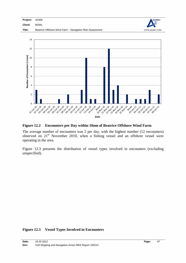
Project: A2456
Client: BOWL
Title: Beatrice Offshore Wind Farm – Navigation Risk Assessment www.anatec.com
Date: 15.02.2012 Page: 97 Doc: S18 Shipping and Navigation Annex NRA Report 150212
0
2
4
6
8
10
12
14
Number of En
counters (<1nm)
Date
Figure 12.2 Encounters per Day within 10nm of Beatrice Offshore Wind Farm
The average number of encounters was 2 per day, with the highest number (12 encounters) observed on 21st November 2010, when a fishing vessel and an offshore vessel were operating in the area. Figure 12.3 presents the distribution of vessel types involved in encounters (excluding unspecified).
6%
22%
5%
1%38%
13%
15%
Unspecified
Fishing
Tug
Passenger
Cargo
Tanker
Other Ship
Figure 12.3 Vessel Types Involved in Encounters

Project: A2456
Client: BOWL
Title: Beatrice Offshore Wind Farm – Navigation Risk Assessment www.anatec.com
Date: 15.02.2012 Page: 98 Doc: S18 Shipping and Navigation Annex NRA Report 150212
It can be seen that the majority of encounters involved cargo ships (38%), fishing vessels (22%) and ‘other ships’ (15%). Excluding the fishing vessels, the majority of both are offshore industry support vessels working at Beatrice or passing through the area. The locations of encounters colour-coded by ship type during the 14 day period are presented in Figure 12.4.
Figure 12.4 Overview of Encounters 1nm during 28 Days (AIS)
The vast majority of encounters occurred on the Pentland Firth route and within the Beatrice Development Area where infield vessels are operating in close proximity. There were no encounters recorded within the proposed turbine perimeter although there were a few close to the north eastern boundary of the proposed site.

Project: A2456
Client: BOWL
Title: Beatrice Offshore Wind Farm – Navigation Risk Assessment www.anatec.com
Date: 15.02.2012 Page: 99 Doc: S18 Shipping and Navigation Annex NRA Report 150212
12.2.2 Vessel-to-Vessel Collisions Based on the existing routeing and encounter levels in the area, Anatec’s COLLRISK model has been run to estimate the existing vessel-to-vessel collision risks in the local area around the Beatrice Offshore Wind Farm site. The route positions and widths are based on the survey analysis with the annual densities based on port logs and Anatec’s ShipRoutes database, which take seasonal variations into consideration. Based on the model run for the area, the baseline vessel-to-vessel collision risk level pre-wind farms is in the order of 1 major collision in just under 2,014 years. It is emphasised the model is calibrated based on major incident data at sea which allows for benchmarking but does not cover all incidents, such as minor impacts, or incidents occurring within port. Other incident data from RNLI and MAIB is presented in Section 6. This includes other minor incidents including collisions in port (no collisions were reported by MAIB within 10nm of Beatrice Offshore Wind Farm).
12.3 With Wind Farm Risk (Base Case)
12.3.1 Vessel-to-Vessel Collisions – Change in Risk The revised routeing pattern following construction of the wind farm has been estimated based on the review of impact on navigation (see Section 8). The main change is displacement of ships on the route passing close to the wind farm area on approach/departure from Wick. It is assumed that ships will be able to pre-plan their revised passage in advance of encountering the wind farm due to effective mitigation in the form of information distribution about the development to shipping through Notices to Mariners, updated charts, liaison with ports, etc. Fishing vessels may also be displaced from the site to other areas, which could increase the frequency of encounters. Based on vessel-to-vessel collision risk modelling of the revised traffic pattern, a negligible increase in collision risk was estimated, i.e. 1 major collision in just under 2,013 years. The change in collision frequency due to the wind farm was negligible given the low number of ships using the displaced route and the available sea room north of the proposed wind farm. As noted earlier, the model is calibrated based on major incidents at sea which allows for benchmarking but does not cover all incidents, such as minor impacts, or incidents occurring within port. The following potential affects have not been quantified but may indirectly influence the vessel-to-vessel collision risk:
Radar interference
Visual obscuration when ships approach each other.
Project: A2456
Client: BOWL
Title: Beatrice Offshore Wind Farm – Navigation Risk Assessment www.anatec.com
Date: 15.02.2012 Page: 100 Doc: S18 Shipping and Navigation Annex NRA Report 150212
The radar interference issue is discussed in Section 14. It is noted that any potential impact is only likely to be a problem during bad visibility and this is mitigated to an extent by the widespread adoption of AIS which will assist vessels in discriminating genuine targets (although AIS is not currently mandatory for smaller vessels, e.g., fishing and recreational vessels). The visual issue is reviewed in Section 18.2 and is not considered a significant factor for the Beatrice Offshore Wind Farm site due to its position and orientation relative to the shipping lanes and the other navigational features in the area.
12.3.2 Ship Collision with Structure There are two main scenarios for passing ships colliding with offshore structures such as wind farm turbines: Powered Collision: Where the vessel is under power but errant Drifting Collision Where a ship on a passing route experiences propulsion failure
and drifts under the influence of the prevailing conditions. Powered Ship Collision Based on the ship routeing identified for the area and the anticipated change in routeing due to the site, and assuming effective mitigation in terms of making mariners aware of the site through Notices to Mariners, charts, lights and markings, etc. the frequency of an errant ship under power deviating from its route, to the extent that it comes into proximity with the Beatrice Offshore Wind Farm site, is not considered to be a likely event. From consultation with the shipping industry it is assumed that merchant ships will not attempt to navigate between turbines due to the restricted sea room and will be directed by the navigational aids in the area. The main risk of powered collision with a wind farm structure is from human error on the bridge of the ship, however, the proximity to the nearest shipping routes and Beatrice Oil Field developments should mean that mariners are already very attentive to their vessel’s position and proximity to other vessels and obstructions in this area. Based on modelling, the revised ship routeing pattern estimated with the Beatrice Offshore wind farm structures in place, and using local metocean data, the frequency of a passing powered ship collision was estimated to be 1.6 x 10⁻⁶ per year (approximately 1 in 600,000 years) for all 277 turbines, 3 substations and 3 met masts. The individual turbine collision frequencies ranged from 2.8 x 10⁻⁷ for a turbine on the north eastern boundary to negligible for a turbine within the centre of the wind farm. This compares to the historical average of 5.3 x 10⁻⁴ per installation-year for offshore installations on the UKCS. A bar chart showing the passing powered collision frequency for each structure relative to the historical benchmark is presented in Figure 12.5. The risk per turbine is well

Project: A2456
Client: BOWL
Title: Beatrice Offshore Wind Farm – Navigation Risk Assessment www.anatec.com
Date: 15.02.2012 Page: 101 Doc: S18 Shipping and Navigation Annex NRA Report 150212
below the historical average, which reflects the smaller size of turbines compared to typical North Sea installations, as well as the shipping characteristics of the area.
0.0E+00
5.0E‐08
1.0E‐07
1.5E‐07
2.0E‐07
2.5E‐07
3.0E‐07
1 7
13
19
25
31
37
43
49
55
61
67
73
79
85
91
97
103
109
115
121
127
133
139
145
151
157
163
169
175
181
187
193
199
205
211
217
223
229
235
241
247
253
259
265
271
277
283
Annual Passing Powered Collision Frequency
Platform/Turbine ID
Figure 12.5 Annual Passing Powered Collision Frequency for the 277 Turbines, Three Offshore Platforms and Three Met Masts
Drifting Ship Collision The risk of a ship losing power and drifting into a Beatrice Offshore Wind Farm structure was assessed using Anatec’s COLLRISK model. This model is based on the premise that propulsion on a vessel must fail before a vessel will drift. The model takes account of the type and size of the vessel, number of engines and average time to repair in different conditions. The exposure times for a drifting scenario are based on the ship-hours spent in proximity to the Beatrice Offshore Wind Farm site (up to 10nm from perimeter). These have been estimated based on the traffic levels, speeds and revised routeing pattern. The exposure is divided by vessel type and size to ensure these factors, which based on analysis of historical accident data, have been shown to influence accident rates, are taken into account within the modelling. Using this information the overall rate of breakdown within the area surrounding the wind farm was estimated. The probability of a ship drifting towards a structure and the drift speed are dependent on the prevailing wind, wave and tide conditions at the time of the accident.

Project: A2456
Client: BOWL
Title: Beatrice Offshore Wind Farm – Navigation Risk Assessment www.anatec.com
Date: 15.02.2012 Page: 102 Doc: S18 Shipping and Navigation Annex NRA Report 150212
The following drift scenarios were modelled:
Wind; Peak Spring Flood Tide; and Peak Spring Ebb Tide.
The probability of vessel recovery from drift is estimated based on the speed of drift and hence the time available before reaching the wind farm structure. Vessels that do not recover within this time are assumed to collide. After modelling the three scenarios it was established that wind-dominated drift produced the worst case results for the Beatrice Offshore Wind Farm, therefore, this result is presented. The annual drifting ship collision frequency with the Beatrice Offshore Wind Farm structures (all 277 turbines, three offshore platforms and met masts) was estimated to be 7.8 x 10⁻⁶ per year corresponding to an average of one drifting ship collision in 128,700 years. The low risk levels reflect the fact that a drifting collision is a low probability event. (There have been no reported ‘passing’ drifting ship collisions with offshore installations on the UKCS in over 6,000 operational-years. Whilst a large number of drifting ships have occurred each year in UK waters, most vessels have been recovered in time, e.g., anchored, restarted engines or taken in tow. There have also been a small number of ‘near-misses’.) The majority of the drifting vessel collision frequency is associated with the more easterly turbines, (e.g., those on the north eastern edge) given the closer proximity to the Pentland Firth route. The turbines located towards the centre of the wind farm tend to be partially shielded from drifting events.
12.3.3 Fishing Vessel Collision The fishing activity in the area of the site was observed during the AIS and radar surveys and is also described in the Commercial Fisheries Assessment (Ref. x). Based on the survey data collected in the area, the average density of fishing vessels operating in the region at any one time was estimated to be just over 1 vessel, per 1,000nm2. Anatec’s COLLRISK fishing vessel risk model has been calibrated using fishing vessel activity data along with offshore installation operating experience in the UK (oil and gas) and the experience of collisions between fishing vessels and UKCS offshore installations (published by HSE). The two main inputs to the model are the fishing vessel density for the area and the structure details. The fishing vessel density in the area of the wind farm was based on the survey data as noted above. The maximum dimensions of the proposed turbines, platforms and met masts have also been input. Using the above site-specific data as input to the model, the annual fishing vessel collision frequency with the Beatrice Offshore Wind Farm structures was estimated to be 3.0 x 10⁻²,

Project: A2456
Client: BOWL
Title: Beatrice Offshore Wind Farm – Navigation Risk Assessment www.anatec.com
Date: 15.02.2012 Page: 103 Doc: S18 Shipping and Navigation Annex NRA Report 150212
which corresponds to an average of 1 collision in 33 years. This collision frequency reflects the relatively high density of fishing vessels operating and passing through the area and also gives account to the fact fishing vessels are likely to operate within the site following construction of the wind farm.
12.3.4 Recreational Vessel Collision There are two main collision hazards from recreational vessels interacting with wind farms:
1. Turbine Rotor Blade to Yacht Mast Collision 2. Vessel Collision with Main Structures
Blade/Mast Collision: A collision between a turbine blade and the mast of a yacht could result in structural failure of the yacht. For a blade/mast collision to occur, the air draught of the yacht (from water-line to top of masthead) must be greater than the available clearance under the area swept by the rotating blade. The planned minimum rotor blade clearance for the turbines is at least 22m above MHWS, which matches the MCA minimum requirement. This is the clearance when the blade is in its lowest (‘6 o’clock’) position. The actual clearance at a given time will depend upon the prevailing tide and wave conditions, i.e. lower clearance at high water and rough seas, greater clearance at low water and calm seas. To determine the extent to which yacht masts could interact with the rotor blades, details on the air draughts of the IRC fleet are provided in Figure 12.6 based on a fleet size of over 3,000 vessels. IRC is a rating (or ‘handicapping’ system) used Worldwide which allows boats of different sizes and designs to race on equal terms. The UK IRC fleet, although numerically only a small proportion of the total number of sailing yachts in the UK, is considered representative of the range of modern sailing boats in general use in UK waters.
0%
5%
10%
15%
20%
25%
30%
6-8
8-10
10-1
2
12-1
4
14-1
6
16-1
8
18-2
0
20-2
2
22-2
4
24-2
6
26-2
8
28-3
0
>=
30
Air Draught (m)
Per
cen
tag
e
Figure 12.6 Air Draught Data – IRC Fleet (2002)
Project: A2456
Client: BOWL
Title: Beatrice Offshore Wind Farm – Navigation Risk Assessment www.anatec.com
Date: 15.02.2012 Page: 104 Doc: S18 Shipping and Navigation Annex NRA Report 150212
From this data, just under 3% of boats have air draughts exceeding 22m. Therefore, only a fraction of vessels could potentially be at risk of dismasting if they were directly under a rotating blade in the worst-case conditions. It is further noted that the wind farm will be designed and constructed to satisfy the requirement of the Maritime & Coastguard Agency in respect of control functions and safety features, as specified in the MCA standards (Ref. ii). The most likely reason for the Emergency Management System being ineffective is considered to be the mariner failing to alert the Coastguard either directly or indirectly using VHF, mobile phone, flares, etc. It is noted that very large yachts, which are the only boats that could potentially interact with the rotor blades, are also most likely to be equipped with VHF radio and other safety equipment. Based on the information presented in this section, the risk of dismasting of a yacht by a rotating blade of wind turbine in the Beatrice Offshore Wind Farm is assessed to be minimal, and has not been further quantified. Vessel/Structure Collision In good conditions the wind farm should be visible, especially as most activity occurs during daylight hours. In this case, vessels, if competently skippered, will be able to navigate safely to avoid the structures. Even if a vessel were to get into difficulty, most should be able to keep clear of the structures or anchor or moor if necessary to avoid drifting closer to the wind farm whilst they fix the problem or call for assistance. The main risk of collision is considered to be in bad weather, especially poor visibility, where a small craft could fail to see the wind farm and inadvertently end up closer than intended. If there were poor visibility combined with adverse weather and/or strong tides, the vessel may not be able to anchor. The risk of small craft being in the area during bad weather is reduced by the fact that most craft are fitted with radio receivers and VHF so will be able to listen to regular broadcasts of the weather forecast by the BBC and Coastguard. It is also standard practice for local clubs to post weather forecasts on notice boards. Given the ready availability of weather forecasts and growing use of GPS, the risk of a vessel being in proximity to the wind farm in bad weather is considered to be low but not negligible. In this scenario, a vessel unable to make way from the wind farm and at risk of collision may alert the Coastguard using mobile phone (dependant on distance from shore and network coverage), VHF or flares. To minimise the risk of collision in this worst-case scenario, mitigation in line with regulator guidance will be put in place. It will be ensured, consistent with the requirements of NLB,
Project: A2456
Client: BOWL
Title: Beatrice Offshore Wind Farm – Navigation Risk Assessment www.anatec.com
Date: 15.02.2012 Page: 105 Doc: S18 Shipping and Navigation Annex NRA Report 150212
that the structures are marked in such a way as to enhance the prospect of visual observation by passing recreational craft even in adverse conditions. The Operator will also ensure notification of the development to the recreational craft community is widespread and effective throughout all phases. These measures mean that whilst the collision risk cannot be completely eliminated it will be reduced to a level as low as reasonably practicable. In terms of consequences, most collisions with the turbines should be relatively low speed and hence low energy. If the seaworthiness of the recreational craft was threatened by the impact, the turbines will be equipped with access ladders for use in emergency, placed in the optimum position taking into account the prevailing wind, wave and tidal conditions, as required by the MCA. This should provide a place of safety/refuge until such time as the rescue services arrive.
12.4 Cable Interaction – Anchor and Trawl All the subsea cables will be buried or trenched where sea bed conditions allow, in order to provide protection from all forms of hostile seabed interaction, such as fishing activity, dragging of anchors and dropped objects. There will be periodic inspections/surveys to ensure they do not become exposed. They will also be marked on Admiralty Charts, although whether all submarine cables are charted depends upon the scale of the chart; in some cases only the export cable may be shown. The export cable route to shore is to be confirmed, however, preliminary routes run south of the proposed wind farm across part of the Moray Firth Round 3 Zone to land fall off Spey Bay on the Moray coastline. The route is away from busy shipping lanes (i.e. the Pentland Firth route), and crosses a coastal route used by vessels headed east/west to Inverness and Cromarty Firth. Anchoring activity was limited within 10nm of Beatrice Offshore Wind Farm during the surveys; however anchoring can occur within Spey Bay during bad weather conditions or when vessels are ‘waiting on orders’. No charted anchorages are present close to the cable land-fall near Portgordon; however Spey Bay is noted as good holding ground for anchoring in the admiralty sailing directions (pilot book). It is noted that occasionally semi-submersible drilling rigs will wait (between operations or for maintenance) along the moray coastline and mooring lines are likely to be deployed onto the sea bed. The predominant fishing activity in the area is demersal trawling and scallop dredging; with the largest number of fishing vessels recorded operating approximately 7 to 11nm off Buckie (a busy local fishing port). It is therefore assumed the cable will be suitably protected for the sea bed conditions and principally the fishing activity in the area through burial / trenching, information promulgation and periodic inspection.

Project: A2456
Client: BOWL
Title: Beatrice Offshore Wind Farm – Navigation Risk Assessment www.anatec.com
Date: 15.02.2012 Page: 106 Doc: S18 Shipping and Navigation Annex NRA Report 150212
12.5 Future Case Level of Risk
12.5.1 Shipping The main factor that is likely to influence the future levels and composition of shipping in the vicinity of the proposed wind farm is the traffic using the Pentland Firth Route and shipping headed into the inner Moray Firth (i.e. Inverness and Cromarty Firth). A summary of main ports and developments which have or are likely to influence future shipping levels within the area are provided below: Inverness Harbour has recently been expanded (Longman Quay) and part of the harbour
regenerated. A new 150m quay has also been created with heavy lifting facilities; the quay is also capable of berthing small cruise ships (those that carry up to 300 passengers). In addition, work has been completed on the new 151 berth marina, with future plans to develop a 120 bedroom hotel and restaurant at the marina front.
Scrabster Harbour has set out a Phase 1 development of the Old Fish Market Pier and
Tanker Berth, with target for completion in mid-2012. The developments will also ensure the oil depot can supply the entire northern North Sea area. The Phase 1 development shall enable the new generation of larger tankers to call at the port. In terms of fishing vessels, refrigeration of the fish market and full tidal access are a major part of the Phase 1 development. The development shall also provide sheltered, deep water facilities and infrastructure, including high speed fuel and water deliveries, essential in ensuring fast turnaround of vessels. Heavy lift facilities shall also be created for future development, i.e. for the renewables industry.
Cromarty Firth Port Authority is an important deep water port able to handle vessels of all
types and sizes. Invergordon is a major centre for the support of offshore operations as well as commercial traffic, Ro-Ro’s and cruise vessels. Cruise ships are generally headed between the east coast of the UK, Northern Isle and Norway, with approximately 45 cruise liner visits expected during 2011.
Nigg Yard/oil terminal facility has been under consideration for future developments
including offshore support, renewables construction facilities and shuttle tanker offloading. It is noted that Talisman used the site during construction and deployment of the Beatrice Demonstration Turbines.
The Moray Council and Highlands and Islands Enterprise (HIE) Moray evaluated re-
development of Buckie harbour in 2006, with recommendations for funding to construct a marina and regenerate the harbour for commercial, fishing and renewable energy interests.
Data published by DfT (Ref.xii) indicates the following changes in ship numbers and goods handled in recent years for the main ports in the area, shown in Figure 12.7.
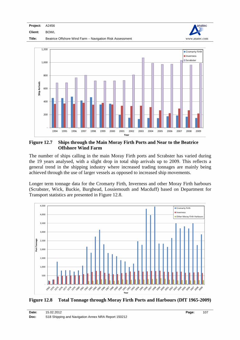
Project: A2456
Client: BOWL
Title: Beatrice Offshore Wind Farm – Navigation Risk Assessment www.anatec.com
Date: 15.02.2012 Page: 107 Doc: S18 Shipping and Navigation Annex NRA Report 150212
‐
200
400
600
800
1,000
1,200
1994 1995 1996 1997 1998 1999 2000 2001 2002 2003 2004 2005 2006 2007 2008 2009
Ship Arrivals
Year
Cromarty Firth
Inverness
Scrabster
Figure 12.7 Ships through the Main Moray Firth Ports and Near to the Beatrice Offshore Wind Farm
The number of ships calling in the main Moray Firth ports and Scrabster has varied during the 19 years analysed, with a slight drop in total ship arrivals up to 2009. This reflects a general trend in the shipping industry where increased trading tonnages are mainly being achieved through the use of larger vessels as opposed to increased ship movements. Longer term tonnage data for the Cromarty Firth, Inverness and other Moray Firth harbours (Scrabster, Wick, Buckie, Burghead, Lossiemouth and Macduff) based on Department for Transport statistics are presented in Figure 12.8.
‐
500
1,000
1,500
2,000
2,500
3,000
3,500
4,000
4,500
Port Tonnage
Year
Cromarty Firth
Inverness
Other Moray Firth Harbours
Figure 12.8 Total Tonnage through Moray Firth Ports and Harbours (DfT 1965-2009)

Project: A2456
Client: BOWL
Title: Beatrice Offshore Wind Farm – Navigation Risk Assessment www.anatec.com
Date: 15.02.2012 Page: 108 Doc: S18 Shipping and Navigation Annex NRA Report 150212
Between 1965 and 2009, total tonnage taken by the Moray Firth Ports increased ten-fold. However, in the last 20 years between 1990 and 2009, the overall increase has only been 35%. The key NW-SE Pentland Firth route passing to the north east of the proposed wind farm is used by a number of ship types including merchant, fishing and oil/gas vessels. A range of factors are likely to influence vessel activity in the area including the global economy/trade of goods, oil prices and national/regional offshore developments (i.e. oil & gas and renewable energy projects). Therefore in the long-term, shipping in the area is expected to increase but the timescale for this is uncertain. It has been conservatively assumed that over the life of the wind farm development, there will be a 10% increase in shipping movements.
12.5.2 Fishing The Commercial Fisheries Assessment (Ref. x) considered the potential changes to the fishing baseline over the life of the development. It is recognised this is a speculative exercise due to numerous unpredictable, direct and indirect factors which can materially affect fisheries. It stated that, at present, scallop fisheries are foreseen in the area surrounding Beatrice Offshore Wind Farm and in all probability there is unlikely to be an increase in either fishing effort or vessel numbers. It is also possible that increasing conservation concerns will lead to the implementation of designated protected marine conservation areas which will conceivably have the effect of enforcing further restrictions upon certain commercial fishing activities. There exists the possibility that fishing practices within the wind farm area could change during its operational life. An example is the appearance of large shoals of squid inshore during the summer in the Moray Firth, providing a valuable fishery which previously did not exist. Based on the above information, the future level of activity has been assumed to increase by 10% compared to current levels.
12.5.3 Recreational In terms of recreational vessel activity, there are no major developments known of that will increase the activity of these vessels in the area (Buckie Marina plans have not been confirmed). There are a range of modern facilities located at Inverness which is popular for vessels passing through the Caledonian Canal. Based on the discussion presented, the future level of activity has been assumed to increase by 10% compared to the current, low levels.
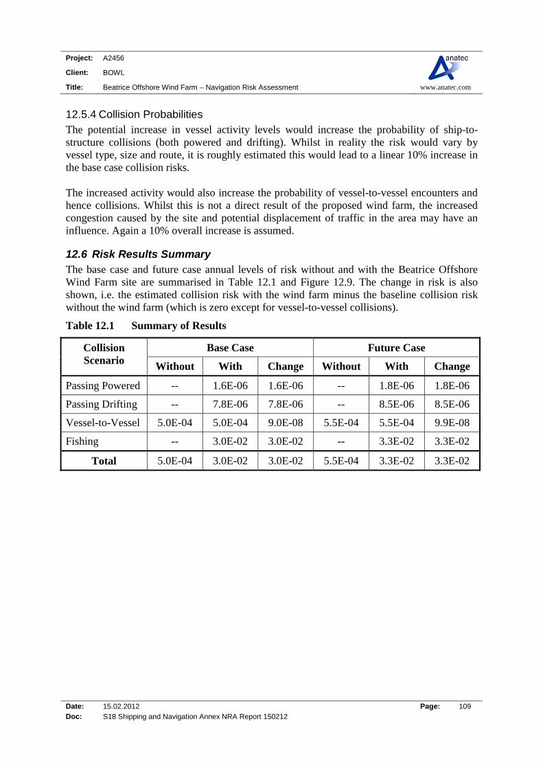
Project: A2456
Client: BOWL
Title: Beatrice Offshore Wind Farm – Navigation Risk Assessment www.anatec.com
Date: 15.02.2012 Page: 109 Doc: S18 Shipping and Navigation Annex NRA Report 150212
12.5.4 Collision Probabilities The potential increase in vessel activity levels would increase the probability of ship-to-structure collisions (both powered and drifting). Whilst in reality the risk would vary by vessel type, size and route, it is roughly estimated this would lead to a linear 10% increase in the base case collision risks. The increased activity would also increase the probability of vessel-to-vessel encounters and hence collisions. Whilst this is not a direct result of the proposed wind farm, the increased congestion caused by the site and potential displacement of traffic in the area may have an influence. Again a 10% overall increase is assumed.
12.6 Risk Results Summary The base case and future case annual levels of risk without and with the Beatrice Offshore Wind Farm site are summarised in Table 12.1 and Figure 12.9. The change in risk is also shown, i.e. the estimated collision risk with the wind farm minus the baseline collision risk without the wind farm (which is zero except for vessel-to-vessel collisions).
Table 12.1 Summary of Results
Collision Scenario
Base Case Future Case
Without With Change Without With Change
Passing Powered -- 1.6E-06 1.6E-06 -- 1.8E-06 1.8E-06
Passing Drifting -- 7.8E-06 7.8E-06 -- 8.5E-06 8.5E-06
Vessel-to-Vessel 5.0E-04 5.0E-04 9.0E-08 5.5E-04 5.5E-04 9.9E-08
Fishing -- 3.0E-02 3.0E-02 -- 3.3E-02 3.3E-02
Total 5.0E-04 3.0E-02 3.0E-02 5.5E-04 3.3E-02 3.3E-02

Project: A2456
Client: BOWL
Title: Beatrice Offshore Wind Farm – Navigation Risk Assessment www.anatec.com
Date: 15.02.2012 Page: 110 Doc: S18 Shipping and Navigation Annex NRA Report 150212
0.0E+00
5.0E-03
1.0E-02
1.5E-02
2.0E-02
2.5E-02
3.0E-02
3.5E-02
4.0E-02
Base Case Future Case
An
nu
al C
olli
sio
n R
isk
Case
Without Beatrice Offshore Wind Farm With Beatrice Offshore Wind Farm
Figure 12.9 Summary of Results
The overall annual level of collision risk is estimated to increase due to the proposed development by approximately 1 in 33 years (base case) and 1 in 30 years (future case). The vast majority of this risk is from fishing vessel collisions with the turbines.
12.7 Consequences The probable outcomes for the majority of hazards are expected to be minor. However, the worst case outcomes could be severe, including events with potentially multiple fatalities. A collision involving a larger ship is likely to result in collapse of a turbine with limited damage to the ship. Breach of a ship’s fuel tank is considered unlikely and in the case of vessels carrying hazardous cargoes, e.g. tanker or gas carrier, the additional safety features associated with these vessels would further mitigate the risk of pollution. Similarly, in a drifting collision, the proposed Beatrice Offshore Wind Farm structures are likely to absorb the majority of the impact energy, with some energy also being retained by the vessel in terms of rotational movement (glancing blow). In terms of smaller vessels, such as fishing and recreational craft, the worst case scenario would be risk of vessel damage leading to foundering of the vessel and potential loss of life. A quantitative assessment of the potential consequences of collision due to the proposed Beatrice Offshore Wind Farm project is presented in Appendix B. This applies the site-specific collision frequency results presented above with estimated outcomes in terms of fatalities on-board and oil pollution from the vessel based on research into historical collision incidents (MAIB, ITOPF, etc.).
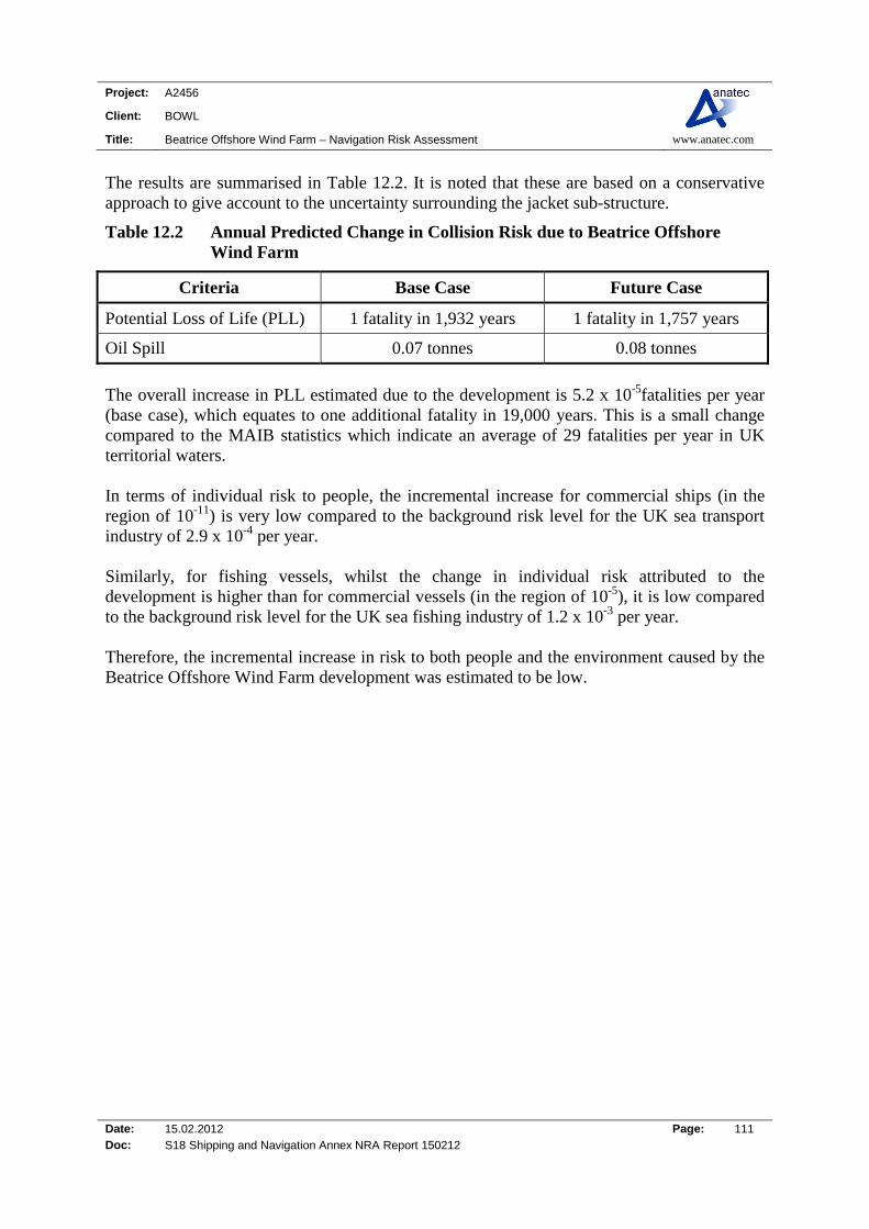
Project: A2456
Client: BOWL
Title: Beatrice Offshore Wind Farm – Navigation Risk Assessment www.anatec.com
Date: 15.02.2012 Page: 111 Doc: S18 Shipping and Navigation Annex NRA Report 150212
The results are summarised in Table 12.2. It is noted that these are based on a conservative approach to give account to the uncertainty surrounding the jacket sub-structure.
Table 12.2 Annual Predicted Change in Collision Risk due to Beatrice Offshore Wind Farm
Criteria Base Case Future Case
Potential Loss of Life (PLL) 1 fatality in 1,932 years 1 fatality in 1,757 years
Oil Spill 0.07 tonnes 0.08 tonnes
The overall increase in PLL estimated due to the development is 5.2 x 10⁻⁵fatalities per year (base case), which equates to one additional fatality in 19,000 years. This is a small change compared to the MAIB statistics which indicate an average of 29 fatalities per year in UK territorial waters. In terms of individual risk to people, the incremental increase for commercial ships (in the region of 10-11) is very low compared to the background risk level for the UK sea transport industry of 2.9 x 10⁻⁴ per year. Similarly, for fishing vessels, whilst the change in individual risk attributed to the development is higher than for commercial vessels (in the region of 10-5), it is low compared to the background risk level for the UK sea fishing industry of 1.2 x 10⁻³ per year. Therefore, the incremental increase in risk to both people and the environment caused by the Beatrice Offshore Wind Farm development was estimated to be low.

Project: A2456
Client: BOWL
Title: Beatrice Offshore Wind Farm – Navigation Risk Assessment www.anatec.com
Date: 15.02.2012 Page: 112 Doc: S18 Shipping and Navigation Annex NRA Report 150212
13. CONSTRUCTION AND DECOMMISIONING IMPACTS
13.1 Introduction This study has primarily focused on the operational and maintenance phase of the Beatrice Offshore Wind Farm, however, it is recognised that there will be additional potential impacts during the construction and decommissioning phases of the project.
13.2 Hazards during Construction/Decommissioning During the construction/decommissioning phase there will be an increased level of vessel activity within the Beatrice Offshore Wind Farm site and along the cable route. The presence of construction vessels within the area is likely to pose an additional navigational risk, although such vessels can also provide on-site response and mitigation. The main hazards associated with construction/decommissioning which have been identified over and above those associated with all phases (i.e. where the same risk control measures and emergency response will apply during all phases) are listed below.
Construction vessel collision with another vessel on-site; Construction vessel collision with structure; Construction vessel collision with passing vessel en route to or from site; Construction vessel encounters (jack-ups or anchors on) underwater obstruction (e.g.
cable, pipeline etc.); Construction vessel jacks-up or anchors onto unexploded ordnance; Man overboard during personnel transfer operations; and Dropped object during major lifting operations.
It is noted that, to a large extent, the hazards will depend on the vessels and procedures which are to be used for these operations. This will not be known in detail until the structures, construction methods and vessels/contractors have been selected. It is therefore planned that hazard/risk assessment workshops be carried out as part of the project-planning process. The objective of the workshops will be to identify all of the different activities which will be taking place and identify any potential hazards as well as appropriate mitigation measures and operating procedures relevant to the selected vessels and construction methods. An example measure might be that, wherever possible, construction vessels would follow prescribed transit corridors. These corridors would be defined in consultation with local maritime stakeholders, such as nearby oil and gas operators. The suggested compositions for the workshops are as follows: BOWL Project Team; Contractor Representatives (e.g. barges, cable-laying); Harbour Representatives;

Project: A2456
Client: BOWL
Title: Beatrice Offshore Wind Farm – Navigation Risk Assessment www.anatec.com
Date: 15.02.2012 Page: 113 Doc: S18 Shipping and Navigation Annex NRA Report 150212
HM Coastguard (MCA); Fishing Representative; Recreational Vessel Representative; and RNLI Representative. This process will build mutual understanding of the activities and operating constraints of the different parties involved and allow effective procedures to be developed. Separate workshops should be held for each phase of the project as well as for distinct activities. It is noted that the construction company appointed will have their own internal health and safety procedures that they will adhere to during the work, providing additional security. Experience and lessons learned from the construction of other offshore wind farm projects will be considered prior to the Beatrice Offshore Wind Farm being constructed. The same process will apply during the decommissioning phase of the project
13.3 Risk Control/Mitigation during Construction/Decommissioning Details of risk control/mitigation measures which will apply during these phases of the work are summarised in Section 19.

Project: A2456
Client: BOWL
Title: Beatrice Offshore Wind Farm – Navigation Risk Assessment www.anatec.com
Date: 15.02.2012 Page: 114 Doc: S18 Shipping and Navigation Annex NRA Report 150212
14. IMPACT ON MARINE RADAR SYSTEMS
14.1 Introduction The MCA conducted trials at the North Hoyle wind farm off North Wales to determine any impact of wind turbines on marine communications and navigations systems (Ref. iii). The trials indicated that there is minimal impact on VHF radio, Global Positioning Systems (GPS) receivers, cellular telephones and AIS. UHF and other microwave systems suffered from the normal masking effect when turbines were in the line of the transmissions. This trial identified areas of concern with regard to the potential impact on ship borne and shore based radar systems. This is due to the large vertical extent of the wind turbine generators returning radar responses strong enough to produce interfering side lobe, multiple and reflected echoes (ghosts). This has also been raised as a major concern by the maritime industry with further evidence of the problems being identified by the Port of London Authority around the Kentish Flats offshore wind farm in the Thames Estuary. Based on the results of the North Hoyle trial, the MCA produced a wind farm/shipping route template (see Section 2.2) to give guidance on the distances which should be established between shipping routes and offshore wind farms. A second trial was conducted at Kentish Flats by Marico Marine on behalf of British Wind Energy Association (BWEA) (Ref. iv). The project steering group had members from BERR, the MCA and the Port of London Authority (PLA). The trial took place between 30 April and 27 June 2006. This trial was conducted in Pilotage waters and in an area covered by the PLA VTS. It therefore had the benefit of Pilot advice and experience but was also able to assess the impact of the generated effects on VTS radars. The trial concluded that:
The phenomena referred to above detected on marine radar displays in the vicinity of wind farms can be produced by other strong echoes close to the observing ship although not necessarily to the same extent.
Reflections and distortions by ships structures and fittings created many of the effects and that the effects vary from ship to ship and radar to radar.
VTS scanners static radars can be subject to similar phenomena as above if passing vessels provide a suitable reflecting surface but the effect did not seem to present a significant problem for the PLA VTS.
Small vessels operating in or near the wind farm were detectable by radar on ships operating near the array but were less detectable when the ship was operating within the array.

Project: A2456
Client: BOWL
Title: Beatrice Offshore Wind Farm – Navigation Risk Assessment www.anatec.com
Date: 15.02.2012 Page: 115 Doc: S18 Shipping and Navigation Annex NRA Report 150212
14.2 Beatrice Demonstrator Turbine Project Radar Impacts Study As well as the documented radar trials carried out at North Hoyle and Kentish Flats, a study was carried out on the impacts of the two 5MW Demonstrator turbines located in the Moray Firth east of the Beatrice Oil Field (Ref. xiii). The main findings of this study are summarised below:
Regarding the Beatrice platform radar - any fluctuations of the wind turbine plots, (caused by the motion of the wind turbines) could lead to occasional false alarms in the collision avoidance systems.
Ship based radar plots showed that the proposed turbines do not make a significant detrimental impact on the overall radar picture. The returns from the turbines are large enough to cause plots on a radars display (which can be used for navigation in the normal way).
Obstruction issues - in the case of Beatrice, the turbine platform is based on a jacket structure, which allows the radar energy through the base of the turbine. In addition, the phenomenon of diffraction means that any shadow cast behind a turbine quickly fills back in.
Furthermore, AIS is unlikely to be affected and the study indicated that shadowing by the turbines will not cause any loss of AIS transponder signals.
Final conclusions were that there were no radar effect caused by the turbines that are not already caused by other large structures such as the oil platforms and large ships.
14.3 Impact on Collision Risk The potential radar interference is mainly a problem during periods of bad visibility when mariners may not be able to visually confirm the presence of other vessels in the vicinity (i.e. those without AIS installed which are usually fishing and recreational craft). However, given recreational vessel activity is influenced by weather conditions, most yachts are likely to take more sheltered coastal routes; therefore fishing vessels are thought to be the most likely to be impacted by possible radar interference. Based on the trials carried out to date, the onset range from the turbines of false returns is about 1.5nm, with progressive deterioration in the radar display as the range closes. Figure 14.1 presents the combined 125 days of survey tracks relative to the Beatrice turbine locations, based on the 277 turbine layout (3.6MW). 500m, 1.5nm and 2nm buffers have been applied around each turbine location to illustrate current passing distances.
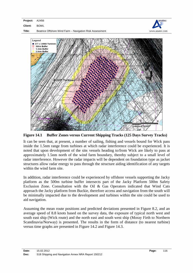
Project: A2456
Client: BOWL
Title: Beatrice Offshore Wind Farm – Navigation Risk Assessment www.anatec.com
Date: 15.02.2012 Page: 116 Doc: S18 Shipping and Navigation Annex NRA Report 150212
Figure 14.1 Buffer Zones versus Current Shipping Tracks (125 Days Survey Tracks)
It can be seen that, at present, a number of sailing, fishing and vessels bound for Wick pass inside the 1.5nm range from turbines at which radar interference could be experienced. It is noted that upon development of the site, vessels heading to/from Wick are likely to pass at approximately 1.5nm north of the wind farm boundary, thereby subject to a small level of radar interference. However the radar impacts will be dependent on foundation type as jacket structures allow radar energy to pass through the structure aiding identification of any targets within the wind farm site. In addition, radar interference could be experienced by offshore vessels supporting the Jacky platform as the 500m turbine buffer intersects part of the Jacky Platform 500m Safety Exclusion Zone. Consultation with the Oil & Gas Operators indicated that Wind Cats approach the Jacky platform from Buckie, therefore access and navigation from the south will be minimally impacted due to the development and turbines within the site could be used to aid navigation. Assuming the mean route positions and predicted deviations presented in Figure 8.2, and an average speed of 8.8 knots based on the survey data, the exposure of typical north west and south east ship (Wick route) and the north east and south west ship (Moray Firth to Northern Scandinavia/Norway) is presented. The results in the form of distance (to nearest turbine) versus time graphs are presented in Figure 14.2 and Figure 14.3.
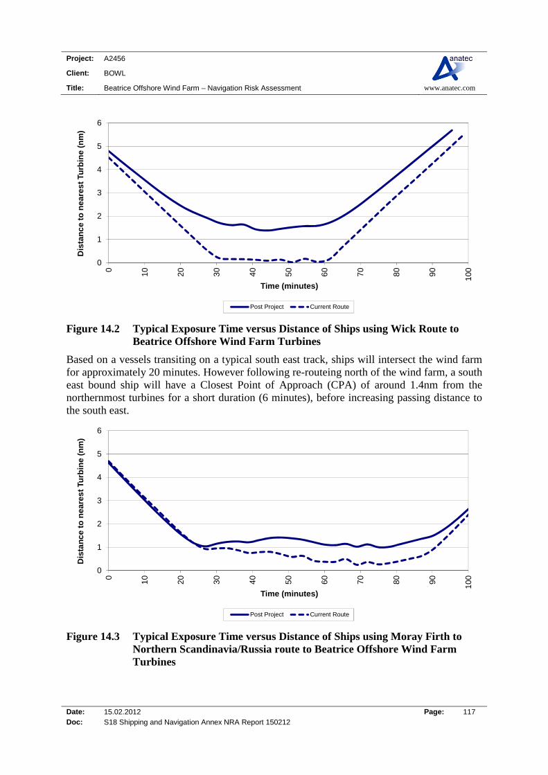
Project: A2456
Client: BOWL
Title: Beatrice Offshore Wind Farm – Navigation Risk Assessment www.anatec.com
Date: 15.02.2012 Page: 117 Doc: S18 Shipping and Navigation Annex NRA Report 150212
0
1
2
3
4
5
6
0 10 20 30 40 50 60 70 80 90 100
Dis
tan
ce
to n
ea
res
t Tu
rbin
e (
nm
)
Time (minutes)
Post Project Current Route
Figure 14.2 Typical Exposure Time versus Distance of Ships using Wick Route to Beatrice Offshore Wind Farm Turbines
Based on a vessels transiting on a typical south east track, ships will intersect the wind farm for approximately 20 minutes. However following re-routeing north of the wind farm, a south east bound ship will have a Closest Point of Approach (CPA) of around 1.4nm from the northernmost turbines for a short duration (6 minutes), before increasing passing distance to the south east.
0
1
2
3
4
5
6
0 10 20 30 40 50 60 70 80 90 100
Dis
tan
ce t
o n
eare
st
Turb
ine
(nm
)
Time (minutes)
Post Project Current Route
Figure 14.3 Typical Exposure Time versus Distance of Ships using Moray Firth to Northern Scandinavia/Russia route to Beatrice Offshore Wind Farm Turbines

Project: A2456
Client: BOWL
Title: Beatrice Offshore Wind Farm – Navigation Risk Assessment www.anatec.com
Date: 15.02.2012 Page: 118 Doc: S18 Shipping and Navigation Annex NRA Report 150212
Based on vessels current transit and mean speed (10 knots), the typical north east bound vessel will be within 1nm of the turbines on the eastern boundary of the wind farm for a total duration of approximately 60 minutes and have a minimum CPA from the turbines of 0.3nm. The typical north east bound ship will have a minimum CPA of 1nm from the turbines on the eastern boundary of the wind farm following construction. Experienced mariners should be able to suppress the observed problems to an extent and for short periods (a few sweeps) by careful adjustment of the receiver amplification (gain), sea clutter and range settings of the radar. However, there is a consequent risk of losing targets with a small radar cross section, which may include buoys or small craft, particularly yachts or Glass Reinforced Plastic (GRP) constructed craft, therefore due care is needed in making such adjustments. The Kentish Flats study observed that the use of an easily identifiable reference target (a small buoy) can help the operator select the optimum radar settings. The performance of a vessel’s automatic radar plotting aid (ARPA) could also be affected when tracking targets in or near the wind farm. However, although greater vigilance is required, it appears that during the Kentish Flats trials, false targets were quickly identified as such by the mariners and then the equipment itself. This was also observed during work carried out for the Beatrice Demonstration turbines whereby the structures were plotted and could be used as an aid to navigation. The evidence from mariners operating in the vicinity of existing wind farms is that they quickly learn to work with and around the effects. The MCA have produced guidance to mariners operating in the vicinity of UK OREIs which highlights radar issue amongst others to be taken into account when planning and undertaking voyages in the vicinity of offshore renewable energy installations (OREIs) off the UK coast (Ref. xiv). AIS information can also be used to verify the targets of larger vessels, generally ships above 300 tonnes, however small fishing and recreational craft are increasingly utilising the cheaper Class B AIS units. Indeed, Directive 2009/17/EC of the European Parliament and of the council of April 23 2009 amended Directive 2002/59/EC. One of the main amendments made related to the use of AIS on fishing vessels, which is addressed through the insertion of Article 6a (see below).

Project: A2456
Client: BOWL
Title: Beatrice Offshore Wind Farm – Navigation Risk Assessment www.anatec.com
Date: 15.02.2012 Page: 119 Doc: S18 Shipping and Navigation Annex NRA Report 150212
Use of automatic identification systems (AIS) by fishing vessels. Any fishing vessel with an overall length of more than 15 metres and flying the flag of a Member State and registered in the Community, or operating in the internal waters or territorial sea of a Member State, or landing its catch in the port of a Member State shall, in accordance with the timetable set out in Annex II, part I (3), be fitted with an AIS (Class A) which meets the performance standards drawn up by the IMO. Fishing vessels equipped with AIS shall maintain it in operation at all times. In exceptional circumstances, AIS may be switched off where the master considers this necessary in the interest of the safety or security of his vessel.
The timetable set out in Annex II, part 1(3) is as follows:
Fishing vessels with a length of more than 15 metres overall are subject to the carrying requirement laid down in Article 6a according to the following timetable:
fishing vessels of overall length 24 metres and upwards but less than 45 metres: not later than 31 May 2012,
fishing vessels of overall length 18 metres and upwards but less
than 24 metres: not later than 31 May 2013,
fishing vessels of overall length exceeding 15 metres but less than 18 metres: not later than 31 May 2014.
New built fishing vessels of overall length exceeding 15 metres are subject to the carrying requirement laid down in Article 6a as from 30 November 2010.’
Beyond this it is noted from a number of surveys Anatec has been carrying out on the United Kingdom Continental Shelf (UKCS) that the number of fishing vessels using AIS has increased significantly over the last two years.

Project: A2456
Client: BOWL
Title: Beatrice Offshore Wind Farm – Navigation Risk Assessment www.anatec.com
Date: 15.02.2012 Page: 120 Doc: S18 Shipping and Navigation Annex NRA Report 150212
15. CUMULATIVE AND IN-COMBINATION EFFECTS
15.1 Introduction Cumulative impacts with maritime activities (shipping, fishing, recreation and associated facilities) are assessed in the main part of this report. The following sections present details on possible cumulative effects with the Moray Forth Round 3 Zone and other offshore projects. In-combination effects with other future developments in the area are assessed, including offshore developments relative to the Beatrice Offshore Wind Farm.
15.2 Developments Considered in the Cumulative and In-Combination Assessment
The following list presents the developments which were considered for the cumulative and in-combination assessment based on the Moray Firth Offshore Wind Developers Group (MFOWDG), Cumulative Impact Assessment Discussion Document (CIADD):
Moray Firth Round 3 Zone (western and eastern development areas); Other Offshore Wind Farms and Infrastructure:
o Aberdeen European Offshore Wind Deployment Centre (EOWDC); o Neart na Gaoithe; o Inch Cape; o Firth of Forth Round 3 sites; o Methil Offshore Windfarm; and
Subsea Cables: o MORL Offshore Export Cable and onshore infrastructure; o BOWL Offshore Export Cable and onshore infrastructure; o Proposed Viking SHETL cable and onshore infrastructure; and
Proposed SHETL hub; Pentland Firth and Orkney Marine Energy developments; Shipping and Navigation; Military and Aviation activities; Dredging and sea disposal in the Moray Firth; Oil and Gas Developments:
o Beatrice and Jacky platforms and associated infrastructure; and o The proposed Polly Well.
Consultation also identified that Ithaca Energy is looking at the possibility of bringing in Liquid Nitrogen Gas (LNG) regasification vessels to do transfer operations at the Nigg Terminal. In addition, there is also a potential future option of tankers offloading in the area.

Project: A2456
Client: BOWL
Title: Beatrice Offshore Wind Farm – Navigation Risk Assessment www.anatec.com
Date: 15.02.2012 Page: 121 Doc: S18 Shipping and Navigation Annex NRA Report 150212
15.3 Predicted Impacts A high level review of the offshore developments was undertaken to screen out those that would not result in a cumulative impact. Details of the developments that were screened out are provided below:
The offshore wind farms in the outer and Firth of Forth and Tay (Neart na Gaoithe, Inch Cape, Firth of Forth Round 3 sites and Methil) and the turbines planned at the Aberdeen EOWDC are of a scale and at a sufficient distance that there will not be a cumulative impact on shipping and navigation;
The Pentland Firth and Orkney Marine Energy developments have been screened out, given that the majority of construction and operation/maintenance vessels will be routeing from local support bases (e.g. Scrabster, Stromness, Kirkwall and Lybster) and as a result vessels will not navigate in the vicinity of the Wind Farm;
A small number of military vessel tracks were recorded during the maritime surveys within 10 nm of the Wind Farm. The large majority of vessels were recorded on the Pentland Firth route, therefore the cumulative impacts on marine based military activities are not considered to be significant; and
Currently there are no licensed aggregate dredging areas in the Moray Firth. However, there are a small number of charted dredge sea disposal (spoil grounds) located within close proximity to the Caithness coast (approximately 4 nm). There is available sea room in the Moray Firth for transiting dredge and/or sea disposal vessels. In addition, given the size of ships working from local ports and small harbours, vessels are likely to use more sheltered coastal routes. Therefore the cumulative impact will not be significant.
Given the relatively low commercial shipping density in the Moray Firth and the availability of sea room east and west of the Beatrice Offshore Wind Farm (i.e. for LNG tankers headed into the Moray Firth) it is considered that any future in-combination impact of Beatrice Offshore Wind Farm will be negligible.
The potential shipping and navigation impacts for the remainder of offshore developments were considered further giving account to:
Changes to commercial, fishing and recreational vessel routeing; and Increase in collision risk (vessel-to-structure or vessel-to-vessel).
Table 15.1 presents the cumulative and in-combination effects identified during the NRA.
Table 15.1 Cumulative and In-Combination Developments Considered
Cumulative and In-combination development considerations Scoped Out
Cumulative Impact Moray Firth Round 3 Zone and associated wind farms/export cables
No
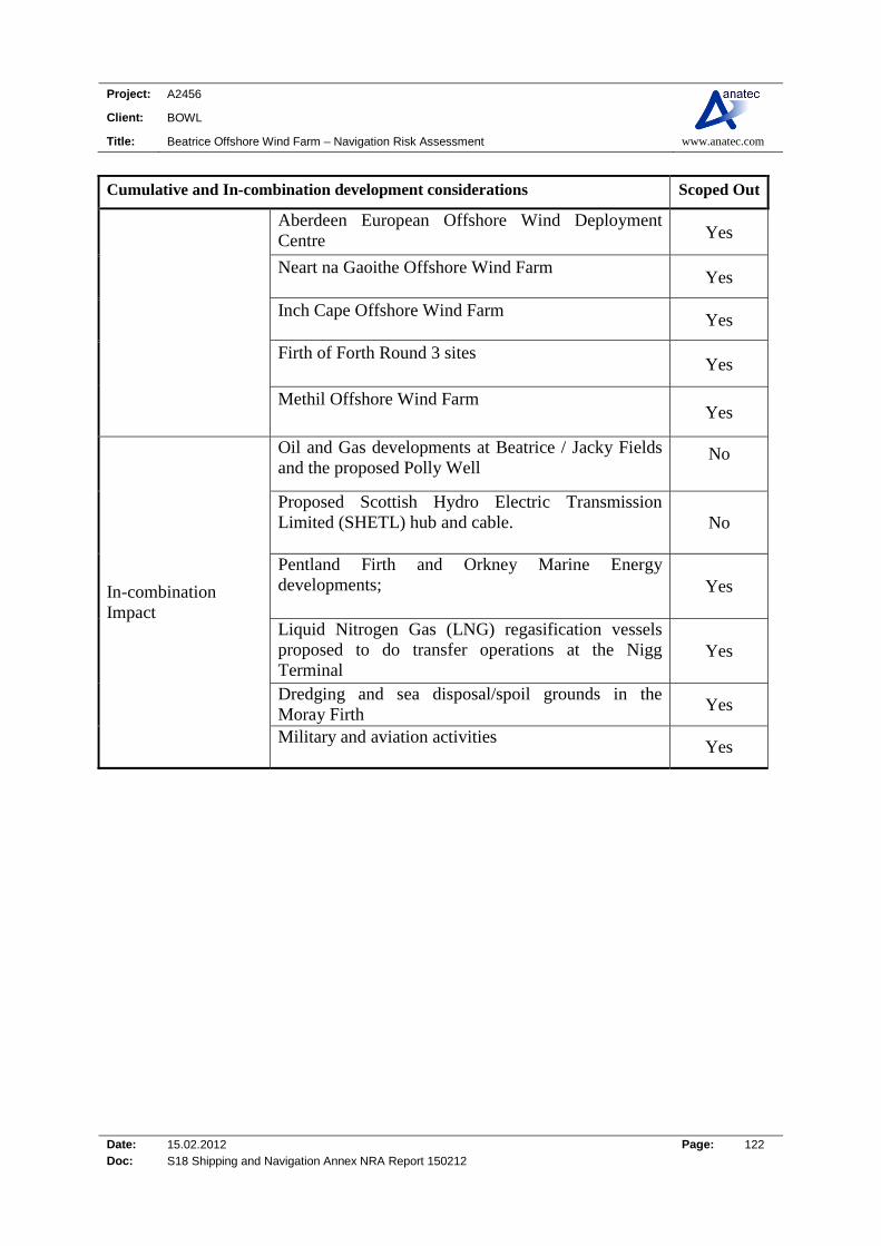
Project: A2456
Client: BOWL
Title: Beatrice Offshore Wind Farm – Navigation Risk Assessment www.anatec.com
Date: 15.02.2012 Page: 122 Doc: S18 Shipping and Navigation Annex NRA Report 150212
Cumulative and In-combination development considerations Scoped Out
Aberdeen European Offshore Wind Deployment Centre Yes
Neart na Gaoithe Offshore Wind Farm Yes
Inch Cape Offshore Wind Farm Yes
Firth of Forth Round 3 sites Yes
Methil Offshore Wind Farm Yes
In-combination Impact
Oil and Gas developments at Beatrice / Jacky Fields and the proposed Polly Well
No
Proposed Scottish Hydro Electric Transmission Limited (SHETL) hub and cable. No
Pentland Firth and Orkney Marine Energy developments;
Yes
Liquid Nitrogen Gas (LNG) regasification vessels proposed to do transfer operations at the Nigg Terminal
Yes
Dredging and sea disposal/spoil grounds in the Moray Firth Yes
Military and aviation activities
Yes
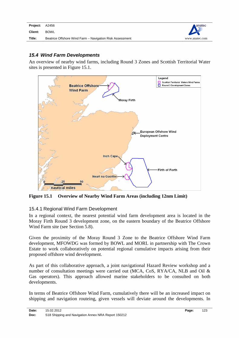
Project: A2456
Client: BOWL
Title: Beatrice Offshore Wind Farm – Navigation Risk Assessment www.anatec.com
Date: 15.02.2012 Page: 123 Doc: S18 Shipping and Navigation Annex NRA Report 150212
15.4 Wind Farm Developments An overview of nearby wind farms, including Round 3 Zones and Scottish Territorial Water sites is presented in Figure 15.1.
Figure 15.1 Overview of Nearby Wind Farm Areas (including 12nm Limit)
15.4.1 Regional Wind Farm Development In a regional context, the nearest potential wind farm development area is located in the Moray Firth Round 3 development zone, on the eastern boundary of the Beatrice Offshore Wind Farm site (see Section 5.8). Given the proximity of the Moray Round 3 Zone to the Beatrice Offshore Wind Farm development, MFOWDG was formed by BOWL and MORL in partnership with The Crown Estate to work collaboratively on potential regional cumulative impacts arising from their proposed offshore wind development. As part of this collaborative approach, a joint navigational Hazard Review workshop and a number of consultation meetings were carried out (MCA, CoS, RYA/CA, NLB and Oil & Gas operators). This approach allowed marine stakeholders to be consulted on both developments. In terms of Beatrice Offshore Wind Farm, cumulatively there will be an increased impact on shipping and navigation routeing, given vessels will deviate around the developments. In
Project: A2456
Client: BOWL
Title: Beatrice Offshore Wind Farm – Navigation Risk Assessment www.anatec.com
Date: 15.02.2012 Page: 124 Doc: S18 Shipping and Navigation Annex NRA Report 150212
addition, there will be a potential increase in the collision risk, where vessels deviate around the wind farm sites into busier shipping channels, (i.e. the Pentland Firth route). However, given the low density of shipping passing through the area and the available sea room out-with major shipping routes (i.e. Pentland Firth route); the cumulative impact is considered to be minor. In terms of the export cable works from the Moray Firth Round 3 Zone wind farms, it is considered that there will not be a significant cumulative impact on shipping and navigation given the expected cable corridors are likely to run well clear of the Beatrice Offshore Wind Farm and associated export cables.
15.5 Oil and Gas Developments Consultation with Oil and Gas Operators identified the potential decommissioning of Jacky to be a possible issue, however this is largely dependent on other offshore developments in the area, as there are possible tie-ins planned with the Polly development (2nm south east of the Beatrice Field). A possible in-combination impact will be on access to the platforms in the Jacky and Beatrice Fields and the proposed Polly development (i.e. future drilling and decommissioning of installations). However as the vessels and rigs tend to route to these locations from the south and south east, they are well clear of the Beatrice Offshore Wind Farm. Overall, the in-combination impact is considered to be minor.
15.6 Other Developments SHETL has made proposals for an offshore High Voltage Direct Current (HVDC) cable and hub, which is planned approximately 4.5nm to the east of the Beatrice Offshore Wind Farm. As commercial shipping density is relatively low within the Beatrice Offshore Wind Farm area it is considered that any in-combination impact of the SHETL cable and hub will be minor.
Project: A2456
Client: BOWL
Title: Beatrice Offshore Wind Farm – Navigation Risk Assessment www.anatec.com
Date: 15.02.2012 Page: 125 Doc: S18 Shipping and Navigation Annex NRA Report 150212
16. Safety Zones
16.1 Guidance on Applications for Safety Zones Guidance for safety zone applications can be found in the DECC guidance notes (authored whilst under the name of BERR [Department for Business, Enterprise and Regulatory Reform]) (Ref. xv). The safety zone scheme, as set out in the Energy Act 2004 applies to territorial waters in or adjacent to England, Scotland and Wales. A safety zone can be established either by the successful application by an applicant or, if no such application is made and the view of the Secretary of State for DECC, following consultation with the MCA Navigation Safety Branch, is that a safety zone is necessary, by the Secretary of State. Where a consent for an OREI is required from the Secretary of State under Section 36 of the Electricity Act 1989 (for generating stations above 1MW in internal and territorial waters and above 50MW in the UK Renewable Energy Zone (REZ)) the Secretary of State must consider whether a safety zone will be needed at the same time that consideration is given to the consent for the OREI development. The safety zone application process is summarised below:
The applicant makes an application to the Secretary of State and serves notice of application on the MCA and, as appropriate, the Scottish Government or National Assembly for Wales, providing information as necessary to support the case for the safety zone;
In parallel the applicant publicises the fact that an application is being made to give an opportunity to anyone who wishes to comment on the application to make their views known to the Secretary of State; and
The Secretary of State then takes a decision on the application, taking into account any comments they have received and all other material considerations.
16.2 Construction/Decommissioning & Major Maintenance Phases The NRA assessment was primarily focused on the operational phase of the project. However, it is identified that during the construction/decommissioning phases of the development there will be large construction vessels, working personnel and support craft in operation within and around the wind farm and export cable. Further, heavy lifting, piling and cable laying operations will be carried out which have inherent dangers. In addition the cost of operating construction vessels, the cost of delay can be significant. A means of controlling 3rd party navigation during these periods of high activity is required. Without this, it will not be possible to exclude vessels and carry out their offshore operations in a controlled manner. Navigational risks are generally managed in line with similar offshore construction projects to ensure the safety of navigational stakeholder in the area. A detailed review of the requirement will be undertaken as part of the construction/decommissioning planning. It is expected that this could involve the use of 500m safety zones which will provide a means of

Project: A2456
Client: BOWL
Title: Beatrice Offshore Wind Farm – Navigation Risk Assessment www.anatec.com
Date: 15.02.2012 Page: 126 Doc: S18 Shipping and Navigation Annex NRA Report 150212
regulating the rights of navigation so as to preserve the safety of those working in the Wind Farm and those on-board other vessels that may be navigating in this area. The safety zones are likely to apply to all vessel types not involved in the wind farm operations. These would be applied for in line with DECC guidance (Ref. xv) and the required level of consultation would be held. Safety zones of 500m may be imposed around construction works, from which all vessels are excluded. The area of the site considered to be a construction zone may vary throughout the project if a phased construction approach is adopted, which is most likely situation. However, in the worst case there is the potential for an exclusion zone to be established that will exclude all traffic from the entire site during construction. In addition, during the construction and decommissioning phases, marine procedures will be implemented for radar and AIS monitoring of vessel activities within the working area, to detect safety zone infringements. Procedures will also be established to ensure that any infringements are formally reported in line with the regulatory requirements. Occasionally larger support vessels may be required for planned and unplanned maintenance activities. It is likely that several pre-determined areas would be identified and marked as temporary anchorage areas. In these cases semi-permanent structure markings would also comply with the NLB requirements and IALA O-0138 and 500m safety zones would apply.
16.3 Operational Phase During the operation of the Beatrice Offshore Wind Farm project there are plans to have 50m operational safety zones during the normal operational phase, unless experience during the construction phase presents evidence that such zones may not be required. In addition, large maintenance vessels could be present at the Wind Farm during the operational phase. The need for 500m safety zones will be assessed based on experience during construction. Safety zones will be based on the length of time and type of maintenance activities at the Wind Farm. It is noted that in terms of third-party vessels, it is considered highly unlikely that merchant ships would elect to pass between turbines due to the limited sea room and the fact that the closest routes tend to naturally avoid the location. Therefore, it is expected that fishing and recreational vessels are the main vessel types navigating within the site. It will be up to individual Masters, taking into account the prevailing weather and sea conditions, to decide whether it is safe to navigate, or fish, within the turbine array.
Project: A2456
Client: BOWL
Title: Beatrice Offshore Wind Farm – Navigation Risk Assessment www.anatec.com
Date: 15.02.2012 Page: 127 Doc: S18 Shipping and Navigation Annex NRA Report 150212
16.4 Summary The safety zones planned for the project are as follows:
Construction/Decommissioning:
o 500m rolling safety zone to prevent vessels not associated with the development work from interfering with the active construction site.
Operation:
o 50m safety zones to prevent vessels not associated with the wind farm site interfering with operations.
The existence of safety zone will be published electronically and via Notices to Mariners.

Project: A2456
Client: BOWL
Title: Beatrice Offshore Wind Farm – Navigation Risk Assessment www.anatec.com
Date: 15.02.2012 Page: 128 Doc: S18 Shipping and Navigation Annex NRA Report 150212
17. Search and Rescue (SAR)
17.1 Introduction This section summarises the existing Search & Rescue resources in the region and the issues being considered in relation to the design of the wind farm. (A detailed review of the historical incidents in the area, including RNLI launches, has been presented in Section 6.)
17.2 SAR Resources
17.2.1 SAR Helicopters A review of the assets in the area of Beatrice Offshore Wind Farm indicated that the closest SAR helicopter base is located at Lossiemouth, operated by the RAF, approximately 30nm to the SSW of the Beatrice Offshore Wind Farm, as shown in Figure 17.1. This base has Sea King helicopters with a maximum endurance of 6 hours and speed of 110mph giving a radius of action of approximately 250nm which is well within the range of the wind farm at the Beatrice site. One helicopter is available at 15 minutes readiness between 0800 and 2200 hours, with another available at 60 minutes readiness between 0800 hours and evening civil twilight (ECT). Between 2200 and 0800 hours, one helicopter is held at 45 minutes readiness. All RAF SAR helicopters are equipped for full day/night all weather operations over land and sea (some limitations exist with regard to freezing conditions, but in general terms the helicopters are all weather capable) and have a full night vision goggle (NVG) capability. Crews are well practised in NVG operations which is a major enhancement to search capability. In addition, all RAF SAR helicopter rear crew are medically trained, with the winchman trained up to paramedic standard. Up to 18 persons can be carried, however this is dependent on weather conditions and the distance of the incident from the helicopter’s operating base. All RAF SAR helicopters are equipped with VHF (Marine and Air Band), UHF and HF radios. They are also capable of homing to all international distress frequencies.

Project: A2456
Client: BOWL
Title: Beatrice Offshore Wind Farm – Navigation Risk Assessment www.anatec.com
Date: 15.02.2012 Page: 129 Doc: S18 Shipping and Navigation Annex NRA Report 150212
Figure 17.1 SAR Helicopter Bases relative to the Beatrice Offshore Wind Farm Site
Based on the above information, the day-time response to the wind farm will be just over 30 minutes. At night time, this will increase by 30 minutes to approximately 1 hour due to the additional response time at the base. It is noted that these calculations are based on still air and will vary depending on the prevailing conditions.
17.2.2 RNLI Lifeboats The Royal National Lifeboat Institution maintains a fleet of over 400 lifeboats of various types at 235 stations round the coast of the UK and Ireland. The RNLI stations in the vicinity of the proposed Beatrice Wind Farm site are presented in Figure 17.2.
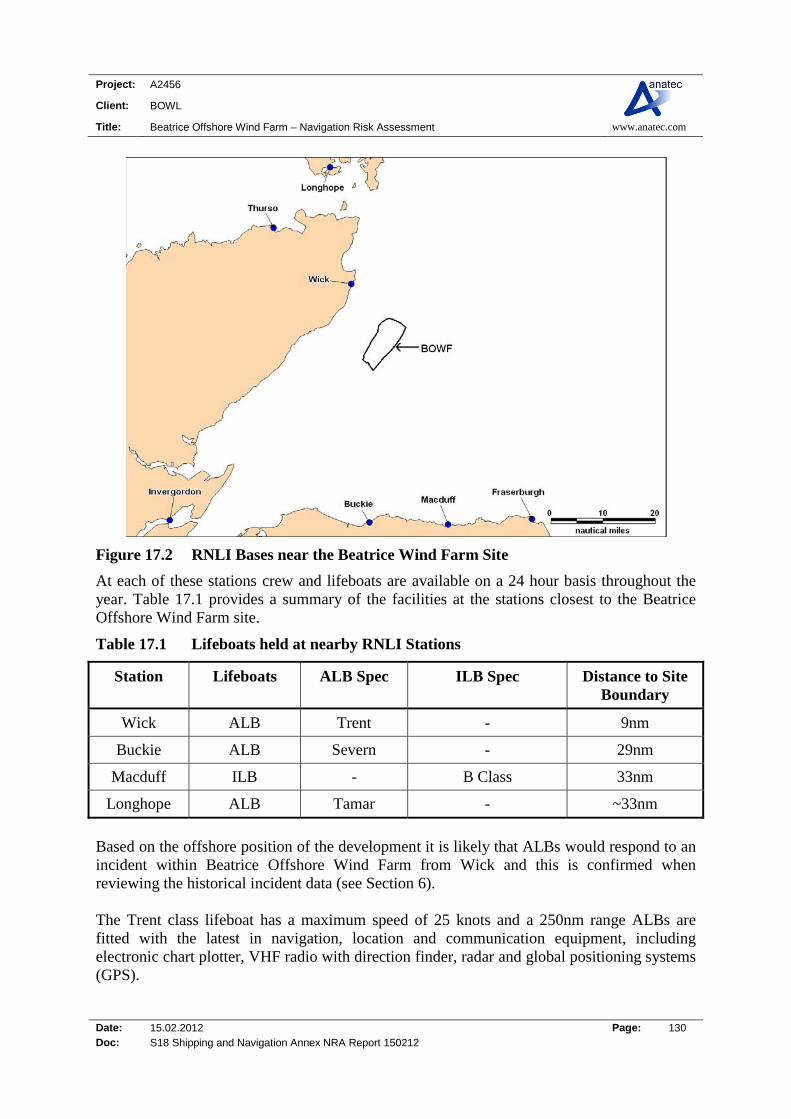
Project: A2456
Client: BOWL
Title: Beatrice Offshore Wind Farm – Navigation Risk Assessment www.anatec.com
Date: 15.02.2012 Page: 130 Doc: S18 Shipping and Navigation Annex NRA Report 150212
Figure 17.2 RNLI Bases near the Beatrice Wind Farm Site
At each of these stations crew and lifeboats are available on a 24 hour basis throughout the year. Table 17.1 provides a summary of the facilities at the stations closest to the Beatrice Offshore Wind Farm site.
Table 17.1 Lifeboats held at nearby RNLI Stations
Station Lifeboats ALB Spec ILB Spec Distance to Site Boundary
Wick ALB Trent - 9nm
Buckie ALB Severn - 29nm
Macduff ILB - B Class 33nm
Longhope ALB Tamar - ~33nm
Based on the offshore position of the development it is likely that ALBs would respond to an incident within Beatrice Offshore Wind Farm from Wick and this is confirmed when reviewing the historical incident data (see Section 6). The Trent class lifeboat has a maximum speed of 25 knots and a 250nm range ALBs are fitted with the latest in navigation, location and communication equipment, including electronic chart plotter, VHF radio with direction finder, radar and global positioning systems (GPS).
Project: A2456
Client: BOWL
Title: Beatrice Offshore Wind Farm – Navigation Risk Assessment www.anatec.com
Date: 15.02.2012 Page: 131 Doc: S18 Shipping and Navigation Annex NRA Report 150212
The Tamar and Severn class lifeboats are similar to the Trent class, but are 2m and 3m longer in length, respectively. They also have a maximum speed of 25 knots and a 250nm range. The B class lifeboat is small and highly manoeuvrable, making it ideal for rescues close to shore in fair to moderate conditions. It has a speed of 35 knots, range of 2.5 hours at maximum speed and is equipped with VHF radio and GPS. Response times vary but an average declared by RNLI is 14 minutes for ALBs and 7 minutes for inshore lifeboats. This is the time from callout, i.e. first contact from the Coastguard to the lifeboat station to launch. The time for an all-weather lifeboat to reach Beatrice Offshore Wind Farm (taking into account a 14 minute call out time) from the nearest station at Wick would be approximately 36 minutes.
17.2.3 Changes to Coastguard Stations MCA published a consultation document in December 2010 (Ref. xvi) in order to modernise HM Coastguard. The main part of the document proposes the reduction in the number of Maritime Rescue Co-ordination (MRCC) stations around the UK coastline. Revised plans were released by the UK Government, (Ref. xvii) mid-way through 2011 with a second consultation period from 14th July 2011 to 6th October 2011. Under the revised proposals the MCA intends to:
Establish a single 24 hour Maritime Operations Centre (MOC) based in the Southampton/Portsmouth area with 96 operational coastguards. The MOC will act as a national strategic centre to manage Coastguard operations across the entire UK network as well as co-ordinating incidents on a day to day basis. The MOC will also generate a maritime picture using information from a variety of sources;
Dover will be configured to act as a stand-by MOC for contingency purposes. Dover
would have 28 staff and would retain its responsibilities for the Channel Navigation Information Service (CNIS);
In addition to the MOC and Dover, there will be eight further put in centres, Maritime
Rescue Sub-Centres (MRCS), all of which would be connected to the national network and the MOC. All would be open 24 hours a day with a total staffing of 23 in each. These would be based at the following stations:
o MRSC Aberdeen o MRSC Shetland o MRSC Stornoway o MRSC Belfast o MRSC Holyhead o MRSC Milford Haven

Project: A2456
Client: BOWL
Title: Beatrice Offshore Wind Farm – Navigation Risk Assessment www.anatec.com
Date: 15.02.2012 Page: 132 Doc: S18 Shipping and Navigation Annex NRA Report 150212
o MRSC Falmouth o MRSC Humber
*NB: The station at London will be retained unchanged.
17.2.4 Effect of Changes to Coastguard Stations on Beatrice Offshore Wind Farm The proposed wind farm currently lies in the former Scotland and Northern Ireland region with the nearest Maritime Rescue Sub-Centres being (MRCS) Aberdeen. MRCS Aberdeen’s area of responsibility provides search and rescue coverage from Cape Wrath (most northerly tip of mainland UK) to the East coast of Scotland at Doonie Point (just south of Aberdeen). The proposed changes to the UK MRCS structure will result in the Aberdeen MRCS covering a much wider area of northern UK; however it will continue to respond to any incidents within the Moray Firth including the Beatrice Offshore Wind Farm area.
17.2.5 Salvage At the time of writing (October 2011) two Emergency Towing Vessels (ETVs) carry out MCA3 duties in the north of Scotland providing emergency towing cover for the Western Isle/north west Scotland and Shetland. The UK Government has provided an additional three month extended contract for the tugs and during this time longer-term arrangements will be made to fund the ETVs. In addition each Marine Rescue Co-ordination Centre (MRCC) also holds comprehensive databases of harbour tugs available locally. Procedures are also in place with Brokers and Lloyd’s Casualty Reporting Service to quickly obtain information on towing vessels that may be able to respond to an incident. Emergency tug provision will generally be a contracted agreement between the vessel owners and tug operators. Coastguard Agreement on Salvage and Towage (CAST) will be invoked when owners are either unable or unwilling to engage in a commercial tow contract. MCA will pursue costs through arbitrators on a cost recovery basis. JP Knight (Caledonian) operates four tugs that work out of Cromarty Firth (approximately 46nm south west of Beatrice Offshore Wind Farm), along with Offshore support vessels which may have with towing capabilities that pass or work in the area (i.e. Beatrice Oil Field). Lastly, tugs are available within Aberdeen Harbour through a licensed Tug Operator. An agreement exists which retains one tug permanently in Aberdeen, however in practice there are two tugs most of the time. The tugs Cultra and Carrickfergus have a bollard pull of 30 tonnes each. A third tug is available with notice.
3 It is noted that as part of the UK Government’s spending review in 2010 it was announced that ETV fleet would no longer be funded by the MCA after September 2011. An additional three months of funding was provided by the UK Government covering the two Scottish ETVs in September 2011. It is noted that over the next three months (from September 2011) options will be explored to ensure longer term funding for the vessels.

Project: A2456
Client: BOWL
Title: Beatrice Offshore Wind Farm – Navigation Risk Assessment www.anatec.com
Date: 15.02.2012 Page: 133 Doc: S18 Shipping and Navigation Annex NRA Report 150212
17.3 Wind Farm SAR Matters The wind farm will meet the MCA’s requirements in terms of standards and procedures for generator shutdown and other operational requirements in the event of a search and rescue, counter pollution or salvage incident in or around the site. These are laid out in Annex 5 of MGN 371 (Ref. ii). This includes the development of an Emergency Response Co-operation Plan (ERCoP) for the wind farm, which will be in place pre-construction. Examples of features to be incorporated are as follows: Design: All wind turbine generators (WTGs) and other OREI individual structures will each be
marked with clearly visible unique identification characters which can be seen by both vessels at sea level and aircraft (helicopters and fixed wing) from above.
The identification characters shall each be illuminated by a low-intensity light visible
from a vessel thus enabling the structure to be detected at a suitable distance to avoid a collision with it. The size of the identification characters in combination with the lighting will be such that, under normal conditions of visibility and all known tidal conditions, they are clearly readable by an observer, stationed 3 metres above sea levels, and at a distance of at least 150 metres from the turbine.
Operation: The Marine Control Centre, or mutually agreed single contact point, will be manned 24
hours a day. All MRCCs will be advised of the contact telephone number of the Central Control
Room, or single contact point (and vice versa) The control room operator, or single contact point, will immediately initiate the shut-
down procedure for WTGs as requested by the MRCC, and maintain the WTG in the appropriate shut-down position, as requested by the MRCC, until receiving notification from the MRCC that it is safe to restart the WTG.
17.4 SAR Routeing It is considered that SAR operations will not significantly impacted by the Wind Farm in terms of transit time, as an ALB or ILB will be able to navigate through a wind farm and associated safety zones (dependant on sea state and weather conditions). In addition, a lifeboat and SAR helicopter will be launched to respond to an incident (based on incident severity).

Project: A2456
Client: BOWL
Title: Beatrice Offshore Wind Farm – Navigation Risk Assessment www.anatec.com
Date: 15.02.2012 Page: 134 Doc: S18 Shipping and Navigation Annex NRA Report 150212
18. ADDITIONAL NAVIGATION ISSUES
18.1 Introduction There are a number of additional navigational issues identified within MGN 371 (Ref. ii) which require to be addressed by the developer. The following sub-sections cover additional navigation related issues which have not been covered elsewhere within this report.
18.2 Visual Navigation and Collision Avoidance
18.2.1 Introduction MGN 371 identifies the potential for visual navigation to be impaired by the location of offshore wind farm structures, based on vessels not being visible to each other (hidden behind structures) and navigational aids and/or landmarks not being visible to shipping.
18.2.2 Visual Impact (Other Vessels) Based on the position, orientation, number of turbines and spacing between turbines it is not considered there will be any significant issue of visual impact between vessels on the main commercial shipping routes in the area, i.e. the Pentland Firth route which passes at a mean distance of 4-5nm to the north east. During the shipping surveys, recreational activity was recorded during the summer survey (2010), with fishing identified all year round in the general area. However, given the low commercial vessel activity in the immediate vicinity of Beatrice Offshore Wind Farm (< 2nm) the likelihood of a small vessel emerging from the wind farm towards shipping traffic is low. Even if that were the case, the vessel should be visible for the vast majority of the time due to the size of the turbines relative to the large spacing between them.
18.2.3 Visual Impact (Navigational Aids and/or Landmarks) It is likely that the wind farm site itself will form a significant aid to navigation, which will be very visible to shipping with lights on significant peripheral structures, as well as selected intermediate structures; in accordance with NLB requirements (see Section 3). It is therefore considered that the Beatrice Offshore Wind Farm will not degrade the ability of ships to navigate in the area through visual impairment of navigation aids or landmarks.
18.3 Potential Effects on Waves and Tidal Currents Based on a specialist study, it was concluded that there will be no significant or measurable far field impact from the development on local tidal currents. Any impact on the waves will be very localised (in close proximity to the turbines).
18.4 Impacts of Structures on Wind Masking/Turbulence or Sheer The offshore turbines have the potential to affect vessels under sail when passing through the site from effects such as wind shear, masking and turbulence. From previous studies of offshore wind farms it was concluded that turbines do reduce wind velocity by the order of 10% downwind of a turbine. The temporary effect is not considered as being significant and
Project: A2456
Client: BOWL
Title: Beatrice Offshore Wind Farm – Navigation Risk Assessment www.anatec.com
Date: 15.02.2012 Page: 135 Doc: S18 Shipping and Navigation Annex NRA Report 150212
similar to that experienced passing a large ship or close to other large structures (e.g. bridges) or the coastline. In addition, practical experience to date from RYA members taking vessels into other sites indicates that this is not likely to be an issue.
18.5 Sedimentation/Scouring Impacting Navigable Water Depths in Area There is the potential for structures positioned in the tidal stream to produce siltation, deposition of sediment or scouring which could affect the navigable water depths in the wind farm area or adjacent to the area. The specialist work carried out as part of the ES has shown that no significant impact on navigation will result from the potential effects of the Beatrice Offshore Wind Farm development on the physical environment.
18.6 Structures and Generators affecting Sonar Systems in Area No evidence has been found to date with regard to existing wind farms to suggest that they produce any kind of sonar interference which is detrimental to the fishing industry, or to military systems. No impact is anticipated for the Beatrice Offshore Wind Farm project.
18.7 Electromagnetic Interference on Navigation Equipment Based on the findings of the trials at the North Hoyle Offshore Wind Farm (Ref. iii), the wind farm generators and their cabling, inter-turbine and onshore, did not cause any compass deviation during the trials. However, it is stated that as with any ferrous metal structure, caution should be exercised when using magnetic compasses close to turbine towers. It is noted that all equipment and cables will be rated and in compliance with design codes. In addition the cables associated with the wind farm will be buried and any generated fields will be very weak and will have no impact on navigation or electronic equipment. No impact is anticipated for the Beatrice Offshore Wind Farm project.
18.8 Impacts on Communications and Position Fixing The following summarises the potential impacts of the different communications and position fixing devices used in and around offshore wind farms. The basis for the assessment is the trials carried out by the MCA at North Hoyle and experience of personnel/vessels operating in and around other offshore wind farm sites.
18.8.1 VHF Communications (including Digital Selective Calling) Vessels operating in and around offshore wind farms have not noted any noticeable effects on VHF (including voice and DSC communications). No significant impact is anticipated at the site.
18.8.2 Navtex The Navtex system is used for the automatic broadcast of localised Maritime Safety Information (MSI). The system mainly operates in the Medium Frequency radio band just above and below the old 500 kHz Morse Distress frequency. No significant impact has been noted at other sites and none are expected at the Beatrice Offshore Wind Farm site.

Project: A2456
Client: BOWL
Title: Beatrice Offshore Wind Farm – Navigation Risk Assessment www.anatec.com
Date: 15.02.2012 Page: 136 Doc: S18 Shipping and Navigation Annex NRA Report 150212
18.8.3 VHF Direction Finding During the North Hoyle trials, the VHF direction equipment carried in the lifeboats did not function correctly when very close to turbines (within about 50 metres). This is deemed to be a relatively small scale impact and provided the effect is recognised, it should not be a problem in practical search and rescue.
18.8.4 Automatic Identification System (AIS) In theory, there could be interference when there is a structure located between the transmitting and receiving antennas (i.e. blocking line of sight). This was not evident in the trials carried out at the North Hoyle site and no significant impact is anticipated for AIS signals being transmitted and received at the Beatrice Offshore Wind Farm site.
18.8.5 Global Positioning System (GPS) No problems with basic GPS reception or positional accuracy were reported during the trials at North Hoyle and this has been confirmed from other vessels which have been inside offshore wind farms. Consideration will require to be given to any potential degradation of DGPS signals being used to position construction equipment when close to a tower.
18.8.6 LORAN-C LORAN-C is a low frequency electronic position-fixing system using pulsed transmissions at 100 kHz. The absolute accuracy of Loran-C varies from 0.1 to 0.25 nautical miles. Its use is in steep decline, with GPS being the primary replacement. It is mostly used in ships on and near the US coast, although some GPS receivers have built-in Loran C software. Attempts were made to test a system during the North Hoyle trial, but there were difficulties which were probably attributable to operational errors or lack of a nearby transmitter. Although a position could not be obtained using LORAN-C in the wind farm area, the available signals were received without apparent degradation. The Beatrice Offshore Wind Farm development is not expected to have a significant impact on LORAN-C. It is noted that the Department for Transport are funding an enhanced LORAN (eLORAN) service in the UK.
18.9 Noise Impact
18.9.1 Acoustic Noise Masking Sound Signals The concern which must be addressed under MGN 371 is whether acoustic noise from the wind farm could mask prescribed sound signals. The sound level from a wind farm at a distance of 350m has been estimated to be 35-45 dB and it should therefore be well below a background sound level which is typically 63-68 dB. A ship’s whistle for a vessel of 75m should generate in the order of 138 dB and be audible at a range of 1.5nm, so this should be heard above the background noise of the site. Foghorns will also be audible over the background noise of the wind farm.
Project: A2456
Client: BOWL
Title: Beatrice Offshore Wind Farm – Navigation Risk Assessment www.anatec.com
Date: 15.02.2012 Page: 137 Doc: S18 Shipping and Navigation Annex NRA Report 150212
Therefore, there is no indication that the sound level of the Beatrice Offshore Wind Farm will have any significant influence on marine safety.
18.9.2 Noise Impacting Sonar Once in operation it is not believed that the subsea acoustic noise generated by the wind farm will have any significant impact on sonar systems.

Project: A2456
Client: BOWL
Title: Beatrice Offshore Wind Farm – Navigation Risk Assessment www.anatec.com
Date: 15.02.2012 Page: 138 Doc: S18 Shipping and Navigation Annex NRA Report 150212
19. RISK MITIGATION MEASURES & MONITORING
19.1 Mitigation This section summarises the main risk industry standard and best practice mitigation measures to reduce the navigational impact of the Beatrice Offshore Project.
Table 19.1 Mitigation Measures
Type of Mitigation
Mitigation Description
Industry Standard
Marked on Admiralty Charts
Wind farm will be charted by the UK Hydrographic Office using the magenta turbine tower chart symbol found in publication ‘NP 5011 - Symbols and Abbreviations used in Admiralty Charts’. Submarine inter-array cables associated with Wind Farm will also be charted on the appropriate scale charts.
Industry Standard
Information circulation
Appropriate liaison to ensure information on the Wind Farm and special activities is circulated in Notices to Mariners, Navigation Information Broadcasts and other appropriate media.
Industry Standard
Marking and lighting Structures to be marked and lit in-line with NLB and IALA guidance. (See Section 3.)
Industry Standard
Turbine air draught Lowest point of rotor sweep at least 22m above Mean High Water Springs as per RYA and MCA recommendations.
Industry Standard
Inter-array Cable protection
Inter-array cables will be protected appropriately taking into account fishing and anchoring practices.
Positions of the inter-array cable routes notified to Kingfisher Information Services-Cable Awareness (KIS-CA) for inclusion in cable awareness charts and plotters for the fishing industry.
Industry Standard
Compliance with MCA’s Marine Guidance Notice (MGN) 371 including Annex 5
Annex 5 specifies ‘Standards and procedures for generator shutdown and other operational requirements in the event of a search and rescue, counter pollution or salvage incident in or around an OREI.’
Industry Standard
Formulation of an Emergency Response Cooperation Plan (ERCoP) as per MCA template
BOWL will use the draft template created by the MCA to formulate an emergency response plan and site Safety Management Systems, in consultation with the MCA.
Best Practice
Marine Control Centre
A Marine Control Centre will monitor AIS and non-AIS vessels by CCTV and record the movements of ships around the Wind Farm as well as company vessels working at the site. Vessels identified in construction areas or safety zones will be identified and contacted.

Project: A2456
Client: BOWL
Title: Beatrice Offshore Wind Farm – Navigation Risk Assessment www.anatec.com
Date: 15.02.2012 Page: 139 Doc: S18 Shipping and Navigation Annex NRA Report 150212
Discussions on best practice and other measures including safety zones (see Section 16) will continue both pre- and post-construction and during the life of the project with the MCA and other stakeholders including offshore operators at the Beatrice and Jacky Oil Fields.
19.2 Future Monitoring
19.2.1 Safety Management Systems From a navigation risk perspective, monitoring will take place through the project’s Safety Management System (SMS). The Safety Management System will include an incident/accident reporting system which will allow incidents and near misses to be recorded and reviewed to monitor the effectiveness of the risk control measures in place at the site. In addition to this any information gleaned from near misses/accidents at other offshore wind farm site will be considered with respect to the control measures applied at the Beatrice Offshore Wind Farm. During maintenance, there will regularly be vessels operating in the site which can monitor any third party vessel activity, both visually and on radar, although this will not be their primary function.
19.2.2 CCTV CCTV may be installed to enable coverage of the whole Beatrice Offshore Wind Farm from key locations either on the wind turbine structures or the substations. CCTV technology can be adjustable for day / night conditions, which will allow operators in a central control room to identify vessel names from a distance to facilitate radio communications.
19.2.3 Marine Control Centre Whilst no radar monitoring of vessel movements has been proposed for the site (it was noted during the Hazard Workshop that Beatrice Alpha has radar fitted, see Section 4.6), a Marine Control Centre monitoring AIS monitoring is being considered which can be used to monitor and record the movements of vessels around the wind farm and associated export cables to shore, as well as company vessels working at the site. Any vessel with AIS installed, observed to stray into the operational safety zones will be identified by all available monitoring methods and contacted by a designated member of the crew of the wind farm or from the Marine Control Centre via multi-channel VHF radio, including DSC, and warned that they have encroached the safety zone. Vessels which ignore this warning and are considered to be causing a potential danger will be further requested to move from the area of concern and the then the details of the vessel will be reported to the MCA enforcement unit.
19.2.4 Subsea Cables and Met Masts The subsea cable routes will be subject to periodic inspection. Met masts and Met Ocean buoys will be deployed prior to the construction phase; however these devices will also be used to support operations throughout the life of the project.

Project: A2456
Client: BOWL
Title: Beatrice Offshore Wind Farm – Navigation Risk Assessment www.anatec.com
Date: 15.02.2012 Page: 140 Doc: S18 Shipping and Navigation Annex NRA Report 150212
20. CONCLUSIONS The main conclusions of this work are as follows: The proposed Beatrice Offshore Wind Farm site has been located in area of low
commercial ship density with the main ship route passing 4-5nm north east of the wind farm on the Pentland Firth route.
In general consultation with navigational stakeholders was positive with no objections to the site, however close coordination is needed between BOWL and the nearby Oil & Gas operators and also Moray Offshore Renewables Limited (MORL) who are proposing to develop the nearby Round 3 zone. This collaborative approach is on-going at the time of writing this report.
During the Offshore Operators meeting and Hazard Review Workshop, a number of
navigational and non-navigational concerns were raised and on-going consultation through different stages of the project will take place to ensure comments are addressed.
There is limited fishing and recreational vessel activity within the proposed wind farm
area. Behaviour is influenced by weather and sea conditions with a small number of RYA/CA cruising routes passing through the area. Fishing activity was recorded mostly to the south and east of the Beatrice Offshore Wind Farm, with vessels also recorded on passage using the Pentland Firth route.
In the hazard review workshop involving local navigational stakeholders, all hazards were
identified to be low. Following identification of the key navigational hazards, risk analyses were carried out to
investigate selected hazards in more detail. The overall annual level of risk was estimated to increase due to Beatrice Offshore Wind Farm by approximately 1 in 33 years (base case) and 1 in 30 years (future case based on traffic growth estimates over the life of the development). The vast majority of this risk is from fishing vessel collisions.
The risks associated with recreational craft interaction with the Beatrice Offshore Wind
Farm structures (blade/mast and vessel/structure collisions) were qualitatively assessed and concluded to be as low as reasonably practicable given the mitigation measures planned.
A quantitative assessment estimated that, compared to the background marine accident
risk levels in the UK, the increase in risk to both people and the environment caused by the Beatrice Offshore Wind Farm development is low.
In terms of cumulative and in-combination issues from nearby developments including
the Moray Firth Round 3 zone, given the low density of shipping passing through the area and the available sea room any impact is considered to be low.

Project: A2456
Client: BOWL
Title: Beatrice Offshore Wind Farm – Navigation Risk Assessment www.anatec.com
Date: 15.02.2012 Page: 141 Doc: S18 Shipping and Navigation Annex NRA Report 150212
APPPENDIX 1 Hazard Workshop Methodology & Results This Appendix presents the Hazard Log for the navigational risks associated with the proposed Beatrice Offshore Wind Farm, development in the Moray Firth. Due to the proximity of the Eastern Development Area within the Moray Firth Round 3 development Zone to the Beatrice wind farm, a Hazard Review workshop was held jointly for the two proposed developments. The workshop was held in Inverness on 6th July 2011 attended by local maritime stakeholders, as outlined in Table 1. Other stakeholders such as the Royal Yachting Association (RYA), Cruising Association (CA) and Chamber of Shipping were also invited to attend but could not attend on the day; therefore, these issues were represented by the local experts who attended the meeting. In addition, consultation had already been carried out with RYA, CA and Chamber of Shipping about the project and their views were documented in the Navigational Risk Assessment (NRA).
Table 1 Hazard Review Workshop Attendees
Attendee Position Company/Organisation
Ken Gray Chief Executive/Harbour Master
Cromarty Firth Port Authority
Keith Stratton Civil Engineer Moray Council
Duncan Pockett Marina Operations Manager Elgin & Lossiemouth Harbour Company
Andrew Ironside Harbour Master Fraserburgh Harbour
Archie Johnstone Navigation Consultant Northern Lighthouse Board
Ken MacLean Harbour Master Inverness Harbour
Clare Lavelle Consenting Manager EDP Renewables
Rosie Scurr Project Developer SSE Renewables
Ali MacDonald Senior Risk Analyst Anatec Ltd
Peter Carey Technical Assistant Anatec Ltd
The approach taken in this assessment is in line with the “Methodology for Assessing the Marine Navigational Safety Risks of Offshore Wind Farms” produced by The Department of Energy and Climate Change (DECC), in association with the Marine Coastguard Agency (MCA) and the Department for Transport (DfT). This provides a template for developers in preparing their navigation risk assessments. The methodology is centred on risk controls and the feedback from risk controls into risk assessment. It requires a submission that shows sufficient risk controls are, or will be, in place for the assessed risk to be judged as broadly acceptable or tolerable with further controls or actions. The key maritime hazards associated with the wind farm site were identified and associated scenarios prioritised by risk level. Within each scenario, vessel types were considered separately to ensure the risk levels were assessed for each and the control options were

Project: A2456
Client: BOWL
Title: Beatrice Offshore Wind Farm – Navigation Risk Assessment www.anatec.com
Date: 15.02.2012 Page: 142 Doc: S18 Shipping and Navigation Annex NRA Report 150212
identified on a type-specific basis, e.g., risk control measures for fishing vessels differ to those for commercial ships. The ranking of the risks associated with the various hazards was carried out afterwards based on the discussion at the workshop, using a risk matrix with the frequency and consequence categories shown below. Other general hazards associated with the construction, decommissioning and maintenance phases, such as dropped object and man overboard, were also identified for the site but were not discussed in detail.
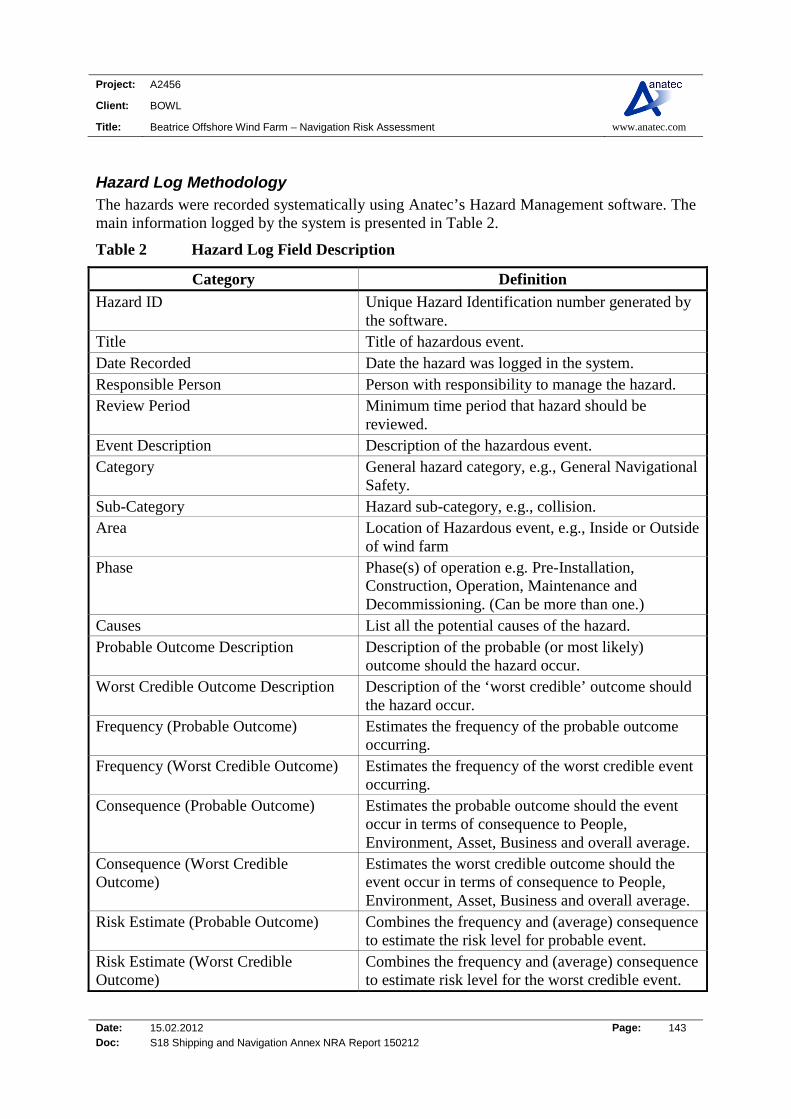
Project: A2456
Client: BOWL
Title: Beatrice Offshore Wind Farm – Navigation Risk Assessment www.anatec.com
Date: 15.02.2012 Page: 143 Doc: S18 Shipping and Navigation Annex NRA Report 150212
Hazard Log Methodology The hazards were recorded systematically using Anatec’s Hazard Management software. The main information logged by the system is presented in Table 2.
Table 2 Hazard Log Field Description
Category Definition
Hazard ID Unique Hazard Identification number generated by the software.
Title Title of hazardous event. Date Recorded Date the hazard was logged in the system. Responsible Person Person with responsibility to manage the hazard. Review Period Minimum time period that hazard should be
reviewed. Event Description Description of the hazardous event. Category General hazard category, e.g., General Navigational
Safety. Sub-Category Hazard sub-category, e.g., collision. Area Location of Hazardous event, e.g., Inside or Outside
of wind farm Phase Phase(s) of operation e.g. Pre-Installation,
Construction, Operation, Maintenance and Decommissioning. (Can be more than one.)
Causes List all the potential causes of the hazard. Probable Outcome Description Description of the probable (or most likely)
outcome should the hazard occur. Worst Credible Outcome Description Description of the ‘worst credible’ outcome should
the hazard occur. Frequency (Probable Outcome) Estimates the frequency of the probable outcome
occurring. Frequency (Worst Credible Outcome) Estimates the frequency of the worst credible event
occurring. Consequence (Probable Outcome) Estimates the probable outcome should the event
occur in terms of consequence to People, Environment, Asset, Business and overall average.
Consequence (Worst Credible Outcome)
Estimates the worst credible outcome should the event occur in terms of consequence to People, Environment, Asset, Business and overall average.
Risk Estimate (Probable Outcome) Combines the frequency and (average) consequence to estimate the risk level for probable event.
Risk Estimate (Worst Credible Outcome)
Combines the frequency and (average) consequence to estimate risk level for the worst credible event.

Project: A2456
Client: BOWL
Title: Beatrice Offshore Wind Farm – Navigation Risk Assessment www.anatec.com
Date: 15.02.2012 Page: 144 Doc: S18 Shipping and Navigation Annex NRA Report 150212
Category Definition
Risk Reduction Measures Documents the potential mitigation measures which will aid in the reduction of risk or in the management of the hazardous event.
The following frequency and consequence categories were applied.
Table 3 Frequency Bands
Rank Description Definition
1 Negligible < 1 occurrence per 10,000 years
2 Extremely Unlikely 1 per 100 to 10,000 years
3 Remote 1 per 10 to 100 years
4 Reasonably Probable 1 per 1 to 10 years
5 Frequent Yearly
Table 4 Consequence Bands
Rank Description Definition
People Property Environment Business
1 Negligible No injury <£10k <£10k <10k
2 Minor Slight injury(s) £10k-£100k Tier 1 Local assistance required
£10k-£100k
3 Moderate Multiple moderate or single injury(s)
£100k-£1M Tier 2 Limited external assistance required
£100k-£1M Local publicity
4 Serious Multiple serious injury(s) or single fatality
£1M-£10M Tier 2 Regional assistance required
£1M-£10M National publicity
5 Major More than 1 fatality >£10M Tier 3 National assistance required
>£10M International publicity
The four consequence scores were averaged and multiplied by the frequency to obtain an overall ranking (or score) which determined the hazard’s position within the risk matrix shown below.
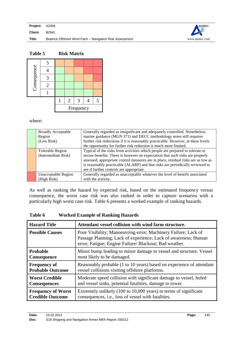
Project: A2456
Client: BOWL
Title: Beatrice Offshore Wind Farm – Navigation Risk Assessment www.anatec.com
Date: 15.02.2012 Page: 145 Doc: S18 Shipping and Navigation Annex NRA Report 150212
Table 5 Risk Matrix
Con
sequ
ence
5
4
3
2
1
1 2 3 4 5
Frequency
where: Broadly Acceptable
Region (Low Risk)
Generally regarded as insignificant and adequately controlled. Nonetheless marine guidance (MGN 371) and DECC methodology notes still requires further risk reductions if it is reasonably practicable. However, at these levels the opportunity for further risk reduction is much more limited.
Tolerable Region (Intermediate Risk)
Typical of the risks from activities which people are prepared to tolerate to secure benefits. There is however an expectation that such risks are properly assessed, appropriate control measures are in place, residual risks are as low as is reasonably practicable (ALARP) and that risks are periodically reviewed to see if further controls are appropriate.
Unacceptable Region (High Risk)
Generally regarded as unacceptable whatever the level of benefit associated with the activity.
As well as ranking the hazard by expected risk, based on the estimated frequency versus consequence, the worst case risk was also ranked in order to capture scenarios with a particularly high worst case risk. Table 6 presents a worked example of ranking hazards.
Table 6 Worked Example of Ranking Hazards
Hazard Title Attendant vessel collision with wind farm structure.
Possible Causes Poor Visibility; Manoeuvring error; Machinery Failure; Lack of Passage Planning; Lack of experience; Lack of awareness; Human error; Fatigue; Engine Failure/ Blackout; Bad weather.
Probable Consequence
Minor bump leading to minor damage to vessel and structure. Vessel most likely to be damaged.
Frequency of Probable Outcome
Reasonably probable (1 to 10 years) based on experience of attendant vessel collisions visiting offshore platforms.
Worst Credible Consequences
Moderate speed collision with significant damage to vessel, holed and vessel sinks, potential fatalities, damage to tower.
Frequency of Worst Credible Outcome
Extremely unlikely (100 to 10,000 years) in terms of significant consequences, i.e., loss of vessel with fatalities.

Project: A2456
Client: BOWL
Title: Beatrice Offshore Wind Farm – Navigation Risk Assessment www.anatec.com
Date: 15.02.2012 Page: 146 Doc: S18 Shipping and Navigation Annex NRA Report 150212
Table 7 presents the risk ranking of this hazard for the probable (most likely) outcome.
Table 7 Risk Matrix: Attendant Vessel Collision with Structure (Probable Outcome)
Con
sequ
ence
(Peo
ple)
5
Con
sequ
ence
(P
rope
rty)
5
4 4
3 3
2 X 2 X
1 1
1 2 3 4 5 1 2 3 4 5
Frequency Frequency
Con
sequ
ence
(Env
iron
men
t) 5
Con
sequ
ence
(B
usin
ess)
5
4 4
3 3
2 2 X
1 X 1
1 2 3 4 5 1 2 3 4 5
Frequency Frequency
The risk for the hazard is calculated by averaging the four consequences, i.e., (2+2+1+2)/4 = 1.75) and multiplying by the frequency, i.e., 4, to obtain a risk ranking of 7 (i.e. 1.75 x 4). A score of 7 puts this hazard in the Tolerable region. The worst credible risk was also ranked using a similar methodology. The potential mitigation measures for this event were logged as follows: Adverse weather working policy and procedures; Control of work procedures; Fenders/bumper bollards installed on turbines; Emergency Response Cooperation Plan; Marine Coordinator on site during works; Marine operating procedures; Marking and lighting; Passage plan to and from the site; Planning of major activities; Site personnel trained in fire fighting, first aid and offshore survival; Safety Management Systems for all vessels working in the site; Sharing of information within the industry.

Project: A2456
Client: BOWL
Title: Beatrice Offshore Wind Farm – Navigation Risk Assessment www.anatec.com
Date: 15.02.2012 Page: 147 Doc: S18 Shipping and Navigation Annex NRA Report 150212
Results The following list of hazards were reviewed, with the information recorded using Anatec’s Hazard Log Software. Fishing vessel collision Commercial ship (powered) collision Recreational vessel collision Drifting ship collision Fishing gear interaction with inter-field cabling Fishing gear interaction with export cable Fishing gear interaction with substructures Vessel anchoring on or dragging anchor over subsea equipment Vessel-to-vessel collision due to avoidance of site or work vessels in area The following generic industry hazards were also identified for the site but not discussed in detail: Attendant vessel collision with structure Man overboard during work activities at site Dropped object during work activities at site Deliberate unauthorised boarding or mooring to structure The following overall breakdown by tolerability region was assessed for the identified hazards.
0
2
4
6
8
10
12
Broadly Acceptable Tolerable Unacceptable
Nu
mb
er o
f R
isks
Tolerability Region
Probable
Worst Case
Figure 1 Beatrice Risk Ranking Results
No risks were assessed to be unacceptable. As shown in the above figure, two risks were ranked within the Tolerable (As Low as Reasonably Practicable, ALARP) region based on
Project: A2456
Client: BOWL
Title: Beatrice Offshore Wind Farm – Navigation Risk Assessment www.anatec.com
Date: 15.02.2012 Page: 148 Doc: S18 Shipping and Navigation Annex NRA Report 150212
the probable outcome whilst five were ranked as Tolerable (ALARP) based on the worst case outcome. The hazards ranked as tolerable based on probable outcome were: Attendant vessel collision with wind farm structure; and Man overboard during transfer to/from turbine or working alongside turbine. These incidents mostly involve vessels and persons working at the site as opposed to third party (non-wind farm related) vessels and persons. As well as the two hazards above, the three additional hazards ranked as tolerable based on worst case outcome were: Fishing vessel collision with structure; Dropped object during construction, decommissioning or major maintenance; and Vessel-to-vessel collision due to avoidance of site. Several of the worst case outcomes involve third party vessels, but these incidents have a lower likelihood of occurring. It was noted that many of the causes are general maritime accident causation factors outside the control of the Developer. Full details of the logged and ranked hazards are summarised in Table 8, sorted by descending order of risk ranking (probable followed by worst credible outcome).

Project: A2456
Client: BOWL
Title: Beatrice Offshore Wind Farm – Navigation Risk Assessment www.anatec.com
Date: 15.02.2012 Page: 149 Doc: S18 Shipping and Navigation Annex NRA Report 150212
Table 8 Beatrice Hazard Ranking Results

Project: A2456
Client: BOWL
Title: Beatrice Offshore Wind Farm – Navigation Risk Assessment www.anatec.com
Date: 15.02.2012 Page: 150 Doc: S18 Shipping and Navigation Annex NRA Report 150212
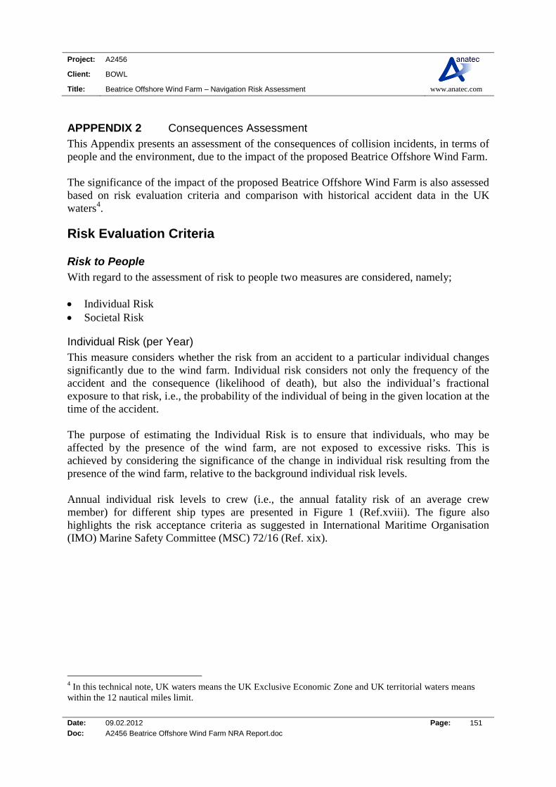
Project: A2456
Client: BOWL
Title: Beatrice Offshore Wind Farm – Navigation Risk Assessment www.anatec.com
Date: 09.02.2012 Page: 151 Doc: A2456 Beatrice Offshore Wind Farm NRA Report.doc
APPPENDIX 2 Consequences Assessment This Appendix presents an assessment of the consequences of collision incidents, in terms of people and the environment, due to the impact of the proposed Beatrice Offshore Wind Farm. The significance of the impact of the proposed Beatrice Offshore Wind Farm is also assessed based on risk evaluation criteria and comparison with historical accident data in the UK waters4.
Risk Evaluation Criteria
Risk to People With regard to the assessment of risk to people two measures are considered, namely; Individual Risk Societal Risk
Individual Risk (per Year) This measure considers whether the risk from an accident to a particular individual changes significantly due to the wind farm. Individual risk considers not only the frequency of the accident and the consequence (likelihood of death), but also the individual’s fractional exposure to that risk, i.e., the probability of the individual of being in the given location at the time of the accident. The purpose of estimating the Individual Risk is to ensure that individuals, who may be affected by the presence of the wind farm, are not exposed to excessive risks. This is achieved by considering the significance of the change in individual risk resulting from the presence of the wind farm, relative to the background individual risk levels. Annual individual risk levels to crew (i.e., the annual fatality risk of an average crew member) for different ship types are presented in Figure 1 (Ref.xviii). The figure also highlights the risk acceptance criteria as suggested in International Maritime Organisation (IMO) Marine Safety Committee (MSC) 72/16 (Ref. xix).
4 In this technical note, UK waters means the UK Exclusive Economic Zone and UK territorial waters means within the 12 nautical miles limit.
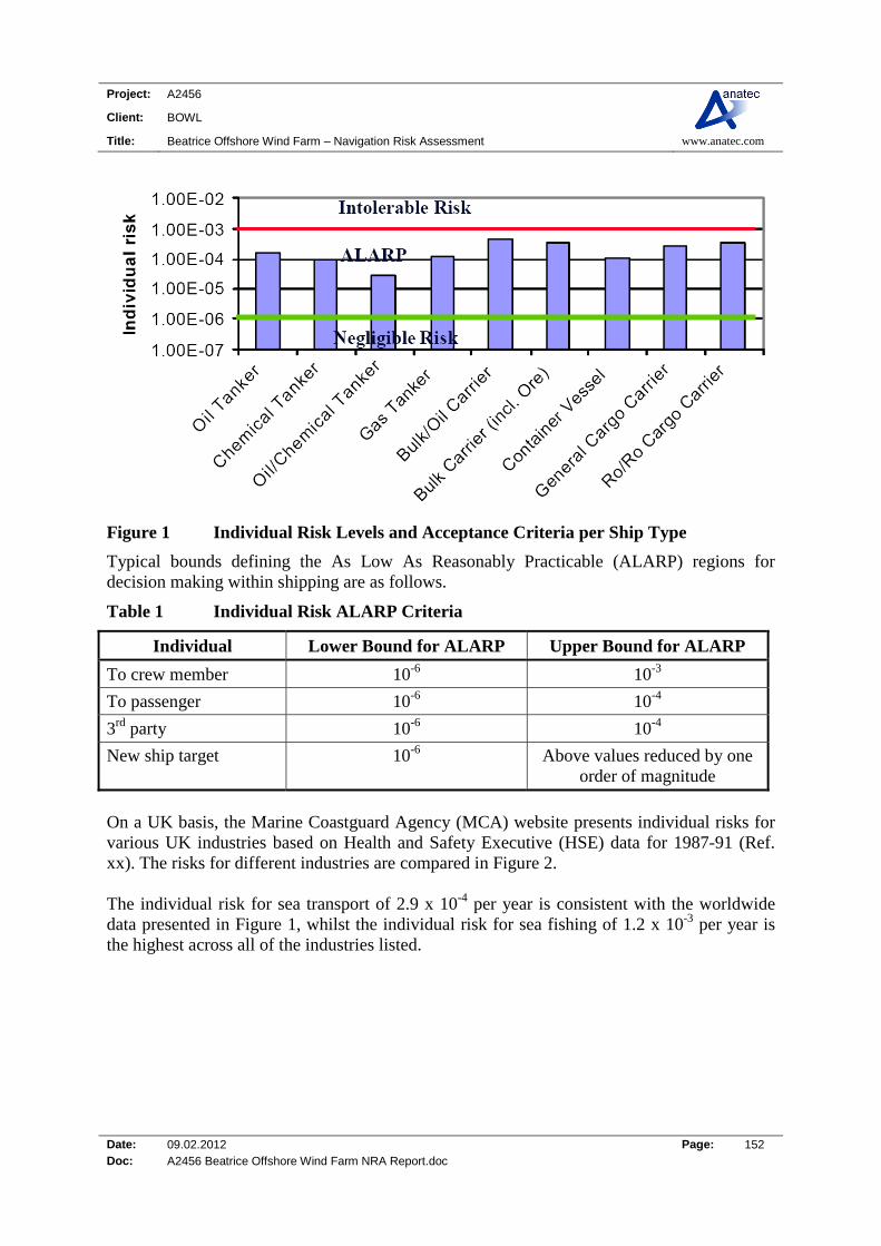
Project: A2456
Client: BOWL
Title: Beatrice Offshore Wind Farm – Navigation Risk Assessment www.anatec.com
Date: 09.02.2012 Page: 152 Doc: A2456 Beatrice Offshore Wind Farm NRA Report.doc
Figure 1 Individual Risk Levels and Acceptance Criteria per Ship Type
Typical bounds defining the As Low As Reasonably Practicable (ALARP) regions for decision making within shipping are as follows.
Table 1 Individual Risk ALARP Criteria
Individual Lower Bound for ALARP Upper Bound for ALARP
To crew member 10-6 10-3
To passenger 10-6 10-4
3rd party 10-6 10-4
New ship target 10-6 Above values reduced by one order of magnitude
On a UK basis, the Marine Coastguard Agency (MCA) website presents individual risks for various UK industries based on Health and Safety Executive (HSE) data for 1987-91 (Ref. xx). The risks for different industries are compared in Figure 2. The individual risk for sea transport of 2.9 x 10⁻⁴ per year is consistent with the worldwide data presented in Figure 1, whilst the individual risk for sea fishing of 1.2 x 10⁻³ per year is the highest across all of the industries listed.

Project: A2456
Client: BOWL
Title: Beatrice Offshore Wind Farm – Navigation Risk Assessment www.anatec.com
Date: 09.02.2012 Page: 153 Doc: A2456 Beatrice Offshore Wind Farm NRA Report.doc
0.0E+00
2.0E-04
4.0E-04
6.0E-04
8.0E-04
1.0E-03
1.2E-03
1.4E-03
Agricu
lture
Sea fis
hing
Coal m
inin
g
Oil &
gas
pro
dn
Energ
y pr
oduc
tion
Chem
ical in
dustry
Mec
hanica
l eng.
Const
ruct
ion
Railway
s
Sea tr
ansp
ort
All manu
factu
ring
All serv
ices
All ind
ustri
es
Industry
Ind
ivid
ual
Ris
k p
er a
nn
um
Figure 2 Individual Risk per Year for various UK Industries
Societal Risk Societal Risk is used to estimate risks of accidents affecting many persons, e.g., catastrophes, and acknowledging risk averse or neutral attitudes. Societal Risk includes the risk to every person, even if a person is only exposed on one brief occasion to that risk. For assessing the risk to a large number of affected people, societal risk is desirable because individual risk is insufficient in evaluating risks imposed on large numbers of people. Within this assessment societal risk (navigational based) can be assessed for the proposed Beatrice Offshore Wind Farm giving account to the change in risk associated with each accident scenario caused by the introduction of the structures. Societal risk may be expressed as: Annual fatality rate: frequency and fatality are combined into a convenient one-
dimensional measure of Societal Risk. This is also known as Potential Loss of Life (PLL). FN-diagrams showing explicitly the relationship between the cumulative frequency of an
accident and the number of fatalities in a multi-dimensional diagram. When assessing societal risk this study focuses on PLL, which takes into account the number of people likely to be involved in an incident (which is higher for passenger ferries, for example), and assesses the significance of the change in risk compared to background risk levels for the UK.
Project: A2456
Client: BOWL
Title: Beatrice Offshore Wind Farm – Navigation Risk Assessment www.anatec.com
Date: 09.02.2012 Page: 154 Doc: A2456 Beatrice Offshore Wind Farm NRA Report.doc
Risk to Environment For risk to the environment the key criteria considered in terms of the effect of the proposed Beatrice Offshore Wind Farm is the potential amount of oil spilled from the vessel involved in an incident. It is recognised there will be other potential pollution, e.g., hazardous containerised cargoes, however, oil is considered the most likely pollutant and the extent of predicted oil spills will provide an indication of the significance of pollution risk due to the proposed Beatrice Offshore Wind Farm compared to background pollution risk levels for the UK.
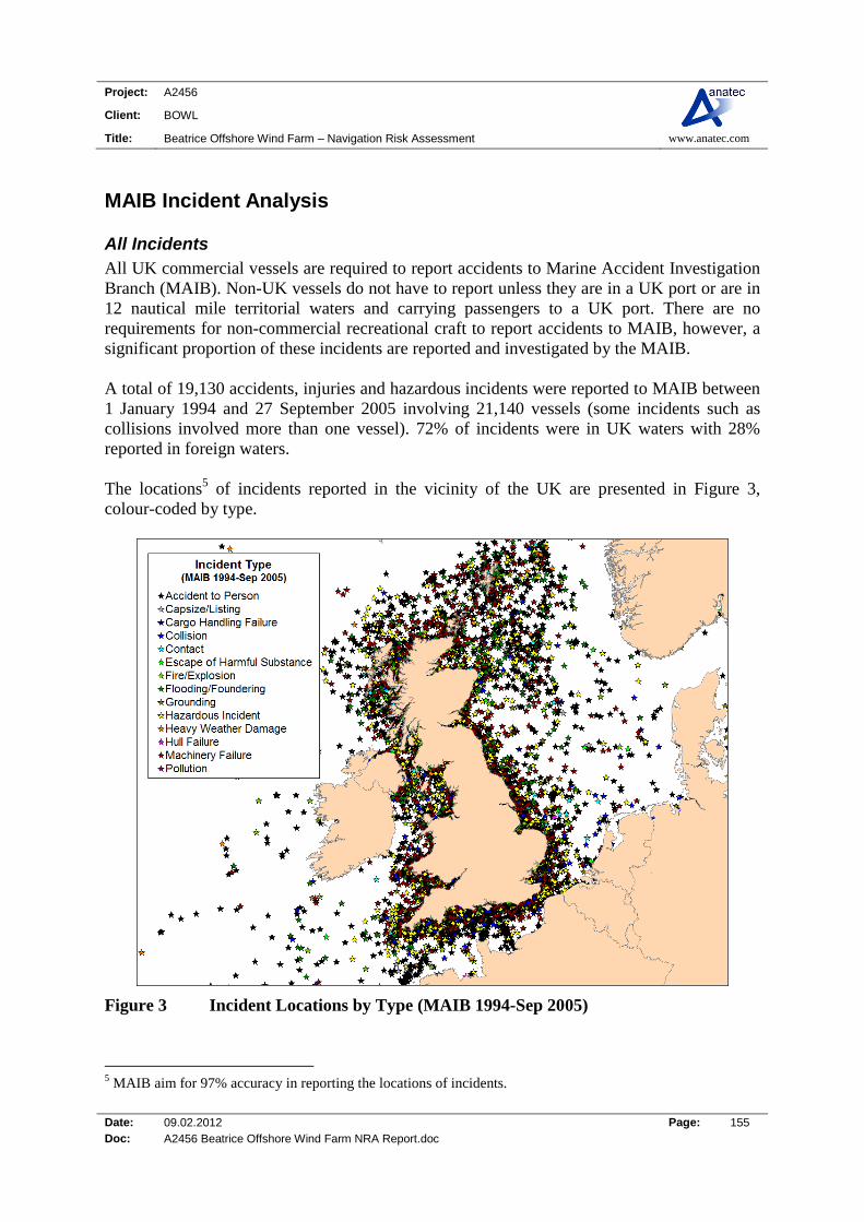
Project: A2456
Client: BOWL
Title: Beatrice Offshore Wind Farm – Navigation Risk Assessment www.anatec.com
Date: 09.02.2012 Page: 155 Doc: A2456 Beatrice Offshore Wind Farm NRA Report.doc
MAIB Incident Analysis
All Incidents All UK commercial vessels are required to report accidents to Marine Accident Investigation Branch (MAIB). Non-UK vessels do not have to report unless they are in a UK port or are in 12 nautical mile territorial waters and carrying passengers to a UK port. There are no requirements for non-commercial recreational craft to report accidents to MAIB, however, a significant proportion of these incidents are reported and investigated by the MAIB. A total of 19,130 accidents, injuries and hazardous incidents were reported to MAIB between 1 January 1994 and 27 September 2005 involving 21,140 vessels (some incidents such as collisions involved more than one vessel). 72% of incidents were in UK waters with 28% reported in foreign waters. The locations5 of incidents reported in the vicinity of the UK are presented in Figure 3, colour-coded by type.
Figure 3 Incident Locations by Type (MAIB 1994-Sep 2005)
5 MAIB aim for 97% accuracy in reporting the locations of incidents.

Project: A2456
Client: BOWL
Title: Beatrice Offshore Wind Farm – Navigation Risk Assessment www.anatec.com
Date: 09.02.2012 Page: 156 Doc: A2456 Beatrice Offshore Wind Farm NRA Report.doc
The distribution of incidents by year is presented in Figure 4.
0200400600800
100012001400160018002000
1994 1995 1996 1997 1998 1999 2000 2001 2002 2003 2004 2005(part)
Year
No
of
Inci
den
ts
Figure 4 Incidents per Year (MAIB 1994-Sep 2005)
The average number of incidents per year, excluding 2005 which is a part-year, was 1,621. There is a declining trend in incidents. The distribution by incident type is presented in Figure 5.
0
1000
2000
3000
4000
5000
6000
7000
8000
Accid
ent T
o Pers
on
Capsiz
e/List
ing
Cargo
Han
dling
Failure
Collisi
on
Conta
ct
Escap
e of
Har
mfu
l Subs
tanc
e
Fire/E
xplos
ion
Flood
ing/
Founde
ring
Gro
undin
g
Hazar
dous
Incid
ent
Heavy
Wea
ther
Dam
age
Hull F
ailur
e
Mac
hinery
Failu
re
Miss
ing V
esse
l
Pollut
ion
Incident Type
No
of
Inci
den
ts
Figure 5 Incidents by Incident Type (MAIB 1994-Sep 2005)

Project: A2456
Client: BOWL
Title: Beatrice Offshore Wind Farm – Navigation Risk Assessment www.anatec.com
Date: 09.02.2012 Page: 157 Doc: A2456 Beatrice Offshore Wind Farm NRA Report.doc
Therefore, the most common incident types were Accident to Person6 (40%), Machinery Failure (24%) and Hazardous Incident (13%). Collisions and Contacts each represented 3% of total incidents. The distribution of vessel type categories involved in incidents is presented in Figure 6.
0%
5%
10%
15%
20%
25%
30%
35%
40%
Dry c
argo
Fish c
atch
ing/
proce
ssin
g
Oth
er (no
n-com
merc
ial)
Oth
er com
mer
cial
Passe
nger
Passe
nger c
argo
Pleas
ure c
raft
(non
-com
merc
ial)
Tanker/c
ombi
natio
n carri
er
Vessel Type
Per
cen
tag
e
Figure 6 Incidents by Vessel Type (MAIB 1994-Sep 2005)
The most common vessel types involved in incidents were fishing vessels (35%), passenger vessels (25%) and other commercial vessels (17%), which includes offshore industry vessels, tugs, workboats and pilot vessels. The total number of fatalities per year (divided into crew, passenger and other) reported in the MAIB incidents is presented in Figure 7.
6 Where the incident is an accident to a vessel, e.g., collision or machinery failure, it would be reported under this vessel accident category.

Project: A2456
Client: BOWL
Title: Beatrice Offshore Wind Farm – Navigation Risk Assessment www.anatec.com
Date: 09.02.2012 Page: 158 Doc: A2456 Beatrice Offshore Wind Farm NRA Report.doc
0
100
200
300
400
500
600
700
800
900
1994
1995
1996
1997
1998
1999
2000
2001
2002
2003
2004
2005
Year
Fat
alit
ies
Other
Passengers
Crew
Figure 7 Number of Fatalities (MAIB 1994-Sep 2005)
The average number of fatalities per year, excluding 2005 which is a part-year, was 115. The sinking of the ‘Estonia’ passenger ferry in the Baltic Sea in 1994, which resulted in a reported 852 fatalities, dominates the figures. If 1994 were excluded, the average number of fatalities per year would drop to 42. Considering only the incidents reported to have occurred in UK territorial waters, the number of fatalities per year is presented in Figure 8.
0
5
10
15
20
25
30
35
40
45
50
1994
1995
1996
1997
1998
1999
2000
2001
2002
2003
2004
2005
Year
Fat
alit
ies
Other
Passengers
Crew
Figure 8 Number of Fatalities for Incidents in UK Waters (MAIB 1994-Sep 2005)

Project: A2456
Client: BOWL
Title: Beatrice Offshore Wind Farm – Navigation Risk Assessment www.anatec.com
Date: 09.02.2012 Page: 159 Doc: A2456 Beatrice Offshore Wind Farm NRA Report.doc
Therefore, the average number of fatalities per year in UK territorial waters between 1994 and 2004 was 29. The distribution of fatalities in UK waters by vessel type and person category is presented in Figure 9.
0%
5%
10%
15%
20%
25%
30%
35%
40%
Dry c
argo
Fish c
atch
ing/
proce
ssin
g
Oth
er (no
n-com
merc
ial)
Oth
er com
mer
cial
Passe
nger
Passe
nger c
argo
Pleas
ure c
raft
(non
-com
merc
ial)
Tanker/c
ombi
natio
n carri
er
Vessel Type
% o
f F
atal
itie
s
Other
Passengers
Crew
Figure 9 Fatalities by Vessel Type for Incidents in UK (MAIB 1994-Sep 2005)
It can be seen that the majority of fatalities in the UK occurred to fishing vessels and pleasure craft, with crew members the main people involved.
Collision Incidents MAIB define a collision incident as “vessel hits another vessel that is floating freely or is anchored (as opposed to being tied up alongside).” A total of 623 collisions were reported to MAIB between 1 January 1994 and 27 September 2005 involving 1,241 vessels (in a handful of cases the other vessel involved was not logged). The locations of collisions reported in the vicinity of the UK are presented in Figure 10, colour-coded by type.

Project: A2456
Client: BOWL
Title: Beatrice Offshore Wind Farm – Navigation Risk Assessment www.anatec.com
Date: 09.02.2012 Page: 160 Doc: A2456 Beatrice Offshore Wind Farm NRA Report.doc
Figure 10 Collision Incident Locations (MAIB 1994-Sep 2005)
The distribution of all collision incidents by year is presented in Figure 11.
0
10
20
30
40
50
60
70
80
1994 1995 1996 1997 1998 1999 2000 2001 2002 2003 2004 2005(part)
Year
No
of
Co
llis
ion
s
Figure 11 Collisions per Year (MAIB 1994-Sep 2005)
The average number of collisions per year, excluding 2005 which is a part-year, was 51.
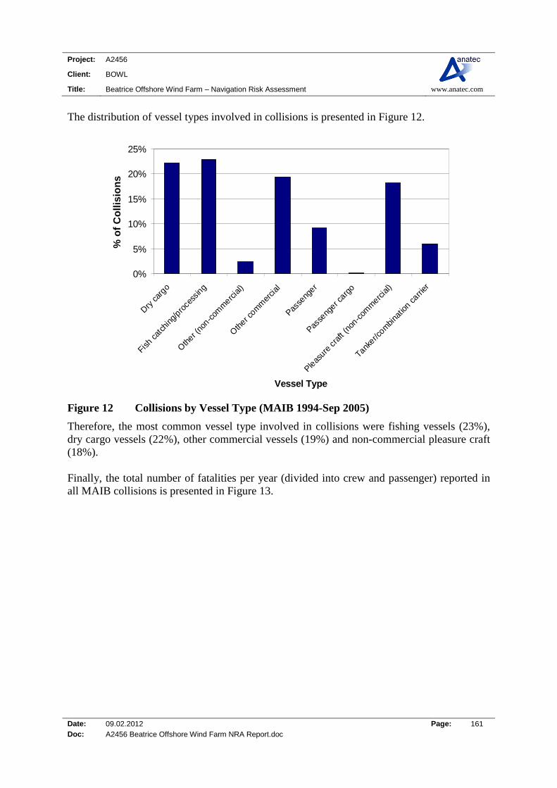
Project: A2456
Client: BOWL
Title: Beatrice Offshore Wind Farm – Navigation Risk Assessment www.anatec.com
Date: 09.02.2012 Page: 161 Doc: A2456 Beatrice Offshore Wind Farm NRA Report.doc
The distribution of vessel types involved in collisions is presented in Figure 12.
0%
5%
10%
15%
20%
25%
Dry c
argo
Fish c
atch
ing/
proce
ssin
g
Oth
er (no
n-com
merc
ial)
Oth
er com
mer
cial
Passe
nger
Passe
nger c
argo
Pleas
ure c
raft
(non
-com
merc
ial)
Tanker/c
ombi
natio
n carri
er
Vessel Type
% o
f C
oll
isio
ns
Figure 12 Collisions by Vessel Type (MAIB 1994-Sep 2005)
Therefore, the most common vessel type involved in collisions were fishing vessels (23%), dry cargo vessels (22%), other commercial vessels (19%) and non-commercial pleasure craft (18%). Finally, the total number of fatalities per year (divided into crew and passenger) reported in all MAIB collisions is presented in Figure 13.
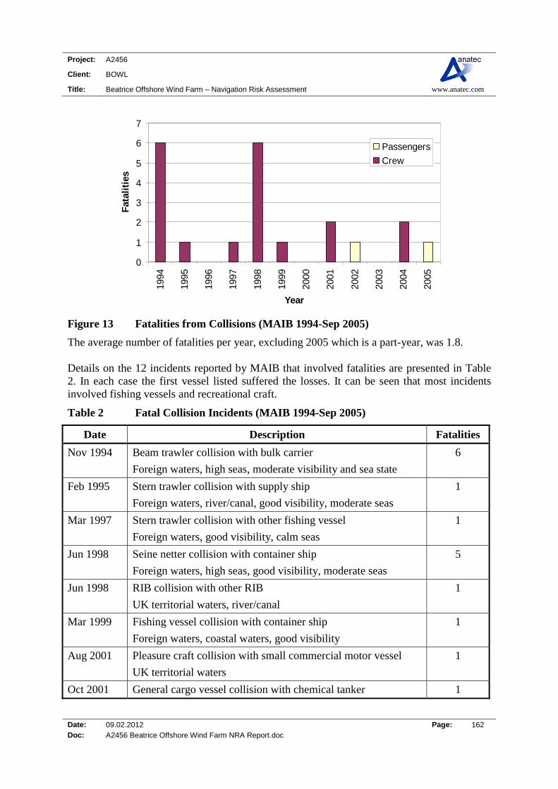
Project: A2456
Client: BOWL
Title: Beatrice Offshore Wind Farm – Navigation Risk Assessment www.anatec.com
Date: 09.02.2012 Page: 162 Doc: A2456 Beatrice Offshore Wind Farm NRA Report.doc
0
1
2
3
4
5
6
7
1994
1995
1996
1997
1998
1999
2000
2001
2002
2003
2004
2005
Year
Fat
alit
ies
Passengers
Crew
Figure 13 Fatalities from Collisions (MAIB 1994-Sep 2005)
The average number of fatalities per year, excluding 2005 which is a part-year, was 1.8. Details on the 12 incidents reported by MAIB that involved fatalities are presented in Table 2. In each case the first vessel listed suffered the losses. It can be seen that most incidents involved fishing vessels and recreational craft.
Table 2 Fatal Collision Incidents (MAIB 1994-Sep 2005)
Date Description Fatalities
Nov 1994 Beam trawler collision with bulk carrier
Foreign waters, high seas, moderate visibility and sea state
6
Feb 1995 Stern trawler collision with supply ship
Foreign waters, river/canal, good visibility, moderate seas
1
Mar 1997 Stern trawler collision with other fishing vessel
Foreign waters, good visibility, calm seas
1
Jun 1998 Seine netter collision with container ship
Foreign waters, high seas, good visibility, moderate seas
5
Jun 1998 RIB collision with other RIB
UK territorial waters, river/canal
1
Mar 1999 Fishing vessel collision with container ship
Foreign waters, coastal waters, good visibility
1
Aug 2001 Pleasure craft collision with small commercial motor vessel
UK territorial waters
1
Oct 2001 General cargo vessel collision with chemical tanker 1

Project: A2456
Client: BOWL
Title: Beatrice Offshore Wind Farm – Navigation Risk Assessment www.anatec.com
Date: 09.02.2012 Page: 163 Doc: A2456 Beatrice Offshore Wind Farm NRA Report.doc
Date Description Fatalities
UK territorial waters, coastal waters, good visibility
Aug 2002 Speed craft collision with another speed boat
UK waters, unspecified location, good visibility, calm seas
1
May 2004 Port service tug collision with passenger ferry (during towing)
Foreign waters, coastal waters
1
Jun 2004 Pleasure craft collision with other pleasure craft
Foreign waters, river/canal
1
Jul 2005 Pleasure craft collision with (1 passenger fatality)
UK territorial waters, coastal waters, good visibility, calm seas
1
A more detailed description of the two incidents which resulted in multiple fatalities is provided below: Collision between bulk carrier and beam trawler in eastward lane of Terschelling -
German Bight Traffic Separation Scheme (TSS). Both vessels were on passage. Visibility was about 5 miles. Collision caused extensive damage to beam trawler and vessel rapidly flooded and sank with loss of her 6 crew, all of whom were Dutch nationals. Collision was primarily caused by Master of bulk carrier failing to take early and substantial action when complying with his obligation to keep out of the way.
The fishing vessel was on an easterly course while on passage from Firth of Forth to
Esbjerg, and the container ship was on a north-westerly course from Hamburg to Gothenburg. The fishing vessel was the give-way vessel but did not alter course and speed, the cause of which could not be established. The chief officer of the container ship did not alter course until it was too late and the two vessels collided. The fishing vessel foundered so quickly that all hands were trapped inside the accommodation and the container ship was so badly damaged that she had to use Esbjerg as a port of refuge.
Contact Incidents MAIB define a contact incident as “vessel hits an object that is immobile and is not subject to the collision regulations e.g. buoy, post, dock (too hard), etc. Also, another ship if it is tied up alongside. Also floating logs, containers etc.” A total of 609 contacts were reported to MAIB between 1 January 1994 and 27 September 2005 involving 663 vessels. The locations of contacts reported in the vicinity of the UK are presented in Figure 14, colour-coded by type.
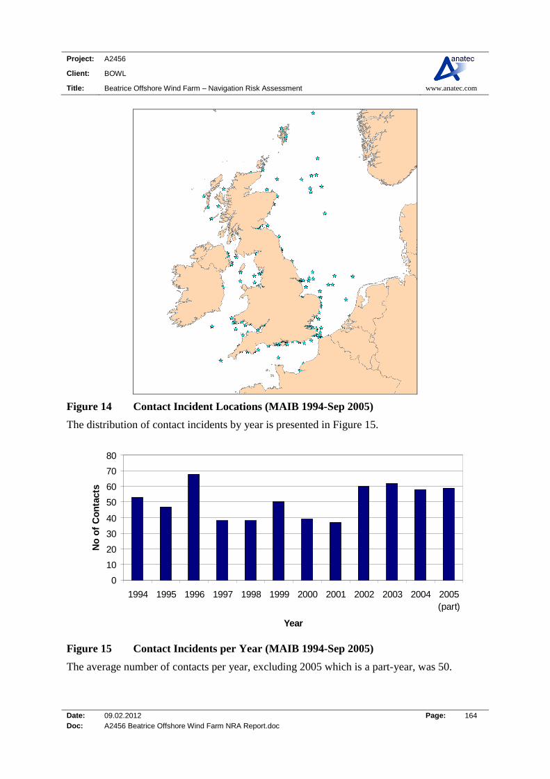
Project: A2456
Client: BOWL
Title: Beatrice Offshore Wind Farm – Navigation Risk Assessment www.anatec.com
Date: 09.02.2012 Page: 164 Doc: A2456 Beatrice Offshore Wind Farm NRA Report.doc
Figure 14 Contact Incident Locations (MAIB 1994-Sep 2005)
The distribution of contact incidents by year is presented in Figure 15.
0
10
20
30
40
50
60
70
80
1994 1995 1996 1997 1998 1999 2000 2001 2002 2003 2004 2005(part)
Year
No
of
Co
nta
cts
Figure 15 Contact Incidents per Year (MAIB 1994-Sep 2005)
The average number of contacts per year, excluding 2005 which is a part-year, was 50.
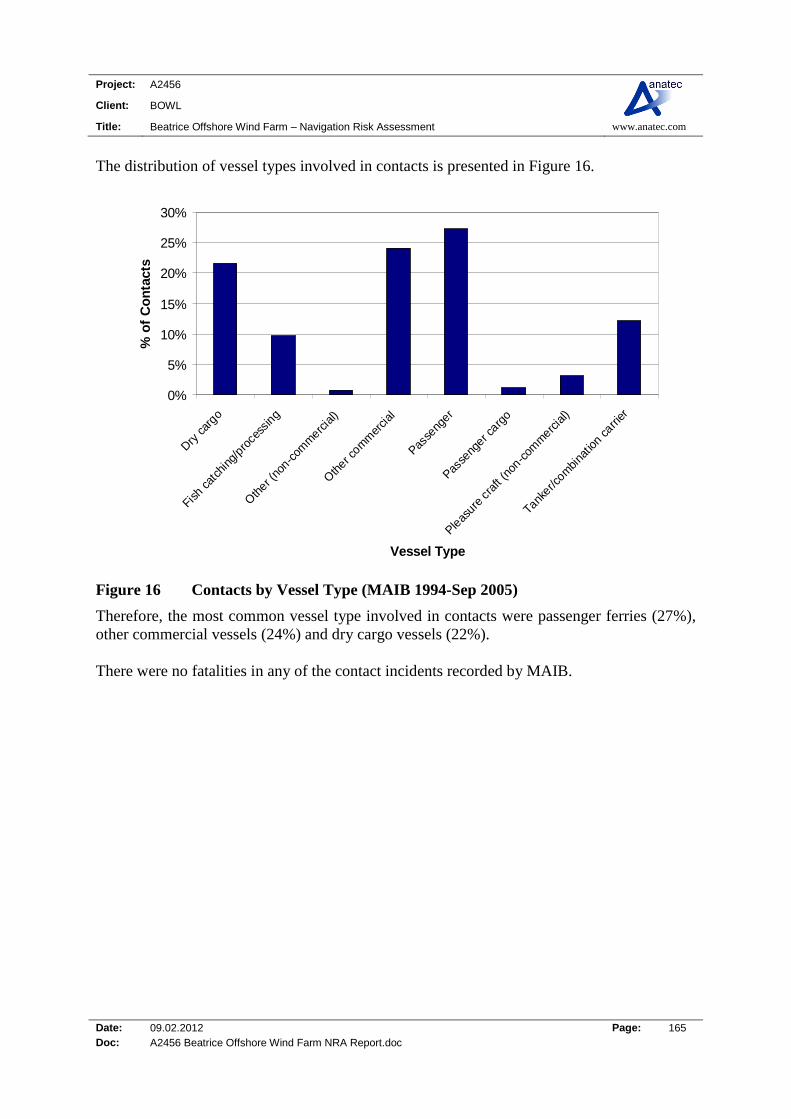
Project: A2456
Client: BOWL
Title: Beatrice Offshore Wind Farm – Navigation Risk Assessment www.anatec.com
Date: 09.02.2012 Page: 165 Doc: A2456 Beatrice Offshore Wind Farm NRA Report.doc
The distribution of vessel types involved in contacts is presented in Figure 16.
0%
5%
10%
15%
20%
25%
30%
Dry c
argo
Fish c
atch
ing/
proce
ssin
g
Oth
er (no
n-com
merc
ial)
Oth
er com
mer
cial
Passe
nger
Passe
nger c
argo
Pleas
ure c
raft
(non
-com
merc
ial)
Tanker/c
ombi
natio
n carri
er
Vessel Type
% o
f C
on
tact
s
Figure 16 Contacts by Vessel Type (MAIB 1994-Sep 2005)
Therefore, the most common vessel type involved in contacts were passenger ferries (27%), other commercial vessels (24%) and dry cargo vessels (22%). There were no fatalities in any of the contact incidents recorded by MAIB.
Project: A2456
Client: BOWL
Title: Beatrice Offshore Wind Farm – Navigation Risk Assessment www.anatec.com
Date: 09.02.2012 Page: 166 Doc: A2456 Beatrice Offshore Wind Farm NRA Report.doc
Fatality Risk
Introduction This section uses the MAIB incident data along with information on average manning levels per vessel type to estimate the probability of fatality in a marine incident associated with the proposed Beatrice Offshore Wind Farm development. The proposed Beatrice Offshore Wind Farm is assessed to have the potential to affect the following incidents:
Passing Powered Collision with Wind Farm Structure;
Passing Drifting Collision with Wind Farm Structure;
Vessel-to-Vessel Collision; and
Fishing Vessel Collision with Wind Farm Structure.
Of these incidents, only vessel-to-vessel collisions match the MAIB definition of collisions and hence the fatality analysis presented in Section 0 is considered to be directly applicable to these types of incidents. The other scenarios of passing powered, passing drifting and fishing vessel collisions with the wind farm structures are technically contacts, i.e., vessel hits an immobile object in the form of a turbine or substation. From Section 0 it can be seen that none of the 609 contact incidents reported by MAIB between 1994 and 2005 resulted in fatalities. However, as the mechanics involved in a vessel contacting a wind turbine may differ in severity from hitting, for example, a buoy, quayside or moored vessel, the MAIB collision fatality risk rate has also been conservatively applied for these incidents. A description of the risk models used in the shipping collision assessment are provided in the following section.
COLLRISK Model One of the major assumptions of the COLLRISK models is that the collision risk is related to the exposure time, i.e., the longer a vessel is exposed to a hazard, such as bad weather or other shipping traffic, the more likely it is that an incident can occur. On this basis, the first stage of the overall analysis is to assess the level of exposure time within each of the grid cells used in the analysis. This is achieved using Anatec’s ShipRoutes shipping data and assessing the following for each route:
Number of vessels using route Proportion of route passing through cell

Project: A2456
Client: BOWL
Title: Beatrice Offshore Wind Farm – Navigation Risk Assessment www.anatec.com
Date: 09.02.2012 Page: 167 Doc: A2456 Beatrice Offshore Wind Farm NRA Report.doc
Average distance of route through cell This calculation is illustrated in Figure 17.
ROUTE CENTRELIN
E
ROUTE WIDTH
Probability of ship passing within cell.
cell
average distance through cell
ROUTE CENTRELIN
E
ROUTE WIDTH
Probability of ship passing within cell.
cell
average distance through cell
Figure 17 Calculation of Distance Travelled by Ships within a Cell
Having assessed the average distance for each route the speed distribution for that route can be used to estimate the overall time for shipping to pass through the cell on a daily and yearly basis. This is the exposure time.
Ship-to-Ship Collision Risk The risk of ships colliding with other ships is calculated in COLLRISK using the exposure times stored within the grid of cells for the area as well as the following influencing factors identified from analysis of historical data:
Vessel types Vessel sizes Vessel speeds Encounter situation (e.g., head-on, overtaking or crossing) Visibility Vessel Traffic Services (VTS)

Project: A2456
Client: BOWL
Title: Beatrice Offshore Wind Farm – Navigation Risk Assessment www.anatec.com
Date: 09.02.2012 Page: 168 Doc: A2456 Beatrice Offshore Wind Farm NRA Report.doc
Bad visibility has been demonstrated to increase the risk of ship collision, whilst the presence of a VTS, has been shown to reduce the risk of collision. Both these factors are taken into account within the model using local data for the area of interest.
Drifting Collision Risk The COLLRISK drifting risk model is based on the assumption that the engine(s) on a vessel must fail before it will drift. A generic failure rate of 2 x 10⁻⁵ per hour for shipping has been applied based on general maritime research, in the absence of detailed data for different vessel types and sizes. However, to provide further sensitivity within the model, the fact that certain vessels are likely to have more than one engine has been accounted for based on a survey of a cross-section of ships of each type/size category operating in the area of interest. For example, passenger ferries generally have multiple engines providing redundancy. Using this information it is possible to derive the overall rate of breakdown within each grid cell. The probability of a vessel drifting towards the Beatrice Offshore Project, are estimated using the metocean data for the area. Similarly, the drift speeds are estimated based on this information. Finally, the probability of vessel recovery from drift is estimated based on the time available to repair engines before collision. Many failures are identified and corrected before they can result in an impact, as ship’s engineers are generally well trained and equipped to perform repairs at sea, and spare parts for many major components are normally kept on-board. There is also the potential for external recovery via a tug. This varies depending on ship size, drift speed and tug availability. Vessels that do not regain power or obtain a tow to safety within the time to reach the hazard are assumed to collide. As discussed above, the following influencing factors, identified from analysis of accident data, are considered when modelling the ship drifting collision risk:
Exposure time Vessel Type Vessel Size Metocean Data Sea State
Powered Collision Risk Powered collisions tend to occur where ships approach the restricted in sea room. This module of the COLLRISK software assesses the risk of ship colliding due to some form of navigational error, whereby a ship alters course to, or fails to alter course away from, the a structure (i.e. wind turbine or platform) in a timely manner.
Project: A2456
Client: BOWL
Title: Beatrice Offshore Wind Farm – Navigation Risk Assessment www.anatec.com
Date: 09.02.2012 Page: 169 Doc: A2456 Beatrice Offshore Wind Farm NRA Report.doc
This assessment is performed for each of the routes passing near the Beatrice Offshore Project and the number of ships potentially on a projected collision course is determined. These are summed to provide the total number of collisions that can be expected, which forms the basis of the frequency calculation. The model also uses location-specific data to take into account the effect of the following influencing factors: Shipping route data (position and width) Shipping traffic data (type, size and speed) Weather Data/Visibility
Fatality Probability Twelve of the 623 collision incidents reported by MAIB resulted in one or more fatalities. This represents a 2% probability that a collision will lead to a fatal accident. A total of 21 fatalities resulted from the collision incidents. To assess the fatality risk for personnel on-board a vessel, either crew, passenger or other, the number of persons involved in the incidents needs to be estimated. From an ILO survey of seafarers during 1998-99 (Ref. xxi), the average commercial vessel had a crew of 17. For other (non-commercial vessels) such as naval craft and Royal National Lifeboat Institute (RNLI) lifeboats the average crew has been estimated to be 20. On-board fishing vessels and pleasure craft the average crew has been estimated to be 5. Finally, for passenger vessels it is estimated that the average number of passengers carried, in addition to crew, is 300 (based on UK sea passenger movements on principal ferry routes, Ref. xxii). It is recognised these numbers can be substantially higher or lower on an individual vessel basis depending on size, subtype, etc., but applying reasonable averages is considered sufficient for this analysis. Using the average number of persons carried along with the vessel type information involved in collisions reported by MAIB (see Figure 12), gives an estimated 50,000 personnel on-board the ships involved in the collisions. Based on 21 fatalities, the overall fatality probability in a collision for any individual on-board is approximately 4.2 x 10⁻⁴ per collision (0.04%). It is considered inappropriate to apply this rate uniformly as the statistics clearly shown that the majority of fatalities tend be associated with smaller craft, such as fishing vessels and recreational vessels. Therefore, the fatality probability has been subdivided into two categories of vessel as presented below.

Project: A2456
Client: BOWL
Title: Beatrice Offshore Wind Farm – Navigation Risk Assessment www.anatec.com
Date: 09.02.2012 Page: 170 Doc: A2456 Beatrice Offshore Wind Farm NRA Report.doc
Table 3 Fatality Probability per Incident per Vessel Category
Vessel Category Sub Categories Fatalities People Involved
Fatality Probability
Commercial Dry cargo, passenger, tanker, etc.
3 46,200 6.5E-05
Non-Commercial Fishing, pleasure, etc. 18 3,120 5.8E-03
From the above table it can be seen the risk is approximately two orders of magnitude higher for people on-board non-commercial vessels.
Fatality Risk due to the Proposed Beatrice Offshore Wind Farm The base case and future case annual collision frequency levels without and with the proposed Beatrice Offshore Wind Farm site are summarised below.
Table 4 Summary of Annual Collision Frequency Results
Risk Scenario
Base Case Future Case
Without With Change Without With Change
Passing Powered
-- 1.6E-06 1.6E-06 -- 1.8E-06 1.8E-06
Passing Drifting
-- 7.8E-06 7.8E-06 -- 8.5E-06 8.5E-06
Vessel-to-Vessel
5.0E-04 5.0E-04 9.0E-08 5.5E-04 5.5E-04 9.9E-08
Fishing -- 3.0E-02 3.0E-02 -- 3.3E-02 3.3E-02
Total 5.0E-04 3.0E-02 3.0E-02 5.5E-04 3.3E-02 3.3E-02
Based on the information in Section 0 and research on the vessels recorded from the survey data, the average manning/persons on-board (POB) has been estimated in Table 5.
Table 5 Vessel Types, Incidents and Average Persons exposed
Vessel Type Collision Incidents Average Manning/
POB
Cargo/Offshore Passing powered, passing drifting, vessel-to-vessel.
15
Tanker Passing powered, passing drifting, vessel-to-vessel.
20
Cruise Liner Passing powered, passing 1500
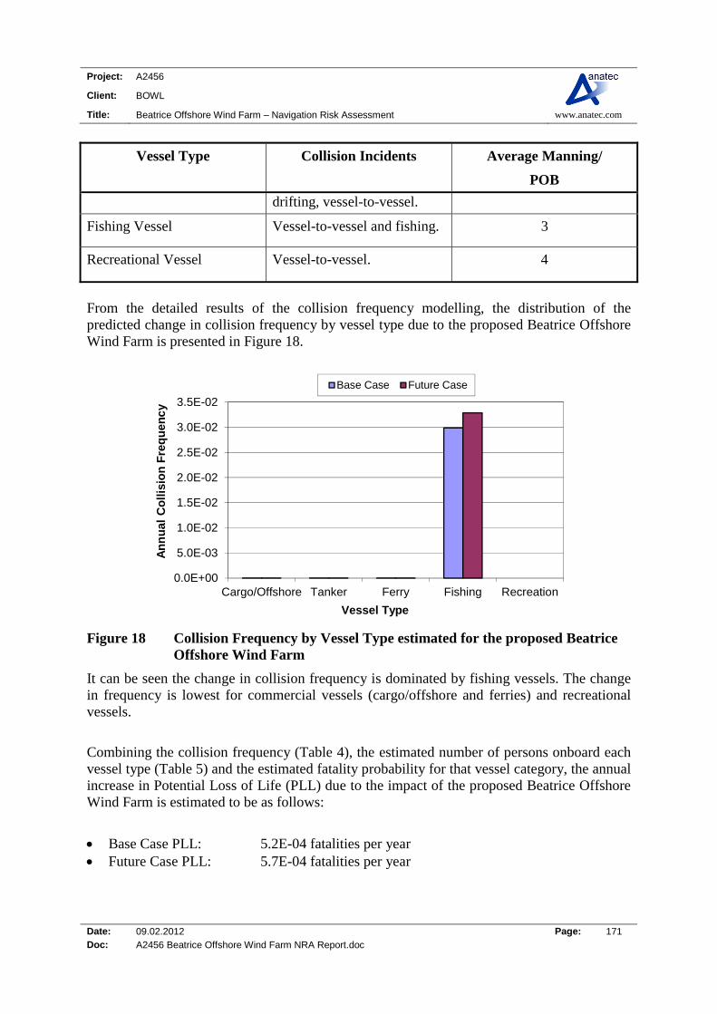
Project: A2456
Client: BOWL
Title: Beatrice Offshore Wind Farm – Navigation Risk Assessment www.anatec.com
Date: 09.02.2012 Page: 171 Doc: A2456 Beatrice Offshore Wind Farm NRA Report.doc
Vessel Type Collision Incidents Average Manning/
POB
drifting, vessel-to-vessel.
Fishing Vessel Vessel-to-vessel and fishing. 3
Recreational Vessel Vessel-to-vessel. 4
From the detailed results of the collision frequency modelling, the distribution of the predicted change in collision frequency by vessel type due to the proposed Beatrice Offshore Wind Farm is presented in Figure 18.
0.0E+00
5.0E-03
1.0E-02
1.5E-02
2.0E-02
2.5E-02
3.0E-02
3.5E-02
Cargo/Offshore Tanker Ferry Fishing Recreation
An
nu
al C
oll
isio
n F
req
uen
cy
Vessel Type
Base Case Future Case
Figure 18 Collision Frequency by Vessel Type estimated for the proposed Beatrice Offshore Wind Farm
It can be seen the change in collision frequency is dominated by fishing vessels. The change in frequency is lowest for commercial vessels (cargo/offshore and ferries) and recreational vessels.
Combining the collision frequency (Table 4), the estimated number of persons onboard each vessel type (Table 5) and the estimated fatality probability for that vessel category, the annual increase in Potential Loss of Life (PLL) due to the impact of the proposed Beatrice Offshore Wind Farm is estimated to be as follows:
Base Case PLL: 5.2E-04 fatalities per year Future Case PLL: 5.7E-04 fatalities per year

Project: A2456
Client: BOWL
Title: Beatrice Offshore Wind Farm – Navigation Risk Assessment www.anatec.com
Date: 09.02.2012 Page: 172 Doc: A2456 Beatrice Offshore Wind Farm NRA Report.doc
The estimated base case PLL increase equates to an average of one additional fatality in 1,932 years, whilst the future case PLL increase corresponds to an average of one additional fatality in 1,757 years. The predicted incremental increases in PLL due to the wind farm, distributed by vessel type for the base and future cases, are presented in Figure 19.
0.0E+00
1.0E-04
2.0E-04
3.0E-04
4.0E-04
5.0E-04
6.0E-04
Cargo/Offshore Tanker Ferry Fishing Recreation
Po
ten
tial
Lo
ss o
f L
ife
Vessel Type
Base Case Future Case
Figure 19 Estimated change in Annual PLL by Vessel Type due to the proposed Beatrice Offshore Wind Farm
Therefore, it can be seen that the fatality risk is dominated by fishing vessels, which historically have a higher fatality probability per incident than merchant vessels. Converting the PLL to individual risk based on the average number of people exposed by vessel type, the results are presented in Figure 20. (This calculation assumes that the risk is shared between 10 vessels of each type, which is considered to be conservative based on the number of different vessels operating in the vicinity of the site.)

Project: A2456
Client: BOWL
Title: Beatrice Offshore Wind Farm – Navigation Risk Assessment www.anatec.com
Date: 09.02.2012 Page: 173 Doc: A2456 Beatrice Offshore Wind Farm NRA Report.doc
0.E+00
2.E-06
4.E-06
6.E-06
8.E-06
1.E-05
1.E-05
1.E-05
2.E-05
2.E-05
2.E-05
Cargo/Offshore Tanker Ferry Fishing Recreation
Ind
ivid
ual
Ris
k p
er a
nn
um
Vessel Type
Base Case Future Case
Figure 20 Estimated change in Individual Risk by Vessel Type due to the proposed Beatrice Offshore Wind Farm
Therefore, individual risk is highest for people on fishing vessels, which is related to the higher probability of fatalities occurring in the event of an incident.
Significance of Increase in Fatality Risk – Proposed Beatrice Offshore Wind Farm
The overall increase in PLL estimated due to the development is 5.1 x 10⁻⁵ fatalities per year (base case), which equates to one additional fatality in 19,000 years. This is a small change compared to the MAIB statistics which indicate an average of 29 fatalities per year in UK territorial waters. In terms of individual risk to people, the incremental increase for commercial ships (in the region of 10-11) is very low compared to the background risk level for the UK sea transport industry of 2.9 x 10⁻⁴ per year. Similarly, for fishing vessels, whilst the change in individual risk attributed to the development is higher than for commercial vessels (in the region of 10-5), it is low compared to the background risk level for the UK sea fishing industry of 1.2 x 10⁻³ per year.
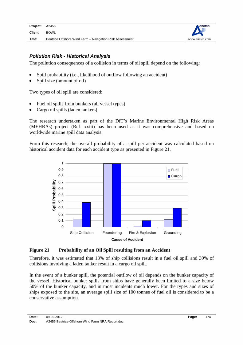
Project: A2456
Client: BOWL
Title: Beatrice Offshore Wind Farm – Navigation Risk Assessment www.anatec.com
Date: 09.02.2012 Page: 174 Doc: A2456 Beatrice Offshore Wind Farm NRA Report.doc
Pollution Risk - Historical Analysis The pollution consequences of a collision in terms of oil spill depend on the following: Spill probability (i.e., likelihood of outflow following an accident) Spill size (amount of oil) Two types of oil spill are considered: Fuel oil spills from bunkers (all vessel types) Cargo oil spills (laden tankers) The research undertaken as part of the DfT’s Marine Environmental High Risk Areas (MEHRAs) project (Ref. xxiii) has been used as it was comprehensive and based on worldwide marine spill data analysis. From this research, the overall probability of a spill per accident was calculated based on historical accident data for each accident type as presented in Figure 21.
0
0.1
0.2
0.3
0.4
0.5
0.6
0.7
0.8
0.9
1
Ship Collision Foundering Fire & Explosion Grounding
Cause of Accident
Sp
ill
Pro
ba
bil
ity
Fuel
Cargo
Figure 21 Probability of an Oil Spill resulting from an Accident
Therefore, it was estimated that 13% of ship collisions result in a fuel oil spill and 39% of collisions involving a laden tanker result in a cargo oil spill. In the event of a bunker spill, the potential outflow of oil depends on the bunker capacity of the vessel. Historical bunker spills from ships have generally been limited to a size below 50% of the bunker capacity, and in most incidents much lower. For the types and sizes of ships exposed to the site, an average spill size of 100 tonnes of fuel oil is considered to be a conservative assumption.
Project: A2456
Client: BOWL
Title: Beatrice Offshore Wind Farm – Navigation Risk Assessment www.anatec.com
Date: 09.02.2012 Page: 175 Doc: A2456 Beatrice Offshore Wind Farm NRA Report.doc
For cargo spills from laden tankers, the spill size can vary significantly. International Tanker Owners Pollution Federation limited (ITOPF) report the following spill size distribution for tanker collisions between 1974 and 2004.
0
50
100
150
200
250
300
< 7 7-700 > 700
Tonnes of Oil
Nu
mb
er o
f C
oll
isio
n I
nci
den
ts
Figure 22 Spill Size Distribution in Tanker Collision Incident (ITOPF 1974-2004)
31% of spills are below 7 tonnes, 52% are between 7 and 700 tonnes and 17% are greater than 700 tonnes. Based on this data and the tankers transiting the area in proximity to the proposed Beatrice Offshore Wind Farm site, an average spill size of 400 tonnes is considered conservative. For fishing and recreational vessel collisions, comprehensive statistical data is not available so it is conservatively assumed that 50% of all collisions involving these vessels will lead to oil spill with the quantity spilled being an average of 5 tonnes for fishing vessels and 1 tonne for recreational vessels.
Pollution Risk – Proposed Beatrice Offshore Wind Farm Applying the above probabilities to the collision frequency by vessel type presented in Figure 18 and the average spill size per vessel, the amount of oil spilled per year due to the impact of the development is estimated to be as follows: Base Case: 0.07 tonnes of oil per year Future Case: 0.08 tonnes of oil per year The predicted increases in tonnes of oil spilled distributed by vessel type for the base and future cases are presented in Figure 23.

Project: A2456
Client: BOWL
Title: Beatrice Offshore Wind Farm – Navigation Risk Assessment www.anatec.com
Date: 09.02.2012 Page: 176 Doc: A2456 Beatrice Offshore Wind Farm NRA Report.doc
0.00
0.01
0.02
0.03
0.04
0.05
0.06
0.07
0.08
0.09
Cargo/Offshore Tanker Ferry Fishing Recreation
To
nn
es o
f O
il
Vessel Type
Base Case Future Case
Figure 23 Estimated change in Pollution by Vessel Type due to Site
It can be seen that fishing vessels contribute the vast majority of the overall risk of oil spill, given the high annual collision frequency for the Beatrice Offshore Wind Farm development.
Significance of Increase in Pollution Risk – Proposed Beatrice Offshore Wind Farm
To assess the significance of the increased pollution risk from marine vessels caused by the proposed Beatrice Offshore Wind Farm, historical oil spill data for the UK has been used as a benchmark. From the MEHRAs research (Ref. xxiii); the average annual tonnes of oil spilled in the waters around the British Isles due to marine accidents in the 10-year period from 1989-98 1998 was 16,111. This is based on a total of 146 reported oil pollution incidents of greater than 1 tonne (smaller spills are excluded as are incidents which occurred within port and harbour areas or as a result of operational errors or equipment failure). Merchant vessel spills accounted for approximately 99% of the total while fishing vessel incidents accounted for less than 1%. The overall increase in pollution estimated due to the development is very low compared to the historical average pollution quantities from marine accidents in UK waters (approximately 0.0073%).
Project: A2456
Client: BOWL
Title: Beatrice Offshore Wind Farm – Navigation Risk Assessment www.anatec.com
Date: 09.02.2012 Page: 177 Doc: A2456 Beatrice Offshore Wind Farm NRA Report.doc
Summary The quantitative risk assessment indicates that the impact of the proposed Beatrice Offshore Wind Farm on people and the environment is relatively low compared to background risk levels in UK waters. However, it is recognised that there is a degree of uncertainty associated with numerical modelling. For example, the model does not consider the potential radar interference from turbines which may have an influence on the risk of vessel-to-vessel collisions, especially in reduced visibility where one or both of the vessels involved is not carrying Automatic Identification System (AIS). Therefore, conservative assumptions have been applied in this analysis and the overall project is being carried out based on the principle of ALARP to ensure the risks to people and the environment are managed to a level that is as low as reasonably practicable.

Project: A2456
Client: BOWL
Title: Beatrice Offshore Wind Farm – Navigation Risk Assessment www.anatec.com
Date: 15.02.2012 Page: 178 Doc: S18 Shipping and Navigation Annex NRA Report 150212
APPPENDIX 3 Marine Guidance Note 371 Checklist This Appendix presents the Marine Coastguard Agency (MCA) checklist based on the requirements set out in Marine Guidance Note (MGN) 371 which was the guidance set by the MCA. Reference notes/remarks are made within the table based on which sections of the Navigational Risk Assessment (NRA), or other documents, address the issue noted in the MGN 371 checklist.

Project: A2456
Client: BOWL
Title: Beatrice Offshore Wind Farm – Navigation Risk Assessment www.anatec.com
Date: 15.02.2012 Page: 179 Doc: S18 Shipping and Navigation Annex NRA Report 150212
MGN 371 Compliance Checklist
Table 1 MGN 371 Compliance Checklist for the Beatrice Offshore Wind Farm
MGN 371 COMPLIANCE Issue Yes No Remarks
Considerations on Site Position, Structures and Safety Zones 1. Traffic Survey All vessel types Sections 7-10 of NRA.
Four weeks duration, within 12 months prior to submission of the Environmental Statement
Section 7 of NRA. Survey period comprised four months AIS/Radar survey from April to July 2010 and AIS/Radar survey in November, December and January 2011.
Seasonal variations Section 7 of NRA. Surveys have been carried out in spring/summer April to July 2010 and winter November, December and January 2011. Consultation was also used to identify variations in recreational and fishing vessel activity. (Also refer to the Commercial Fisheries assessment carried out for the ES.)
Recreational and fishing vessel organisations
Sections 4, 9 and 10 of NRA.
Port and navigation authorities Sections 5 and 12 of NRA.
Assessment Proposed OREI site relative to areas used by any type of marine craft.
Sections 7-12 of NRA.
Numbers, types and sizes of vessels presently using such areas
Sections 7-12 of NRA.
Non-transit uses of the areas, e.g. fishing, day cruising of leisure craft, racing, aggregate dredging, etc.
Sections 7-12 of NRA.
Whether these areas contain transit routes used by coastal or deep-draught vessels on passage.
Section 7 and 8 of NRA.
Alignment and proximity of the site relative to adjacent shipping lanes
Sections 7 and 8 of NRA.
Whether the nearby area contains prescribed routeing schemes or precautionary areas
Sections 5, 7 and 8 of NRA.
Whether the site lies on or near a prescribed or conventionally accepted separation zone between two opposing routes
Sections 5, 7 and 8 of NRA.
Proximity of the site to areas used for anchorage, safe haven, port approaches
Sections 5, 7 and 8 of NRA.
Project: A2456
Client: BOWL
Title: Beatrice Offshore Wind Farm – Navigation Risk Assessment www.anatec.com
Date: 15.02.2012 Page: 180 Doc: S18 Shipping and Navigation Annex NRA Report 150212
MGN 371 COMPLIANCE Issue Yes No Remarks and pilot boarding or landing areas.
Whether the site lies within the limits of jurisdiction of a port and/or navigation authority.
Section 5.2/5.3 of NRA.
Proximity of the site to existing fishing grounds, or to routes used by fishing vessels to such grounds.
Section 10 of NRA and Commercial Fisheries assessment
Proximity of the site to offshore firing/bombing ranges and areas used for any marine military purposes.
Section 5.9.
Proximity of the site to existing or proposed offshore oil / gas platform, marine aggregate dredging, or other exploration/exploitation sites
Section 5.7 and Section 15 of NRA.
Proximity of the site relative to any designated areas for the disposal of dredging spoil
Section 5.9
Proximity of the site to aids to navigation and/or Vessel Traffic Services (VTS) in or adjacent to the area and any impact thereon.
Section 5.3 and 5.4 of NRA.
Researched opinion using computer simulation techniques with respect to the displacement of traffic and, in particular, the creation of ‘choke points’ in areas of high traffic density.
Sections 7, 8 and 13 of NRA.
Type(s) of simulation used in analysis Limitation of system (s)
Section 13 of NRA
2. OREI Structures Whether any features of the OREI, including auxiliary platforms outside the main generator site and cabling to the shore, could pose any type of difficulty or danger to vessels underway, performing normal operations, or anchoring
Sections 8-15 of NRA. (Note: The final design has not yet been selected therefore the Rochdale Envelope has been assumed). A separate NRA on the Beatrice Offshore Wind Farm export cable works has been prepared and will be submitted as part of the application.
Clearances of wind turbine blades above the sea surface not less than 22 metres
Section 3.5 and 9.4 of NRA.
Least depth of current turbine blades Not applicable.
The burial depth of cabling Consideration of surface cables and burial (1m to 3m) based on preliminary export cable route investigation works (Note: The final route and landfall has not yet been selected).

Project: A2456
Client: BOWL
Title: Beatrice Offshore Wind Farm – Navigation Risk Assessment www.anatec.com
Date: 15.02.2012 Page: 181 Doc: S18 Shipping and Navigation Annex NRA Report 150212
MGN 371 COMPLIANCE Issue Yes No Remarks
A separate NRA on the Beatrice Offshore Wind Farm export cable works has been prepared and will be submitted as part of the application.
Whether any feature of the installation could create problems for emergency rescue services, including the use of lifeboats, helicopters and emergency towing vessels (ETVs)
Section 17 of NRA.
How rotor blade rotation and power transmission, etc., will be controlled by the designated services when this is required in an emergency.
Section 17 of NRA.
3. Assessment of Access to and Navigation Within, or Close to , an OREI To determine the extent to which navigation would be feasible within the OREI site itself by assessing whether:
a. Navigation within the site would be safe:
i. by all vessels, or ii. by specified vessel types,
operations and/or sizes.
iii. in all directions or areas, or
iv. in specified directions or areas.
v. in specified tidal, weather or other conditions
Entire NRA.
b. Navigation in and/or near the site should be:
i. prohibited by specified vessels
types, operations and/or sizes. ii. prohibited in respect of
specific activities,
iii. prohibited in all areas or directions, or
iv. prohibited in specified areas or
directions, or
Entire NRA.
Project: A2456
Client: BOWL
Title: Beatrice Offshore Wind Farm – Navigation Risk Assessment www.anatec.com
Date: 15.02.2012 Page: 182 Doc: S18 Shipping and Navigation Annex NRA Report 150212
MGN 371 COMPLIANCE Issue Yes No Remarks
v. prohibited in specified tidal or weather conditions, or simply
vi. recommended to be avoided.
c. Exclusion from the site could cause navigational, safety or routeing problems for vessels operating in the area.
See Sections 8-11 and 16 for discussion of likely impacts of site on vessel activity.
Relevant information concerning a decision to seek a “safety zone” for a particular site during any point in its construction, operation or decommissioning.
Sections 13 and 16 of NRA.
Navigation, collision avoidance and communications 1. The Effect of Tides and Tidal Streams : It should be determined whether or not:
Current maritime traffic flows and operations in the general area are affected by the depth of water in which the proposed installation is situated at various states of the tide i.e. whether the installation could pose problems at high water which do not exist at low water conditions, and vice versa.
Sections 4, 5, 7 and 18 of NRA
Set and rate of the tidal stream, at any state of the tide, has a significant affect on vessels in the area of the OREI site.
Sections 4, 5, 7, 11, 12 and 18 of NRA
Maximum rate tidal stream runs parallel to the major axis of the proposed site layout, and, if so, its effect.
Section 5.10 of NRA.
The set is across the major axis of the layout at any time, and, if so, at what rate.
Section 5.10 of NRA.
In general, whether engine failure or other circumstance could cause vessels to be set into danger by the tidal stream.
Section 5.10, 11, and 12 of NRA. (Tides in the area used to model risk of drifting ship collision.)
Structures themselves could cause changes in the set and rate of the tidal stream.
Section 18.3 of NRA.
Structures in the tidal stream could be such as to produce siltation, deposition of sediment or scouring, affecting navigable water depths in the wind farm area or adjacent to the area
Section 18.5 of NRA.
2. Weather: To determine if:
The site, in normal, bad weather, or restricted visibility conditions, could present difficulties or dangers to craft, including
Sections 4, 5.10, 7, 9-16, and 18 of NRA.

Project: A2456
Client: BOWL
Title: Beatrice Offshore Wind Farm – Navigation Risk Assessment www.anatec.com
Date: 15.02.2012 Page: 183 Doc: S18 Shipping and Navigation Annex NRA Report 150212
MGN 371 COMPLIANCE Issue Yes No Remarks sailing vessels, which might pass in close proximity to it.
The structures could create problems in the area for vessels under sail, such as wind masking, turbulence or sheer.
Section 18.4 of NRA.
In general taking into account the prevailing winds for the area, whether engine failure or other circumstances could cause vessels to drift into danger, particularly if in conjunction with a tidal set.
Section 12.3 of NRA (Drifting collision risk model).
3. Visual Navigation and Collision Avoidance: To assess the extent to which Structures could block or hinder the view of other vessels under way on any route.
Section 18.2 of NRA.
Structures could block or hinder the view of the coastline or of any other navigational feature such as aids to navigation, landmarks, promontories, etc.
Section 18.2 of NRA.
4. Communications, Radar and Positioning Systems : To provide researched opinion of a generic and, where appropriate, site specific nature concerning whether or not:
Structures could produce radio interference such as shadowing, reflections or phase changes, with respect to any frequencies used for marine positioning, navigation or communications, including Automatic Identification Systems (AIS), whether ship borne, ashore or fitted to any of the proposed structures.
Section 14 of NRA.
Structures could produce radar reflections, blind spots, shadow areas or other adverse effects: a. Vessel to vessel; b. Vessel to shore; c. VTS radar to vessel; d. Racon to/from vessel.
Section 14 of NRA.
OREI, in general, would comply with current recommendations concerning electromagnetic interference.
Section 14 of NRA.
Structures and generators might produce sonar interference affecting fishing, industrial or military systems used in the area.
Section 18.6 of NRA.
Site might produce acoustic noise which Section 18.9 of NRA.
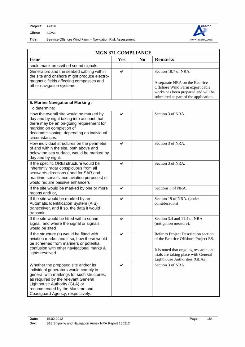
Project: A2456
Client: BOWL
Title: Beatrice Offshore Wind Farm – Navigation Risk Assessment www.anatec.com
Date: 15.02.2012 Page: 184 Doc: S18 Shipping and Navigation Annex NRA Report 150212
MGN 371 COMPLIANCE Issue Yes No Remarks could mask prescribed sound signals.
Generators and the seabed cabling within the site and onshore might produce electro-magnetic fields affecting compasses and other navigation systems.
Section 18.7 of NRA. A separate NRA on the Beatrice Offshore Wind Farm export cable works has been prepared and will be submitted as part of the application.
5. Marine Navigational Marking : To determine:
How the overall site would be marked by day and by night taking into account that there may be an on-going requirement for marking on completion of decommissioning, depending on individual circumstances.
Section 3 of NRA.
How individual structures on the perimeter of and within the site, both above and below the sea surface, would be marked by day and by night.
Section 3 of NRA.
If the specific OREI structure would be inherently radar conspicuous from all seawards directions ( and for SAR and maritime surveillance aviation purposes) or would require passive enhancers
Section 3 of NRA.
If the site would be marked by one or more racons and/ or,
Sections 3 of NRA.
If the site would be marked by an Automatic Identification System (AIS) transceiver, and if so, the data it would transmit.
Section 19 of NRA. (under consideration)
If the site would be fitted with a sound signal, and where the signal or signals would be sited
Section 3.4 and 11.4 of NRA (mitigation measure).
If the structure (s) would be fitted with aviation marks, and if so, how these would be screened from mariners or potential confusion with other navigational marks & lights resolved.
Refer to Project Description section of the Beatrice Offshore Project ES. It is noted that ongoing research and trials are taking place with General Lighthouse Authorities (GLAs).
Whether the proposed site and/or its individual generators would comply in general with markings for such structures, as required by the relevant General Lighthouse Authority (GLA) or recommended by the Maritime and Coastguard Agency, respectively.
Section 3 of NRA.

Project: A2456
Client: BOWL
Title: Beatrice Offshore Wind Farm – Navigation Risk Assessment www.anatec.com
Date: 15.02.2012 Page: 185 Doc: S18 Shipping and Navigation Annex NRA Report 150212
MGN 371 COMPLIANCE Issue Yes No Remarks The aids to navigation specified by the GLAs are being maintained such that the ‘availability criteria’, as laid down and applied by the GLAs, is met at all times.
Section 3 of NRA.
The procedures that need to be put in place to respond to casualties to the aids to navigation specified by the GLAs, within the timescales laid down and specified by the GLAs.
Section 3 of NRA.
Safety and mitigation measures recommended for OREI during construction, operation and decommissioning. Mitigation and safety measures will be applied to the OREI development appropriate to the level and type of risk determined during the Environmental Impact Assessment (EIA).The specific measures to be employed will be selected in consultation with the Maritime and Coastguard Agency and will be listed in the developer’s Environmental Statement (ES). These will be consistent with international standards contained in, for example, the Safety of Life at Sea (SOLAS) Convention - Chapter V, IMO Resolution A.572 (14)3 and Resolution A.671(16)4 and could include any or all of the following:
Sections 11.6, 17 and 19 of NRA.
Promulgation of information and warnings through notices to mariners and other appropriate media.
Sections 11.6, 17 and 19 of NRA.
Continuous watch by multi-channel VHF, including Digital Selective Calling (DSC).
Sections 17 and 19 of NRA.
Safety zones of appropriate configuration, extent and application to specified vessels
Section 16 of NRA.
Designation of the site as an area to be avoided (ATBA).
Not applicable.
Implementation of routeing measures within or near to the development.
Not applicable. (See Section 8 of NRA for Impact on Commercial Shipping Navigation).
Monitoring by radar, AIS and/or closed circuit television (CCTV).
Sections 17 and 19 of NRA.
Appropriate means to notify and provide evidence of the infringement of safety zones or ATBA’s.
Sections 16, 17 and 19 of NRA.
Any other measures and procedures considered appropriate in consultation with
Sections 4, 17 and 19 of NRA.

Project: A2456
Client: BOWL
Title: Beatrice Offshore Wind Farm – Navigation Risk Assessment www.anatec.com
Date: 15.02.2012 Page: 186 Doc: S18 Shipping and Navigation Annex NRA Report 150212
MGN 371 COMPLIANCE Issue Yes No Remarks other stakeholders.
Standards and procedures for wind turbine generator shutdown in the event of a search and rescue, counter pollution or salvage incident in or around a wind farm. The wind farm should be designed and constructed to satisfy the following design requirements for emergency rotor shut-down in the event of a search and rescue (SAR), counter pollution or salvage operation in or around a wind farm: All wind turbine generators (WTGs) will be marked with clearly visible unique identification characters which can be seen by both vessels at sea level and aircraft (helicopters and fixed wing) from above.
Sections 3 and 17 of NRA.
The identification characters shall each be illuminated by a low intensity light visible from a vessel this enabling the structure to be detected at a suitable distance to avoid a collision with it. The size of the identification characters in combination with the lighting should be such that, under normal conditions of visibility and all known tidal conditions, they are clearly readable by an observer, stationed 3 metres above sea levels, and at a distance of at least 150 metres from the turbine. It is recommended that lighting for this purpose be hooded or baffled so as to avoid unnecessary light pollution or confusion with navigation marks. (Precise dimensions to be determined by the height of lights and necessary range of visibility of the identification numbers).
Sections 3 and 17 of NRA
For aviation purposes, OREI structures should be marked with hazard warning lighting in accordance with CAA guidance and also with unique identification numbers (with illumination controlled from the site control centre and activated as required) on the upper works of the OREI structure so that aircraft can identify each installation from a height of 500ft (150 metres) above the highest part of the OREI structure.
Sections 3 and 17 of NRA.
Wind Turbine Generators (WTG) shall have high contrast markings (dots or stripes) placed at 10 metre intervals on both sides of the blades to provide SAR helicopter pilots with a hover reference point.
Section 17 of NRA.
All WTGs should be equipped with control mechanisms that can be operated from the Central Control Room of the wind farm or
Section 17 of NRA.

Project: A2456
Client: BOWL
Title: Beatrice Offshore Wind Farm – Navigation Risk Assessment www.anatec.com
Date: 15.02.2012 Page: 187 Doc: S18 Shipping and Navigation Annex NRA Report 150212
MGN 371 COMPLIANCE Issue Yes No Remarks through a single contact point.
Throughout the design process for a wind farm, appropriate assessments and methods for safe shutdown should be established and agreed, through consultation with MCA and other emergency support services.
Sections 17 and 19 of NRA.
The WTG control mechanisms should allow the Control Room Operator to fix and maintain the position of the WTG blades as determined by the Maritime Rescue Co-ordination Centre or Maritime Rescue Sub Centre (MRCC/SC).
Sections 17 and 19 of NRA.
Nacelle hatches should be capable of being opened from the outside. This will allow rescuers (e.g. helicopter winch-man) to gain access to the tower if tower occupants are unable to assist and when sea-borne approach is not possible.
Sections 17 and 19 of NRA.
Access ladders, although designed for entry by trained personnel using specialised equipment and procedures for turbine maintenance in calm weather, could conceivably be used, in an emergency situation, to provide refuge on the turbine structure for distressed mariners. This scenario should therefore be considered when identifying the optimum position of such ladders and take into account the prevailing wind, wave and tidal conditions.
Section 12 of NRA.
Although it may not be feasible for mariners in emergency situations to be able to use wave or tidal generators as places of refuge, consideration should nevertheless be given to the provision of appropriate facilities.
Section 17 of NRA
2. Operational Requirements
The Central Control Room, or mutually agreed single point of contact, should be manned 24 hours a day.
Sections 17 and 19 of NRA.
The Central Control Room operator, or mutually agreed single point of contact, should have a chart indicating the Global Positioning System (GPS) position and unique identification numbers of each of the WTGs in the wind farm.
Sections 17 and 19 of NRA.
All MRCCs/MRSCs will be advised of the Sections 17 and 19 of NRA.

Project: A2456
Client: BOWL
Title: Beatrice Offshore Wind Farm – Navigation Risk Assessment www.anatec.com
Date: 15.02.2012 Page: 188 Doc: S18 Shipping and Navigation Annex NRA Report 150212
MGN 371 COMPLIANCE Issue Yes No Remarks contact telephone number of the Central Control Room, or mutually agreed central point of conatct.
All MRCCs/MRSCs will have a chart indicating the GPS position and unique identification number of each of the WTGs in all wind farms.
Sections 17 and 19 of NRA.
3. Operational Procedures Upon receiving a distress call or other emergency alert from a vessel which is concerned about a possible collision with a WTG or is already close to or within the wind farm, or when the MRCC/MRSC receives a report that persons are in actual or possible danger in or near a wind farm and search and rescue aircraft and/or rescue boats or craft are required to operate over or within the wind farm, the MRCC/MRSC will establish the position of the vessel and the identification numbers of any WTGs which are visible to the vessel. This information will be passed immediately to the Central Control Room, or single contact point, by the MRCC/MRSC. A similar procedure will be followed when vessels are close to or within other types of OREI site
Sections 17 and 19 of NRA.
The control room operator should immediately initiate the shut-down procedure for those WTGs as requested by the MRCC/MRSC, and maintain the WTG in the appropriate shut-down position, again as requested by the MRCC/MRSC, or as agreed with MCA Navigation Safety Branch or Search and Rescue Branch for that particular installation, until receiving notification from the MRCC/MRSC that it is safe to restart the WTG.
Sections 17 and 19 of NRA.
The appropriate procedure to be followed in respect of other OREI types, designs and configurations will be determined by these MCA branches on a case by case basis, in consultation with appropriate stakeholders, during the Scoping and Environmental Impact Assessment processes.
Sections 17 and 19 of NRA
Communication and shutdown procedures Sections 17 and 19 of NRA.
Project: A2456
Client: BOWL
Title: Beatrice Offshore Wind Farm – Navigation Risk Assessment www.anatec.com
Date: 15.02.2012 Page: 189 Doc: S18 Shipping and Navigation Annex NRA Report 150212
MGN 371 COMPLIANCE Issue Yes No Remarks should be tested satisfactorily at least twice a year. Shutdown and other procedures should be tested as and when mutually agreed with the MCA.

Project: A2456
Client: BOWL
Title: Beatrice Offshore Wind Farm – Navigation Risk Assessment www.anatec.com
Date: 15.02.2012 Page: 190 Doc: S18 Shipping and Navigation Annex NRA Report 150212
REFERENCES i DECC, 2005. Methodology for Assessing the Marine Navigational Safety Risks of
Offshore Windfarms.
ii MCA, 2008. Marine Guidance Notice 371, Offshore Renewable Energy Installations (OREIs) - Guidance on UK Navigational Practice, Safety and Emergency Response Issues. iii QinetiQ and MCA, 2004. Results of the EM Investigations and assessments of marine
radar, communications and positioning systems undertaken at the North Hoyle Wind Farm.
iv BWEA, 2007. Investigation of Technical and Operational Effects on Marine Radar
Close to Kentish Flats Offshore Wind Farm. v Admiralty Sailing Directions, 2009. North Coast of Scotland Pilot, NP 52, 7th Edition vi PhysE, 2003. Beatrice Wind Farm Project Initial Environmental Report (Offshore
Conditions). vii PhysE, 2004. Beatrice Windfarm Metocean Criteria for Design. viii Anatec Ltd, 2011. Beatrice Gargano Traffic Survey – winter 2010.
ix RYA, supported by Trinity House and Cruising Association, 2010. UK Coastal Atlas
of Recreational Boating. x Brown and May, 2011. Beatrice Offshore Wind Farm, Commercial Fisheries
Assessment.
xi IMO, 2002. Guidelines for Formal Safety Assessment (FSA) for use in the IMO rule Making Process.
xii Department for Transport, 2000-2009. Maritime Statistics.
Available:http://www2.dft.gov.uk/pgr/statistics/datatablespublications/maritime/ports/ index.html
xiii QinetiQ, 2006. Beatrice Wind Turbine Impact on Radio Frequency Navigation and
Safety Systems. xiv MCA, 2008. Marine Guidance Notice 372 (M+F), Guidance to Mariners Operating
in the Vicinity of UK OREIs.
Project: A2456
Client: BOWL
Title: Beatrice Offshore Wind Farm – Navigation Risk Assessment www.anatec.com
Date: 15.02.2012 Page: 191 Doc: S18 Shipping and Navigation Annex NRA Report 150212
xv DECC, 2007. Guidance Notes: Applying for Safety Zones around Offshore Renewable
Energy Installations. xvi MCA, 2010. Protecting our Seas and Shores in the 21st Century, Consultation on
Proposals for Modernising the Coastguard.
xvii MCA, 2011. Protecting our Seas and Shores in the 21st Century, Consultation on Revised Proposals for Modernising the Coastguard.
xviii IMO, 2001. Maritime Safety Committee, 74th Edition, Agenda Item 5 (MSC 74/5/X), Bulk Carrier Safety – Formal Safety Assessment.
xix IMO, 2000. Maritime Safety Committee, 72nd Edition, Agenda Item 1 (MSC 72/1/X),
Decision Parameters including Risk Acceptance Criteria – Formal Safety Assessment. xx MCA, 2001. Safety Information – FSA, Statistical Data. Available:
http://web.archive.org/web/20071012045654/http://www.mcga.gov.uk/c4mca/mcga-safety_information/mcga-formal_safety_assessment/mcga-ds-rap-fsa/mcga-ds-rap-statdata.htm [Accessed 13 December 2011].
xxi International Labour Organisation, 2001. The Impact on Seafarers’ Living and
Working Conditions of Changes in the Structure of the Shipping Industry. xxii Department for Transport, 2004. Transport Statistics Report, Maritime Statistics. xxiii Department for Transport, 2001. Identification of Marine Environmental High Risk
Areas (MEHRA’s) in the UK.