Navigation and EDL for the Mars Exploration Rovers
30
Navigation and EDL for the Mars Exploration Rovers Michael M. Watkins Dongsuk Han NASA Jet Propulsion Laboratory Korea Aerospace Research Institute June 21-23, 2006
Transcript of Navigation and EDL for the Mars Exploration Rovers

Navigation and EDL for the Mars Exploration Rovers
Michael M. Watkins
Dongsuk Han NASA Jet Propulsion Laboratory
Korea Aerospace Research Institute
June 21-23, 2006
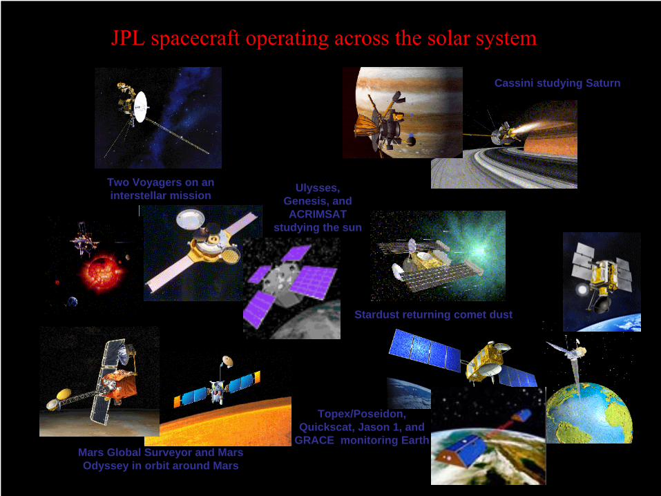
JPL spacecraft operating across the solar system
Two Voyagers on an interstellar mission
Cassini studying Saturn
Mars Global Surveyor and Mars Odyssey in orbit around Mars
Ulysses, Genesis, and ACRIMSAT
studying the sun
Stardust returning comet dust
Topex/Poseidon, Quickscat, Jason 1, and
GRACE monitoring Earth

2003 -
2004: The Busiest Period in JPL’s History
April 2003 June 6, 2003June 25, 2003August 25, 2003December 25, 2003January 2, 2004January 4, 2004January 25, 2004June 20, 2004
July 1, 2004September 8, 2004
October 26, 2004December 24, 2004January 14, 2005
Galaxy Evolution Explorer (GALEX) launchSpace Infrared Telescope Facility (SIRTF) launchMars Exploration Rover –
1 (MER-1) launchMars Exploration Rover –
2 (MER-2) launchMars Express arrivalStardust Encounter with Comet Wild-2Mars Exploration Rover –
1 (MER-1) landingMars Exploration Rover –
2 (MER-2) landingMicrowave Limb Sounder (MLS) and Tropospheric
Emission Spectrometer (TES) launch on EOS-AURACassini Saturn orbit insertionGenesis solar wind sample return (first
samples from beyond lunar orbit)First Cassini images of Titan surfaceHuygens probe releaseHuygens probe Titan atmospheric entry
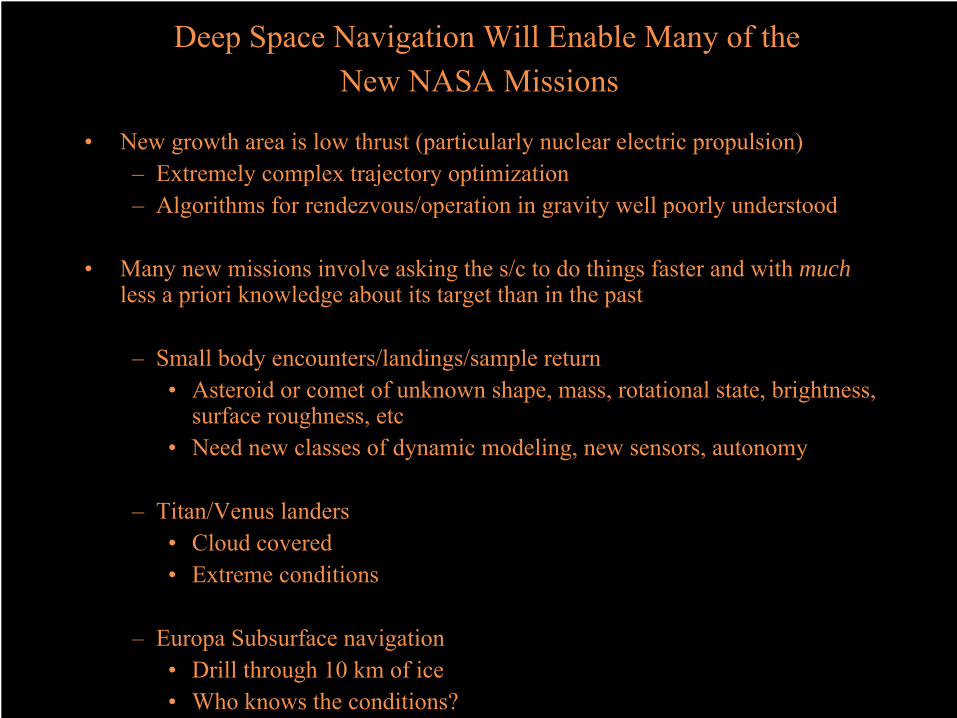
Deep Space Navigation
Will Enable Many of the New NASA Missions
•
New growth area is low thrust (particularly nuclear electric propulsion)–
Extremely complex trajectory optimization–
Algorithms for rendezvous/operation in gravity well poorly understood
•
Many new missions involve asking the s/c to do things faster and
with much less
a priori knowledge about its target than in the past
–
Small body encounters/landings/sample return•
Asteroid or comet of unknown shape, mass, rotational state, brightness, surface roughness, etc
•
Need new classes of dynamic modeling, new sensors, autonomy
–
Titan/Venus landers•
Cloud covered •
Extreme conditions
–
Europa Subsurface navigation•
Drill through
10 km of ice•
Who knows the conditions?

What Exactly is Navigation vs. GNC for Deep Space?
•
Classic Definition of “Mission Design and Navigation”
refers to the “translational”
(trajectory) of the s/c and not to Attitude Control.•
Have traditionally been handled quite separately at JPL because–
Time constant of translational system much longer than the rotational system
–
Attitude control is an intimate part of the Fault Protection/Automated Response of the s/c•
Point antenna at Earth and solar panels at Sun•
Now seeing many Deep Space applications where time constants are
same and which require the system to make real time decisions:–
Entry/Descent/Landing–
Spacecraft rendezvous/sample capture etc•
Future Trends–
Greater autonomy–
Integrated Guidance, Navigation and Control -
JPL GNC reorganization

Cruise and Approach: Why is Deep Space Nav So Difficult?
•
Tiny nongravitational forces add up over time and are extremely difficult to solve for and even harder to predict into the future for targeting–
10 nanometer/s/s error => 3.7 km drift over 10 days–
Can only know if you’re getting it right by consistency of solutions over time
•
Tracking Data traditionally only supplies line of sight (1 component) position and velocity. –
Other components inferred from dynamics + time–
Exceptions: DDOR (VLBI) and target relative optical navigation
•
Celestial mechanics doesn’t help much–
Generally small central angle travel (180 degree transfer over months or years)
–
No out of orbit plane dynamic constraint

Project Importance of GNC: Landing Site Selection
-8 -4 0 4 8 12 km
180˚ 210˚ 240˚ 270˚ 300˚ 330˚ 0˚ 30˚ 60˚ 90˚ 120˚ 150˚ 180˚East Longitude
30˚
-30˚
0˚Latit
ude
60˚
-60˚
Isidis Planitia
Elysium Mons
Utopia Planitia
Chryse Planitia
Hellas Planitia
ArgyrePlanitia
Olympus MonsAmazonisPlanitia
Tharsis Montes
Valles Marineris
TerraMeridiani
Elysium
Gusev
IsidisHematite
VL2
VL1MPF
• Nav can target accurately enough to land inside it• Safe for landing
-
slopes, rocks, wind• High science value
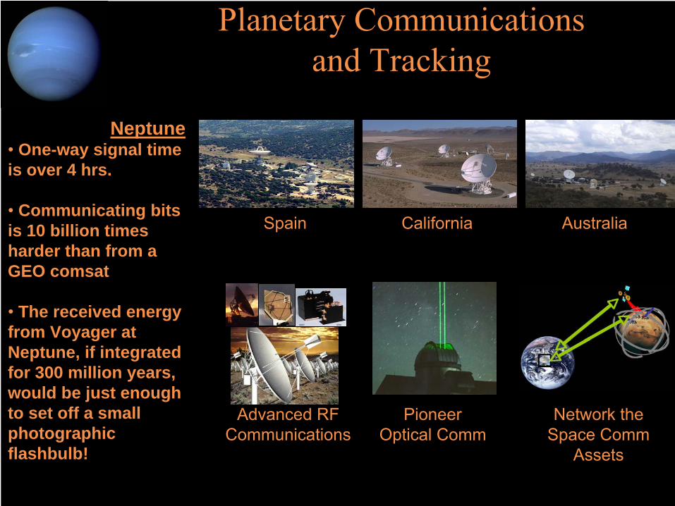
Planetary Communications and Tracking
Neptune•
One-way signal time is over 4 hrs.
•
Communicating bits is 10 billion times harder than from a GEO comsat
•
The received energy from Voyager at Neptune, if integrated for 300 million years, would be just enough to set off a small photographic flashbulb!
Advanced RF Communications
PioneerOptical Comm
Network the Space Comm
Assets
Today’s Deep Space Network (DSN)
Strategies for Tomorrow’s Exploration
Spain AustraliaCalifornia

Tracking Data Types•
2-Way Coherent X-Band Doppler (7.2 GHz up/8.4 GHz down)–
Measures line-of-sight velocity of S/C via frequency shift in radio signal–
Noise: 0.02 –
0.2 mm/s –
Nominally weighted at 0.1 mm/s (60 sec count time)•
Range–
Directly measures the relative Earth-S/C distance via the round-trip timing of coded signal modulated on the signal
–
Noise < 1 meter–
Nominally weighted at 3 meters–
Stochastic pass dependent range biases estimated at 5 meters•
∆DOR–
Measures angular position in Earth plane of sky–
Noise < 4.5 nrad or 0.12 nsec in geometric delay for two stations separated by 8000 km
–
Weighted at 0.12 nsec–
Position accuracies of 90 –
680 meters for Earth-S/C distances of 20 Mkm (Jun 01) –
152 Mkm (Odyssey MOI, Oct 23)
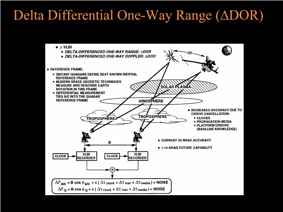
Delta Differential One-Way Range (∆DOR)
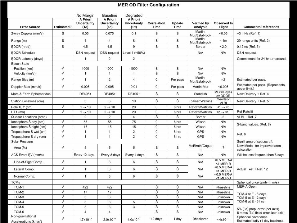
Assumption Verification MatrixNo Margin Baseline Degraded
Error Source Estimated?
A Priori Uncertainty
(1σ)
A Priori Uncertainty
(1σ)
A Priori Uncertainty
(1σ)Correlation
TimeUpdate Time
Verified by Analysis
Observed In-Flight Comments/References
2-way Doppler (mm/s) Š 0.05 0.075 0.1 Š Š Martin-Mur/Estabrook <0.05 ~3 mHz (Ref. 1)
Range (m) Š 4 4 8 Š Š Martin-Mur/Estabrook < 4m 29 range units (Ref. 2)
ĘDOR (nrad) Š 4.5 4.5 9 Š Š Border <2.0 0.12 ns (Ref. 3)
ĘDOR Schedule DSN request DSN request Level 1 (~50%) N/A N/A DSN request.
ĘDOR Latency (days) 1 2 2 Commitment for 24-hr turnaround.Epoch State Position (km) √ 1000 1000 1000 Š Š N/A N/A Velocity (km/s) √ 1 1 1 Š Š N/A N/A
Range Bias (m) √ 1 2 4 0 Per pass Martin-Mur/Estabrook <2 Estimated per pass.
Doppler Bias (mm/s) √ 0.005 0.005 0.01 0 Per pass Martin-Mur <0.005 Estimated per pass. (Represents upper limit.)
Mars & Earth Ephemerides DE405+ DE405+ DE405+ Š Š Standish MGS/Odyssey DDOR New Delivery + Ref. 4
Station Locations (cm) 3 3 10 Š Š Folkner/Watkins Geodetic VLBI New Delivery + Ref. 5
Pole X, Y (cm) √ 1 → 10 2 → 10 20 0 6 hrs Ratcliff/Watkins <1 → <5UT1 (ms) √ 1 → 10 2 → 10 20 0 6 hrs Ratcliff/Watkins <2 → <10Quasar Locations (nrad) 2 2 4 Š Š Border 2 VLBI + Ref. 7Ionosphere Š day (cm) √ 55 55 75 0 6 hrs Wilson N/AIonosphere Š night (cm) √ 15 15 15 0 6 hrs Wilson N/ATroposphere Š wet (cm) √ 1 1 2 0 6 hrs GPS N/ATroposphere Š dry (cm) √ 1 1 2 0 6 hrs GPS N/ASolar Pressure Sunlit area of spacecraft.
Area (%) √ 5 5 5 Š Š McElrath/Goguen ? New Model for improved area
calculationACS Event ĘV (mm/s) Every 12 days Every 8 days Every 4 days Š Š N/A N/A Will be less frequent than 8 days
Line-of-Sight Comp. √ 1 3 6 Š Š N/A <0.5 MER-A <1 MER-B
Lateral Comp. √ 1 3 6 Š Š N/A <0.5 MER-A <1 MER-B
Normal Comp. √ 1 3 6 Š Š N/A <0.5 MER-A <1 MER-B
TCMs Spherical uncertainty (mm/s). TCM-1 √ 422 422 Š Š N/A <baseline TCM-2 √ 17 17 Š Š N/A <baseline TCM-3 √ 3 3 Š Š N/A unknown TCM-4 √ 3 3 5 Š Š N/A unknown TCM-5 √ 3 3 3 Š Š N/A unknown TCM-6 √ 4 4 Š Š N/A unknownNon-gravitational Accelerations (km/s2)
√ 1.7x10⁻¹² 2.0x10⁻¹² 4.0x10⁻¹² 10 days 1 day Bhaskaran <4x10-12 Spherical covariance. Estimated daily (1 day batches).
MER OD Filter Configuration
Ref Ratcliff
MER-A Open
TCM-4 at E - 8 daysTCM-5 at E - 2 daysTCM-6 at E - 6 hrs
5% (3s) prop. error (per axis)6 mm/s (3s) fixed error (per axis)
S-band values. (Ref. 8)
Ref. 6
Actual Test + Ref. 12

All solutions leading up to TCM-4 design

MER-A Gusev TCM-4 EFPA Sensitivities
±0.26
±0.38 ±0.36 ±0.38 ±0.38 ±0.38 ±0.38 ±0.38 ±0.38 ±0.38 ±0.38 ±0.39 ±0.38 ±0.38 ±0.40
±0.56
±0.39 ±0.38 ±0.39
±0.72
0.00
0.10
0.20
0.30
0.40
0.50
0.60
0.70
0.80
no m
argin
base
line
ĘDOR or
der
tropo
sphe
re
statio
n loc
ation
range
bias
dopp
ler bi
asran
ge no
isedo
ppler
noise
99% hi
gh TCM-4
ionos
phere
1 trac
k/day eo
p
quas
ar loc
ation
non-g
rav ac
cel
ACS Eve
nt Ę
V
ĘDOR no
ise
ACS even
t Freq
.
ĘDOR Le
vel 1
No ĘDOR
EFPA
(de
g., 3
s)
0.17 deg. TCM-5 requirement (3 σ)
MER-A Gusev TCM-5 EFPA Sensitivities
±0.09
±0.12 ±0.12 ±0.12 ±0.12 ±0.12 ±0.12 ±0.12 ±0.12 ±0.12 ±0.12 ±0.12 ±0.13 ±0.13 ±0.13 ±0.12 ±0.13
±0.14
±0.33
±0.13
0.00
0.05
0.10
0.15
0.20
0.25
0.30
0.35
0.40
no m
argin
base
line
ĘDOR or
der
tropo
sphe
re
statio
n loc
ation
range
bias
dopp
ler bi
asran
ge no
isedo
ppler
noise
99% hi
gh TCM-4
ionos
phere
1 trac
k/day eo
p
quas
ar loc
ation
non-g
rav ac
cel
ACS Eve
nt ĘV
ĘD
OR noise
ACS even
t Freq
.
ĘDOR Le
vel 1
No ĘDOR
EFPA
(de
g., 3
σ)
0.17 deg. TCM-5 requirement (3 σ)
Entry Flight Path Sensitivities

•
Required atmospheric entry FPA delivery accuracies at TCM-5 (E–2
days) were ±0.12°
(3σ) for Spirit and ±0.14°
(3σ) for Opportunity•
Actual entry FPA errors (based on the final pre-entry OD solutions) were estimated to be –0.007° ± 0.010°
(3σ) for Spirit and +0.030° ± 0.021°
(3σ) for Opportunity–
Equivalent to B-plane errors of only ~180 m for Spirit and ~750 m for Opportunity
–
FPA error for Opportunity would have been smaller if TCM-5 had not been canceled
•
TCMs 5 (E–2
days) and 6 (E–4
hours) were canceled for Spirit•
TCMs 3 (E–65
days), 5 (E–2
days) and 6
(E–4
hours) were canceled for Opportunity•
Miss distance on surface (relative to 70–80 km downtrack dimension of landing ellipse):
Spirit
OpportunityNavigation-only error
3.3 km (uptrack)
9.7 km (downtrack) Total miss distance*
10.1
km (~downtrack)
24.6
km (downtrack)*Including atmosphere and spacecraft aerodynamics uncertainties
MER Navigation Results

Atmospheric Entry Targeting and Delivery
–
Entry Flight Path Angle (FPA) uncertainty creates the dominant error source in the downtrack component of the landing ellipse.
–
The desire to make the landing ellipse as small as possible to enable scientifically interesting and safe landing sites.
–
The landing ellipse size (end-to-end downtrack error) ranges from 108 km to 140 km (3σ) corresponding to FPA uncertainty requirements ranging from 0.17 deg to 0.25 deg (3σ), depending on the latitude of the landing site, for the sites considered in this analysis.
±0.25 deg FPA requirement ±0.17 deg FPA requirement+0.17 deg FPA requirement
Isidis Planitia: 4.62°
North (3σ
dispersions)Gusev Crater: 14.67°
South (3σ
dispersions)

Landing Ellipse OrientationIllustrative Landing Ellipses - Based on Pre-Nav Peer Review Dispersions
MER-A Open
Launch Period
MER-B Open Launch Period
[2/8/04 Arrival]
Grid lines every 0.5°, Minor tics = 0.1°
TCM-4 Site Ellipses TCM-5
(E-10d, L1 ΔDOR) (E-12hr, L1 ΔDOR)
Isidis [4.7°N] Gusev [15°S]
10°N Melas [9°S]
0.0
0.1
0.2
0.3
0.4
0.5
0.6
0.7
0.8
0.9
1.0
1.1
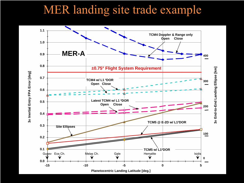
-15 -10 -5 0 5Planetocentric Landing Latitude [deg.]
MER-A
TCM4 w/ L1 ²DOROpen Close
±0.75° Flight System Requirement
TCM5 w/ L1²DOR
300
200
100
0
400
Site Ellipses
Latest TCM4 w/ L1 ²DOROpen Close
TCM4 Doppler & Range onlyOpen Close
TCM5 @ E-2D w/ L1²DOR
MER landing site trade example
3σEn
d-to
-End
Lan
ding
Elli
pse
[km
]
3σIn
ertia
l Ent
ry F
PA E
rror
[deg
]
Gusev Eos Ch. Melas Ch. Gale Hematite Isidis
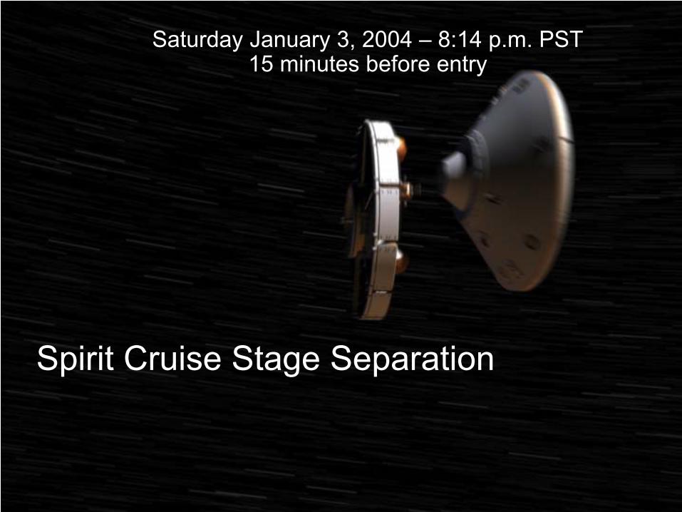
Spirit Cruise Stage Separation
Saturday January 3, 2004 –
8:14 p.m. PST15 minutes before entry

Entry, Descent and Landing: Entry Guidance or What Things Do We NOT do for MER landings
(but we will later…)•
Spacecraft -
Spacecraft tracking
–
UHF or X-band tracking between orbiter and incoming lander could potentially give 100m accuracy•
May demo on Phoenix (probably not) and MSL
•
Guided Entry–
We use ballistic entry, and pay a price by having slightly larger landing footprints•
More pressure on Navigation to be perfect•
Phoenix (probably) and MSL will use hypersonic guidance–
Interesting point•
Knowledge AND control both needed for ballistic•
For guided entry:–
Knowledge is the more driving requirement–
Control just has to be “in the box”
(~0.3 deg FPA)

24 hours before entry, the spacecraft was traveling at speed of 6,000 mph relative to Mars.
During the course of the day, its speed steadily increased to 7,000 mph.
But in the last two hours, firmly in the grasp of Mars gravity, the spacecraft accelerated to 12,000 mph at entry point 80 miles above the surface.
It is less than 6 minutes before landing.
Entering Martian Space 8:29 p.m. PST (ERT)
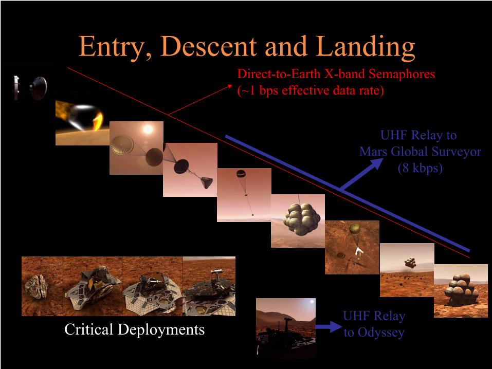
Entry, Descent and LandingDirect-to-Earth X-band Semaphores(~1 bps effective data rate)
Critical Deployments
UHF Relay to Mars Global Surveyor
(8 kbps)
UHF Relay to Odyssey

Entry, Descent and Landing: Terminal Guidance
•
Terrain sensing for landmark navigation–
Not done for MER: Since we are unguided, we do not use cameras to identify landmarks for navigating to target
–
Probably NOT done for either Phoenix or MSL (possible demo)
•
Hazard Detection/aviodance–
Airbag lander, no terminal guidance or control•
Except to null horizontal velocity (DIMES/TIRS)•
Also NOT done for Phoenix or MSL!–
Risk and cost are high, odds of landing on a rock are lower…
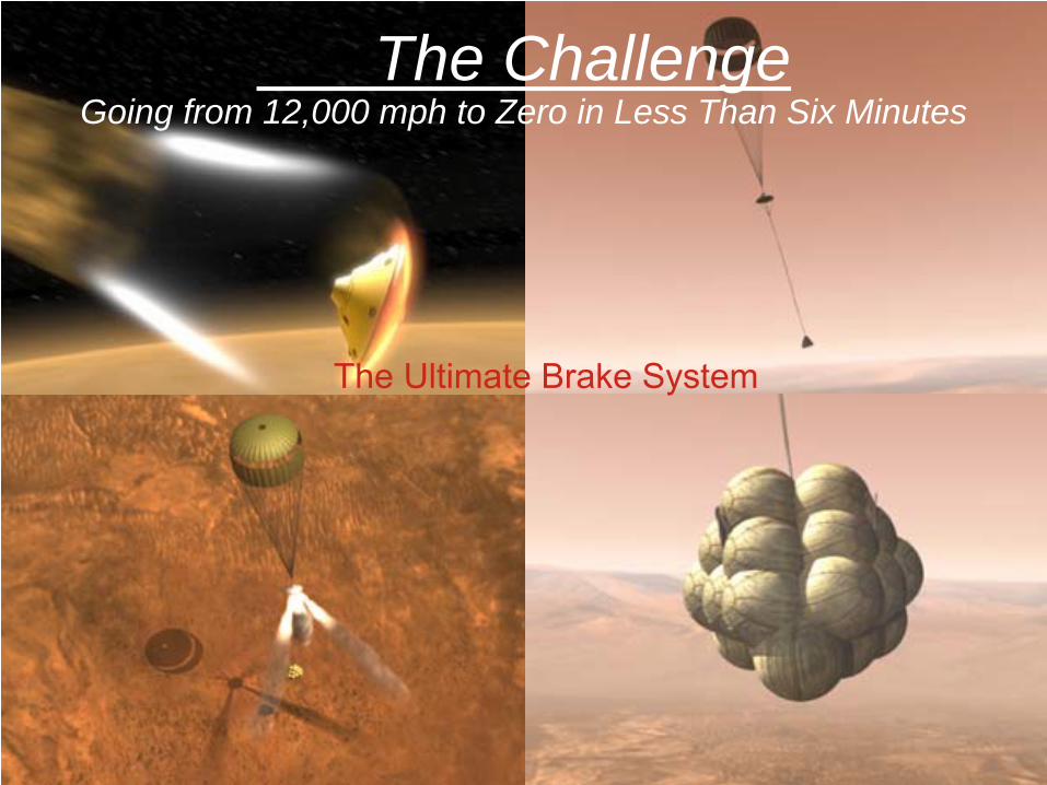
The ChallengeGoing from 12,000 mph to Zero in Less Than Six Minutes
The Ultimate Brake System
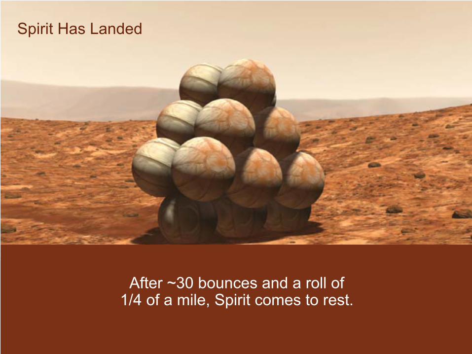
Spirit Has Landed
After ~30 bounces and a roll of 1/4 of a mile, Spirit comes to rest.

Presenter�
Presentation Notes�
Opportunity Pan 2 http://marsrovers.jpl.nasa.gov/gallery/press/opportunity/20040202a/MSPan_B1_2x-B009R1.jpg�

deg metersLatitude* -14.59 -14.57189 1.14E-04 6.5 0.01811
Longitude* 175.30 175.4785 2.58E-06 0.2 0.17848
Miss Distance
(km)
*IAU/IAG 2000 coordinate system (areocentric).
10.1
ParameterTarget (deg)
Error(deg)
Navigation SolutionValue (deg)
Uncertainty (1σ)
Spirit Landing Location
•
Airbags are not a mass-efficient method for landing when the landed mass exceeds a few hundred kg.–
Phoenix will use the Mars Polar Lander legged lander with powered descent
•
Phoenix is a fixed lander ( a la Viking)
–
MSL will use the powered descent with sky crane•
Sky crane is useful for landing rovers
Entry, Descent and Landing: The Future

Powered Descent Time-Line
Time-20 s 0 s 17 s
Rover Touchdown Fly Away phase starts
Hor. Velocity Nulled Sky Crane phase starts
Chute JettisonedPowered Phase Starts
Approach Phase Fly-Away PhaseSky Crane Phase
Altitude = 1000 mDescent Rate = 95 m/s
Altitude =<100 mDescent Rate = <10 m/s

Updated Sky Crane Maneuver Description
One Body Phase -Vertical Descent-
Two Body Phase-DRL/Bridle Deployment-
Two Body Phase-Constant Velocity-
Two Body Phase-Touchdown Event-
Fly-Away Phase
Summary
•
GNC is taking the lead in future EDL systems as we move away from “mechanically” driven systems to GNC-driven systems like sky crane
•
“Planetary” GNC will have to include a significant aero component in EDL and aero-braking/aerocapture
•
Great Challenges and Technologies are on the way